Total solar eclipse of 05/29/2663
| Day of week: | Friday |
| Maximum duration of eclipse: | 05m07s |
| Maximum width of eclipse path: | 276 km |
| Saros cycle: | 148 |
| Coverage: | 100% |
| Magnitude: | 1.0719 |
| Gamma: | 0.5295 |
Wo kann man die Sonnenfinsternis vom 05/29/2663 sehen?
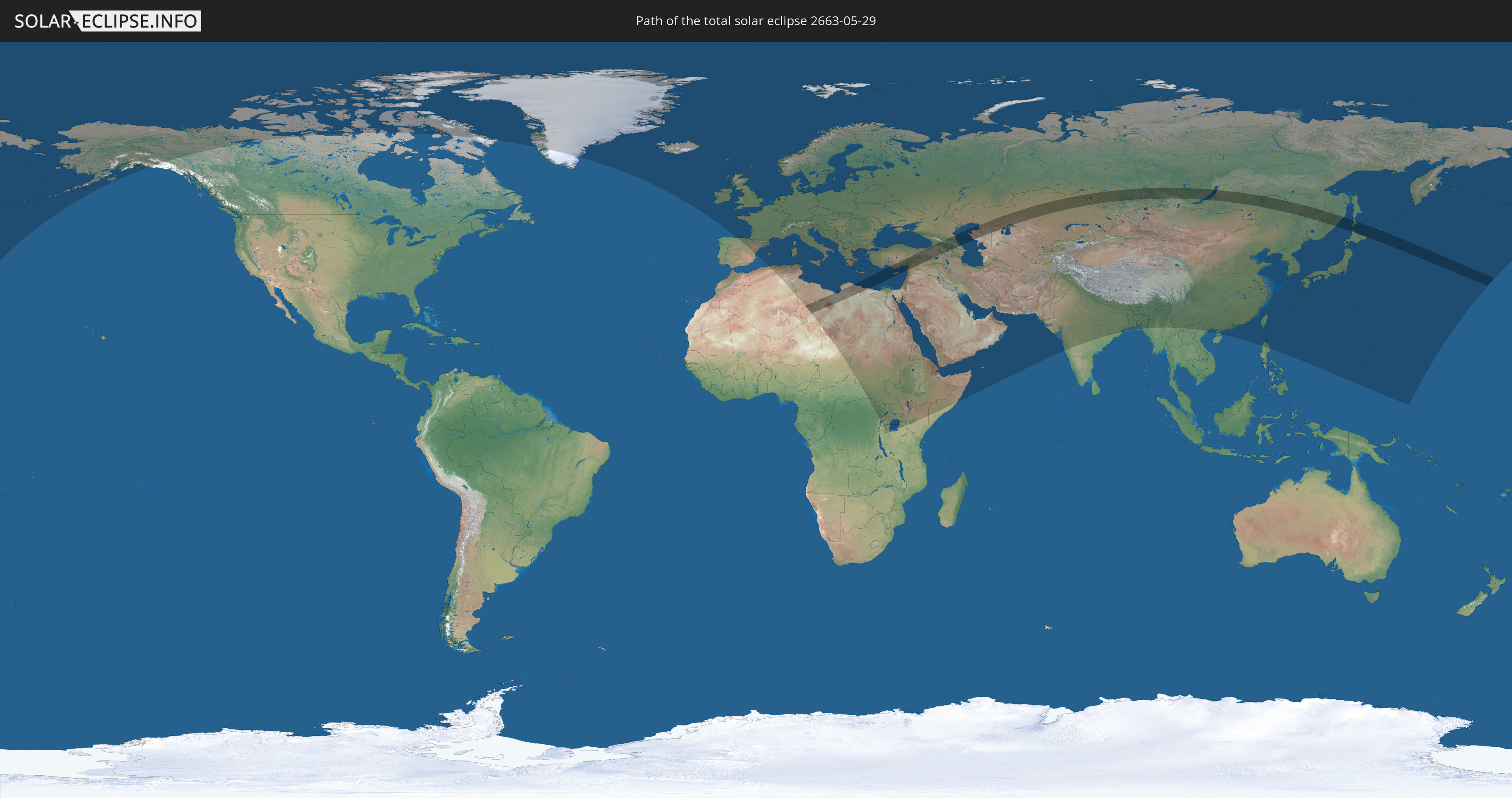
Die Sonnenfinsternis am 05/29/2663 kann man in 113 Ländern als partielle Sonnenfinsternis beobachten.
Der Finsternispfad verläuft durch 13 Länder. Nur in diesen Ländern ist sie als total Sonnenfinsternis zu sehen.
In den folgenden Ländern ist die Sonnenfinsternis total zu sehen
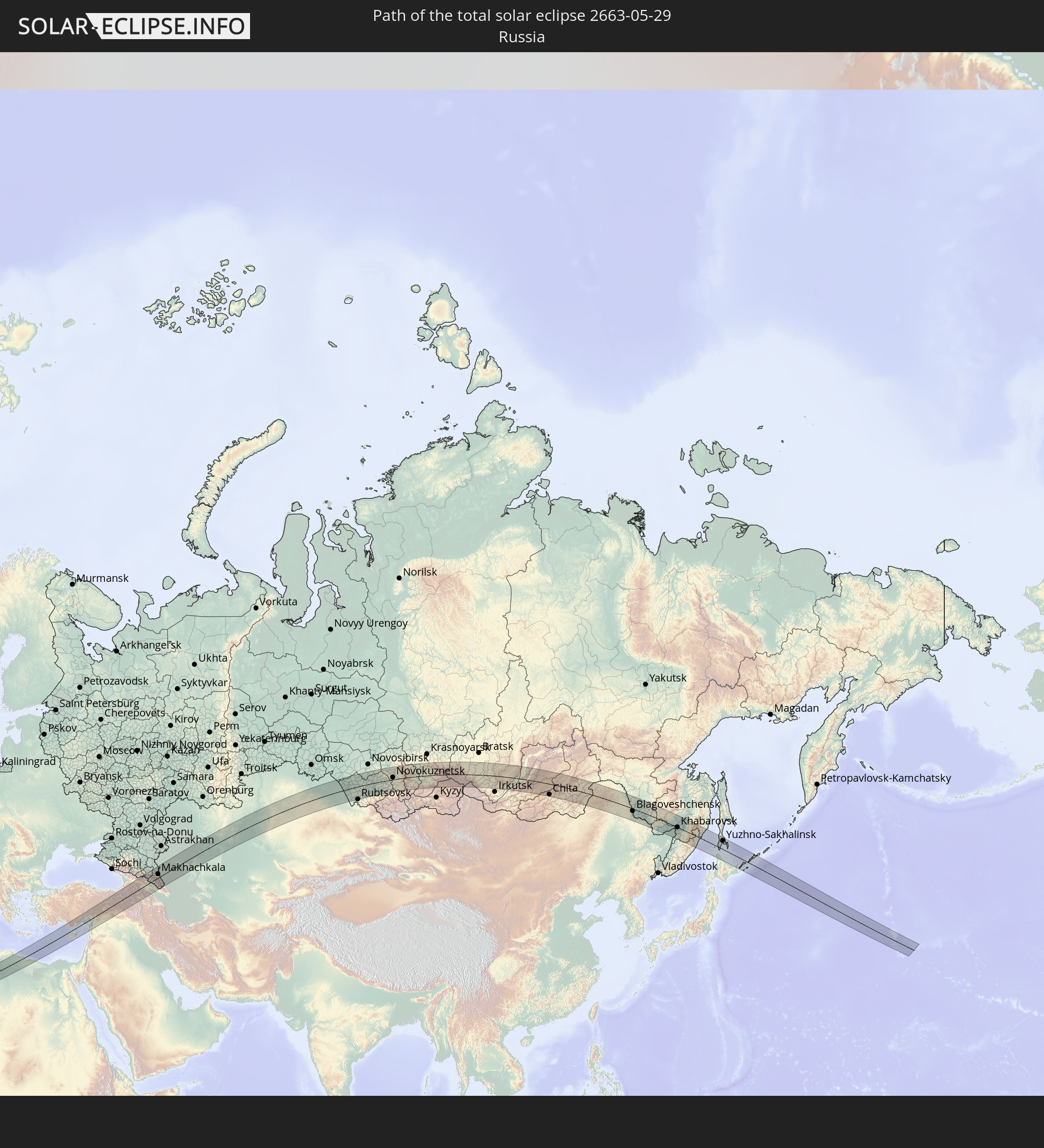 Russia
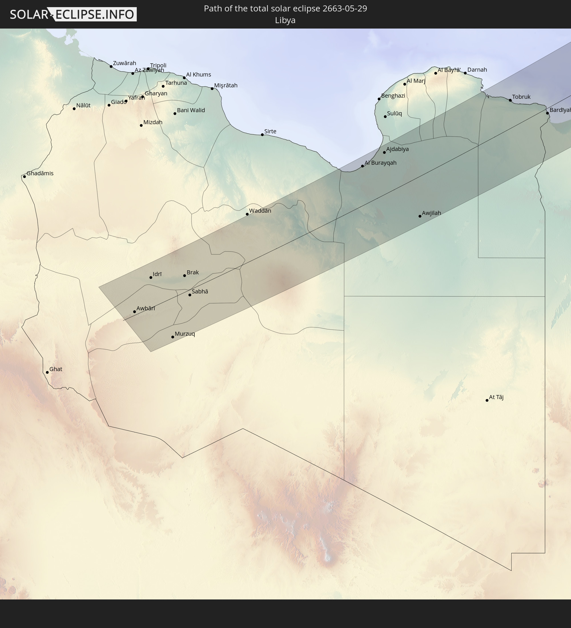 Libya
Libya
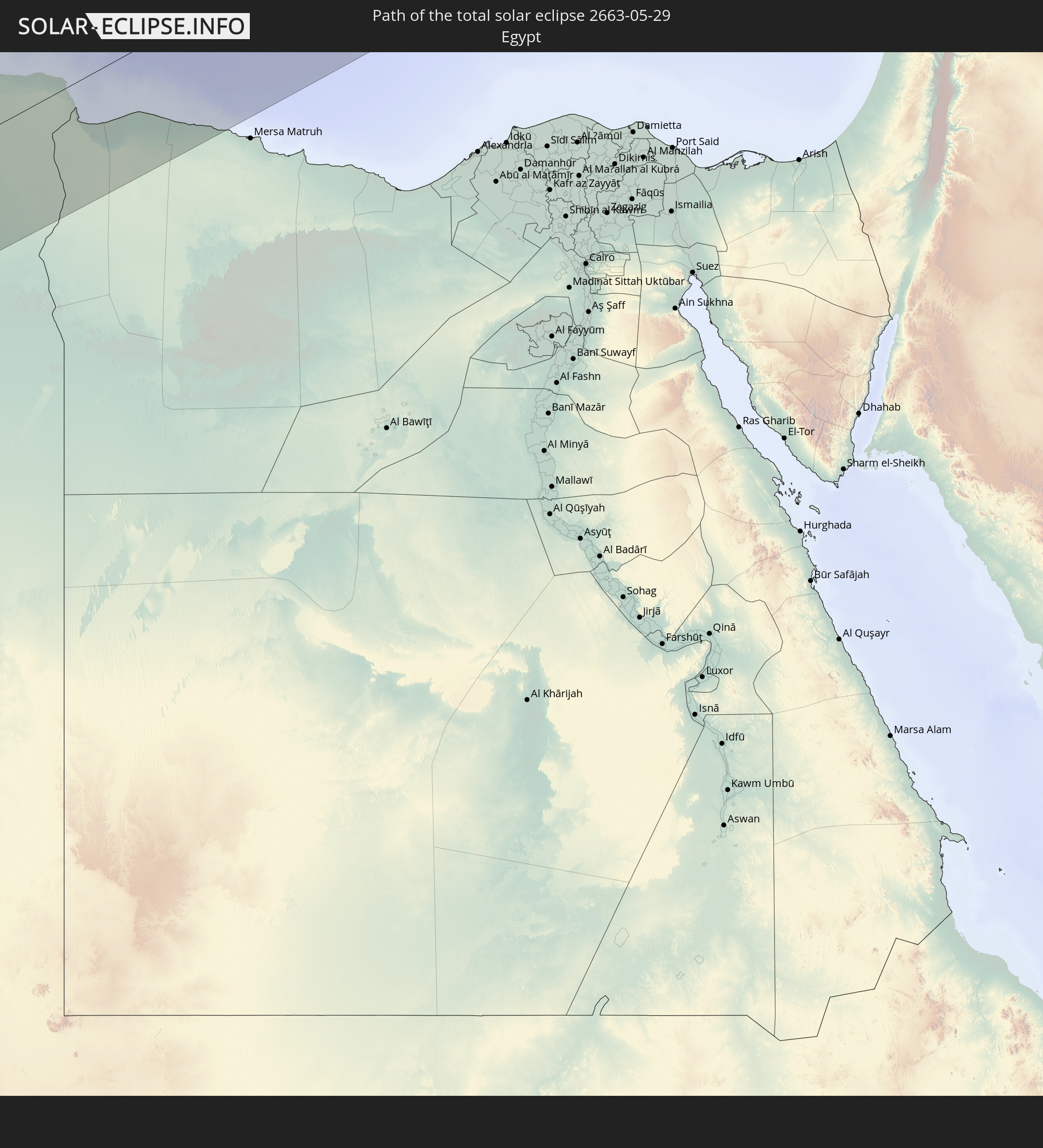 Egypt
Egypt
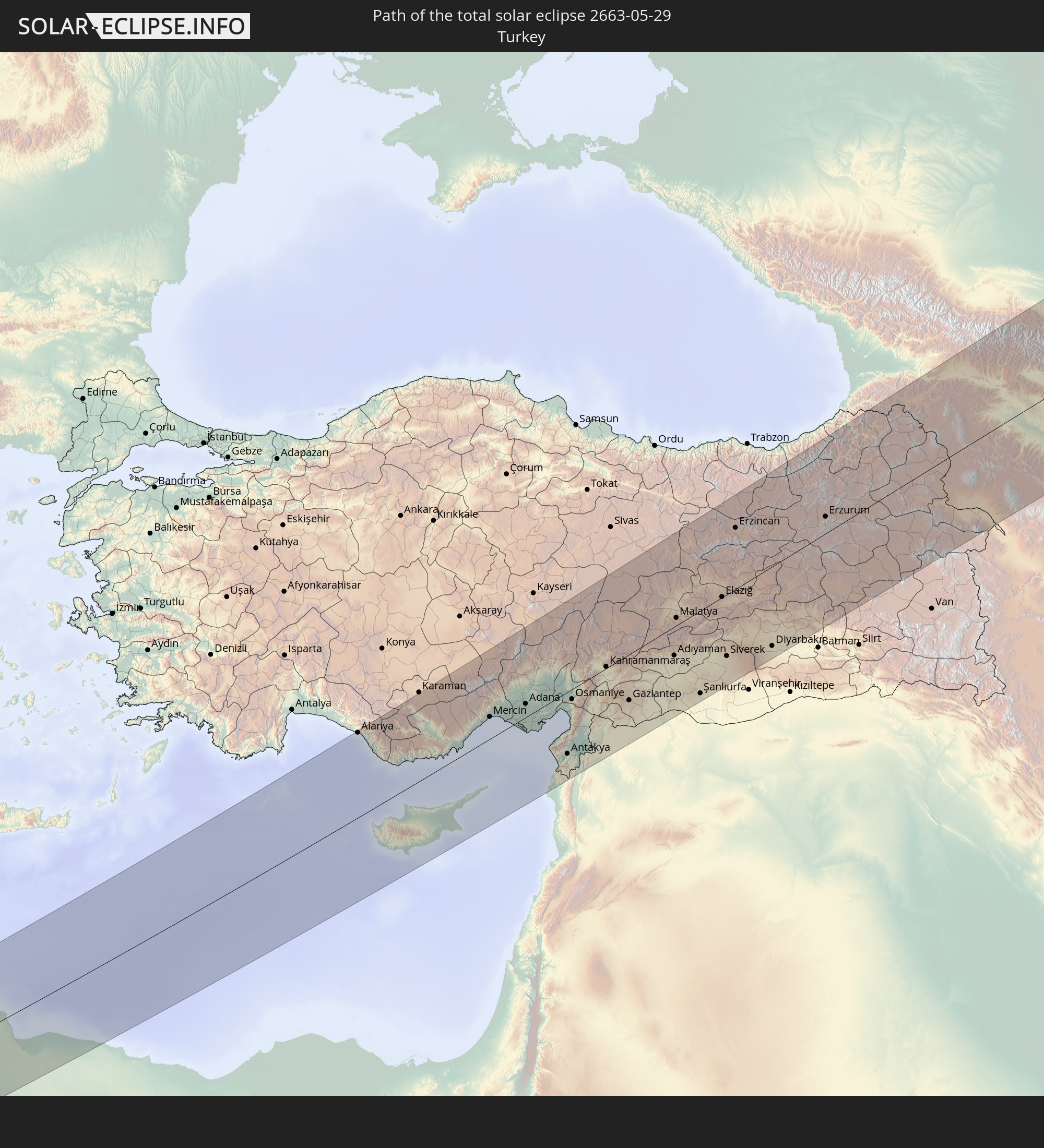 Turkey
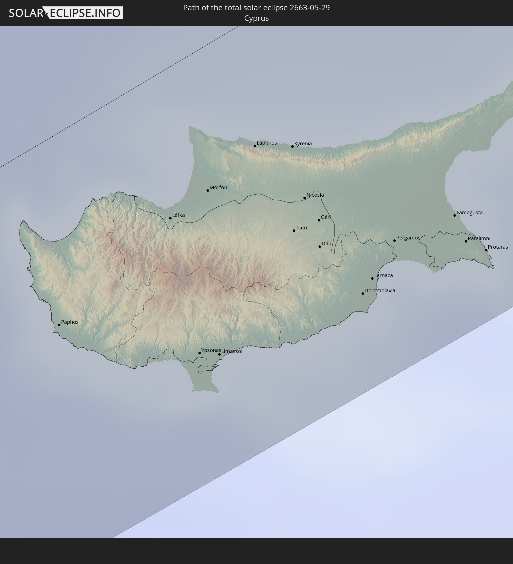 Cyprus
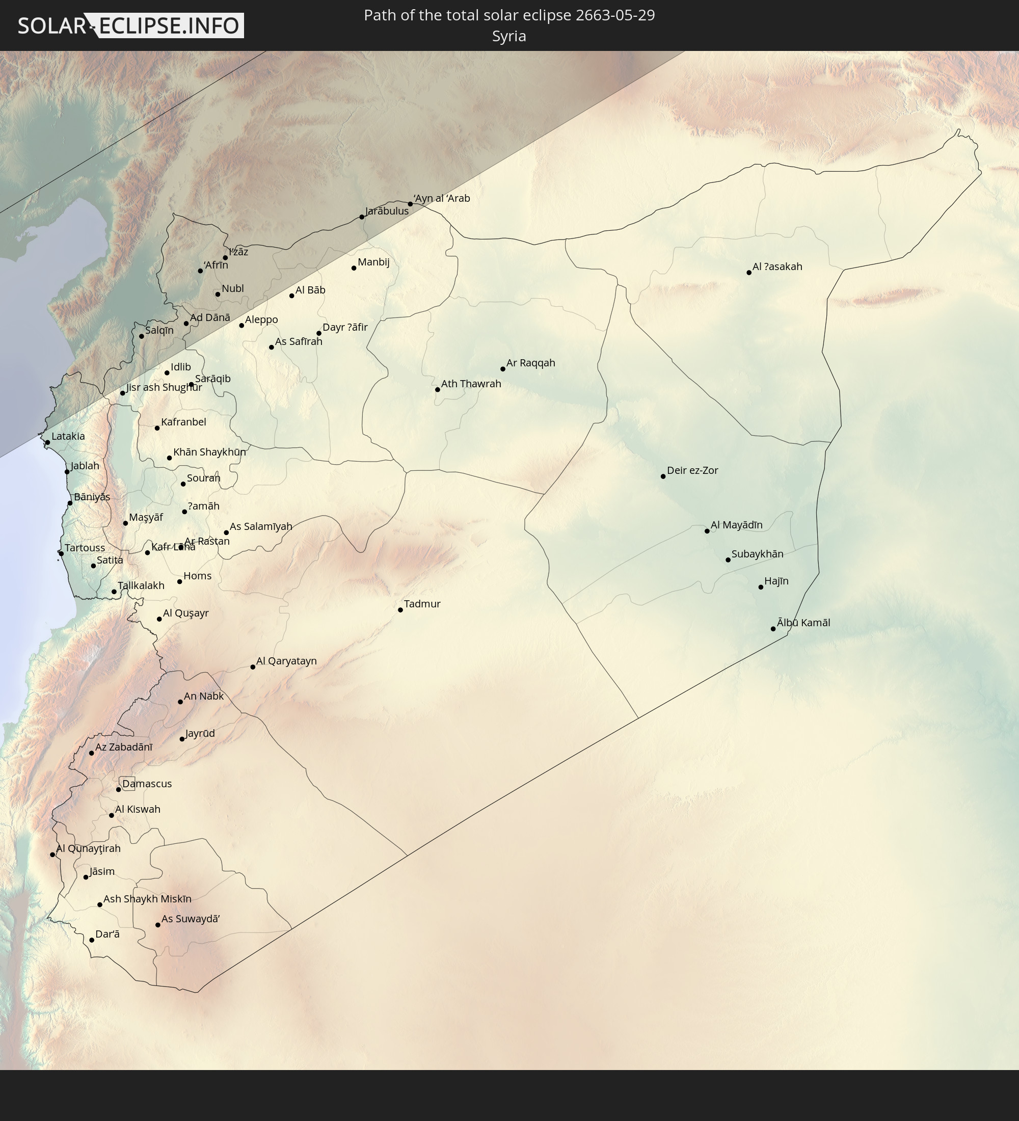 Syria
Syria
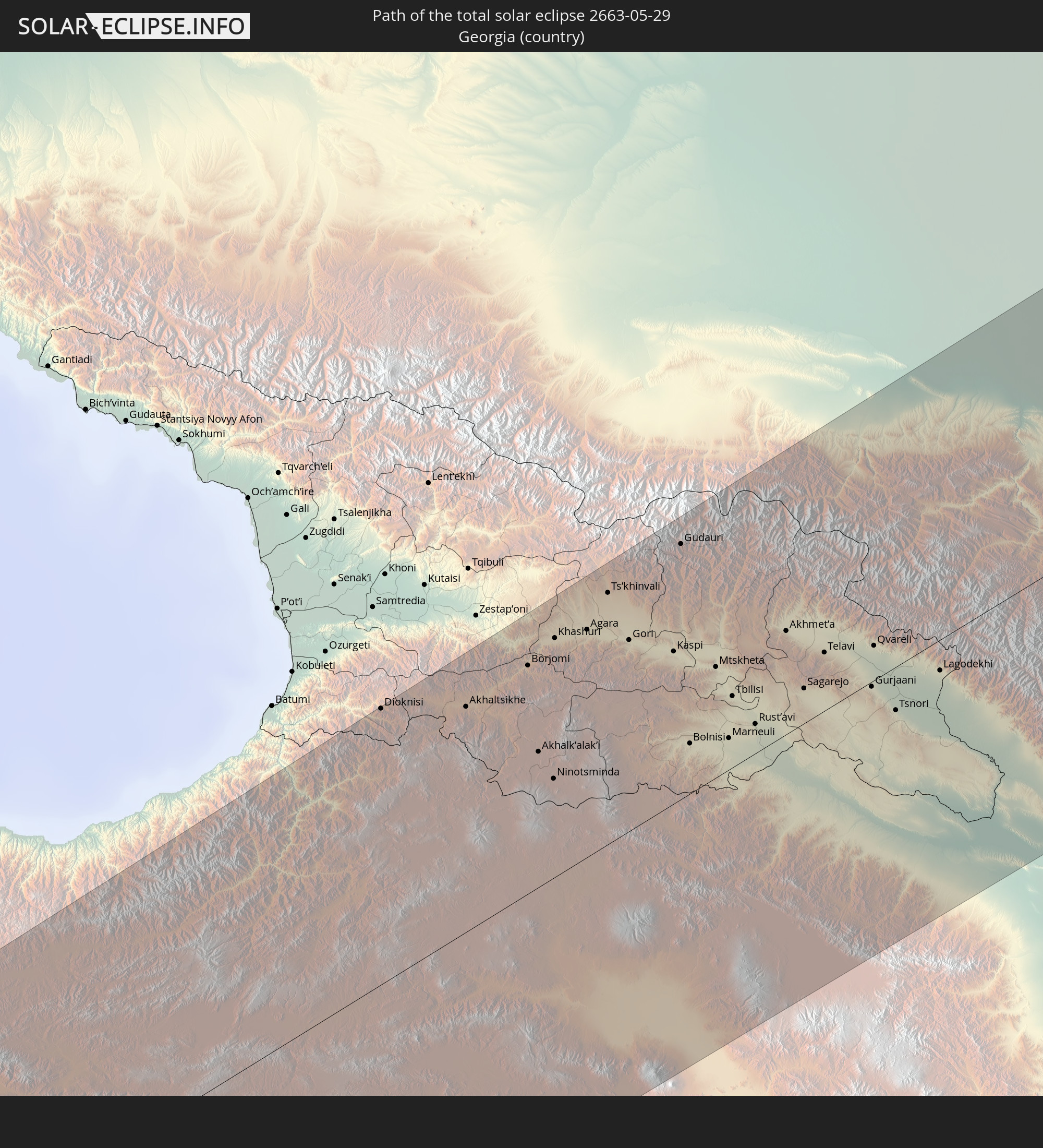 Georgia
 Armenia
 Azerbaijan
 Kazakhstan
 Uzbekistan
 China
China
 Japan
Japan
In den folgenden Ländern ist die Sonnenfinsternis partiell zu sehen
 Russia
 United States
 Canada
 Greenland
 Iceland
 Spain
Spain
 Republic of Ireland
 Svalbard and Jan Mayen
 Algeria
 United Kingdom
 Faroe Islands
 France
 Isle of Man
 Guernsey
 Jersey
 Andorra
 Belgium
 Netherlands
 Norway
 Luxembourg
 Germany
 Switzerland
 Italy
Italy
 Monaco
 Tunisia
 Denmark
 Libya
Libya
 Liechtenstein
 Austria
 Sweden
 Czechia
 Democratic Republic of the Congo
 San Marino
 Vatican City
 Slovenia
 Chad
Chad
 Croatia
 Poland
 Malta
Malta
 Central African Republic
 Bosnia and Herzegovina
 Hungary
 Slovakia
 Montenegro
 Serbia
 Albania
 Åland Islands
 Greece
 Romania
 Republic of Macedonia
 Finland
 Lithuania
 Latvia
 Estonia
 Sudan
Sudan
 Ukraine
 Bulgaria
 Belarus
 Egypt
Egypt
 Turkey
 Moldova
 Rwanda
 Tanzania
 Uganda
 Cyprus
 Ethiopia
 Kenya
Kenya
 State of Palestine
 Israel
 Saudi Arabia
 Jordan
 Lebanon
 Syria
Syria
 Eritrea
 Iraq
Iraq
 Georgia
 Somalia
 Djibouti
 Yemen
Yemen
 Armenia
 Iran
Iran
 Azerbaijan
 Kazakhstan
 Kuwait
 Bahrain
 Qatar
Qatar
 United Arab Emirates
 Oman
Oman
 Turkmenistan
 Uzbekistan
 Afghanistan
 Pakistan
 Tajikistan
 India
India
 Kyrgyzstan
 China
China
 Nepal
Nepal
 Mongolia
 Bangladesh
 Bhutan
 Myanmar
 Laos
Laos
 Vietnam
 Macau
Macau
 Hong Kong
 Taiwan
 Philippines
 Japan
Japan
 North Korea
 South Korea
 Federated States of Micronesia
 Guam
Guam
 Northern Mariana Islands
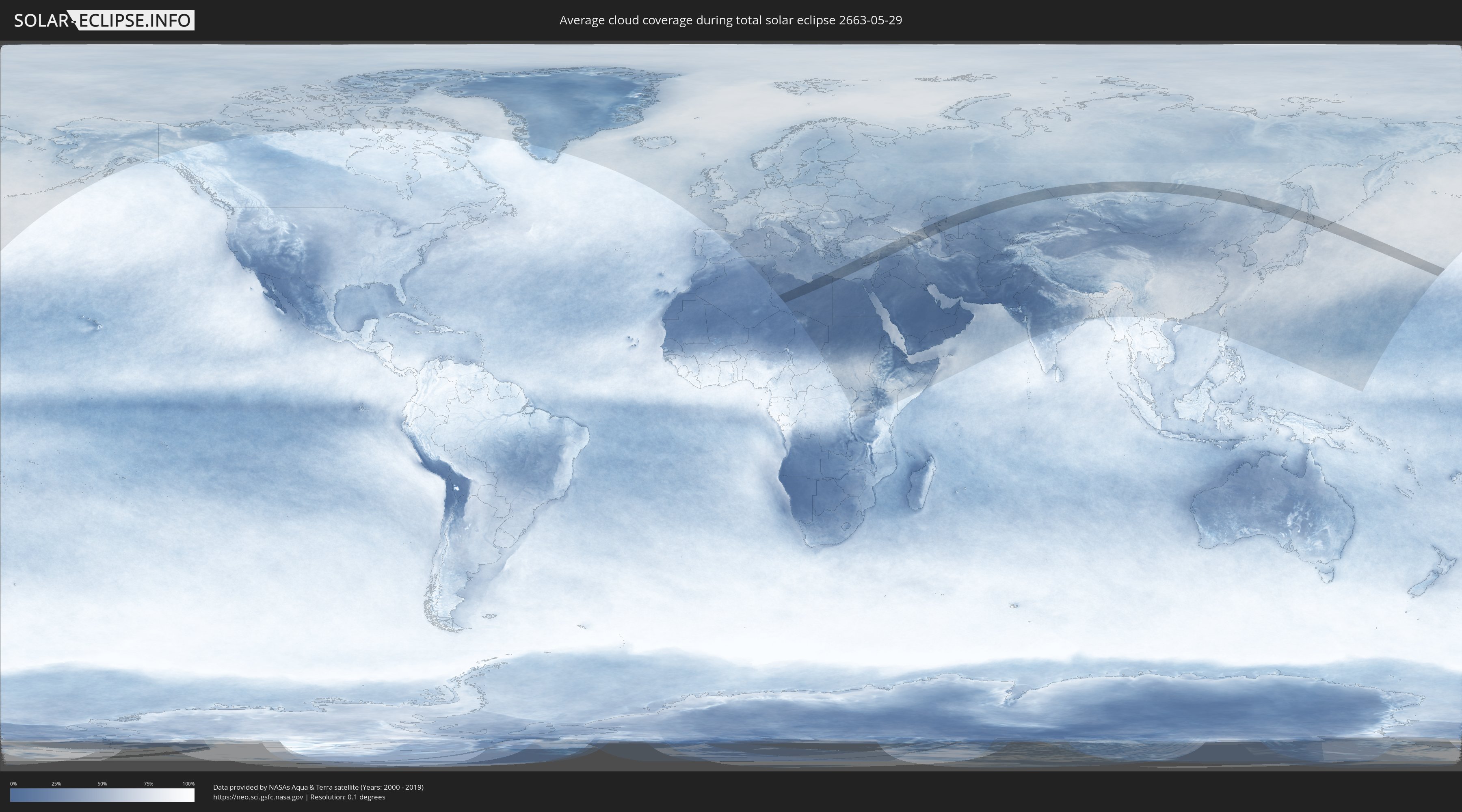
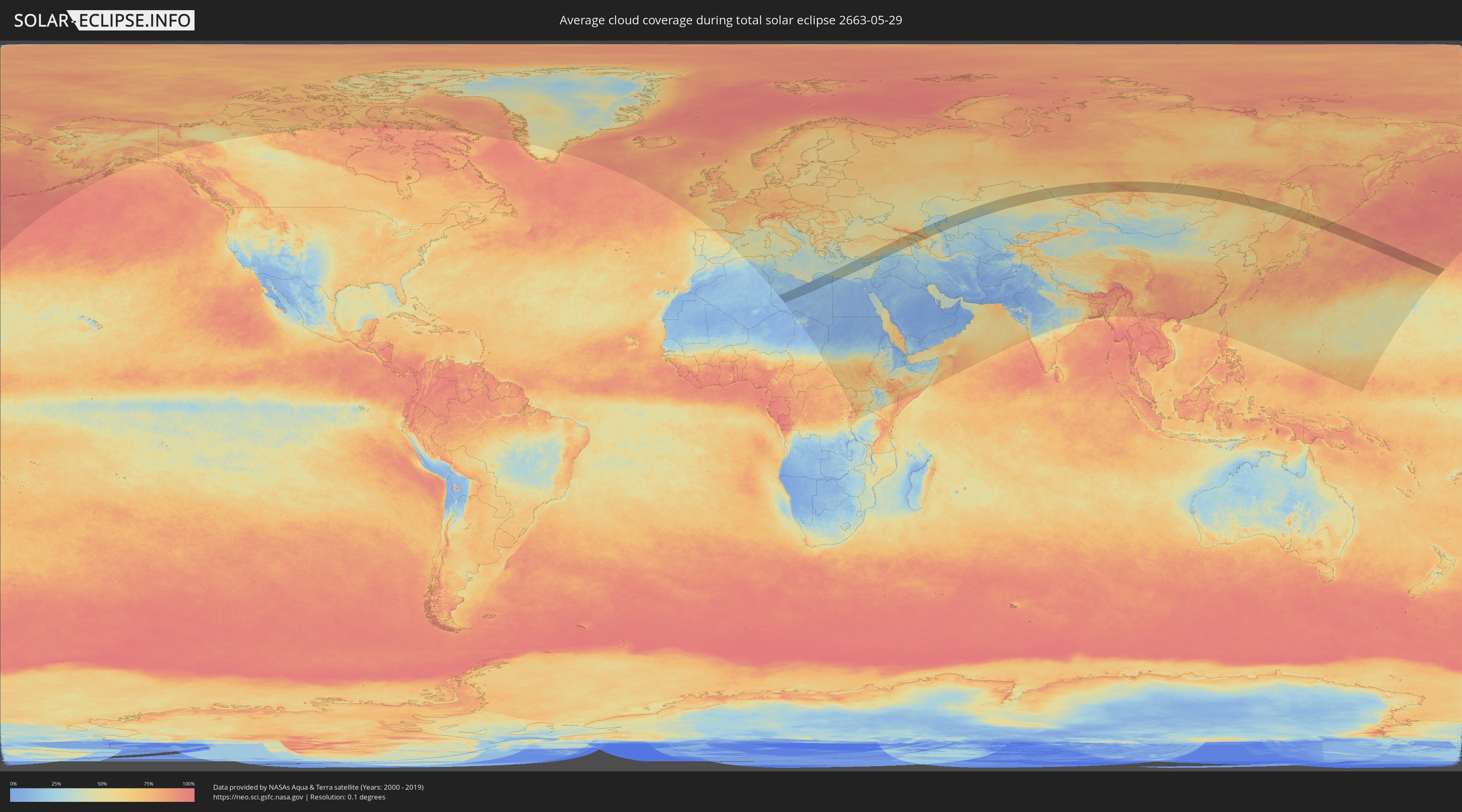
How will be the weather during the total solar eclipse on 05/29/2663?
Where is the best place to see the total solar eclipse of 05/29/2663?
The following maps show the average cloud coverage for the day of the total solar eclipse.
With the help of these maps, it is possible to find the place along the eclipse path, which has the best
chance of a cloudless sky.
Nevertheless, you should consider local circumstances and inform about the weather of your chosen
observation site.
The data is provided by NASAs satellites
AQUA and TERRA.
The cloud maps are averaged over a period of 19 years (2000 - 2019).
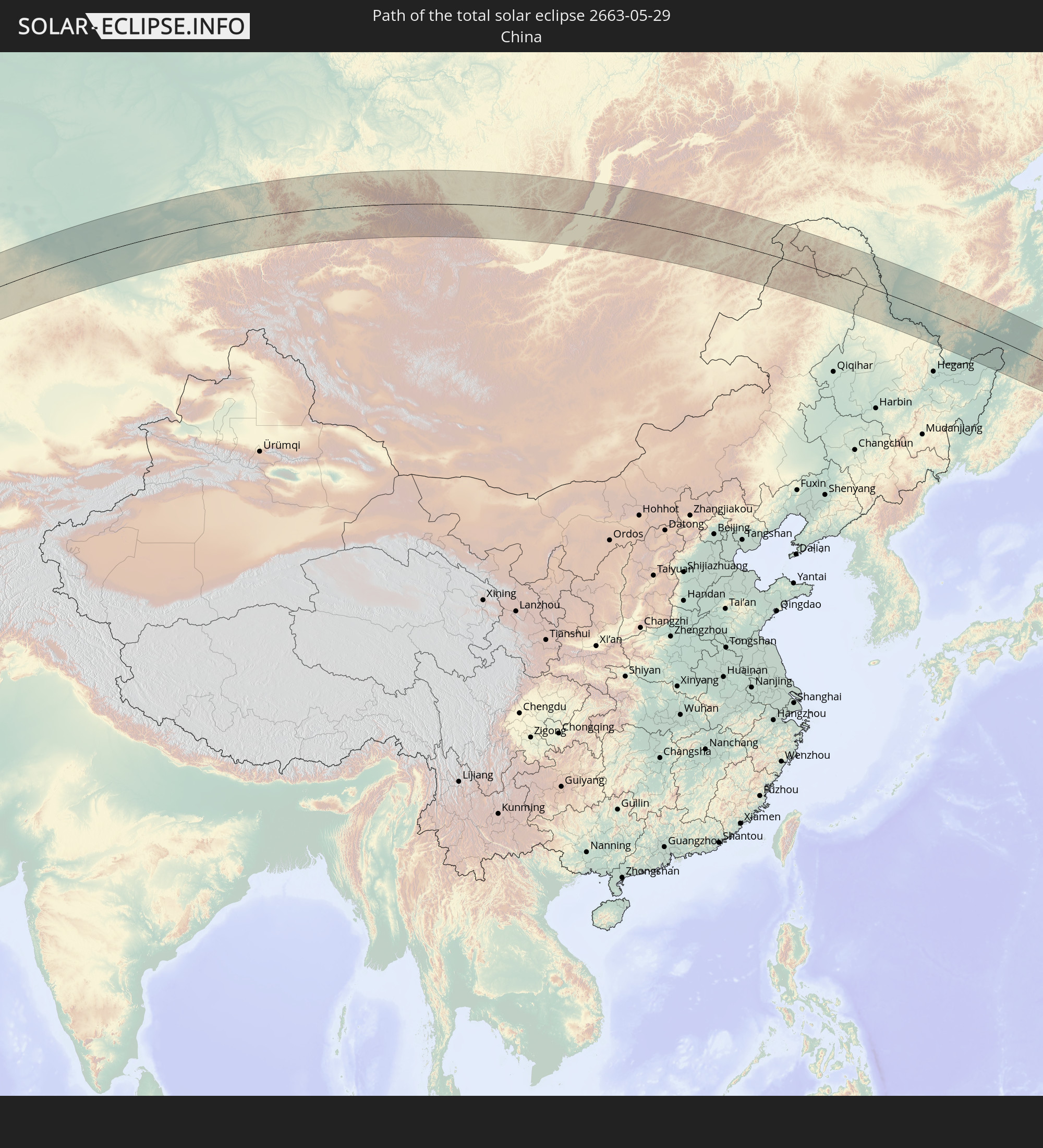
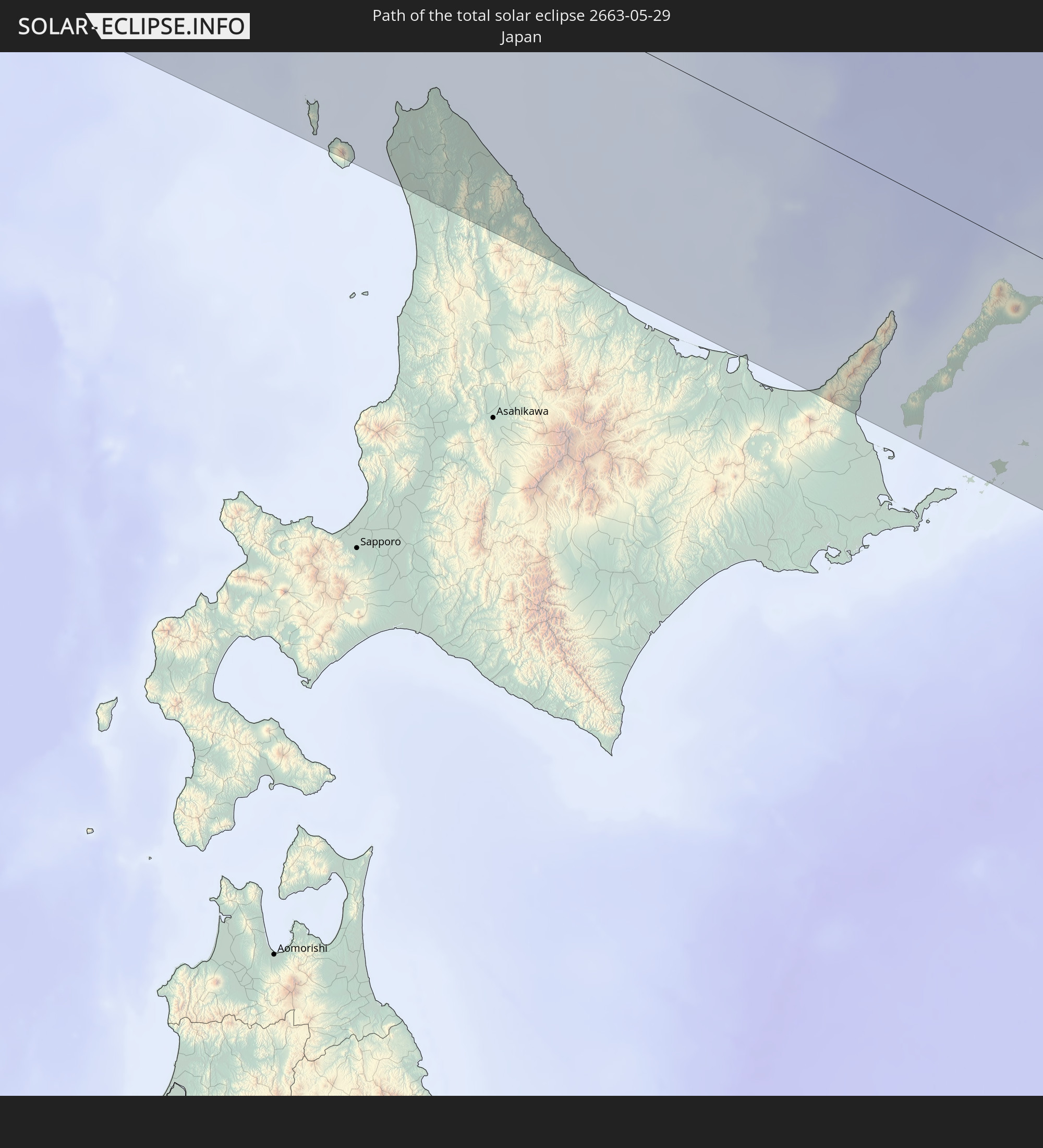
Detailed country maps
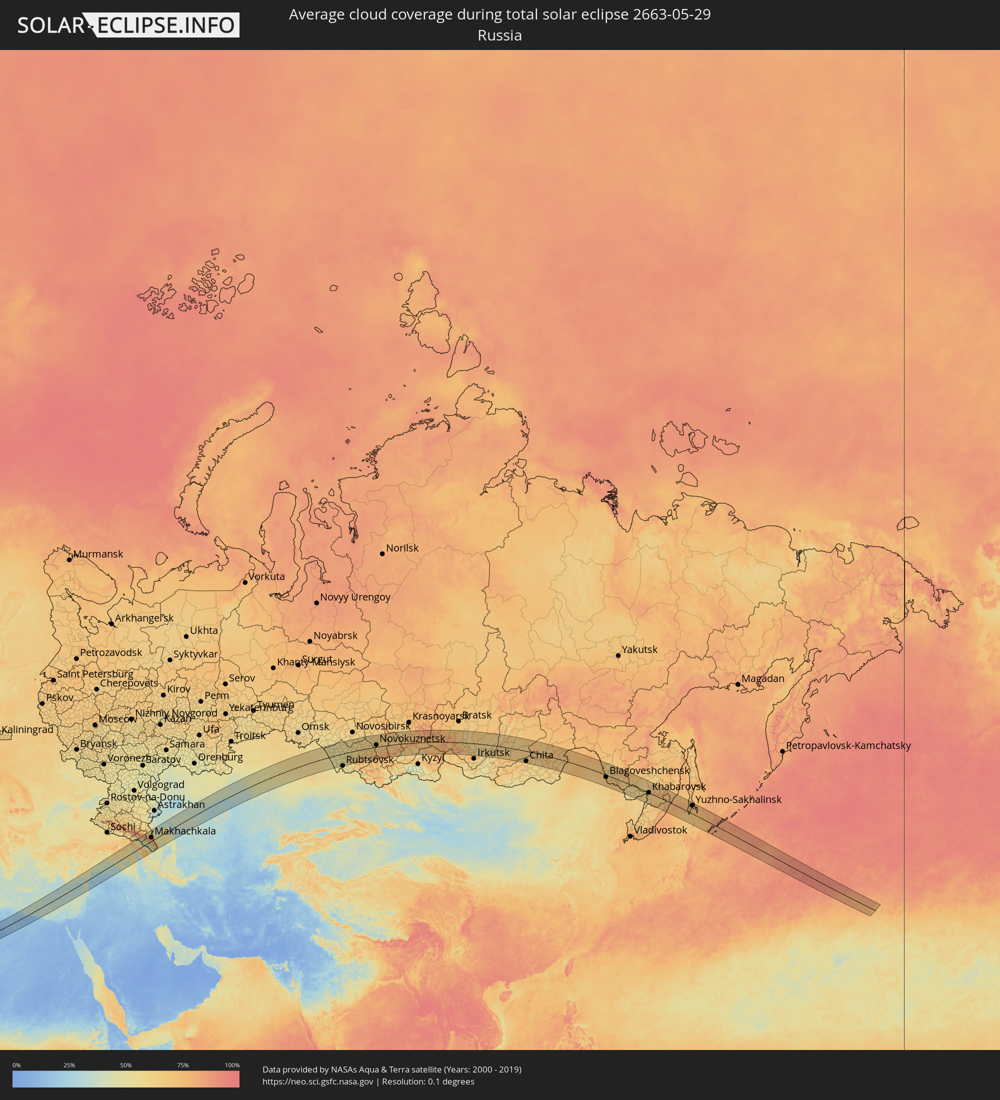 Russia
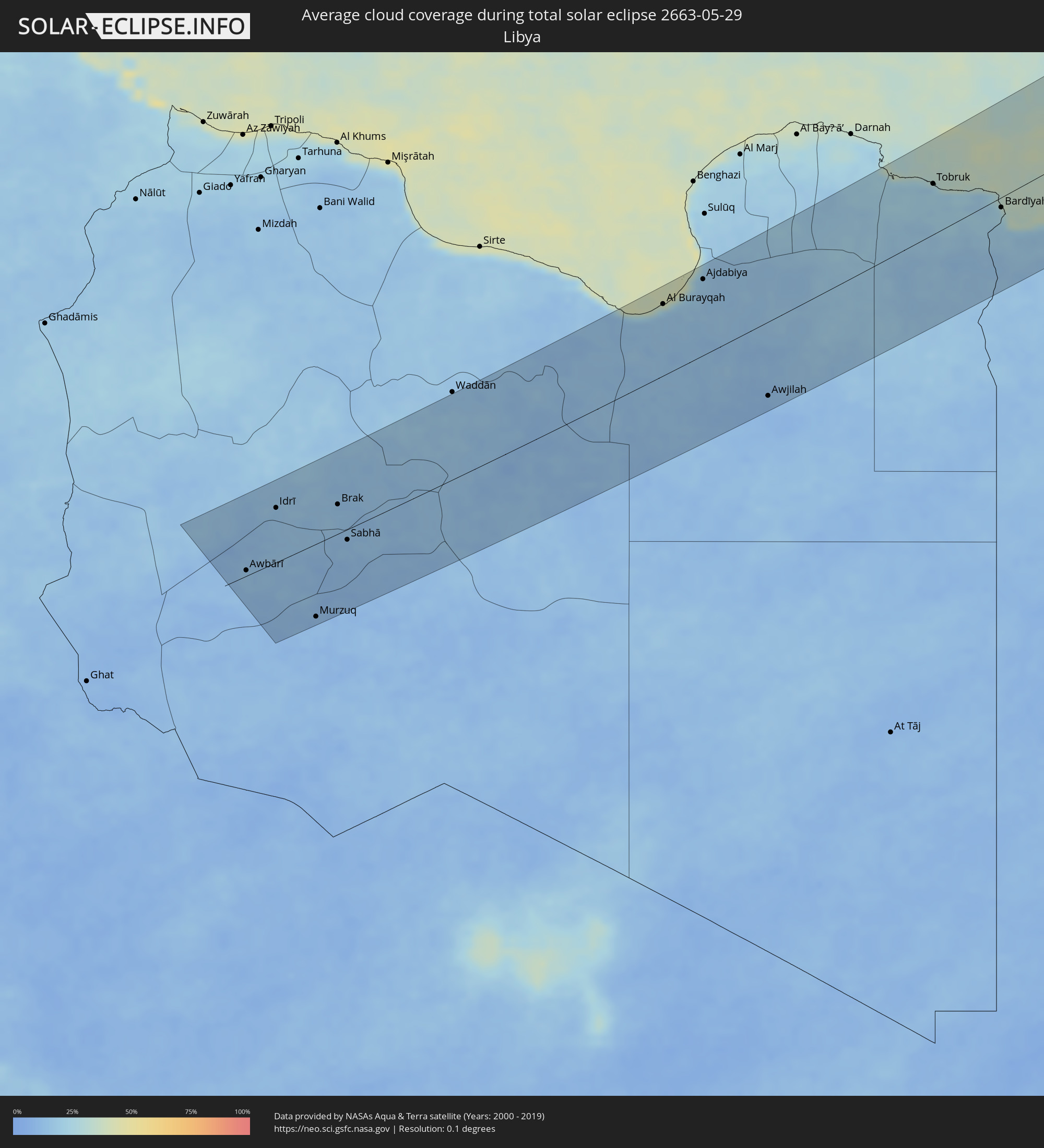 Libya
Libya
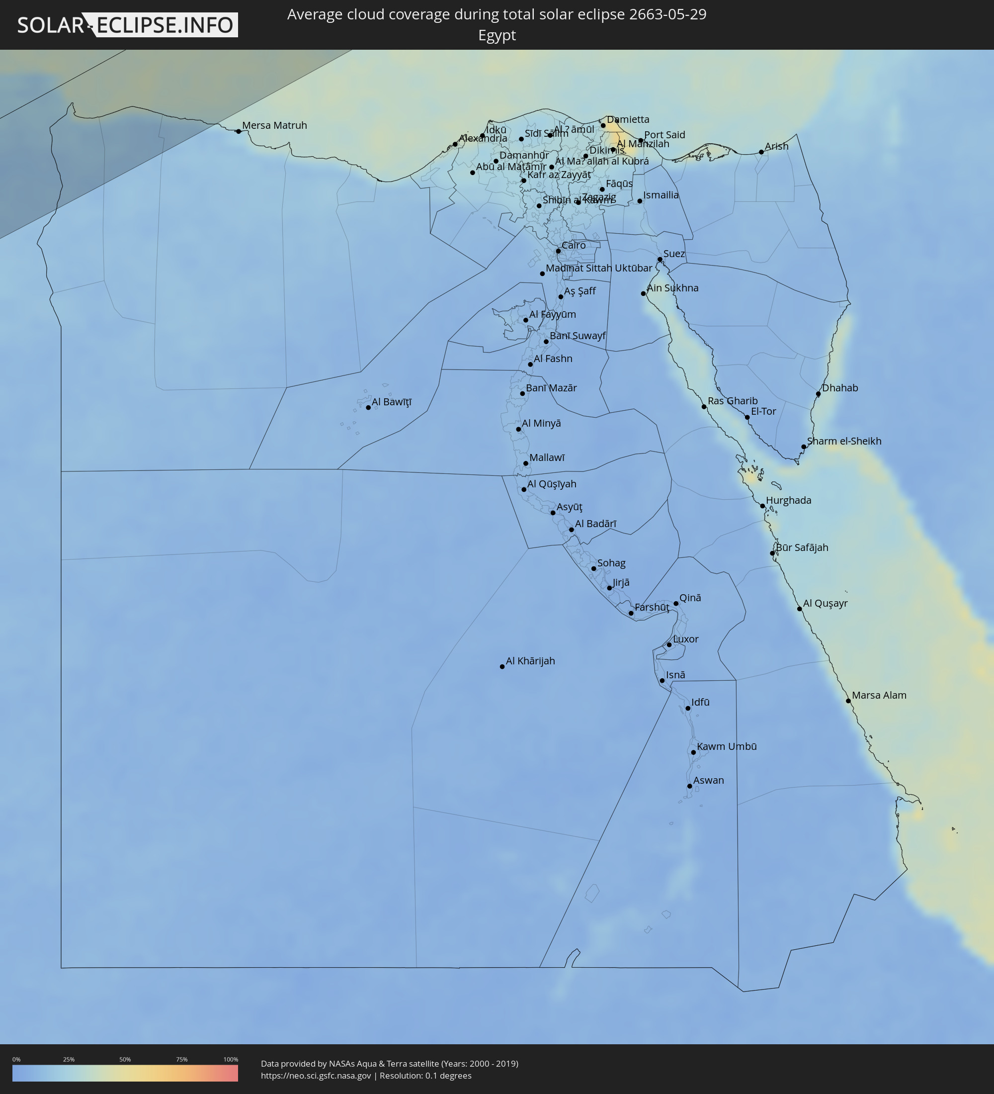 Egypt
Egypt
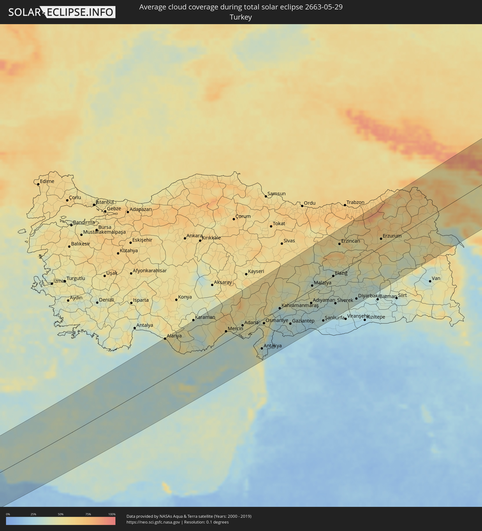 Turkey
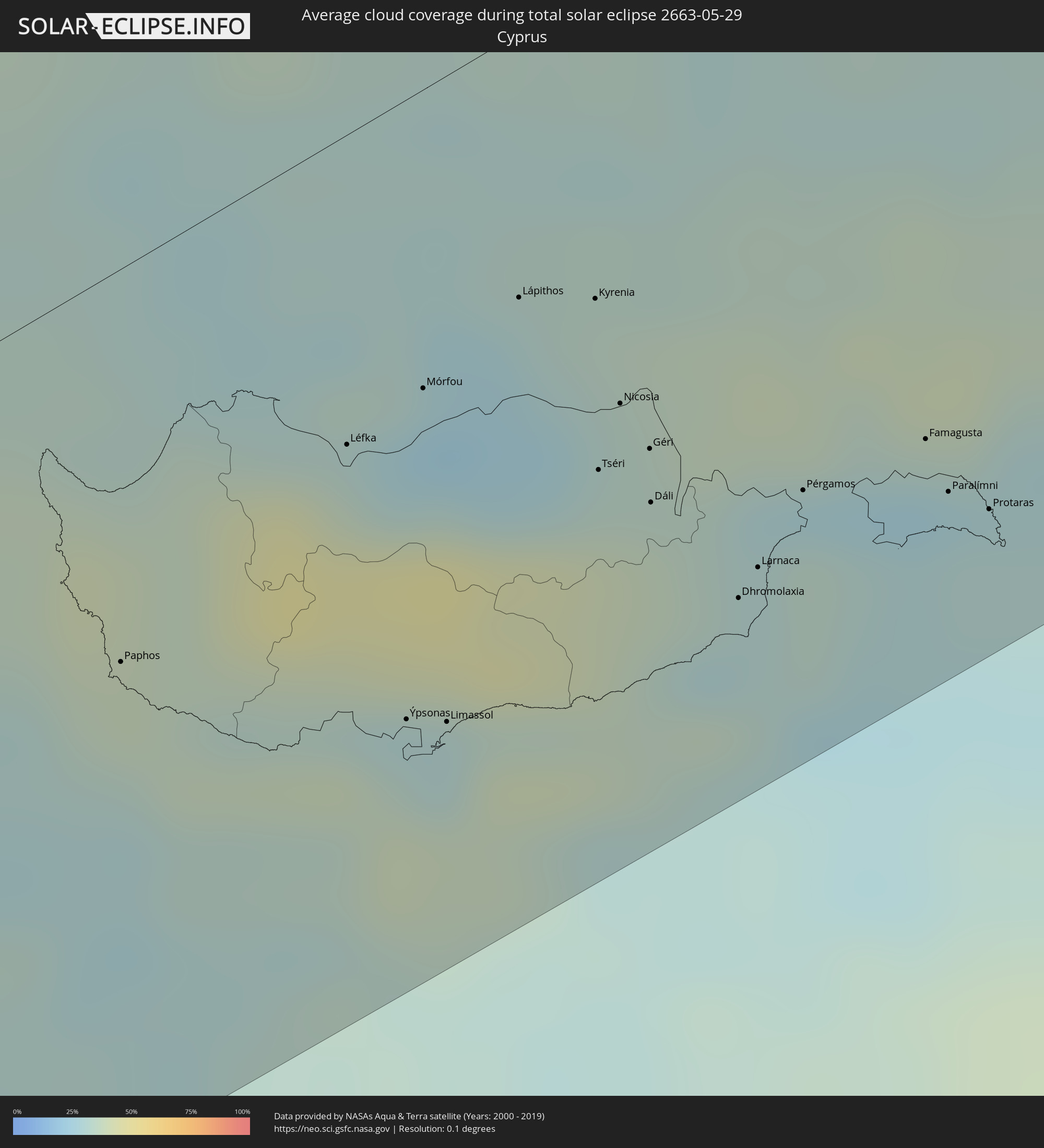 Cyprus
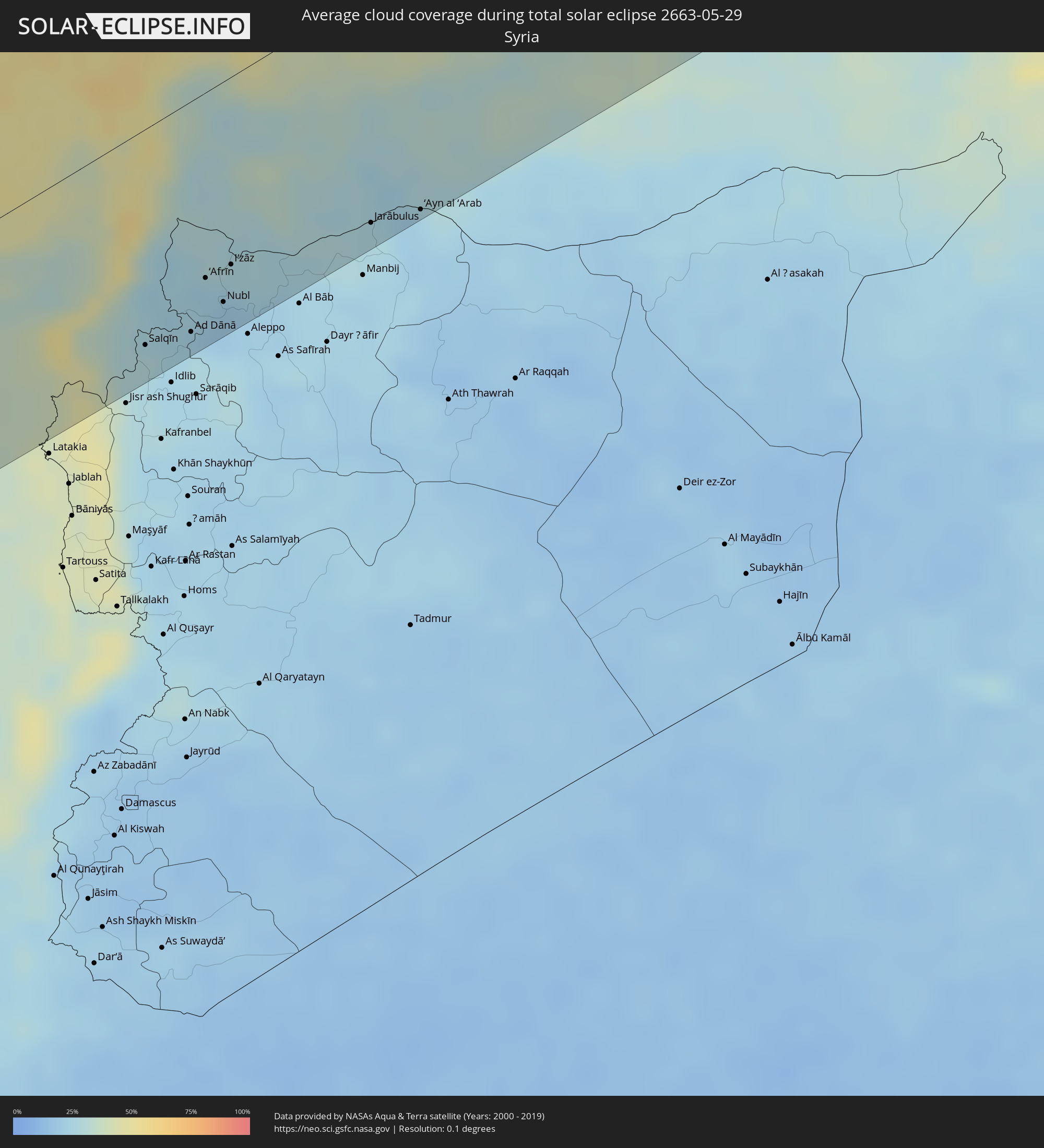 Syria
Syria
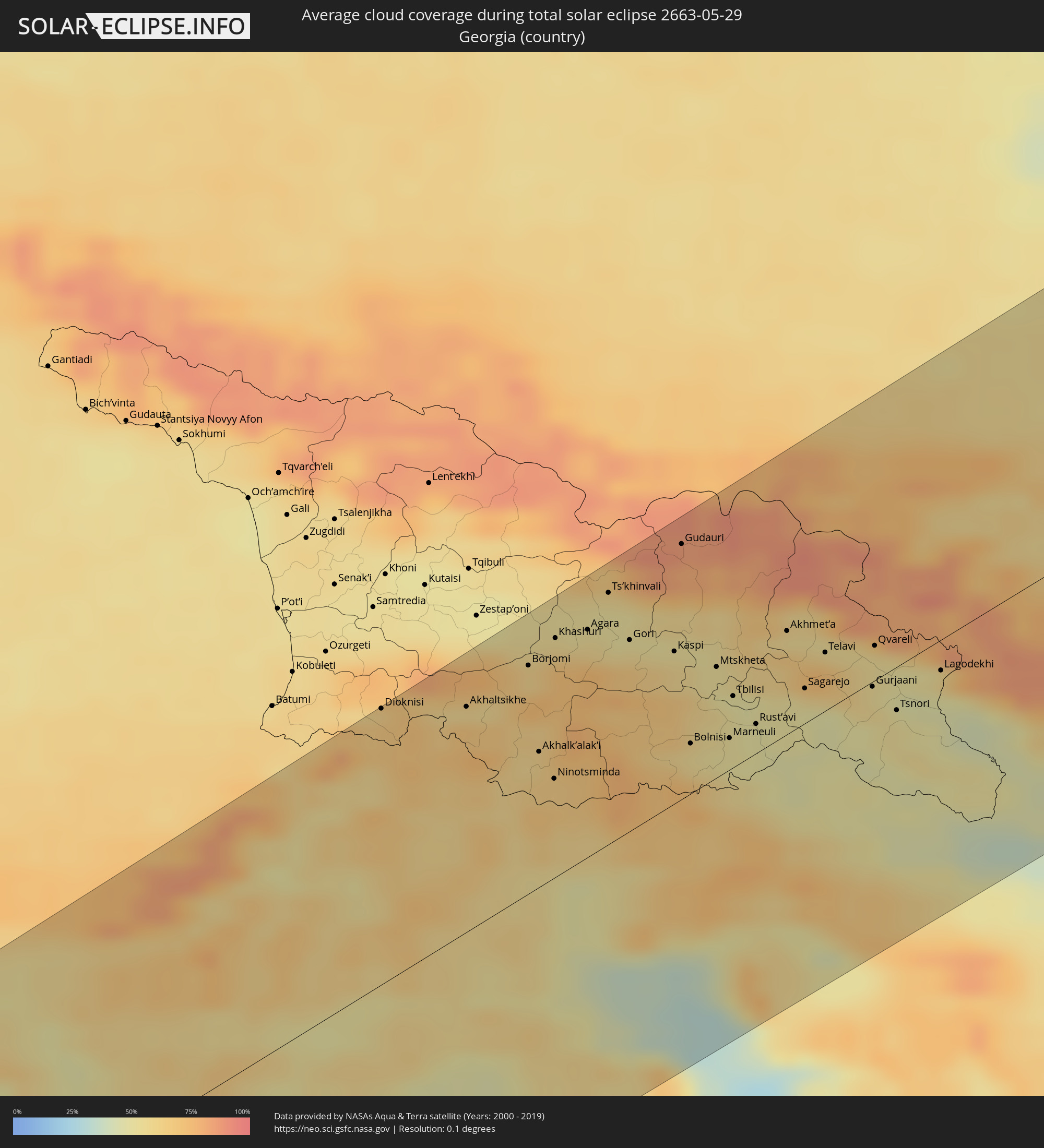 Georgia
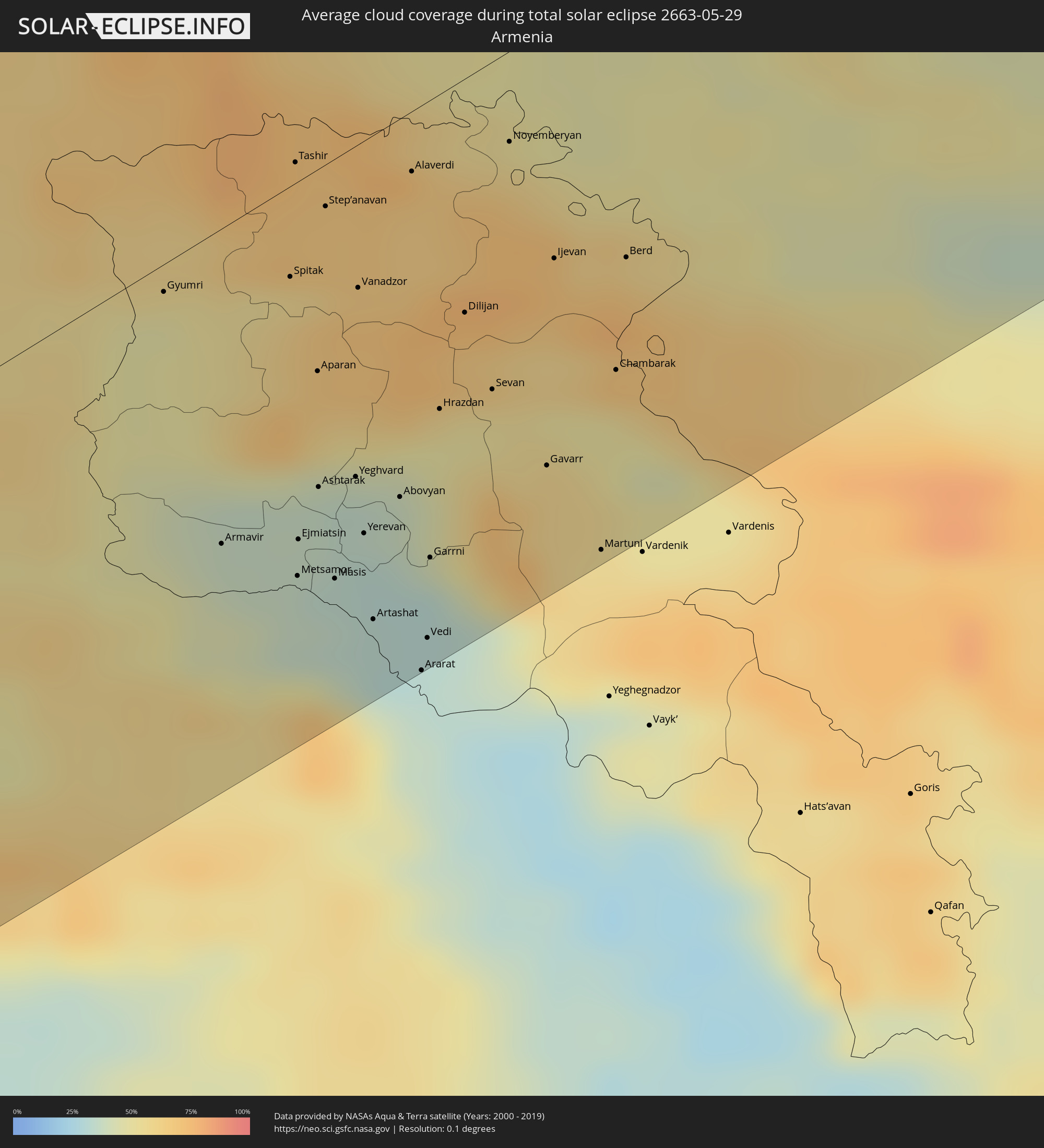 Armenia
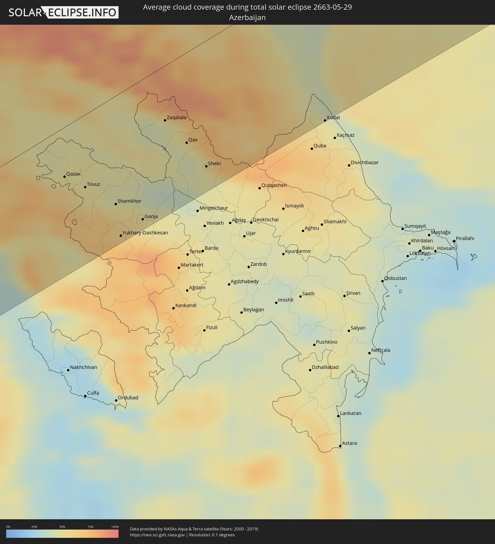 Azerbaijan
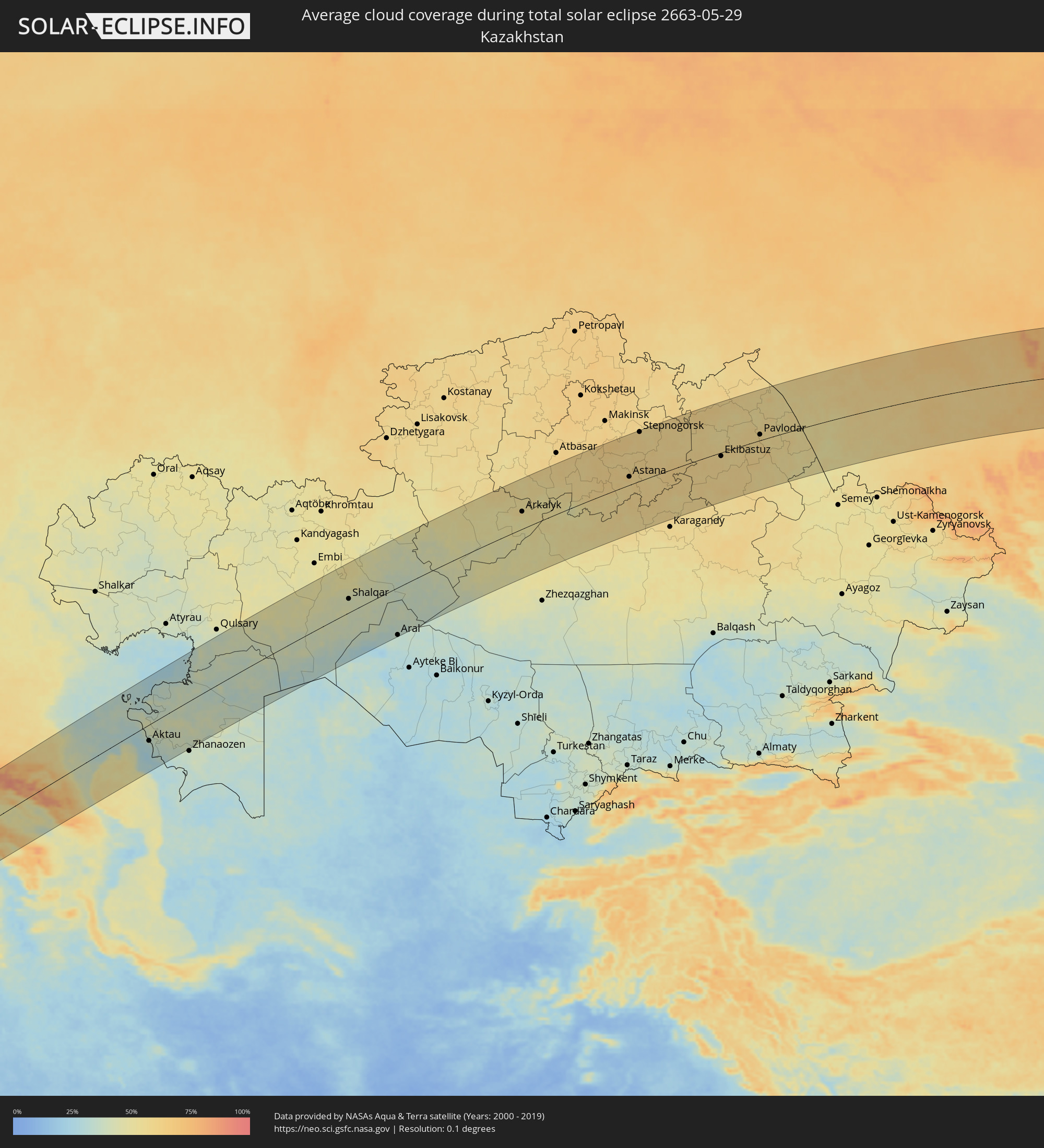 Kazakhstan
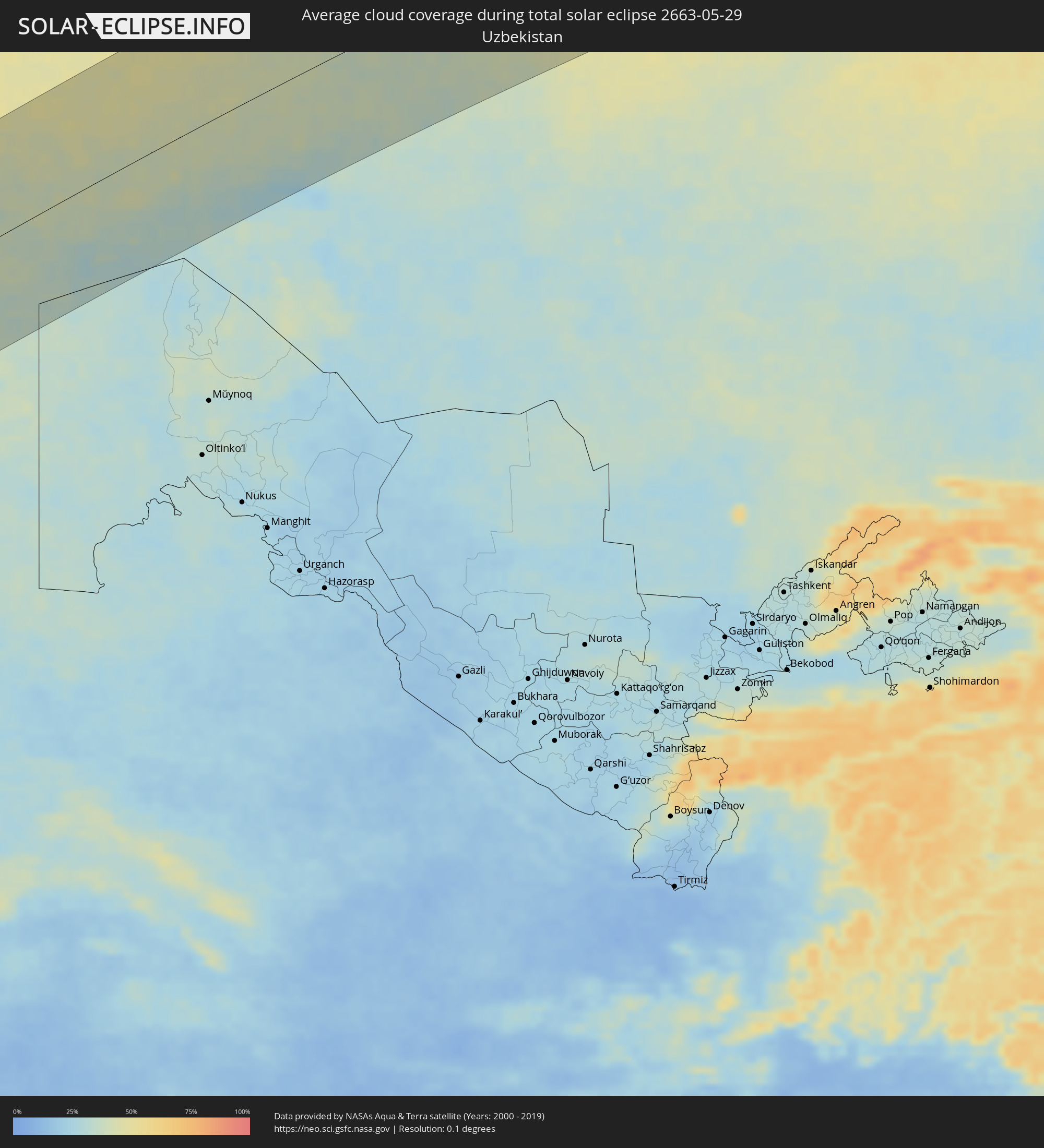 Uzbekistan
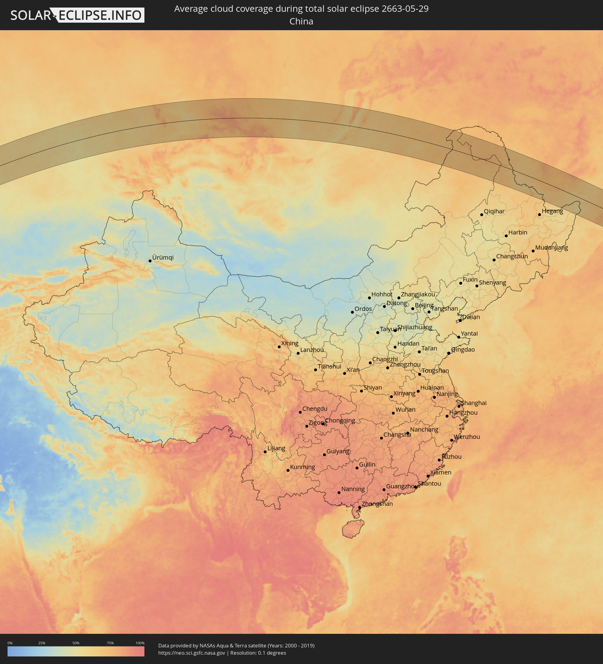 China
China
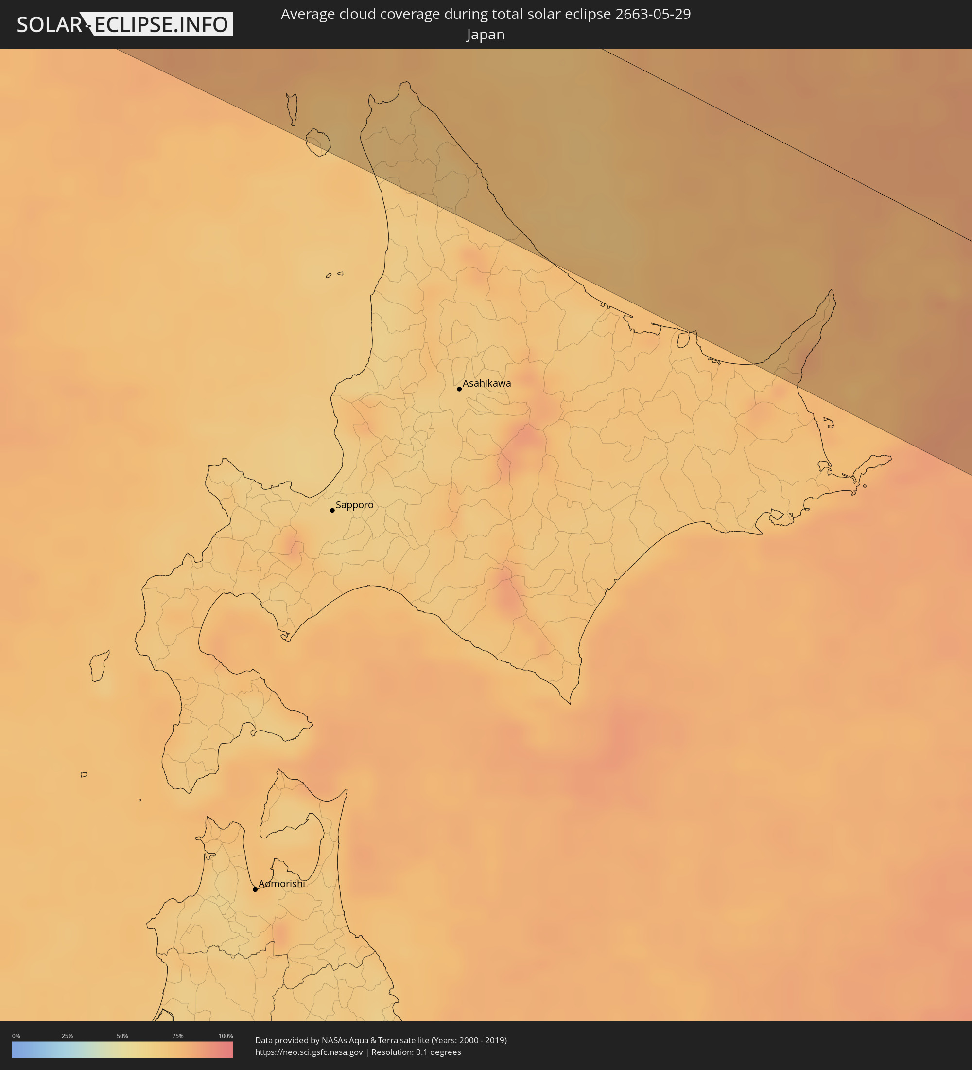 Japan
Japan
Cities inside the path of the eclipse
The following table shows all locations with a population of more than 5,000 inside the eclipse path. Cities which have more than 100,000 inhabitants are marked bold. A click at the locations opens a detailed map.
| City | Type | Eclipse duration | Local time of max. eclipse | Distance to central line | Ø Cloud coverage |
|
Awbārī, Sha‘bīyat Wādī al Ḩayāt
|
total | - | 06:23:47 UTC+02:00 | 22 km | 14% |
|
Idrī, Ash Shāţiʼ
|
total | - | 06:24:29 UTC+02:00 | 81 km | 14% |
|
Murzuq, Murzuq
|
total | - | 06:22:44 UTC+02:00 | 107 km | 11% |
|
Brak, Ash Shāţiʼ
|
total | - | 06:24:11 UTC+02:00 | 43 km | 14% |
|
Al Jadīd, Sabhā
|
total | - | 06:23:39 UTC+02:00 | 21 km | 13% |
|
Sabhā, Sabhā
|
total | - | 06:23:38 UTC+02:00 | 21 km | 14% |
|
Al Burayqah, Sha‘bīyat al Wāḩāt
|
total | - | 06:25:47 UTC+02:00 | 100 km | 19% |
|
Ajdabiya, Sha‘bīyat al Wāḩāt
|
total | - | 06:26:03 UTC+02:00 | 109 km | 17% |
|
Awjilah, Sha‘bīyat al Wāḩāt
|
total | - | 06:24:01 UTC+02:00 | 106 km | 11% |
|
Tobruk, Sha‘bīyat al Buţnān
|
total | - | 06:27:06 UTC+02:00 | 69 km | 25% |
|
Bardīyah, Sha‘bīyat al Buţnān
|
total | - | 06:26:38 UTC+02:00 | 14 km | 30% |
|
Alanya, Antalya
|
total | - | 07:33:10 UTC+03:00 | 133 km | 35% |
|
Paphos, Pafos
|
total | - | 06:30:50 UTC+02:00 | 59 km | 37% |
|
Léfka, Nicosia
|
total | - | 06:31:22 UTC+02:00 | 47 km | 37% |
|
Ýpsonas, Limassol
|
total | - | 06:30:49 UTC+02:00 | 92 km | 31% |
|
Mórfou, Nicosia
|
total | - | 06:31:30 UTC+02:00 | 51 km | 24% |
|
Limassol, Limassol
|
total | - | 06:30:49 UTC+02:00 | 95 km | 31% |
|
Lápithos, Keryneia
|
total | - | 06:31:44 UTC+02:00 | 39 km | 29% |
|
Kyrenia, Keryneia
|
total | - | 06:31:45 UTC+02:00 | 46 km | 33% |
|
Tséri, Nicosia
|
total | - | 06:31:24 UTC+02:00 | 72 km | 33% |
|
Nicosia, Nicosia
|
total | - | 06:31:33 UTC+02:00 | 63 km | 34% |
|
Géri, Nicosia
|
total | - | 06:31:28 UTC+02:00 | 73 km | 34% |
|
Dáli, Nicosia
|
total | - | 06:31:21 UTC+02:00 | 81 km | 36% |
|
Dhromolaxia, Larnaka
|
total | - | 06:31:11 UTC+02:00 | 102 km | 30% |
|
Aradíppou, Larnaka
|
total | - | 06:31:17 UTC+02:00 | 95 km | 30% |
|
Larnaca, Larnaka
|
total | - | 06:31:15 UTC+02:00 | 100 km | 30% |
|
Livádia, Larnaka
|
total | - | 06:31:17 UTC+02:00 | 97 km | 30% |
|
Pérgamos, Larnaka
|
total | - | 06:31:26 UTC+02:00 | 94 km | 33% |
|
Famagusta, Ammochostos
|
total | - | 06:31:35 UTC+02:00 | 96 km | 26% |
|
Paralímni, Ammochostos
|
total | - | 06:31:29 UTC+02:00 | 105 km | 30% |
|
Ereğli, Konya
|
total | - | 07:34:56 UTC+03:00 | 130 km | 43% |
|
Protaras, Ammochostos
|
total | - | 06:31:28 UTC+02:00 | 111 km | 30% |
|
Mercin, Mersin
|
total | - | 07:34:03 UTC+03:00 | 39 km | 40% |
|
Tarsus, Mersin
|
total | - | 07:34:17 UTC+03:00 | 34 km | 40% |
|
Adana, Adana
|
total | - | 07:34:31 UTC+03:00 | 21 km | 46% |
|
Ceyhan, Adana
|
total | - | 07:34:41 UTC+03:00 | 19 km | 44% |
|
Antakya, Hatay
|
total | - | 07:33:37 UTC+03:00 | 94 km | 32% |
|
İskenderun, Hatay
|
total | - | 07:34:10 UTC+03:00 | 61 km | 45% |
|
Osmaniye, Osmaniye
|
total | - | 07:34:52 UTC+03:00 | 22 km | 46% |
|
Salqīn, Idlib
|
total | - | 06:33:37 UTC+02:00 | 116 km | 26% |
|
Kafr Takhārīm, Idlib
|
total | - | 06:33:36 UTC+02:00 | 120 km | 26% |
|
Ad Dānā, Idlib
|
total | - | 06:33:48 UTC+02:00 | 122 km | 26% |
|
‘Afrīn, Aleppo
|
total | - | 06:34:16 UTC+02:00 | 99 km | 23% |
|
Kahramanmaraş, Kahramanmaraş
|
total | - | 07:35:49 UTC+03:00 | 7 km | 31% |
|
Nubl, Aleppo
|
total | - | 06:34:07 UTC+02:00 | 117 km | 19% |
|
I‘zāz, Aleppo
|
total | - | 06:34:25 UTC+02:00 | 98 km | 24% |
|
Tall Rif‘at, Aleppo
|
total | - | 06:34:16 UTC+02:00 | 112 km | 22% |
|
Gaziantep, Gaziantep
|
total | - | 07:35:12 UTC+03:00 | 69 km | 32% |
|
Jarābulus, Aleppo
|
total | - | 06:35:04 UTC+02:00 | 121 km | 26% |
|
Adıyaman, Adıyaman
|
total | - | 07:36:31 UTC+03:00 | 43 km | 38% |
|
Malatya, Malatya
|
total | - | 07:37:23 UTC+03:00 | 11 km | 42% |
|
‘Ayn al ‘Arab, Aleppo
|
total | - | 06:35:17 UTC+02:00 | 129 km | 24% |
|
Şanlıurfa, Şanlıurfa
|
total | - | 07:35:50 UTC+03:00 | 123 km | 29% |
|
Elazığ, Elazığ
|
total | - | 07:38:12 UTC+03:00 | 1 km | 41% |
|
Siverek, Şanlıurfa
|
total | - | 07:36:53 UTC+03:00 | 91 km | 34% |
|
Erzincan, Erzincan
|
total | - | 07:39:53 UTC+03:00 | 89 km | 50% |
|
Diyarbakır, Diyarbakır
|
total | - | 07:37:29 UTC+03:00 | 117 km | 31% |
|
Erzurum, Erzurum
|
total | - | 07:40:54 UTC+03:00 | 25 km | 64% |
|
Akhaltsikhe, Samtskhe-Javakheti
|
total | - | 08:44:22 UTC+04:00 | 113 km | 68% |
|
Borjomi, Samtskhe-Javakheti
|
total | - | 08:44:55 UTC+04:00 | 113 km | 61% |
|
Akhalk’alak’i
|
total | - | 08:44:16 UTC+04:00 | 68 km | 63% |
|
Surami
|
total | - | 08:45:15 UTC+04:00 | 124 km | 63% |
|
Khashuri, Shida Kartli
|
total | - | 08:45:14 UTC+04:00 | 119 km | 63% |
|
Gyumri, Shirak Province
|
total | - | 08:43:32 UTC+04:00 | 20 km | 48% |
|
Ts’khinvali, Shida Kartli
|
total | - | 08:45:47 UTC+04:00 | 126 km | 51% |
|
Armavir, Armavir Province
|
total | - | 08:42:40 UTC+04:00 | 76 km | 38% |
|
Gori, Shida Kartli
|
total | - | 08:45:30 UTC+04:00 | 96 km | 58% |
|
Spitak, Lori Province
|
total | - | 08:43:49 UTC+04:00 | 25 km | 66% |
|
Ejmiatsin, Armavir Province
|
total | - | 08:42:49 UTC+04:00 | 89 km | 36% |
|
Ashtarak, Aragatsotn Province
|
total | - | 08:43:03 UTC+04:00 | 77 km | 35% |
|
Step’anavan, Lori Province
|
total | - | 08:44:09 UTC+04:00 | 20 km | 67% |
|
Masis, Ararat Province
|
total | - | 08:42:44 UTC+04:00 | 103 km | 33% |
|
Kaspi, Shida Kartli
|
total | - | 08:45:35 UTC+04:00 | 75 km | 59% |
|
Gudauri
|
total | - | 08:46:28 UTC+04:00 | 127 km | 84% |
|
Vanadzor, Lori Province
|
total | - | 08:43:54 UTC+04:00 | 41 km | 70% |
|
Yerevan, Yerevan
|
total | - | 08:42:58 UTC+04:00 | 95 km | 33% |
|
Bolnisi, Kvemo Kartli
|
total | - | 08:44:55 UTC+04:00 | 31 km | 59% |
|
Artashat, Ararat Province
|
total | - | 08:42:39 UTC+04:00 | 118 km | 32% |
|
Alaverdi, Lori Province
|
total | - | 08:44:27 UTC+04:00 | 17 km | 65% |
|
Ararat, Ararat Province
|
total | - | 08:42:32 UTC+04:00 | 137 km | 33% |
|
Vedi, Ararat Province
|
total | - | 08:42:41 UTC+04:00 | 129 km | 32% |
|
Hrazdan, Kotayk Province
|
total | - | 08:43:35 UTC+04:00 | 78 km | 50% |
|
Marneuli, Kvemo Kartli
|
total | - | 08:45:06 UTC+04:00 | 18 km | 51% |
|
Tbilisi, T'bilisi
|
total | - | 08:45:27 UTC+04:00 | 36 km | 51% |
|
Dilijan, Tavush Province
|
total | - | 08:44:00 UTC+04:00 | 56 km | 64% |
|
Sevan, Gegharkunik Province
|
total | - | 08:43:46 UTC+04:00 | 79 km | 52% |
|
Rust’avi, Kvemo Kartli
|
total | - | 08:45:20 UTC+04:00 | 17 km | 48% |
|
Gardabani, Kvemo Kartli
|
total | - | 08:45:15 UTC+04:00 | 10 km | 47% |
|
Gavarr, Gegharkunik Province
|
total | - | 08:43:35 UTC+04:00 | 105 km | 59% |
|
Ijevan, Tavush Province
|
total | - | 08:44:23 UTC+04:00 | 59 km | 71% |
|
Akhmet’a, Kakheti
|
total | - | 08:46:12 UTC+04:00 | 51 km | 65% |
|
Martuni, Gegharkunik Province
|
total | - | 08:43:21 UTC+04:00 | 133 km | 60% |
|
Sagarejo, Kakheti
|
total | - | 08:45:49 UTC+04:00 | 18 km | 49% |
|
Qazax, Qazax
|
total | - | 08:44:51 UTC+04:00 | 46 km | 52% |
|
Aghstafa, Ağstafa
|
total | - | 08:44:56 UTC+04:00 | 49 km | 51% |
|
Telavi, Kakheti
|
total | - | 08:46:11 UTC+04:00 | 32 km | 68% |
|
Tovuz, Tovuz
|
total | - | 08:44:51 UTC+04:00 | 69 km | 53% |
|
Gurjaani, Kakheti
|
total | - | 08:46:06 UTC+04:00 | 2 km | 55% |
|
Kyadabek, Gǝdǝbǝy
|
total | - | 08:44:19 UTC+04:00 | 115 km | 67% |
|
Qvareli, Kakheti
|
total | - | 08:46:27 UTC+04:00 | 17 km | 56% |
|
Dzagam, Şǝmkir
|
total | - | 08:44:52 UTC+04:00 | 87 km | 53% |
|
Shamkhor, Şǝmkir
|
total | - | 08:44:50 UTC+04:00 | 99 km | 57% |
|
Yukhary-Dashkesan, Daşkǝsǝn
|
total | - | 08:44:24 UTC+04:00 | 133 km | 70% |
|
Qarayeri, Samux
|
total | - | 08:44:57 UTC+04:00 | 116 km | 51% |
|
Yelenendorf, Goygol Rayon
|
total | - | 08:44:39 UTC+04:00 | 135 km | 62% |
|
Ganja, Gǝncǝ
|
total | - | 08:44:49 UTC+04:00 | 128 km | 52% |
|
Belokany, Balakǝn
|
total | - | 08:46:27 UTC+04:00 | 30 km | 45% |
|
Samux, Samux
|
total | - | 08:44:59 UTC+04:00 | 123 km | 49% |
|
Khasavyurt, Dagestan
|
total | - | 07:48:56 UTC+03:00 | 109 km | 57% |
|
Aliabad, Zaqatala
|
total | - | 08:46:13 UTC+04:00 | 63 km | 45% |
|
Zaqatala, Zaqatala
|
total | - | 08:46:28 UTC+04:00 | 52 km | 44% |
|
Çinarlı, Qǝx
|
total | - | 08:46:23 UTC+04:00 | 77 km | 52% |
|
Qax, Qǝx
|
total | - | 08:46:18 UTC+04:00 | 82 km | 46% |
|
Sheki, Shaki City
|
total | - | 08:46:07 UTC+04:00 | 114 km | 48% |
|
Makhachkala, Dagestan
|
total | - | 07:49:06 UTC+03:00 | 47 km | 52% |
|
Kaspiysk, Dagestan
|
total | - | 07:49:02 UTC+03:00 | 32 km | 54% |
|
Derbent, Dagestan
|
total | - | 07:48:13 UTC+03:00 | 81 km | 48% |
|
Xudat, Xaçmaz
|
total | - | 08:47:49 UTC+04:00 | 138 km | 51% |
|
Aktau, Mangghystaū
|
total | - | 09:52:48 UTC+05:00 | 49 km | 34% |
|
Yeraliyev, Mangghystaū
|
total | - | 09:52:29 UTC+05:00 | 113 km | 32% |
|
Zhetibay, Mangghystaū
|
total | - | 09:53:26 UTC+05:00 | 90 km | 38% |
|
Shetpe, Mangghystaū
|
total | - | 09:54:21 UTC+05:00 | 38 km | 40% |
|
Qaraton, Atyraū
|
total | - | 09:59:00 UTC+05:00 | 128 km | 39% |
|
Beyneu, Mangghystaū
|
total | - | 09:58:47 UTC+05:00 | 47 km | 34% |
|
Shalqar, Aqtöbe
|
total | - | 10:06:49 UTC+05:00 | 39 km | 42% |
|
Sekseūil, Qyzylorda
|
total | - | 10:07:22 UTC+05:00 | 88 km | 36% |
|
Aral, Qyzylorda
|
total | - | 10:07:31 UTC+05:00 | 135 km | 32% |
|
Arkalyk, Qostanay
|
total | - | 10:18:16 UTC+05:00 | 48 km | 52% |
|
Astana, Astana Qalasy
|
total | - | 10:24:59 UTC+05:00 | 23 km | 61% |
|
Stepnogorsk, Aqmola
|
total | - | 10:26:49 UTC+05:00 | 134 km | 59% |
|
Temirtau, Qaraghandy
|
total | - | 10:25:45 UTC+05:00 | 133 km | 59% |
|
Aqtaū, Qaraghandy
|
total | - | 10:26:05 UTC+05:00 | 115 km | 59% |
|
Yereymentau, Aqmola
|
total | - | 10:27:37 UTC+05:00 | 34 km | 61% |
|
Ekibastuz, Pavlodar
|
total | - | 10:30:39 UTC+05:00 | 19 km | 58% |
|
Qashyr, Pavlodar
|
total | - | 10:32:57 UTC+05:00 | 117 km | 58% |
|
Aksu, Pavlodar
|
total | - | 10:33:07 UTC+05:00 | 12 km | 57% |
|
Pavlodar, Pavlodar
|
total | - | 10:33:23 UTC+05:00 | 16 km | 59% |
|
Barnaul, Altai Krai
|
total | - | 12:43:37 UTC+07:00 | 23 km | 61% |
|
Biysk, Altai Krai
|
total | - | 12:45:16 UTC+07:00 | 90 km | 61% |
|
Leninsk-Kuznetsky, Kemerovo
|
total | - | 12:47:36 UTC+07:00 | 131 km | 65% |
|
Belovo, Kemerovo
|
total | - | 12:47:40 UTC+07:00 | 104 km | 63% |
|
Prokop’yevsk, Kemerovo
|
total | - | 12:48:03 UTC+07:00 | 45 km | 63% |
|
Novokuznetsk, Kemerovo
|
total | - | 12:48:33 UTC+07:00 | 25 km | 64% |
|
Mezhdurechensk, Kemerovo
|
total | - | 12:49:53 UTC+07:00 | 8 km | 62% |
|
Abakan, Khakasiya
|
total | - | 12:54:44 UTC+07:00 | 19 km | 62% |
|
Minusinsk, Krasnoyarskiy
|
total | - | 12:55:07 UTC+07:00 | 23 km | 63% |
|
Usol’ye-Sibirskoye, Irkutsk
|
total | - | 14:12:36 UTC+08:00 | 133 km | 57% |
|
Chita, Transbaikal Territory
|
total | - | 15:26:25 UTC+09:00 | 118 km | 64% |
|
Genhe, Inner Mongolia
|
total | - | 14:37:13 UTC+08:00 | 112 km | 70% |
|
Oroqen Zizhiqi, Inner Mongolia
|
total | - | 14:39:49 UTC+08:00 | 88 km | 71% |
|
Jagdaqi, Inner Mongolia
|
total | - | 14:40:25 UTC+08:00 | 94 km | 70% |
|
Tahe, Heilongjiang
|
total | - | 14:38:38 UTC+08:00 | 122 km | 75% |
|
Heihe, Heilongjiang
|
total | - | 14:43:56 UTC+08:00 | 33 km | 65% |
|
Blagoveshchensk, Amur
|
total | - | 15:43:56 UTC+09:00 | 29 km | 65% |
|
Birobidzhan, Jewish Autonomous Oblast
|
total | - | 16:50:34 UTC+10:00 | 34 km | 65% |
|
Fuyuan, Heilongjiang
|
total | - | 14:52:13 UTC+08:00 | 36 km | 61% |
|
Khabarovsk, Khabarovsk Krai
|
total | - | 16:52:37 UTC+10:00 | 7 km | 62% |
|
Wakkanai, Hokkaido
|
total | - | 16:01:08 UTC+09:00 | 95 km | 68% |
|
Makubetsu, Hokkaido
|
total | - | 16:01:16 UTC+09:00 | 92 km | 68% |
|
Yuzhno-Sakhalinsk, Sakhalin
|
total | - | 17:59:28 UTC+11:00 | 98 km | 74% |