Total solar eclipse of 12/25/2755
| Day of week: | Sunday |
| Maximum duration of eclipse: | 03m05s |
| Maximum width of eclipse path: | 174 km |
| Saros cycle: | 173 |
| Coverage: | 100% |
| Magnitude: | 1.0335 |
| Gamma: | 0.7595 |
Wo kann man die Sonnenfinsternis vom 12/25/2755 sehen?
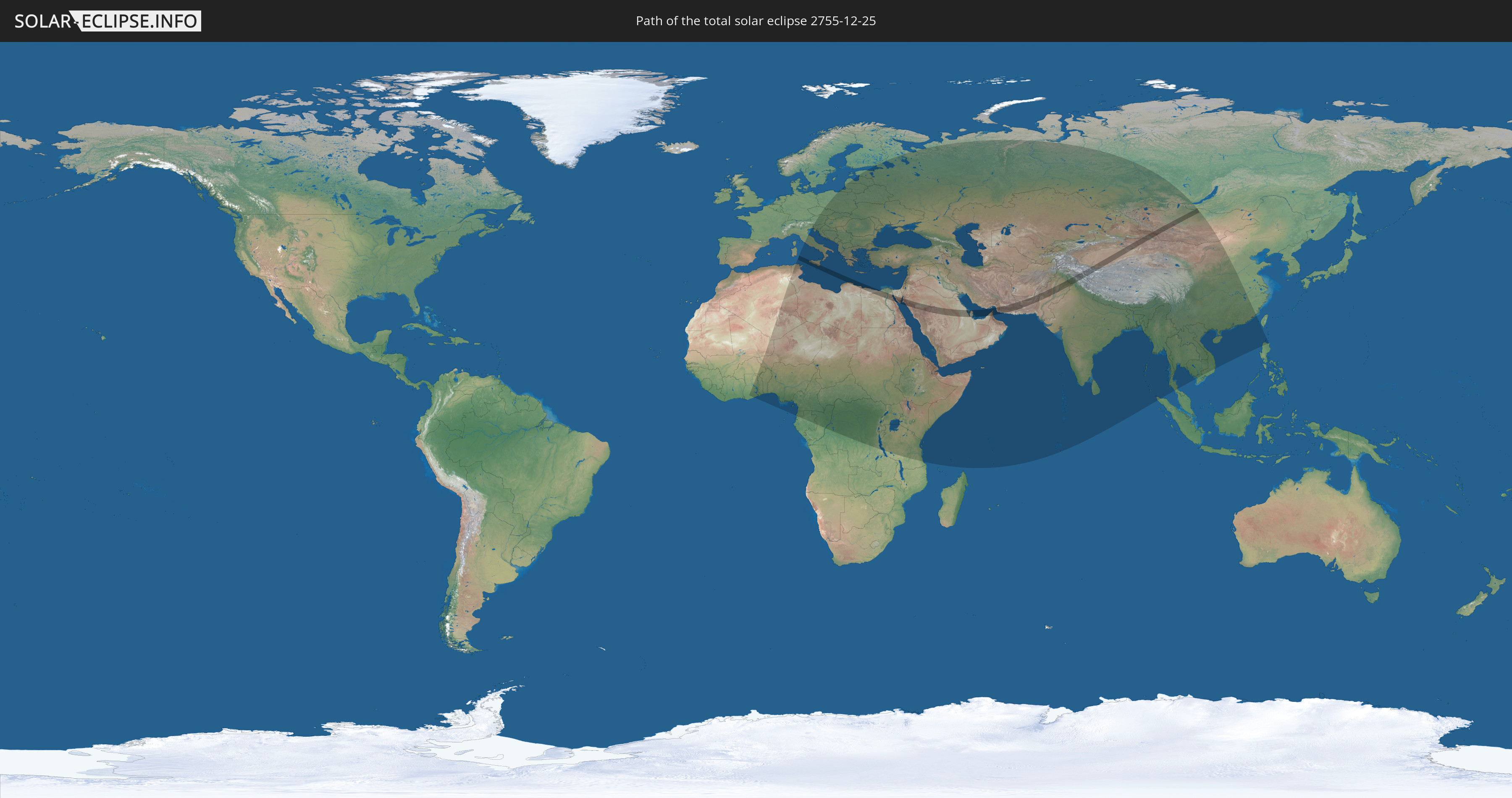
Die Sonnenfinsternis am 12/25/2755 kann man in 101 Ländern als partielle Sonnenfinsternis beobachten.
Der Finsternispfad verläuft durch 13 Länder. Nur in diesen Ländern ist sie als total Sonnenfinsternis zu sehen.
In den folgenden Ländern ist die Sonnenfinsternis total zu sehen
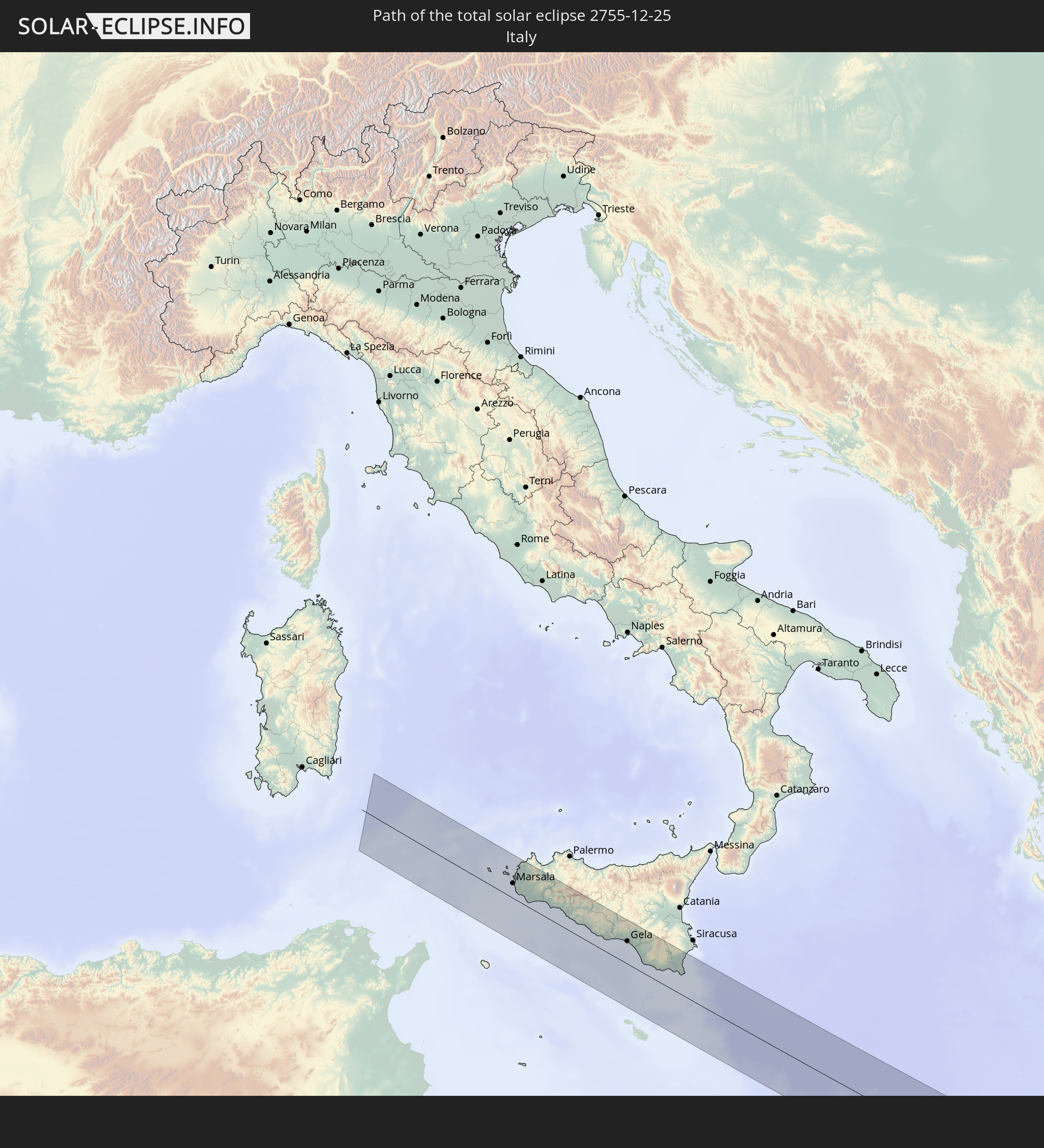 Italy
Italy
 Libya
Libya
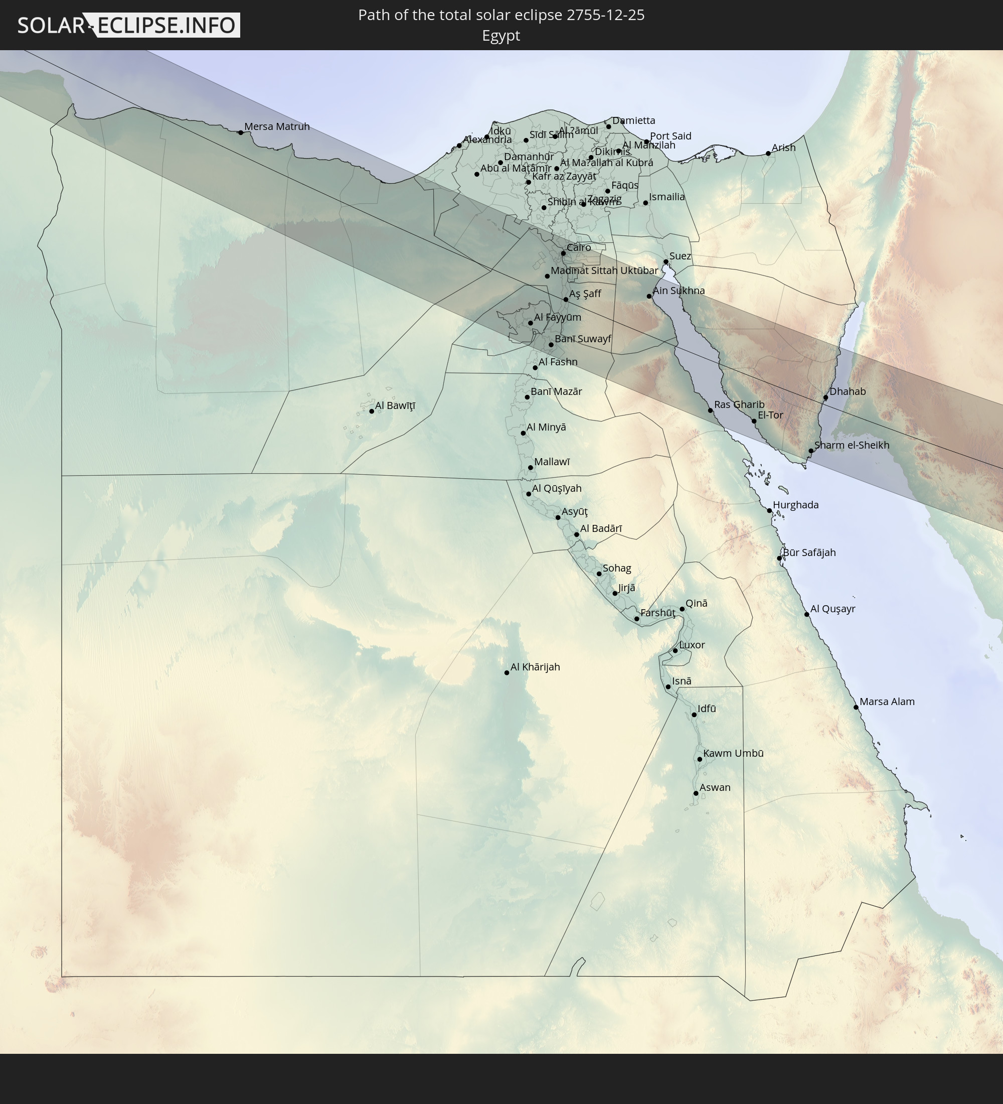 Egypt
Egypt
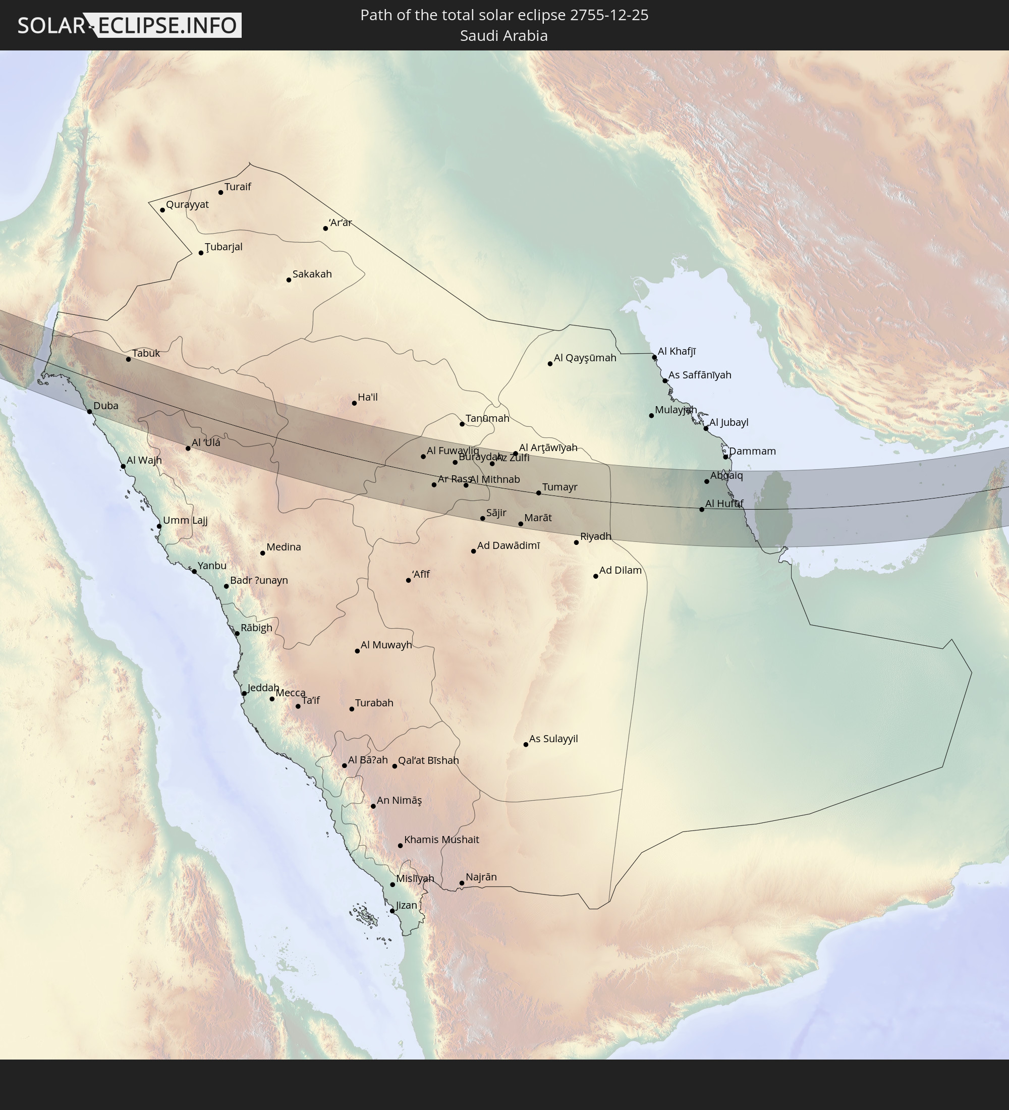 Saudi Arabia
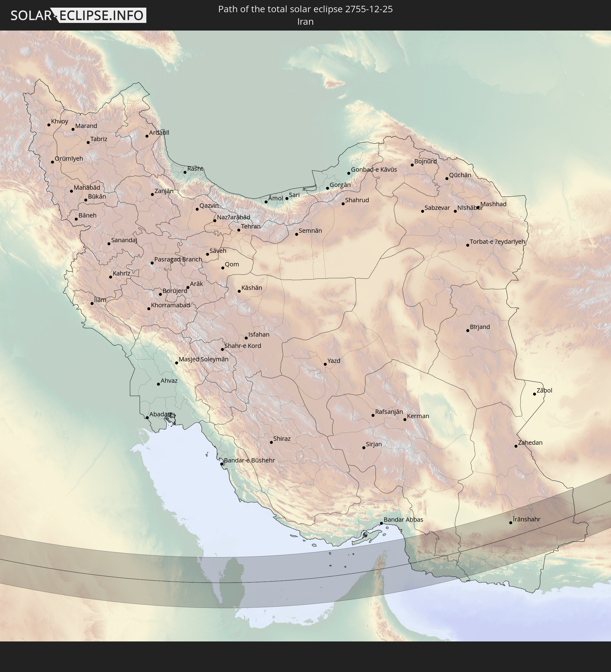 Iran
Iran
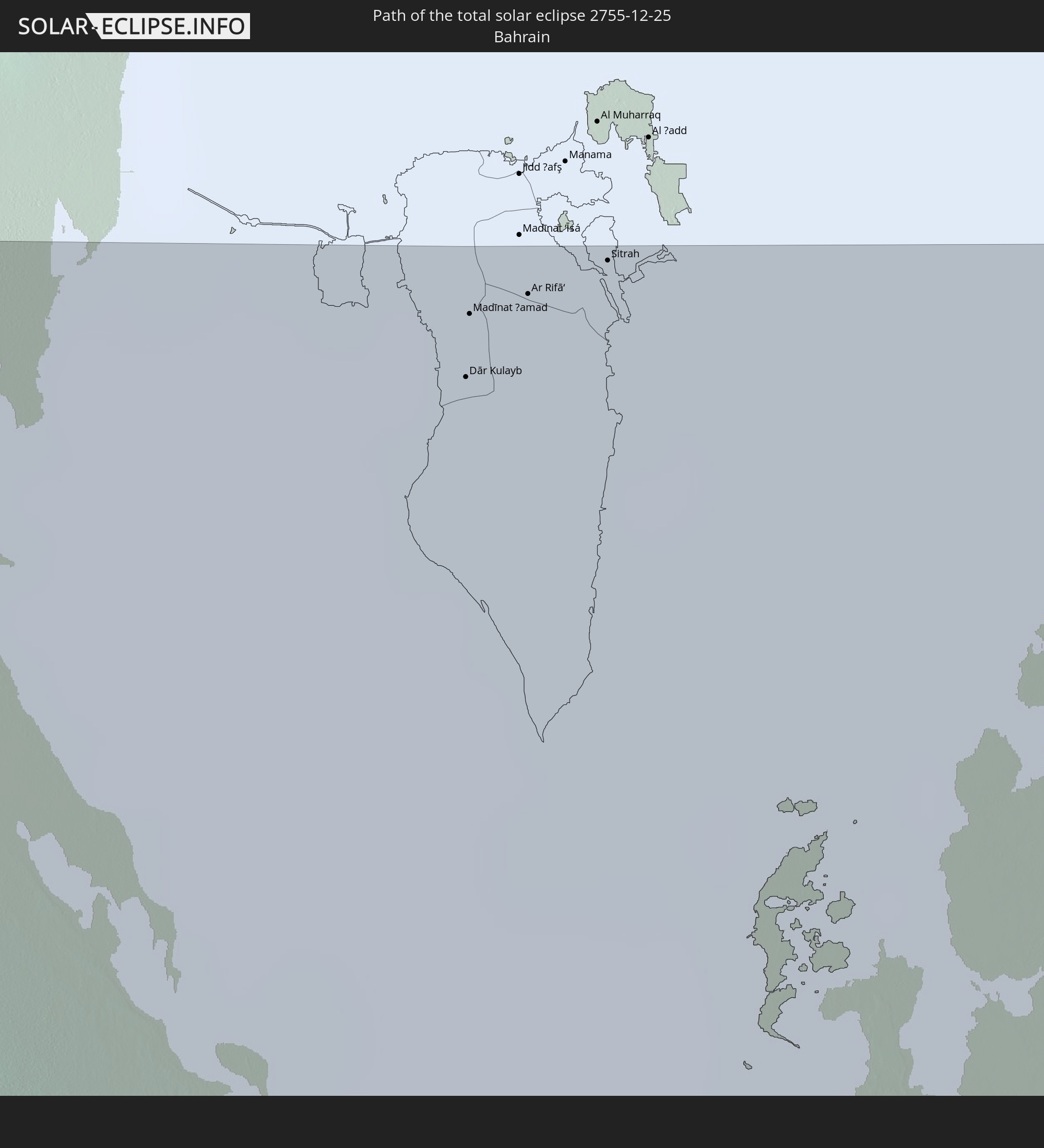 Bahrain
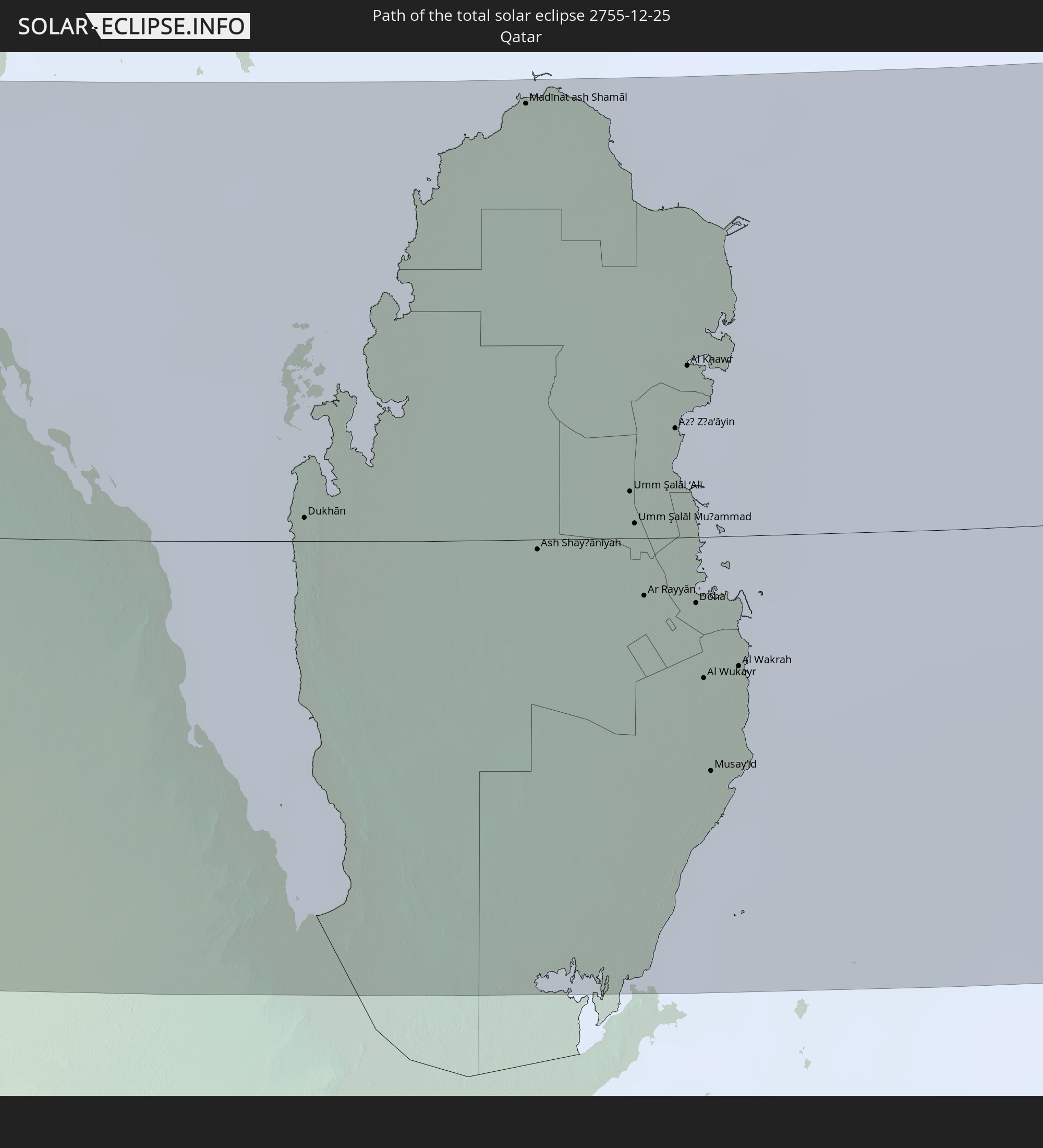 Qatar
Qatar
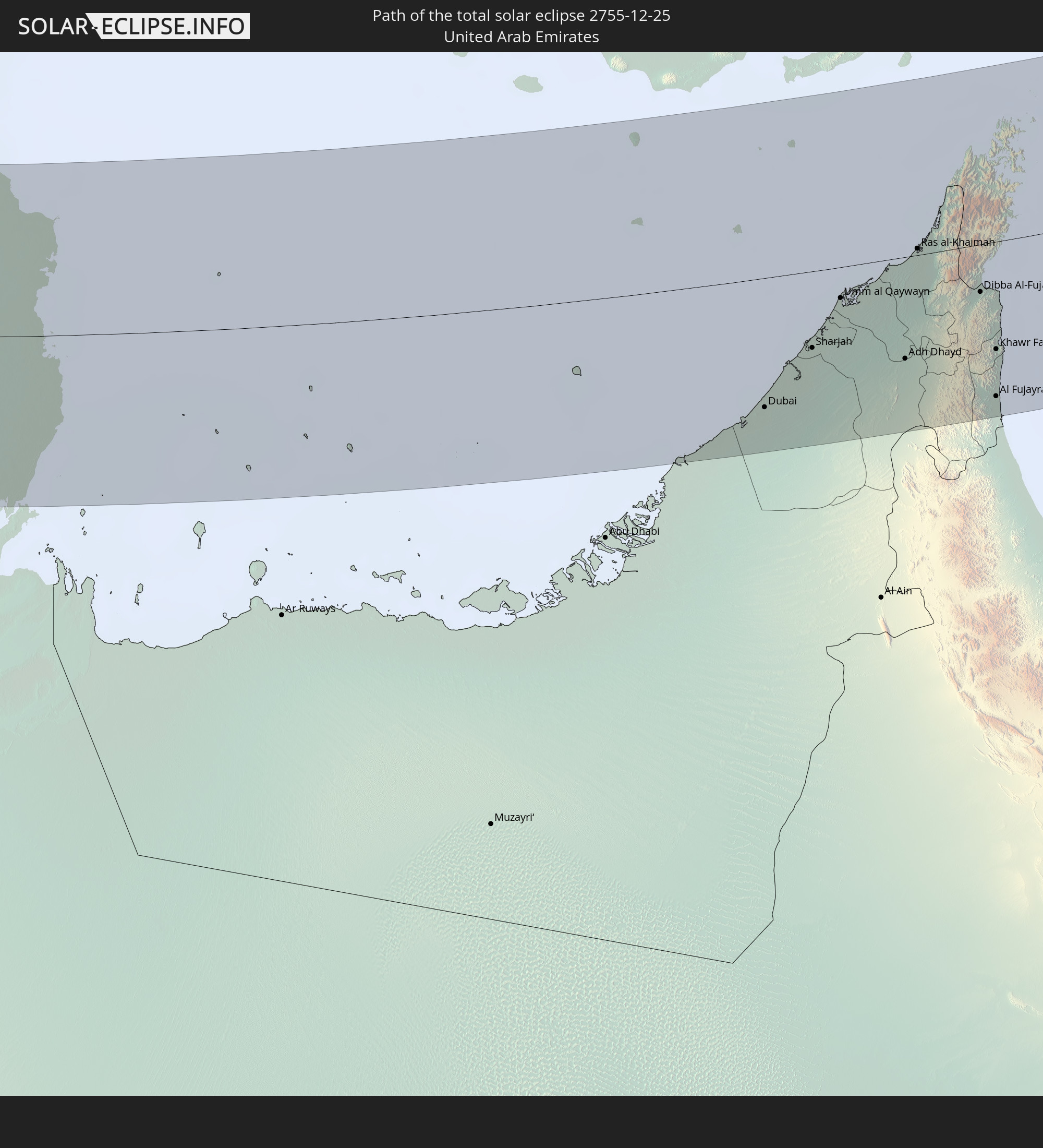 United Arab Emirates
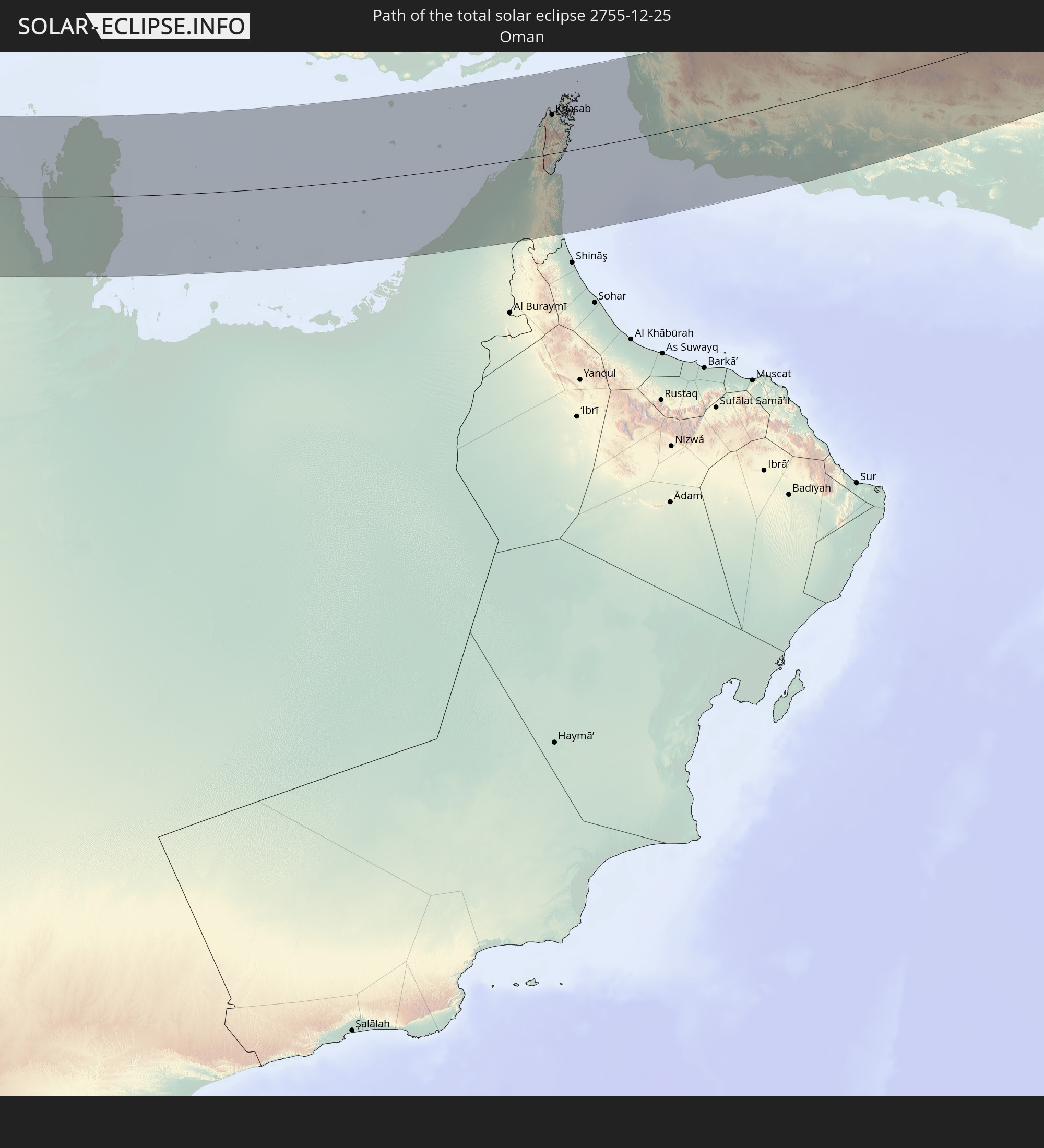 Oman
Oman
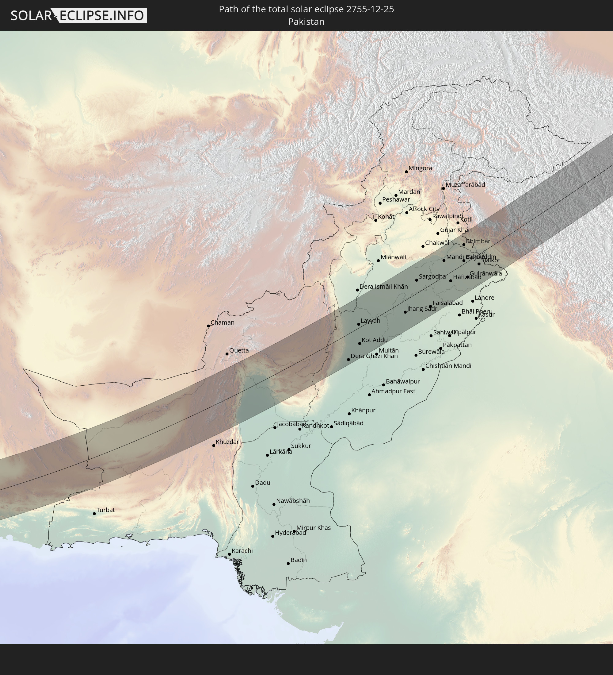 Pakistan
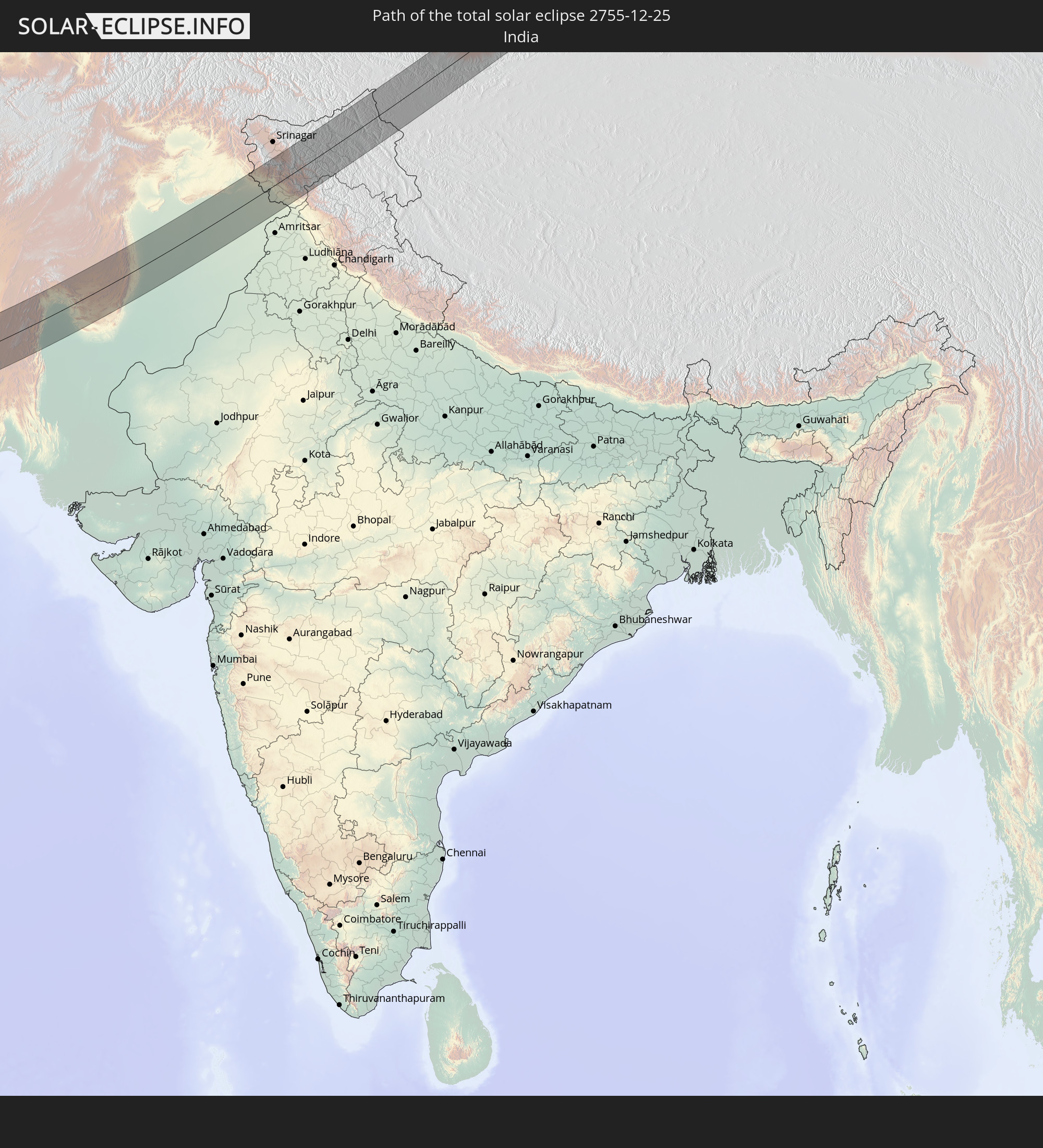 India
India
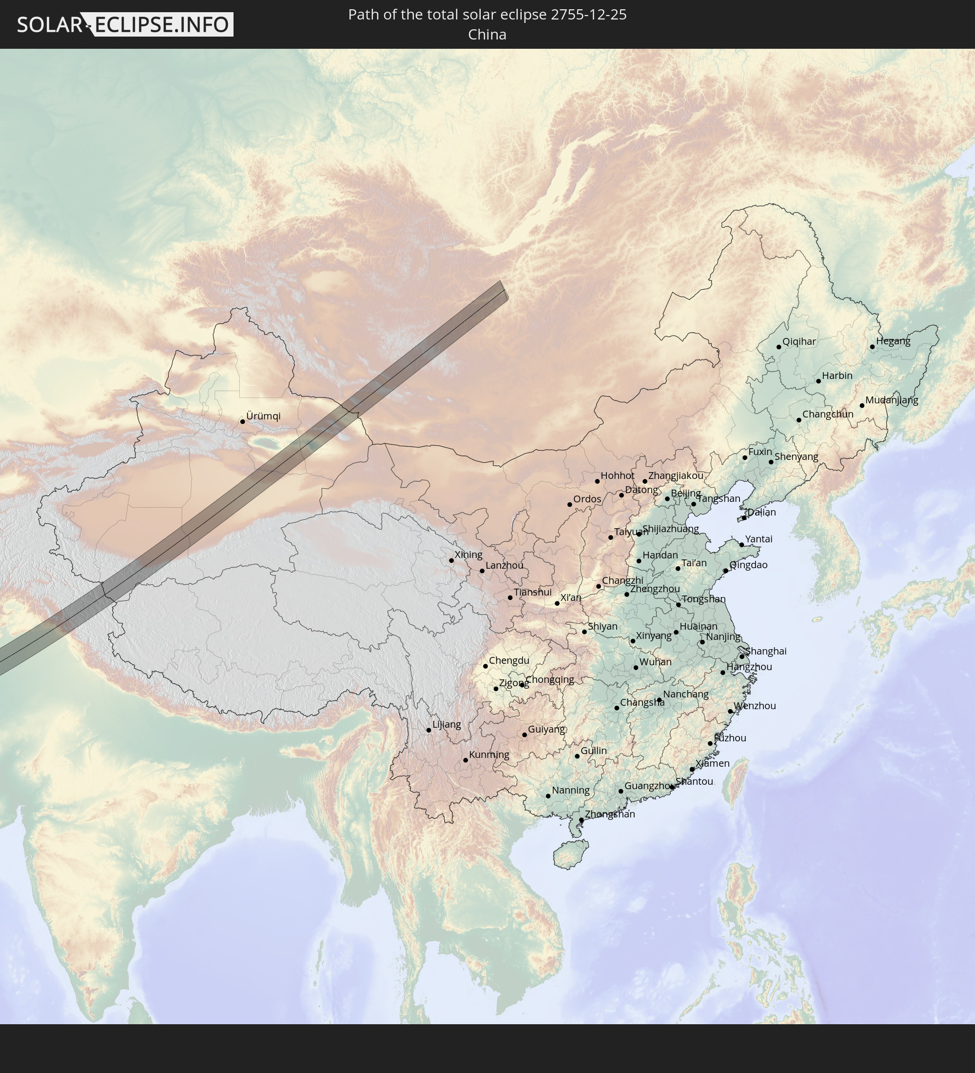 China
China
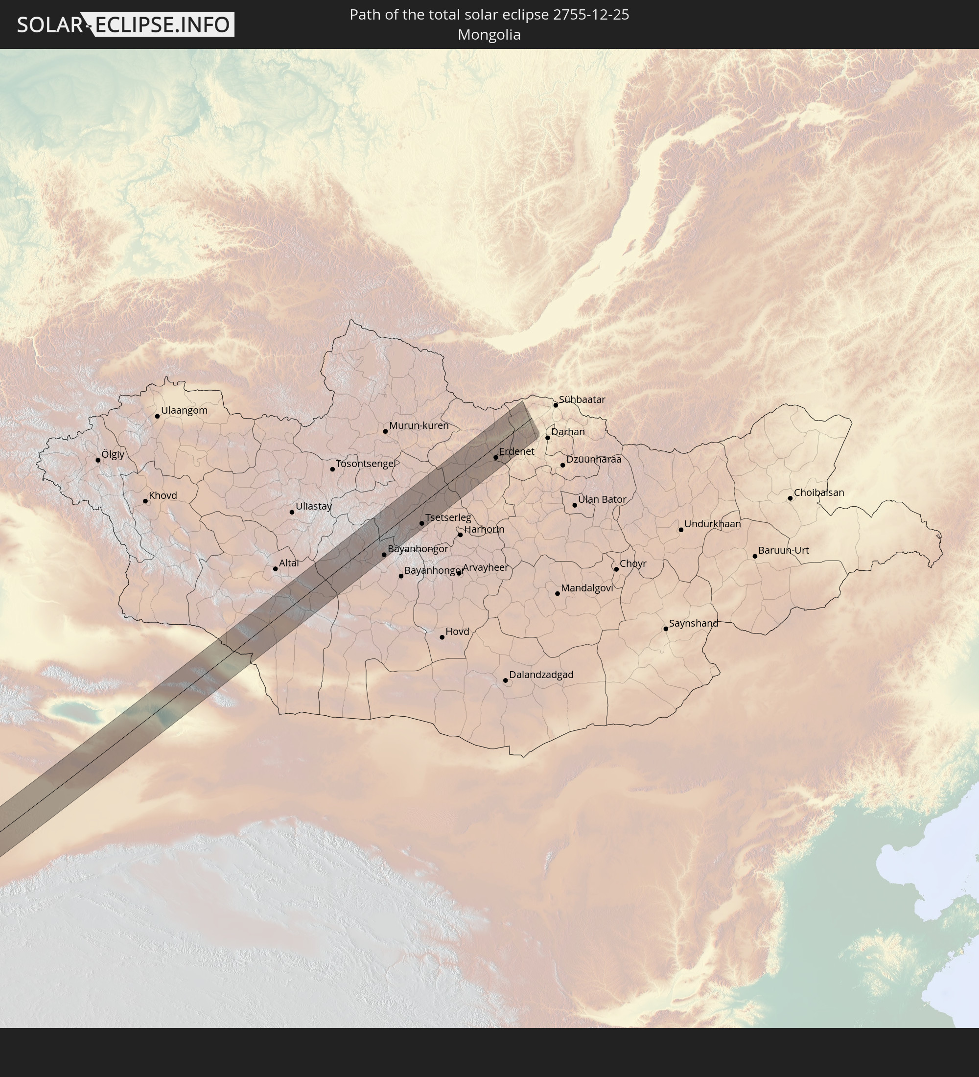 Mongolia
In den folgenden Ländern ist die Sonnenfinsternis partiell zu sehen
 Russia
 Mali
Mali
 Algeria
 Burkina Faso
 Ghana
Ghana
 Togo
Togo
 Niger
Niger
 Benin
Benin
 Nigeria
 Equatorial Guinea
 Italy
Italy
 Tunisia
 Cameroon
 Gabon
Gabon
 Libya
Libya
 Austria
 Republic of the Congo
 Czechia
 Democratic Republic of the Congo
 San Marino
 Vatican City
 Slovenia
 Chad
Chad
 Croatia
 Poland
 Malta
Malta
 Central African Republic
 Bosnia and Herzegovina
 Hungary
 Slovakia
 Montenegro
 Serbia
 Albania
 Greece
 Romania
 Republic of Macedonia
 Lithuania
 Latvia
 Estonia
 Sudan
Sudan
 Ukraine
 Bulgaria
 Belarus
 Egypt
Egypt
 Turkey
 Moldova
 Rwanda
 Burundi
 Tanzania
 Uganda
 Cyprus
 Ethiopia
 Kenya
Kenya
 State of Palestine
 Israel
 Saudi Arabia
 Jordan
 Lebanon
 Syria
Syria
 Eritrea
 Iraq
Iraq
 Georgia
 Somalia
 Djibouti
 Yemen
Yemen
 Armenia
 Iran
Iran
 Azerbaijan
 Seychelles
 Kazakhstan
 Kuwait
 Bahrain
 Qatar
Qatar
 United Arab Emirates
 Oman
Oman
 Turkmenistan
 Uzbekistan
 Mauritius
 Afghanistan
 Pakistan
 Tajikistan
 India
India
 Kyrgyzstan
 British Indian Ocean Territory
 Maldives
 China
China
 Sri Lanka
 Nepal
Nepal
 Mongolia
 Bangladesh
 Bhutan
 Myanmar
 Indonesia
 Thailand
 Laos
Laos
 Vietnam
 Cambodia
 Macau
Macau
 Hong Kong
 Taiwan
 Philippines
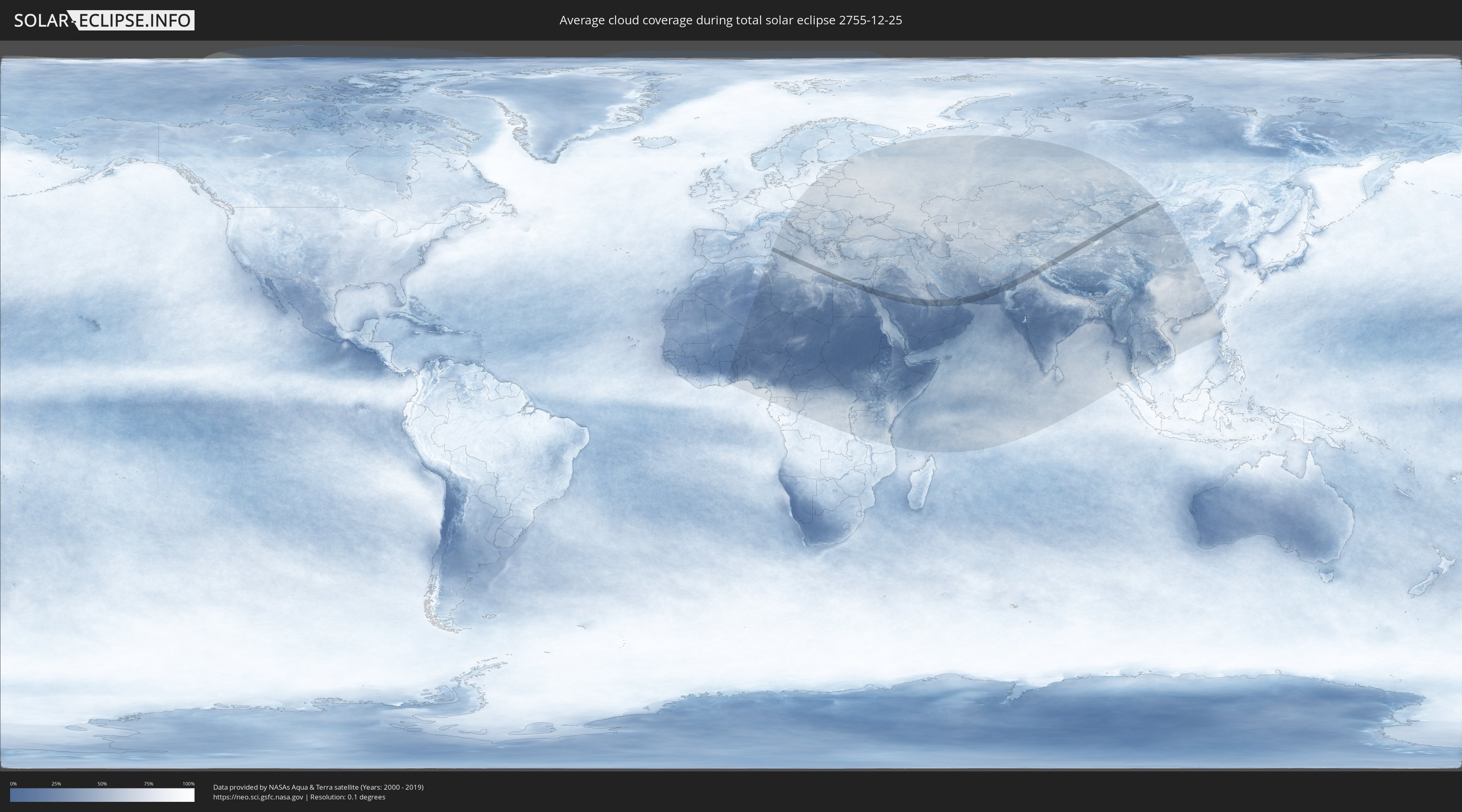
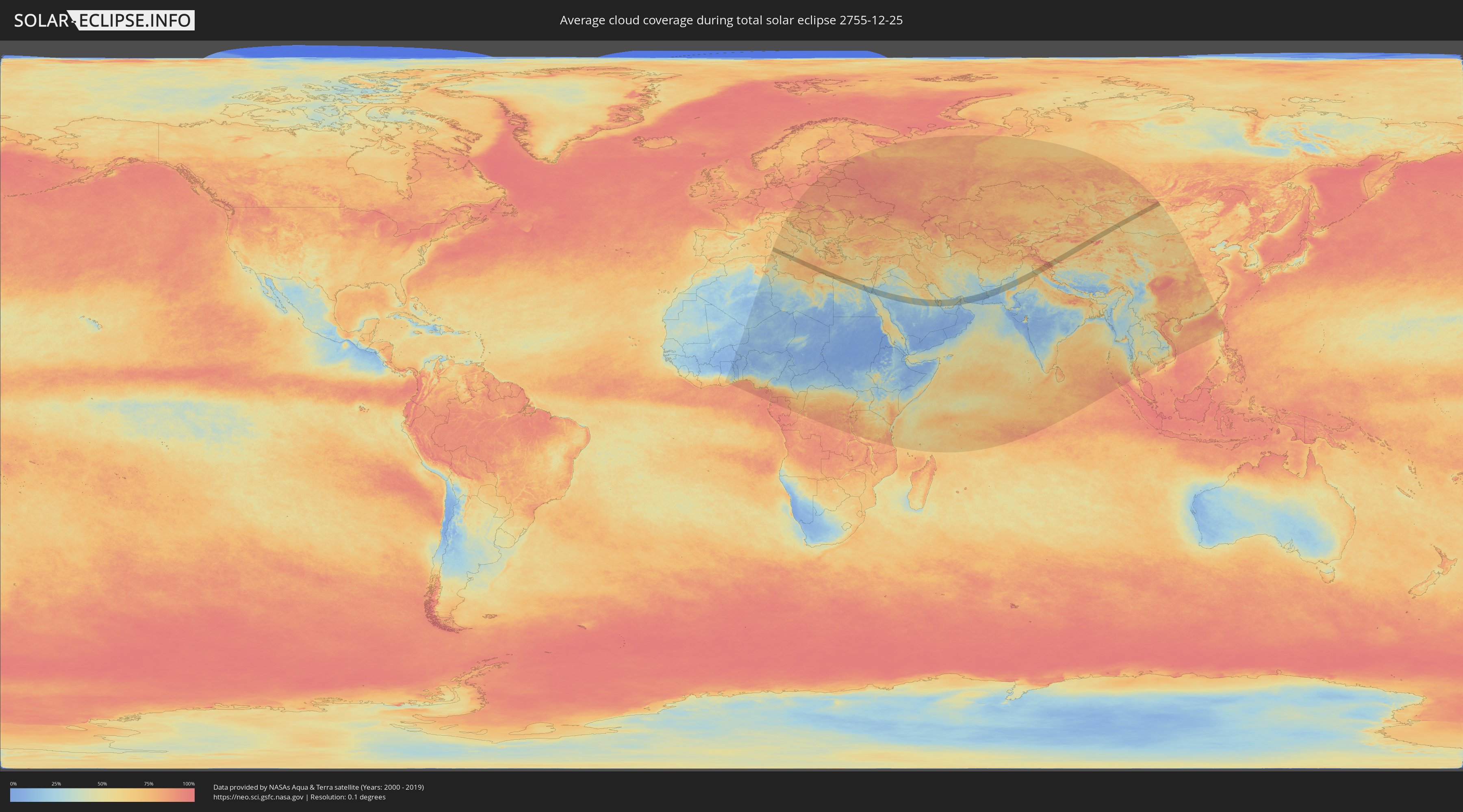
How will be the weather during the total solar eclipse on 12/25/2755?
Where is the best place to see the total solar eclipse of 12/25/2755?
The following maps show the average cloud coverage for the day of the total solar eclipse.
With the help of these maps, it is possible to find the place along the eclipse path, which has the best
chance of a cloudless sky.
Nevertheless, you should consider local circumstances and inform about the weather of your chosen
observation site.
The data is provided by NASAs satellites
AQUA and TERRA.
The cloud maps are averaged over a period of 19 years (2000 - 2019).
Detailed country maps
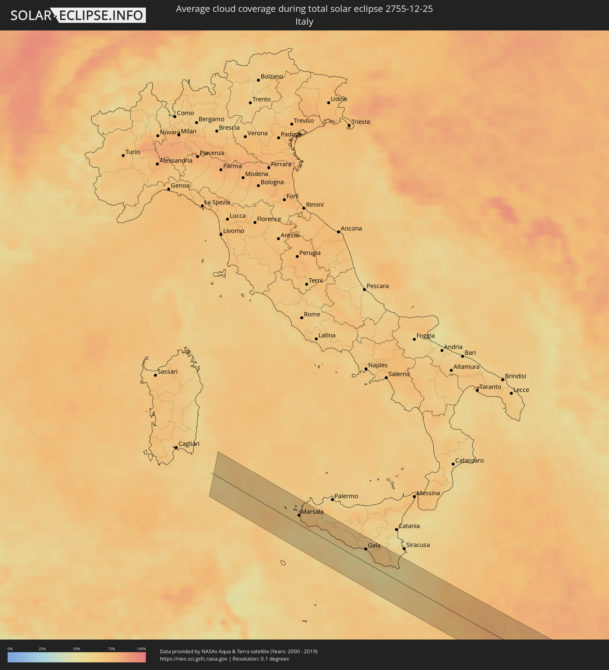 Italy
Italy
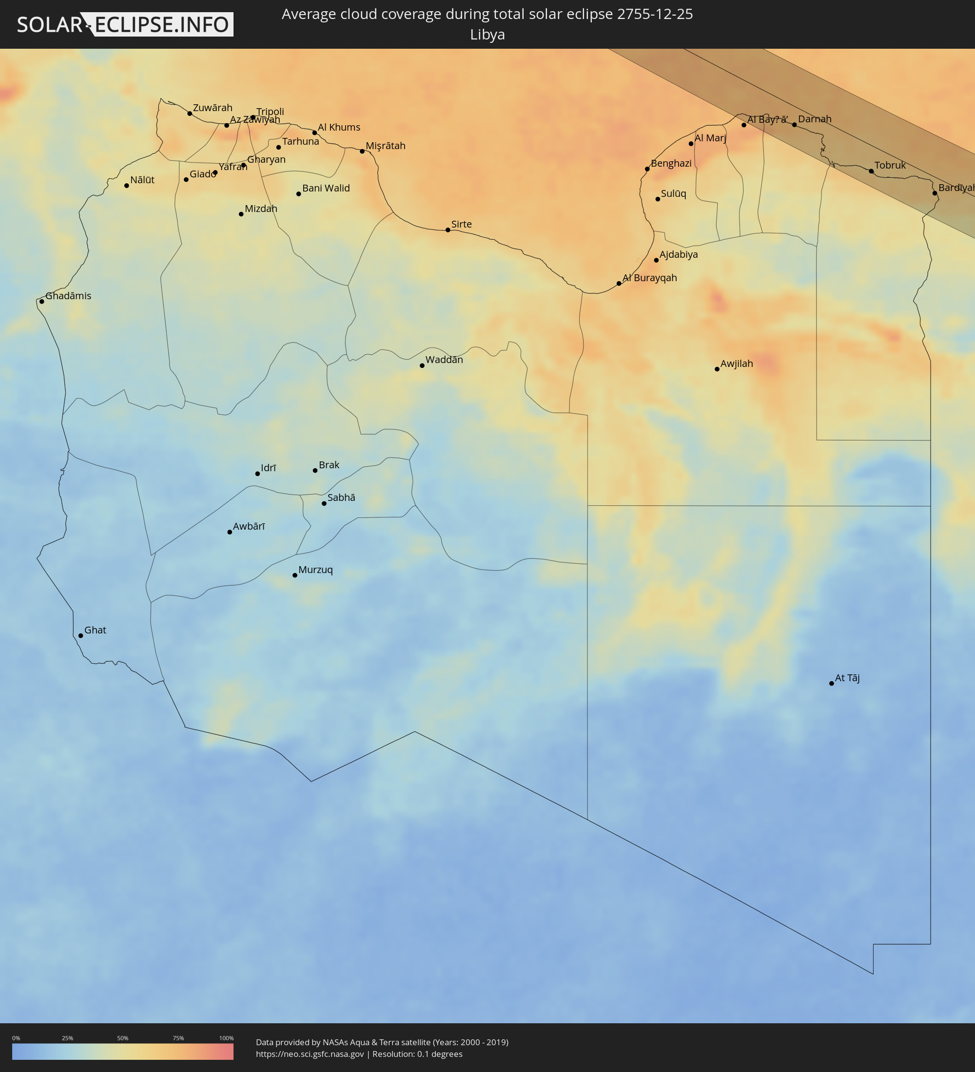 Libya
Libya
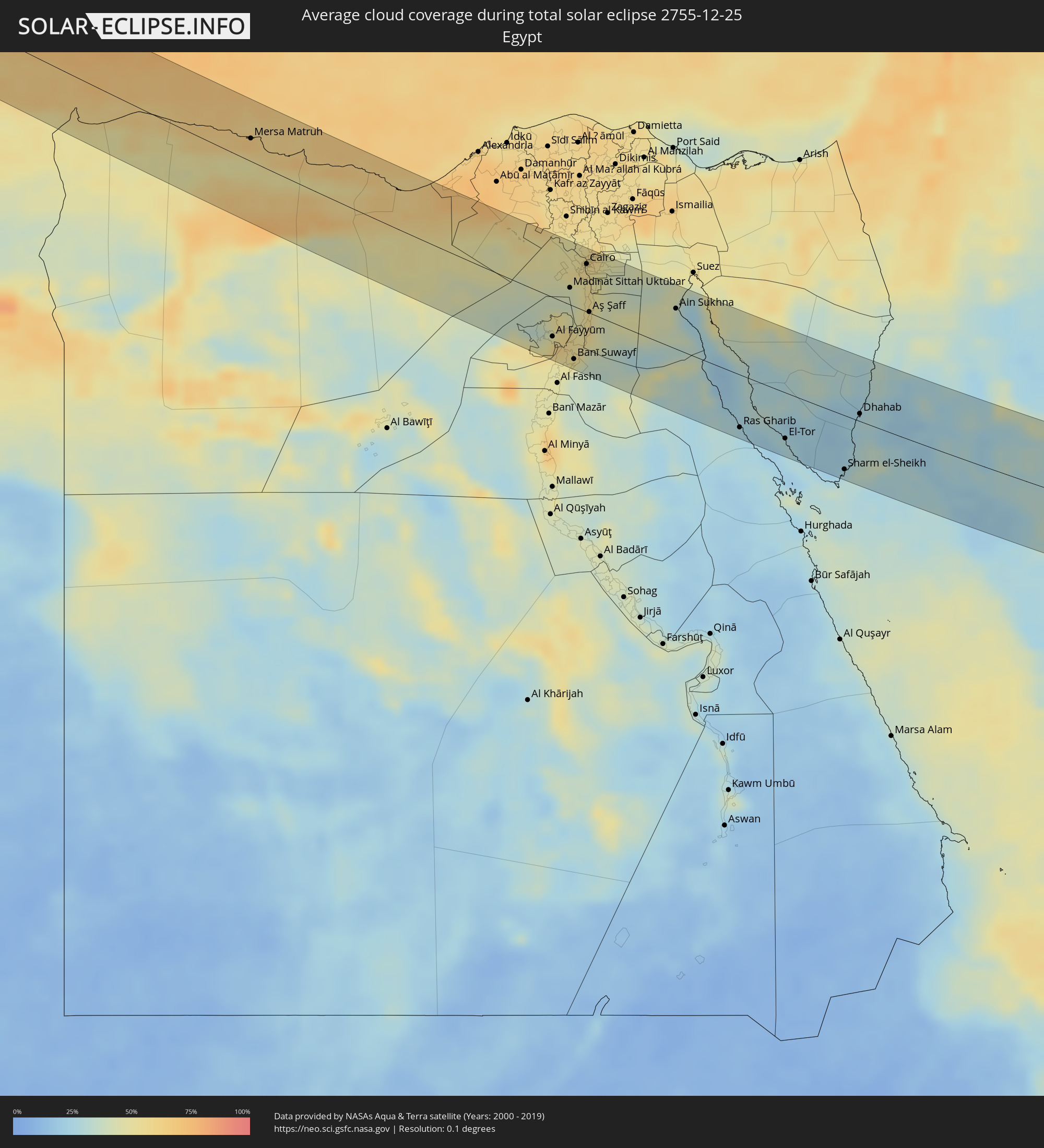 Egypt
Egypt
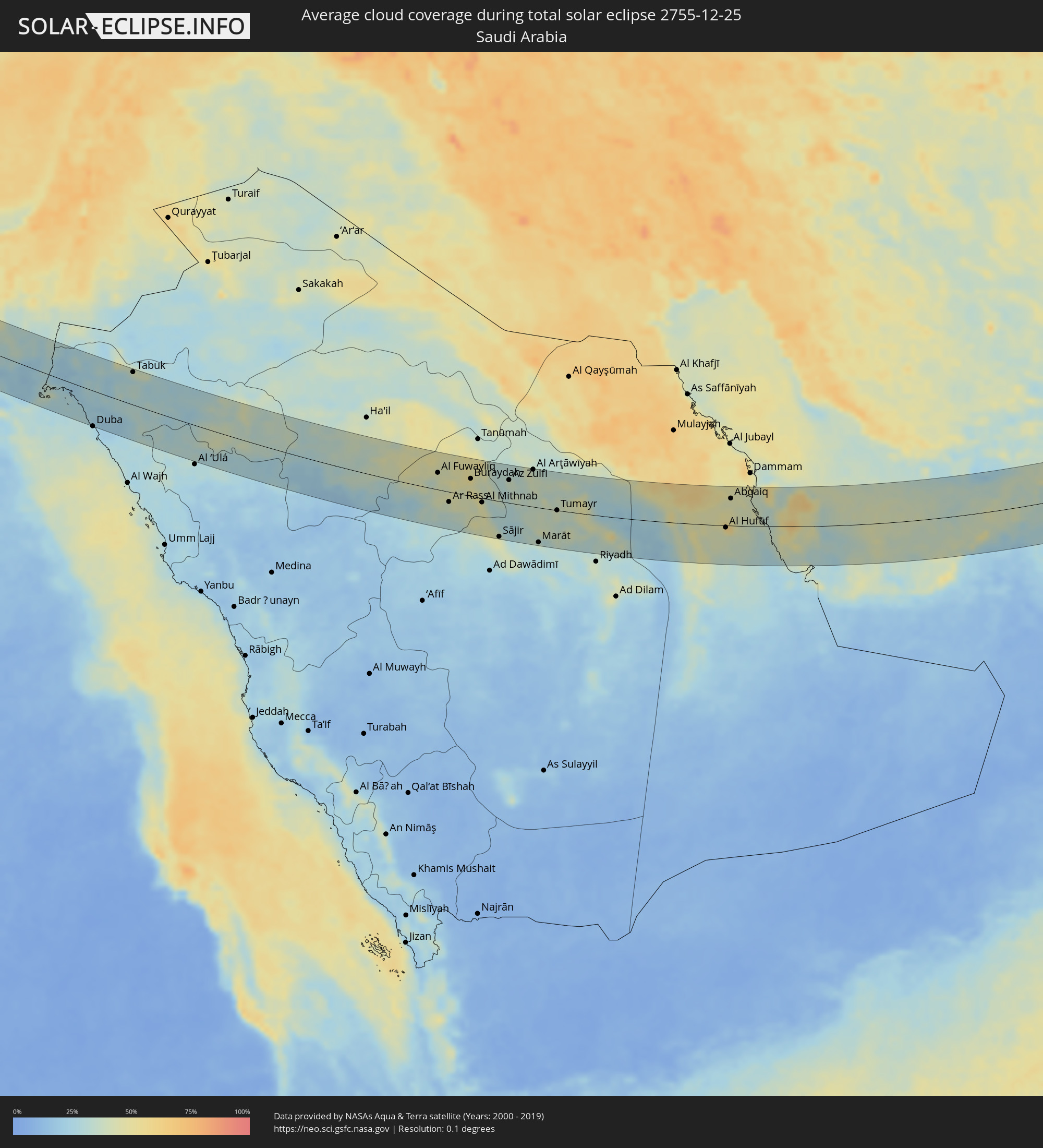 Saudi Arabia
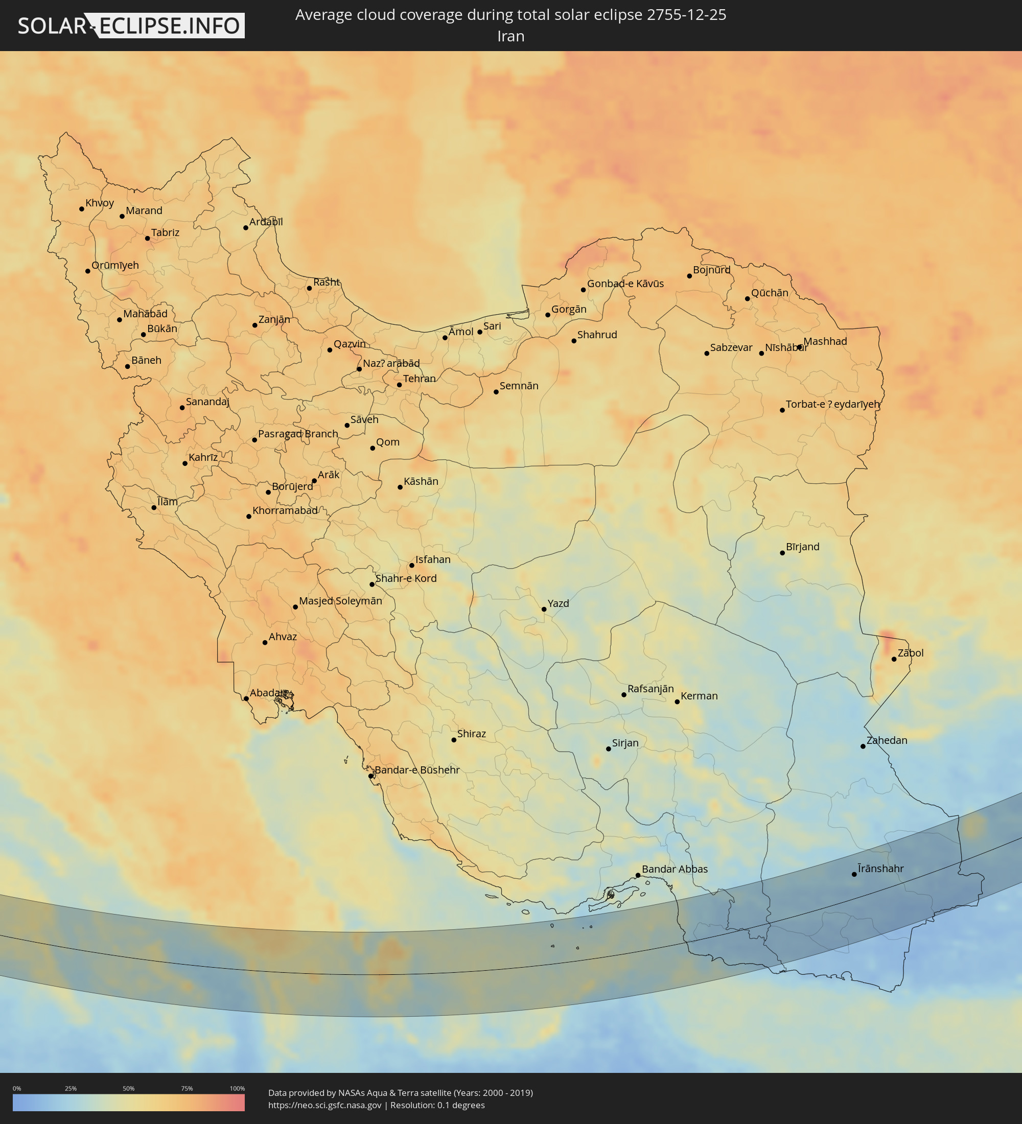 Iran
Iran
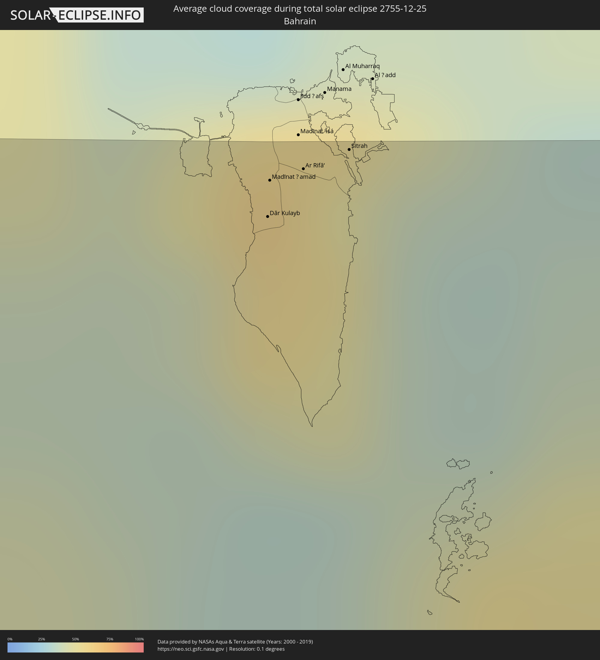 Bahrain
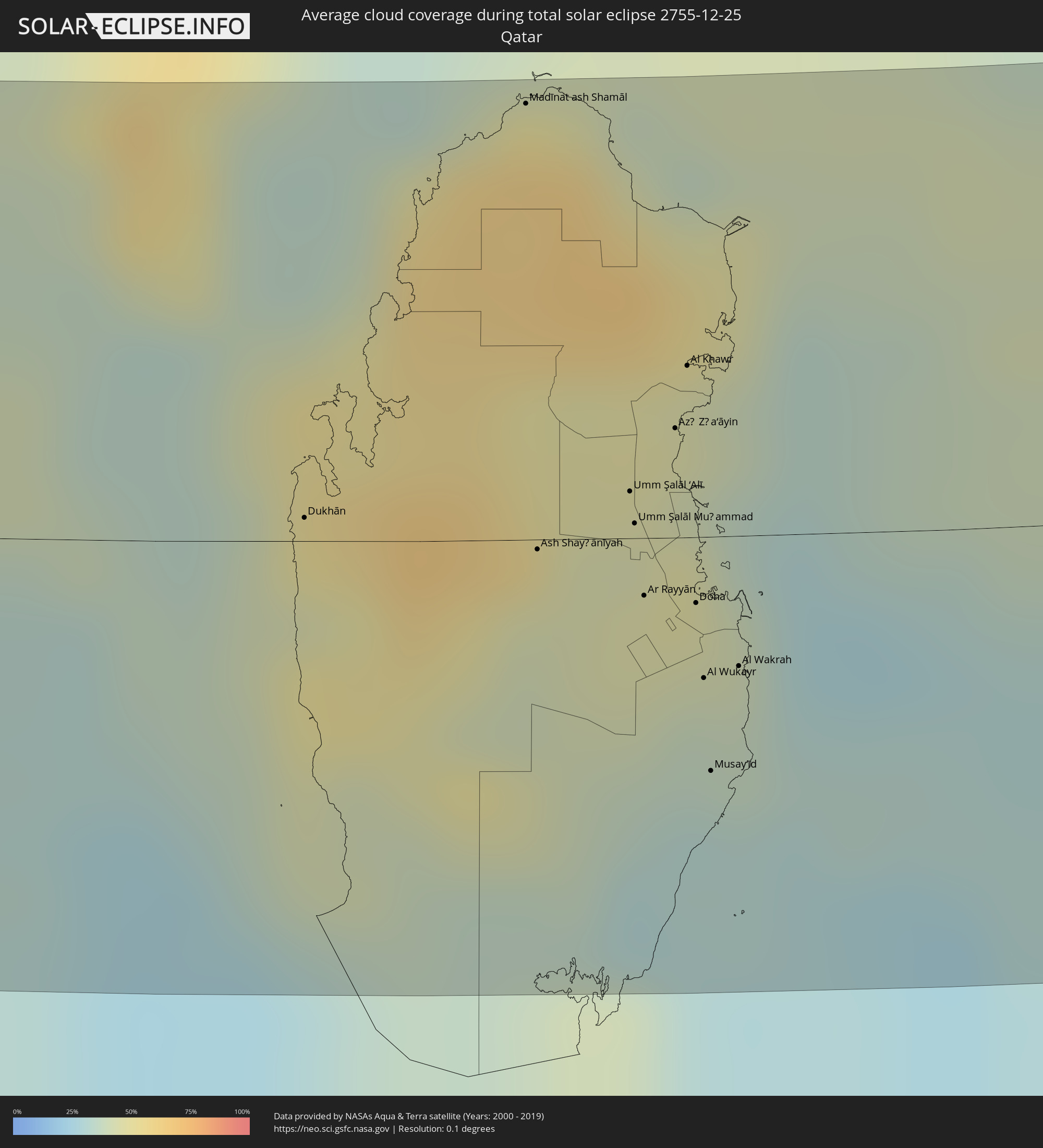 Qatar
Qatar
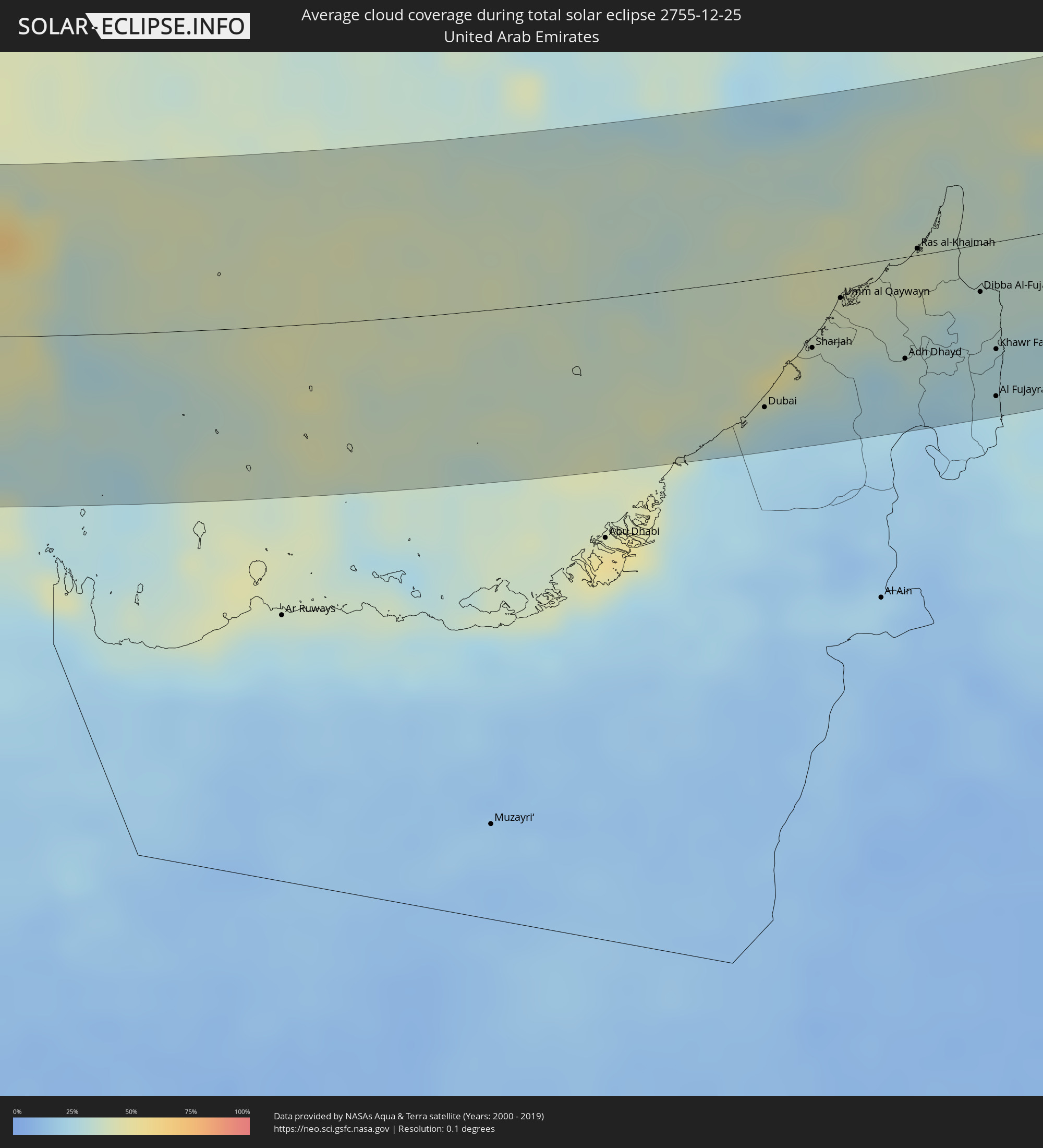 United Arab Emirates
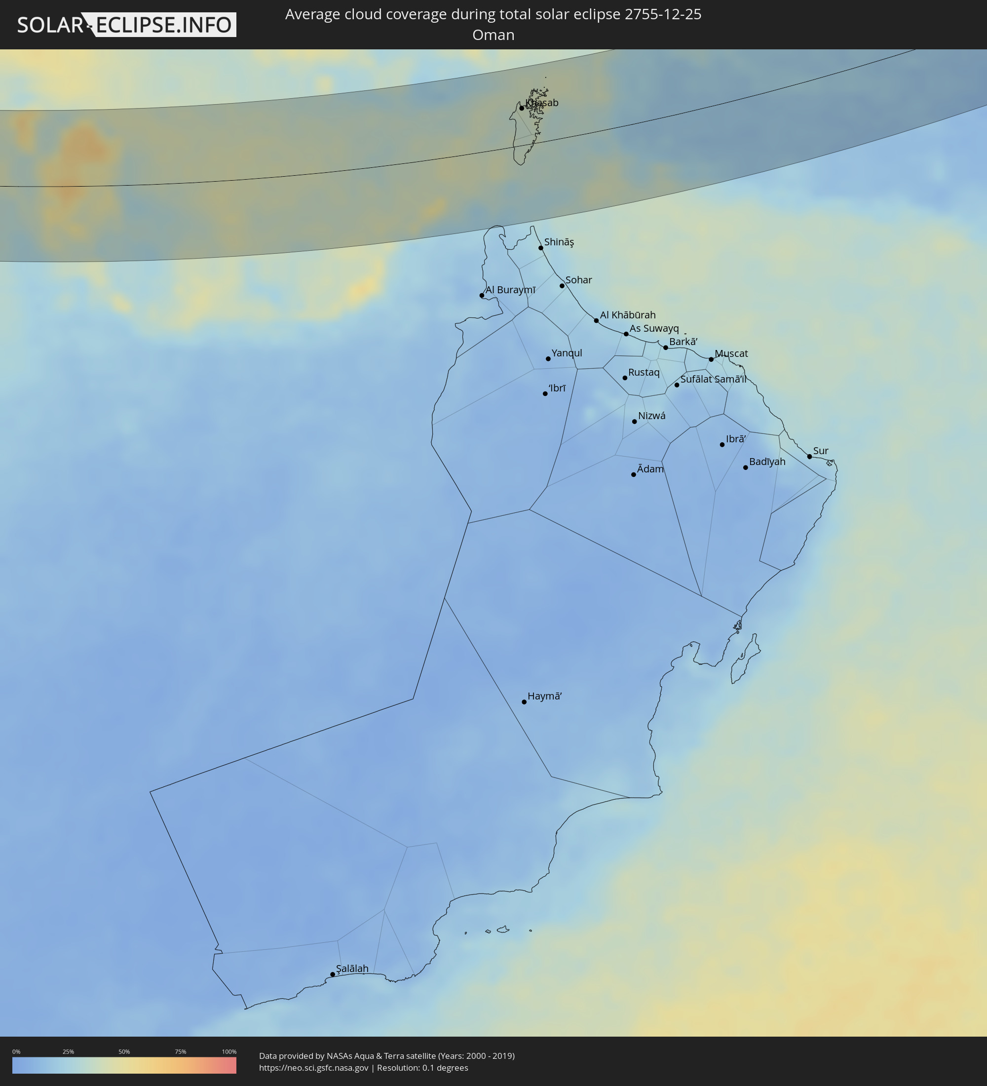 Oman
Oman
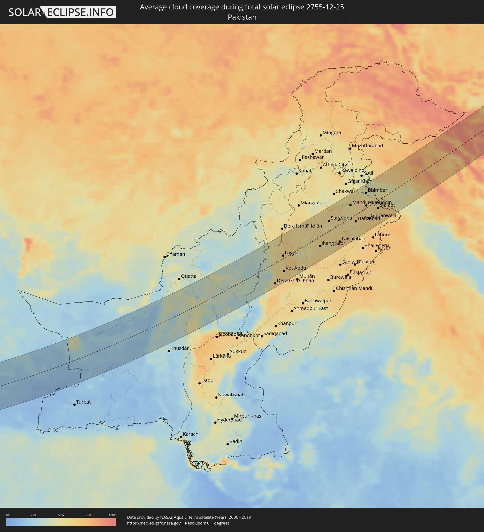 Pakistan
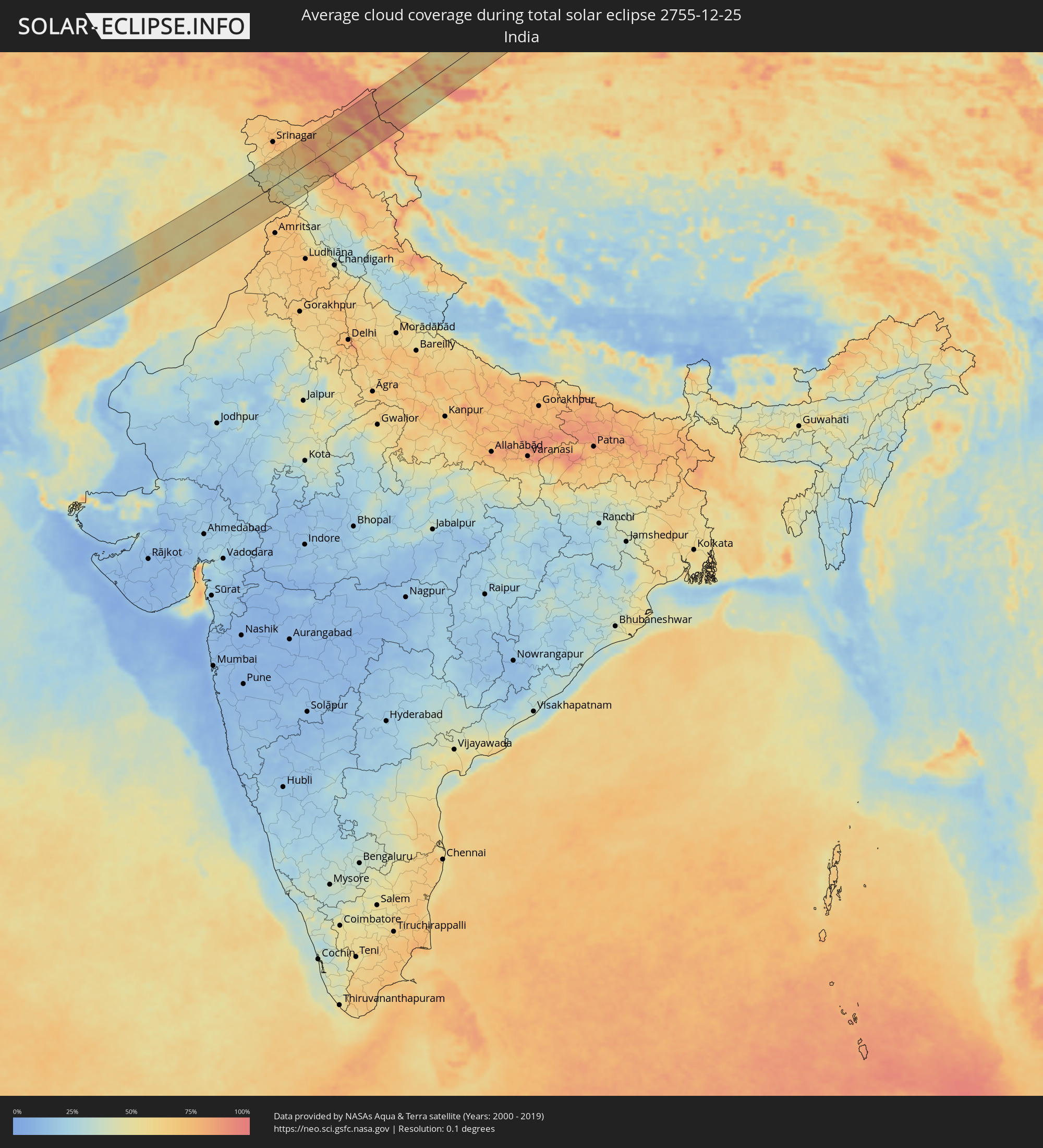 India
India
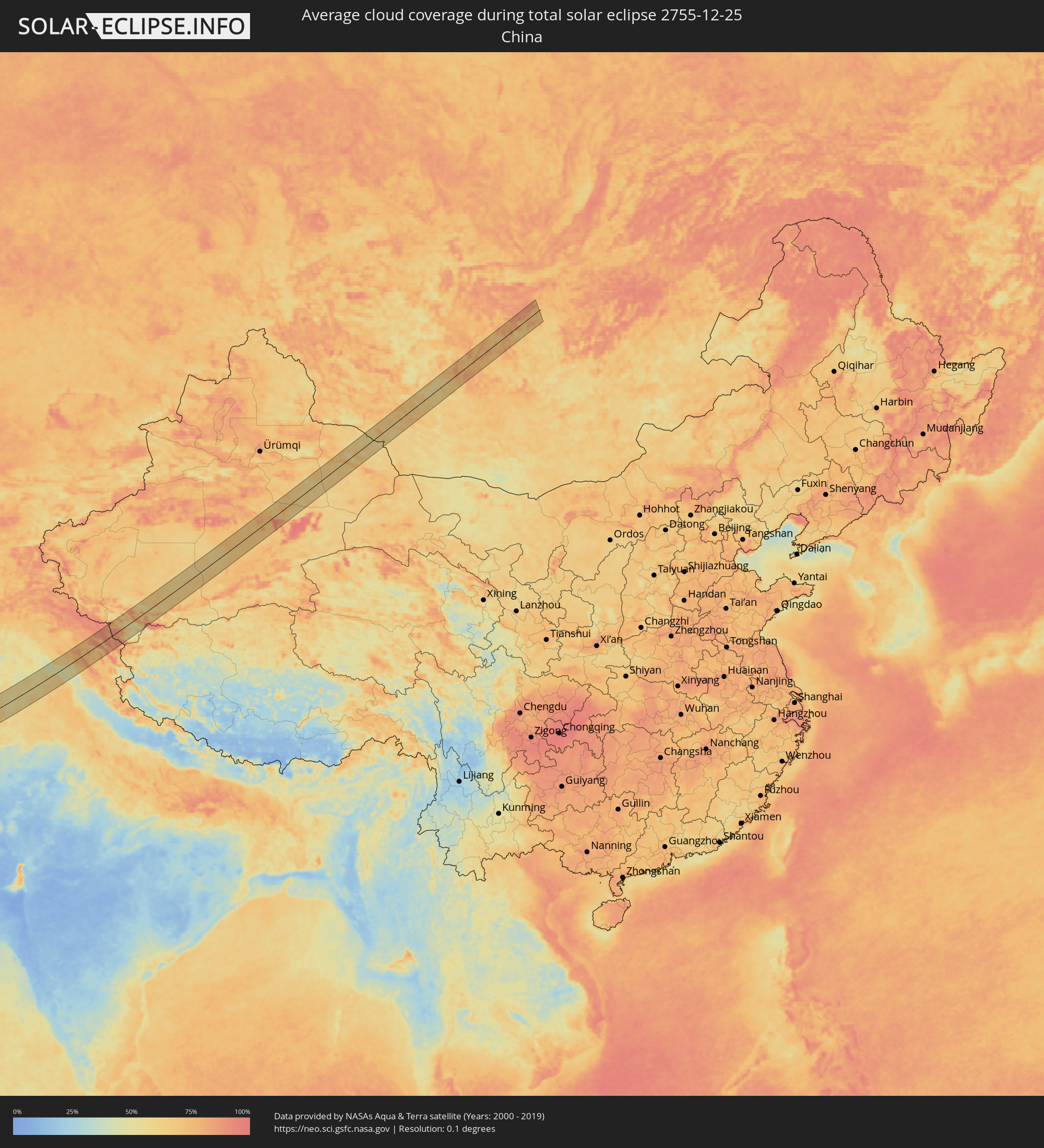 China
China
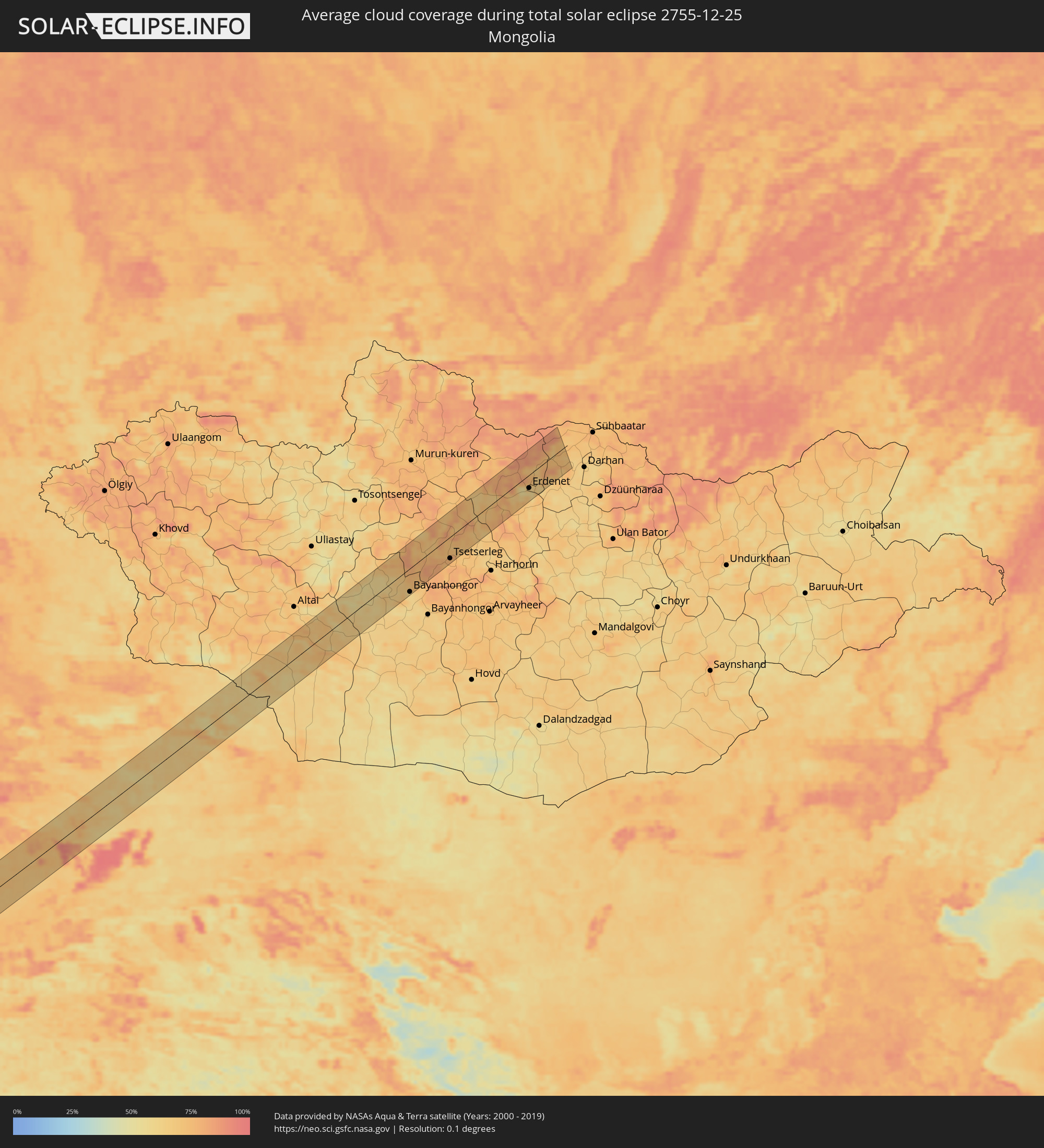 Mongolia
Cities inside the path of the eclipse
The following table shows all locations with a population of more than 5,000 inside the eclipse path. Cities which have more than 100,000 inhabitants are marked bold. A click at the locations opens a detailed map.
| City | Type | Eclipse duration | Local time of max. eclipse | Distance to central line | Ø Cloud coverage |
|
Marsala, Sicily
|
total | - | 07:39:01 UTC+01:00 | 18 km | 63% |
|
Trapani, Sicily
|
total | - | 07:39:20 UTC+01:00 | 43 km | 65% |
|
Mazara del Vallo, Sicily
|
total | - | 07:38:57 UTC+01:00 | 11 km | 68% |
|
Castelvetrano, Sicily
|
total | - | 07:39:07 UTC+01:00 | 22 km | 71% |
|
Sciacca, Sicily
|
total | - | 07:39:06 UTC+01:00 | 18 km | 57% |
|
Ribera, Sicily
|
total | - | 07:39:13 UTC+01:00 | 25 km | 61% |
|
Agrigento, Sicily
|
total | - | 07:39:12 UTC+01:00 | 21 km | 60% |
|
Palma di Montechiaro, Sicily
|
total | - | 07:39:11 UTC+01:00 | 18 km | 63% |
|
Canicattì, Sicily
|
total | - | 07:39:26 UTC+01:00 | 38 km | 66% |
|
Licata, Sicily
|
total | - | 07:39:13 UTC+01:00 | 17 km | 53% |
|
Gela, Sicily
|
total | - | 07:39:23 UTC+01:00 | 28 km | 53% |
|
Niscemi, Sicily
|
total | - | 07:39:35 UTC+01:00 | 41 km | 66% |
|
Vittoria, Sicily
|
total | - | 07:39:27 UTC+01:00 | 28 km | 69% |
|
Ragusa, Sicily
|
total | - | 07:39:34 UTC+01:00 | 35 km | 67% |
|
Rosolini, Sicily
|
total | - | 07:39:36 UTC+01:00 | 35 km | 65% |
|
Pachino, Sicily
|
total | - | 07:39:35 UTC+01:00 | 30 km | 55% |
|
Avola, Sicily
|
total | - | 07:39:51 UTC+01:00 | 51 km | 60% |
|
Al Qubbah, Darnah
|
total | - | 08:41:40 UTC+02:00 | 45 km | 78% |
|
Darnah, Darnah
|
total | - | 08:42:05 UTC+02:00 | 27 km | 73% |
|
Tobruk, Sha‘bīyat al Buţnān
|
total | - | 08:42:53 UTC+02:00 | 38 km | 65% |
|
Bardīyah, Sha‘bīyat al Buţnān
|
total | - | 08:43:51 UTC+02:00 | 25 km | 62% |
|
Mersa Matruh, Matruh
|
total | - | 08:46:09 UTC+02:00 | 24 km | 65% |
|
Ibshawāy, Faiyum
|
total | - | 08:49:09 UTC+02:00 | 43 km | 41% |
|
Iţsā, Faiyum
|
total | - | 08:49:12 UTC+02:00 | 51 km | 54% |
|
Al Fayyūm, Faiyum
|
total | - | 08:49:21 UTC+02:00 | 42 km | 51% |
|
Ţāmiyah, Faiyum
|
total | - | 08:49:41 UTC+02:00 | 20 km | 58% |
|
Ashmūn, Monufia
|
total | - | 08:50:27 UTC+02:00 | 64 km | 48% |
|
Madīnat Sittah Uktūbar, Giza
|
total | - | 08:50:07 UTC+02:00 | 18 km | 42% |
|
Banī Suwayf, Beni Suweif
|
total | - | 08:49:32 UTC+02:00 | 56 km | 51% |
|
Awsīm, Giza
|
total | - | 08:50:32 UTC+02:00 | 53 km | 53% |
|
Al Qanāţir al Khayrīyah, Qalyubia
|
total | - | 08:50:36 UTC+02:00 | 60 km | 49% |
|
Al Wāsiţah, Faiyum
|
total | - | 08:49:56 UTC+02:00 | 25 km | 53% |
|
Cairo, Cairo
|
total | - | 08:50:39 UTC+02:00 | 51 km | 55% |
|
Al ‘Ayyāţ, Giza
|
total | - | 08:50:16 UTC+02:00 | 6 km | 56% |
|
Aş Şaff, Giza
|
total | - | 08:50:15 UTC+02:00 | 1 km | 56% |
|
Ḩalwān, Cairo
|
total | - | 08:50:32 UTC+02:00 | 30 km | 55% |
|
Ain Sukhna, Suez
|
total | - | 08:51:55 UTC+02:00 | 43 km | 42% |
|
Ras Gharib, Red Sea
|
total | - | 08:52:04 UTC+02:00 | 57 km | 27% |
|
Tabuk, Tabuk
|
total | - | 09:58:14 UTC+03:00 | 66 km | 36% |
|
Ar Rass, Al-Qassim
|
total | - | 10:10:39 UTC+03:00 | 22 km | 39% |
|
Al Bukayrīyah, Al-Qassim
|
total | - | 10:11:13 UTC+03:00 | 11 km | 44% |
|
Buraydah, Al-Qassim
|
total | - | 10:12:04 UTC+03:00 | 37 km | 46% |
|
Unaizah, Al-Qassim
|
total | - | 10:11:56 UTC+03:00 | 11 km | 48% |
|
Al Mithnab, Al-Qassim
|
total | - | 10:12:19 UTC+03:00 | 9 km | 49% |
|
Sājir, Ar Riyāḑ
|
total | - | 10:12:43 UTC+03:00 | 77 km | 45% |
|
Az Zulfi, Ar Riyāḑ
|
total | - | 10:14:00 UTC+03:00 | 49 km | 35% |
|
Al Arţāwīyah, Ar Riyāḑ
|
total | - | 10:15:24 UTC+03:00 | 80 km | 42% |
|
Al Hufūf, Eastern Province
|
total | - | 10:25:07 UTC+03:00 | 5 km | 52% |
|
Al Qurayn, Eastern Province
|
total | - | 10:25:16 UTC+03:00 | 9 km | 62% |
|
Al Baţţālīyah, Eastern Province
|
total | - | 10:25:20 UTC+03:00 | 3 km | 52% |
|
Al Jubayl, Eastern Province
|
total | - | 10:25:21 UTC+03:00 | 0 km | 55% |
|
Al Qārah, Eastern Province
|
total | - | 10:25:24 UTC+03:00 | 2 km | 55% |
|
Al Munayzilah, Eastern Province
|
total | - | 10:25:23 UTC+03:00 | 2 km | 55% |
|
Abqaiq, Eastern Province
|
total | - | 10:25:45 UTC+03:00 | 60 km | 43% |
|
Aţ Ţaraf, Eastern Province
|
total | - | 10:25:31 UTC+03:00 | 4 km | 55% |
|
Dār Kulayb, Southern Governorate
|
total | - | 10:27:58 UTC+03:00 | 76 km | 55% |
|
Madīnat Ḩamad, Central Governorate
|
total | - | 10:28:00 UTC+03:00 | 81 km | 55% |
|
Ar Rifā‘, Southern Governorate
|
total | - | 10:28:08 UTC+03:00 | 83 km | 52% |
|
Sitrah, Manama
|
total | - | 10:28:20 UTC+03:00 | 86 km | 49% |
|
Dukhān, Baladīyat ar Rayyān
|
total | - | 10:28:18 UTC+03:00 | 4 km | 44% |
|
Madīnat ash Shamāl, Madīnat ash Shamāl
|
total | - | 10:29:49 UTC+03:00 | 83 km | 61% |
|
Ash Shayḩānīyah, Baladīyat ar Rayyān
|
total | - | 10:29:26 UTC+03:00 | 2 km | 45% |
|
Umm Şalāl ‘Alī, Baladīyat Umm Şalāl
|
total | - | 10:29:57 UTC+03:00 | 9 km | 44% |
|
Umm Şalāl Muḩammad, Baladīyat Umm Şalāl
|
total | - | 10:29:56 UTC+03:00 | 3 km | 46% |
|
Ar Rayyān, Baladīyat ar Rayyān
|
total | - | 10:29:55 UTC+03:00 | 11 km | 45% |
|
Az̧ Z̧a‘āyin, Baladīyat az̧ Z̧a‘āyin
|
total | - | 10:30:14 UTC+03:00 | 21 km | 42% |
|
Al Khawr, Al Khawr
|
total | - | 10:30:22 UTC+03:00 | 33 km | 45% |
|
Doha, Baladīyat ad Dawḩah
|
total | - | 10:30:10 UTC+03:00 | 13 km | 43% |
|
Al Wukayr, Al Wakrah
|
total | - | 10:30:08 UTC+03:00 | 27 km | 38% |
|
Musay‘īd, Al Wakrah
|
total | - | 10:30:04 UTC+03:00 | 45 km | 32% |
|
Al Wakrah, Al Wakrah
|
total | - | 10:30:19 UTC+03:00 | 25 km | 38% |
|
Dubai, Dubai
|
total | - | 11:39:50 UTC+04:00 | 65 km | 30% |
|
Sharjah, Ash Shāriqah
|
total | - | 11:40:38 UTC+04:00 | 38 km | 36% |
|
Ajman, Ajman
|
total | - | 11:40:44 UTC+04:00 | 31 km | 38% |
|
Umm al Qaywayn, Umm al Qaywayn
|
total | - | 11:41:08 UTC+04:00 | 15 km | 40% |
|
Adh Dhayd, Ash Shāriqah
|
total | - | 11:41:52 UTC+04:00 | 51 km | 31% |
|
Ras al-Khaimah, Raʼs al Khaymah
|
total | - | 11:42:17 UTC+04:00 | 3 km | 41% |
|
Khasab, Musandam
|
total | - | 11:43:18 UTC+04:00 | 41 km | 35% |
|
Dibba Al-Fujairah, Al Fujayrah
|
total | - | 11:43:03 UTC+04:00 | 24 km | 32% |
|
Dibba Al-Hisn, Al Fujayrah
|
total | - | 11:43:06 UTC+04:00 | 21 km | 32% |
|
Al Fujayrah, Al Fujayrah
|
total | - | 11:43:02 UTC+04:00 | 77 km | 25% |
|
Khawr Fakkān, Ash Shāriqah
|
total | - | 11:43:09 UTC+04:00 | 54 km | 28% |
|
Īrānshahr, Sistan and Baluchestan
|
total | - | 11:25:37 UTC+03:30 | 45 km | 27% |
|
Qaşr-e Qand, Sistan and Baluchestan
|
total | - | 11:25:26 UTC+03:30 | 58 km | 18% |
|
Dera Ghazi Khan, Punjab
|
total | - | 13:20:37 UTC+05:00 | 65 km | 62% |
|
Jhang Sadr, Punjab
|
total | - | 13:24:18 UTC+05:00 | 30 km | 57% |
|
Sargodha, Punjab
|
total | - | 13:24:58 UTC+05:00 | 30 km | 55% |
|
Gojra, Punjab
|
total | - | 13:25:03 UTC+05:00 | 59 km | 56% |
|
Chiniot, Punjab
|
total | - | 13:25:38 UTC+05:00 | 19 km | 57% |
|
Faisalābād, Punjab
|
total | - | 13:25:52 UTC+05:00 | 53 km | 63% |
|
Mandi Bahāuddīn, Punjab
|
total | - | 13:26:36 UTC+05:00 | 37 km | 53% |
|
Shahkot, Punjab
|
total | - | 13:26:41 UTC+05:00 | 59 km | 60% |
|
Hāfizābād, Punjab
|
total | - | 13:27:03 UTC+05:00 | 22 km | 55% |
|
Jhelum, Punjab
|
total | - | 13:27:03 UTC+05:00 | 58 km | 55% |
|
Sheikhupura, Punjab
|
total | - | 13:27:40 UTC+05:00 | 70 km | 63% |
|
Bhimbar, Azad Kashmir
|
total | - | 13:27:45 UTC+05:00 | 44 km | 52% |
|
Gujrāt, Punjab
|
total | - | 13:27:48 UTC+05:00 | 6 km | 59% |
|
Gujrānwāla, Punjab
|
total | - | 13:28:03 UTC+05:00 | 38 km | 66% |
|
Kamoke, Punjab
|
total | - | 13:28:09 UTC+05:00 | 57 km | 62% |
|
Rajaori, Kashmir
|
total | - | 13:58:09 UTC+05:30 | 70 km | 44% |
|
Daska, Punjab
|
total | - | 13:28:22 UTC+05:00 | 31 km | 62% |
|
Nawānshahr, Kashmir
|
total | - | 13:58:40 UTC+05:30 | 2 km | 62% |
|
Sialkot, Punjab
|
total | - | 13:28:42 UTC+05:00 | 24 km | 63% |
|
Akhnūr, Kashmir
|
total | - | 13:59:03 UTC+05:30 | 1 km | 60% |
|
Norīa, Kashmir
|
total | - | 13:59:13 UTC+05:30 | 35 km | 62% |
|
Bishnāh, Kashmir
|
total | - | 13:59:19 UTC+05:30 | 29 km | 62% |
|
Jammu, Kashmir
|
total | - | 13:59:20 UTC+05:30 | 18 km | 61% |
|
Kulgam, Kashmir
|
total | - | 13:59:29 UTC+05:30 | 59 km | 63% |
|
Bijbehara, Kashmir
|
total | - | 13:59:38 UTC+05:30 | 68 km | 65% |
|
Sāmba, Kashmir
|
total | - | 13:59:51 UTC+05:30 | 47 km | 59% |
|
Udhampur, Kashmir
|
total | - | 13:59:49 UTC+05:30 | 14 km | 46% |
|
Anantnag, Kashmir
|
total | - | 13:59:44 UTC+05:30 | 60 km | 62% |
|
Hirānagar, Kashmir
|
total | - | 14:00:09 UTC+05:30 | 65 km | 59% |
|
Doda, Kashmir
|
total | - | 14:00:35 UTC+05:30 | 14 km | 48% |
|
Bhadarwāh, Kashmir
|
total | - | 14:00:56 UTC+05:30 | 39 km | 50% |
|
Kishtwār, Kashmir
|
total | - | 14:00:58 UTC+05:30 | 10 km | 57% |
|
Padam, Kashmir
|
total | - | 14:03:02 UTC+05:30 | 53 km | 69% |
|
Leh, Kashmir
|
total | - | 14:04:08 UTC+05:30 | 25 km | 65% |
|
Bayanhongor, Bayanhongor
|
total | - | 16:53:22 UTC+08:00 | 47 km | 60% |
|
Tsetserleg, Arhangay
|
total | - | 16:53:33 UTC+08:00 | 42 km | 76% |
|
Bulgan, Bulgan
|
total | - | 16:53:31 UTC+08:00 | 20 km | 69% |
|
Erdenet, Orhon
|
total | - | 16:53:37 UTC+08:00 | 25 km | 59% |