Total solar eclipse of 12/26/2801
| Day of week: | Wednesday |
| Maximum duration of eclipse: | 03m04s |
| Maximum width of eclipse path: | 111 km |
| Saros cycle: | 164 |
| Coverage: | 100% |
| Magnitude: | 1.0328 |
| Gamma: | -0.0555 |
Wo kann man die Sonnenfinsternis vom 12/26/2801 sehen?
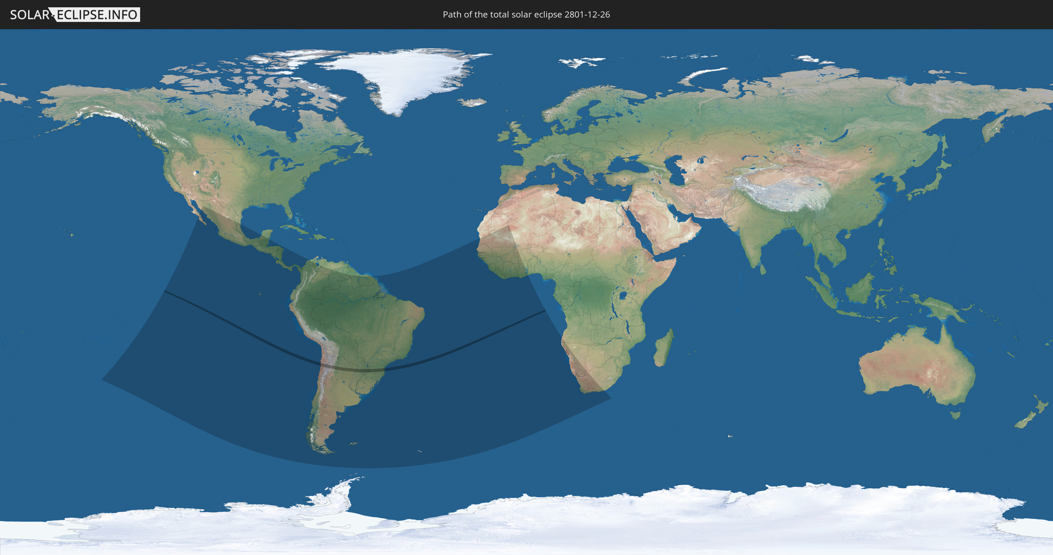
Die Sonnenfinsternis am 12/26/2801 kann man in 41 Ländern als partielle Sonnenfinsternis beobachten.
Der Finsternispfad verläuft durch 4 Länder. Nur in diesen Ländern ist sie als total Sonnenfinsternis zu sehen.
In den folgenden Ländern ist die Sonnenfinsternis total zu sehen
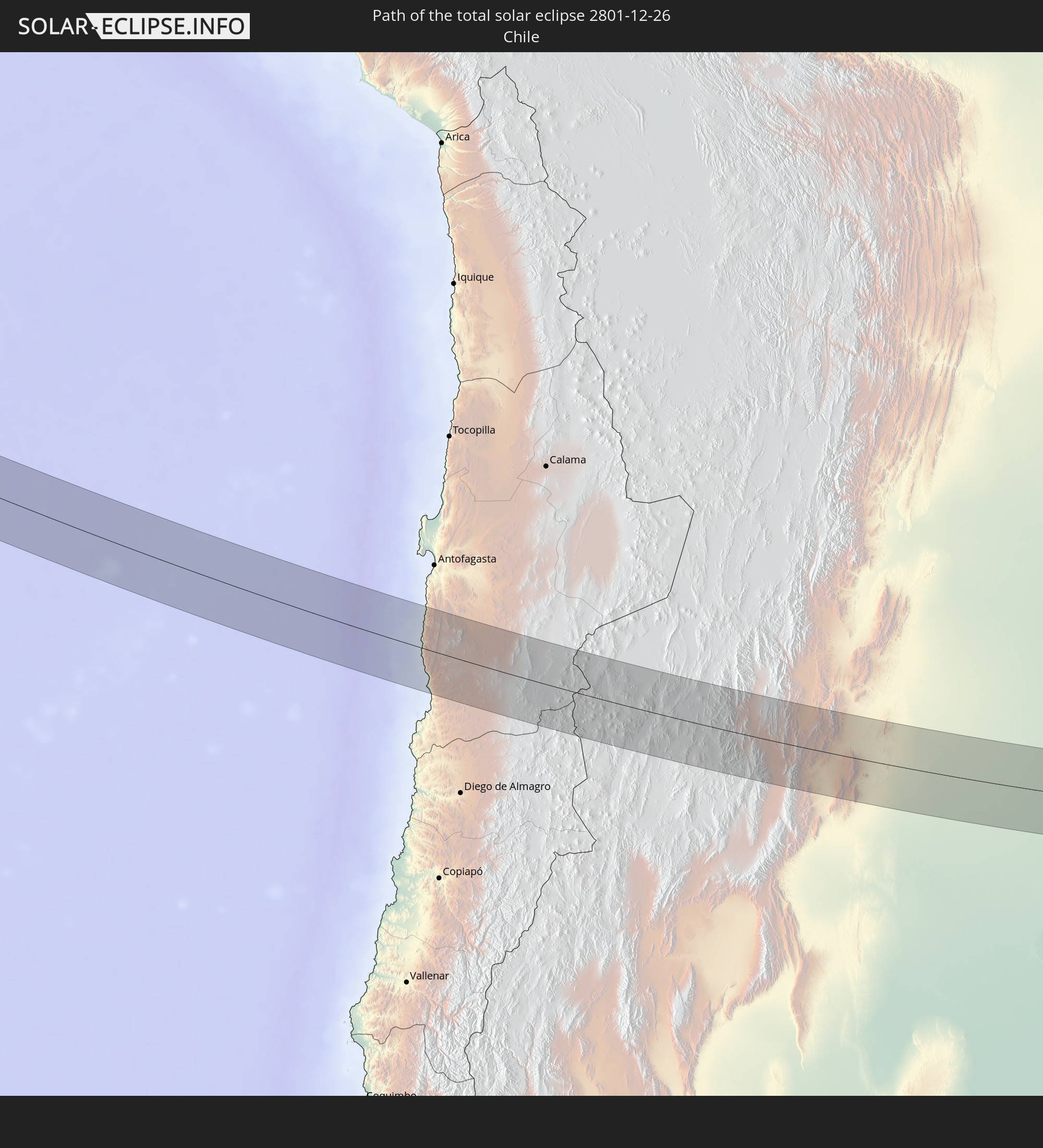 Chile
Chile
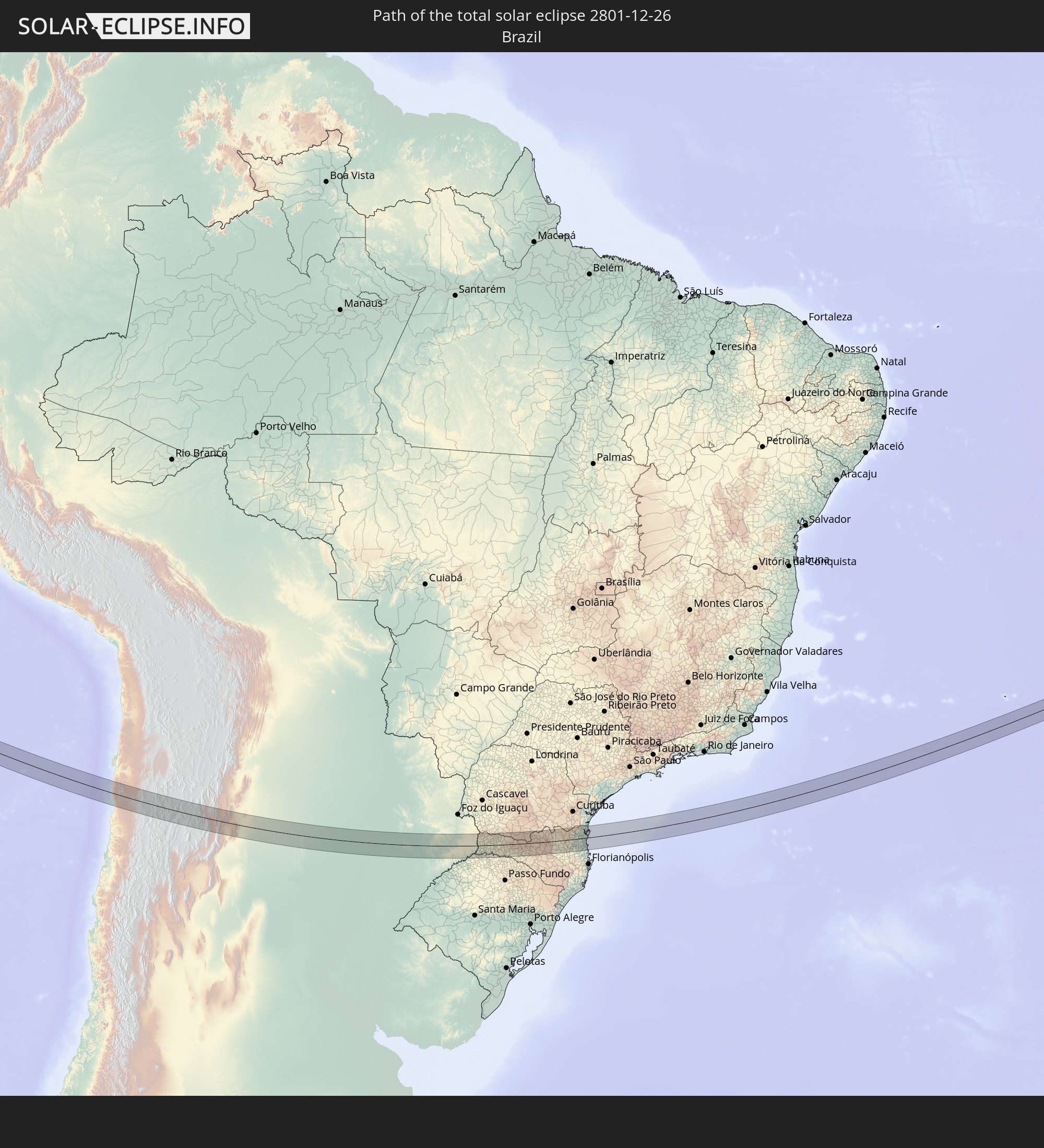 Brazil
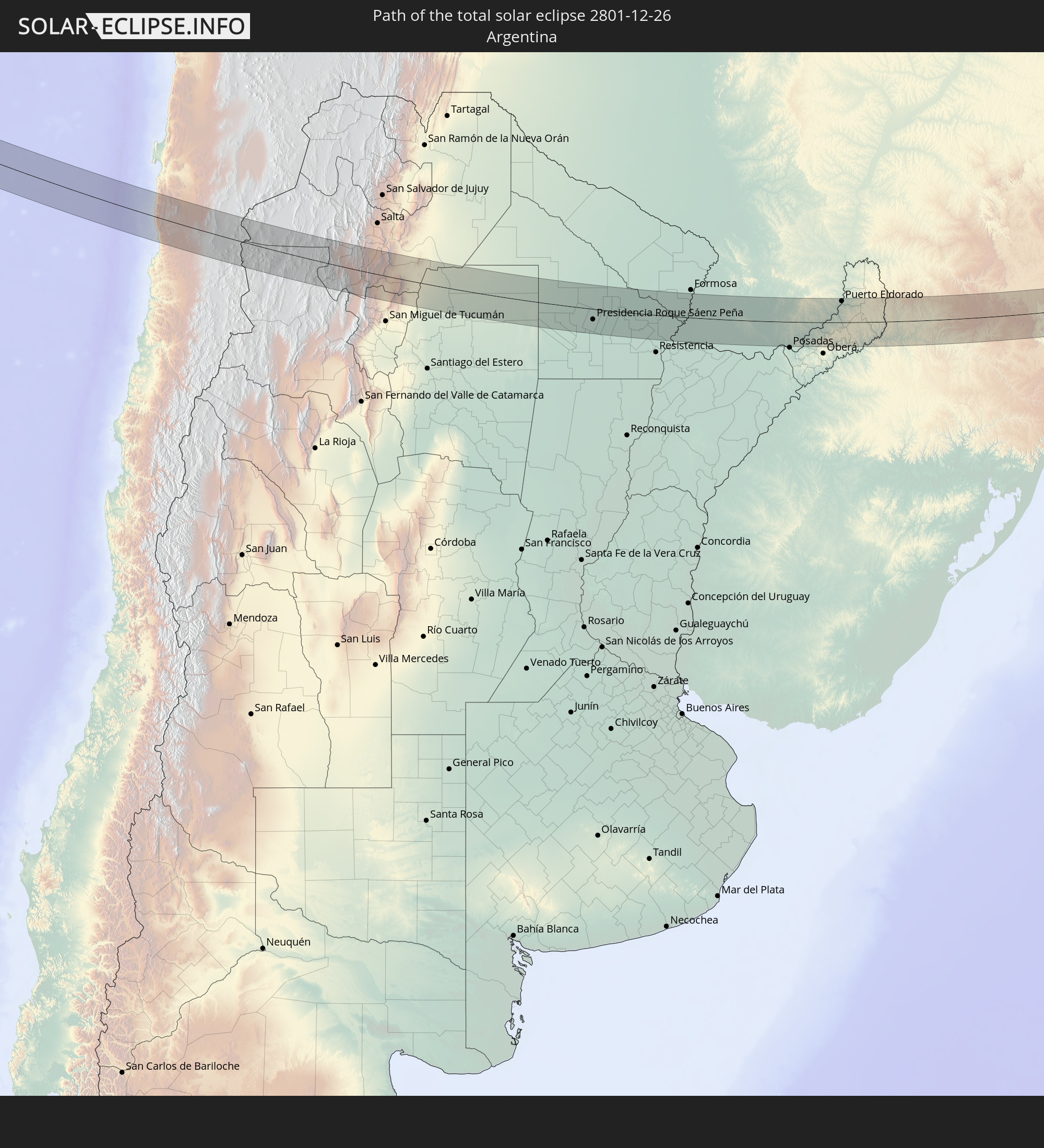 Argentina
 Paraguay
In den folgenden Ländern ist die Sonnenfinsternis partiell zu sehen
 French Polynesia
 Pitcairn Islands
 Mexico
 Chile
Chile
 Guatemala
 Ecuador
 El Salvador
 Honduras
 Belize
 Nicaragua
 Costa Rica
 Panama
 Colombia
 Peru
Peru
 Brazil
 Argentina
 Venezuela
 Bolivia
 Paraguay
 Falkland Islands
 Guyana
 Uruguay
 Suriname
 French Guiana
 South Georgia and the South Sandwich Islands
 Cabo Verde
 Senegal
 Mauritania
 The Gambia
 Guinea-Bissau
 Guinea
 Saint Helena, Ascension and Tristan da Cunha
 Sierra Leone
 Mali
Mali
 Liberia
 Ivory Coast
 Burkina Faso
 Ghana
Ghana
 Angola
 Namibia
 South Africa
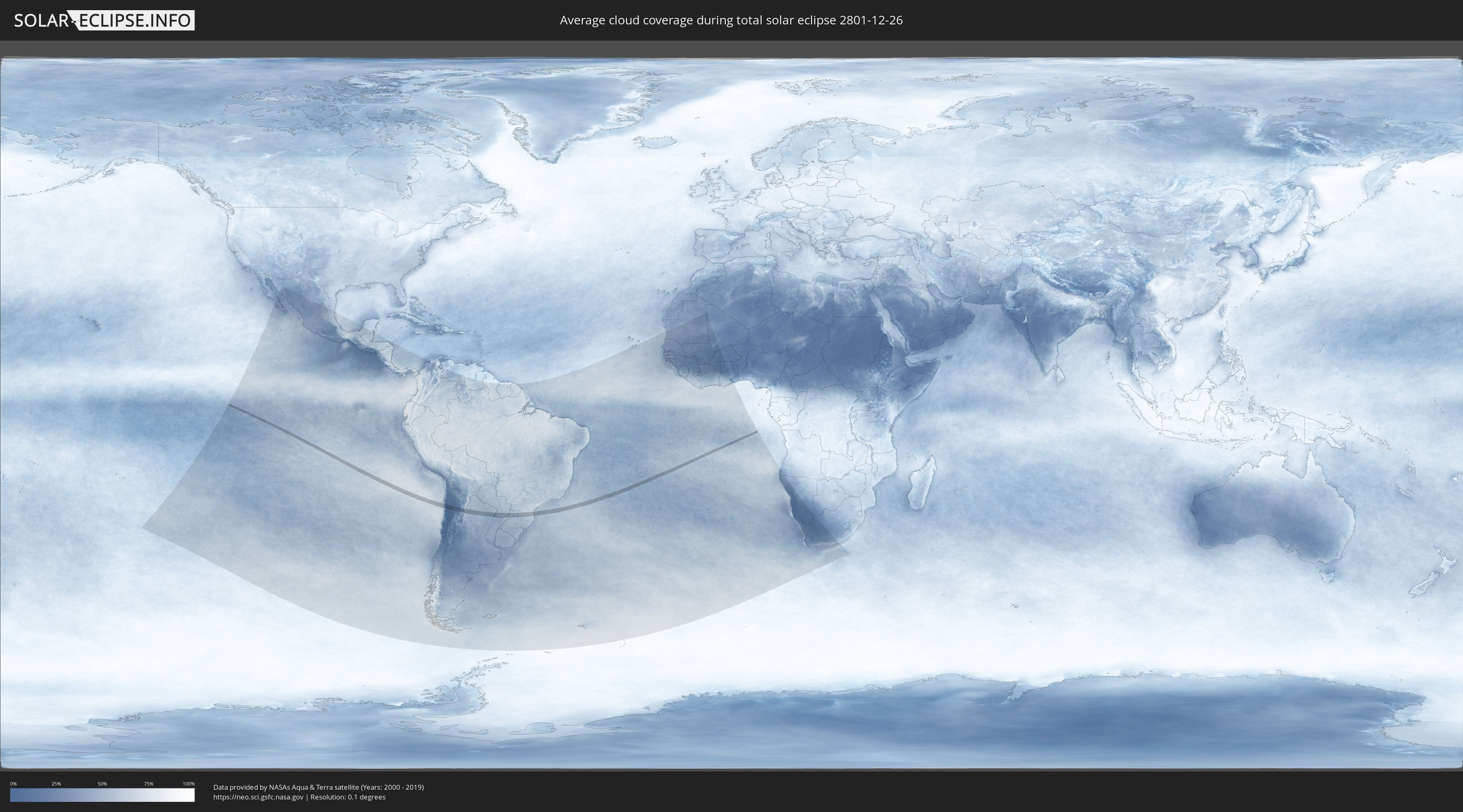
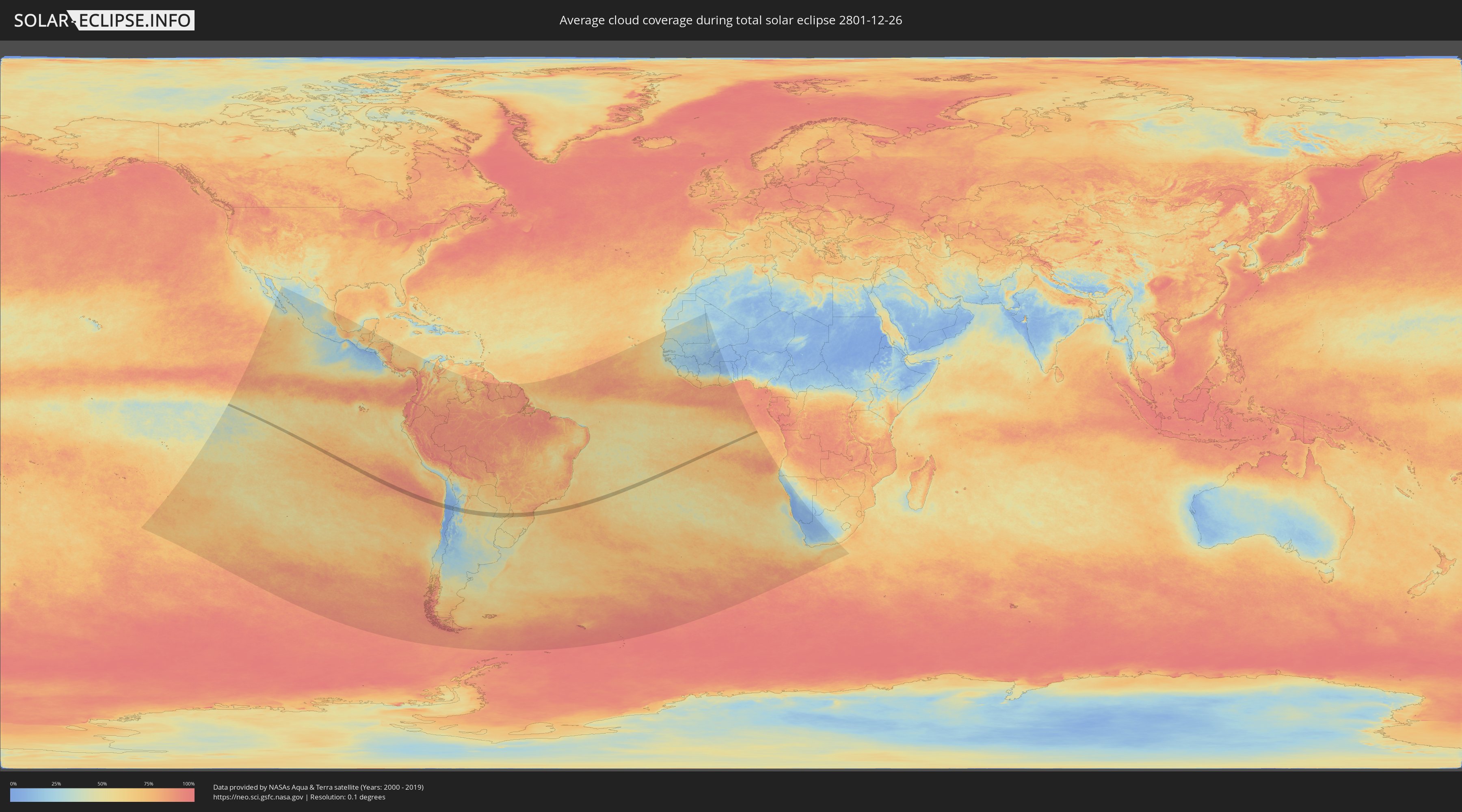
How will be the weather during the total solar eclipse on 12/26/2801?
Where is the best place to see the total solar eclipse of 12/26/2801?
The following maps show the average cloud coverage for the day of the total solar eclipse.
With the help of these maps, it is possible to find the place along the eclipse path, which has the best
chance of a cloudless sky.
Nevertheless, you should consider local circumstances and inform about the weather of your chosen
observation site.
The data is provided by NASAs satellites
AQUA and TERRA.
The cloud maps are averaged over a period of 19 years (2000 - 2019).
Detailed country maps
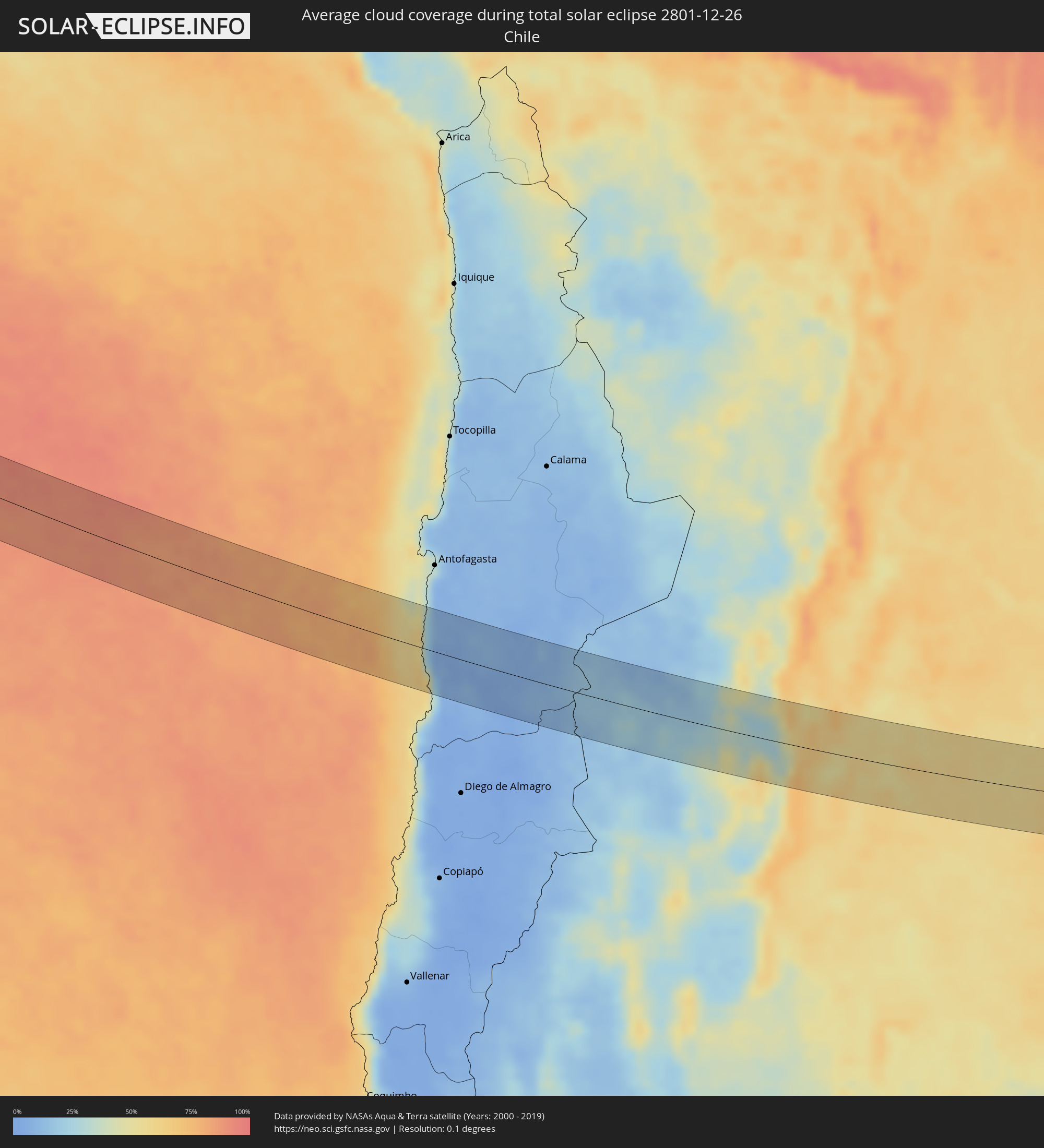 Chile
Chile
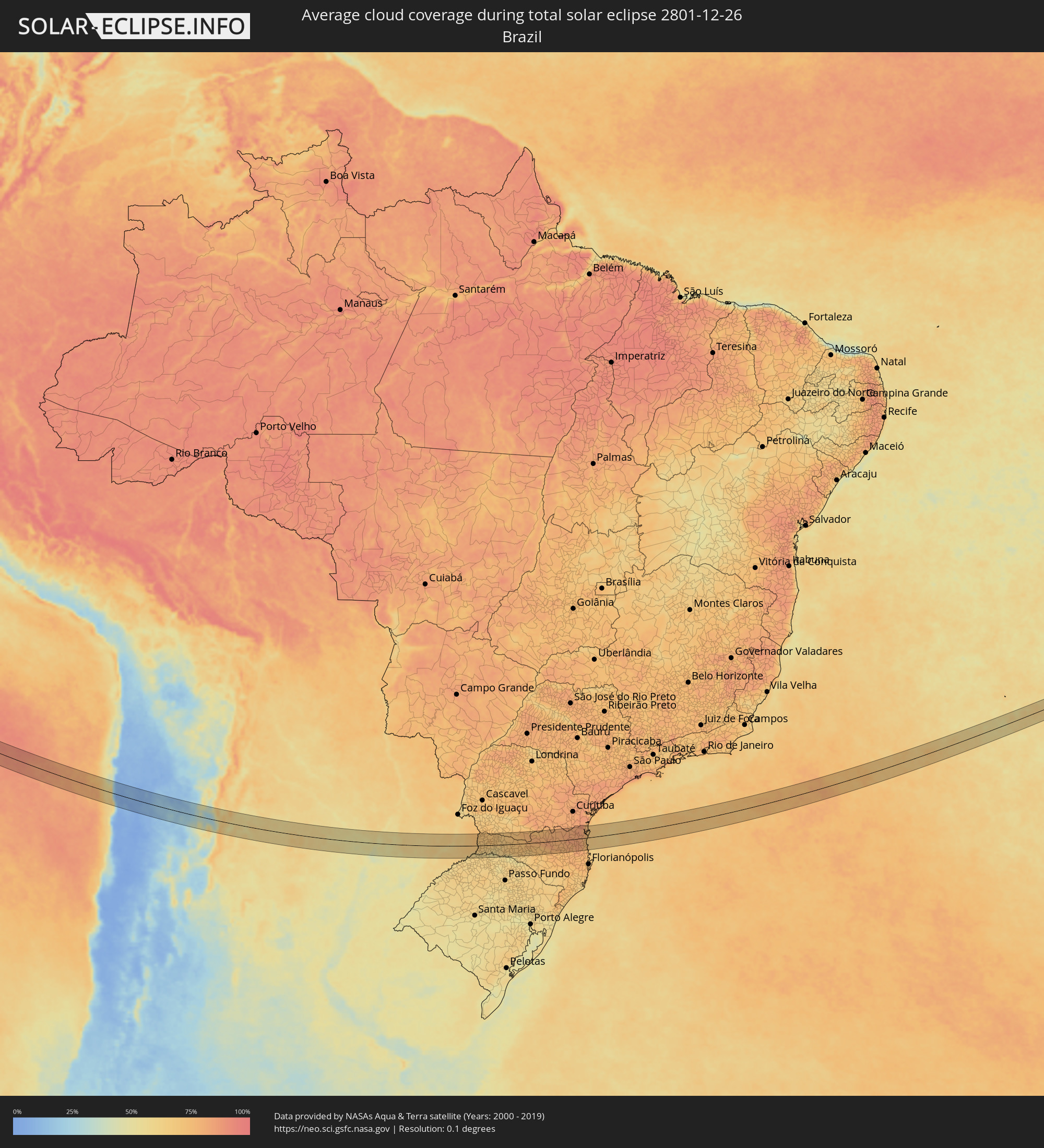 Brazil
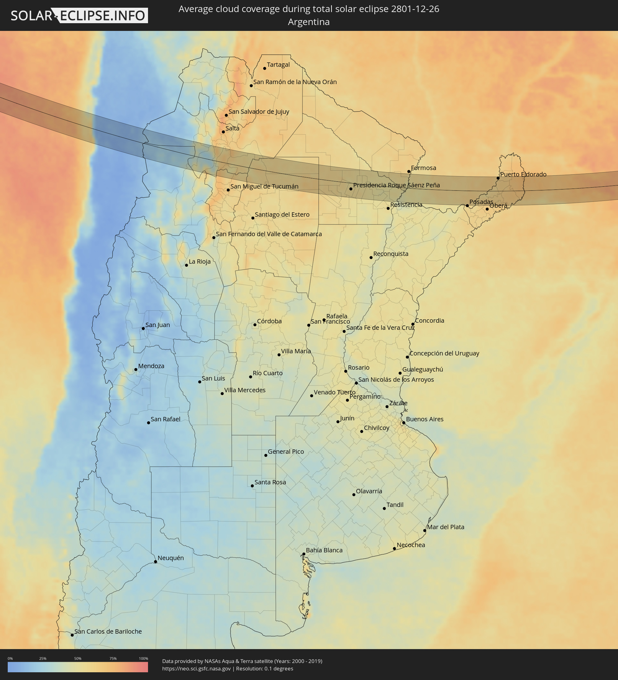 Argentina
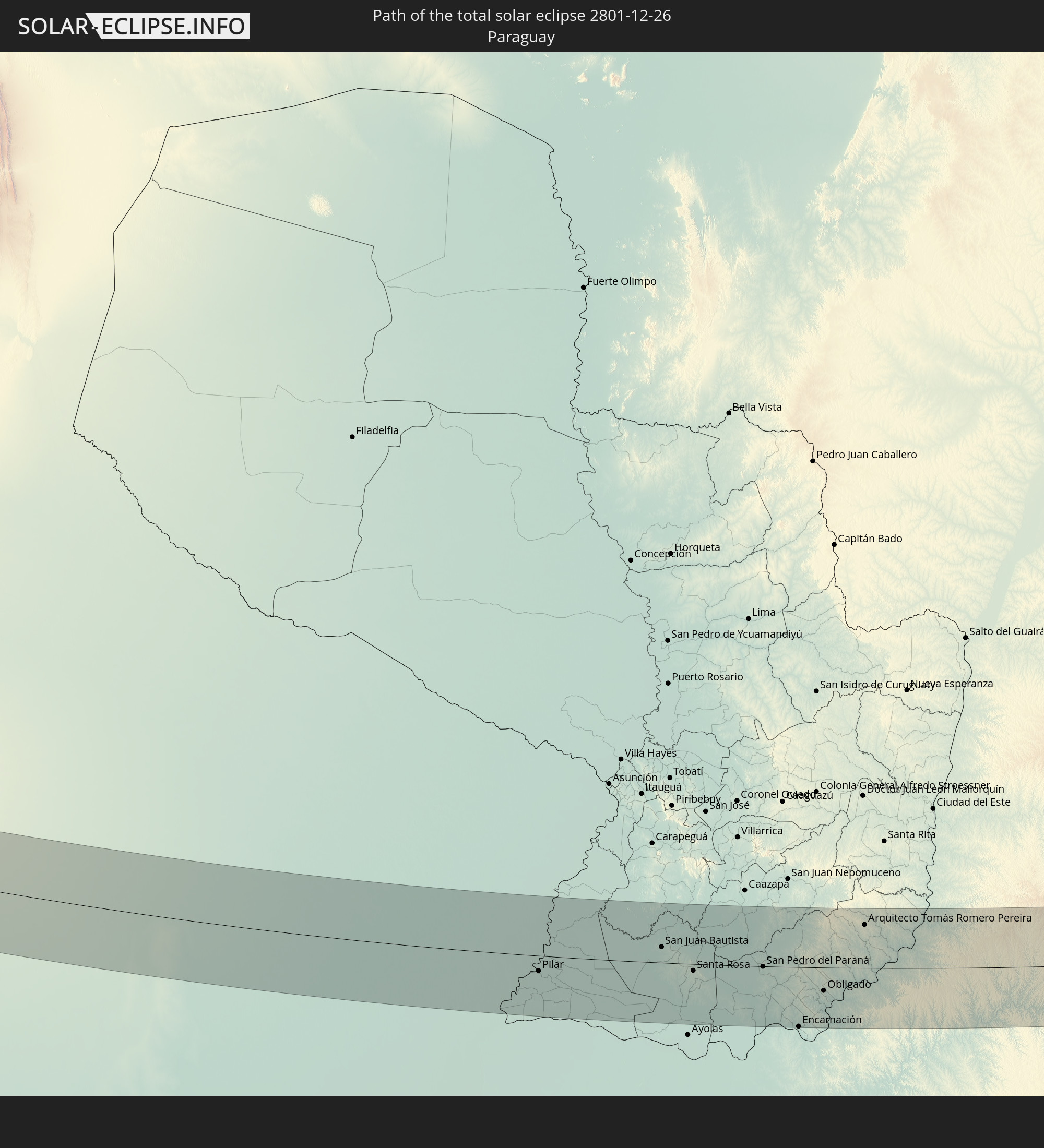
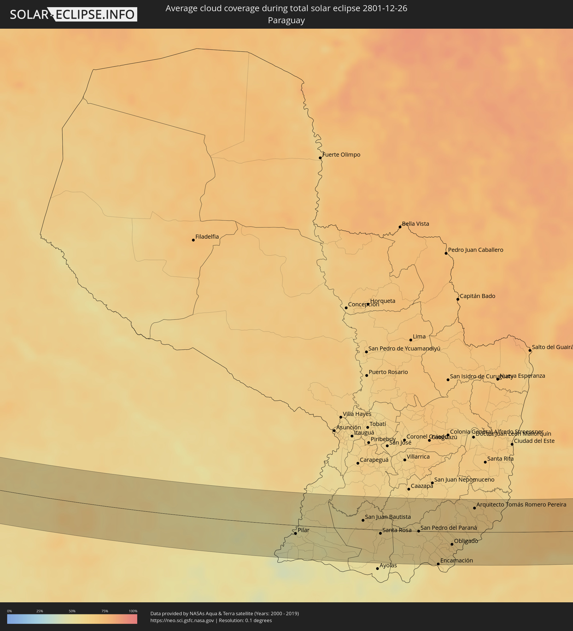 Paraguay
Cities inside the path of the eclipse
The following table shows all locations with a population of more than 5,000 inside the eclipse path. Cities which have more than 100,000 inhabitants are marked bold. A click at the locations opens a detailed map.
| City | Type | Eclipse duration | Local time of max. eclipse | Distance to central line | Ø Cloud coverage |
|
Cafayate, Salta Province
|
total | - | 12:44:18 UTC-03:00 | 36 km | 56% |
|
Trancas, Tucumán Province
|
total | - | 12:46:14 UTC-03:00 | 37 km | 56% |
|
Campo Gallo, Santiago del Estero Province
|
total | - | 12:52:57 UTC-03:00 | 34 km | 56% |
|
Los Frentones, Chaco Province
|
total | - | 12:56:46 UTC-03:00 | 6 km | 58% |
|
Pampa del Infierno, Chaco Province
|
total | - | 12:57:28 UTC-03:00 | 2 km | 57% |
|
Corzuela, Chaco Province
|
total | - | 12:58:11 UTC-03:00 | 49 km | 55% |
|
Concepción del Bermejo, Chaco Province
|
total | - | 12:58:07 UTC-03:00 | 9 km | 57% |
|
Campo Largo, Chaco Province
|
total | - | 12:58:29 UTC-03:00 | 30 km | 54% |
|
Aviá Terai, Chaco Province
|
total | - | 12:58:45 UTC-03:00 | 16 km | 53% |
|
Presidencia Roque Sáenz Peña, Chaco Province
|
total | - | 12:59:34 UTC-03:00 | 24 km | 54% |
|
Tres Isletas, Chaco Province
|
total | - | 12:59:26 UTC-03:00 | 25 km | 55% |
|
Quitilipi, Chaco Province
|
total | - | 13:00:12 UTC-03:00 | 31 km | 54% |
|
Machagai, Chaco Province
|
total | - | 13:00:41 UTC-03:00 | 35 km | 53% |
|
Presidencia de la Plaza, Chaco Province
|
total | - | 13:01:16 UTC-03:00 | 42 km | 51% |
|
El Colorado, Formosa Province
|
total | - | 13:02:21 UTC-03:00 | 40 km | 50% |
|
General José de San Martín, Chaco Province
|
total | - | 13:02:30 UTC-03:00 | 14 km | 53% |
|
La Leonesa, Chaco Province
|
total | - | 13:04:22 UTC-03:00 | 36 km | 48% |
|
Pilar, Ñeembucú
|
total | - | 13:05:27 UTC-03:00 | 14 km | 49% |
|
San Juan Bautista, Misiones
|
total | - | 13:08:34 UTC-03:00 | 14 km | 59% |
|
Santa Rosa, Misiones
|
total | - | 13:09:24 UTC-03:00 | 6 km | 59% |
|
San Pedro del Paraná, Itapúa
|
total | - | 13:11:10 UTC-03:00 | 0 km | 59% |
|
Encarnación, Itapúa
|
total | - | 13:12:05 UTC-03:00 | 55 km | 58% |
|
Hohenau, Itapúa
|
total | - | 13:12:24 UTC-03:00 | 27 km | 61% |
|
Obligado, Itapúa
|
total | - | 13:12:42 UTC-03:00 | 22 km | 62% |
|
Gobernador Roca, Misiones Province
|
total | - | 13:13:10 UTC-03:00 | 38 km | 58% |
|
Santo Pipó, Misiones Province
|
total | - | 13:13:19 UTC-03:00 | 33 km | 61% |
|
Arquitecto Tomás Romero Pereira, Itapúa
|
total | - | 13:13:45 UTC-03:00 | 40 km | 64% |
|
Jardín América, Misiones Province
|
total | - | 13:13:48 UTC-03:00 | 22 km | 61% |
|
Capioví, Misiones Province
|
total | - | 13:14:15 UTC-03:00 | 10 km | 57% |
|
Puerto Rico, Misiones Province
|
total | - | 13:14:21 UTC-03:00 | 5 km | 58% |
|
Campo Grande, Misiones Province
|
total | - | 13:14:28 UTC-03:00 | 40 km | 62% |
|
Garuhapé, Misiones Province
|
total | - | 13:14:32 UTC-03:00 | 3 km | 58% |
|
Aristóbulo del Valle, Misiones Province
|
total | - | 13:14:42 UTC-03:00 | 28 km | 63% |
|
El Alcázar, Misiones Province
|
total | - | 13:14:55 UTC-03:00 | 14 km | 60% |
|
Montecarlo, Misiones Province
|
total | - | 13:15:05 UTC-03:00 | 31 km | 57% |
|
Puerto Piray, Misiones Province
|
total | - | 13:15:12 UTC-03:00 | 42 km | 63% |
|
Puerto Eldorado, Misiones Province
|
total | - | 13:15:16 UTC-03:00 | 49 km | 60% |
|
Dos de Mayo, Misiones Province
|
total | - | 13:15:16 UTC-03:00 | 20 km | 62% |
|
El Soberbio, Misiones Province
|
total | - | 13:16:33 UTC-03:00 | 51 km | 58% |
|
San Vicente, Misiones Province
|
total | - | 13:16:46 UTC-03:00 | 25 km | 68% |
|
San Pedro, Misiones Province
|
total | - | 13:16:50 UTC-03:00 | 24 km | 68% |
|
São Lourenço dOeste, Santa Catarina
|
total | - | 13:20:16 UTC-03:00 | 50 km | 70% |
|
Chapecó, Santa Catarina
|
total | - | 13:20:46 UTC-03:00 | 33 km | 63% |
|
Clevelândia, Paraná
|
total | - | 13:21:16 UTC-03:00 | 44 km | 67% |
|
Xanxerê, Santa Catarina
|
total | - | 13:21:22 UTC-03:00 | 10 km | 68% |
|
Concórdia, Santa Catarina
|
total | - | 13:22:17 UTC-03:00 | 51 km | 63% |
|
Palmas, Paraná
|
total | - | 13:22:32 UTC-03:00 | 32 km | 72% |
|
Joaçaba, Santa Catarina
|
total | - | 13:23:39 UTC-03:00 | 48 km | 64% |
|
Videira, Santa Catarina
|
total | - | 13:24:37 UTC-03:00 | 32 km | 68% |
|
União da Vitória, Paraná
|
total | - | 13:24:59 UTC-03:00 | 54 km | 74% |
|
Porto União, Santa Catarina
|
total | - | 13:25:00 UTC-03:00 | 53 km | 74% |
|
Caçador, Santa Catarina
|
total | - | 13:25:02 UTC-03:00 | 7 km | 70% |
|
Santa Cecília, Santa Catarina
|
total | - | 13:26:30 UTC-03:00 | 32 km | 75% |
|
Canoinhas, Santa Catarina
|
total | - | 13:26:50 UTC-03:00 | 55 km | 77% |
|
Rio Negrinho, Santa Catarina
|
total | - | 13:29:04 UTC-03:00 | 38 km | 82% |
|
Ibirama, Santa Catarina
|
total | - | 13:28:47 UTC-03:00 | 51 km | 76% |
|
São Bento do Sul, Santa Catarina
|
total | - | 13:29:26 UTC-03:00 | 37 km | 82% |
|
Gavea, Santa Catarina
|
total | - | 13:29:14 UTC-03:00 | 36 km | 79% |
|
Timbó, Santa Catarina
|
total | - | 13:29:30 UTC-03:00 | 28 km | 80% |
|
Corupá, Santa Catarina
|
total | - | 13:29:43 UTC-03:00 | 16 km | 82% |
|
Indaial, Santa Catarina
|
total | - | 13:29:34 UTC-03:00 | 37 km | 79% |
|
Pomerode, Santa Catarina
|
total | - | 13:29:46 UTC-03:00 | 20 km | 82% |
|
Schroeder, Santa Catarina
|
total | - | 13:30:09 UTC-03:00 | 16 km | 83% |
|
Jaraguá do Sul, Santa Catarina
|
total | - | 13:30:08 UTC-03:00 | 7 km | 82% |
|
Blumenau, Santa Catarina
|
total | - | 13:29:59 UTC-03:00 | 41 km | 82% |
|
Guaramirim, Santa Catarina
|
total | - | 13:30:18 UTC-03:00 | 8 km | 82% |
|
Gaspar, Santa Catarina
|
total | - | 13:30:15 UTC-03:00 | 43 km | 80% |
|
Joinville, Santa Catarina
|
total | - | 13:30:46 UTC-03:00 | 25 km | 81% |
|
Barra Velha, Santa Catarina
|
total | - | 13:31:03 UTC-03:00 | 13 km | 72% |
|
Itajaí, Santa Catarina
|
total | - | 13:31:00 UTC-03:00 | 44 km | 76% |
|
Navegantes, Santa Catarina
|
total | - | 13:31:01 UTC-03:00 | 43 km | 76% |
|
Penha, Santa Catarina
|
total | - | 13:31:06 UTC-03:00 | 29 km | 70% |
|
São Francisco do Sul, Santa Catarina
|
total | - | 13:31:19 UTC-03:00 | 29 km | 72% |
|
Balneário Camboriú, Santa Catarina
|
total | - | 13:31:02 UTC-03:00 | 53 km | 71% |