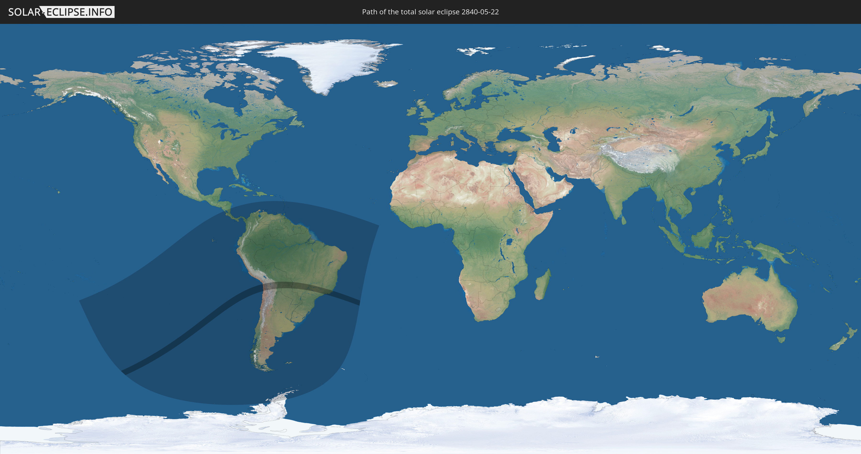
Total solar eclipse of 05/22/2840
| Day of week: | Tuesday |
| Maximum duration of eclipse: | 05m41s |
| Maximum width of eclipse path: | 303 km |
| Saros cycle: | 151 |
| Coverage: | 100% |
| Magnitude: | 1.0657 |
| Gamma: | -0.7118 |
Wo kann man die Sonnenfinsternis vom 05/22/2840 sehen?
Die Sonnenfinsternis am 05/22/2840 kann man in 29 Ländern als partielle Sonnenfinsternis beobachten.
Der Finsternispfad verläuft durch 4 Länder. Nur in diesen Ländern ist sie als total Sonnenfinsternis zu sehen.
In den folgenden Ländern ist die Sonnenfinsternis total zu sehen
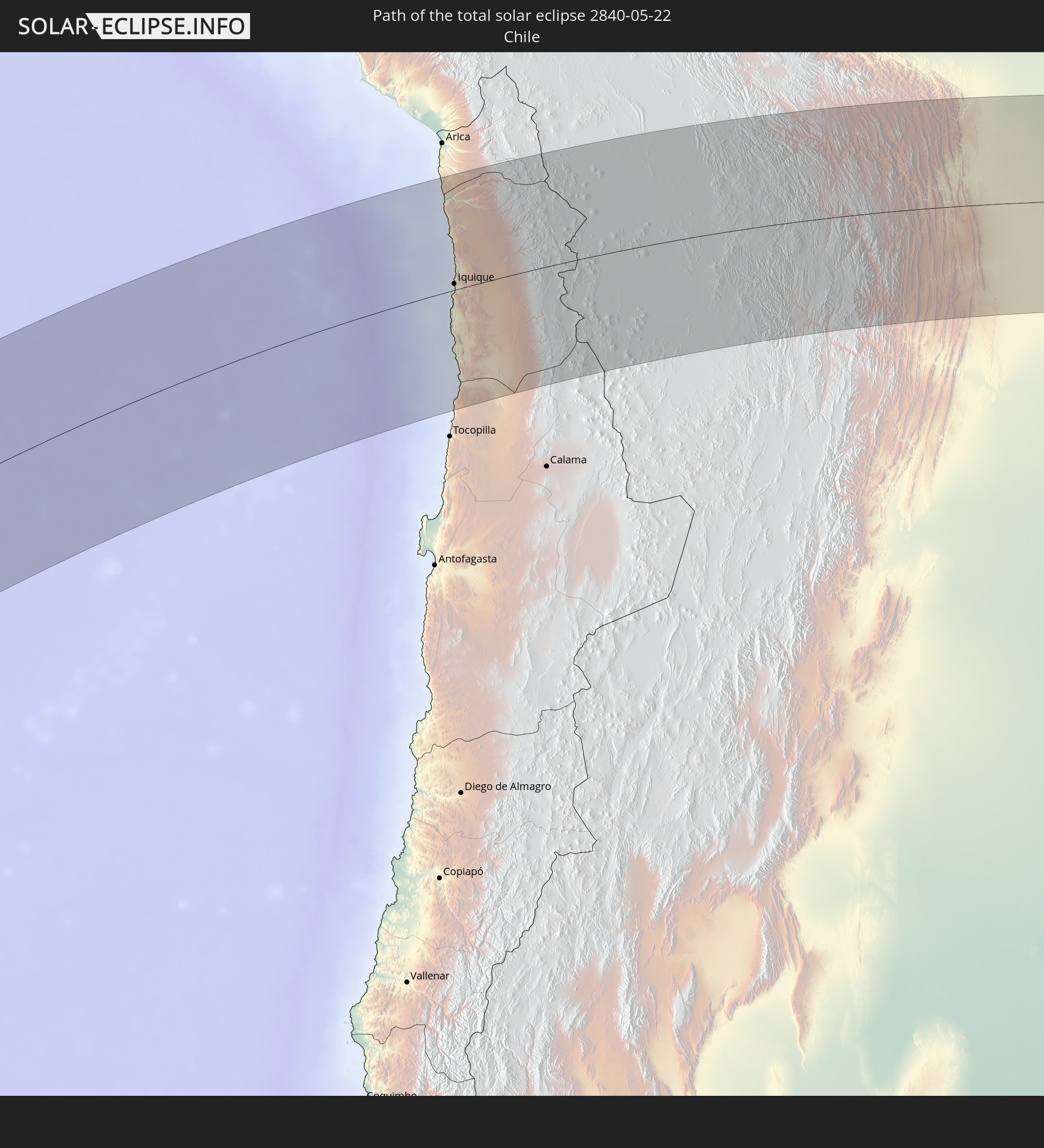 Chile
Chile
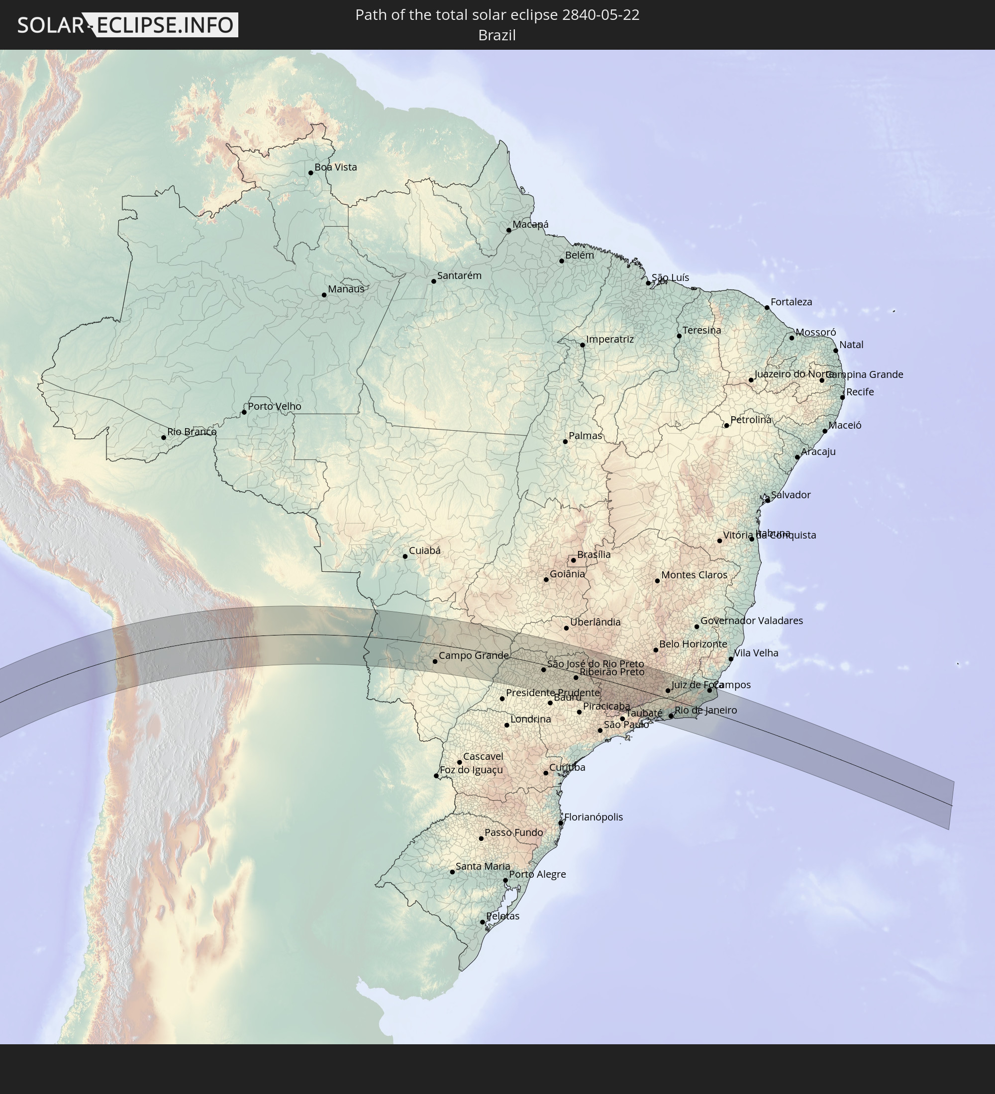 Brazil
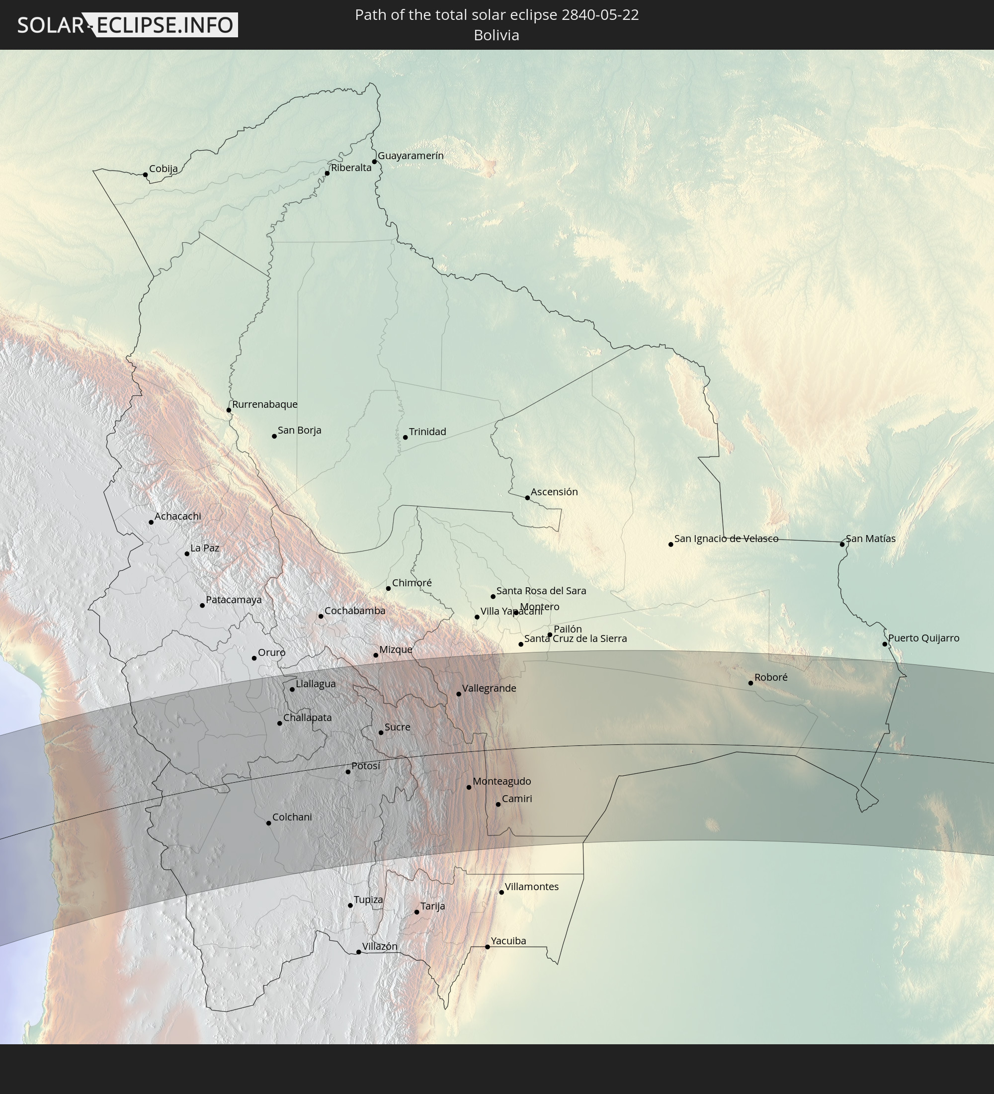 Bolivia
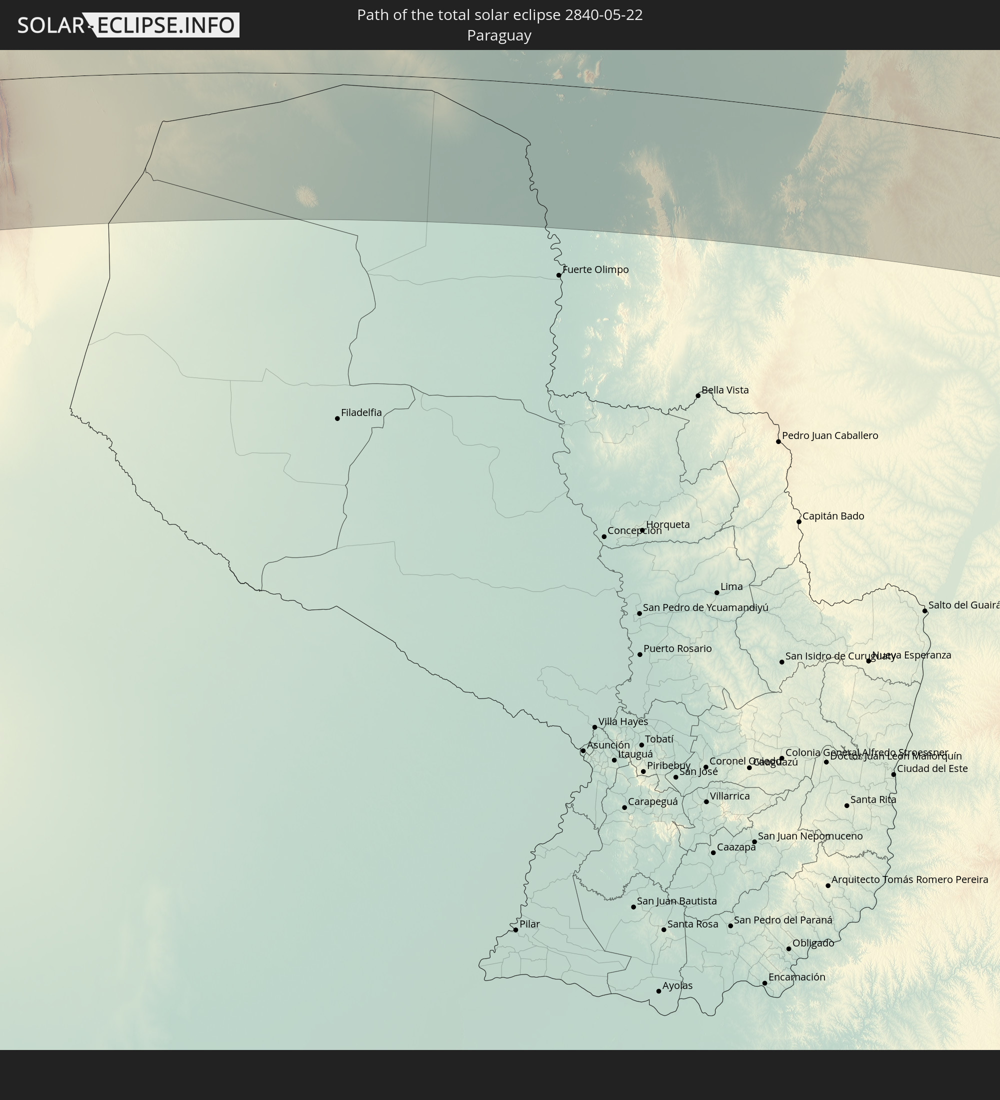 Paraguay
In den folgenden Ländern ist die Sonnenfinsternis partiell zu sehen
 Antarctica
 French Polynesia
 Pitcairn Islands
 Chile
Chile
 Ecuador
 Nicaragua
 Costa Rica
 Panama
 Colombia
 Peru
Peru
 Brazil
 Argentina
 Venezuela
 Aruba
Aruba
 Bolivia
 Paraguay
 Trinidad and Tobago
 Grenada
 Dominica
 Saint Vincent and the Grenadines
 Falkland Islands
 Guyana
 Martinique
 Saint Lucia
 Barbados
 Uruguay
 Suriname
 French Guiana
 South Georgia and the South Sandwich Islands
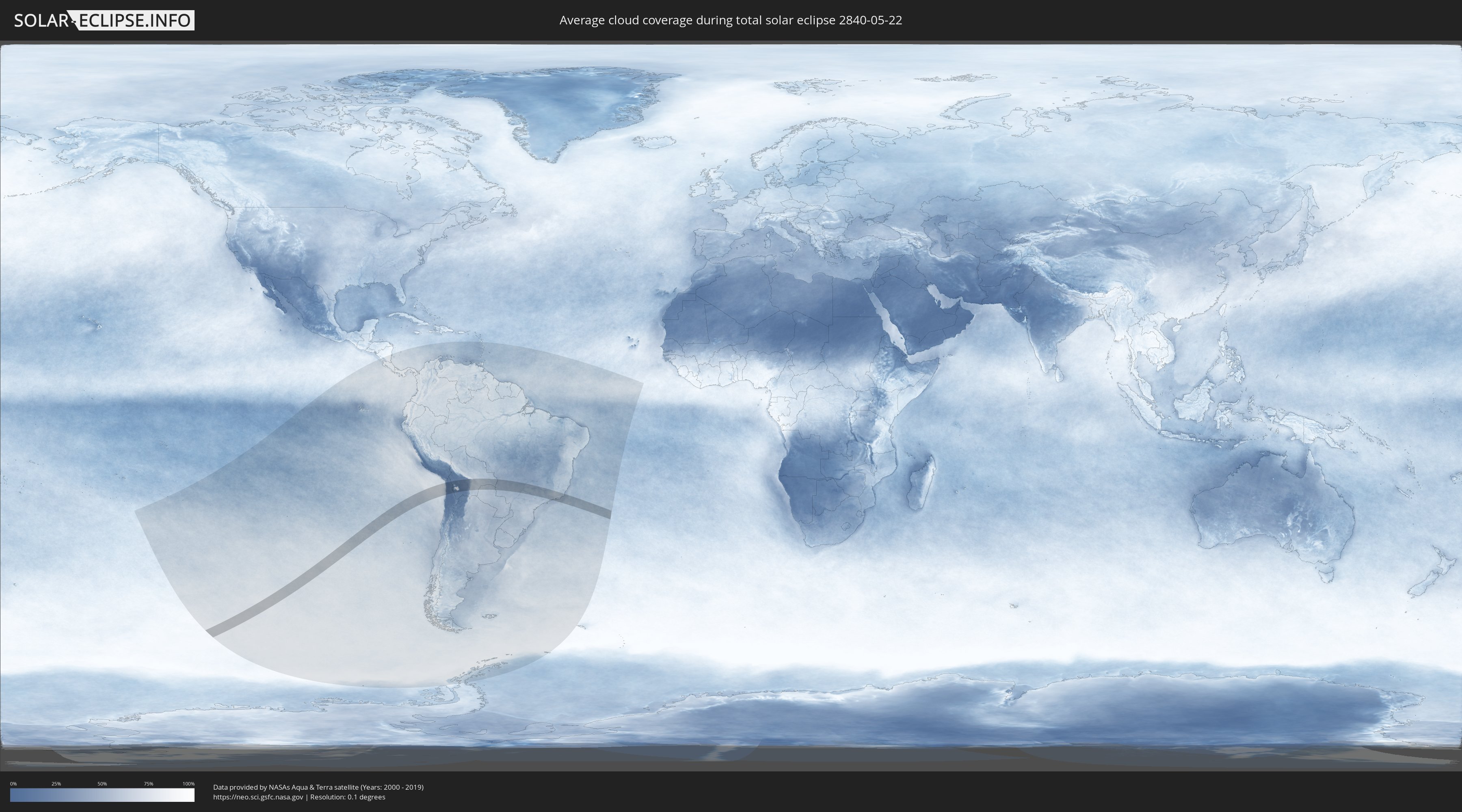
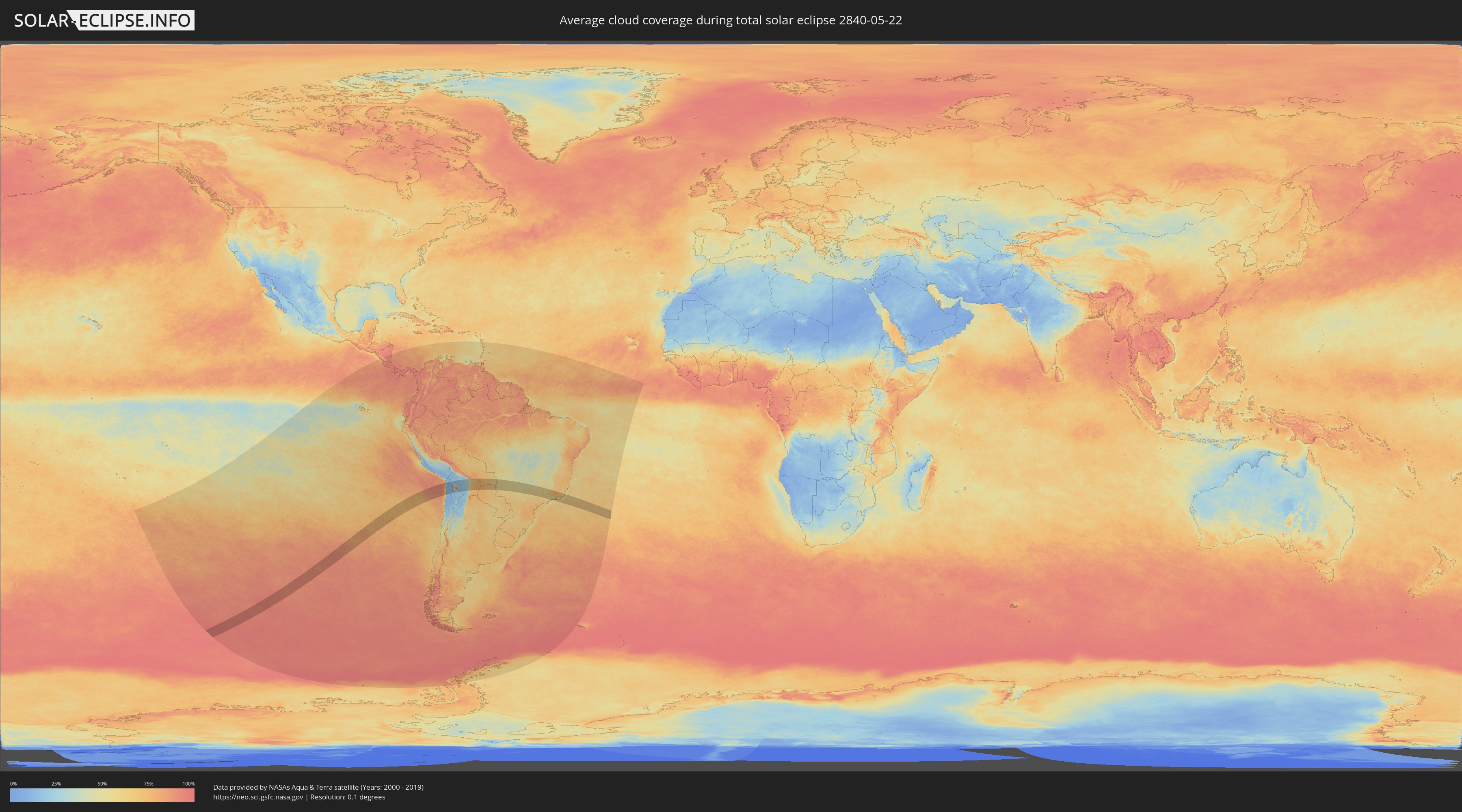
How will be the weather during the total solar eclipse on 05/22/2840?
Where is the best place to see the total solar eclipse of 05/22/2840?
The following maps show the average cloud coverage for the day of the total solar eclipse.
With the help of these maps, it is possible to find the place along the eclipse path, which has the best
chance of a cloudless sky.
Nevertheless, you should consider local circumstances and inform about the weather of your chosen
observation site.
The data is provided by NASAs satellites
AQUA and TERRA.
The cloud maps are averaged over a period of 19 years (2000 - 2019).
Detailed country maps
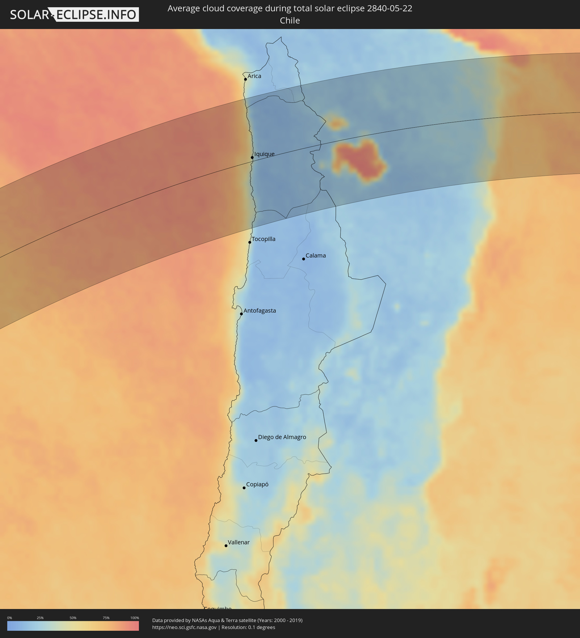 Chile
Chile
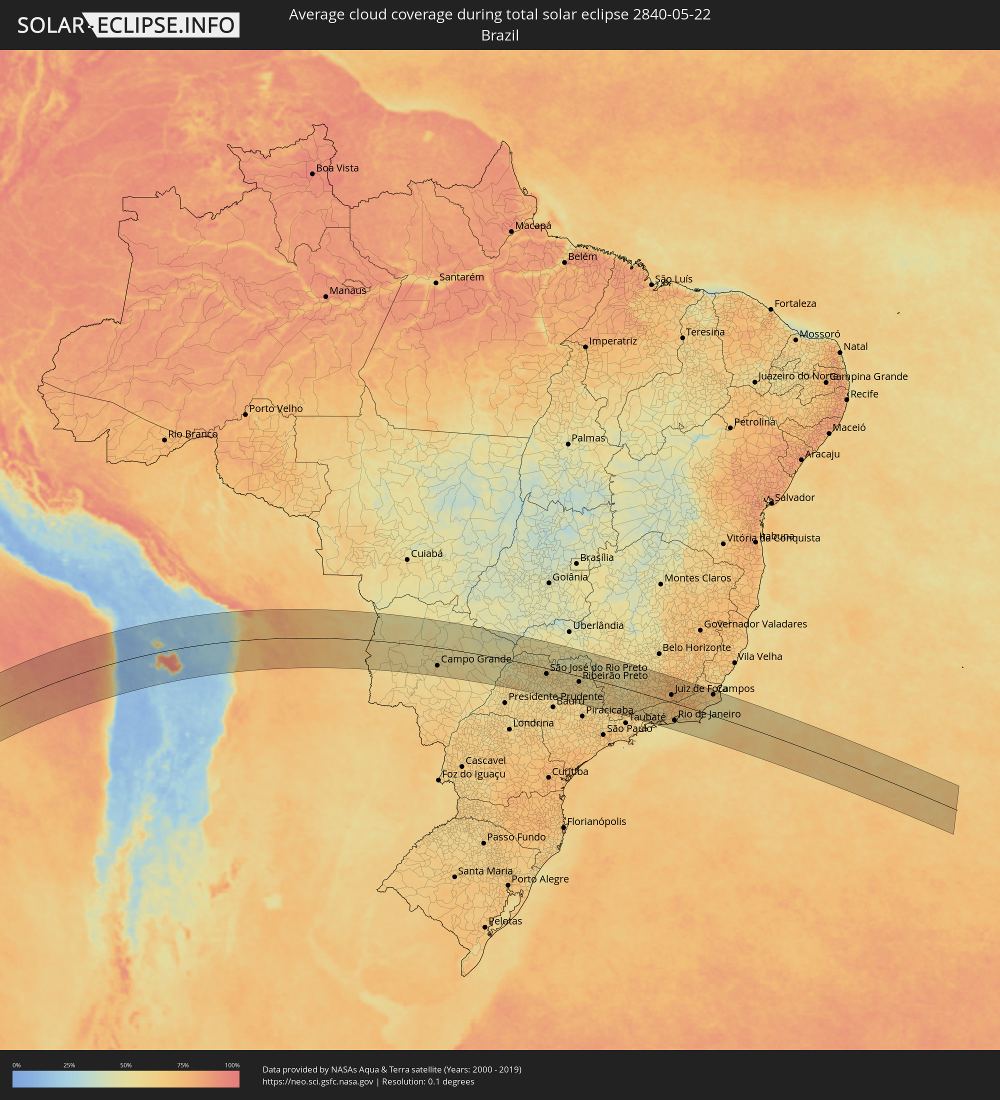 Brazil
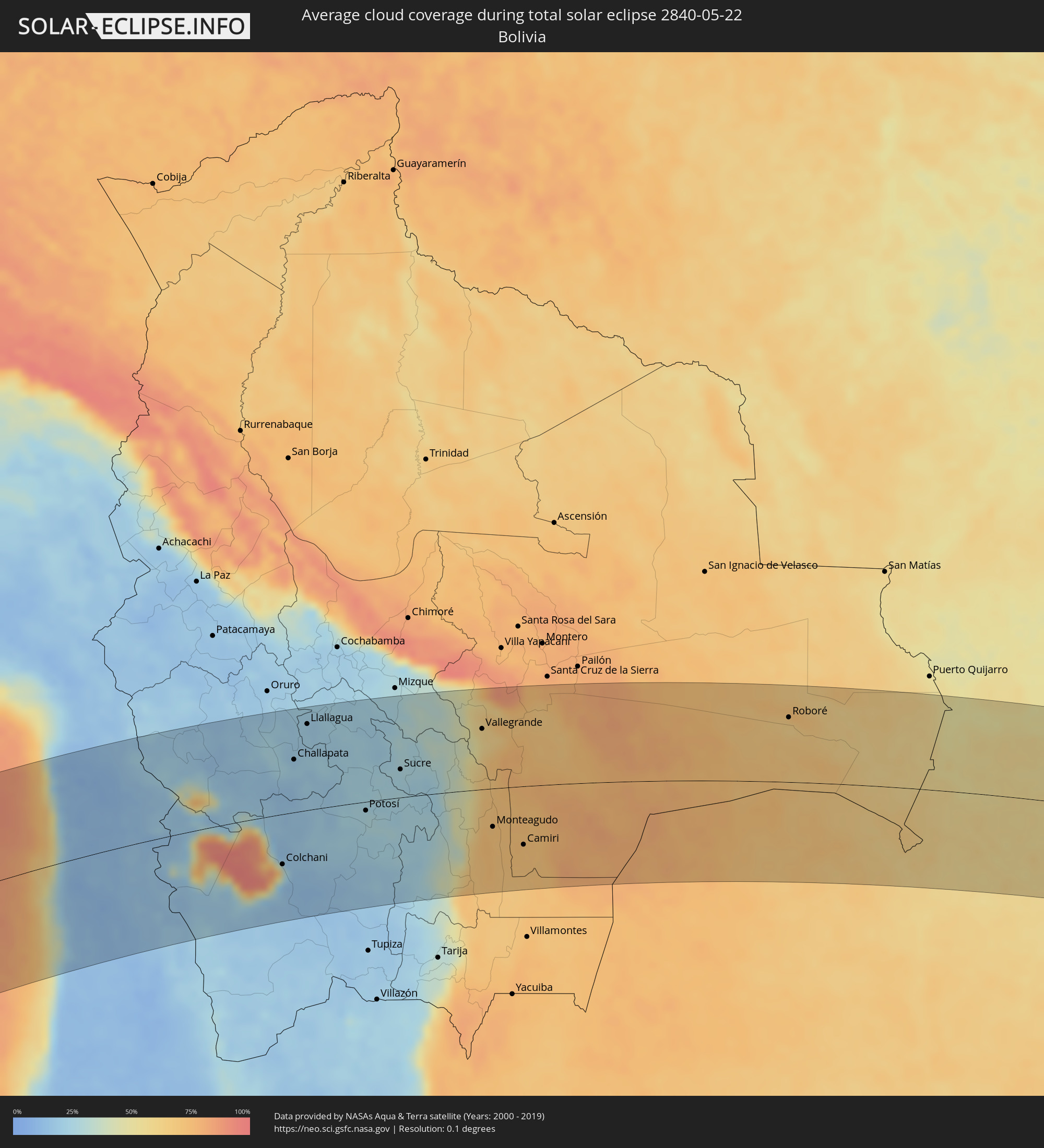 Bolivia
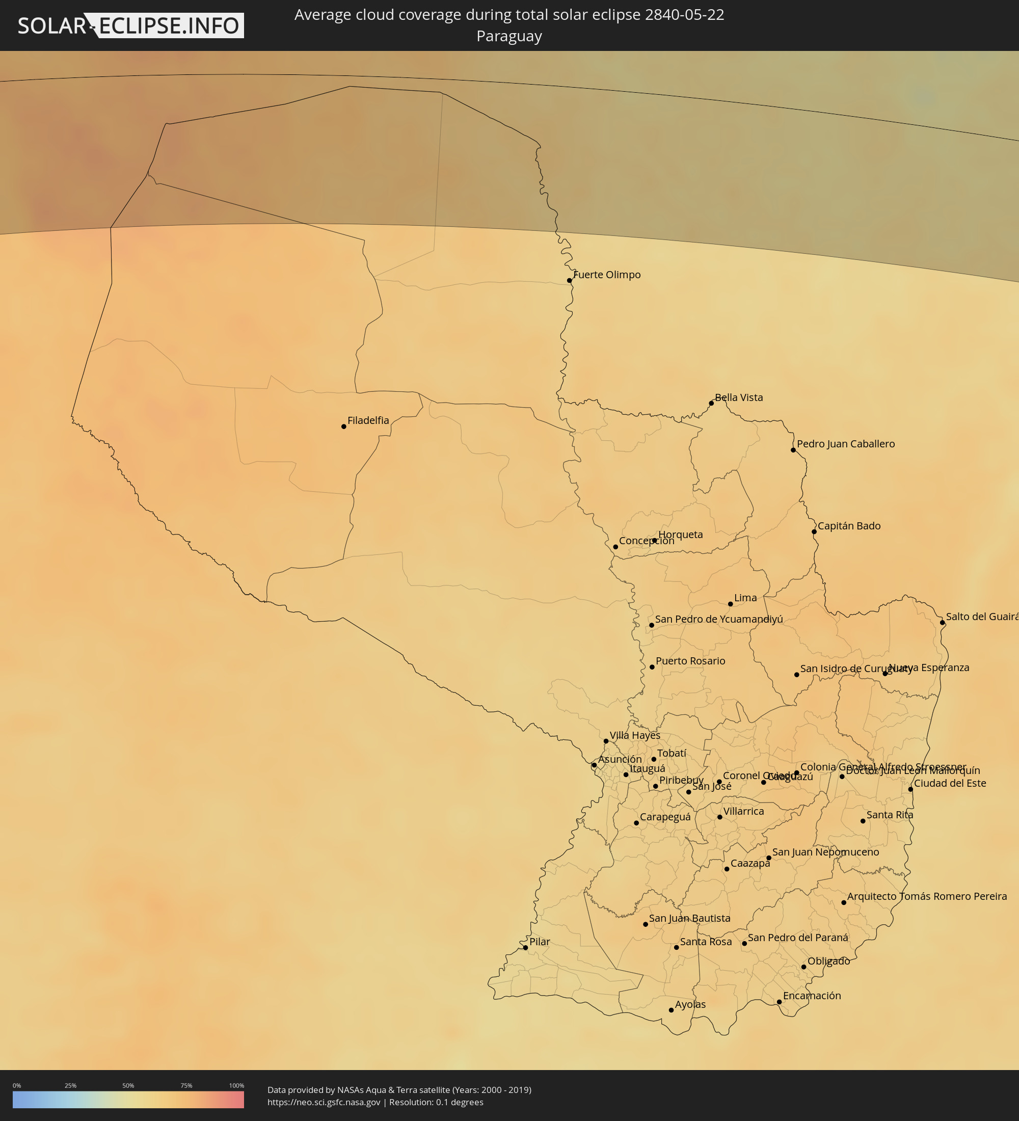 Paraguay
Cities inside the path of the eclipse
The following table shows all locations with a population of more than 5,000 inside the eclipse path. Cities which have more than 100,000 inhabitants are marked bold. A click at the locations opens a detailed map.
| City | Type | Eclipse duration | Local time of max. eclipse | Distance to central line | Ø Cloud coverage |
|
Iquique, Tarapacá
|
total | - | 15:22:28 UTC-03:00 | 8 km | 28% |
|
Colchani, Potosí
|
total | - | 14:30:01 UTC-04:00 | 73 km | 29% |
|
Huanuni, Oruro
|
total | - | 14:32:39 UTC-04:00 | 146 km | 20% |
|
Uyuni, Potosí
|
total | - | 14:30:05 UTC-04:00 | 93 km | 14% |
|
Challapata, Oruro
|
total | - | 14:32:04 UTC-04:00 | 78 km | 20% |
|
Llallagua, Potosí
|
total | - | 14:33:04 UTC-04:00 | 127 km | 20% |
|
Potosí, Potosí
|
total | - | 14:33:36 UTC-04:00 | 13 km | 26% |
|
Sucre, Chuquisaca
|
total | - | 14:35:22 UTC-04:00 | 42 km | 26% |
|
Aiquile, Cochabamba
|
total | - | 14:36:32 UTC-04:00 | 132 km | 27% |
|
Vallegrande, Santa Cruz
|
total | - | 14:38:34 UTC-04:00 | 90 km | 59% |
|
Monteagudo, Chuquisaca
|
total | - | 14:37:21 UTC-04:00 | 57 km | 72% |
|
Camiri, Santa Cruz
|
total | - | 14:38:01 UTC-04:00 | 87 km | 71% |
|
Santiago del Torno, Santa Cruz
|
total | - | 14:40:44 UTC-04:00 | 141 km | 72% |
|
Roboré, Santa Cruz
|
total | - | 14:47:47 UTC-04:00 | 97 km | 64% |
|
Corumbá, Mato Grosso do Sul
|
total | - | 14:51:01 UTC-04:00 | 34 km | 55% |
|
Campo Grande, Mato Grosso do Sul
|
total | - | 14:54:39 UTC-04:00 | 90 km | 58% |
|
Três Lagoas, Mato Grosso do Sul
|
total | - | 14:58:55 UTC-04:00 | 75 km | 49% |
|
Andradina, São Paulo
|
total | - | 15:59:16 UTC-03:00 | 81 km | 55% |
|
Araçatuba, São Paulo
|
total | - | 16:00:17 UTC-03:00 | 94 km | 58% |
|
Fernandópolis, São Paulo
|
total | - | 16:01:36 UTC-03:00 | 10 km | 57% |
|
Penápolis, São Paulo
|
total | - | 16:00:33 UTC-03:00 | 109 km | 58% |
|
Votuporanga, São Paulo
|
total | - | 16:01:49 UTC-03:00 | 2 km | 59% |
|
Lins, São Paulo
|
total | - | 16:00:43 UTC-03:00 | 130 km | 60% |
|
São José do Rio Preto, São Paulo
|
total | - | 16:02:12 UTC-03:00 | 28 km | 59% |
|
Catanduva, São Paulo
|
total | - | 16:02:23 UTC-03:00 | 53 km | 59% |
|
Ibitinga, São Paulo
|
total | - | 16:01:52 UTC-03:00 | 116 km | 54% |
|
Barretos, São Paulo
|
total | - | 16:03:34 UTC-03:00 | 20 km | 54% |
|
Taquaritinga, São Paulo
|
total | - | 16:02:42 UTC-03:00 | 70 km | 60% |
|
Bebedouro, São Paulo
|
total | - | 16:03:15 UTC-03:00 | 20 km | 55% |
|
Matão, São Paulo
|
total | - | 16:02:40 UTC-03:00 | 88 km | 59% |
|
Jaboticabal, São Paulo
|
total | - | 16:03:07 UTC-03:00 | 49 km | 59% |
|
Araraquara, São Paulo
|
total | - | 16:02:41 UTC-03:00 | 104 km | 61% |
|
Sertãozinho, São Paulo
|
total | - | 16:03:40 UTC-03:00 | 28 km | 60% |
|
Uberaba, Minas Gerais
|
total | - | 16:05:16 UTC-03:00 | 123 km | 52% |
|
São Carlos, São Paulo
|
total | - | 16:02:48 UTC-03:00 | 120 km | 58% |
|
Ribeirão Preto, São Paulo
|
total | - | 16:03:51 UTC-03:00 | 28 km | 61% |
|
Batatais, São Paulo
|
total | - | 16:04:28 UTC-03:00 | 9 km | 56% |
|
Porto Ferreira, São Paulo
|
total | - | 16:03:31 UTC-03:00 | 92 km | 59% |
|
Pirassununga, São Paulo
|
total | - | 16:03:25 UTC-03:00 | 106 km | 59% |
|
Franca, São Paulo
|
total | - | 16:05:05 UTC-03:00 | 52 km | 52% |
|
Leme, São Paulo
|
total | - | 16:03:15 UTC-03:00 | 125 km | 62% |
|
Mococa, São Paulo
|
total | - | 16:04:32 UTC-03:00 | 38 km | 57% |
|
São Sebastião do Paraíso, Minas Gerais
|
total | - | 16:05:10 UTC-03:00 | 22 km | 56% |
|
São João da Boa Vista, São Paulo
|
total | - | 16:04:13 UTC-03:00 | 86 km | 59% |
|
Passos, Minas Gerais
|
total | - | 16:05:51 UTC-03:00 | 53 km | 59% |
|
Poços de Caldas, Minas Gerais
|
total | - | 16:04:43 UTC-03:00 | 60 km | 61% |
|
Alfenas, Minas Gerais
|
total | - | 16:05:51 UTC-03:00 | 5 km | 57% |
|
Pouso Alegre, Minas Gerais
|
total | - | 16:04:58 UTC-03:00 | 90 km | 61% |
|
Itajubá, Minas Gerais
|
total | - | 16:05:18 UTC-03:00 | 98 km | 61% |
|
Varginha, Minas Gerais
|
total | - | 16:06:19 UTC-03:00 | 3 km | 61% |
|
Formiga, Minas Gerais
|
total | - | 16:07:30 UTC-03:00 | 113 km | 54% |
|
Três Corações, Minas Gerais
|
total | - | 16:06:21 UTC-03:00 | 14 km | 64% |
|
Lorena, São Paulo
|
total | - | 16:05:20 UTC-03:00 | 121 km | 61% |
|
Lavras, Minas Gerais
|
total | - | 16:07:08 UTC-03:00 | 42 km | 63% |
|
Cruzeiro, São Paulo
|
total | - | 16:05:41 UTC-03:00 | 99 km | 59% |
|
Resende, Rio de Janeiro
|
total | - | 16:06:23 UTC-03:00 | 73 km | 64% |
|
Angra dos Reis, Rio de Janeiro
|
total | - | 16:05:55 UTC-03:00 | 126 km | 56% |
|
São João del Rei, Minas Gerais
|
total | - | 16:08:04 UTC-03:00 | 75 km | 65% |
|
Volta Redonda, Rio de Janeiro
|
total | - | 16:06:42 UTC-03:00 | 68 km | 64% |
|
Barra do Piraí, Rio de Janeiro
|
total | - | 16:07:03 UTC-03:00 | 54 km | 61% |
|
Itaguaí, Rio de Janeiro
|
total | - | 16:06:40 UTC-03:00 | 93 km | 58% |
|
Barbacena, Minas Gerais
|
total | - | 16:08:29 UTC-03:00 | 80 km | 69% |
|
Valença, Rio de Janeiro
|
total | - | 16:07:26 UTC-03:00 | 27 km | 69% |
|
Japeri, Rio de Janeiro
|
total | - | 16:07:02 UTC-03:00 | 67 km | 60% |
|
Nova Iguaçu, Rio de Janeiro
|
total | - | 16:07:07 UTC-03:00 | 73 km | 65% |
|
Juiz de Fora, Minas Gerais
|
total | - | 16:08:20 UTC-03:00 | 35 km | 74% |
|
Três Rios, Rio de Janeiro
|
total | - | 16:08:05 UTC-03:00 | 2 km | 71% |
|
Rio de Janeiro, Rio de Janeiro
|
total | - | 16:07:12 UTC-03:00 | 81 km | 59% |
|
Petrópolis, Rio de Janeiro
|
total | - | 16:07:41 UTC-03:00 | 38 km | 65% |
|
Teresópolis, Rio de Janeiro
|
total | - | 16:07:59 UTC-03:00 | 23 km | 71% |
|
Ubá, Minas Gerais
|
total | - | 16:09:27 UTC-03:00 | 116 km | 70% |
|
Itaboraí, Rio de Janeiro
|
total | - | 16:07:45 UTC-03:00 | 54 km | 62% |
|
Maricá, Rio de Janeiro
|
total | - | 16:07:35 UTC-03:00 | 71 km | 60% |
|
Cataguases, Minas Gerais
|
total | - | 16:09:24 UTC-03:00 | 95 km | 72% |
|
Nova Friburgo, Rio de Janeiro
|
total | - | 16:08:35 UTC-03:00 | 6 km | 75% |
|
Saquarema, Rio de Janeiro
|
total | - | 16:07:54 UTC-03:00 | 61 km | 58% |
|
Araruama, Rio de Janeiro
|
total | - | 16:08:07 UTC-03:00 | 51 km | 58% |
|
Cabo Frio, Rio de Janeiro
|
total | - | 16:08:25 UTC-03:00 | 42 km | 60% |
|
Rio das Ostras, Rio de Janeiro
|
total | - | 16:08:53 UTC-03:00 | 2 km | 56% |
|
Macaé, Rio de Janeiro
|
total | - | 16:09:13 UTC-03:00 | 20 km | 56% |
|
Campos, Rio de Janeiro
|
total | - | 16:10:19 UTC-03:00 | 100 km | 69% |