Total solar eclipse of 09/17/2992
| Day of week: | Monday |
| Maximum duration of eclipse: | 04m16s |
| Maximum width of eclipse path: | 307 km |
| Saros cycle: | 160 |
| Coverage: | 100% |
| Magnitude: | 1.0617 |
| Gamma: | 0.7636 |
Wo kann man die Sonnenfinsternis vom 09/17/2992 sehen?
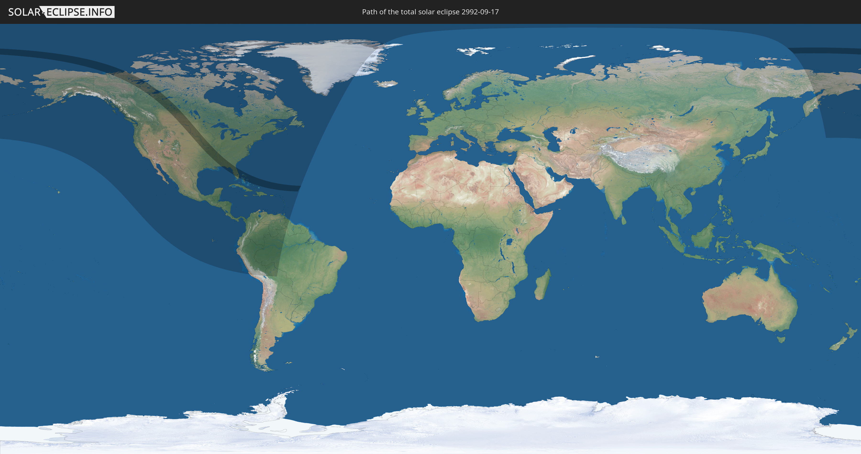
Die Sonnenfinsternis am 09/17/2992 kann man in 47 Ländern als partielle Sonnenfinsternis beobachten.
Der Finsternispfad verläuft durch 3 Länder. Nur in diesen Ländern ist sie als total Sonnenfinsternis zu sehen.
In den folgenden Ländern ist die Sonnenfinsternis total zu sehen
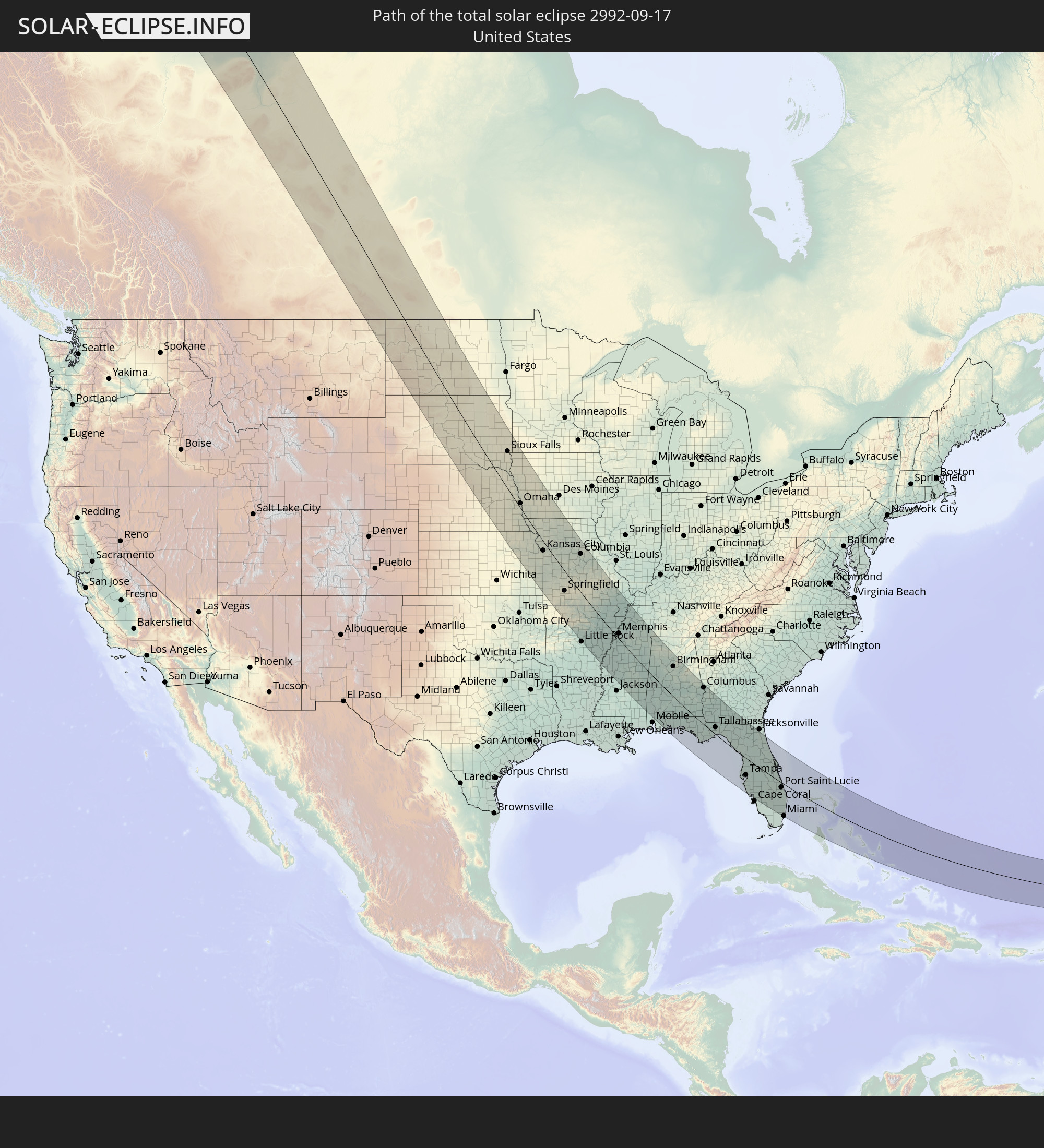 United States
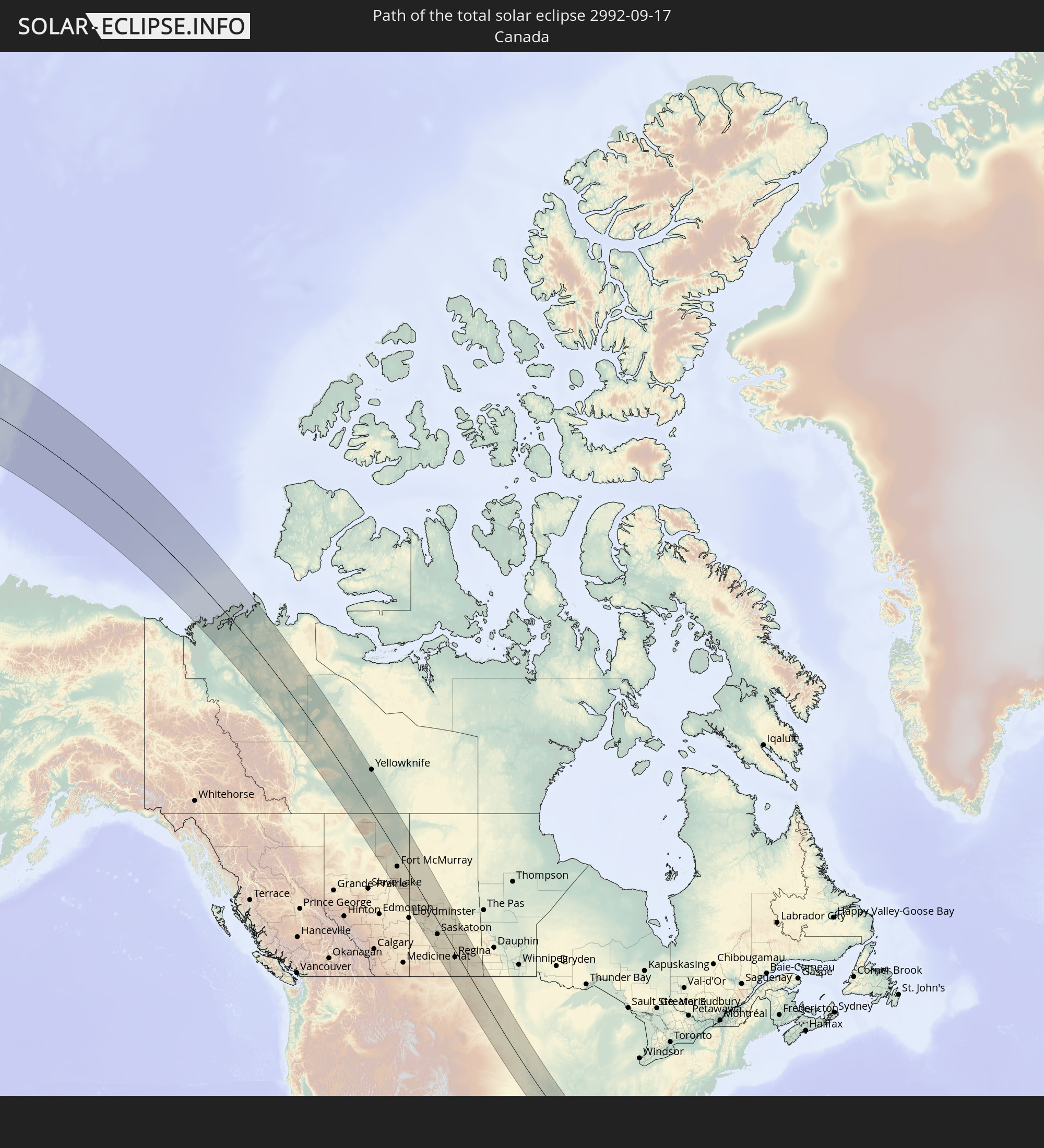 Canada
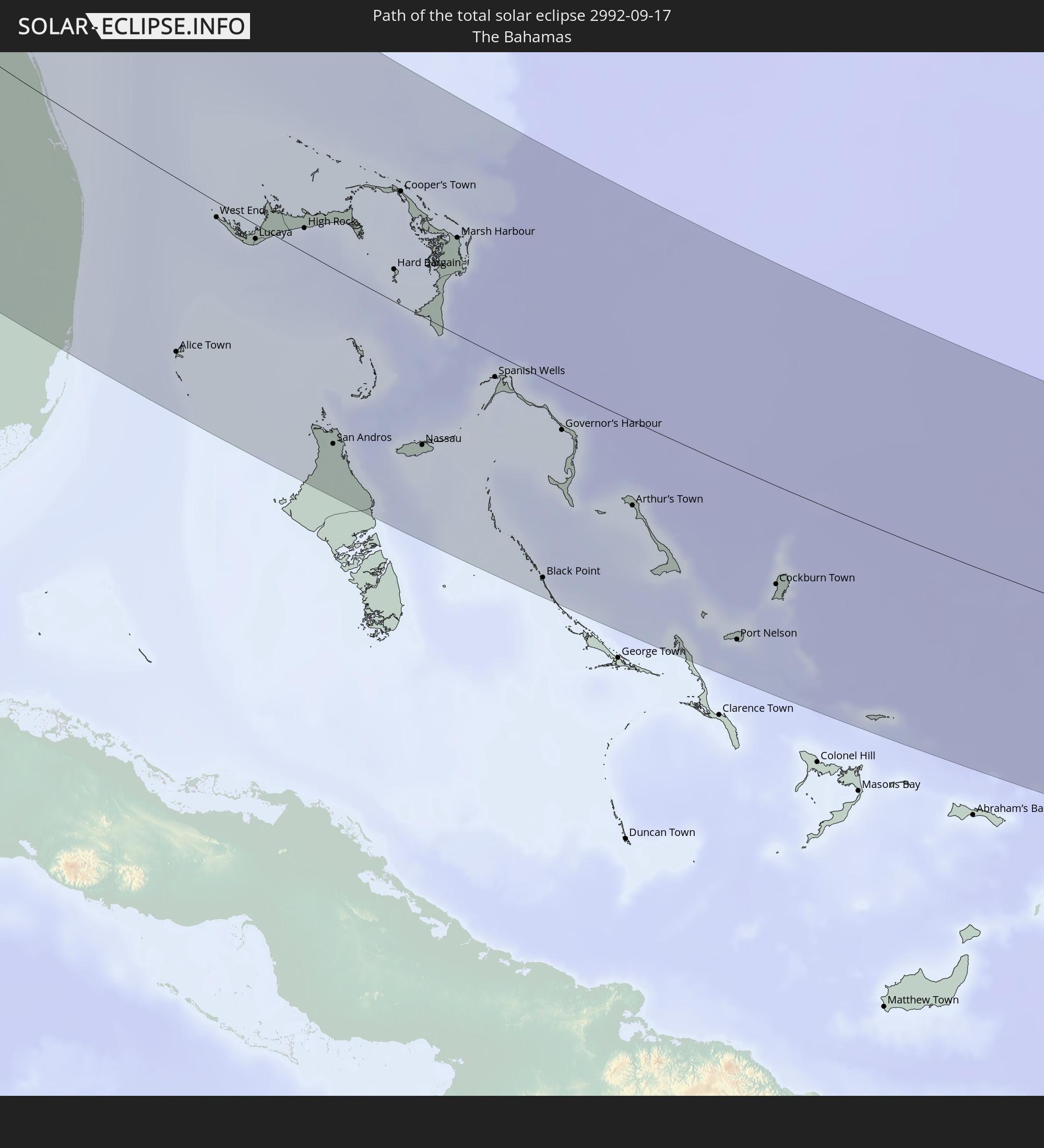 The Bahamas
In den folgenden Ländern ist die Sonnenfinsternis partiell zu sehen
 Russia
 United States
 United States Minor Outlying Islands
 Canada
 Mexico
 Greenland
 Guatemala
 Ecuador
 El Salvador
 Honduras
 Belize
 Nicaragua
 Costa Rica
 Cuba
Cuba
 Panama
 Colombia
 Cayman Islands
 Peru
Peru
 The Bahamas
 Jamaica
 Haiti
Haiti
 Brazil
 Venezuela
 Turks and Caicos Islands
 Dominican Republic
 Aruba
Aruba
 Bolivia
 Puerto Rico
 United States Virgin Islands
 Bermuda
 British Virgin Islands
 Anguilla
 Collectivity of Saint Martin
 Saint Barthélemy
 Saint Kitts and Nevis
 Antigua and Barbuda
 Montserrat
 Trinidad and Tobago
 Guadeloupe
 Grenada
 Dominica
 Saint Vincent and the Grenadines
 Guyana
 Martinique
 Saint Lucia
 Barbados
 Saint Pierre and Miquelon
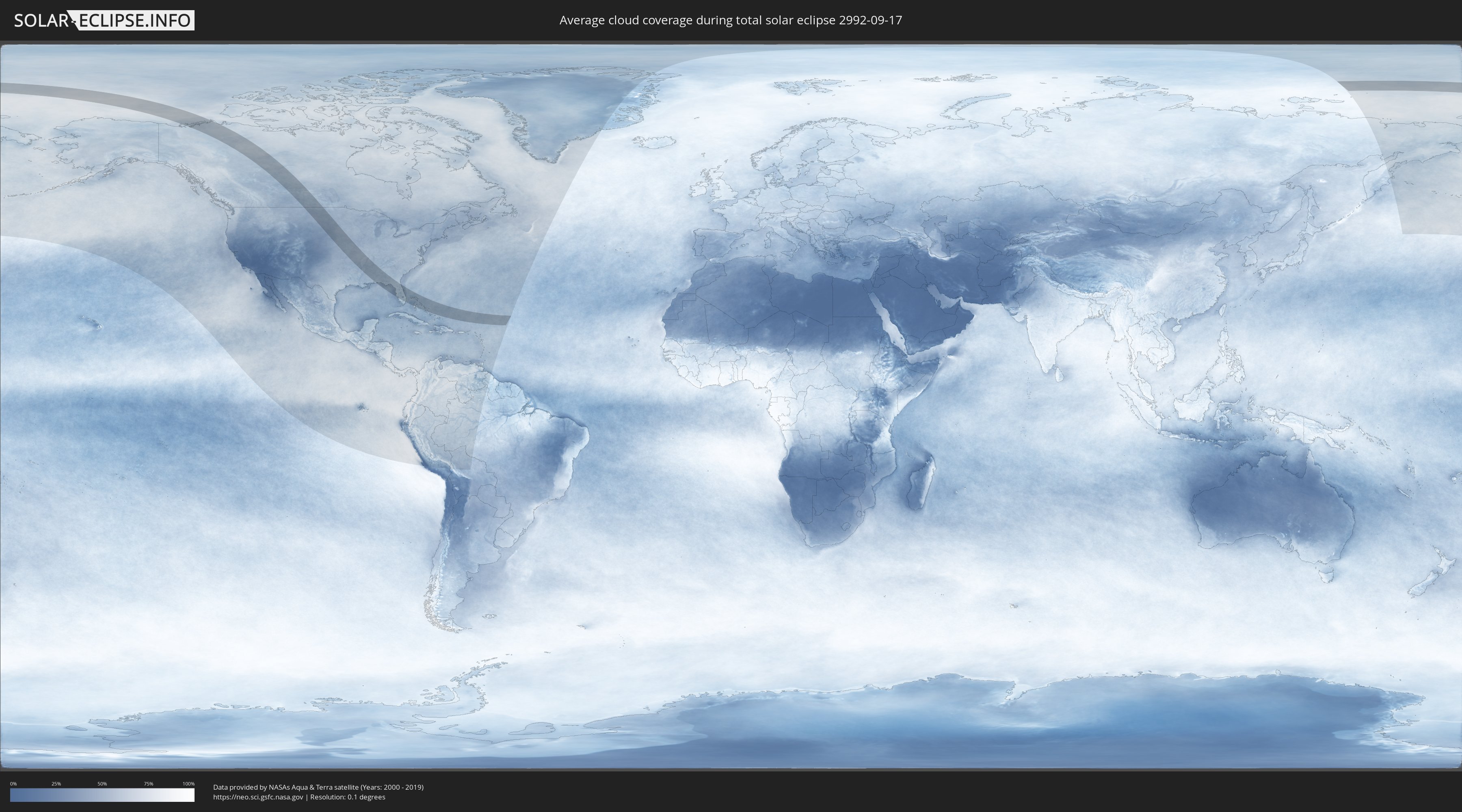
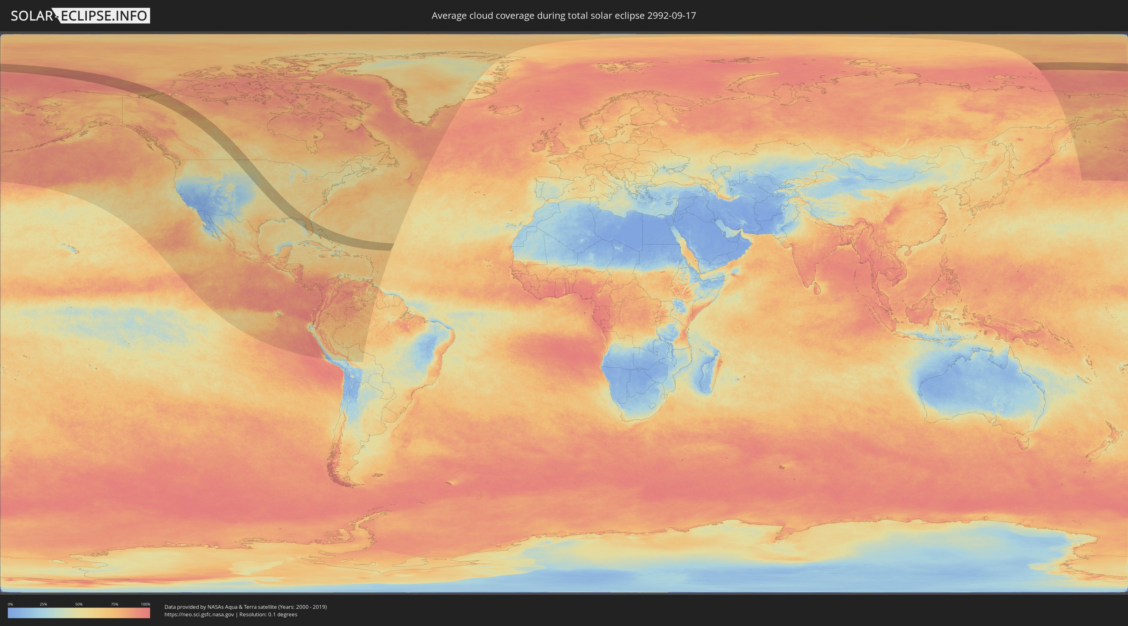
How will be the weather during the total solar eclipse on 09/17/2992?
Where is the best place to see the total solar eclipse of 09/17/2992?
The following maps show the average cloud coverage for the day of the total solar eclipse.
With the help of these maps, it is possible to find the place along the eclipse path, which has the best
chance of a cloudless sky.
Nevertheless, you should consider local circumstances and inform about the weather of your chosen
observation site.
The data is provided by NASAs satellites
AQUA and TERRA.
The cloud maps are averaged over a period of 19 years (2000 - 2019).
Detailed country maps
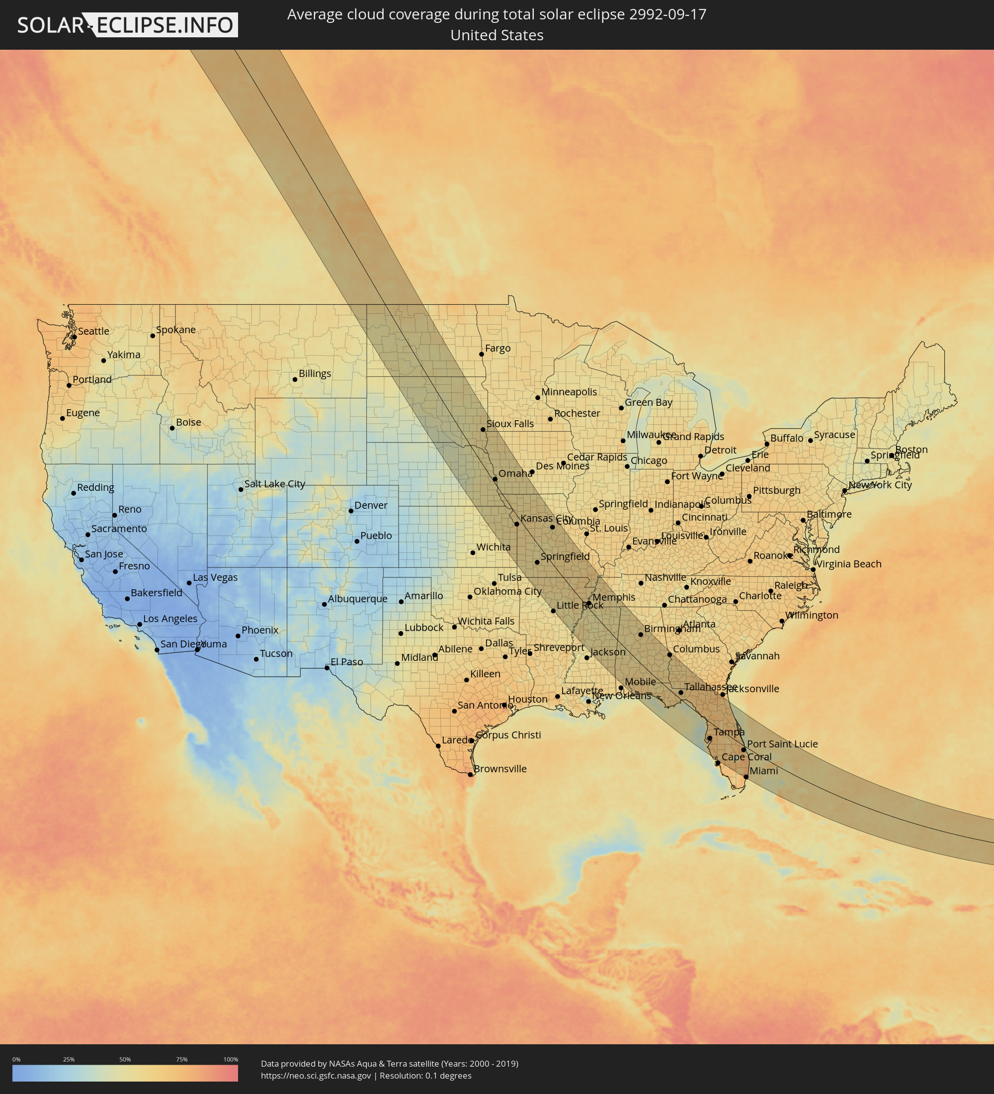 United States
 Canada
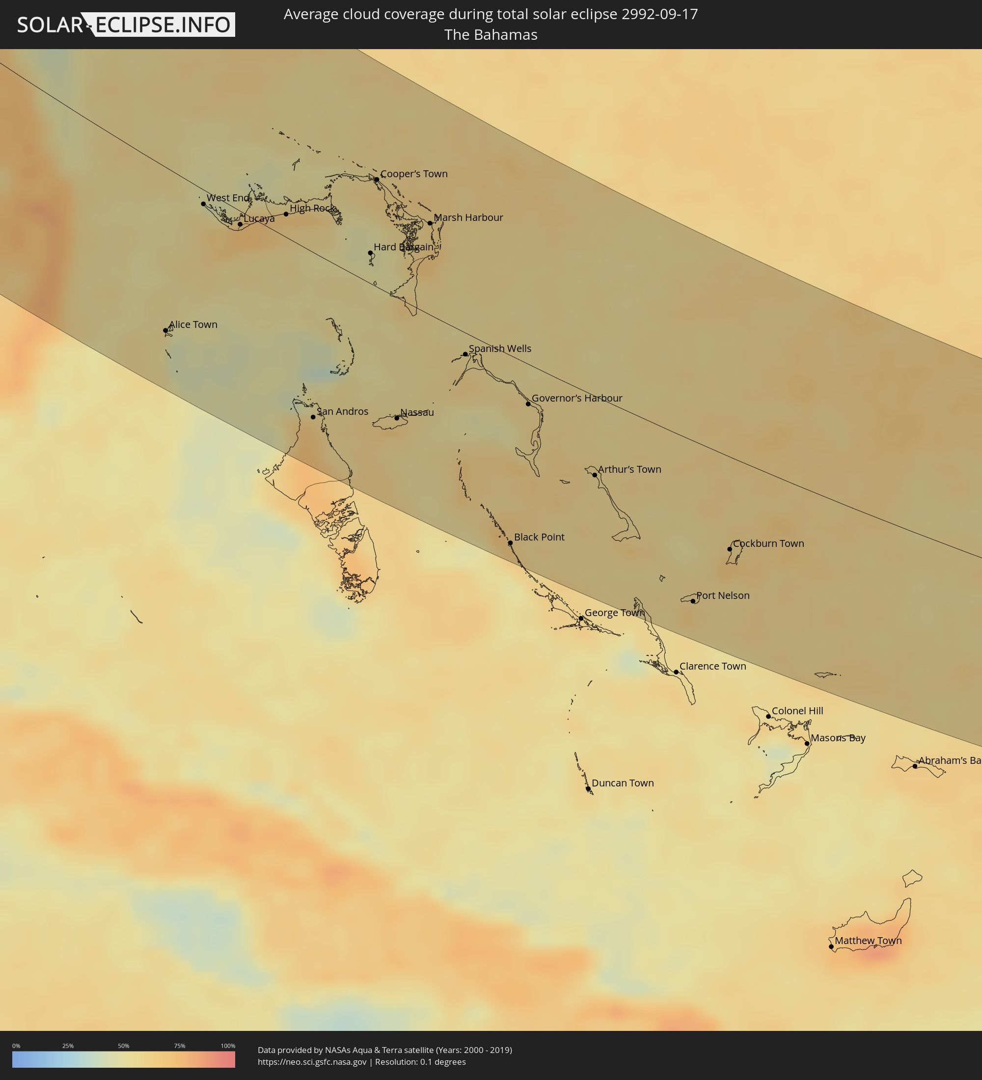 The Bahamas
Cities inside the path of the eclipse
The following table shows all locations with a population of more than 5,000 inside the eclipse path. Cities which have more than 100,000 inhabitants are marked bold. A click at the locations opens a detailed map.
| City | Type | Eclipse duration | Local time of max. eclipse | Distance to central line | Ø Cloud coverage |
|
Fort McMurray, Alberta
|
total | - | 12:56:25 UTC-07:00 | 50 km | 65% |
|
Cold Lake, Alberta
|
total | - | 13:00:04 UTC-07:00 | 118 km | 58% |
|
North Battleford, Saskatchewan
|
total | - | 14:04:03 UTC-06:00 | 111 km | 60% |
|
Saskatoon, Saskatchewan
|
total | - | 14:06:36 UTC-06:00 | 54 km | 57% |
|
Prince Albert, Saskatchewan
|
total | - | 14:06:09 UTC-06:00 | 59 km | 65% |
|
Moose Jaw, Saskatchewan
|
total | - | 14:10:10 UTC-06:00 | 85 km | 58% |
|
Regina, Saskatchewan
|
total | - | 14:11:06 UTC-06:00 | 26 km | 58% |
|
Melfort, Saskatchewan
|
total | - | 14:07:47 UTC-06:00 | 108 km | 72% |
|
Weyburn, Saskatchewan
|
total | - | 14:13:04 UTC-06:00 | 23 km | 58% |
|
Estevan, Saskatchewan
|
total | - | 14:14:48 UTC-06:00 | 1 km | 53% |
|
Bismarck, North Dakota
|
total | - | 14:20:50 UTC-06:00 | 11 km | 50% |
|
Sioux Falls, South Dakota
|
total | - | 14:30:49 UTC-06:00 | 98 km | 55% |
|
Lincoln, Nebraska
|
total | - | 14:35:45 UTC-06:00 | 66 km | 52% |
|
Sioux City, Iowa
|
total | - | 14:33:00 UTC-06:00 | 57 km | 53% |
|
Omaha, Nebraska
|
total | - | 14:35:44 UTC-06:00 | 13 km | 53% |
|
Topeka, Kansas
|
total | - | 14:40:03 UTC-06:00 | 108 km | 55% |
|
Lawrence, Kansas
|
total | - | 14:40:42 UTC-06:00 | 82 km | 57% |
|
Saint Joseph, Missouri
|
total | - | 14:39:39 UTC-06:00 | 3 km | 59% |
|
Olathe, Kansas
|
total | - | 14:41:19 UTC-06:00 | 58 km | 60% |
|
Overland Park, Kansas
|
total | - | 14:41:18 UTC-06:00 | 41 km | 60% |
|
Kansas City, Missouri
|
total | - | 14:41:11 UTC-06:00 | 27 km | 59% |
|
Joplin, Missouri
|
total | - | 14:45:01 UTC-06:00 | 156 km | 54% |
|
Lee's Summit, Missouri
|
total | - | 14:41:45 UTC-06:00 | 26 km | 57% |
|
East Independence, Missouri
|
total | - | 14:41:26 UTC-06:00 | 12 km | 60% |
|
Springfield, Missouri
|
total | - | 14:46:07 UTC-06:00 | 62 km | 59% |
|
Conway, Arkansas
|
total | - | 14:51:04 UTC-06:00 | 150 km | 53% |
|
Columbia, Missouri
|
total | - | 14:43:54 UTC-06:00 | 121 km | 58% |
|
North Little Rock, Arkansas
|
total | - | 14:51:52 UTC-06:00 | 161 km | 55% |
|
Jonesboro, Arkansas
|
total | - | 14:51:28 UTC-06:00 | 24 km | 61% |
|
Memphis, Tennessee
|
total | - | 14:53:28 UTC-06:00 | 20 km | 56% |
|
Southaven, Mississippi
|
total | - | 14:53:49 UTC-06:00 | 11 km | 54% |
|
Bartlett, Tennessee
|
total | - | 14:53:33 UTC-06:00 | 36 km | 57% |
|
Jackson, Tennessee
|
total | - | 14:53:50 UTC-06:00 | 139 km | 56% |
|
Tuscaloosa, Alabama
|
total | - | 14:59:39 UTC-06:00 | 44 km | 54% |
|
East Pensacola Heights, Florida
|
total | - | 15:05:19 UTC-06:00 | 153 km | 57% |
|
Birmingham, Alabama
|
total | - | 14:59:47 UTC-06:00 | 119 km | 59% |
|
Montgomery, Alabama
|
total | - | 15:02:28 UTC-06:00 | 62 km | 62% |
|
Auburn, Alabama
|
total | - | 15:02:45 UTC-06:00 | 135 km | 60% |
|
Dothan, Alabama
|
total | - | 15:05:28 UTC-06:00 | 28 km | 59% |
|
Columbus, Georgia
|
total | - | 16:03:29 UTC-05:00 | 155 km | 62% |
|
Tallahassee, Florida
|
total | - | 16:07:57 UTC-05:00 | 31 km | 67% |
|
Albany, Georgia
|
total | - | 16:05:54 UTC-05:00 | 135 km | 62% |
|
Valdosta, Georgia
|
total | - | 16:08:04 UTC-05:00 | 126 km | 67% |
|
Clearwater, Florida
|
total | - | 16:13:49 UTC-05:00 | 98 km | 58% |
|
St. Petersburg, Florida
|
total | - | 16:14:16 UTC-05:00 | 108 km | 58% |
|
Bradenton, Florida
|
total | - | 16:14:51 UTC-05:00 | 127 km | 65% |
|
Sarasota, Florida
|
total | - | 16:15:12 UTC-05:00 | 140 km | 65% |
|
Spring Hill, Florida
|
total | - | 16:13:06 UTC-05:00 | 36 km | 69% |
|
Tampa, Florida
|
total | - | 16:14:08 UTC-05:00 | 80 km | 53% |
|
Wesley Chapel, Florida
|
total | - | 16:13:41 UTC-05:00 | 46 km | 70% |
|
Gainesville, Florida
|
total | - | 16:11:04 UTC-05:00 | 81 km | 68% |
|
Brandon, Florida
|
total | - | 16:14:17 UTC-05:00 | 71 km | 75% |
|
North Port, Florida
|
total | - | 16:15:58 UTC-05:00 | 150 km | 59% |
|
Ocala, Florida
|
total | - | 16:12:05 UTC-05:00 | 50 km | 75% |
|
Port Charlotte, Florida
|
total | - | 16:16:12 UTC-05:00 | 148 km | 60% |
|
The Villages, Florida
|
total | - | 16:12:42 UTC-05:00 | 38 km | 69% |
|
Lakeland, Florida
|
total | - | 16:14:22 UTC-05:00 | 43 km | 66% |
|
Lehigh Acres, Florida
|
total | - | 16:17:13 UTC-05:00 | 155 km | 74% |
|
Poinciana, Florida
|
total | - | 16:14:34 UTC-05:00 | 6 km | 64% |
|
Kissimmee, Florida
|
total | - | 16:14:18 UTC-05:00 | 12 km | 61% |
|
Orlando, Florida
|
total | - | 16:13:54 UTC-05:00 | 35 km | 75% |
|
Deltona, Florida
|
total | - | 16:13:19 UTC-05:00 | 74 km | 67% |
|
Alafaya, Florida
|
total | - | 16:13:59 UTC-05:00 | 47 km | 76% |
|
Palm Coast, Florida
|
total | - | 16:12:06 UTC-05:00 | 140 km | 65% |
|
Daytona Beach, Florida
|
total | - | 16:12:56 UTC-05:00 | 116 km | 63% |
|
Palm Bay, Florida
|
total | - | 16:15:26 UTC-05:00 | 32 km | 66% |
|
Weston, Florida
|
total | - | 16:19:05 UTC-05:00 | 139 km | 76% |
|
Port Saint Lucie, Florida
|
total | - | 16:16:58 UTC-05:00 | 24 km | 75% |
|
Coral Springs, Florida
|
total | - | 16:18:52 UTC-05:00 | 116 km | 75% |
|
Wellington, Florida
|
total | - | 16:18:12 UTC-05:00 | 78 km | 80% |
|
Pembroke Pines, Florida
|
total | - | 16:19:23 UTC-05:00 | 139 km | 75% |
|
Miami, Florida
|
total | - | 16:19:49 UTC-05:00 | 160 km | 67% |
|
Fort Lauderdale, Florida
|
total | - | 16:19:14 UTC-05:00 | 124 km | 63% |
|
Jupiter, Florida
|
total | - | 16:17:48 UTC-05:00 | 44 km | 73% |
|
Boca Raton, Florida
|
total | - | 16:18:51 UTC-05:00 | 98 km | 68% |
|
Boynton Beach, Florida
|
total | - | 16:18:34 UTC-05:00 | 82 km | 72% |
|
West Palm Beach, Florida
|
total | - | 16:18:14 UTC-05:00 | 63 km | 73% |
|
Alice Town, Bimini
|
total | - | 16:20:33 UTC-05:00 | 119 km | 53% |
|
West End, West Grand Bahama
|
total | - | 16:19:03 UTC-05:00 | 10 km | 56% |
|
Freeport, Freeport
|
total | - | 16:19:31 UTC-05:00 | 11 km | 63% |
|
Lucaya, Freeport
|
total | - | 16:19:33 UTC-05:00 | 10 km | 63% |
|
High Rock, East Grand Bahama
|
total | - | 21:19:41 UTC+00:00 | 17 km | 62% |
|
San Andros, North Andros
|
total | - | 16:22:34 UTC-05:00 | 123 km | 69% |
|
Hard Bargain, Moore’s Island
|
total | - | 16:20:41 UTC-05:00 | 22 km | 52% |
|
Cooper’s Town, North Abaco
|
total | - | 16:19:44 UTC-05:00 | 79 km | 62% |
|
Nassau, New Providence
|
total | - | 16:23:02 UTC-05:00 | 91 km | 62% |
|
Marsh Harbour, Central Abaco
|
total | - | 16:20:36 UTC-05:00 | 68 km | 64% |
|
Spanish Wells, Spanish Wells
|
total | - | 16:22:33 UTC-05:00 | 16 km | 60% |
|
Black Point, Black Point
|
total | - | 21:25:18 UTC+00:00 | 145 km | 62% |
|
Governor’s Harbour, Central Eleuthera
|
total | - | 21:23:32 UTC+00:00 | 31 km | 59% |
|
Arthur’s Town, Cat Island
|
total | - | 16:24:49 UTC-05:00 | 61 km | 59% |
|
Port Nelson, Rum Cay
|
total | - | 16:26:57 UTC-05:00 | 127 km | 58% |
|
Cockburn Town, San Salvador
|
total | - | 16:26:26 UTC-05:00 | 73 km | 65% |