Total solar eclipse of 06/30/-0009
| Day of week: | Saturday |
| Maximum duration of eclipse: | 06m14s |
| Maximum width of eclipse path: | 249 km |
| Saros cycle: | 75 |
| Coverage: | 100% |
| Magnitude: | 1.0753 |
| Gamma: | 0.1963 |
Wo kann man die Sonnenfinsternis vom 06/30/-0009 sehen?
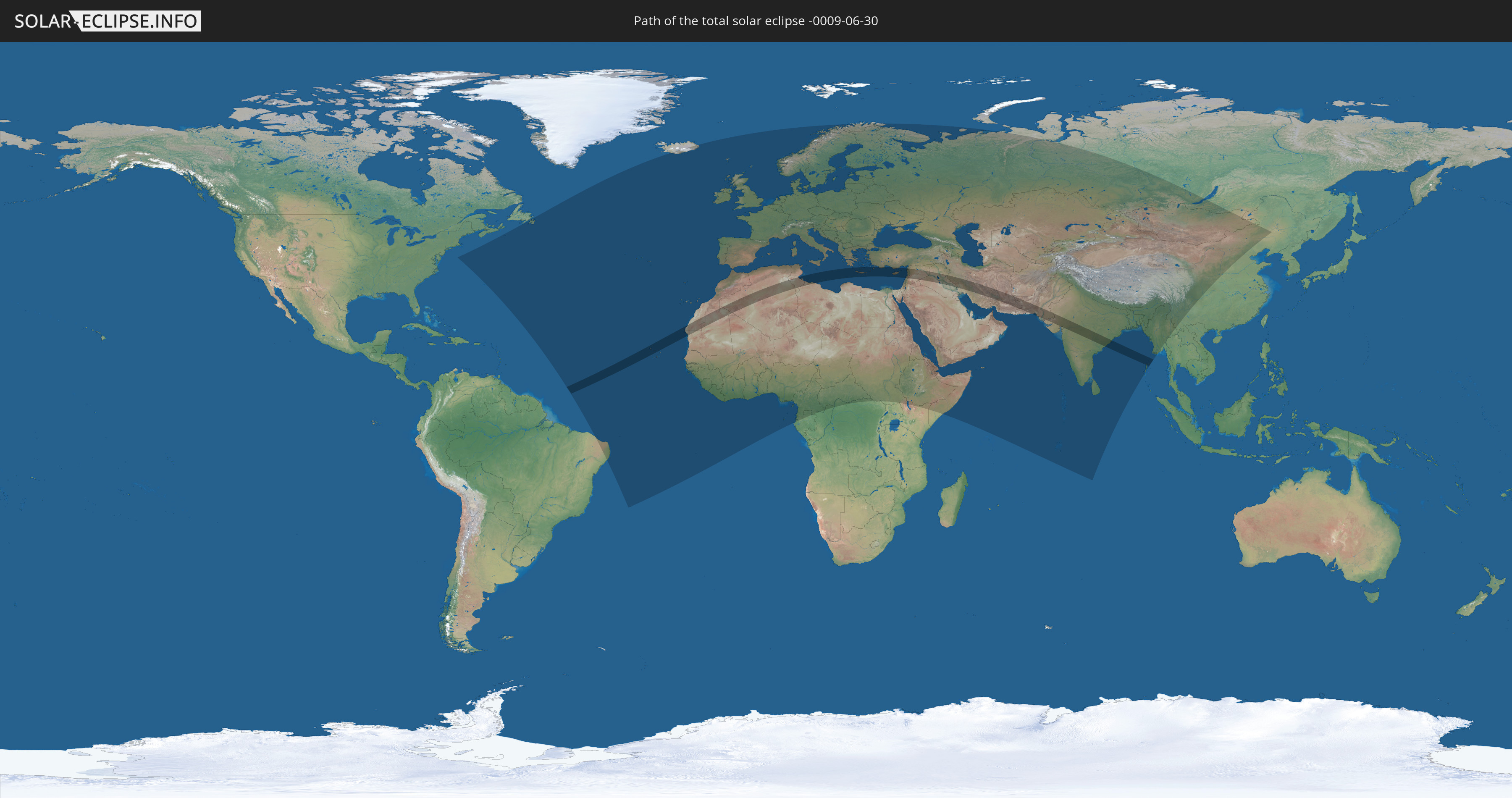
Die Sonnenfinsternis am 06/30/-0009 kann man in 126 Ländern als partielle Sonnenfinsternis beobachten.
Der Finsternispfad verläuft durch 14 Länder. Nur in diesen Ländern ist sie als total Sonnenfinsternis zu sehen.
In den folgenden Ländern ist die Sonnenfinsternis total zu sehen
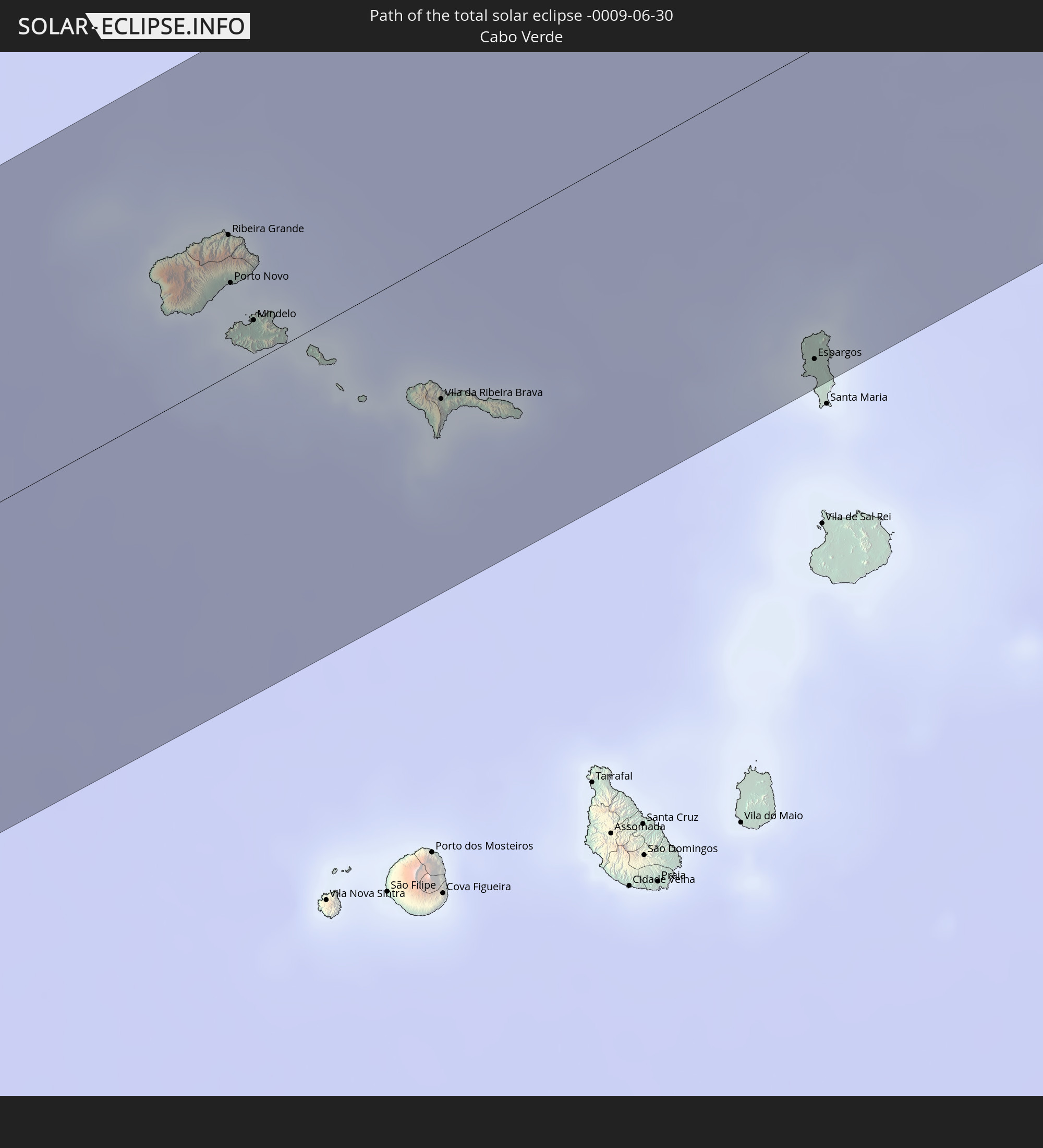 Cabo Verde
 Mauritania
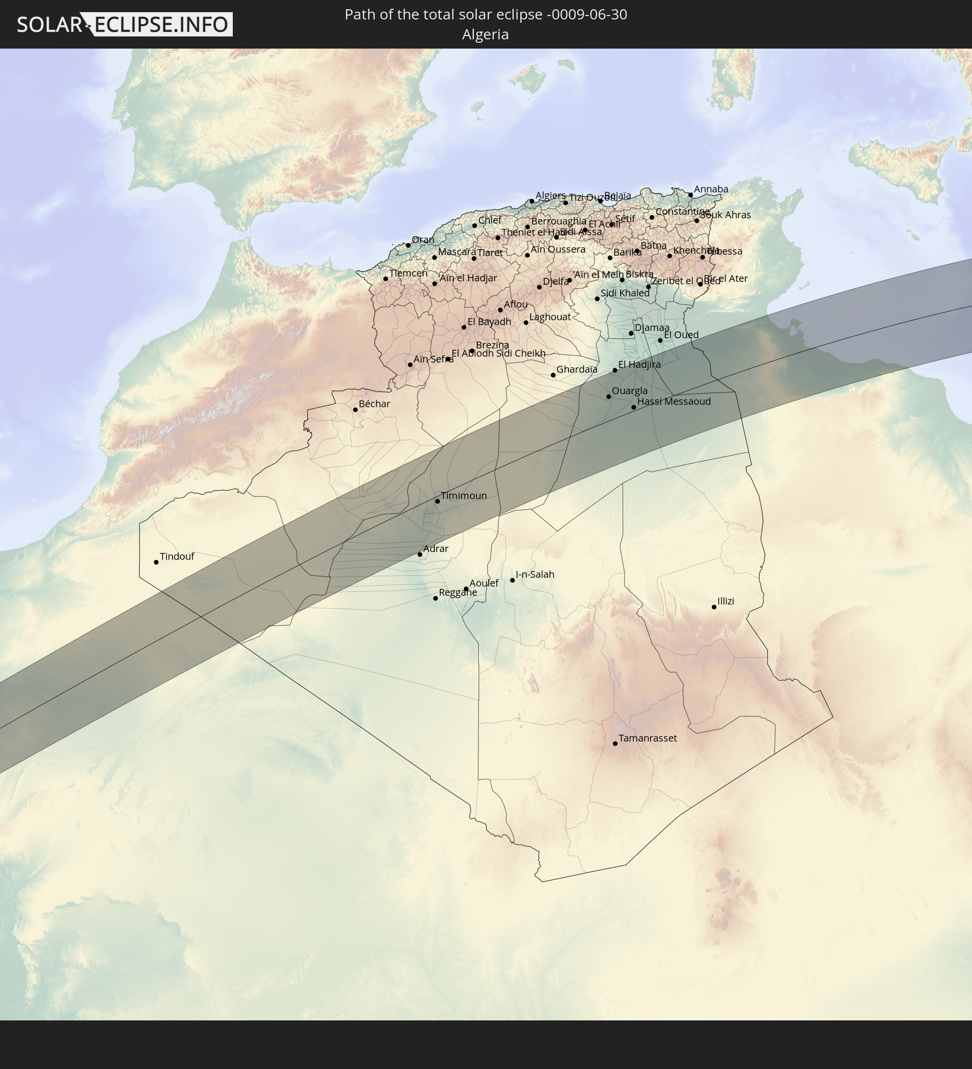 Algeria
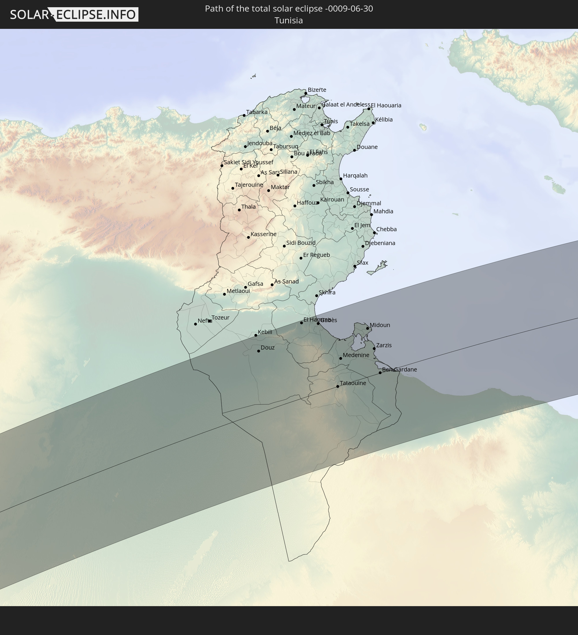 Tunisia
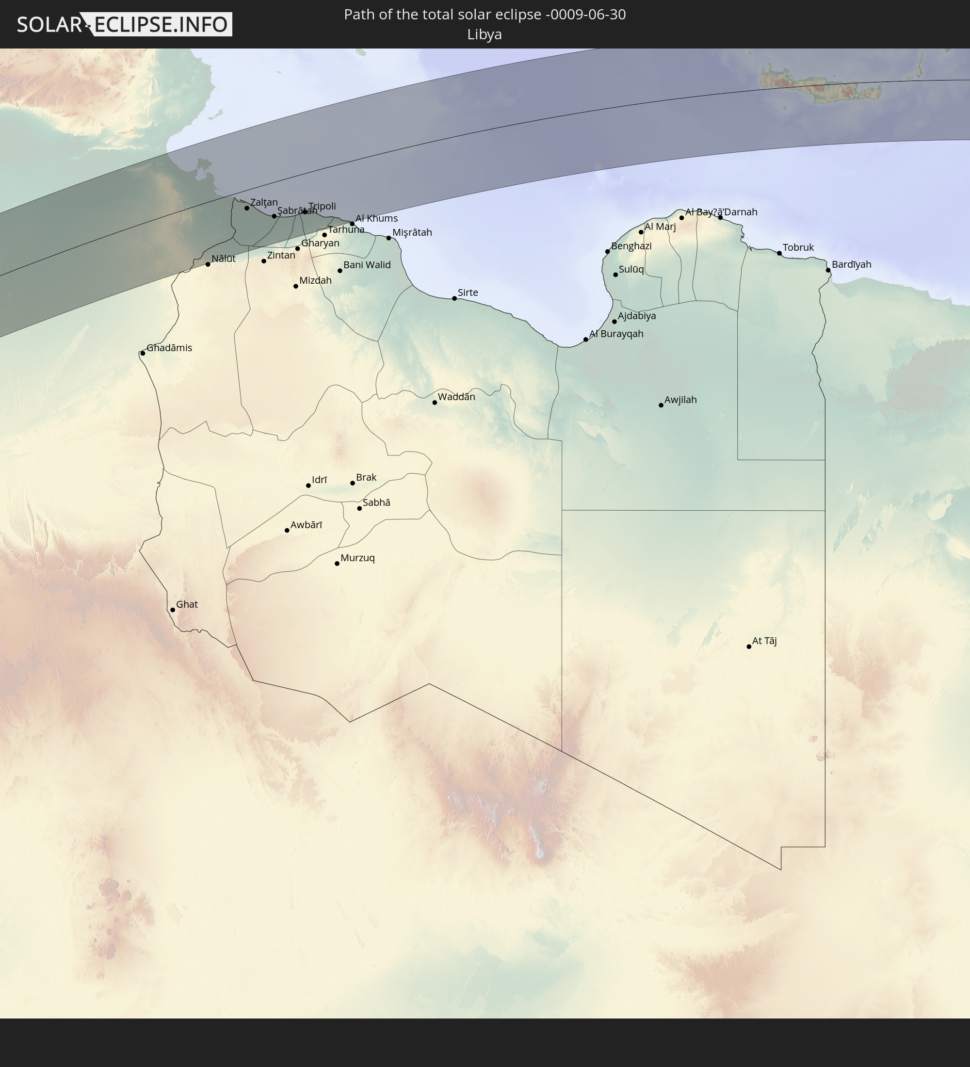 Libya
Libya
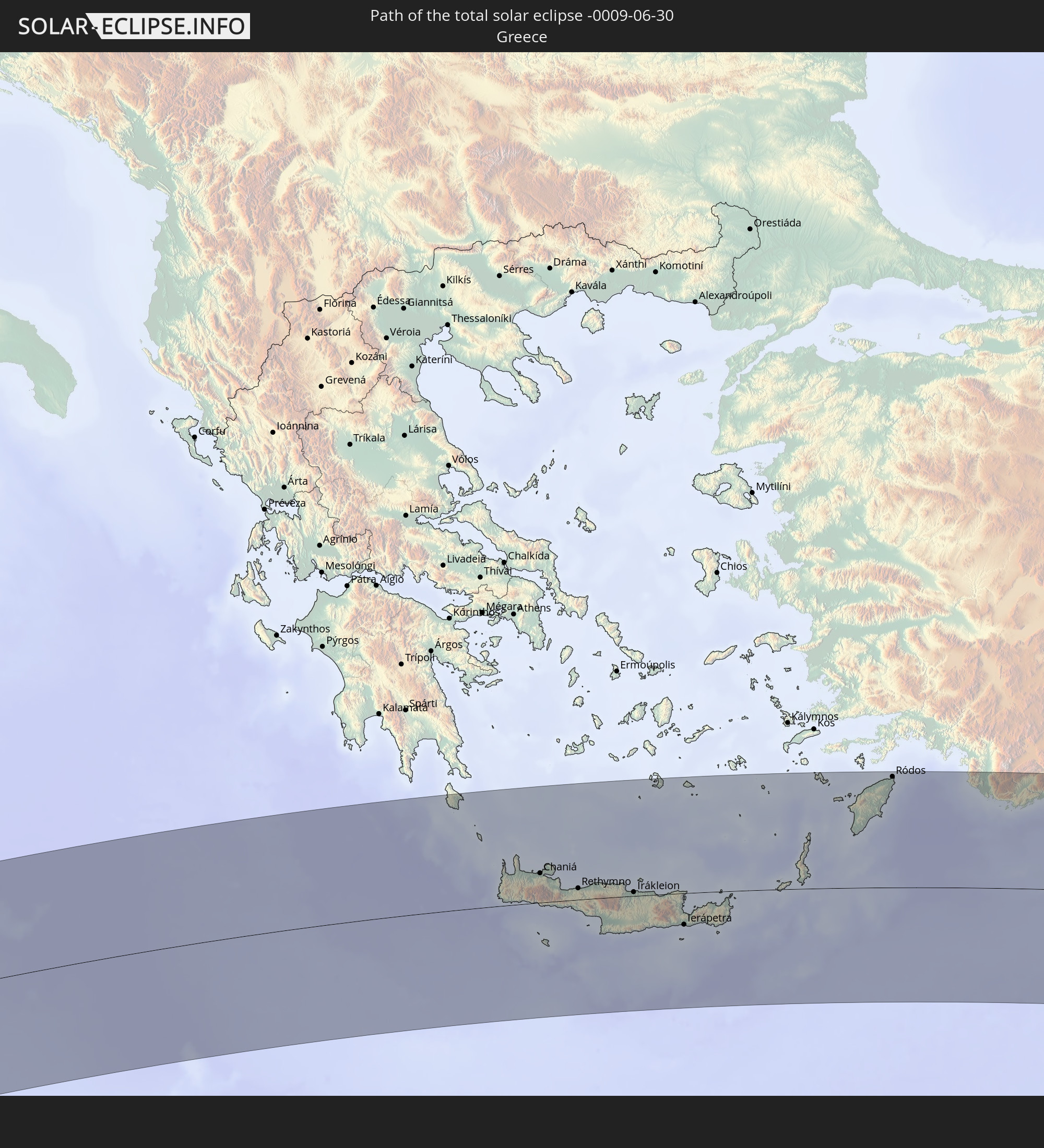 Greece
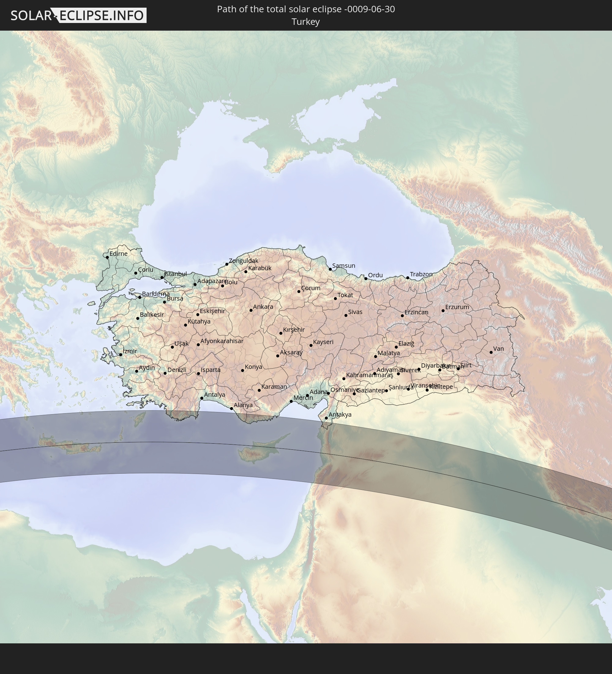 Turkey
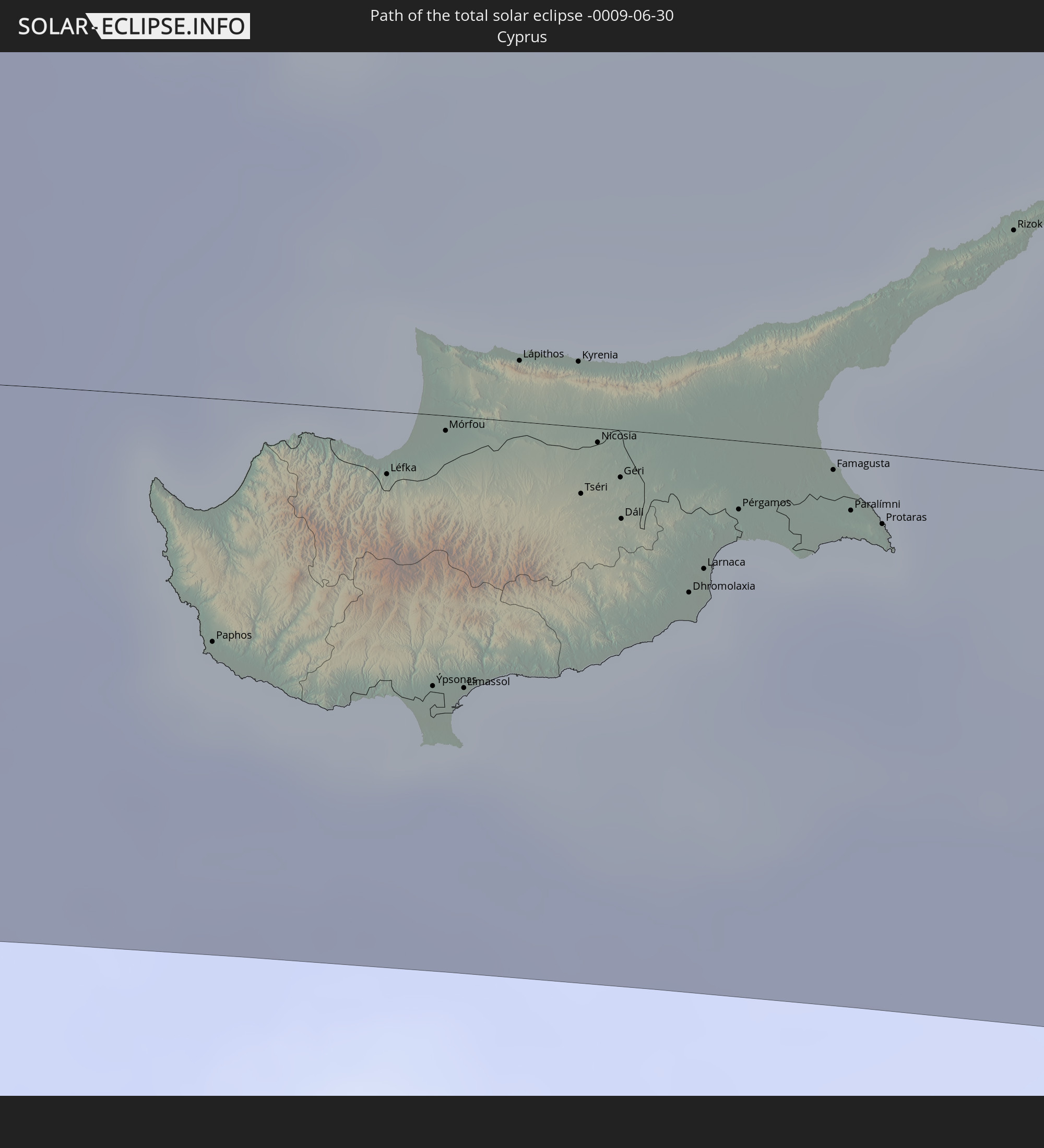 Cyprus
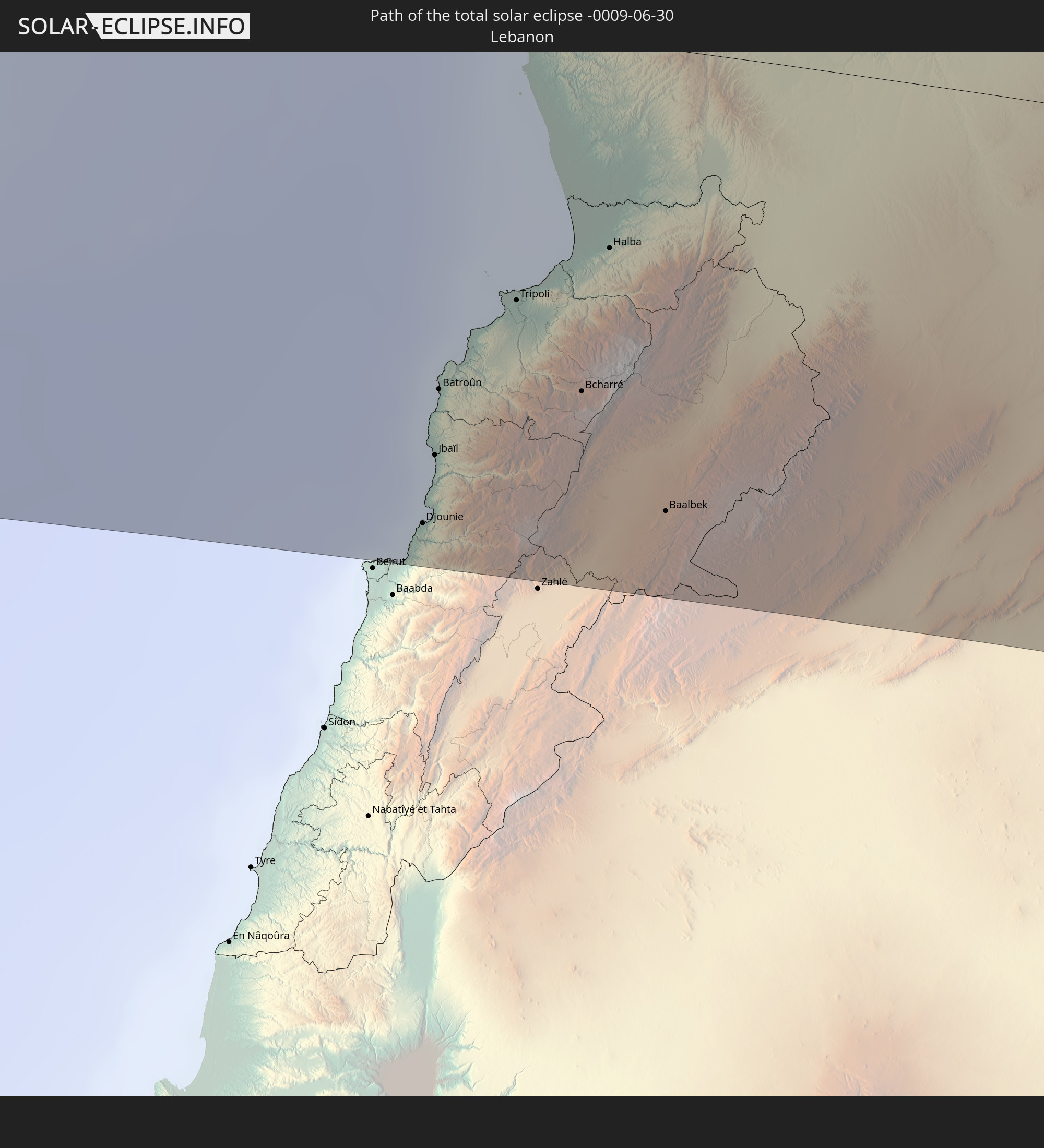 Lebanon
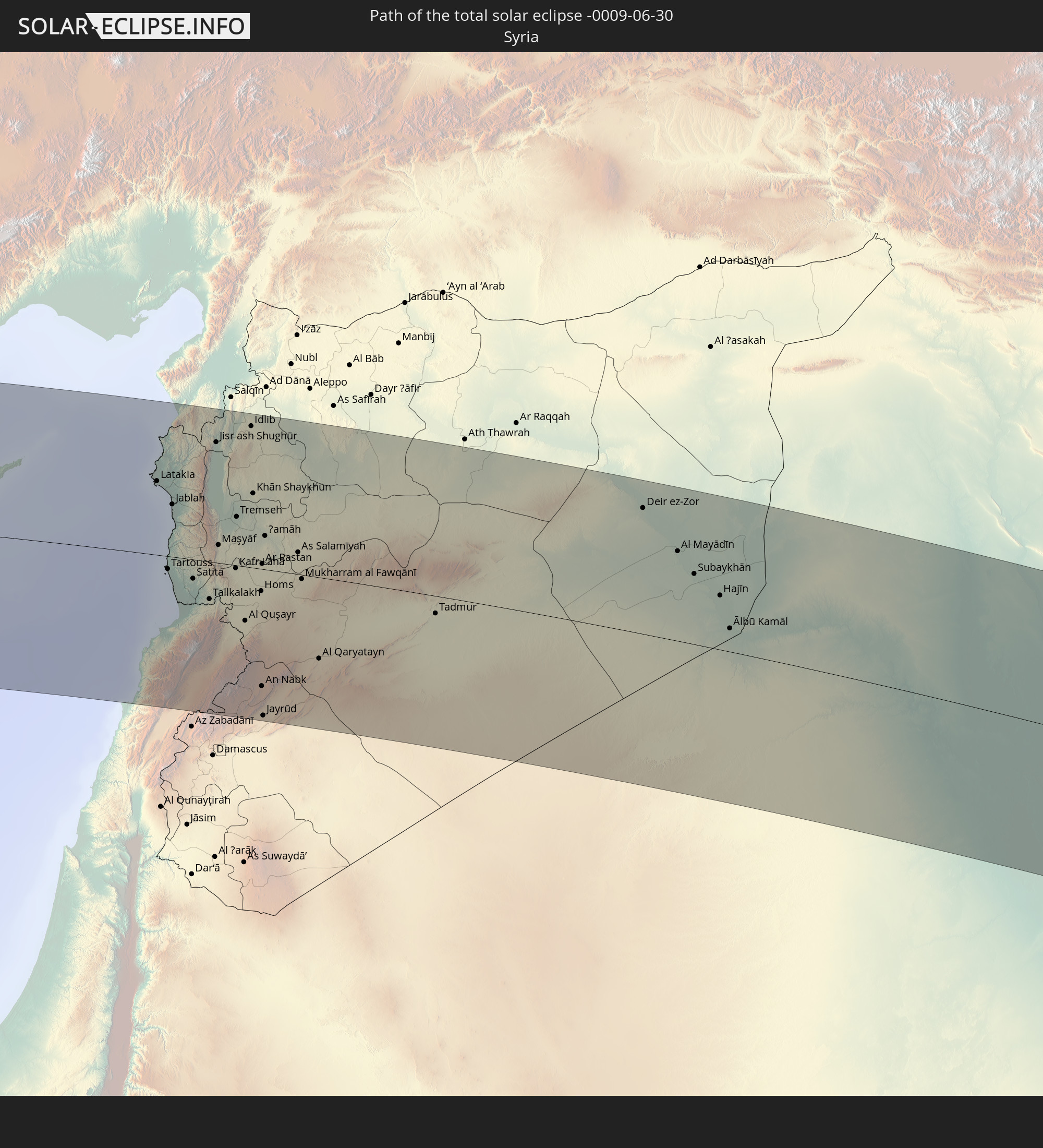 Syria
Syria
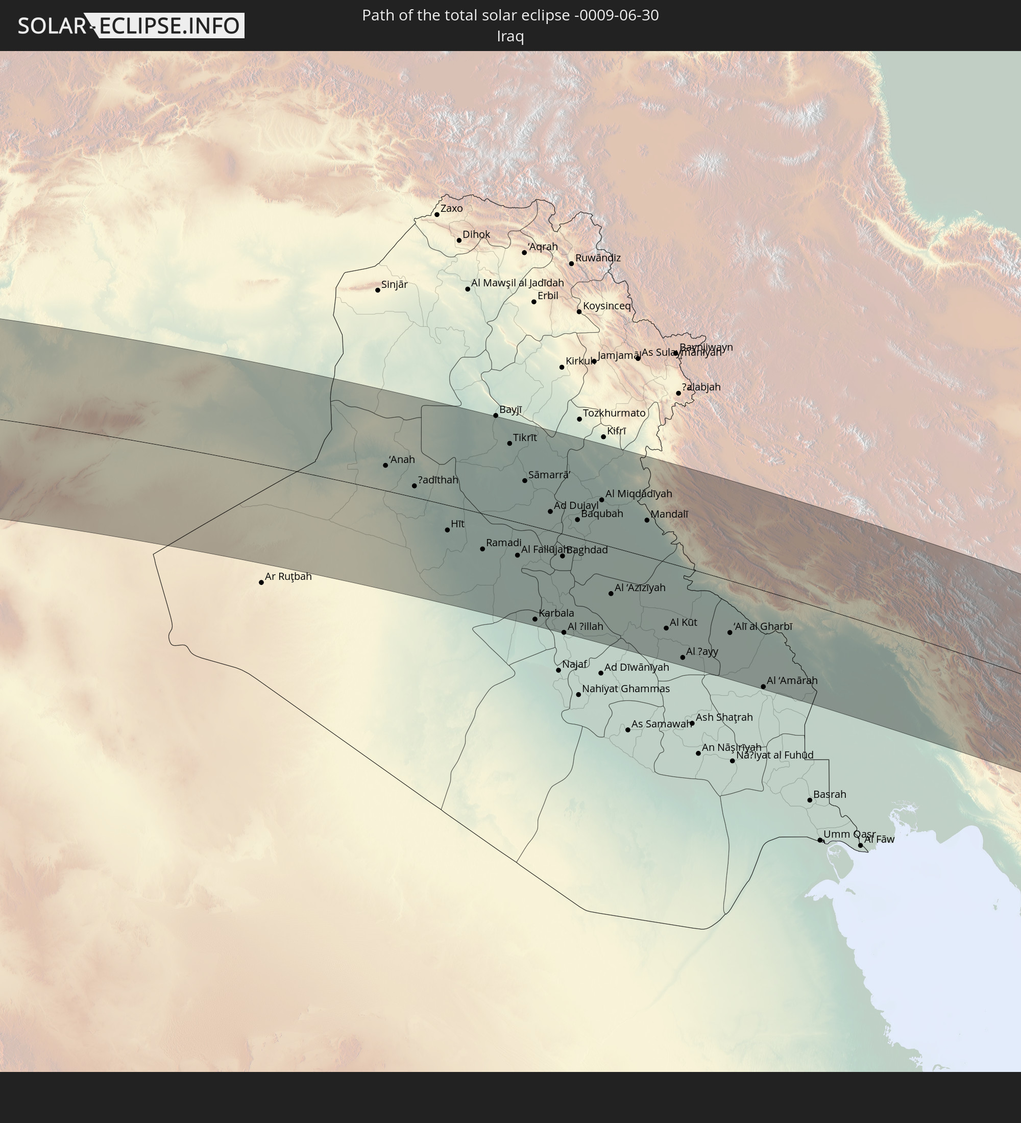 Iraq
Iraq
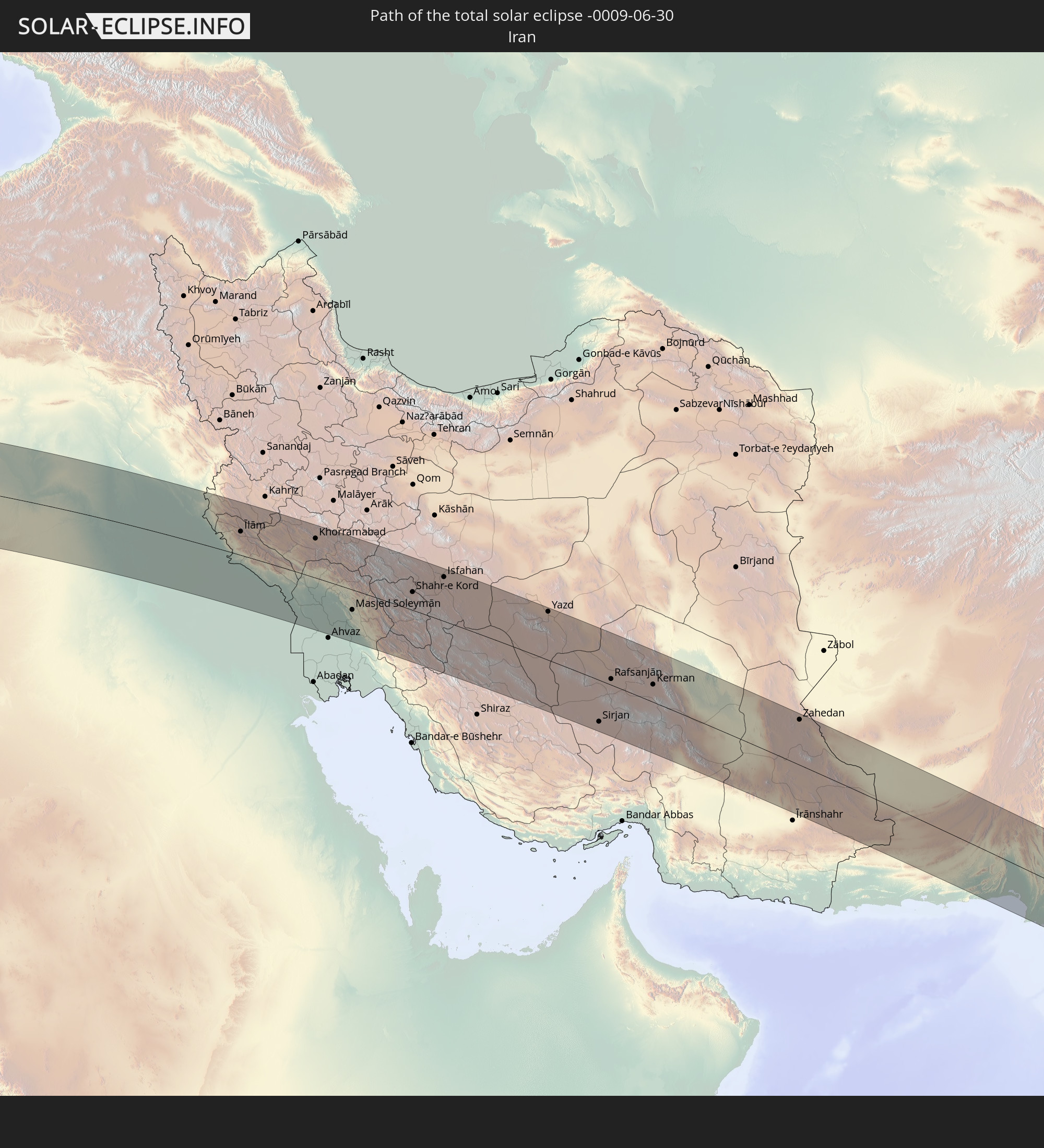 Iran
Iran
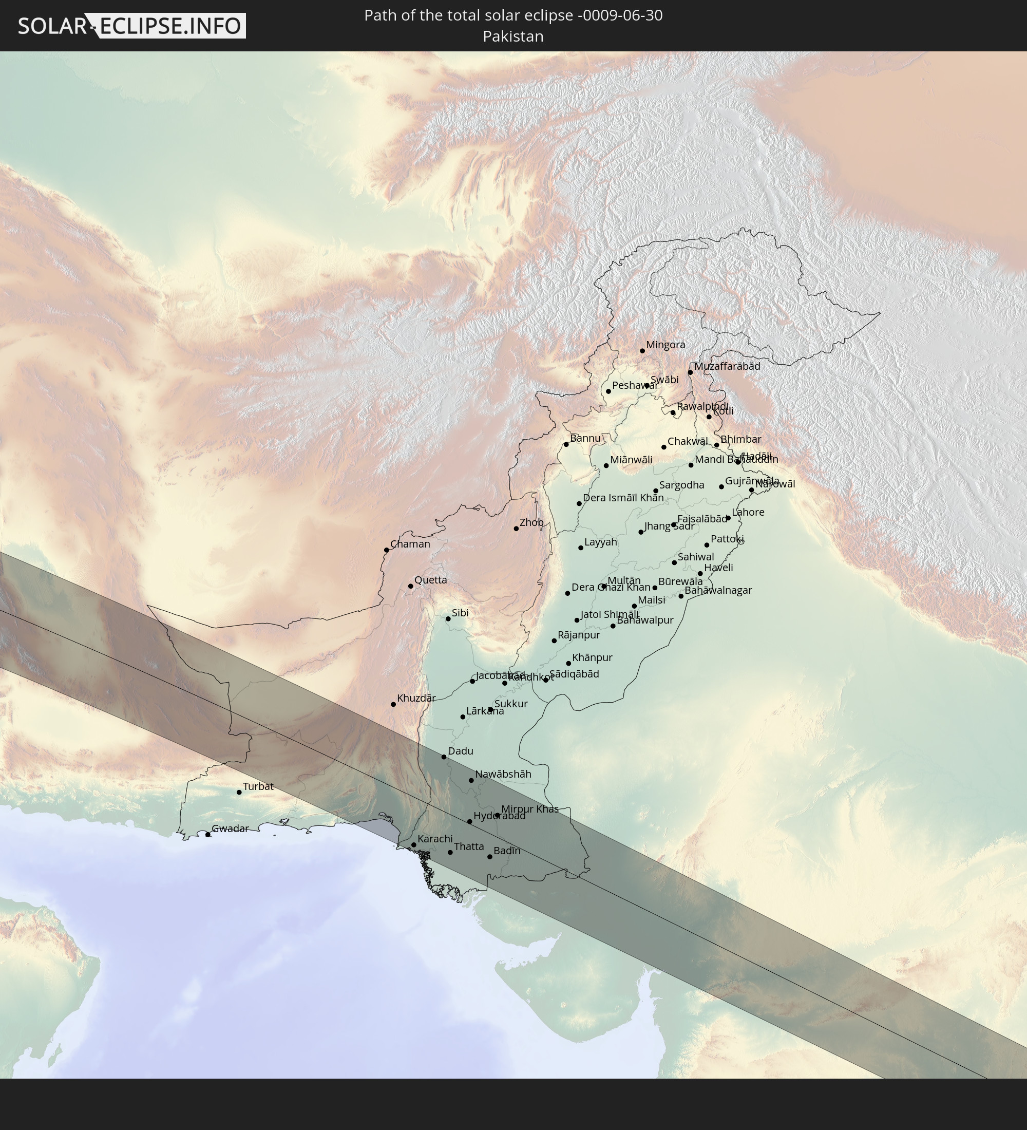 Pakistan
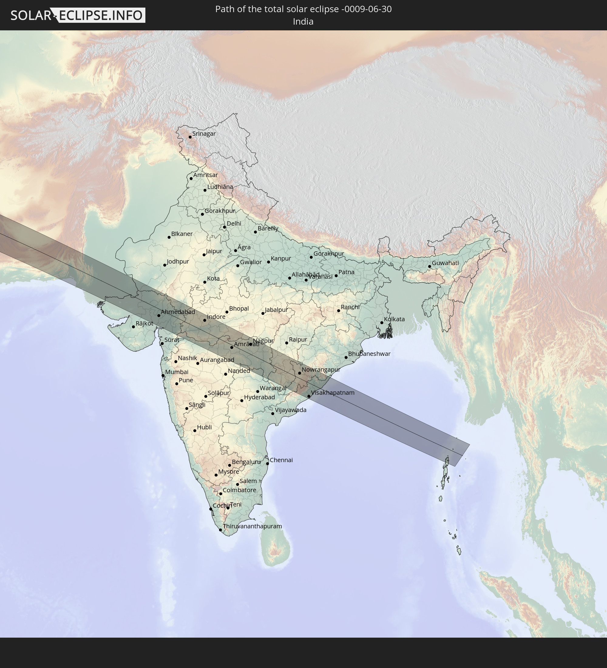 India
India
In den folgenden Ländern ist die Sonnenfinsternis partiell zu sehen
 Russia
 Canada
 Brazil
 Portugal
 Cabo Verde
 Iceland
 Spain
Spain
 Senegal
 Mauritania
 The Gambia
 Guinea-Bissau
 Guinea
 Saint Helena, Ascension and Tristan da Cunha
 Sierra Leone
 Morocco
 Mali
Mali
 Liberia
 Republic of Ireland
 Algeria
 United Kingdom
 Ivory Coast
 Faroe Islands
 Burkina Faso
 Gibraltar
 France
 Isle of Man
 Ghana
Ghana
 Guernsey
 Jersey
 Togo
Togo
 Niger
Niger
 Benin
Benin
 Andorra
 Belgium
 Nigeria
 Netherlands
 Norway
 Equatorial Guinea
 Luxembourg
 Germany
 Switzerland
 São Tomé and Príncipe
 Italy
Italy
 Monaco
 Tunisia
 Denmark
 Cameroon
 Gabon
Gabon
 Libya
Libya
 Liechtenstein
 Austria
 Sweden
 Republic of the Congo
 Czechia
 Democratic Republic of the Congo
 San Marino
 Vatican City
 Slovenia
 Chad
Chad
 Croatia
 Poland
 Malta
Malta
 Central African Republic
 Bosnia and Herzegovina
 Hungary
 Slovakia
 Montenegro
 Serbia
 Albania
 Åland Islands
 Greece
 Romania
 Republic of Macedonia
 Finland
 Lithuania
 Latvia
 Estonia
 Sudan
Sudan
 Ukraine
 Bulgaria
 Belarus
 Egypt
Egypt
 Turkey
 Moldova
 Uganda
 Cyprus
 Ethiopia
 Kenya
Kenya
 State of Palestine
 Israel
 Saudi Arabia
 Jordan
 Lebanon
 Syria
Syria
 Eritrea
 Iraq
Iraq
 Georgia
 Somalia
 Djibouti
 Yemen
Yemen
 Armenia
 Iran
Iran
 Azerbaijan
 Kazakhstan
 Kuwait
 Bahrain
 Qatar
Qatar
 United Arab Emirates
 Oman
Oman
 Turkmenistan
 Uzbekistan
 Afghanistan
 Pakistan
 Tajikistan
 India
India
 Kyrgyzstan
 British Indian Ocean Territory
 Maldives
 China
China
 Sri Lanka
 Nepal
Nepal
 Mongolia
 Bangladesh
 Bhutan
 Myanmar
 Thailand
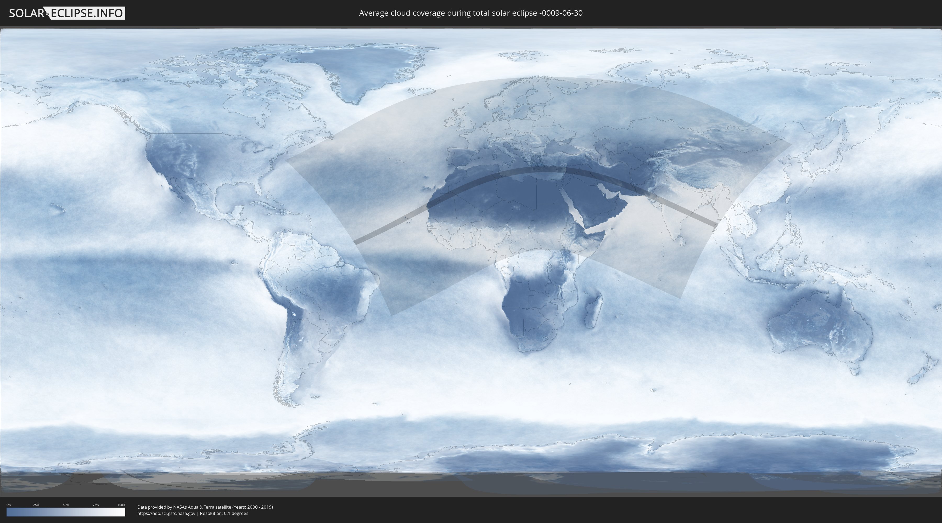
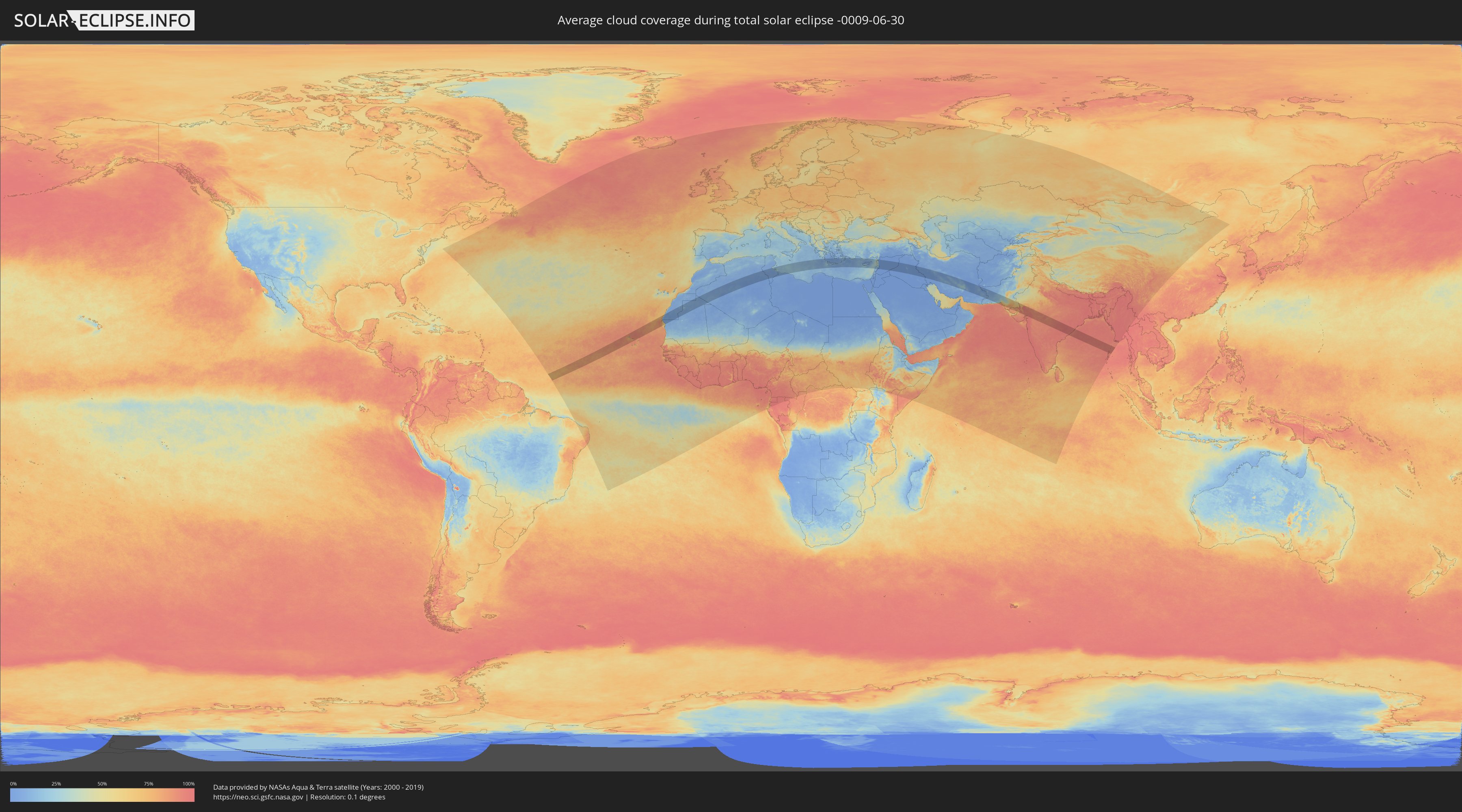
How will be the weather during the total solar eclipse on 06/30/-0009?
Where is the best place to see the total solar eclipse of 06/30/-0009?
The following maps show the average cloud coverage for the day of the total solar eclipse.
With the help of these maps, it is possible to find the place along the eclipse path, which has the best
chance of a cloudless sky.
Nevertheless, you should consider local circumstances and inform about the weather of your chosen
observation site.
The data is provided by NASAs satellites
AQUA and TERRA.
The cloud maps are averaged over a period of 19 years (2000 - 2019).
Detailed country maps
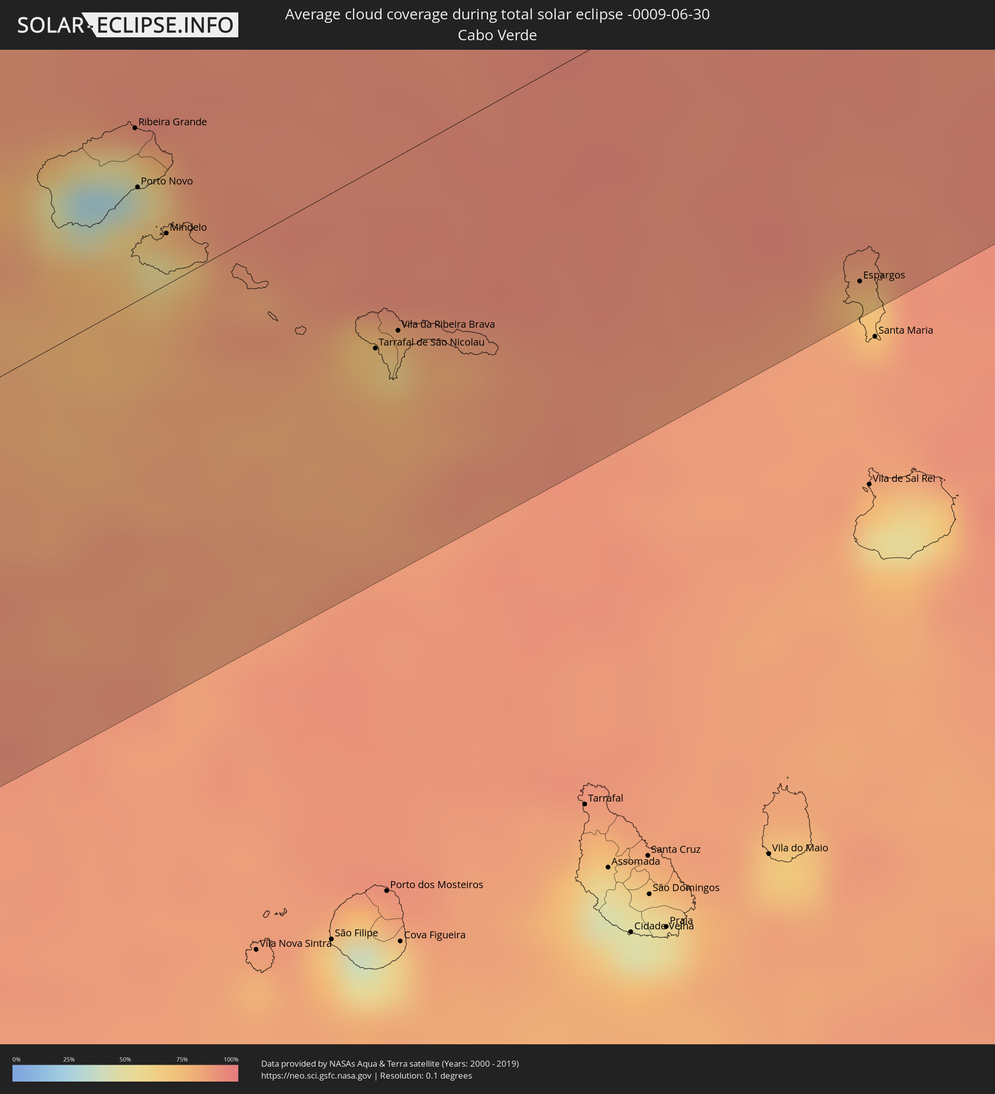 Cabo Verde
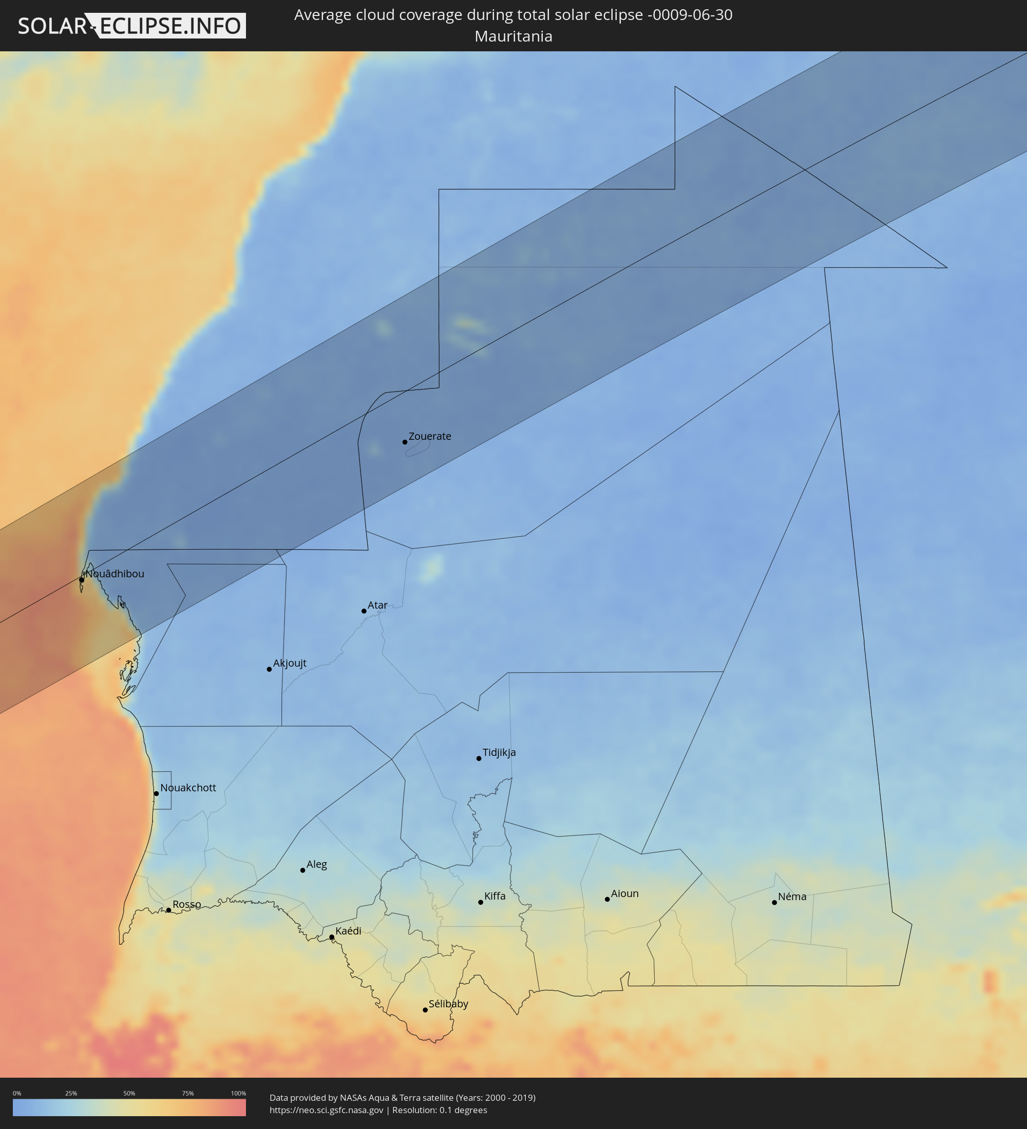 Mauritania
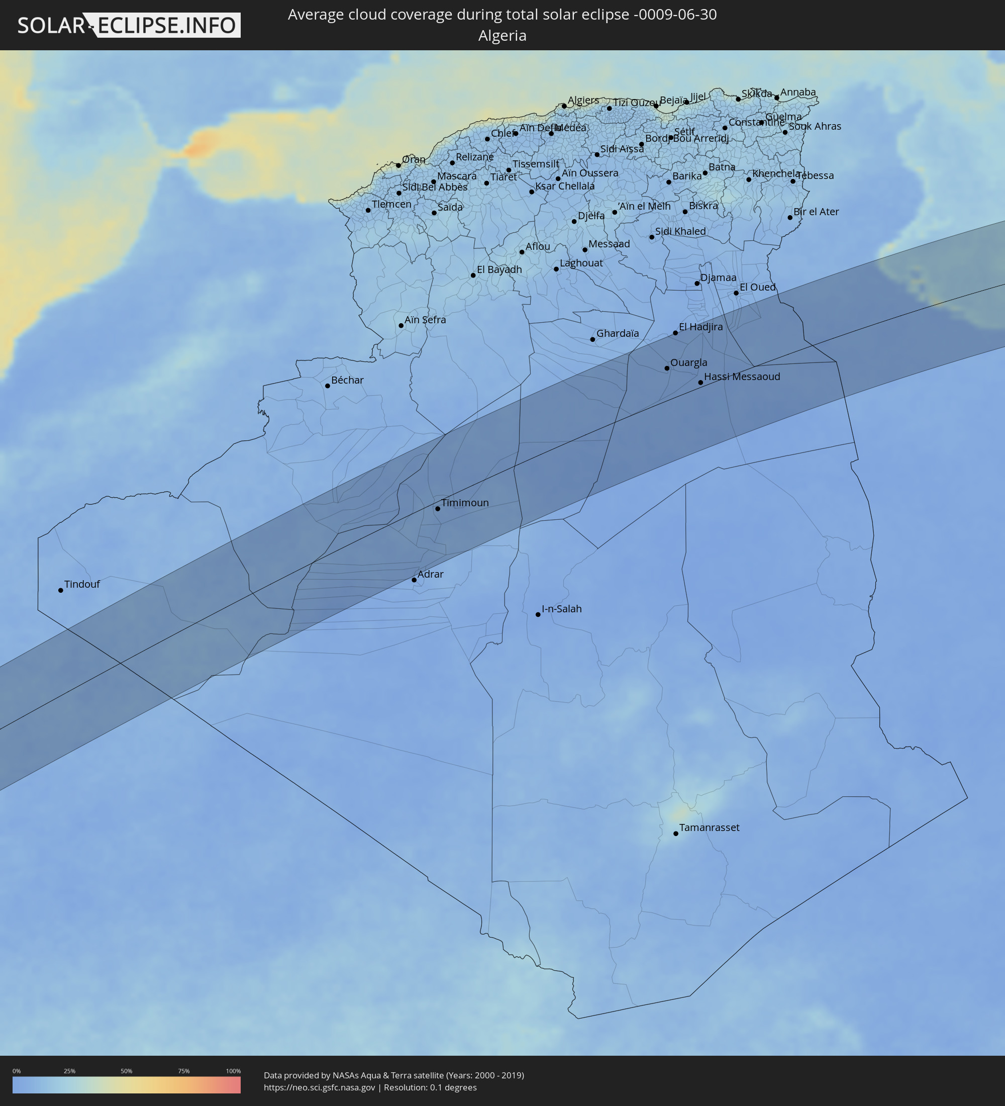 Algeria
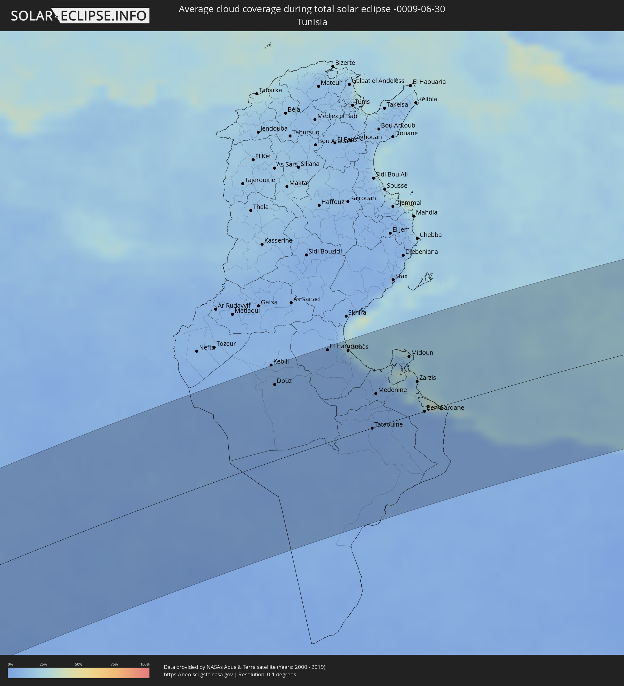 Tunisia
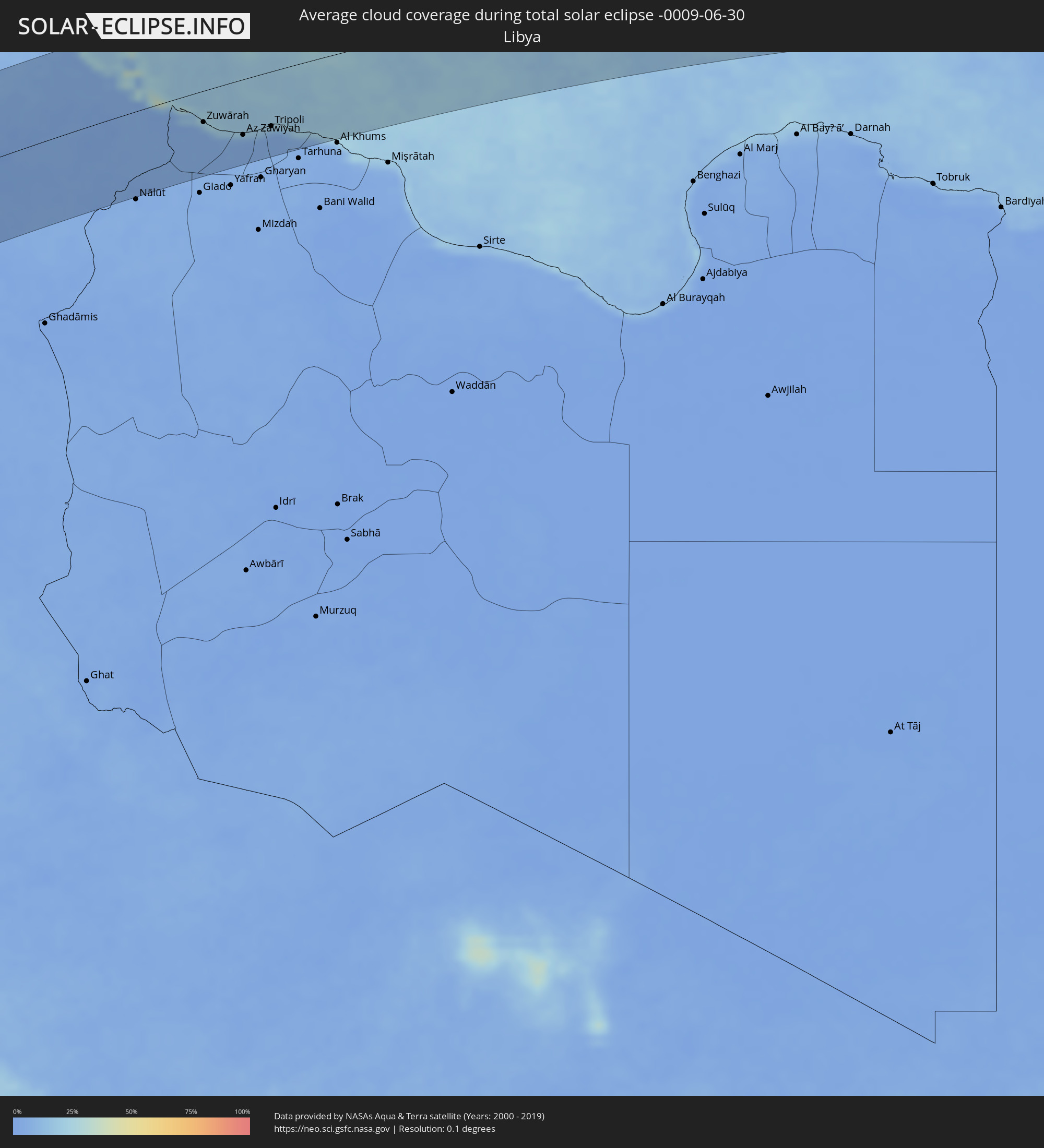 Libya
Libya
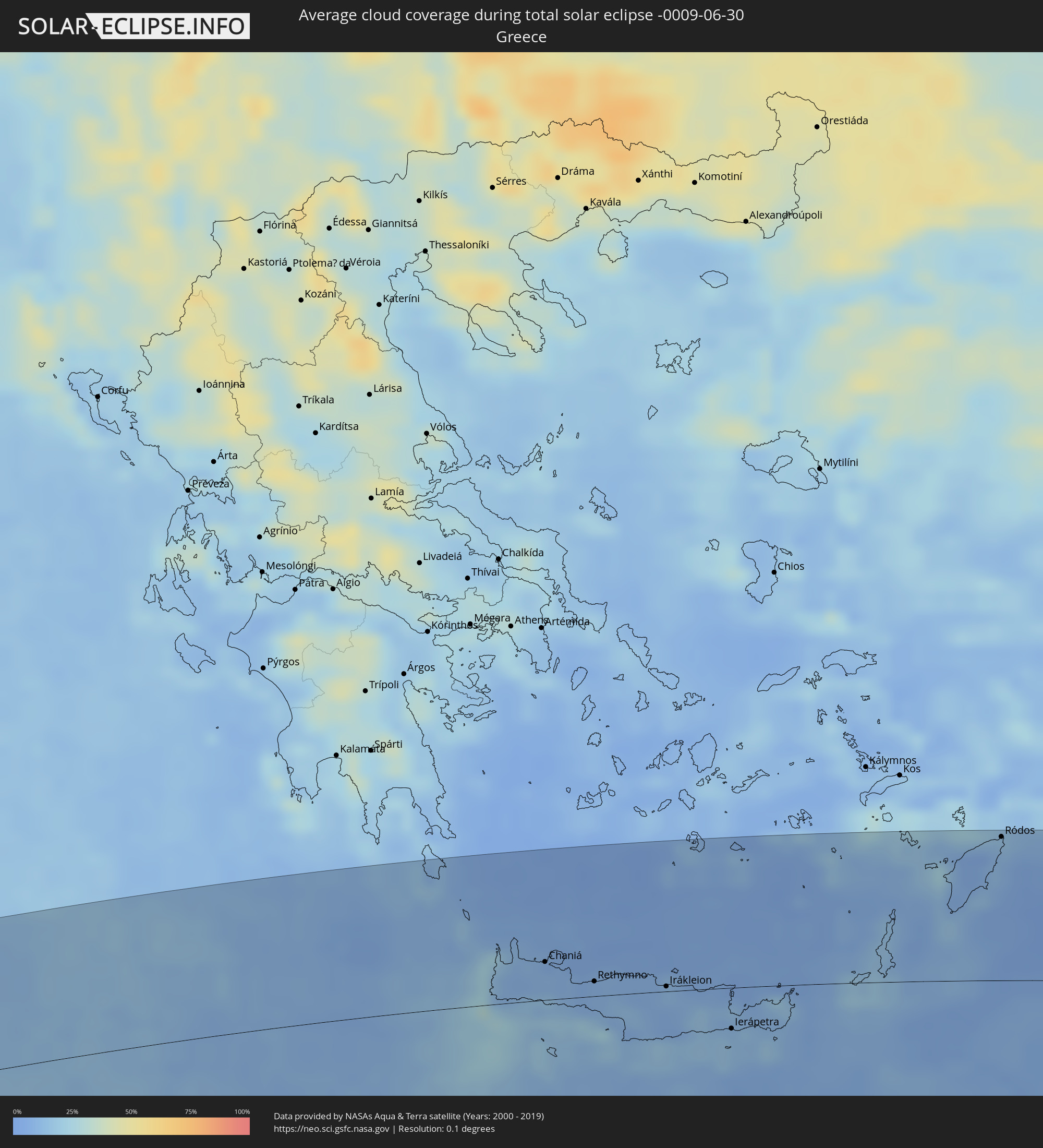 Greece
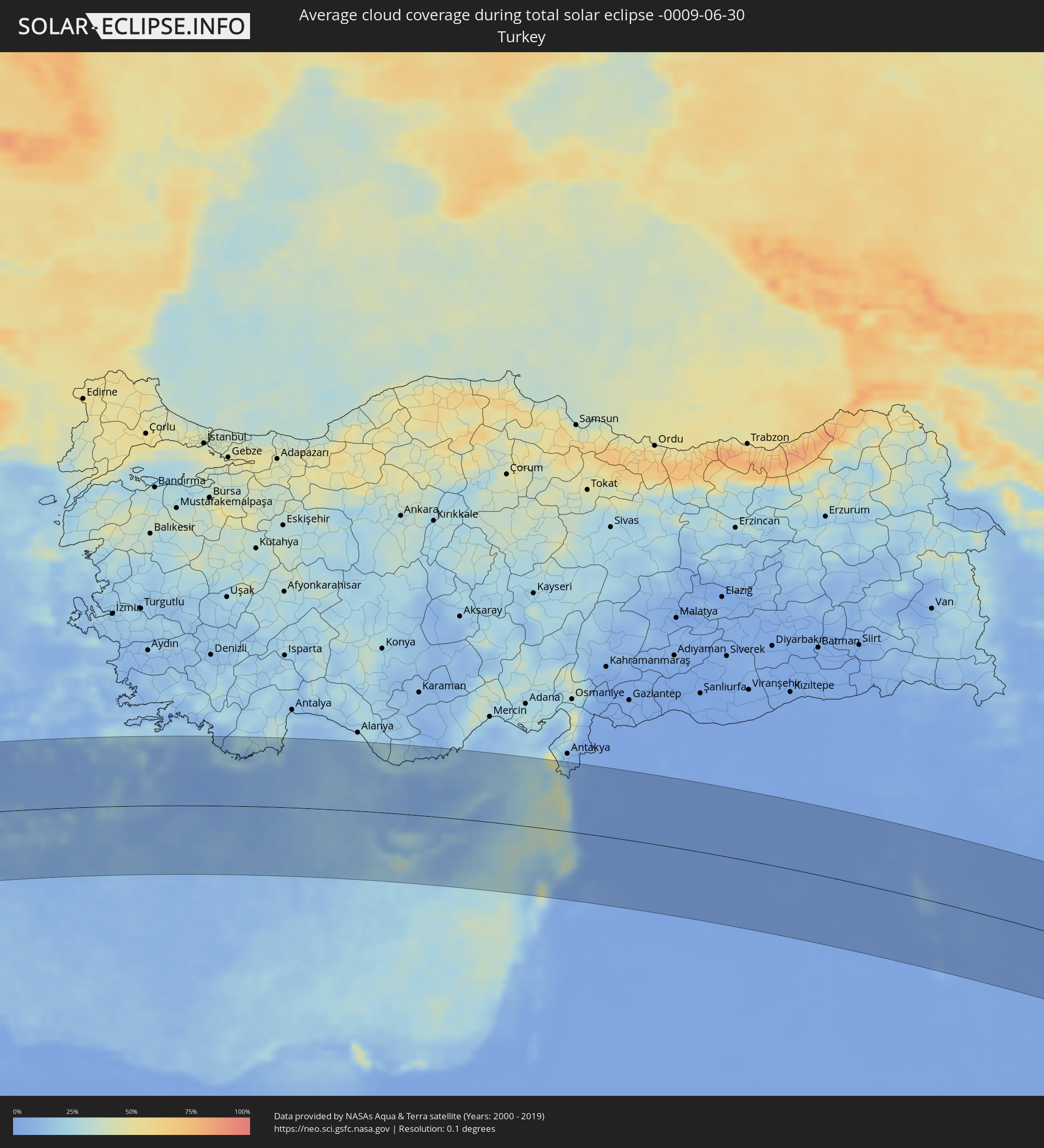 Turkey
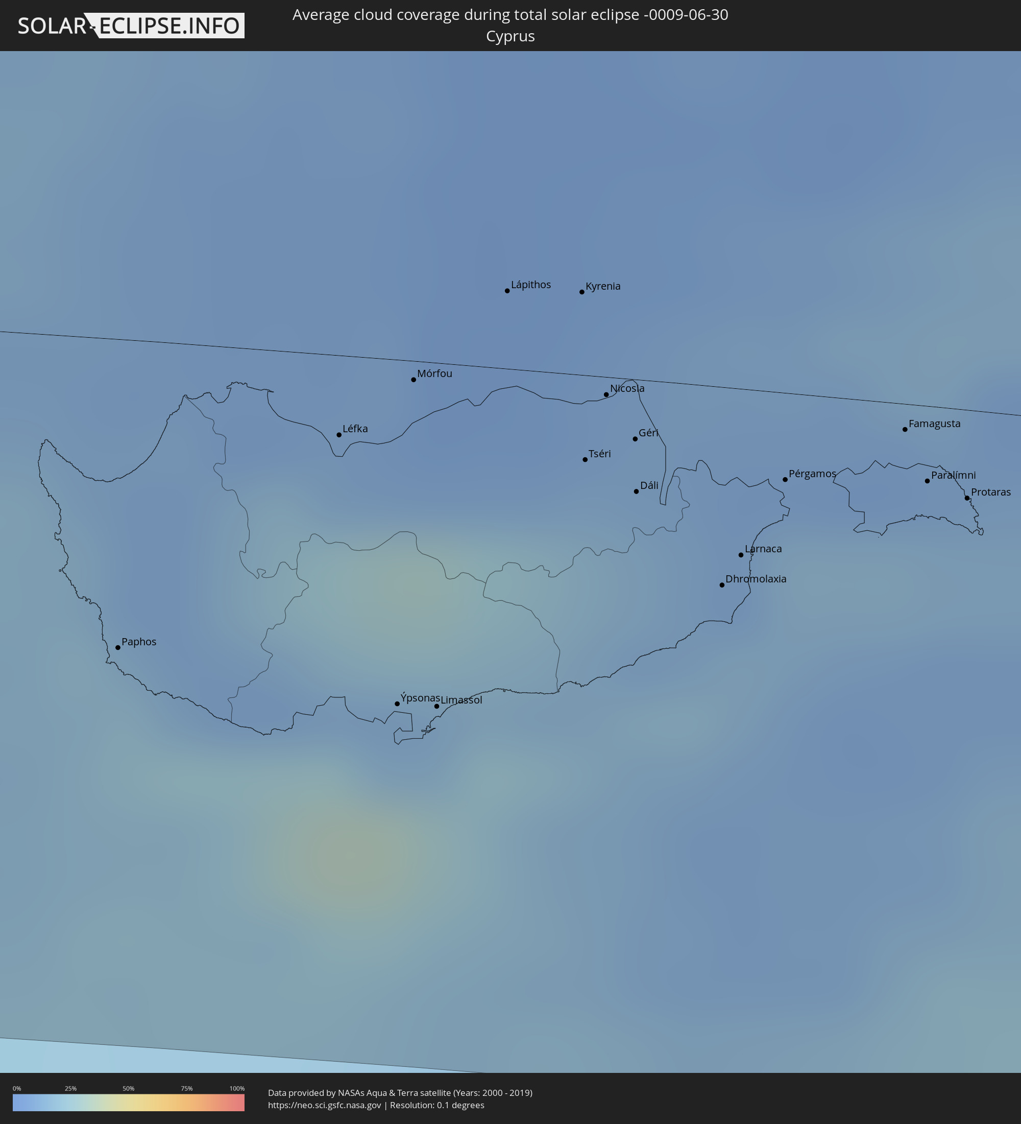 Cyprus
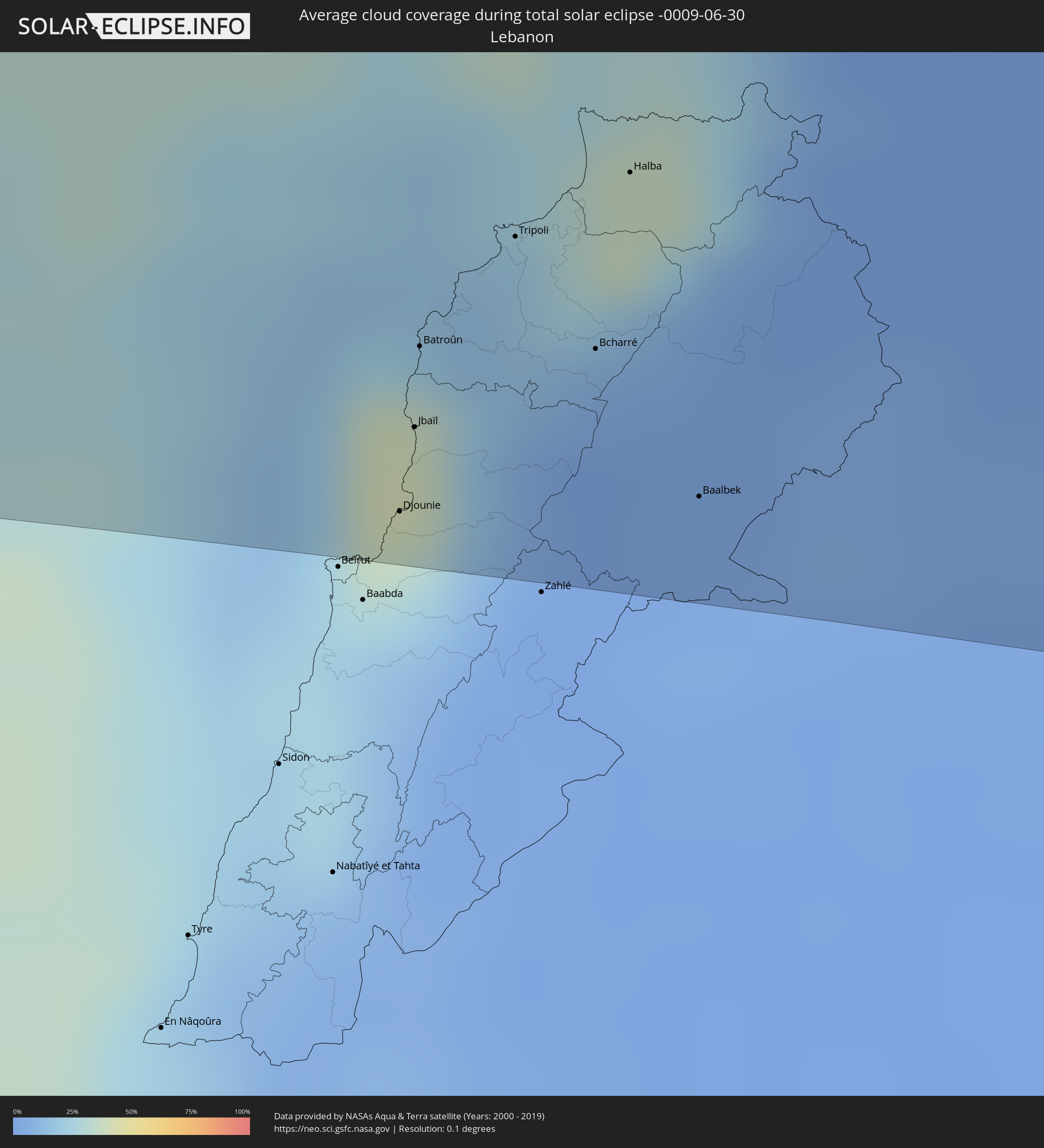 Lebanon
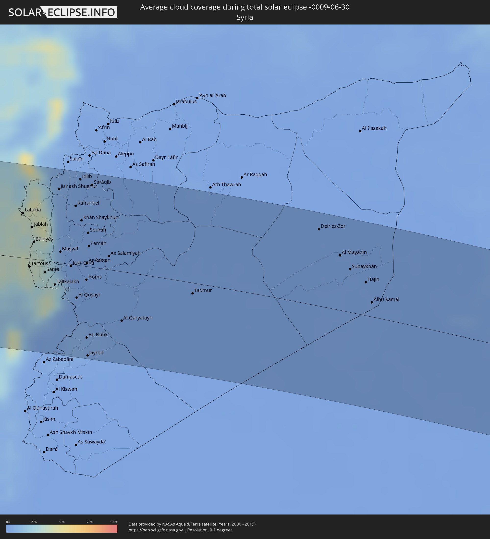 Syria
Syria
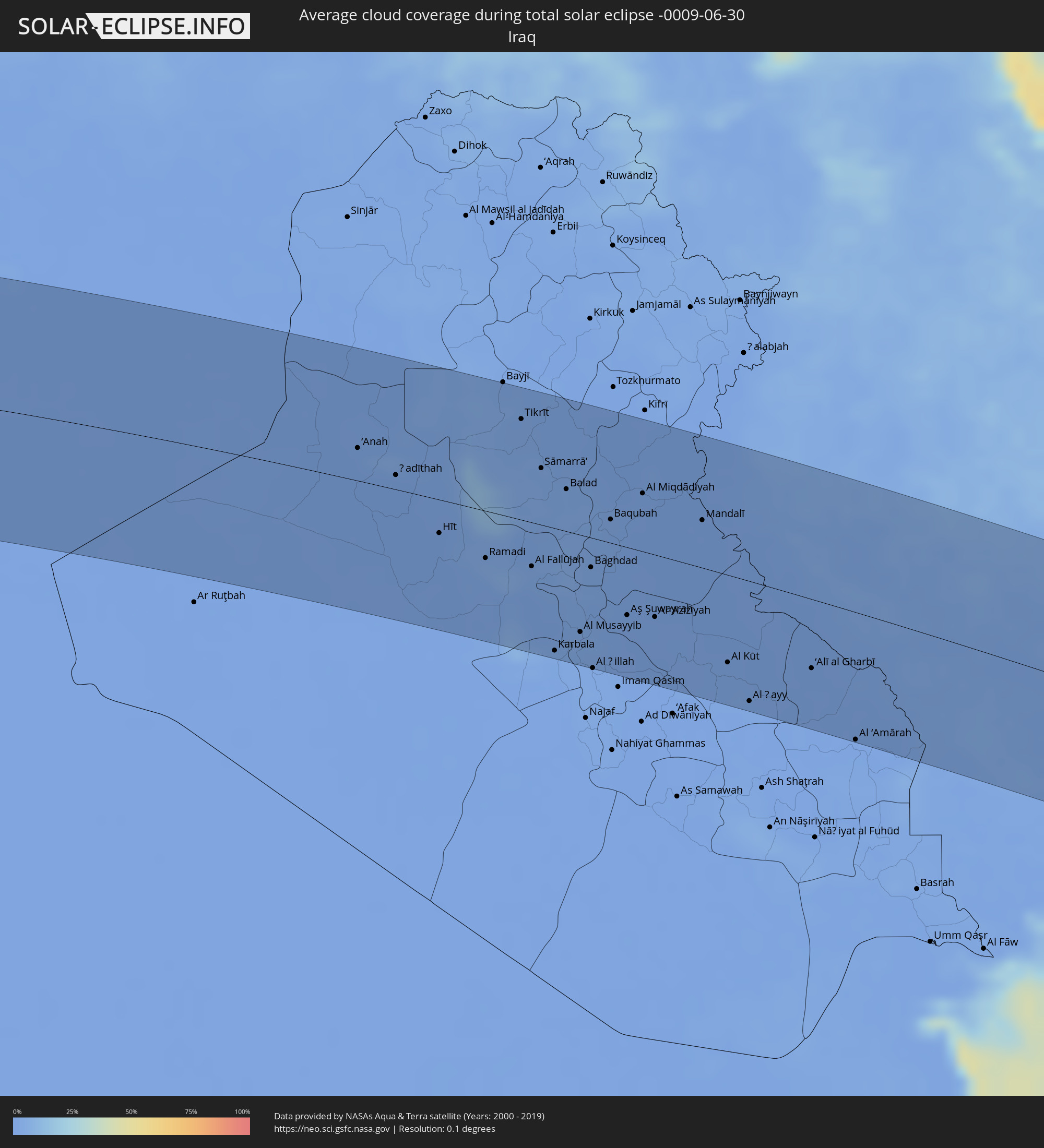 Iraq
Iraq
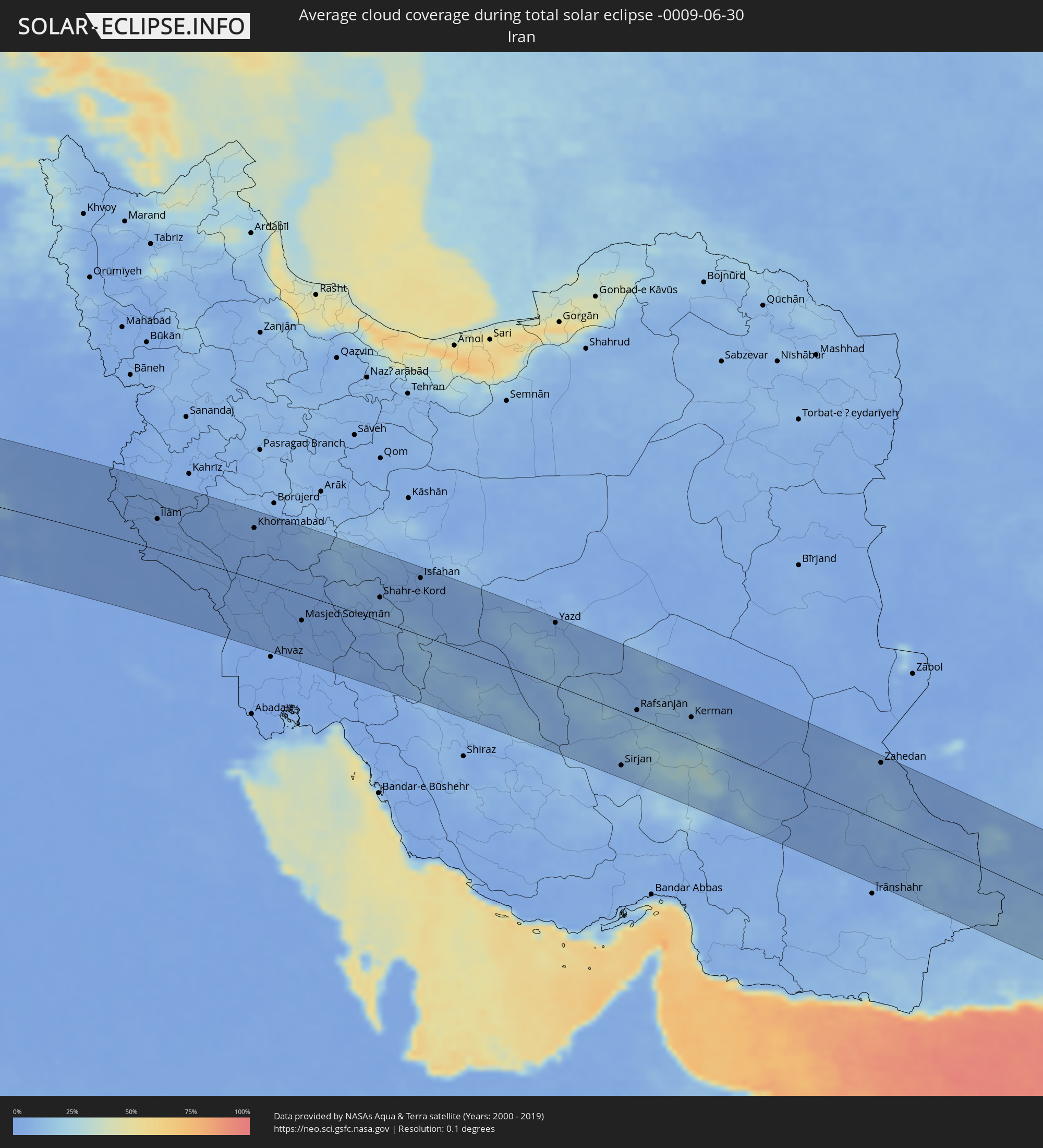 Iran
Iran
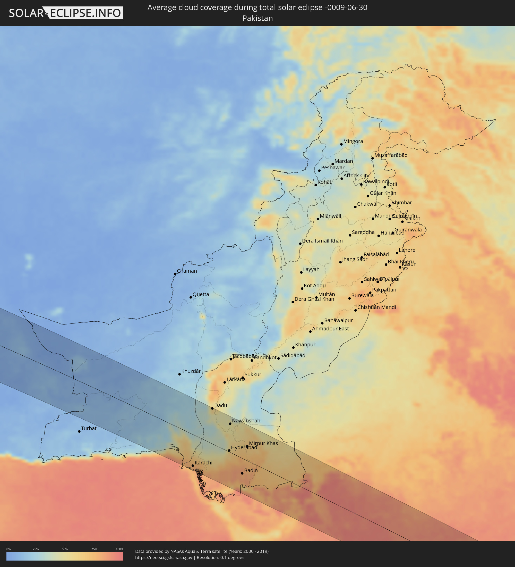 Pakistan
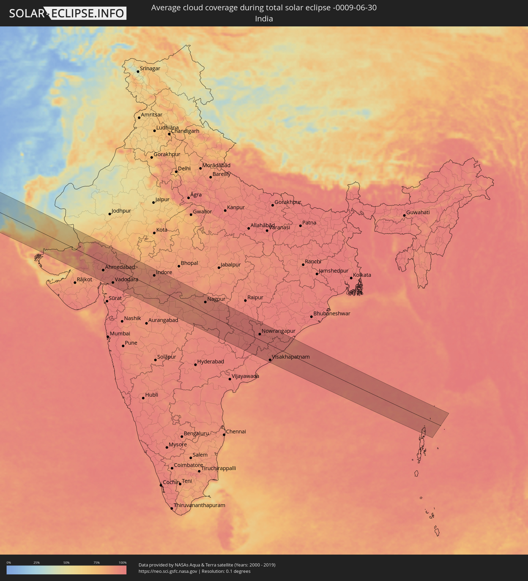 India
India
Cities inside the path of the eclipse
The following table shows all locations with a population of more than 5,000 inside the eclipse path. Cities which have more than 100,000 inhabitants are marked bold. A click at the locations opens a detailed map.
| City | Type | Eclipse duration | Local time of max. eclipse | Distance to central line | Ø Cloud coverage |
|
Ribeira Grande, Ribeira Grande
|
total | - | 07:19:22 UTC-01:34 | 47 km | 53% |
|
Porto Novo, Porto Novo
|
total | - | 07:19:13 UTC-01:34 | 31 km | 57% |
|
Pombas, Paul
|
total | - | 07:19:22 UTC-01:34 | 41 km | 74% |
|
Mindelo, São Vicente
|
total | - | 07:19:07 UTC-01:34 | 14 km | 53% |
|
Tarrafal de São Nicolau, Tarrafal de São Nicolau
|
total | - | 07:19:03 UTC-01:34 | 49 km | 72% |
|
Vila da Ribeira Brava, Ribeira Brava
|
total | - | 07:19:08 UTC-01:34 | 48 km | 64% |
|
Espargos, Sal
|
total | - | 07:19:54 UTC-01:34 | 105 km | 71% |
|
Nouâdhibou, Dakhlet Nouadhibou
|
total | - | 08:46:08 UTC-00:16 | 6 km | 67% |
|
Zouerate, Tiris Zemmour
|
total | - | 08:52:21 UTC-00:16 | 65 km | 5% |
|
Timimoun, Adrar
|
total | - | 09:43:09 UTC+00:09 | 16 km | 6% |
|
Ouargla, Ouargla
|
total | - | 09:55:28 UTC+00:09 | 61 km | 5% |
|
Rouissat, Ouargla
|
total | - | 09:55:29 UTC+00:09 | 58 km | 5% |
|
El Hadjira, Ouargla
|
total | - | 09:56:35 UTC+00:09 | 123 km | 4% |
|
Hassi Messaoud, Ouargla
|
total | - | 09:56:35 UTC+00:09 | 7 km | 3% |
|
El Golaa, Qibilī
|
total | - | 10:04:18 UTC+00:09 | 101 km | 6% |
|
Jemna, Qibilī
|
total | - | 10:04:25 UTC+00:09 | 110 km | 7% |
|
Douz, Qibilī
|
total | - | 10:04:18 UTC+00:09 | 98 km | 6% |
|
El Hamma, Qābis
|
total | - | 10:06:18 UTC+00:09 | 120 km | 5% |
|
Gabès, Qābis
|
total | - | 10:06:54 UTC+00:09 | 110 km | 11% |
|
Tataouine, Tataouine
|
total | - | 10:06:43 UTC+00:09 | 1 km | 3% |
|
Medenine, Madanīn
|
total | - | 10:07:14 UTC+00:09 | 43 km | 5% |
|
Houmt Souk, Madanīn
|
total | - | 10:08:27 UTC+00:09 | 88 km | 16% |
|
Midoun, Madanīn
|
total | - | 10:08:40 UTC+00:09 | 77 km | 23% |
|
Zarzis, Madanīn
|
total | - | 10:08:38 UTC+00:09 | 42 km | 24% |
|
Ben Gardane, Madanīn
|
total | - | 10:08:31 UTC+00:09 | 0 km | 4% |
|
Zalţan, An Nuqāţ al Khams
|
total | - | 10:53:07 UTC+00:52 | 38 km | 5% |
|
Zuwārah, An Nuqāţ al Khams
|
total | - | 10:53:34 UTC+00:52 | 46 km | 6% |
|
Şabrātah, Az Zāwiyah
|
total | - | 10:54:19 UTC+00:52 | 71 km | 8% |
|
Şurmān, Az Zāwiyah
|
total | - | 10:54:28 UTC+00:52 | 77 km | 9% |
|
Az Zāwīyah, Az Zāwiyah
|
total | - | 10:54:49 UTC+00:52 | 81 km | 8% |
|
Zawiya, Az Zāwiyah
|
total | - | 10:54:49 UTC+00:52 | 82 km | 8% |
|
Al ‘Azīzīyah, Sha‘bīyat al Jafārah
|
total | - | 10:55:16 UTC+00:52 | 113 km | 5% |
|
Tripoli, Tripoli
|
total | - | 10:55:56 UTC+00:52 | 80 km | 8% |
|
Tagiura, Tripoli
|
total | - | 10:56:18 UTC+00:52 | 83 km | 10% |
|
Chaniá, Crete
|
total | - | 12:04:20 UTC+01:34 | 32 km | 9% |
|
Soúda, Crete
|
total | - | 12:04:26 UTC+01:34 | 29 km | 9% |
|
Rethymno, Crete
|
total | - | 12:05:21 UTC+01:34 | 12 km | 9% |
|
Moíres, Crete
|
total | - | 12:06:12 UTC+01:34 | 25 km | 8% |
|
Gázi, Crete
|
total | - | 12:06:42 UTC+01:34 | 4 km | 7% |
|
Irákleion, Crete
|
total | - | 12:06:52 UTC+01:34 | 4 km | 7% |
|
Néa Alikarnassós, Crete
|
total | - | 12:06:54 UTC+01:34 | 5 km | 7% |
|
Ágios Nikólaos, Crete
|
total | - | 12:08:11 UTC+01:34 | 14 km | 9% |
|
Ierápetra, Crete
|
total | - | 12:08:13 UTC+01:34 | 34 km | 16% |
|
Sitia, Crete
|
total | - | 12:09:05 UTC+01:34 | 14 km | 10% |
|
Archángelos, South Aegean
|
total | - | 12:13:40 UTC+01:34 | 94 km | 11% |
|
Afántou, South Aegean
|
total | - | 12:13:46 UTC+01:34 | 102 km | 11% |
|
Triánta, South Aegean
|
total | - | 12:13:46 UTC+01:34 | 115 km | 9% |
|
Faliraki, South Aegean
|
total | - | 12:13:51 UTC+01:34 | 108 km | 11% |
|
Ródos, South Aegean
|
total | - | 12:13:54 UTC+01:34 | 119 km | 9% |
|
Kaş, Antalya
|
total | - | 12:39:08 UTC+01:56 | 93 km | 26% |
|
Demre, Antalya
|
total | - | 12:39:53 UTC+01:56 | 100 km | 18% |
|
Demre, Antalya
|
total | - | 12:39:54 UTC+01:56 | 99 km | 12% |
|
Turunçova, Antalya
|
total | - | 12:40:13 UTC+01:56 | 113 km | 21% |
|
Finike, Antalya
|
total | - | 12:40:14 UTC+01:56 | 105 km | 19% |
|
Beykonak, Antalya
|
total | - | 12:40:35 UTC+01:56 | 109 km | 17% |
|
Gazipaşa, Antalya
|
total | - | 12:45:00 UTC+01:56 | 111 km | 20% |
|
Paphos, Pafos
|
total | - | 13:02:14 UTC+02:13 | 54 km | 20% |
|
Anamur, Mersin
|
total | - | 12:46:11 UTC+01:56 | 93 km | 21% |
|
Léfka, Nicosia
|
total | - | 13:03:04 UTC+02:13 | 14 km | 13% |
|
Bozyazı, Mersin
|
total | - | 12:46:26 UTC+01:56 | 97 km | 17% |
|
Ýpsonas, Limassol
|
total | - | 13:03:28 UTC+02:13 | 60 km | 17% |
|
Mórfou, Nicosia
|
total | - | 13:03:21 UTC+02:13 | 3 km | 6% |
|
Limassol, Limassol
|
total | - | 13:03:38 UTC+02:13 | 60 km | 17% |
|
Kyrenia, Keryneia
|
total | - | 13:04:01 UTC+02:13 | 14 km | 7% |
|
Aydıncık, Mersin
|
total | - | 12:47:12 UTC+01:56 | 104 km | 15% |
|
Nicosia, Nicosia
|
total | - | 13:04:11 UTC+02:13 | 3 km | 10% |
|
Géri, Nicosia
|
total | - | 13:04:20 UTC+02:13 | 10 km | 11% |
|
Dáli, Nicosia
|
total | - | 13:04:22 UTC+02:13 | 20 km | 14% |
|
Aradíppou, Larnaka
|
total | - | 13:04:46 UTC+02:13 | 26 km | 9% |
|
Larnaca, Larnaka
|
total | - | 13:04:51 UTC+02:13 | 29 km | 15% |
|
Pérgamos, Larnaka
|
total | - | 13:04:59 UTC+02:13 | 15 km | 16% |
|
Famagusta, Ammochostos
|
total | - | 13:05:28 UTC+02:13 | 5 km | 8% |
|
Paralímni, Ammochostos
|
total | - | 13:05:35 UTC+02:13 | 13 km | 14% |
|
Protaras, Ammochostos
|
total | - | 13:05:46 UTC+02:13 | 15 km | 14% |
|
Djounie, Mont-Liban
|
total | - | 12:56:11 UTC+02:00 | 114 km | 35% |
|
Jbaïl, Mont-Liban
|
total | - | 12:56:10 UTC+02:00 | 98 km | 39% |
|
Batroûn, Liban-Nord
|
total | - | 12:56:08 UTC+02:00 | 83 km | 20% |
|
Latakia, Latakia
|
total | - | 13:20:59 UTC+02:25 | 60 km | 36% |
|
Tripoli, Liban-Nord
|
total | - | 12:56:27 UTC+02:00 | 61 km | 14% |
|
Tartouss, Tartus
|
total | - | 13:21:30 UTC+02:25 | 10 km | 35% |
|
Jablah, Latakia
|
total | - | 13:21:21 UTC+02:25 | 42 km | 31% |
|
Bcharré, Liban-Nord
|
total | - | 12:56:54 UTC+02:00 | 79 km | 12% |
|
Yayladağı, Hatay
|
total | - | 12:53:06 UTC+01:56 | 104 km | 26% |
|
Halba, Aakkâr
|
total | - | 12:56:54 UTC+02:00 | 46 km | 35% |
|
Baalbek, Baalbek-Hermel
|
total | - | 12:57:28 UTC+02:00 | 104 km | 2% |
|
Kafranbel, Idlib
|
total | - | 13:22:33 UTC+02:25 | 78 km | 1% |
|
Idlib, Idlib
|
total | - | 13:22:31 UTC+02:25 | 114 km | 2% |
|
Khān Shaykhūn, Idlib
|
total | - | 13:22:49 UTC+02:25 | 60 km | 1% |
|
Homs, Homs
|
total | - | 13:23:22 UTC+02:25 | 18 km | 0% |
|
An Nabk, Rif-dimashq
|
total | - | 13:23:46 UTC+02:25 | 95 km | 4% |
|
Ar Rastan, Homs
|
total | - | 13:23:17 UTC+02:25 | 4 km | 0% |
|
Ḩamāh, Hama
|
total | - | 13:23:13 UTC+02:25 | 27 km | 0% |
|
As Salamīyah, Hama
|
total | - | 13:23:54 UTC+02:25 | 18 km | 0% |
|
Tadmur, Homs
|
total | - | 13:26:43 UTC+02:25 | 14 km | 0% |
|
Deir ez-Zor, Deir ez-Zor
|
total | - | 13:29:55 UTC+02:25 | 101 km | 0% |
|
Al Mayādīn, Deir ez-Zor
|
total | - | 13:30:45 UTC+02:25 | 72 km | 0% |
|
Ālbū Kamāl, Deir ez-Zor
|
total | - | 13:32:05 UTC+02:25 | 19 km | 1% |
|
Ramadi, Anbar
|
total | - | 14:09:52 UTC+02:57 | 44 km | 3% |
|
Al Fallūjah, Anbar
|
total | - | 14:10:49 UTC+02:57 | 41 km | 2% |
|
Sāmarrā’, Salah ad Din Governorate
|
total | - | 14:10:17 UTC+02:57 | 53 km | 2% |
|
Karbala, Karbalāʼ
|
total | - | 14:11:53 UTC+02:57 | 114 km | 1% |
|
Abū Ghurayb, Mayorality of Baghdad
|
total | - | 14:11:35 UTC+02:57 | 36 km | 3% |
|
Al Hindīyah, Karbalāʼ
|
total | - | 14:12:19 UTC+02:57 | 117 km | 2% |
|
Al Musayyib, Bābil
|
total | - | 14:12:14 UTC+02:57 | 91 km | 2% |
|
Baghdad, Mayorality of Baghdad
|
total | - | 14:11:57 UTC+02:57 | 28 km | 1% |
|
Al Ḩillah, Bābil
|
total | - | 14:12:45 UTC+02:57 | 122 km | 2% |
|
Baqubah, Diyālá
|
total | - | 14:11:58 UTC+02:57 | 22 km | 1% |
|
Al Miqdādīyah, Diyālá
|
total | - | 14:12:22 UTC+02:57 | 54 km | 1% |
|
Al ‘Azīzīyah, Wāsiţ
|
total | - | 14:13:32 UTC+02:57 | 58 km | 1% |
|
Al Kūt, Wāsiţ
|
total | - | 14:15:15 UTC+02:57 | 82 km | 1% |
|
Al Ḩayy, Wāsiţ
|
total | - | 14:15:57 UTC+02:57 | 112 km | 1% |
|
Īlām, Īlām
|
total | - | 14:43:24 UTC+03:25 | 54 km | 1% |
|
Al ‘Amārah, Maysan
|
total | - | 14:18:12 UTC+02:57 | 119 km | 1% |
|
Kūhdasht, Lorestān
|
total | - | 14:45:30 UTC+03:25 | 75 km | 2% |
|
Khorramabad, Lorestān
|
total | - | 14:46:46 UTC+03:25 | 90 km | 3% |
|
Masjed Soleymān, Khuzestan
|
total | - | 14:49:50 UTC+03:25 | 47 km | 1% |
|
Shahr-e Kord, Chahār Maḩāll va Bakhtīārī
|
total | - | 14:51:52 UTC+03:25 | 42 km | 8% |
|
Najafābād, Isfahan
|
total | - | 14:52:18 UTC+03:25 | 90 km | 2% |
|
Yasuj, Kohgīlūyeh va Būyer Aḩmad
|
total | - | 14:54:41 UTC+03:25 | 110 km | 9% |
|
Isfahan, Isfahan
|
total | - | 14:52:44 UTC+03:25 | 101 km | 3% |
|
Shāhreẕā, Isfahan
|
total | - | 14:53:41 UTC+03:25 | 43 km | 5% |
|
Yazd, Yazd
|
total | - | 14:57:19 UTC+03:25 | 111 km | 3% |
|
Sirjan, Kerman
|
total | - | 15:01:42 UTC+03:25 | 96 km | 8% |
|
Rafsanjān, Kerman
|
total | - | 15:01:04 UTC+03:25 | 14 km | 9% |
|
Kerman, Kerman
|
total | - | 15:02:33 UTC+03:25 | 40 km | 8% |
|
Bam, Kerman
|
total | - | 15:05:21 UTC+03:25 | 33 km | 7% |
|
Zahedan, Sistan and Baluchestan
|
total | - | 15:07:40 UTC+03:25 | 104 km | 6% |
|
Karachi, Sindh
|
total | - | 16:20:33 UTC+04:28 | 101 km | 77% |
|
Dadu, Sindh
|
total | - | 16:19:08 UTC+04:28 | 112 km | 58% |
|
Thatta, Sindh
|
total | - | 16:21:19 UTC+04:28 | 80 km | 79% |
|
Hyderabad, Sindh
|
total | - | 16:20:57 UTC+04:28 | 4 km | 63% |
|
Nawābshāh, Sindh
|
total | - | 16:20:05 UTC+04:28 | 91 km | 50% |
|
Hāla, Sindh
|
total | - | 16:20:33 UTC+04:28 | 48 km | 54% |
|
Tando Muhammad Khān, Sindh
|
total | - | 16:21:21 UTC+04:28 | 16 km | 76% |
|
Shāhdādpur, Sindh
|
total | - | 16:20:34 UTC+04:28 | 68 km | 54% |
|
Mātli, Sindh
|
total | - | 16:21:30 UTC+04:28 | 19 km | 79% |
|
Tando Ādam, Sindh
|
total | - | 16:20:46 UTC+04:28 | 54 km | 56% |
|
Tando Allāhyār, Sindh
|
total | - | 16:21:07 UTC+04:28 | 26 km | 65% |
|
Badīn, Sindh
|
total | - | 16:22:01 UTC+04:28 | 49 km | 81% |
|
Sānghar, Sindh
|
total | - | 16:20:40 UTC+04:28 | 95 km | 56% |
|
Mirpur Khas, Sindh
|
total | - | 16:21:15 UTC+04:28 | 45 km | 68% |
|
Umarkot, Sindh
|
total | - | 16:21:52 UTC+04:28 | 61 km | 69% |
|
Ahmedabad, Gujarat
|
total | - | 17:18:44 UTC+05:21 | 45 km | 90% |
|
Nadiād, Gujarat
|
total | - | 17:19:11 UTC+05:21 | 66 km | 94% |
|
Vadodara, Gujarat
|
total | - | 17:19:43 UTC+05:21 | 90 km | 93% |
|
Ratlām, Madhya Pradesh
|
total | - | 17:19:32 UTC+05:21 | 96 km | 85% |
|
Māndu, Madhya Pradesh
|
total | - | 17:20:34 UTC+05:21 | 16 km | 87% |
|
Indore, Madhya Pradesh
|
total | - | 17:20:25 UTC+05:21 | 72 km | 89% |
|
Dewas, Madhya Pradesh
|
total | - | 17:20:15 UTC+05:21 | 107 km | 88% |
|
Burhānpur, Madhya Pradesh
|
total | - | 17:21:50 UTC+05:21 | 51 km | 89% |
|
Punāsa, Madhya Pradesh
|
total | - | 17:21:03 UTC+05:21 | 49 km | 87% |
|
Akola, Maharashtra
|
total | - | 17:22:36 UTC+05:21 | 75 km | 91% |
|
Amrāvati, Maharashtra
|
total | - | 17:22:38 UTC+05:21 | 18 km | 90% |
|
Nagpur, Maharashtra
|
total | - | 17:22:48 UTC+05:21 | 64 km | 92% |
|
Chānda, Maharashtra
|
total | - | 17:23:52 UTC+05:21 | 45 km | 93% |
|
Nowrangapur, Odisha
|
total | - | 17:24:59 UTC+05:21 | 33 km | 97% |
|
Visakhapatnam, Andhra Pradesh
|
total | - | 17:26:14 UTC+05:21 | 92 km | 95% |