Annular solar eclipse of 11/30/-0213
| Day of week: | Wednesday |
| Maximum duration of eclipse: | 11m47s |
| Maximum width of eclipse path: | 370 km |
| Saros cycle: | 58 |
| Coverage: | 91.5% |
| Magnitude: | 0.9148 |
| Gamma: | 0.4916 |
Wo kann man die Sonnenfinsternis vom 11/30/-0213 sehen?
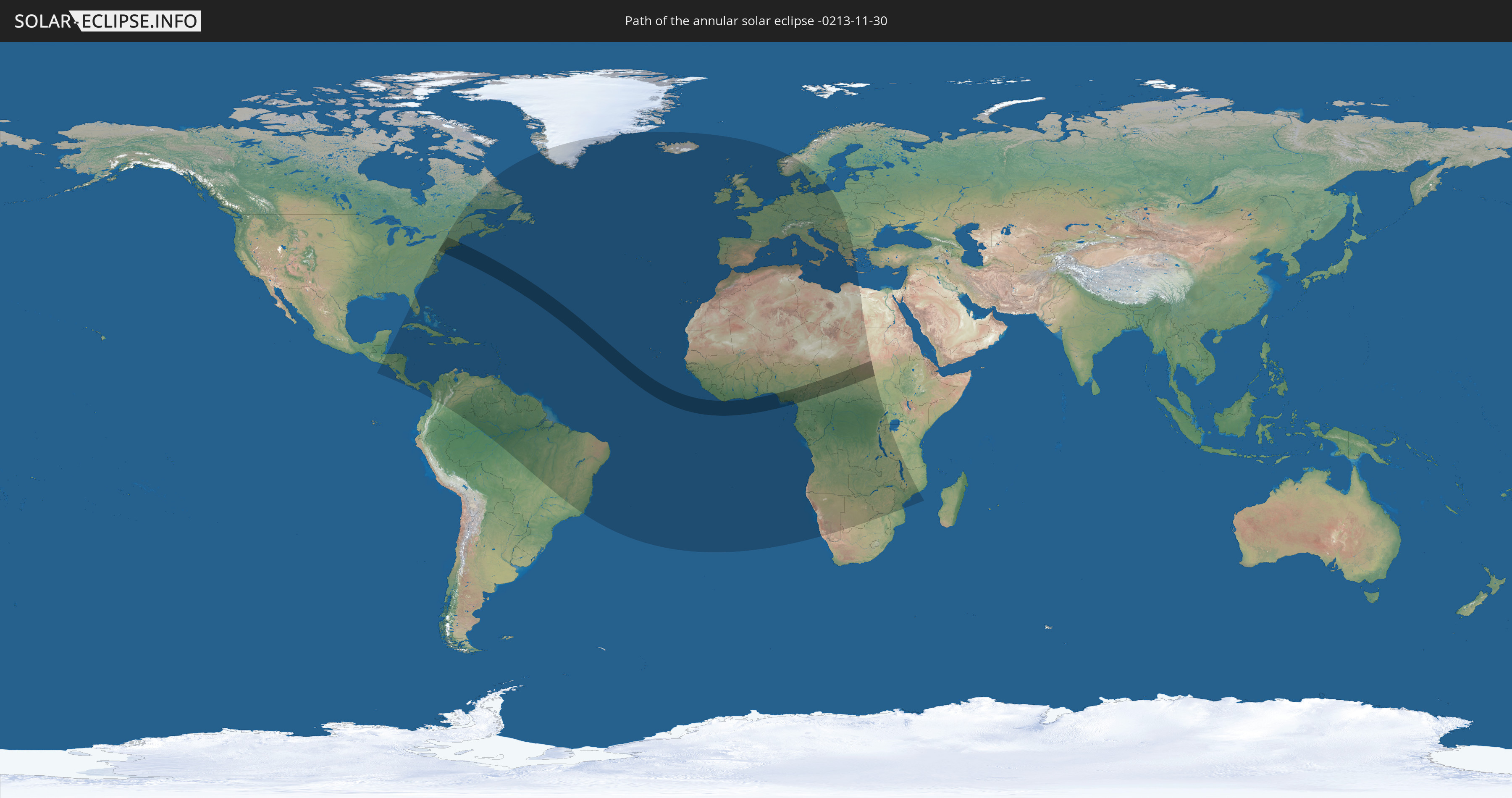
Die Sonnenfinsternis am 11/30/-0213 kann man in 126 Ländern als partielle Sonnenfinsternis beobachten.
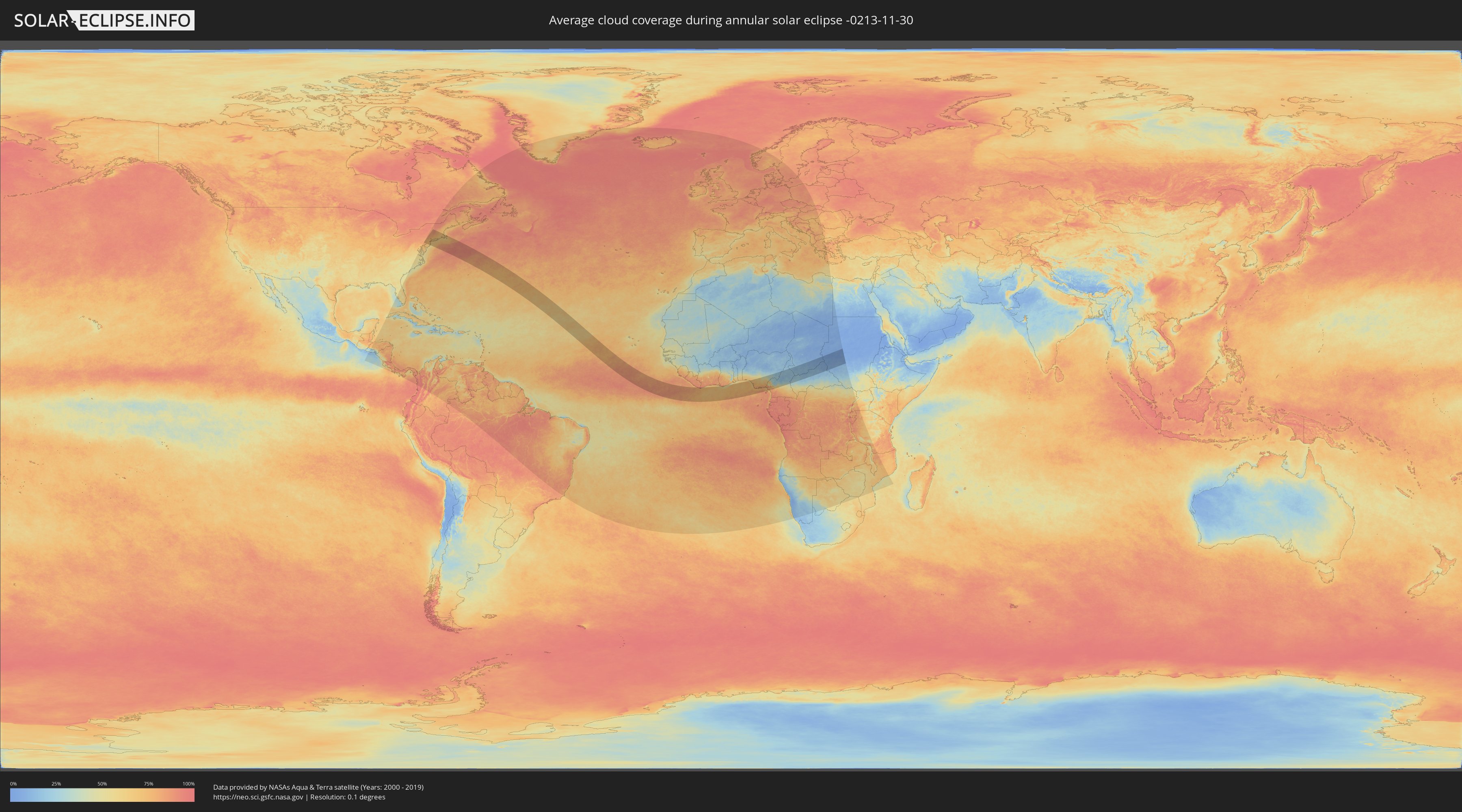
Der Finsternispfad verläuft durch 10 Länder. Nur in diesen Ländern ist sie als annular Sonnenfinsternis zu sehen.
In den folgenden Ländern ist die Sonnenfinsternis annular zu sehen
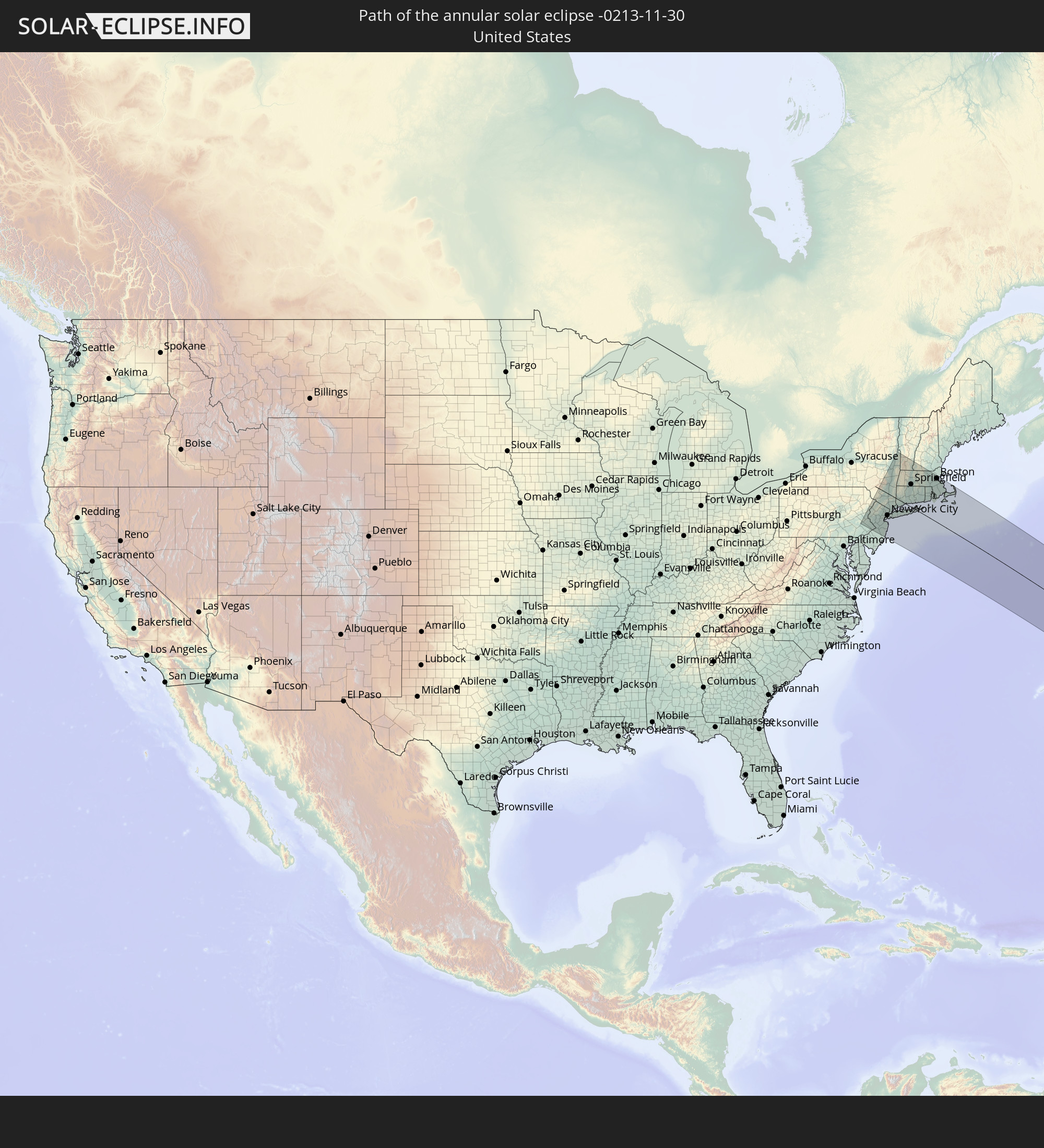 United States
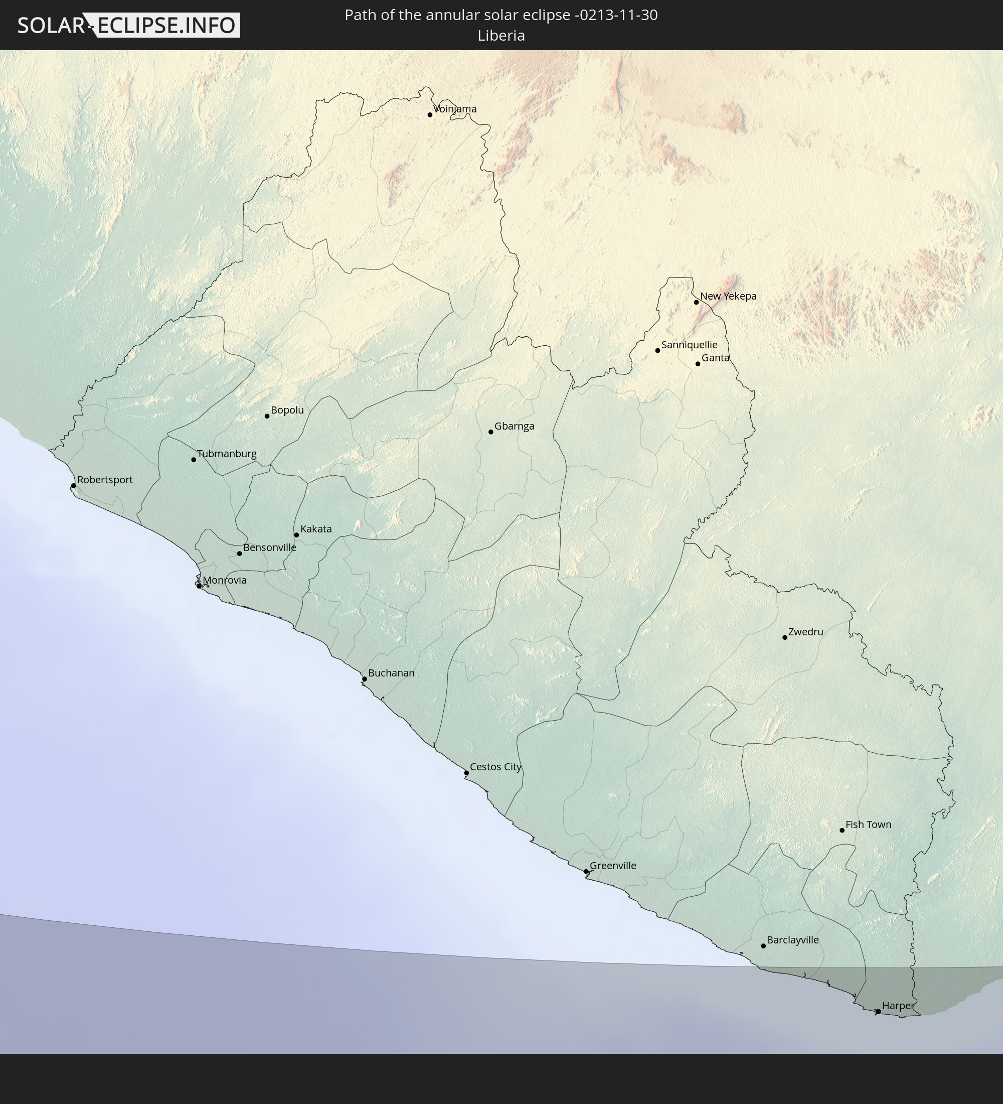 Liberia
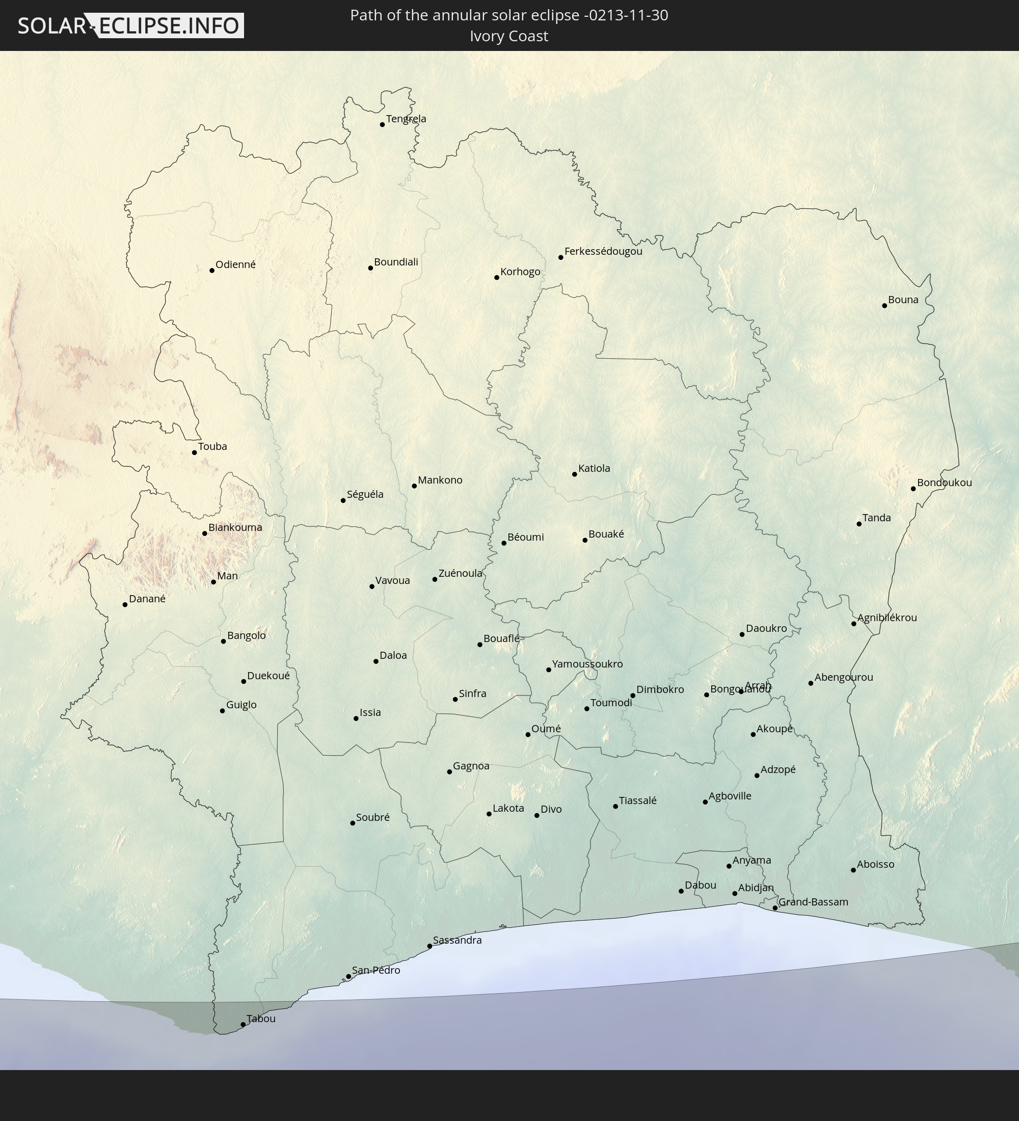 Ivory Coast
 Ghana
Ghana
 Nigeria
 Cameroon
 Chad
Chad
 Central African Republic
 Sudan
Sudan
 South Sudan
In den folgenden Ländern ist die Sonnenfinsternis partiell zu sehen
 United States
 United States Minor Outlying Islands
 Canada
 Greenland
 El Salvador
 Honduras
 Nicaragua
 Costa Rica
 Cuba
Cuba
 Panama
 Colombia
 Cayman Islands
 The Bahamas
 Jamaica
 Haiti
Haiti
 Brazil
 Venezuela
 Turks and Caicos Islands
 Dominican Republic
 Aruba
Aruba
 Puerto Rico
 United States Virgin Islands
 Bermuda
 British Virgin Islands
 Anguilla
 Collectivity of Saint Martin
 Saint Barthélemy
 Saint Kitts and Nevis
 Antigua and Barbuda
 Montserrat
 Trinidad and Tobago
 Guadeloupe
 Grenada
 Dominica
 Saint Vincent and the Grenadines
 Guyana
 Martinique
 Saint Lucia
 Barbados
 Suriname
 Saint Pierre and Miquelon
 French Guiana
 Portugal
 Cabo Verde
 Iceland
 Spain
Spain
 Senegal
 Mauritania
 The Gambia
 Guinea-Bissau
 Guinea
 Saint Helena, Ascension and Tristan da Cunha
 Sierra Leone
 Morocco
 Mali
Mali
 Liberia
 Republic of Ireland
 Algeria
 United Kingdom
 Ivory Coast
 Faroe Islands
 Burkina Faso
 Gibraltar
 France
 Isle of Man
 Ghana
Ghana
 Guernsey
 Jersey
 Togo
Togo
 Niger
Niger
 Benin
Benin
 Andorra
 Belgium
 Nigeria
 Netherlands
 Norway
 Equatorial Guinea
 Luxembourg
 Germany
 Switzerland
 São Tomé and Príncipe
 Italy
Italy
 Monaco
 Tunisia
 Denmark
 Cameroon
 Gabon
Gabon
 Libya
Libya
 Liechtenstein
 Austria
 Sweden
 Republic of the Congo
 Angola
 Namibia
 Czechia
 Democratic Republic of the Congo
 San Marino
 Vatican City
 Slovenia
 Chad
Chad
 Croatia
 Poland
 Malta
Malta
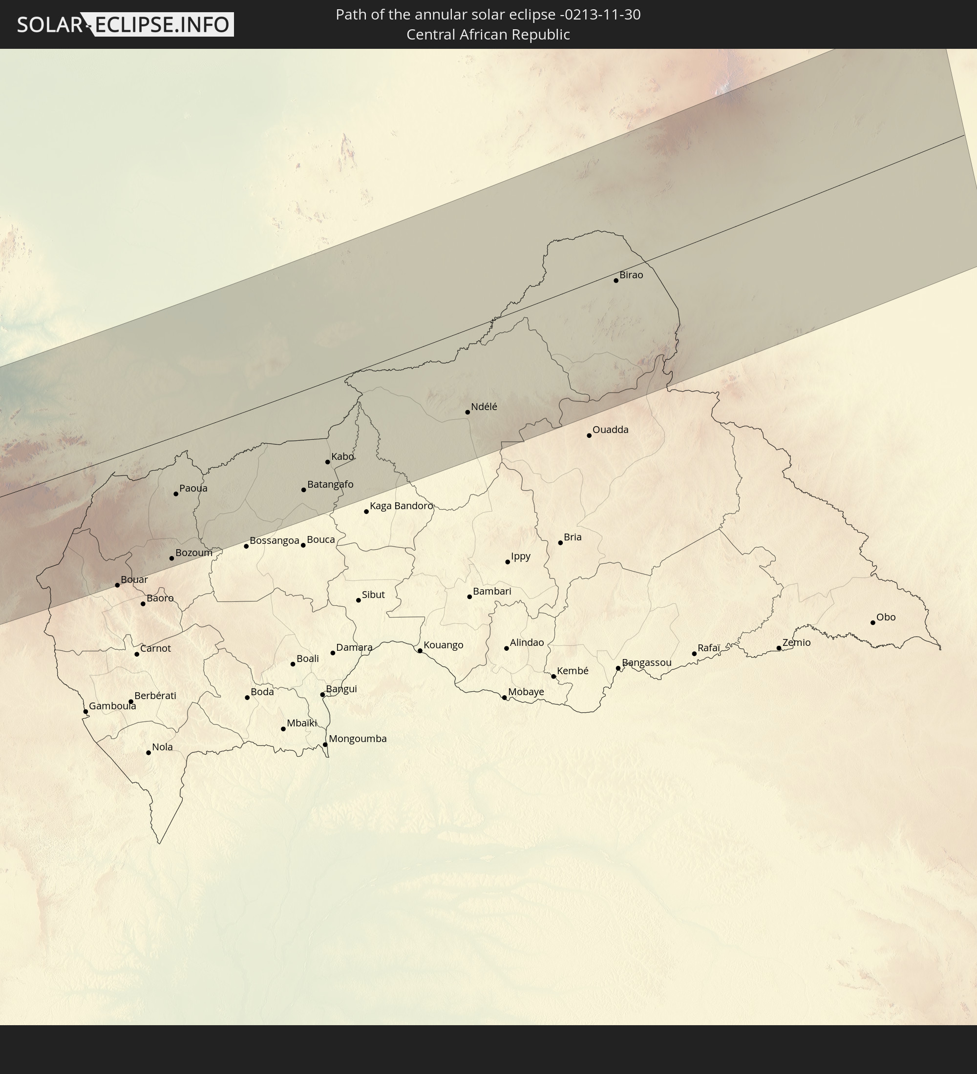
 Central African Republic
 Bosnia and Herzegovina
 Hungary
 South Africa
 Slovakia
 Montenegro
 Serbia
 Albania
 Greece
 Botswana
 Romania
 Republic of Macedonia
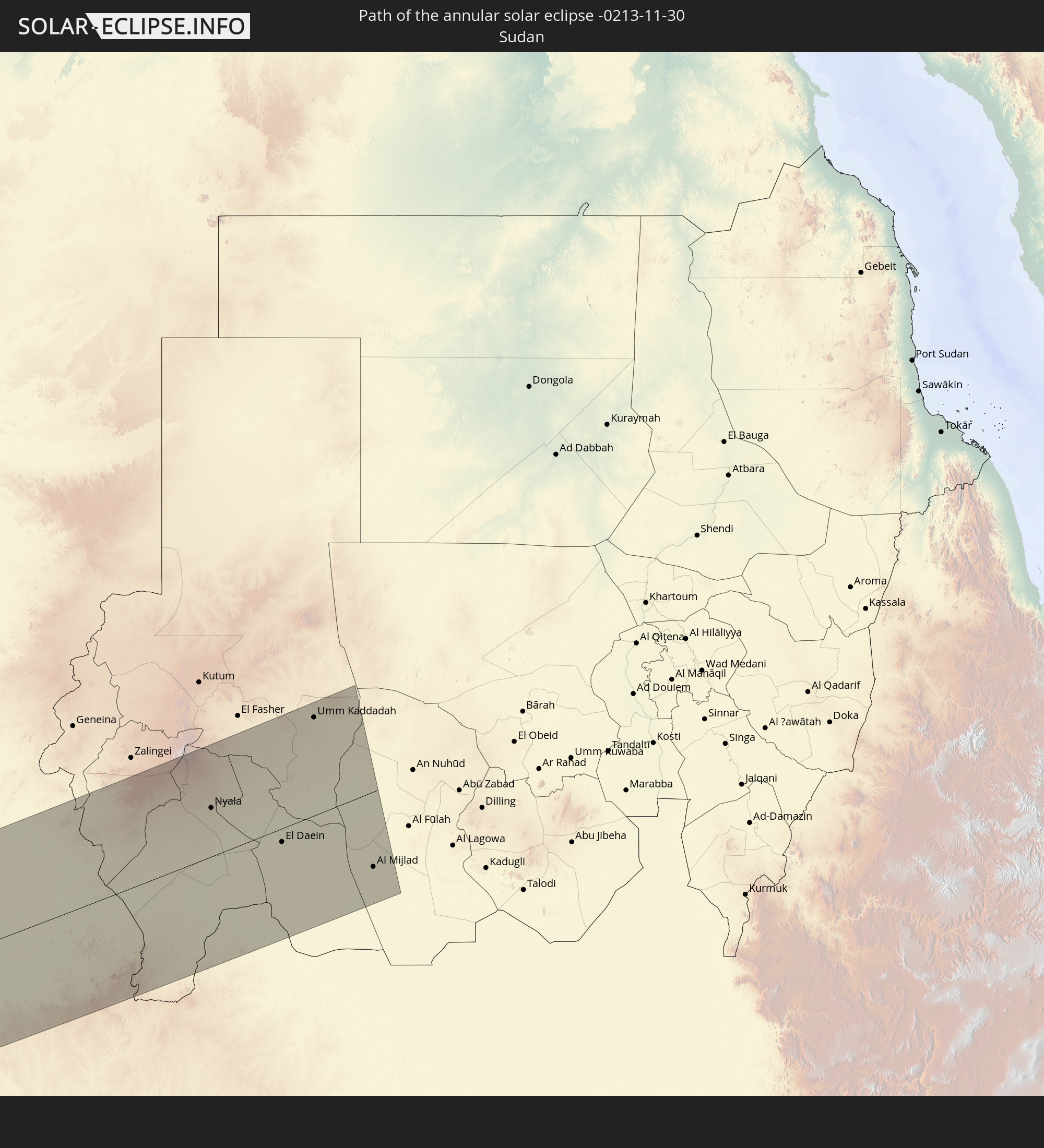
 Sudan
Sudan
 Zambia
 Bulgaria
 Egypt
Egypt
 Zimbabwe
 Rwanda
 Burundi
 Tanzania
 Uganda
 Mozambique
 Malawi
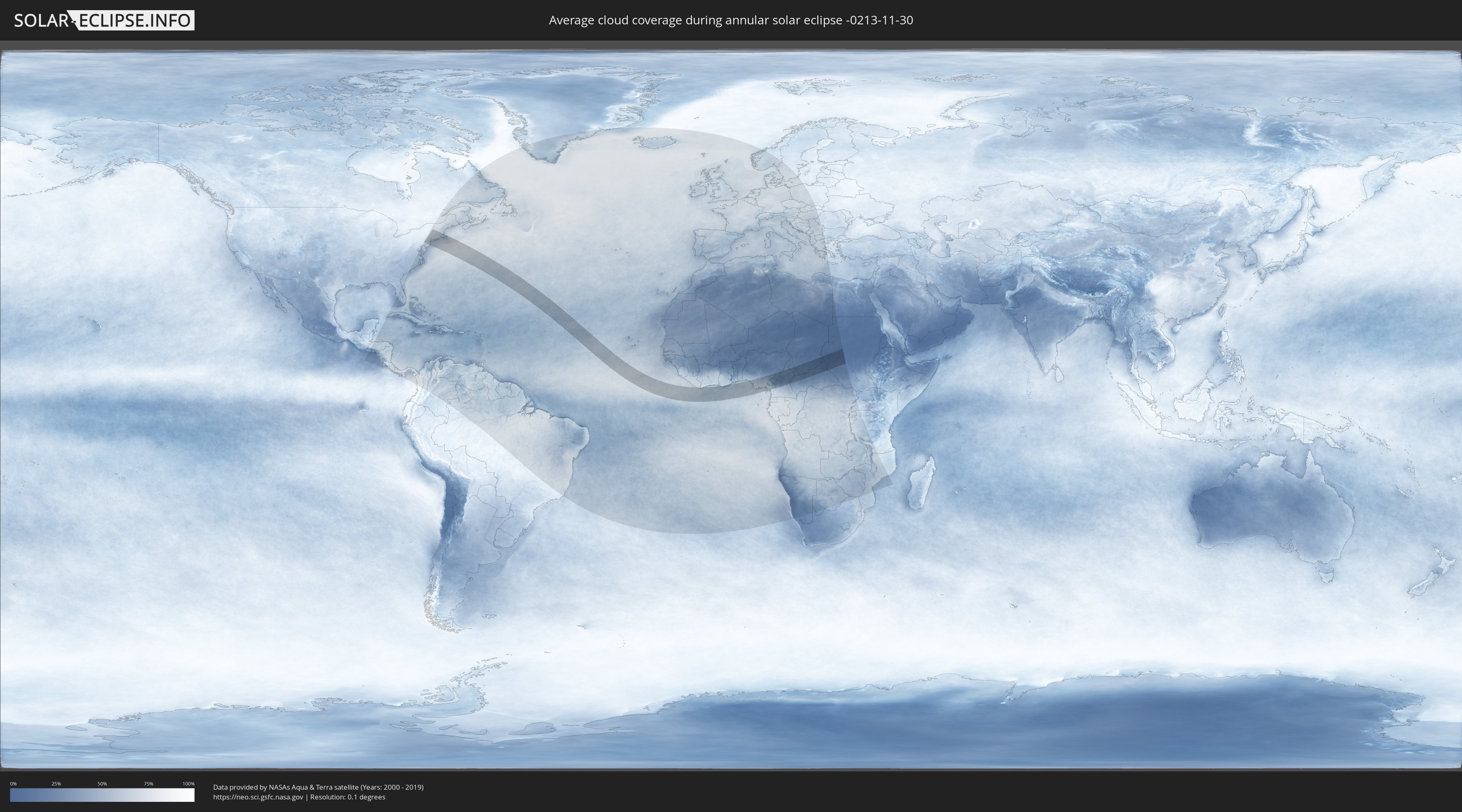
How will be the weather during the annular solar eclipse on 11/30/-0213?
Where is the best place to see the annular solar eclipse of 11/30/-0213?
The following maps show the average cloud coverage for the day of the annular solar eclipse.
With the help of these maps, it is possible to find the place along the eclipse path, which has the best
chance of a cloudless sky.
Nevertheless, you should consider local circumstances and inform about the weather of your chosen
observation site.
The data is provided by NASAs satellites
AQUA and TERRA.
The cloud maps are averaged over a period of 19 years (2000 - 2019).
Detailed country maps
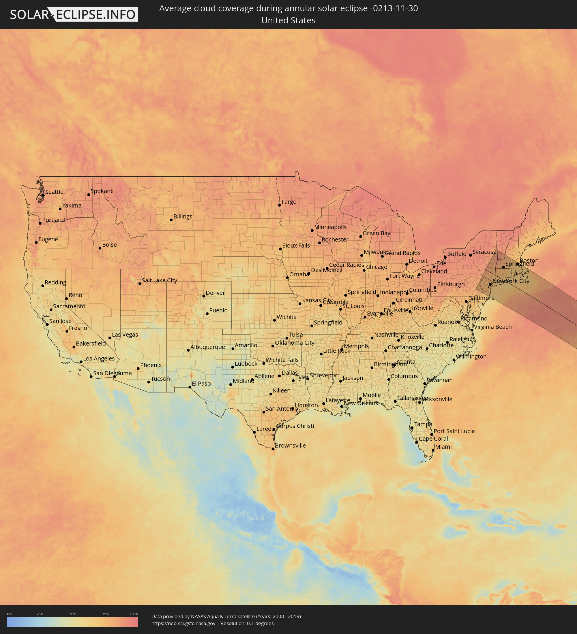 United States
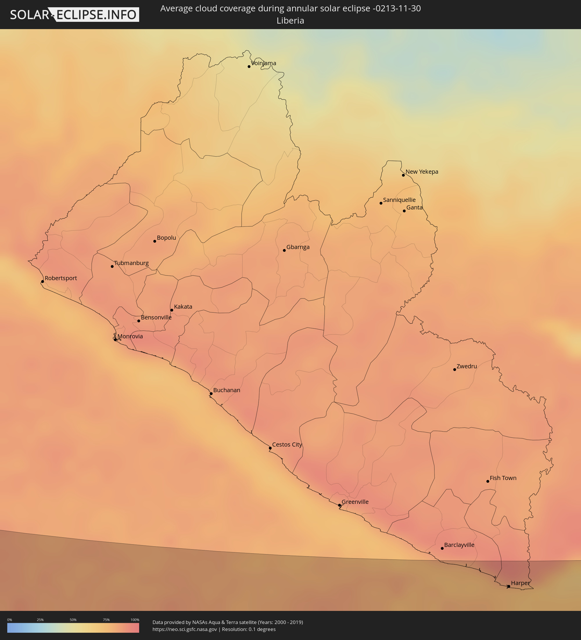 Liberia
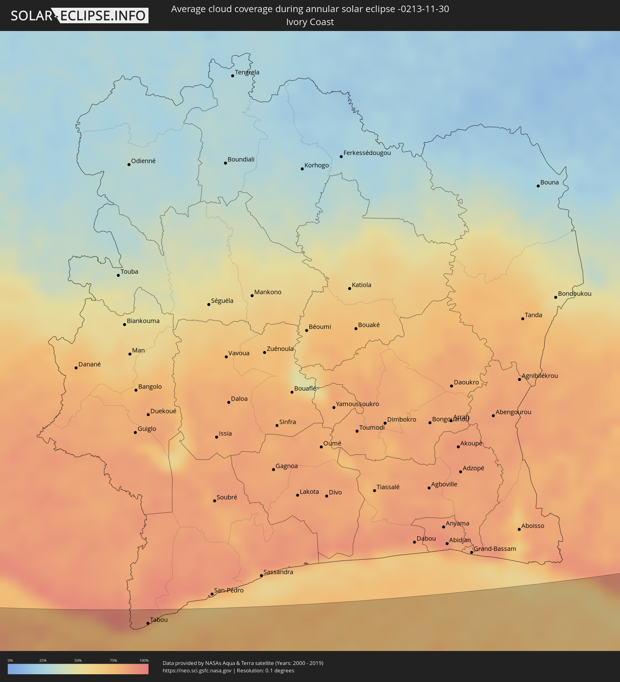 Ivory Coast
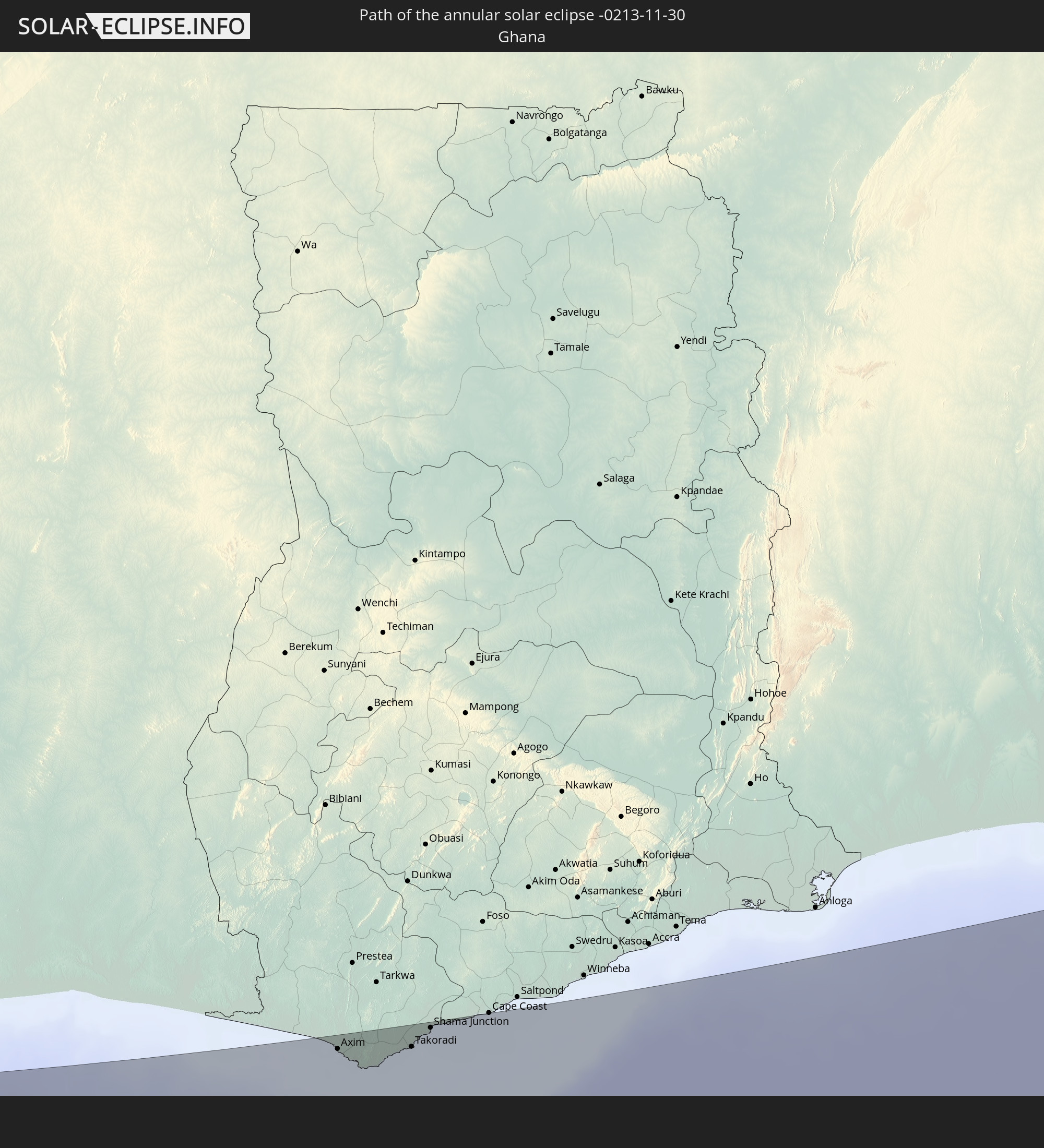
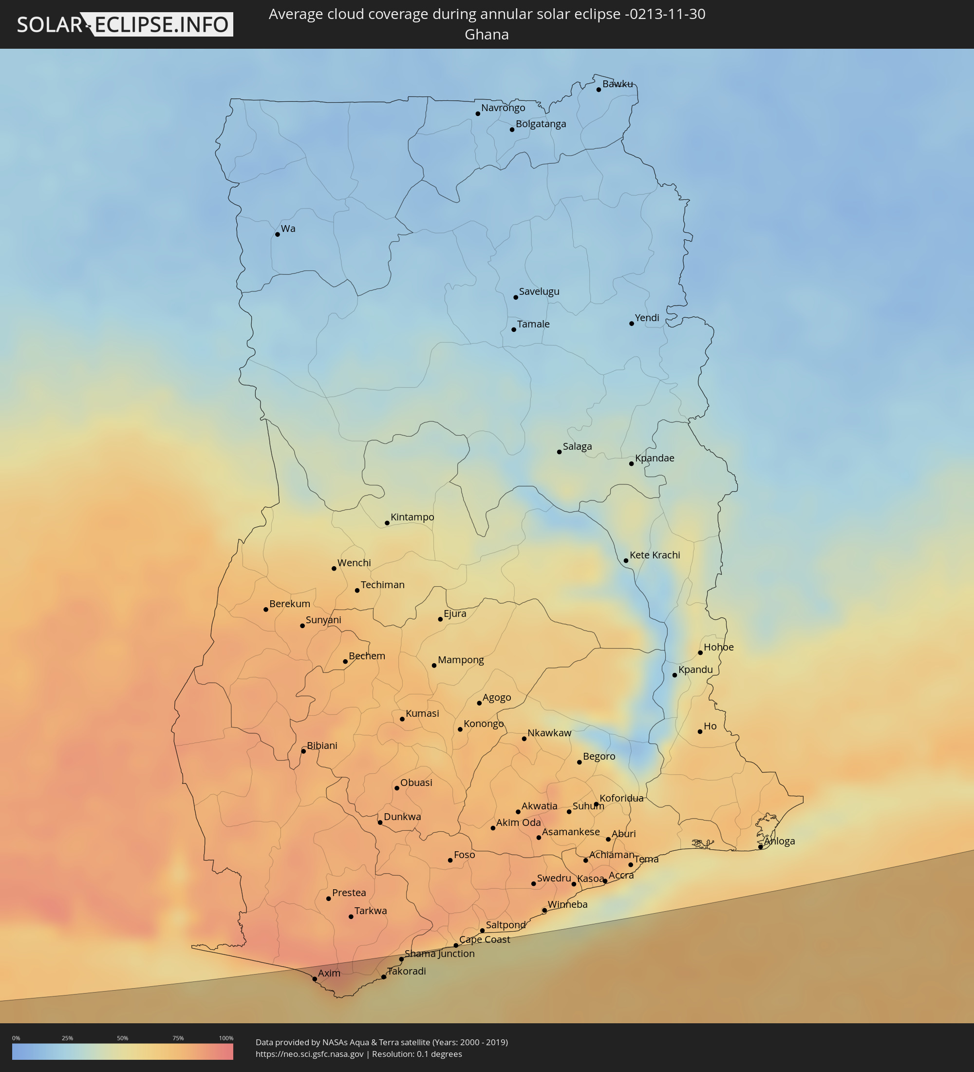 Ghana
Ghana
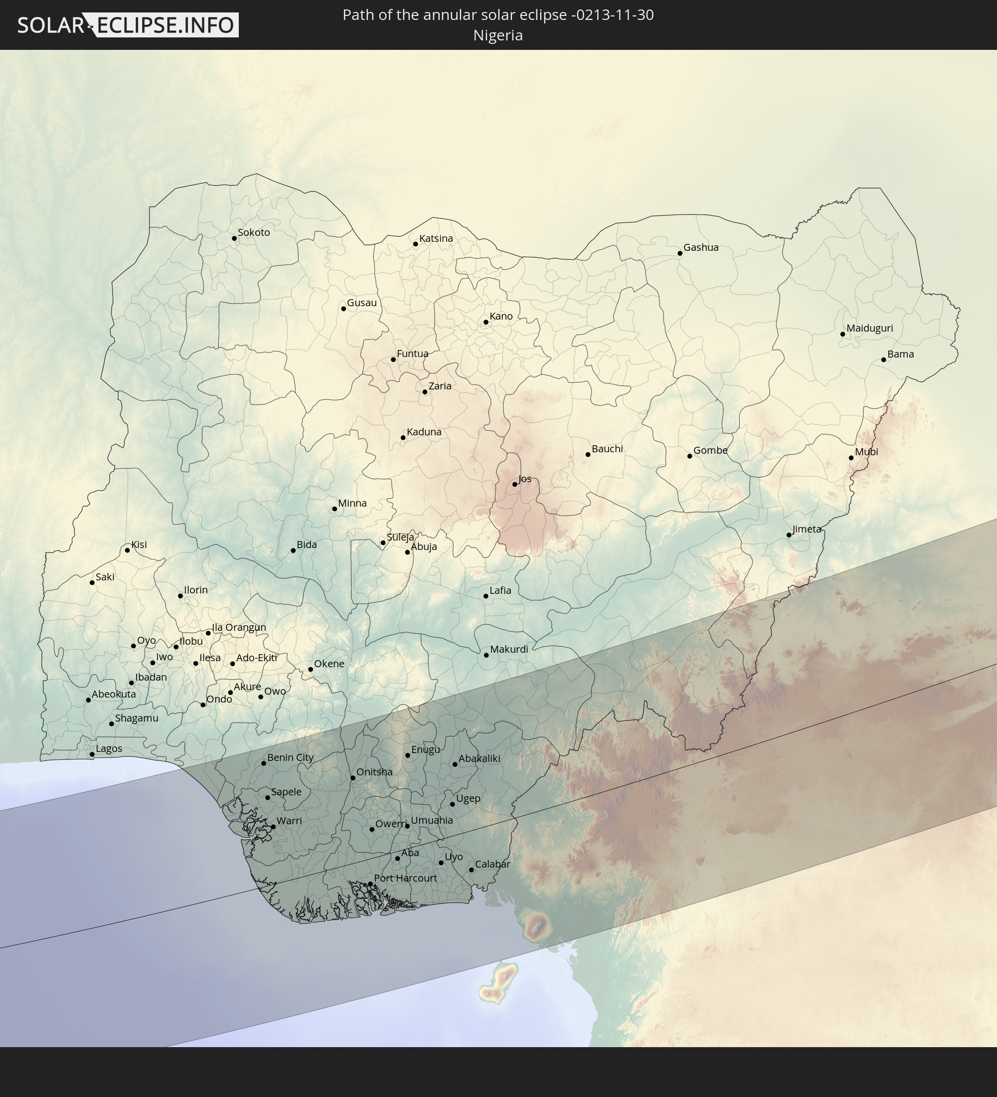
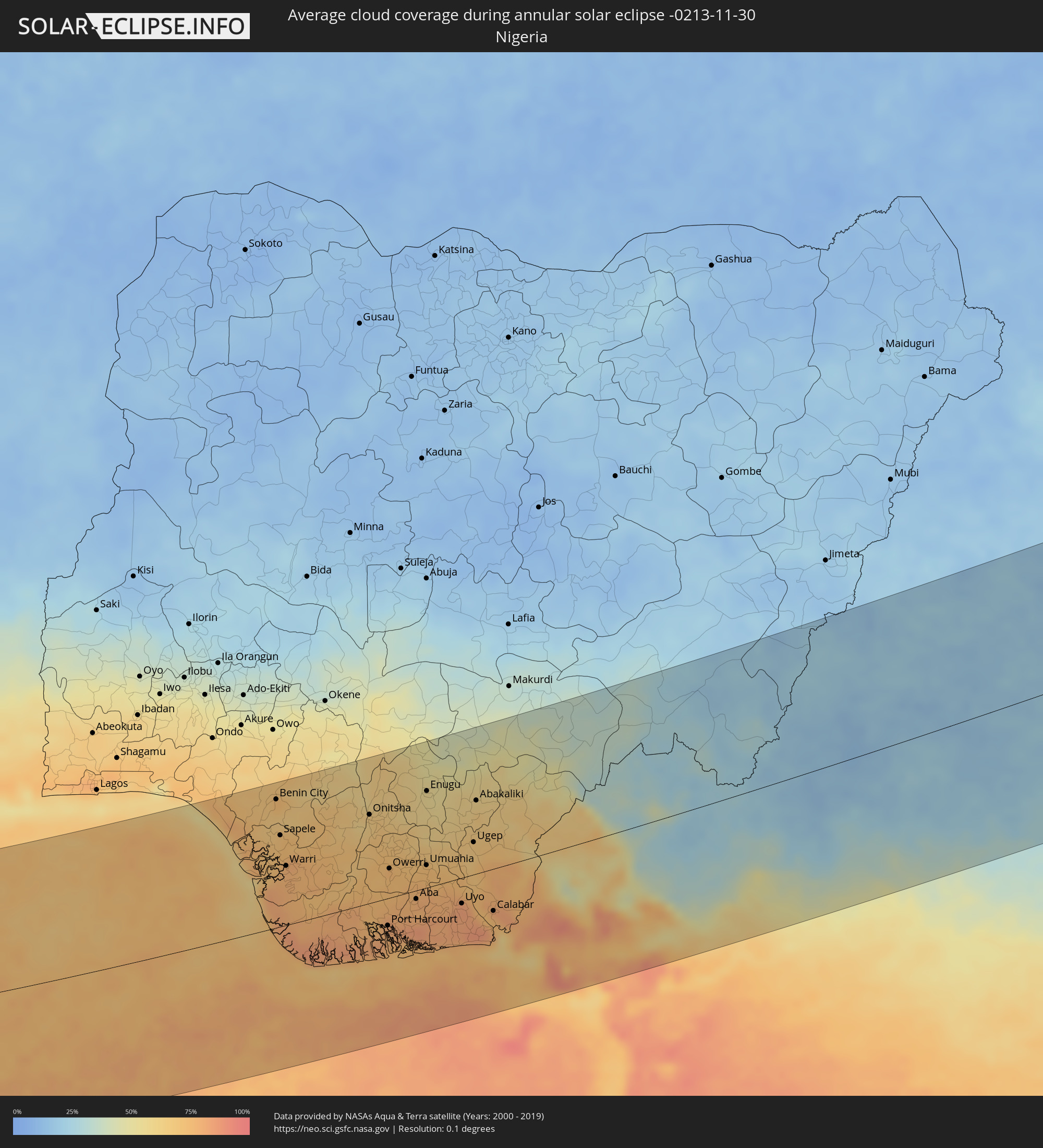 Nigeria
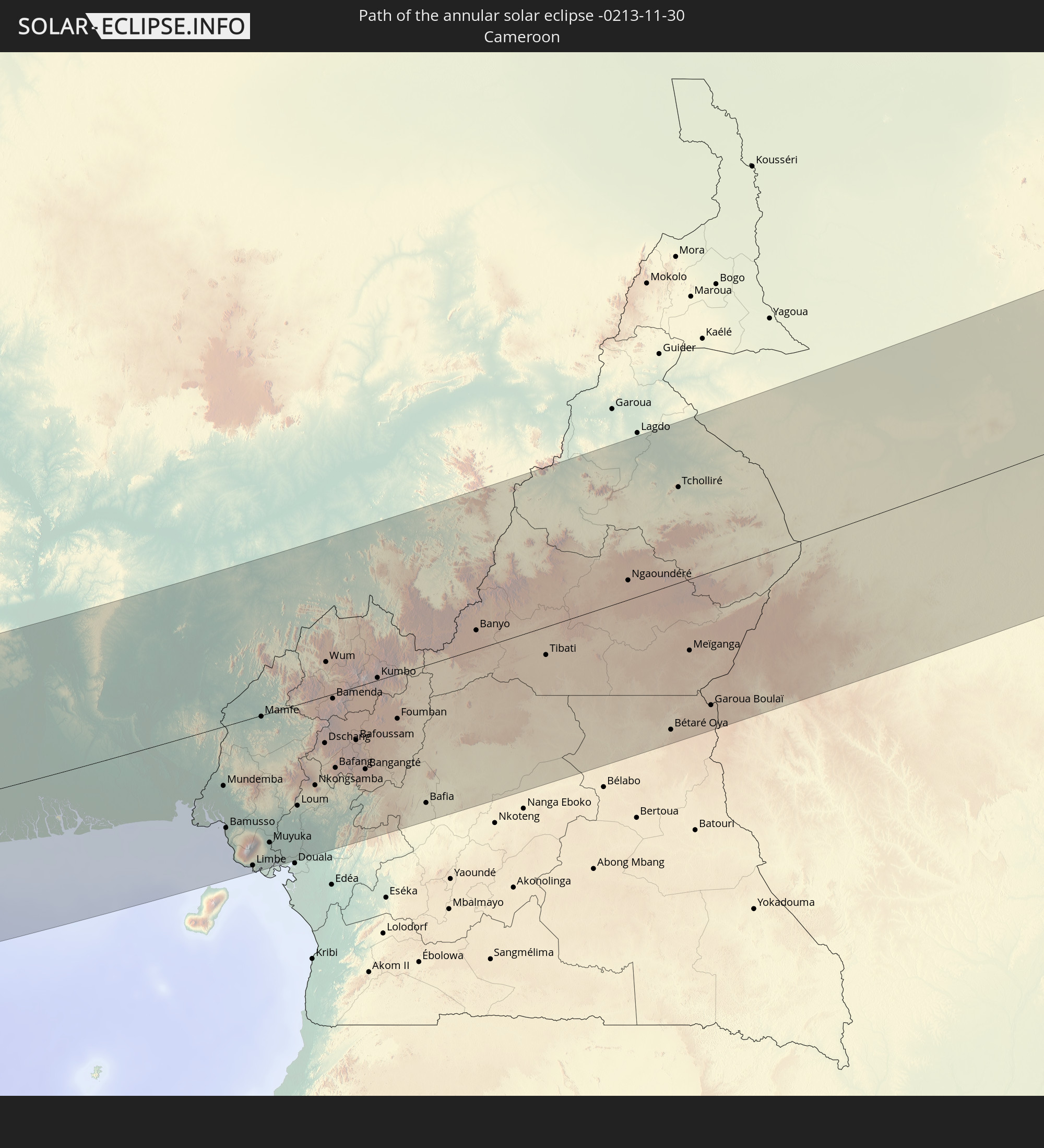
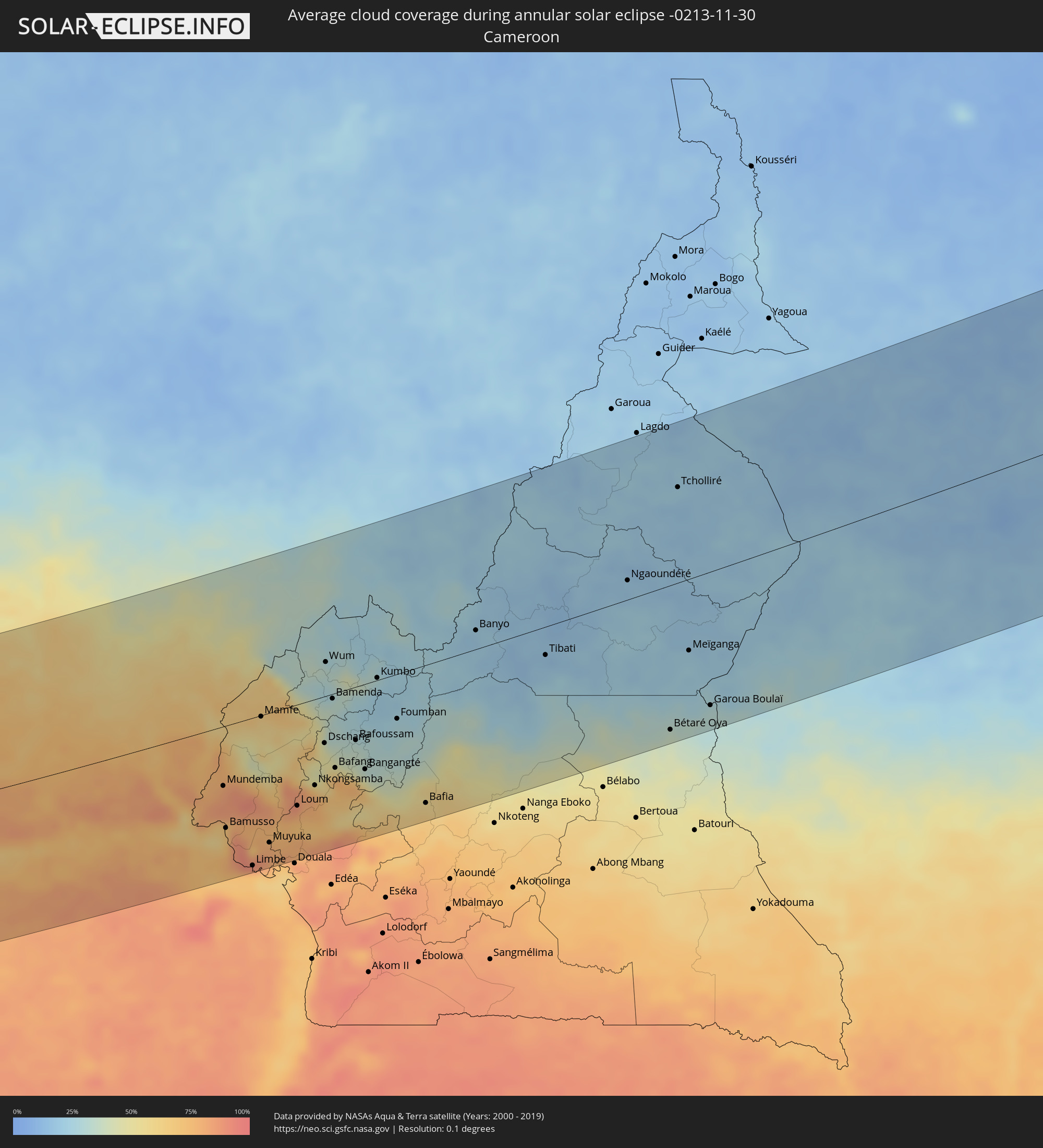 Cameroon
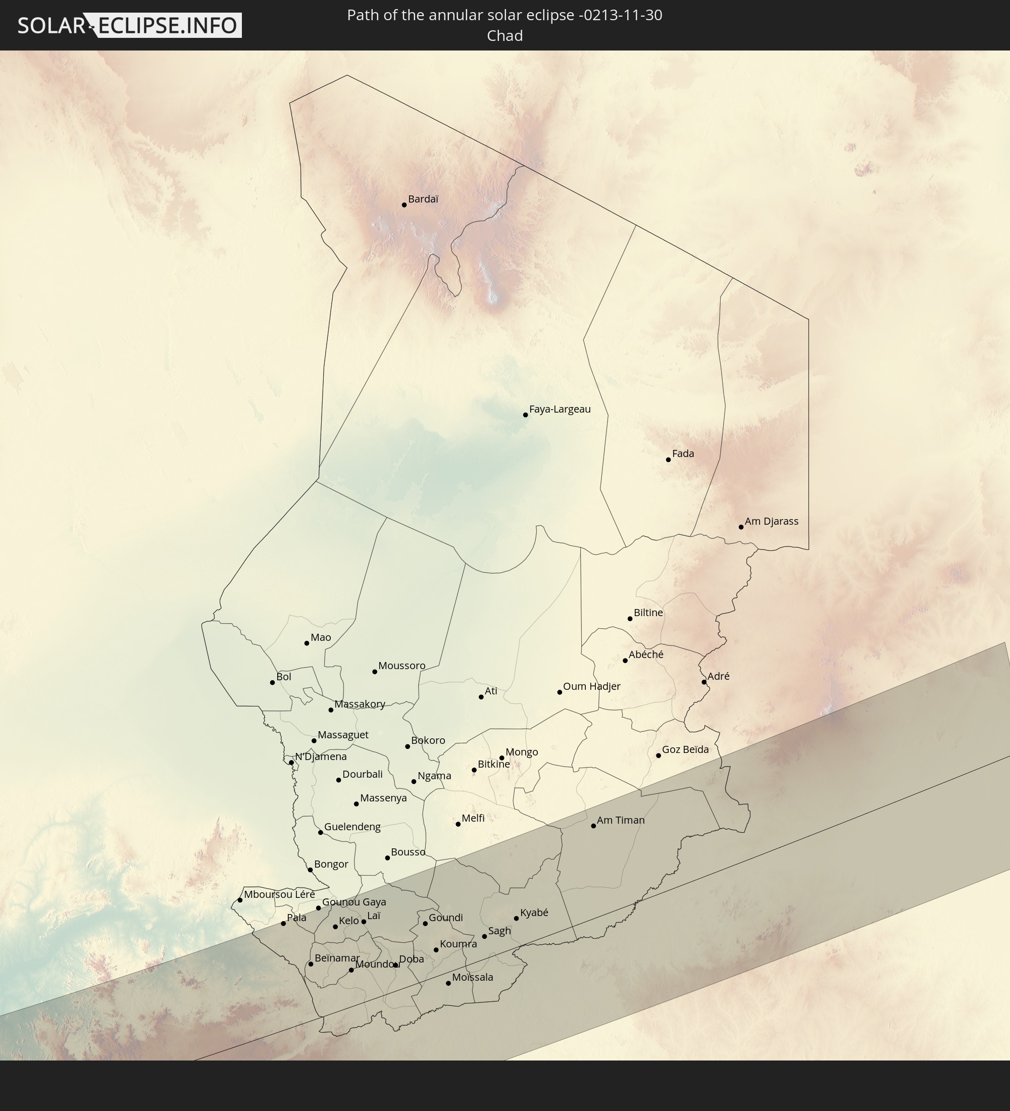
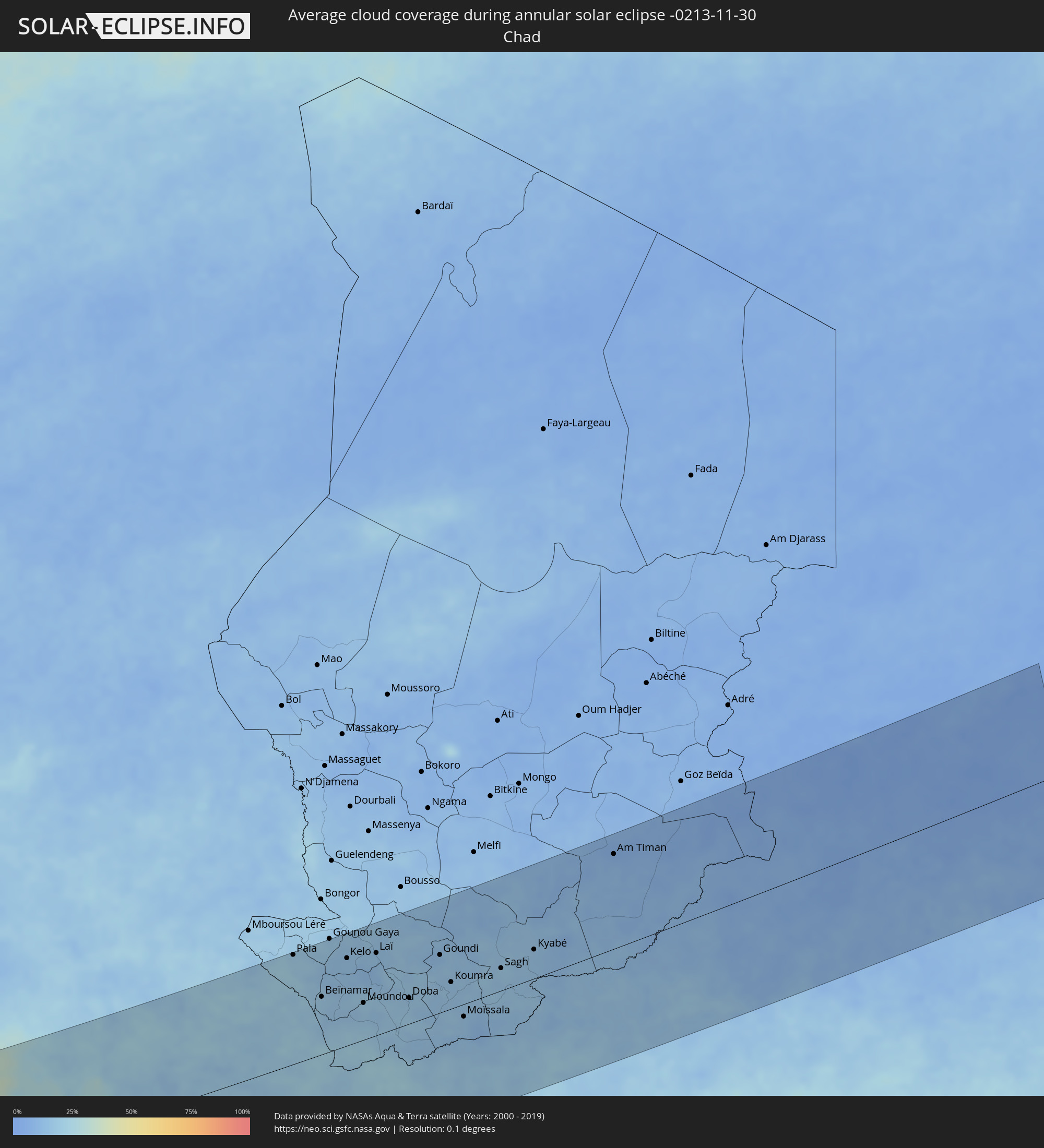 Chad
Chad
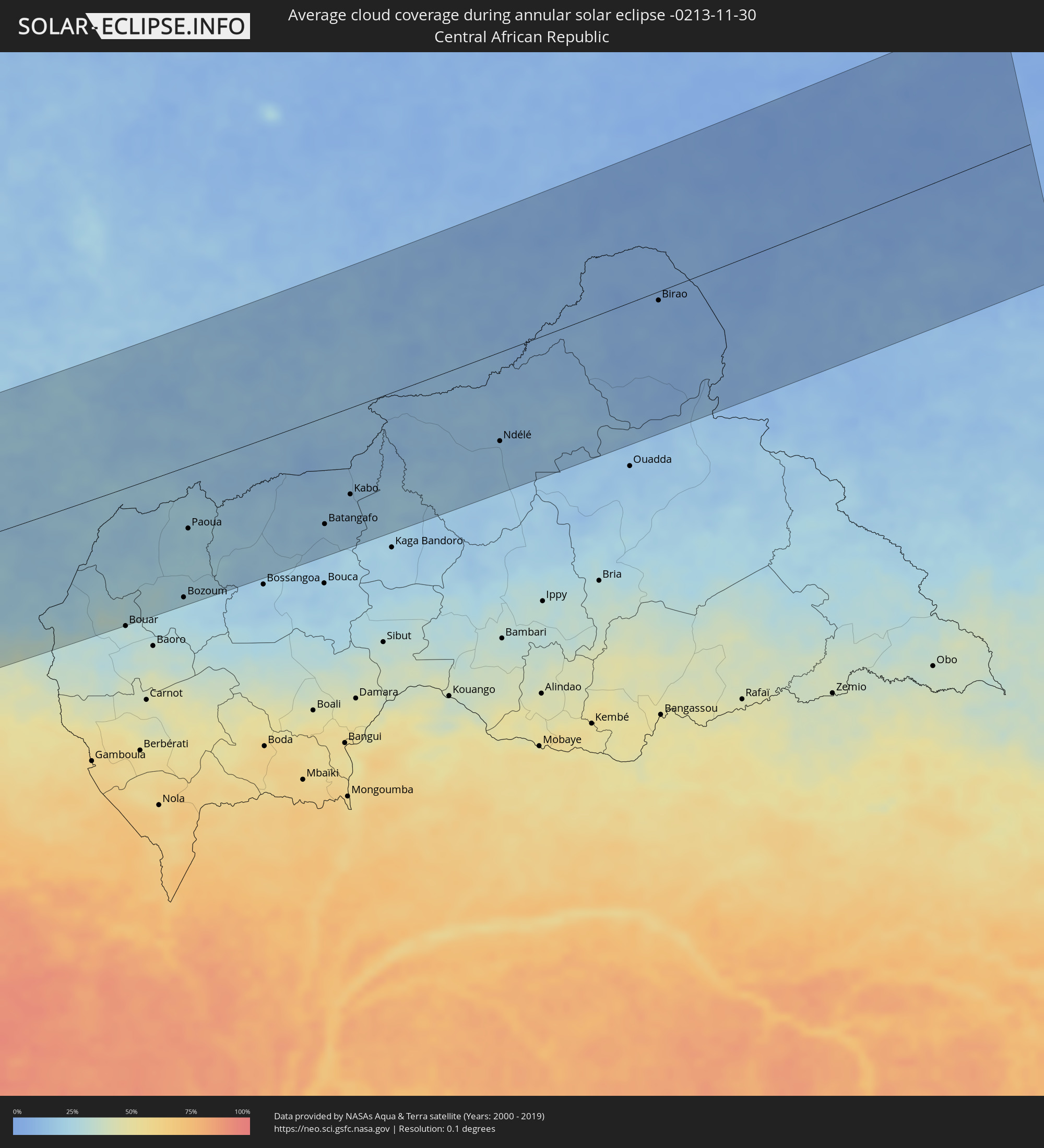 Central African Republic
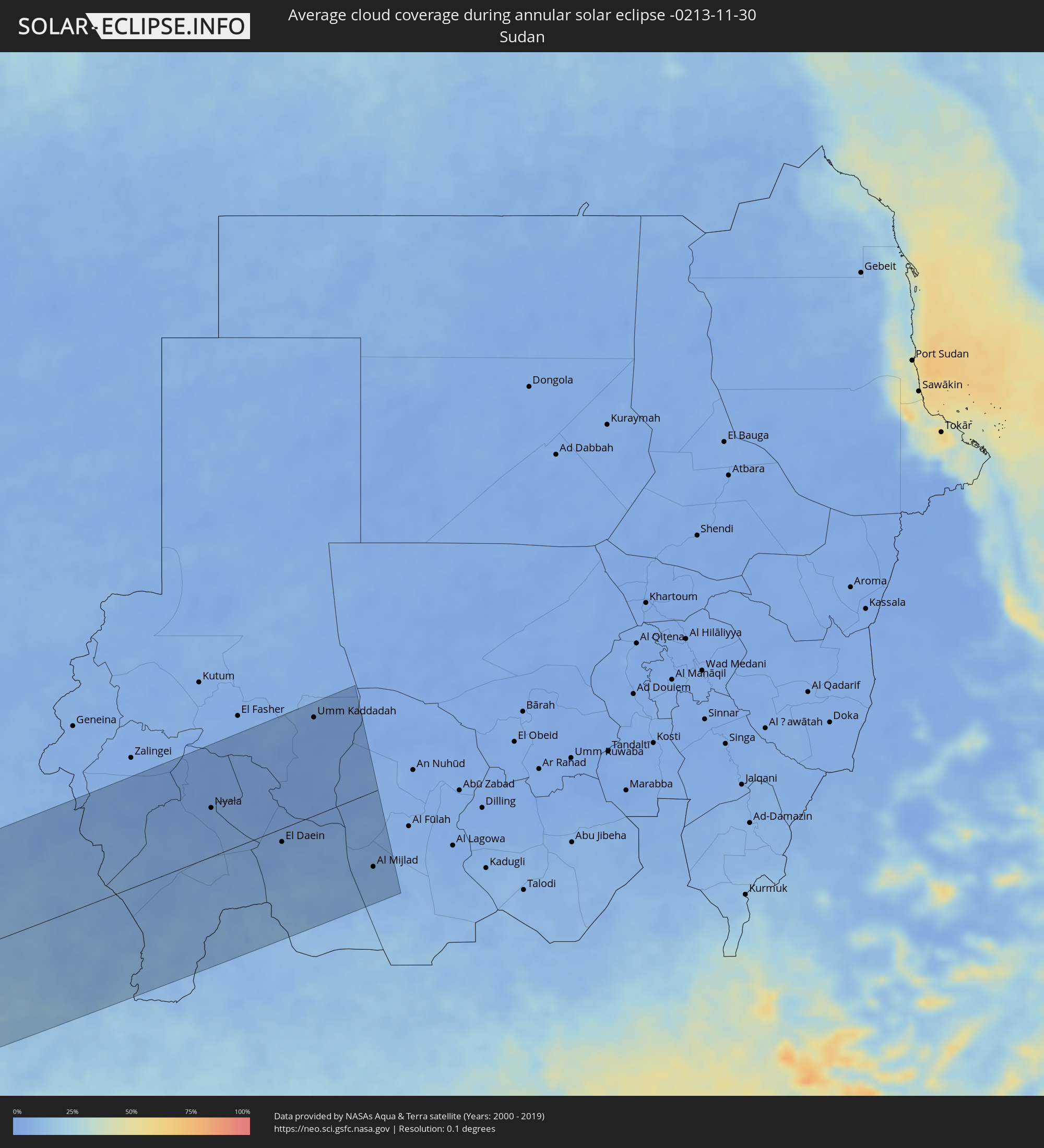 Sudan
Sudan
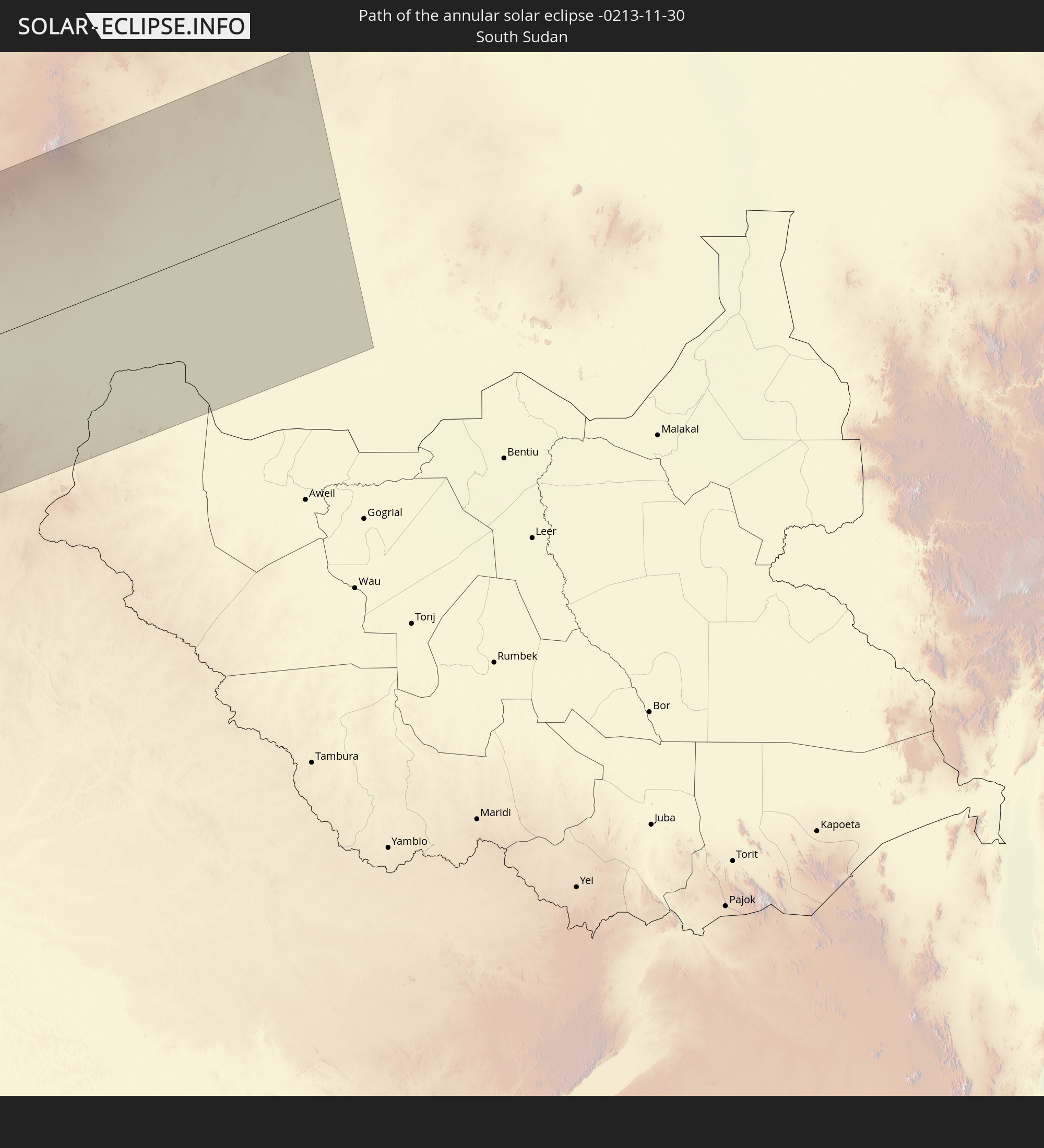
 South Sudan
Cities inside the path of the eclipse
The following table shows all locations with a population of more than 5,000 inside the eclipse path. Cities which have more than 100,000 inhabitants are marked bold. A click at the locations opens a detailed map.
| City | Type | Eclipse duration | Local time of max. eclipse | Distance to central line | Ø Cloud coverage |
|
Trenton, New Jersey
|
annular | - | 07:12:56 UTC-05:00 | 174 km | 74% |
|
Edison, New Jersey
|
annular | - | 07:13:12 UTC-05:00 | 131 km | 73% |
|
Toms River, New Jersey
|
annular | - | 07:12:57 UTC-05:00 | 177 km | 69% |
|
Paterson, New Jersey
|
annular | - | 07:13:30 UTC-05:00 | 83 km | 74% |
|
Staten Island, New York
|
annular | - | 07:13:19 UTC-05:00 | 116 km | 72% |
|
New York City, New York
|
annular | - | 07:13:26 UTC-05:00 | 96 km | 76% |
|
The Bronx, New York
|
annular | - | 07:13:33 UTC-05:00 | 77 km | 75% |
|
Greenburgh, New York
|
annular | - | 07:13:40 UTC-05:00 | 58 km | 71% |
|
Jamaica, New York
|
annular | - | 07:13:29 UTC-05:00 | 89 km | 75% |
|
Albany, New York
|
annular | - | 07:14:44 UTC-05:00 | 103 km | 82% |
|
Stamford, Connecticut
|
annular | - | 07:13:47 UTC-05:00 | 43 km | 68% |
|
Danbury, Connecticut
|
annular | - | 07:14:01 UTC-05:00 | 7 km | 74% |
|
Bridgeport, Connecticut
|
annular | - | 07:13:57 UTC-05:00 | 18 km | 69% |
|
Waterbury, Connecticut
|
annular | - | 07:14:14 UTC-05:00 | 26 km | 77% |
|
New Haven, Connecticut
|
annular | - | 07:14:08 UTC-05:00 | 7 km | 67% |
|
Hartford, Connecticut
|
annular | - | 07:14:29 UTC-05:00 | 61 km | 75% |
|
Springfield, Massachusetts
|
annular | - | 07:14:44 UTC-05:00 | 97 km | 77% |
|
Worcester, Massachusetts
|
annular | - | 07:15:07 UTC-05:00 | 146 km | 73% |
|
Providence, Rhode Island
|
annular | - | 07:14:58 UTC-05:00 | 121 km | 67% |
|
Fall River, Massachusetts
|
annular | - | 07:14:59 UTC-05:00 | 120 km | 65% |
|
Boston, Massachusetts
|
annular | - | 07:15:26 UTC-05:00 | 187 km | 71% |
|
Brockton, Massachusetts
|
annular | - | 07:15:17 UTC-05:00 | 162 km | 70% |
|
New Bedford, Massachusetts
|
annular | - | 07:15:02 UTC-05:00 | 123 km | 69% |
|
Harper, Maryland
|
annular | - | 14:13:32 UTC-00:43 | 173 km | 76% |
|
Tabou, Bas-Sassandra
|
annular | - | 14:41:33 UTC-00:16 | 178 km | 71% |
|
Axim, Western
|
annular | - | 15:10:13 UTC-00:00 | 184 km | 77% |
|
Takoradi, Western
|
annular | - | 15:11:22 UTC-00:00 | 178 km | 59% |
|
Sekondi-Takoradi, Western
|
annular | - | 15:11:26 UTC-00:00 | 183 km | 53% |
|
Shama Junction, Western
|
annular | - | 15:11:34 UTC-00:00 | 190 km | 49% |
|
Elmina, Central
|
annular | - | 15:12:09 UTC-00:00 | 194 km | 53% |
|
Benin City, Edo
|
annular | - | 15:39:35 UTC+00:13 | 171 km | 73% |
|
Sapele, Delta
|
annular | - | 15:39:59 UTC+00:13 | 122 km | 73% |
|
Warri, Delta
|
annular | - | 15:40:22 UTC+00:13 | 79 km | 77% |
|
Uromi, Edo
|
annular | - | 15:40:29 UTC+00:13 | 190 km | 63% |
|
Onitsha, Anambra
|
annular | - | 15:41:36 UTC+00:13 | 118 km | 65% |
|
Buguma, Rivers
|
annular | - | 15:42:39 UTC+00:13 | 36 km | 78% |
|
Nnewi, Anambra
|
annular | - | 15:41:54 UTC+00:13 | 100 km | 69% |
|
Port Harcourt, Rivers
|
annular | - | 15:42:51 UTC+00:13 | 36 km | 81% |
|
Owerri, Imo
|
annular | - | 15:42:26 UTC+00:13 | 39 km | 76% |
|
Awka, Anambra
|
annular | - | 15:42:00 UTC+00:13 | 116 km | 61% |
|
Okigwe, Imo
|
annular | - | 15:42:41 UTC+00:13 | 67 km | 68% |
|
Aba, Abia
|
annular | - | 15:43:10 UTC+00:13 | 11 km | 80% |
|
Nsukka, Enugu
|
annular | - | 15:42:03 UTC+00:13 | 176 km | 51% |
|
Umuahia, Abia
|
annular | - | 15:43:06 UTC+00:13 | 30 km | 74% |
|
Enugu, Enugu
|
annular | - | 15:42:29 UTC+00:13 | 128 km | 55% |
|
Ikot Ekpene, Akwa Ibom
|
annular | - | 15:43:38 UTC+00:13 | 13 km | 78% |
|
Amaigbo, Abia
|
annular | - | 15:43:26 UTC+00:13 | 48 km | 67% |
|
Uyo, Akwa Ibom
|
annular | - | 15:44:02 UTC+00:13 | 34 km | 83% |
|
Effium, Ebonyi
|
annular | - | 15:43:11 UTC+00:13 | 131 km | 55% |
|
Ugep, Cross River
|
annular | - | 15:43:46 UTC+00:13 | 43 km | 68% |
|
Abakaliki, Ebonyi
|
annular | - | 15:43:29 UTC+00:13 | 97 km | 62% |
|
Esuk Oron, Akwa Ibom
|
annular | - | 15:44:39 UTC+00:13 | 70 km | 76% |
|
Calabar, Cross River
|
annular | - | 15:44:39 UTC+00:13 | 56 km | 80% |
|
Limbe, South-West
|
annular | - | 15:46:24 UTC+00:13 | 183 km | 74% |
|
Tiko, South-West
|
annular | - | 15:46:34 UTC+00:13 | 182 km | 80% |
|
Kumba, South-West
|
annular | - | 15:46:22 UTC+00:13 | 125 km | 78% |
|
Mbanga, Littoral
|
annular | - | 15:46:36 UTC+00:13 | 143 km | 75% |
|
Loum, Littoral
|
annular | - | 15:46:41 UTC+00:13 | 125 km | 81% |
|
Fontem, South-West
|
annular | - | 15:46:26 UTC+00:13 | 50 km | 68% |
|
Nkongsamba, Littoral
|
annular | - | 15:46:49 UTC+00:13 | 106 km | 72% |
|
Bali, North-West
|
annular | - | 15:46:21 UTC+00:13 | 9 km | 38% |
|
Dschang, West
|
annular | - | 15:46:40 UTC+00:13 | 58 km | 46% |
|
Wum, North-West
|
annular | - | 15:46:07 UTC+00:13 | 42 km | 32% |
|
Bamenda, North-West
|
annular | - | 15:46:29 UTC+00:13 | 6 km | 32% |
|
Bafang, West
|
annular | - | 15:47:00 UTC+00:13 | 92 km | 58% |
|
Mbouda, West
|
annular | - | 15:46:49 UTC+00:13 | 45 km | 31% |
|
Fundong, North-West
|
annular | - | 15:46:27 UTC+00:13 | 21 km | 42% |
|
Bafoussam, West
|
annular | - | 15:47:07 UTC+00:13 | 66 km | 34% |
|
Bangangté, West
|
annular | - | 15:47:26 UTC+00:13 | 105 km | 49% |
|
Foumbot, West
|
annular | - | 15:47:21 UTC+00:13 | 70 km | 30% |
|
Kumbo, North-West
|
annular | - | 15:46:59 UTC+00:13 | 3 km | 25% |
|
Foumban, West
|
annular | - | 15:47:33 UTC+00:13 | 55 km | 28% |
|
Bafia, Centre
|
annular | - | 15:48:30 UTC+00:13 | 170 km | 59% |
|
Ngaoundéré, Adamaoua
|
annular | - | 15:49:35 UTC+00:13 | 24 km | 17% |
|
Meïganga, Adamaoua
|
annular | - | 15:50:48 UTC+00:13 | 87 km | 22% |
|
Garoua Boulaï, East
|
annular | - | 15:51:23 UTC+00:13 | 163 km | 31% |
|
Pala, Mayo-Kebbi Ouest
|
annular | - | 16:36:11 UTC+01:00 | 191 km | 19% |
|
Beïnamar, Logone Occidental
|
annular | - | 16:37:06 UTC+01:00 | 101 km | 17% |
|
Kelo, Tandjilé
|
annular | - | 16:37:04 UTC+01:00 | 152 km | 15% |
|
Moundou, Logone Occidental
|
annular | - | 16:37:48 UTC+01:00 | 64 km | 18% |
|
Béré, Tandjilé
|
annular | - | 16:37:22 UTC+01:00 | 141 km | 13% |
|
Laï, Tandjilé
|
annular | - | 16:37:27 UTC+01:00 | 143 km | 14% |
|
Benoy, Logone Occidental
|
annular | - | 16:37:44 UTC+01:00 | 99 km | 12% |
|
Bozoum, Ouham-Pendé
|
annular | - | 15:52:47 UTC+00:13 | 183 km | 24% |
|
Paoua, Ouham-Pendé
|
annular | - | 15:52:19 UTC+00:13 | 88 km | 22% |
|
Bébédja, Logone Oriental
|
annular | - | 16:38:09 UTC+01:00 | 58 km | 16% |
|
Doba, Logone Oriental
|
annular | - | 16:38:24 UTC+01:00 | 45 km | 17% |
|
Béboto, Logone Oriental
|
annular | - | 16:38:43 UTC+01:00 | 1 km | 18% |
|
Goundi, Mandoul
|
annular | - | 16:38:22 UTC+01:00 | 100 km | 13% |
|
Koumra, Mandoul
|
annular | - | 16:38:48 UTC+01:00 | 46 km | 15% |
|
Moïssala, Mandoul
|
annular | - | 16:39:20 UTC+01:00 | 22 km | 13% |
|
Batangafo, Ouham
|
annular | - | 15:53:43 UTC+00:13 | 150 km | 20% |
|
Sagh, Moyen-Chari
|
annular | - | 16:39:18 UTC+01:00 | 39 km | 17% |
|
Kabo, Ouham
|
annular | - | 15:53:44 UTC+00:13 | 121 km | 16% |
|
Kyabé, Moyen-Chari
|
annular | - | 16:39:30 UTC+01:00 | 50 km | 15% |
|
Am Timan, Salamat
|
annular | - | 16:39:20 UTC+01:00 | 163 km | 10% |
|
Ndélé, Bamingui-Bangoran
|
annular | - | 15:54:38 UTC+00:13 | 124 km | 16% |
|
Birao, Vakaga
|
annular | - | 15:54:39 UTC+00:13 | 12 km | 8% |
|
Nyala, Southern Darfur
|
annular | - | 17:50:57 UTC+02:10 | 87 km | 4% |
|
El Daein, Eastern Darfur
|
annular | - | 17:51:49 UTC+02:10 | 24 km | 5% |
|
Umm Kaddadah, Northern Darfur
|
annular | - | 17:50:30 UTC+02:10 | 174 km | 3% |
|
Al Mijlad, West Kordofan State
|
annular | - | 17:52:35 UTC+02:10 | 134 km | 6% |