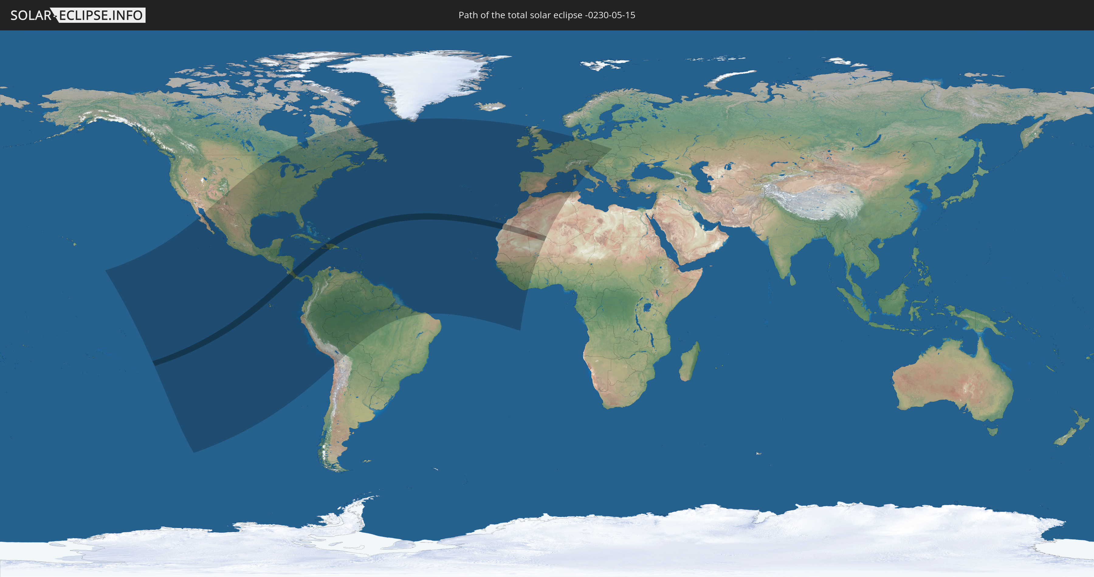
Total solar eclipse of 05/15/-0230
| Day of week: | Sunday |
| Maximum duration of eclipse: | 06m16s |
| Maximum width of eclipse path: | 241 km |
| Saros cycle: | 63 |
| Coverage: | 100% |
| Magnitude: | 1.0742 |
| Gamma: | 0.0162 |
Wo kann man die Sonnenfinsternis vom 05/15/-0230 sehen?
Die Sonnenfinsternis am 05/15/-0230 kann man in 90 Ländern als partielle Sonnenfinsternis beobachten.
Der Finsternispfad verläuft durch 11 Länder. Nur in diesen Ländern ist sie als total Sonnenfinsternis zu sehen.
In den folgenden Ländern ist die Sonnenfinsternis total zu sehen
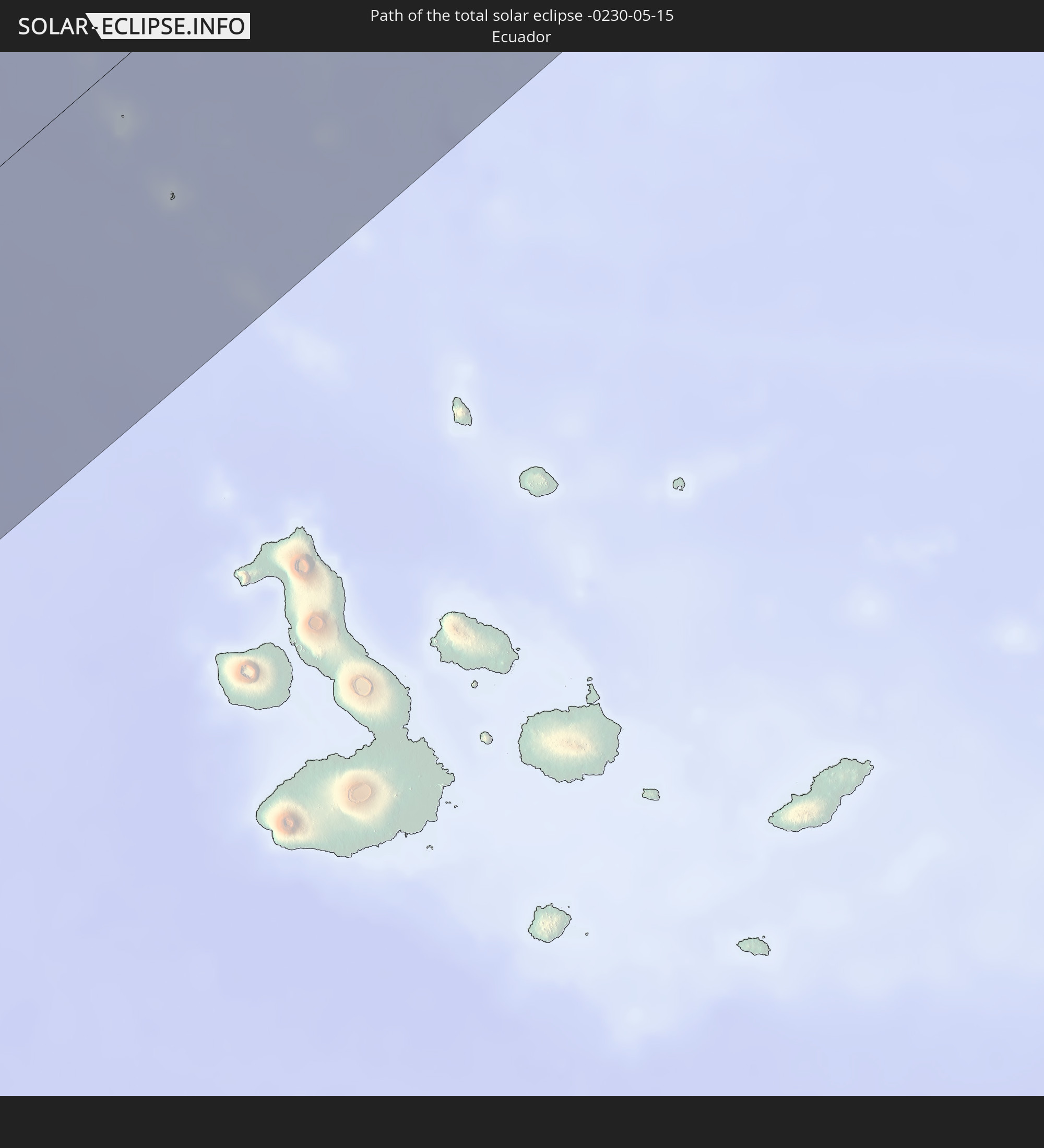 Ecuador
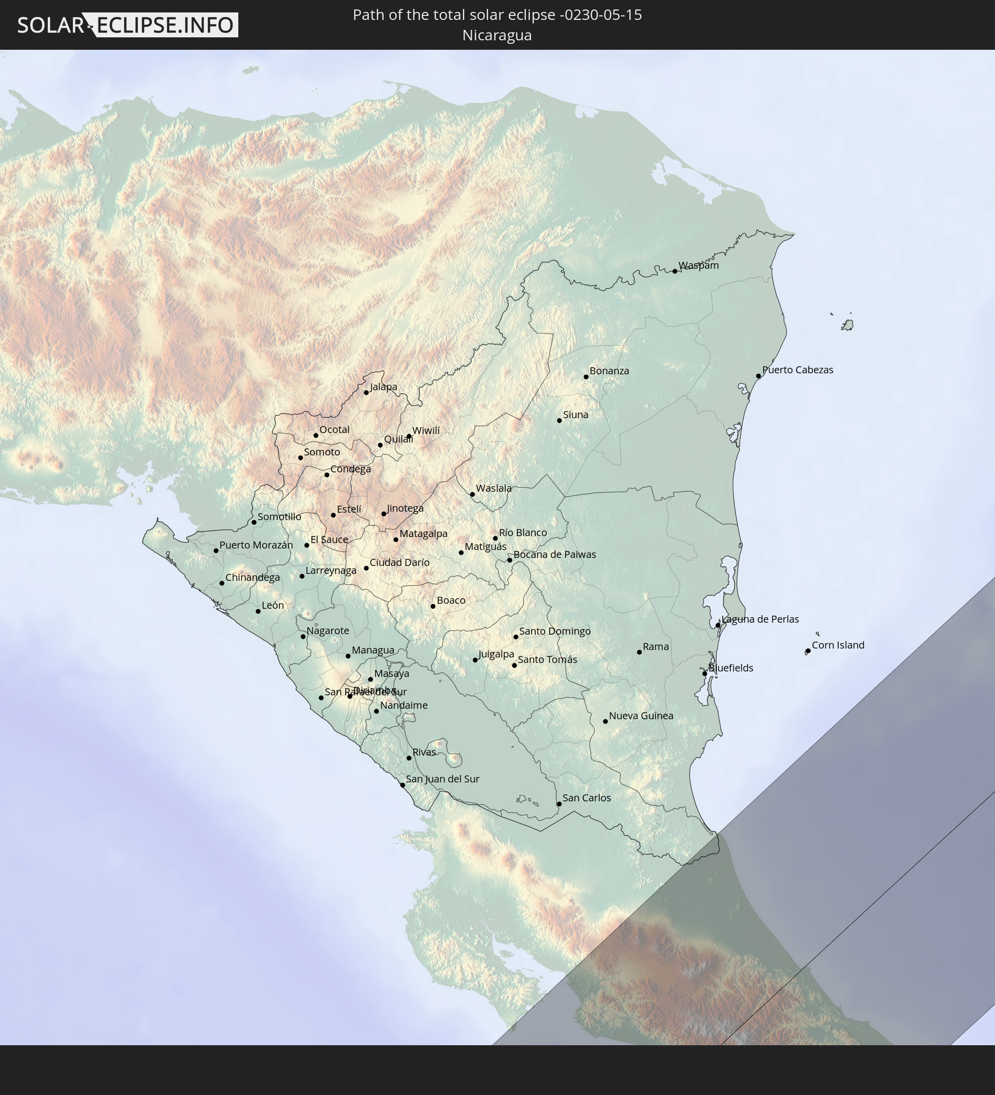 Nicaragua
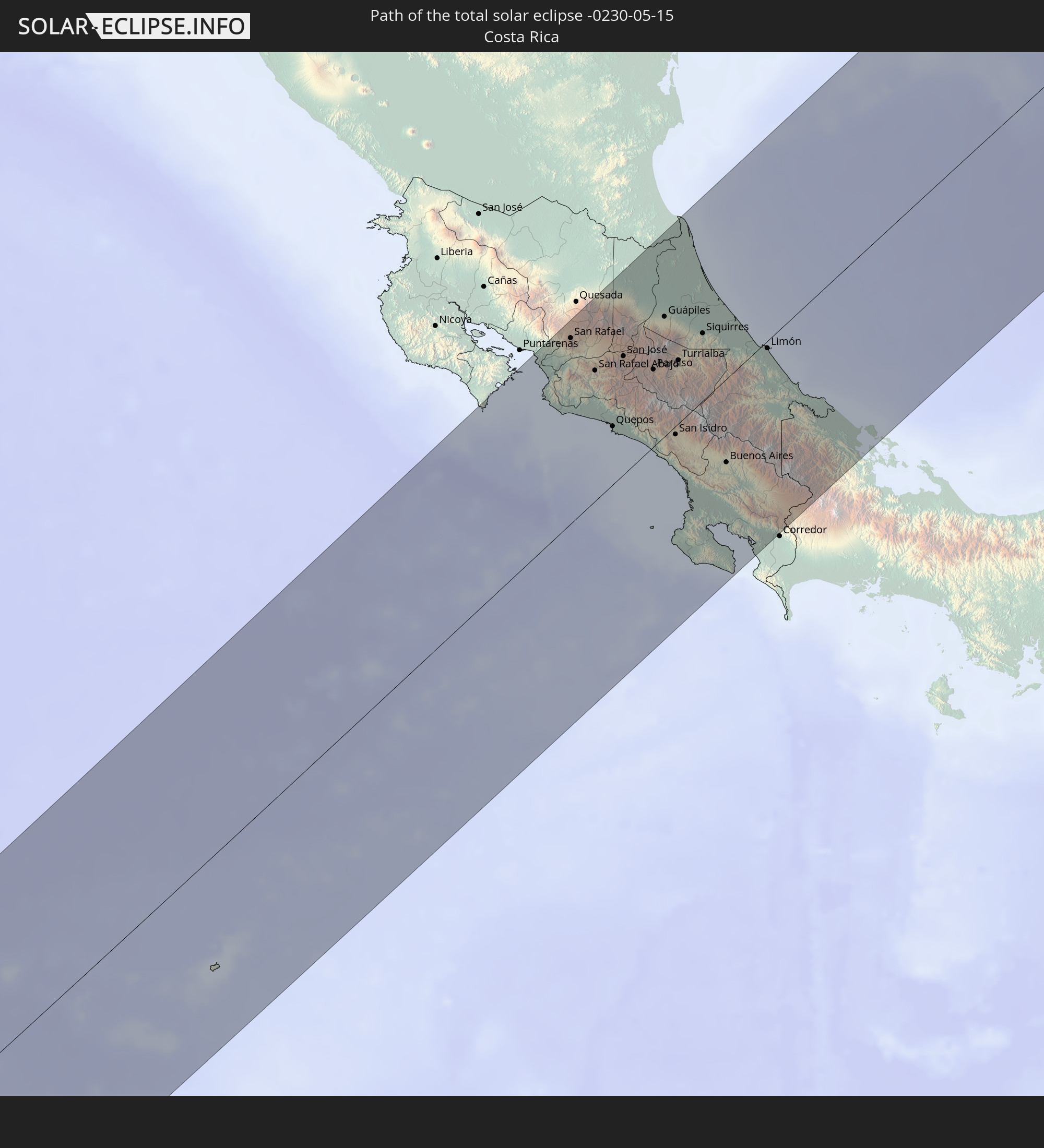 Costa Rica
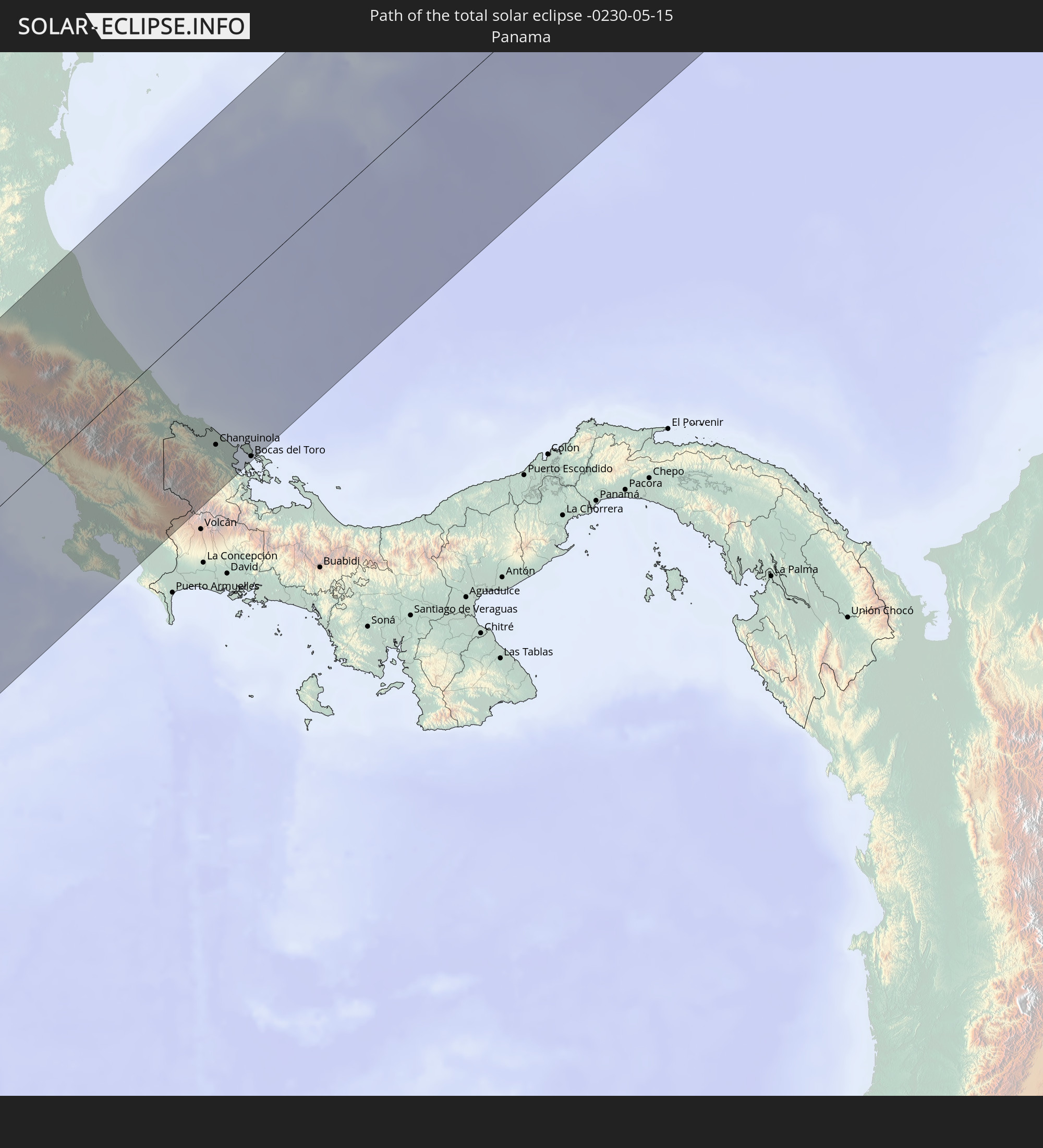 Panama
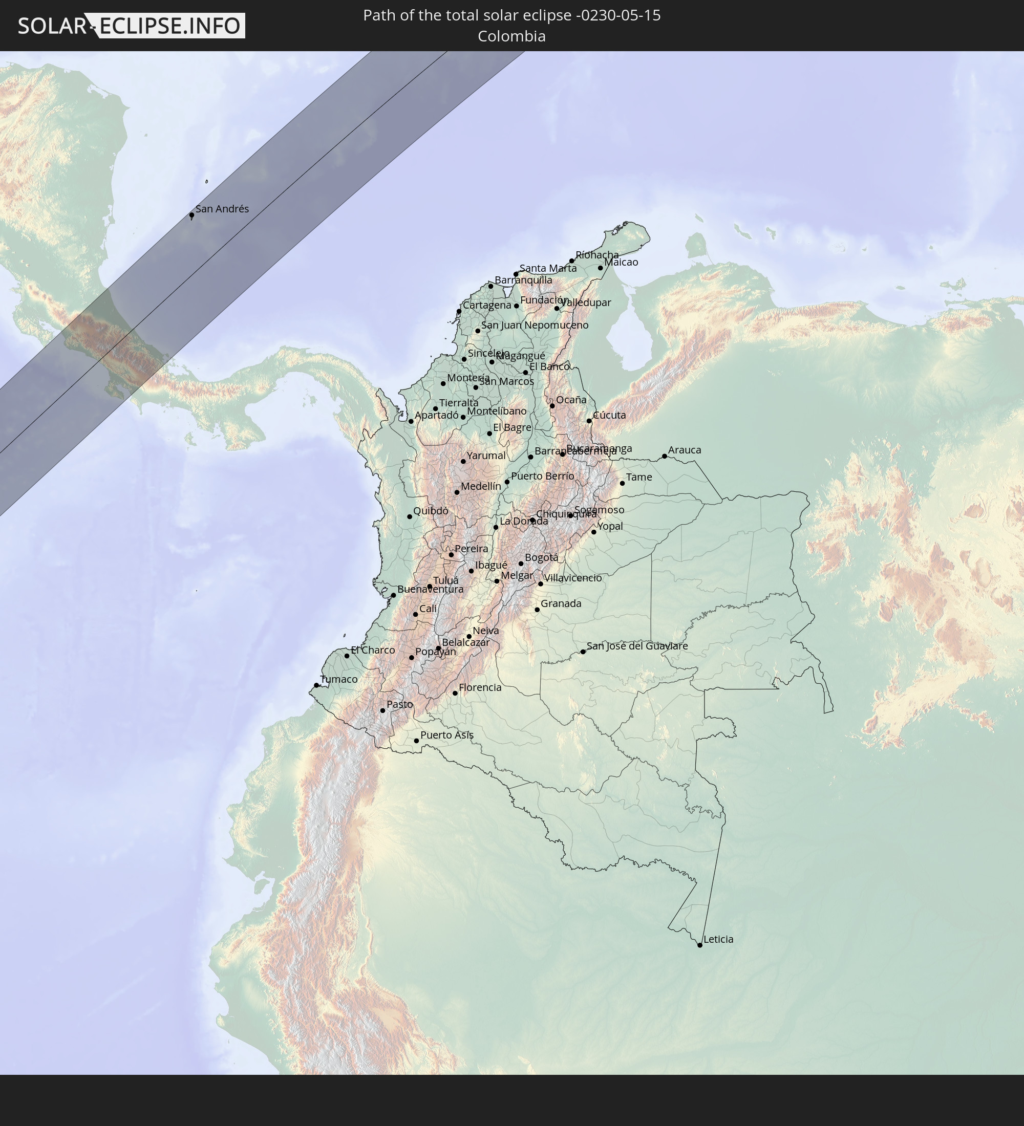 Colombia
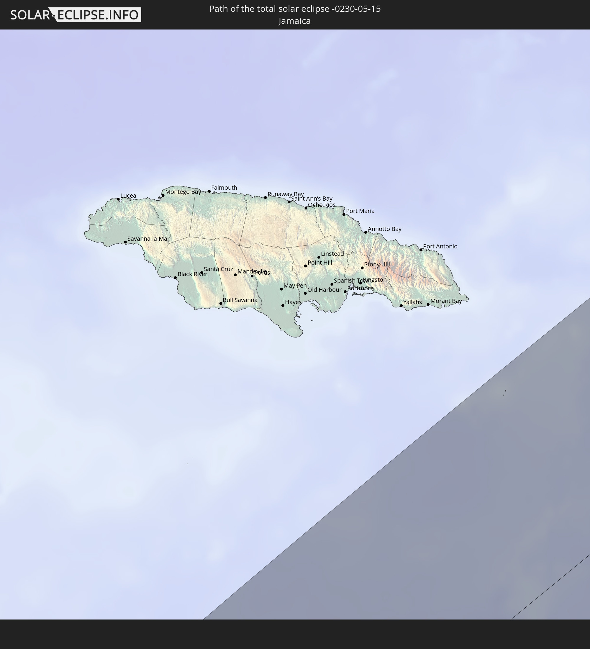 Jamaica
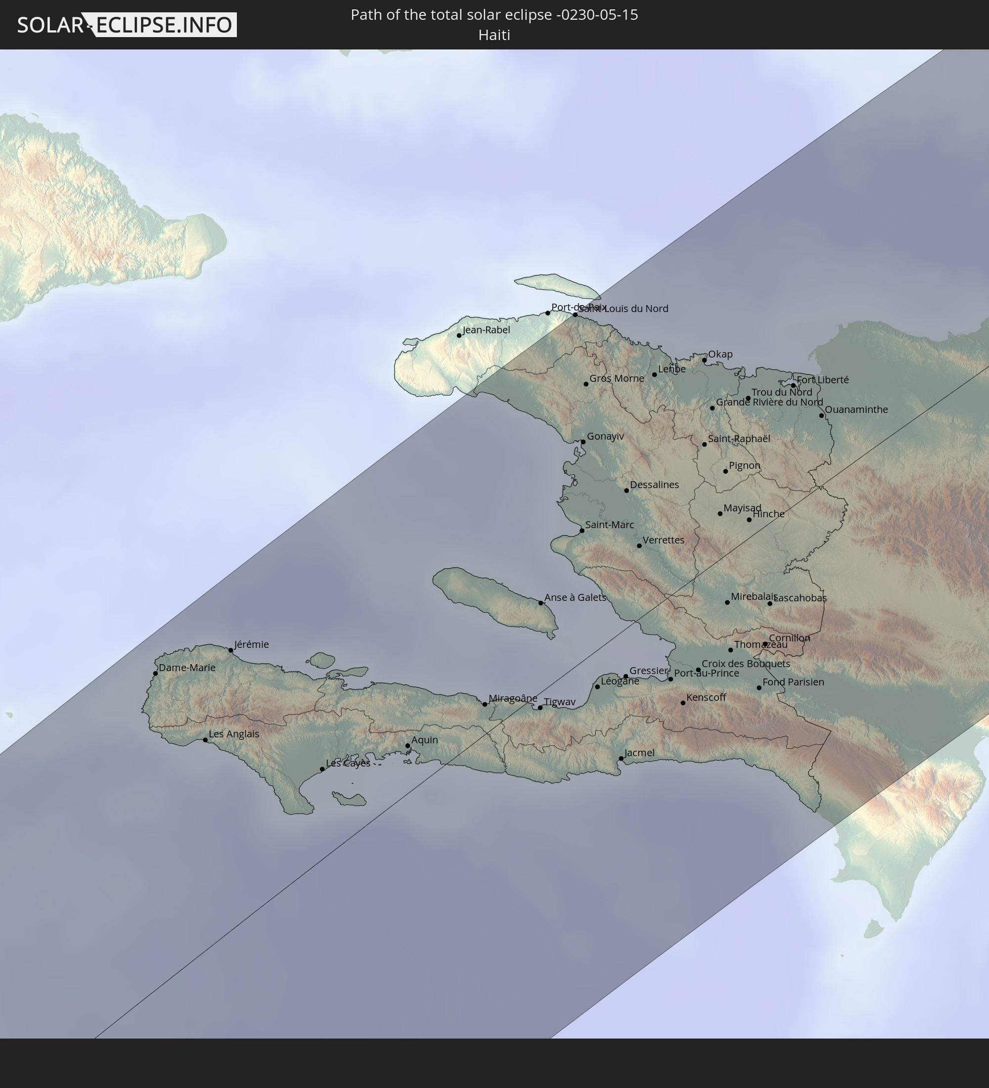 Haiti
Haiti
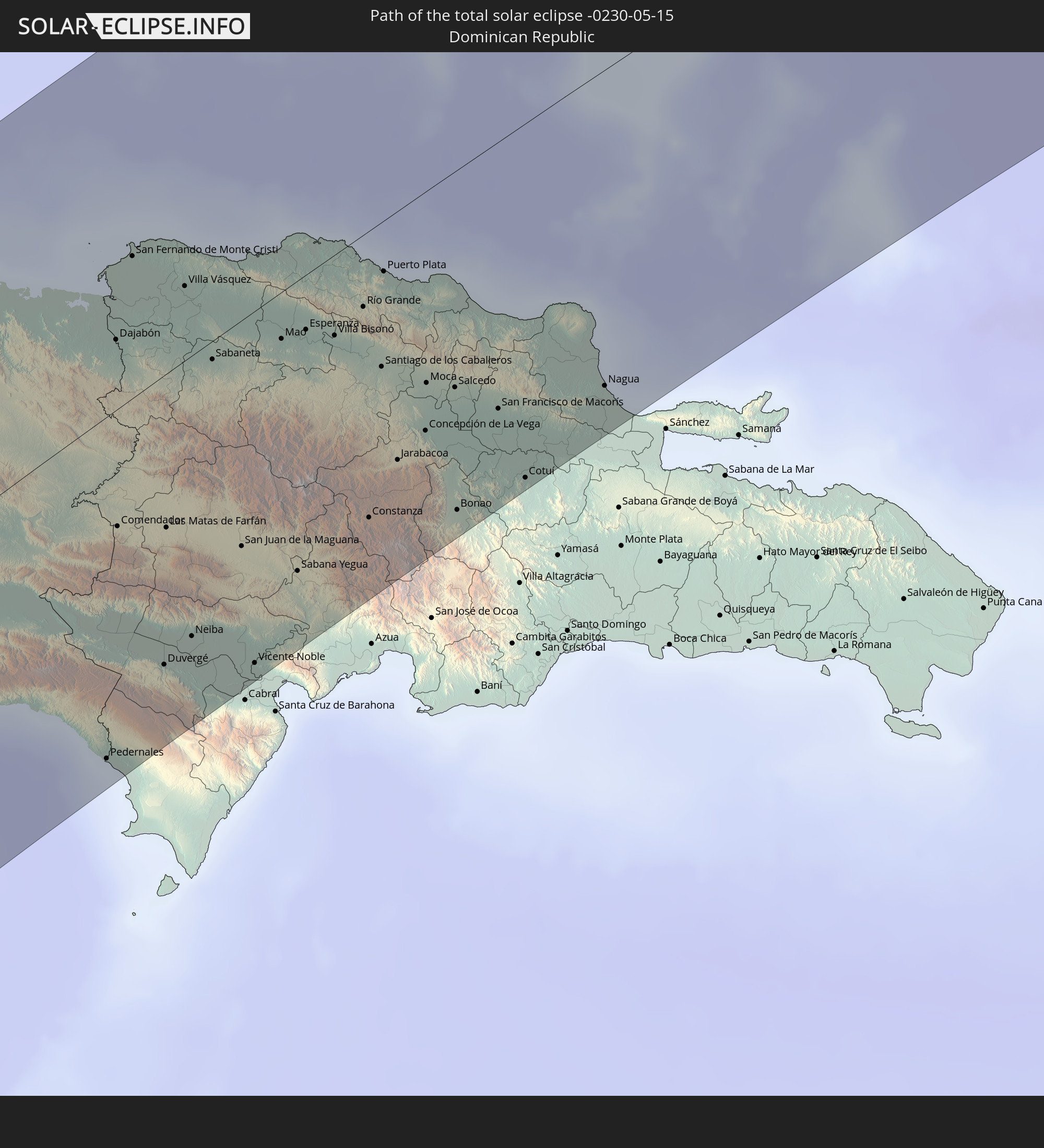 Dominican Republic
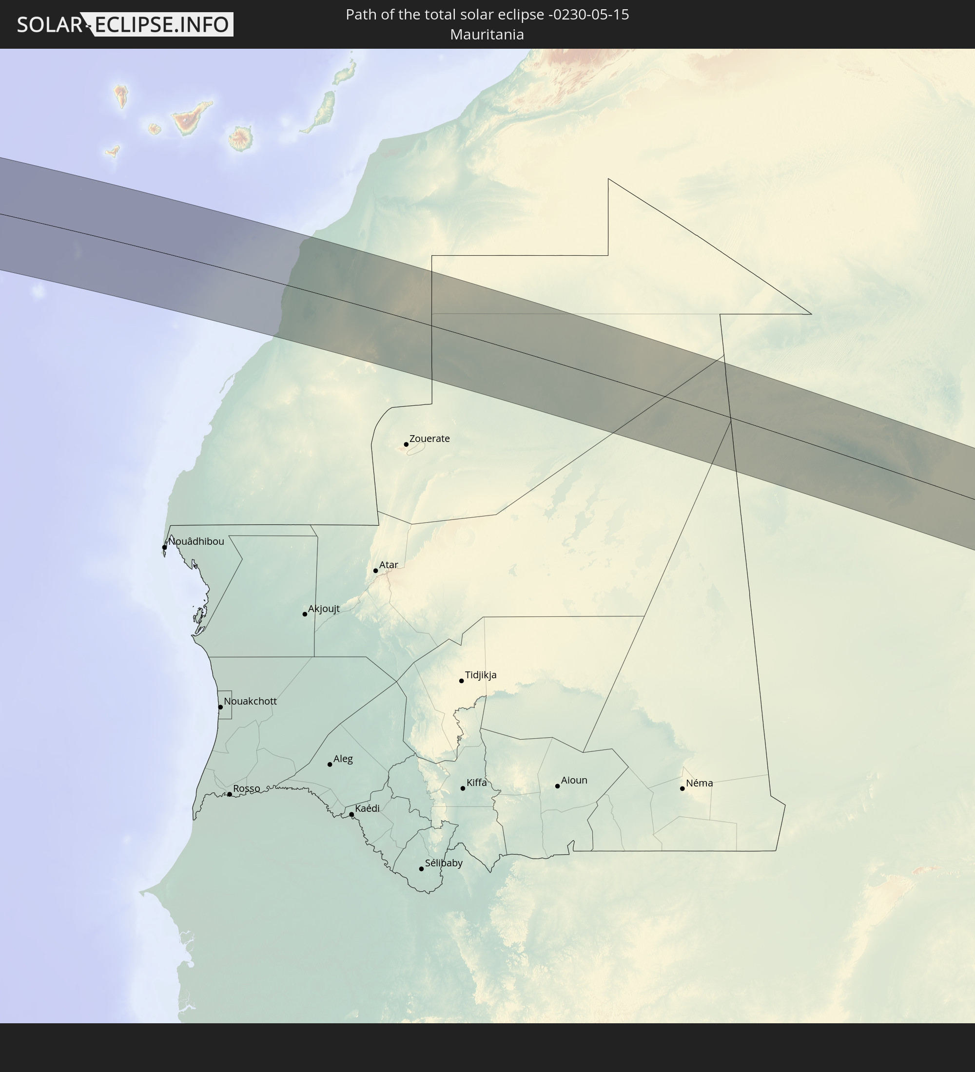 Mauritania
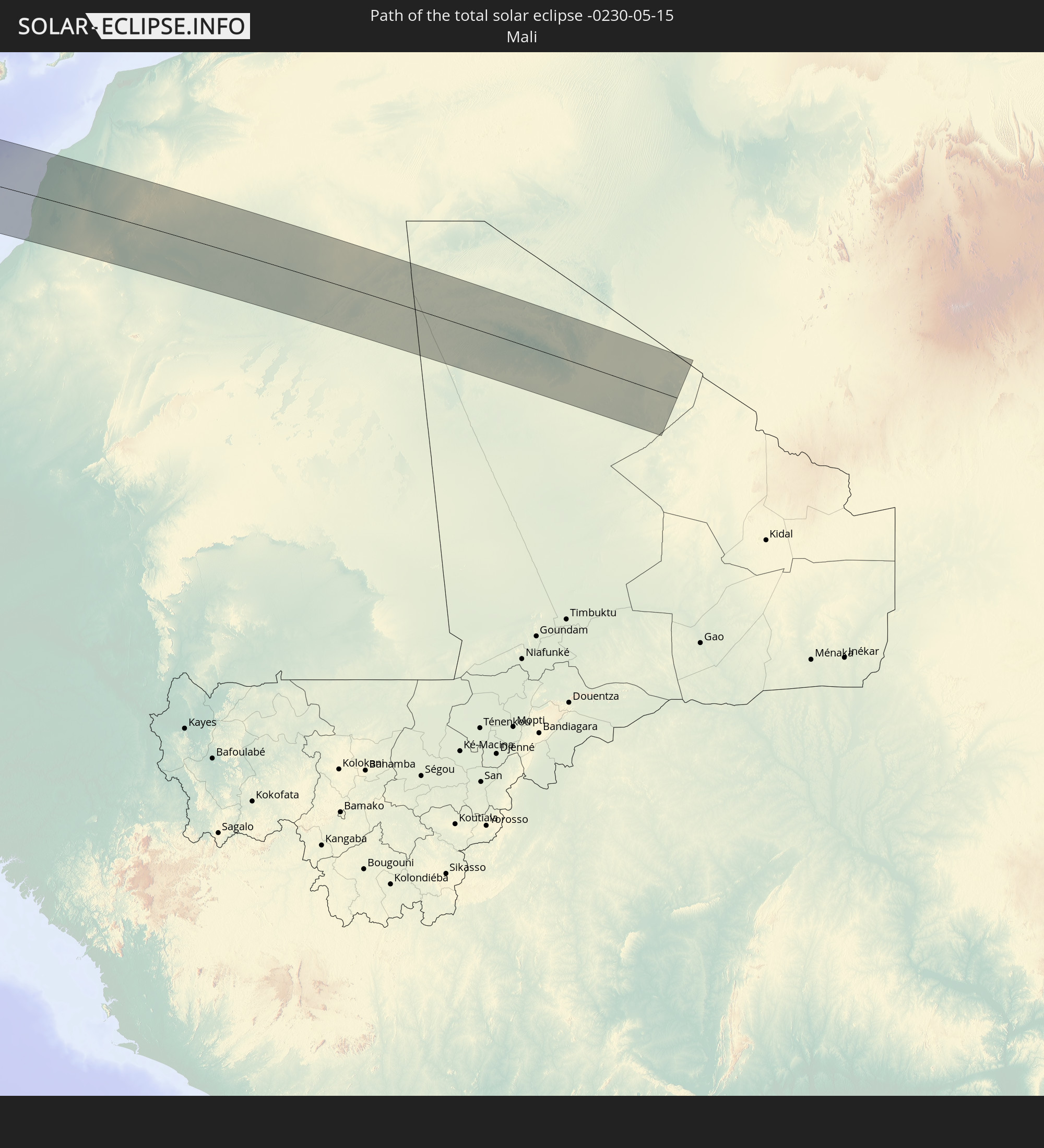 Mali
Mali
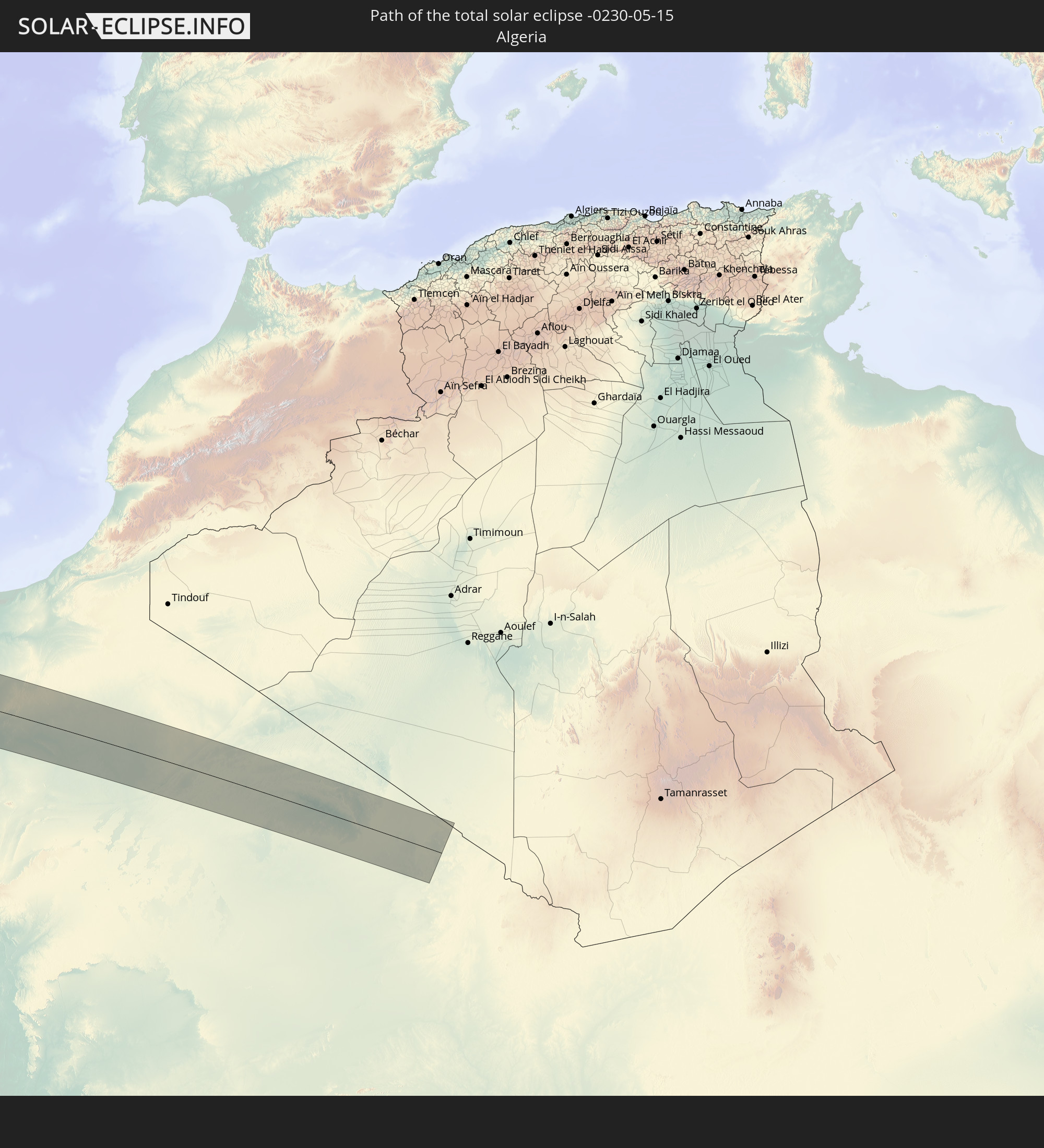 Algeria
In den folgenden Ländern ist die Sonnenfinsternis partiell zu sehen
 United States
 United States Minor Outlying Islands
 Canada
 Pitcairn Islands
 Mexico
 Chile
Chile
 Greenland
 Guatemala
 Ecuador
 El Salvador
 Honduras
 Belize
 Nicaragua
 Costa Rica
 Cuba
Cuba
 Panama
 Colombia
 Cayman Islands
 Peru
Peru
 The Bahamas
 Jamaica
 Haiti
Haiti
 Brazil
 Venezuela
 Turks and Caicos Islands
 Dominican Republic
 Aruba
Aruba
 Bolivia
 Puerto Rico
 United States Virgin Islands
 Bermuda
 British Virgin Islands
 Anguilla
 Collectivity of Saint Martin
 Saint Barthélemy
 Saint Kitts and Nevis
 Antigua and Barbuda
 Montserrat
 Trinidad and Tobago
 Guadeloupe
 Grenada
 Dominica
 Saint Vincent and the Grenadines
 Guyana
 Martinique
 Saint Lucia
 Barbados
 Suriname
 Saint Pierre and Miquelon
 French Guiana
 Portugal
 Cabo Verde
 Spain
Spain
 Senegal
 Mauritania
 The Gambia
 Guinea-Bissau
 Guinea
 Sierra Leone
 Morocco
 Mali
Mali
 Liberia
 Republic of Ireland
 Algeria
 United Kingdom
 Ivory Coast
 Burkina Faso
 Gibraltar
 France
 Isle of Man
 Guernsey
 Jersey
 Andorra
 Belgium
 Netherlands
 Luxembourg
 Germany
 Switzerland
 Italy
Italy
 Monaco
 Denmark
 Liechtenstein
 Austria
 Czechia
 San Marino
 Slovenia
 Croatia
 Poland
 Hungary
 Slovakia
How will be the weather during the total solar eclipse on 05/15/-0230?
Where is the best place to see the total solar eclipse of 05/15/-0230?
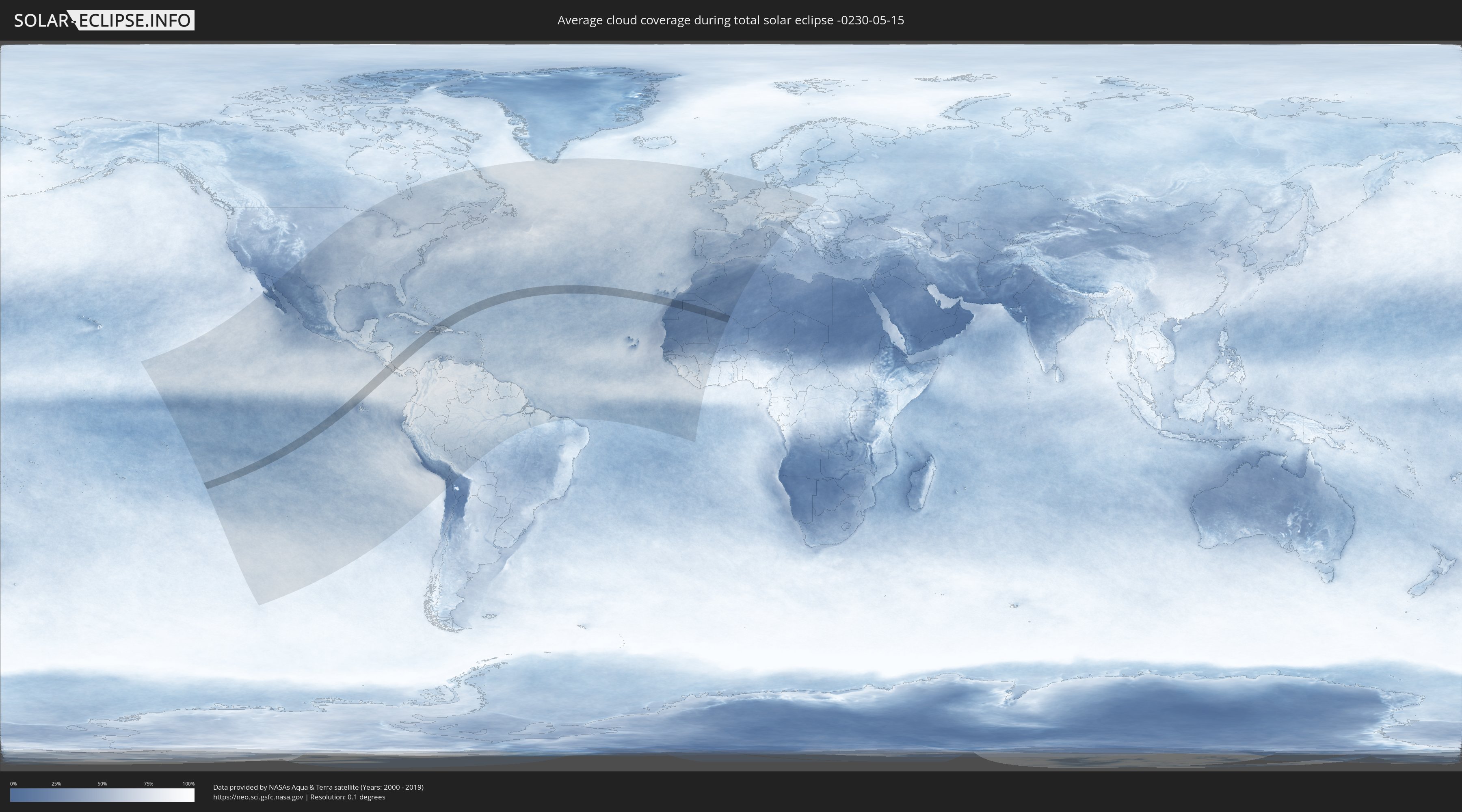
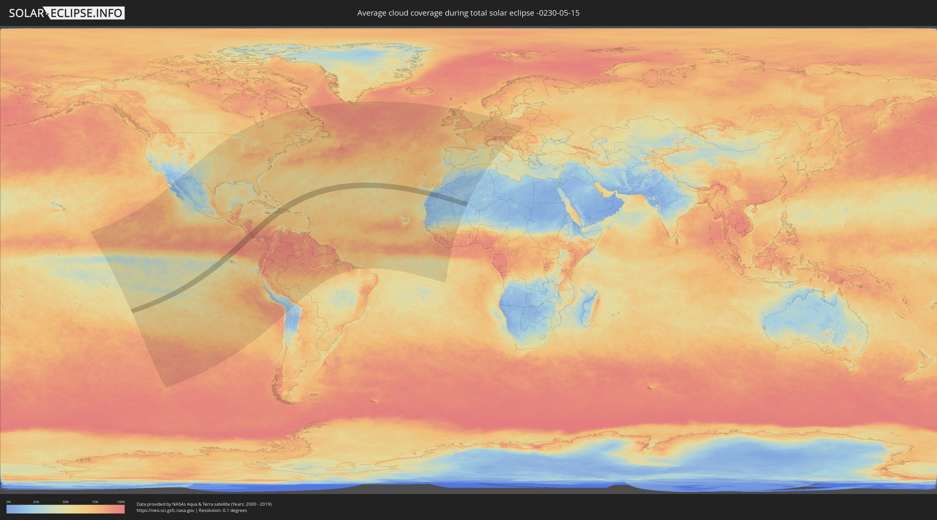
The following maps show the average cloud coverage for the day of the total solar eclipse.
With the help of these maps, it is possible to find the place along the eclipse path, which has the best
chance of a cloudless sky.
Nevertheless, you should consider local circumstances and inform about the weather of your chosen
observation site.
The data is provided by NASAs satellites
AQUA and TERRA.
The cloud maps are averaged over a period of 19 years (2000 - 2019).
Detailed country maps
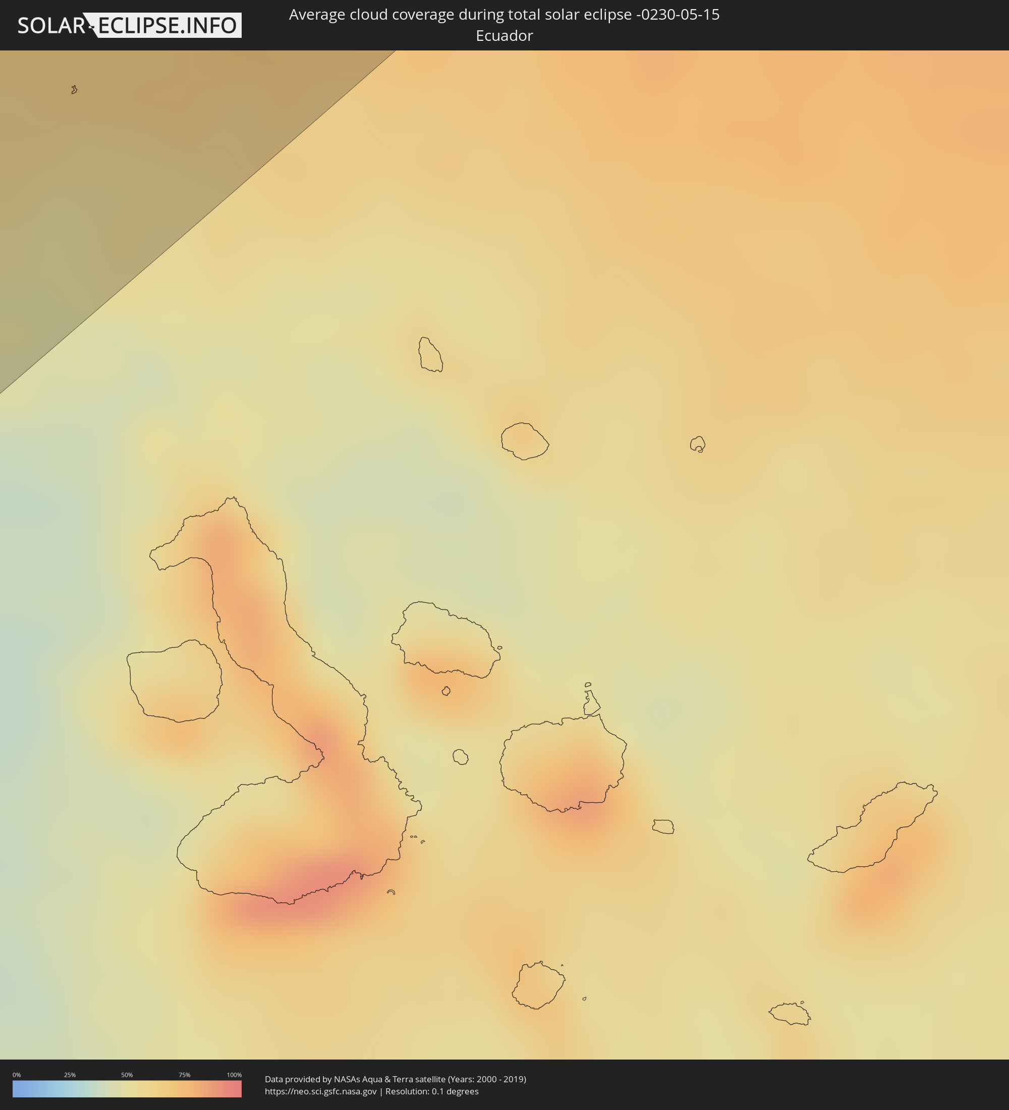 Ecuador
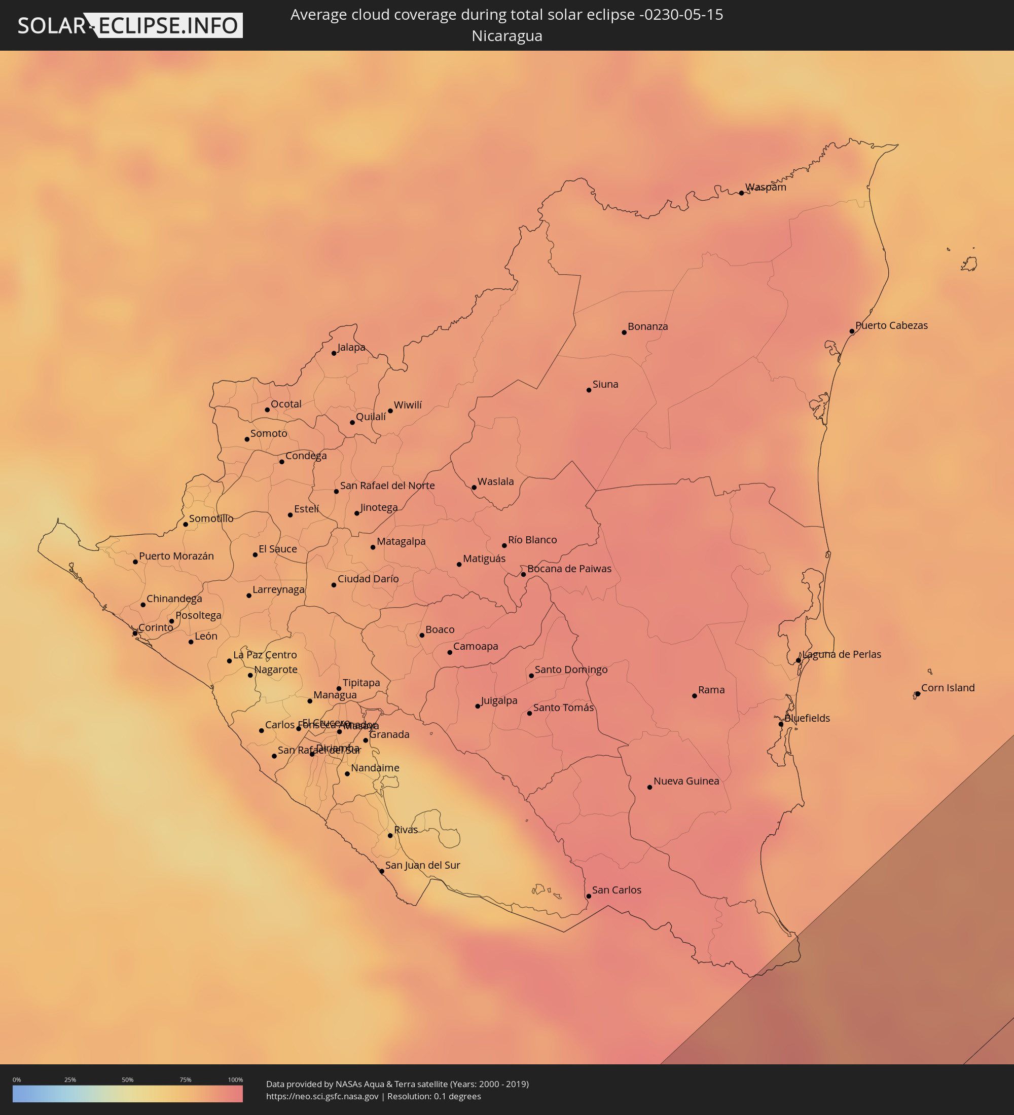 Nicaragua
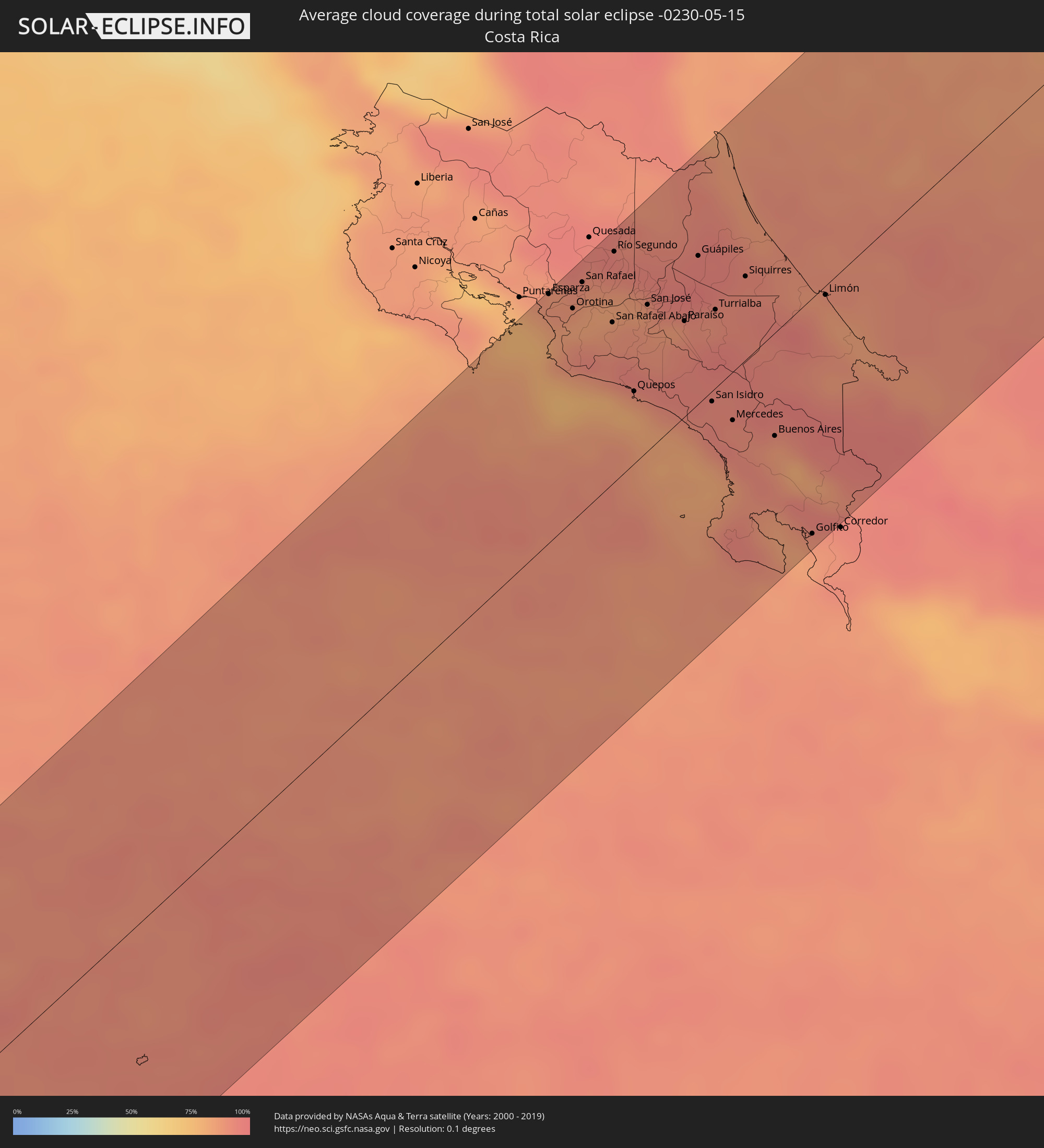 Costa Rica
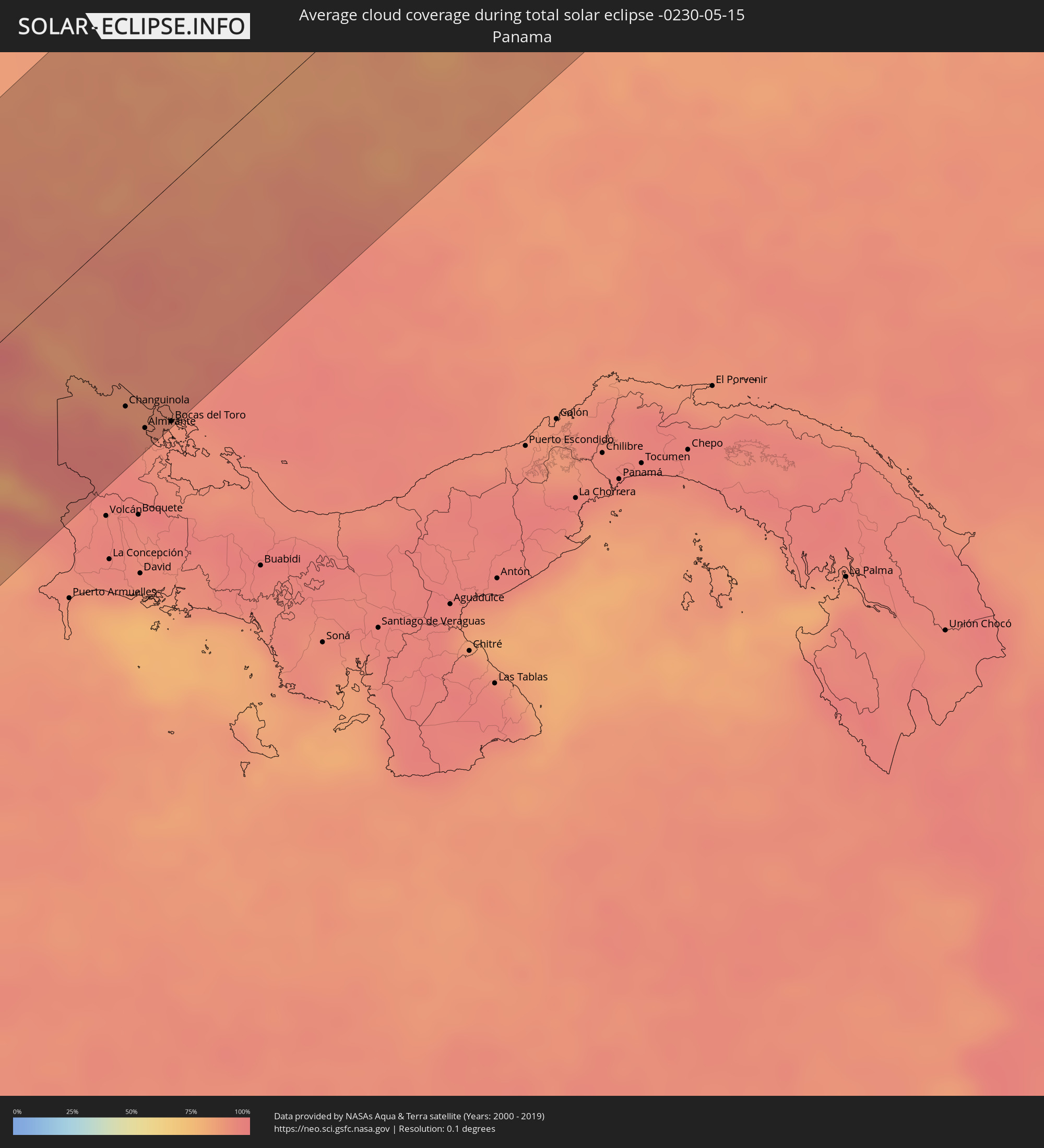 Panama
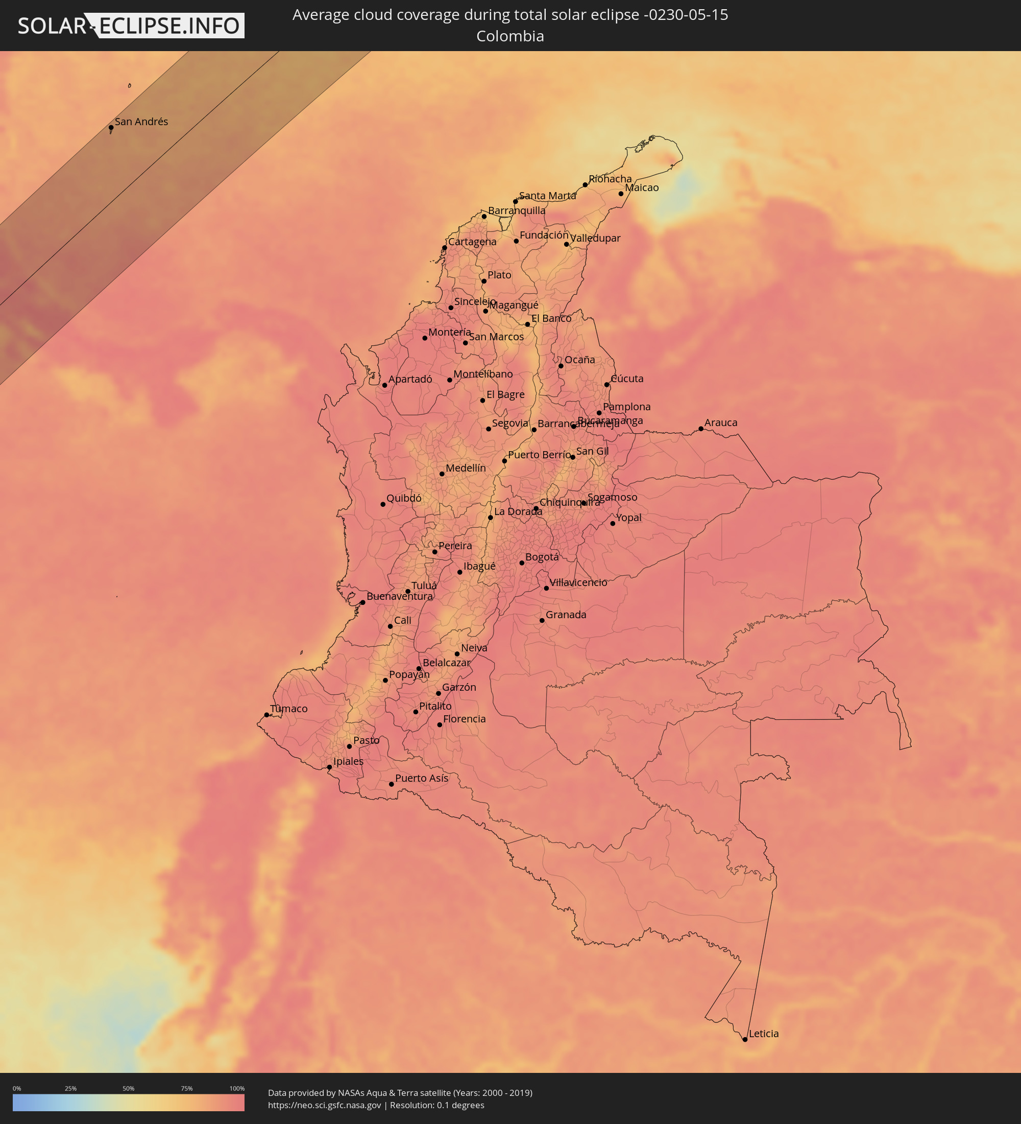 Colombia
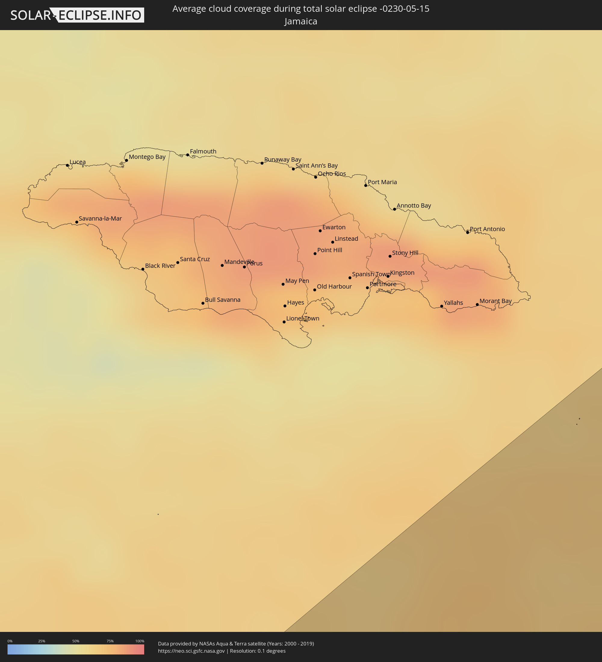 Jamaica
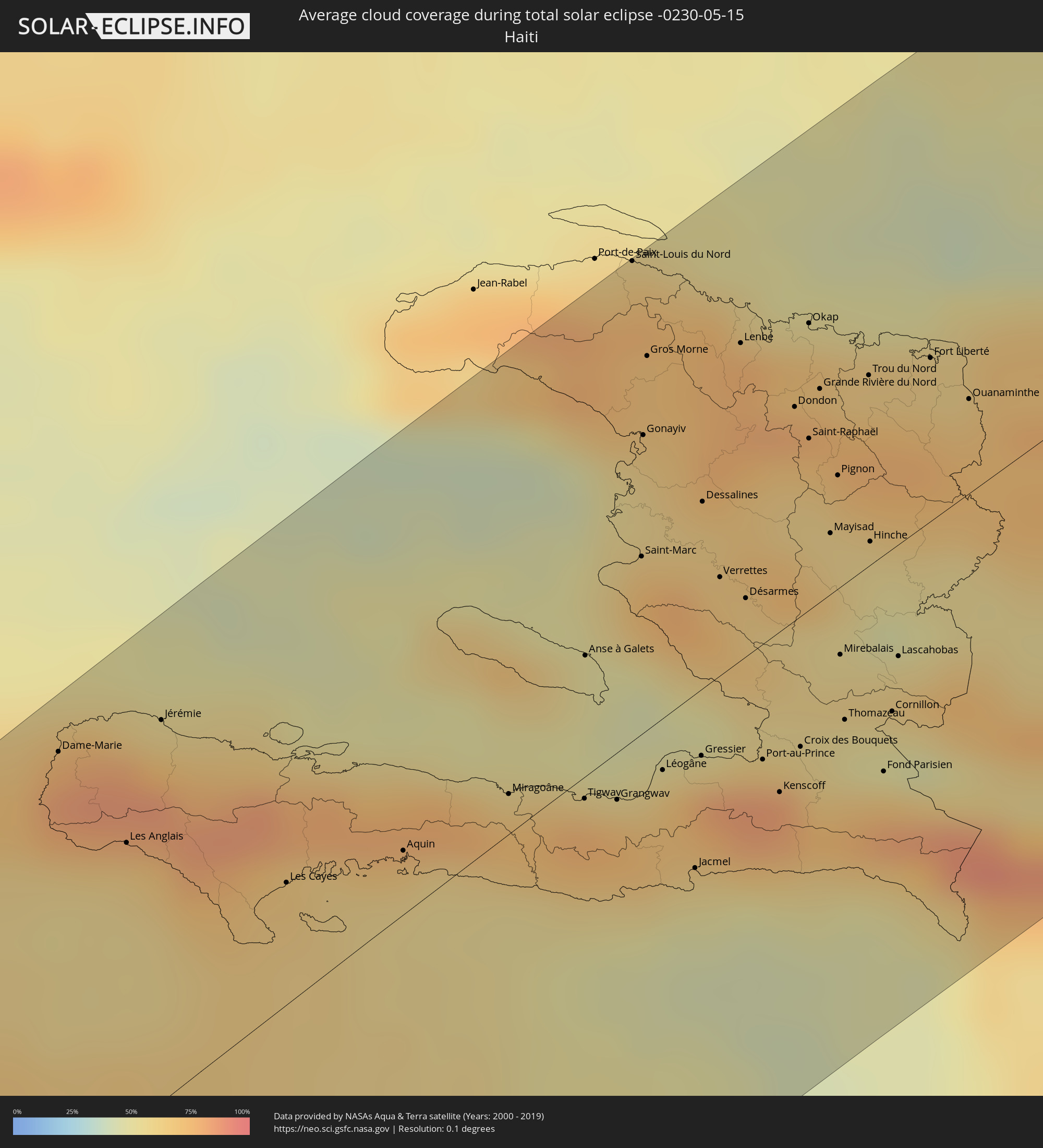 Haiti
Haiti
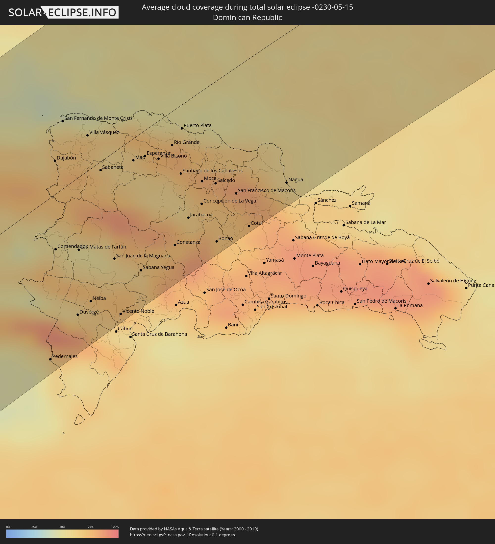 Dominican Republic
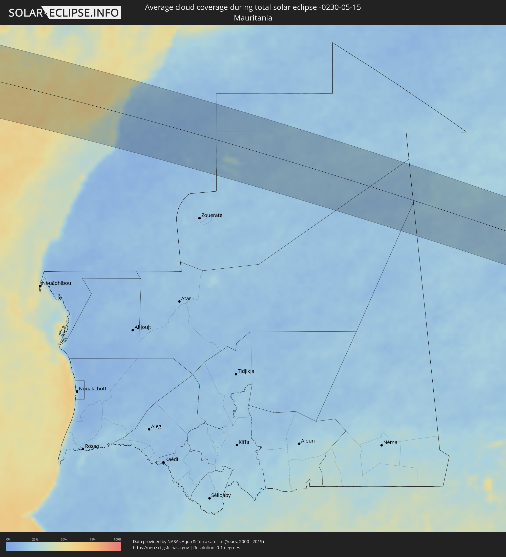 Mauritania
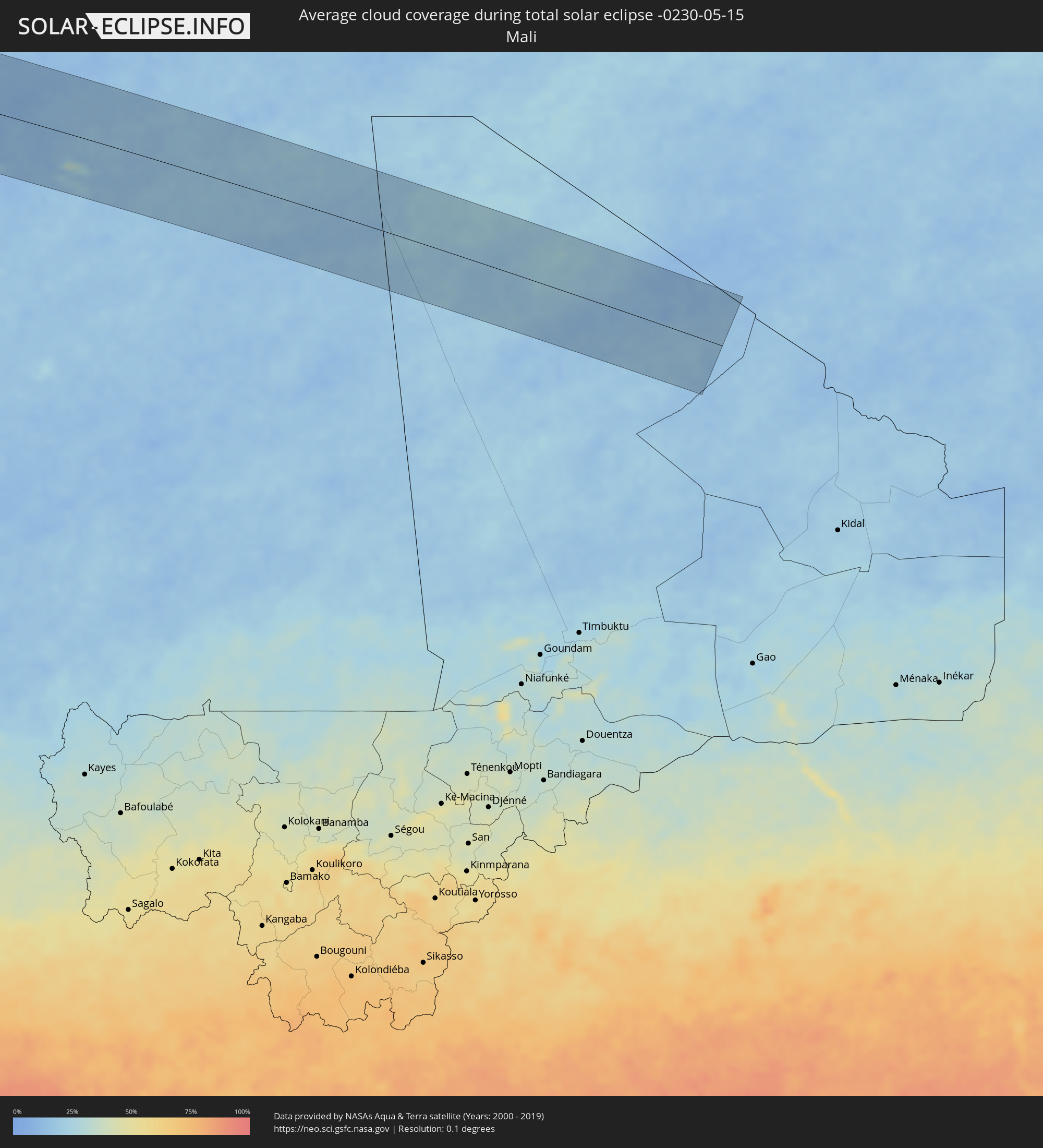 Mali
Mali
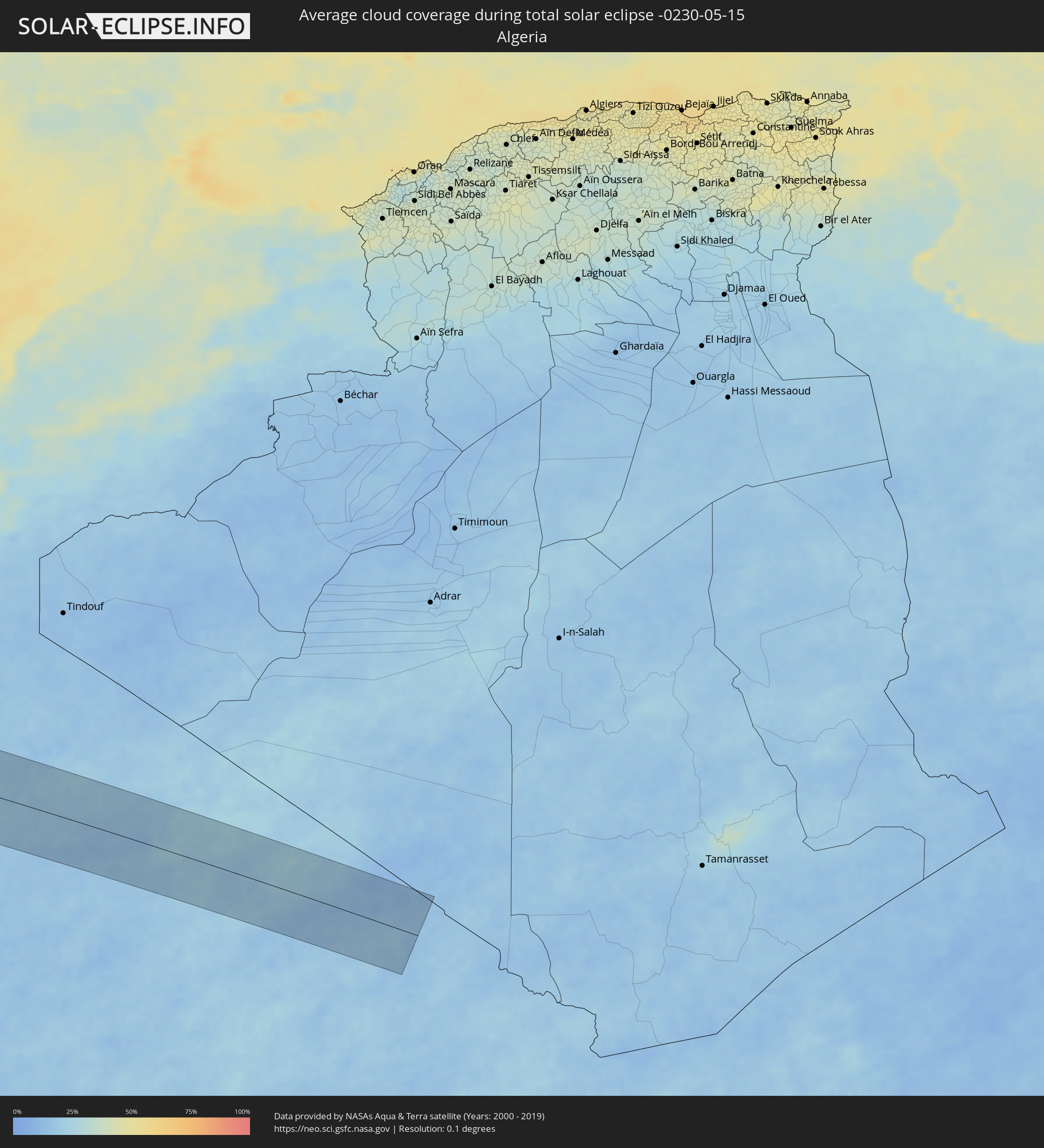 Algeria
Cities inside the path of the eclipse
The following table shows all locations with a population of more than 5,000 inside the eclipse path. Cities which have more than 100,000 inhabitants are marked bold. A click at the locations opens a detailed map.
| City | Type | Eclipse duration | Local time of max. eclipse | Distance to central line | Ø Cloud coverage |
|
Esparza, Puntarenas
|
total | - | 10:23:48 UTC-05:36 | 118 km | 85% |
|
Desamparados, Alajuela
|
total | - | 10:23:59 UTC-05:36 | 102 km | 84% |
|
San Ramón, Alajuela
|
total | - | 10:24:18 UTC-05:36 | 111 km | 90% |
|
San Rafael, Alajuela
|
total | - | 10:24:16 UTC-05:36 | 109 km | 90% |
|
Naranjo, Alajuela
|
total | - | 10:24:29 UTC-05:36 | 105 km | 87% |
|
San Juan, Alajuela
|
total | - | 10:24:36 UTC-05:36 | 100 km | 86% |
|
Santiago, San José
|
total | - | 10:24:08 UTC-05:36 | 79 km | 89% |
|
San Rafael Abajo, San José
|
total | - | 10:24:09 UTC-05:36 | 76 km | 89% |
|
Río Segundo, Alajuela
|
total | - | 10:24:55 UTC-05:36 | 109 km | 91% |
|
Colón, Heredia
|
total | - | 10:24:23 UTC-05:36 | 80 km | 89% |
|
Alajuela, Alajuela
|
total | - | 10:24:37 UTC-05:36 | 86 km | 85% |
|
San Antonio, Heredia
|
total | - | 10:24:37 UTC-05:36 | 81 km | 85% |
|
Santa Ana, San José
|
total | - | 10:24:31 UTC-05:36 | 77 km | 89% |
|
Quepos, Puntarenas
|
total | - | 10:23:39 UTC-05:36 | 34 km | 79% |
|
Escazú, San José
|
total | - | 10:24:34 UTC-05:36 | 72 km | 89% |
|
Alajuelita, San José
|
total | - | 10:24:37 UTC-05:36 | 68 km | 89% |
|
San Rafael, Heredia
|
total | - | 10:24:49 UTC-05:36 | 77 km | 85% |
|
San Josecito, Heredia
|
total | - | 10:24:49 UTC-05:36 | 77 km | 85% |
|
San Juan de Dios, San José
|
total | - | 10:24:36 UTC-05:36 | 65 km | 89% |
|
San José, San José
|
total | - | 10:24:42 UTC-05:36 | 69 km | 89% |
|
San Rafael Arriba, San José
|
total | - | 10:24:36 UTC-05:36 | 64 km | 89% |
|
Sabanilla, San José
|
total | - | 10:24:48 UTC-05:36 | 67 km | 87% |
|
Granadilla, San José
|
total | - | 10:24:49 UTC-05:36 | 64 km | 87% |
|
Concepción, Cartago
|
total | - | 10:24:50 UTC-05:36 | 63 km | 87% |
|
Tres Ríos, Cartago
|
total | - | 10:24:49 UTC-05:36 | 60 km | 87% |
|
Paraíso, Cartago
|
total | - | 10:24:54 UTC-05:36 | 45 km | 91% |
|
Guápiles, Limón
|
total | - | 10:25:44 UTC-05:36 | 70 km | 96% |
|
San Isidro, San José
|
total | - | 10:24:21 UTC-05:36 | 5 km | 93% |
|
Guácimo, Limón
|
total | - | 10:25:53 UTC-05:36 | 62 km | 95% |
|
Turrialba, Cartago
|
total | - | 10:25:20 UTC-05:36 | 37 km | 90% |
|
Daniel Flores, San José
|
total | - | 10:24:20 UTC-05:36 | 11 km | 94% |
|
Siquirres, Limón
|
total | - | 10:26:00 UTC-05:36 | 39 km | 92% |
|
Buenos Aires, Puntarenas
|
total | - | 10:24:38 UTC-05:36 | 49 km | 86% |
|
Limón, Limón
|
total | - | 10:26:38 UTC-05:36 | 4 km | 86% |
|
Guabito, Bocas del Toro
|
total | - | 10:43:06 UTC-05:19 | 77 km | 89% |
|
Changuinola, Bocas del Toro
|
total | - | 10:43:10 UTC-05:19 | 89 km | 93% |
|
Almirante, Bocas del Toro
|
total | - | 10:43:09 UTC-05:19 | 108 km | 92% |
|
Bocas del Toro, Bocas del Toro
|
total | - | 10:43:30 UTC-05:19 | 117 km | 92% |
|
San Andrés, Archipiélago de San Andrés, Providencia y Santa Catalina
|
total | - | 11:13:46 UTC-04:56 | 109 km | 82% |
|
Dame-Marie, GrandʼAnse
|
total | - | 11:46:31 UTC-04:49 | 106 km | 77% |
|
Les Anglais, Sud
|
total | - | 11:46:30 UTC-04:49 | 71 km | 65% |
|
Jérémie, GrandʼAnse
|
total | - | 11:47:19 UTC-04:49 | 94 km | 59% |
|
Les Cayes, Sud
|
total | - | 11:47:20 UTC-04:49 | 30 km | 66% |
|
Miragoâne, Nippes
|
total | - | 11:49:12 UTC-04:49 | 10 km | 73% |
|
Tigwav, Ouest
|
total | - | 11:49:40 UTC-04:49 | 5 km | 77% |
|
Anse à Galets, Ouest
|
total | - | 11:50:22 UTC-04:49 | 30 km | 52% |
|
Grangwav, Ouest
|
total | - | 11:49:52 UTC-04:49 | 12 km | 75% |
|
Saint-Louis du Nord, Nord-Ouest
|
total | - | 11:52:32 UTC-04:49 | 120 km | 69% |
|
Saint-Marc, Artibonite
|
total | - | 11:51:12 UTC-04:49 | 44 km | 73% |
|
Gonayiv, Artibonite
|
total | - | 11:51:47 UTC-04:49 | 74 km | 59% |
|
Gros Morne, Artibonite
|
total | - | 11:52:11 UTC-04:49 | 93 km | 71% |
|
Léogâne, Ouest
|
total | - | 11:50:19 UTC-04:49 | 13 km | 70% |
|
Jacmel, Sud-Est
|
total | - | 11:50:03 UTC-04:49 | 44 km | 53% |
|
Gressier, Ouest
|
total | - | 11:50:38 UTC-04:49 | 17 km | 61% |
|
Dessalines, Artibonite
|
total | - | 11:51:51 UTC-04:49 | 47 km | 64% |
|
Verrettes, Artibonite
|
total | - | 11:51:37 UTC-04:49 | 25 km | 68% |
|
Lenbe, Nord
|
total | - | 11:52:51 UTC-04:49 | 79 km | 76% |
|
Désarmes, Artibonite
|
total | - | 11:51:41 UTC-04:49 | 15 km | 64% |
|
Port-au-Prince, Ouest
|
total | - | 11:51:01 UTC-04:49 | 29 km | 81% |
|
Kenscoff, Ouest
|
total | - | 11:50:59 UTC-04:49 | 40 km | 80% |
|
Okap, Nord
|
total | - | 11:53:23 UTC-04:49 | 72 km | 55% |
|
Saint-Raphaël, Nord
|
total | - | 11:52:51 UTC-04:49 | 43 km | 64% |
|
Grande Rivière du Nord, Nord
|
total | - | 11:53:09 UTC-04:49 | 53 km | 76% |
|
Pignon, Nord
|
total | - | 11:52:52 UTC-04:49 | 28 km | 62% |
|
Mirebalais, Centre
|
total | - | 11:52:02 UTC-04:49 | 17 km | 61% |
|
Thomazeau, Ouest
|
total | - | 11:51:45 UTC-04:49 | 34 km | 54% |
|
Trou du Nord, Nord-Est
|
total | - | 11:53:32 UTC-04:49 | 48 km | 73% |
|
Hinche, Centre
|
total | - | 11:52:46 UTC-04:49 | 6 km | 56% |
|
Fond Parisien, Ouest
|
total | - | 11:51:46 UTC-04:49 | 54 km | 68% |
|
Cornillon, Ouest
|
total | - | 11:52:06 UTC-04:49 | 41 km | 53% |
|
Lascahobas, Centre
|
total | - | 11:52:24 UTC-04:49 | 28 km | 67% |
|
Fort Liberté, Nord-Est
|
total | - | 11:54:01 UTC-04:49 | 41 km | 61% |
|
Pedernales, Pedernales
|
total | - | 12:00:29 UTC-04:40 | 111 km | 60% |
|
Ouanaminthe, Nord-Est
|
total | - | 11:54:05 UTC-04:49 | 24 km | 72% |
|
Dajabón, Dajabón
|
total | - | 12:03:07 UTC-04:40 | 23 km | 72% |
|
Comendador, Elías Piña
|
total | - | 12:02:00 UTC-04:40 | 38 km | 63% |
|
San Fernando de Monte Cristi, Monte Cristi
|
total | - | 12:03:45 UTC-04:40 | 46 km | 65% |
|
Duvergé, Independencia
|
total | - | 12:01:33 UTC-04:40 | 94 km | 69% |
|
Las Matas de Farfán, San Juan
|
total | - | 12:02:25 UTC-04:40 | 50 km | 55% |
|
Las Matas de Santa Cruz, Monte Cristi
|
total | - | 12:03:47 UTC-04:40 | 21 km | 69% |
|
Villa Jaragua, Baoruco
|
total | - | 12:01:50 UTC-04:40 | 87 km | 61% |
|
Villa Vásquez, Monte Cristi
|
total | - | 12:04:01 UTC-04:40 | 24 km | 66% |
|
Neiba, Baoruco
|
total | - | 12:01:58 UTC-04:40 | 91 km | 65% |
|
Sabaneta, Santiago Rodríguez
|
total | - | 12:03:49 UTC-04:40 | 6 km | 68% |
|
San Juan de la Maguana, San Juan
|
total | - | 12:02:57 UTC-04:40 | 74 km | 60% |
|
Vicente Noble, Barahona
|
total | - | 12:02:21 UTC-04:40 | 115 km | 64% |
|
Mao, Valverde
|
total | - | 12:04:32 UTC-04:40 | 15 km | 61% |
|
Sabana Yegua, Azua
|
total | - | 12:03:16 UTC-04:40 | 95 km | 65% |
|
San José de Las Matas, Santiago
|
total | - | 12:04:29 UTC-04:40 | 43 km | 68% |
|
Villa Bisonó, Santiago
|
total | - | 12:05:00 UTC-04:40 | 26 km | 64% |
|
Villa González, Santiago
|
total | - | 12:05:10 UTC-04:40 | 34 km | 60% |
|
Río Grande, Puerto Plata
|
total | - | 12:05:25 UTC-04:40 | 24 km | 75% |
|
Constanza, La Vega
|
total | - | 12:04:13 UTC-04:40 | 94 km | 79% |
|
Santiago de los Caballeros, Santiago
|
total | - | 12:05:13 UTC-04:40 | 47 km | 66% |
|
Puerto Plata, Puerto Plata
|
total | - | 12:05:48 UTC-04:40 | 17 km | 67% |
|
Jarabacoa, La Vega
|
total | - | 12:04:48 UTC-04:40 | 82 km | 73% |
|
Concepción de La Vega, La Vega
|
total | - | 12:05:13 UTC-04:40 | 78 km | 69% |
|
Moca, Espaillat
|
total | - | 12:05:31 UTC-04:40 | 63 km | 72% |
|
Bonao, Monseñor Nouel
|
total | - | 12:05:01 UTC-04:40 | 112 km | 75% |
|
Salsipuedes, Hermanas Mirabal
|
total | - | 12:05:52 UTC-04:40 | 71 km | 73% |
|
Fantino, Sánchez Ramírez
|
total | - | 12:05:34 UTC-04:40 | 101 km | 70% |
|
San Francisco de Macorís, Duarte
|
total | - | 12:05:59 UTC-04:40 | 88 km | 70% |
|
Las Guáranas, Duarte
|
total | - | 12:05:54 UTC-04:40 | 100 km | 72% |
|
Cotuí, Sánchez Ramírez
|
total | - | 12:05:48 UTC-04:40 | 117 km | 78% |
|
Pimentel, Duarte
|
total | - | 12:06:07 UTC-04:40 | 107 km | 75% |
|
Río San Juan, María Trinidad Sánchez
|
total | - | 12:06:56 UTC-04:40 | 67 km | 72% |
|
Nagua, María Trinidad Sánchez
|
total | - | 12:07:02 UTC-04:40 | 104 km | 64% |
|
Gueltat Zemmour, Laâyoune-Boujdour-Sakia El Hamra
|
total | - | 17:28:45 UTC-00:52 | 26 km | 12% |