Total solar eclipse of 07/13/-0363
| Day of week: | Saturday |
| Maximum duration of eclipse: | 04m30s |
| Maximum width of eclipse path: | 237 km |
| Saros cycle: | 69 |
| Coverage: | 100% |
| Magnitude: | 1.0618 |
| Gamma: | 0.5151 |
Wo kann man die Sonnenfinsternis vom 07/13/-0363 sehen?
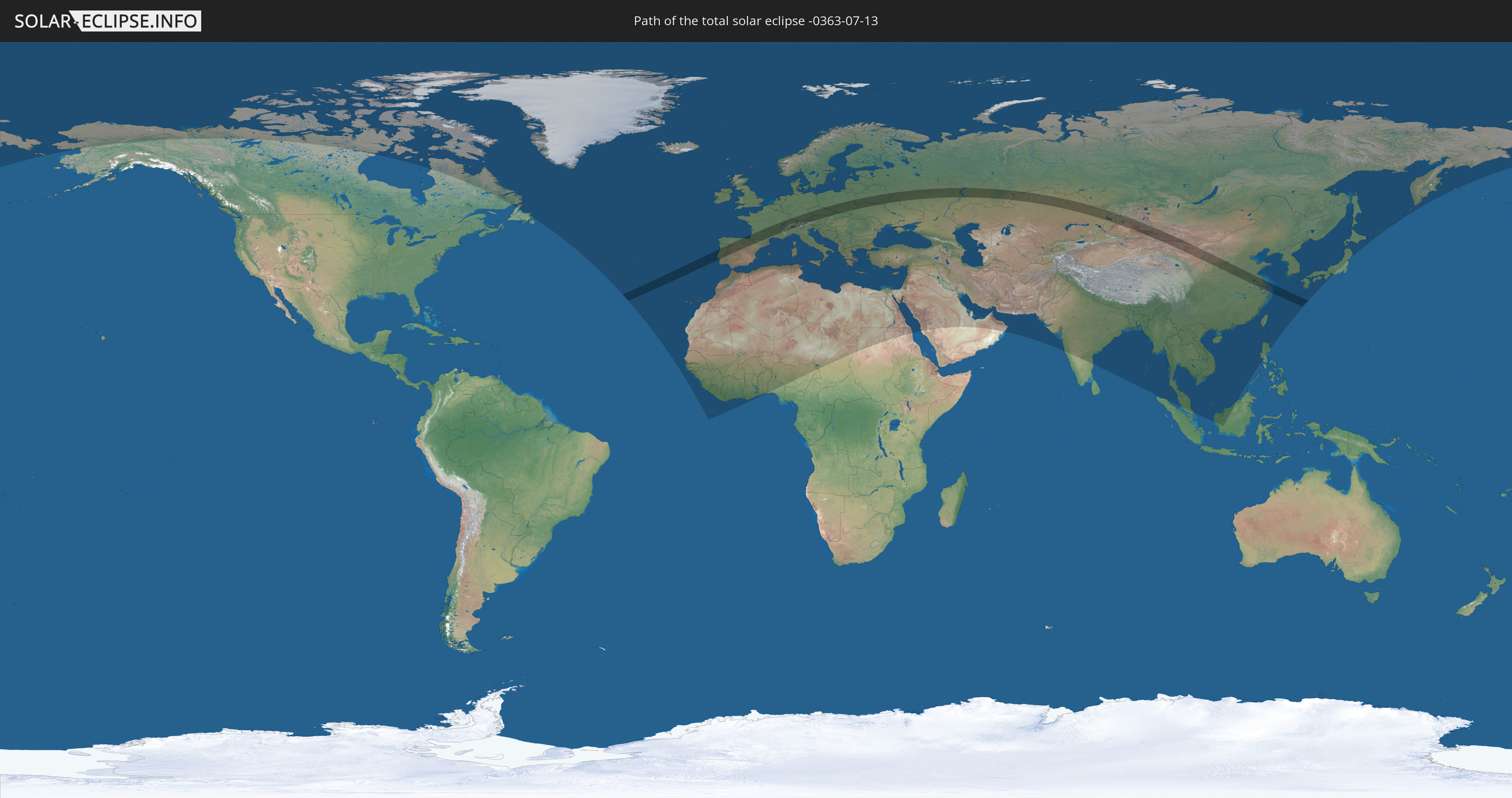
Die Sonnenfinsternis am 07/13/-0363 kann man in 123 Ländern als partielle Sonnenfinsternis beobachten.
Der Finsternispfad verläuft durch 18 Länder. Nur in diesen Ländern ist sie als total Sonnenfinsternis zu sehen.
In den folgenden Ländern ist die Sonnenfinsternis total zu sehen
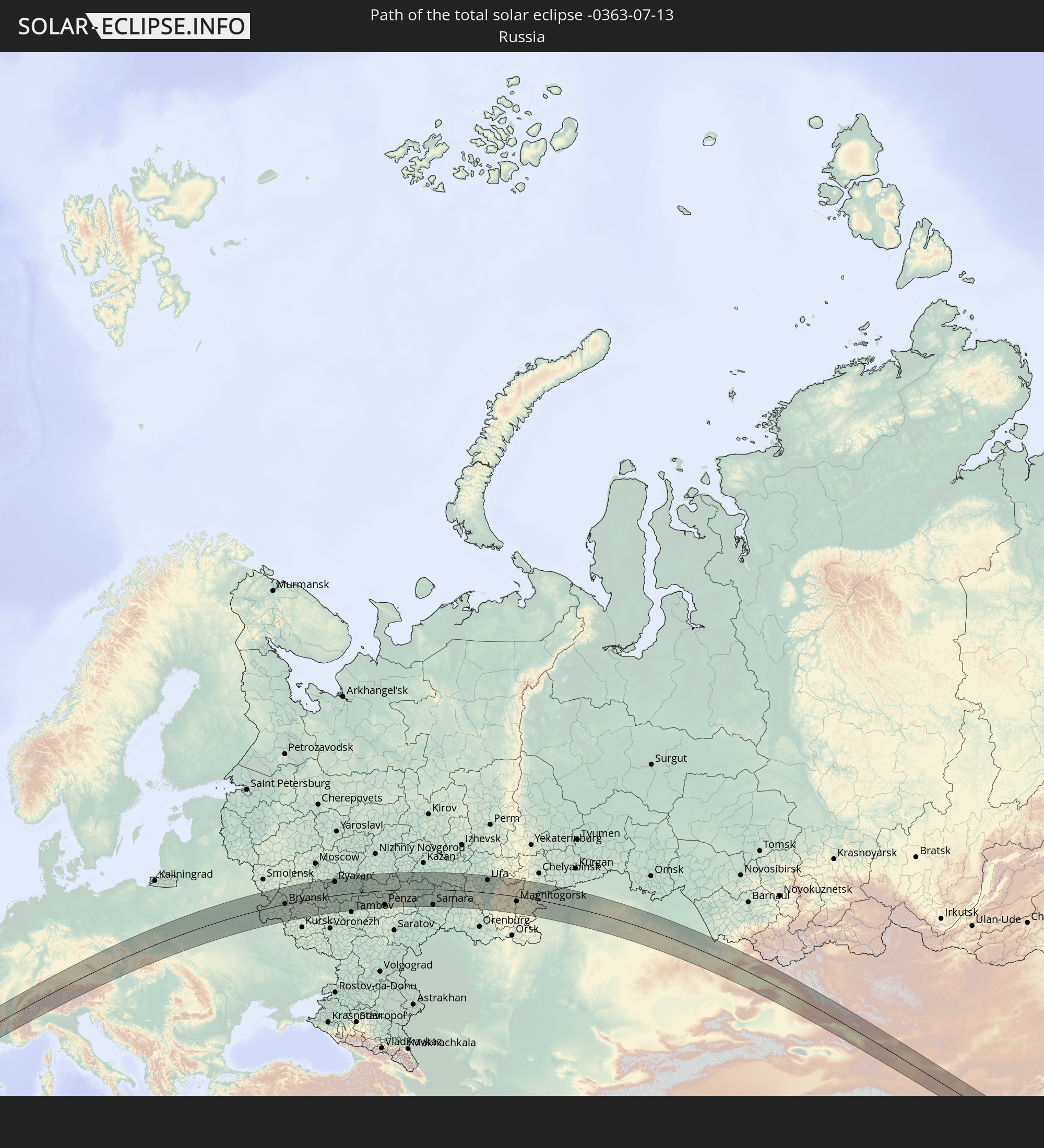 Russia
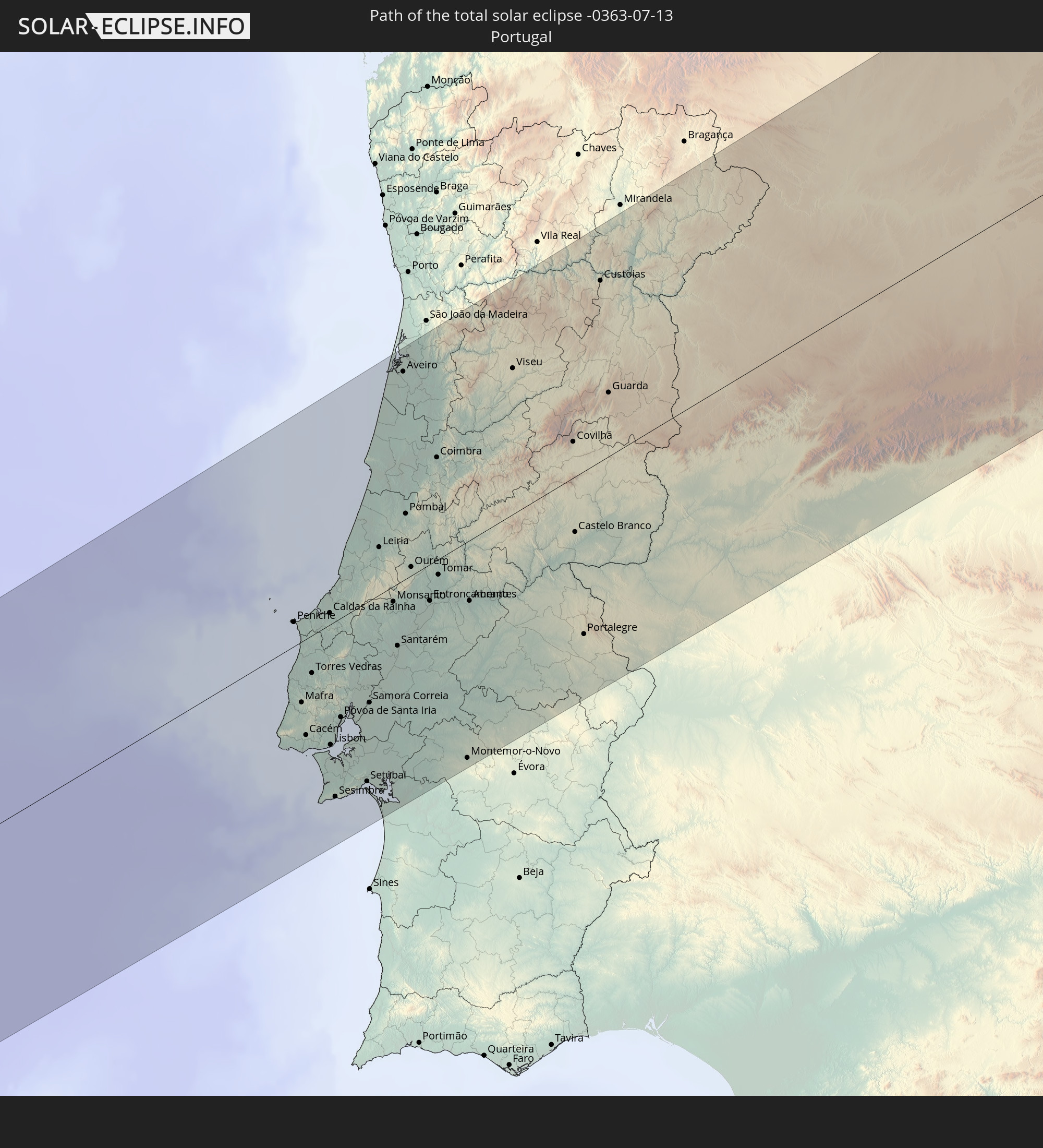 Portugal
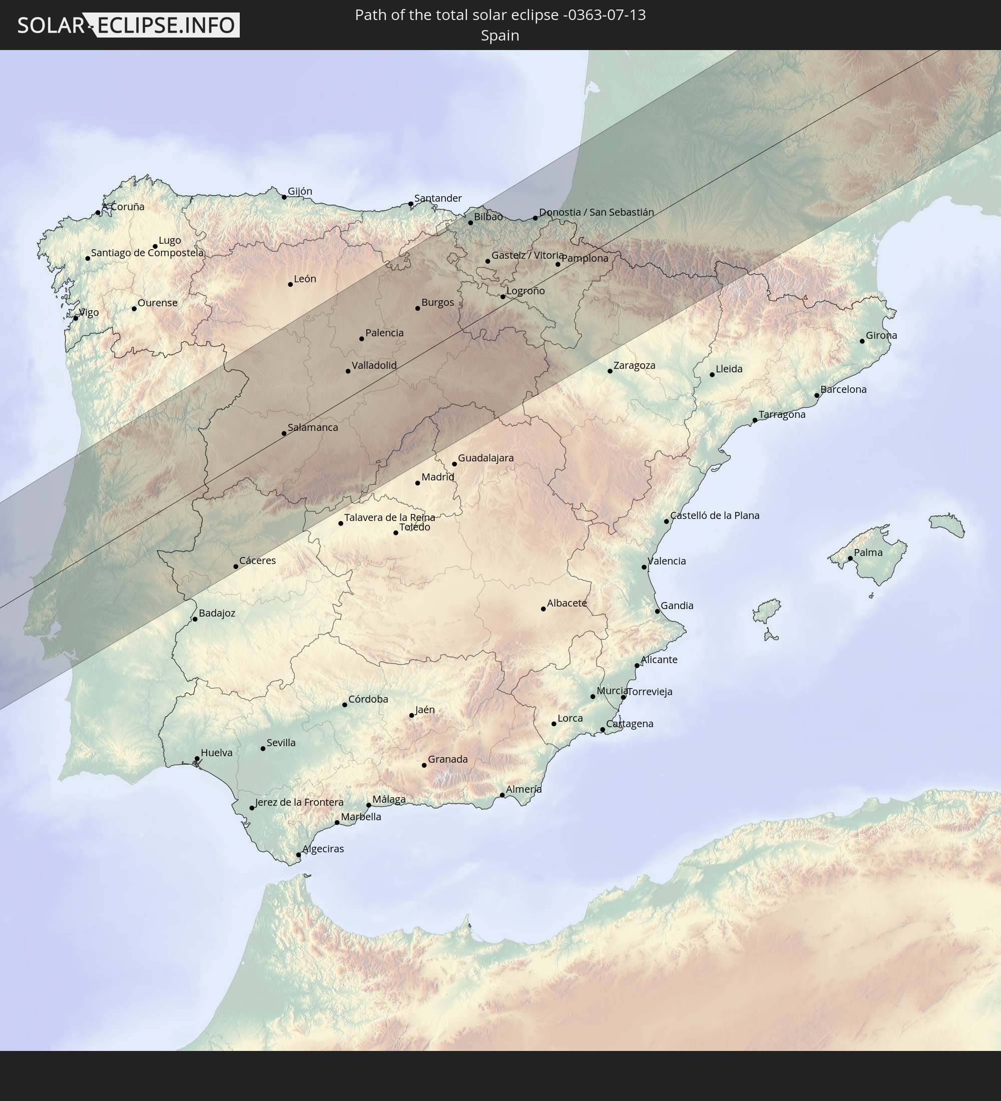 Spain
Spain
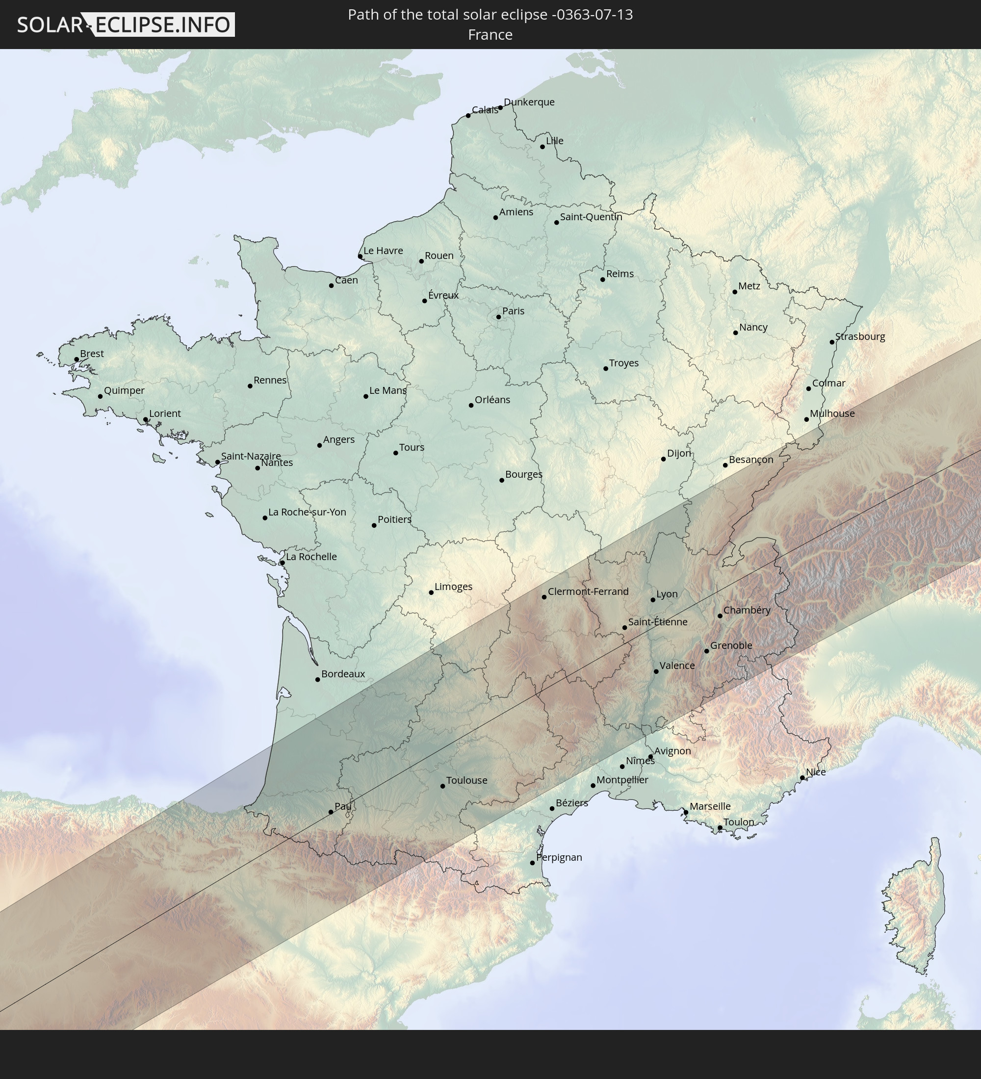 France
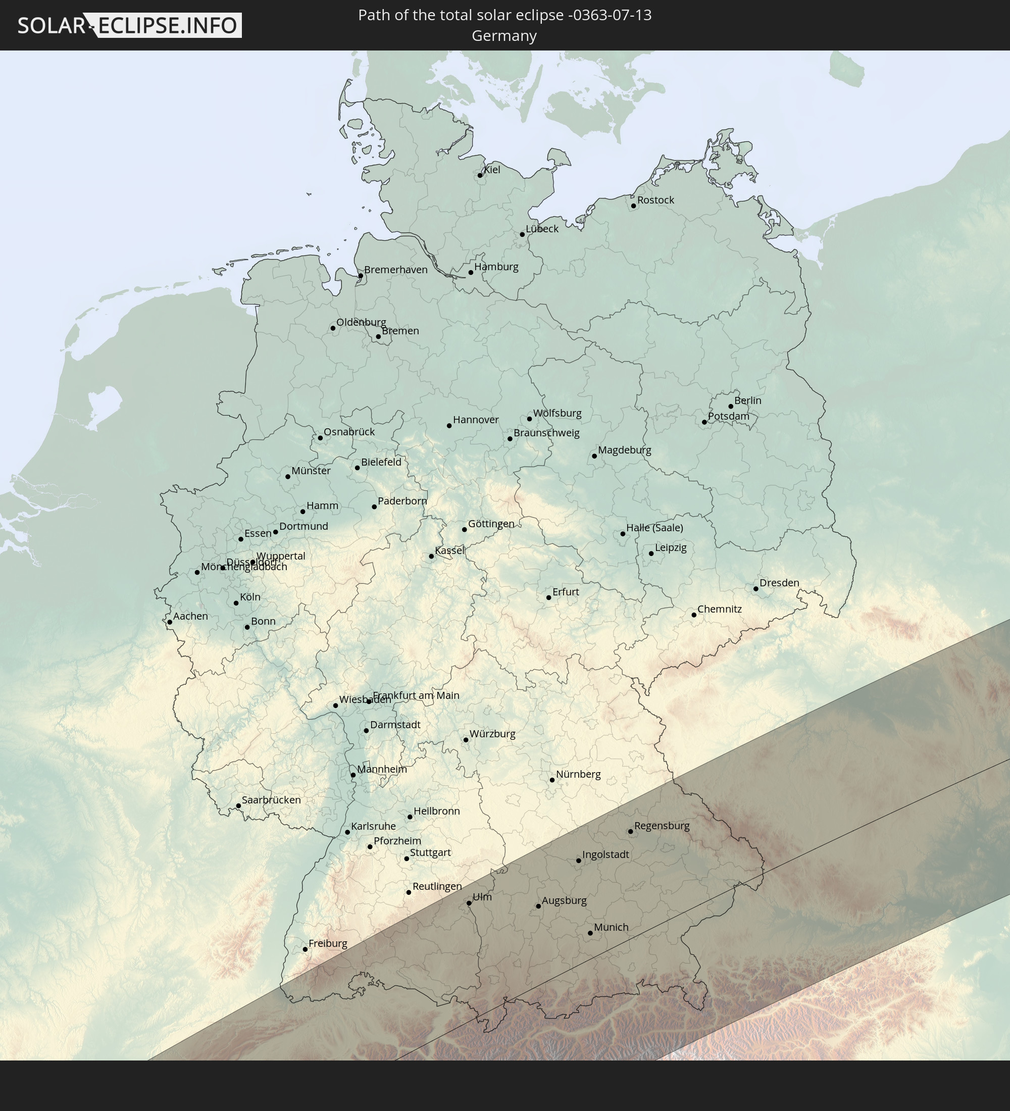 Germany
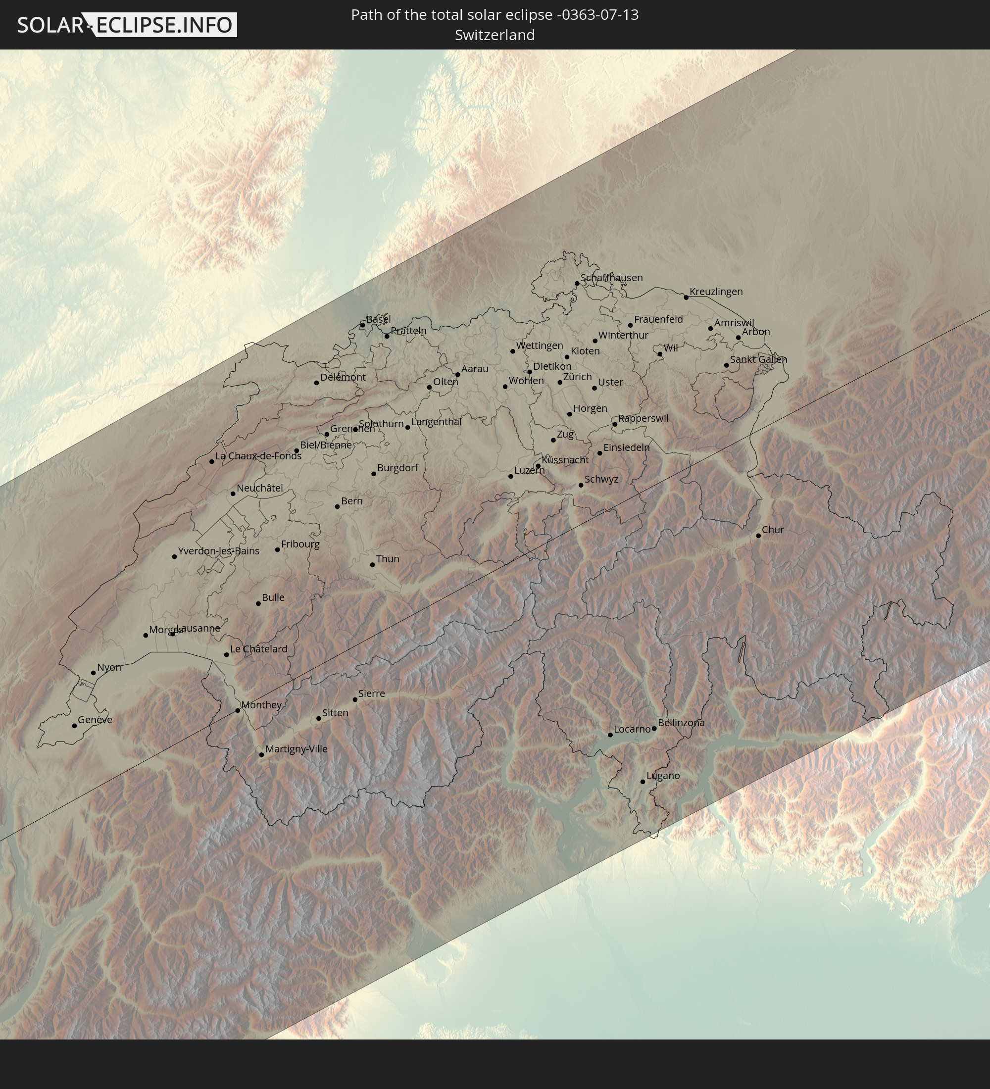 Switzerland
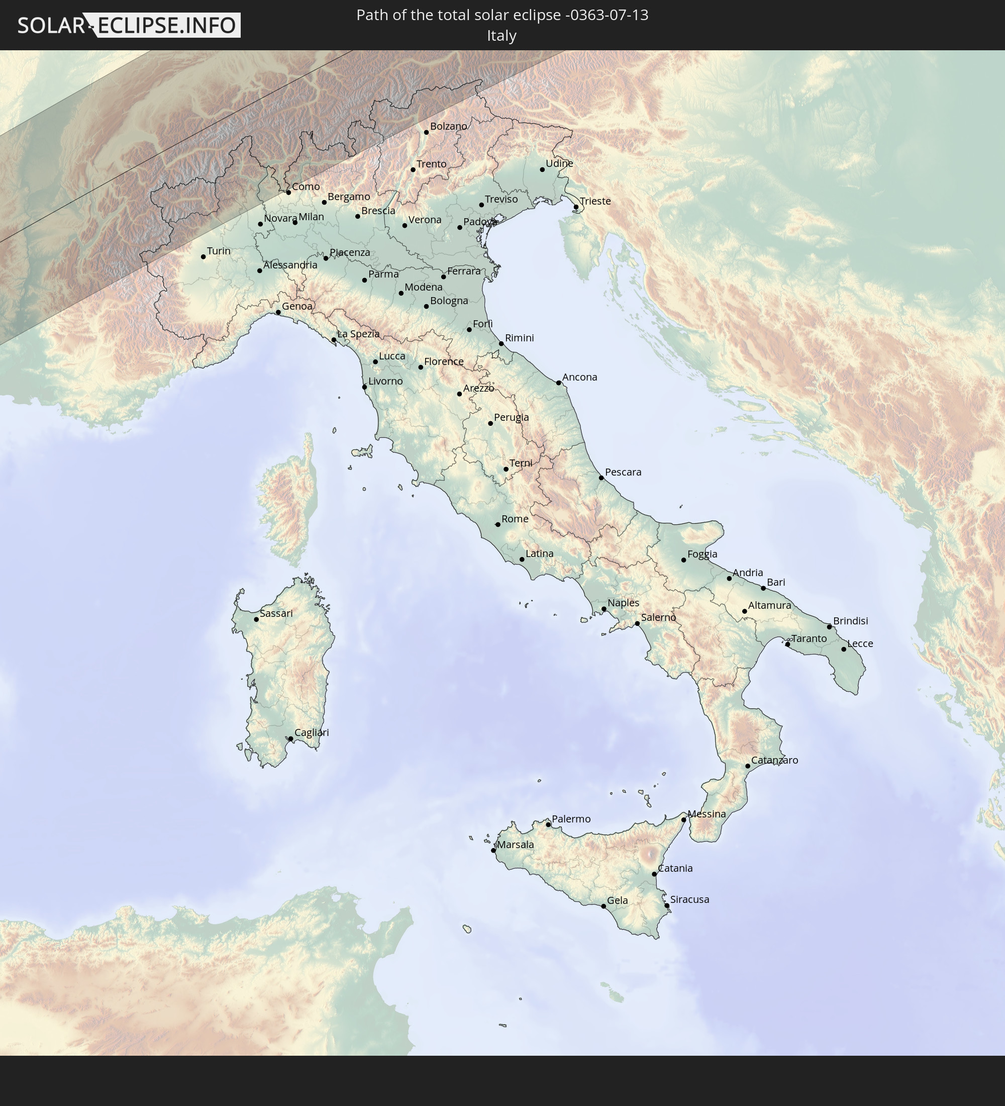 Italy
Italy
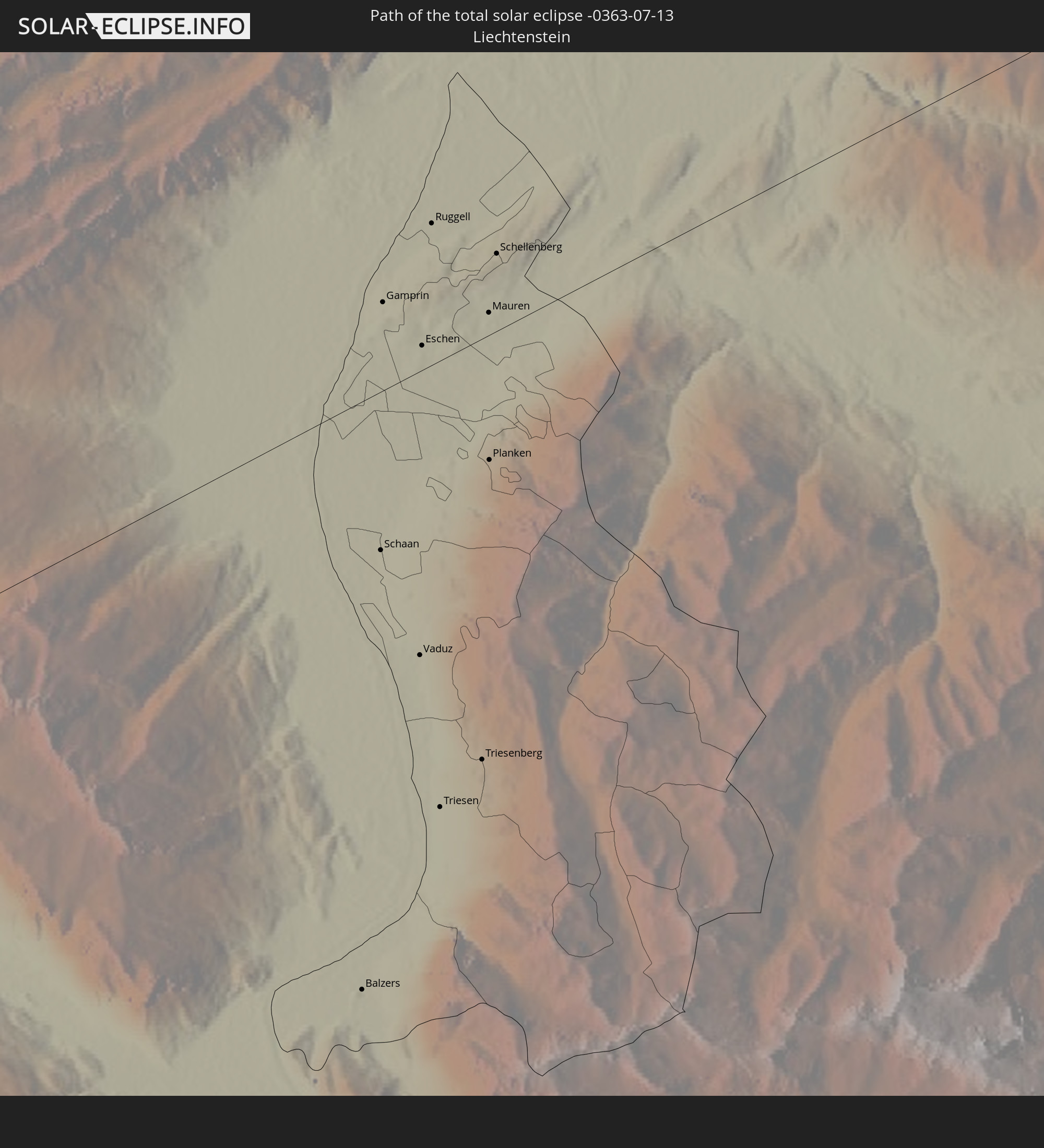 Liechtenstein
 Austria
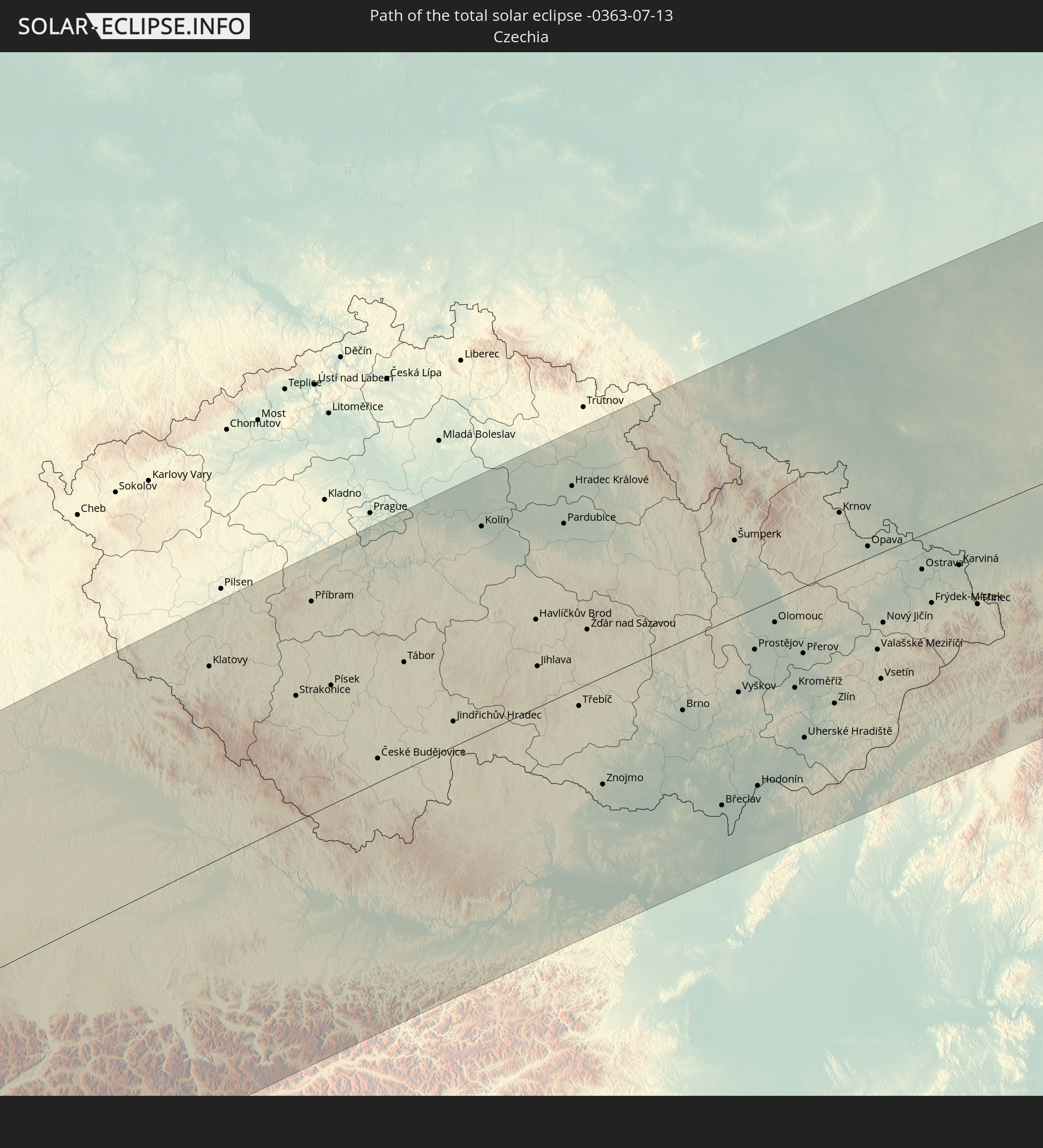 Czechia
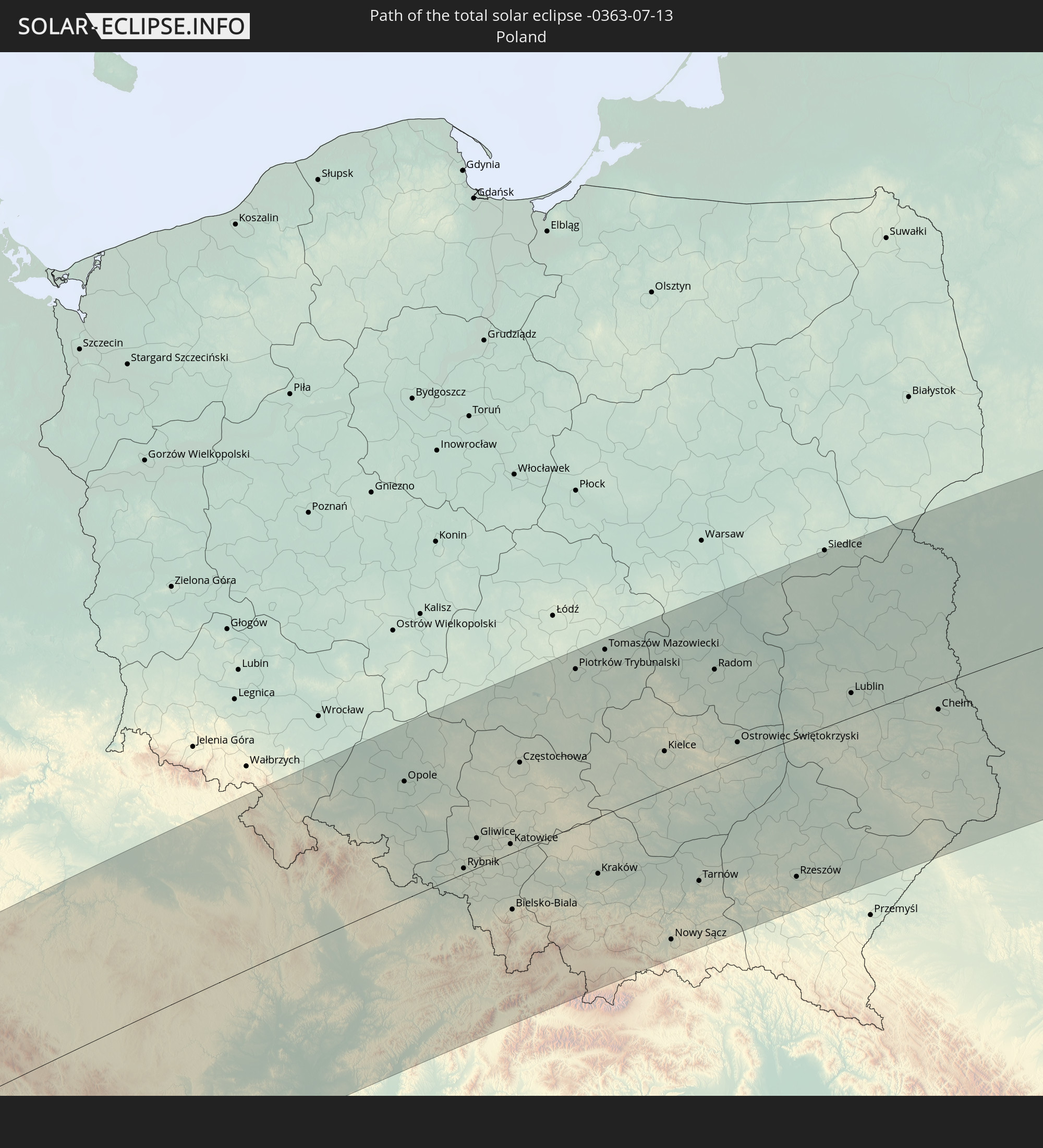 Poland
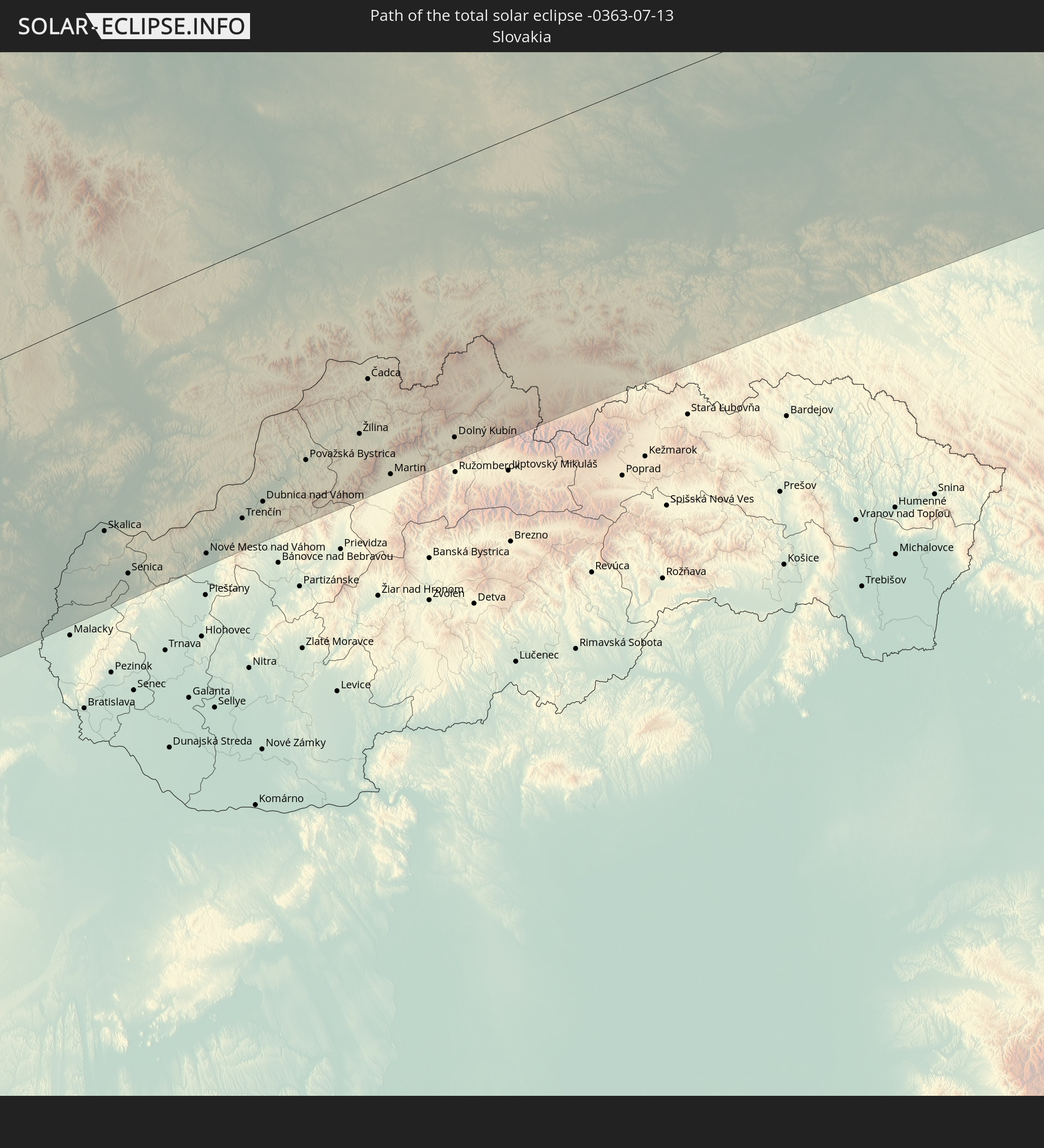 Slovakia
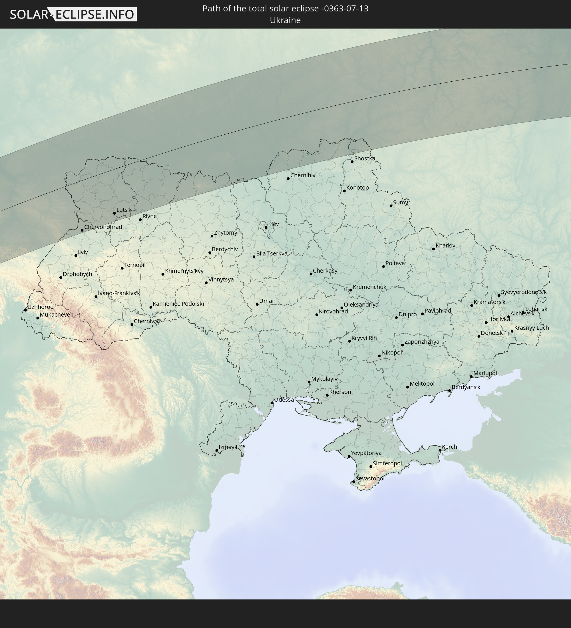 Ukraine
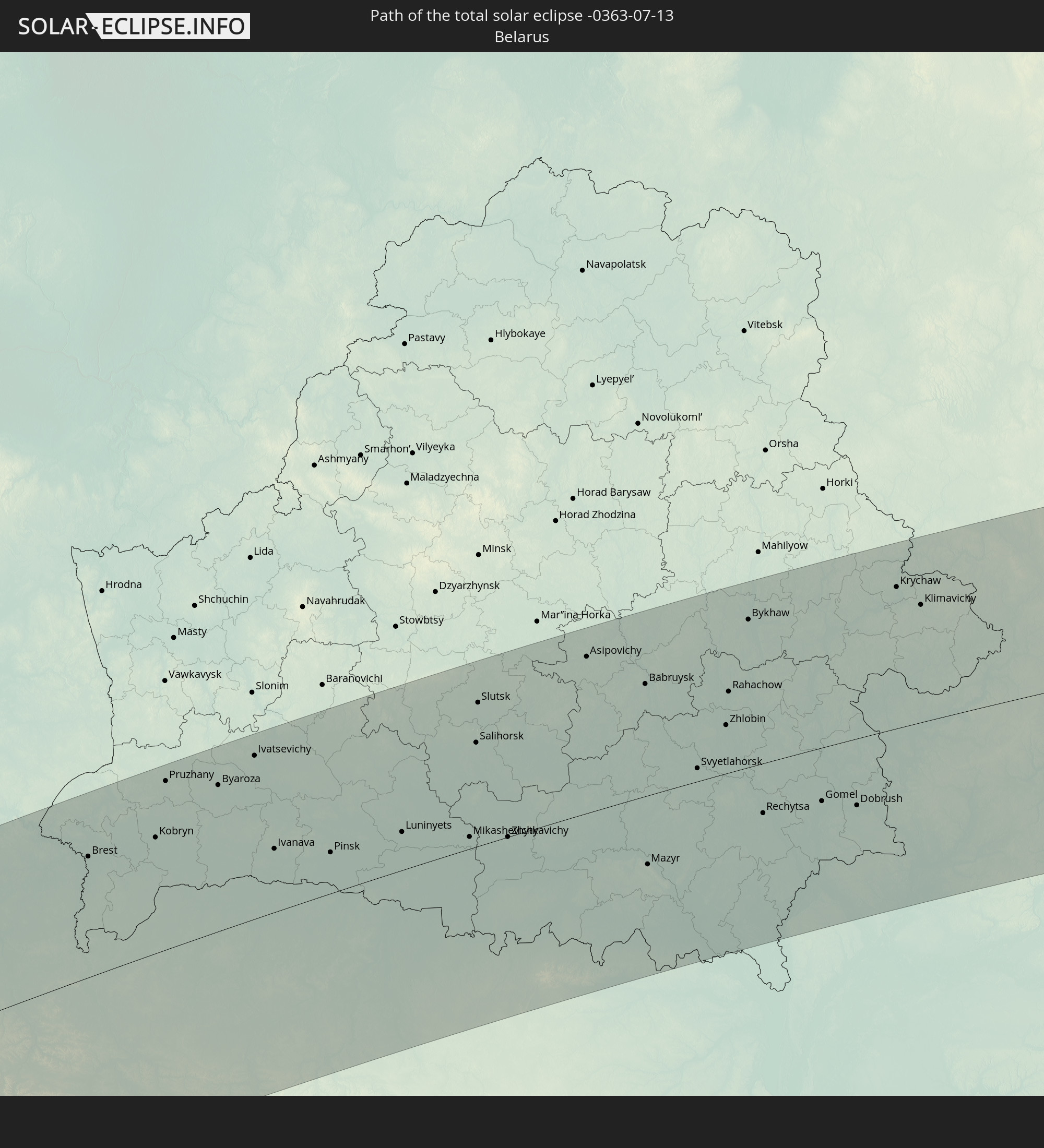 Belarus
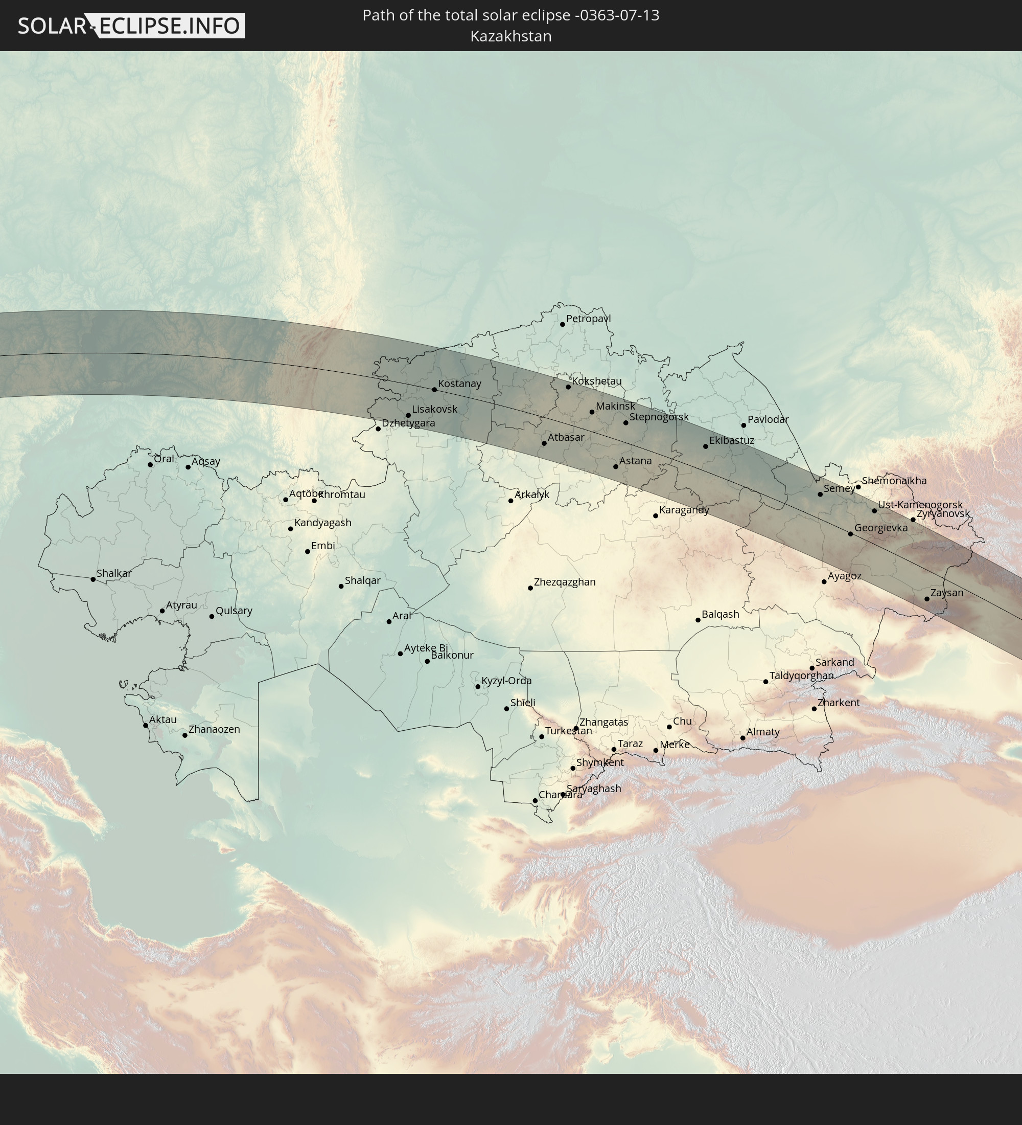 Kazakhstan
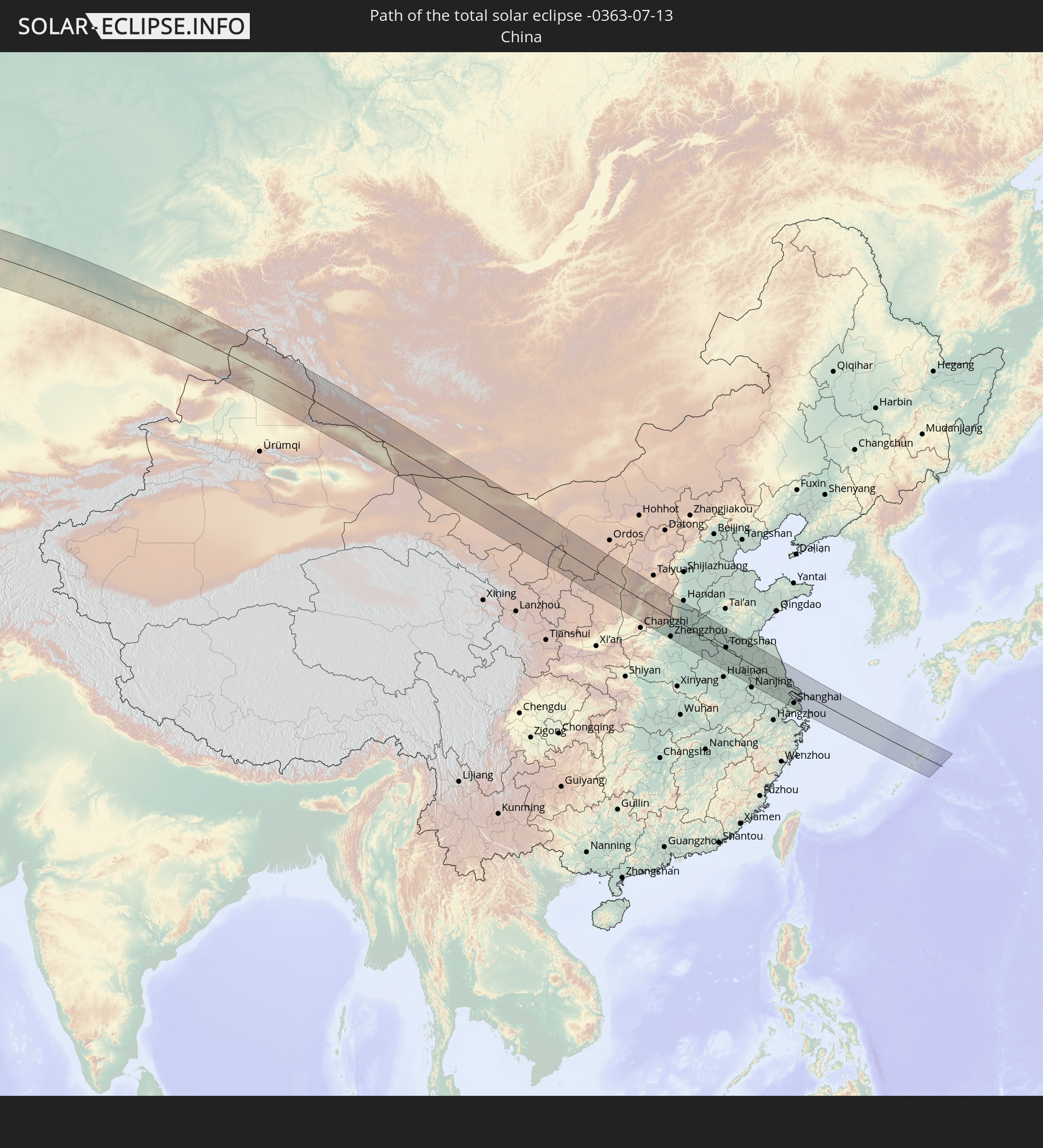 China
China
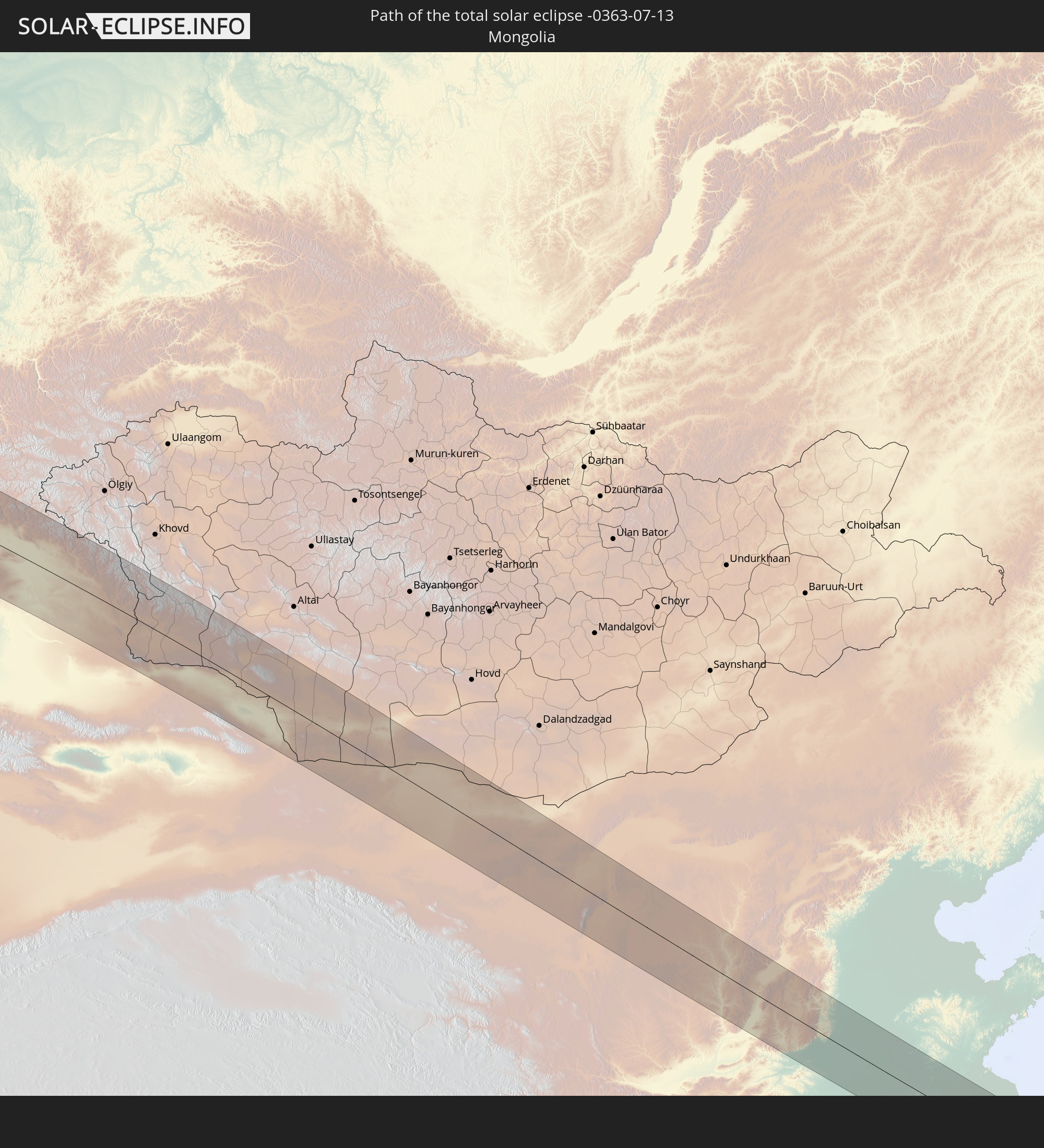 Mongolia
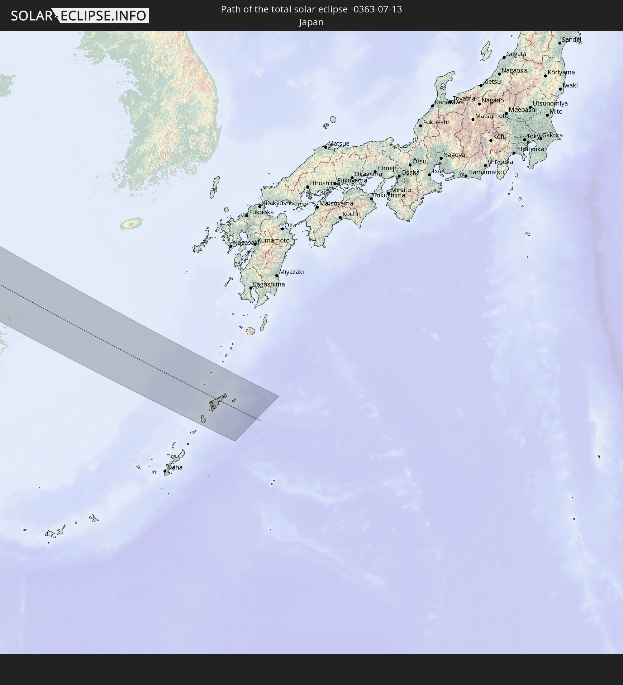 Japan
Japan
In den folgenden Ländern ist die Sonnenfinsternis partiell zu sehen
 Russia
 United States
 Canada
 Greenland
 Portugal
 Iceland
 Spain
Spain
 Senegal
 Mauritania
 The Gambia
 Guinea-Bissau
 Guinea
 Sierra Leone
 Morocco
 Mali
Mali
 Liberia
 Republic of Ireland
 Svalbard and Jan Mayen
 Algeria
 United Kingdom
 Ivory Coast
 Faroe Islands
 Burkina Faso
 Gibraltar
 France
 Isle of Man
 Ghana
Ghana
 Guernsey
 Jersey
 Togo
Togo
 Niger
Niger
 Benin
Benin
 Andorra
 Belgium
 Nigeria
 Netherlands
 Norway
 Luxembourg
 Germany
 Switzerland
 Italy
Italy
 Monaco
 Tunisia
 Denmark
 Cameroon
 Libya
Libya
 Liechtenstein
 Austria
 Sweden
 Czechia
 San Marino
 Vatican City
 Slovenia
 Chad
Chad
 Croatia
 Poland
 Malta
Malta
 Bosnia and Herzegovina
 Hungary
 Slovakia
 Montenegro
 Serbia
 Albania
 Åland Islands
 Greece
 Romania
 Republic of Macedonia
 Finland
 Lithuania
 Latvia
 Estonia
 Sudan
Sudan
 Ukraine
 Bulgaria
 Belarus
 Egypt
Egypt
 Turkey
 Moldova
 Cyprus
 State of Palestine
 Israel
 Saudi Arabia
 Jordan
 Lebanon
 Syria
Syria
 Iraq
Iraq
 Georgia
 Armenia
 Iran
Iran
 Azerbaijan
 Kazakhstan
 Kuwait
 Bahrain
 Qatar
Qatar
 United Arab Emirates
 Oman
Oman
 Turkmenistan
 Uzbekistan
 Afghanistan
 Pakistan
 Tajikistan
 India
India
 Kyrgyzstan
 China
China
 Nepal
Nepal
 Mongolia
 Bangladesh
 Bhutan
 Myanmar
 Indonesia
 Thailand
 Malaysia
 Laos
Laos
 Vietnam
 Cambodia
 Macau
Macau
 Hong Kong
 Brunei
 Taiwan
 Philippines
 Japan
Japan
 North Korea
 South Korea
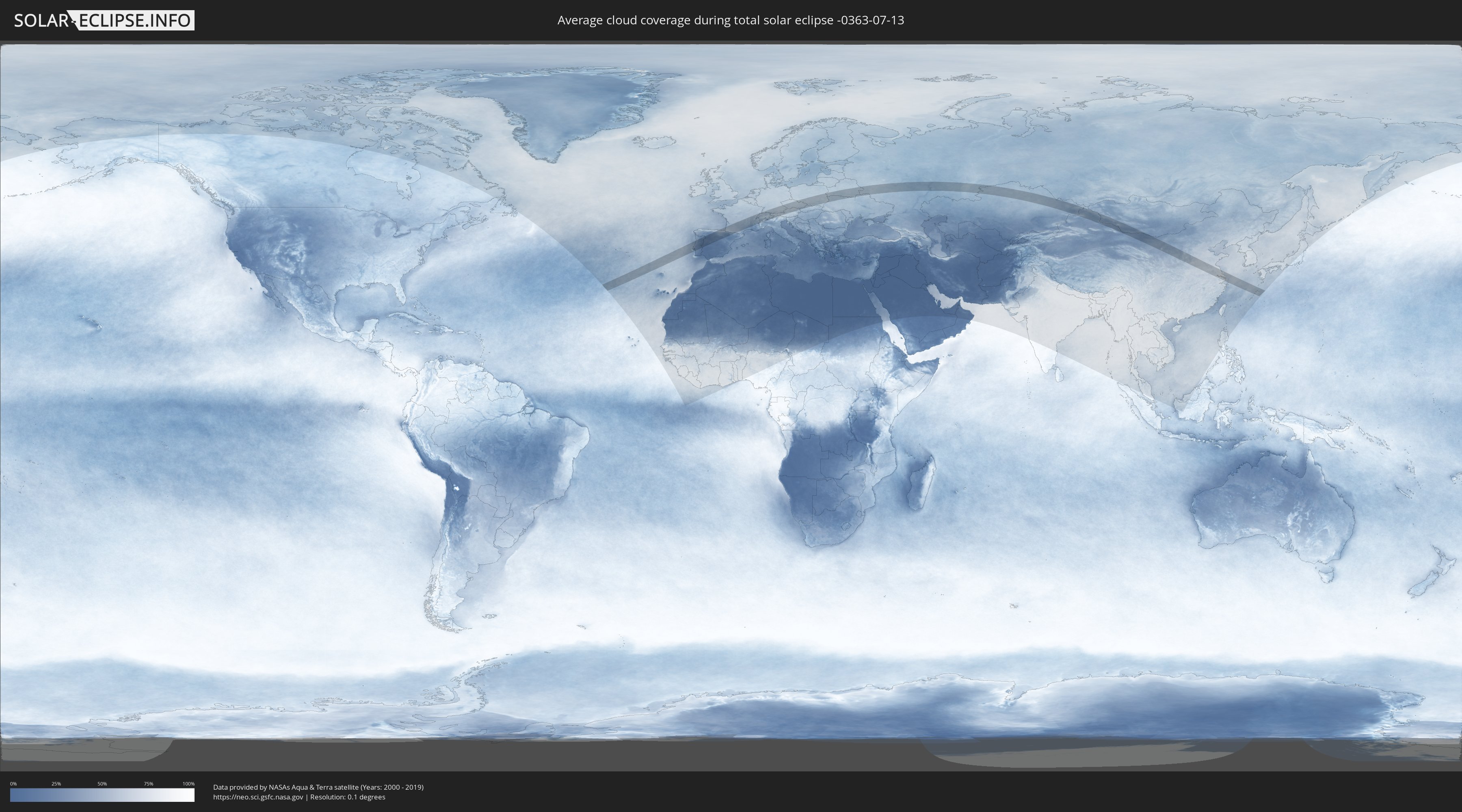
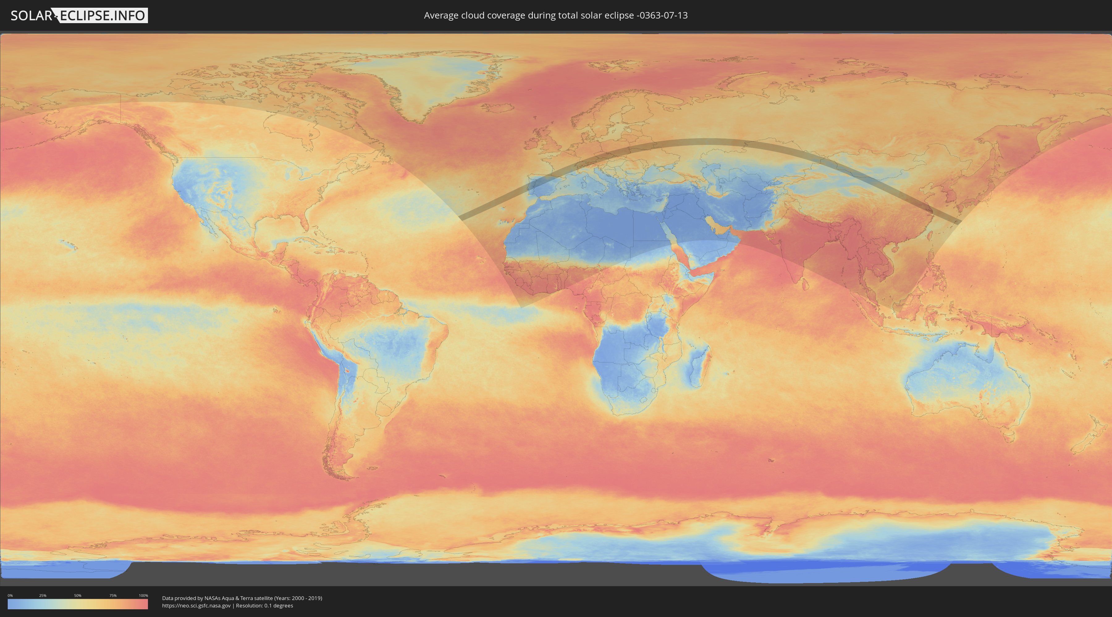
How will be the weather during the total solar eclipse on 07/13/-0363?
Where is the best place to see the total solar eclipse of 07/13/-0363?
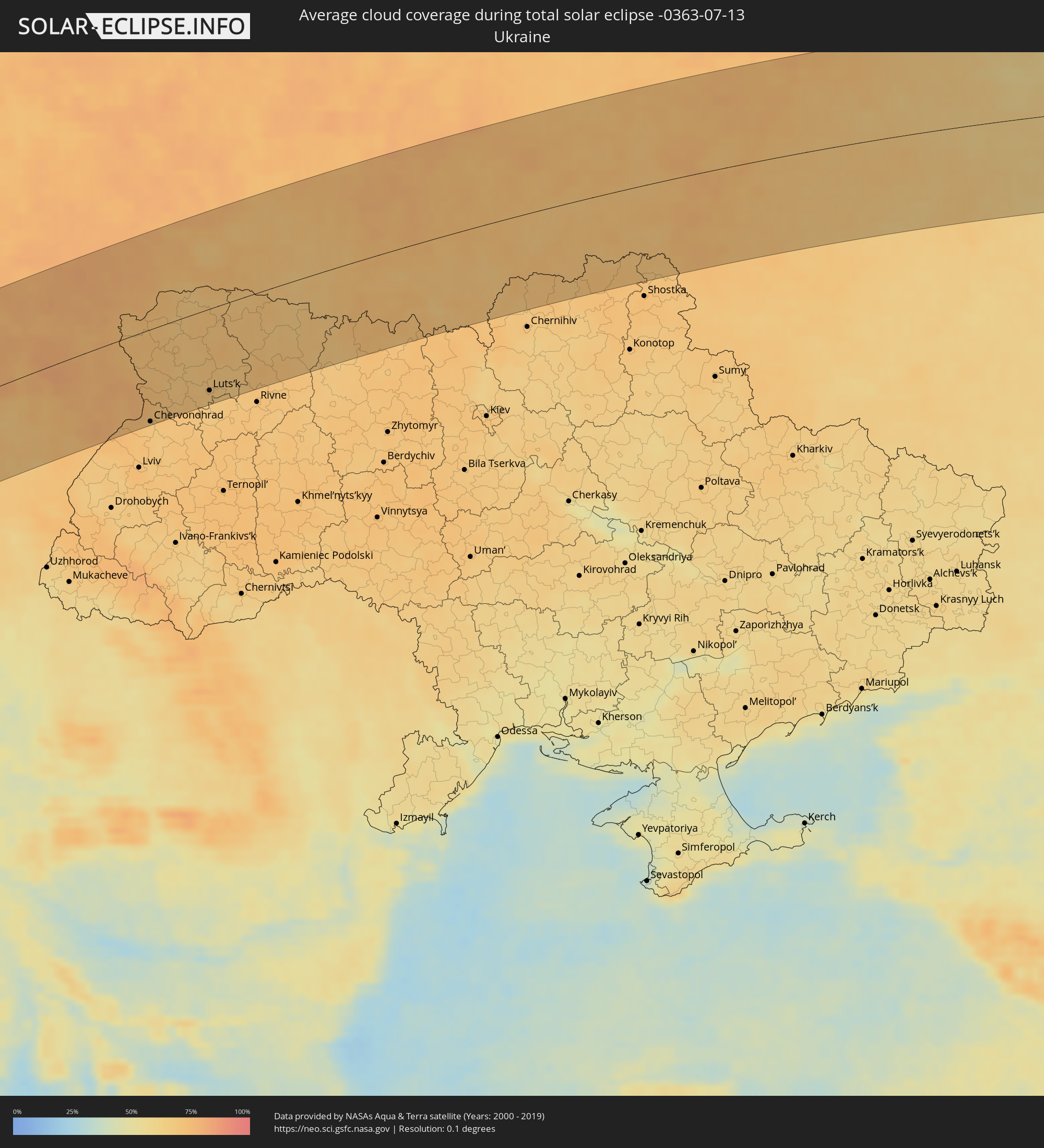
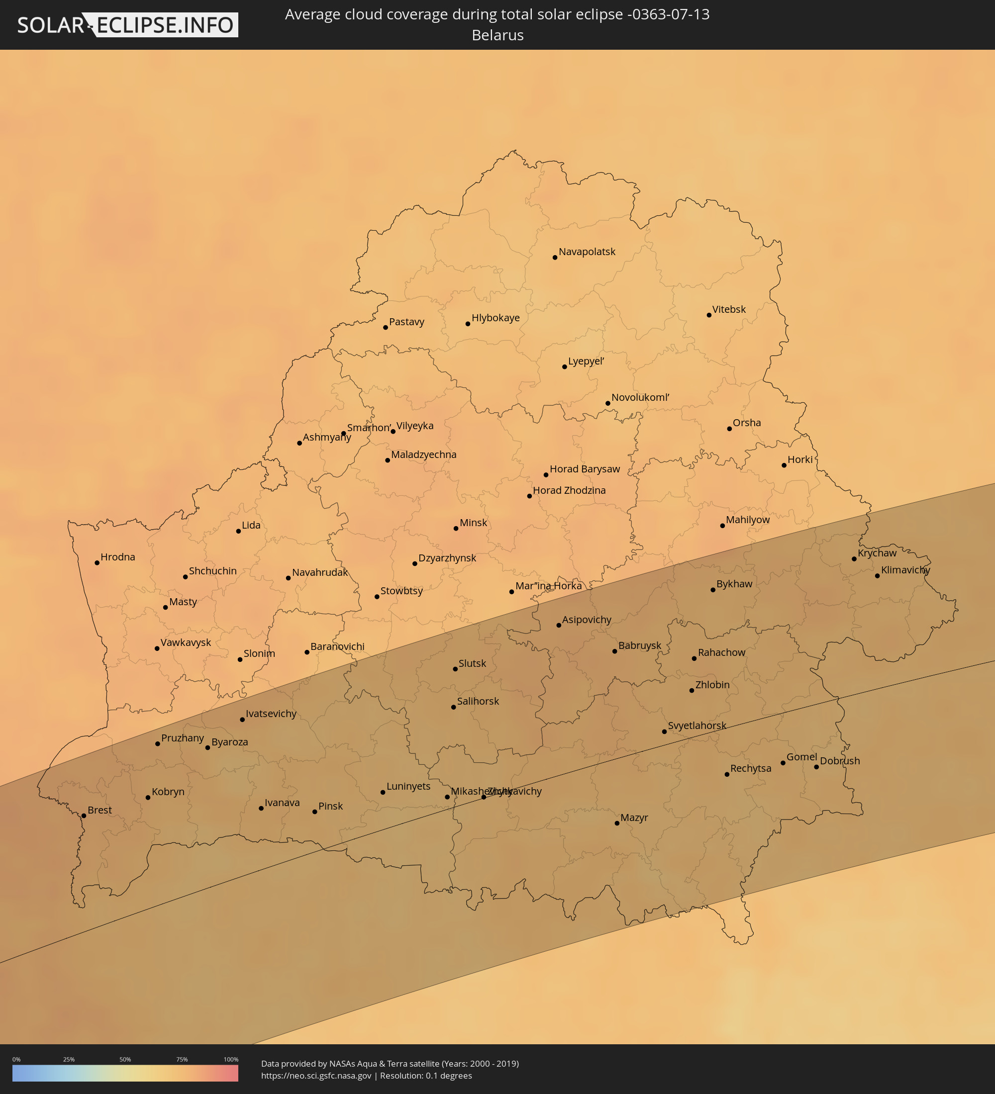
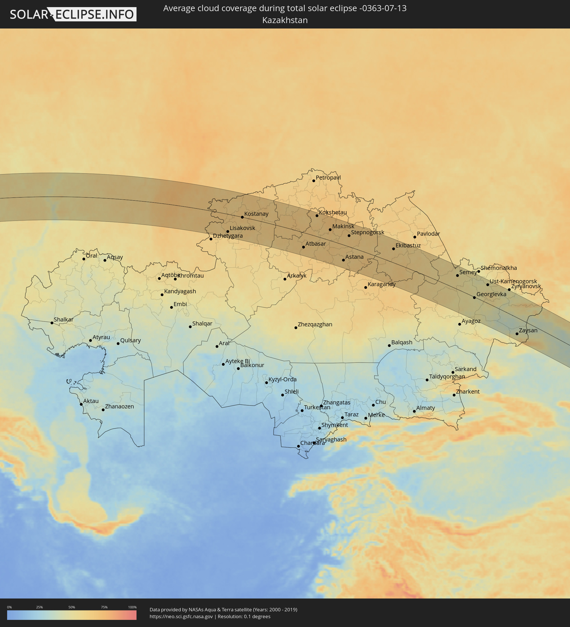
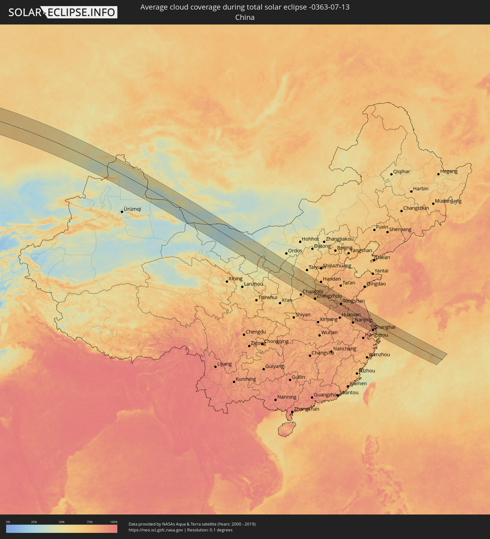
The following maps show the average cloud coverage for the day of the total solar eclipse.
With the help of these maps, it is possible to find the place along the eclipse path, which has the best
chance of a cloudless sky.
Nevertheless, you should consider local circumstances and inform about the weather of your chosen
observation site.
The data is provided by NASAs satellites
AQUA and TERRA.
The cloud maps are averaged over a period of 19 years (2000 - 2019).
Detailed country maps
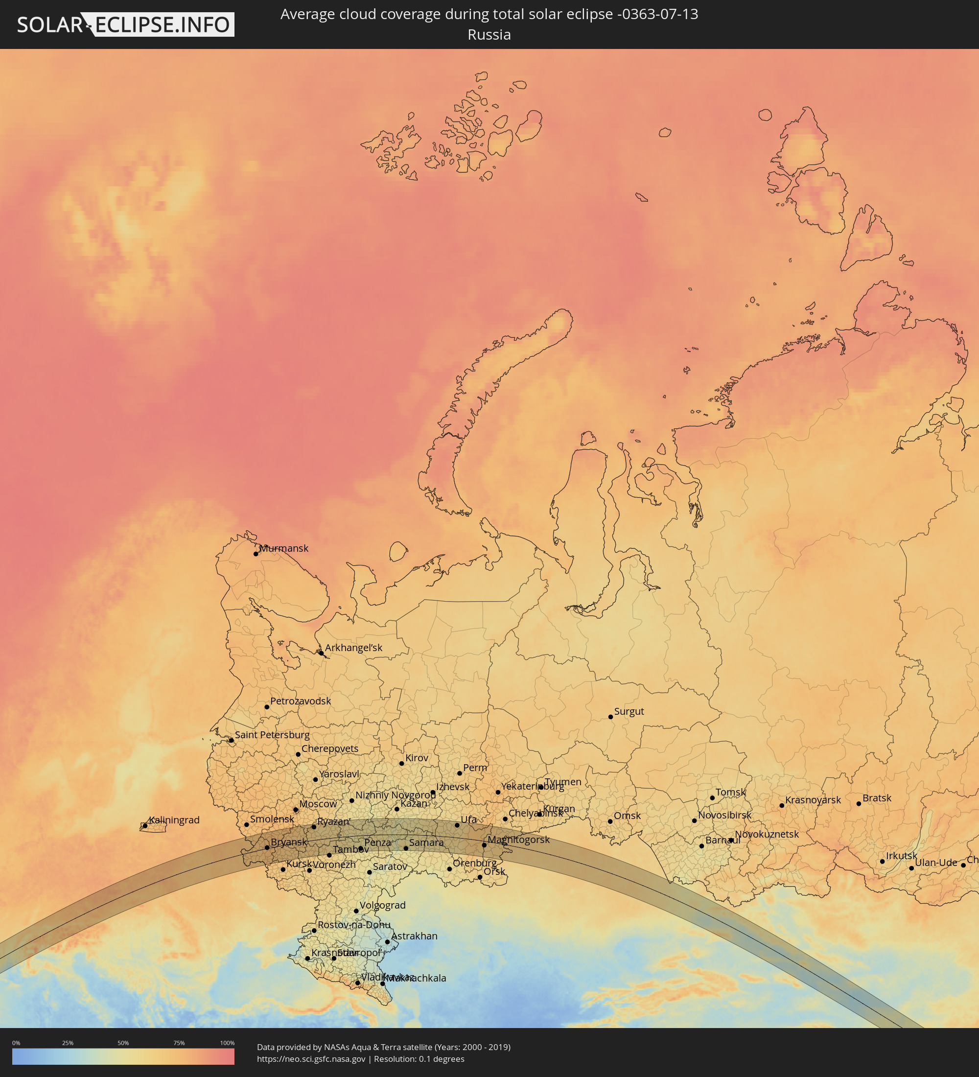 Russia
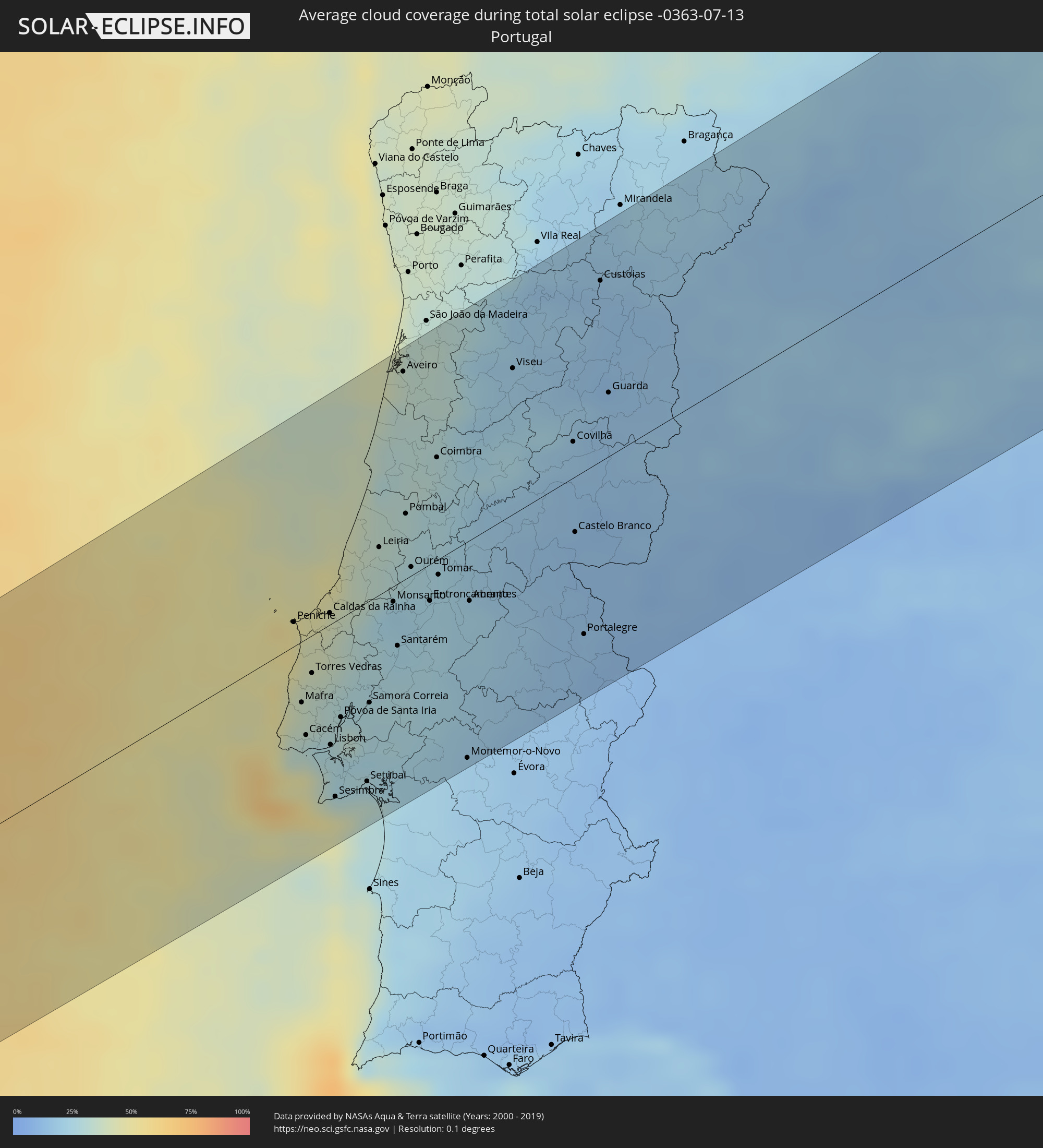 Portugal
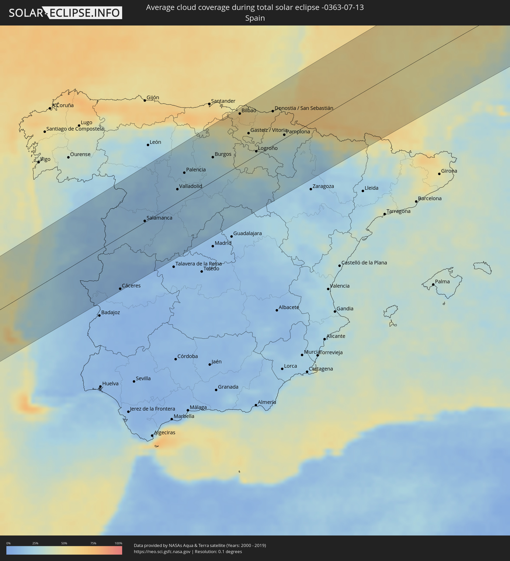 Spain
Spain
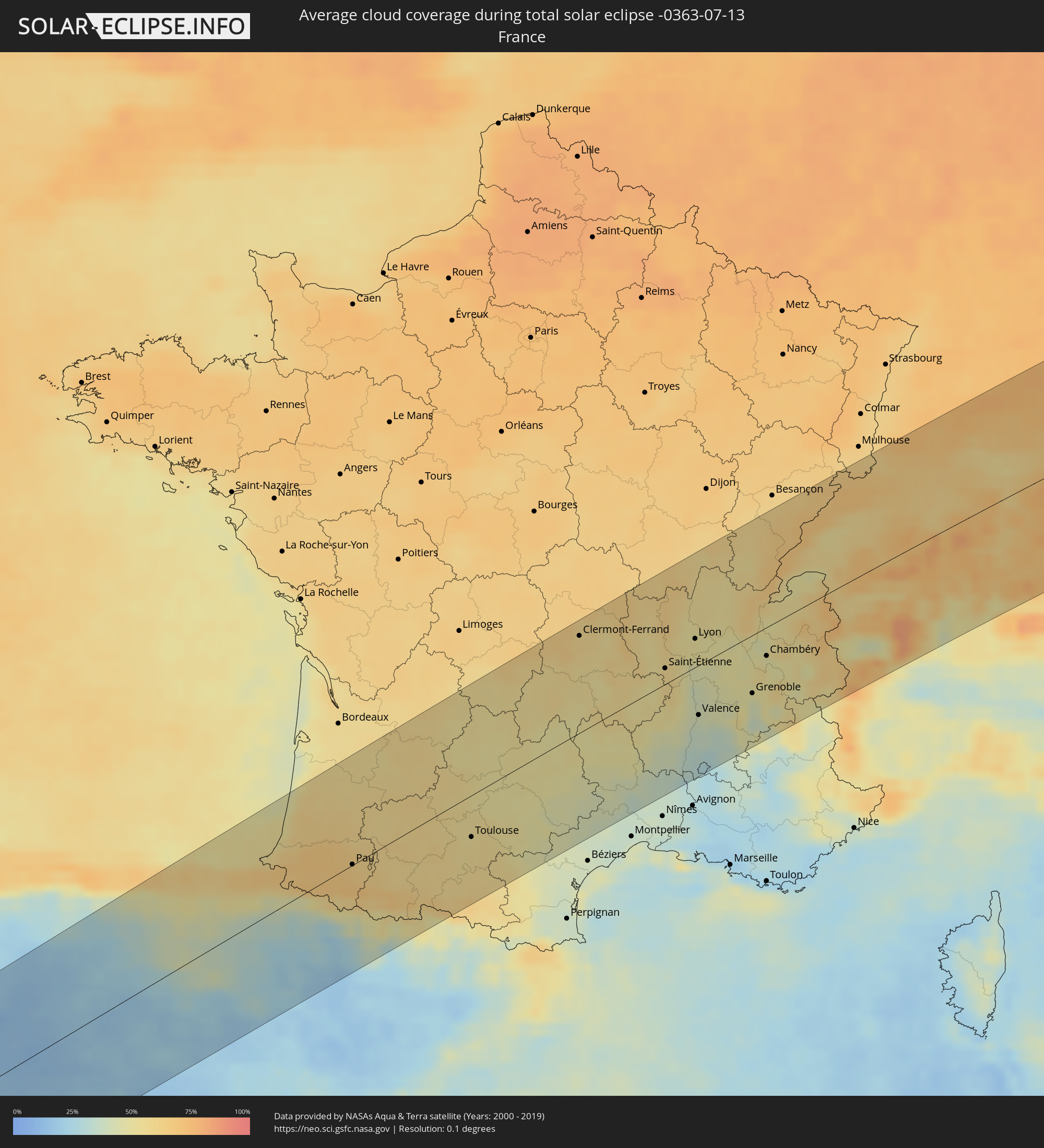 France
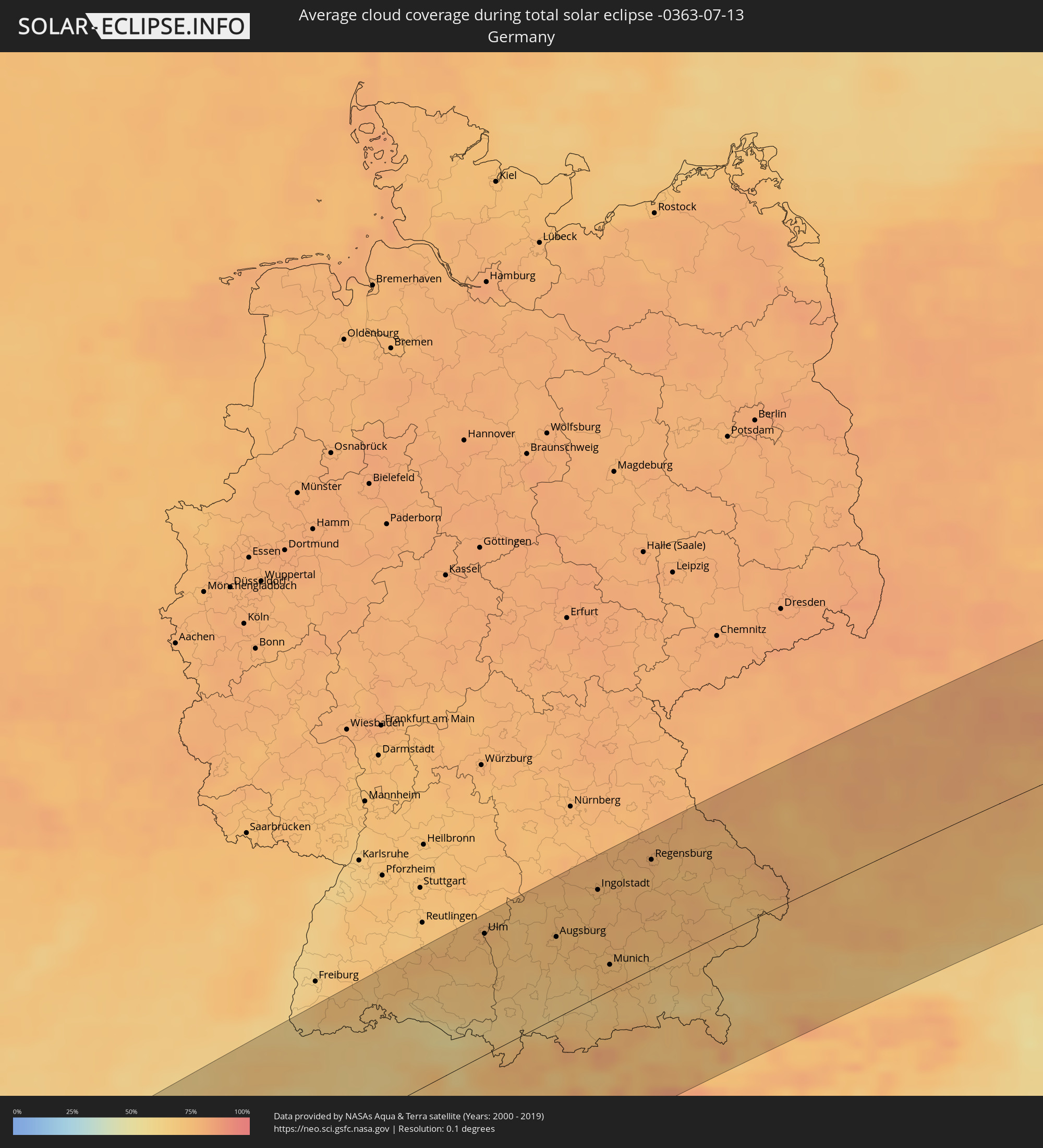 Germany
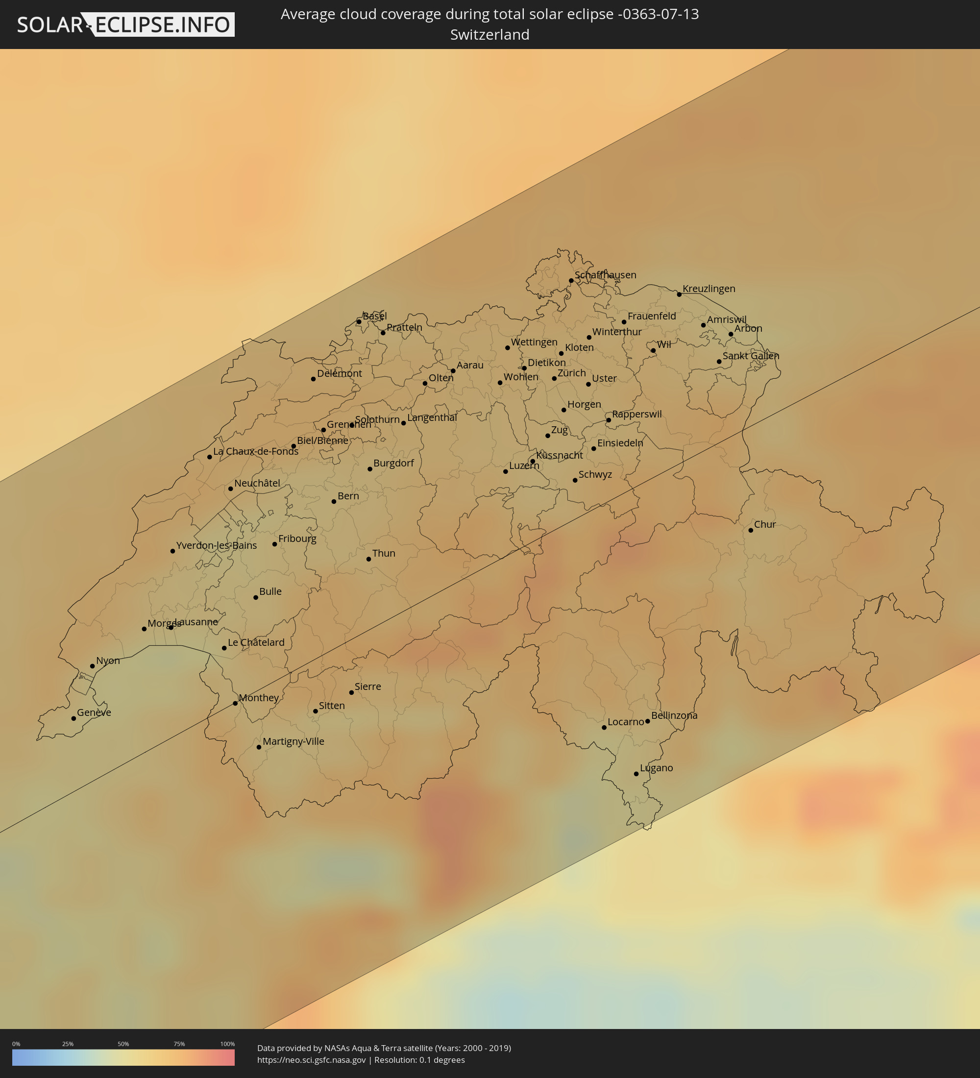 Switzerland
 Italy
Italy
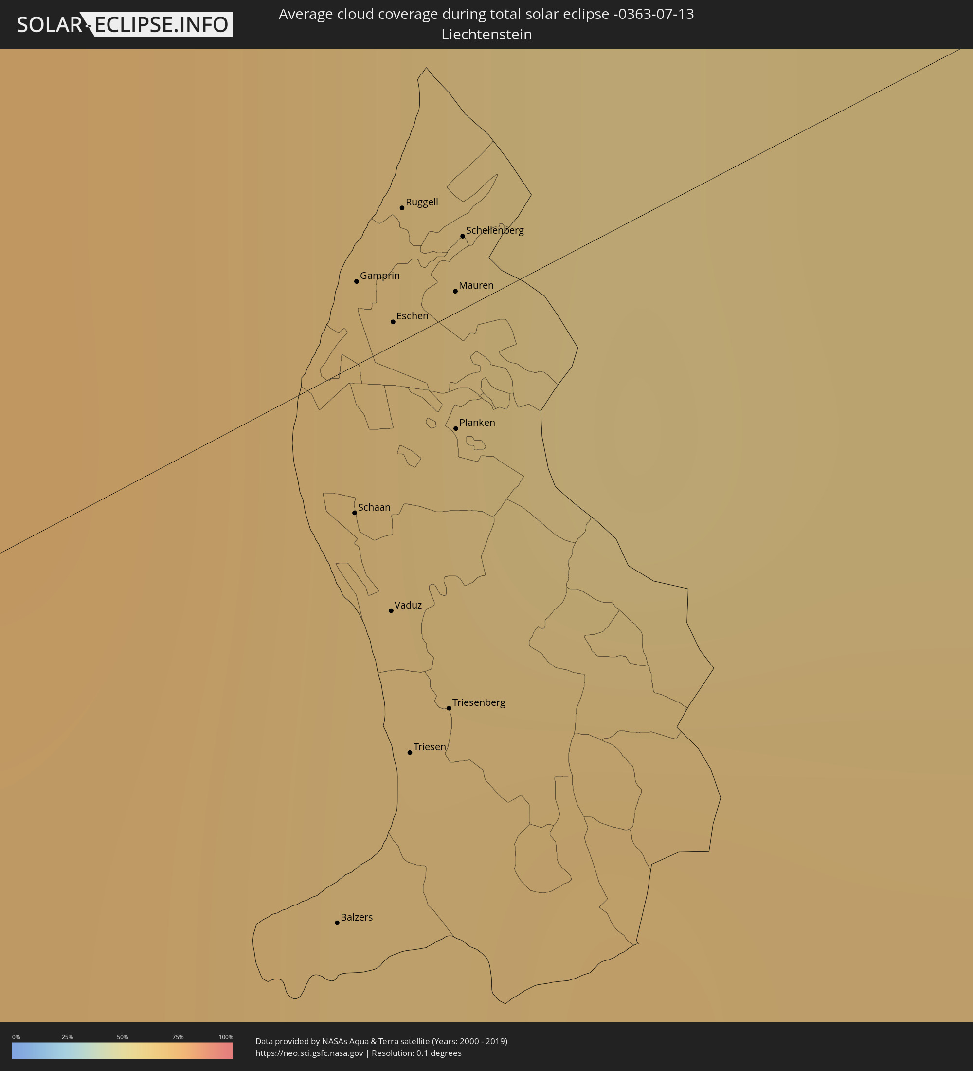 Liechtenstein
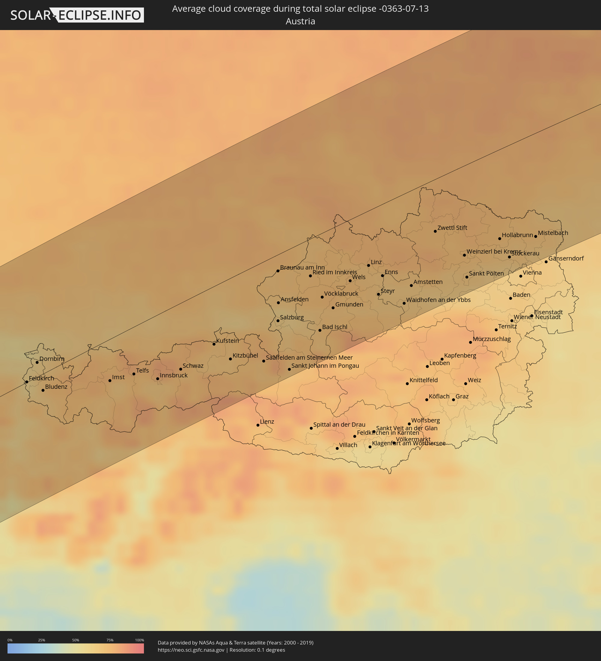 Austria
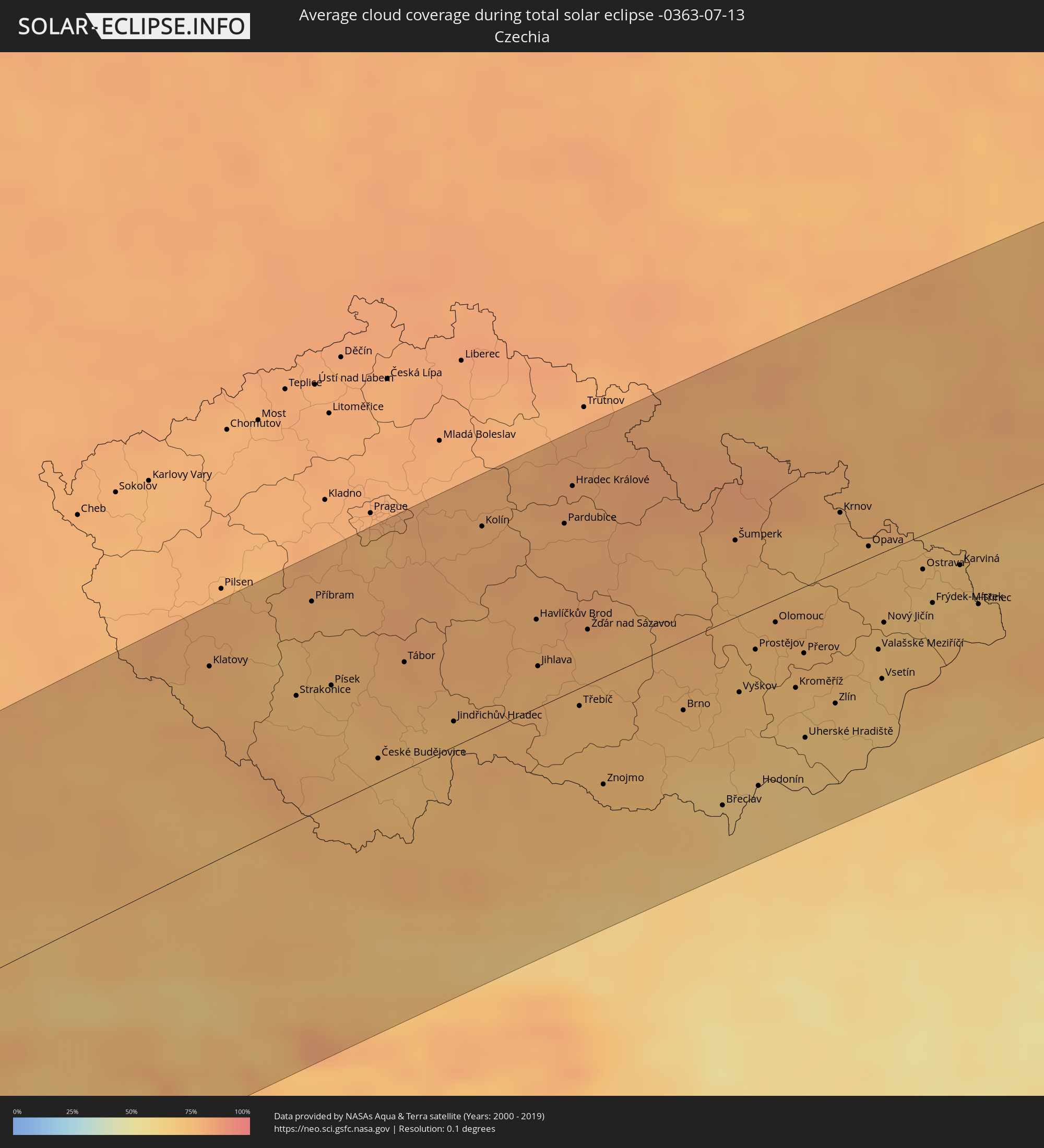 Czechia
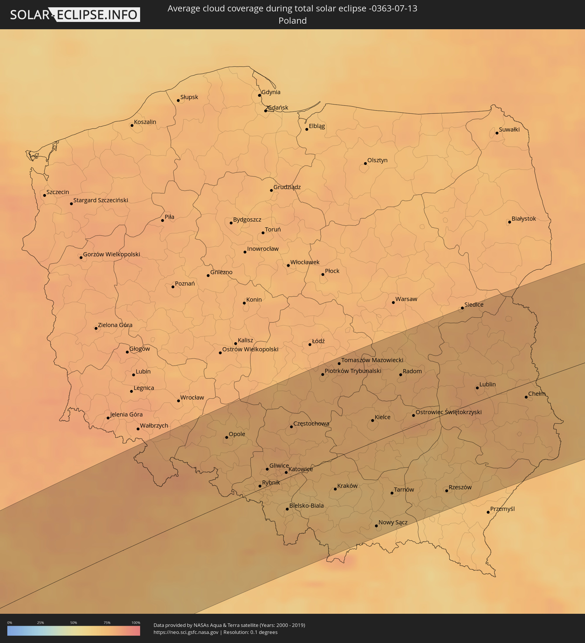 Poland
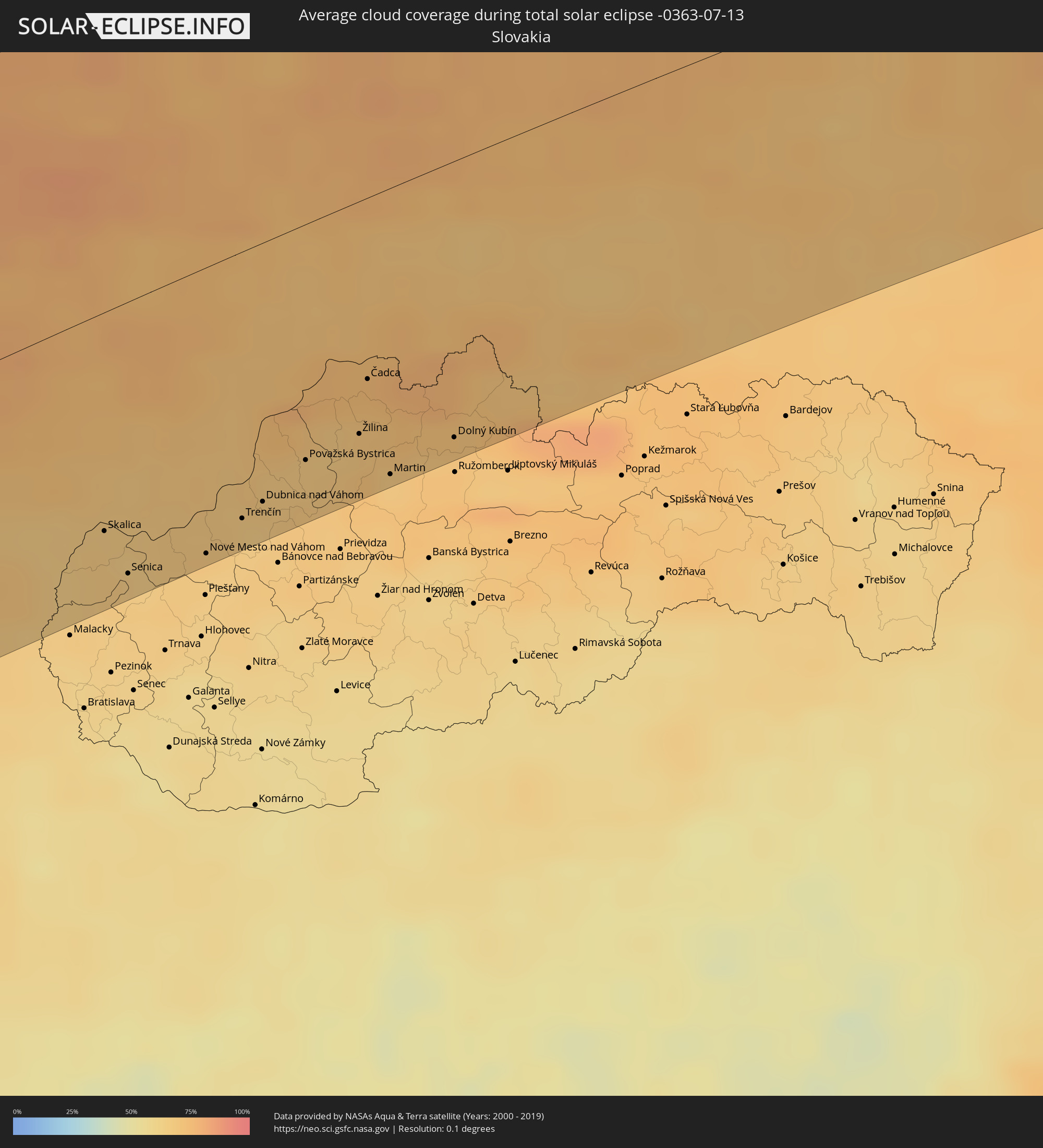 Slovakia
 Ukraine
 Belarus
 Kazakhstan
 China
China
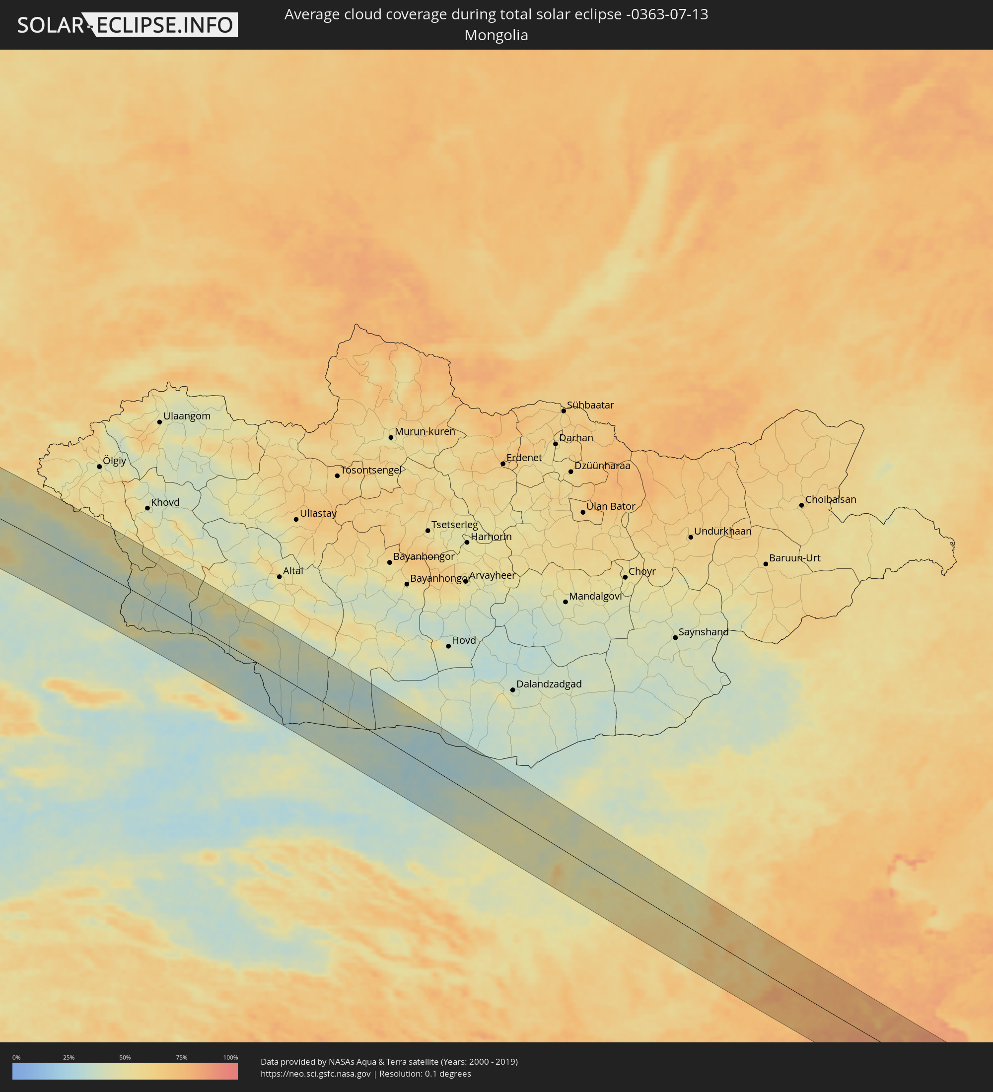 Mongolia
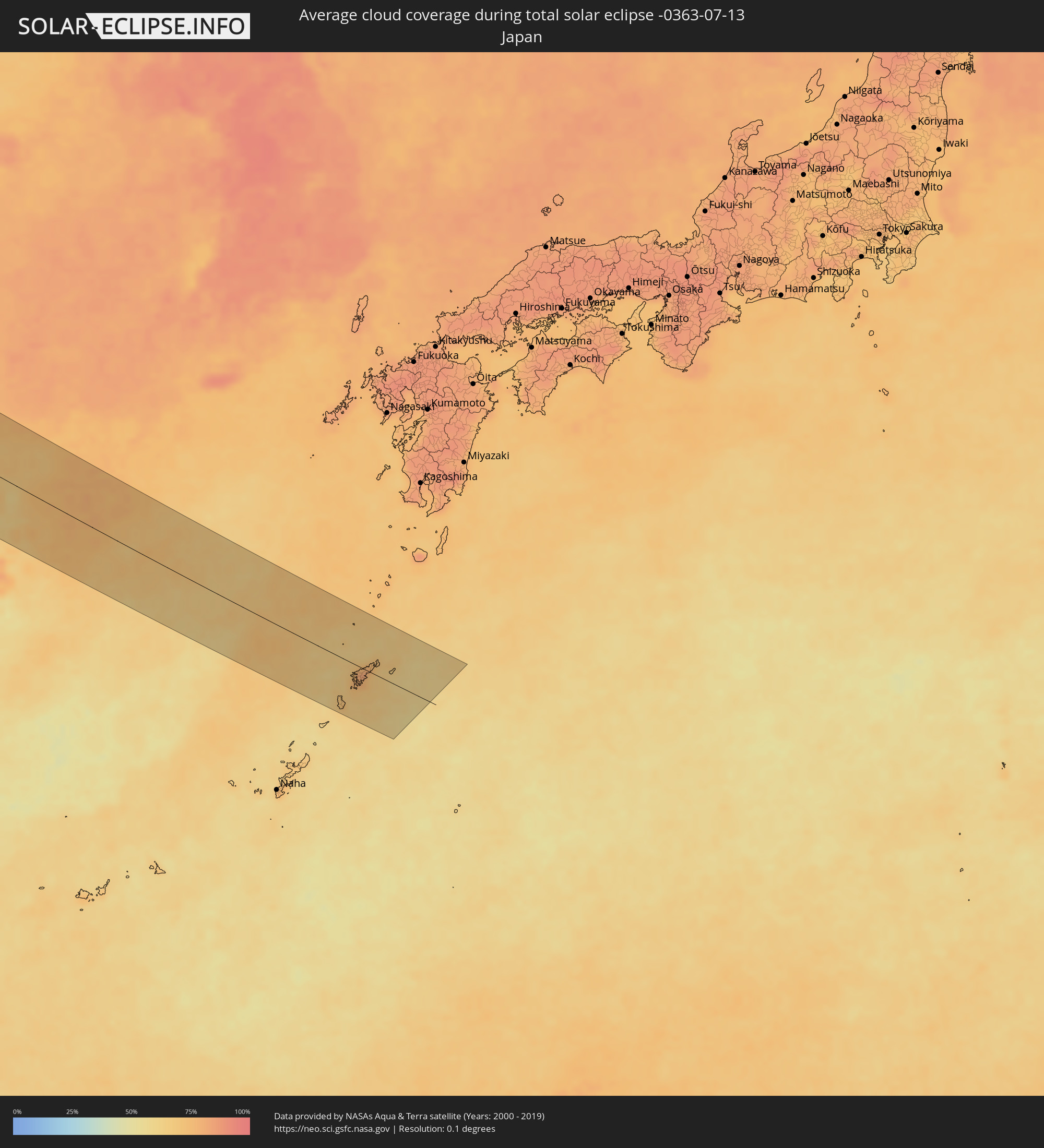 Japan
Japan
Cities inside the path of the eclipse
The following table shows all locations with a population of more than 5,000 inside the eclipse path. Cities which have more than 100,000 inhabitants are marked bold. A click at the locations opens a detailed map.
| City | Type | Eclipse duration | Local time of max. eclipse | Distance to central line | Ø Cloud coverage |
|
Cacém, Lisbon
|
total | - | 06:41:35 UTC-00:36 | 49 km | 31% |
|
Lisbon, Lisbon
|
total | - | 06:41:33 UTC-00:36 | 60 km | 27% |
|
Sesimbra, Setúbal
|
total | - | 06:41:11 UTC-00:36 | 88 km | 46% |
|
Póvoa de Santa Iria, Lisbon
|
total | - | 06:41:45 UTC-00:36 | 51 km | 29% |
|
Setúbal, Setúbal
|
total | - | 06:41:20 UTC-00:36 | 90 km | 34% |
|
Leiria, Leiria
|
total | - | 06:43:01 UTC-00:36 | 29 km | 32% |
|
Monsanto, Santarém
|
total | - | 06:42:39 UTC-00:36 | 26 km | 22% |
|
Santarém, Santarém
|
total | - | 06:42:20 UTC-00:36 | 33 km | 25% |
|
Aveiro, Aveiro
|
total | - | 06:44:18 UTC-00:36 | 102 km | 33% |
|
Coimbra, Coimbra
|
total | - | 06:43:45 UTC-00:36 | 52 km | 29% |
|
Castelo Branco, Castelo Branco
|
total | - | 06:43:26 UTC-00:36 | 27 km | 13% |
|
Guarda, Guarda
|
total | - | 06:44:29 UTC-00:36 | 32 km | 16% |
|
Cáceres, Extremadura
|
total | - | 07:19:59 UTC+00:00 | 109 km | 11% |
|
Zamora, Castille and León
|
total | - | 07:23:03 UTC+00:00 | 57 km | 14% |
|
Salamanca, Castille and León
|
total | - | 07:22:18 UTC+00:00 | 2 km | 16% |
|
Valladolid, Castille and León
|
total | - | 07:23:36 UTC+00:00 | 27 km | 19% |
|
Palencia, Castille and León
|
total | - | 07:24:11 UTC+00:00 | 52 km | 22% |
|
Burgos, Castille and León
|
total | - | 07:24:57 UTC+00:00 | 49 km | 27% |
|
Bilbao, Basque Country
|
total | - | 07:26:37 UTC+00:00 | 104 km | 64% |
|
Gasteiz / Vitoria, Basque Country
|
total | - | 07:26:06 UTC+00:00 | 54 km | 44% |
|
Logroño, La Rioja
|
total | - | 07:25:38 UTC+00:00 | 8 km | 37% |
|
Donostia / San Sebastián, Basque Country
|
total | - | 07:27:05 UTC+00:00 | 69 km | 63% |
|
Irun, Basque Country
|
total | - | 07:27:12 UTC+00:00 | 63 km | 66% |
|
Pamplona, Navarre
|
total | - | 07:26:30 UTC+00:00 | 7 km | 38% |
|
Pau, Nouvelle-Aquitaine
|
total | - | 07:37:09 UTC+00:09 | 1 km | 64% |
|
Tarbes, Occitania
|
total | - | 07:37:16 UTC+00:09 | 24 km | 61% |
|
Montauban, Occitania
|
total | - | 07:39:05 UTC+00:09 | 14 km | 55% |
|
Toulouse, Occitania
|
total | - | 07:38:31 UTC+00:09 | 44 km | 54% |
|
Brive-la-Gaillarde, Nouvelle-Aquitaine
|
total | - | 07:40:53 UTC+00:09 | 102 km | 55% |
|
Albi, Occitania
|
total | - | 07:39:23 UTC+00:09 | 42 km | 50% |
|
Clermont-Ferrand, Auvergne-Rhône-Alpes
|
total | - | 07:42:43 UTC+00:09 | 100 km | 59% |
|
Saint-Étienne, Auvergne-Rhône-Alpes
|
total | - | 07:42:59 UTC+00:09 | 16 km | 57% |
|
Lyon, Auvergne-Rhône-Alpes
|
total | - | 07:43:45 UTC+00:09 | 29 km | 50% |
|
Valence, Auvergne-Rhône-Alpes
|
total | - | 07:42:34 UTC+00:09 | 52 km | 38% |
|
Grenoble, Auvergne-Rhône-Alpes
|
total | - | 07:43:27 UTC+00:09 | 62 km | 44% |
|
Chambéry, Auvergne-Rhône-Alpes
|
total | - | 07:44:12 UTC+00:09 | 37 km | 48% |
|
Genève, Geneva
|
total | - | 08:35:57 UTC+01:00 | 30 km | 53% |
|
Lausanne, Vaud
|
total | - | 08:36:46 UTC+01:00 | 37 km | 47% |
|
La Chaux-de-Fonds, Neuchâtel
|
total | - | 08:37:47 UTC+01:00 | 87 km | 68% |
|
Biel/Bienne, Bern
|
total | - | 08:38:08 UTC+01:00 | 77 km | 57% |
|
Aosta, Aosta Valley
|
total | - | 08:36:05 UTC+01:00 | 65 km | 48% |
|
Bern, Bern
|
total | - | 08:38:00 UTC+01:00 | 53 km | 59% |
|
Basel, Basel-City
|
total | - | 08:39:00 UTC+01:00 | 106 km | 62% |
|
Thun, Bern
|
total | - | 08:37:49 UTC+01:00 | 31 km | 63% |
|
Cuorgnè, Piedmont
|
total | - | 08:35:48 UTC+01:00 | 111 km | 54% |
|
Ivrea, Piedmont
|
total | - | 08:36:05 UTC+01:00 | 112 km | 51% |
|
Biella, Piedmont
|
total | - | 08:36:22 UTC+01:00 | 109 km | 53% |
|
Domodossola, Piedmont
|
total | - | 08:37:22 UTC+01:00 | 64 km | 58% |
|
Luzern, Lucerne
|
total | - | 08:38:47 UTC+01:00 | 28 km | 62% |
|
Borgomanero, Piedmont
|
total | - | 08:36:52 UTC+01:00 | 112 km | 49% |
|
Zürich, Zurich
|
total | - | 08:39:26 UTC+01:00 | 52 km | 60% |
|
Verbania, Piedmont
|
total | - | 08:37:16 UTC+01:00 | 92 km | 42% |
|
Winterthur, Zurich
|
total | - | 08:39:47 UTC+01:00 | 58 km | 63% |
|
Luino, Lombardy
|
total | - | 08:37:33 UTC+01:00 | 92 km | 47% |
|
Rapperswil, Saint Gallen
|
total | - | 08:39:26 UTC+01:00 | 27 km | 63% |
|
Varese, Lombardy
|
total | - | 08:37:20 UTC+01:00 | 112 km | 51% |
|
Konstanz, Baden-Württemberg
|
total | - | 08:40:21 UTC+01:00 | 57 km | 57% |
|
Sankt Gallen, Saint Gallen
|
total | - | 08:40:10 UTC+01:00 | 27 km | 67% |
|
Friedrichshafen, Baden-Württemberg
|
total | - | 08:40:35 UTC+01:00 | 50 km | 55% |
|
Balzers, Balzers
|
total | - | 08:39:44 UTC+01:00 | 15 km | 64% |
|
Schaan, Schaan
|
total | - | 08:39:53 UTC+01:00 | 4 km | 65% |
|
Gamprin, Gamprin
|
total | - | 08:39:58 UTC+01:00 | 3 km | 65% |
|
Vaduz, Vaduz
|
total | - | 08:39:51 UTC+01:00 | 6 km | 64% |
|
Eschen, Eschen
|
total | - | 08:39:57 UTC+01:00 | 2 km | 65% |
|
Ruggell, Ruggell
|
total | - | 08:40:00 UTC+01:00 | 5 km | 65% |
|
Triesen, Triesen
|
total | - | 08:39:48 UTC+01:00 | 10 km | 64% |
|
Triesenberg, Triesenberg
|
total | - | 08:39:50 UTC+01:00 | 9 km | 64% |
|
Mauren, Mauren
|
total | - | 08:39:59 UTC+01:00 | 4 km | 65% |
|
Planken, Planken
|
total | - | 08:39:56 UTC+01:00 | 4 km | 65% |
|
Schellenberg, Schellenberg
|
total | - | 08:40:00 UTC+01:00 | 5 km | 65% |
|
Morbegno, Lombardy
|
total | - | 08:38:24 UTC+01:00 | 107 km | 70% |
|
Feldkirch, Vorarlberg
|
total | - | 08:40:03 UTC+01:00 | 9 km | 66% |
|
Ravensburg, Baden-Württemberg
|
total | - | 08:40:53 UTC+01:00 | 54 km | 63% |
|
Dornbirn, Vorarlberg
|
total | - | 08:40:26 UTC+01:00 | 20 km | 63% |
|
Sondrio, Lombardy
|
total | - | 08:38:41 UTC+01:00 | 116 km | 60% |
|
Ulm, Baden-Württemberg
|
total | - | 08:42:06 UTC+01:00 | 102 km | 72% |
|
Kempten (Allgäu), Bavaria
|
total | - | 08:41:21 UTC+01:00 | 24 km | 64% |
|
Augsburg, Bavaria
|
total | - | 08:42:48 UTC+01:00 | 69 km | 74% |
|
Merano, Trentino-Alto Adige
|
total | - | 08:40:29 UTC+01:00 | 110 km | 62% |
|
Innsbruck, Tyrol
|
total | - | 08:41:34 UTC+01:00 | 59 km | 68% |
|
Ingolstadt, Bavaria
|
total | - | 08:43:49 UTC+01:00 | 89 km | 73% |
|
Munich, Bavaria
|
total | - | 08:43:01 UTC+01:00 | 28 km | 74% |
|
Regensburg, Bavaria
|
total | - | 08:44:45 UTC+01:00 | 92 km | 75% |
|
Rosenheim, Bavaria
|
total | - | 08:43:04 UTC+01:00 | 25 km | 67% |
|
Landshut, Bavaria
|
total | - | 08:44:05 UTC+01:00 | 42 km | 75% |
|
Braunau am Inn, Upper Austria
|
total | - | 08:44:28 UTC+01:00 | 16 km | 70% |
|
Salzburg, Salzburg
|
total | - | 08:43:48 UTC+01:00 | 63 km | 69% |
|
Passau, Bavaria
|
total | - | 08:45:16 UTC+01:00 | 5 km | 70% |
|
Wels, Upper Austria
|
total | - | 08:45:14 UTC+01:00 | 59 km | 74% |
|
Linz, Upper Austria
|
total | - | 08:45:40 UTC+01:00 | 50 km | 70% |
|
Steyr, Upper Austria
|
total | - | 08:45:25 UTC+01:00 | 81 km | 68% |
|
České Budějovice, Jihočeský
|
total | - | 08:46:48 UTC+01:00 | 11 km | 74% |
|
Amstetten, Lower Austria
|
total | - | 08:45:57 UTC+01:00 | 88 km | 67% |
|
Jihlava, Vysočina
|
total | - | 08:48:27 UTC+01:00 | 25 km | 76% |
|
Weinzierl bei Krems, Lower Austria
|
total | - | 08:47:03 UTC+01:00 | 83 km | 70% |
|
Sankt Pölten, Lower Austria
|
total | - | 08:46:48 UTC+01:00 | 103 km | 64% |
|
Pardubice, Pardubický
|
total | - | 08:49:33 UTC+01:00 | 80 km | 79% |
|
Hradec Králové, Královéhradecký
|
total | - | 08:49:50 UTC+01:00 | 94 km | 80% |
|
Klosterneuburg, Lower Austria
|
total | - | 08:47:38 UTC+01:00 | 115 km | 63% |
|
Brno, South Moravian
|
total | - | 08:49:10 UTC+01:00 | 33 km | 74% |
|
Prostějov, Olomoucký
|
total | - | 08:50:03 UTC+01:00 | 19 km | 73% |
|
Skalica, Trnavský
|
total | - | 08:49:18 UTC+01:00 | 88 km | 68% |
|
Olomouc, Olomoucký
|
total | - | 08:50:22 UTC+01:00 | 18 km | 75% |
|
Senica, Trnavský
|
total | - | 08:49:13 UTC+01:00 | 109 km | 66% |
|
Myjava, Trenčiansky
|
total | - | 08:49:32 UTC+01:00 | 105 km | 67% |
|
Zlín, Zlín
|
total | - | 08:50:17 UTC+01:00 | 62 km | 70% |
|
Stará Turá, Nitriansky
|
total | - | 08:49:41 UTC+01:00 | 107 km | 68% |
|
Nové Mesto nad Váhom, Trenčiansky
|
total | - | 08:49:48 UTC+01:00 | 114 km | 68% |
|
Opava, Moravskoslezský
|
total | - | 08:51:30 UTC+01:00 | 8 km | 73% |
|
Opole, Opole Voivodeship
|
total | - | 09:16:32 UTC+01:24 | 80 km | 77% |
|
Trenčín, Trenčiansky
|
total | - | 08:50:13 UTC+01:00 | 105 km | 67% |
|
Ostrava, Moravskoslezský
|
total | - | 08:51:45 UTC+01:00 | 22 km | 70% |
|
Frýdek-Místek, Moravskoslezský
|
total | - | 08:51:37 UTC+01:00 | 36 km | 70% |
|
Považská Bystrica, Trenčiansky
|
total | - | 08:50:55 UTC+01:00 | 93 km | 67% |
|
Karviná, Moravskoslezský
|
total | - | 08:52:03 UTC+01:00 | 22 km | 70% |
|
Rybnik, Silesian Voivodeship
|
total | - | 09:16:22 UTC+01:24 | 6 km | 74% |
|
Gliwice, Silesian Voivodeship
|
total | - | 09:16:47 UTC+01:24 | 26 km | 75% |
|
Žilina, Žilinský
|
total | - | 08:51:24 UTC+01:00 | 93 km | 68% |
|
Čadca, Žilinský
|
total | - | 08:51:44 UTC+01:00 | 72 km | 72% |
|
Martin, Žilinský
|
total | - | 08:51:23 UTC+01:00 | 114 km | 68% |
|
Katowice, Silesian Voivodeship
|
total | - | 09:17:06 UTC+01:24 | 8 km | 78% |
|
Bielsko-Biala, Silesian Voivodeship
|
total | - | 09:16:32 UTC+01:24 | 41 km | 73% |
|
Częstochowa, Silesian Voivodeship
|
total | - | 09:17:55 UTC+01:24 | 59 km | 75% |
|
Dąbrowa Górnicza, Silesian Voivodeship
|
total | - | 09:17:24 UTC+01:24 | 19 km | 76% |
|
Dolný Kubín, Žilinský
|
total | - | 08:51:59 UTC+01:00 | 110 km | 69% |
|
Tvrdošín, Žilinský
|
total | - | 08:52:25 UTC+01:00 | 103 km | 75% |
|
Kraków, Lesser Poland Voivodeship
|
total | - | 09:17:48 UTC+01:24 | 43 km | 71% |
|
Kielce, Świętokrzyskie
|
total | - | 09:19:37 UTC+01:24 | 32 km | 75% |
|
Radom, Masovian Voivodeship
|
total | - | 09:20:52 UTC+01:24 | 68 km | 76% |
|
Rzeszów, Subcarpathian Voivodeship
|
total | - | 09:20:04 UTC+01:24 | 95 km | 69% |
|
Lublin, Lublin Voivodeship
|
total | - | 09:22:14 UTC+01:24 | 20 km | 79% |
|
Brest, Brest
|
total | - | 09:50:33 UTC+01:50 | 78 km | 77% |
|
Novovolyns’k, Volyn
|
total | - | 10:01:30 UTC+02:02 | 79 km | 75% |
|
Chervonohrad, Lviv
|
total | - | 10:01:11 UTC+02:02 | 115 km | 69% |
|
Volodymyr-Volyns’kyy, Volyn
|
total | - | 10:01:51 UTC+02:02 | 68 km | 73% |
|
Kobryn, Brest
|
total | - | 09:51:27 UTC+01:50 | 76 km | 74% |
|
Kovel’, Volyn
|
total | - | 10:02:44 UTC+02:02 | 38 km | 70% |
|
Rozhyshche, Volyn
|
total | - | 10:03:04 UTC+02:02 | 83 km | 69% |
|
Luts’k, Volyn
|
total | - | 10:02:58 UTC+02:02 | 101 km | 69% |
|
Kuznetsovs’k, Rivne
|
total | - | 10:04:40 UTC+02:02 | 21 km | 70% |
|
Pinsk, Brest
|
total | - | 09:53:23 UTC+01:50 | 31 km | 73% |
|
Kostopil’, Rivne
|
total | - | 10:04:28 UTC+02:02 | 113 km | 71% |
|
Sarny, Rivne
|
total | - | 10:05:11 UTC+02:02 | 69 km | 70% |
|
Salihorsk, Minsk
|
total | - | 09:55:51 UTC+01:50 | 68 km | 72% |
|
Slutsk, Minsk
|
total | - | 09:56:08 UTC+01:50 | 92 km | 73% |
|
Ovruch, Zhytomyr
|
total | - | 10:07:57 UTC+02:02 | 115 km | 71% |
|
Babruysk, Mogilev
|
total | - | 09:58:17 UTC+01:50 | 72 km | 76% |
|
Mazyr, Gomel
|
total | - | 09:57:12 UTC+01:50 | 45 km | 74% |
|
Svyetlahorsk, Gomel
|
total | - | 09:58:25 UTC+01:50 | 8 km | 72% |
|
Zhlobin, Gomel
|
total | - | 09:59:02 UTC+01:50 | 31 km | 72% |
|
Rahachow, Gomel
|
total | - | 09:59:16 UTC+01:50 | 52 km | 74% |
|
Rechytsa, Gomel
|
total | - | 09:58:59 UTC+01:50 | 32 km | 70% |
|
Gomel, Gomel
|
total | - | 09:59:49 UTC+01:50 | 36 km | 72% |
|
Horodnya, Chernihiv
|
total | - | 10:12:12 UTC+02:02 | 105 km | 71% |
|
Shchors, Chernihiv
|
total | - | 10:12:36 UTC+02:02 | 118 km | 71% |
|
Bryansk, Brjansk
|
total | - | 10:45:19 UTC+02:30 | 9 km | 75% |
|
Orël, Orjol
|
total | - | 10:47:26 UTC+02:30 | 53 km | 70% |
|
Kaluga, Kaluga
|
total | - | 10:48:48 UTC+02:30 | 116 km | 74% |
|
Tula, Tula
|
total | - | 10:50:22 UTC+02:30 | 66 km | 72% |
|
Ryazan’, Rjazan
|
total | - | 10:53:26 UTC+02:30 | 92 km | 65% |
|
Penza, Penza
|
total | - | 11:00:26 UTC+02:30 | 101 km | 55% |
|
Saransk, Mordoviya
|
total | - | 11:00:56 UTC+02:30 | 14 km | 56% |
|
Ulyanovsk, Ulyanovsk
|
total | - | 11:55:38 UTC+03:20 | 18 km | 49% |
|
Tol’yatti, Samara
|
total | - | 11:57:00 UTC+03:20 | 71 km | 52% |
|
Samara, Samara
|
total | - | 11:58:12 UTC+03:20 | 107 km | 50% |
|
Ufa, Bashkortostan
|
total | - | 12:48:36 UTC+04:02 | 87 km | 60% |
|
Magnitogorsk, Chelyabinsk
|
total | - | 12:53:32 UTC+04:02 | 35 km | 68% |
|
Lisakovsk, Qostanay
|
total | - | 13:18:20 UTC+04:21 | 91 km | 62% |
|
Rudnyy, Qostanay
|
total | - | 13:18:54 UTC+04:21 | 38 km | 64% |
|
Kostanay, Qostanay
|
total | - | 13:19:26 UTC+04:21 | 9 km | 67% |
|
Atbasar, Aqmola
|
total | - | 13:27:07 UTC+04:21 | 76 km | 66% |
|
Kokshetau, Aqmola
|
total | - | 13:27:02 UTC+04:21 | 102 km | 65% |
|
Shchuchinsk, Aqmola
|
total | - | 13:28:23 UTC+04:21 | 82 km | 67% |
|
Astana, Astana Qalasy
|
total | - | 13:31:51 UTC+04:21 | 80 km | 64% |
|
Stepnogorsk, Aqmola
|
total | - | 13:31:07 UTC+04:21 | 55 km | 65% |
|
Ekibastuz, Pavlodar
|
total | - | 13:36:01 UTC+04:21 | 69 km | 62% |
|
Semey, East Kazakhstan
|
total | - | 13:43:15 UTC+04:21 | 69 km | 55% |
|
Georgīevka, East Kazakhstan
|
total | - | 13:46:09 UTC+04:21 | 9 km | 48% |
|
Ust-Kamenogorsk, East Kazakhstan
|
total | - | 13:46:19 UTC+04:21 | 93 km | 50% |
|
Zhengzhou, Henan
|
total | - | 18:03:41 UTC+08:00 | 97 km | 73% |
|
Nangandao, Henan
|
total | - | 18:03:08 UTC+08:00 | 48 km | 77% |
|
Kaifeng, Henan
|
total | - | 18:03:39 UTC+08:00 | 64 km | 74% |
|
Anyang, Henan
|
total | - | 18:02:00 UTC+08:00 | 66 km | 74% |
|
Puyang Chengguanzhen, Henan
|
total | - | 18:02:31 UTC+08:00 | 61 km | 77% |
|
Huaibei, Anhui
|
total | - | 18:04:40 UTC+08:00 | 26 km | 83% |
|
Tongshan, Jiangsu
|
total | - | 18:04:24 UTC+08:00 | 11 km | 82% |
|
Changzhou, Jiangsu
|
total | - | 18:06:59 UTC+08:00 | 92 km | 84% |
|
Wuxi, Jiangsu
|
total | - | 18:07:10 UTC+08:00 | 99 km | 82% |
|
Changshu City, Jiangsu
|
total | - | 18:07:01 UTC+08:00 | 69 km | 83% |
|
Nantong, Jiangsu
|
total | - | 18:06:33 UTC+08:00 | 25 km | 85% |
|
Shanghai, Shanghai
|
total | - | 18:07:22 UTC+08:00 | 78 km | 84% |
|
Naze, Kagoshima
|
total | - | 19:08:05 UTC+09:00 | 5 km | 78% |