Total solar eclipse of 02/07/-0392
| Day of week: | Tuesday |
| Maximum duration of eclipse: | 04m53s |
| Maximum width of eclipse path: | 212 km |
| Saros cycle: | 63 |
| Coverage: | 100% |
| Magnitude: | 1.056 |
| Gamma: | 0.5057 |
Wo kann man die Sonnenfinsternis vom 02/07/-0392 sehen?
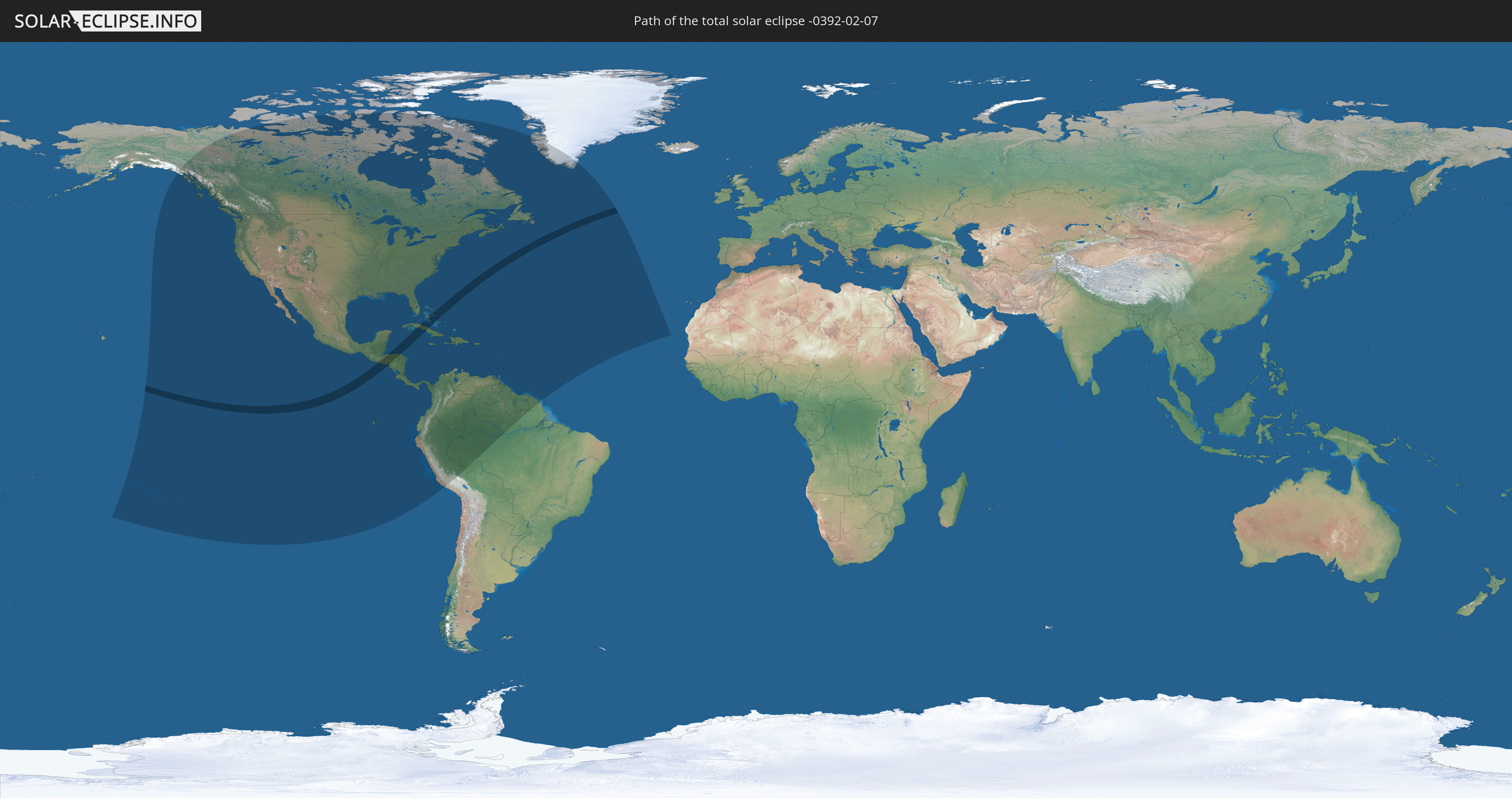
Die Sonnenfinsternis am 02/07/-0392 kann man in 53 Ländern als partielle Sonnenfinsternis beobachten.
Der Finsternispfad verläuft durch 5 Länder. Nur in diesen Ländern ist sie als total Sonnenfinsternis zu sehen.
In den folgenden Ländern ist die Sonnenfinsternis total zu sehen
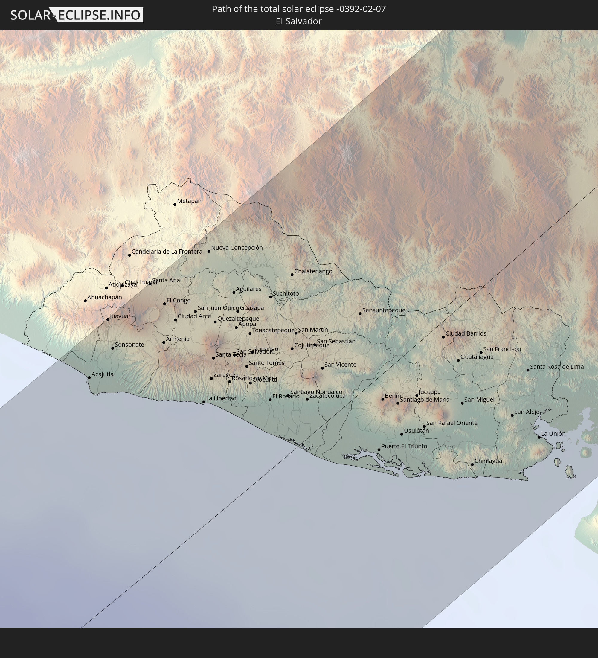 El Salvador
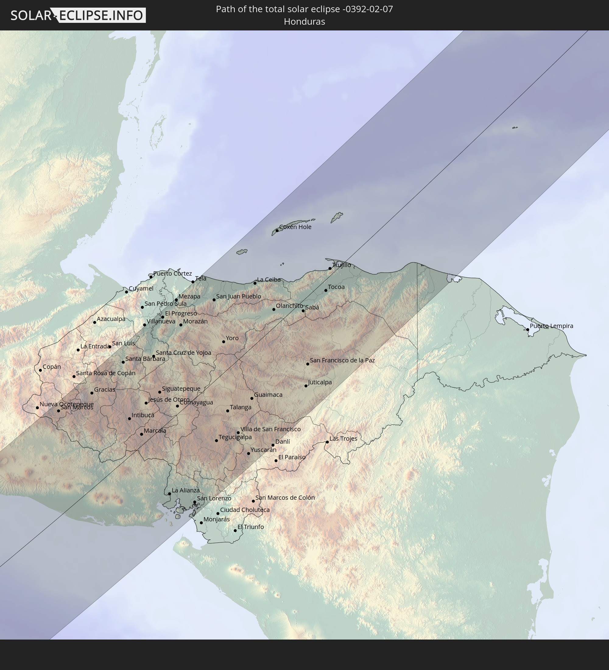 Honduras
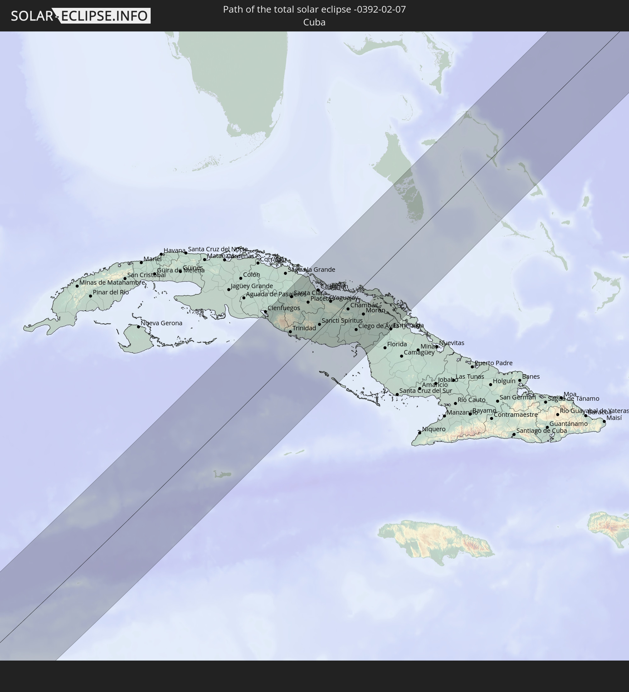 Cuba
Cuba
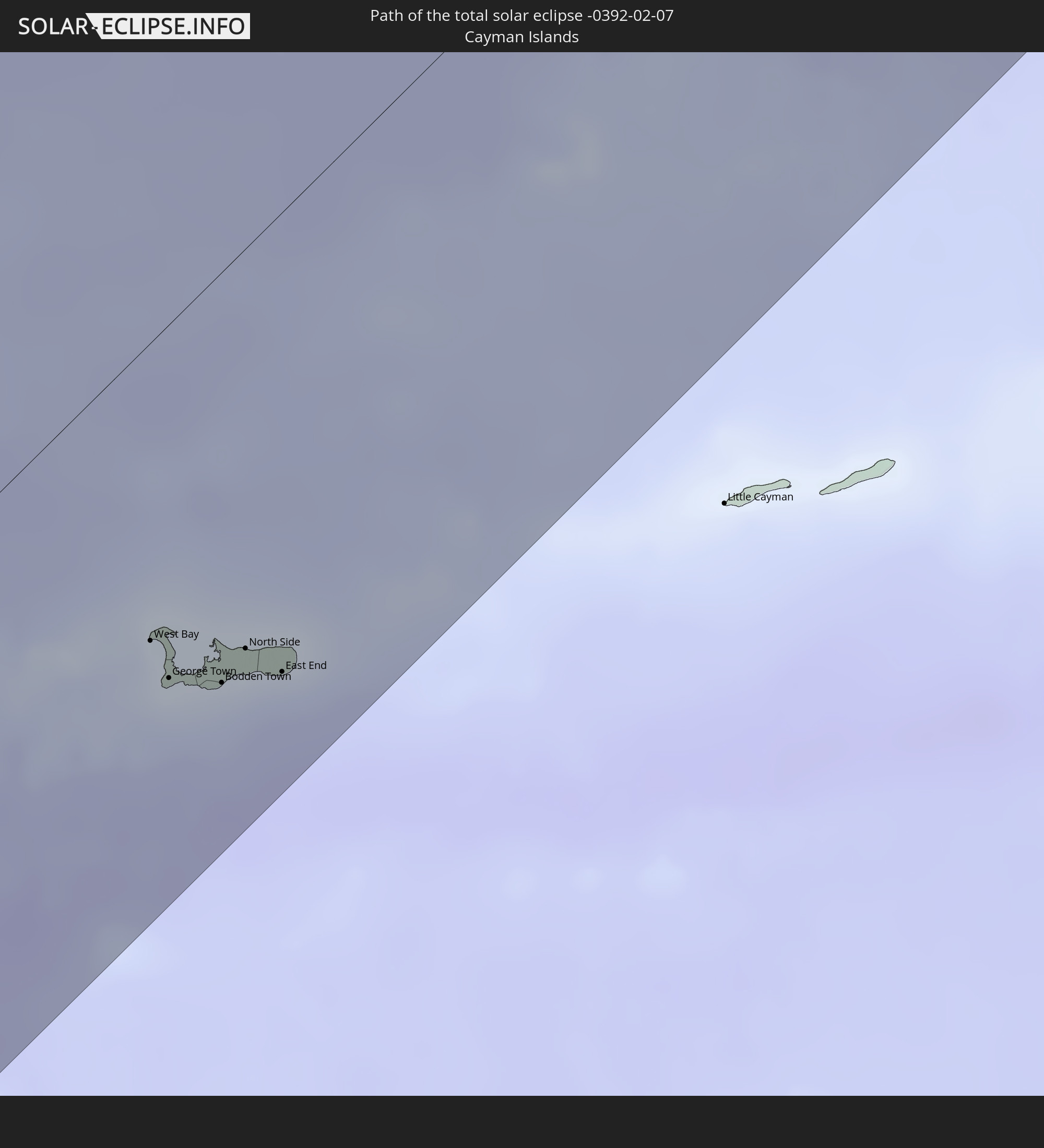 Cayman Islands
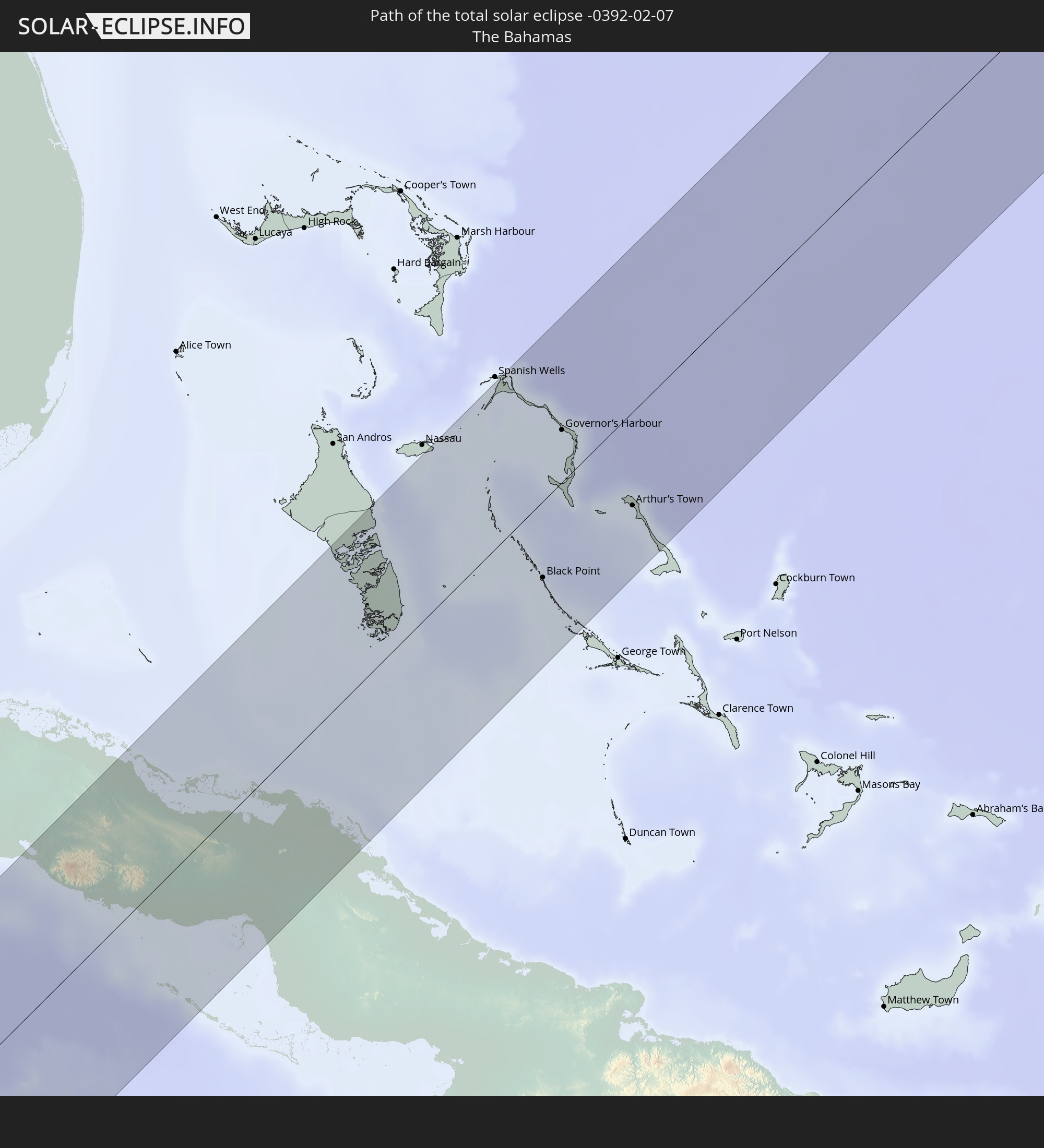 The Bahamas
In den folgenden Ländern ist die Sonnenfinsternis partiell zu sehen
 United States
 United States Minor Outlying Islands
 Kiribati
 French Polynesia
 Canada
 Pitcairn Islands
 Mexico
 Chile
Chile
 Greenland
 Guatemala
 Ecuador
 El Salvador
 Honduras
 Belize
 Nicaragua
 Costa Rica
 Cuba
Cuba
 Panama
 Colombia
 Cayman Islands
 Peru
Peru
 The Bahamas
 Jamaica
 Haiti
Haiti
 Brazil
 Venezuela
 Turks and Caicos Islands
 Dominican Republic
 Aruba
Aruba
 Bolivia
 Puerto Rico
 United States Virgin Islands
 Bermuda
 British Virgin Islands
 Anguilla
 Collectivity of Saint Martin
 Saint Barthélemy
 Saint Kitts and Nevis
 Antigua and Barbuda
 Montserrat
 Trinidad and Tobago
 Guadeloupe
 Grenada
 Dominica
 Saint Vincent and the Grenadines
 Guyana
 Martinique
 Saint Lucia
 Barbados
 Suriname
 Saint Pierre and Miquelon
 French Guiana
 Portugal
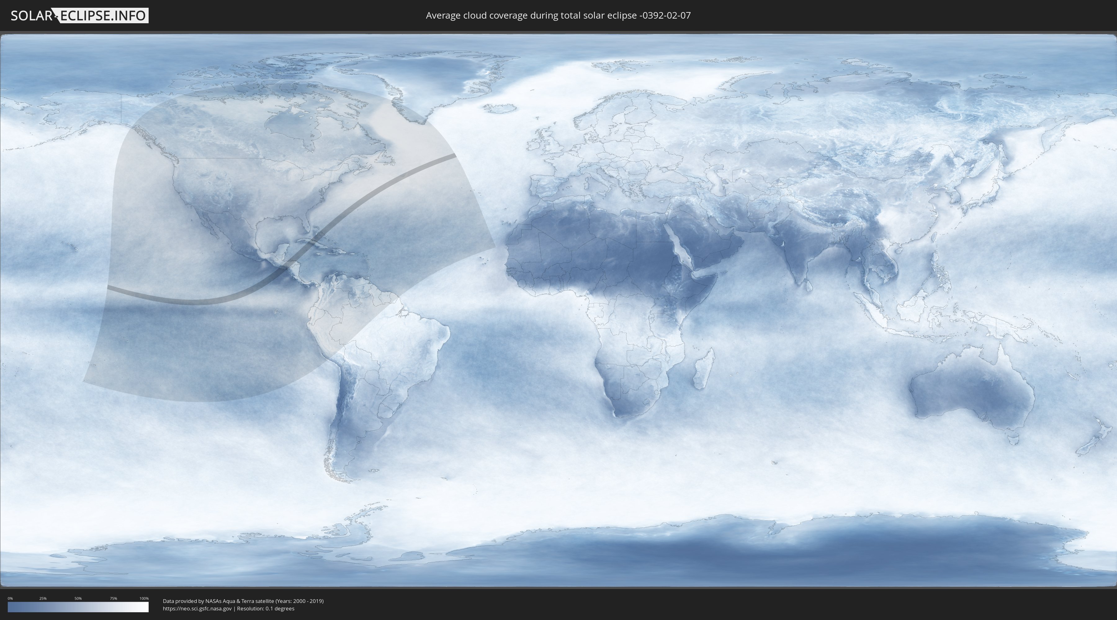
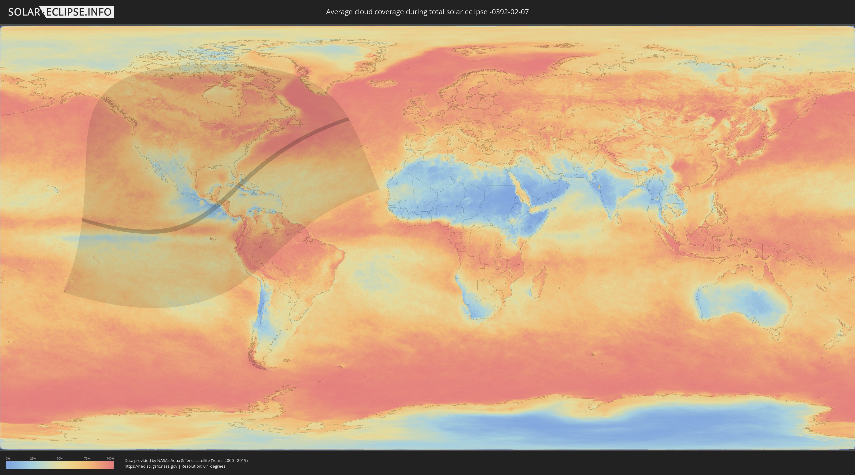
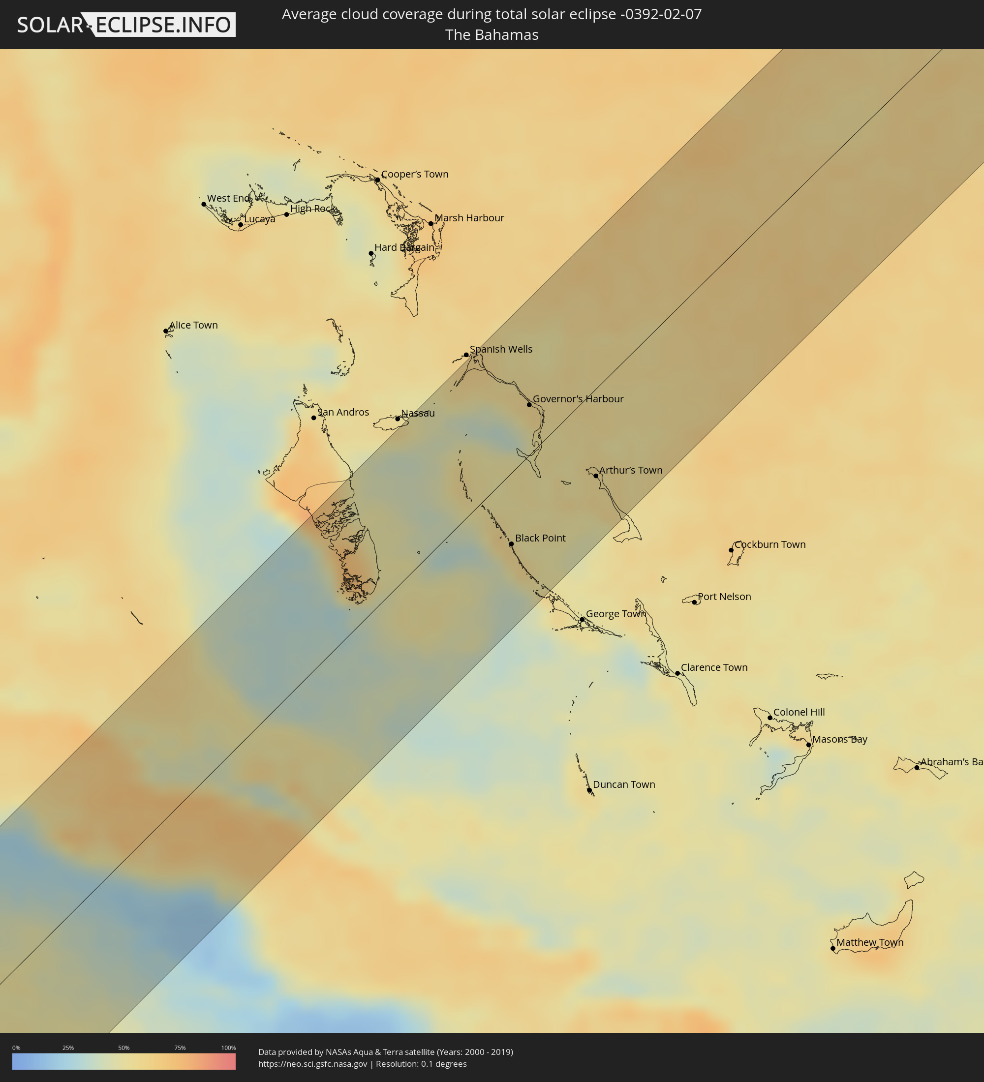
How will be the weather during the total solar eclipse on 02/07/-0392?
Where is the best place to see the total solar eclipse of 02/07/-0392?
The following maps show the average cloud coverage for the day of the total solar eclipse.
With the help of these maps, it is possible to find the place along the eclipse path, which has the best
chance of a cloudless sky.
Nevertheless, you should consider local circumstances and inform about the weather of your chosen
observation site.
The data is provided by NASAs satellites
AQUA and TERRA.
The cloud maps are averaged over a period of 19 years (2000 - 2019).
Detailed country maps
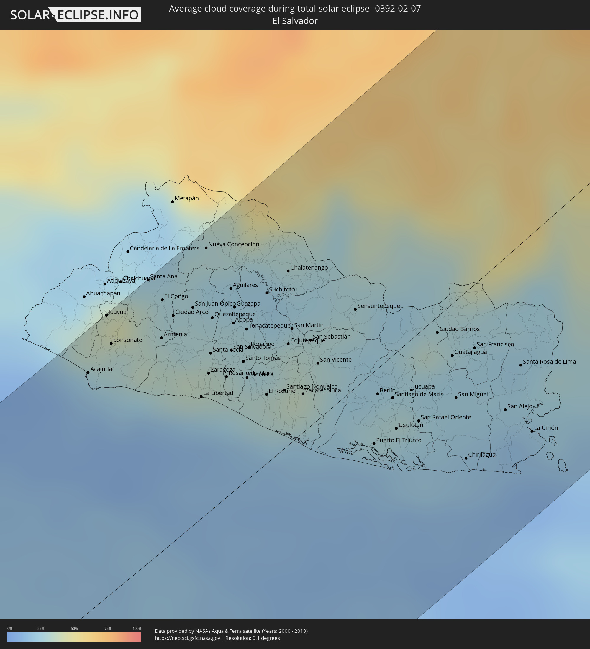 El Salvador
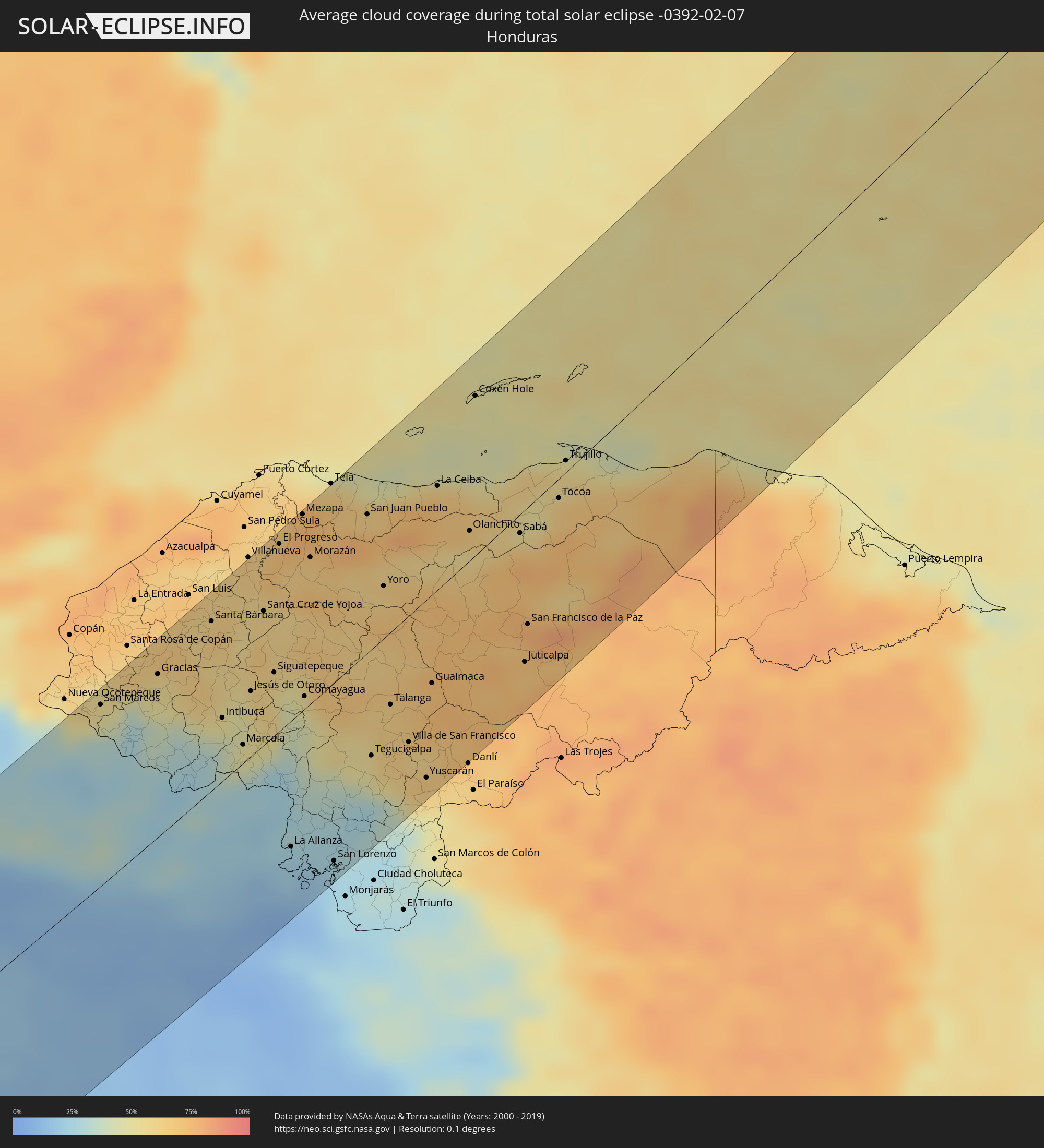 Honduras
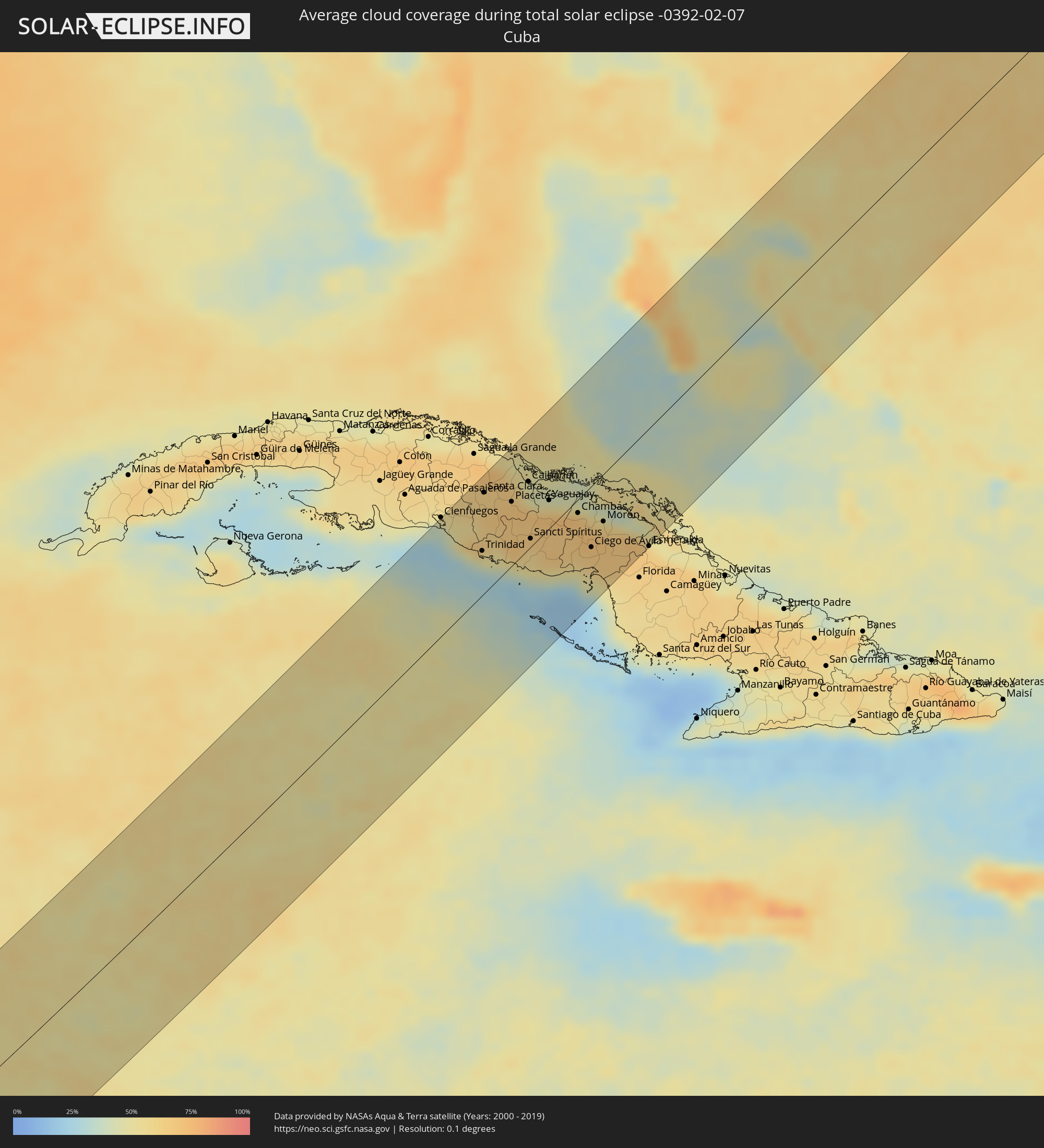 Cuba
Cuba
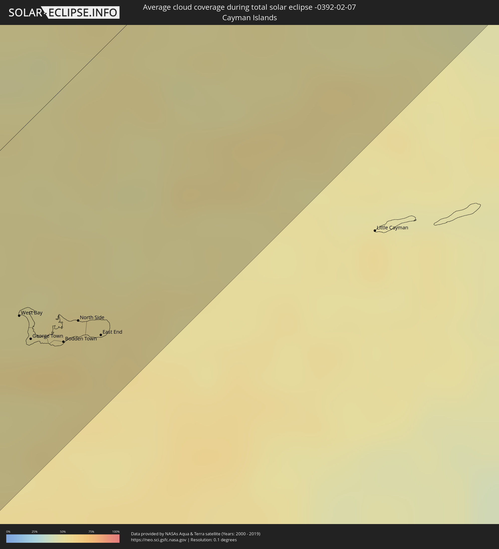 Cayman Islands
 The Bahamas
Cities inside the path of the eclipse
The following table shows all locations with a population of more than 5,000 inside the eclipse path. Cities which have more than 100,000 inhabitants are marked bold. A click at the locations opens a detailed map.
| City | Type | Eclipse duration | Local time of max. eclipse | Distance to central line | Ø Cloud coverage |
|
Acajutla, Sonsonate
|
total | - | 11:48:05 UTC-05:56 | 89 km | 18% |
|
Juayúa, Sonsonate
|
total | - | 11:48:40 UTC-05:56 | 105 km | 31% |
|
San Antonio del Monte, Sonsonate
|
total | - | 11:48:29 UTC-05:56 | 93 km | 29% |
|
Nahuizalco, Sonsonate
|
total | - | 11:48:35 UTC-05:56 | 99 km | 31% |
|
Sonsonate, Sonsonate
|
total | - | 11:48:31 UTC-05:56 | 93 km | 29% |
|
Sonzacate, Sonsonate
|
total | - | 11:48:34 UTC-05:56 | 93 km | 29% |
|
Santa Ana, Santa Ana
|
total | - | 11:49:20 UTC-05:56 | 105 km | 33% |
|
Armenia, Sonsonate
|
total | - | 11:49:05 UTC-05:56 | 79 km | 33% |
|
El Congo, Santa Ana
|
total | - | 11:49:21 UTC-05:56 | 93 km | 29% |
|
Ciudad Arce, La Libertad
|
total | - | 11:49:21 UTC-05:56 | 84 km | 29% |
|
San Juan Opico, La Libertad
|
total | - | 11:49:37 UTC-05:56 | 80 km | 29% |
|
La Libertad, La Libertad
|
total | - | 11:49:06 UTC-05:56 | 45 km | 22% |
|
Nueva Concepción, Chalatenango
|
total | - | 11:50:09 UTC-05:56 | 98 km | 25% |
|
Zaragoza, La Libertad
|
total | - | 11:49:20 UTC-05:56 | 51 km | 32% |
|
Quezaltepeque, La Libertad
|
total | - | 11:49:45 UTC-05:56 | 71 km | 30% |
|
Aguilares, San Salvador
|
total | - | 11:50:08 UTC-05:56 | 75 km | 24% |
|
San Salvador, San Salvador
|
total | - | 11:49:43 UTC-05:56 | 53 km | 31% |
|
Panchimalco, San Salvador
|
total | - | 11:49:37 UTC-05:56 | 46 km | 31% |
|
Guazapa, San Salvador
|
total | - | 11:50:03 UTC-05:56 | 67 km | 27% |
|
Santo Tomás, San Salvador
|
total | - | 11:49:46 UTC-05:56 | 45 km | 31% |
|
San Marcos, Ocotepeque
|
total | - | 11:59:19 UTC-05:48 | 96 km | 50% |
|
Santiago Nonualco, La Paz
|
total | - | 11:50:00 UTC-05:56 | 21 km | 31% |
|
Chalatenango, Chalatenango
|
total | - | 11:50:51 UTC-05:56 | 64 km | 24% |
|
Cojutepeque, Cuscatlán
|
total | - | 11:50:21 UTC-05:56 | 37 km | 33% |
|
Zacatecoluca, La Paz
|
total | - | 11:50:10 UTC-05:56 | 14 km | 31% |
|
San Sebastián, San Vicente
|
total | - | 11:50:37 UTC-05:56 | 31 km | 30% |
|
San Vicente, San Vicente
|
total | - | 11:50:32 UTC-05:56 | 21 km | 31% |
|
Sensuntepeque, Cabañas
|
total | - | 11:51:17 UTC-05:56 | 29 km | 28% |
|
Jiquilisco, Usulután
|
total | - | 11:50:32 UTC-05:56 | 21 km | 17% |
|
Gracias, Lempira
|
total | - | 12:00:28 UTC-05:48 | 86 km | 53% |
|
Puerto El Triunfo, Usulután
|
total | - | 11:50:34 UTC-05:56 | 27 km | 17% |
|
Berlín, Usulután
|
total | - | 11:50:56 UTC-05:56 | 9 km | 28% |
|
Santiago de María, Usulután
|
total | - | 11:51:04 UTC-05:56 | 16 km | 28% |
|
Usulután, Usulután
|
total | - | 11:50:54 UTC-05:56 | 28 km | 27% |
|
Jucuapa, Usulután
|
total | - | 11:51:19 UTC-05:56 | 19 km | 29% |
|
Chinameca, San Miguel
|
total | - | 11:51:22 UTC-05:56 | 22 km | 29% |
|
El Tránsito, San Miguel
|
total | - | 11:51:08 UTC-05:56 | 35 km | 24% |
|
Ciudad Barrios, San Miguel
|
total | - | 11:51:58 UTC-05:56 | 6 km | 32% |
|
Santa Bárbara, Santa Bárbara
|
total | - | 12:01:46 UTC-05:48 | 88 km | 65% |
|
San Miguel, San Miguel
|
total | - | 11:51:43 UTC-05:56 | 36 km | 23% |
|
Intibucá, Intibucá
|
total | - | 12:00:59 UTC-05:48 | 33 km | 39% |
|
San Francisco, Morazán
|
total | - | 11:52:15 UTC-05:56 | 23 km | 23% |
|
Las Vegas, Santa Barbara, Santa Bárbara
|
total | - | 12:02:04 UTC-05:48 | 73 km | 63% |
|
Marcala, La Paz
|
total | - | 12:01:02 UTC-05:48 | 10 km | 49% |
|
Jesús de Otoro, Intibucá
|
total | - | 12:01:40 UTC-05:48 | 34 km | 49% |
|
Potrerillos, Cortés
|
total | - | 12:02:52 UTC-05:48 | 95 km | 62% |
|
Pimienta Vieja, Cortés
|
total | - | 12:02:52 UTC-05:48 | 95 km | 62% |
|
San Manuel, Cortés
|
total | - | 12:03:08 UTC-05:48 | 100 km | 64% |
|
Santa Cruz de Yojoa, Cortés
|
total | - | 12:02:38 UTC-05:48 | 70 km | 62% |
|
Santa Rosa de Lima, La Unión
|
total | - | 11:52:36 UTC-05:56 | 44 km | 22% |
|
Agua Blanca Sur, Yoro
|
total | - | 12:03:05 UTC-05:48 | 90 km | 64% |
|
La Unión, La Unión
|
total | - | 11:52:16 UTC-05:56 | 72 km | 14% |
|
Siguatepeque, Comayagua
|
total | - | 12:02:11 UTC-05:48 | 33 km | 57% |
|
El Progreso, Yoro
|
total | - | 12:03:30 UTC-05:48 | 97 km | 71% |
|
La Alianza, Valle
|
total | - | 12:00:45 UTC-05:48 | 66 km | 22% |
|
El Negrito, Yoro
|
total | - | 12:03:36 UTC-05:48 | 83 km | 63% |
|
Ajuterique, Comayagua
|
total | - | 12:02:10 UTC-05:48 | 5 km | 43% |
|
La Paz, La Paz
|
total | - | 12:02:06 UTC-05:48 | 1 km | 40% |
|
Mezapa, Atlántida
|
total | - | 12:04:07 UTC-05:48 | 101 km | 73% |
|
Comayagua, Comayagua
|
total | - | 12:02:24 UTC-05:48 | 7 km | 50% |
|
Villa de San Antonio, Comayagua
|
total | - | 12:02:15 UTC-05:48 | 6 km | 43% |
|
Morazán, Yoro
|
total | - | 12:03:49 UTC-05:48 | 76 km | 67% |
|
Nacaome, Valle
|
total | - | 12:01:19 UTC-05:48 | 81 km | 23% |
|
San Lorenzo, Valle
|
total | - | 12:01:14 UTC-05:48 | 93 km | 24% |
|
Santa Rita, Yoro
|
total | - | 12:04:18 UTC-05:48 | 40 km | 65% |
|
San Juan Pueblo, Atlántida
|
total | - | 12:05:03 UTC-05:48 | 71 km | 75% |
|
Tegucigalpa, Francisco Morazán
|
total | - | 12:02:49 UTC-05:48 | 55 km | 50% |
|
Yoro, Yoro
|
total | - | 12:04:37 UTC-05:48 | 27 km | 68% |
|
Talanga, Francisco Morazán
|
total | - | 12:03:35 UTC-05:48 | 37 km | 64% |
|
Villa de San Francisco, Francisco Morazán
|
total | - | 12:03:29 UTC-05:48 | 65 km | 65% |
|
Guaimaca, Francisco Morazán
|
total | - | 12:04:23 UTC-05:48 | 46 km | 72% |
|
La Ceiba, Atlántida
|
total | - | 12:06:20 UTC-05:48 | 53 km | 64% |
|
Campamento, Olancho
|
total | - | 12:04:47 UTC-05:48 | 56 km | 72% |
|
Olanchito, Yoro
|
total | - | 12:06:22 UTC-05:48 | 15 km | 56% |
|
Coxen Hole, Bay Islands
|
total | - | 12:07:42 UTC-05:48 | 81 km | 48% |
|
Sabá, Colón
|
total | - | 12:07:04 UTC-05:48 | 10 km | 66% |
|
Juticalpa, Olancho
|
total | - | 12:05:56 UTC-05:48 | 78 km | 69% |
|
San Francisco de la Paz, Olancho
|
total | - | 12:06:19 UTC-05:48 | 60 km | 71% |
|
Tocoa, Colón
|
total | - | 12:07:57 UTC-05:48 | 10 km | 62% |
|
Trujillo, Colón
|
total | - | 12:08:24 UTC-05:48 | 6 km | 58% |
|
West Bay, West Bay
|
total | - | 12:52:02 UTC-05:19 | 51 km | 51% |
|
George Town, George Town
|
total | - | 12:52:01 UTC-05:19 | 60 km | 56% |
|
Bodden Town, Bodden Town
|
total | - | 12:52:15 UTC-05:19 | 70 km | 58% |
|
North Side, North Side
|
total | - | 12:52:27 UTC-05:19 | 68 km | 54% |
|
East End, East End
|
total | - | 12:52:33 UTC-05:19 | 78 km | 54% |
|
Cumanayagua, Cienfuegos
|
total | - | 12:47:52 UTC-05:29 | 80 km | 54% |
|
Ranchuelo, Villa Clara
|
total | - | 12:48:14 UTC-05:29 | 93 km | 60% |
|
Esperanza, Villa Clara
|
total | - | 12:48:25 UTC-05:29 | 95 km | 60% |
|
Topes de Collantes, Sancti Spíritus
|
total | - | 12:47:56 UTC-05:29 | 48 km | 59% |
|
Trinidad, Sancti Spíritus
|
total | - | 12:47:52 UTC-05:29 | 36 km | 42% |
|
Manicaragua, Villa Clara
|
total | - | 12:48:17 UTC-05:29 | 63 km | 58% |
|
Santa Clara, Villa Clara
|
total | - | 12:48:37 UTC-05:29 | 82 km | 61% |
|
Calabazar de Sagua, Villa Clara
|
total | - | 12:49:01 UTC-05:29 | 96 km | 67% |
|
Encrucijada, Villa Clara
|
total | - | 12:49:03 UTC-05:29 | 92 km | 67% |
|
Condado, Sancti Spíritus
|
total | - | 12:48:14 UTC-05:29 | 32 km | 53% |
|
Camajuaní, Villa Clara
|
total | - | 12:49:07 UTC-05:29 | 73 km | 64% |
|
Fomento, Sancti Spíritus
|
total | - | 12:48:43 UTC-05:29 | 41 km | 65% |
|
Placetas, Villa Clara
|
total | - | 12:49:05 UTC-05:29 | 52 km | 69% |
|
Remedios, Villa Clara
|
total | - | 12:49:30 UTC-05:29 | 59 km | 58% |
|
Cabaiguán, Sancti Spíritus
|
total | - | 12:49:07 UTC-05:29 | 23 km | 67% |
|
Caibarién, Villa Clara
|
total | - | 12:49:41 UTC-05:29 | 55 km | 58% |
|
Guayos, Sancti Spíritus
|
total | - | 12:49:09 UTC-05:29 | 18 km | 67% |
|
Sancti Spíritus, Sancti Spíritus
|
total | - | 12:49:02 UTC-05:29 | 7 km | 58% |
|
Zaza del Medio, Sancti Spíritus
|
total | - | 12:49:16 UTC-05:29 | 7 km | 65% |
|
La Sierpe, Sancti Spíritus
|
total | - | 12:49:11 UTC-05:29 | 18 km | 62% |
|
Yaguajay, Sancti Spíritus
|
total | - | 12:49:53 UTC-05:29 | 23 km | 70% |
|
Jatibonico, Sancti Spíritus
|
total | - | 12:49:34 UTC-05:29 | 12 km | 67% |
|
Florencia, Ciego de Ávila
|
total | - | 12:50:10 UTC-05:29 | 10 km | 67% |
|
Chambas, Ciego de Ávila
|
total | - | 12:50:20 UTC-05:29 | 11 km | 68% |
|
Venezuela, Ciego de Ávila
|
total | - | 12:50:02 UTC-05:29 | 56 km | 56% |
|
Ciego de Ávila, Ciego de Ávila
|
total | - | 12:50:12 UTC-05:29 | 50 km | 63% |
|
Ciro Redondo, Ciego de Ávila
|
total | - | 12:50:31 UTC-05:29 | 40 km | 70% |
|
Morón, Ciego de Ávila
|
total | - | 12:50:46 UTC-05:29 | 39 km | 68% |
|
Baraguá, Ciego de Ávila
|
total | - | 12:50:16 UTC-05:29 | 72 km | 65% |
|
Primero de Enero, Ciego de Ávila
|
total | - | 12:50:56 UTC-05:29 | 66 km | 66% |
|
Esmeralda, Camagüey
|
total | - | 12:51:24 UTC-05:29 | 96 km | 66% |
|
Black Point, Black Point
|
total | - | 18:26:32 UTC+00:00 | 44 km | 55% |
|
Governor’s Harbour, Central Eleuthera
|
total | - | 18:27:51 UTC+00:00 | 30 km | 58% |
|
Arthur’s Town, Cat Island
|
total | - | 13:18:46 UTC-05:09 | 53 km | 56% |