Annular solar eclipse of 01/15/-0531
| Day of week: | Wednesday |
| Maximum duration of eclipse: | 06m47s |
| Maximum width of eclipse path: | 281 km |
| Saros cycle: | 42 |
| Coverage: | 94.6% |
| Magnitude: | 0.9455 |
| Gamma: | 0.6993 |
Wo kann man die Sonnenfinsternis vom 01/15/-0531 sehen?
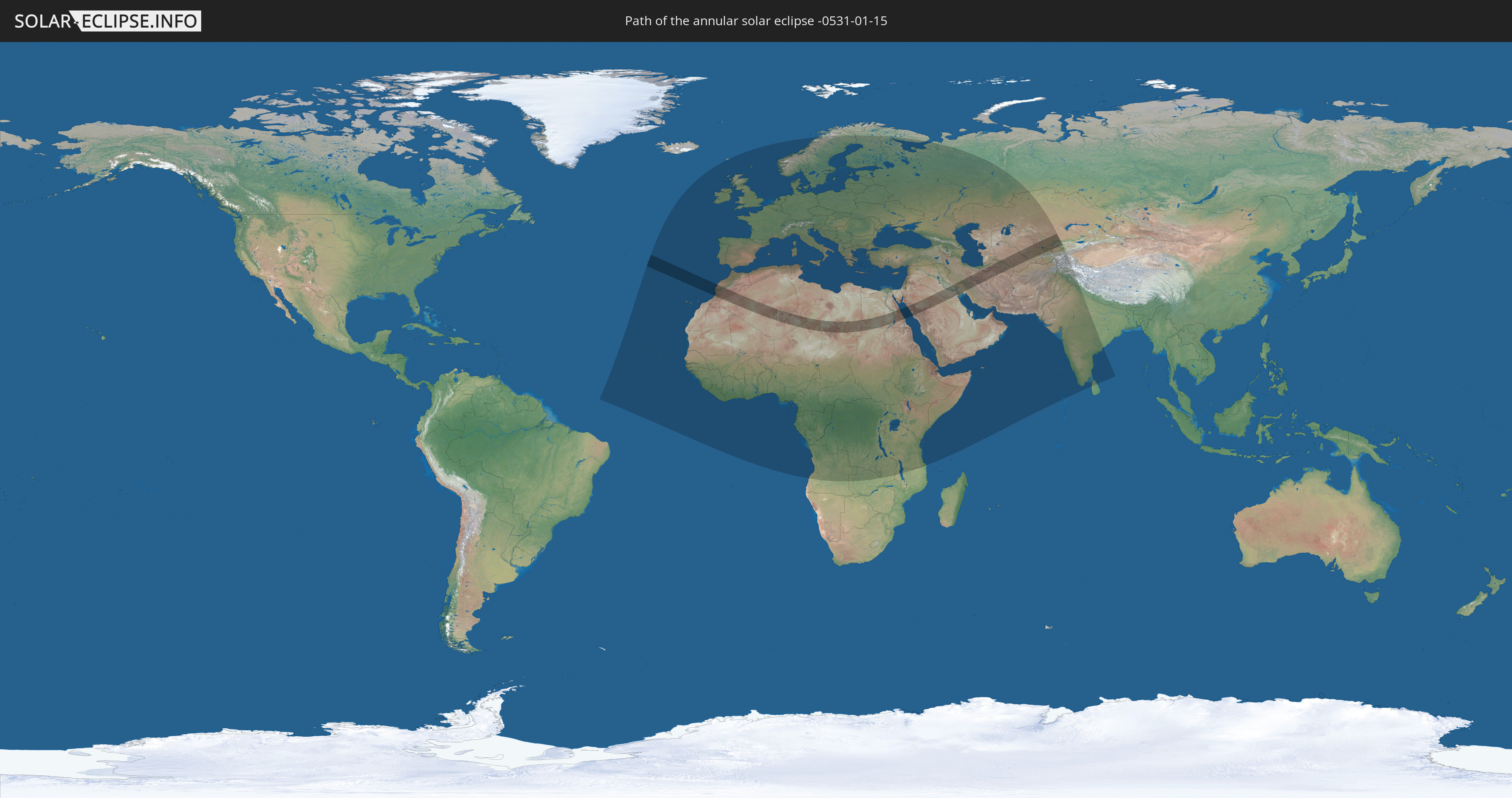
Die Sonnenfinsternis am 01/15/-0531 kann man in 123 Ländern als partielle Sonnenfinsternis beobachten.
Der Finsternispfad verläuft durch 17 Länder. Nur in diesen Ländern ist sie als annular Sonnenfinsternis zu sehen.
In den folgenden Ländern ist die Sonnenfinsternis annular zu sehen
 Portugal
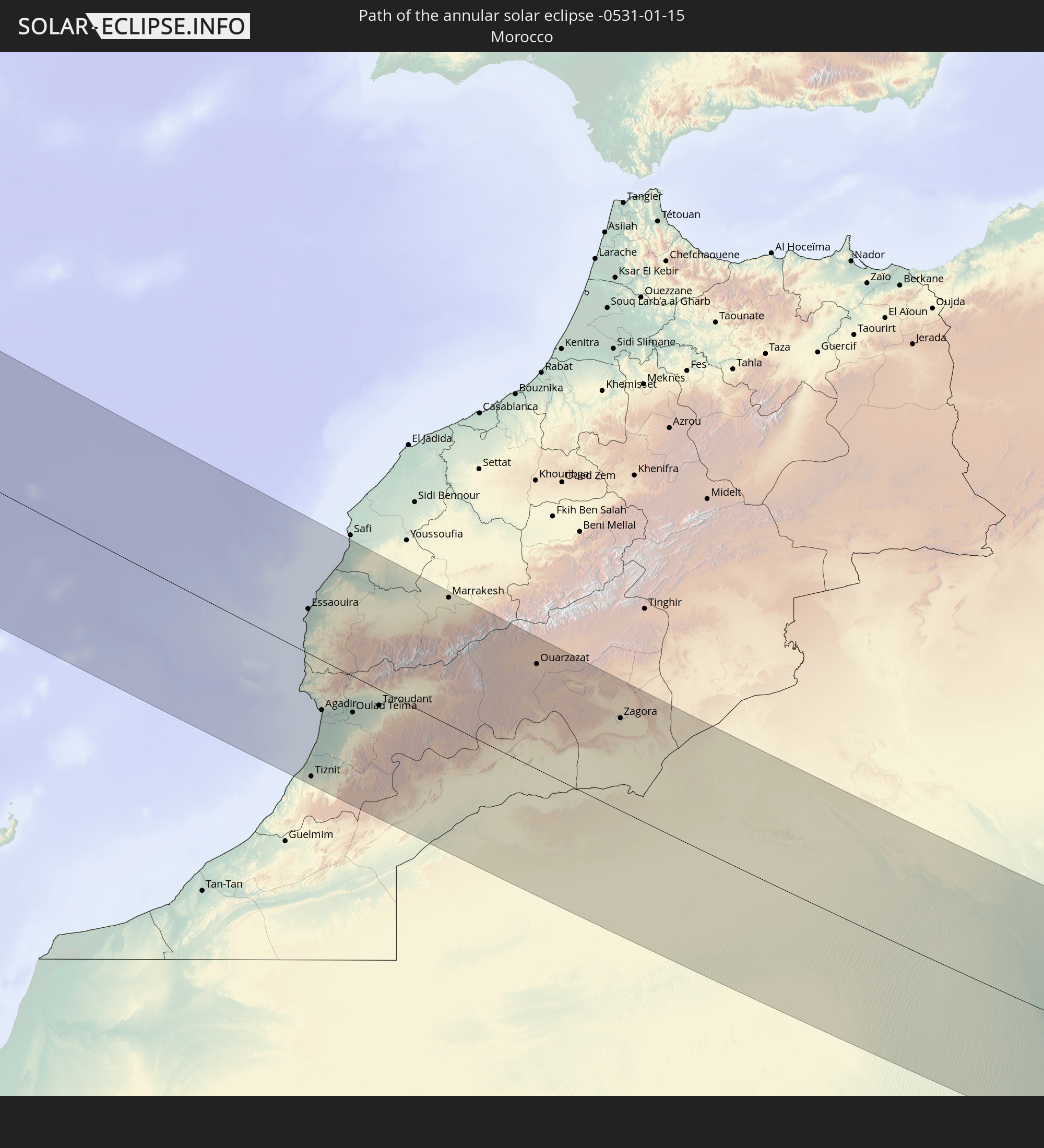 Morocco
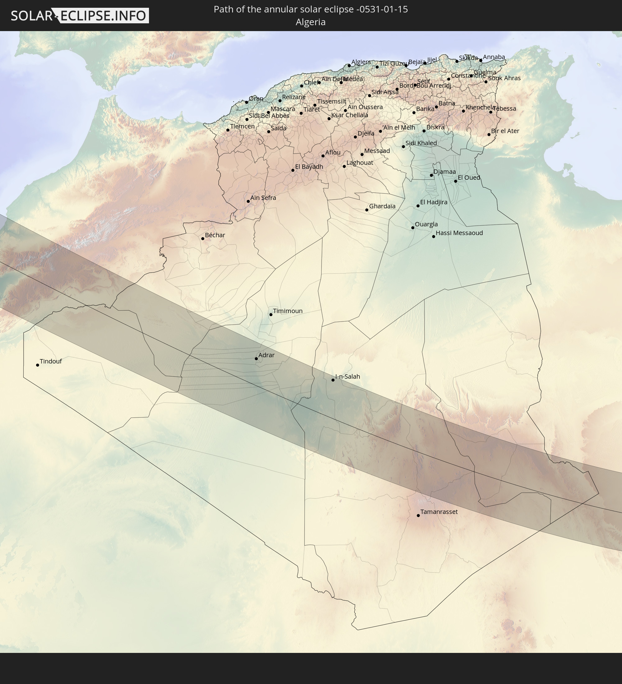 Algeria
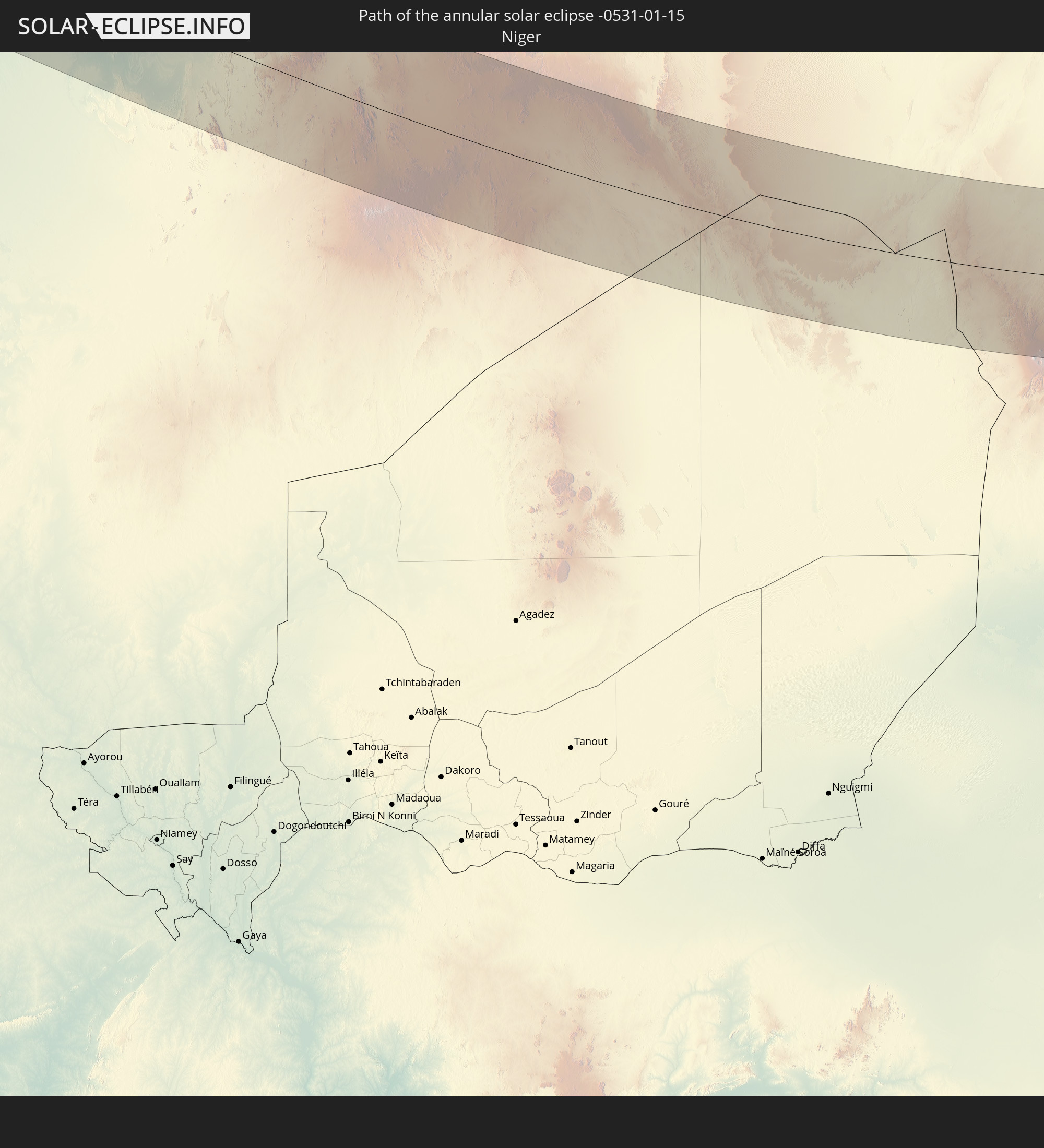 Niger
Niger
 Libya
Libya
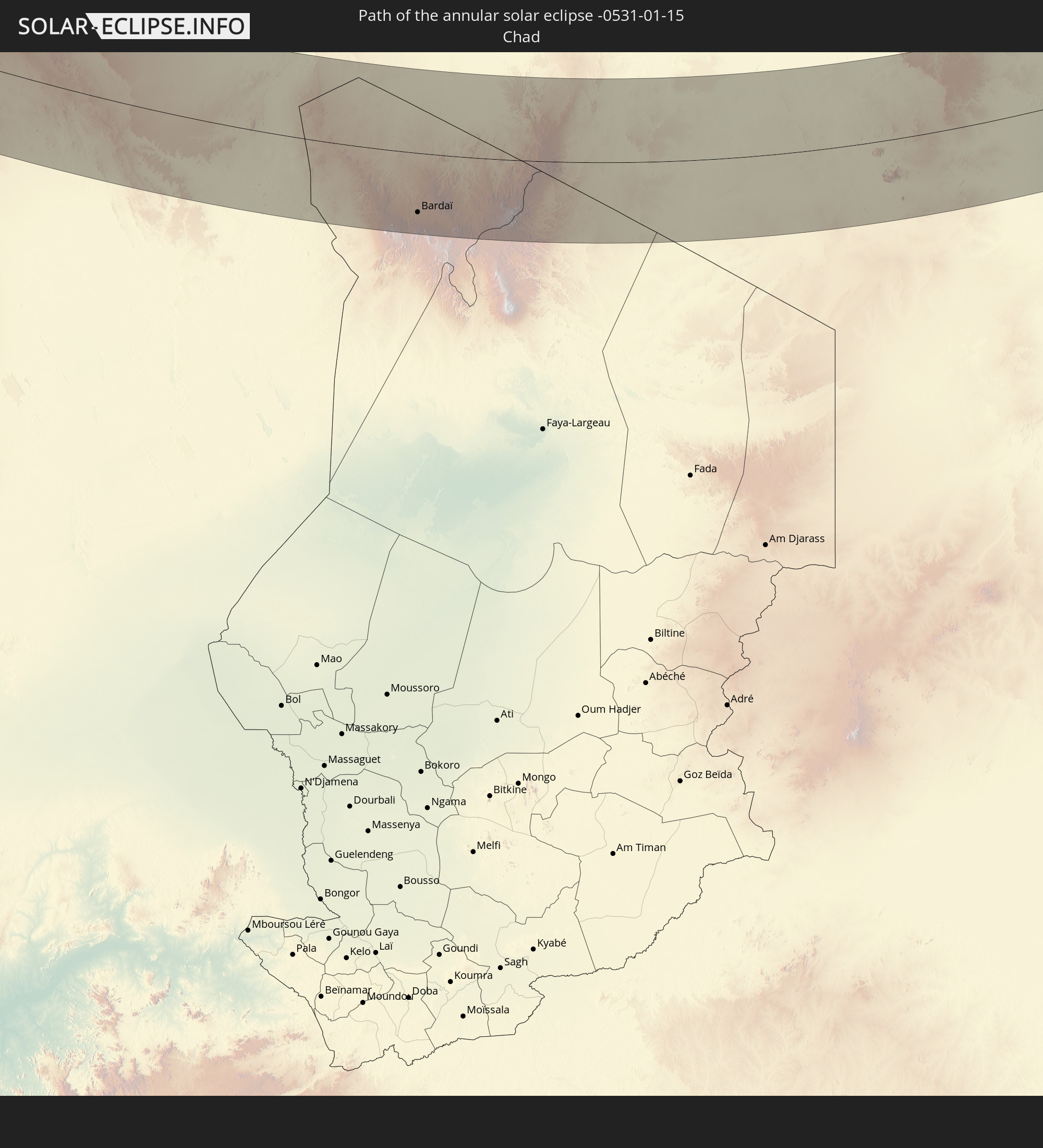 Chad
Chad
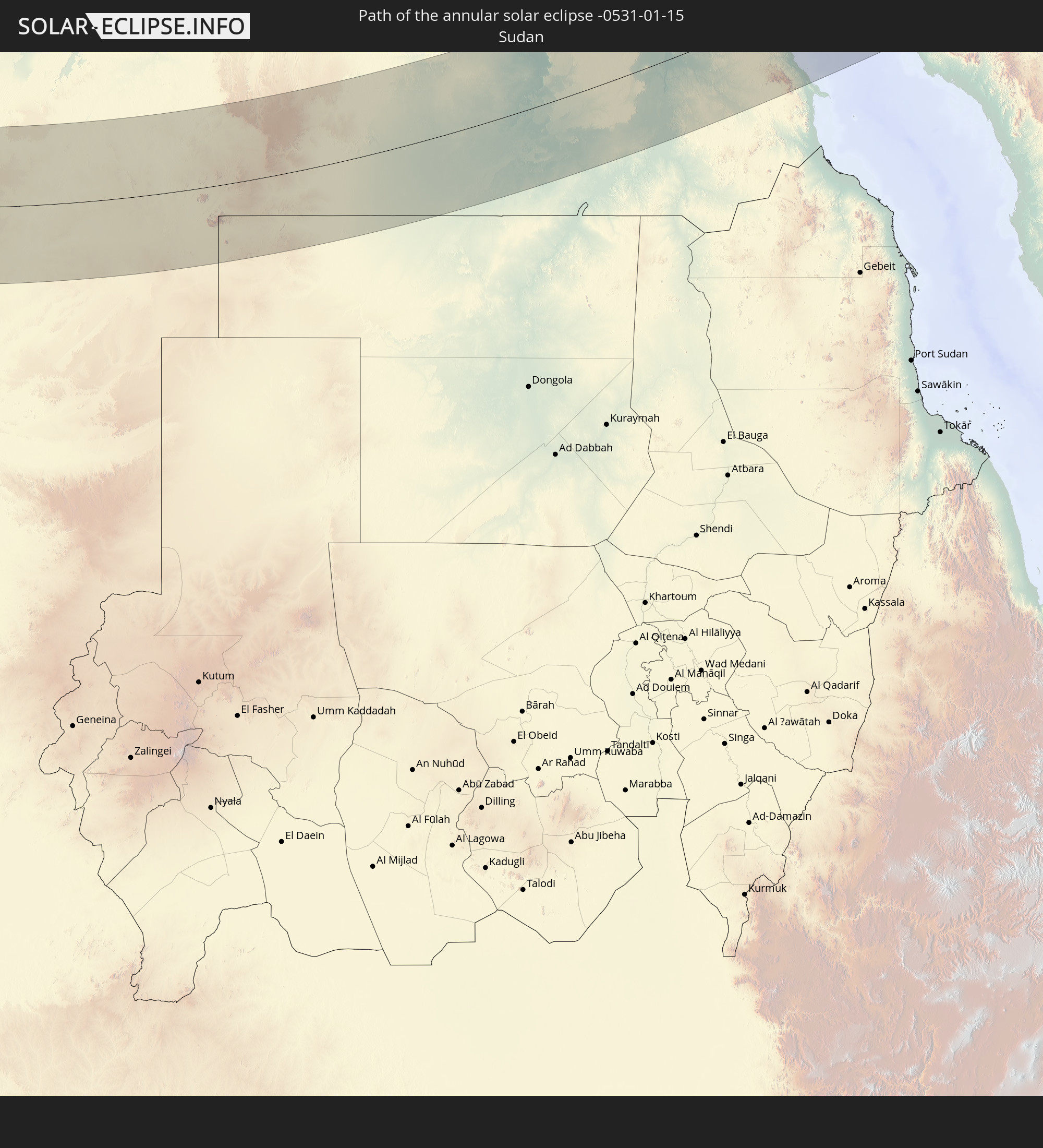 Sudan
Sudan
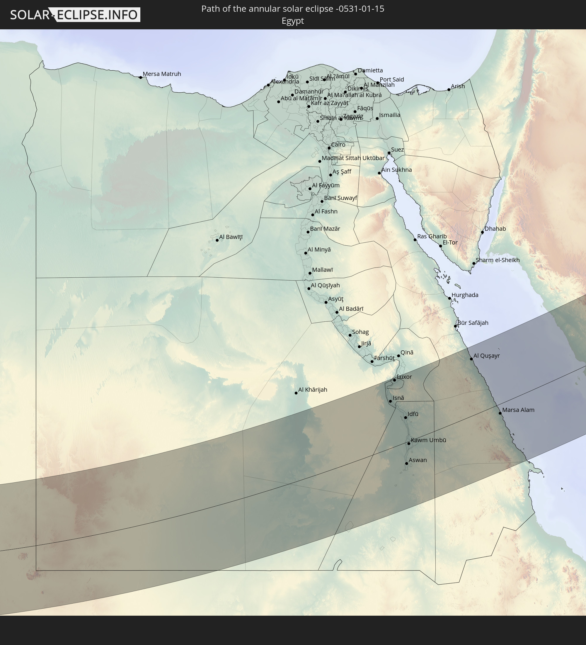 Egypt
Egypt
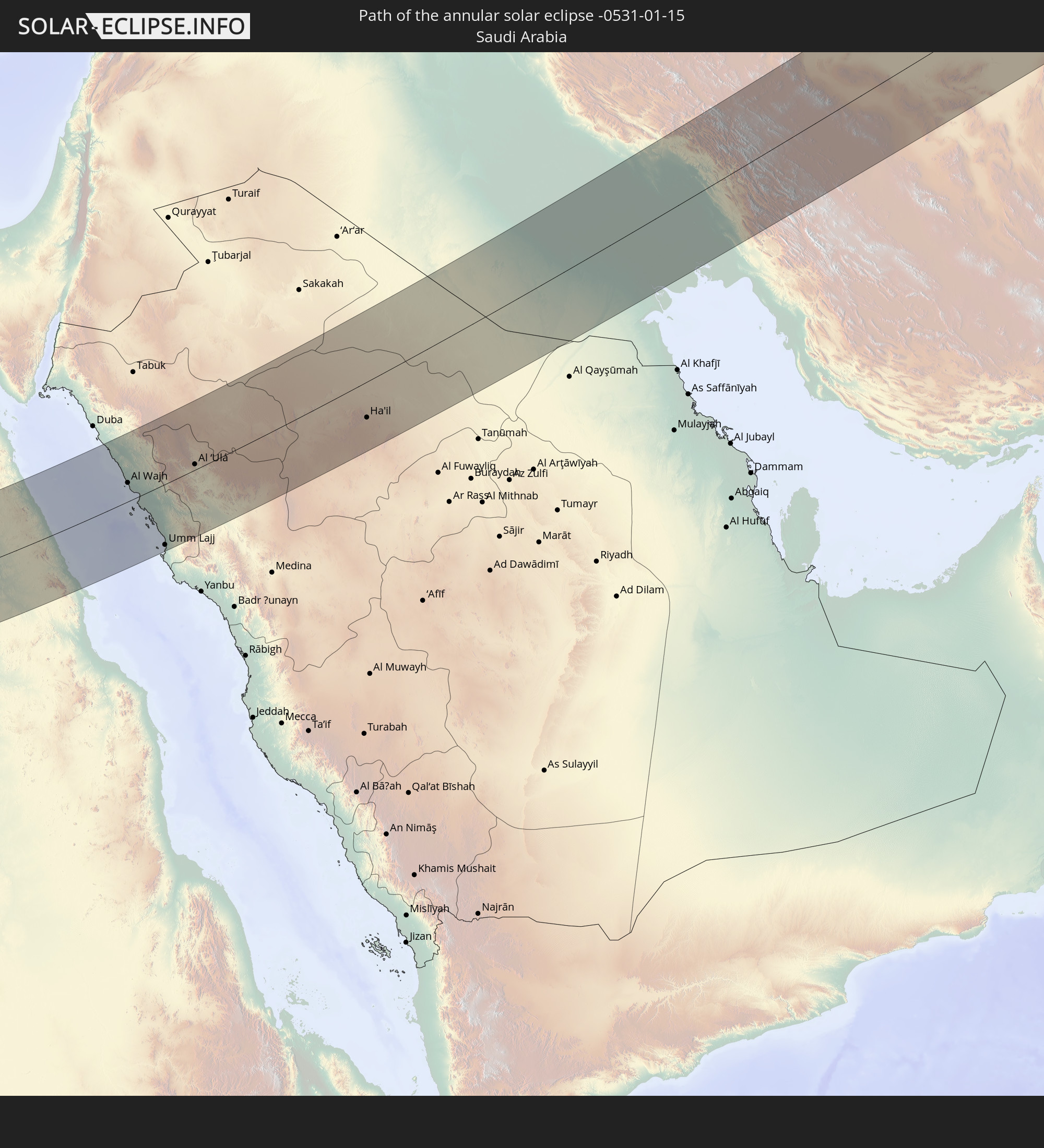 Saudi Arabia
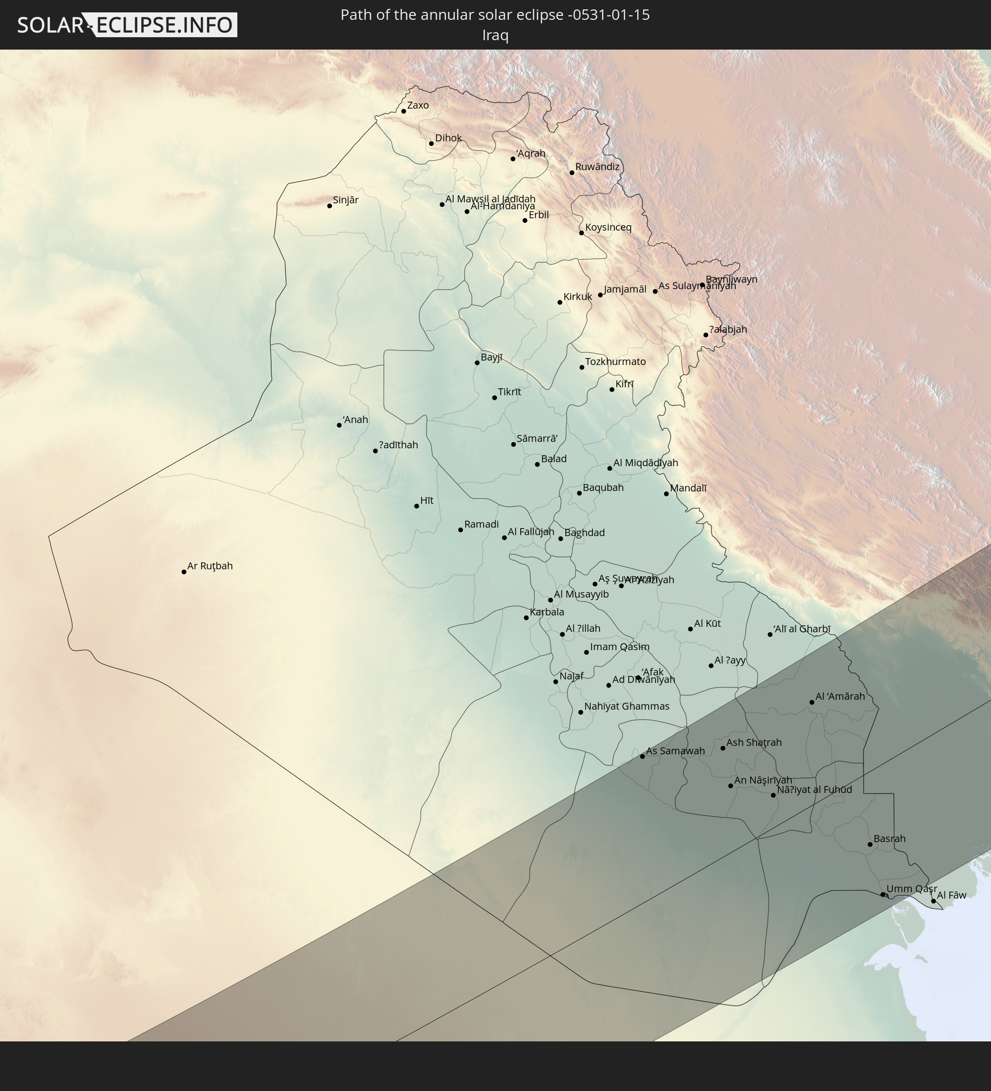 Iraq
Iraq
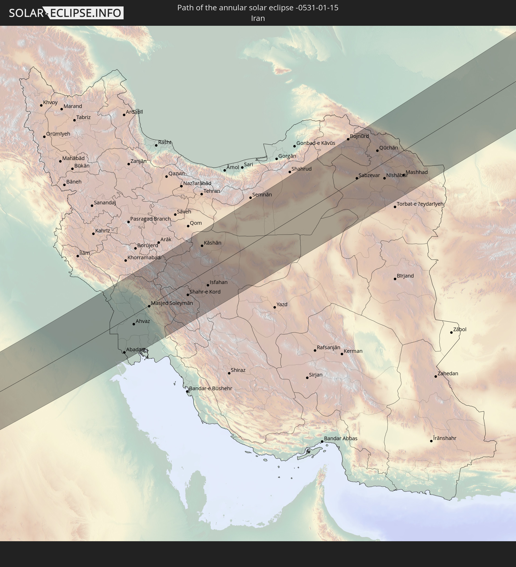 Iran
Iran
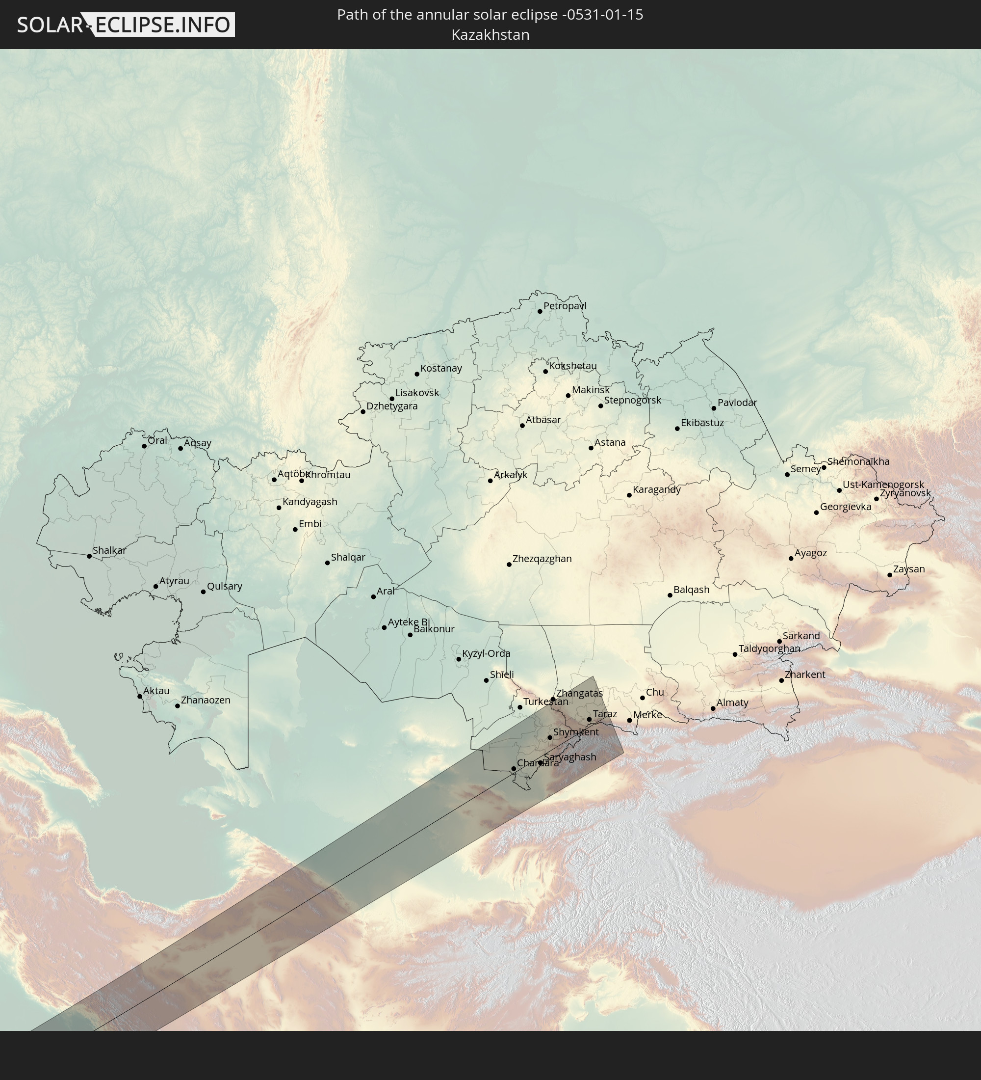 Kazakhstan
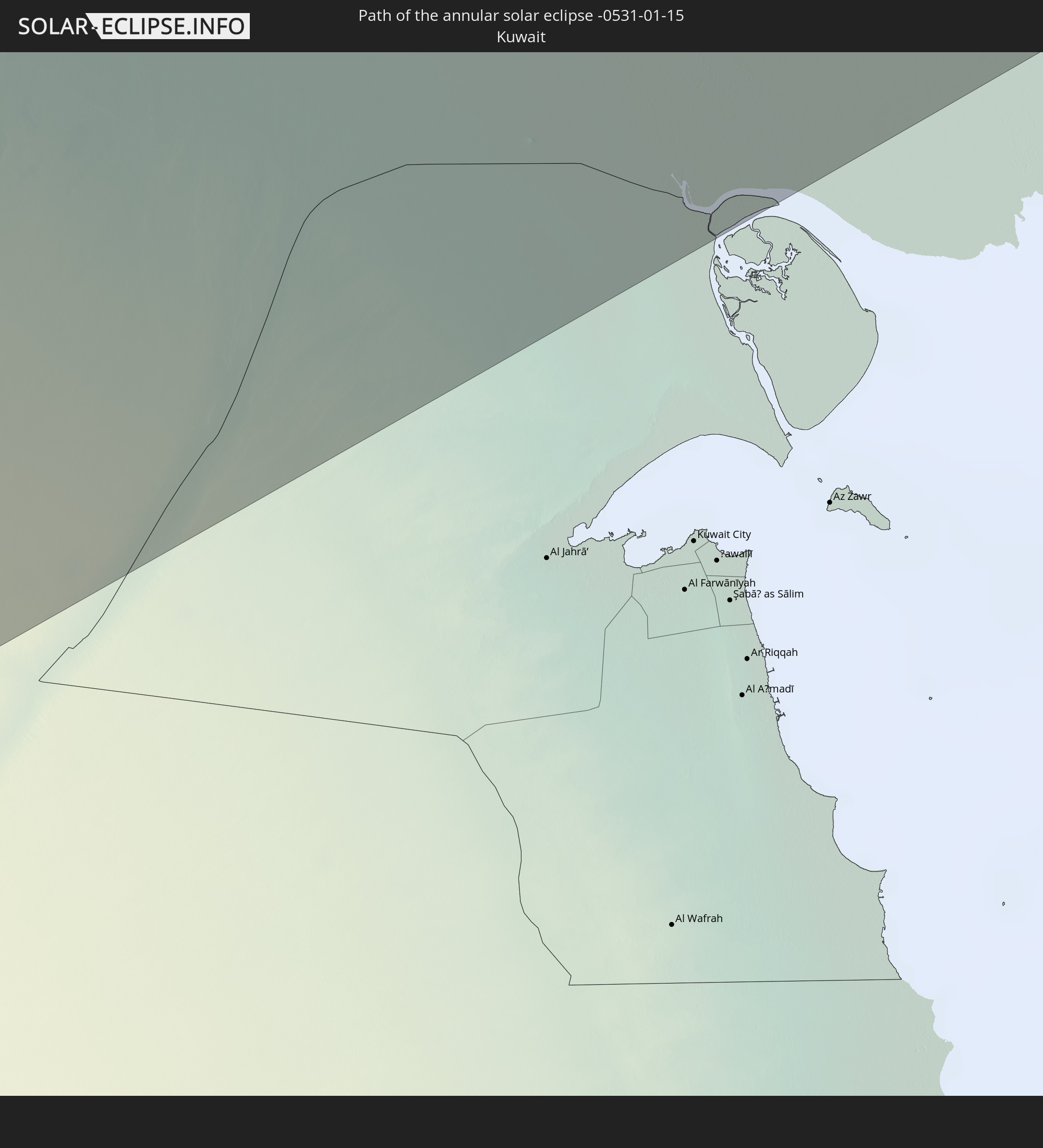 Kuwait
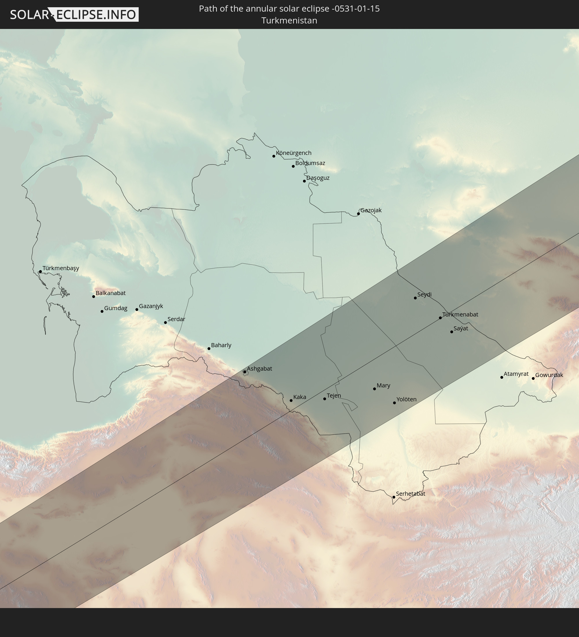 Turkmenistan
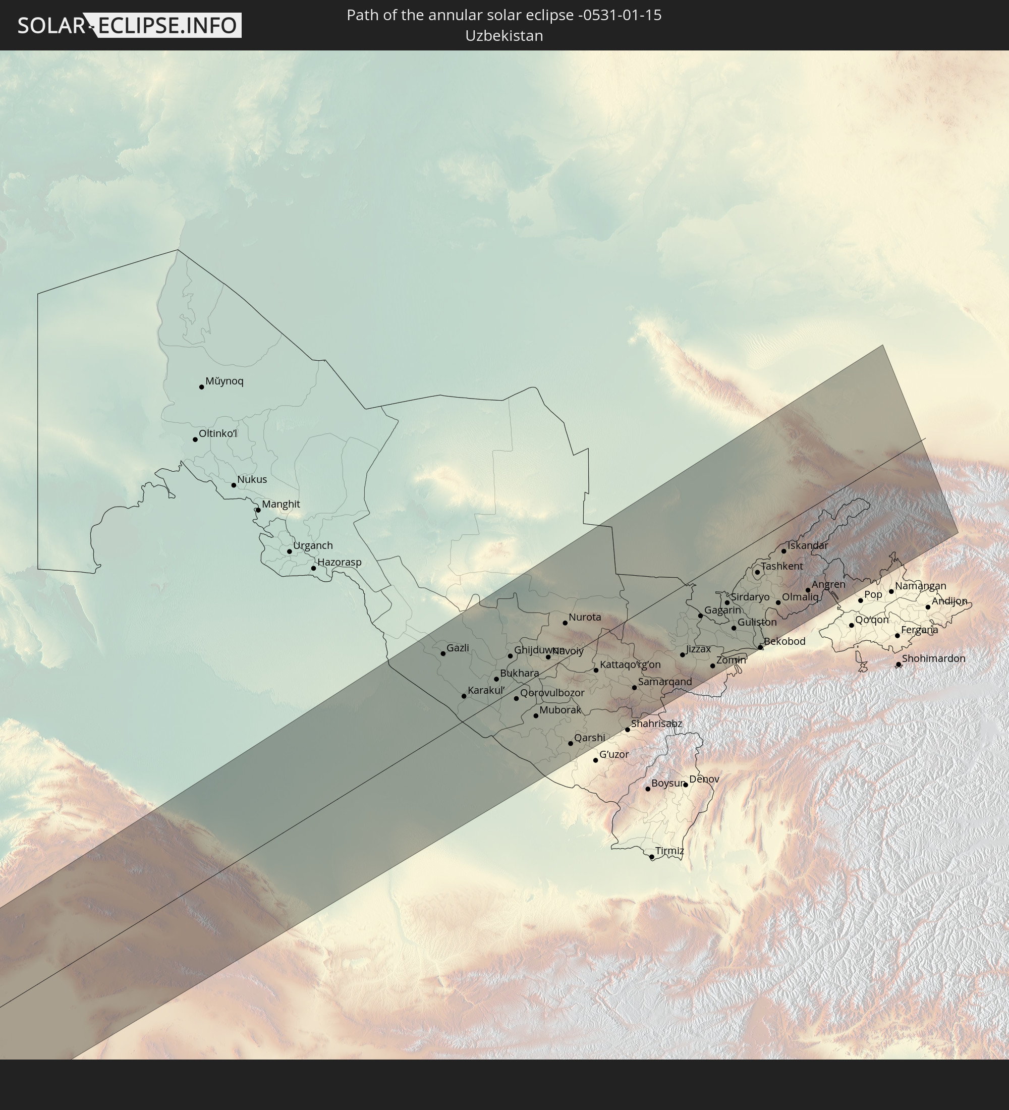 Uzbekistan
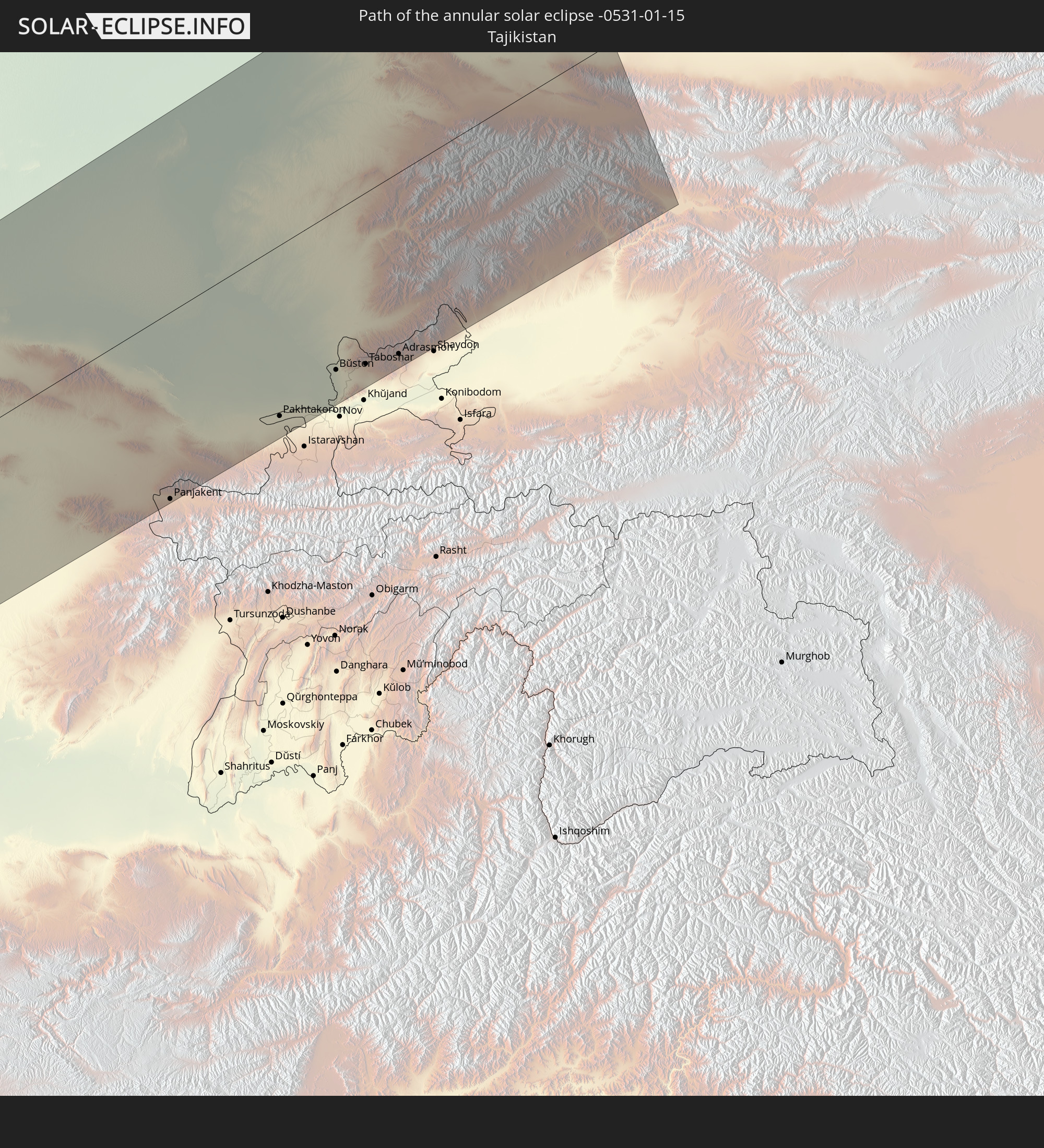 Tajikistan
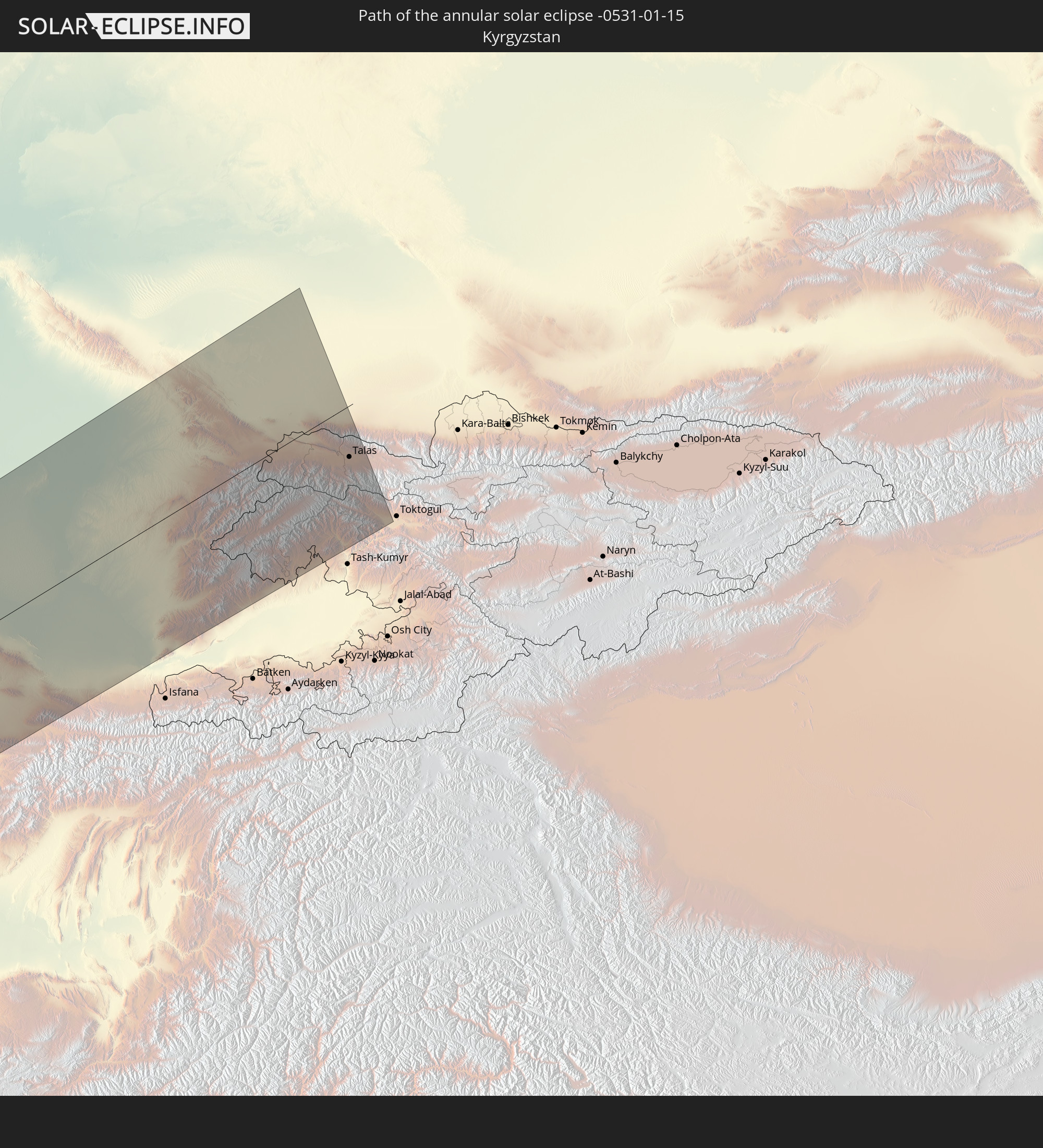 Kyrgyzstan
In den folgenden Ländern ist die Sonnenfinsternis partiell zu sehen
 Russia
 Portugal
 Cabo Verde
 Spain
Spain
 Senegal
 Mauritania
 The Gambia
 Guinea-Bissau
 Guinea
 Sierra Leone
 Morocco
 Mali
Mali
 Liberia
 Republic of Ireland
 Algeria
 United Kingdom
 Ivory Coast
 Faroe Islands
 Burkina Faso
 Gibraltar
 France
 Isle of Man
 Ghana
Ghana
 Guernsey
 Jersey
 Togo
Togo
 Niger
Niger
 Benin
Benin
 Andorra
 Belgium
 Nigeria
 Netherlands
 Norway
 Equatorial Guinea
 Luxembourg
 Germany
 Switzerland
 São Tomé and Príncipe
 Italy
Italy
 Monaco
 Tunisia
 Denmark
 Cameroon
 Gabon
Gabon
 Libya
Libya
 Liechtenstein
 Austria
 Sweden
 Republic of the Congo
 Angola
 Czechia
 Democratic Republic of the Congo
 San Marino
 Vatican City
 Slovenia
 Chad
Chad
 Croatia
 Poland
 Malta
Malta
 Central African Republic
 Bosnia and Herzegovina
 Hungary
 Slovakia
 Montenegro
 Serbia
 Albania
 Åland Islands
 Greece
 Romania
 Republic of Macedonia
 Finland
 Lithuania
 Latvia
 Estonia
 Sudan
Sudan
 Zambia
 Ukraine
 Bulgaria
 Belarus
 Egypt
Egypt
 Turkey
 Moldova
 Rwanda
 Burundi
 Tanzania
 Uganda
 Mozambique
 Cyprus
 Malawi
 Ethiopia
 Kenya
Kenya
 State of Palestine
 Israel
 Saudi Arabia
 Jordan
 Lebanon
 Syria
Syria
 Eritrea
 Iraq
Iraq
 Georgia
 Somalia
 Djibouti
 Yemen
Yemen
 Armenia
 Iran
Iran
 Azerbaijan
 Seychelles
 Kazakhstan
 Kuwait
 Bahrain
 Qatar
Qatar
 United Arab Emirates
 Oman
Oman
 Turkmenistan
 Uzbekistan
 Afghanistan
 Pakistan
 Tajikistan
 India
India
 Kyrgyzstan
 Maldives
 China
China
 Sri Lanka
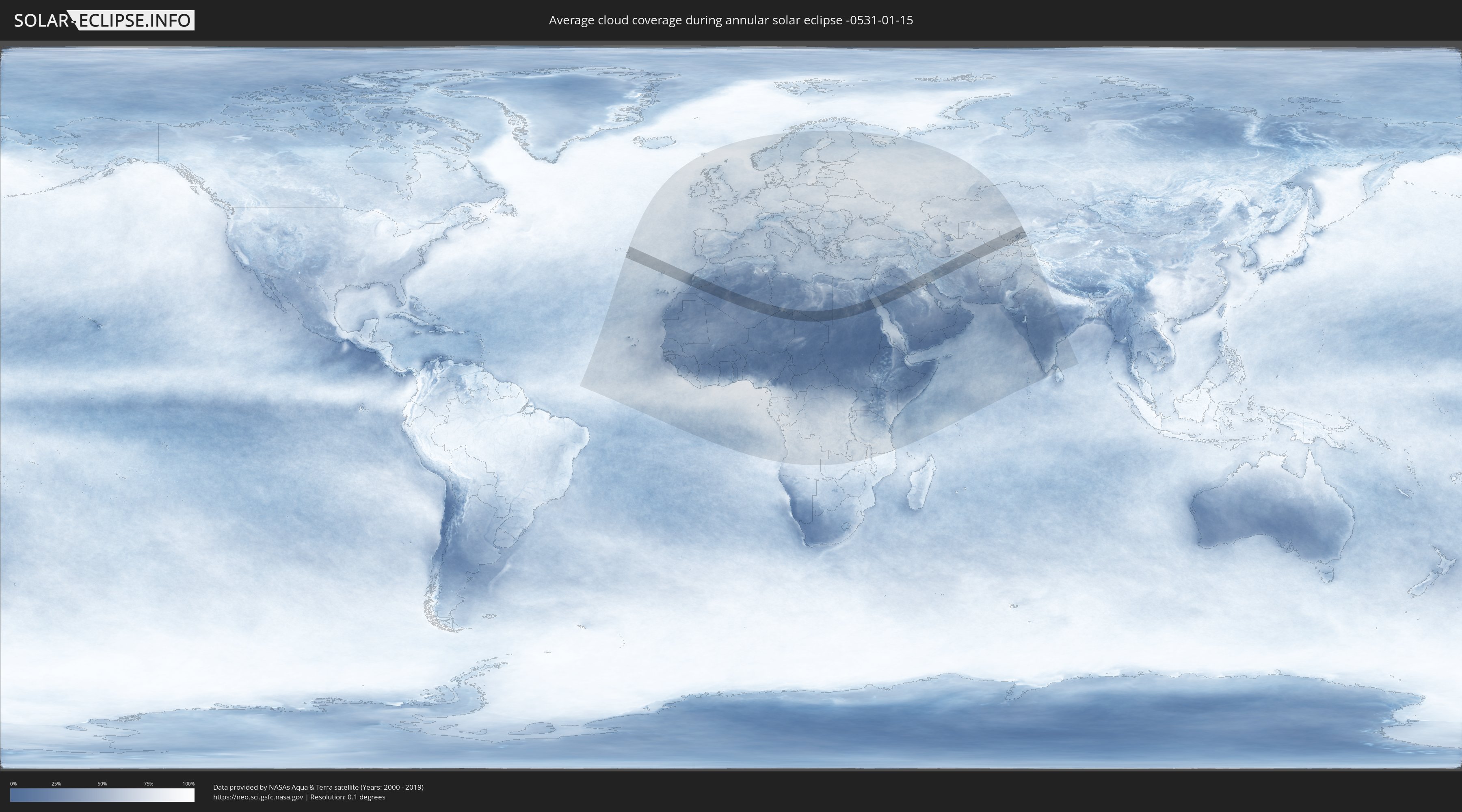
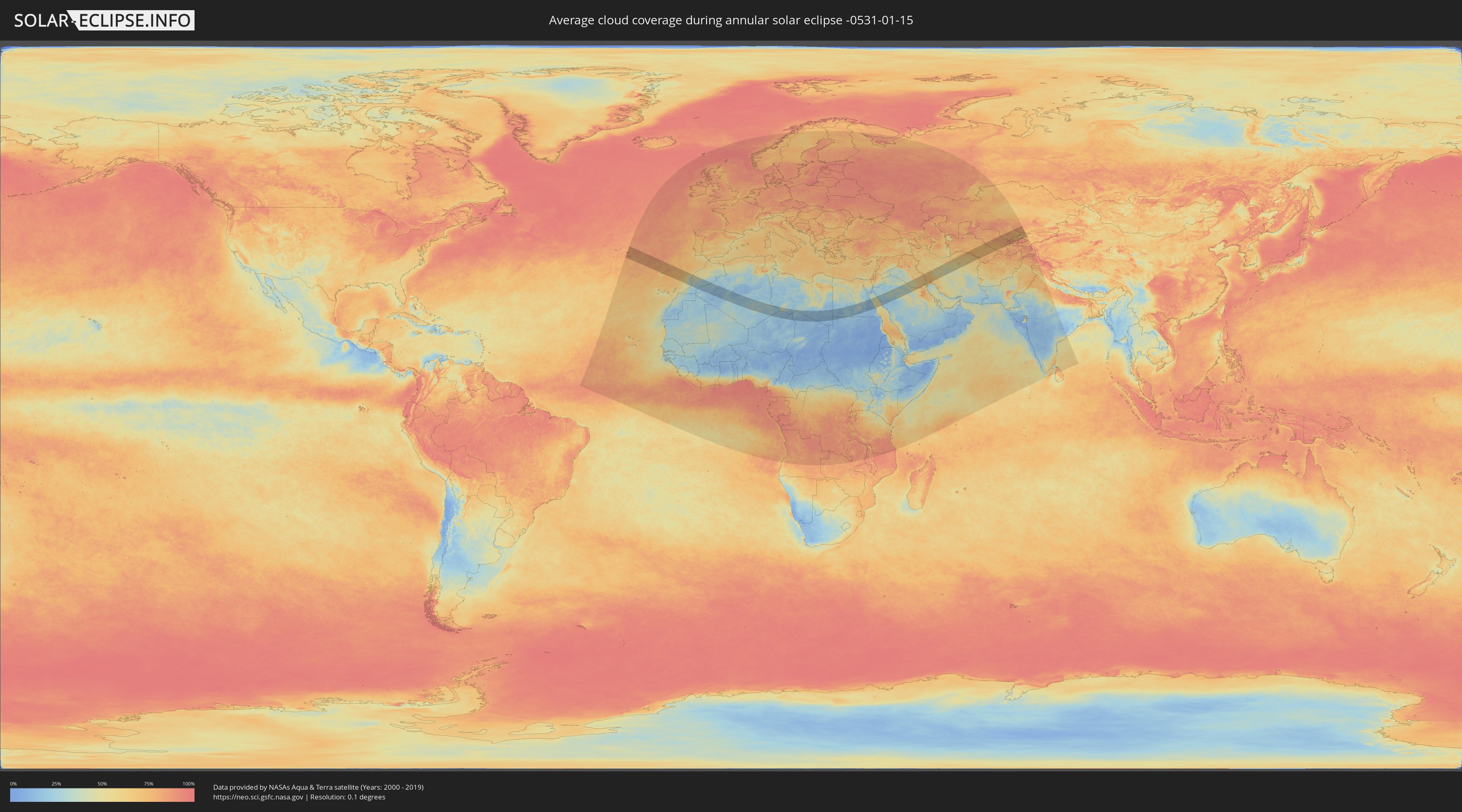
How will be the weather during the annular solar eclipse on 01/15/-0531?
Where is the best place to see the annular solar eclipse of 01/15/-0531?
The following maps show the average cloud coverage for the day of the annular solar eclipse.
With the help of these maps, it is possible to find the place along the eclipse path, which has the best
chance of a cloudless sky.
Nevertheless, you should consider local circumstances and inform about the weather of your chosen
observation site.
The data is provided by NASAs satellites
AQUA and TERRA.
The cloud maps are averaged over a period of 19 years (2000 - 2019).
Detailed country maps
 Portugal
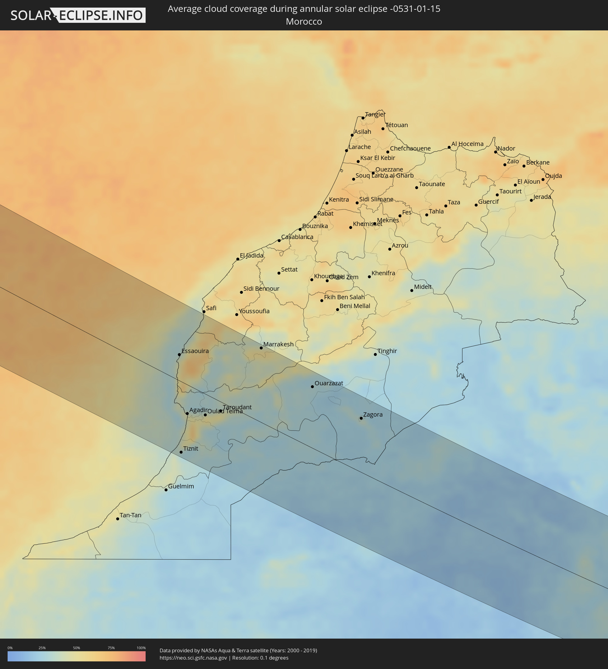 Morocco
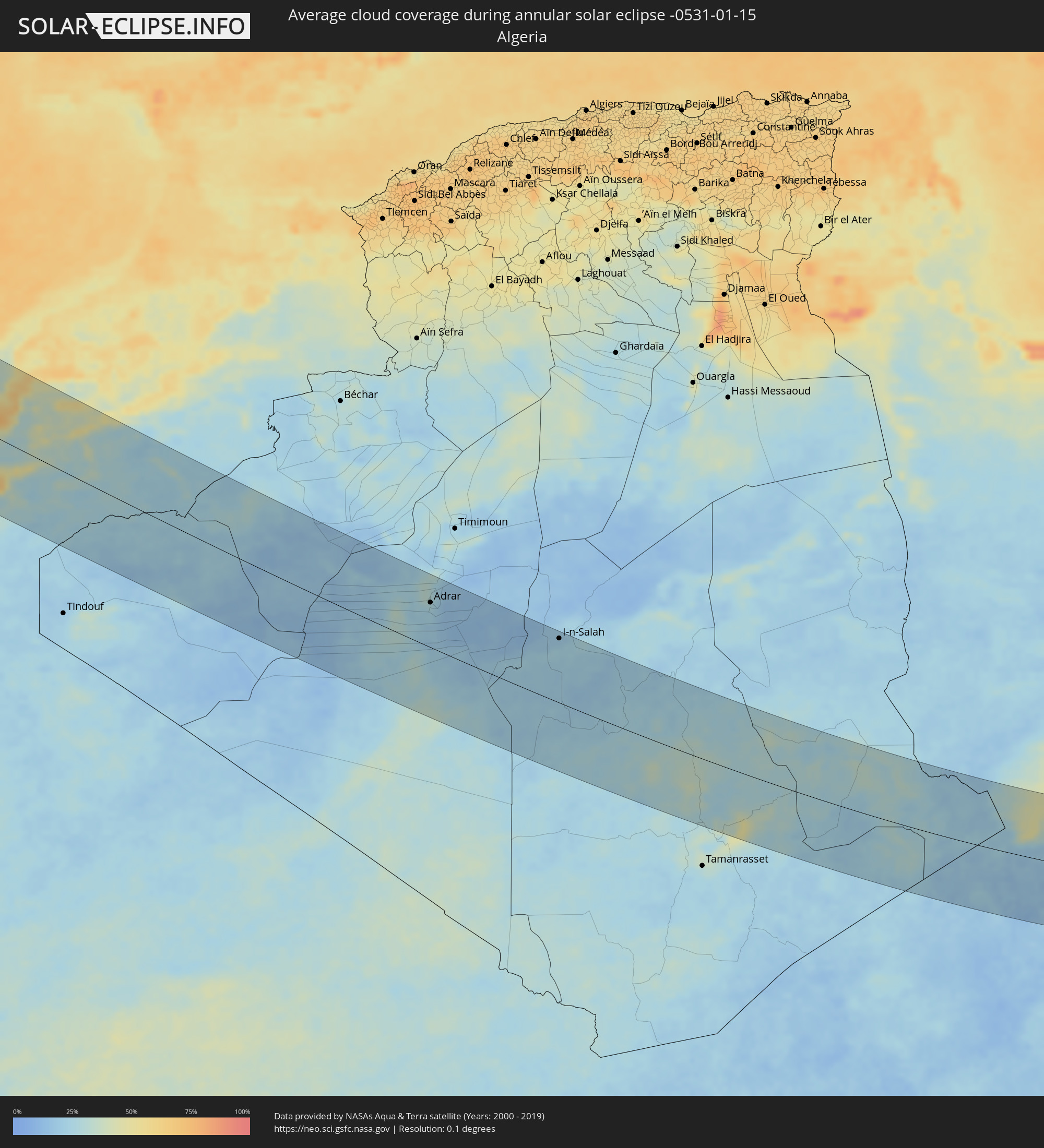 Algeria
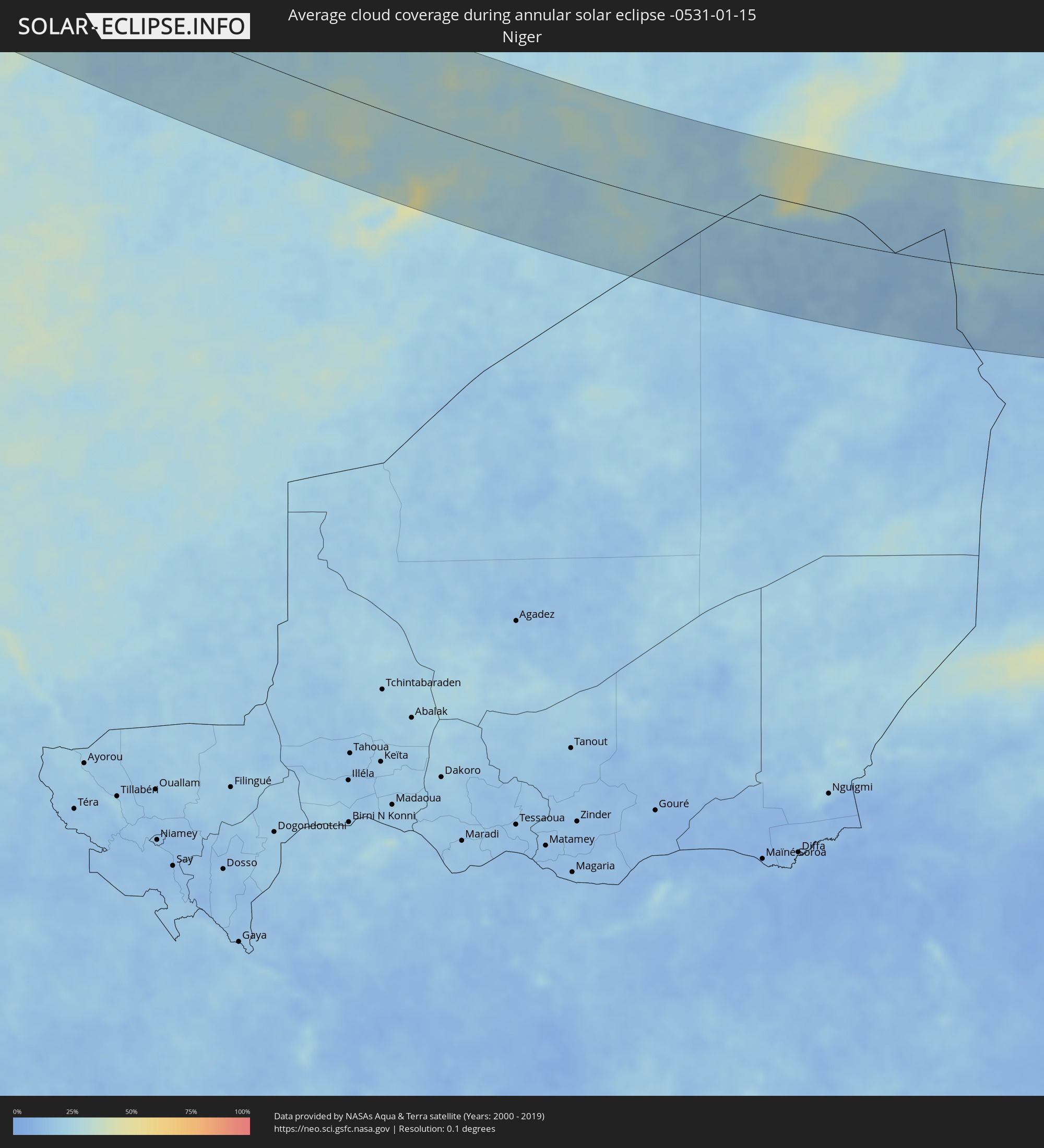 Niger
Niger
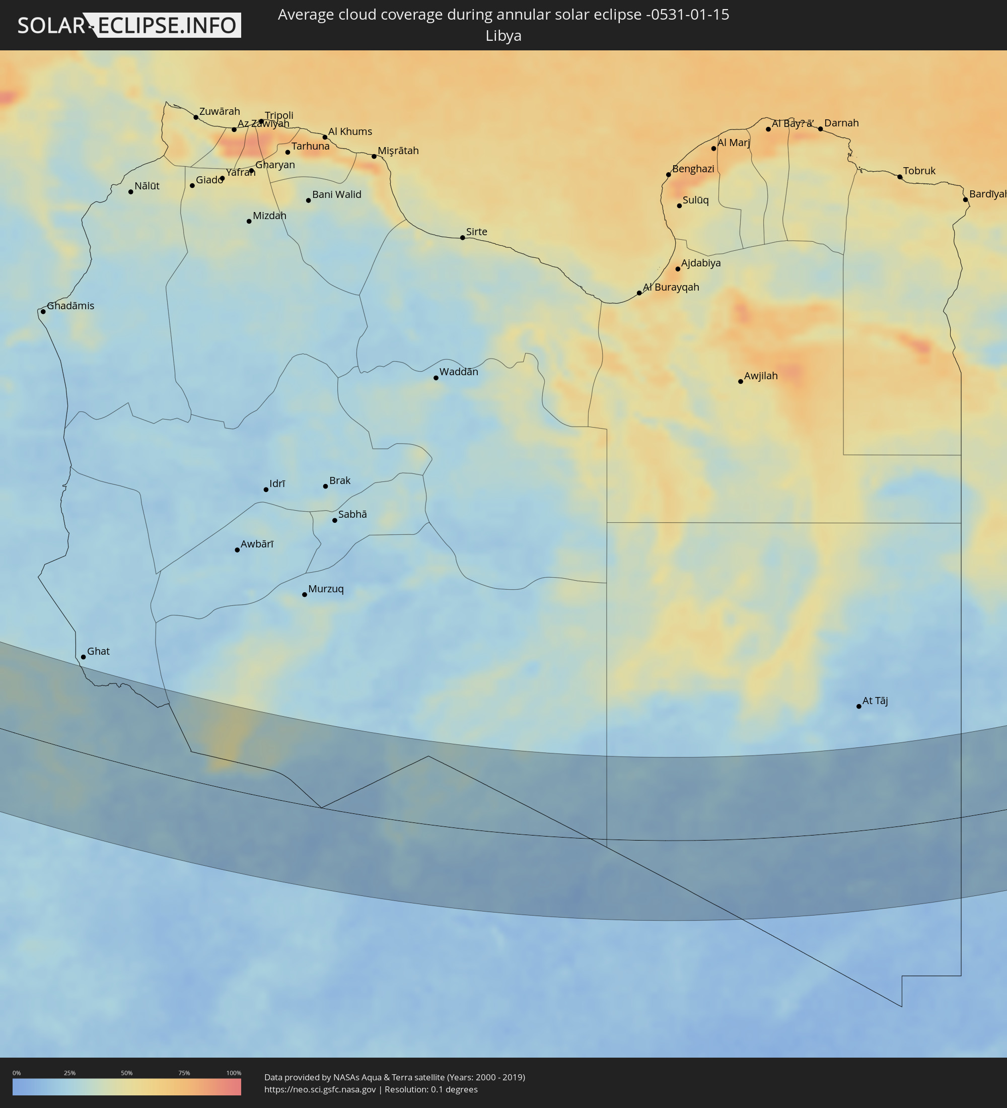 Libya
Libya
 Chad
Chad
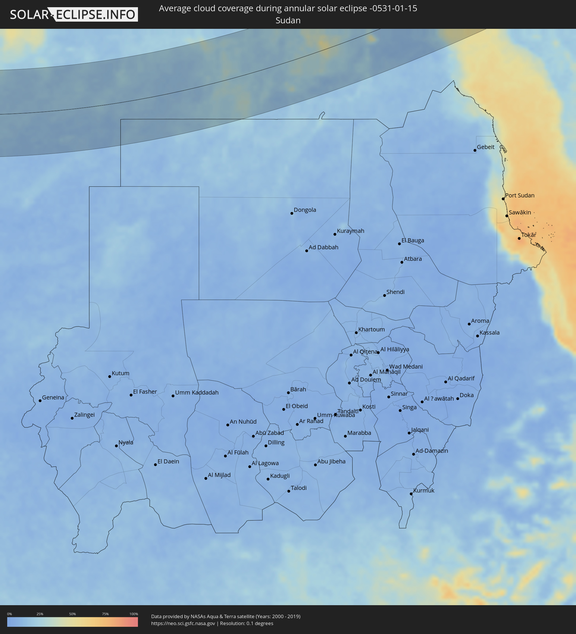 Sudan
Sudan
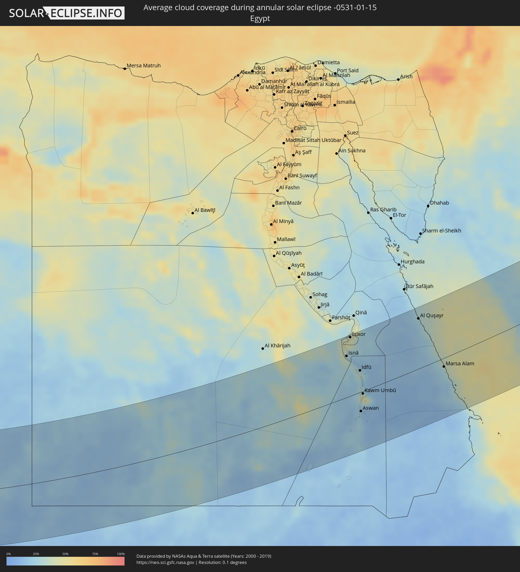 Egypt
Egypt
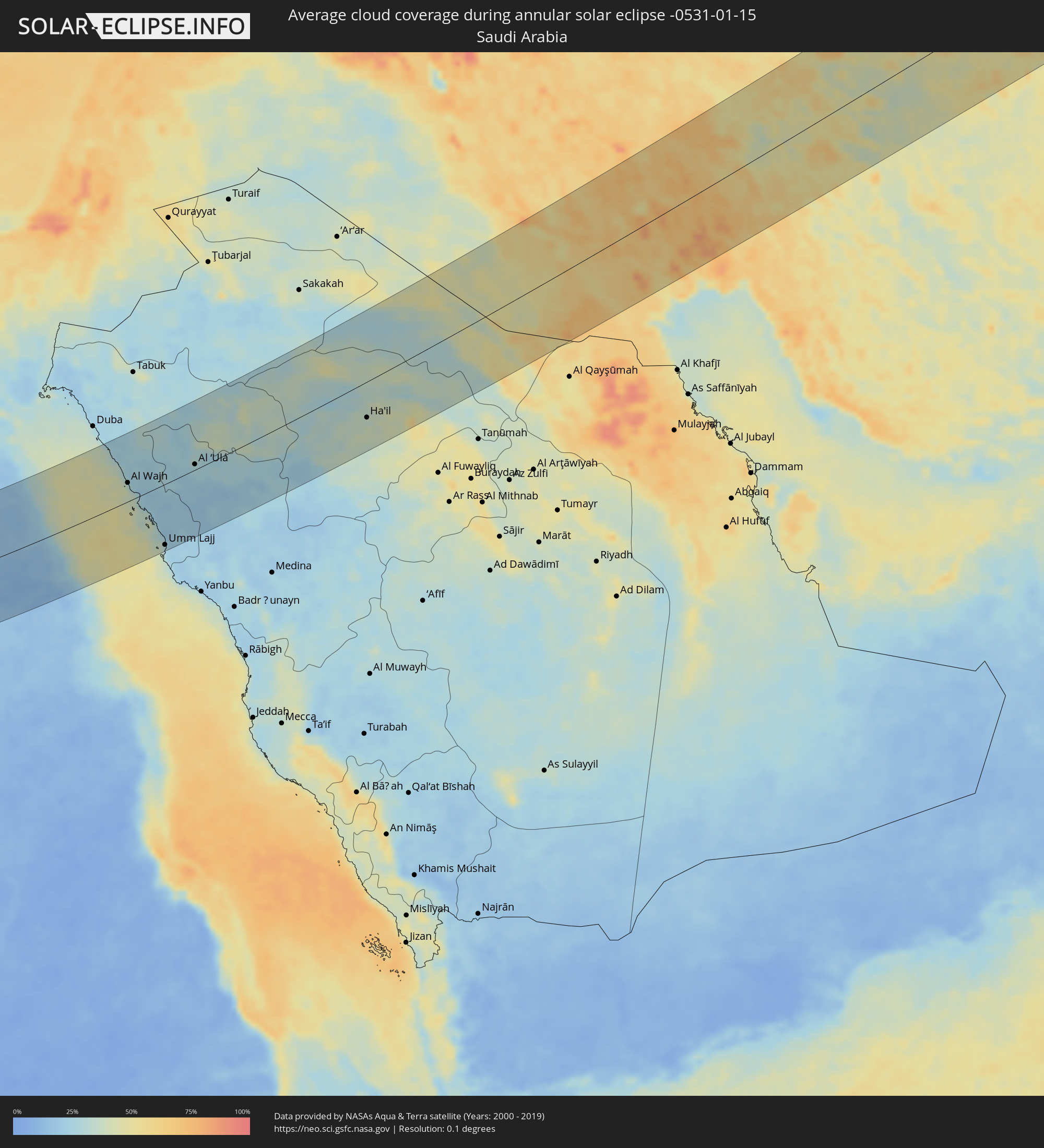 Saudi Arabia
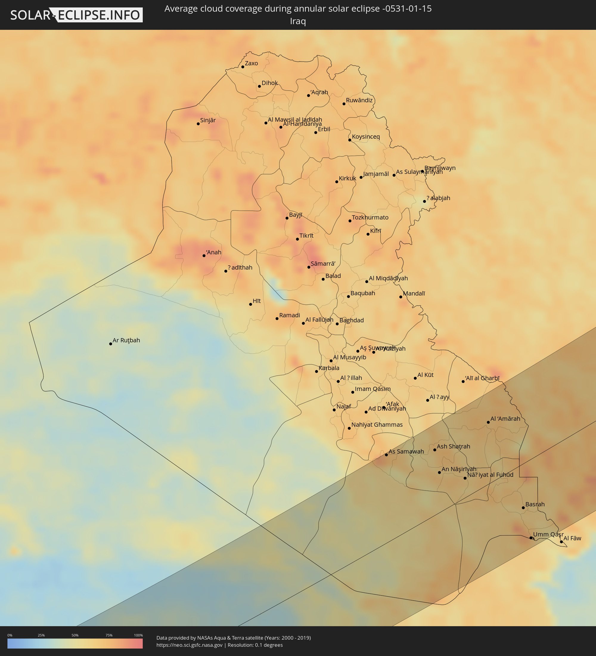 Iraq
Iraq
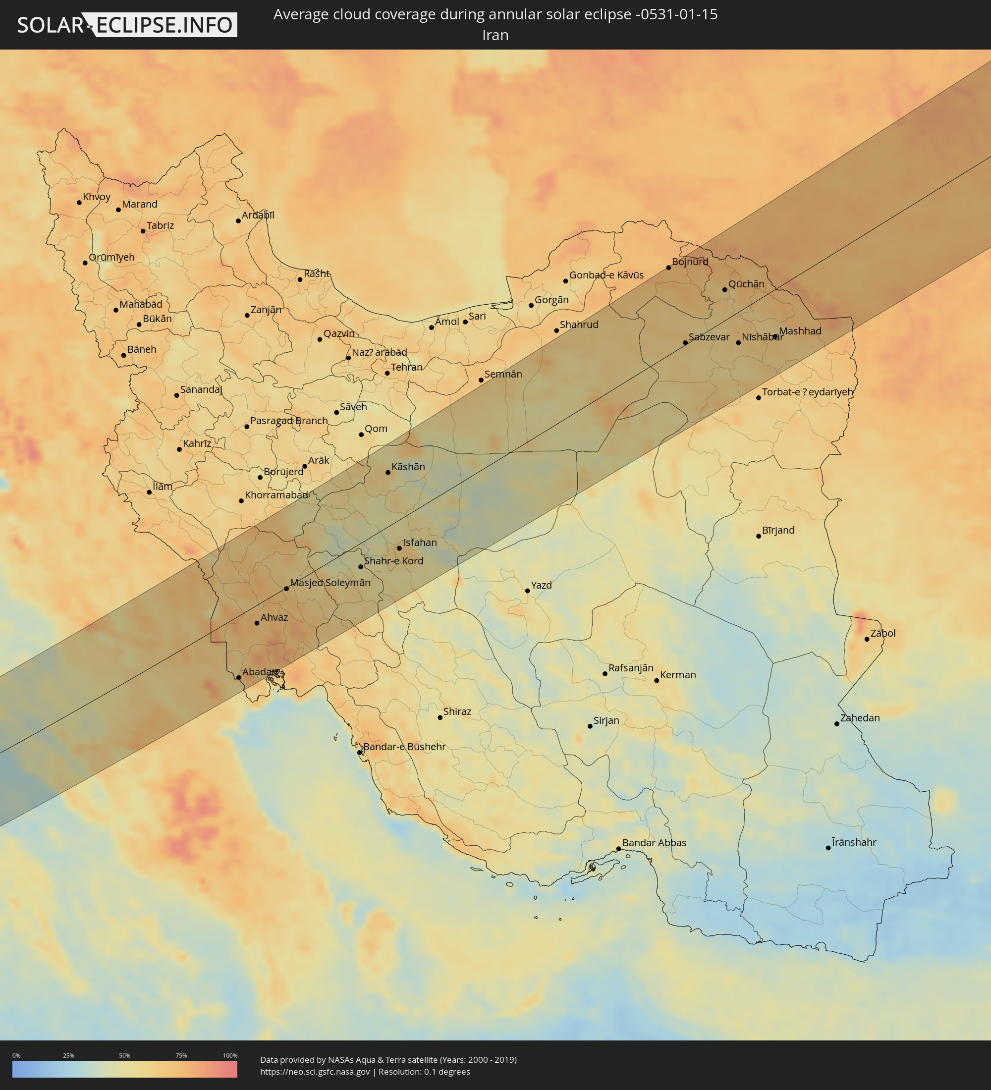 Iran
Iran
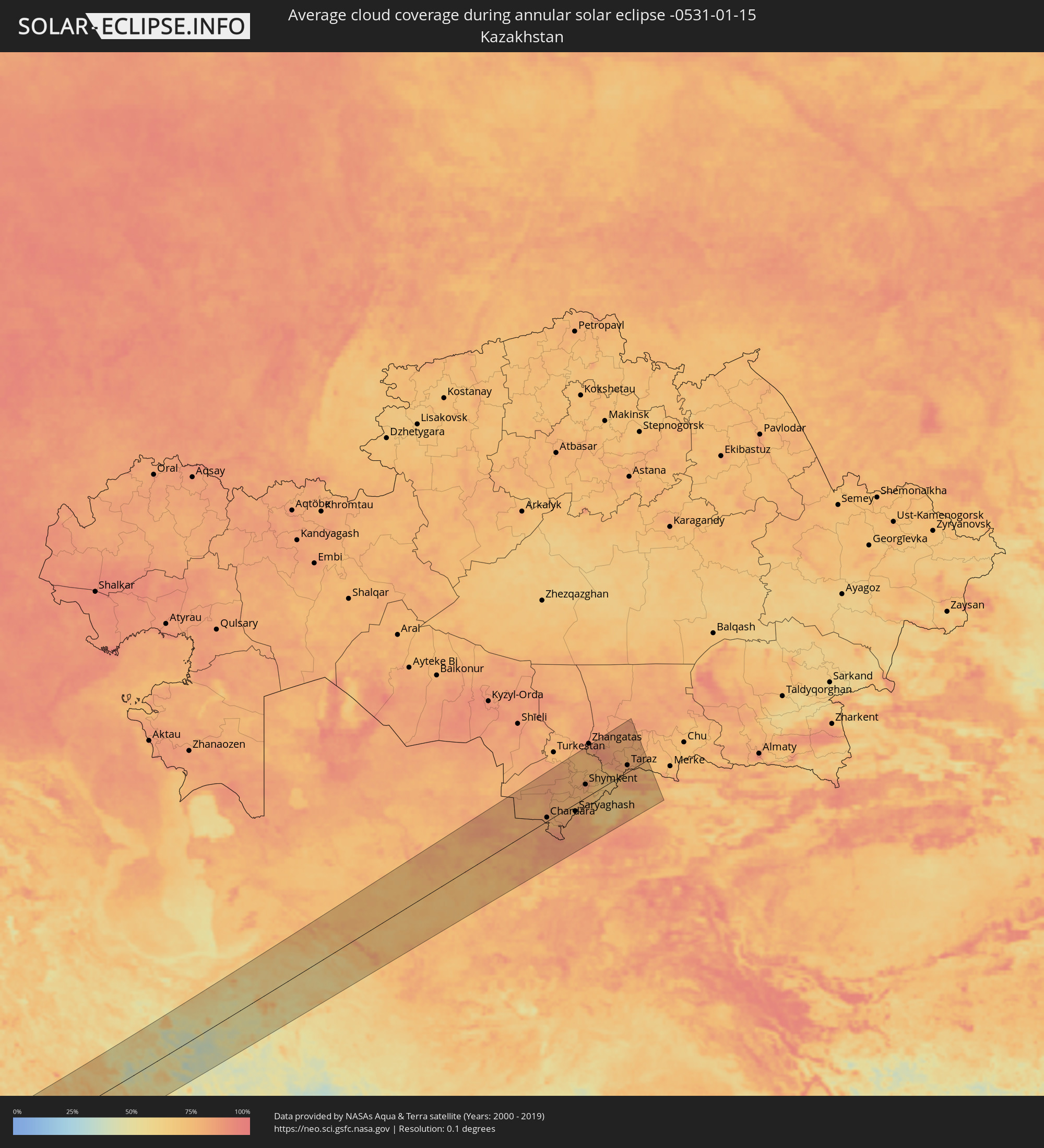 Kazakhstan
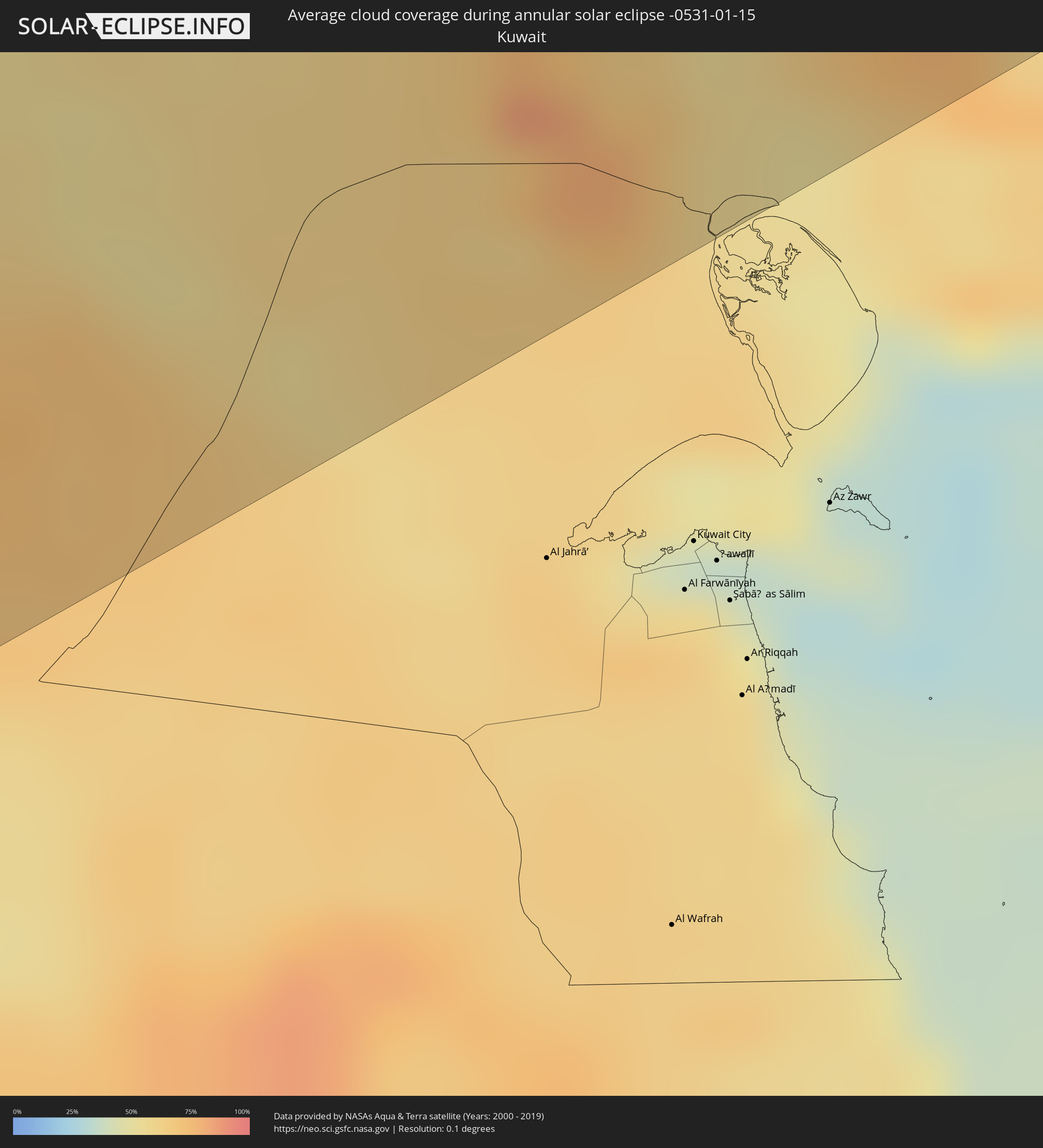 Kuwait
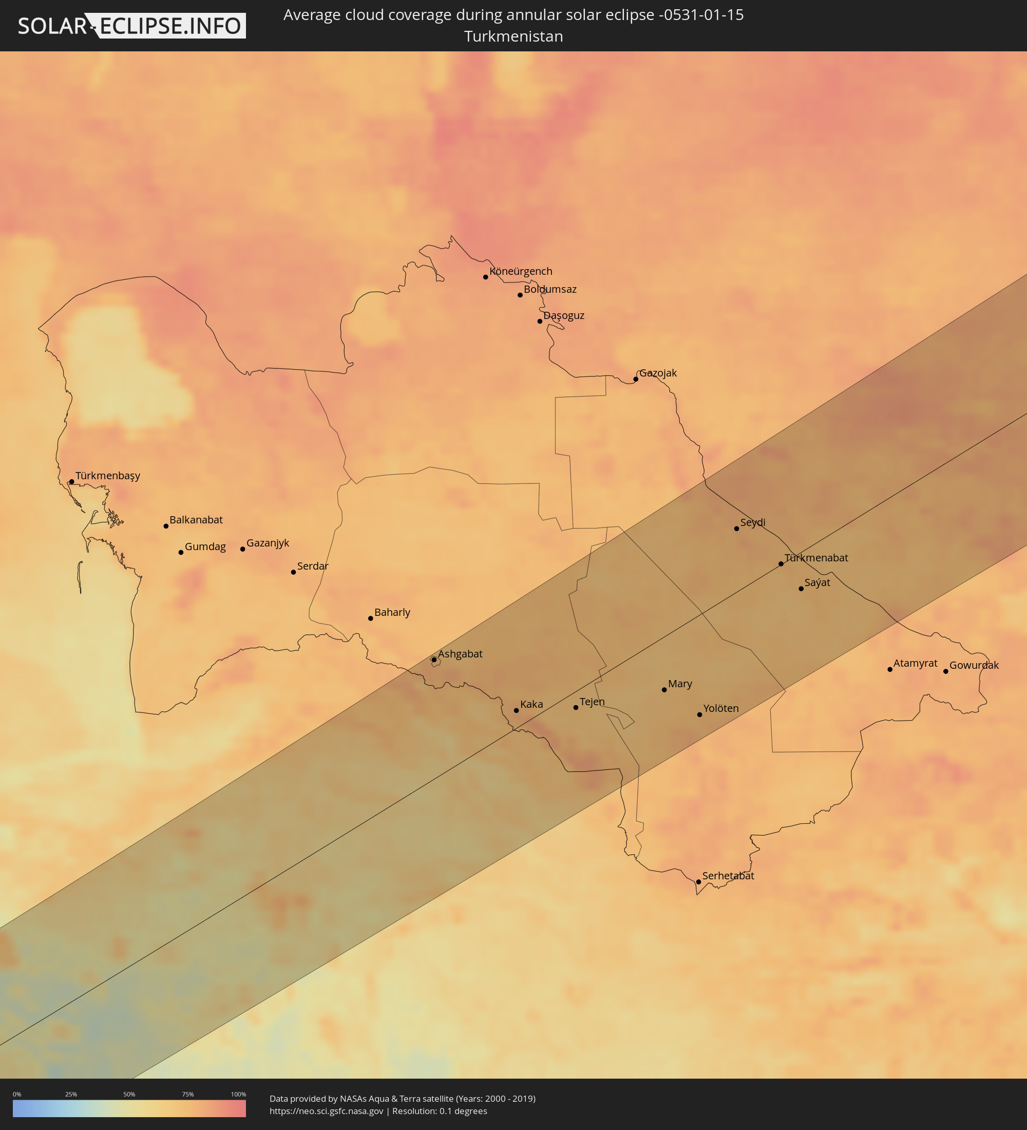 Turkmenistan
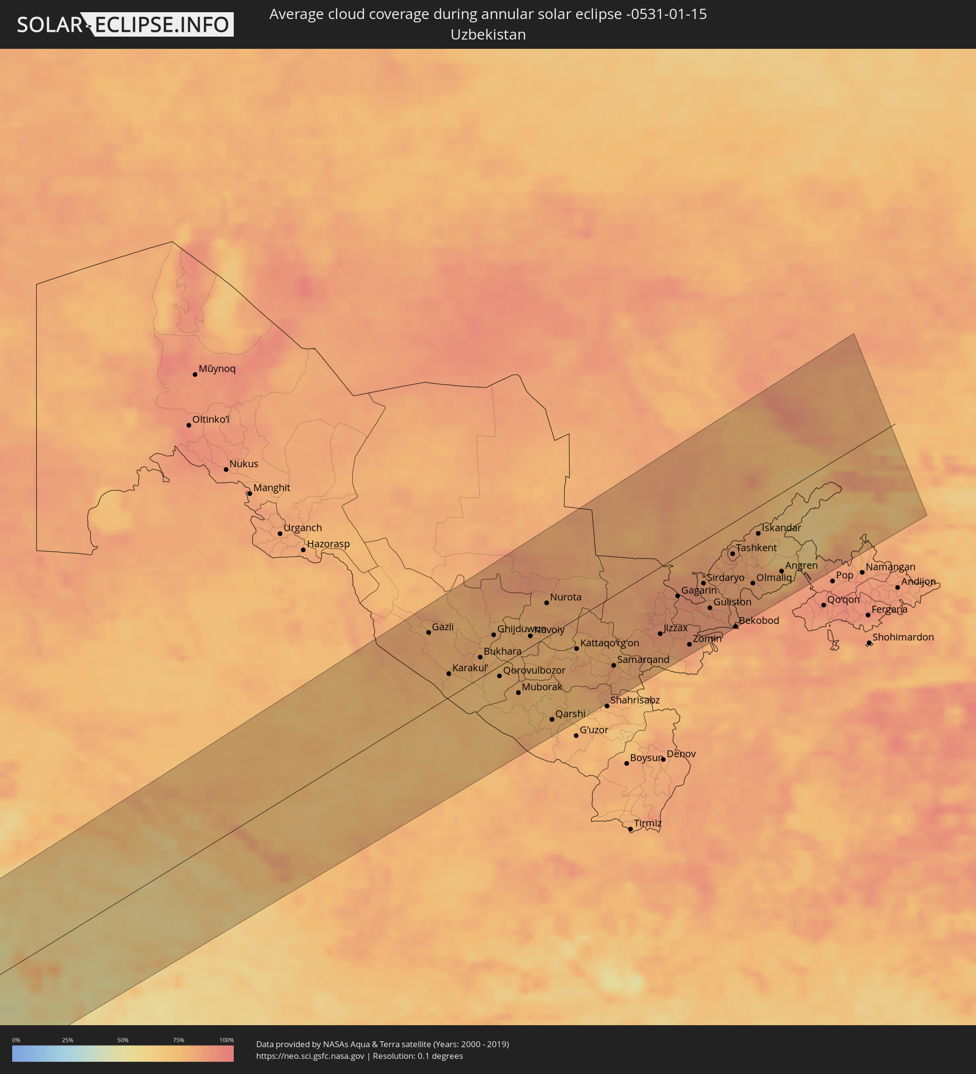 Uzbekistan
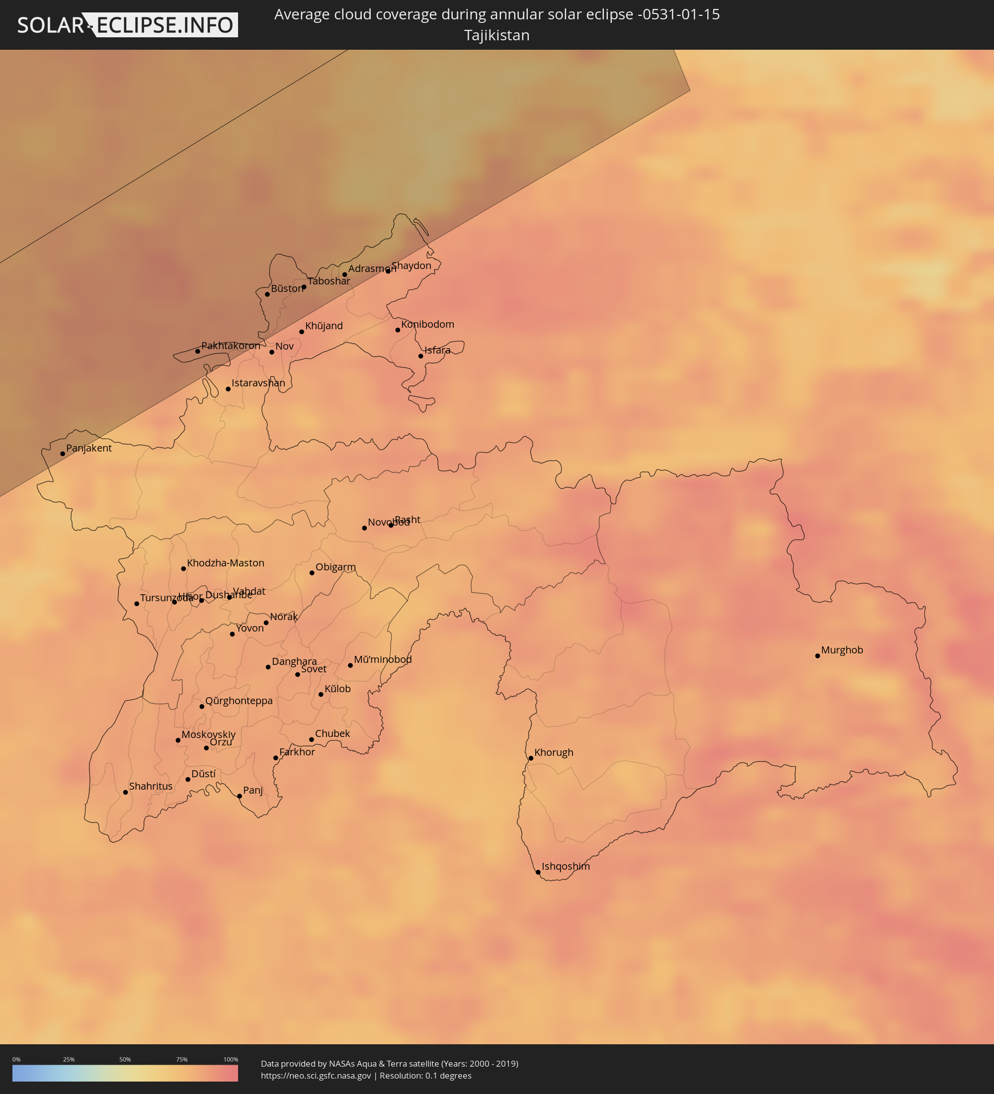 Tajikistan
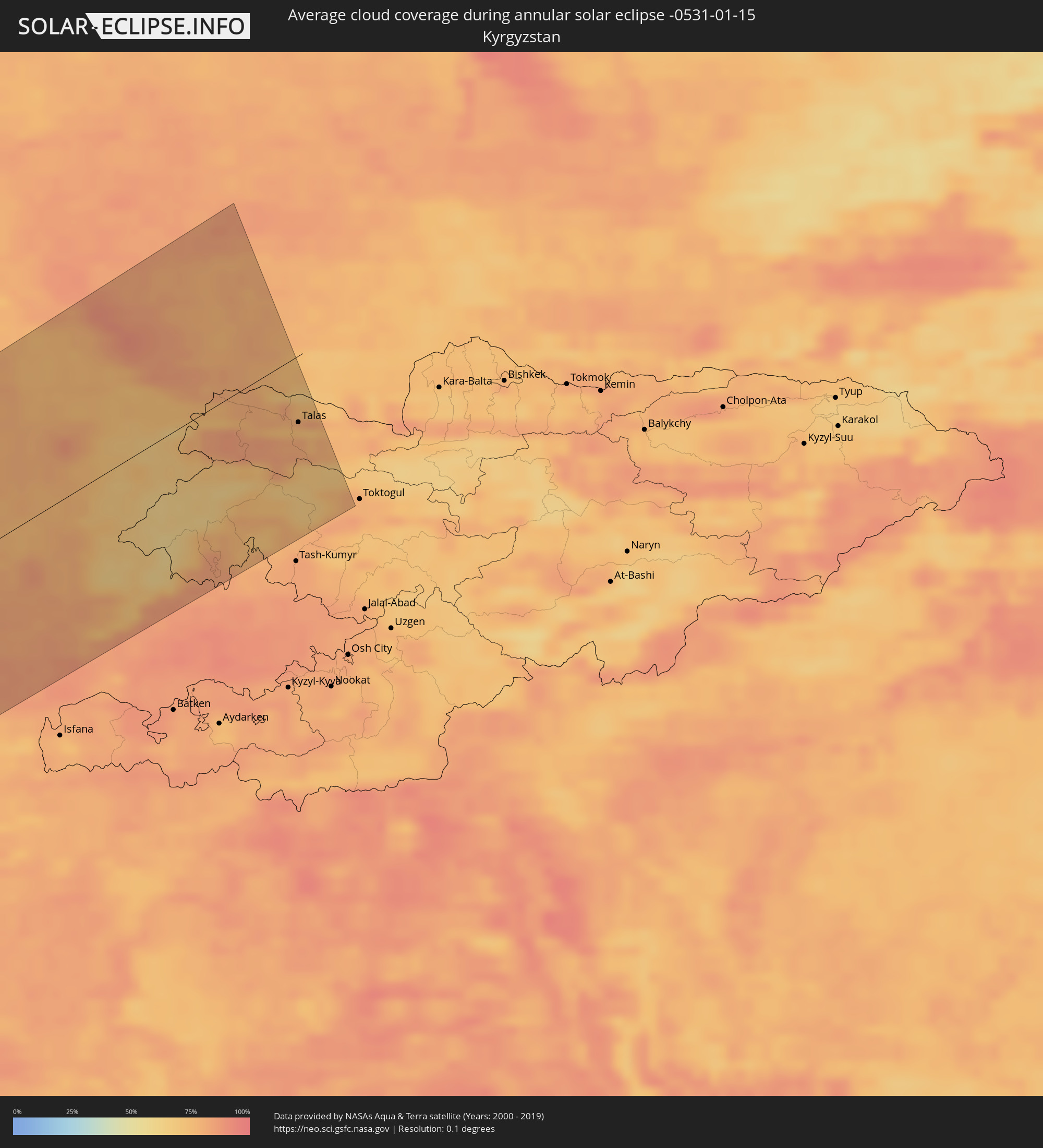 Kyrgyzstan
Cities inside the path of the eclipse
The following table shows all locations with a population of more than 5,000 inside the eclipse path. Cities which have more than 100,000 inhabitants are marked bold. A click at the locations opens a detailed map.
| City | Type | Eclipse duration | Local time of max. eclipse | Distance to central line | Ø Cloud coverage |
|
Rabo de Peixe, Azores
|
annular | - | 07:15:35 UTC-01:54 | 22 km | 84% |
|
Vila Franca do Campo, Azores
|
annular | - | 07:15:34 UTC-01:54 | 30 km | 82% |
|
Santana, Madeira
|
annular | - | 08:33:54 UTC-00:36 | 137 km | 73% |
|
Machico, Madeira
|
annular | - | 08:33:54 UTC-00:36 | 142 km | 76% |
|
Camacha, Madeira
|
annular | - | 08:34:40 UTC-00:36 | 85 km | 81% |
|
Essaouira, Marrakech-Tensift-Al Haouz
|
annular | - | 08:46:38 UTC-00:30 | 47 km | 42% |
|
Tiznit, Souss-Massa-Drâa
|
annular | - | 08:45:04 UTC-00:30 | 131 km | 28% |
|
Agadir, Souss-Massa-Drâa
|
annular | - | 08:45:52 UTC-00:30 | 53 km | 43% |
|
Dakhla, Dakhla-Oued Ed-Dahab
|
annular | - | 08:45:55 UTC-00:30 | 53 km | 43% |
|
Oulad Teïma, Souss-Massa-Drâa
|
annular | - | 08:46:21 UTC-00:30 | 39 km | 51% |
|
Taroudant, Souss-Massa-Drâa
|
annular | - | 08:46:51 UTC-00:30 | 17 km | 50% |
|
Marrakesh, Marrakech-Tensift-Al Haouz
|
annular | - | 08:49:05 UTC-00:30 | 136 km | 52% |
|
Ouarzazat, Souss-Massa-Drâa
|
annular | - | 08:50:00 UTC-00:30 | 113 km | 28% |
|
Zagora, Souss-Massa-Drâa
|
annular | - | 08:51:03 UTC-00:30 | 101 km | 27% |
|
Mhamid, Souss-Massa-Drâa
|
annular | - | 08:50:47 UTC-00:30 | 55 km | 25% |
|
Adrar, Adrar
|
annular | - | 09:38:17 UTC+00:09 | 86 km | 26% |
|
Reggane, Adrar
|
annular | - | 09:38:22 UTC+00:09 | 13 km | 19% |
|
Aoulef, Adrar
|
annular | - | 09:40:23 UTC+00:09 | 49 km | 16% |
|
I-n-Salah, Tamanrasset
|
annular | - | 09:43:26 UTC+00:09 | 126 km | 21% |
|
Bardaï, Tibesti
|
annular | - | 11:11:39 UTC+01:00 | 102 km | 15% |
|
Isnā, Qena
|
annular | - | 13:04:16 UTC+02:00 | 94 km | 37% |
|
Luxor, Luxor
|
annular | - | 13:04:32 UTC+02:00 | 132 km | 42% |
|
Idfū, Aswan
|
annular | - | 13:05:14 UTC+02:00 | 49 km | 34% |
|
Aswan, Aswan
|
annular | - | 13:05:16 UTC+02:00 | 44 km | 22% |
|
Kawm Umbū, Aswan
|
annular | - | 13:05:25 UTC+02:00 | 6 km | 32% |
|
Al Quşayr, Red Sea
|
annular | - | 13:09:19 UTC+02:00 | 112 km | 22% |
|
Marsa Alam, Red Sea
|
annular | - | 13:11:06 UTC+02:00 | 19 km | 26% |
|
Al Wajh, Tabuk
|
annular | - | 14:22:14 UTC+03:06 | 37 km | 33% |
|
Umm Lajj, Tabuk
|
annular | - | 14:24:32 UTC+03:06 | 121 km | 26% |
|
Al ‘Ulá, Al Madīnah al Munawwarah
|
annular | - | 14:26:04 UTC+03:06 | 11 km | 27% |
|
Ha'il, Ḩāʼil
|
annular | - | 14:35:00 UTC+03:06 | 68 km | 34% |
|
As Samawah, Al Muthanná
|
annular | - | 14:31:55 UTC+02:57 | 132 km | 56% |
|
Ash Shaţrah, Dhi Qar
|
annular | - | 14:33:33 UTC+02:57 | 97 km | 68% |
|
An Nāşirīyah, Dhi Qar
|
annular | - | 14:33:53 UTC+02:57 | 59 km | 67% |
|
Nāḩiyat al Fuhūd, Dhi Qar
|
annular | - | 14:34:47 UTC+02:57 | 29 km | 64% |
|
Al ‘Amārah, Maysan
|
annular | - | 14:35:07 UTC+02:57 | 91 km | 67% |
|
Az Zubayr, Basra Governorate
|
annular | - | 14:36:51 UTC+02:57 | 74 km | 72% |
|
Al Hārithah, Basra Governorate
|
annular | - | 14:36:52 UTC+02:57 | 59 km | 65% |
|
Basrah, Basra Governorate
|
annular | - | 14:36:56 UTC+02:57 | 67 km | 60% |
|
Al Başrah al Qadīmah, Basra Governorate
|
annular | - | 14:37:00 UTC+02:57 | 69 km | 60% |
|
Umm Qaşr, Basra Governorate
|
annular | - | 14:37:24 UTC+02:57 | 119 km | 62% |
|
Khorramshahr, Khuzestan
|
annular | - | 15:05:49 UTC+03:25 | 93 km | 62% |
|
Abadan, Khuzestan
|
annular | - | 15:06:04 UTC+03:25 | 108 km | 59% |
|
Ahvaz, Khuzestan
|
annular | - | 15:06:14 UTC+03:25 | 33 km | 70% |
|
Masjed Soleymān, Khuzestan
|
annular | - | 15:06:57 UTC+03:25 | 3 km | 72% |
|
Alīgūdarz, Lorestān
|
annular | - | 15:06:43 UTC+03:25 | 117 km | 52% |
|
Shahr-e Kord, Chahār Maḩāll va Bakhtīārī
|
annular | - | 15:09:14 UTC+03:25 | 42 km | 49% |
|
Najafābād, Isfahan
|
annular | - | 15:09:49 UTC+03:25 | 36 km | 60% |
|
Kāshān, Isfahan
|
annular | - | 15:09:03 UTC+03:25 | 89 km | 58% |
|
Isfahan, Isfahan
|
annular | - | 15:10:16 UTC+03:25 | 49 km | 65% |
|
Shāhreẕā, Isfahan
|
annular | - | 15:10:57 UTC+03:25 | 118 km | 56% |
|
Bojnūrd, Khorāsān-e Shomālī
|
annular | - | 15:14:07 UTC+03:25 | 138 km | 72% |
|
Sabzevar, Razavi Khorasan
|
annular | - | 15:15:35 UTC+03:25 | 2 km | 62% |
|
Ashgabat, Ahal
|
annular | - | 15:42:40 UTC+03:53 | 133 km | 76% |
|
Kāshmar, Razavi Khorasan
|
annular | - | 15:17:15 UTC+03:25 | 128 km | 61% |
|
Qūchān, Razavi Khorasan
|
annular | - | 15:15:45 UTC+03:25 | 48 km | 61% |
|
Annau, Ahal
|
annular | - | 15:42:52 UTC+03:53 | 121 km | 78% |
|
Nīshābūr, Razavi Khorasan
|
annular | - | 15:16:49 UTC+03:25 | 50 km | 61% |
|
Mashhad, Razavi Khorasan
|
annular | - | 15:17:33 UTC+03:25 | 77 km | 66% |
|
Kaka, Ahal
|
annular | - | 15:44:31 UTC+03:53 | 19 km | 75% |
|
Tejen, Ahal
|
annular | - | 15:45:23 UTC+03:53 | 19 km | 72% |
|
Mary, Mary
|
annular | - | 15:46:28 UTC+03:53 | 61 km | 71% |
|
Murgab
|
annular | - | 15:46:41 UTC+03:53 | 76 km | 72% |
|
Bayramaly, Mary
|
annular | - | 15:46:45 UTC+03:53 | 74 km | 74% |
|
Yolöten, Mary
|
annular | - | 15:47:13 UTC+03:53 | 113 km | 75% |
|
Seydi, Mary
|
annular | - | 15:45:40 UTC+03:53 | 69 km | 76% |
|
Türkmenabat, Lebap
|
annular | - | 15:46:38 UTC+03:53 | 0 km | 74% |
|
Farap, Lebap
|
annular | - | 15:46:34 UTC+03:53 | 7 km | 76% |
|
Saýat, Lebap
|
annular | - | 15:47:10 UTC+03:53 | 41 km | 73% |
|
Bukhara, Bukhara
|
annular | - | 16:20:59 UTC+04:27 | 28 km | 77% |
|
Navoiy, Navoiy
|
annular | - | 16:21:26 UTC+04:27 | 14 km | 79% |
|
Koson, Qashqadaryo
|
annular | - | 16:22:38 UTC+04:27 | 94 km | 73% |
|
Qarshi, Qashqadaryo
|
annular | - | 16:22:57 UTC+04:27 | 120 km | 75% |
|
Kattaqo’rg’on, Samarqand
|
annular | - | 16:22:16 UTC+04:27 | 42 km | 78% |
|
Samarqand, Samarqand
|
annular | - | 16:23:01 UTC+04:27 | 97 km | 82% |
|
Urgut, Samarqand
|
annular | - | 16:23:28 UTC+04:27 | 134 km | 79% |
|
Panjakent, Viloyati Sughd
|
annular | - | 16:30:57 UTC+04:35 | 141 km | 77% |
|
Jizzax, Jizzax
|
annular | - | 16:23:10 UTC+04:27 | 92 km | 85% |
|
Chardara, Ongtüstik Qazaqstan
|
annular | - | 16:16:02 UTC+04:21 | 11 km | 79% |
|
Asyqata, Ongtüstik Qazaqstan
|
annular | - | 16:16:41 UTC+04:21 | 41 km | 90% |
|
Atakent, Ongtüstik Qazaqstan
|
annular | - | 16:16:49 UTC+04:21 | 52 km | 90% |
|
Slavyanka, Ongtüstik Qazaqstan
|
annular | - | 16:17:02 UTC+04:21 | 71 km | 87% |
|
Pakhtakoron, Viloyati Sughd
|
annular | - | 16:31:02 UTC+04:35 | 128 km | 84% |
|
Guliston, Sirdaryo
|
annular | - | 16:23:23 UTC+04:27 | 98 km | 86% |
|
Arys, Ongtüstik Qazaqstan
|
annular | - | 16:15:18 UTC+04:21 | 85 km | 79% |
|
Yangiyŭl, Toshkent
|
annular | - | 16:22:54 UTC+04:27 | 50 km | 81% |
|
Saryaghash, Ongtüstik Qazaqstan
|
annular | - | 16:16:35 UTC+04:21 | 22 km | 80% |
|
Tashkent, Toshkent Shahri
|
annular | - | 16:22:50 UTC+04:27 | 43 km | 85% |
|
Temirlanovka, Ongtüstik Qazaqstan
|
annular | - | 16:15:23 UTC+04:21 | 82 km | 78% |
|
Bekobod, Toshkent
|
annular | - | 16:23:58 UTC+04:27 | 145 km | 86% |
|
Bŭston, Viloyati Sughd
|
annular | - | 16:31:01 UTC+04:35 | 119 km | 84% |
|
Chayan, Ongtüstik Qazaqstan
|
annular | - | 16:14:58 UTC+04:21 | 118 km | 74% |
|
Leninskoye, Ongtüstik Qazaqstan
|
annular | - | 16:16:24 UTC+04:21 | 3 km | 77% |
|
Chirchiq, Toshkent
|
annular | - | 16:22:51 UTC+04:27 | 39 km | 79% |
|
Olmaliq, Toshkent
|
annular | - | 16:23:31 UTC+04:27 | 100 km | 82% |
|
Shymkent, Ongtüstik Qazaqstan
|
annular | - | 16:15:56 UTC+04:21 | 39 km | 82% |
|
Taboshar, Viloyati Sughd
|
annular | - | 16:31:09 UTC+04:35 | 128 km | 87% |
|
Konsoy, Viloyati Sughd
|
annular | - | 16:31:16 UTC+04:35 | 138 km | 88% |
|
Belyye Vody, Ongtüstik Qazaqstan
|
annular | - | 16:15:56 UTC+04:21 | 41 km | 80% |
|
Lenger, Ongtüstik Qazaqstan
|
annular | - | 16:16:14 UTC+04:21 | 15 km | 75% |
|
Adrasmon, Viloyati Sughd
|
annular | - | 16:31:16 UTC+04:35 | 135 km | 86% |
|
Angren, Toshkent
|
annular | - | 16:23:40 UTC+04:27 | 107 km | 78% |
|
Vannovka, Ongtüstik Qazaqstan
|
annular | - | 16:16:06 UTC+04:21 | 29 km | 71% |
|
Karatau, Zhambyl
|
annular | - | 16:15:27 UTC+04:21 | 85 km | 86% |
|
Taraz, Zhambyl
|
annular | - | 16:16:16 UTC+04:21 | 20 km | 80% |
|
Mikhaylovka, Zhambyl
|
annular | - | 16:16:13 UTC+04:21 | 24 km | 80% |
|
Kosonsoy, Namangan
|
annular | - | 16:24:11 UTC+04:27 | 144 km | 80% |
|
Talas, Talas
|
annular | - | 16:53:41 UTC+04:58 | 54 km | 74% |