Total solar eclipse of 09/30/-0609
| Day of week: | Wednesday |
| Maximum duration of eclipse: | 03m16s |
| Maximum width of eclipse path: | 167 km |
| Saros cycle: | 63 |
| Coverage: | 100% |
| Magnitude: | 1.0398 |
| Gamma: | 0.6092 |
Wo kann man die Sonnenfinsternis vom 09/30/-0609 sehen?
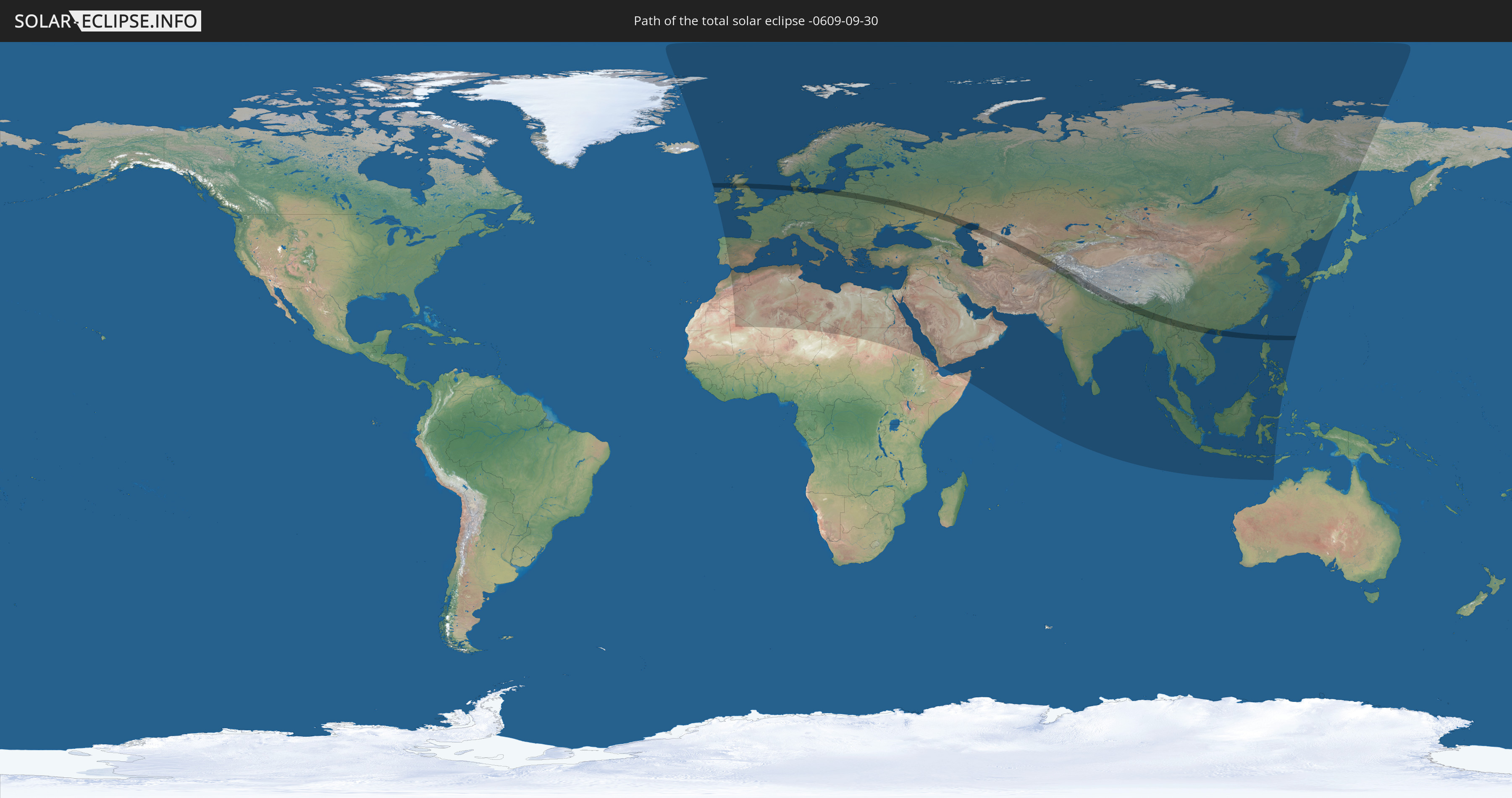
Die Sonnenfinsternis am 09/30/-0609 kann man in 117 Ländern als partielle Sonnenfinsternis beobachten.
Der Finsternispfad verläuft durch 24 Länder. Nur in diesen Ländern ist sie als total Sonnenfinsternis zu sehen.
In den folgenden Ländern ist die Sonnenfinsternis total zu sehen
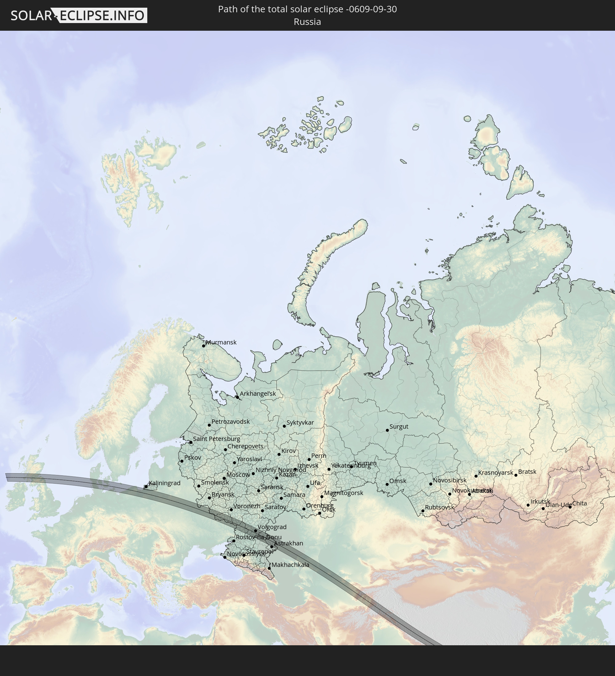 Russia
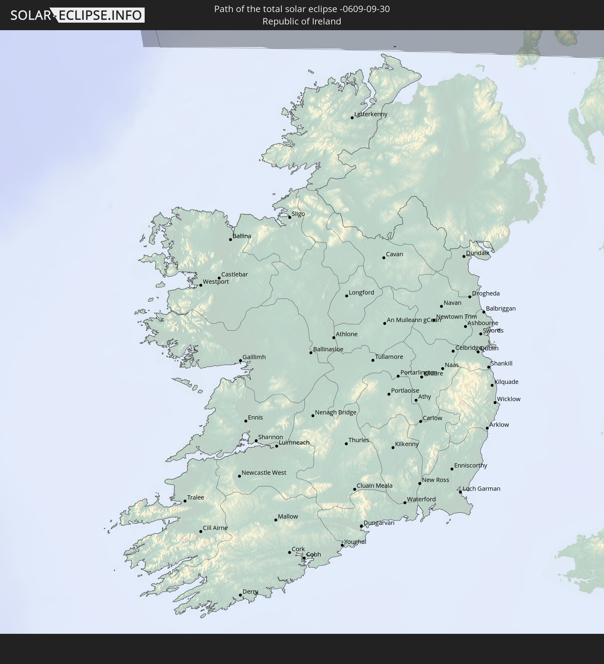 Republic of Ireland
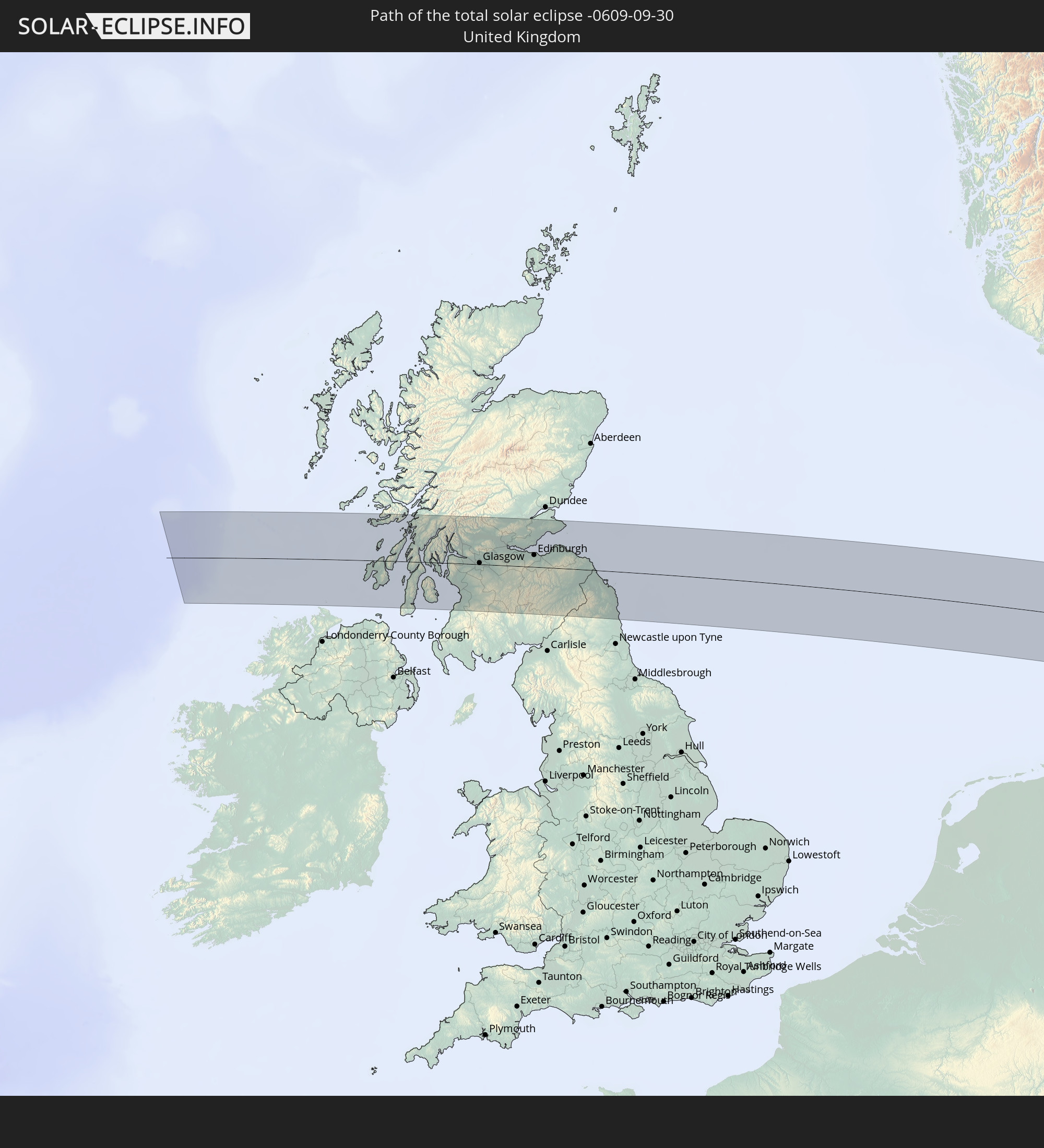 United Kingdom
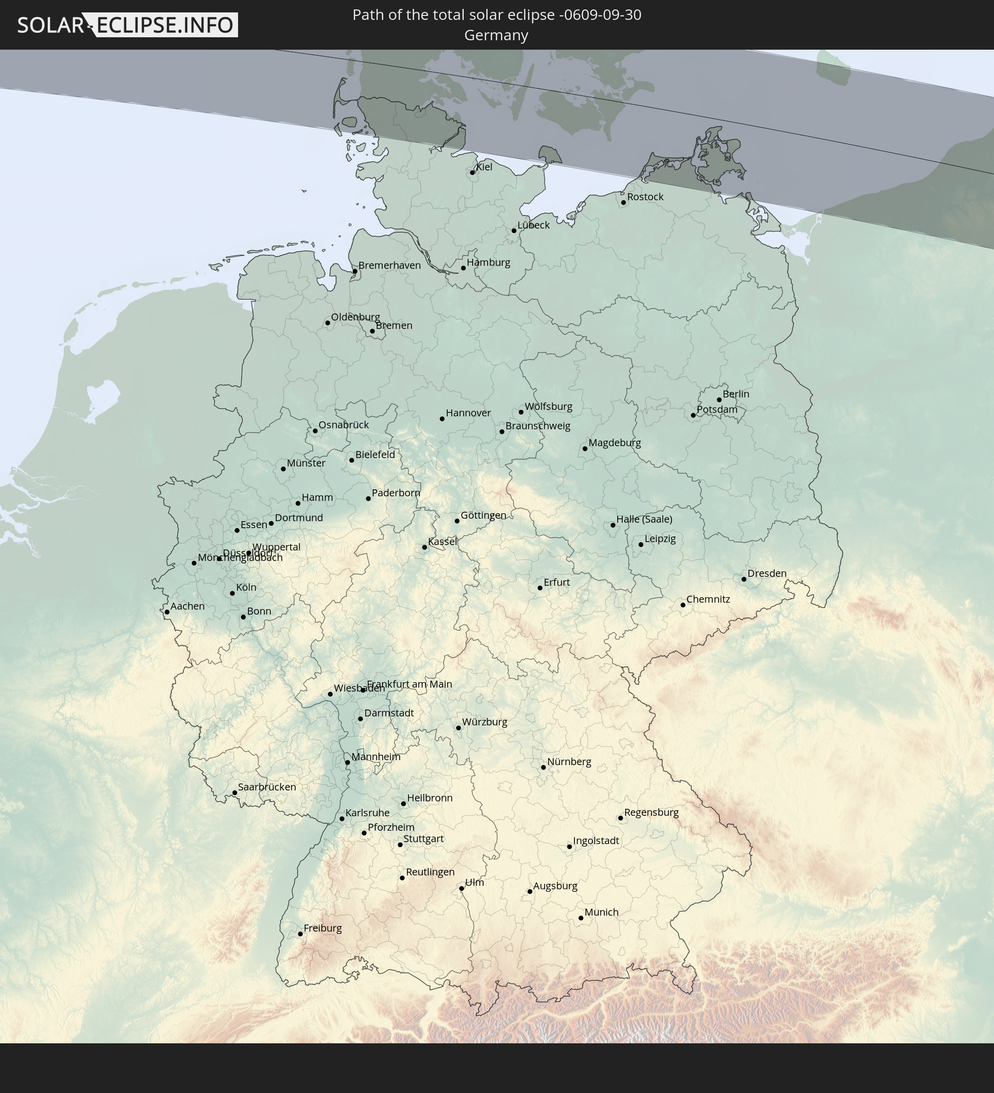 Germany
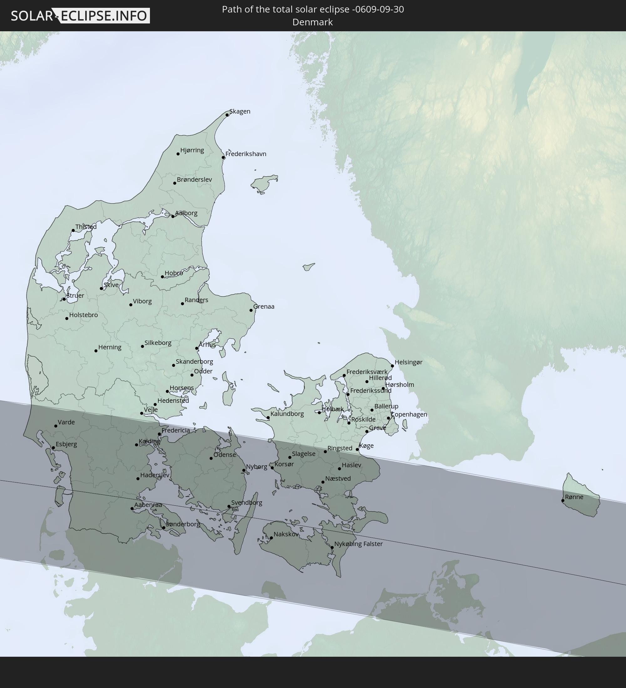 Denmark
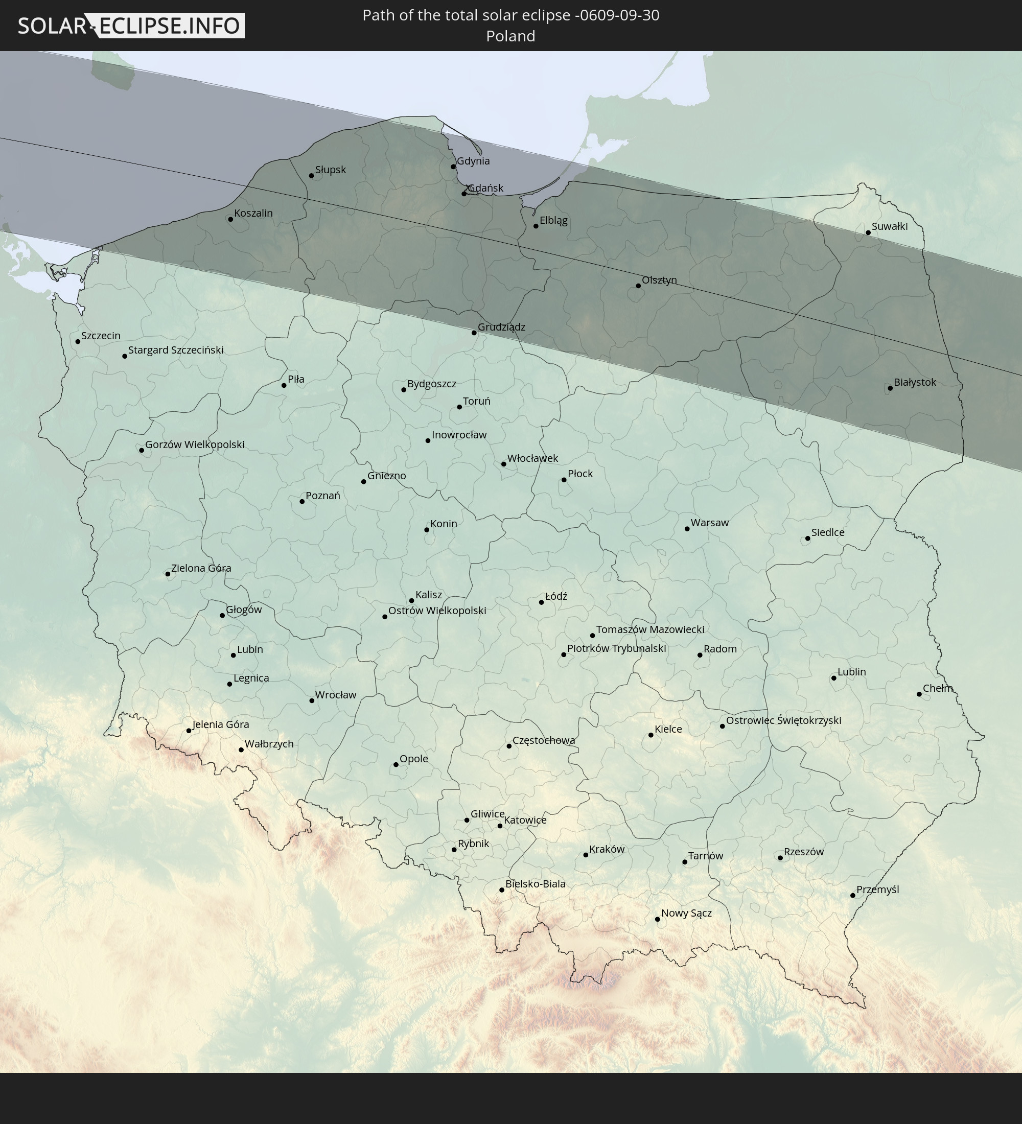 Poland
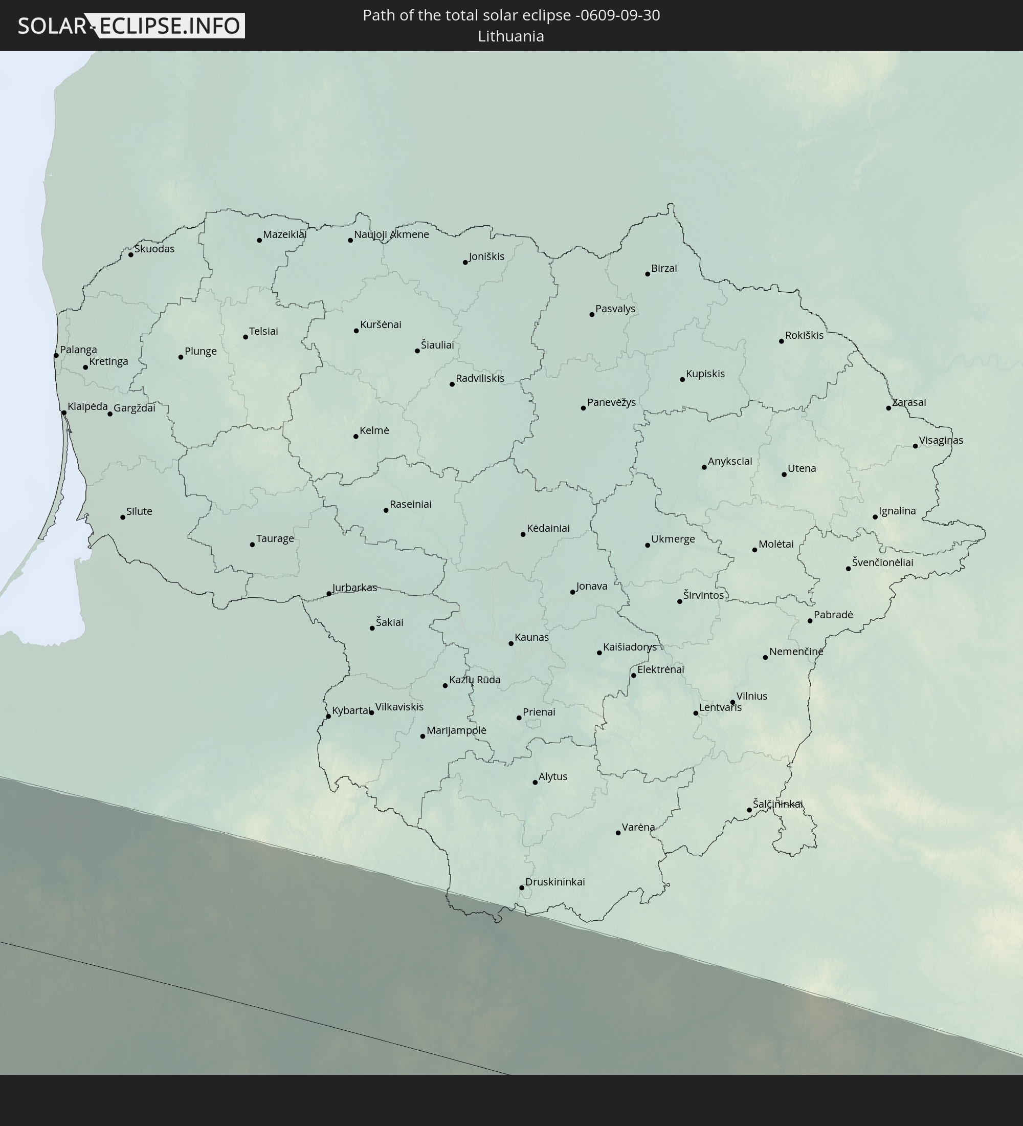 Lithuania
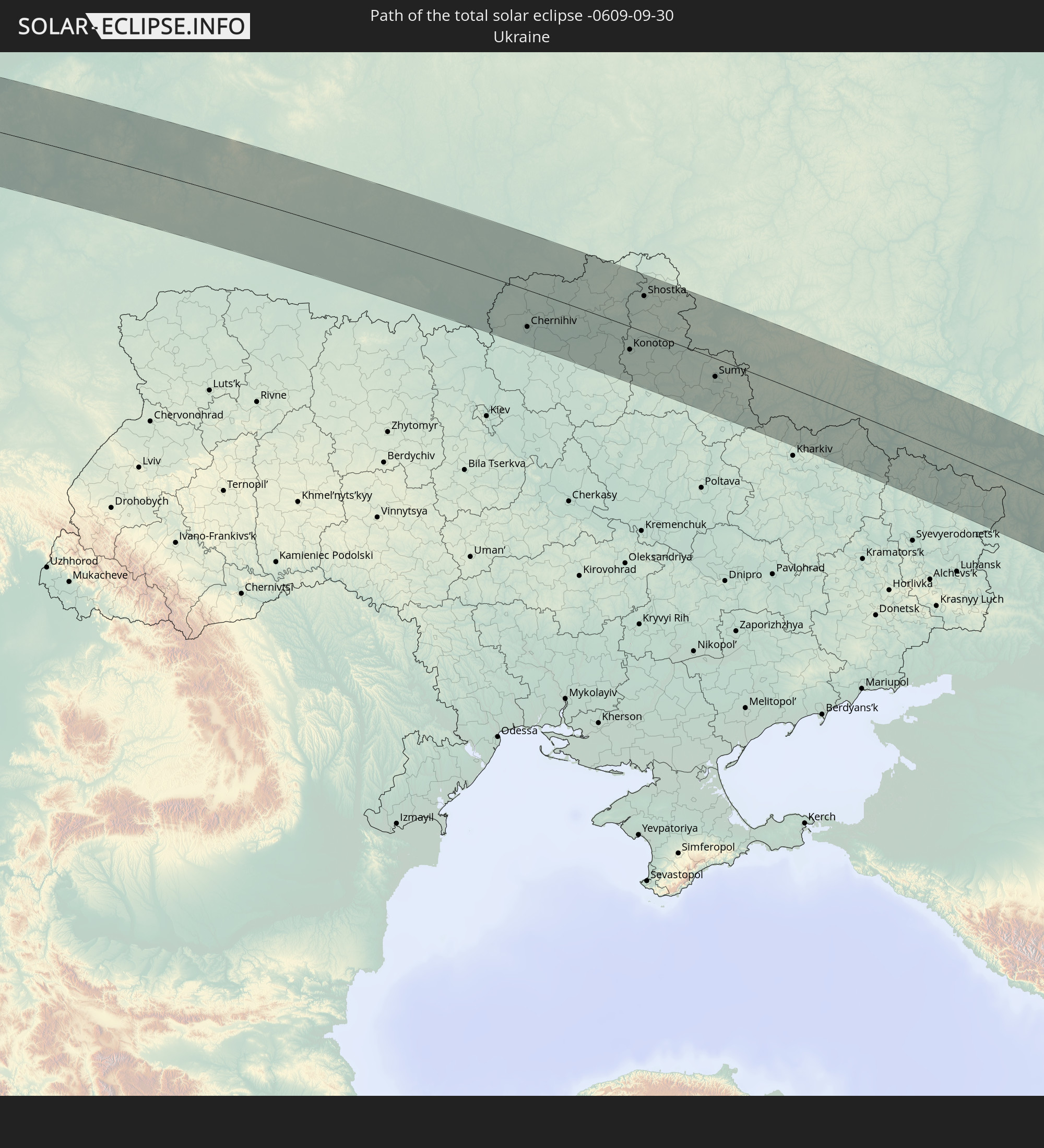 Ukraine
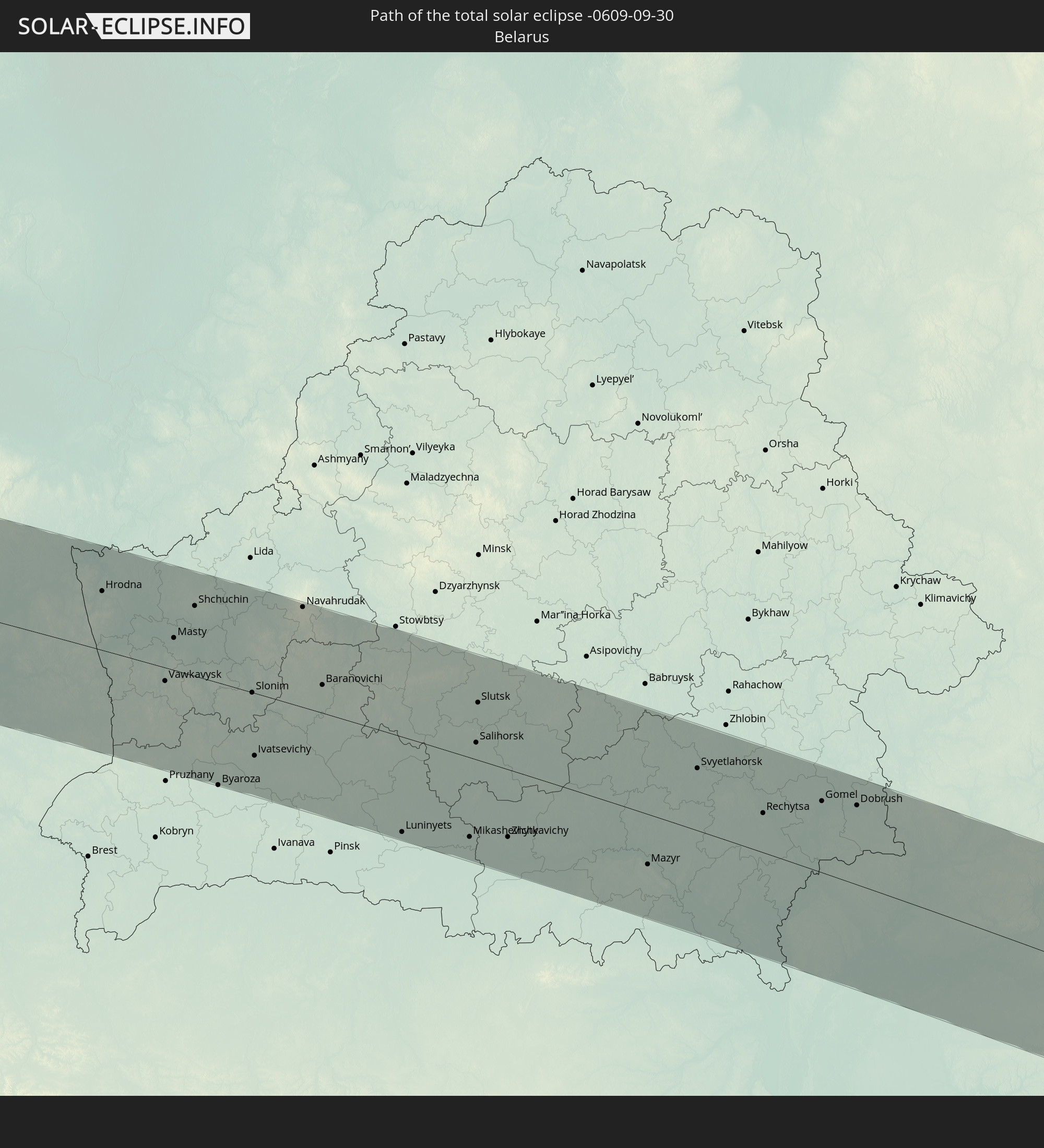 Belarus
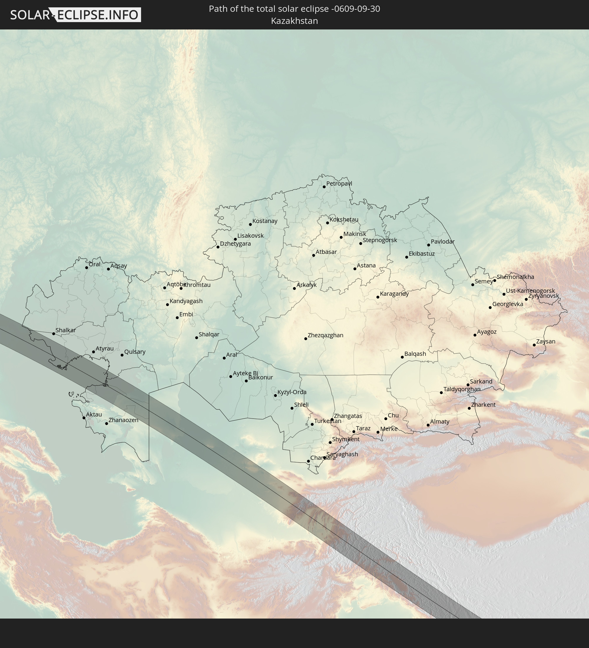 Kazakhstan
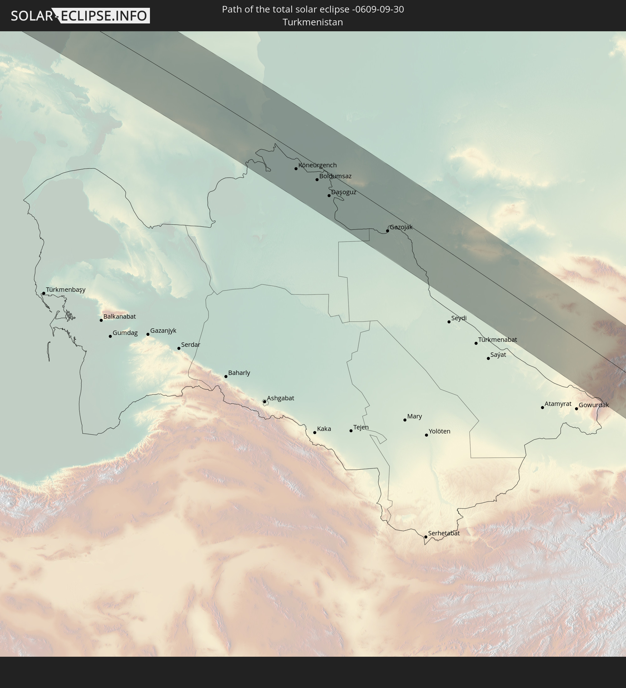 Turkmenistan
 Uzbekistan
 Afghanistan
 Pakistan
 Tajikistan
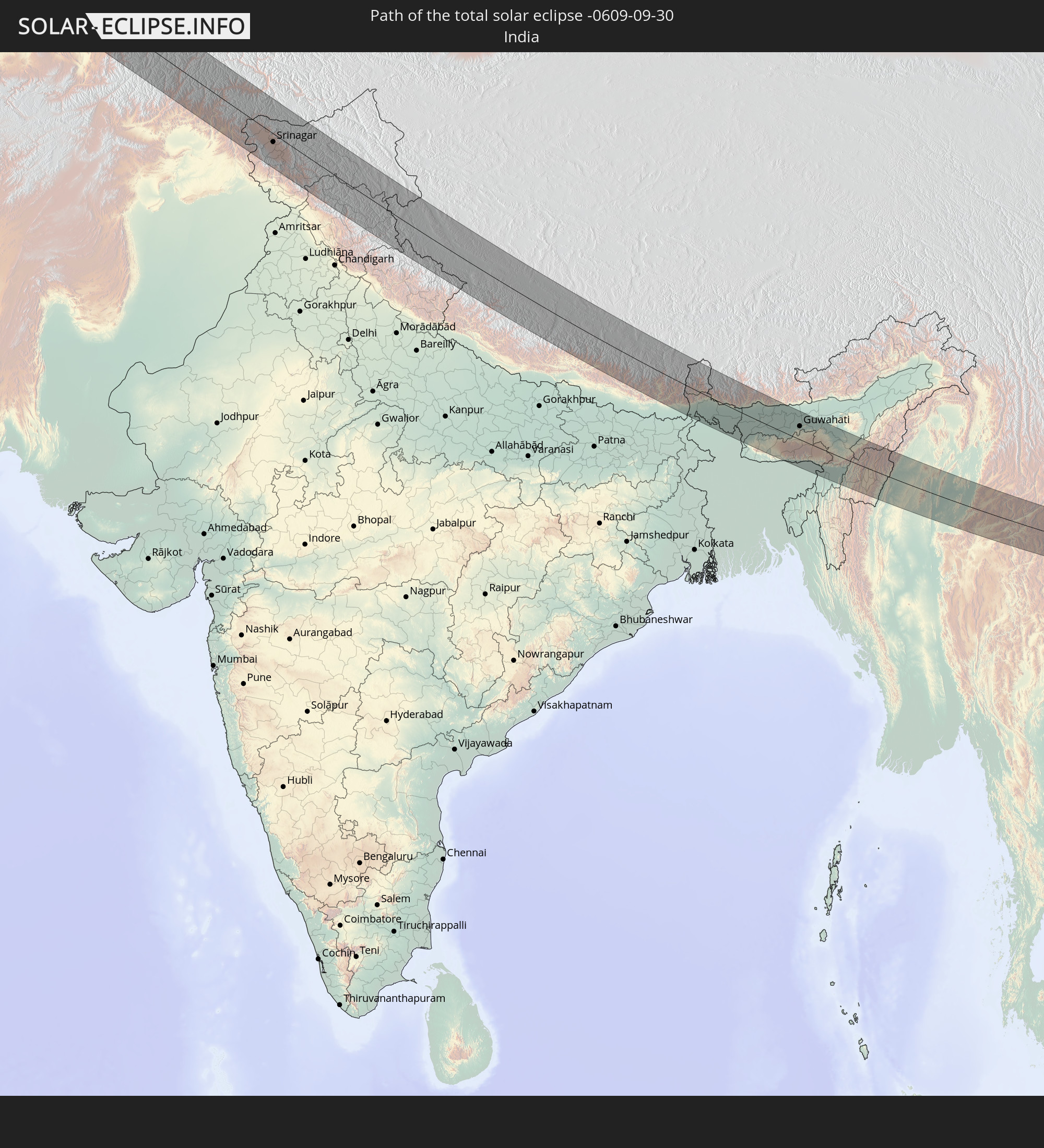 India
India
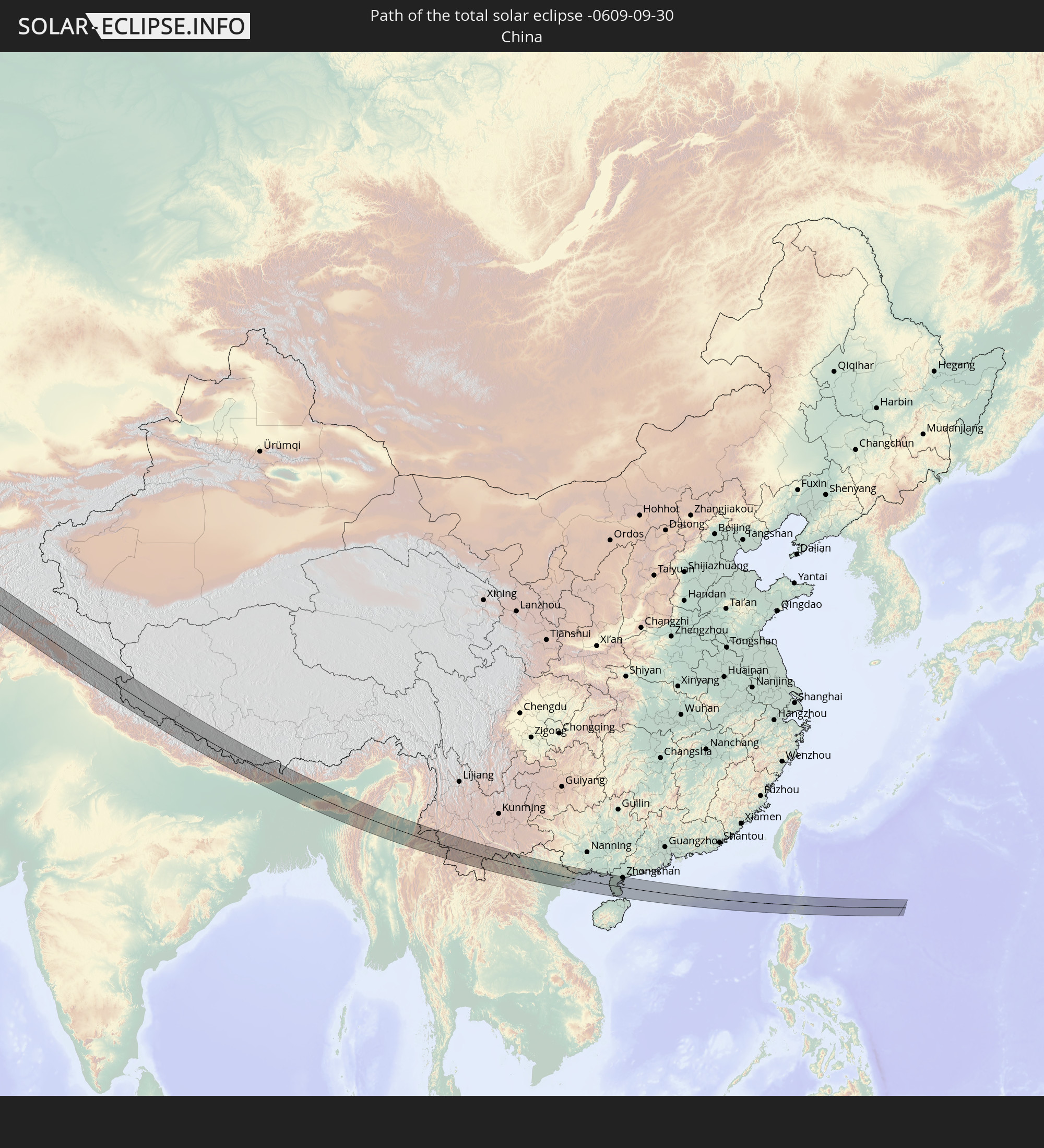 China
China
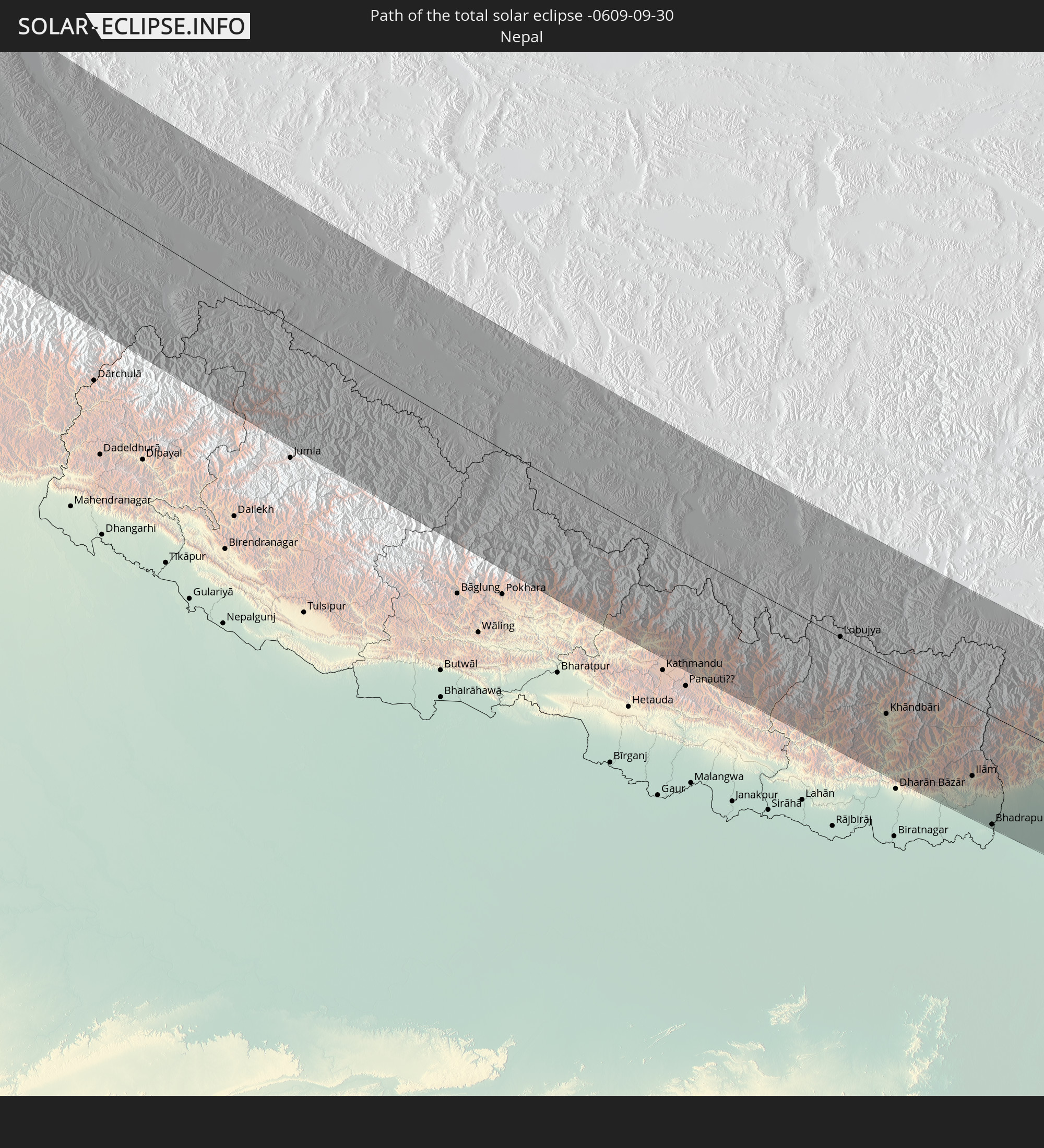 Nepal
Nepal
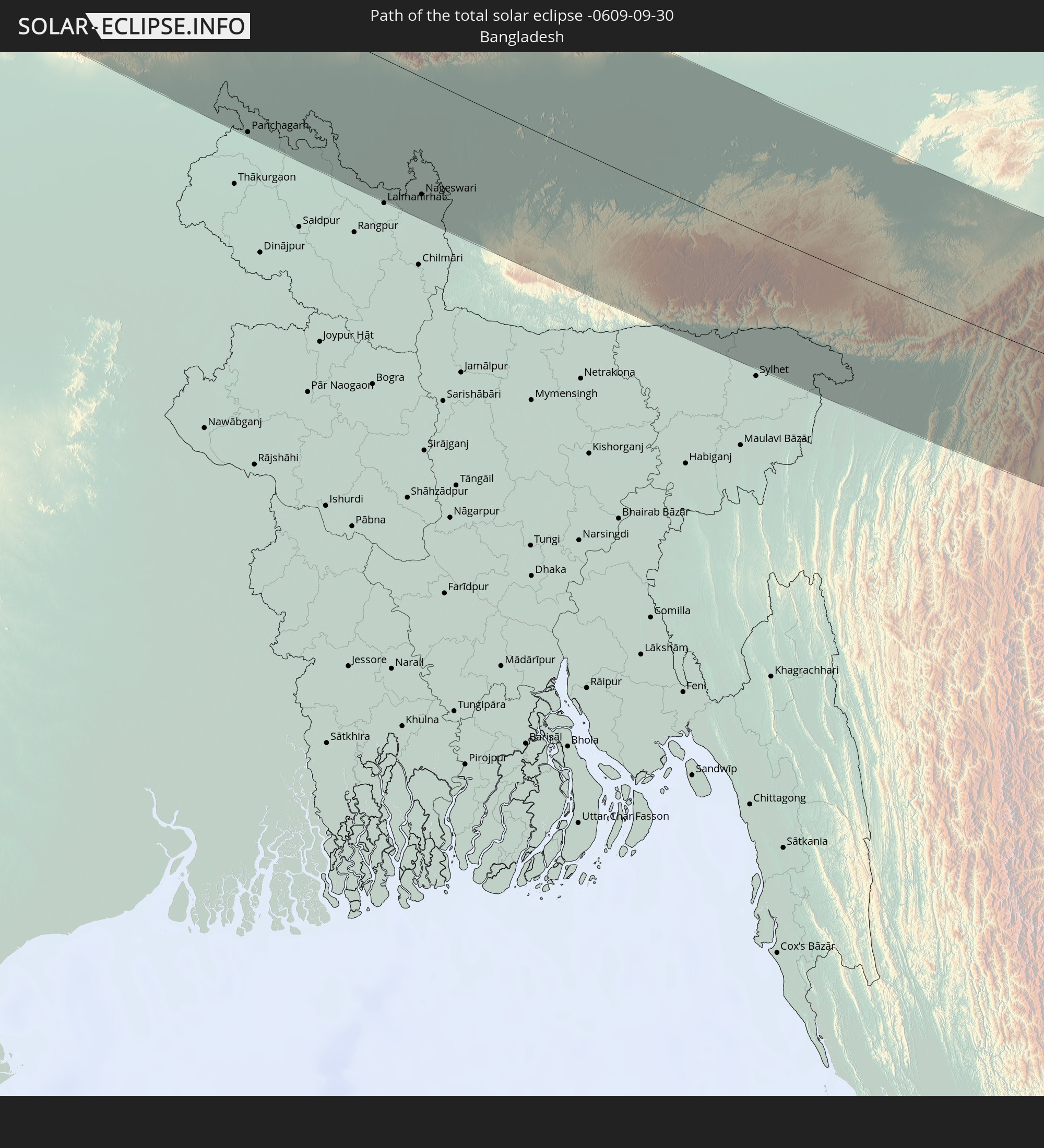 Bangladesh
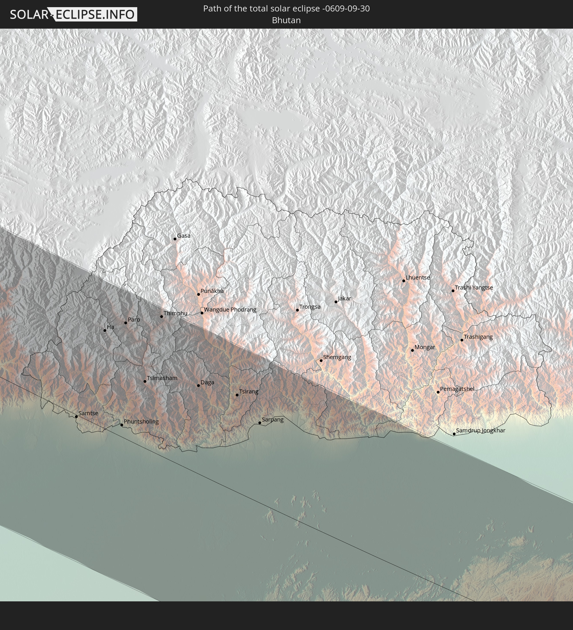 Bhutan
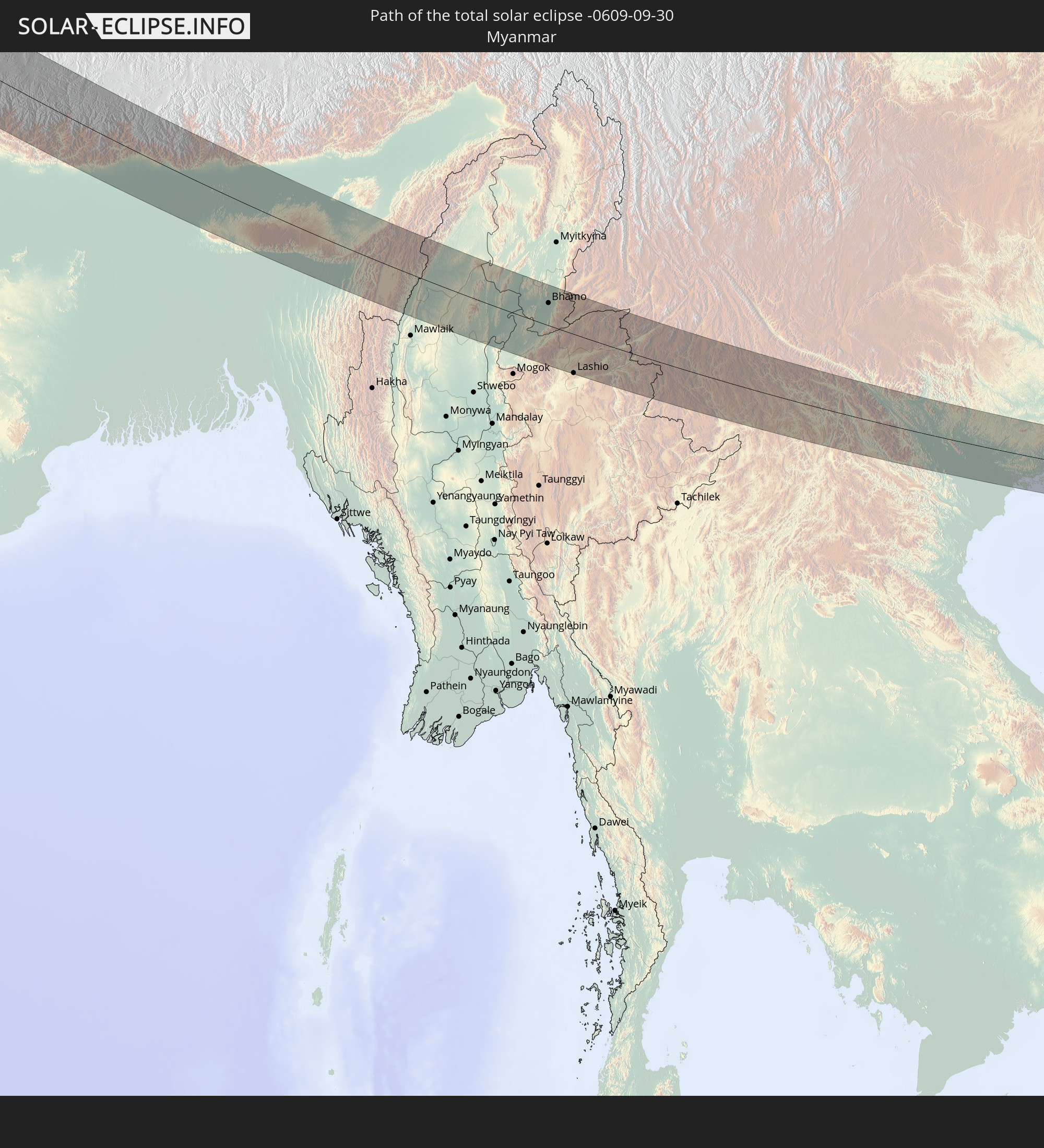 Myanmar
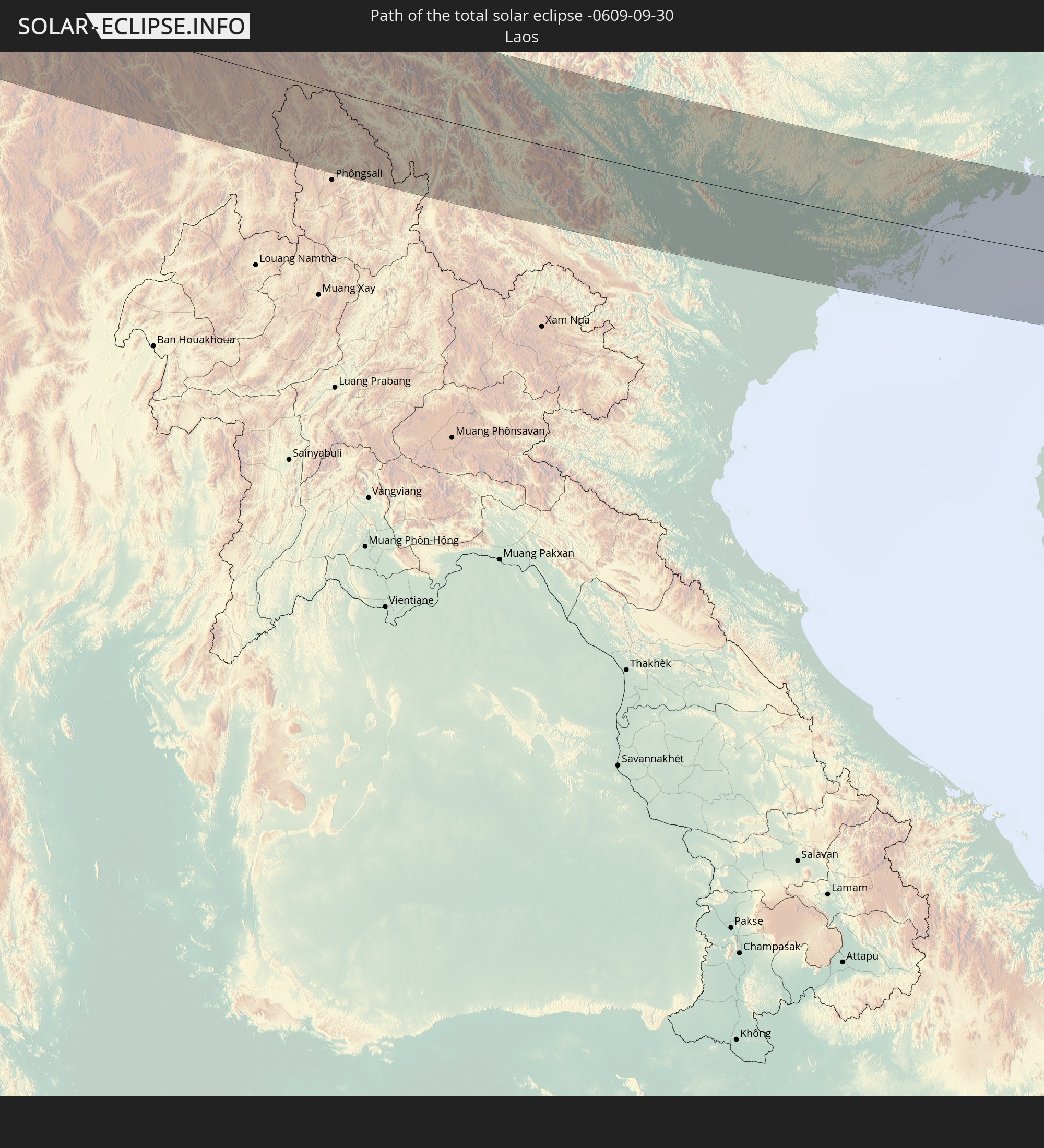 Laos
Laos
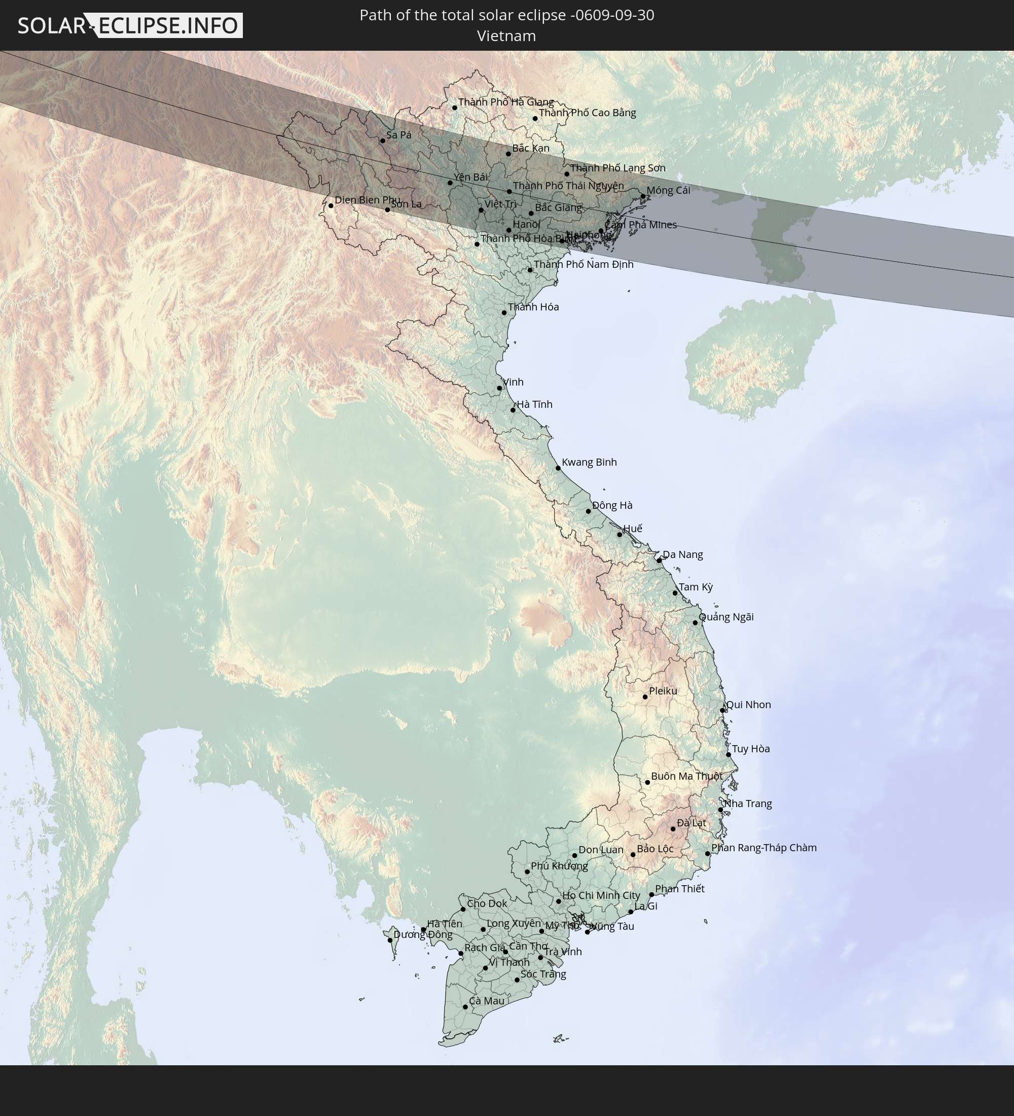 Vietnam
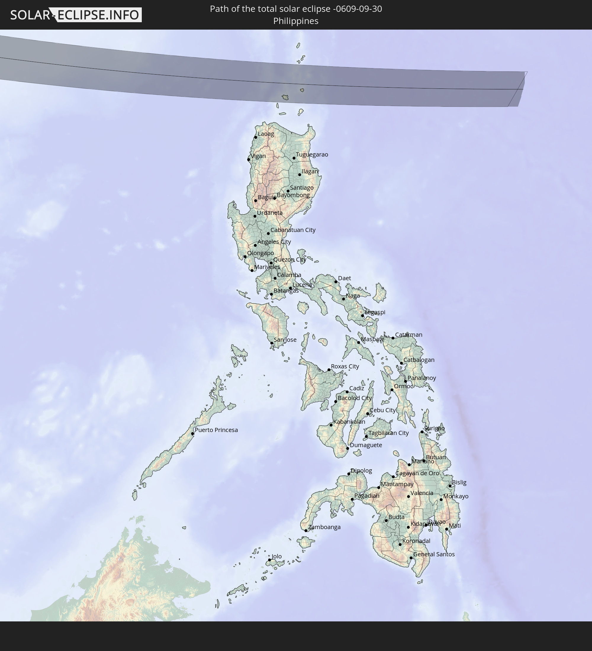 Philippines
In den folgenden Ländern ist die Sonnenfinsternis partiell zu sehen
 Russia
 Greenland
 Portugal
 Spain
Spain
 Mauritania
 Morocco
 Mali
Mali
 Republic of Ireland
 Svalbard and Jan Mayen
 Algeria
 United Kingdom
 Faroe Islands
 Gibraltar
 France
 Isle of Man
 Guernsey
 Jersey
 Niger
Niger
 Andorra
 Belgium
 Netherlands
 Norway
 Luxembourg
 Germany
 Switzerland
 Italy
Italy
 Monaco
 Tunisia
 Denmark
 Libya
Libya
 Liechtenstein
 Austria
 Sweden
 Czechia
 San Marino
 Vatican City
 Slovenia
 Chad
Chad
 Croatia
 Poland
 Malta
Malta
 Bosnia and Herzegovina
 Hungary
 Slovakia
 Montenegro
 Serbia
 Albania
 Åland Islands
 Greece
 Romania
 Republic of Macedonia
 Finland
 Lithuania
 Latvia
 Estonia
 Sudan
Sudan
 Ukraine
 Bulgaria
 Belarus
 Egypt
Egypt
 Turkey
 Moldova
 Cyprus
 Ethiopia
 State of Palestine
 Israel
 Saudi Arabia
 Jordan
 Lebanon
 Syria
Syria
 Eritrea
 Iraq
Iraq
 Georgia
 Somalia
 Yemen
Yemen
 Armenia
 Iran
Iran
 Azerbaijan
 Kazakhstan
 Kuwait
 Bahrain
 Qatar
Qatar
 United Arab Emirates
 Oman
Oman
 Turkmenistan
 Uzbekistan
 Afghanistan
 Pakistan
 Tajikistan
 India
India
 Kyrgyzstan
 Maldives
 China
China
 Sri Lanka
 Nepal
Nepal
 Mongolia
 Bangladesh
 Bhutan
 Myanmar
 Indonesia
 Cocos Islands
 Thailand
 Malaysia
 Laos
Laos
 Vietnam
 Cambodia
 Singapore
 Christmas Island
 Australia
 Macau
Macau
 Hong Kong
 Brunei
 Taiwan
 Philippines
 Japan
Japan
 North Korea
 South Korea
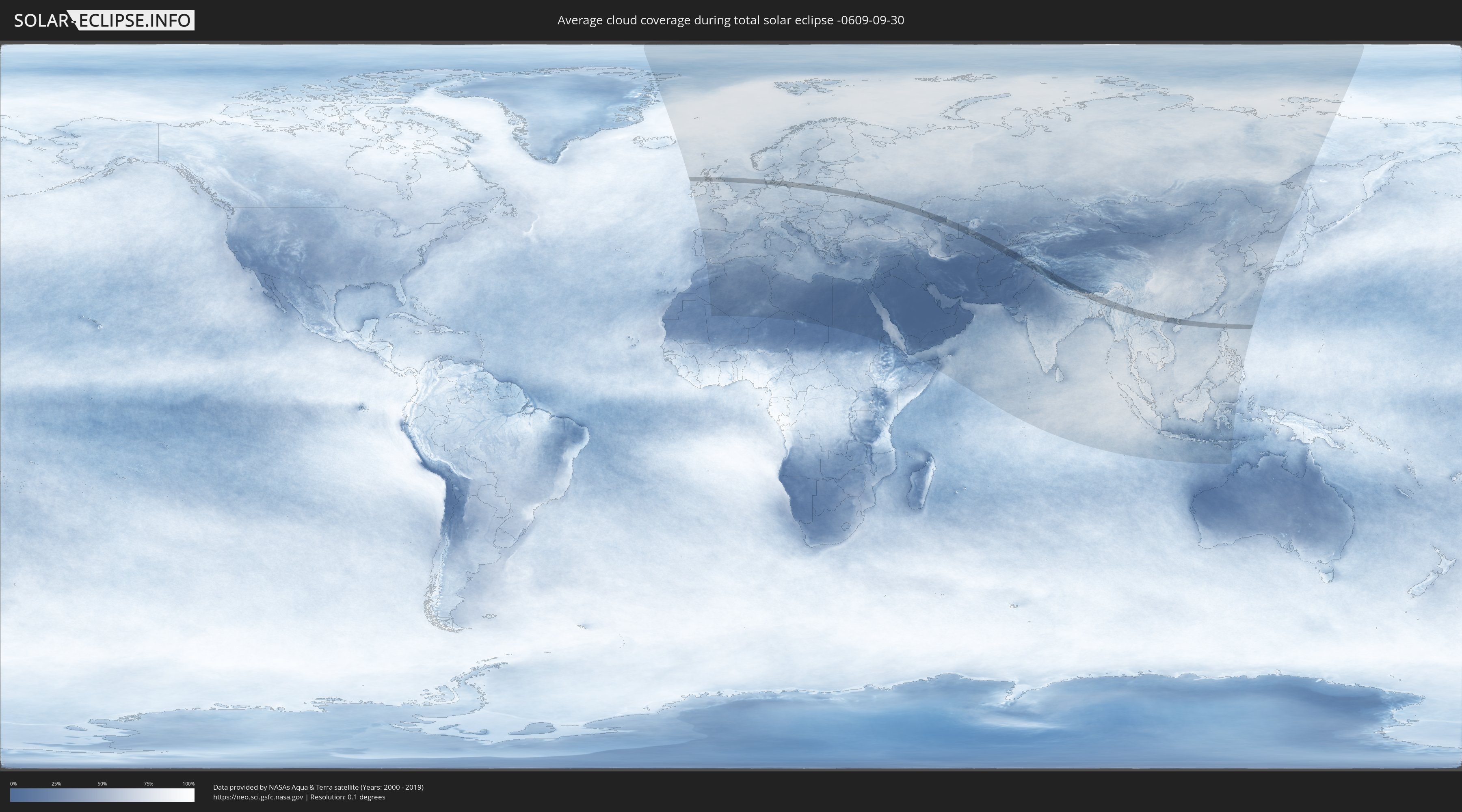
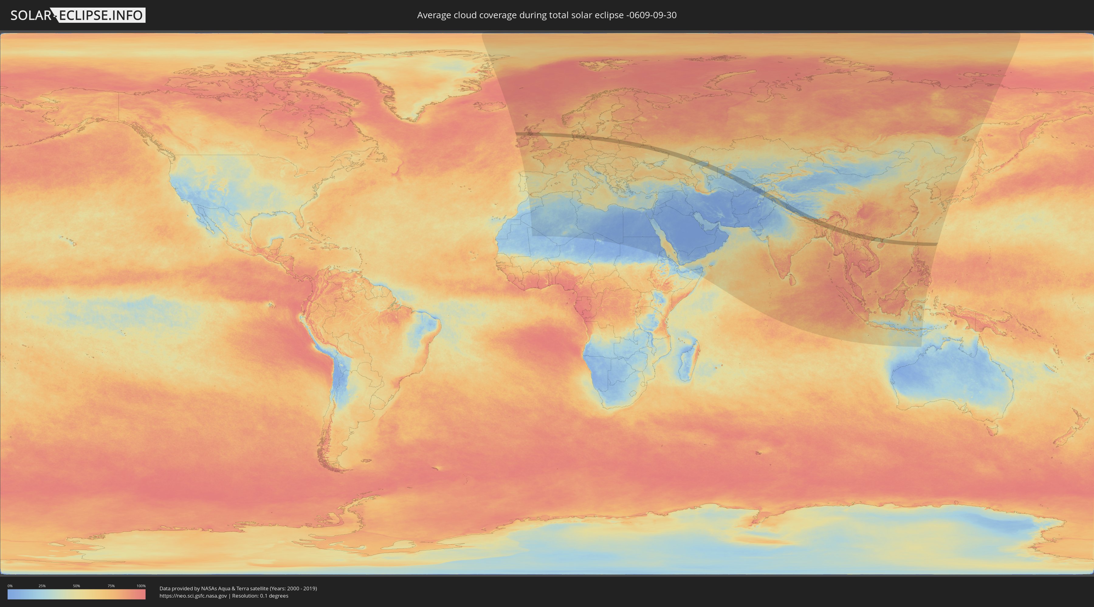
How will be the weather during the total solar eclipse on 09/30/-0609?
Where is the best place to see the total solar eclipse of 09/30/-0609?
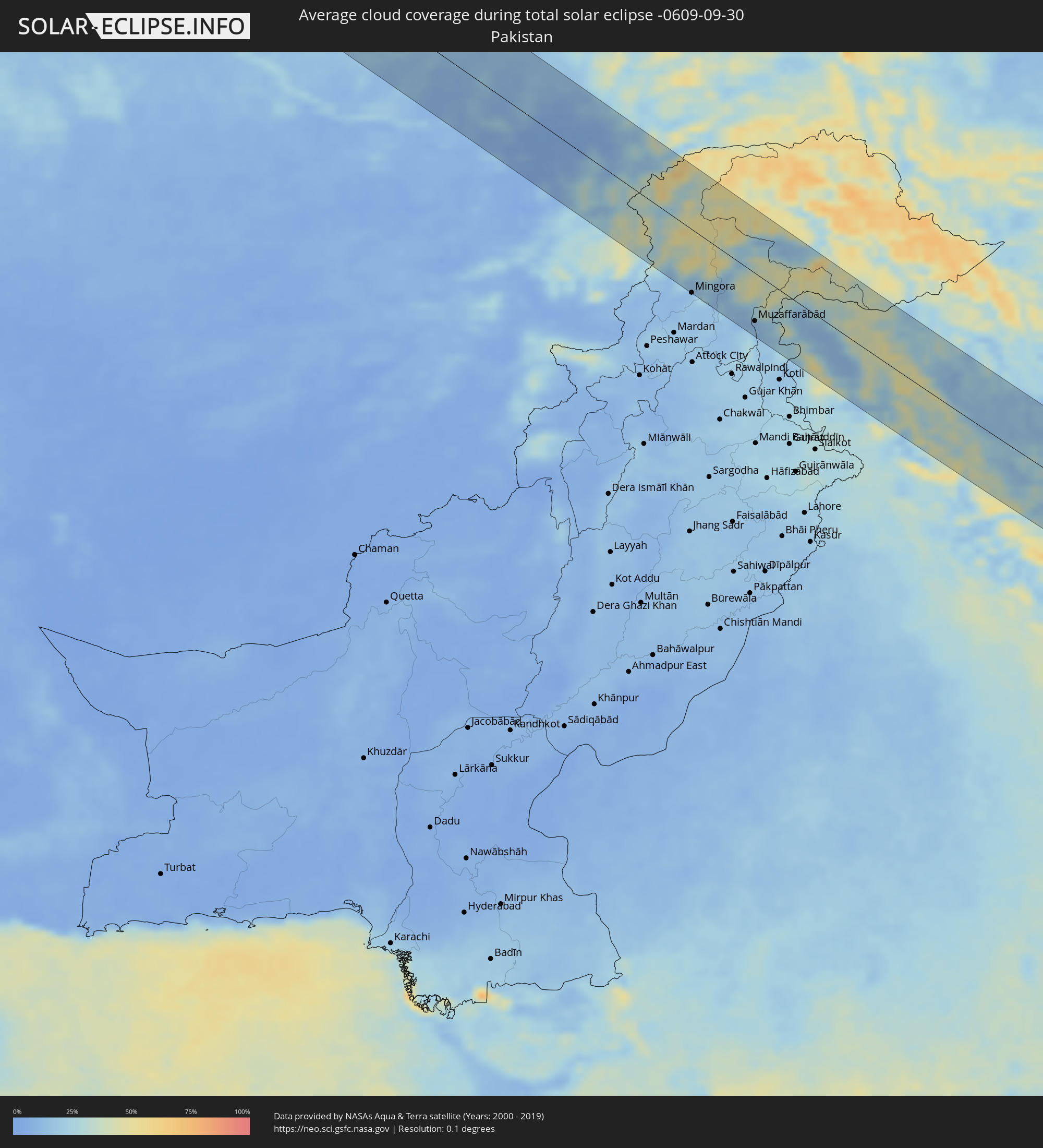
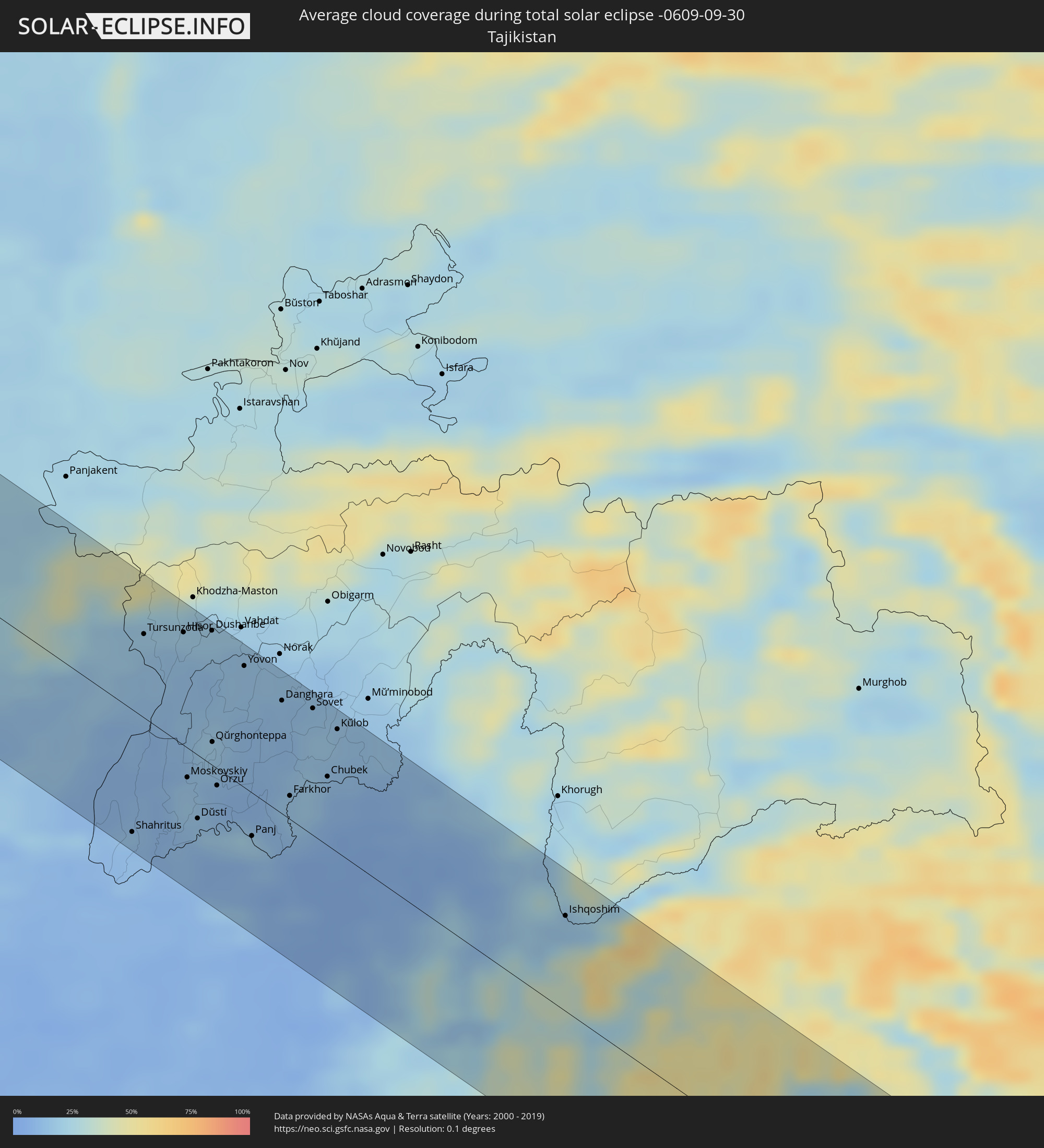
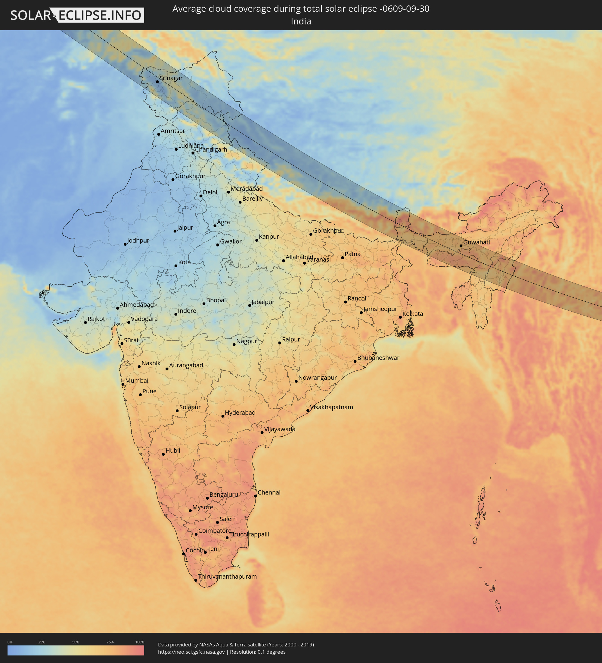
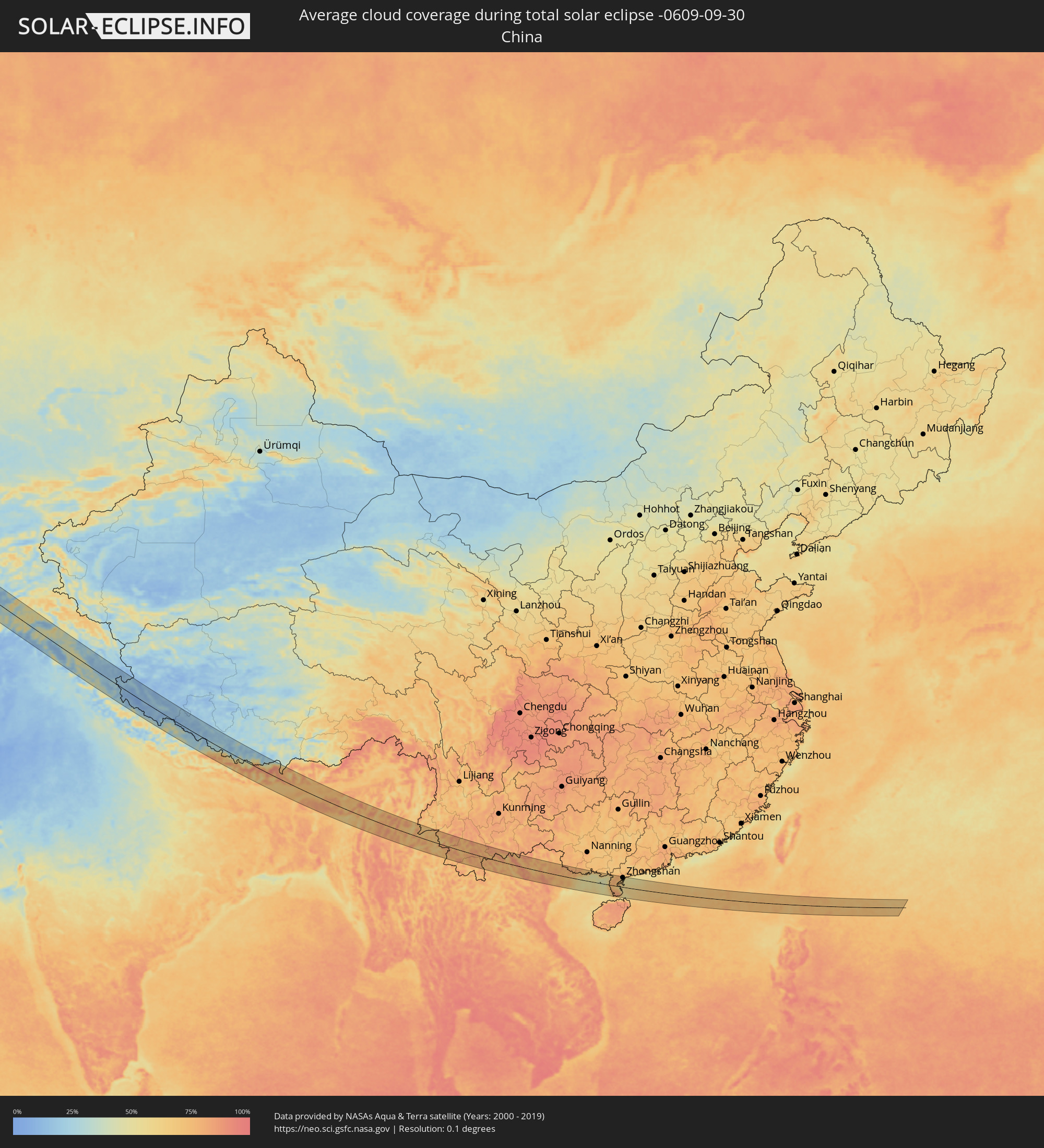
The following maps show the average cloud coverage for the day of the total solar eclipse.
With the help of these maps, it is possible to find the place along the eclipse path, which has the best
chance of a cloudless sky.
Nevertheless, you should consider local circumstances and inform about the weather of your chosen
observation site.
The data is provided by NASAs satellites
AQUA and TERRA.
The cloud maps are averaged over a period of 19 years (2000 - 2019).
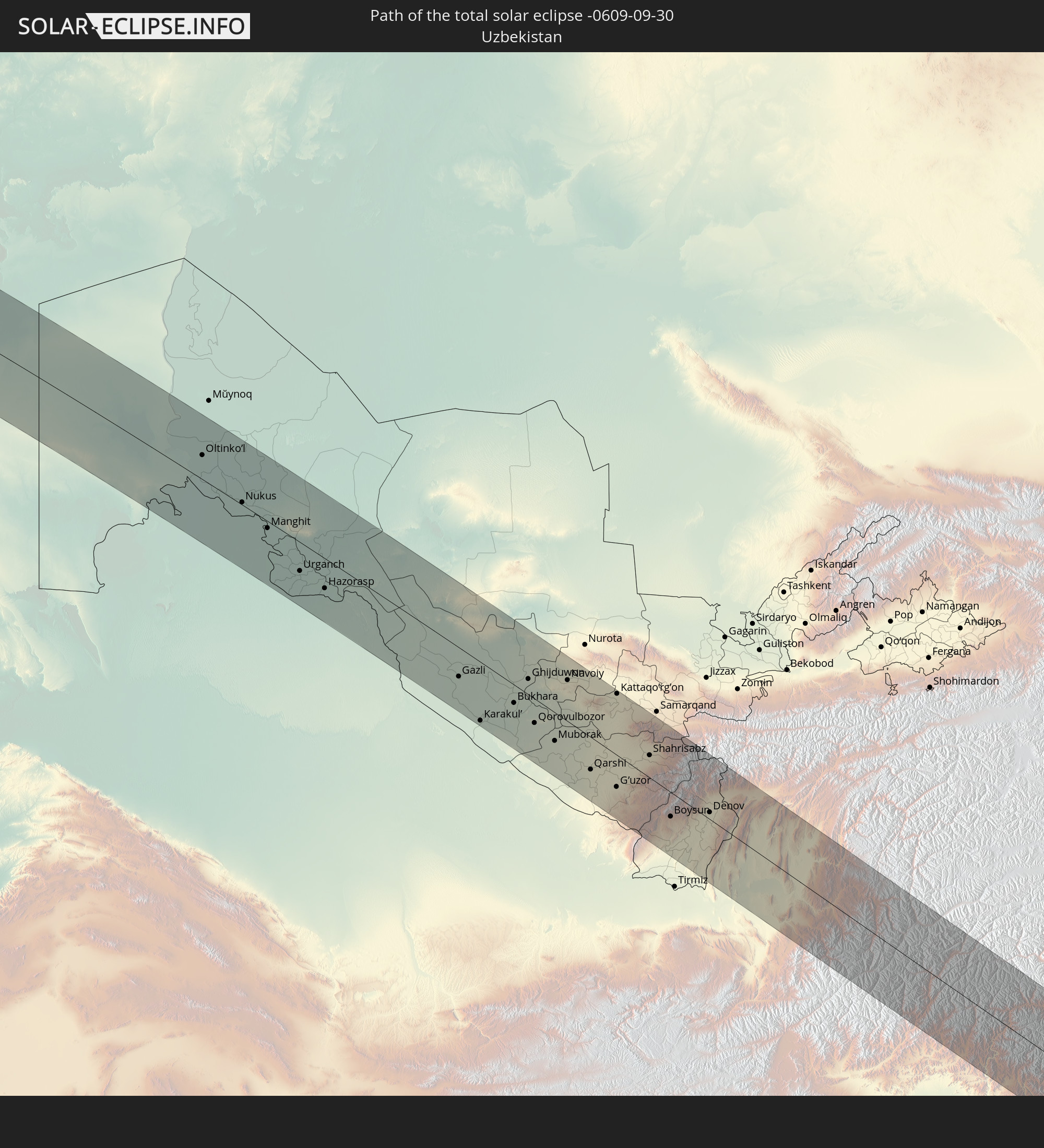
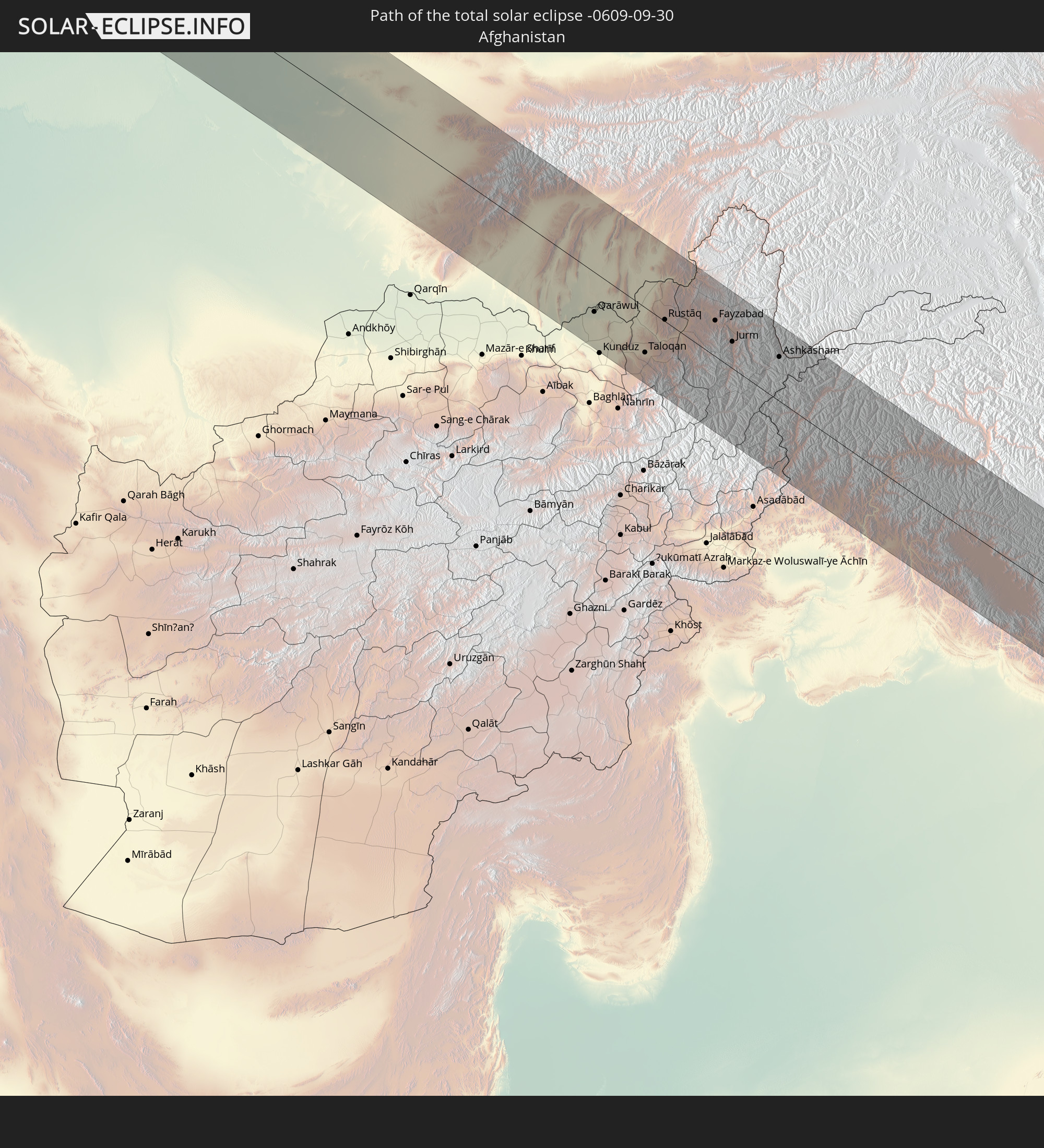
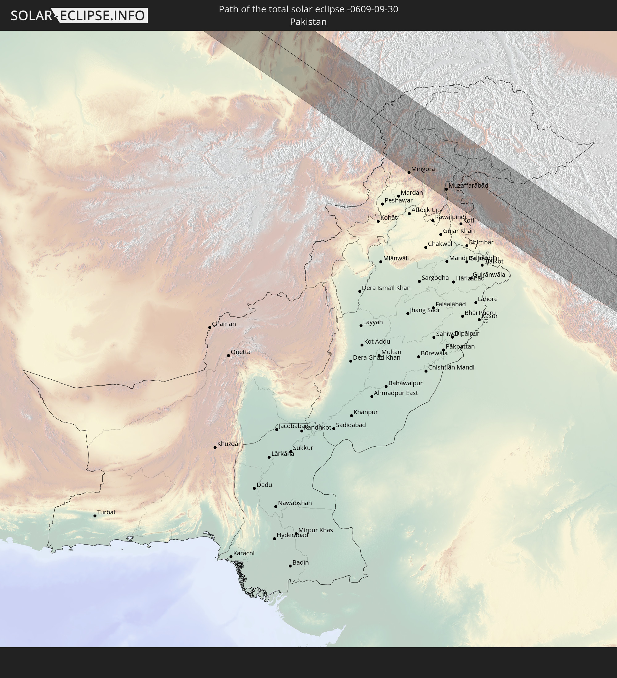
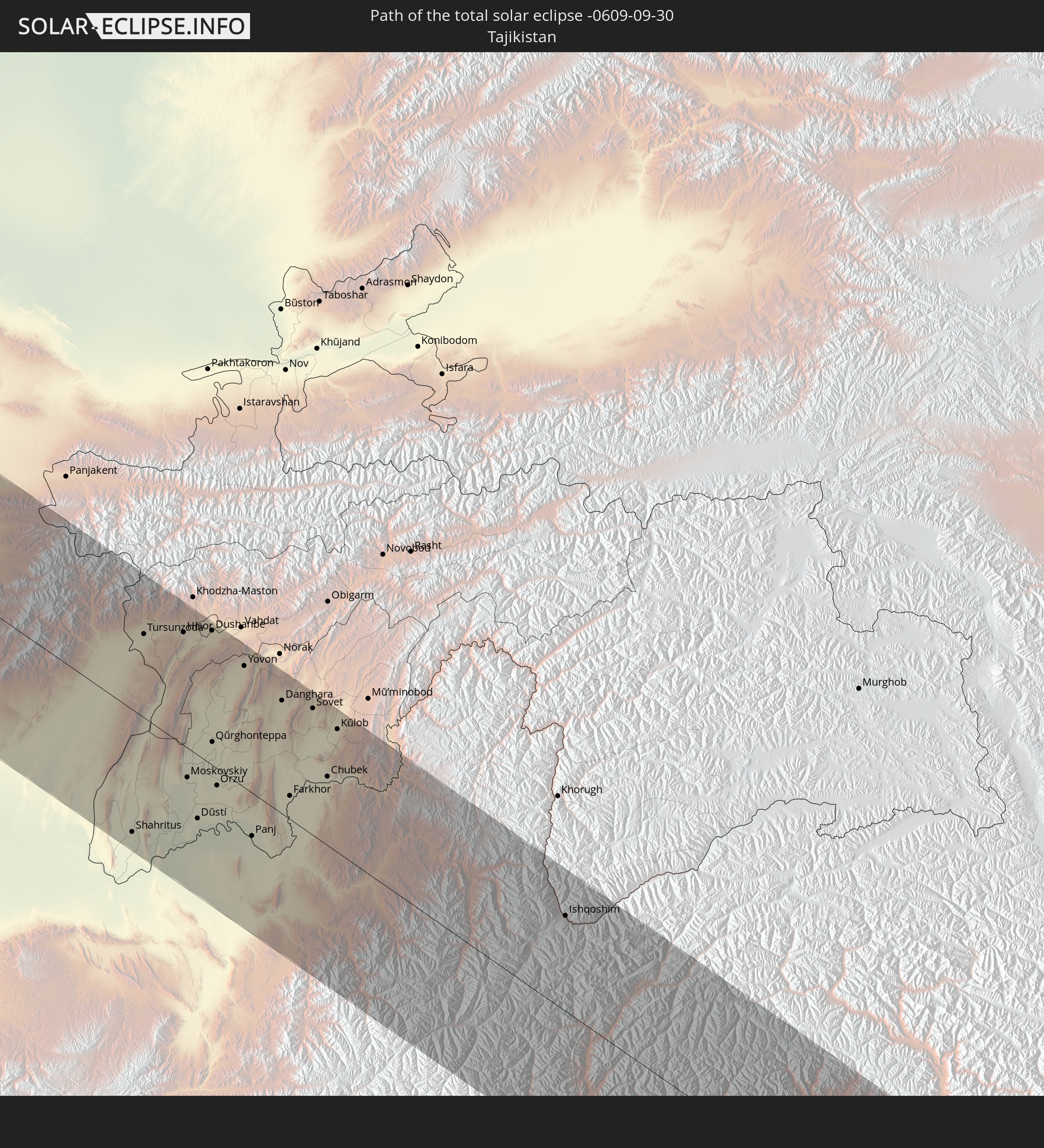
Detailed country maps
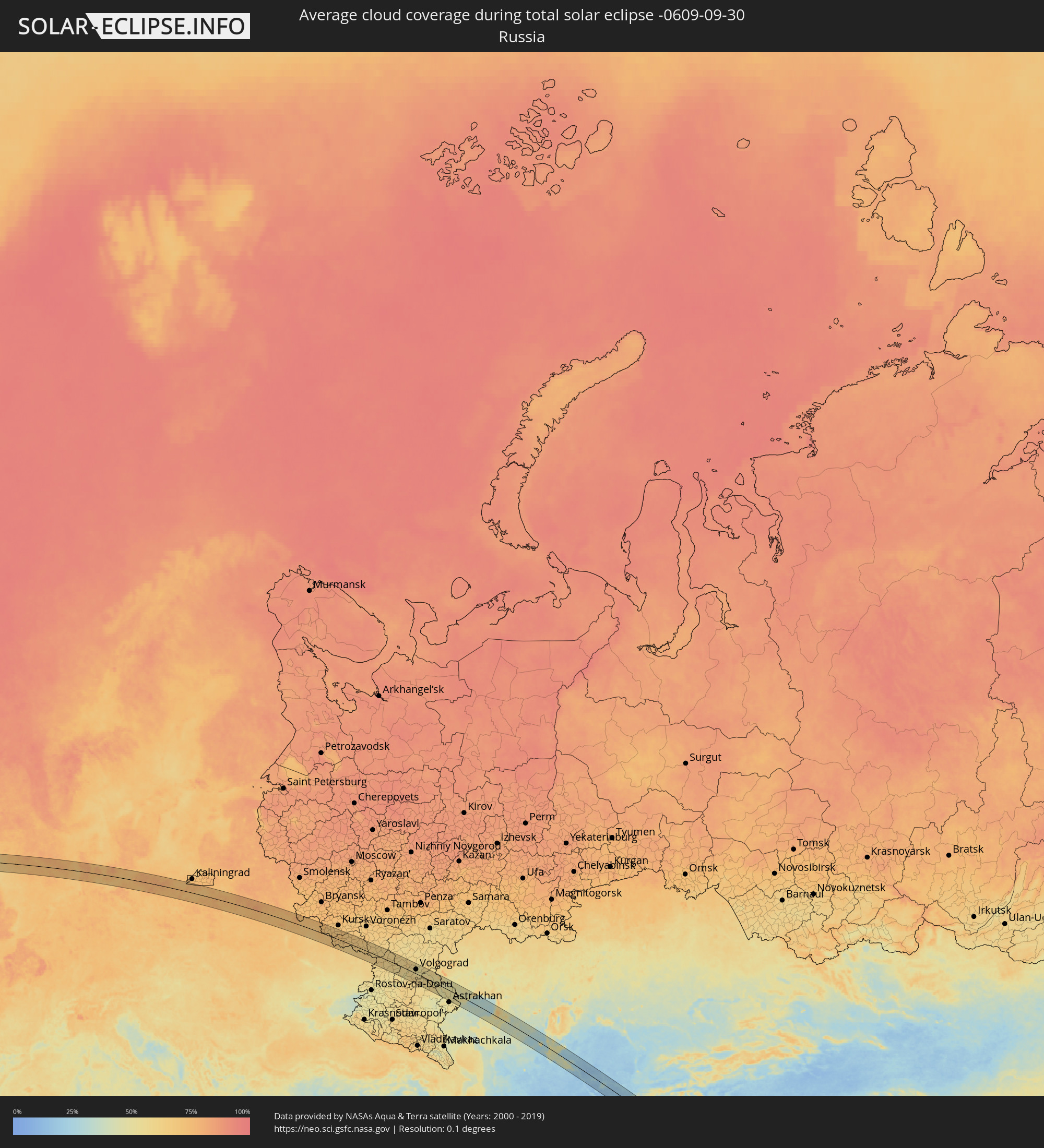 Russia
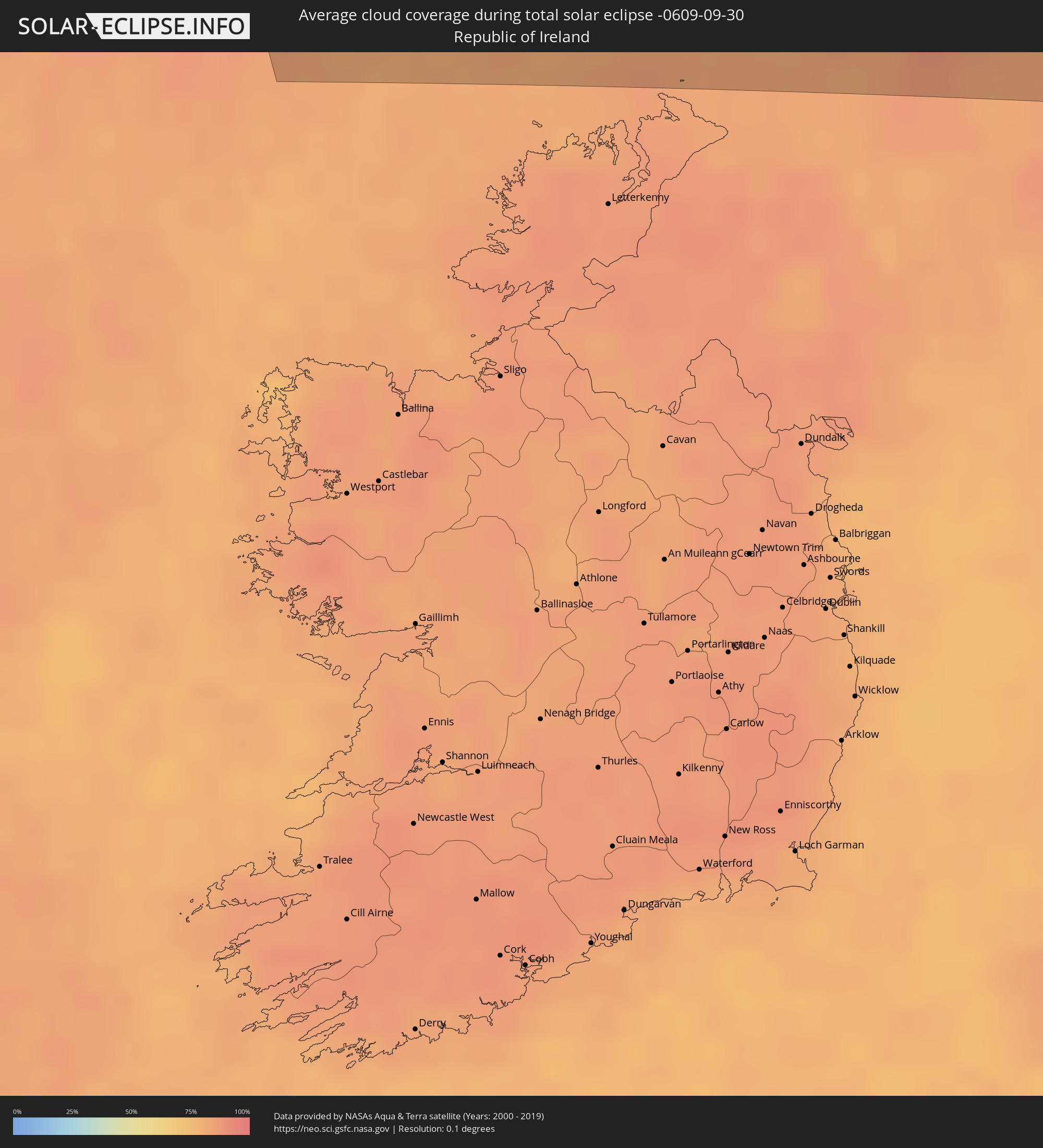 Republic of Ireland
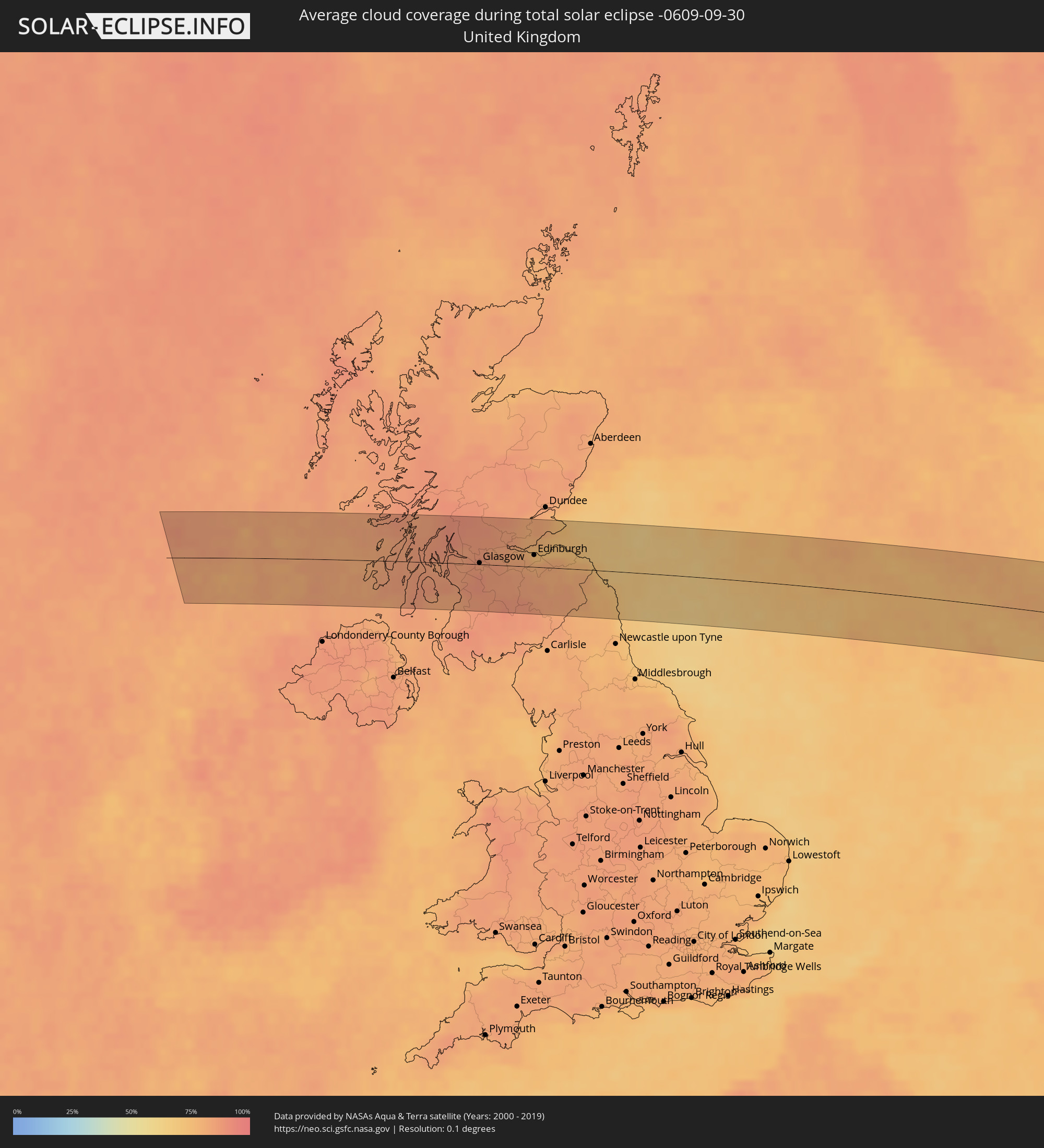 United Kingdom
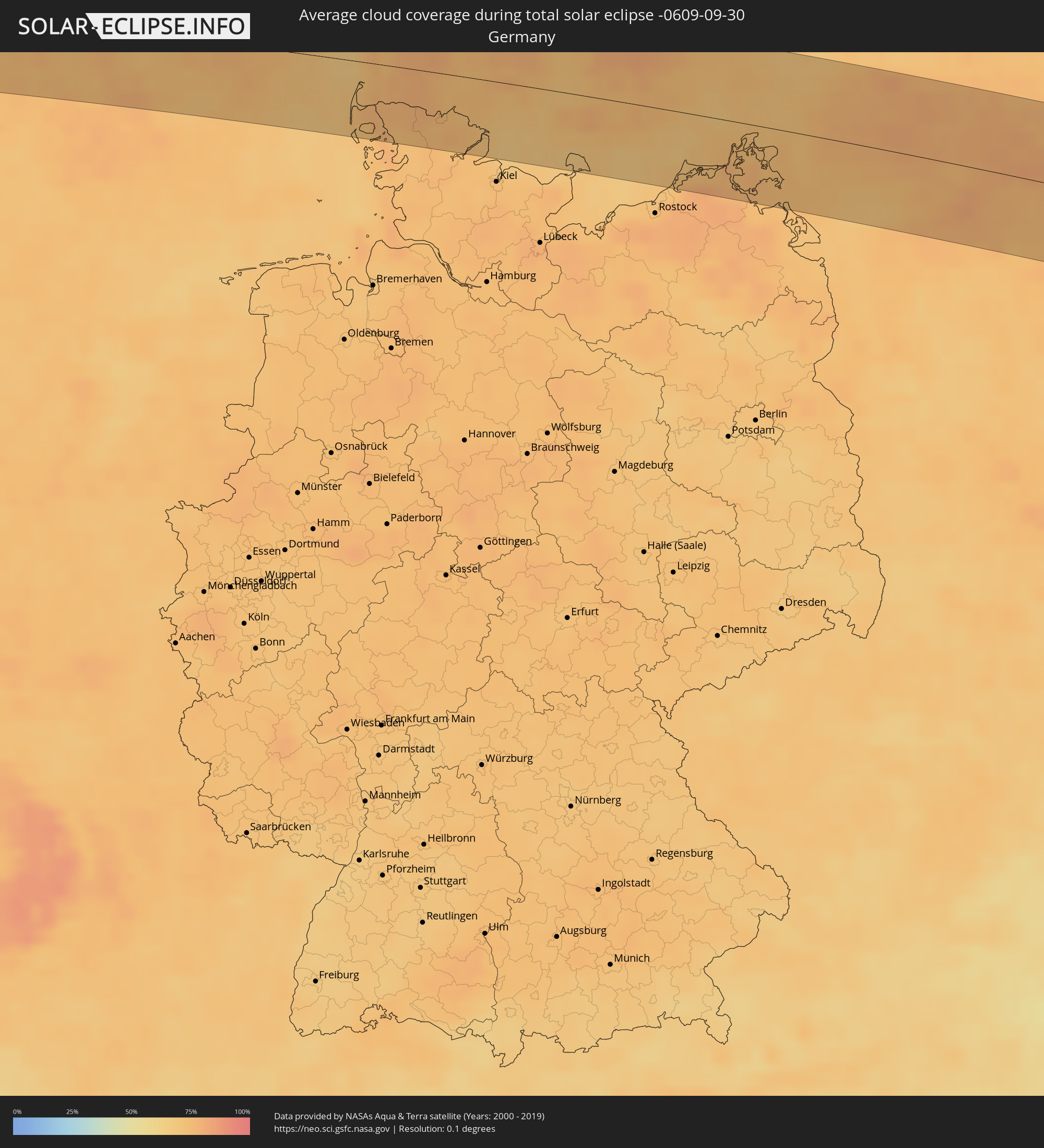 Germany
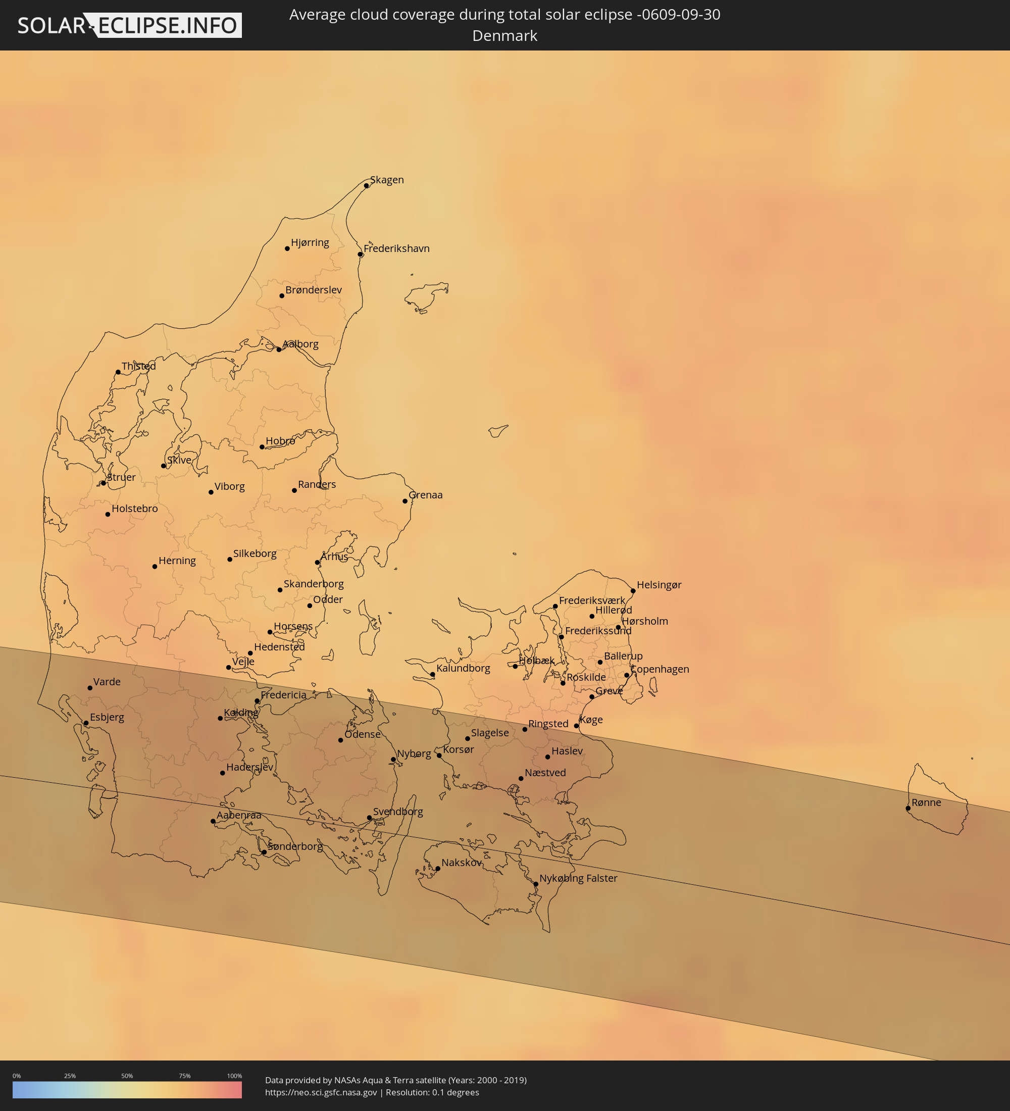 Denmark
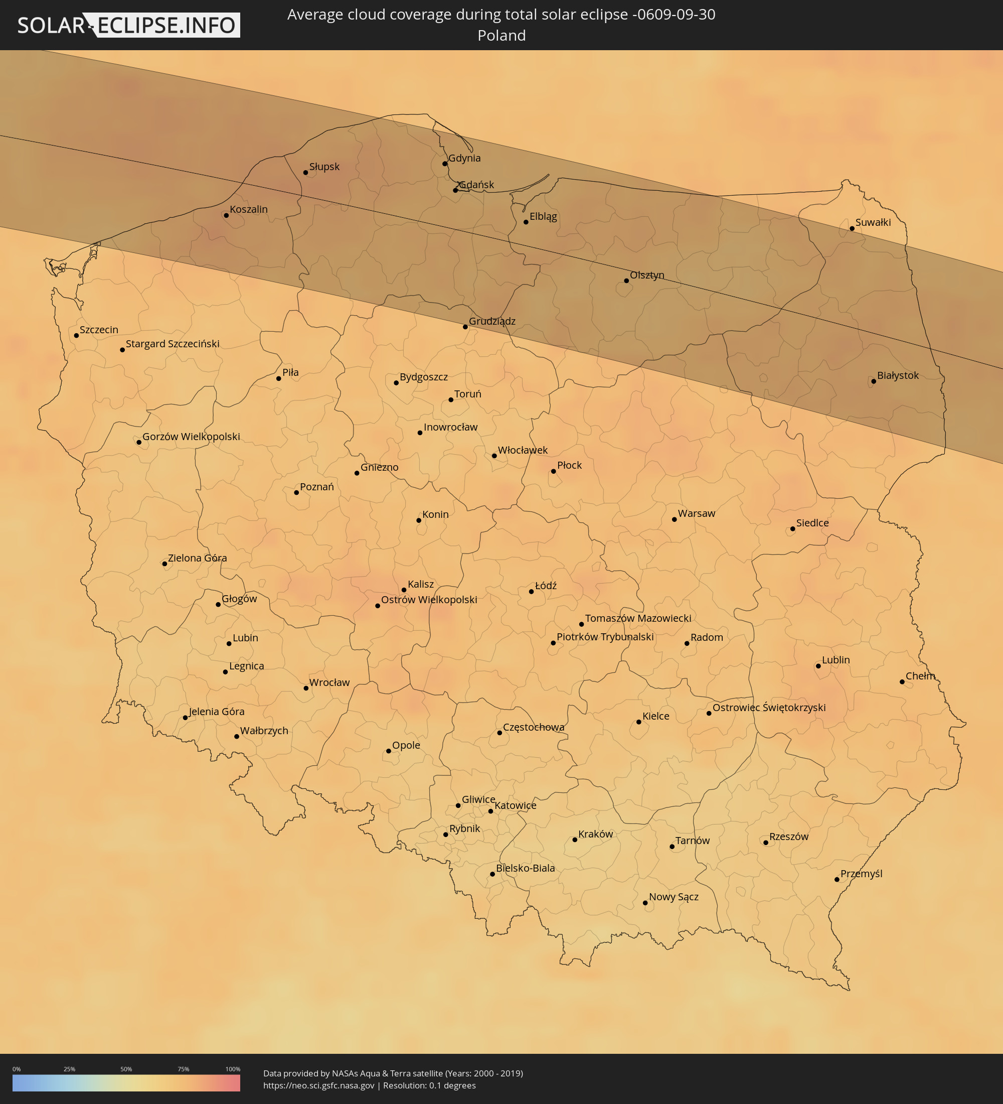 Poland
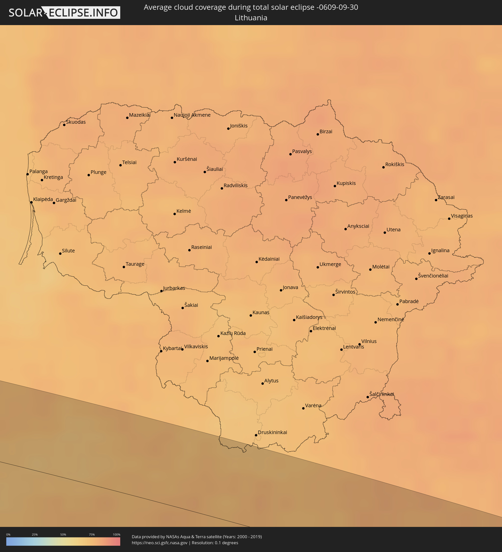 Lithuania
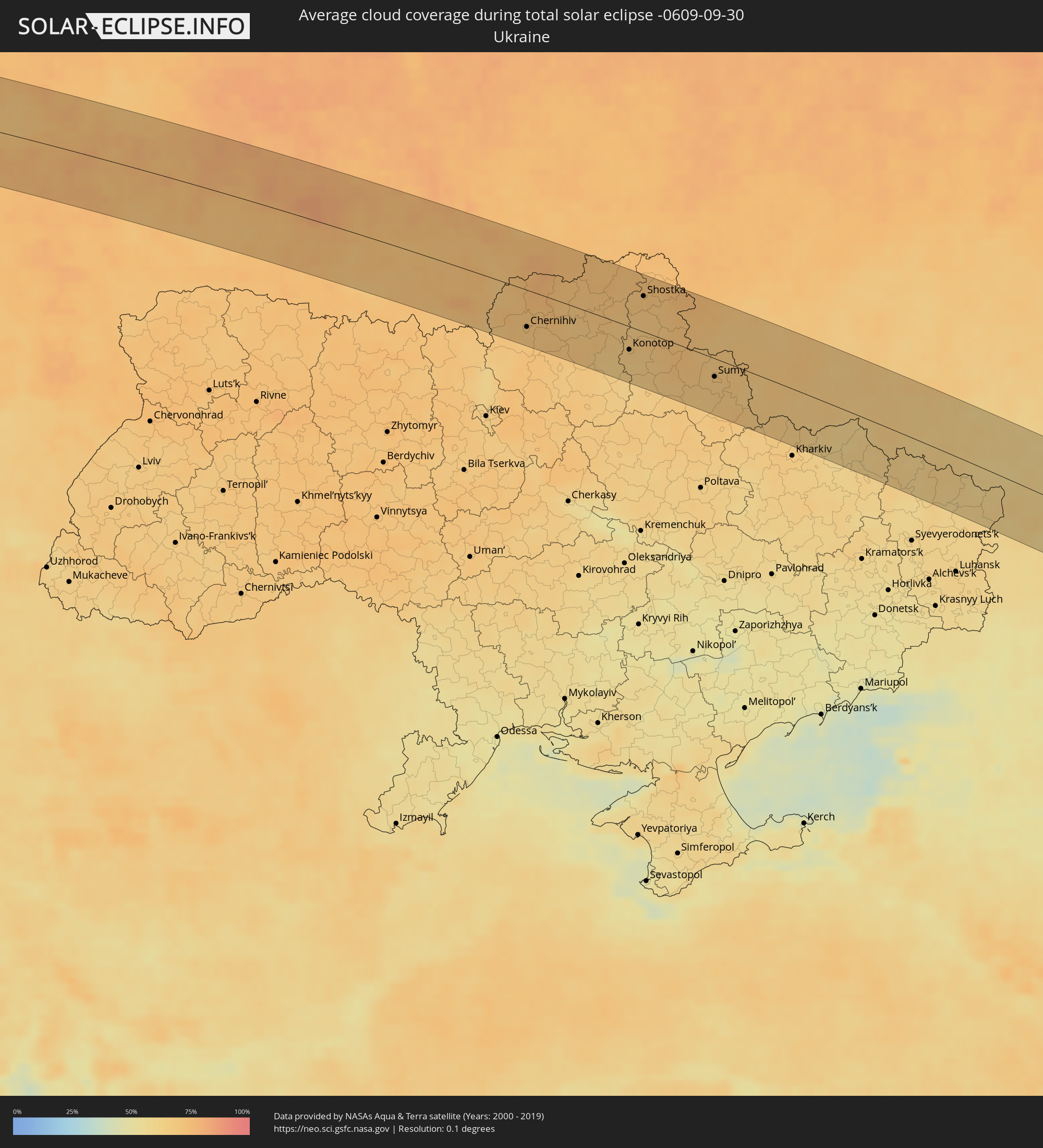 Ukraine
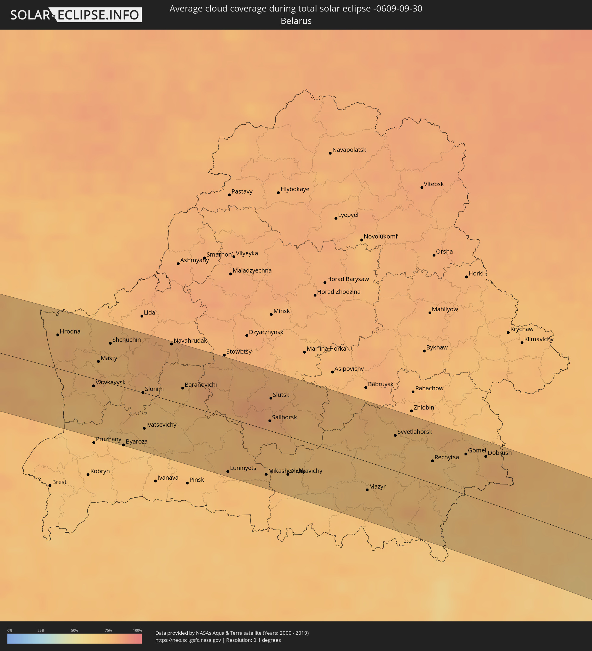 Belarus
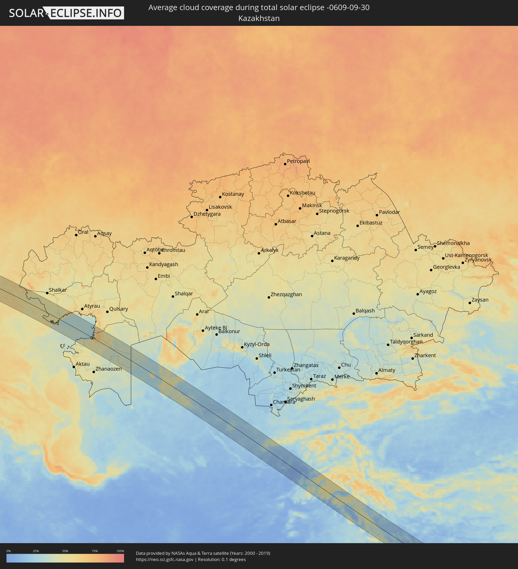 Kazakhstan
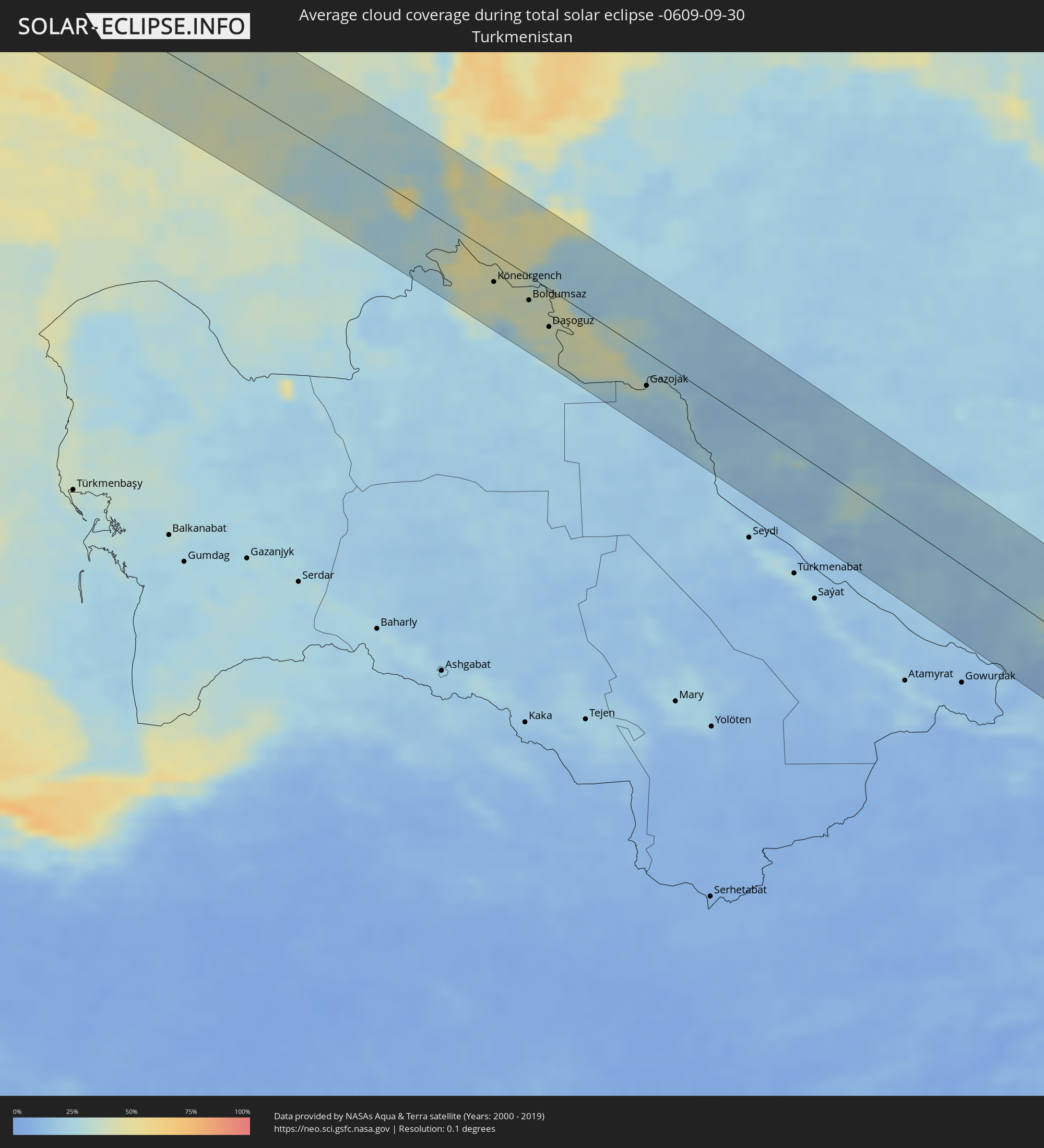 Turkmenistan
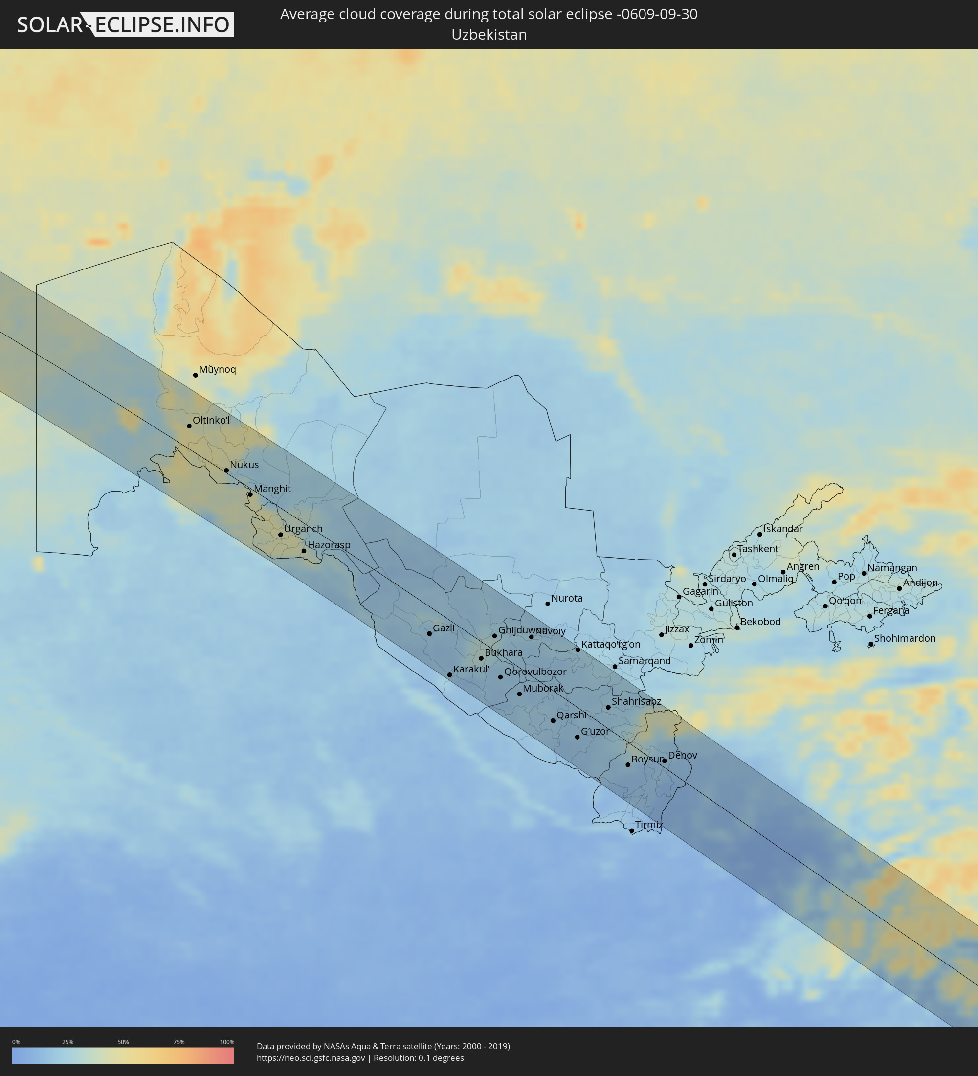 Uzbekistan
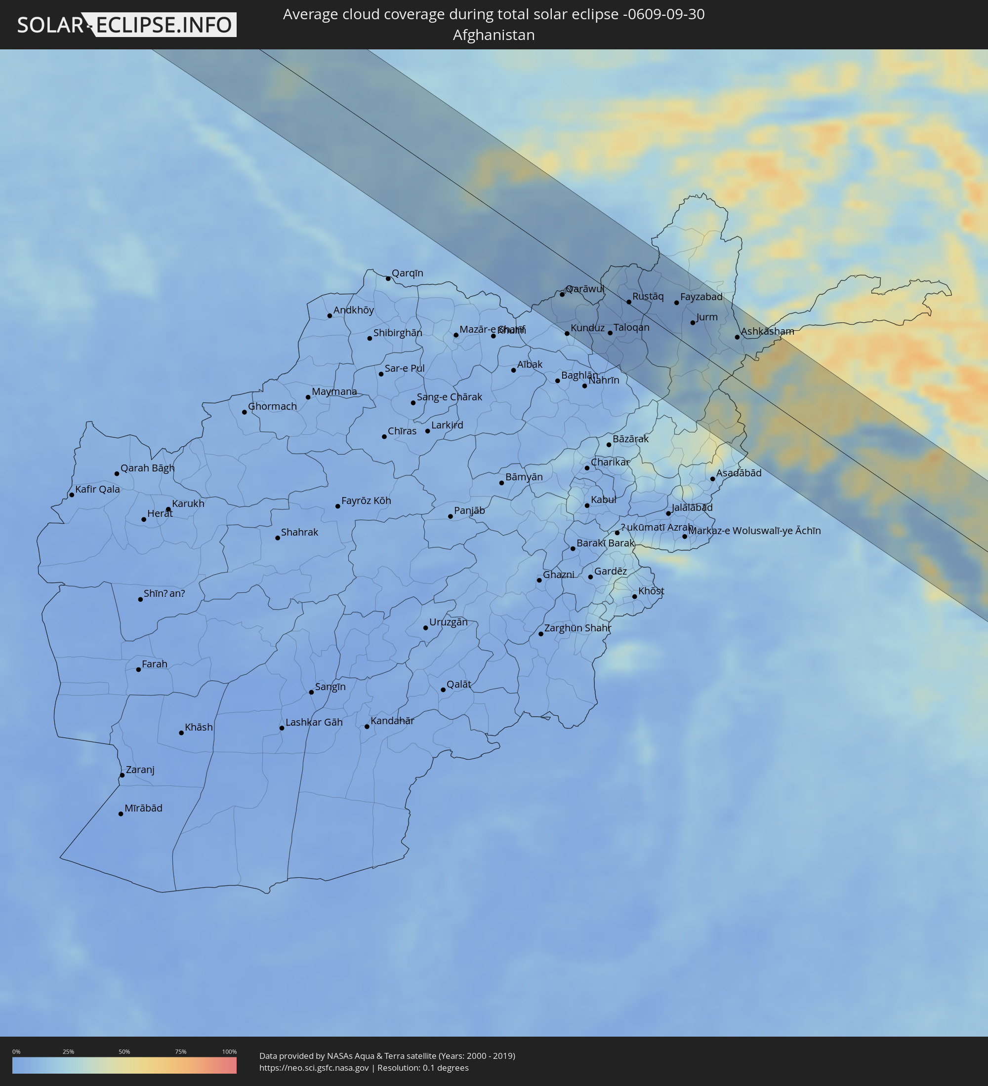 Afghanistan
 Pakistan
 Tajikistan
 India
India
 China
China
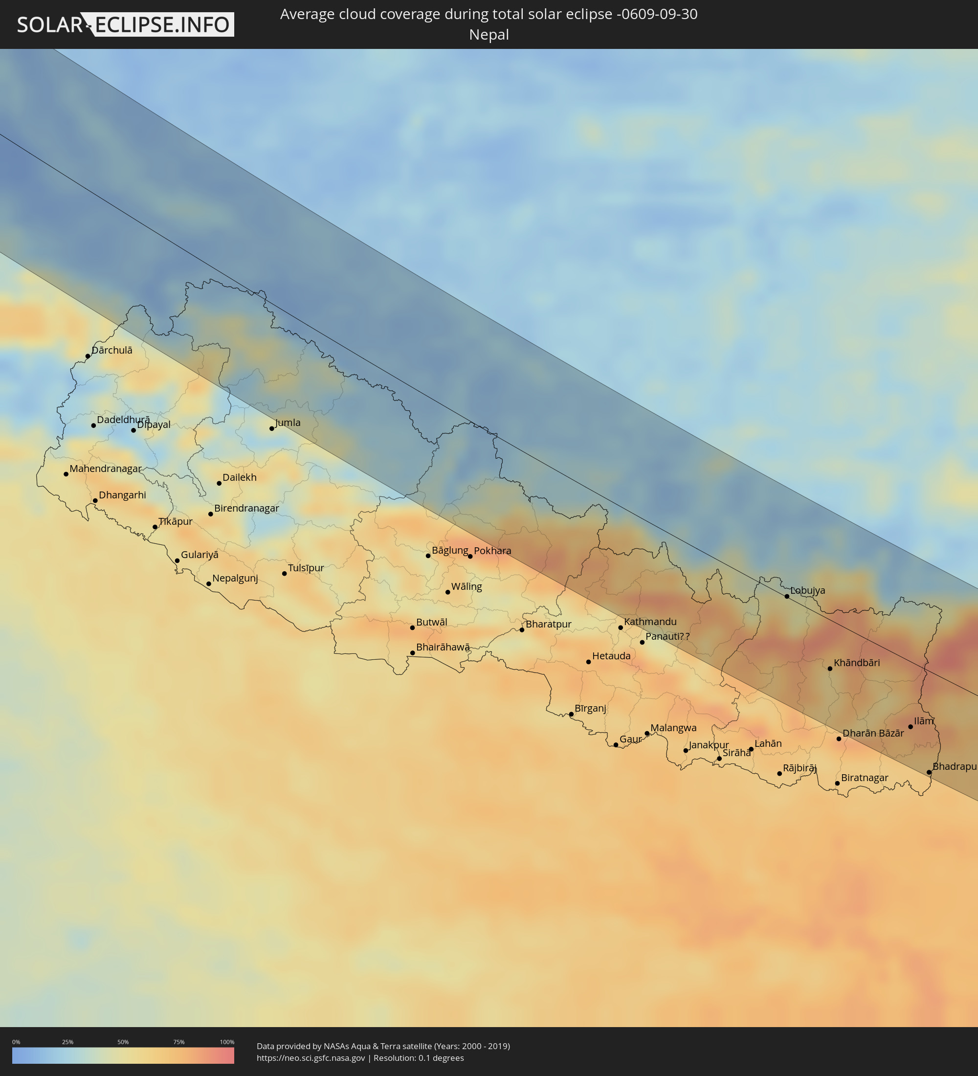 Nepal
Nepal
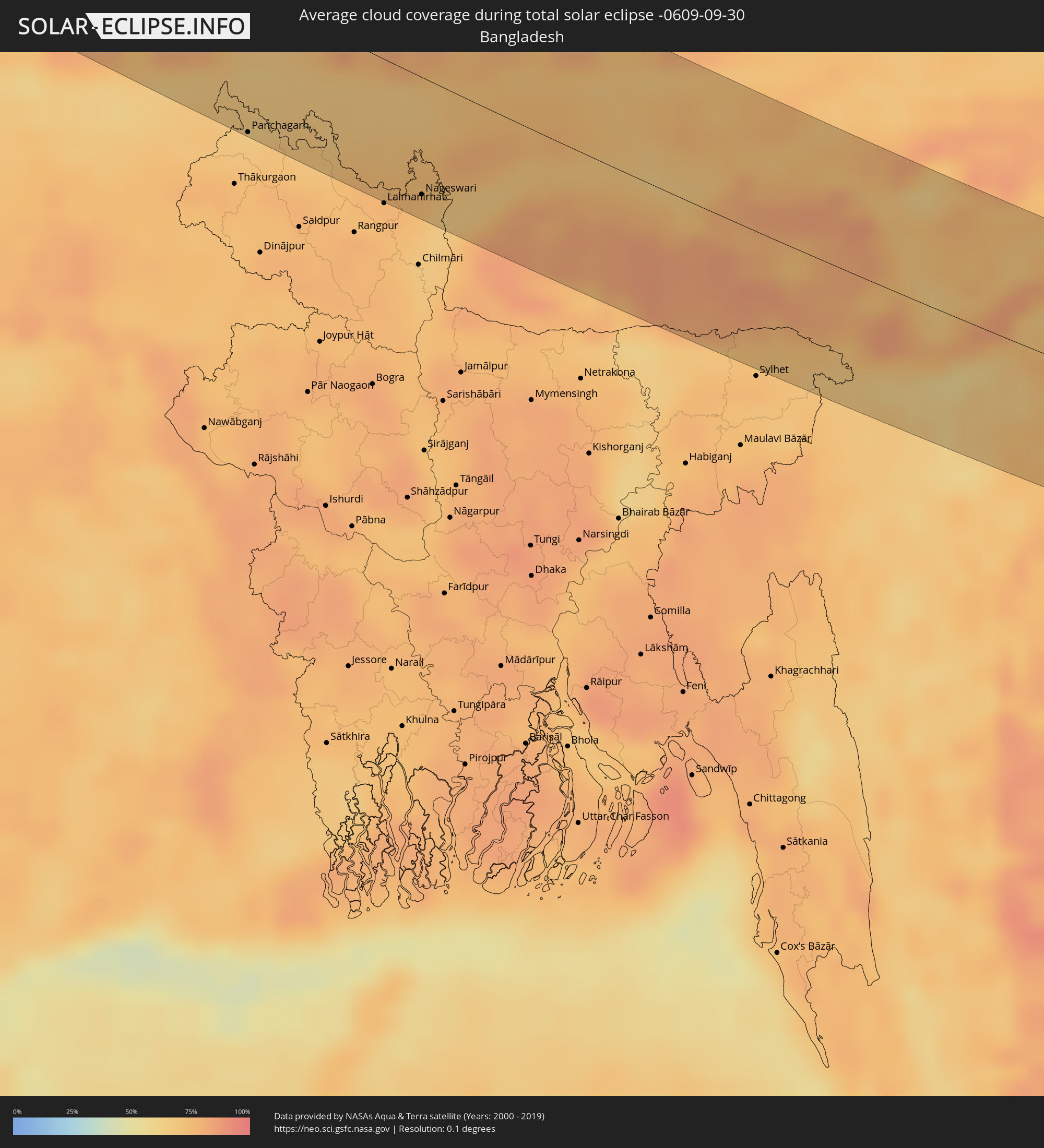 Bangladesh
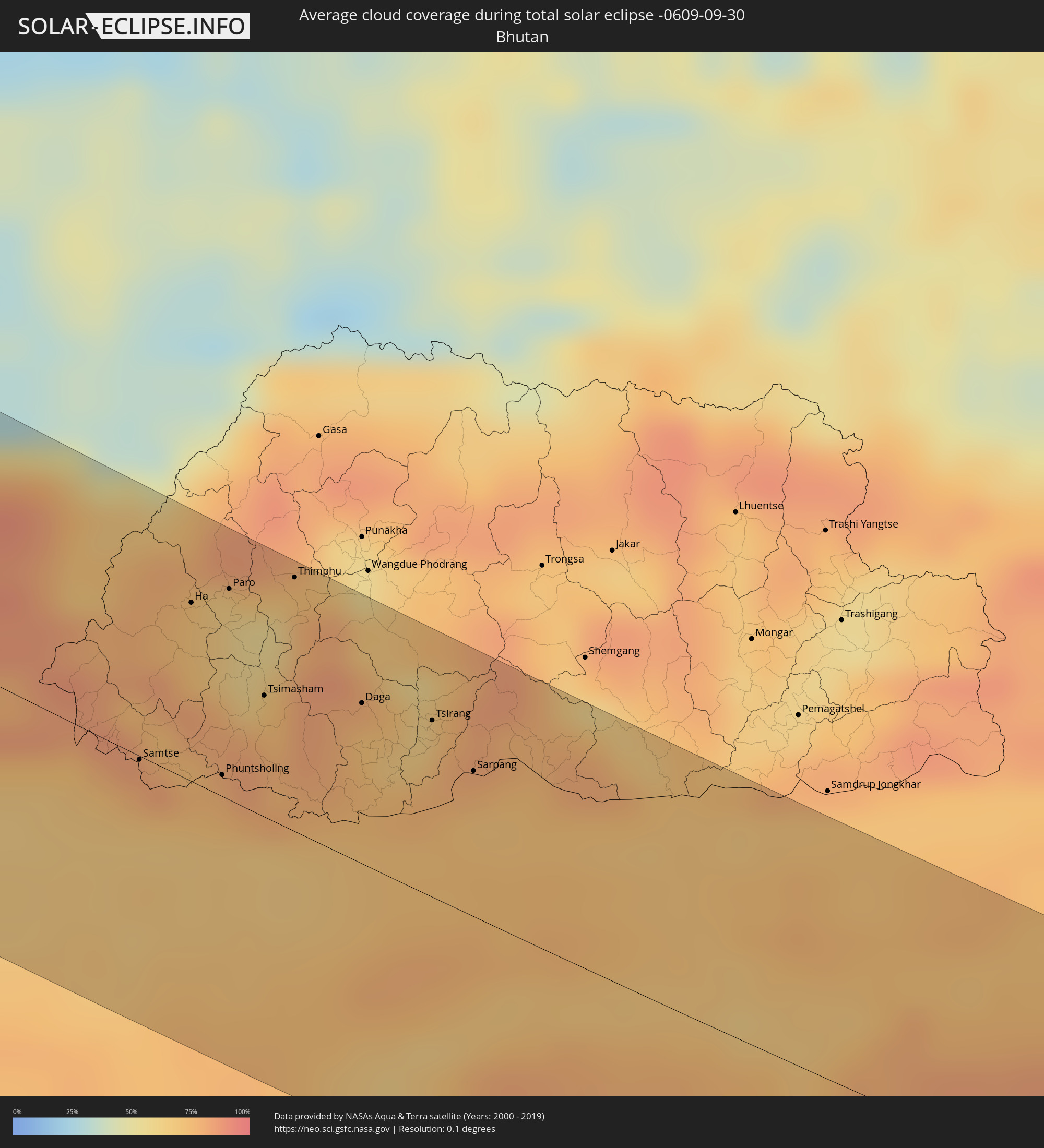 Bhutan
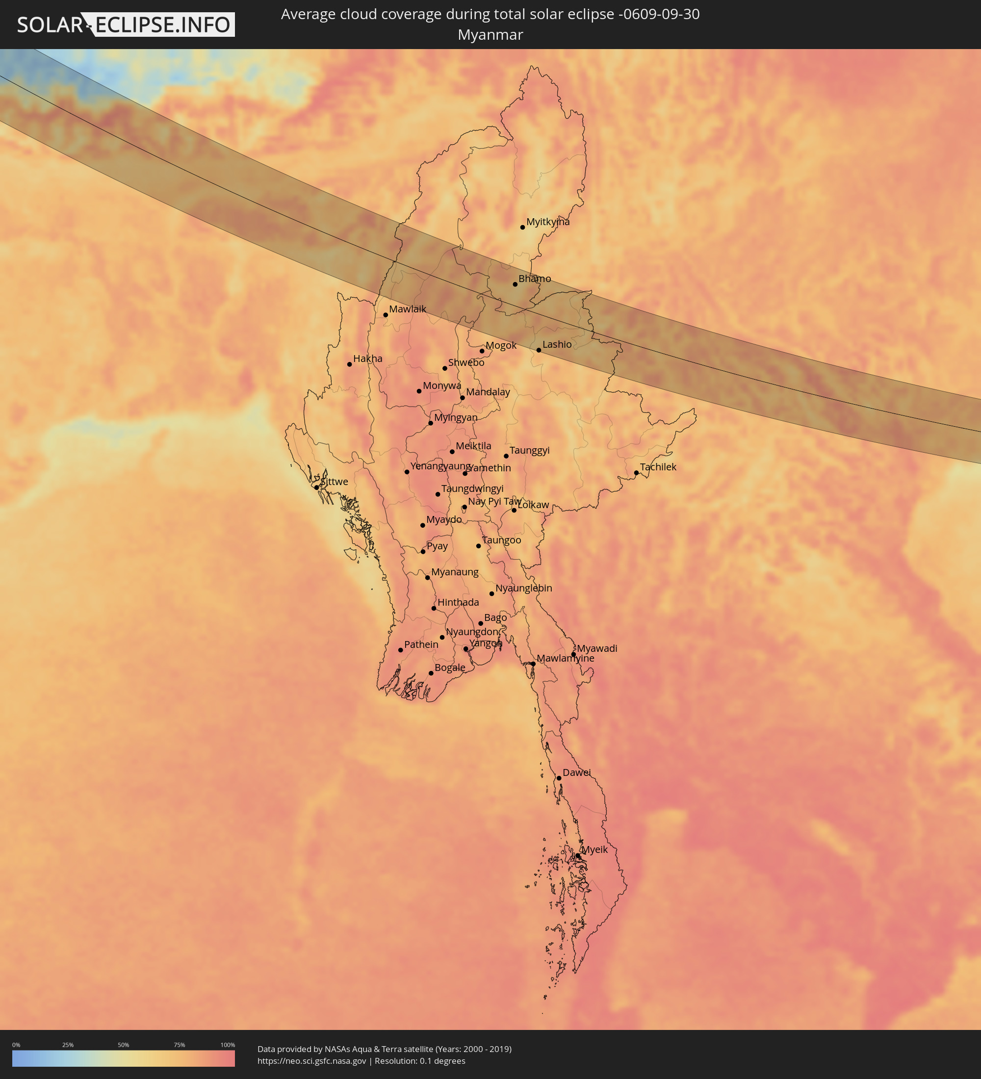 Myanmar
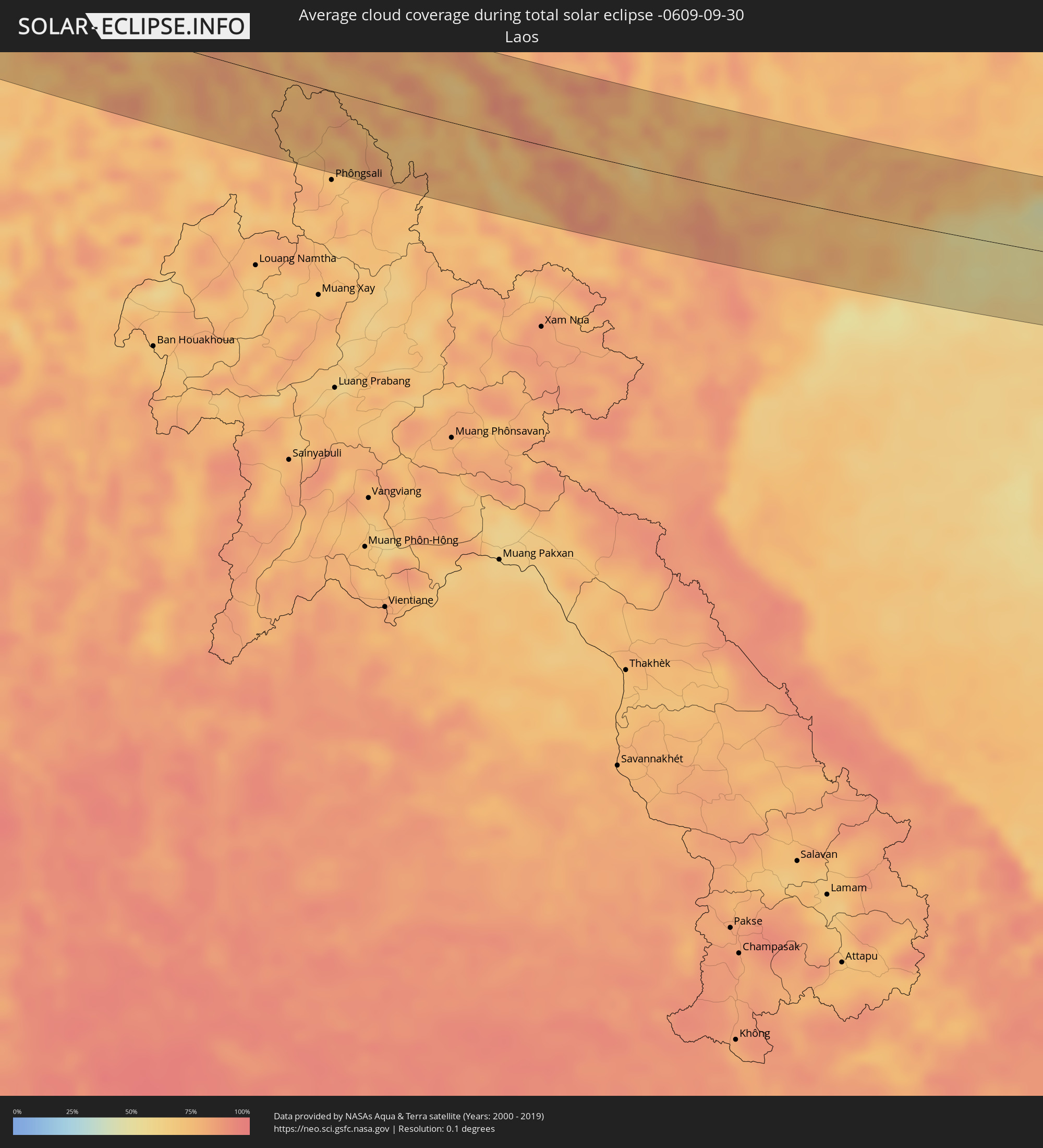 Laos
Laos
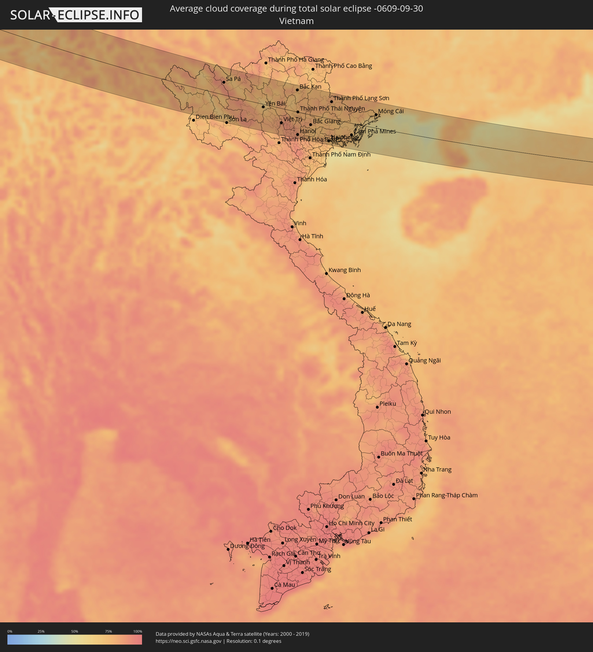 Vietnam
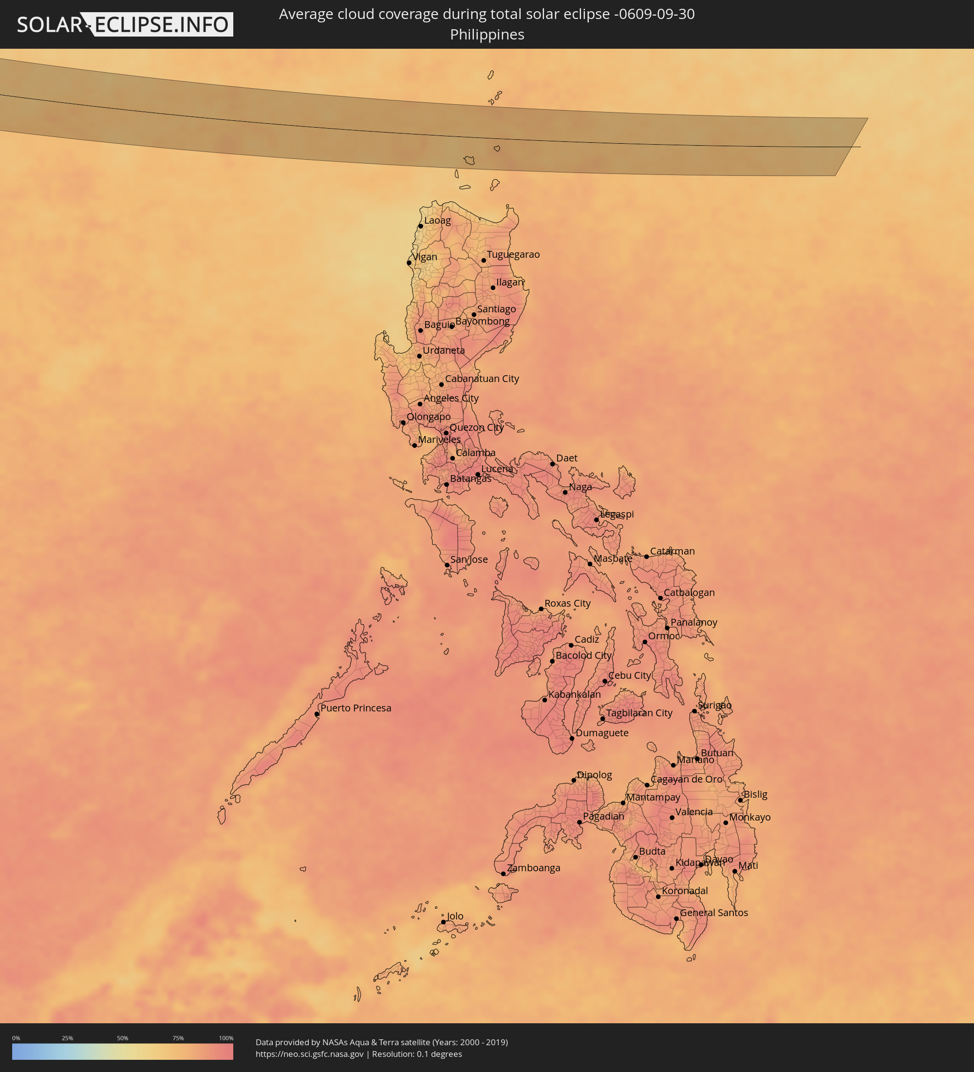 Philippines
Cities inside the path of the eclipse
The following table shows all locations with a population of more than 5,000 inside the eclipse path. Cities which have more than 100,000 inhabitants are marked bold. A click at the locations opens a detailed map.
| City | Type | Eclipse duration | Local time of max. eclipse | Distance to central line | Ø Cloud coverage |
|
Greenock, Scotland
|
total | - | 06:35:28 UTC+00:00 | 10 km | 87% |
|
Ayr, Scotland
|
total | - | 06:34:56 UTC+00:00 | 44 km | 83% |
|
Kilmarnock, Scotland
|
total | - | 06:35:07 UTC+00:00 | 27 km | 87% |
|
Glasgow, Scotland
|
total | - | 06:35:25 UTC+00:00 | 2 km | 86% |
|
Hamilton, Scotland
|
total | - | 06:35:20 UTC+00:00 | 9 km | 86% |
|
Cumbernauld, Scotland
|
total | - | 06:35:32 UTC+00:00 | 11 km | 86% |
|
Livingston, Scotland
|
total | - | 06:35:33 UTC+00:00 | 8 km | 83% |
|
Dunfermline, Scotland
|
total | - | 06:35:44 UTC+00:00 | 27 km | 80% |
|
Edinburgh, Scotland
|
total | - | 06:35:38 UTC+00:00 | 14 km | 75% |
|
Kirkcaldy, Scotland
|
total | - | 06:35:50 UTC+00:00 | 33 km | 74% |
|
Westerland, Schleswig-Holstein
|
total | - | 07:37:13 UTC+01:00 | 33 km | 73% |
|
Esbjerg, South Denmark
|
total | - | 07:37:52 UTC+01:00 | 30 km | 76% |
|
Niebüll, Schleswig-Holstein
|
total | - | 07:37:17 UTC+01:00 | 42 km | 75% |
|
Leck, Schleswig-Holstein
|
total | - | 07:37:19 UTC+01:00 | 42 km | 76% |
|
Flensburg, Schleswig-Holstein
|
total | - | 07:37:30 UTC+01:00 | 36 km | 74% |
|
Kolding, South Denmark
|
total | - | 07:38:15 UTC+01:00 | 42 km | 78% |
|
Haderslev, South Denmark
|
total | - | 07:38:01 UTC+01:00 | 16 km | 78% |
|
Fredericia, South Denmark
|
total | - | 07:38:26 UTC+01:00 | 53 km | 72% |
|
Sønderborg, South Denmark
|
total | - | 07:37:46 UTC+01:00 | 19 km | 73% |
|
Kappeln, Schleswig-Holstein
|
total | - | 07:37:34 UTC+01:00 | 45 km | 72% |
|
Odense, South Denmark
|
total | - | 07:38:30 UTC+01:00 | 40 km | 77% |
|
Svendborg, South Denmark
|
total | - | 07:38:14 UTC+01:00 | 6 km | 74% |
|
Fehmarn, Schleswig-Holstein
|
total | - | 07:37:50 UTC+01:00 | 57 km | 71% |
|
Slagelse, Zealand
|
total | - | 07:38:54 UTC+01:00 | 51 km | 78% |
|
Næstved, Zealand
|
total | - | 07:38:53 UTC+01:00 | 36 km | 78% |
|
Ringsted, Zealand
|
total | - | 07:39:07 UTC+01:00 | 60 km | 81% |
|
Barth, Mecklenburg-Vorpommern
|
total | - | 07:38:26 UTC+01:00 | 48 km | 75% |
|
Stralsund, Mecklenburg-Vorpommern
|
total | - | 07:38:32 UTC+01:00 | 50 km | 77% |
|
Bergen auf Rügen, Mecklenburg-Vorpommern
|
total | - | 07:38:48 UTC+01:00 | 34 km | 77% |
|
Saßnitz, Mecklenburg-Vorpommern
|
total | - | 07:39:00 UTC+01:00 | 21 km | 74% |
|
Koszalin, West Pomeranian Voivodeship
|
total | - | 08:03:56 UTC+01:24 | 25 km | 79% |
|
Słupsk, Pomeranian Voivodeship
|
total | - | 08:04:39 UTC+01:24 | 16 km | 80% |
|
Gdynia, Pomeranian Voivodeship
|
total | - | 08:05:33 UTC+01:24 | 43 km | 73% |
|
Gdańsk, Pomeranian Voivodeship
|
total | - | 08:05:27 UTC+01:24 | 26 km | 73% |
|
Tczew, Pomeranian Voivodeship
|
total | - | 08:05:17 UTC+01:24 | 0 km | 74% |
|
Elbląg, Warmian-Masurian Voivodeship
|
total | - | 08:05:43 UTC+01:24 | 16 km | 72% |
|
Olsztyn, Warmian-Masurian Voivodeship
|
total | - | 08:06:03 UTC+01:24 | 8 km | 72% |
|
Łomża, Podlasie
|
total | - | 08:06:32 UTC+01:24 | 48 km | 75% |
|
Ełk, Warmian-Masurian Voivodeship
|
total | - | 08:07:18 UTC+01:24 | 27 km | 75% |
|
Białystok, Podlasie
|
total | - | 08:07:15 UTC+01:24 | 34 km | 76% |
|
Hrodna, Grodnenskaya
|
total | - | 08:34:10 UTC+01:50 | 37 km | 75% |
|
Vawkavysk, Grodnenskaya
|
total | - | 08:34:11 UTC+01:50 | 9 km | 74% |
|
Slonim, Grodnenskaya
|
total | - | 08:34:46 UTC+01:50 | 0 km | 74% |
|
Baranovichi, Brest
|
total | - | 08:35:19 UTC+01:50 | 18 km | 73% |
|
Salihorsk, Minsk
|
total | - | 08:36:15 UTC+01:50 | 11 km | 77% |
|
Slutsk, Minsk
|
total | - | 08:36:27 UTC+01:50 | 37 km | 79% |
|
Mazyr, Gomel
|
total | - | 08:37:09 UTC+01:50 | 32 km | 71% |
|
Svyetlahorsk, Gomel
|
total | - | 08:37:58 UTC+01:50 | 40 km | 72% |
|
Rechytsa, Gomel
|
total | - | 08:38:21 UTC+01:50 | 25 km | 72% |
|
Slavutych, Kiev
|
total | - | 08:50:11 UTC+02:02 | 56 km | 68% |
|
Gomel, Gomel
|
total | - | 08:38:54 UTC+01:50 | 46 km | 71% |
|
Chernihiv, Chernihiv
|
total | - | 08:50:40 UTC+02:02 | 45 km | 68% |
|
Bakhmach, Chernihiv
|
total | - | 08:51:55 UTC+02:02 | 43 km | 64% |
|
Konotop, Sumy
|
total | - | 08:52:19 UTC+02:02 | 28 km | 65% |
|
Krolevets’, Sumy
|
total | - | 08:52:39 UTC+02:02 | 8 km | 67% |
|
Shostka, Sumy
|
total | - | 08:52:55 UTC+02:02 | 43 km | 70% |
|
Putyvl’, Sumy
|
total | - | 08:53:00 UTC+02:02 | 2 km | 69% |
|
Hlukhiv, Sumy
|
total | - | 08:53:14 UTC+02:02 | 35 km | 70% |
|
Lebedyn, Sumy
|
total | - | 08:53:14 UTC+02:02 | 65 km | 66% |
|
Sumy, Sumy
|
total | - | 08:53:43 UTC+02:02 | 22 km | 68% |
|
Belgorod, Belgorod
|
total | - | 09:23:37 UTC+02:30 | 9 km | 66% |
|
Shebekino, Belgorod
|
total | - | 09:23:53 UTC+02:30 | 21 km | 64% |
|
Valuyki, Belgorod
|
total | - | 09:25:05 UTC+02:30 | 10 km | 65% |
|
Alekseyevka, Belgorod
|
total | - | 09:25:53 UTC+02:30 | 50 km | 64% |
|
Rossosh’, Voronezj
|
total | - | 09:26:43 UTC+02:30 | 30 km | 63% |
|
Kalach-na-Donu, Volgograd
|
total | - | 09:31:03 UTC+02:30 | 4 km | 53% |
|
Volgograd, Volgograd
|
total | - | 09:32:17 UTC+02:30 | 30 km | 50% |
|
Volzhskiy, Volgograd
|
total | - | 09:32:39 UTC+02:30 | 45 km | 53% |
|
Znamensk, Astrakhan
|
total | - | 10:23:55 UTC+03:20 | 56 km | 54% |
|
Akhtubinsk, Astrakhan
|
total | - | 10:24:28 UTC+03:20 | 41 km | 54% |
|
Maloye Ganyushkino, Atyraū
|
total | - | 10:33:50 UTC+03:25 | 18 km | 54% |
|
Oltinko’l, Karakalpakstan
|
total | - | 11:52:44 UTC+04:27 | 30 km | 50% |
|
Köneürgench, Daşoguz
|
total | - | 11:19:17 UTC+03:53 | 29 km | 42% |
|
Akdepe
|
total | - | 11:19:52 UTC+03:53 | 45 km | 40% |
|
Nukus, Karakalpakstan
|
total | - | 11:54:20 UTC+04:27 | 3 km | 40% |
|
Yylanly, Daşoguz
|
total | - | 11:20:29 UTC+03:53 | 53 km | 34% |
|
Boldumsaz, Daşoguz
|
total | - | 11:20:19 UTC+03:53 | 25 km | 41% |
|
Tagta, Daşoguz
|
total | - | 11:21:05 UTC+03:53 | 58 km | 41% |
|
Daşoguz, Daşoguz
|
total | - | 11:21:02 UTC+03:53 | 39 km | 36% |
|
Urganch, Xorazm
|
total | - | 11:56:46 UTC+04:27 | 35 km | 43% |
|
Gazojak, Lebap
|
total | - | 11:24:03 UTC+03:53 | 34 km | 28% |
|
Bukhara, Bukhara
|
total | - | 12:05:06 UTC+04:27 | 23 km | 29% |
|
Navoiy, Navoiy
|
total | - | 12:06:32 UTC+04:27 | 51 km | 20% |
|
Koson, Qashqadaryo
|
total | - | 12:07:58 UTC+04:27 | 35 km | 20% |
|
Qarshi, Qashqadaryo
|
total | - | 12:08:31 UTC+04:27 | 41 km | 19% |
|
Kattaqo’rg’on, Samarqand
|
total | - | 12:08:19 UTC+04:27 | 77 km | 22% |
|
Shahrisabz, Qashqadaryo
|
total | - | 12:10:15 UTC+04:27 | 28 km | 21% |
|
Denov, Surxondaryo
|
total | - | 12:13:06 UTC+04:27 | 9 km | 17% |
|
Tursunzoda, Republican Subordination
|
total | - | 12:20:46 UTC+04:35 | 48 km | 17% |
|
Hisor, Republican Subordination
|
total | - | 12:21:21 UTC+04:35 | 65 km | 17% |
|
Moskovskiy, Khatlon
|
total | - | 12:22:28 UTC+04:35 | 17 km | 15% |
|
Dushanbe, Dushanbe
|
total | - | 12:21:46 UTC+04:35 | 77 km | 17% |
|
Qarāwul, Kunduz
|
total | - | 11:48:06 UTC+04:00 | 43 km | 13% |
|
Qŭrghonteppa, Khatlon
|
total | - | 12:22:35 UTC+04:35 | 13 km | 16% |
|
Imām Şāḩib, Kunduz
|
total | - | 11:48:26 UTC+04:00 | 38 km | 15% |
|
Khanabad, Kunduz
|
total | - | 11:49:23 UTC+04:00 | 75 km | 10% |
|
Danghara, Khatlon
|
total | - | 12:23:19 UTC+04:35 | 65 km | 13% |
|
Farkhor, Khatlon
|
total | - | 12:24:09 UTC+04:35 | 14 km | 15% |
|
Ārt Khwājah, Takhar
|
total | - | 11:49:36 UTC+04:00 | 20 km | 5% |
|
Taloqan, Takhar
|
total | - | 11:50:08 UTC+04:00 | 49 km | 6% |
|
Vose’, Khatlon
|
total | - | 12:24:14 UTC+04:35 | 54 km | 15% |
|
Kŭlob, Khatlon
|
total | - | 12:24:22 UTC+04:35 | 71 km | 15% |
|
Rustāq, Takhar
|
total | - | 11:50:13 UTC+04:00 | 2 km | 6% |
|
Farkhār, Takhar
|
total | - | 11:50:57 UTC+04:00 | 47 km | 6% |
|
Fayzabad, Badakhshan
|
total | - | 11:51:38 UTC+04:00 | 39 km | 6% |
|
Jurm, Badakhshan
|
total | - | 11:52:26 UTC+04:00 | 29 km | 8% |
|
Ashkāsham, Badakhshan
|
total | - | 11:53:59 UTC+04:00 | 48 km | 16% |
|
Ishqoshim, Gorno-Badakhshan
|
total | - | 12:29:17 UTC+04:35 | 56 km | 17% |
|
Upper Dir, Khyber Pakhtunkhwa
|
total | - | 12:24:47 UTC+04:28 | 69 km | 19% |
|
Tāl, Khyber Pakhtunkhwa
|
total | - | 12:25:08 UTC+04:28 | 25 km | 37% |
|
Mingora, Khyber Pakhtunkhwa
|
total | - | 12:26:18 UTC+04:28 | 83 km | 15% |
|
Mānsehra, Khyber Pakhtunkhwa
|
total | - | 12:28:32 UTC+04:28 | 81 km | 16% |
|
Baffa, Khyber Pakhtunkhwa
|
total | - | 12:28:26 UTC+04:28 | 70 km | 12% |
|
Muzaffarābād, Azad Kashmir
|
total | - | 12:29:00 UTC+04:28 | 63 km | 12% |
|
Srinagar, Kashmir
|
total | - | 13:24:56 UTC+05:21 | 20 km | 12% |
|
Burang, Tibet Autonomous Region
|
total | - | 16:21:29 UTC+08:00 | 46 km | 12% |
|
Lobujya, Eastern Region
|
total | - | 14:16:20 UTC+05:41 | 1 km | 56% |
|
Khāndbāri, Eastern Region
|
total | - | 14:17:55 UTC+05:41 | 39 km | 57% |
|
Dhankutā, Eastern Region
|
total | - | 14:18:46 UTC+05:41 | 71 km | 67% |
|
Ilām, Eastern Region
|
total | - | 14:19:51 UTC+05:41 | 52 km | 73% |
|
Bhadrapur, Eastern Region
|
total | - | 14:20:43 UTC+05:41 | 81 km | 69% |
|
Dārjiling, West Bengal
|
total | - | 14:00:05 UTC+05:21 | 25 km | 80% |
|
Shiliguri, West Bengal
|
total | - | 14:00:52 UTC+05:21 | 50 km | 67% |
|
Panchagarh, Rangpur Division
|
total | - | 14:33:52 UTC+05:53 | 81 km | 70% |
|
Jalpāiguri, West Bengal
|
total | - | 14:01:40 UTC+05:21 | 55 km | 66% |
|
Samtse, Samchi
|
total | - | 14:39:02 UTC+05:58 | 1 km | 78% |
|
Ha, Haa District
|
total | - | 14:38:30 UTC+05:58 | 56 km | 72% |
|
Jaigaon, West Bengal
|
total | - | 14:02:07 UTC+05:21 | 6 km | 73% |
|
Phuntsholing, Chukha District
|
total | - | 14:02:07 UTC+05:21 | 7 km | 77% |
|
Paro, Paro
|
total | - | 14:38:38 UTC+05:58 | 66 km | 66% |
|
Tsimasham, Chukha District
|
total | - | 14:39:23 UTC+05:58 | 38 km | 79% |
|
Thimphu, Thimphu
|
total | - | 14:38:56 UTC+05:58 | 79 km | 71% |
|
Lungtenzampa, Thimphu
|
total | - | 14:38:56 UTC+05:58 | 79 km | 71% |
|
Nageswari, Rangpur Division
|
total | - | 14:36:13 UTC+05:53 | 69 km | 74% |
|
Daga, Dagana District
|
total | - | 14:39:56 UTC+05:58 | 50 km | 73% |
|
Tsirang, Chirang
|
total | - | 14:40:24 UTC+05:58 | 55 km | 69% |
|
Sarpang, Geylegphug
|
total | - | 14:40:52 UTC+05:58 | 46 km | 77% |
|
Chhātak, Sylhet
|
total | - | 14:40:41 UTC+05:53 | 80 km | 74% |
|
Guwahati, Assam
|
total | - | 14:06:44 UTC+05:21 | 39 km | 74% |
|
Shillong, Meghalaya
|
total | - | 14:07:56 UTC+05:21 | 18 km | 85% |
|
Silchar, Assam
|
total | - | 14:10:26 UTC+05:21 | 58 km | 66% |
|
Imphal, Manipur
|
total | - | 14:12:02 UTC+05:21 | 16 km | 67% |
|
Kohima, Nagaland
|
total | - | 14:10:51 UTC+05:21 | 80 km | 85% |
|
Bhamo, Kachin
|
total | - | 15:20:42 UTC+06:24 | 44 km | 62% |
|
Lashio, Shan
|
total | - | 15:23:23 UTC+06:24 | 77 km | 77% |
|
Sa Pá, Lào Cai
|
total | - | 16:12:27 UTC+07:06 | 33 km | 89% |
|
Yên Bái, Yên Bái
|
total | - | 16:14:18 UTC+07:06 | 8 km | 72% |
|
Việt Trì, Phú Thọ
|
total | - | 16:15:17 UTC+07:06 | 40 km | 83% |
|
Hanoi, Ha Nội
|
total | - | 16:16:04 UTC+07:06 | 63 km | 88% |
|
Thành Phố Thái Nguyên, Thái Nguyên
|
total | - | 16:15:15 UTC+07:06 | 1 km | 79% |
|
Haiphong, Hải Phòng
|
total | - | 16:16:57 UTC+07:06 | 62 km | 74% |
|
Thành Phố Uông Bí, Quảng Ninh
|
total | - | 16:16:47 UTC+07:06 | 42 km | 70% |
|
Thành Phố Hạ Long, Quảng Ninh
|
total | - | 16:17:08 UTC+07:06 | 45 km | 73% |
|
Cẩm Phả Mines, Quảng Ninh
|
total | - | 16:17:12 UTC+07:06 | 33 km | 68% |
|
Móng Cái, Quảng Ninh
|
total | - | 16:16:59 UTC+07:06 | 36 km | 58% |
|
Beihai, Guangxi Zhuang Autonomous Region
|
total | - | 17:11:10 UTC+08:00 | 53 km | 61% |
|
Xucheng, Guangdong
|
total | - | 17:13:27 UTC+08:00 | 55 km | 71% |
|
Zhanjiang, Guangdong
|
total | - | 17:12:16 UTC+08:00 | 53 km | 77% |
|
Zhongshan, Guangdong
|
total | - | 17:12:21 UTC+08:00 | 61 km | 62% |