Total solar eclipse of 07/28/-0690
| Day of week: | Saturday |
| Maximum duration of eclipse: | 04m11s |
| Maximum width of eclipse path: | 229 km |
| Saros cycle: | 44 |
| Coverage: | 100% |
| Magnitude: | 1.0589 |
| Gamma: | 0.5338 |
Wo kann man die Sonnenfinsternis vom 07/28/-0690 sehen?
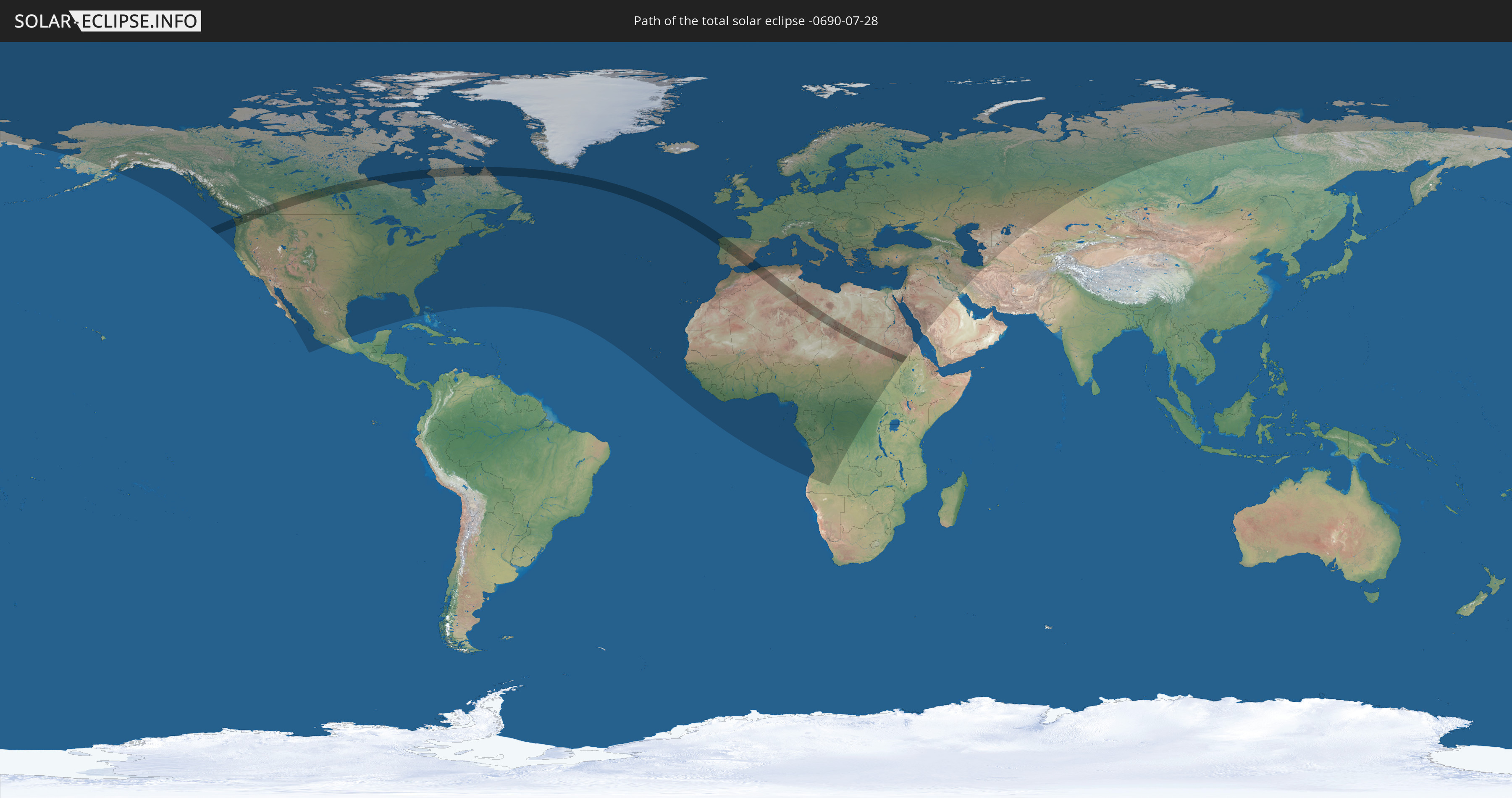
Die Sonnenfinsternis am 07/28/-0690 kann man in 107 Ländern als partielle Sonnenfinsternis beobachten.
Der Finsternispfad verläuft durch 9 Länder. Nur in diesen Ländern ist sie als total Sonnenfinsternis zu sehen.
In den folgenden Ländern ist die Sonnenfinsternis total zu sehen
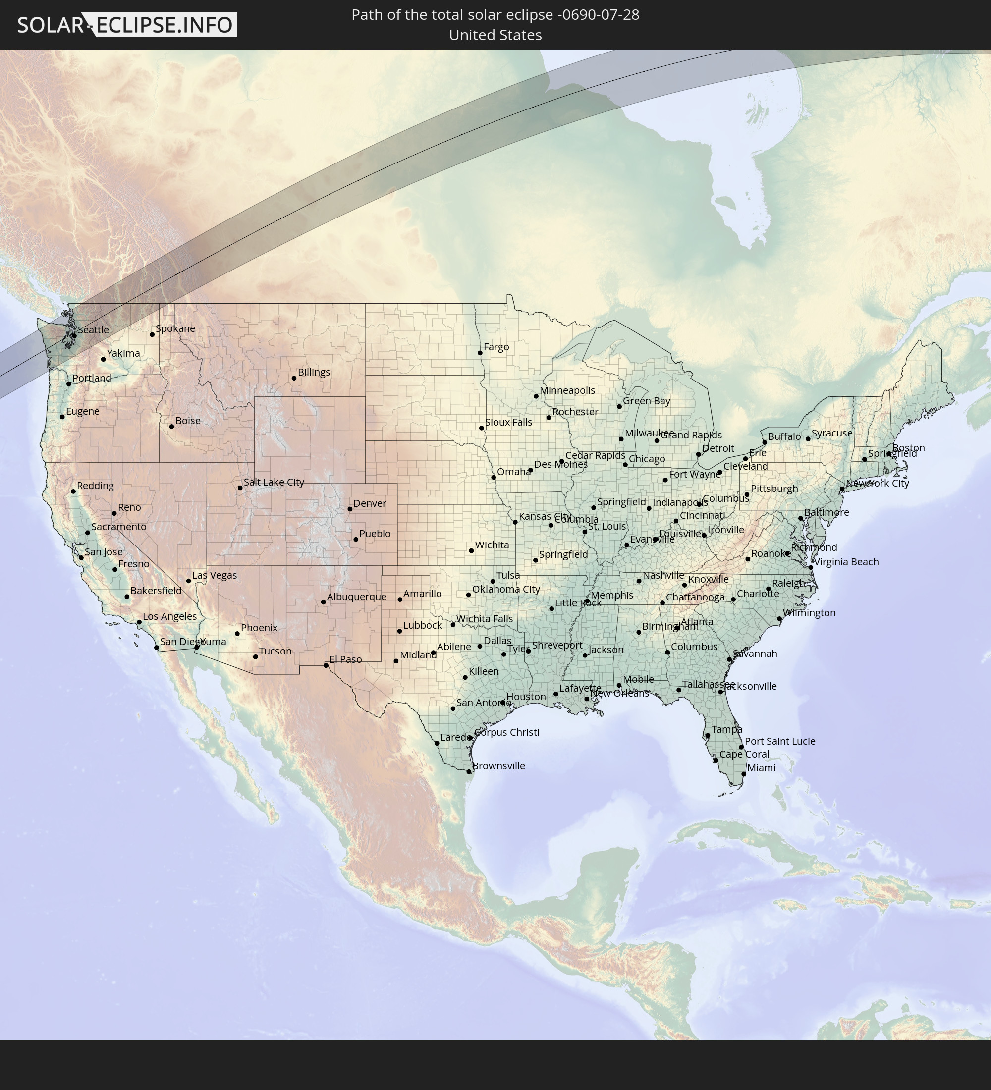 United States
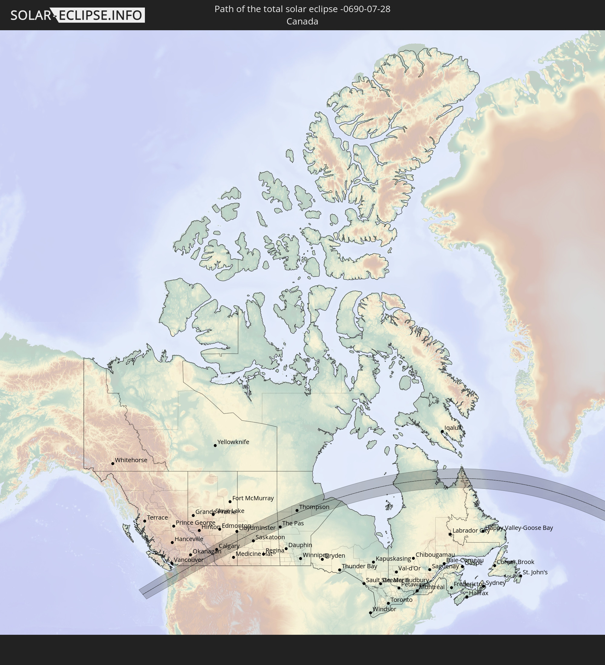 Canada
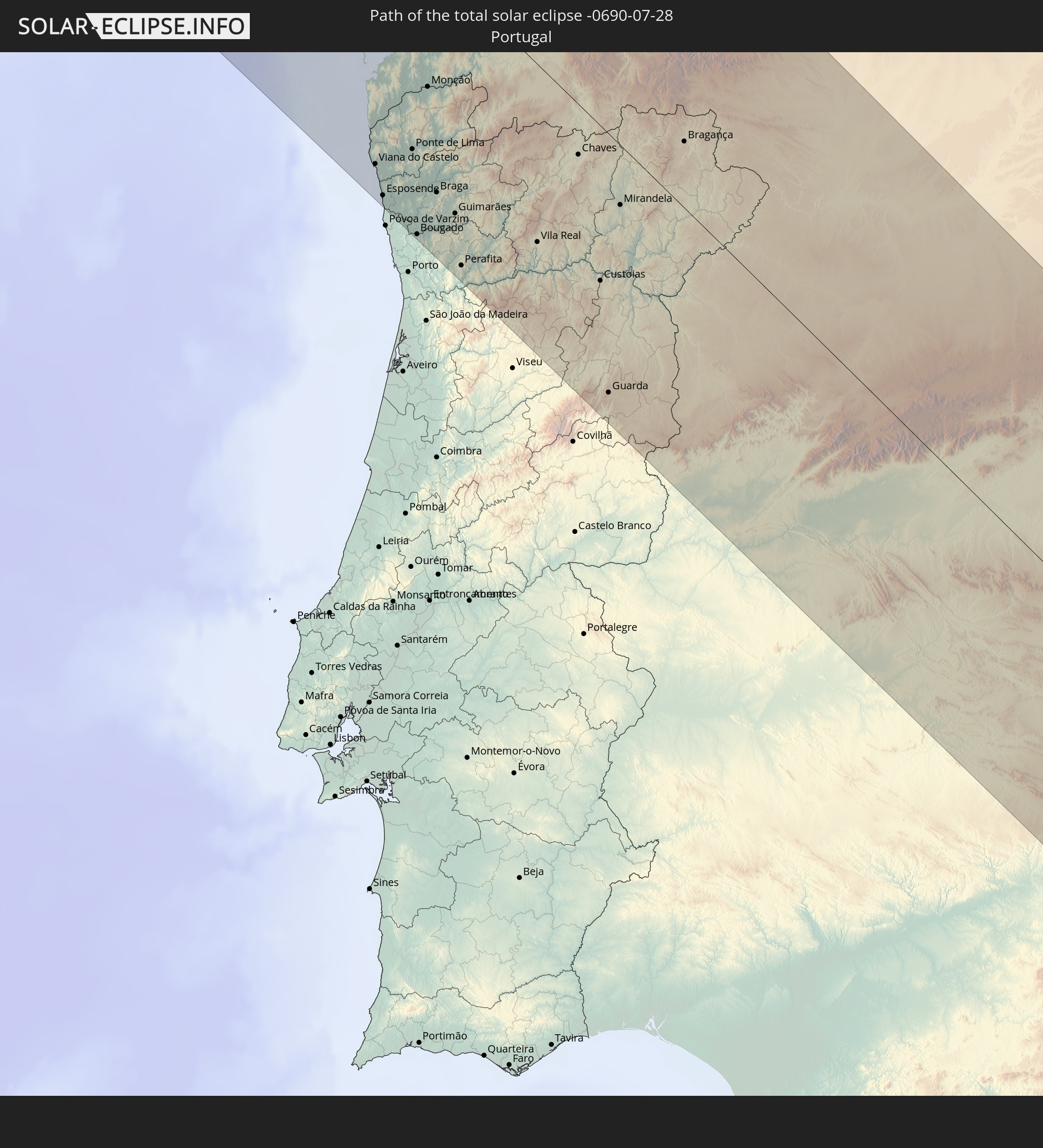 Portugal
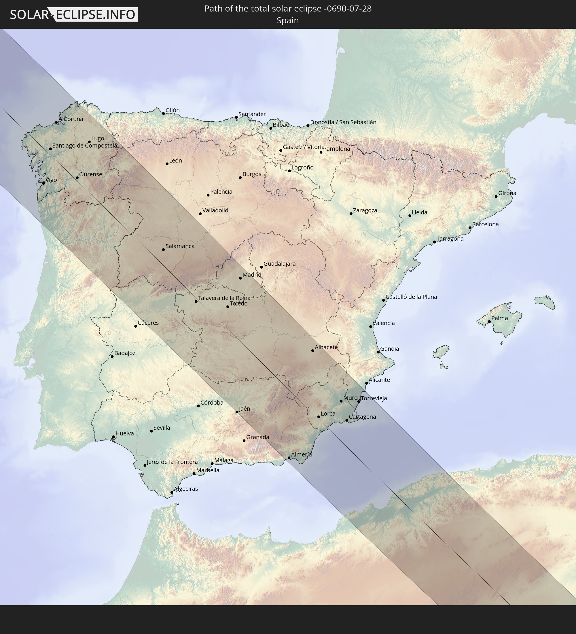 Spain
Spain
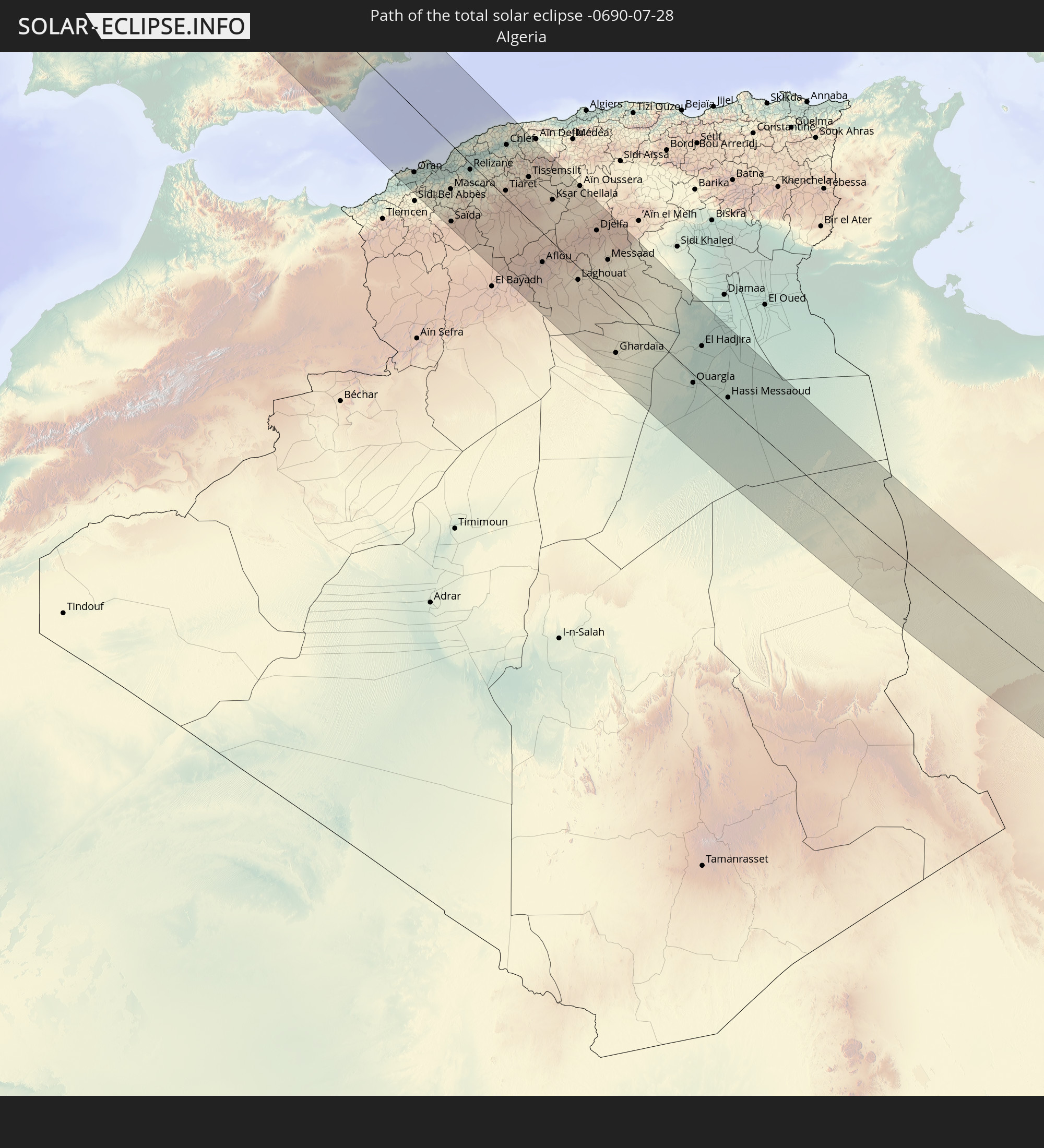 Algeria
 Tunisia
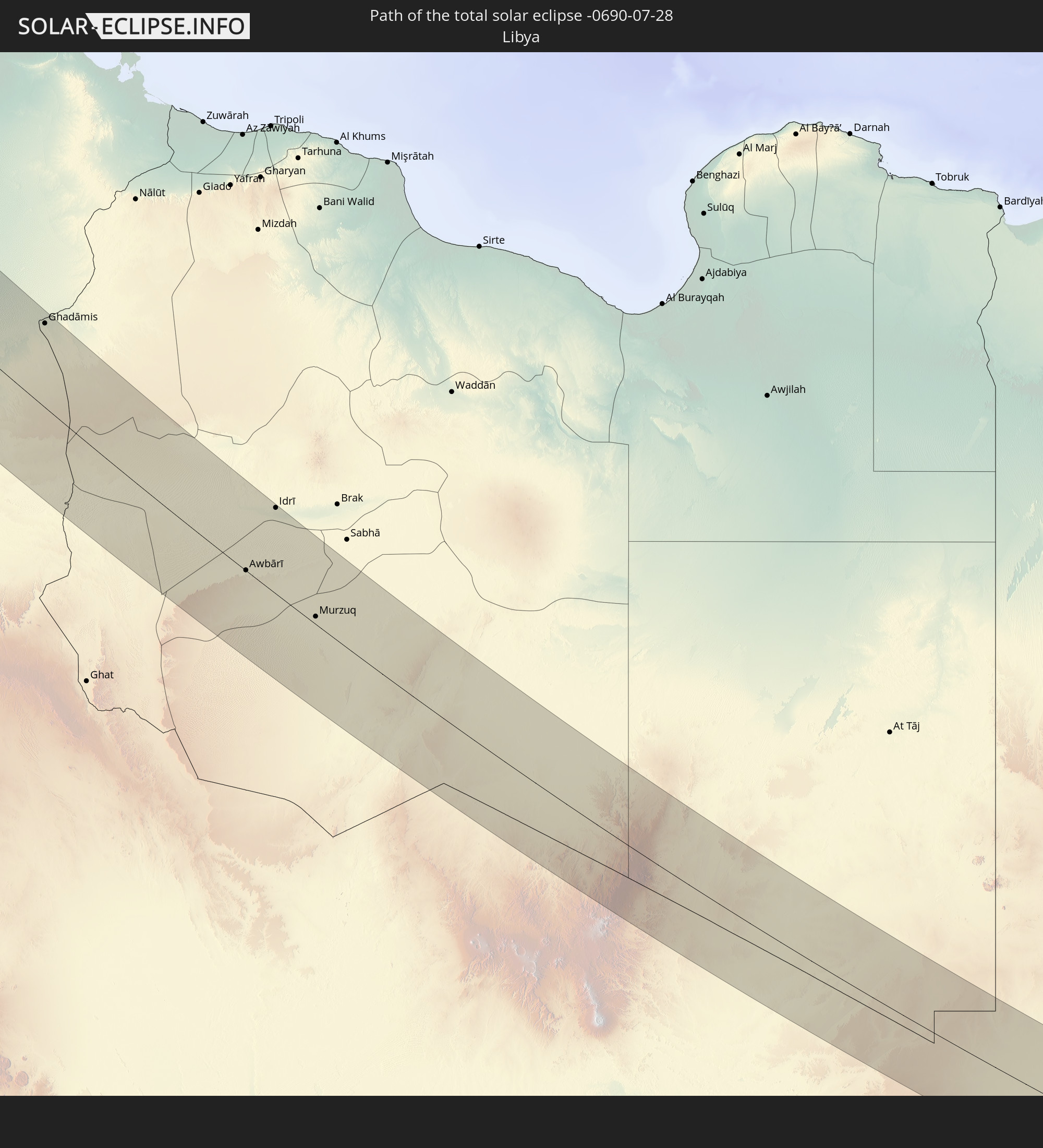 Libya
Libya
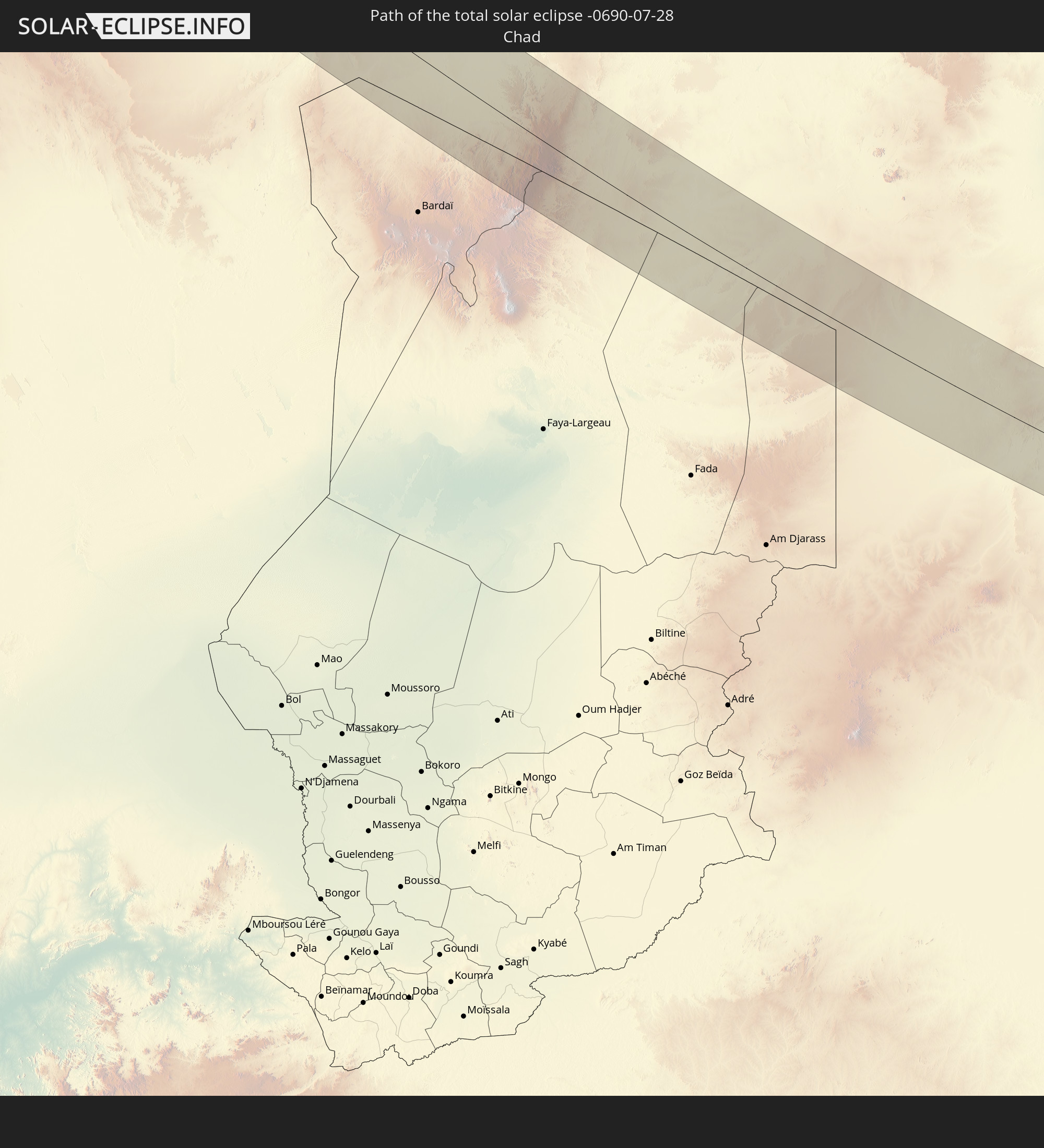 Chad
Chad
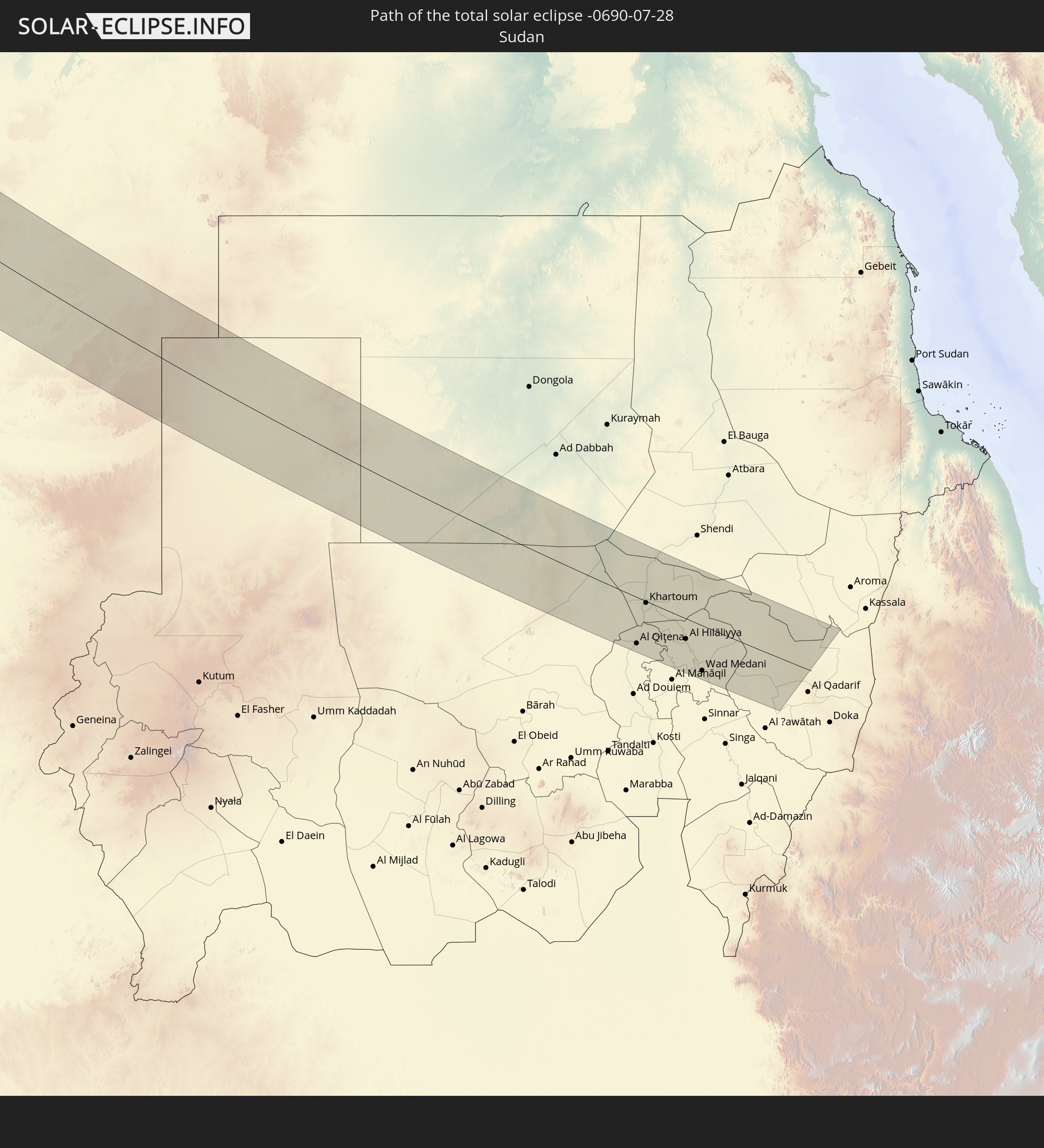 Sudan
Sudan
In den folgenden Ländern ist die Sonnenfinsternis partiell zu sehen
 Russia
 United States
 Canada
 Mexico
 Greenland
 The Bahamas
 Bermuda
 Saint Pierre and Miquelon
 Portugal
 Cabo Verde
 Iceland
 Spain
Spain
 Senegal
 Mauritania
 The Gambia
 Guinea-Bissau
 Guinea
 Sierra Leone
 Morocco
 Mali
Mali
 Liberia
 Republic of Ireland
 Svalbard and Jan Mayen
 Algeria
 United Kingdom
 Ivory Coast
 Faroe Islands
 Burkina Faso
 Gibraltar
 France
 Isle of Man
 Ghana
Ghana
 Guernsey
 Jersey
 Togo
Togo
 Niger
Niger
 Benin
Benin
 Andorra
 Belgium
 Nigeria
 Netherlands
 Norway
 Equatorial Guinea
 Luxembourg
 Germany
 Switzerland
 São Tomé and Príncipe
 Italy
Italy
 Monaco
 Tunisia
 Denmark
 Cameroon
 Gabon
Gabon
 Libya
Libya
 Liechtenstein
 Austria
 Sweden
 Republic of the Congo
 Angola
 Czechia
 Democratic Republic of the Congo
 San Marino
 Vatican City
 Slovenia
 Chad
Chad
 Croatia
 Poland
 Malta
Malta
 Central African Republic
 Bosnia and Herzegovina
 Hungary
 Slovakia
 Montenegro
 Serbia
 Albania
 Åland Islands
 Greece
 Romania
 Republic of Macedonia
 Finland
 Lithuania
 Latvia
 Estonia
 Sudan
Sudan
 Ukraine
 Bulgaria
 Belarus
 Egypt
Egypt
 Turkey
 Moldova
 Cyprus
 State of Palestine
 Israel
 Saudi Arabia
 Jordan
 Lebanon
 Syria
Syria
 Eritrea
 Iraq
Iraq
 Georgia
 Armenia
 Iran
Iran
 Azerbaijan
 Kazakhstan
 Kuwait
 Turkmenistan
 Uzbekistan
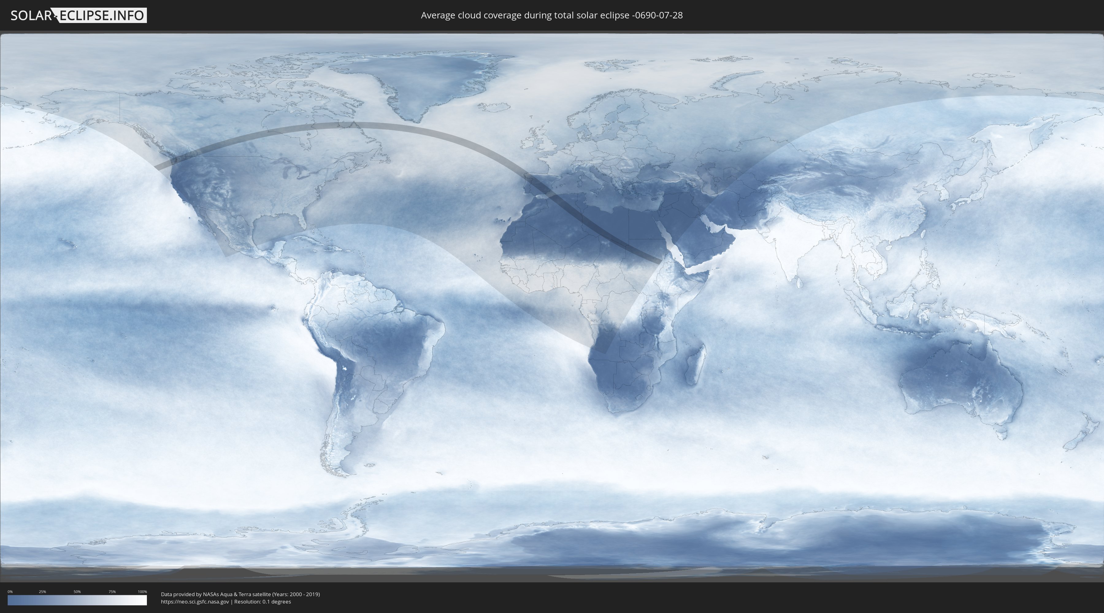
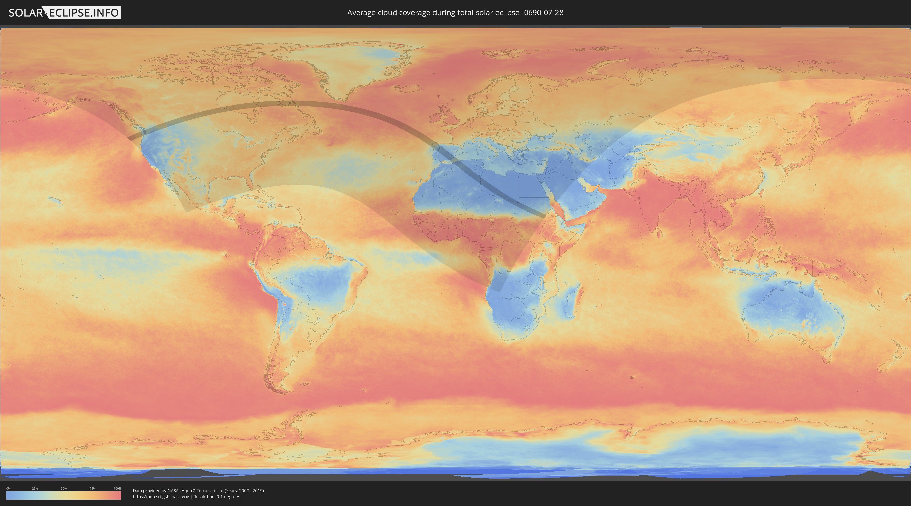
How will be the weather during the total solar eclipse on 07/28/-0690?
Where is the best place to see the total solar eclipse of 07/28/-0690?
The following maps show the average cloud coverage for the day of the total solar eclipse.
With the help of these maps, it is possible to find the place along the eclipse path, which has the best
chance of a cloudless sky.
Nevertheless, you should consider local circumstances and inform about the weather of your chosen
observation site.
The data is provided by NASAs satellites
AQUA and TERRA.
The cloud maps are averaged over a period of 19 years (2000 - 2019).
Detailed country maps
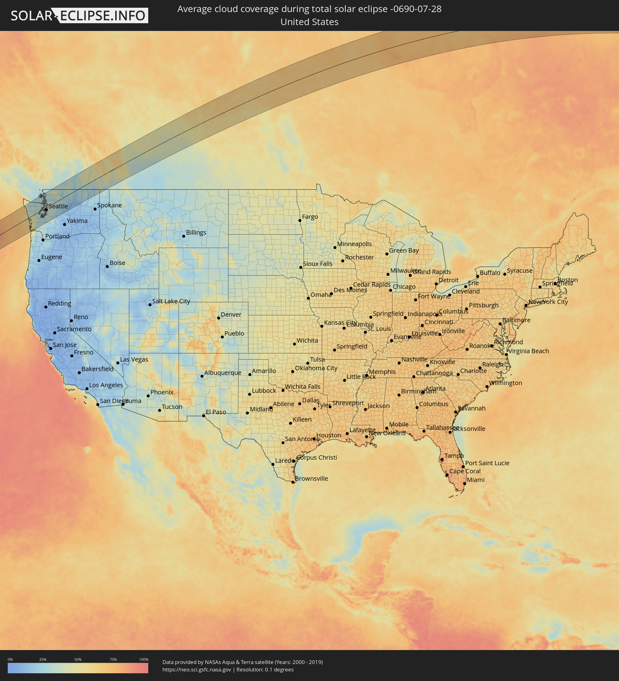 United States
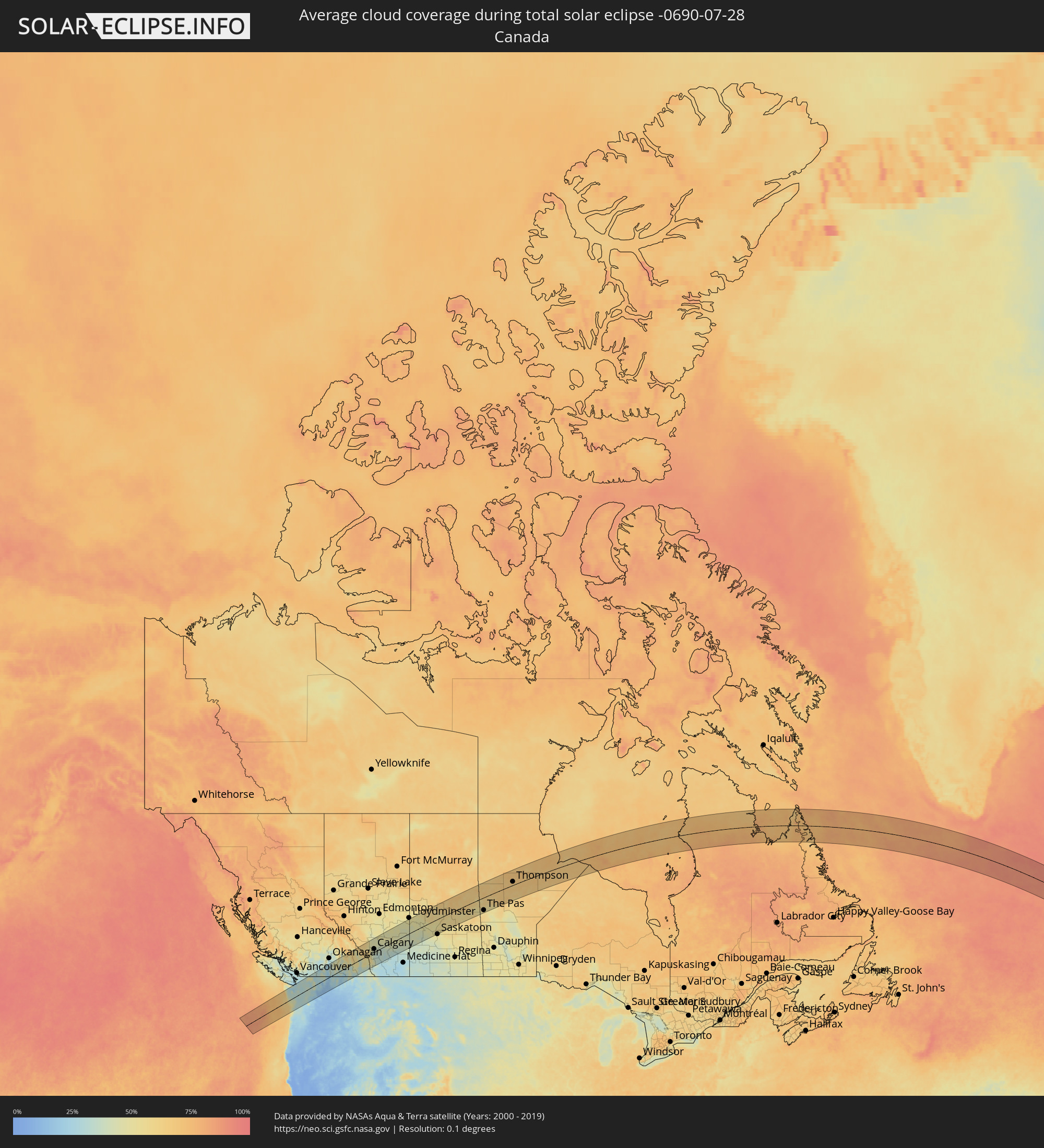 Canada
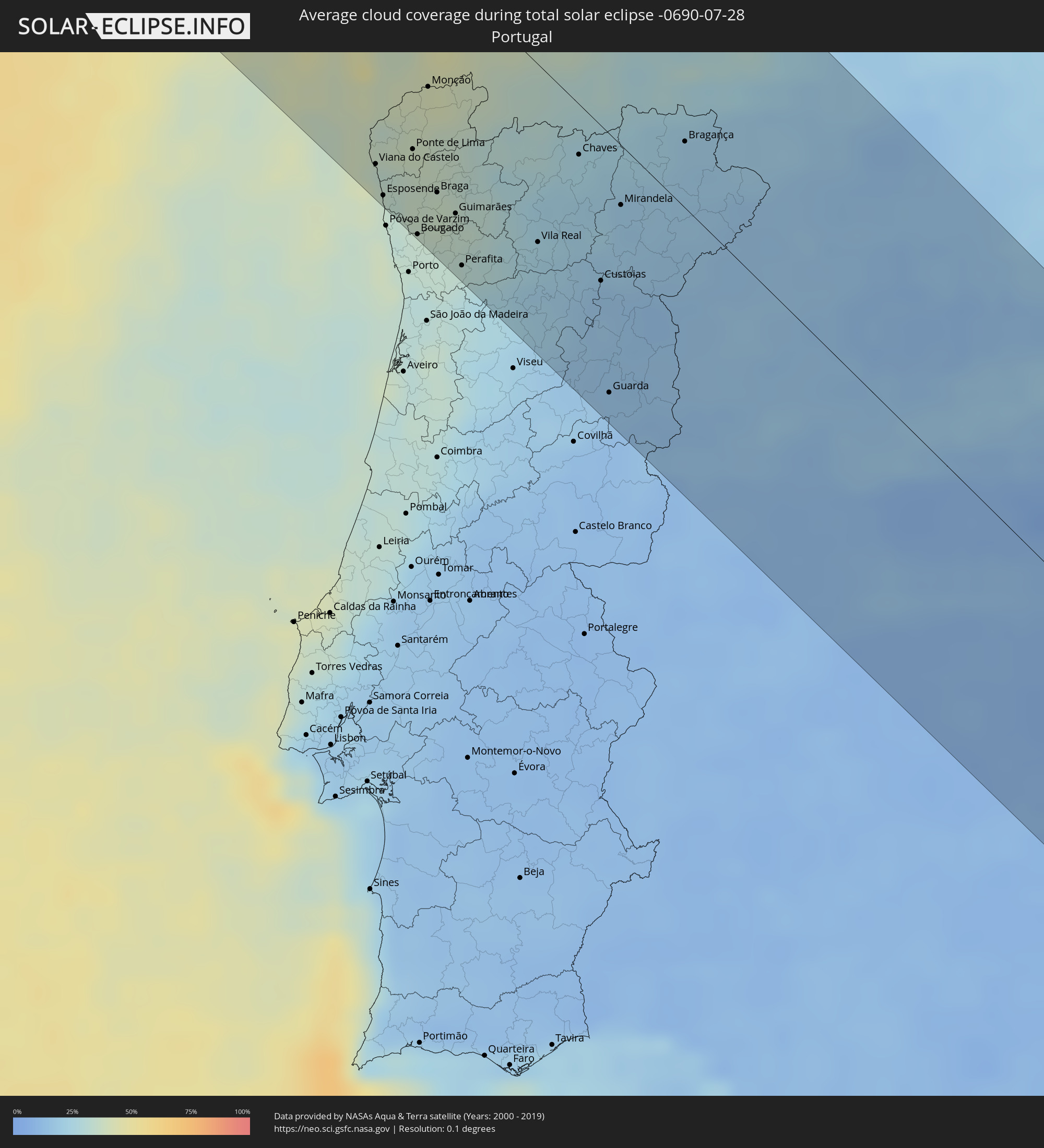 Portugal
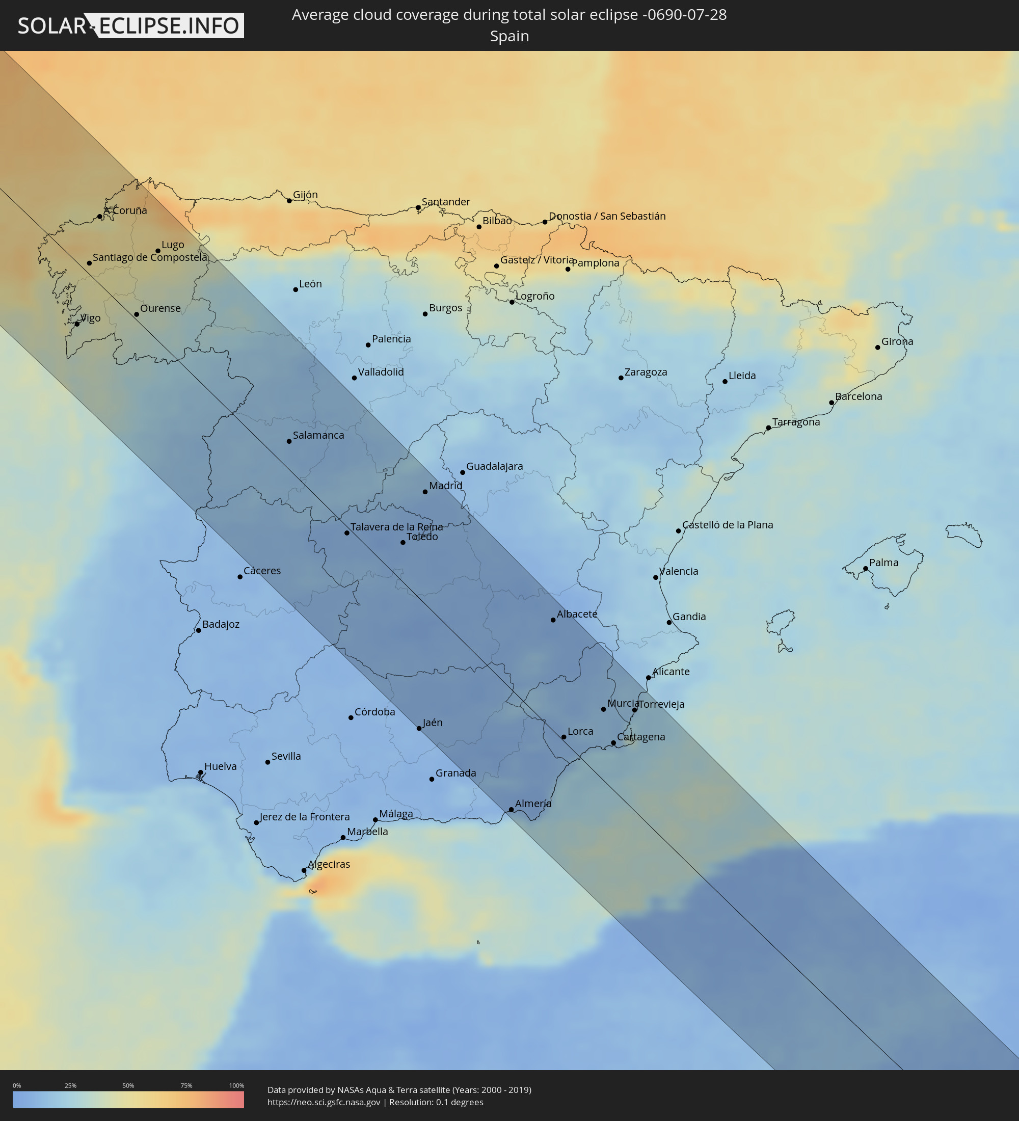 Spain
Spain
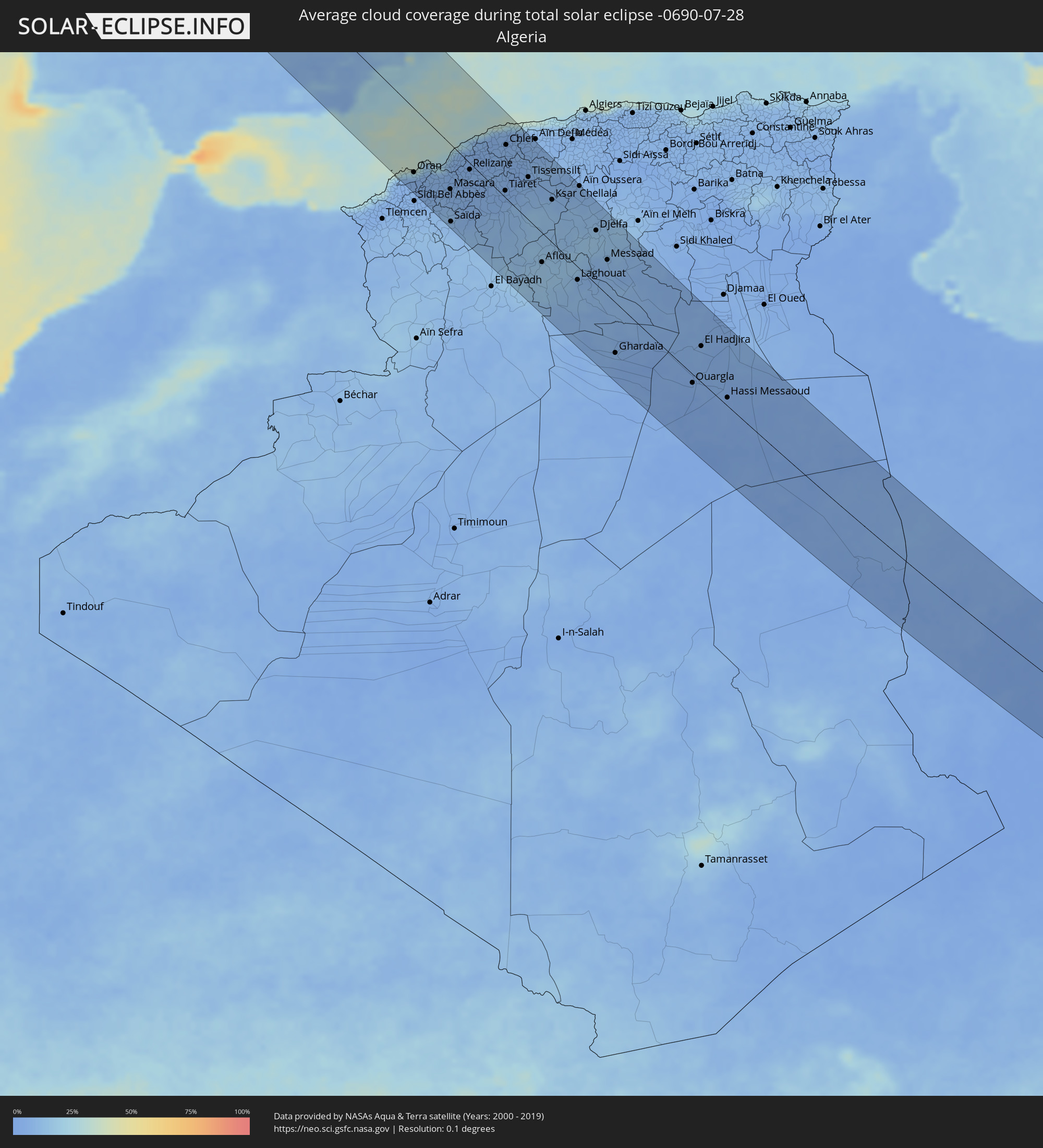 Algeria
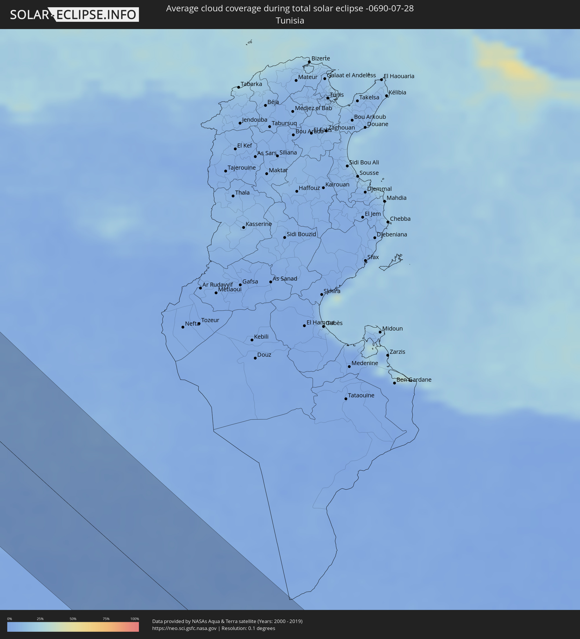 Tunisia
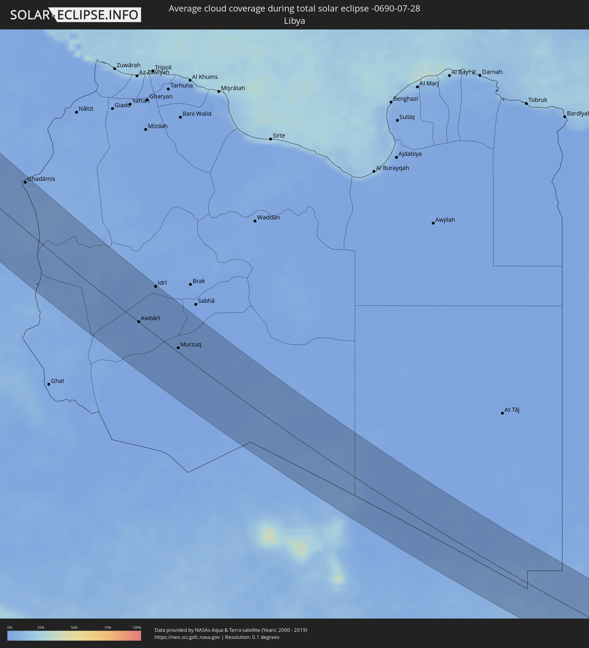 Libya
Libya
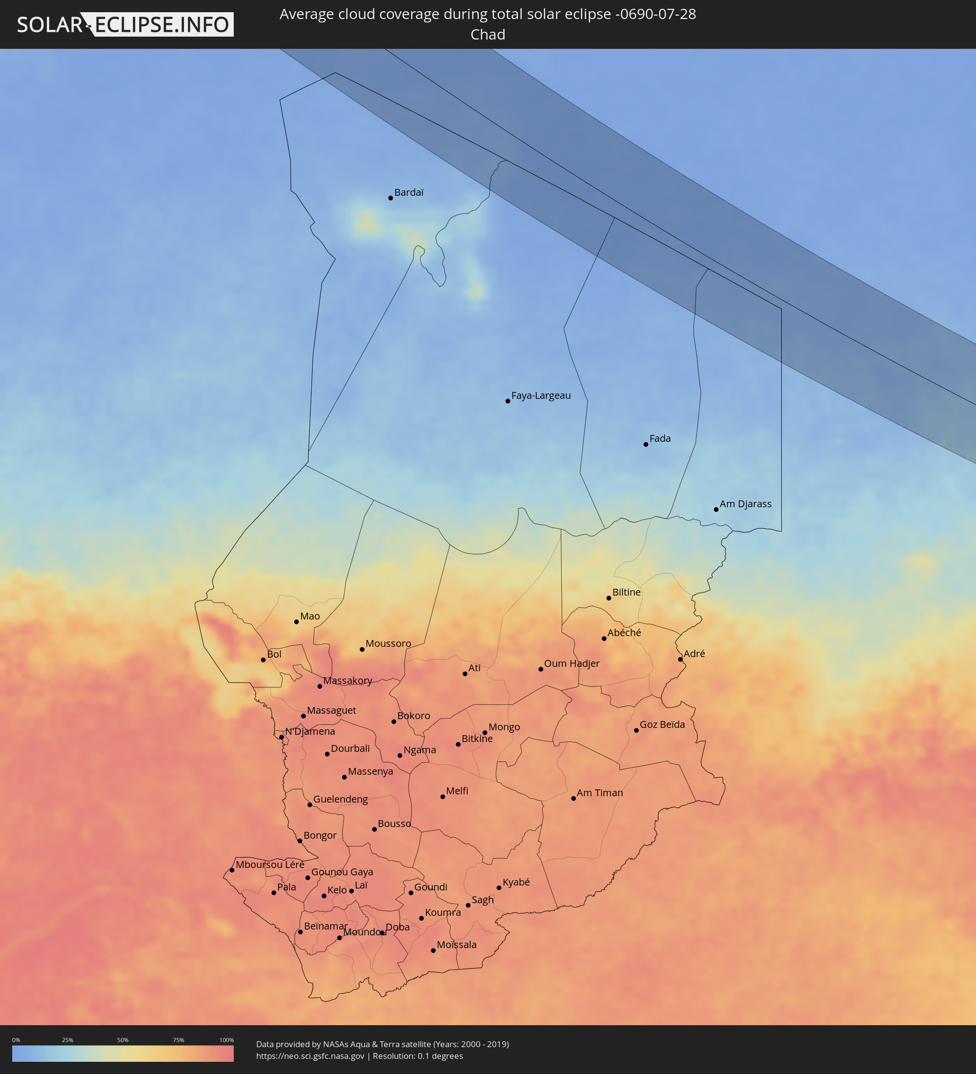 Chad
Chad
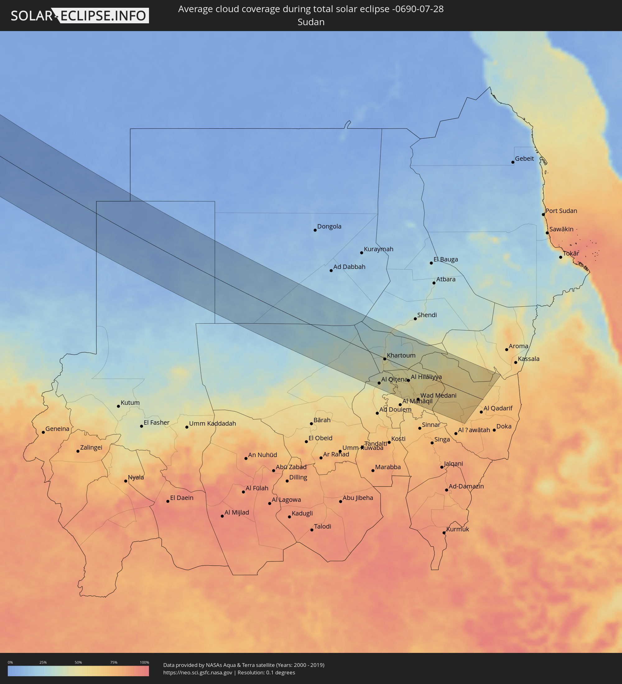 Sudan
Sudan
Cities inside the path of the eclipse
The following table shows all locations with a population of more than 5,000 inside the eclipse path. Cities which have more than 100,000 inhabitants are marked bold. A click at the locations opens a detailed map.
| City | Type | Eclipse duration | Local time of max. eclipse | Distance to central line | Ø Cloud coverage |
|
Aberdeen, Washington
|
total | - | 05:07:37 UTC-08:00 | 23 km | 46% |
|
Port Angeles, Washington
|
total | - | 05:08:41 UTC-08:00 | 73 km | 27% |
|
Shelton, Washington
|
total | - | 05:07:40 UTC-08:00 | 33 km | 30% |
|
Chehalis, Washington
|
total | - | 05:07:04 UTC-08:00 | 85 km | 32% |
|
Centralia, Washington
|
total | - | 05:07:07 UTC-08:00 | 80 km | 32% |
|
Olympia, Washington
|
total | - | 05:07:26 UTC-08:00 | 55 km | 30% |
|
Port Townsend, Washington
|
total | - | 05:08:30 UTC-08:00 | 48 km | 29% |
|
Poulsbo, Washington
|
total | - | 05:08:05 UTC-08:00 | 11 km | 30% |
|
Oak Harbor, Washington
|
total | - | 05:08:40 UTC-08:00 | 63 km | 30% |
|
Bremerton, Washington
|
total | - | 05:07:54 UTC-08:00 | 20 km | 30% |
|
Anacortes, Washington
|
total | - | 05:08:53 UTC-08:00 | 80 km | 31% |
|
Parkwood, Washington
|
total | - | 05:07:52 UTC-08:00 | 23 km | 31% |
|
Gig Harbor, Washington
|
total | - | 05:07:39 UTC-08:00 | 39 km | 30% |
|
Fort Lewis, Washington
|
total | - | 05:07:25 UTC-08:00 | 57 km | 30% |
|
Camano, Washington
|
total | - | 05:08:31 UTC-08:00 | 48 km | 30% |
|
Tacoma, Washington
|
total | - | 05:07:32 UTC-08:00 | 52 km | 30% |
|
Klahanie, Washington
|
total | - | 05:07:43 UTC-08:00 | 33 km | 31% |
|
Shoreline, Washington
|
total | - | 05:08:02 UTC-08:00 | 12 km | 32% |
|
Mount Vernon, Washington
|
total | - | 05:08:43 UTC-08:00 | 61 km | 32% |
|
Seattle, Washington
|
total | - | 05:07:52 UTC-08:00 | 18 km | 30% |
|
South Hill, Washington
|
total | - | 05:07:23 UTC-08:00 | 68 km | 32% |
|
Kent, Washington
|
total | - | 05:07:37 UTC-08:00 | 43 km | 34% |
|
Everett, Washington
|
total | - | 05:08:14 UTC-08:00 | 16 km | 31% |
|
Arlington, Washington
|
total | - | 05:08:26 UTC-08:00 | 32 km | 34% |
|
Redmond, Washington
|
total | - | 05:07:54 UTC-08:00 | 29 km | 34% |
|
Issaquah, Washington
|
total | - | 05:07:43 UTC-08:00 | 41 km | 36% |
|
Enumclaw, Washington
|
total | - | 05:07:23 UTC-08:00 | 70 km | 34% |
|
Monroe, Washington
|
total | - | 05:08:03 UTC-08:00 | 8 km | 34% |
|
Snoqualmie, Washington
|
total | - | 05:07:40 UTC-08:00 | 46 km | 33% |
|
Summerland, British Columbia
|
total | - | 05:09:27 UTC-08:00 | 77 km | 26% |
|
Penticton, British Columbia
|
total | - | 05:09:18 UTC-08:00 | 63 km | 24% |
|
West Kelowna, British Columbia
|
total | - | 05:09:43 UTC-08:00 | 98 km | 27% |
|
Kelowna, British Columbia
|
total | - | 05:09:44 UTC-08:00 | 97 km | 26% |
|
Trail, British Columbia
|
total | - | 05:08:35 UTC-08:00 | 43 km | 24% |
|
Castlegar, British Columbia
|
total | - | 05:08:48 UTC-08:00 | 28 km | 27% |
|
Nelson, British Columbia
|
total | - | 05:08:58 UTC-08:00 | 20 km | 35% |
|
Kimberley, British Columbia
|
total | - | 05:35:08 UTC-07:33 | 51 km | 37% |
|
Cranbrook, British Columbia
|
total | - | 05:34:55 UTC-07:33 | 75 km | 32% |
|
Banff, Alberta
|
total | - | 05:36:50 UTC-07:33 | 84 km | 58% |
|
Canmore, Alberta
|
total | - | 05:36:42 UTC-07:33 | 68 km | 59% |
|
Fernie, British Columbia
|
total | - | 05:34:51 UTC-07:33 | 98 km | 34% |
|
Cochrane, Alberta
|
total | - | 05:36:45 UTC-07:33 | 49 km | 45% |
|
Olds, Alberta
|
total | - | 05:37:26 UTC-07:33 | 94 km | 45% |
|
Calgary, Alberta
|
total | - | 05:36:34 UTC-07:33 | 22 km | 46% |
|
Airdrie, Alberta
|
total | - | 05:36:52 UTC-07:33 | 48 km | 43% |
|
Okotoks, Alberta
|
total | - | 05:36:11 UTC-07:33 | 15 km | 36% |
|
High River, Alberta
|
total | - | 05:36:00 UTC-07:33 | 32 km | 35% |
|
Strathmore, Alberta
|
total | - | 05:36:32 UTC-07:33 | 8 km | 37% |
|
Stettler, Alberta
|
total | - | 05:38:01 UTC-07:33 | 100 km | 44% |
|
Brooks, Alberta
|
total | - | 05:35:56 UTC-07:33 | 97 km | 32% |
|
Wainwright, Alberta
|
total | - | 05:38:39 UTC-07:33 | 93 km | 45% |
|
North Battleford, Saskatchewan
|
total | - | 06:13:57 UTC-06:58 | 20 km | 48% |
|
Prince Albert, Saskatchewan
|
total | - | 06:14:42 UTC-06:58 | 27 km | 55% |
|
Melfort, Saskatchewan
|
total | - | 06:14:26 UTC-06:58 | 94 km | 58% |
|
Flin Flon, Manitoba
|
total | - | 07:15:57 UTC-06:00 | 29 km | 62% |
|
The Pas, Manitoba
|
total | - | 07:14:52 UTC-06:00 | 89 km | 57% |
|
Thompson, Manitoba
|
total | - | 07:18:13 UTC-06:00 | 27 km | 67% |
|
Viana do Castelo, Viana do Castelo
|
total | - | 14:32:05 UTC-00:36 | 102 km | 35% |
|
Esposende, Braga
|
total | - | 14:32:26 UTC-00:36 | 114 km | 35% |
|
Darque, Viana do Castelo
|
total | - | 14:32:11 UTC-00:36 | 100 km | 35% |
|
Vigo, Galicia
|
total | - | 15:07:59 UTC+00:00 | 58 km | 40% |
|
Pontevedra, Galicia
|
total | - | 15:07:42 UTC+00:00 | 36 km | 38% |
|
Ponte de Lima, Viana do Castelo
|
total | - | 14:32:13 UTC-00:36 | 83 km | 36% |
|
Bougado, Porto
|
total | - | 14:33:01 UTC-00:36 | 115 km | 33% |
|
Ferreiros, Braga
|
total | - | 14:33:00 UTC-00:36 | 114 km | 33% |
|
Santiago de Compostela, Galicia
|
total | - | 15:07:00 UTC+00:00 | 17 km | 49% |
|
Monção, Viana do Castelo
|
total | - | 14:31:45 UTC-00:36 | 52 km | 40% |
|
Braga, Braga
|
total | - | 14:32:46 UTC-00:36 | 92 km | 36% |
|
Joane, Braga
|
total | - | 14:32:59 UTC-00:36 | 99 km | 34% |
|
Negrelos, Porto
|
total | - | 14:33:09 UTC-00:36 | 105 km | 33% |
|
Mozelos, Viana do Castelo
|
total | - | 14:32:13 UTC-00:36 | 65 km | 35% |
|
A Coruña, Galicia
|
total | - | 15:06:16 UTC+00:00 | 58 km | 47% |
|
Sande, Braga
|
total | - | 14:32:31 UTC-00:36 | 82 km | 35% |
|
Paços de Ferreira, Porto
|
total | - | 14:33:19 UTC-00:36 | 110 km | 33% |
|
Freamunde, Porto
|
total | - | 14:33:20 UTC-00:36 | 107 km | 33% |
|
Ponte, Braga
|
total | - | 14:33:00 UTC-00:36 | 92 km | 34% |
|
Guimarães, Braga
|
total | - | 14:33:05 UTC-00:36 | 92 km | 34% |
|
Penafiel, Porto
|
total | - | 14:33:32 UTC-00:36 | 111 km | 31% |
|
Perafita, Porto
|
total | - | 14:33:36 UTC-00:36 | 112 km | 31% |
|
Ferrol, Galicia
|
total | - | 15:06:14 UTC+00:00 | 76 km | 51% |
|
Serzedo, Braga
|
total | - | 14:33:14 UTC-00:36 | 91 km | 32% |
|
Amarante, Porto
|
total | - | 14:33:37 UTC-00:36 | 96 km | 30% |
|
Valadares, Porto
|
total | - | 14:33:57 UTC-00:36 | 99 km | 25% |
|
Ourense, Galicia
|
total | - | 15:08:40 UTC+00:00 | 12 km | 36% |
|
Lamego, Viseu
|
total | - | 14:34:12 UTC-00:36 | 91 km | 21% |
|
Vila Real, Vila Real
|
total | - | 14:33:54 UTC-00:36 | 73 km | 22% |
|
Lugo, Galicia
|
total | - | 15:07:45 UTC+00:00 | 79 km | 48% |
|
Chaves, Vila Real
|
total | - | 14:33:23 UTC-00:36 | 31 km | 24% |
|
Custoias, Guarda
|
total | - | 14:34:41 UTC-00:36 | 66 km | 15% |
|
Guarda, Guarda
|
total | - | 14:35:46 UTC-00:36 | 105 km | 14% |
|
Mirandela, Bragança
|
total | - | 14:34:07 UTC-00:36 | 24 km | 18% |
|
Macedo de Cavaleiros, Bragança
|
total | - | 14:34:15 UTC-00:36 | 13 km | 18% |
|
Bragança, Bragança
|
total | - | 14:33:57 UTC-00:36 | 27 km | 19% |
|
Ponferrada, Castille and León
|
total | - | 15:09:31 UTC+00:00 | 95 km | 28% |
|
Zamora, Castille and León
|
total | - | 15:12:13 UTC+00:00 | 68 km | 15% |
|
Salamanca, Castille and León
|
total | - | 15:13:16 UTC+00:00 | 29 km | 13% |
|
Talavera de la Reina, Castille-La Mancha
|
total | - | 15:15:52 UTC+00:00 | 26 km | 9% |
|
Toledo, Castille-La Mancha
|
total | - | 15:16:47 UTC+00:00 | 42 km | 8% |
|
Ciudad Real, Castille-La Mancha
|
total | - | 15:18:27 UTC+00:00 | 37 km | 6% |
|
Las Rozas de Madrid, Madrid
|
total | - | 15:15:45 UTC+00:00 | 95 km | 13% |
|
Móstoles, Madrid
|
total | - | 15:16:04 UTC+00:00 | 81 km | 9% |
|
Jaén, Andalusia
|
total | - | 15:20:48 UTC+00:00 | 118 km | 9% |
|
Madrid, Madrid
|
total | - | 15:16:02 UTC+00:00 | 98 km | 8% |
|
Valdemoro, Madrid
|
total | - | 15:16:28 UTC+00:00 | 83 km | 8% |
|
Alcobendas, Madrid
|
total | - | 15:15:51 UTC+00:00 | 112 km | 9% |
|
Torrejón de Ardoz, Madrid
|
total | - | 15:16:10 UTC+00:00 | 115 km | 10% |
|
Campiña, Andalusia
|
total | - | 15:20:40 UTC+00:00 | 42 km | 8% |
|
Almería, Andalusia
|
total | - | 15:23:38 UTC+00:00 | 110 km | 27% |
|
Albacete, Castille-La Mancha
|
total | - | 15:20:11 UTC+00:00 | 100 km | 6% |
|
Lorca, Murcia
|
total | - | 15:22:43 UTC+00:00 | 29 km | 10% |
|
Murcia, Murcia
|
total | - | 15:22:36 UTC+00:00 | 67 km | 14% |
|
Cartagena, Murcia
|
total | - | 15:23:25 UTC+00:00 | 48 km | 24% |
|
Orihuela, Valencia
|
total | - | 15:22:34 UTC+00:00 | 85 km | 15% |
|
Elche, Valencia
|
total | - | 15:22:26 UTC+00:00 | 113 km | 17% |
|
Torrevieja, Valencia
|
total | - | 15:22:58 UTC+00:00 | 92 km | 21% |
|
Oran, Oran
|
total | - | 15:36:30 UTC+00:09 | 88 km | 7% |
|
Sig, Mascara
|
total | - | 15:37:07 UTC+00:09 | 75 km | 7% |
|
Mostaganem, Mostaganem
|
total | - | 15:36:36 UTC+00:09 | 37 km | 9% |
|
Mascara, Mascara
|
total | - | 15:37:36 UTC+00:09 | 64 km | 6% |
|
Saïda, Saida
|
total | - | 15:38:38 UTC+00:09 | 107 km | 8% |
|
Relizane, Relizane
|
total | - | 15:37:18 UTC+00:09 | 18 km | 6% |
|
Oued Rhiou, Relizane
|
total | - | 15:37:09 UTC+00:09 | 39 km | 5% |
|
Frenda, Tiaret
|
total | - | 15:38:51 UTC+00:09 | 41 km | 6% |
|
Tiaret, Tiaret
|
total | - | 15:38:30 UTC+00:09 | 32 km | 5% |
|
Chlef, Chlef
|
total | - | 15:37:05 UTC+00:09 | 80 km | 7% |
|
Sougueur, Tiaret
|
total | - | 15:38:57 UTC+00:09 | 9 km | 10% |
|
Oued Fodda, Chlef
|
total | - | 15:37:11 UTC+00:09 | 90 km | 6% |
|
El Attaf, Aïn Defla
|
total | - | 15:37:12 UTC+00:09 | 101 km | 4% |
|
Mehdia, Tiaret
|
total | - | 15:38:41 UTC+00:09 | 43 km | 10% |
|
Tissemsilt, Tissemsilt
|
total | - | 15:38:24 UTC+00:09 | 63 km | 7% |
|
Aflou, Laghouat
|
total | - | 15:41:16 UTC+00:09 | 43 km | 15% |
|
Ksar Chellala, Tiaret
|
total | - | 15:39:27 UTC+00:09 | 60 km | 10% |
|
El Idrissia, Djelfa
|
total | - | 15:40:57 UTC+00:09 | 15 km | 12% |
|
Laghouat, Laghouat
|
total | - | 15:42:19 UTC+00:09 | 18 km | 8% |
|
Aïn Oussera, Djelfa
|
total | - | 15:39:25 UTC+00:09 | 117 km | 8% |
|
Djelfa, Djelfa
|
total | - | 15:41:01 UTC+00:09 | 80 km | 14% |
|
Dar Chioukh, Djelfa
|
total | - | 15:40:46 UTC+00:09 | 111 km | 11% |
|
Messaad, Djelfa
|
total | - | 15:42:05 UTC+00:09 | 53 km | 9% |
|
Metlili Chaamba, Ghardaia
|
total | - | 15:45:29 UTC+00:09 | 94 km | 5% |
|
Ghardaïa, Ghardaia
|
total | - | 15:45:07 UTC+00:09 | 74 km | 5% |
|
Berriane, Ghardaia
|
total | - | 15:44:35 UTC+00:09 | 40 km | 4% |
|
Ouargla, Ouargla
|
total | - | 15:46:59 UTC+00:09 | 17 km | 3% |
|
El Hadjira, Ouargla
|
total | - | 15:45:57 UTC+00:09 | 56 km | 6% |
|
Hassi Messaoud, Ouargla
|
total | - | 15:47:51 UTC+00:09 | 13 km | 4% |
|
Ghadāmis, Sha‘bīyat Nālūt
|
total | - | 16:35:24 UTC+00:52 | 104 km | 4% |
|
Awbārī, Sha‘bīyat Wādī al Ḩayāt
|
total | - | 16:42:08 UTC+00:52 | 28 km | 1% |
|
Idrī, Ash Shāţiʼ
|
total | - | 16:40:52 UTC+00:52 | 110 km | 1% |
|
Murzuq, Murzuq
|
total | - | 16:43:27 UTC+00:52 | 21 km | 0% |
|
Al Qiţena, White Nile
|
total | - | 18:13:44 UTC+02:10 | 82 km | 46% |
|
Omdurman, Khartoum
|
total | - | 18:12:54 UTC+02:10 | 6 km | 48% |
|
Khartoum, Khartoum
|
total | - | 18:12:59 UTC+02:10 | 6 km | 48% |
|
Wad Rāwah, Al Jazīrah
|
total | - | 18:13:11 UTC+02:10 | 29 km | 50% |
|
Al Hilāliyya, Al Jazīrah
|
total | - | 18:13:23 UTC+02:10 | 39 km | 51% |
|
Al Hasaheisa, Al Jazīrah
|
total | - | 18:13:33 UTC+02:10 | 52 km | 54% |
|
Al Masallamiyya, Al Jazīrah
|
total | - | 18:13:43 UTC+02:10 | 69 km | 56% |
|
Wad Medani, Al Jazīrah
|
total | - | 18:13:49 UTC+02:10 | 82 km | 62% |