Total solar eclipse of 03/14/-0710
| Day of week: | Sunday |
| Maximum duration of eclipse: | 04m26s |
| Maximum width of eclipse path: | 321 km |
| Saros cycle: | 57 |
| Coverage: | 100% |
| Magnitude: | 1.0617 |
| Gamma: | 0.7877 |
Wo kann man die Sonnenfinsternis vom 03/14/-0710 sehen?
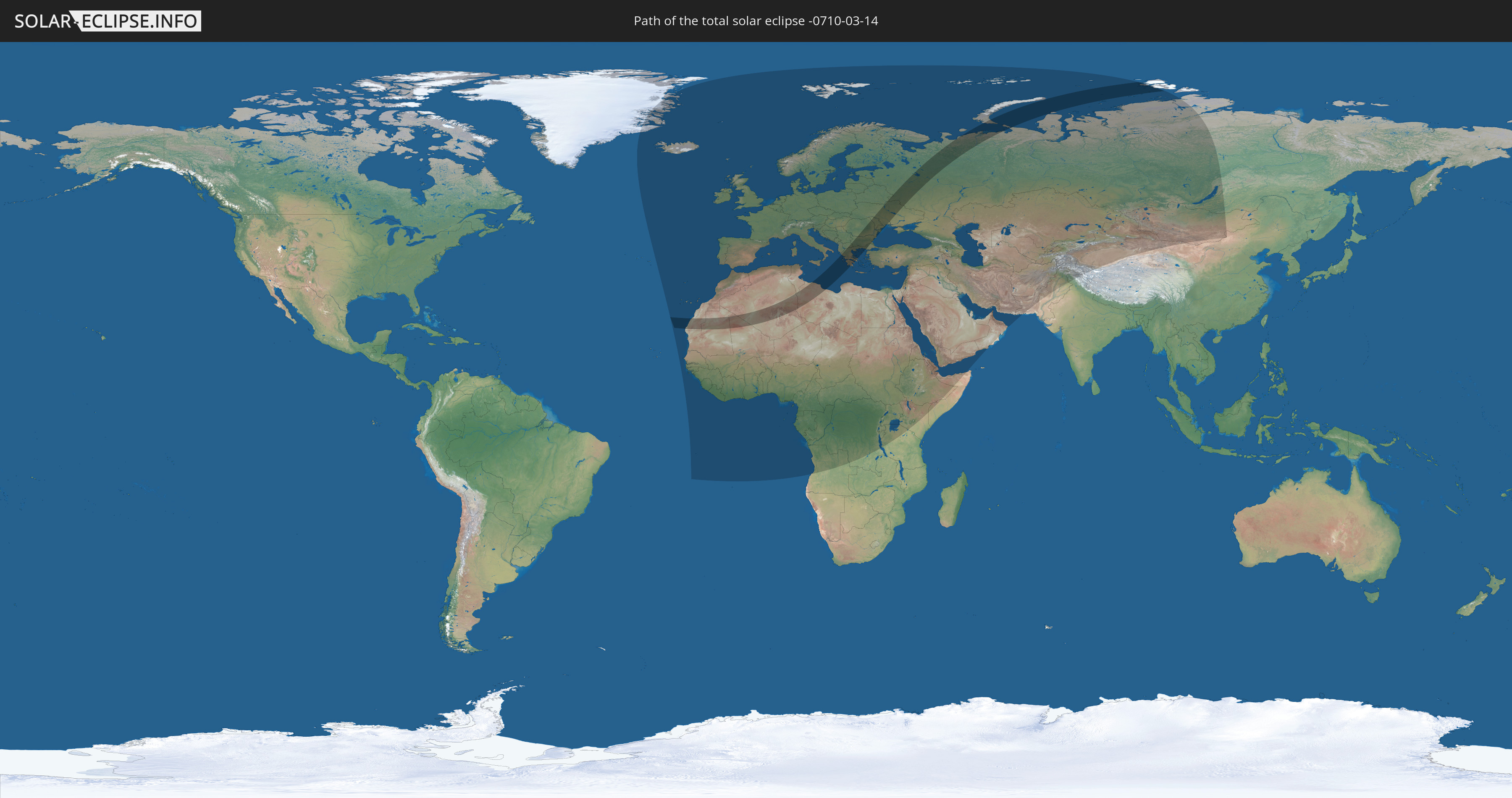
Die Sonnenfinsternis am 03/14/-0710 kann man in 121 Ländern als partielle Sonnenfinsternis beobachten.
Der Finsternispfad verläuft durch 14 Länder. Nur in diesen Ländern ist sie als total Sonnenfinsternis zu sehen.
In den folgenden Ländern ist die Sonnenfinsternis total zu sehen
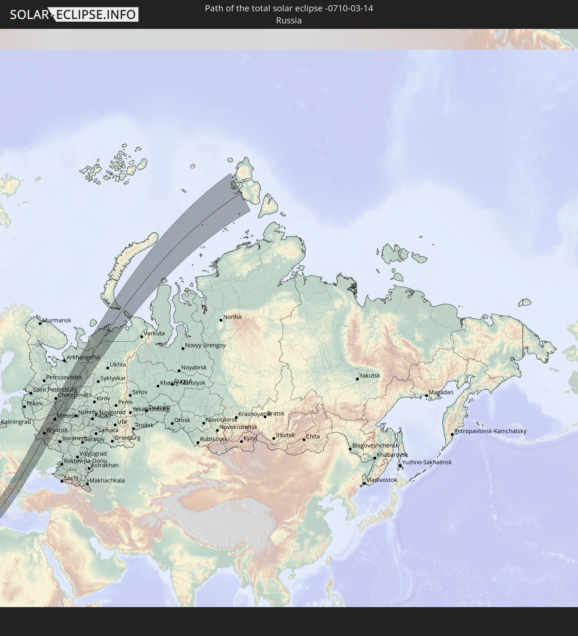 Russia
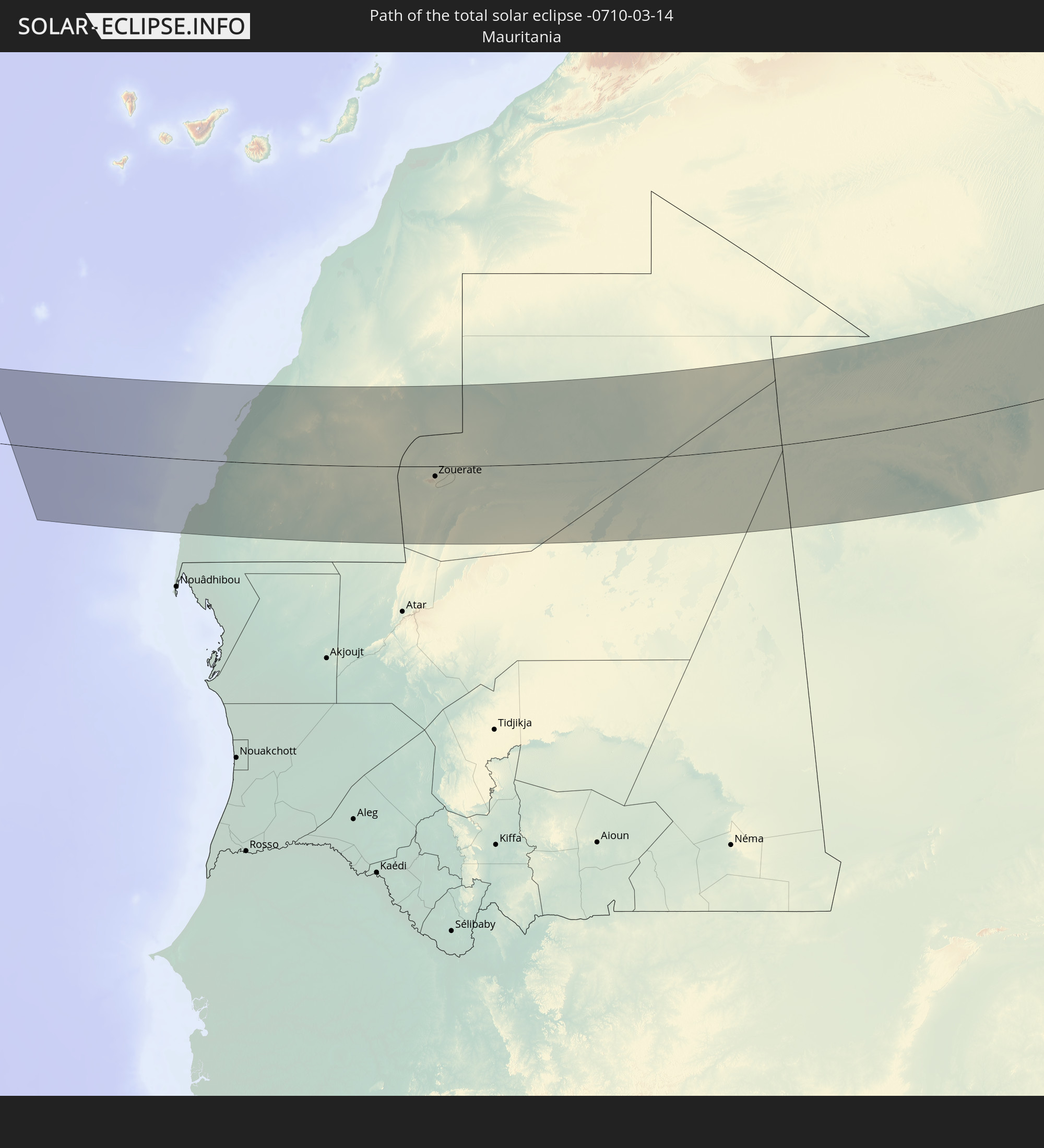 Mauritania
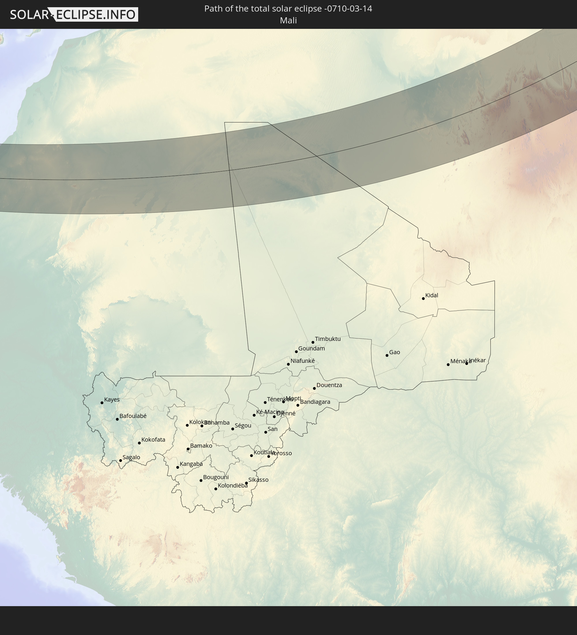 Mali
Mali
 Algeria
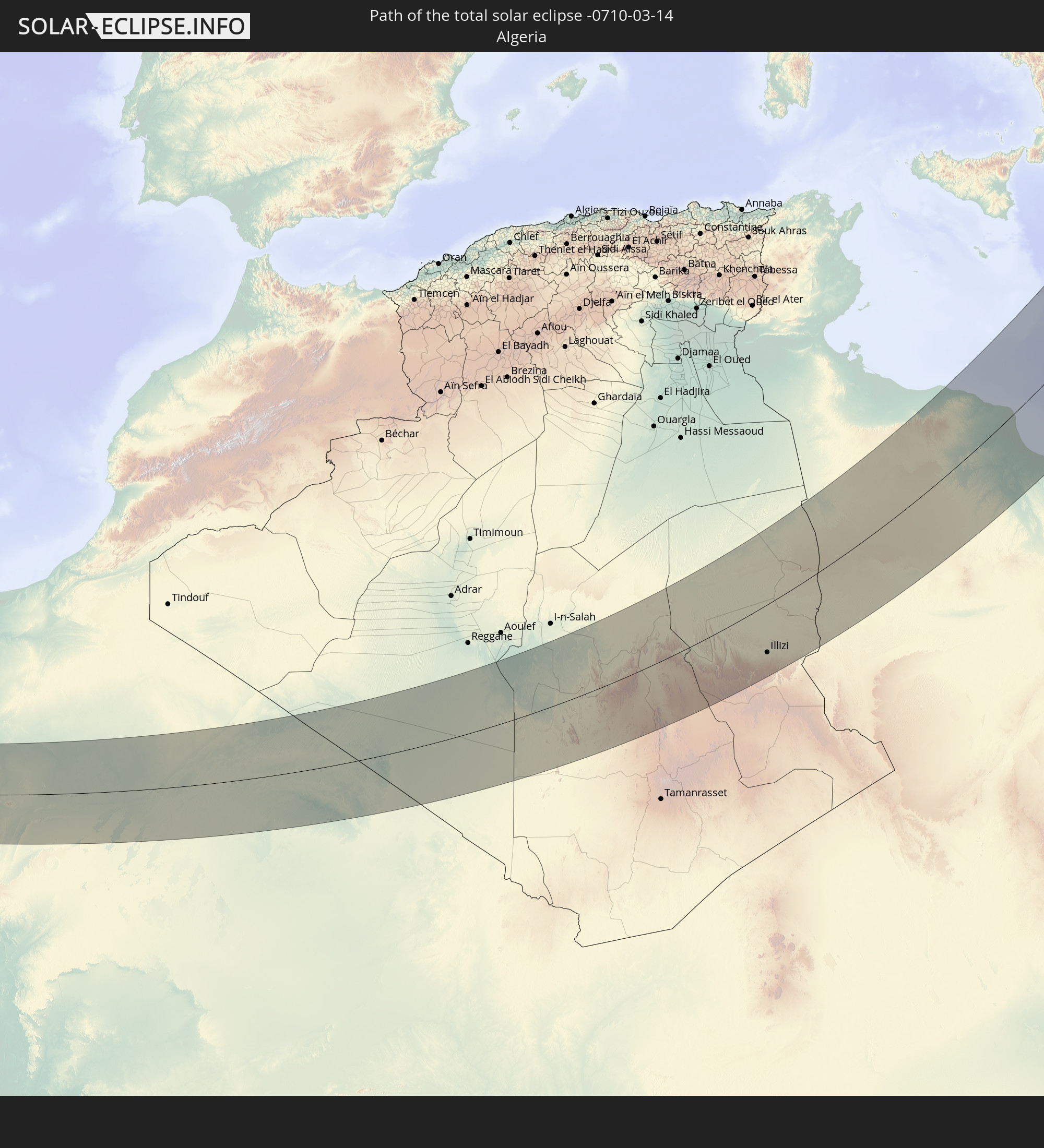
 Tunisia
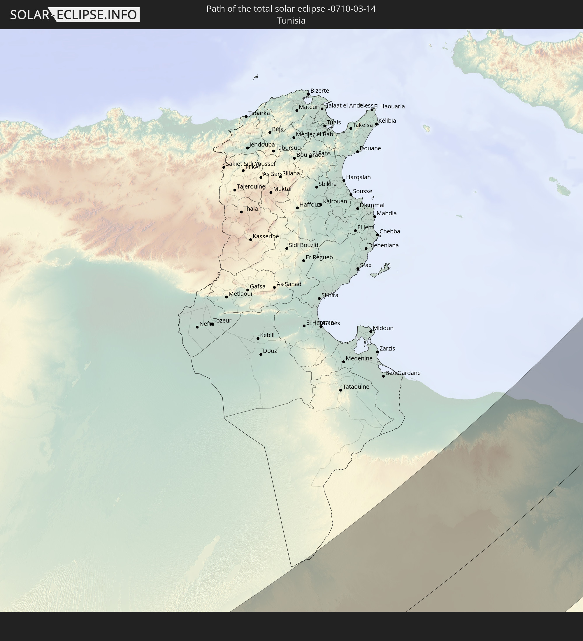
 Libya
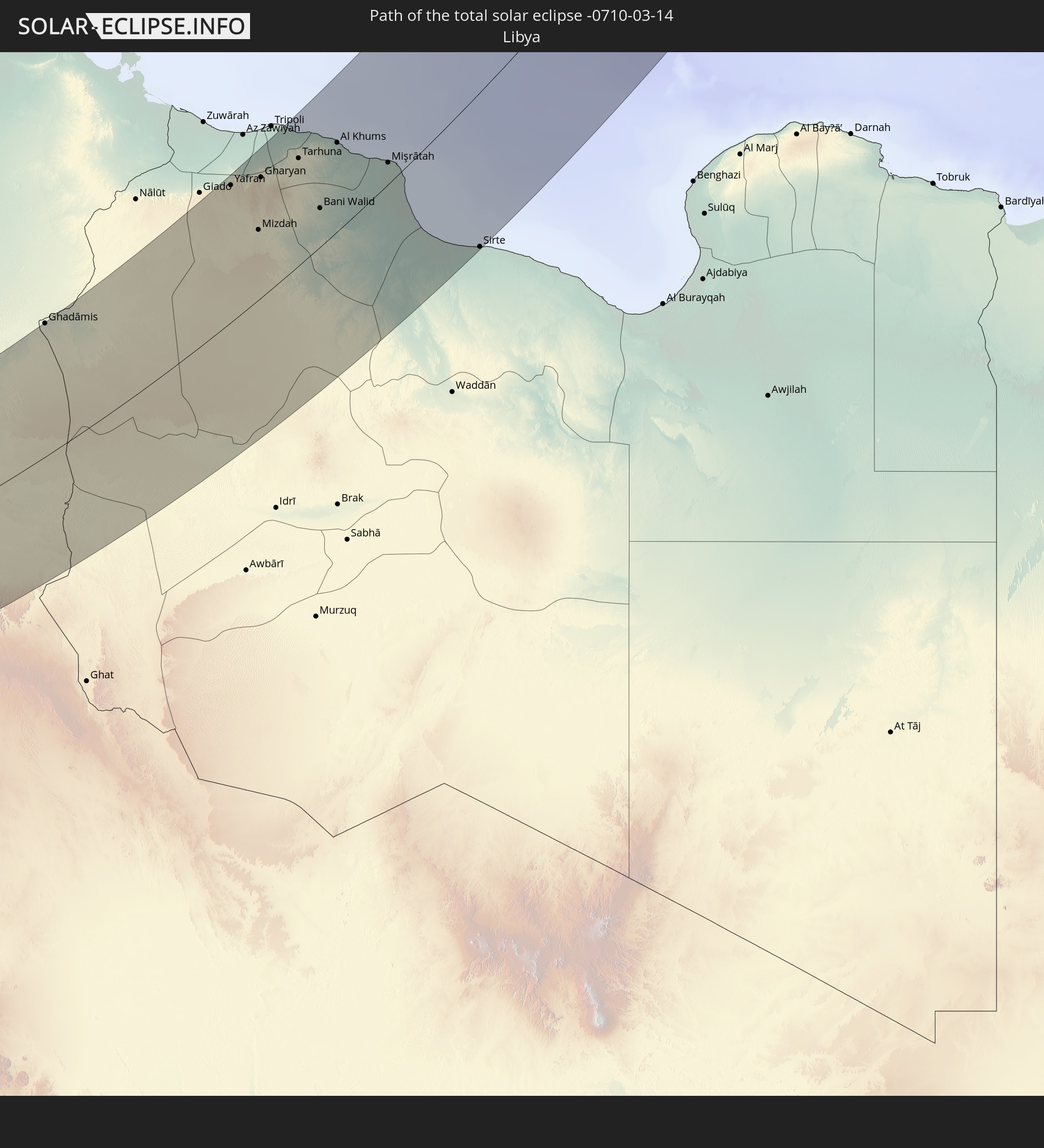
Libya
 Greece
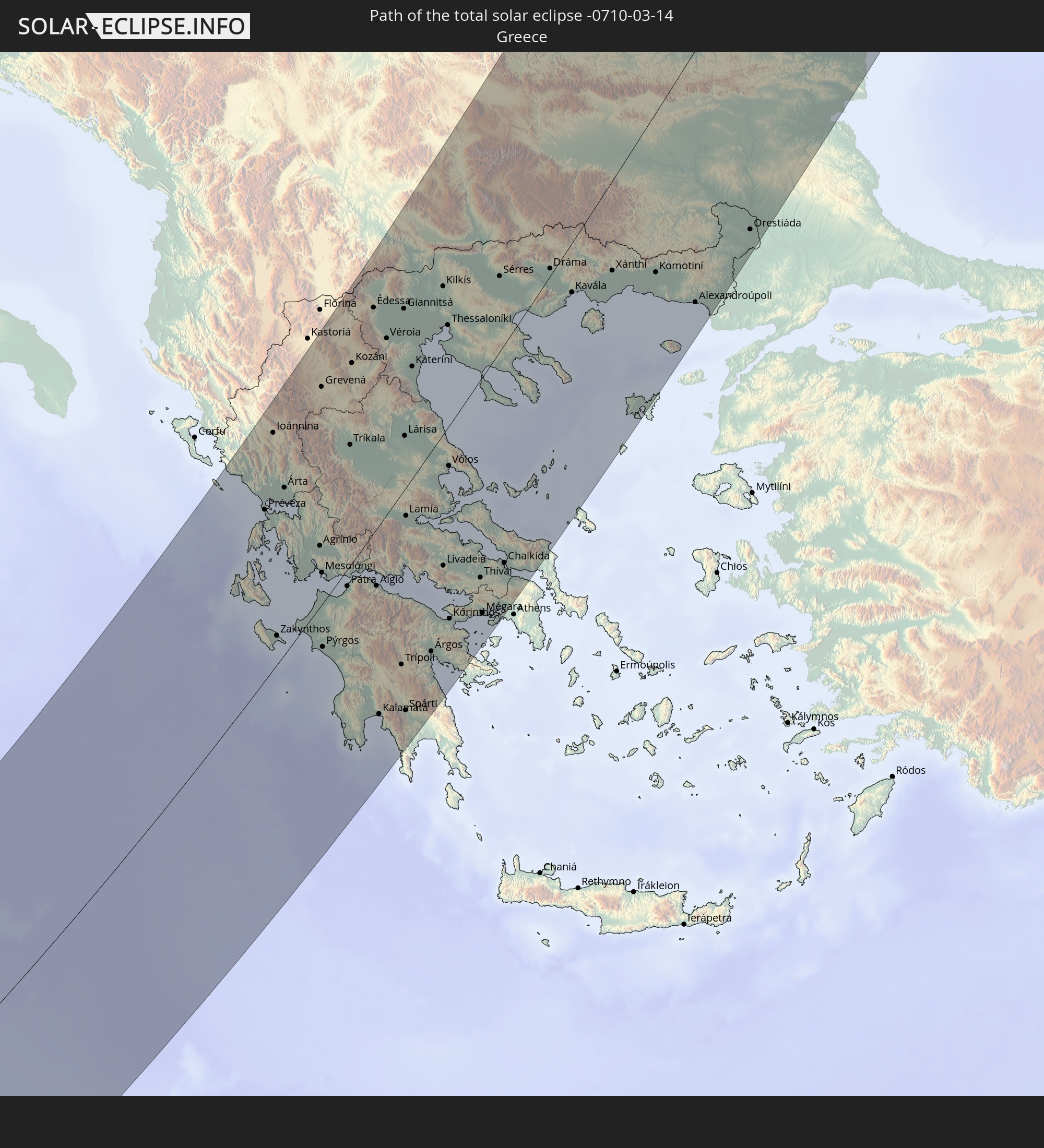
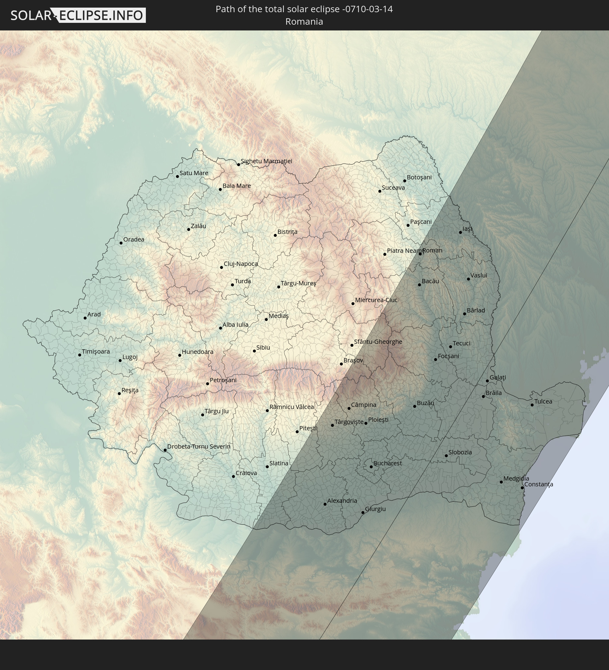 Romania
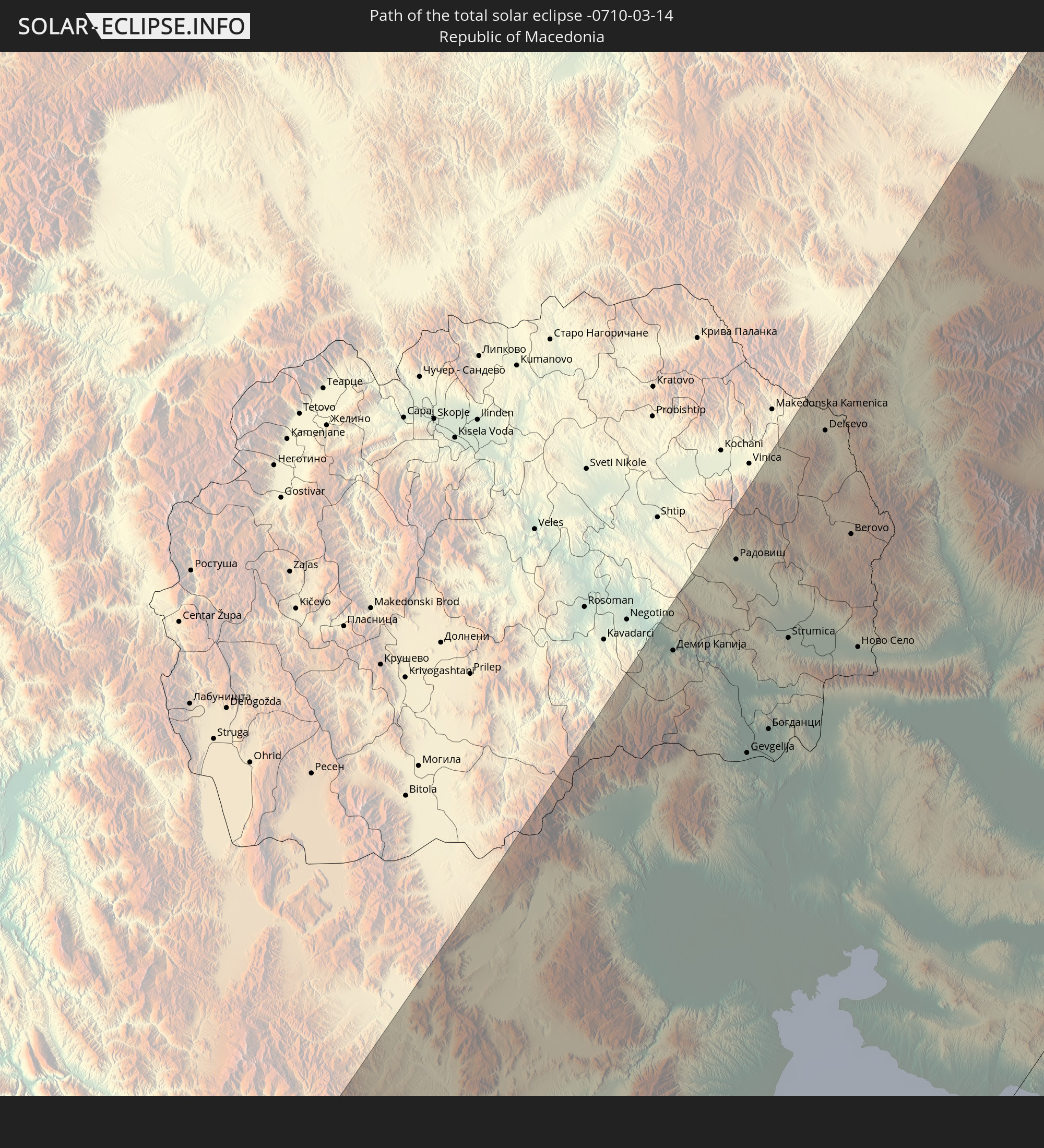 Republic of Macedonia
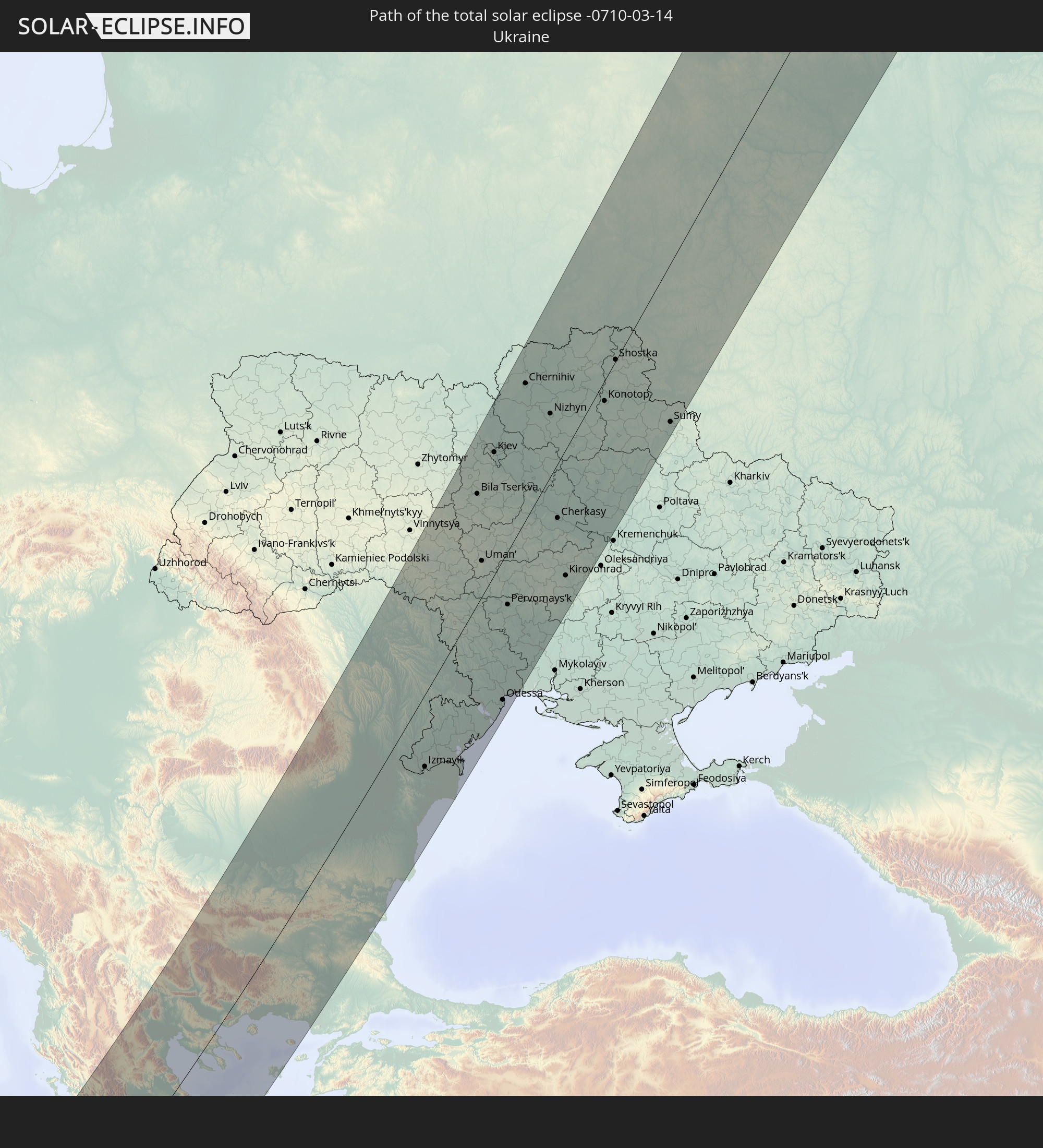 Ukraine
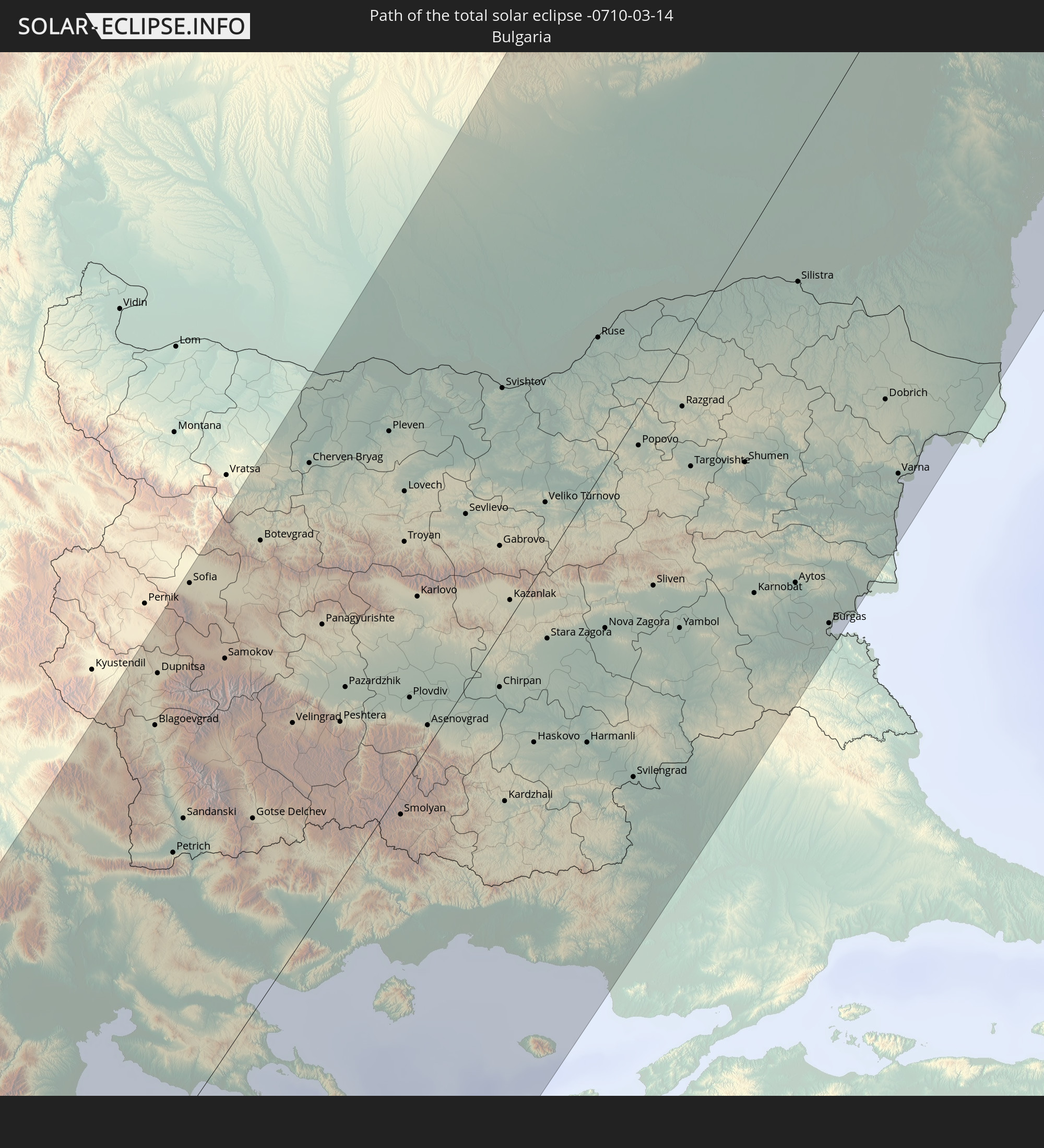 Bulgaria
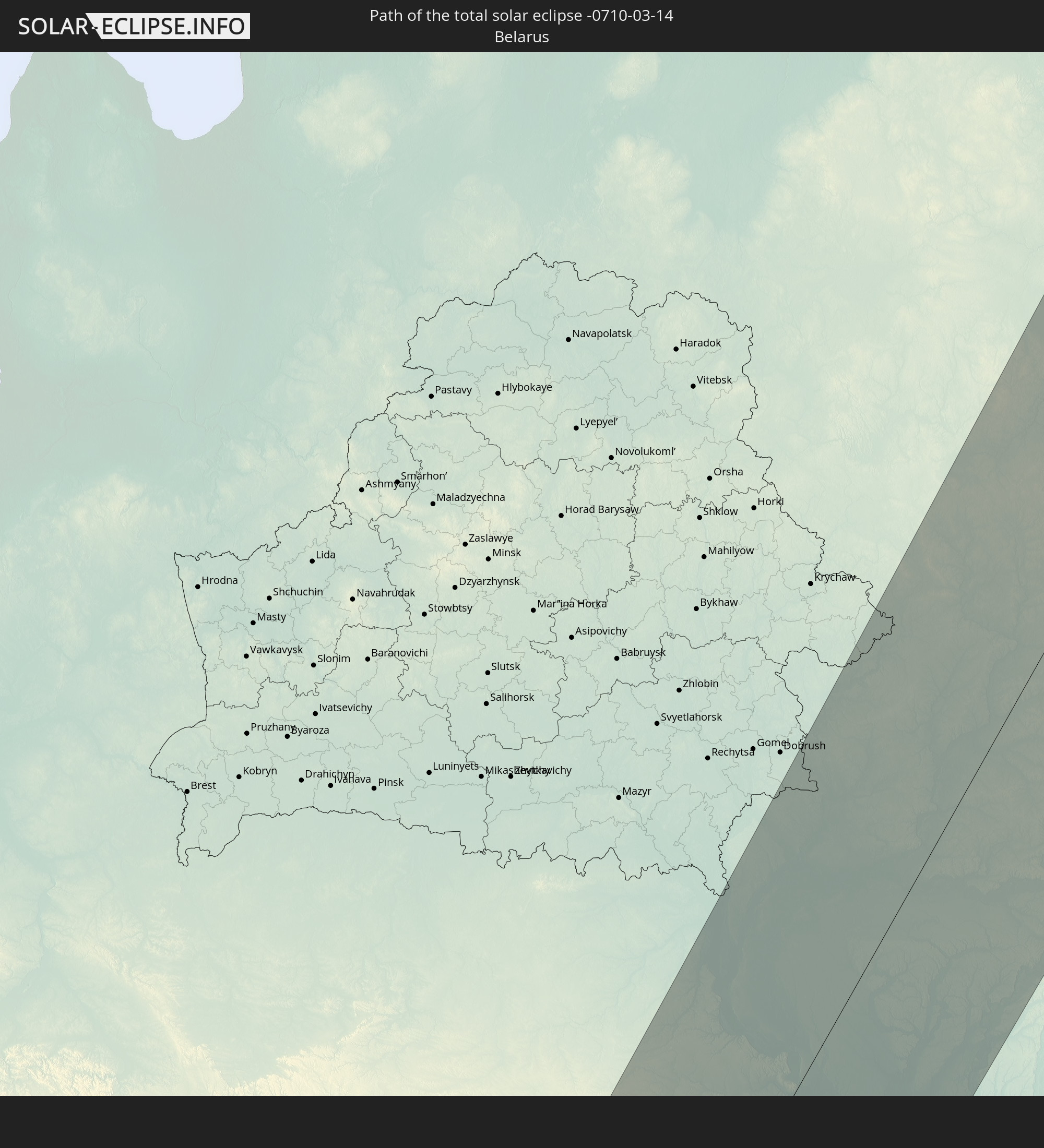 Belarus
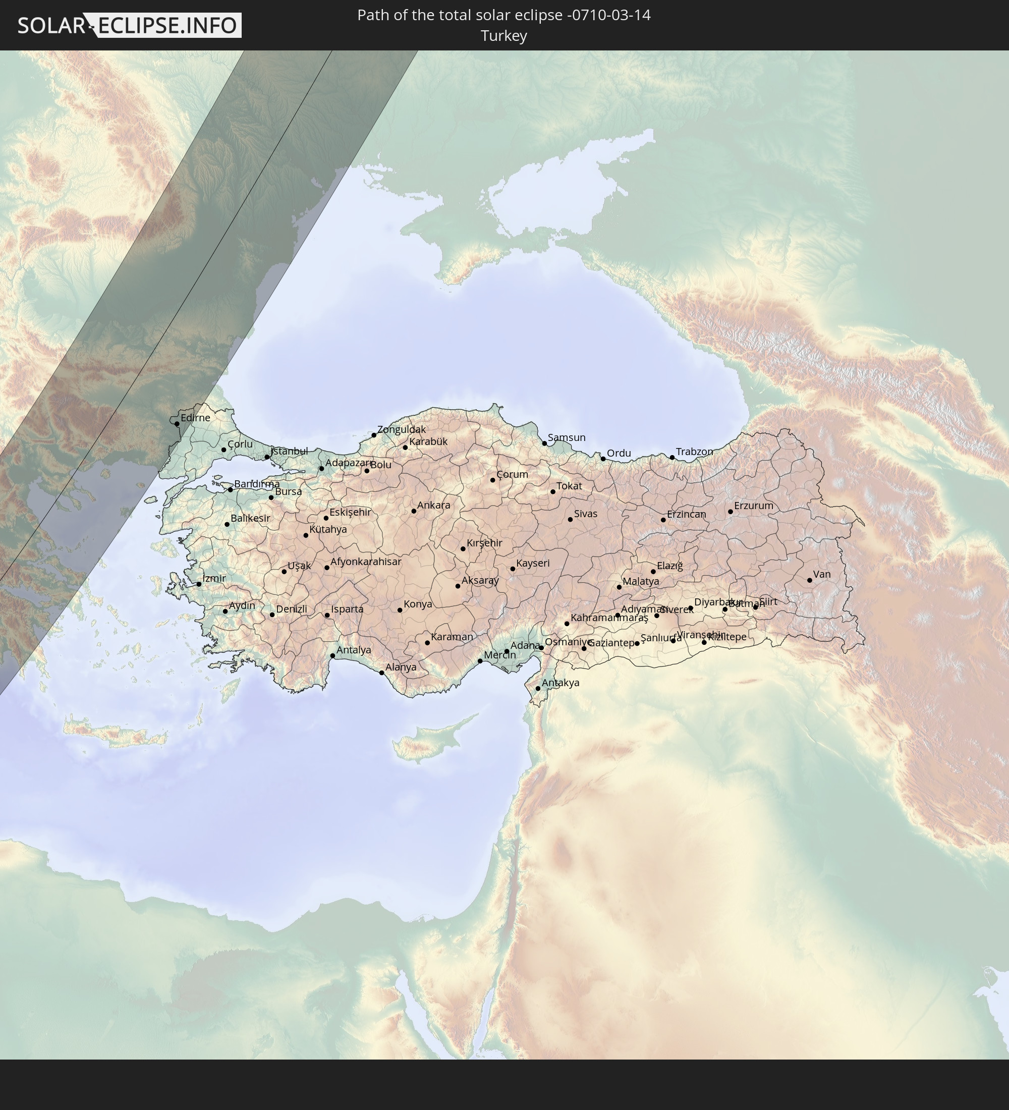 Turkey
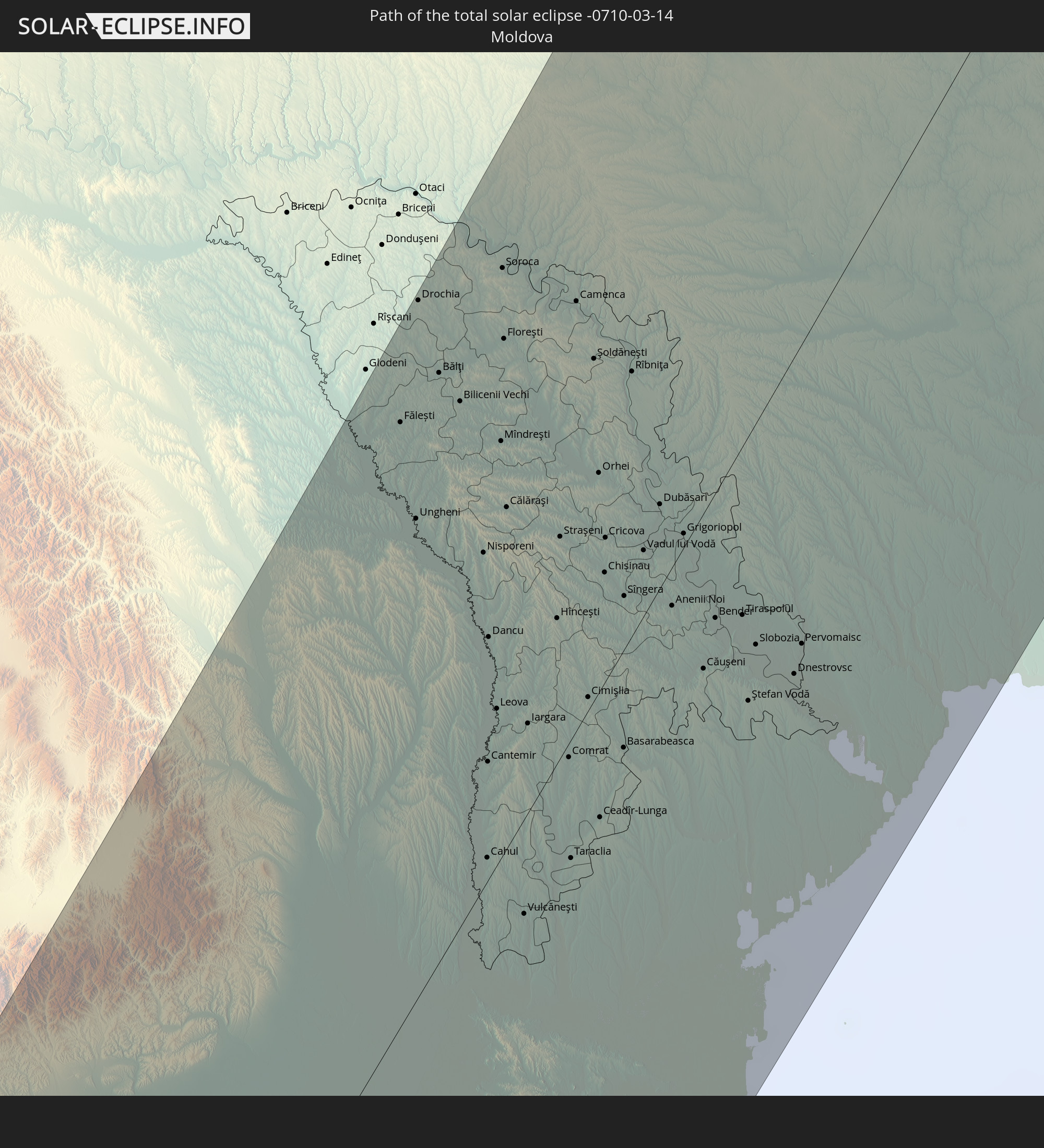 Moldova
In den folgenden Ländern ist die Sonnenfinsternis partiell zu sehen
 Russia
 Greenland
 Portugal
 Iceland
 Spain
Spain
 Senegal
 Mauritania
 The Gambia
 Guinea-Bissau
 Guinea
 Saint Helena, Ascension and Tristan da Cunha
 Sierra Leone
 Morocco
 Mali
Mali
 Liberia
 Republic of Ireland
 Svalbard and Jan Mayen
 Algeria
 United Kingdom
 Ivory Coast
 Faroe Islands
 Burkina Faso
 Gibraltar
 France
 Isle of Man
 Ghana
Ghana
 Guernsey
 Jersey
 Togo
Togo
 Niger
Niger
 Benin
Benin
 Andorra
 Belgium
 Nigeria
 Netherlands
 Norway
 Equatorial Guinea
 Luxembourg
 Germany
 Switzerland
 São Tomé and Príncipe
 Italy
Italy
 Monaco
 Tunisia
 Denmark
 Cameroon
 Gabon
Gabon
 Libya
Libya
 Liechtenstein
 Austria
 Sweden
 Republic of the Congo
 Angola
 Czechia
 Democratic Republic of the Congo
 San Marino
 Vatican City
 Slovenia
 Chad
Chad
 Croatia
 Poland
 Malta
Malta
 Central African Republic
 Bosnia and Herzegovina
 Hungary
 Slovakia
 Montenegro
 Serbia
 Albania
 Åland Islands
 Greece
 Romania
 Republic of Macedonia
 Finland
 Lithuania
 Latvia
 Estonia
 Sudan
Sudan
 Ukraine
 Bulgaria
 Belarus
 Egypt
Egypt
 Turkey
 Moldova
 Rwanda
 Burundi
 Tanzania
 Uganda
 Cyprus
 Ethiopia
 Kenya
Kenya
 State of Palestine
 Israel
 Saudi Arabia
 Jordan
 Lebanon
 Syria
Syria
 Eritrea
 Iraq
Iraq
 Georgia
 Somalia
 Djibouti
 Yemen
Yemen
 Armenia
 Iran
Iran
 Azerbaijan
 Kazakhstan
 Kuwait
 Bahrain
 Qatar
Qatar
 United Arab Emirates
 Oman
Oman
 Turkmenistan
 Uzbekistan
 Afghanistan
 Pakistan
 Tajikistan
 India
India
 Kyrgyzstan
 China
China
 Mongolia
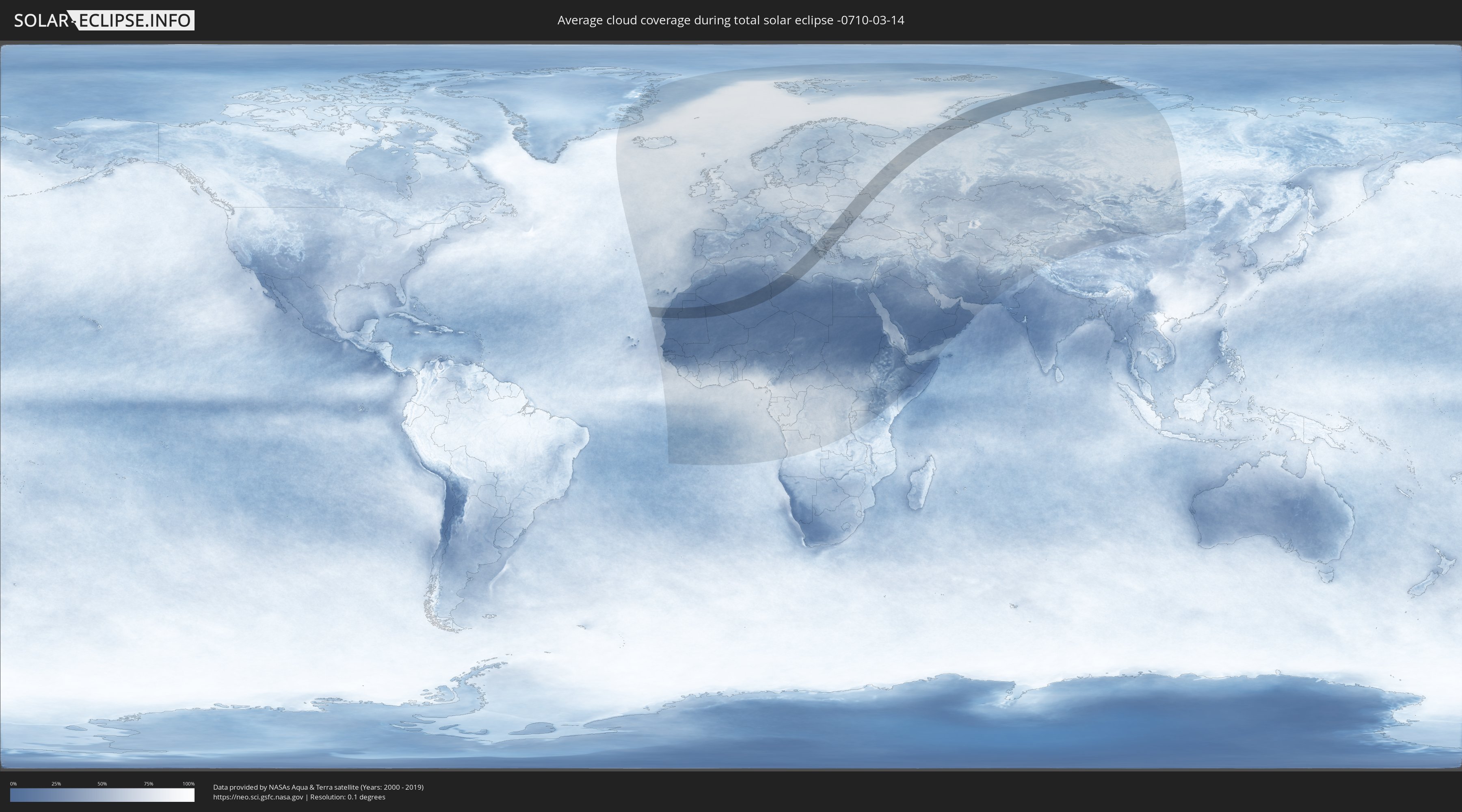
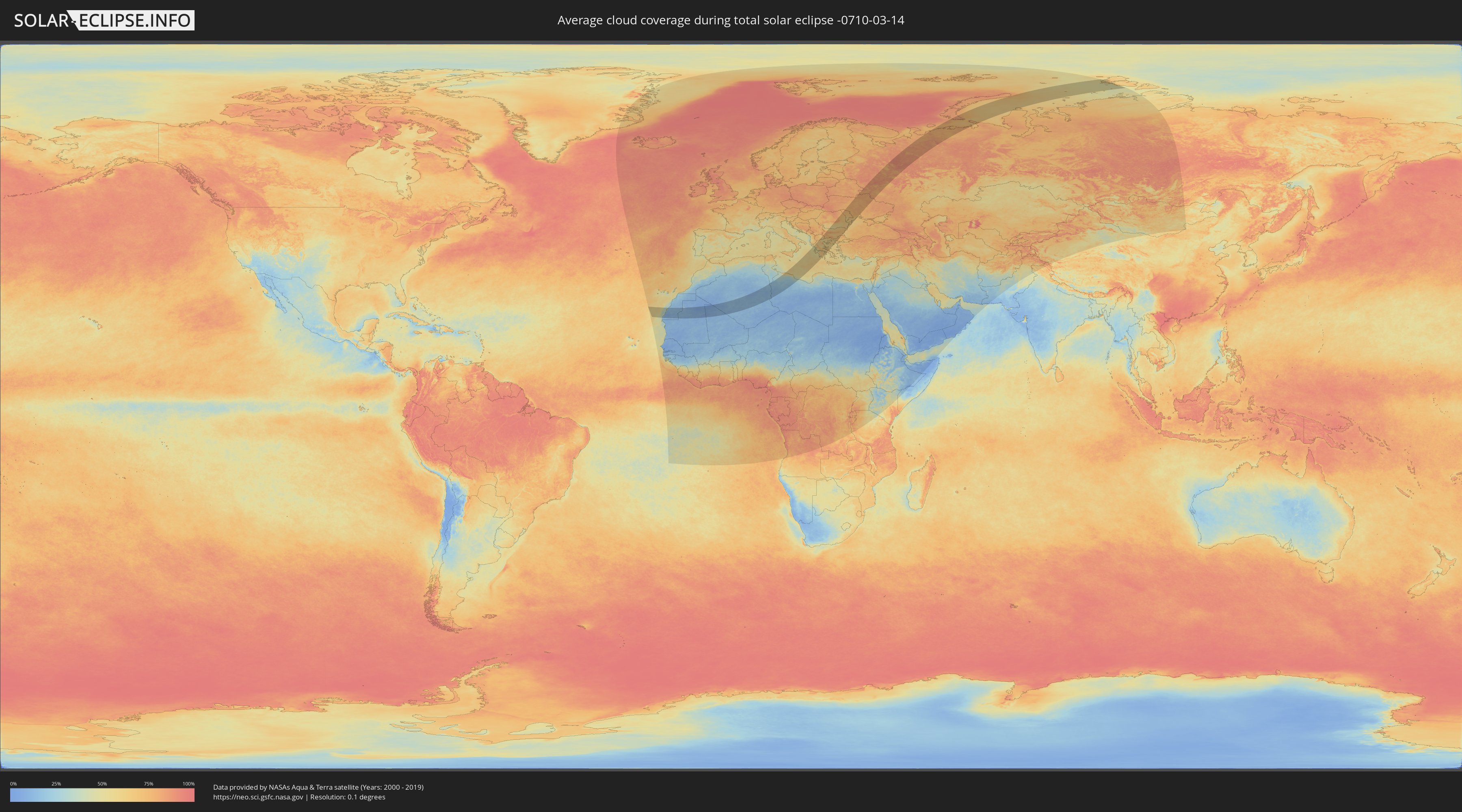
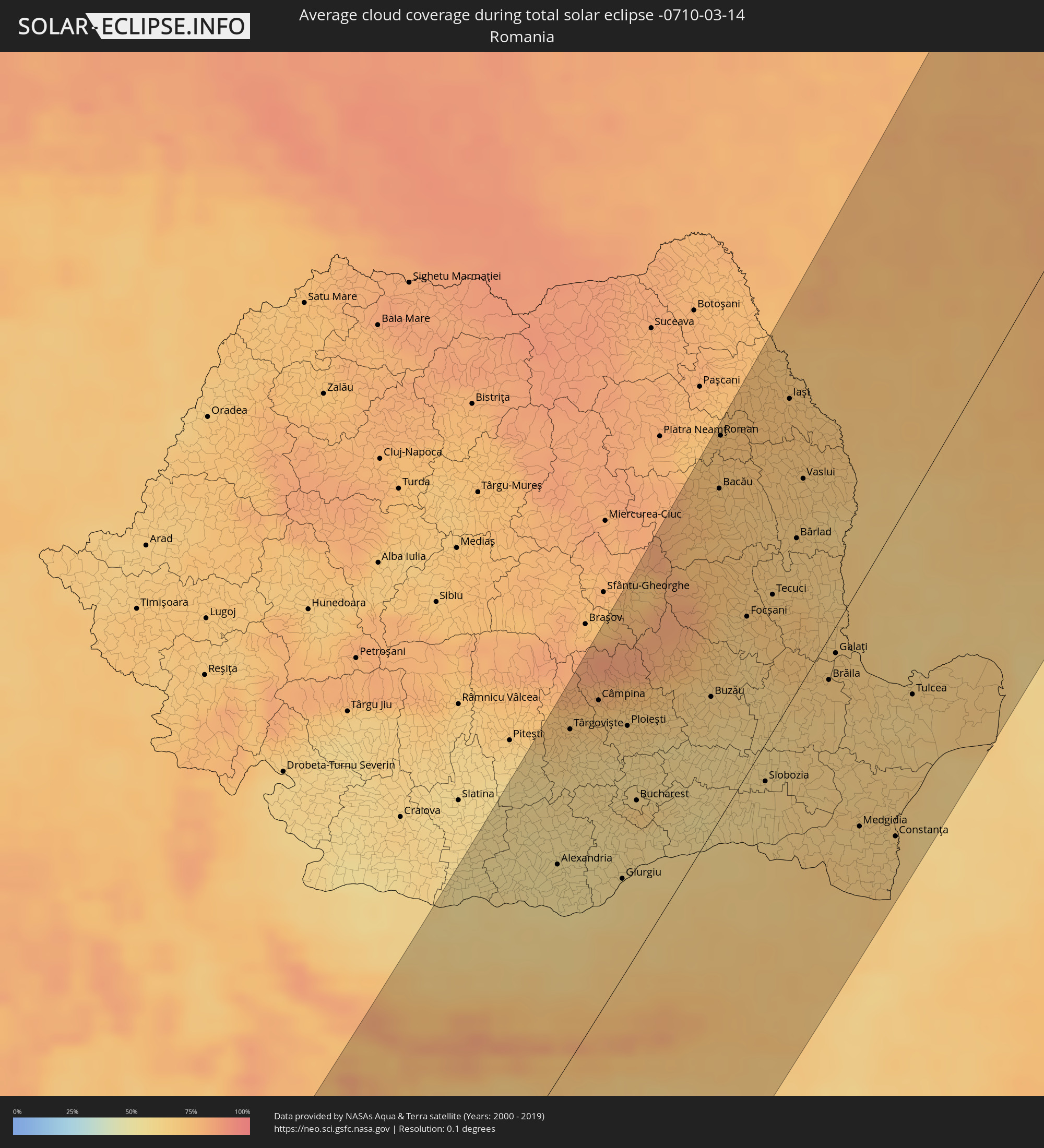
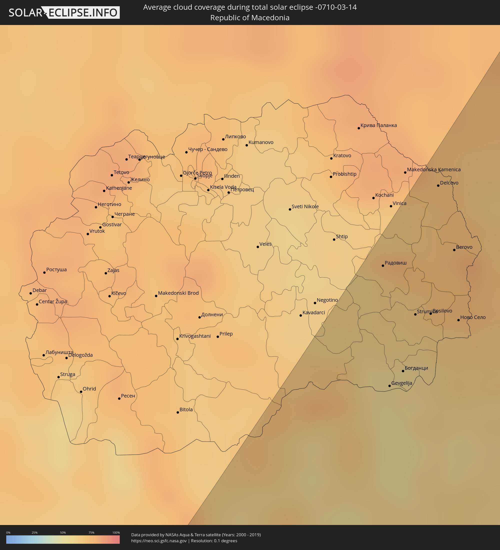
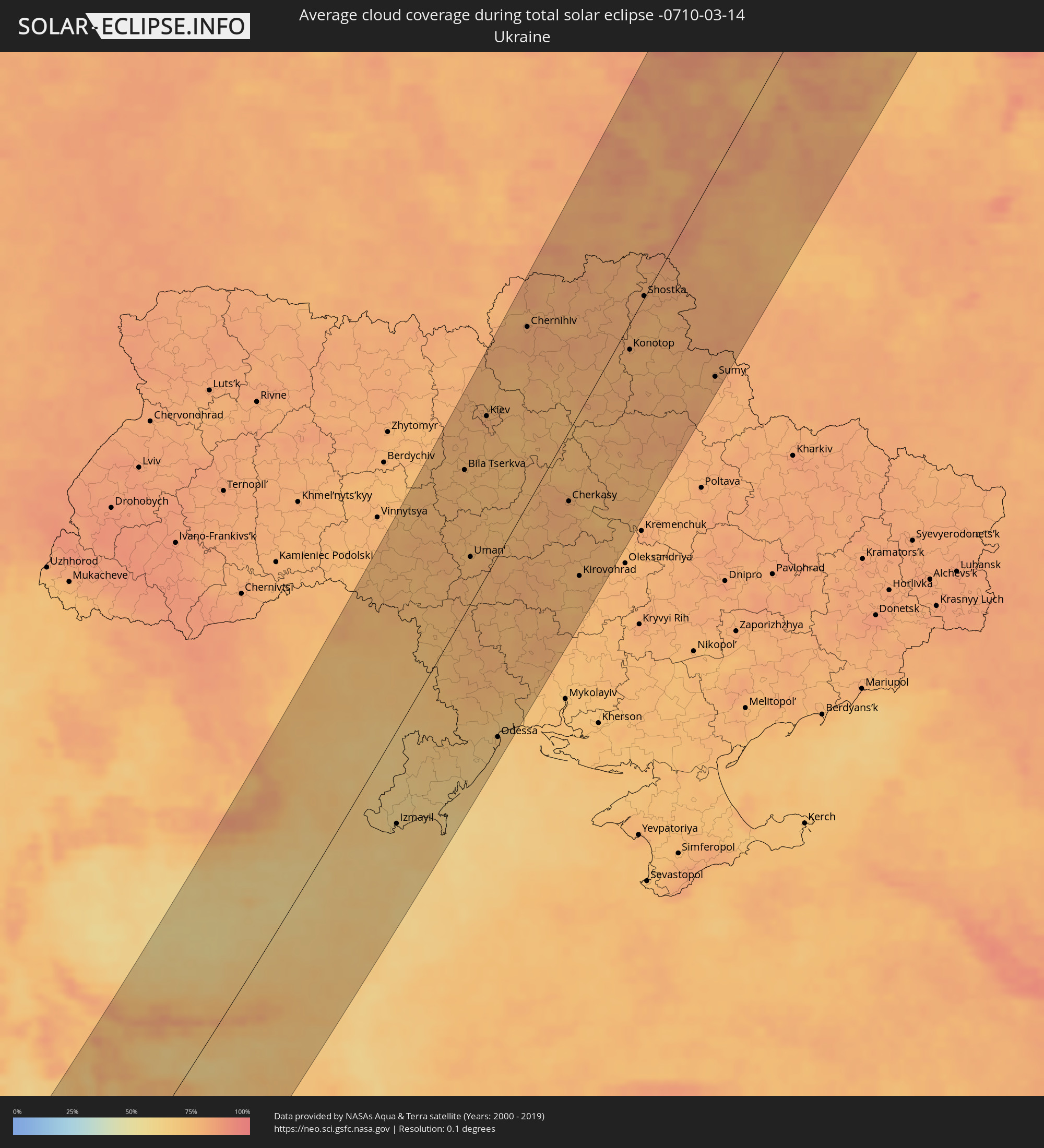
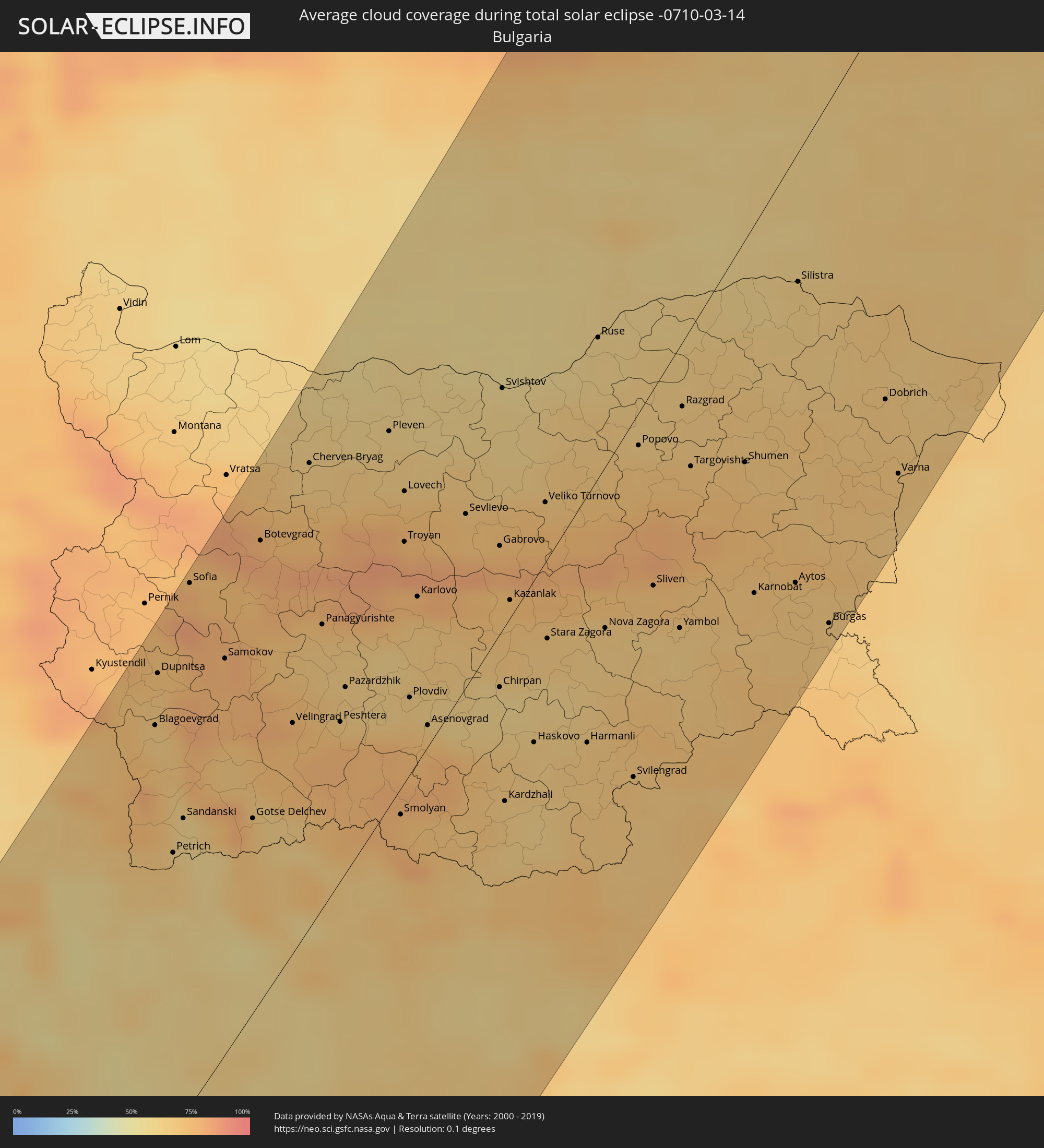
How will be the weather during the total solar eclipse on 03/14/-0710?
Where is the best place to see the total solar eclipse of 03/14/-0710?
The following maps show the average cloud coverage for the day of the total solar eclipse.
With the help of these maps, it is possible to find the place along the eclipse path, which has the best
chance of a cloudless sky.
Nevertheless, you should consider local circumstances and inform about the weather of your chosen
observation site.
The data is provided by NASAs satellites
AQUA and TERRA.
The cloud maps are averaged over a period of 19 years (2000 - 2019).
Detailed country maps
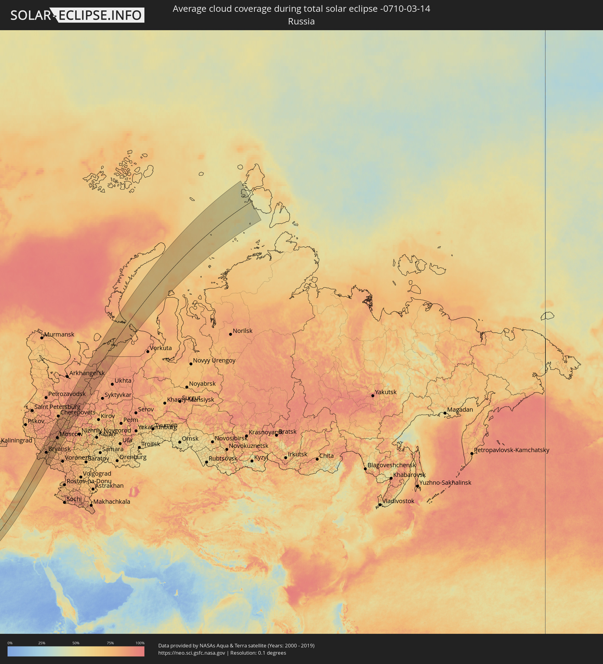 Russia
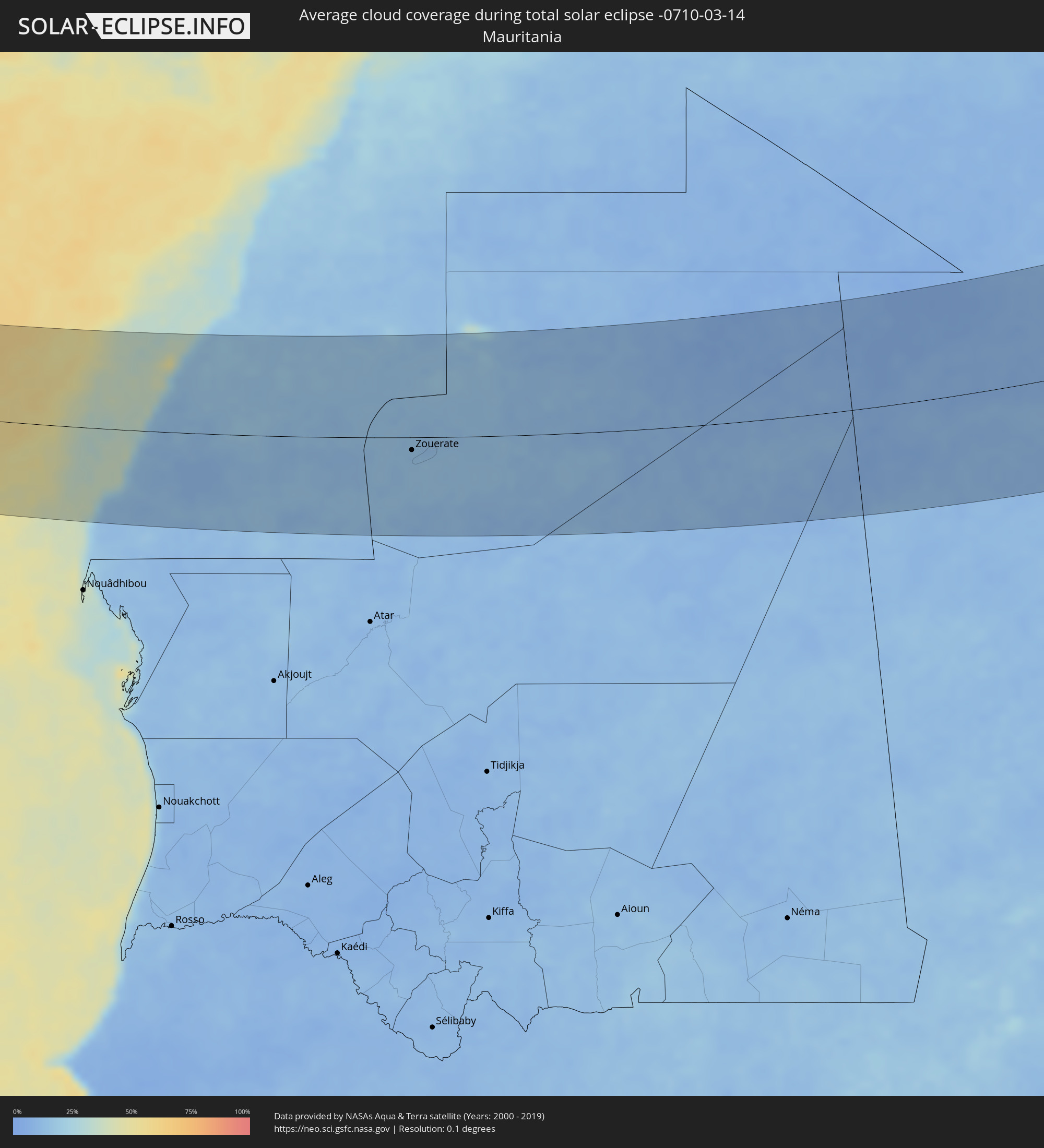 Mauritania
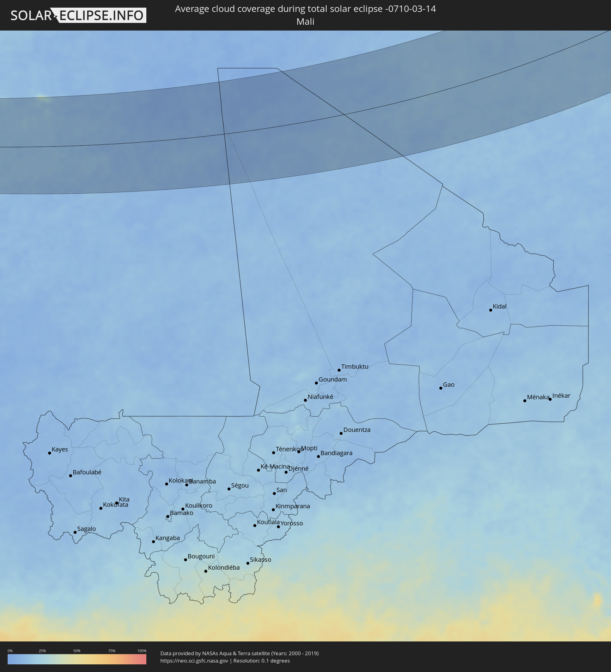 Mali
Mali
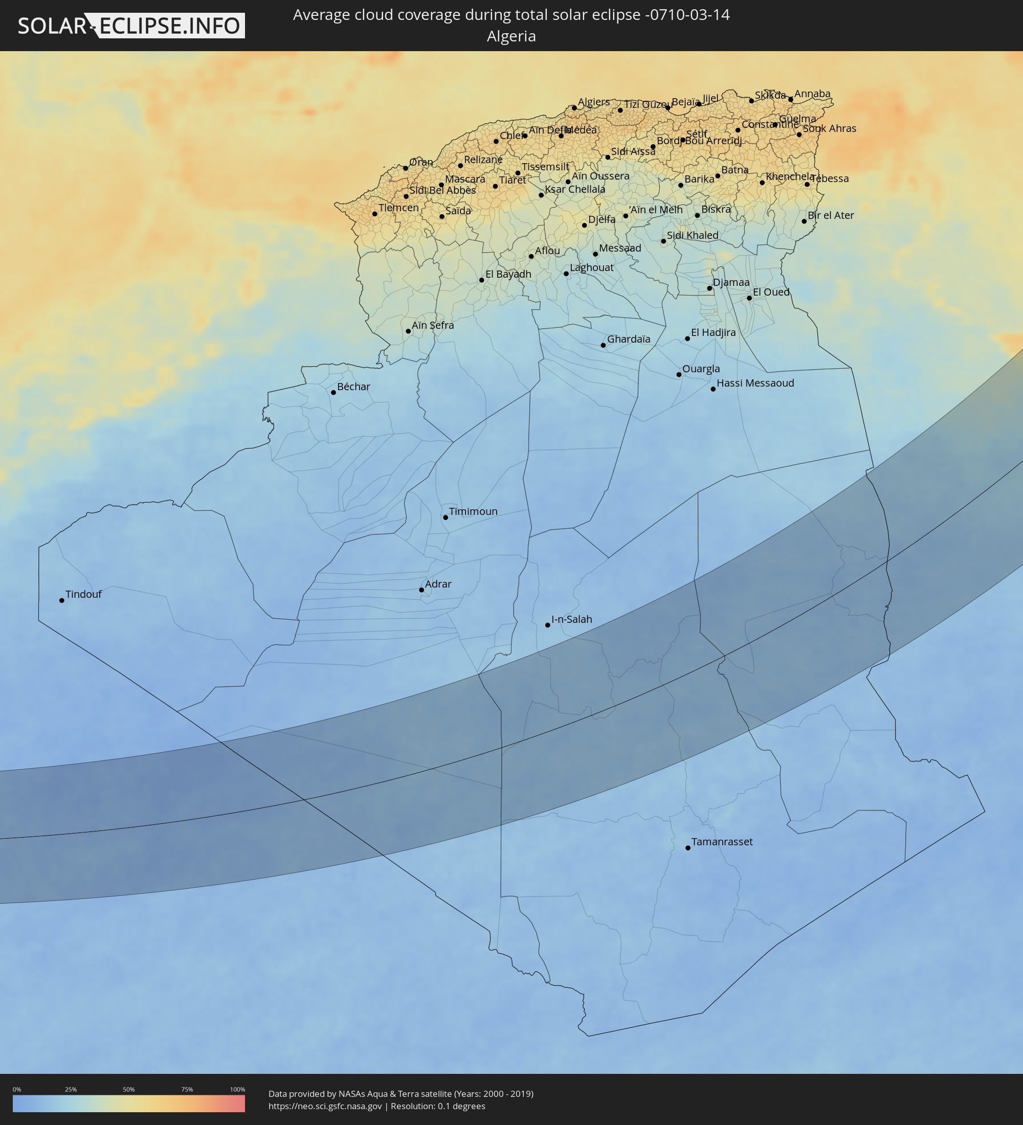 Algeria
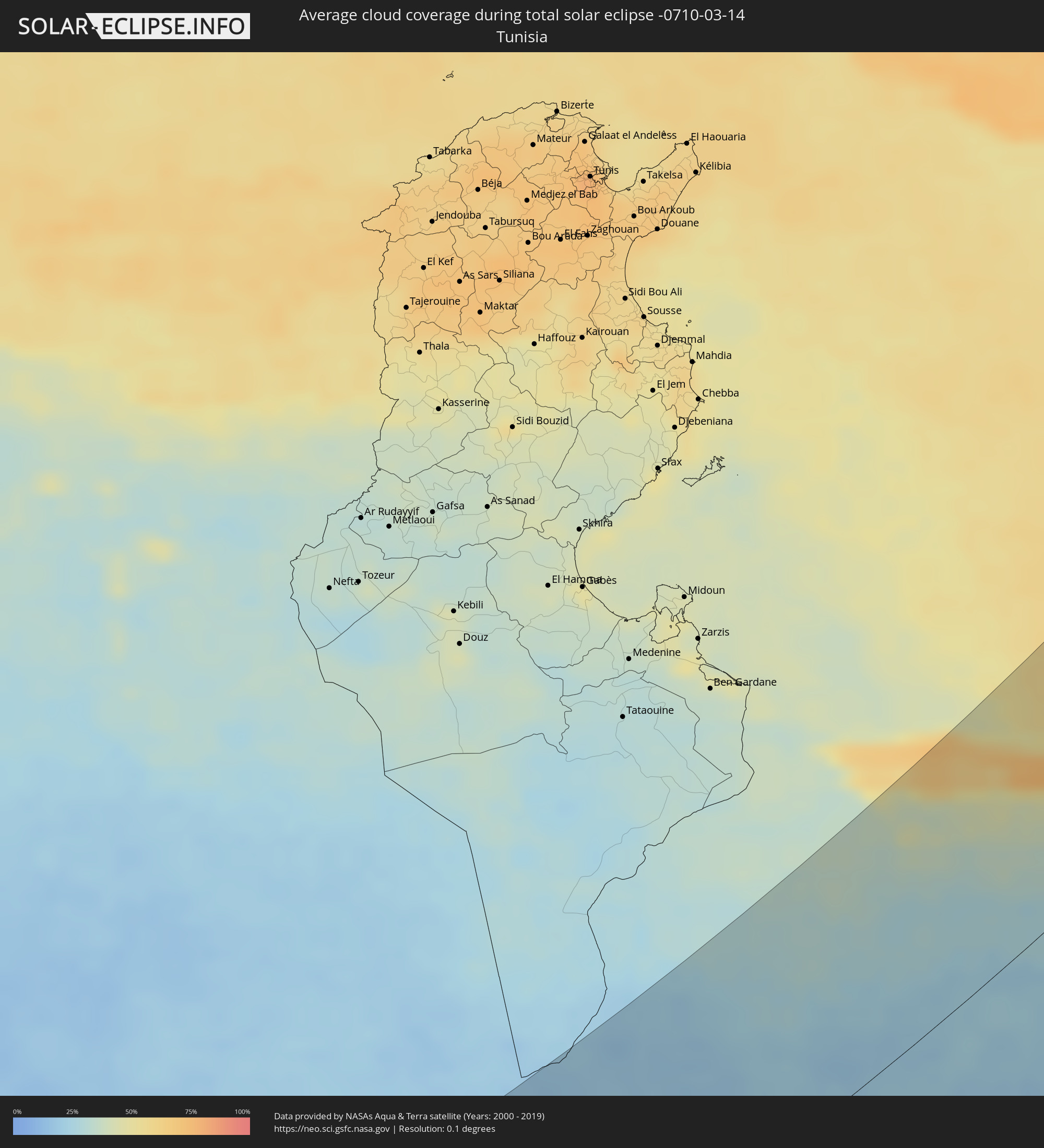 Tunisia
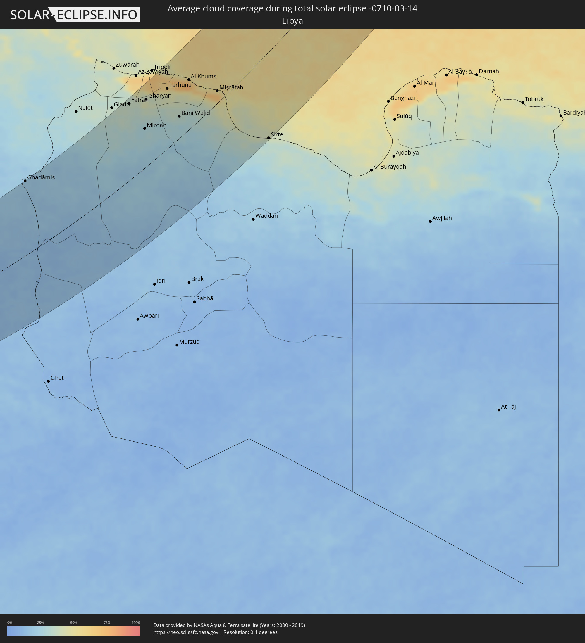 Libya
Libya
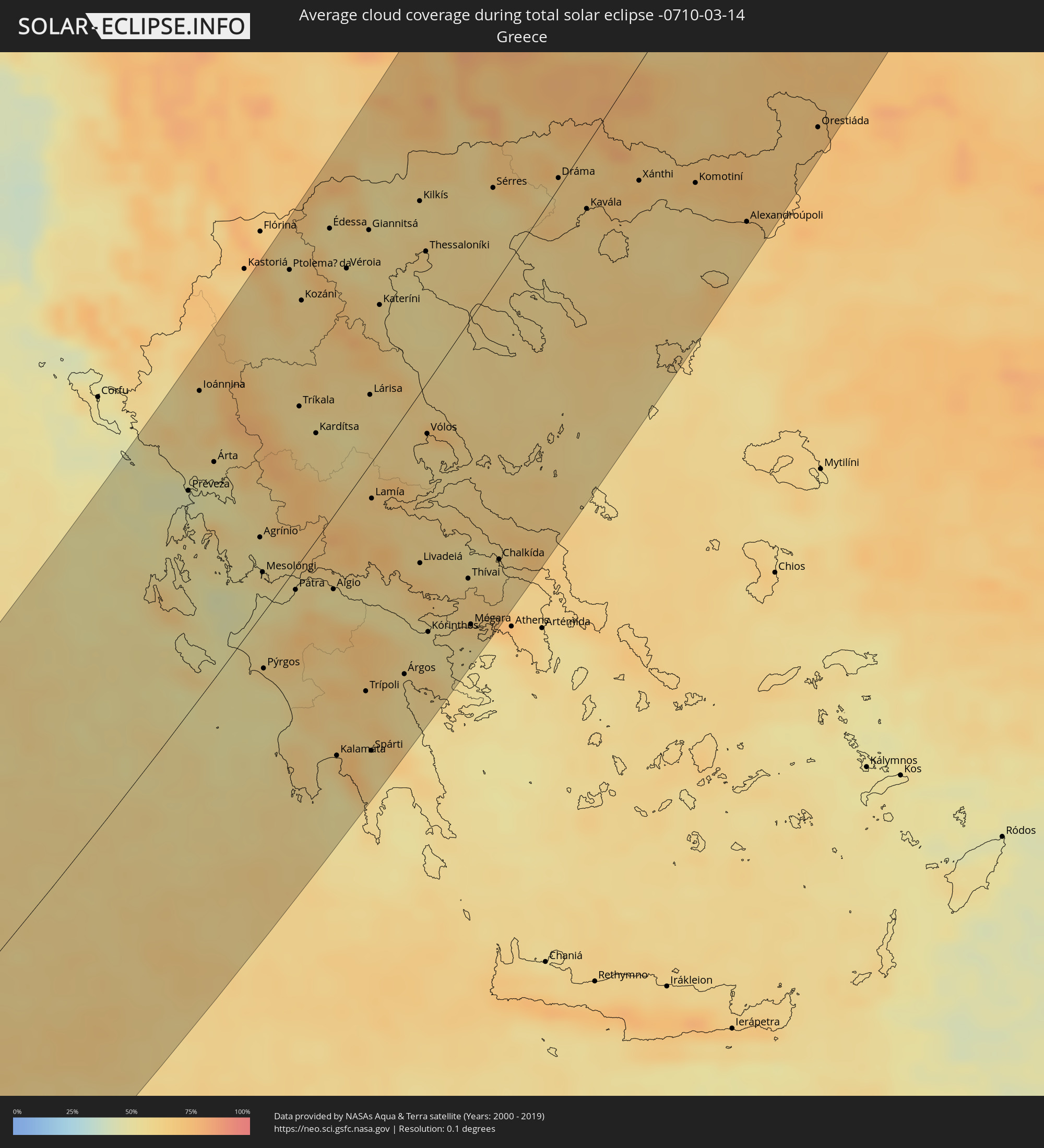 Greece
 Romania
 Republic of Macedonia
 Ukraine
 Bulgaria
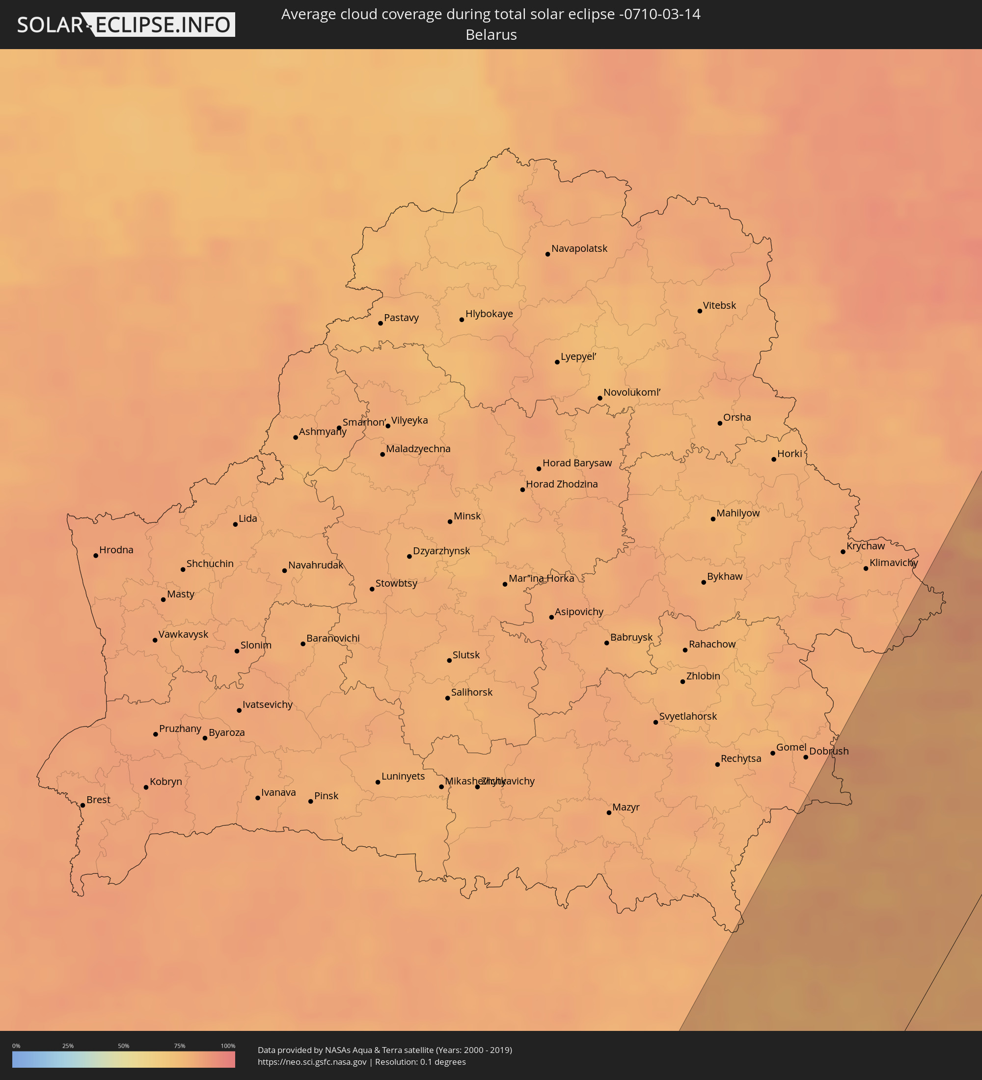 Belarus
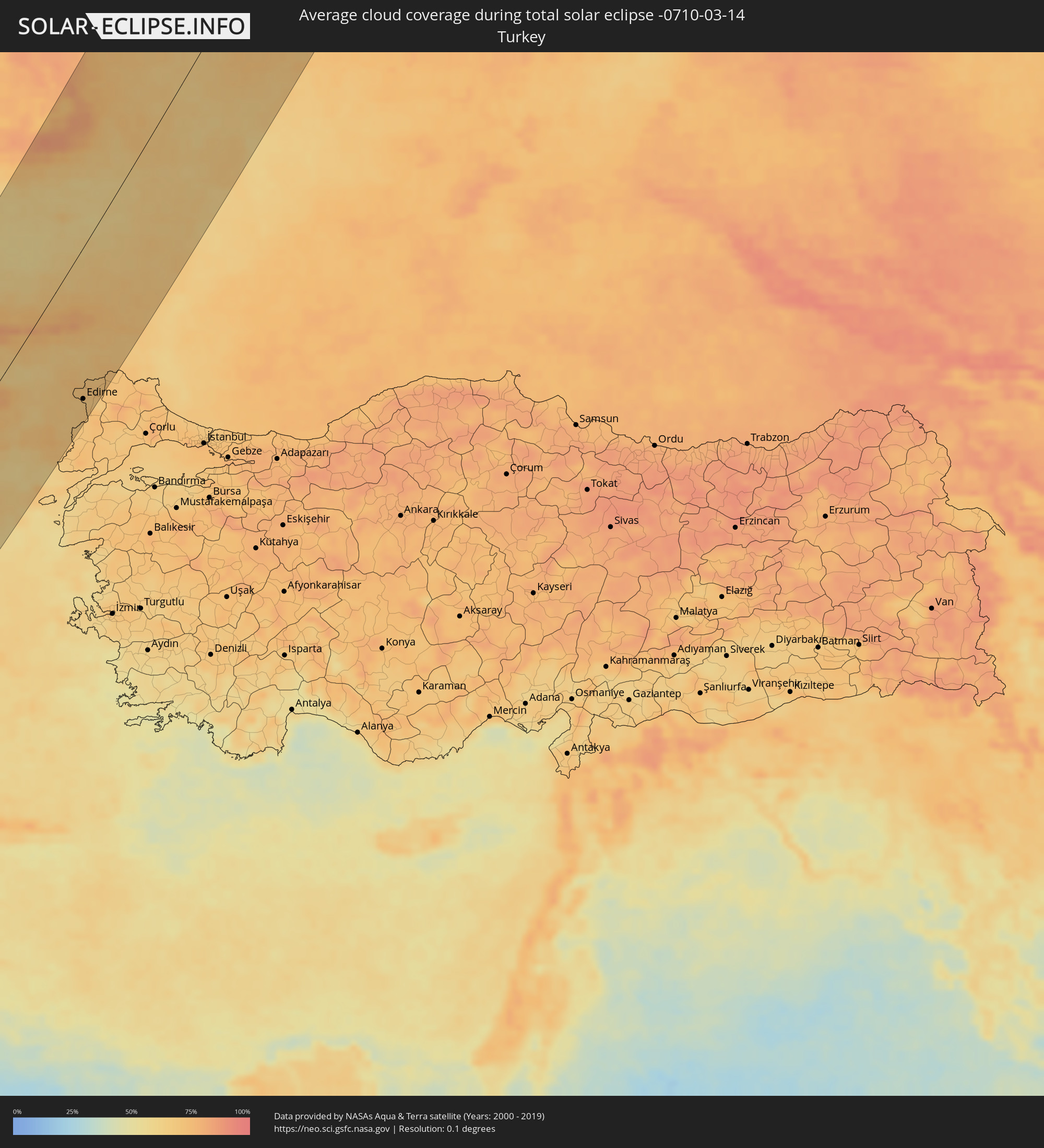 Turkey
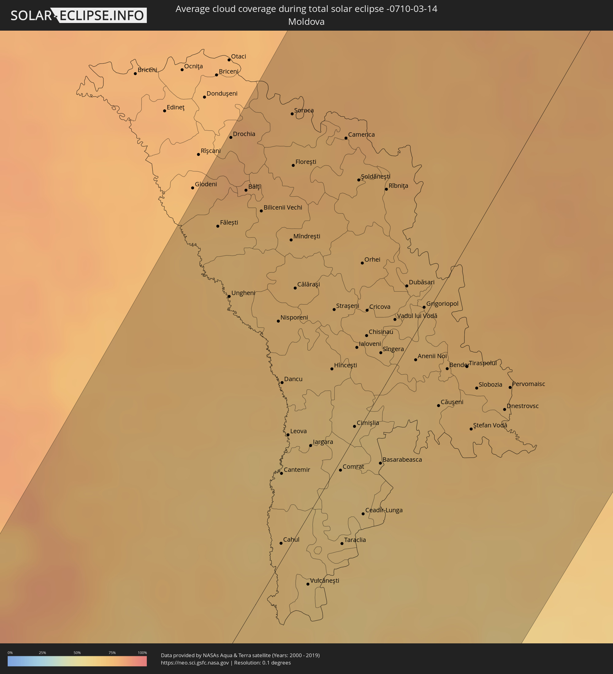 Moldova
Cities inside the path of the eclipse
The following table shows all locations with a population of more than 5,000 inside the eclipse path. Cities which have more than 100,000 inhabitants are marked bold. A click at the locations opens a detailed map.
| City | Type | Eclipse duration | Local time of max. eclipse | Distance to central line | Ø Cloud coverage |
 Dakhla, Oued Ed-Dahab-Lagouira
|
total | - | 06:51:50 UTC-00:52 | 80 km | 40% |
|
Zouerate, Tiris Zemmour
|
total | - | 07:28:12 UTC-00:16 | 18 km | 13% |
|
Illizi, Illizi
|
total | - | 08:15:22 UTC+00:09 | 114 km | 14% |
|
Ghadāmis, Sha‘bīyat Nālūt
|
total | - | 09:06:36 UTC+00:52 | 175 km | 19% |
|
Zintan, Jabal al Gharbi District
|
total | - | 09:13:09 UTC+00:52 | 169 km | 34% |
|
Yafran, Jabal al Gharbi District
|
total | - | 09:13:44 UTC+00:52 | 163 km | 36% |
|
Mizdah, Jabal al Gharbi District
|
total | - | 09:13:09 UTC+00:52 | 83 km | 28% |
|
Al ‘Azīzīyah, Sha‘bīyat al Jafārah
|
total | - | 09:15:12 UTC+00:52 | 171 km | 49% |
|
Gharyan, Jabal al Gharbi District
|
total | - | 09:14:32 UTC+00:52 | 141 km | 42% |
|
Tarhuna, Al Marqab
|
total | - | 09:15:47 UTC+00:52 | 123 km | 44% |
|
Bani Walid, Mişrātah
|
total | - | 09:14:57 UTC+00:52 | 44 km | 30% |
|
Masallātah, Al Marqab
|
total | - | 09:16:35 UTC+00:52 | 114 km | 72% |
|
Al Khums, Al Marqab
|
total | - | 09:16:58 UTC+00:52 | 100 km | 70% |
|
Zliten, Mişrātah
|
total | - | 09:17:01 UTC+00:52 | 65 km | 60% |
|
Mişrātah, Mişrātah
|
total | - | 09:17:31 UTC+00:52 | 24 km | 69% |
|
Sirte, Surt
|
total | - | 09:17:18 UTC+00:52 | 168 km | 33% |
|
Ioánnina, Epirus
|
total | - | 10:20:09 UTC+01:34 | 144 km | 60% |
|
Agrínio, West Greece
|
total | - | 10:19:07 UTC+01:34 | 37 km | 52% |
|
Pátra, West Greece
|
total | - | 10:18:54 UTC+01:34 | 10 km | 54% |
|
Tríkala, Thessaly
|
total | - | 10:21:10 UTC+01:34 | 72 km | 57% |
|
Kalamáta, Peloponnese
|
total | - | 10:17:20 UTC+01:34 | 117 km | 54% |
|
Демир Капија, Demir Kapija
|
total | - | 09:50:00 UTC+01:00 | 152 km | 64% |
|
Konče, Konče
|
total | - | 09:50:19 UTC+01:00 | 148 km | 64% |
|
Lárisa, Thessaly
|
total | - | 10:22:10 UTC+01:34 | 31 km | 58% |
|
Lamía, Central Greece
|
total | - | 10:20:57 UTC+01:34 | 17 km | 63% |
|
Радовиш, Radoviš
|
total | - | 09:50:39 UTC+01:00 | 151 km | 66% |
|
Gevgelija, Gevgelija
|
total | - | 09:49:54 UTC+01:00 | 119 km | 54% |
|
Kateríni, Central Macedonia
|
total | - | 10:23:20 UTC+01:34 | 65 km | 63% |
|
Valandovo, Valandovo Municipality
|
total | - | 09:50:16 UTC+01:00 | 125 km | 57% |
|
Богданци, Bogdanci
|
total | - | 09:50:06 UTC+01:00 | 117 km | 57% |
|
Василево, Vasilevo
|
total | - | 09:50:37 UTC+01:00 | 129 km | 64% |
|
Strumica, Strumica
|
total | - | 09:50:34 UTC+01:00 | 127 km | 62% |
|
Star Dojran, Dojran
|
total | - | 09:50:15 UTC+01:00 | 106 km | 57% |
|
Bosilovo, Bosilovo
|
total | - | 09:50:41 UTC+01:00 | 121 km | 62% |
|
Delcevo, Delčevo
|
total | - | 09:51:35 UTC+01:00 | 150 km | 71% |
|
Berovo, Berovo
|
total | - | 09:51:16 UTC+01:00 | 128 km | 74% |
|
Ново Село, Novo Selo
|
total | - | 09:50:50 UTC+01:00 | 109 km | 68% |
|
Pehčevo, Pehčevo
|
total | - | 09:51:25 UTC+01:00 | 129 km | 76% |
|
Thessaloníki, Central Macedonia
|
total | - | 10:24:31 UTC+01:34 | 58 km | 57% |
|
Vólos, Thessaly
|
total | - | 10:22:25 UTC+01:34 | 23 km | 63% |
|
Blagoevgrad, Blagoevgrad
|
total | - | 10:52:05 UTC+02:00 | 129 km | 65% |
|
Sofia, Sofia-Capital
|
total | - | 10:53:28 UTC+02:00 | 154 km | 77% |
|
Sérres, Central Macedonia
|
total | - | 10:26:03 UTC+01:34 | 42 km | 58% |
|
Chalkída, Central Greece
|
total | - | 10:21:48 UTC+01:34 | 128 km | 56% |
|
Dráma, East Macedonia and Thrace
|
total | - | 10:26:57 UTC+01:34 | 4 km | 63% |
|
Pazardzhik, Pazardzhik
|
total | - | 10:53:59 UTC+02:00 | 54 km | 66% |
|
Kavála, East Macedonia and Thrace
|
total | - | 10:26:57 UTC+01:34 | 27 km | 62% |
|
Pleven, Pleven
|
total | - | 10:56:15 UTC+02:00 | 106 km | 64% |
|
Plovdiv, Plovdiv
|
total | - | 10:54:28 UTC+02:00 | 22 km | 64% |
|
Xánthi, East Macedonia and Thrace
|
total | - | 10:27:54 UTC+01:34 | 49 km | 71% |
|
Alexandria, Teleorman
|
total | - | 10:42:26 UTC+01:44 | 90 km | 57% |
|
Gabrovo, Gabrovo
|
total | - | 10:56:21 UTC+02:00 | 25 km | 76% |
|
Kazanlak, Stara Zagora
|
total | - | 10:56:02 UTC+02:00 | 5 km | 70% |
|
Komotiní, East Macedonia and Thrace
|
total | - | 10:28:34 UTC+01:34 | 86 km | 66% |
|
Târgovişte, Dâmboviţa
|
total | - | 10:43:59 UTC+01:44 | 135 km | 63% |
|
Haskovo, Khaskovo
|
total | - | 10:55:11 UTC+02:00 | 47 km | 64% |
|
Veliko Tŭrnovo, Veliko Tŭrnovo
|
total | - | 10:57:03 UTC+02:00 | 17 km | 71% |
|
Stara Zagora, Stara Zagora
|
total | - | 10:56:04 UTC+02:00 | 23 km | 66% |
|
Alexandroúpoli, East Macedonia and Thrace
|
total | - | 10:28:47 UTC+01:34 | 136 km | 62% |
|
Giurgiu, Giurgiu
|
total | - | 10:43:06 UTC+01:44 | 40 km | 62% |
|
Ruse, Ruse
|
total | - | 10:58:40 UTC+02:00 | 39 km | 62% |
|
Ploieşti, Prahova
|
total | - | 10:44:44 UTC+01:44 | 98 km | 65% |
|
Bucharest, Bucureşti
|
total | - | 10:44:05 UTC+01:44 | 63 km | 66% |
|
Sliven, Sliven
|
total | - | 10:57:22 UTC+02:00 | 55 km | 71% |
|
Yambol, Yambol
|
total | - | 10:57:17 UTC+02:00 | 79 km | 65% |
|
Edirne, Edirne
|
total | - | 10:53:03 UTC+01:56 | 132 km | 69% |
|
Buzău, Buzău
|
total | - | 10:46:04 UTC+01:44 | 54 km | 66% |
|
Bacău, Bacău
|
total | - | 10:48:10 UTC+01:44 | 128 km | 72% |
|
Shumen, Shumen
|
total | - | 10:59:01 UTC+02:00 | 61 km | 69% |
|
Roman, Neamţ
|
total | - | 10:48:40 UTC+01:44 | 146 km | 72% |
|
Focșani, Vrancea
|
total | - | 10:47:17 UTC+01:44 | 62 km | 68% |
|
Slobozia, Ialomiţa
|
total | - | 10:45:54 UTC+01:44 | 15 km | 62% |
|
Burgas, Burgas
|
total | - | 10:58:36 UTC+02:00 | 144 km | 66% |
|
Iaşi, Iaşi
|
total | - | 10:49:50 UTC+01:44 | 115 km | 72% |
|
Bârlad, Vaslui
|
total | - | 10:48:38 UTC+01:44 | 59 km | 67% |
|
Vaslui, Vaslui
|
total | - | 10:49:16 UTC+01:44 | 77 km | 69% |
|
Ungheni, Ungheni
|
total | - | 11:00:44 UTC+01:55 | 105 km | 70% |
|
Drochia, Drochia
|
total | - | 11:01:51 UTC+01:55 | 148 km | 78% |
|
Dobrich, Dobrich
|
total | - | 11:00:39 UTC+02:00 | 106 km | 68% |
|
Varna, Varna
|
total | - | 11:00:15 UTC+02:00 | 132 km | 69% |
|
Bălţi, Bălţi
|
total | - | 11:01:38 UTC+01:55 | 126 km | 75% |
|
Brăila, Brăila
|
total | - | 10:47:41 UTC+01:44 | 17 km | 68% |
|
Galaţi, Galaţi
|
total | - | 10:48:02 UTC+01:44 | 11 km | 68% |
|
Sîngerei, Sîngerei
|
total | - | 11:01:43 UTC+01:55 | 105 km | 70% |
|
Cahul, Cahul
|
total | - | 10:59:27 UTC+01:55 | 5 km | 68% |
|
Soroca, Raionul Soroca
|
total | - | 11:02:35 UTC+01:55 | 124 km | 75% |
|
Floreşti, Floreşti
|
total | - | 11:02:14 UTC+01:55 | 109 km | 75% |
|
Hînceşti, Hînceşti
|
total | - | 11:01:12 UTC+01:55 | 31 km | 67% |
|
Straşeni, Strășeni
|
total | - | 11:01:38 UTC+01:55 | 48 km | 70% |
|
Constanţa, Constanța
|
total | - | 10:46:59 UTC+01:44 | 124 km | 67% |
|
Comrat, Găgăuzia
|
total | - | 11:00:34 UTC+01:55 | 3 km | 62% |
|
Tulcea, Tulcea
|
total | - | 10:48:36 UTC+01:44 | 77 km | 63% |
|
Orhei, Orhei
|
total | - | 11:02:14 UTC+01:55 | 47 km | 71% |
|
Ceadîr-Lunga, Găgăuzia
|
total | - | 11:00:28 UTC+01:55 | 28 km | 62% |
|
Izmayil, Odessa
|
total | - | 11:06:34 UTC+02:02 | 69 km | 66% |
|
Chisinau, Chişinău
|
total | - | 11:01:46 UTC+01:55 | 24 km | 71% |
|
Rîbniţa, Stînga Nistrului
|
total | - | 11:02:57 UTC+01:55 | 56 km | 73% |
|
Dubăsari, Teleneşti
|
total | - | 11:02:30 UTC+01:55 | 18 km | 70% |
|
Căuşeni, Căuşeni
|
total | - | 11:01:58 UTC+01:55 | 33 km | 70% |
|
Tiraspolul, Stînga Nistrului
|
total | - | 11:02:31 UTC+01:55 | 36 km | 70% |
|
Bila Tserkva, Kiev
|
total | - | 11:13:54 UTC+02:02 | 96 km | 75% |
|
Uman’, Cherkasy
|
total | - | 11:12:44 UTC+02:02 | 32 km | 76% |
|
Kiev, Kyiv City
|
total | - | 11:15:08 UTC+02:02 | 105 km | 82% |
|
Odessa, Odessa
|
total | - | 11:10:29 UTC+02:02 | 129 km | 70% |
|
Brovary, Kiev
|
total | - | 11:15:33 UTC+02:02 | 91 km | 77% |
|
Pervomays’k, Mykolaiv
|
total | - | 11:12:38 UTC+02:02 | 48 km | 75% |
|
Boryspil’, Kiev
|
total | - | 11:15:31 UTC+02:02 | 73 km | 75% |
|
Chernihiv, Chernihiv
|
total | - | 11:17:13 UTC+02:02 | 114 km | 81% |
|
Nizhyn, Chernihiv
|
total | - | 11:17:24 UTC+02:02 | 53 km | 76% |
|
Smila, Cherkasy
|
total | - | 11:15:18 UTC+02:02 | 48 km | 79% |
|
Cherkasy, Cherkasy
|
total | - | 11:15:45 UTC+02:02 | 47 km | 77% |
|
Kirovohrad, Kirovohrad
|
total | - | 11:14:55 UTC+02:02 | 111 km | 77% |
|
Pryluky, Chernihiv
|
total | - | 11:17:28 UTC+02:02 | 3 km | 77% |
|
Konotop, Sumy
|
total | - | 11:19:07 UTC+02:02 | 17 km | 77% |
|
Shostka, Sumy
|
total | - | 11:20:05 UTC+02:02 | 1 km | 79% |
|
Bryansk, Brjansk
|
total | - | 11:50:41 UTC+02:30 | 23 km | 81% |
|
Sumy, Sumy
|
total | - | 11:20:37 UTC+02:02 | 131 km | 79% |
|
Tver, Tverskaya
|
total | - | 11:55:26 UTC+02:30 | 130 km | 82% |
|
Orël, Orjol
|
total | - | 11:52:17 UTC+02:30 | 92 km | 78% |
|
Kaluga, Kaluga
|
total | - | 11:53:54 UTC+02:30 | 16 km | 82% |
|
Zelenograd, Moscow
|
total | - | 11:56:02 UTC+02:30 | 14 km | 85% |
|
Khimki, Moscow Oblast
|
total | - | 11:56:13 UTC+02:30 | 5 km | 86% |
|
Yasenevo, Moscow
|
total | - | 11:56:05 UTC+02:30 | 25 km | 85% |
|
Podolsk, Moscow Oblast
|
total | - | 11:55:59 UTC+02:30 | 37 km | 83% |
|
Moscow, Moscow
|
total | - | 11:56:18 UTC+02:30 | 23 km | 90% |
|
Tula, Tula
|
total | - | 11:55:03 UTC+02:30 | 110 km | 82% |
|
Mytishchi, Moscow Oblast
|
total | - | 11:56:32 UTC+02:30 | 20 km | 90% |
|
Lyubertsy, Moscow Oblast
|
total | - | 11:56:31 UTC+02:30 | 42 km | 86% |
|
Rybinsk, Jaroslavl
|
total | - | 11:59:09 UTC+02:30 | 38 km | 81% |
|
Yaroslavl, Jaroslavl
|
total | - | 11:59:52 UTC+02:30 | 38 km | 81% |
|
Vologda, Vologda
|
total | - | 12:00:52 UTC+02:30 | 50 km | 79% |
|
Kostroma, Kostroma
|
total | - | 12:00:58 UTC+02:30 | 84 km | 76% |
|
Ivanovo, Ivanovo
|
total | - | 12:00:32 UTC+02:30 | 130 km | 83% |