Total solar eclipse of 10/19/-0741
| Day of week: | Friday |
| Maximum duration of eclipse: | 03m19s |
| Maximum width of eclipse path: | 171 km |
| Saros cycle: | 41 |
| Coverage: | 100% |
| Magnitude: | 1.0423 |
| Gamma: | -0.5676 |
Wo kann man die Sonnenfinsternis vom 10/19/-0741 sehen?
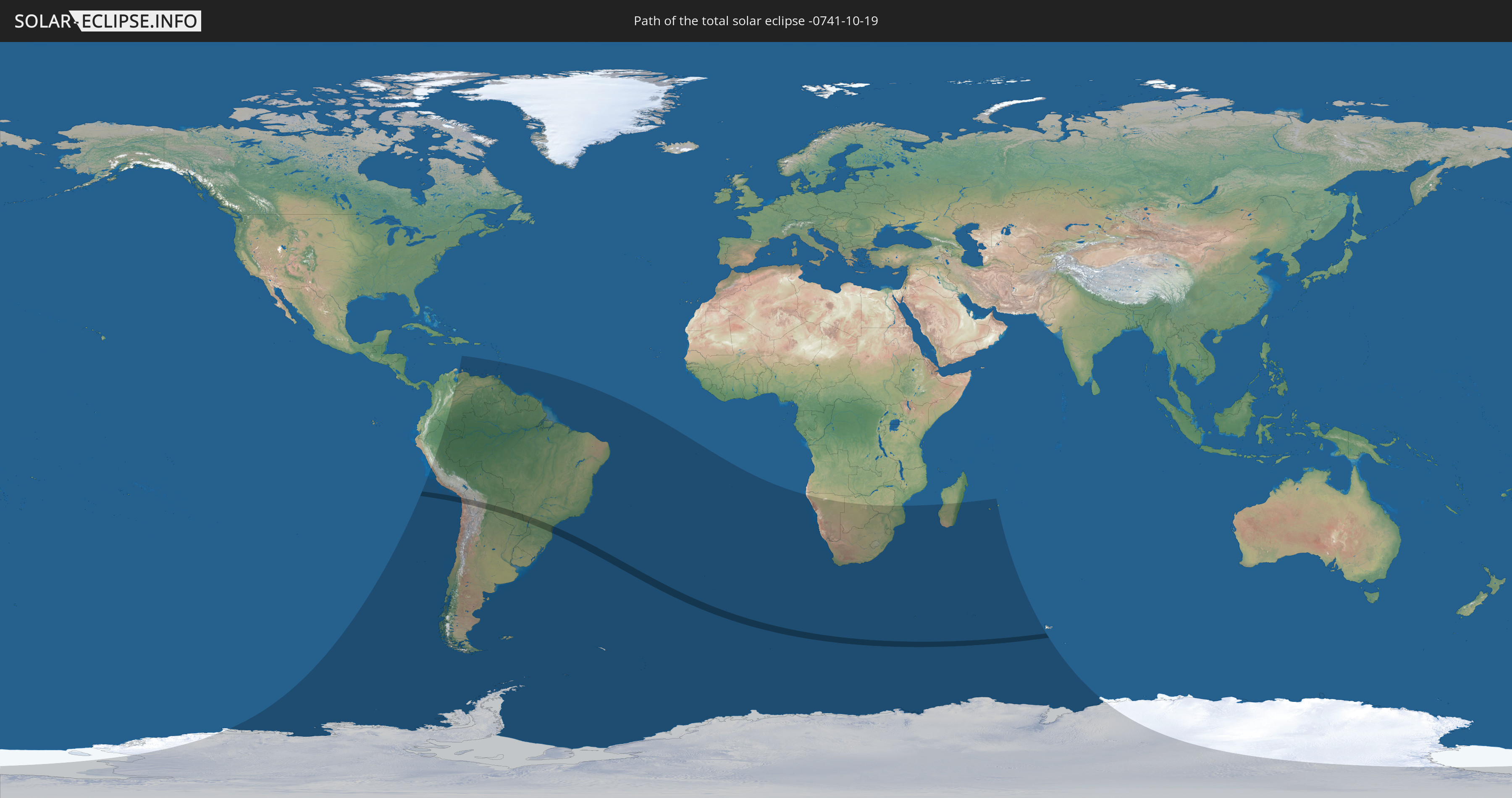
Die Sonnenfinsternis am 10/19/-0741 kann man in 34 Ländern als partielle Sonnenfinsternis beobachten.
Der Finsternispfad verläuft durch 4 Länder. Nur in diesen Ländern ist sie als total Sonnenfinsternis zu sehen.
In den folgenden Ländern ist die Sonnenfinsternis total zu sehen
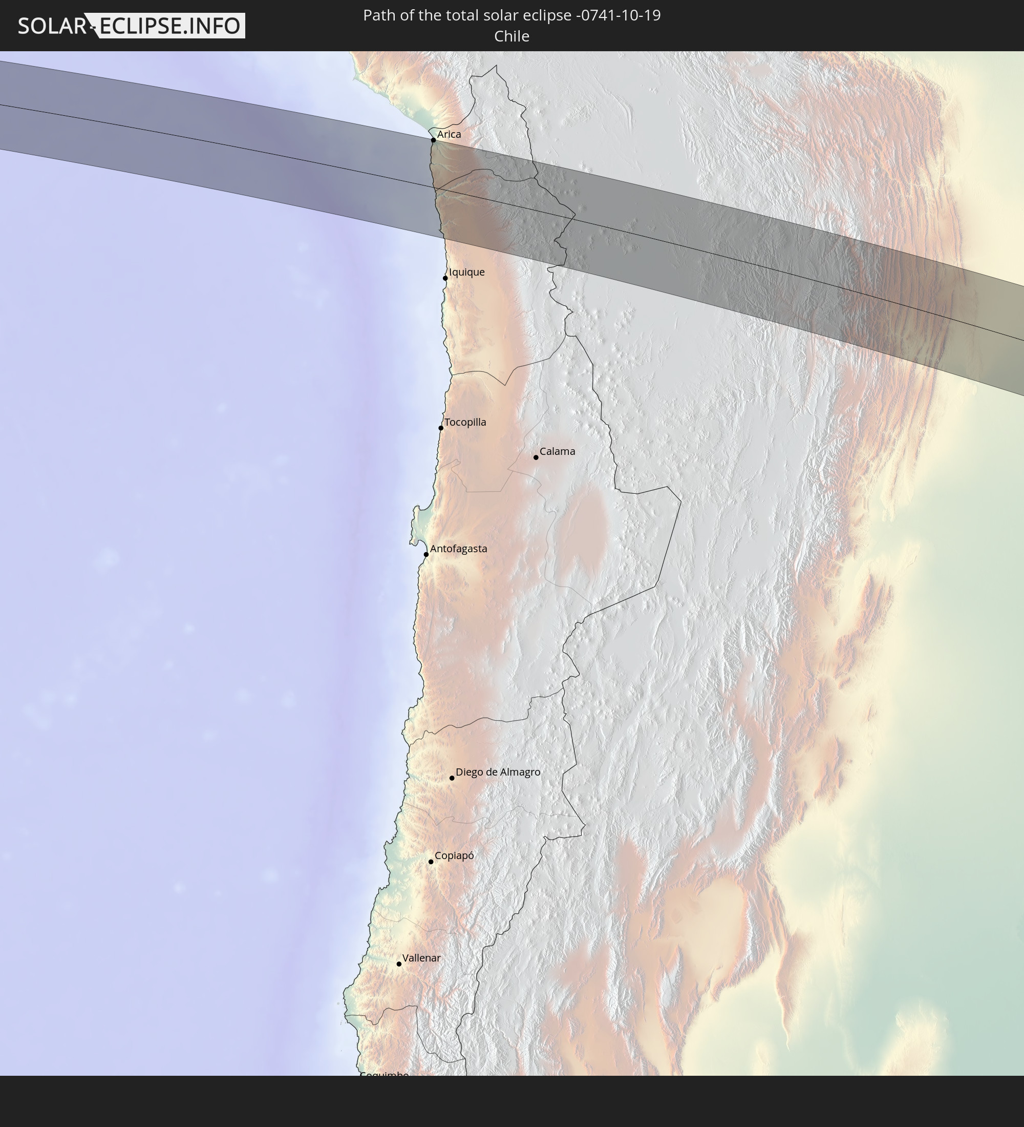 Chile
Chile
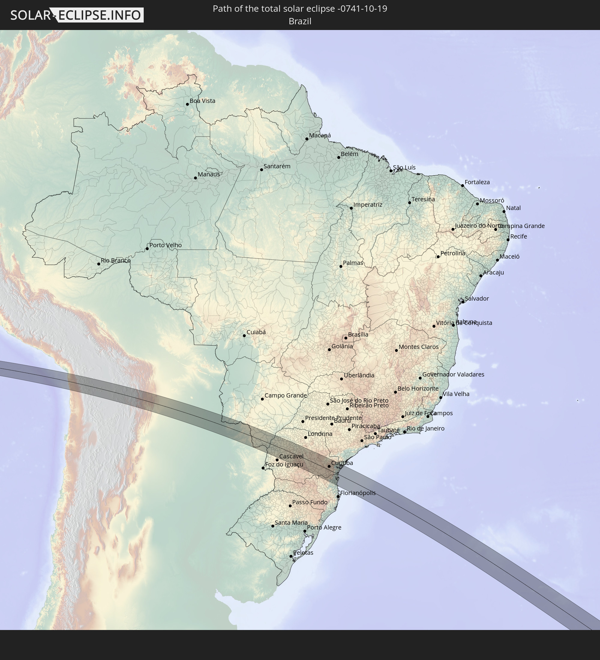 Brazil
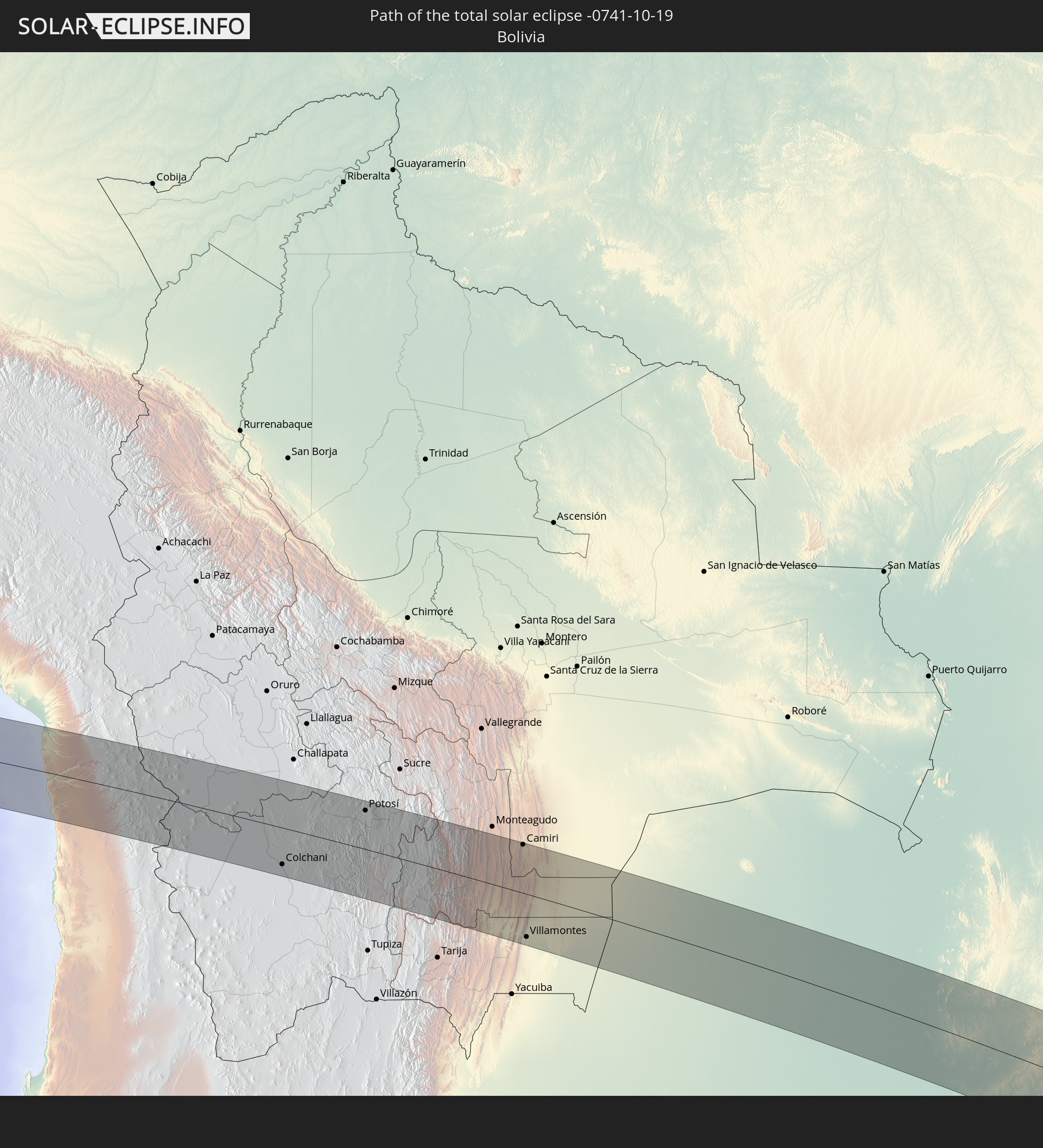 Bolivia
 Paraguay
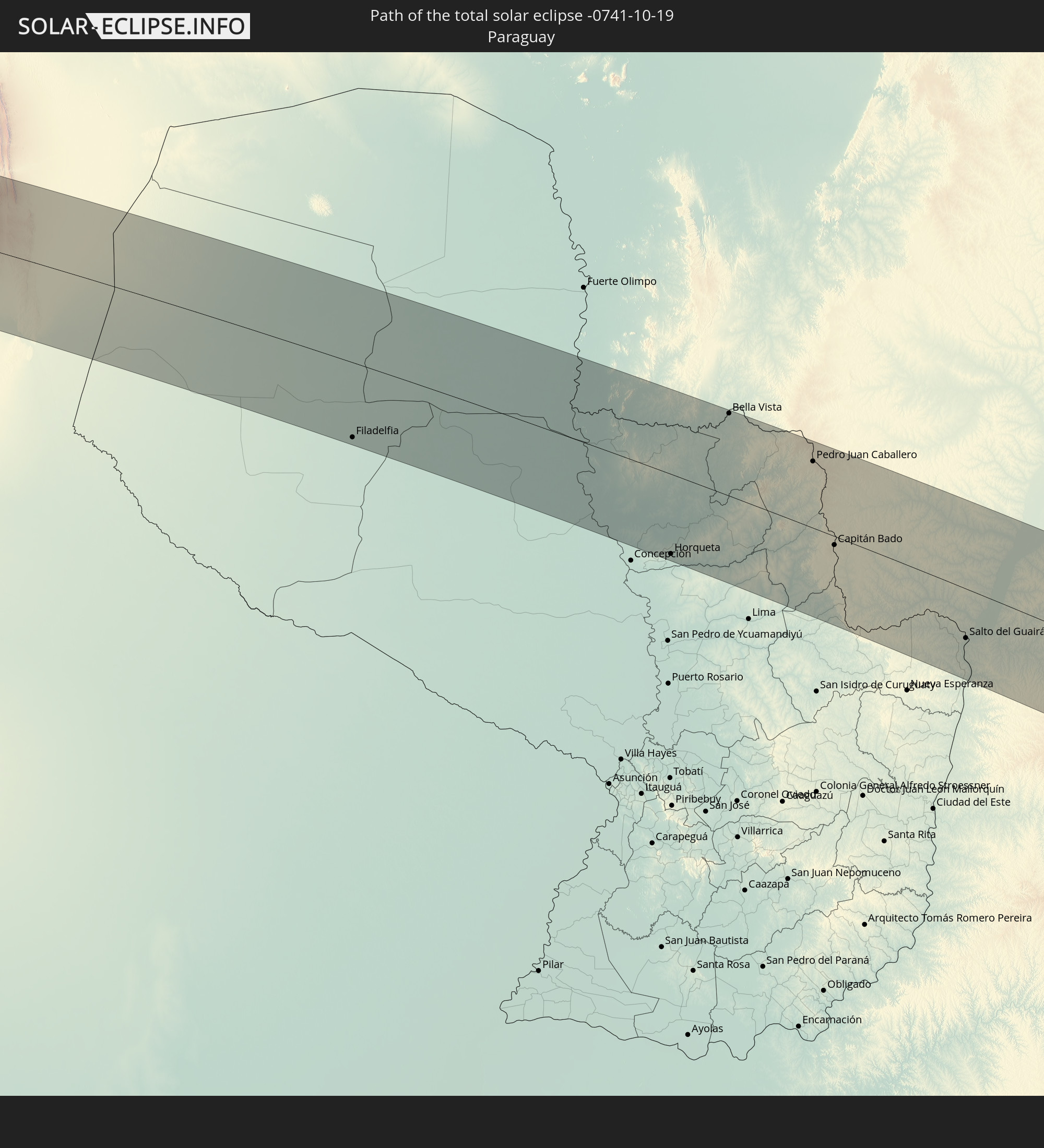
In den folgenden Ländern ist die Sonnenfinsternis partiell zu sehen
 Antarctica
 Chile
Chile
 Colombia
 Peru
Peru
 Brazil
 Argentina
 Venezuela
 Aruba
Aruba
 Bolivia
 Paraguay
 Trinidad and Tobago
 Grenada
 Saint Vincent and the Grenadines
 Falkland Islands
 Guyana
 Saint Lucia
 Barbados
 Uruguay
 Suriname
 French Guiana
 South Georgia and the South Sandwich Islands
 Saint Helena, Ascension and Tristan da Cunha
 Bouvet Island
 Namibia
 South Africa
 Botswana
 Zimbabwe
 Lesotho
 Mozambique
 Swaziland
 French Southern and Antarctic Lands
 Madagascar
 Réunion
 Mauritius
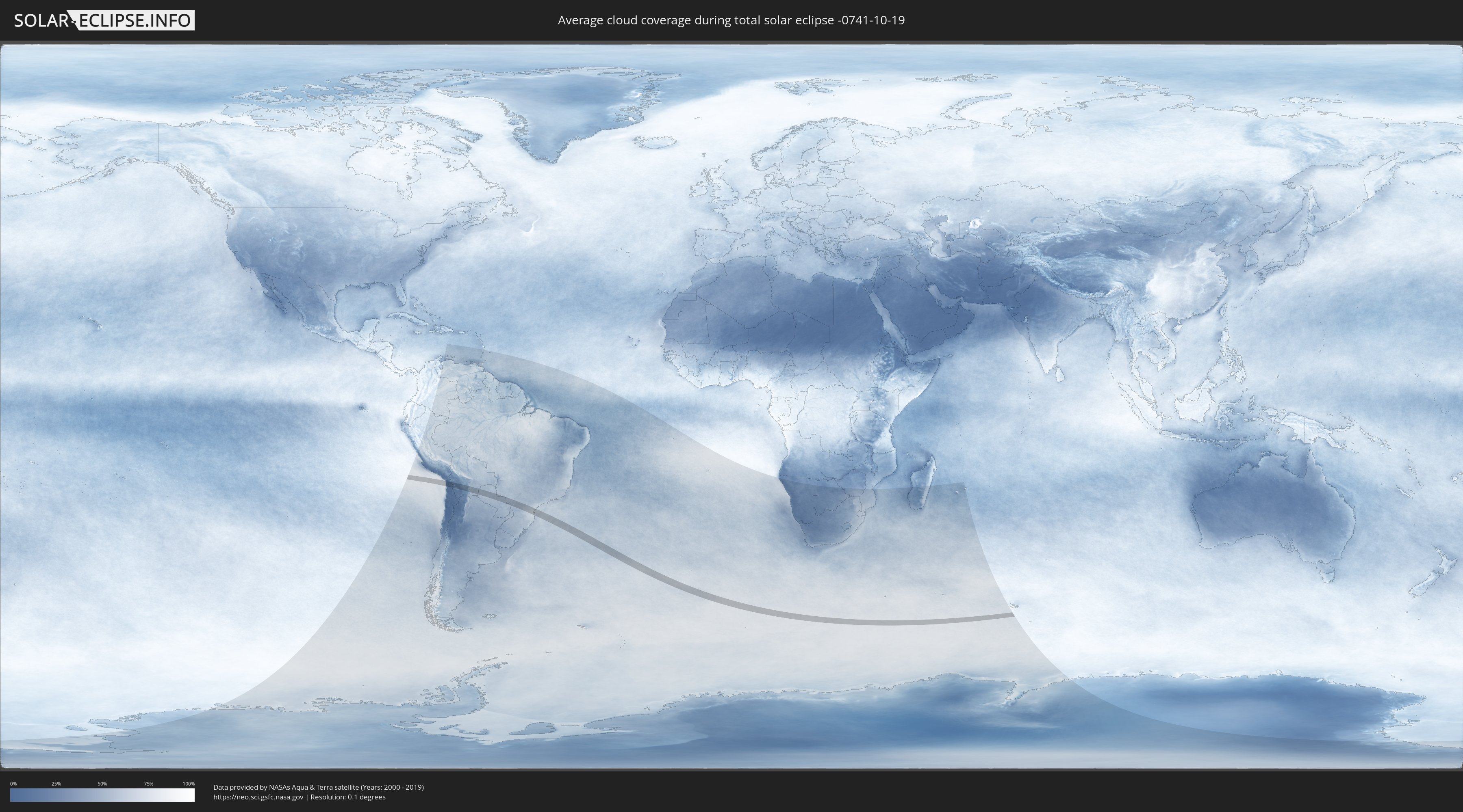
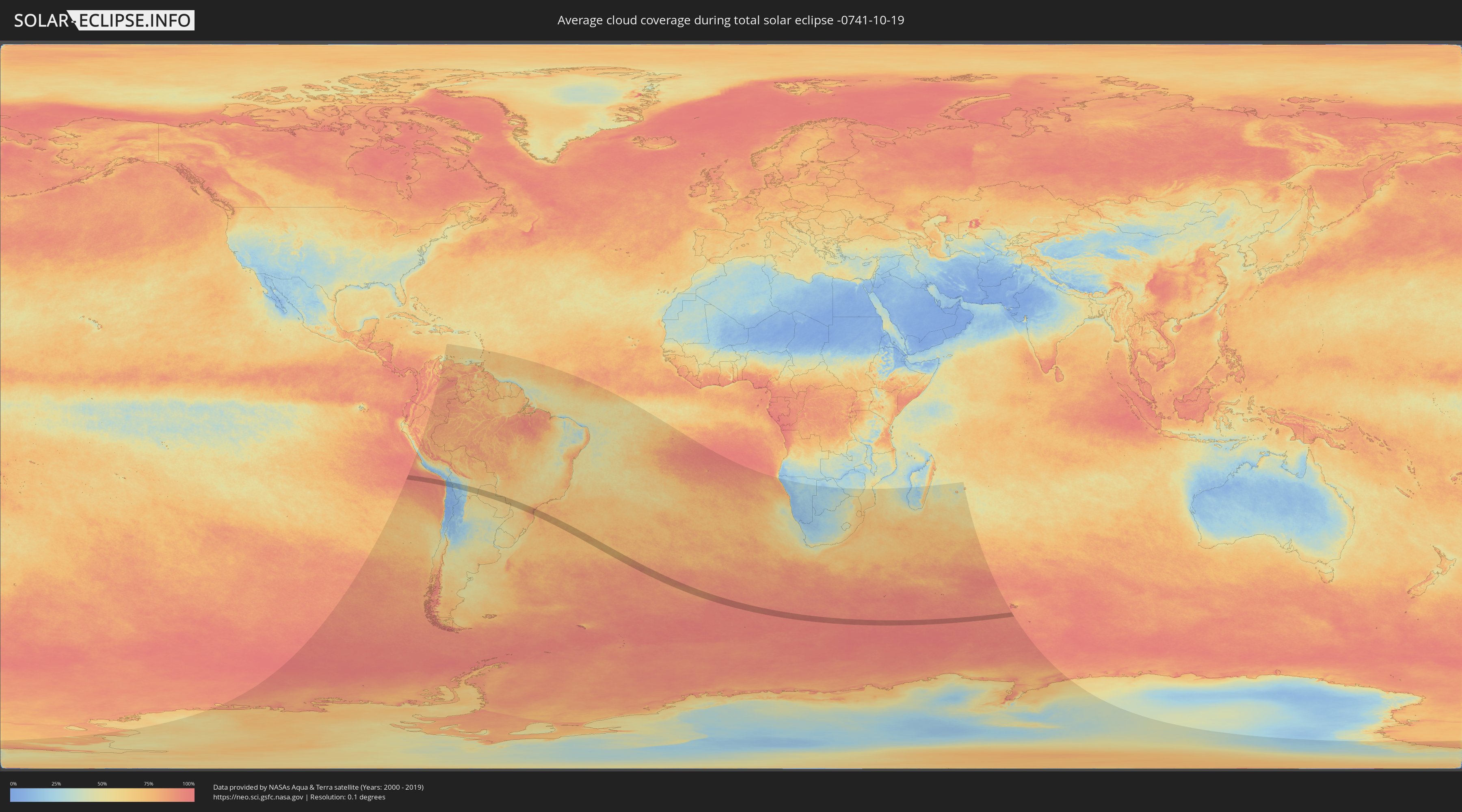
How will be the weather during the total solar eclipse on 10/19/-0741?
Where is the best place to see the total solar eclipse of 10/19/-0741?
The following maps show the average cloud coverage for the day of the total solar eclipse.
With the help of these maps, it is possible to find the place along the eclipse path, which has the best
chance of a cloudless sky.
Nevertheless, you should consider local circumstances and inform about the weather of your chosen
observation site.
The data is provided by NASAs satellites
AQUA and TERRA.
The cloud maps are averaged over a period of 19 years (2000 - 2019).
Detailed country maps
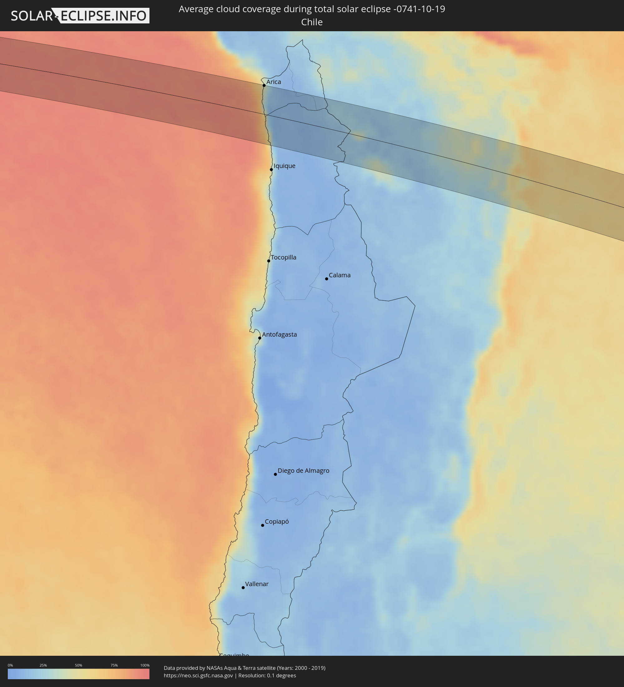 Chile
Chile
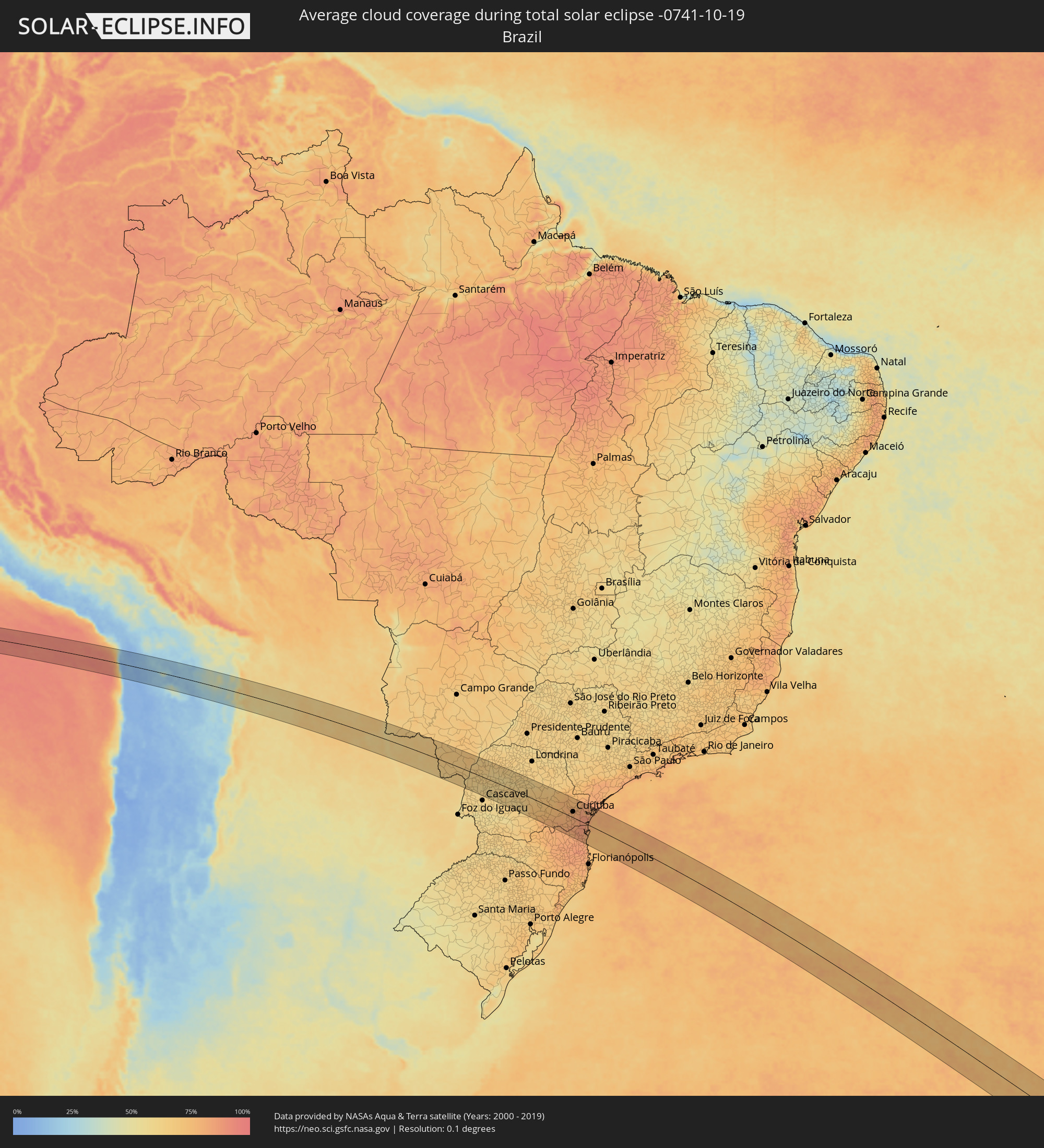 Brazil
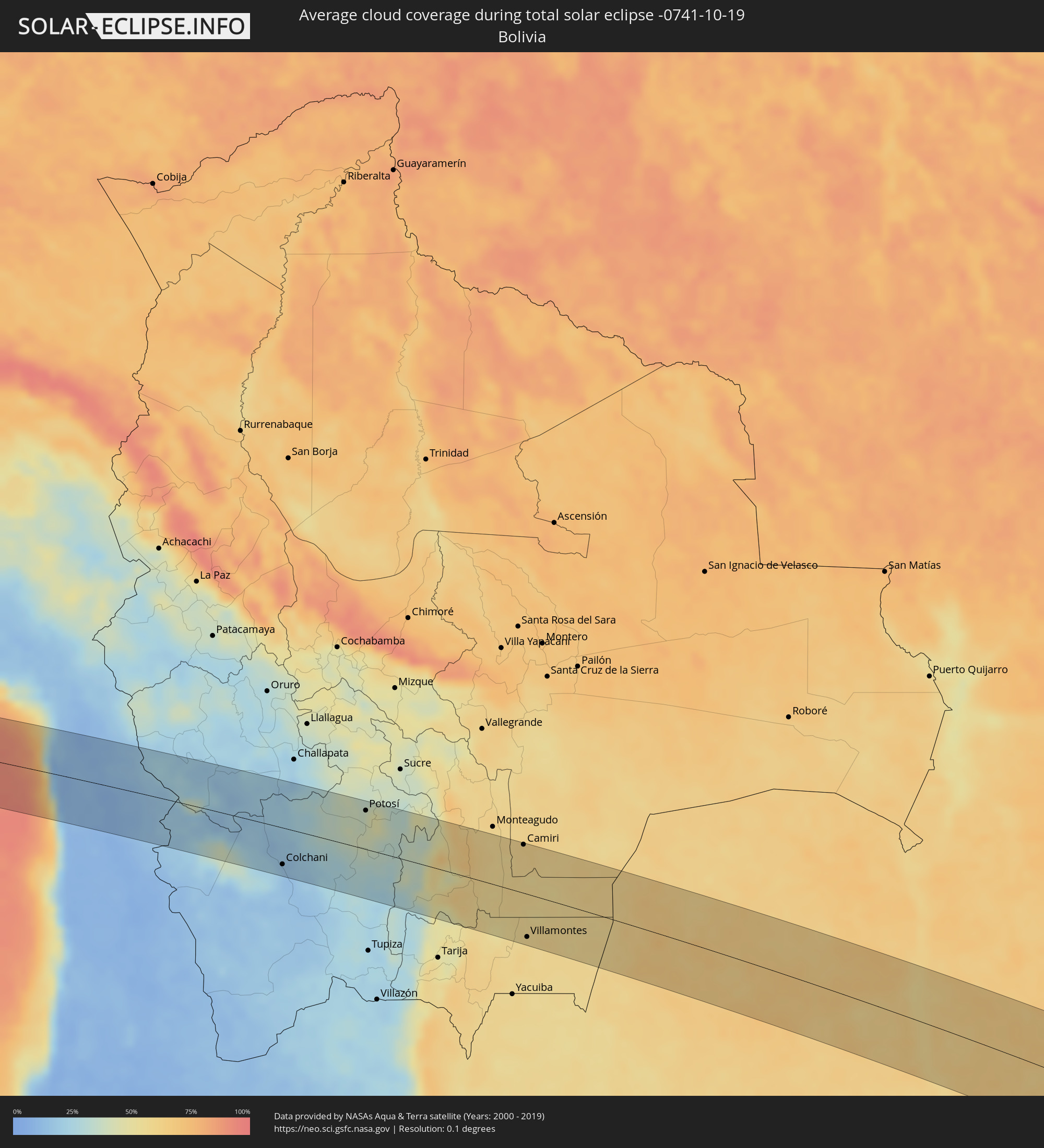 Bolivia
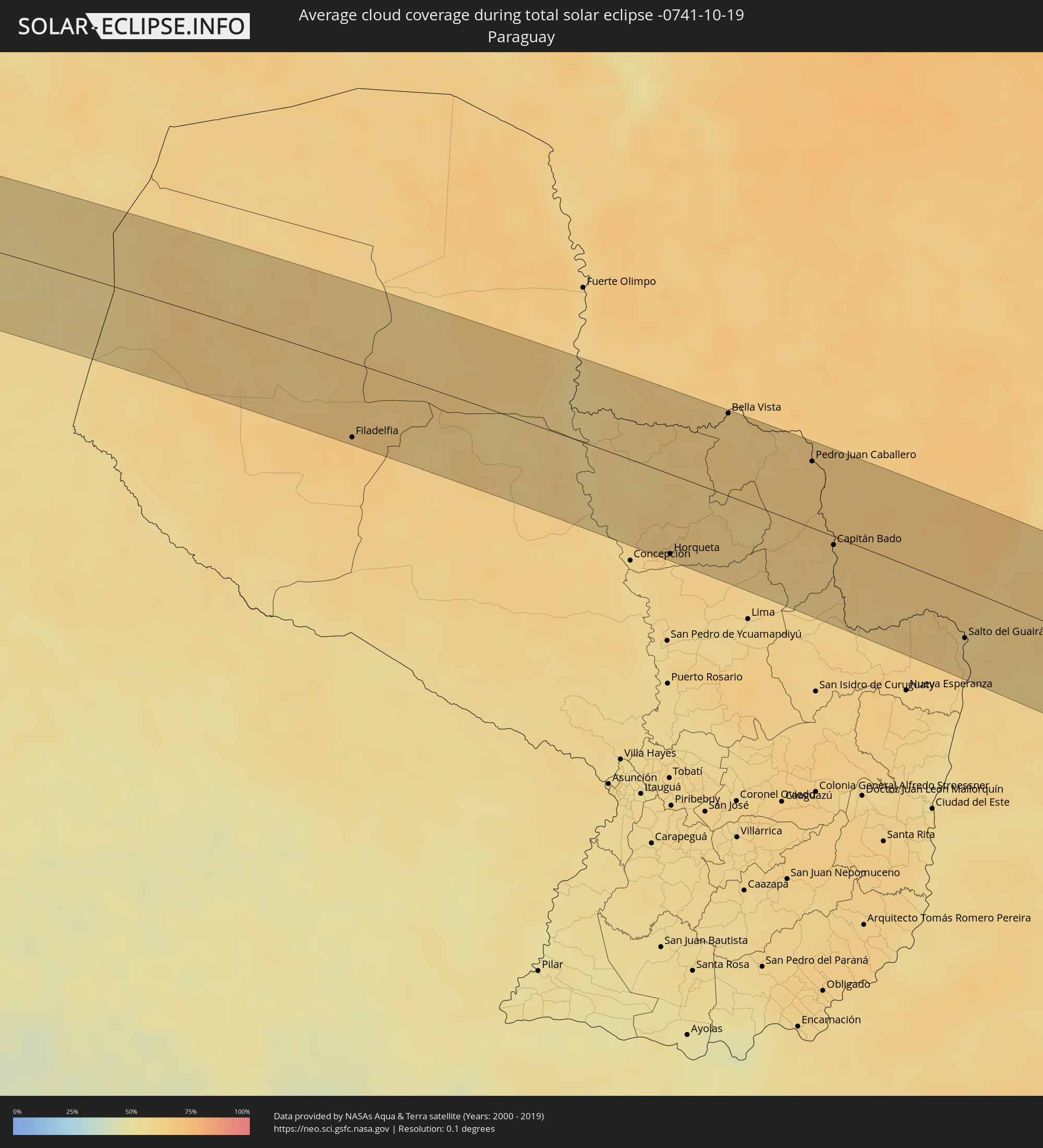 Paraguay
Cities inside the path of the eclipse
The following table shows all locations with a population of more than 5,000 inside the eclipse path. Cities which have more than 100,000 inhabitants are marked bold. A click at the locations opens a detailed map.
| City | Type | Eclipse duration | Local time of max. eclipse | Distance to central line | Ø Cloud coverage |
|
Arica, Arica y Parinacota
|
total | - | 06:17:53 UTC-04:42 | 65 km | 37% |
|
Colchani, Potosí
|
total | - | 06:30:55 UTC-04:32 | 53 km | 15% |
|
Uyuni, Potosí
|
total | - | 06:31:09 UTC-04:32 | 67 km | 13% |
|
Potosí, Potosí
|
total | - | 06:30:19 UTC-04:32 | 56 km | 37% |
|
Camiri, Santa Cruz
|
total | - | 06:31:37 UTC-04:32 | 69 km | 61% |
|
Villamontes, Tarija
|
total | - | 06:33:15 UTC-04:32 | 61 km | 59% |
|
Filadelfia, Boquerón
|
total | - | 07:18:10 UTC-03:50 | 68 km | 68% |
|
Colonia Menno, Boquerón
|
total | - | 07:18:18 UTC-03:50 | 64 km | 67% |
|
Porto Murtinho, Mato Grosso do Sul
|
total | - | 07:30:36 UTC-03:38 | 71 km | 57% |
|
Horqueta, Concepción
|
total | - | 07:21:16 UTC-03:50 | 72 km | 63% |
|
Bela Vista, Mato Grosso do Sul
|
total | - | 07:19:48 UTC-03:50 | 76 km | 63% |
|
Bella Vista, Amambay
|
total | - | 07:19:50 UTC-03:50 | 74 km | 63% |
|
Pedro Juan Caballero, Amambay
|
total | - | 07:20:56 UTC-03:50 | 59 km | 67% |
|
Ponta Porã, Mato Grosso do Sul
|
total | - | 07:33:08 UTC-03:38 | 61 km | 67% |
|
Capitán Bado, Amambay
|
total | - | 07:22:08 UTC-03:50 | 8 km | 65% |
|
Costa Rica, Mato Grosso do Sul
|
total | - | 07:35:09 UTC-03:38 | 10 km | 66% |
|
Salto del Guairá, Canindeyú
|
total | - | 07:24:10 UTC-03:50 | 43 km | 61% |
|
Naviraí, Mato Grosso do Sul
|
total | - | 07:34:58 UTC-03:38 | 64 km | 70% |
|
Palotina, Paraná
|
total | - | 08:09:03 UTC-03:06 | 48 km | 60% |
|
Umuarama, Paraná
|
total | - | 08:08:39 UTC-03:06 | 25 km | 63% |
|
Corbélia, Paraná
|
total | - | 08:10:14 UTC-03:06 | 80 km | 61% |
|
Cruzeiro do Oeste, Paraná
|
total | - | 08:08:52 UTC-03:06 | 33 km | 61% |
|
Cianorte, Paraná
|
total | - | 08:09:03 UTC-03:06 | 64 km | 63% |
|
Terra Boa, Paraná
|
total | - | 08:09:20 UTC-03:06 | 60 km | 61% |
|
Campo Mourão, Paraná
|
total | - | 08:09:48 UTC-03:06 | 35 km | 59% |
|
Engenheiro Beltrão, Paraná
|
total | - | 08:09:31 UTC-03:06 | 64 km | 62% |
|
Pitanga, Paraná
|
total | - | 08:11:24 UTC-03:06 | 13 km | 64% |
|
Guarapuava, Paraná
|
total | - | 08:12:38 UTC-03:06 | 65 km | 63% |
|
Prudentópolis, Paraná
|
total | - | 08:12:47 UTC-03:06 | 27 km | 72% |
|
Irati, Paraná
|
total | - | 08:13:28 UTC-03:06 | 39 km | 73% |
|
Telêmaco Borba, Paraná
|
total | - | 08:11:42 UTC-03:06 | 78 km | 66% |
|
Imbituva, Paraná
|
total | - | 08:13:08 UTC-03:06 | 13 km | 70% |
|
Tibagi, Paraná
|
total | - | 08:12:10 UTC-03:06 | 68 km | 66% |
|
São Mateus do Sul, Paraná
|
total | - | 08:14:20 UTC-03:06 | 68 km | 77% |
|
Ponta Grossa, Paraná
|
total | - | 08:13:18 UTC-03:06 | 20 km | 73% |
|
Carambeí, Paraná
|
total | - | 08:13:07 UTC-03:06 | 36 km | 72% |
|
Castro, Paraná
|
total | - | 08:12:57 UTC-03:06 | 57 km | 73% |
|
Palmeira, Paraná
|
total | - | 08:13:58 UTC-03:06 | 8 km | 75% |
|
Mafra, Santa Catarina
|
total | - | 08:15:14 UTC-03:06 | 68 km | 80% |
|
Rio Negro, Paraná
|
total | - | 08:15:14 UTC-03:06 | 67 km | 80% |
|
Lapa, Paraná
|
total | - | 08:14:46 UTC-03:06 | 29 km | 78% |
|
Campo Largo, Paraná
|
total | - | 08:14:27 UTC-03:06 | 10 km | 78% |
|
Rio Negrinho, Santa Catarina
|
total | - | 08:15:44 UTC-03:06 | 69 km | 80% |
|
Araucária, Paraná
|
total | - | 08:14:46 UTC-03:06 | 2 km | 79% |
|
São Bento do Sul, Santa Catarina
|
total | - | 08:15:51 UTC-03:06 | 63 km | 79% |
|
Itaperuçu, Paraná
|
total | - | 08:14:14 UTC-03:06 | 42 km | 79% |
|
Rio Branco do Sul, Paraná
|
total | - | 08:14:13 UTC-03:06 | 46 km | 79% |
|
Curitiba, Paraná
|
total | - | 08:14:38 UTC-03:06 | 24 km | 80% |
|
Colombo, Paraná
|
total | - | 08:14:28 UTC-03:06 | 40 km | 80% |
|
Quatro Barras, Paraná
|
total | - | 08:14:43 UTC-03:06 | 39 km | 80% |
|
Schroeder, Santa Catarina
|
total | - | 08:16:24 UTC-03:06 | 66 km | 83% |
|
Piraquara, Paraná
|
total | - | 08:14:51 UTC-03:06 | 32 km | 80% |
|
Jaraguá do Sul, Santa Catarina
|
total | - | 08:16:31 UTC-03:06 | 73 km | 83% |
|
Campina Grande do Sul, Paraná
|
total | - | 08:14:39 UTC-03:06 | 46 km | 80% |
|
Guaramirim, Santa Catarina
|
total | - | 08:16:34 UTC-03:06 | 69 km | 83% |
|
Joinville, Santa Catarina
|
total | - | 08:16:26 UTC-03:06 | 45 km | 83% |
|
Antonina, Paraná
|
total | - | 08:15:10 UTC-03:06 | 48 km | 79% |
|
Barra Velha, Santa Catarina
|
total | - | 08:17:07 UTC-03:06 | 71 km | 78% |
|
Penha, Santa Catarina
|
total | - | 08:17:23 UTC-03:06 | 83 km | 77% |
|
São Francisco do Sul, Santa Catarina
|
total | - | 08:16:32 UTC-03:06 | 30 km | 79% |
|
Guaratuba, Paraná
|
total | - | 08:16:01 UTC-03:06 | 9 km | 81% |
|
Paranaguá, Paraná
|
total | - | 08:15:29 UTC-03:06 | 48 km | 82% |
|
Pontal do Paraná, Paraná
|
total | - | 08:15:45 UTC-03:06 | 33 km | 81% |