Annular solar eclipse of 09/07/-0748
| Day of week: | Thursday |
| Maximum duration of eclipse: | 00m58s |
| Maximum width of eclipse path: | 48 km |
| Saros cycle: | 42 |
| Coverage: | 98.9% |
| Magnitude: | 0.9886 |
| Gamma: | 0.5509 |
Wo kann man die Sonnenfinsternis vom 09/07/-0748 sehen?
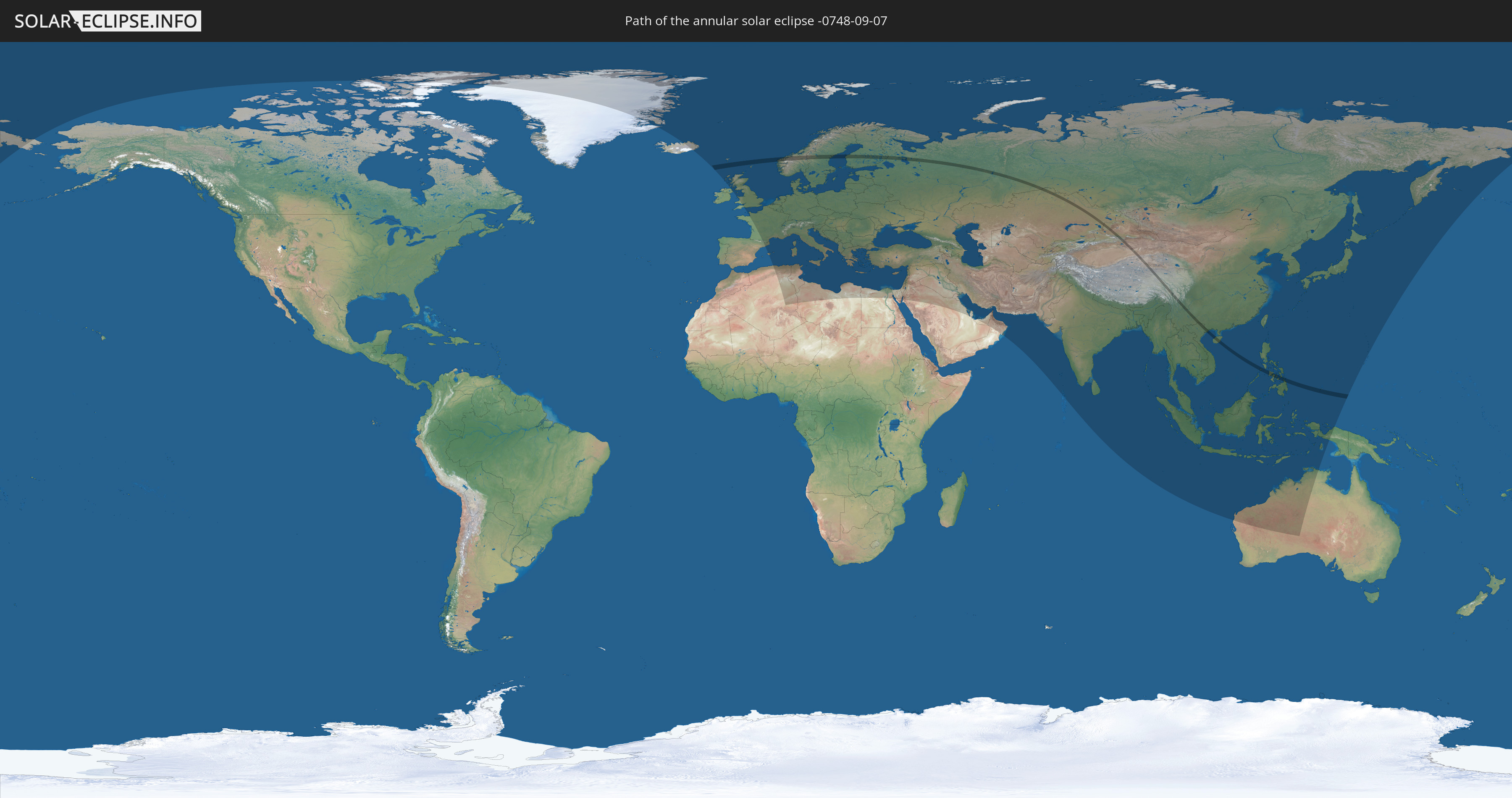
Die Sonnenfinsternis am 09/07/-0748 kann man in 110 Ländern als partielle Sonnenfinsternis beobachten.
Der Finsternispfad verläuft durch 9 Länder. Nur in diesen Ländern ist sie als annular Sonnenfinsternis zu sehen.
In den folgenden Ländern ist die Sonnenfinsternis annular zu sehen
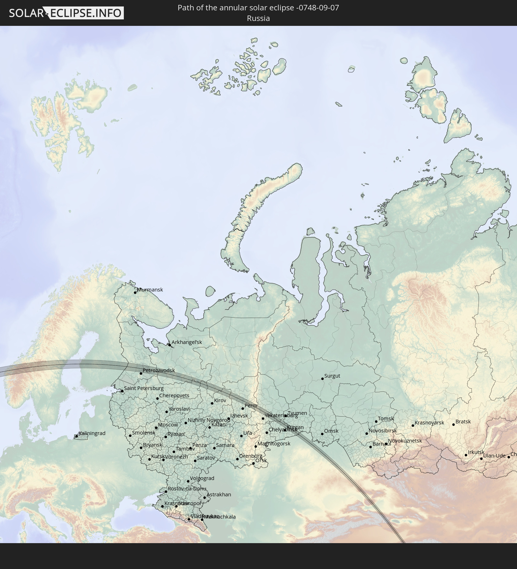 Russia
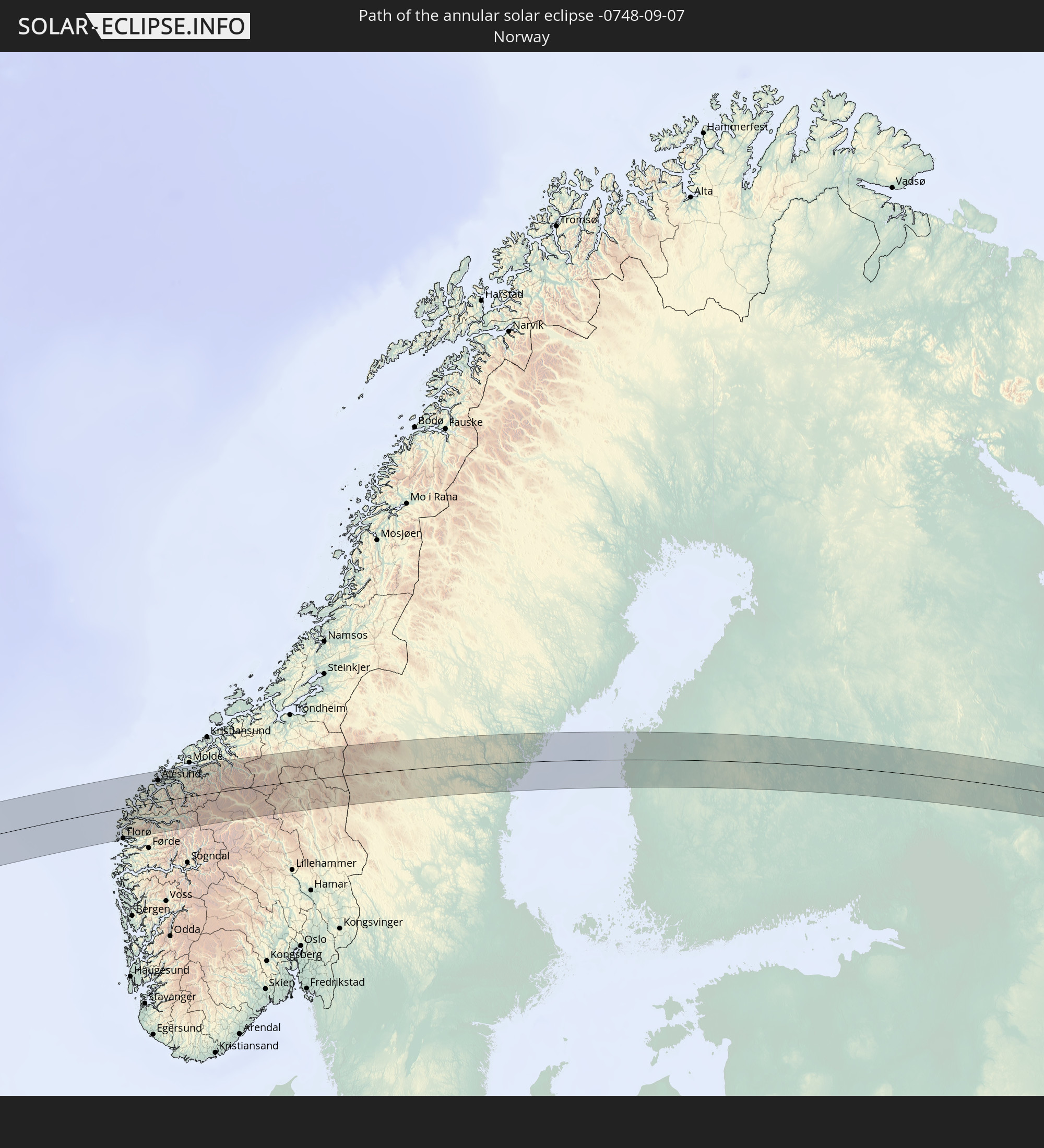 Norway
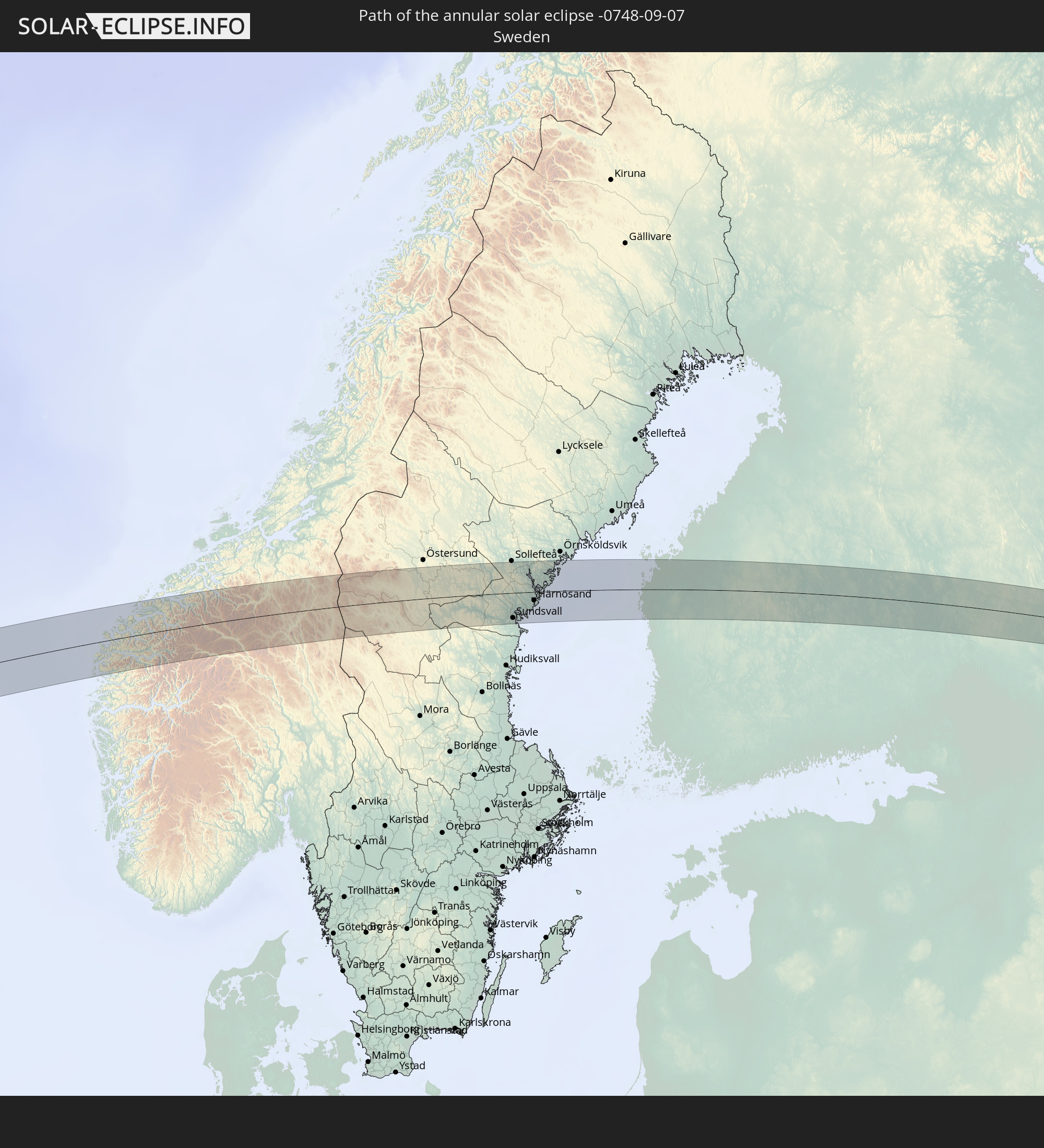 Sweden
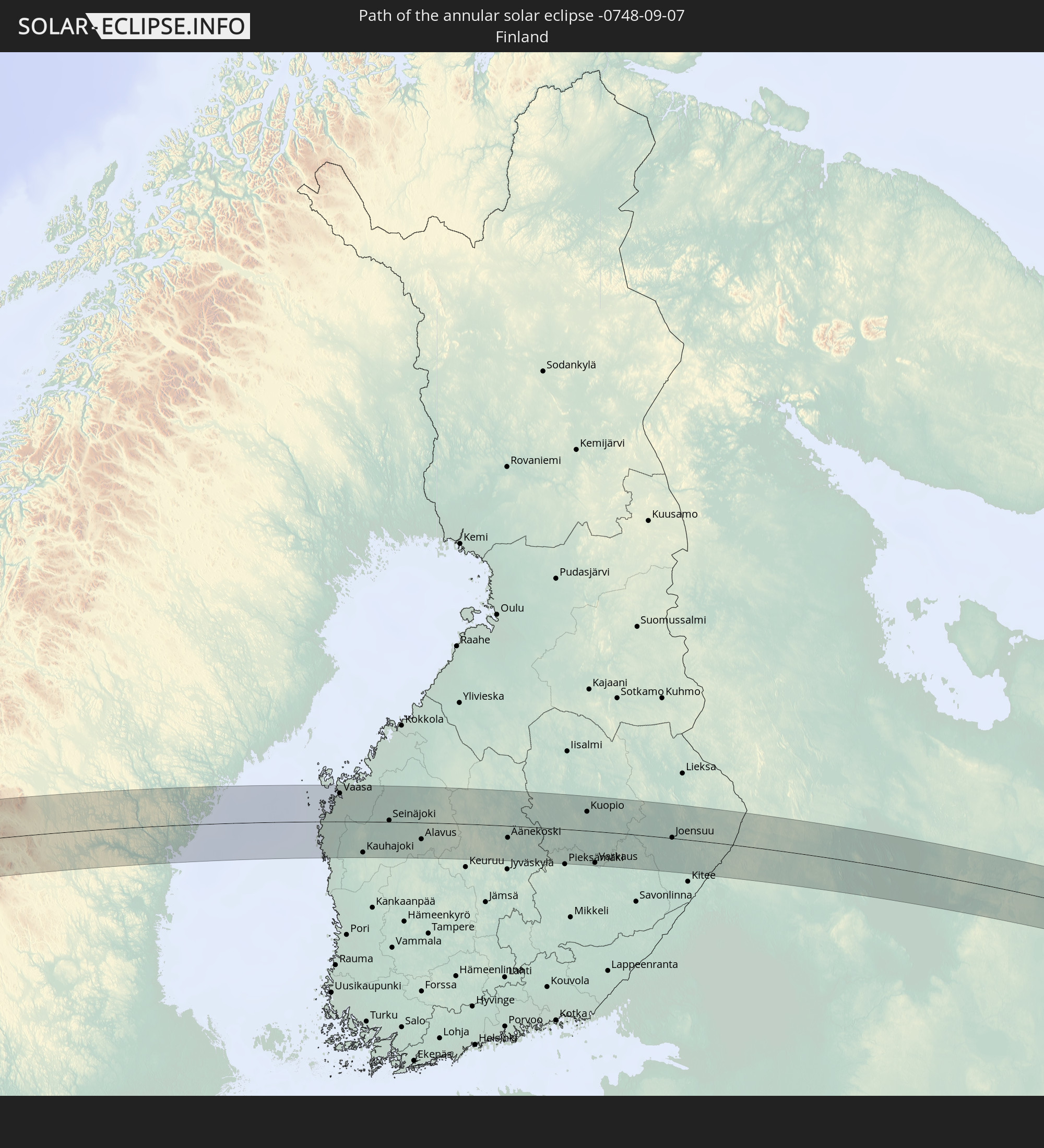 Finland
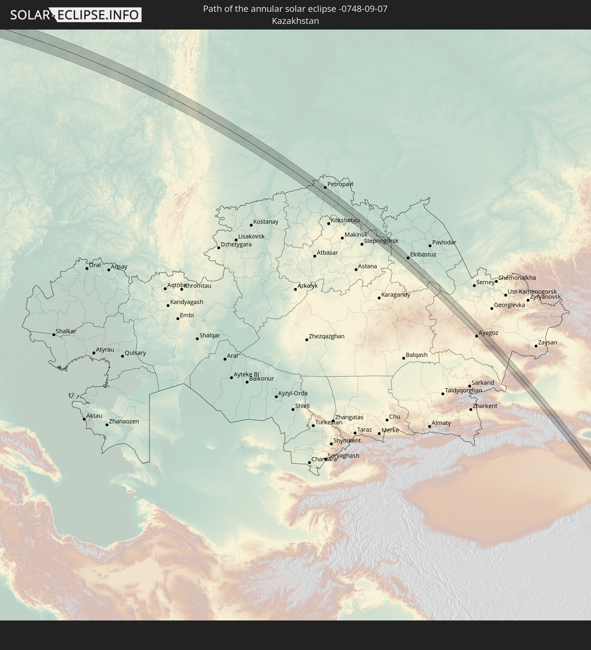 Kazakhstan
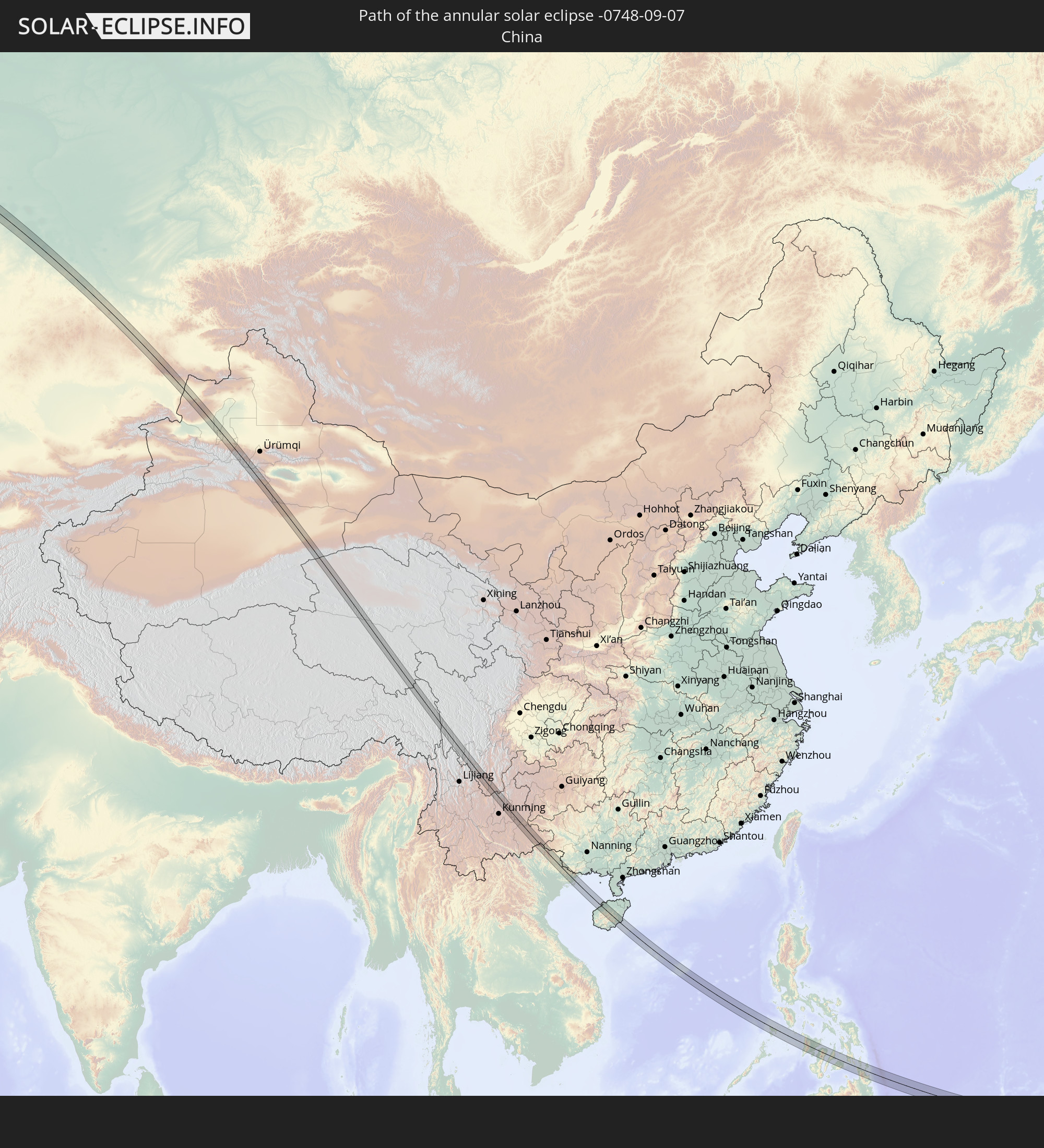 China
China
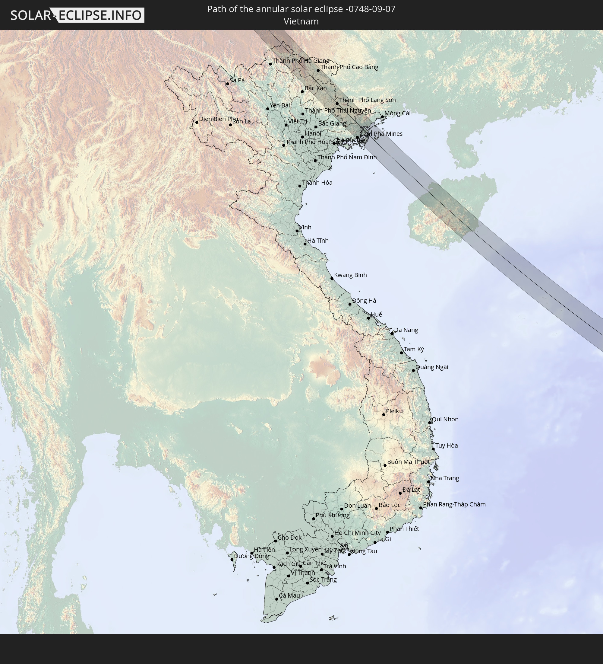 Vietnam
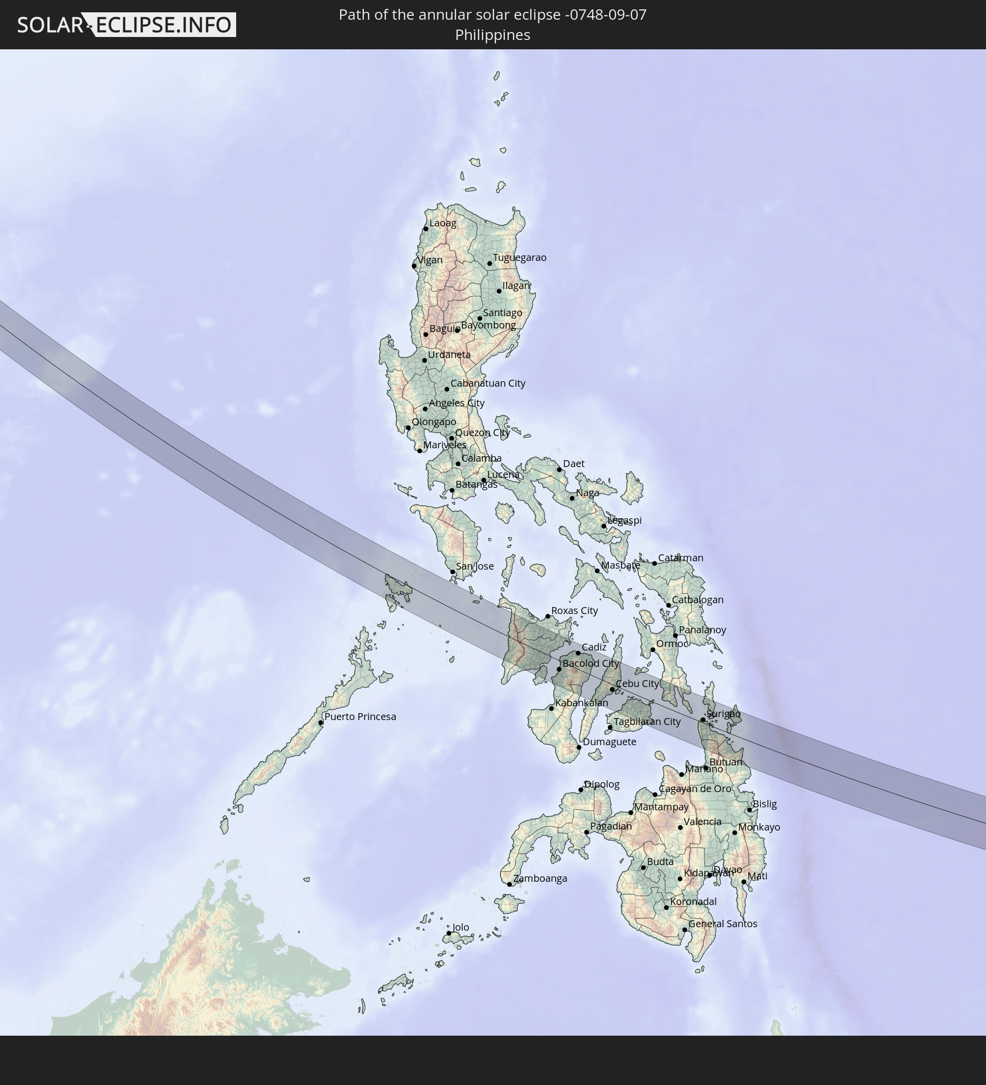 Philippines
 Palau
Palau
In den folgenden Ländern ist die Sonnenfinsternis partiell zu sehen
 Russia
 Canada
 Greenland
 Iceland
 Spain
Spain
 Svalbard and Jan Mayen
 Algeria
 United Kingdom
 Faroe Islands
 France
 Isle of Man
 Guernsey
 Jersey
 Andorra
 Belgium
 Netherlands
 Norway
 Luxembourg
 Germany
 Switzerland
 Italy
Italy
 Monaco
 Tunisia
 Denmark
 Libya
Libya
 Liechtenstein
 Austria
 Sweden
 Czechia
 San Marino
 Vatican City
 Slovenia
 Croatia
 Poland
 Malta
Malta
 Bosnia and Herzegovina
 Hungary
 Slovakia
 Montenegro
 Serbia
 Albania
 Åland Islands
 Greece
 Romania
 Republic of Macedonia
 Finland
 Lithuania
 Latvia
 Estonia
 Ukraine
 Bulgaria
 Belarus
 Egypt
Egypt
 Turkey
 Moldova
 Cyprus
 State of Palestine
 Israel
 Saudi Arabia
 Jordan
 Lebanon
 Syria
Syria
 Iraq
Iraq
 Georgia
 Armenia
 Iran
Iran
 Azerbaijan
 Kazakhstan
 Kuwait
 Bahrain
 Qatar
Qatar
 United Arab Emirates
 Oman
Oman
 Turkmenistan
 Uzbekistan
 Afghanistan
 Pakistan
 Tajikistan
 India
India
 Kyrgyzstan
 Maldives
 China
China
 Sri Lanka
 Nepal
Nepal
 Mongolia
 Bangladesh
 Bhutan
 Myanmar
 Indonesia
 Cocos Islands
 Thailand
 Malaysia
 Laos
Laos
 Vietnam
 Cambodia
 Singapore
 Christmas Island
 Australia
 Macau
Macau
 Hong Kong
 Brunei
 Taiwan
 Philippines
 Japan
Japan
 East Timor
 North Korea
 South Korea
 Palau
Palau
 Federated States of Micronesia
 Northern Mariana Islands
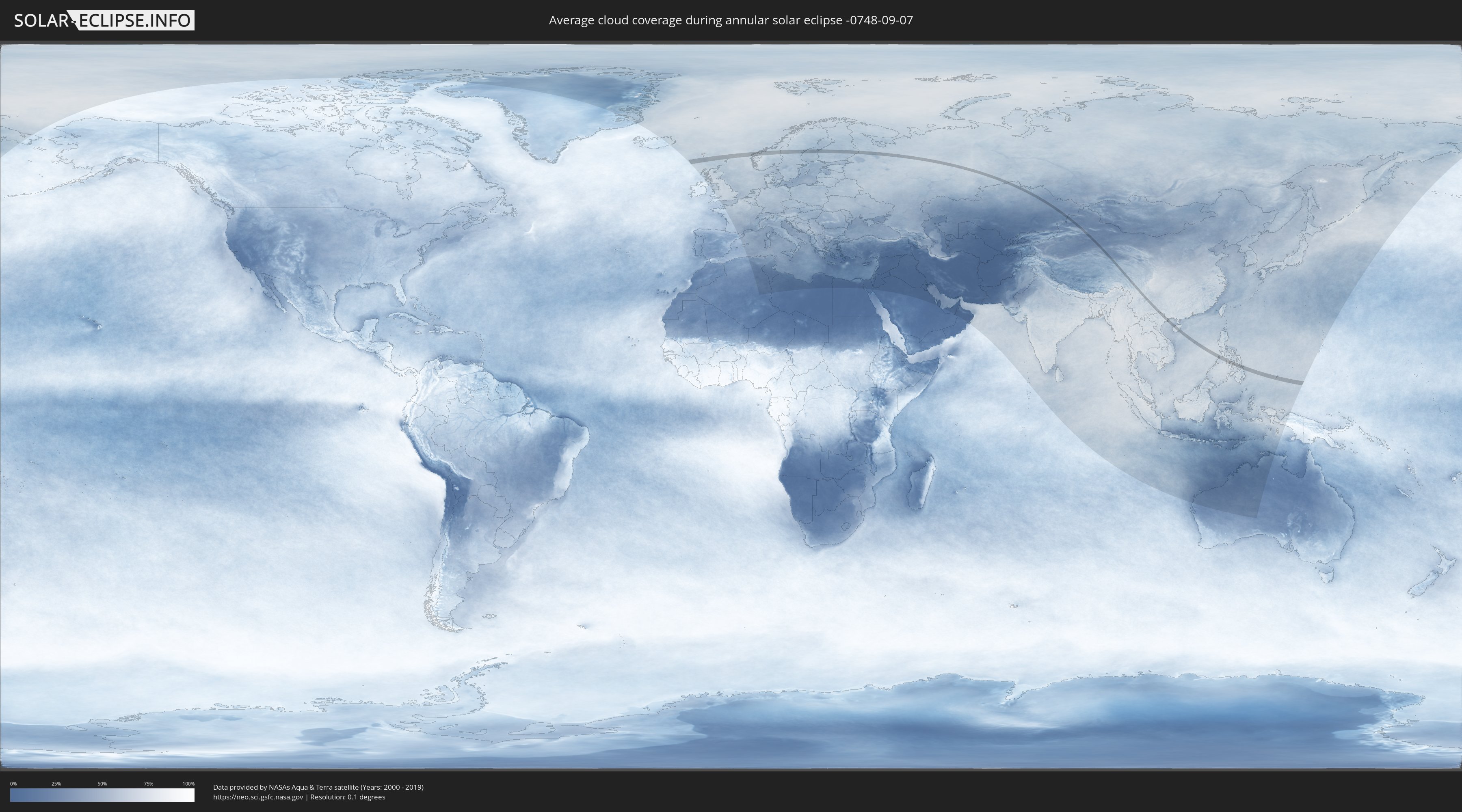
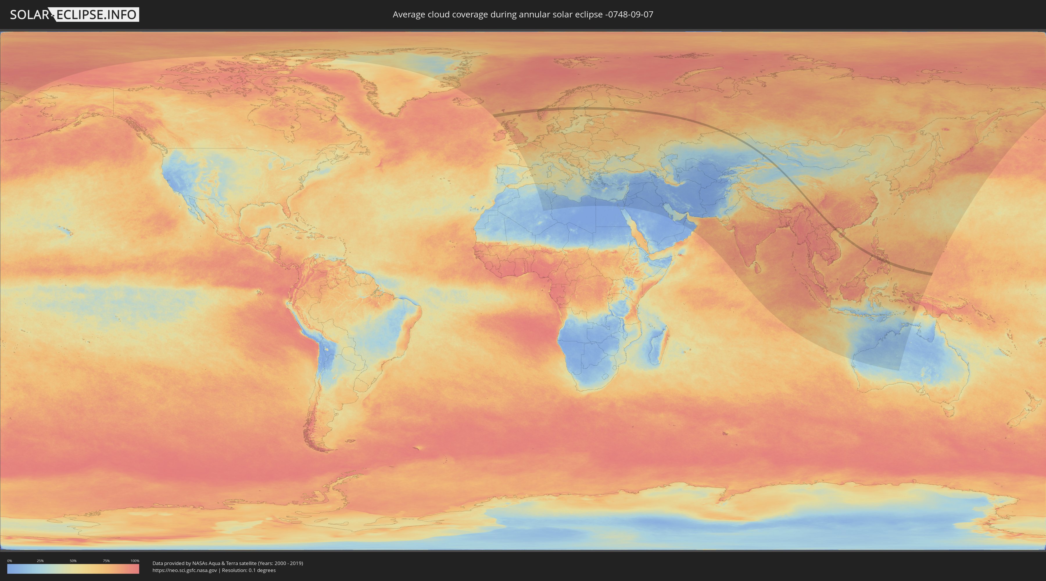
How will be the weather during the annular solar eclipse on 09/07/-0748?
Where is the best place to see the annular solar eclipse of 09/07/-0748?
The following maps show the average cloud coverage for the day of the annular solar eclipse.
With the help of these maps, it is possible to find the place along the eclipse path, which has the best
chance of a cloudless sky.
Nevertheless, you should consider local circumstances and inform about the weather of your chosen
observation site.
The data is provided by NASAs satellites
AQUA and TERRA.
The cloud maps are averaged over a period of 19 years (2000 - 2019).
Detailed country maps
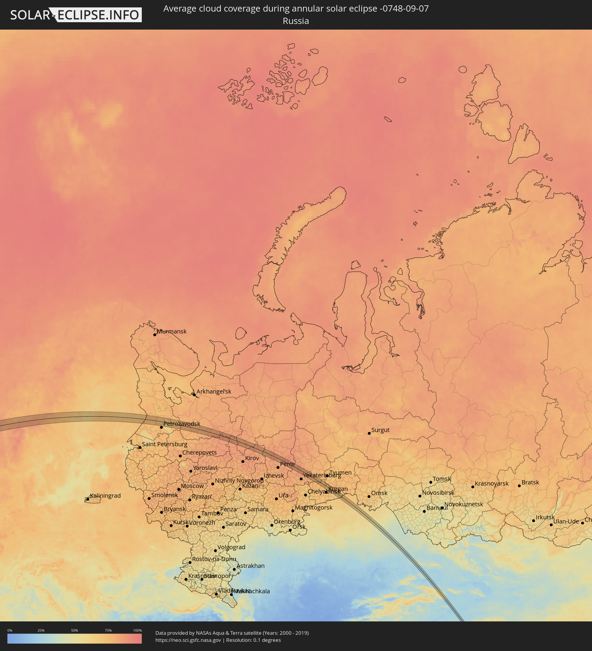 Russia
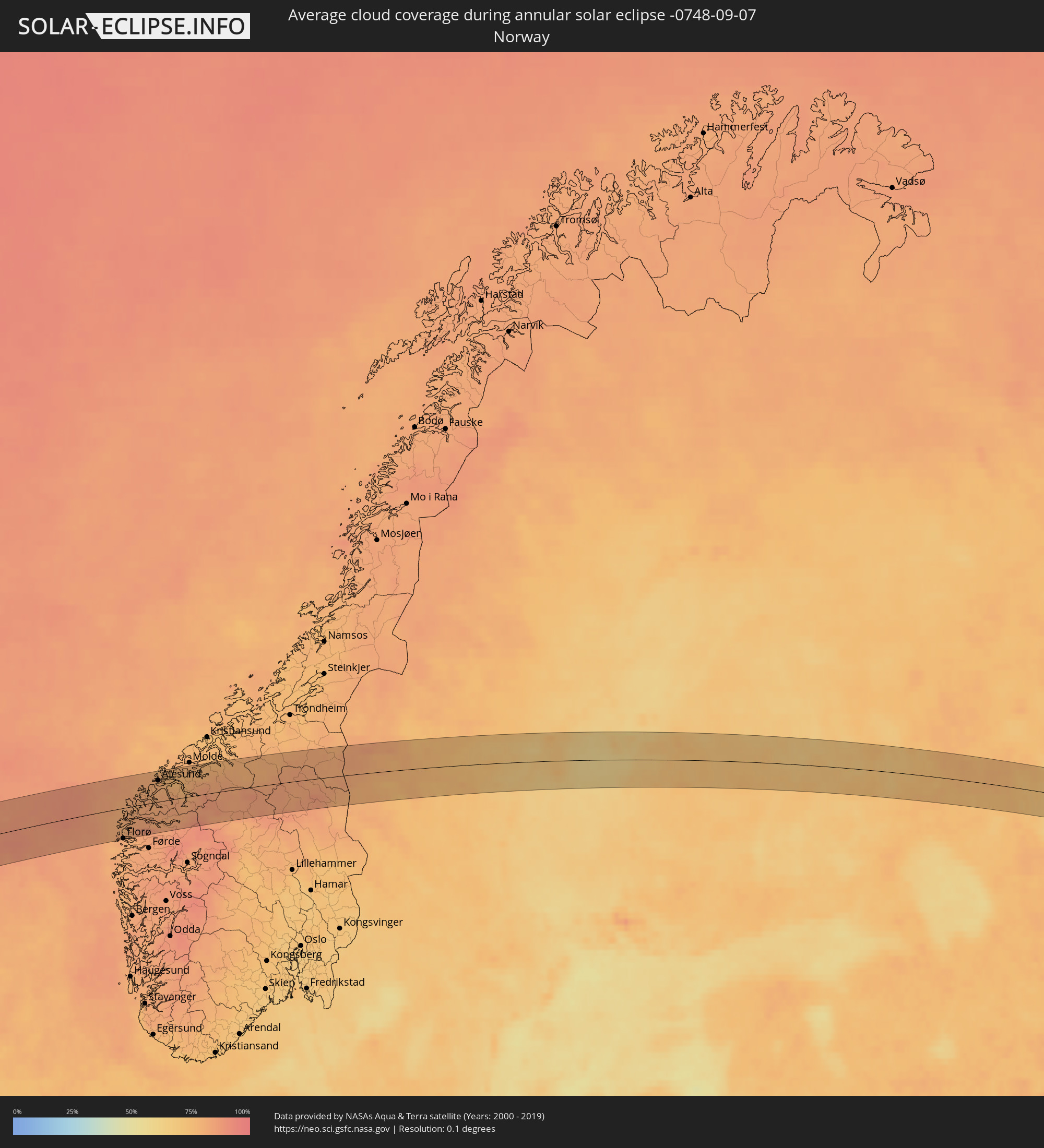 Norway
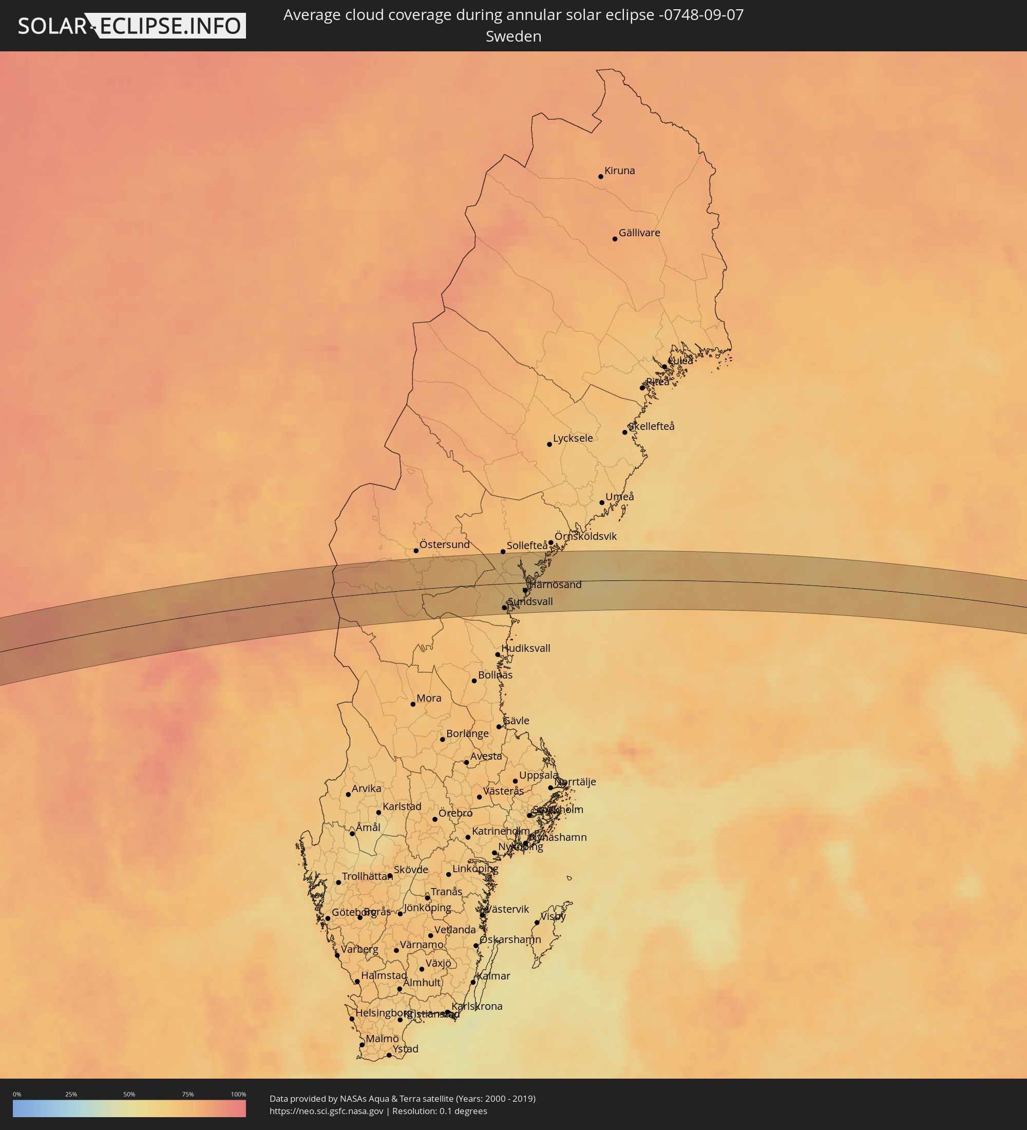 Sweden
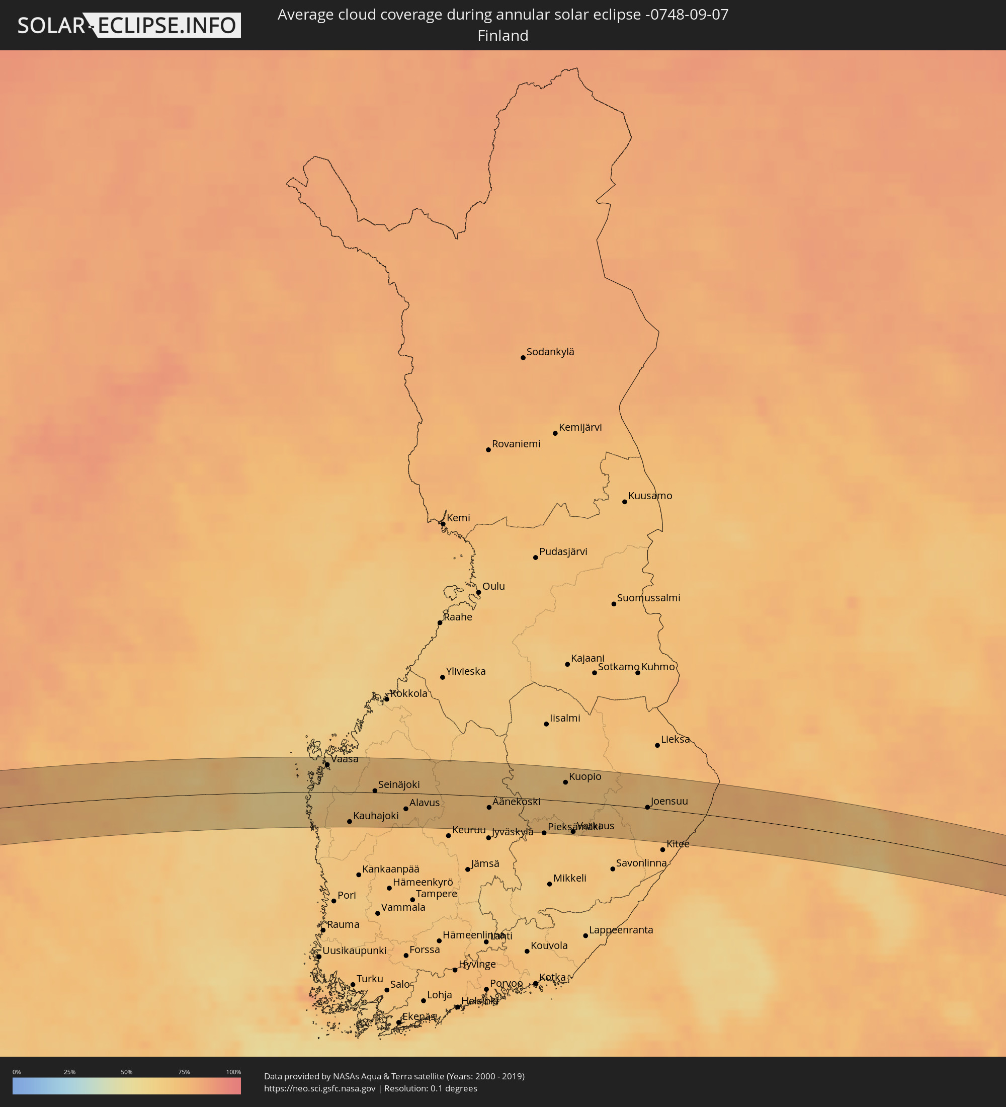 Finland
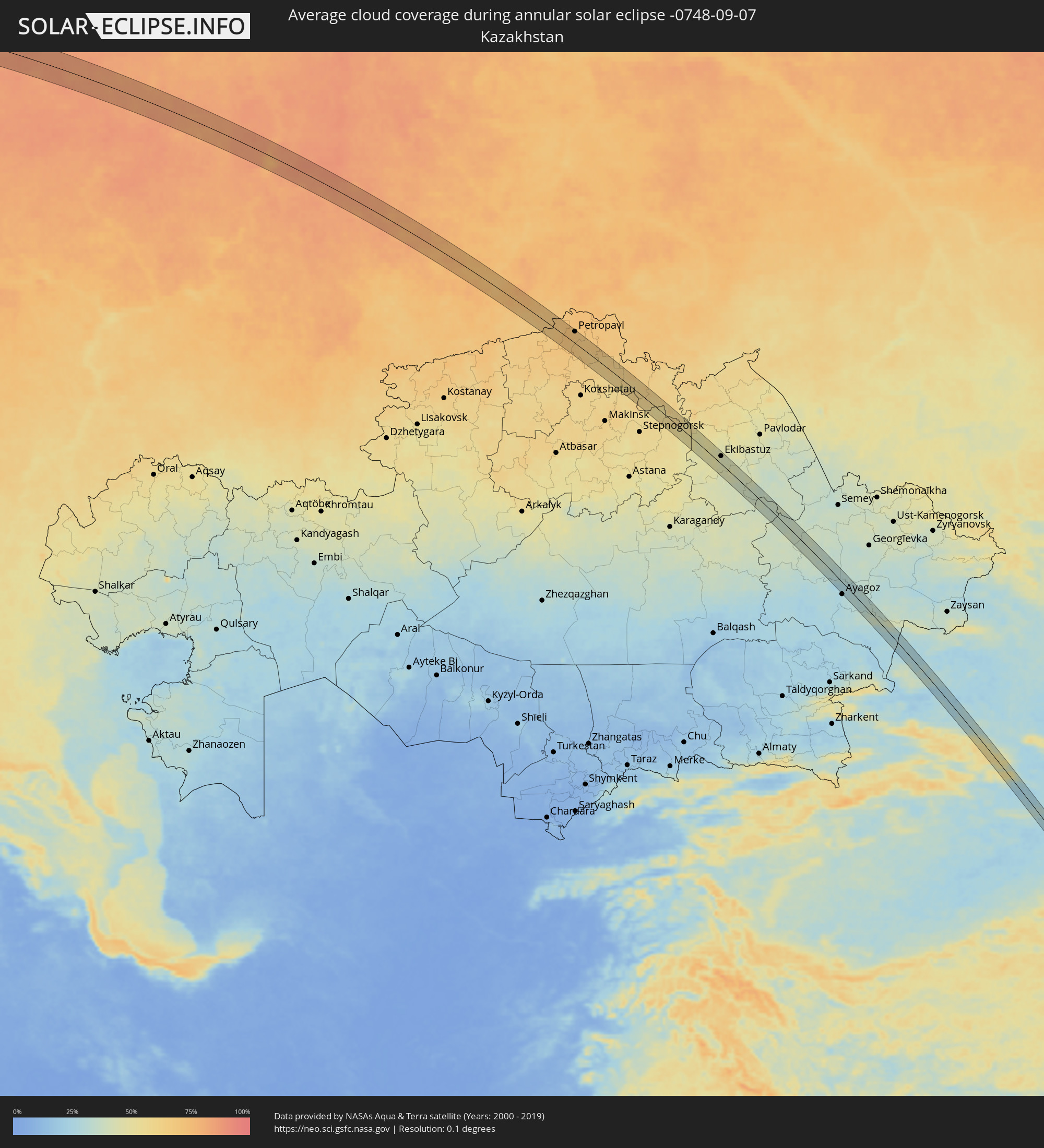 Kazakhstan
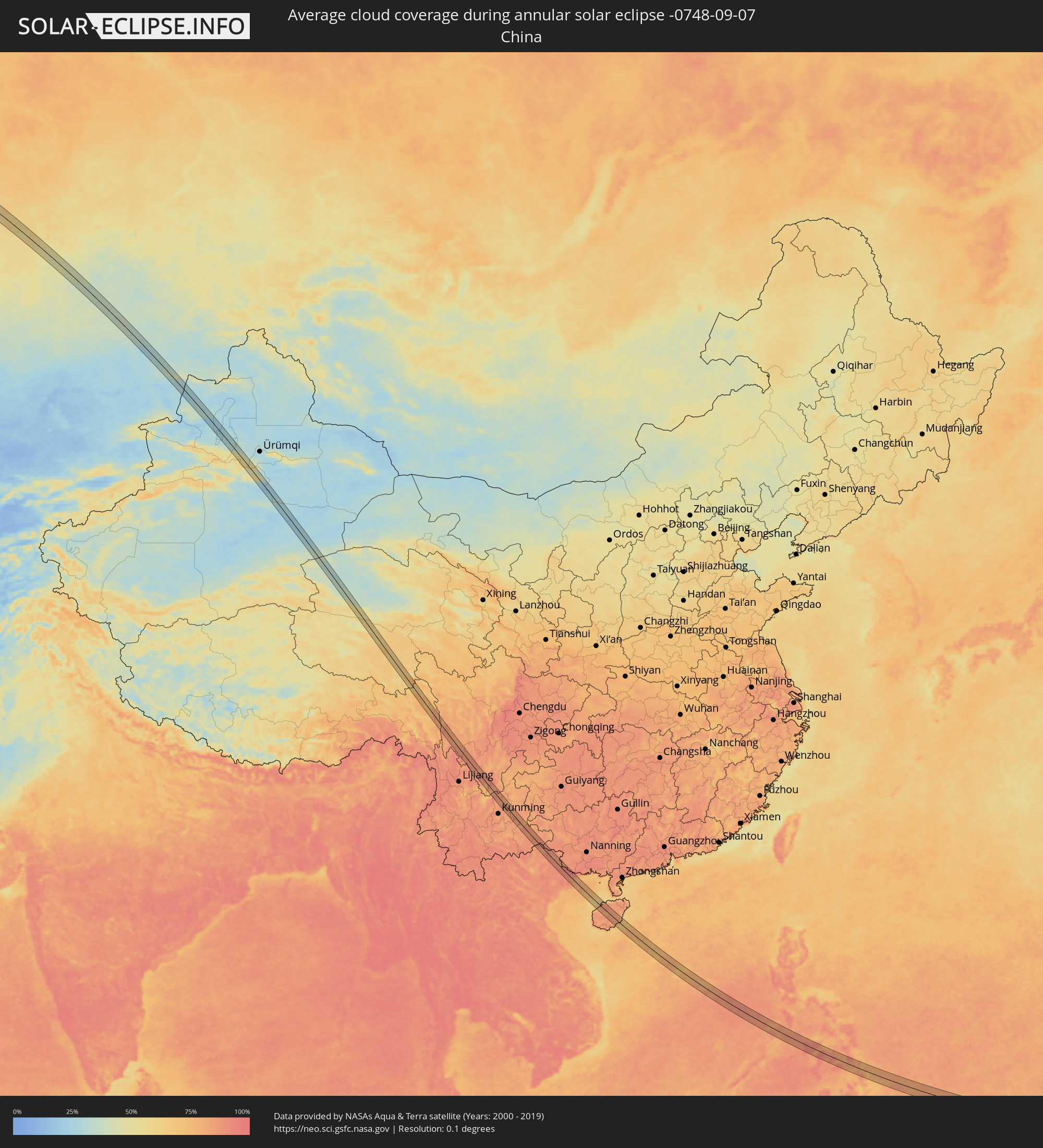 China
China
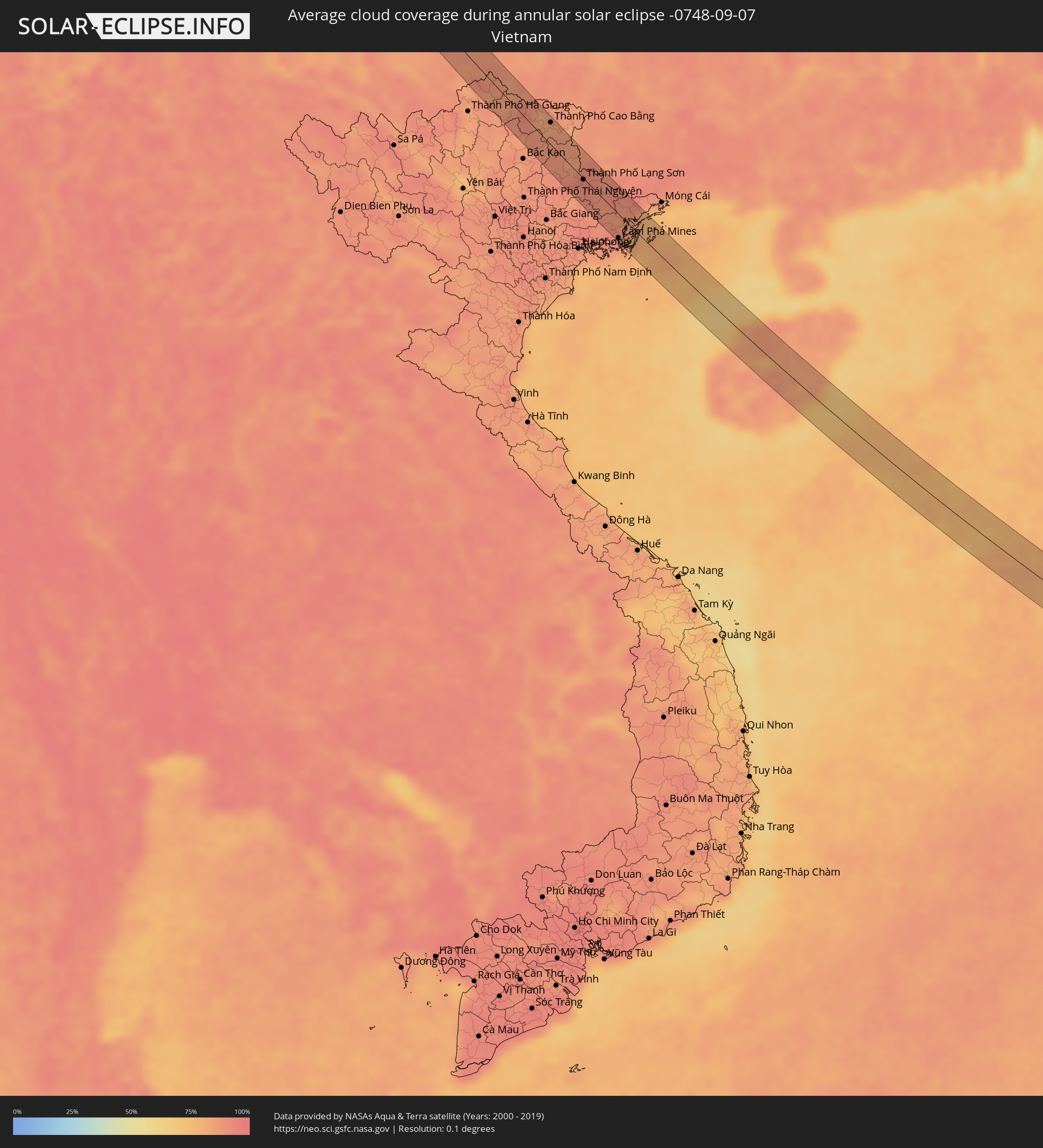 Vietnam
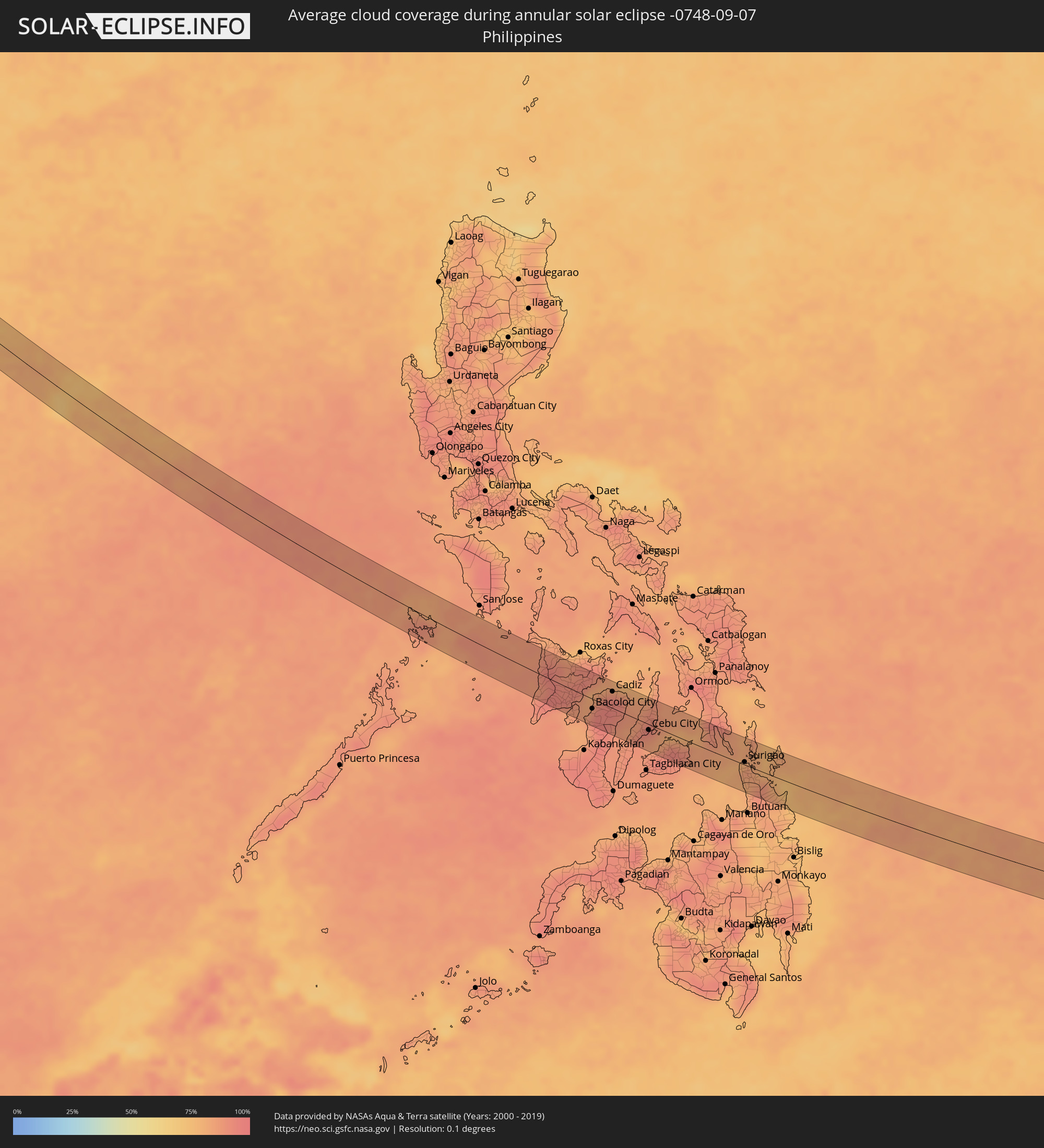 Philippines
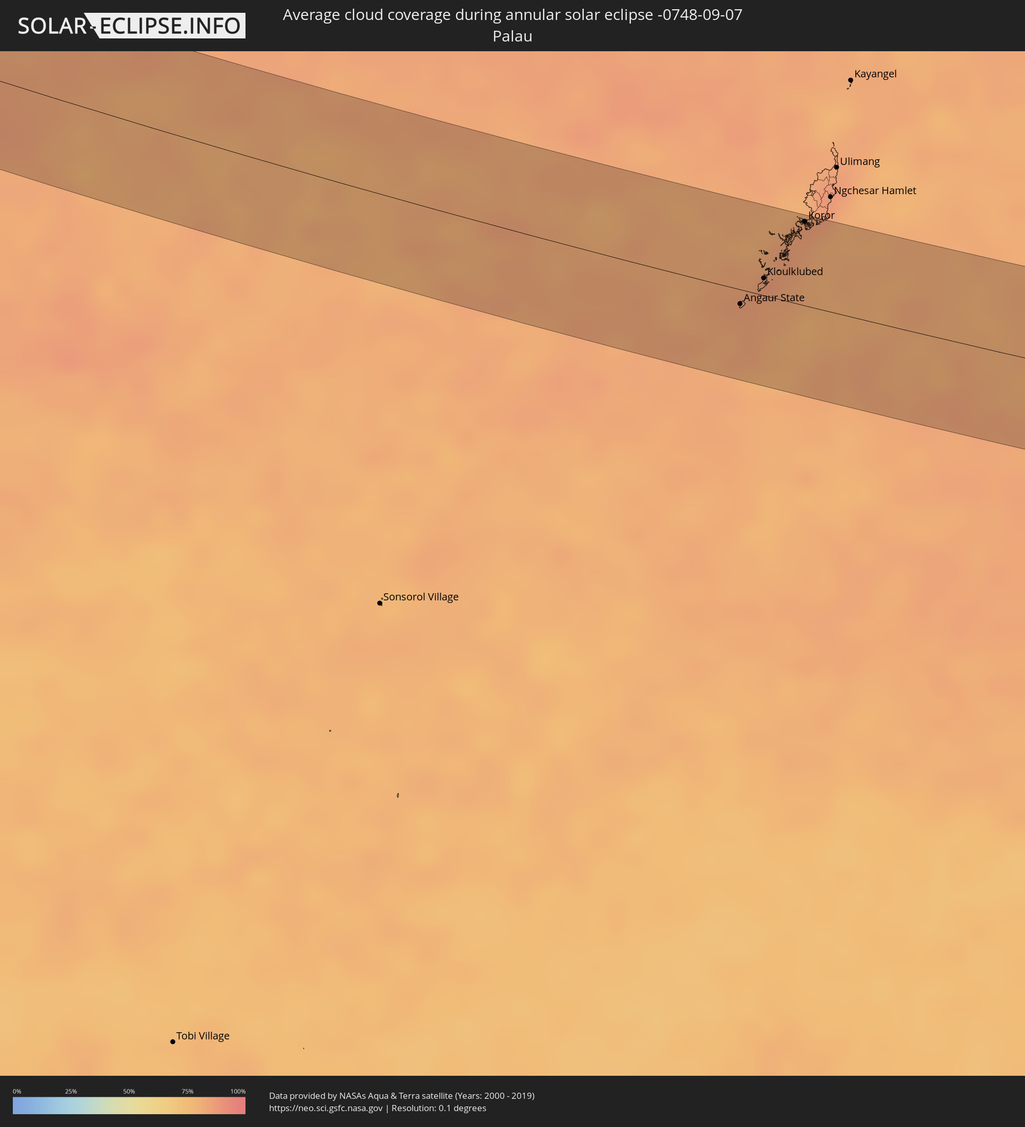 Palau
Palau
Cities inside the path of the eclipse
The following table shows all locations with a population of more than 5,000 inside the eclipse path. Cities which have more than 100,000 inhabitants are marked bold. A click at the locations opens a detailed map.
| City | Type | Eclipse duration | Local time of max. eclipse | Distance to central line | Ø Cloud coverage |
|
Florø, Sogn og Fjordane
|
annular | - | 06:36:43 UTC+01:00 | 50 km | 81% |
|
Ulsteinvik, Møre og Romsdal
|
annular | - | 06:37:38 UTC+01:00 | 23 km | 80% |
|
Volda, Møre og Romsdal
|
annular | - | 06:37:25 UTC+01:00 | 0 km | 81% |
|
Ørsta, Møre og Romsdal
|
annular | - | 06:37:29 UTC+01:00 | 5 km | 80% |
|
Ålesund, Møre og Romsdal
|
annular | - | 06:37:49 UTC+01:00 | 35 km | 79% |
|
Sundsvall, Västernorrland
|
annular | - | 06:39:29 UTC+01:00 | 38 km | 67% |
|
Timrå, Västernorrland
|
annular | - | 06:39:36 UTC+01:00 | 28 km | 67% |
|
Kramfors, Västernorrland
|
annular | - | 06:40:13 UTC+01:00 | 21 km | 67% |
|
Härnösand, Västernorrland
|
annular | - | 06:39:55 UTC+01:00 | 13 km | 67% |
|
Vaasa, Ostrobothnia
|
annular | - | 07:21:18 UTC+01:39 | 35 km | 64% |
|
Laihia, Ostrobothnia
|
annular | - | 07:21:17 UTC+01:39 | 22 km | 71% |
|
Kauhajoki, Southern Ostrobothnia
|
annular | - | 07:20:45 UTC+01:39 | 39 km | 71% |
|
Kurikka, Southern Ostrobothnia
|
annular | - | 07:21:02 UTC+01:39 | 18 km | 71% |
|
Jalasjärvi, Southern Ostrobothnia
|
annular | - | 07:21:01 UTC+01:39 | 31 km | 74% |
|
Seinäjoki, Southern Ostrobothnia
|
annular | - | 07:21:21 UTC+01:39 | 2 km | 70% |
|
Lapua, Southern Ostrobothnia
|
annular | - | 07:21:36 UTC+01:39 | 21 km | 73% |
|
Kauhava, Southern Ostrobothnia
|
annular | - | 07:21:46 UTC+01:39 | 36 km | 72% |
|
Alavus, Southern Ostrobothnia
|
annular | - | 07:21:24 UTC+01:39 | 21 km | 73% |
|
Alajärvi, Southern Ostrobothnia
|
annular | - | 07:21:55 UTC+01:39 | 26 km | 70% |
|
Saarijärvi, Central Finland
|
annular | - | 07:22:07 UTC+01:39 | 4 km | 71% |
|
Äänekoski, Central Finland
|
annular | - | 07:22:11 UTC+01:39 | 15 km | 71% |
|
Viitasaari, Central Finland
|
annular | - | 07:22:44 UTC+01:39 | 37 km | 67% |
|
Laukaa, Central Finland
|
annular | - | 07:22:05 UTC+01:39 | 35 km | 70% |
|
Suonenjoki, Northern Savo
|
annular | - | 07:22:46 UTC+01:39 | 9 km | 71% |
|
Kuopio, Northern Savo
|
annular | - | 07:23:16 UTC+01:39 | 24 km | 69% |
|
Leppävirta, Northern Savo
|
annular | - | 07:22:54 UTC+01:39 | 21 km | 70% |
|
Varkaus, Northern Savo
|
annular | - | 07:22:46 UTC+01:39 | 40 km | 70% |
|
Outokumpu, North Karelia
|
annular | - | 07:23:39 UTC+01:39 | 11 km | 71% |
|
Liperi, North Karelia
|
annular | - | 07:23:37 UTC+01:39 | 9 km | 72% |
|
Joensuu, North Karelia
|
annular | - | 07:23:52 UTC+01:39 | 1 km | 68% |
|
Kontiolahti, North Karelia
|
annular | - | 07:24:03 UTC+01:39 | 19 km | 68% |
|
Pyhäselkä, North Karelia
|
annular | - | 07:23:47 UTC+01:39 | 17 km | 72% |
|
Suoyarvi, Republic of Karelia
|
annular | - | 08:15:04 UTC+02:30 | 41 km | 73% |
|
Kondopoga, Republic of Karelia
|
annular | - | 08:16:09 UTC+02:30 | 13 km | 71% |
|
Pudozh, Republic of Karelia
|
annular | - | 08:17:03 UTC+02:30 | 37 km | 74% |
|
Nyandoma, Arkhangelskaya
|
annular | - | 08:19:08 UTC+02:30 | 12 km | 78% |
|
Mirnyy, Arkhangelskaya
|
annular | - | 08:21:47 UTC+02:30 | 13 km | 83% |
|
Velikiy Ustyug, Vologda
|
annular | - | 08:22:44 UTC+02:30 | 19 km | 83% |
|
Luza, Kirov
|
annular | - | 08:23:22 UTC+02:30 | 17 km | 86% |
|
Kudymkar, Perm
|
annular | - | 10:01:12 UTC+04:02 | 30 km | 83% |
|
Gubakha, Perm
|
annular | - | 10:03:50 UTC+04:02 | 25 km | 87% |
|
Chusovoy, Perm
|
annular | - | 10:04:03 UTC+04:02 | 21 km | 83% |
|
Gremyachinsk, Perm
|
annular | - | 10:04:06 UTC+04:02 | 6 km | 85% |
|
Gornozavodsk, Perm
|
annular | - | 10:04:32 UTC+04:02 | 0 km | 85% |
|
Baranchinskiy, Sverdlovsk
|
annular | - | 10:05:52 UTC+04:02 | 18 km | 83% |
|
Kushva, Sverdlovsk
|
annular | - | 10:05:55 UTC+04:02 | 32 km | 82% |
|
Nizhniy Tagil, Sverdlovsk
|
annular | - | 10:06:08 UTC+04:02 | 2 km | 82% |
|
Verkhnyaya Salda, Sverdlovsk
|
annular | - | 10:06:43 UTC+04:02 | 31 km | 82% |
|
Rezh, Sverdlovsk
|
annular | - | 10:07:38 UTC+04:02 | 9 km | 80% |
|
Reftinskiy, Sverdlovsk
|
annular | - | 10:07:57 UTC+04:02 | 27 km | 80% |
|
Artëmovskiy, Sverdlovsk
|
annular | - | 10:08:06 UTC+04:02 | 4 km | 79% |
|
Bulanash, Sverdlovsk
|
annular | - | 10:08:15 UTC+04:02 | 0 km | 78% |
|
Kamyshlov, Sverdlovsk
|
annular | - | 10:09:04 UTC+04:02 | 19 km | 77% |
|
Talitsa, Sverdlovsk
|
annular | - | 10:10:06 UTC+04:02 | 30 km | 76% |
|
Petukhovo, Kurgan
|
annular | - | 10:15:22 UTC+04:02 | 4 km | 67% |
|
Bishkul, Soltüstik Qazaqstan
|
annular | - | 10:36:13 UTC+04:21 | 15 km | 70% |
|
Petropavl, Soltüstik Qazaqstan
|
annular | - | 10:36:14 UTC+04:21 | 25 km | 69% |
|
Smirnovo, Soltüstik Qazaqstan
|
annular | - | 10:36:45 UTC+04:21 | 5 km | 66% |
|
Bestobe, Aqmola
|
annular | - | 10:42:35 UTC+04:21 | 19 km | 54% |
|
Ekibastuz, Pavlodar
|
annular | - | 10:46:04 UTC+04:21 | 17 km | 43% |
|
Mayqayyng, Pavlodar
|
annular | - | 10:46:56 UTC+04:21 | 18 km | 44% |
|
Qaraūyl, East Kazakhstan
|
annular | - | 10:54:12 UTC+04:21 | 13 km | 35% |
|
Zhongshu, Yunnan
|
annular | - | 15:52:09 UTC+08:00 | 25 km | 86% |
|
Thành Phố Cao Bằng, Cao Bằng
|
annular | - | 15:05:23 UTC+07:06 | 24 km | 85% |
|
Thành Phố Lạng Sơn, Lạng Sơn
|
annular | - | 15:07:35 UTC+07:06 | 1 km | 91% |
|
Cẩm Phả Mines, Quảng Ninh
|
annular | - | 15:09:50 UTC+07:06 | 27 km | 87% |
|
Wanning, Hainan
|
annular | - | 16:10:27 UTC+08:00 | 12 km | 78% |
|
Tigbauan, Western Visayas
|
annular | - | 16:32:07 UTC+08:00 | 42 km | 86% |
|
Janiuay, Western Visayas
|
annular | - | 16:31:44 UTC+08:00 | 8 km | 93% |
|
Iloilo, Western Visayas
|
annular | - | 16:32:09 UTC+08:00 | 31 km | 86% |
|
Passi, Western Visayas
|
annular | - | 16:31:33 UTC+08:00 | 14 km | 92% |
|
Barotac Nuevo, Western Visayas
|
annular | - | 16:31:54 UTC+08:00 | 5 km | 87% |
|
Bago City, Western Visayas
|
annular | - | 16:32:30 UTC+08:00 | 35 km | 84% |
|
La Carlota, Western Visayas
|
annular | - | 16:32:42 UTC+08:00 | 42 km | 88% |
|
Bacolod City, Western Visayas
|
annular | - | 16:32:20 UTC+08:00 | 16 km | 94% |
|
Victorias, Western Visayas
|
annular | - | 16:32:01 UTC+08:00 | 13 km | 91% |
|
Canlaon, Central Visayas
|
annular | - | 16:32:52 UTC+08:00 | 32 km | 93% |
|
Cadiz, Western Visayas
|
annular | - | 16:32:02 UTC+08:00 | 28 km | 94% |
|
Ualog, Western Visayas
|
annular | - | 16:32:38 UTC+08:00 | 5 km | 90% |
|
Escalante, Western Visayas
|
annular | - | 16:32:16 UTC+08:00 | 26 km | 87% |
|
Toledo, Central Visayas
|
annular | - | 16:33:01 UTC+08:00 | 15 km | 85% |
|
Carcar, Central Visayas
|
annular | - | 16:33:25 UTC+08:00 | 42 km | 89% |
|
Balamban, Central Visayas
|
annular | - | 16:32:51 UTC+08:00 | 2 km | 87% |
|
Naga, Central Visayas
|
annular | - | 16:33:18 UTC+08:00 | 26 km | 87% |
|
Cebu City, Central Visayas
|
annular | - | 16:33:11 UTC+08:00 | 10 km | 89% |
|
Tibigan, Central Visayas
|
annular | - | 16:33:45 UTC+08:00 | 44 km | 90% |
|
Danao, Central Visayas
|
annular | - | 16:32:56 UTC+08:00 | 17 km | 88% |
|
Maasin, Eastern Visayas
|
annular | - | 16:33:46 UTC+08:00 | 13 km | 84% |
|
Surigao, Caraga
|
annular | - | 16:34:27 UTC+08:00 | 5 km | 83% |
|
Tandag, Caraga
|
annular | - | 16:35:39 UTC+08:00 | 41 km | 74% |
|
Angaur State, Angaur
|
annular | - | 17:39:29 UTC+09:00 | 8 km | 82% |
|
Kloulklubed, Peleliu
|
annular | - | 17:39:19 UTC+09:00 | 10 km | 81% |
|
Koror, Koror
|
annular | - | 17:38:57 UTC+09:00 | 48 km | 82% |
|
Koror Town, Koror
|
annular | - | 17:38:57 UTC+09:00 | 48 km | 82% |
|
Ngetkib, Airai
|
annular | - | 17:38:55 UTC+09:00 | 51 km | 84% |