Annular solar eclipse of 11/18/-0798
| Day of week: | Saturday |
| Maximum duration of eclipse: | 10m53s |
| Maximum width of eclipse path: | 304 km |
| Saros cycle: | 49 |
| Coverage: | 92.3% |
| Magnitude: | 0.9225 |
| Gamma: | 0.2717 |
Wo kann man die Sonnenfinsternis vom 11/18/-0798 sehen?
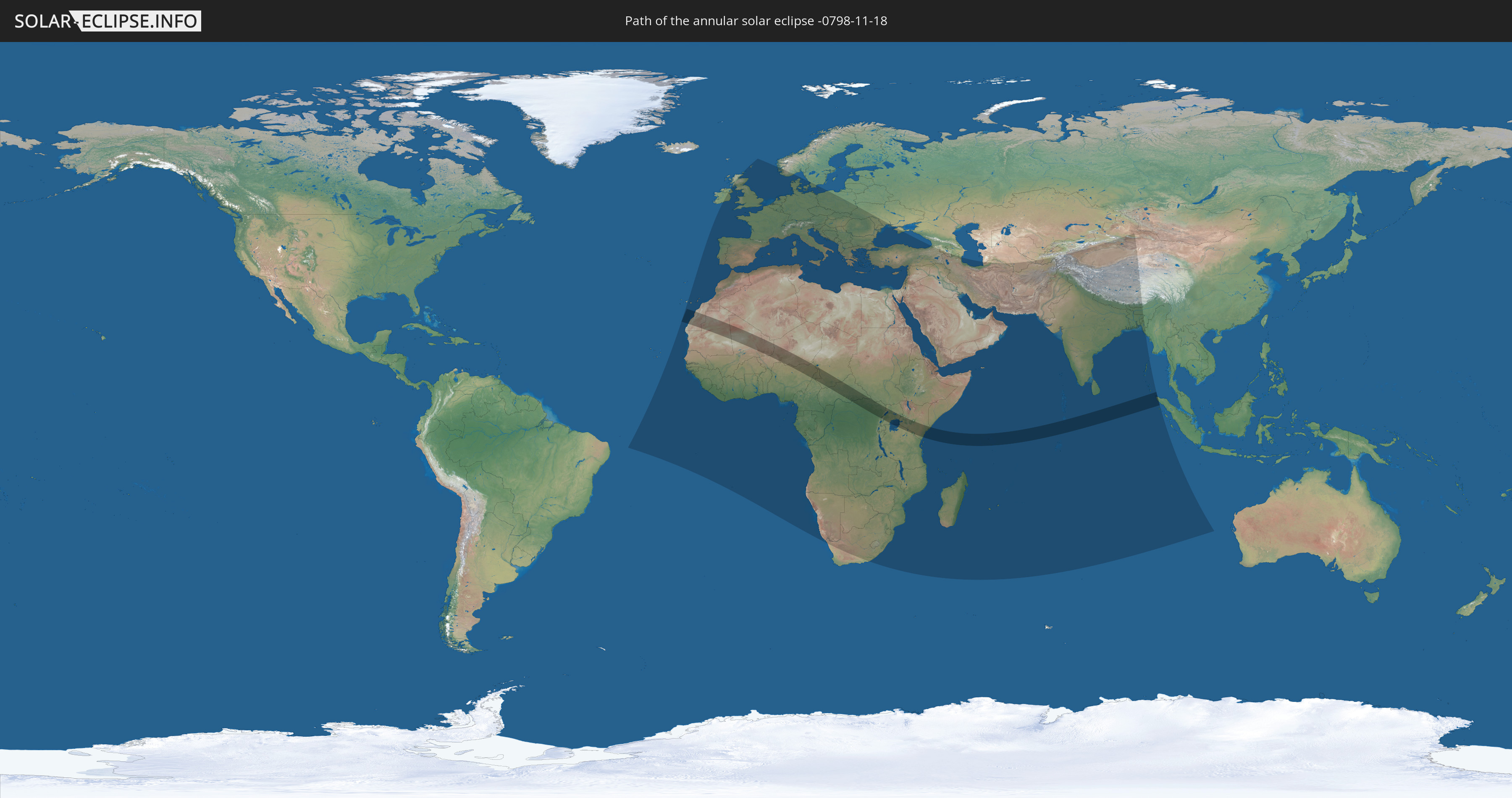
Die Sonnenfinsternis am 11/18/-0798 kann man in 133 Ländern als partielle Sonnenfinsternis beobachten.
Der Finsternispfad verläuft durch 15 Länder. Nur in diesen Ländern ist sie als annular Sonnenfinsternis zu sehen.
In den folgenden Ländern ist die Sonnenfinsternis annular zu sehen
 Mauritania
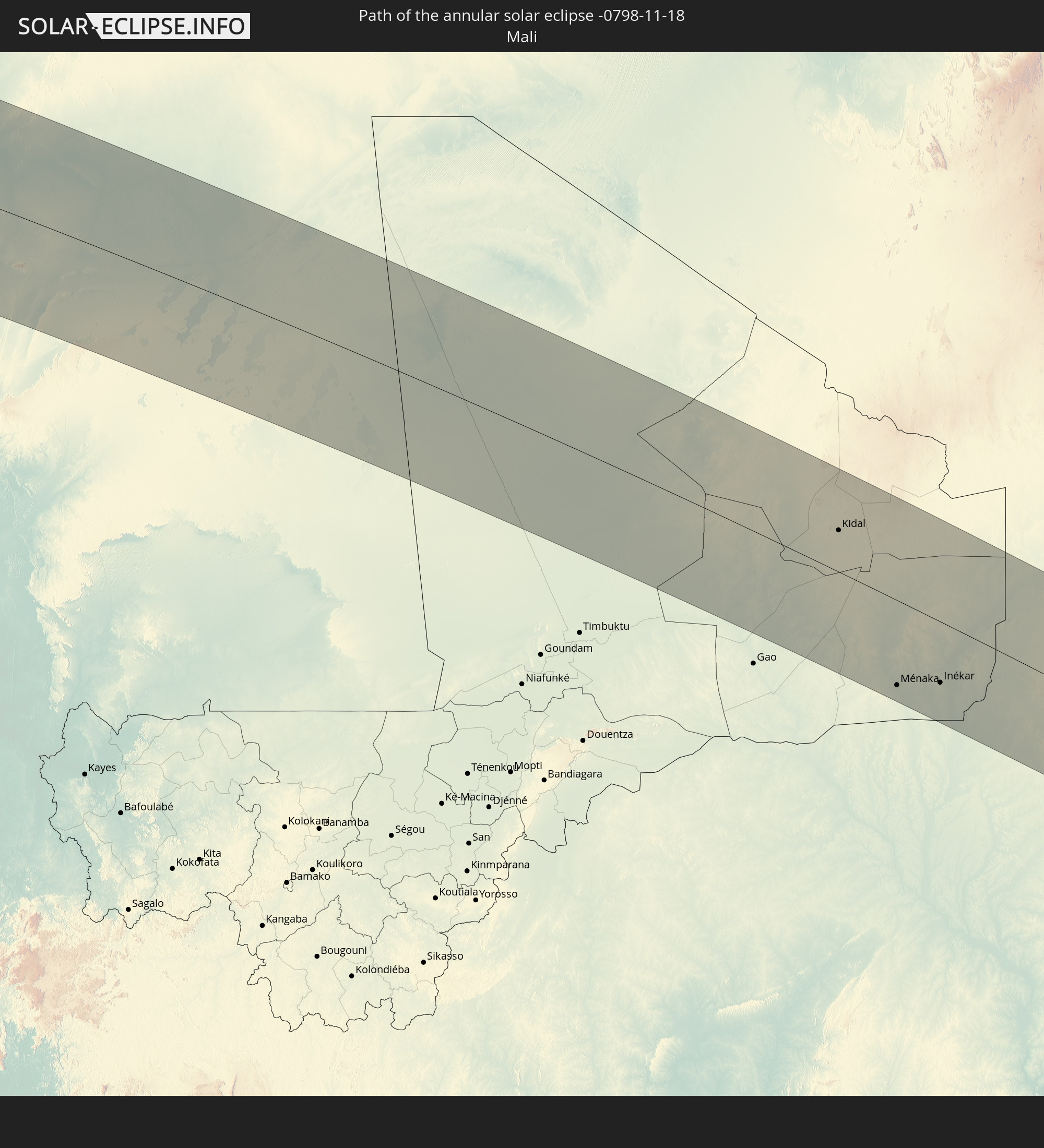 Mali
Mali
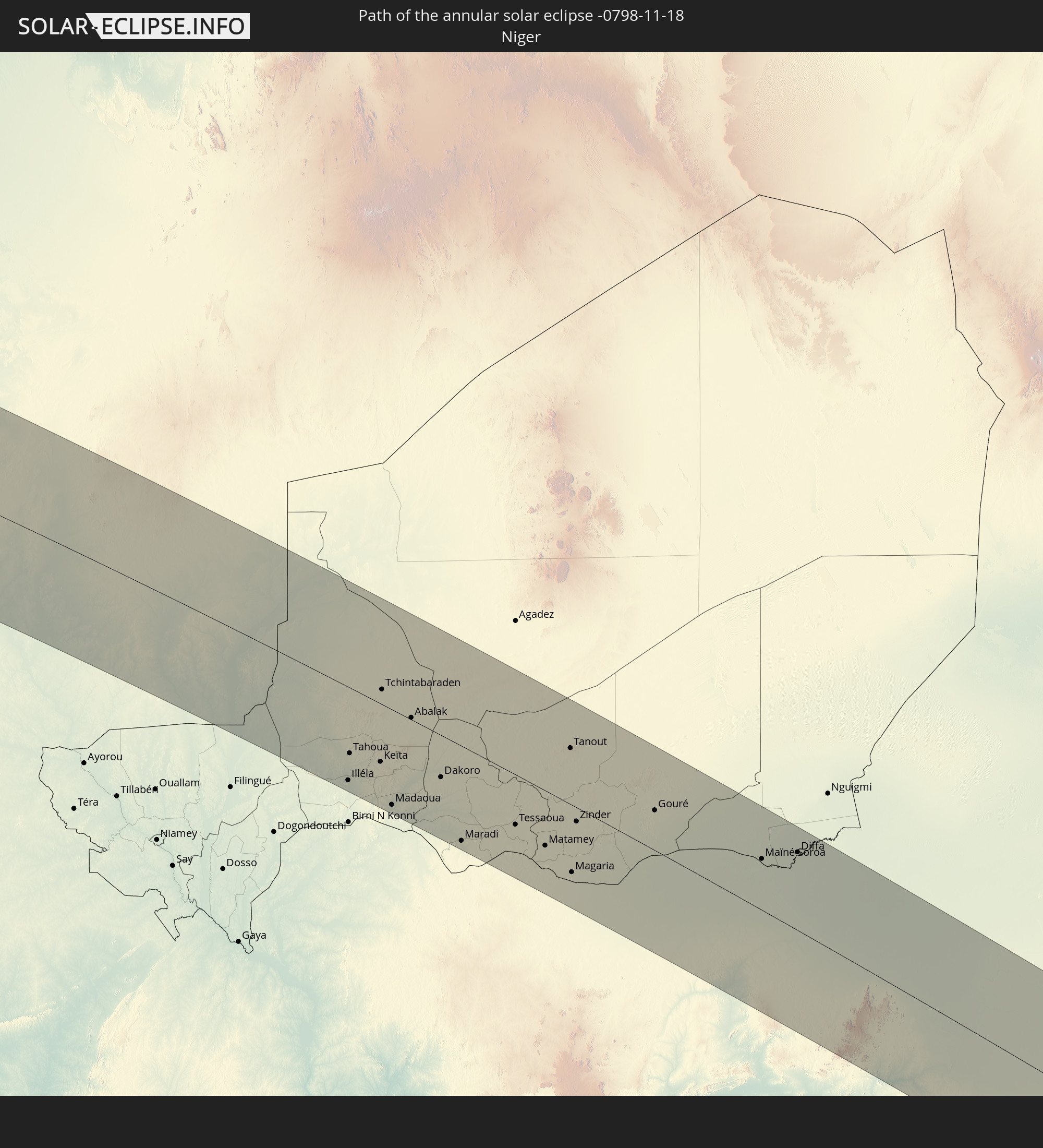 Niger
Niger
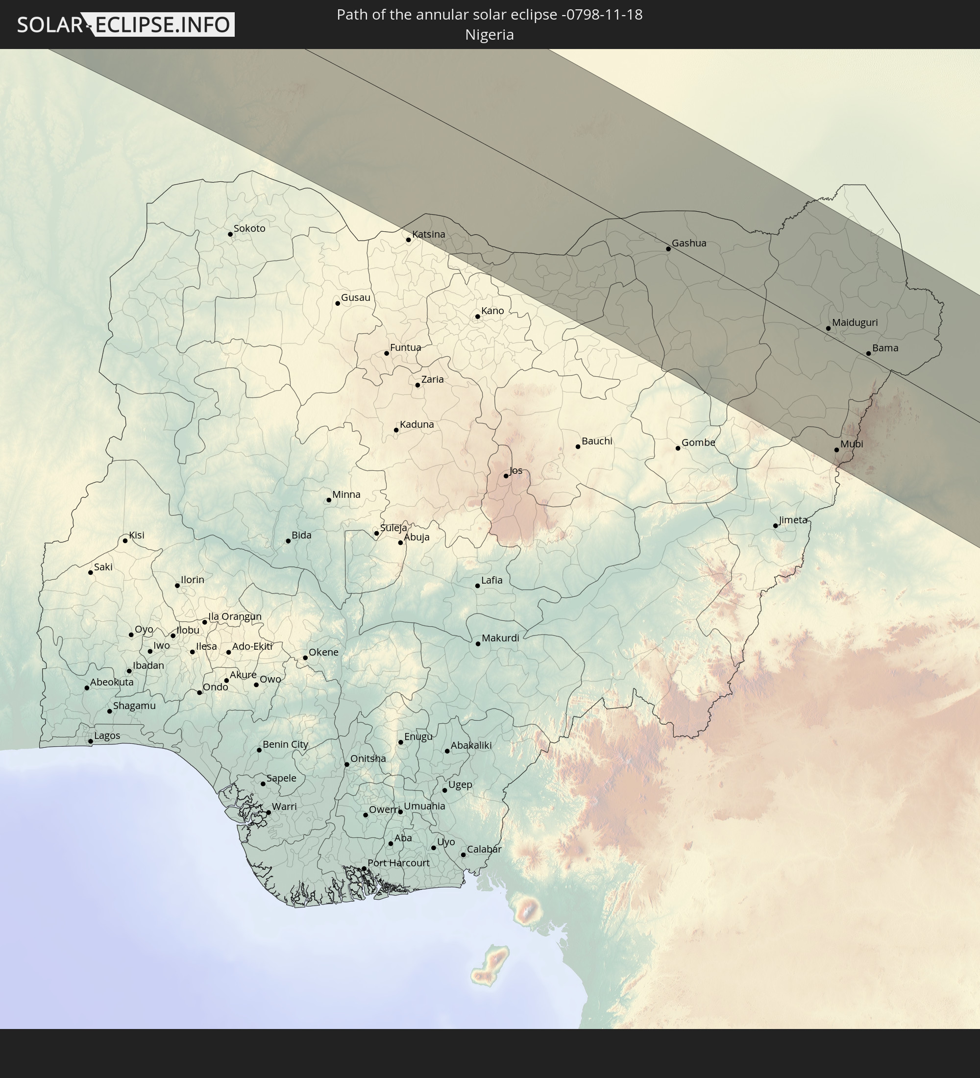 Nigeria
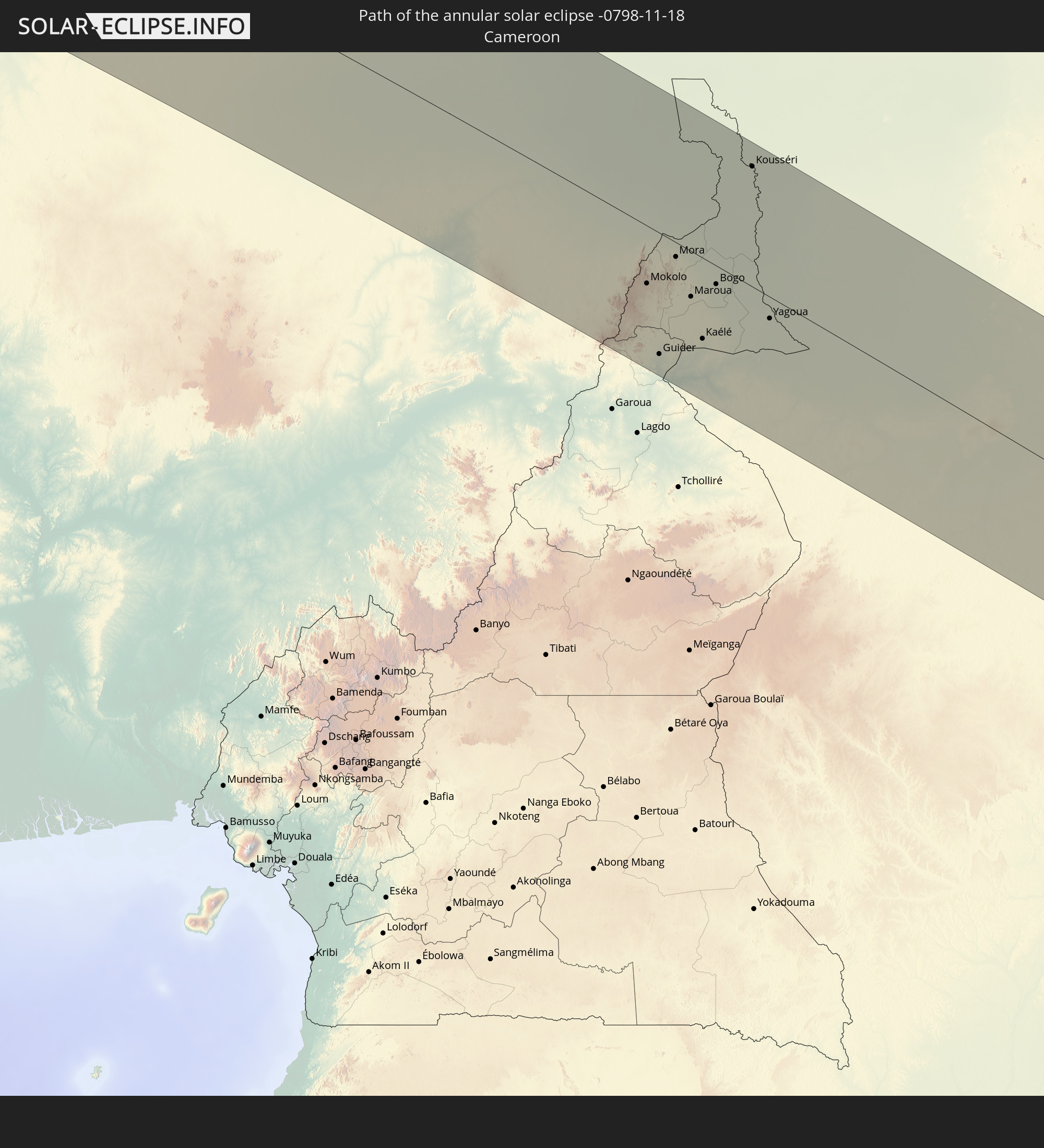 Cameroon
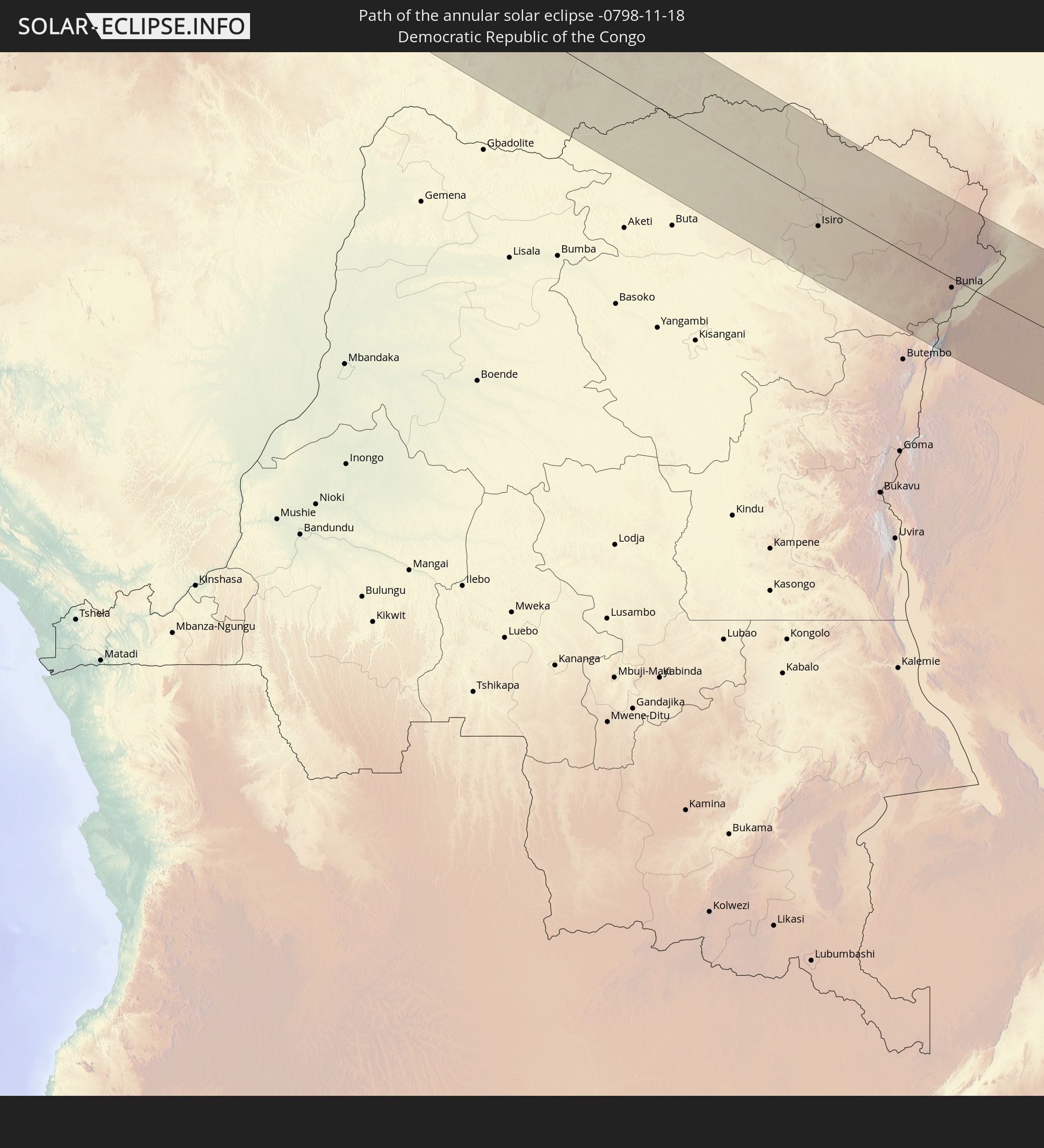 Democratic Republic of the Congo
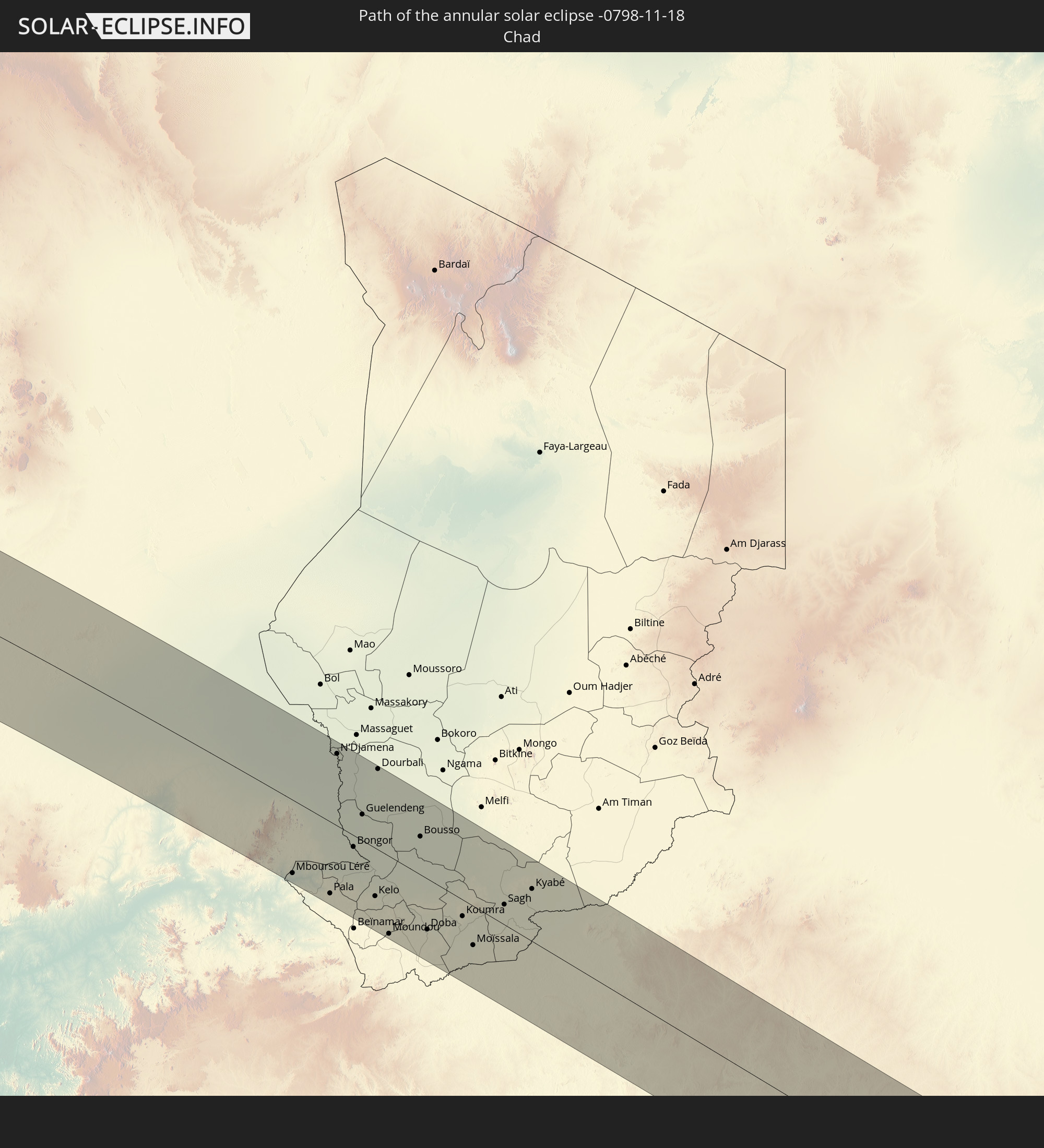 Chad
Chad
 Central African Republic
 South Sudan
 Tanzania
 Uganda
 Kenya
Kenya
 Seychelles
 Maldives
 Indonesia
In den folgenden Ländern ist die Sonnenfinsternis partiell zu sehen
 Portugal
 Spain
Spain
 Senegal
 Mauritania
 The Gambia
 Guinea-Bissau
 Guinea
 Saint Helena, Ascension and Tristan da Cunha
 Sierra Leone
 Morocco
 Mali
Mali
 Liberia
 Republic of Ireland
 Algeria
 United Kingdom
 Ivory Coast
 Burkina Faso
 Gibraltar
 France
 Isle of Man
 Ghana
Ghana
 Guernsey
 Jersey
 Togo
Togo
 Niger
Niger
 Benin
Benin
 Andorra
 Belgium
 Nigeria
 Netherlands
 Norway
 Equatorial Guinea
 Luxembourg
 Germany
 Switzerland
 São Tomé and Príncipe
 Italy
Italy
 Monaco
 Tunisia
 Denmark
 Cameroon
 Gabon
Gabon
 Libya
Libya
 Liechtenstein
 Austria
 Sweden
 Republic of the Congo
 Angola
 Namibia
 Czechia
 Democratic Republic of the Congo
 San Marino
 Vatican City
 Slovenia
 Chad
Chad
 Croatia
 Poland
 Malta
Malta
 Central African Republic
 Bosnia and Herzegovina
 Hungary
 South Africa
 Slovakia
 Montenegro
 Serbia
 Albania
 Greece
 Botswana
 Romania
 Republic of Macedonia
 Sudan
Sudan
 Zambia
 Ukraine
 Bulgaria
 Egypt
Egypt
 Zimbabwe
 Turkey
 Moldova
 Lesotho
 Rwanda
 Burundi
 Tanzania
 Uganda
 Mozambique
 Swaziland
 Cyprus
 Malawi
 Ethiopia
 Kenya
Kenya
 State of Palestine
 Israel
 Saudi Arabia
 Jordan
 Lebanon
 Syria
Syria
 Eritrea
 Iraq
Iraq
 Georgia
 French Southern and Antarctic Lands
 Somalia
 Djibouti
 Yemen
Yemen
 Madagascar
 Comoros
 Armenia
 Iran
Iran
 Azerbaijan
 Mayotte
 Seychelles
 Kuwait
 Bahrain
 Qatar
Qatar
 United Arab Emirates
 Oman
Oman
 Turkmenistan
 Réunion
 Uzbekistan
 Mauritius
 Afghanistan
 Pakistan
 Tajikistan
 India
India
 Kyrgyzstan
 British Indian Ocean Territory
 Maldives
 China
China
 Sri Lanka
 Nepal
Nepal
 Bangladesh
 Bhutan
 Myanmar
 Indonesia
 Cocos Islands
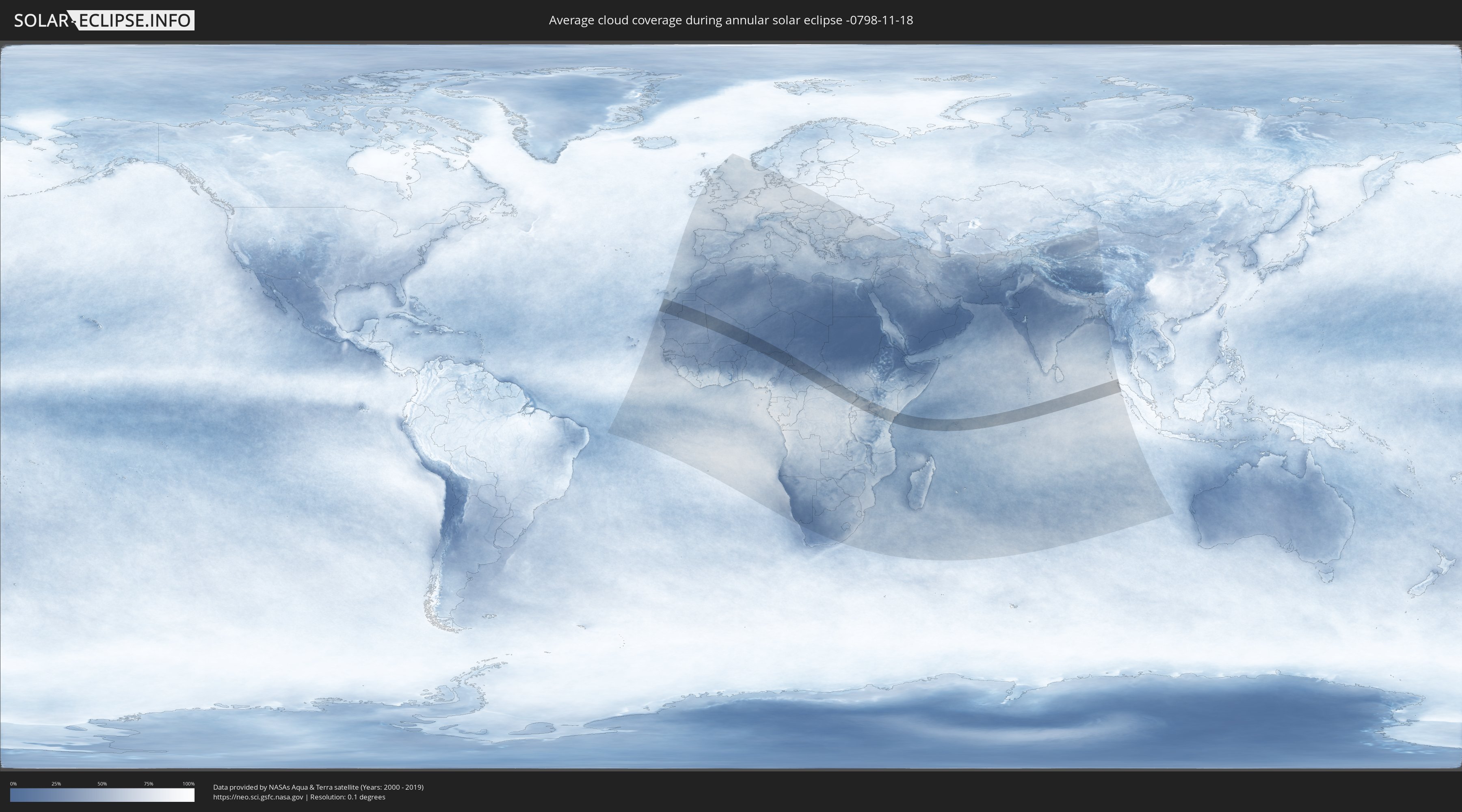
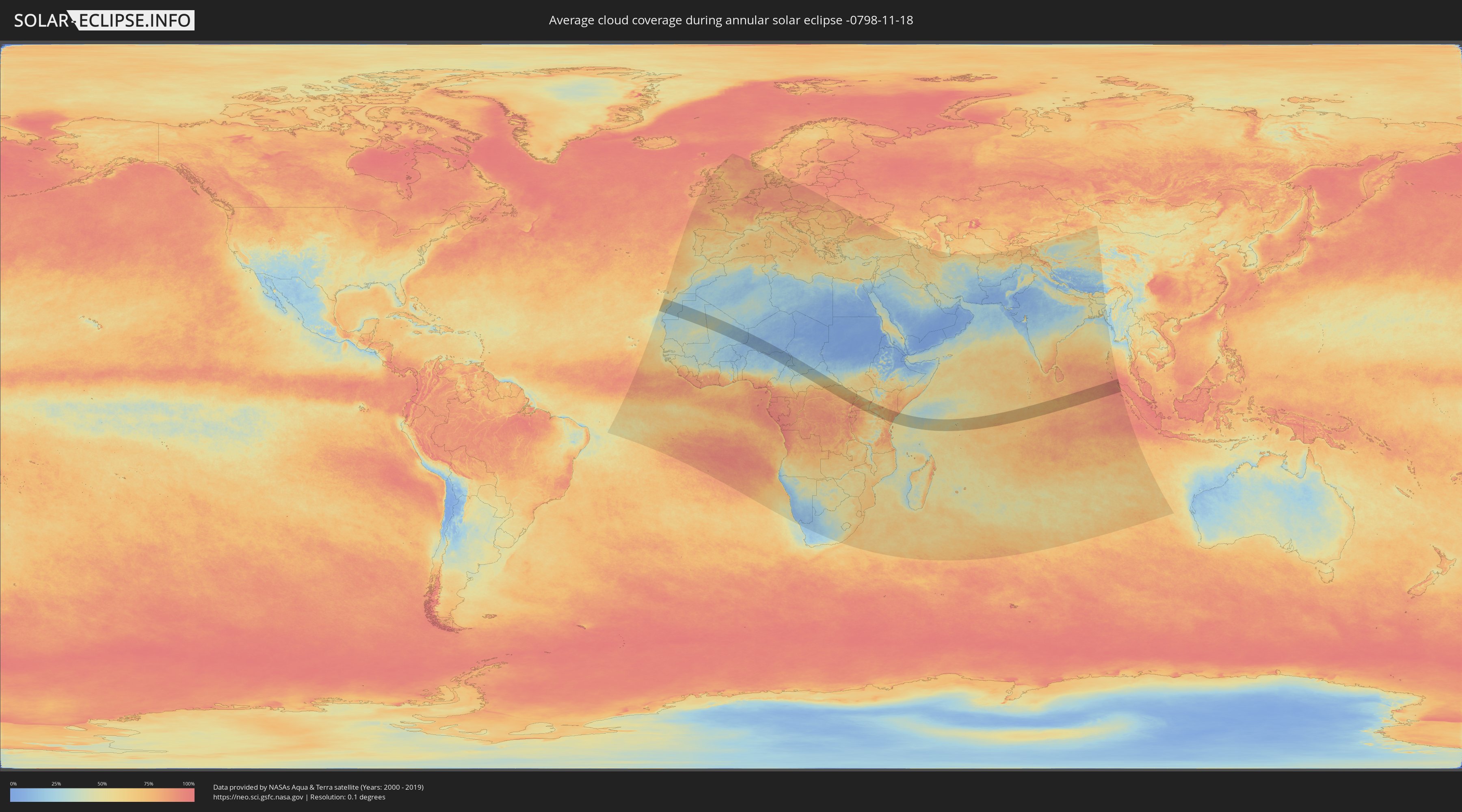
How will be the weather during the annular solar eclipse on 11/18/-0798?
Where is the best place to see the annular solar eclipse of 11/18/-0798?
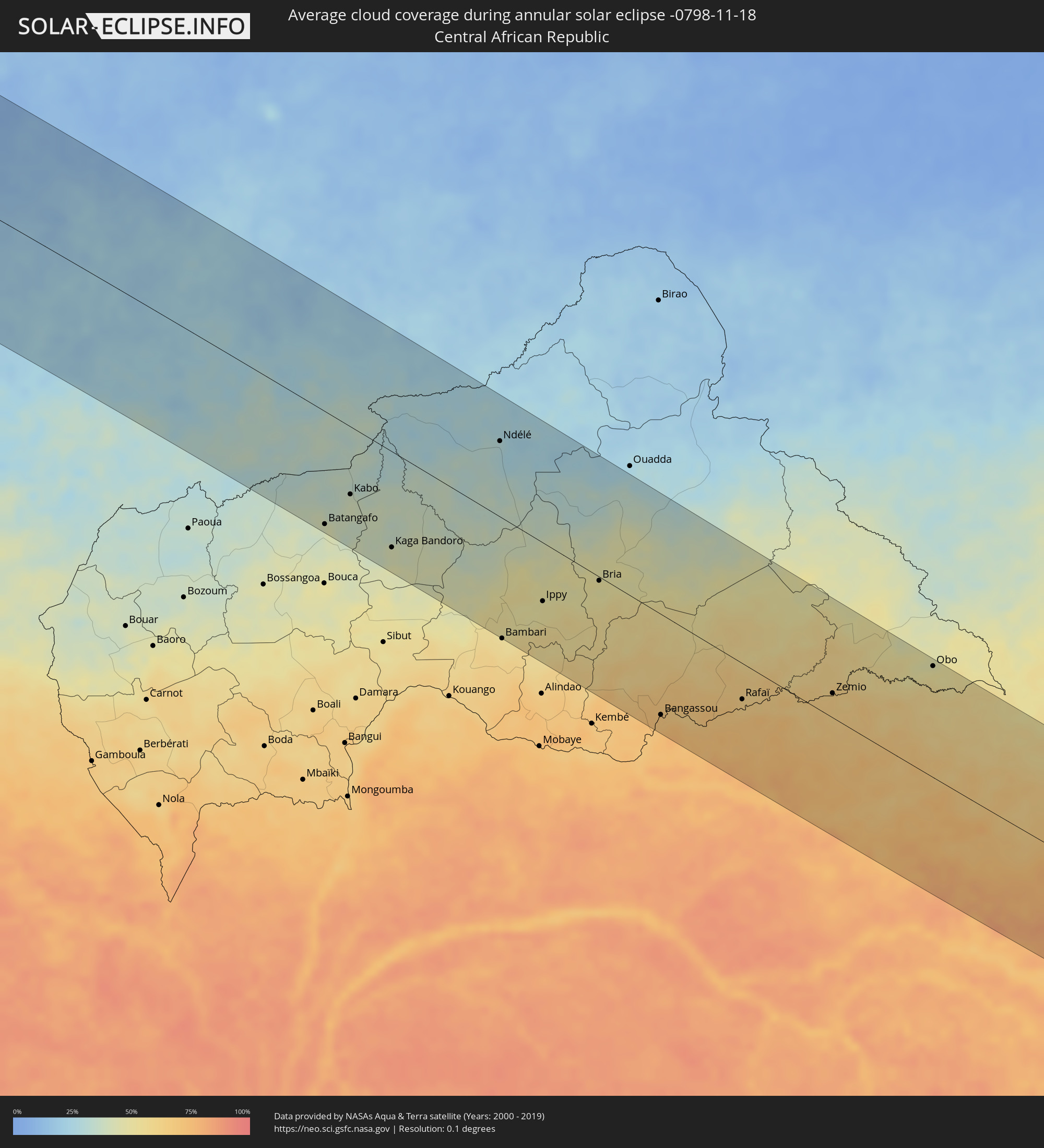
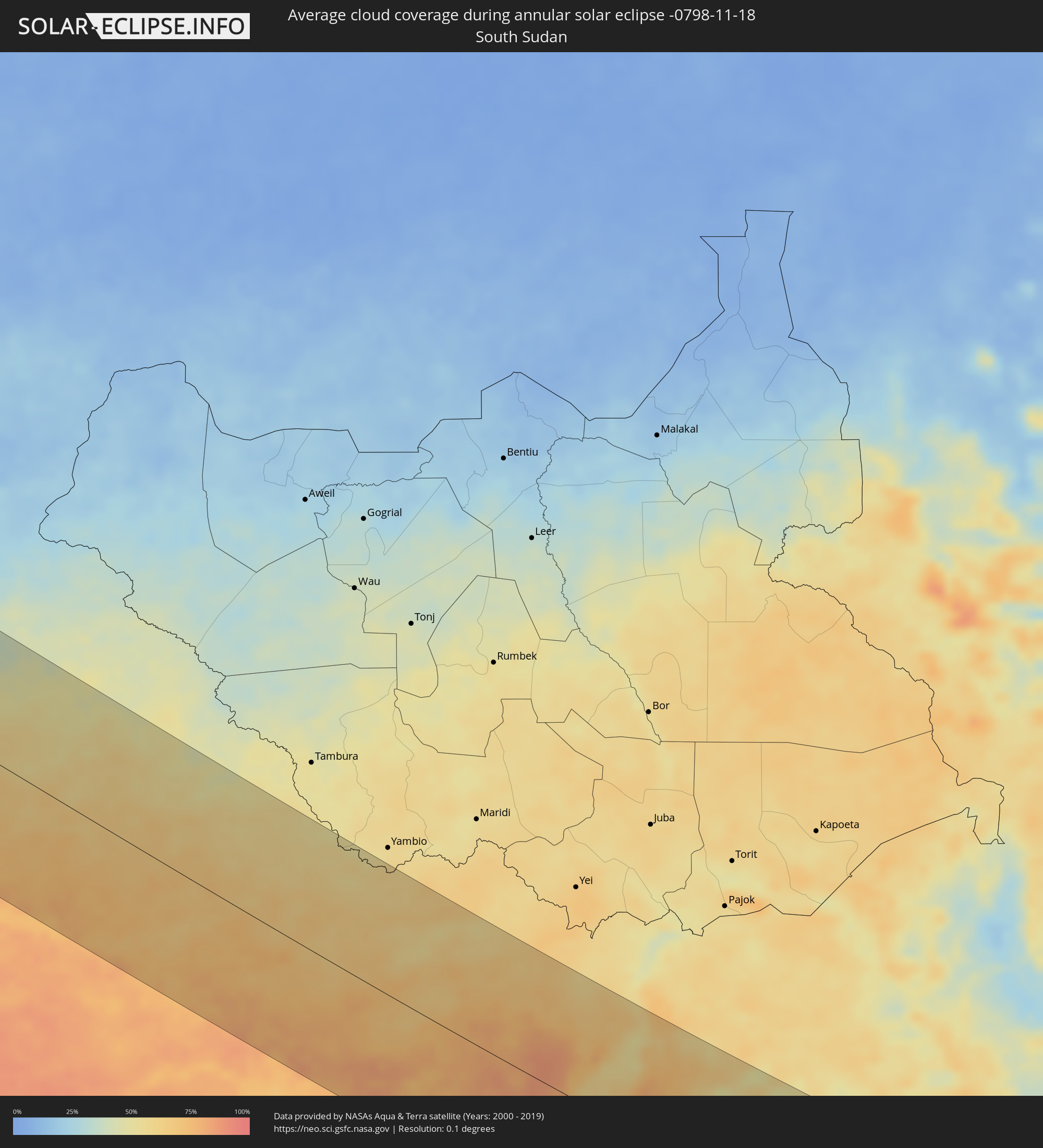
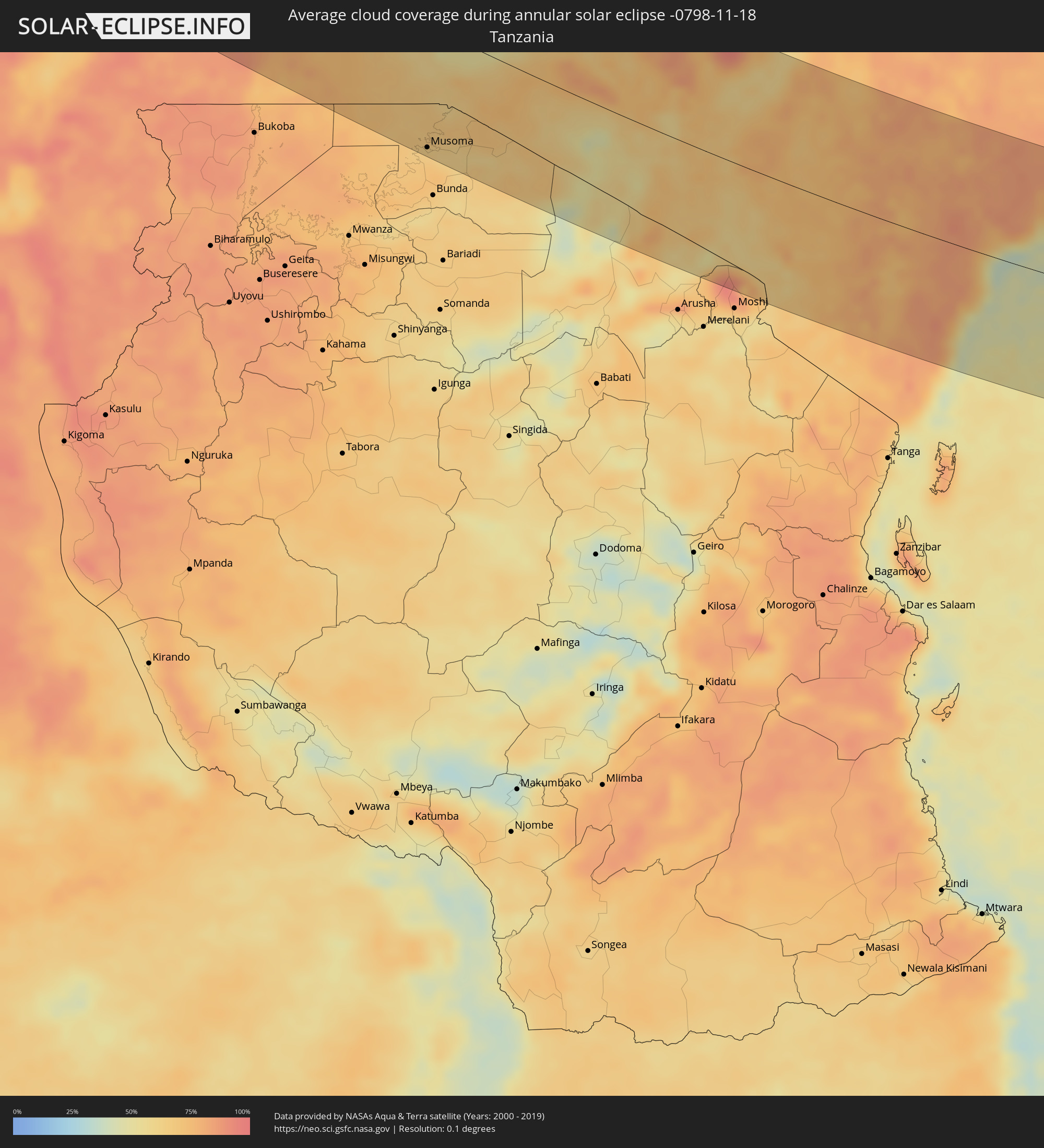
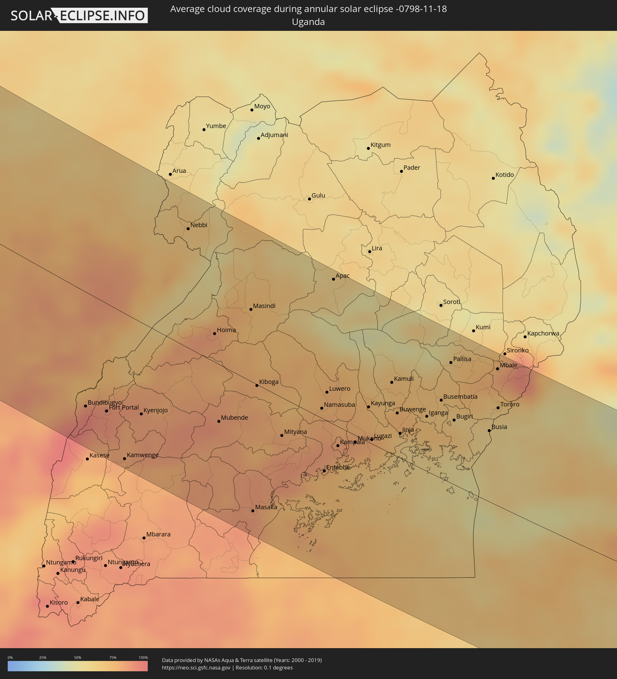
The following maps show the average cloud coverage for the day of the annular solar eclipse.
With the help of these maps, it is possible to find the place along the eclipse path, which has the best
chance of a cloudless sky.
Nevertheless, you should consider local circumstances and inform about the weather of your chosen
observation site.
The data is provided by NASAs satellites
AQUA and TERRA.
The cloud maps are averaged over a period of 19 years (2000 - 2019).
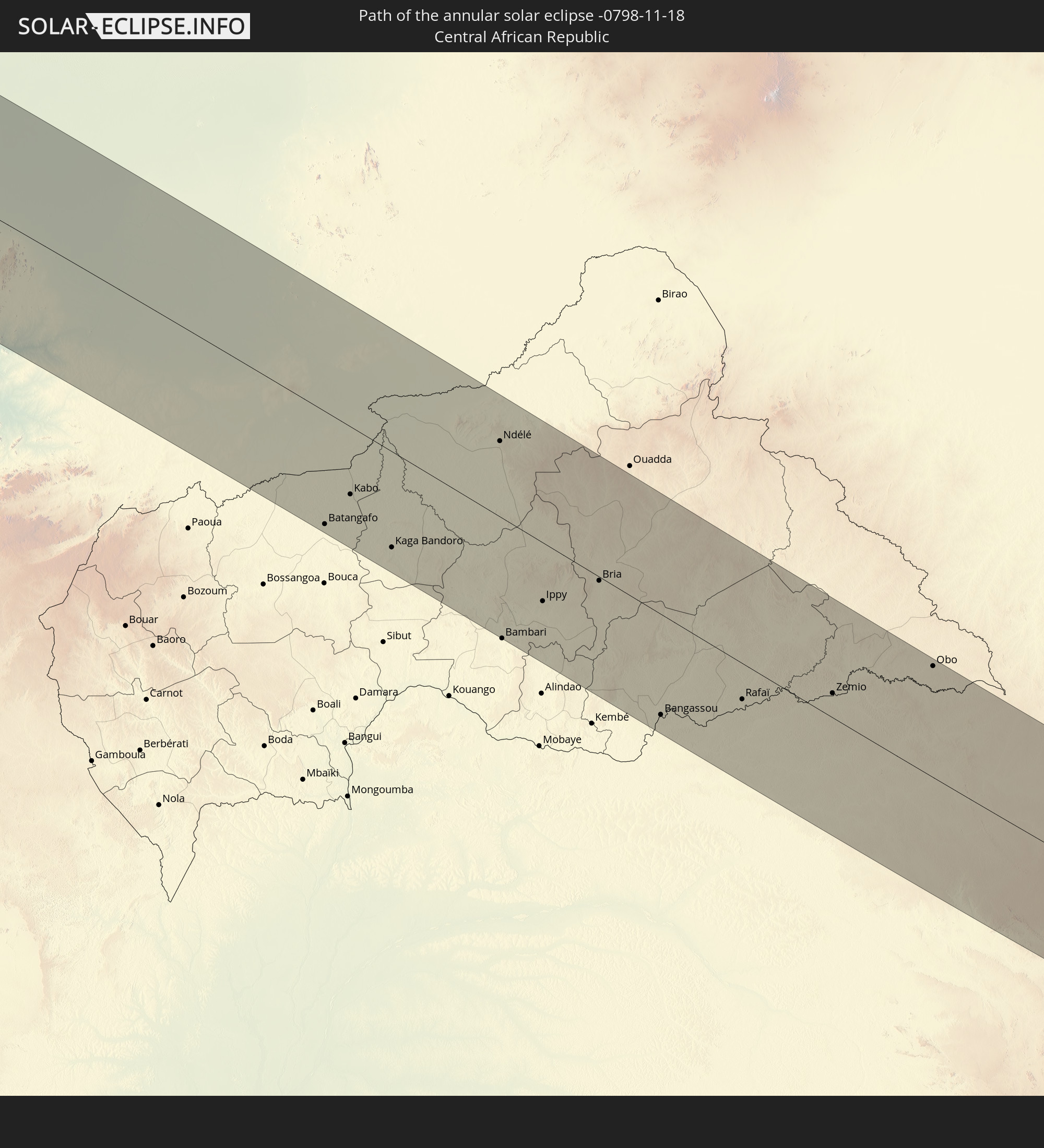
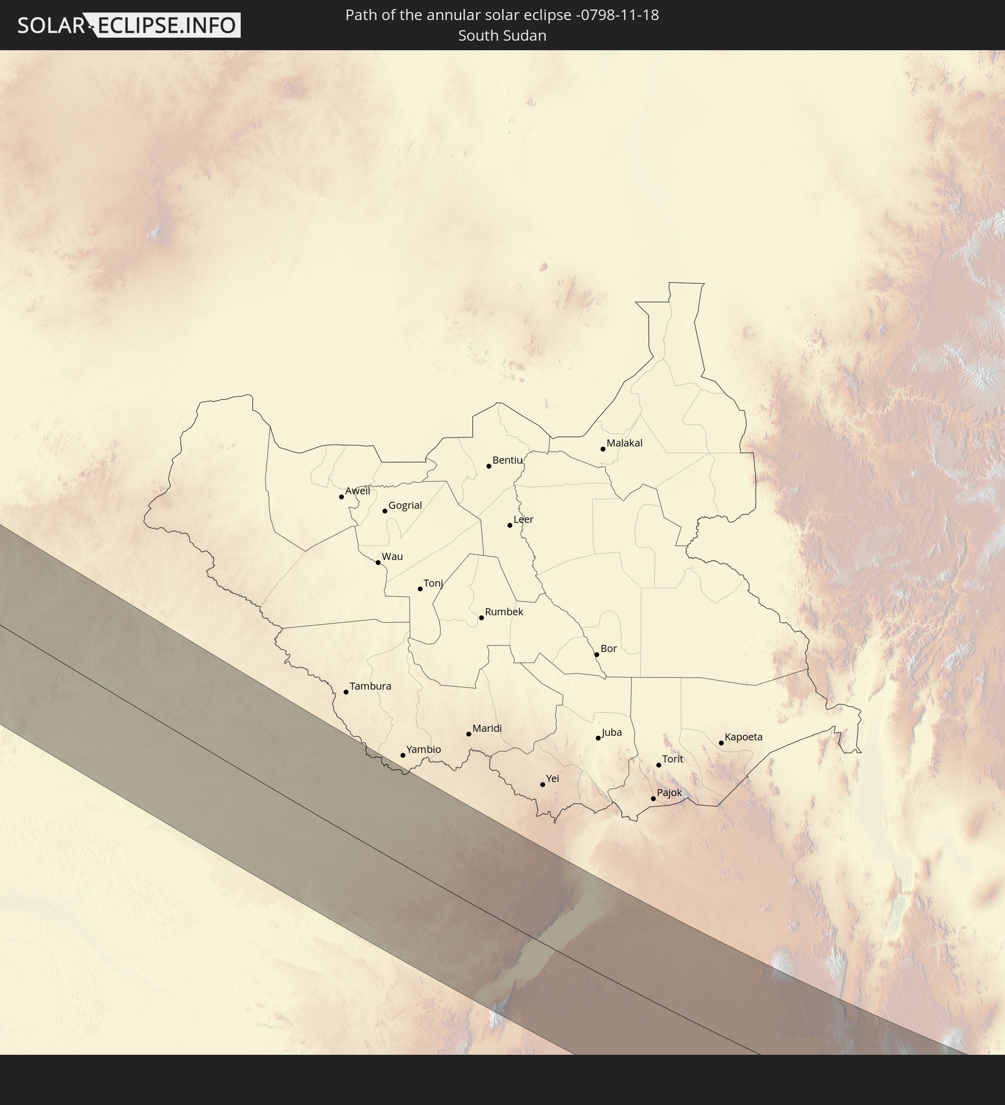
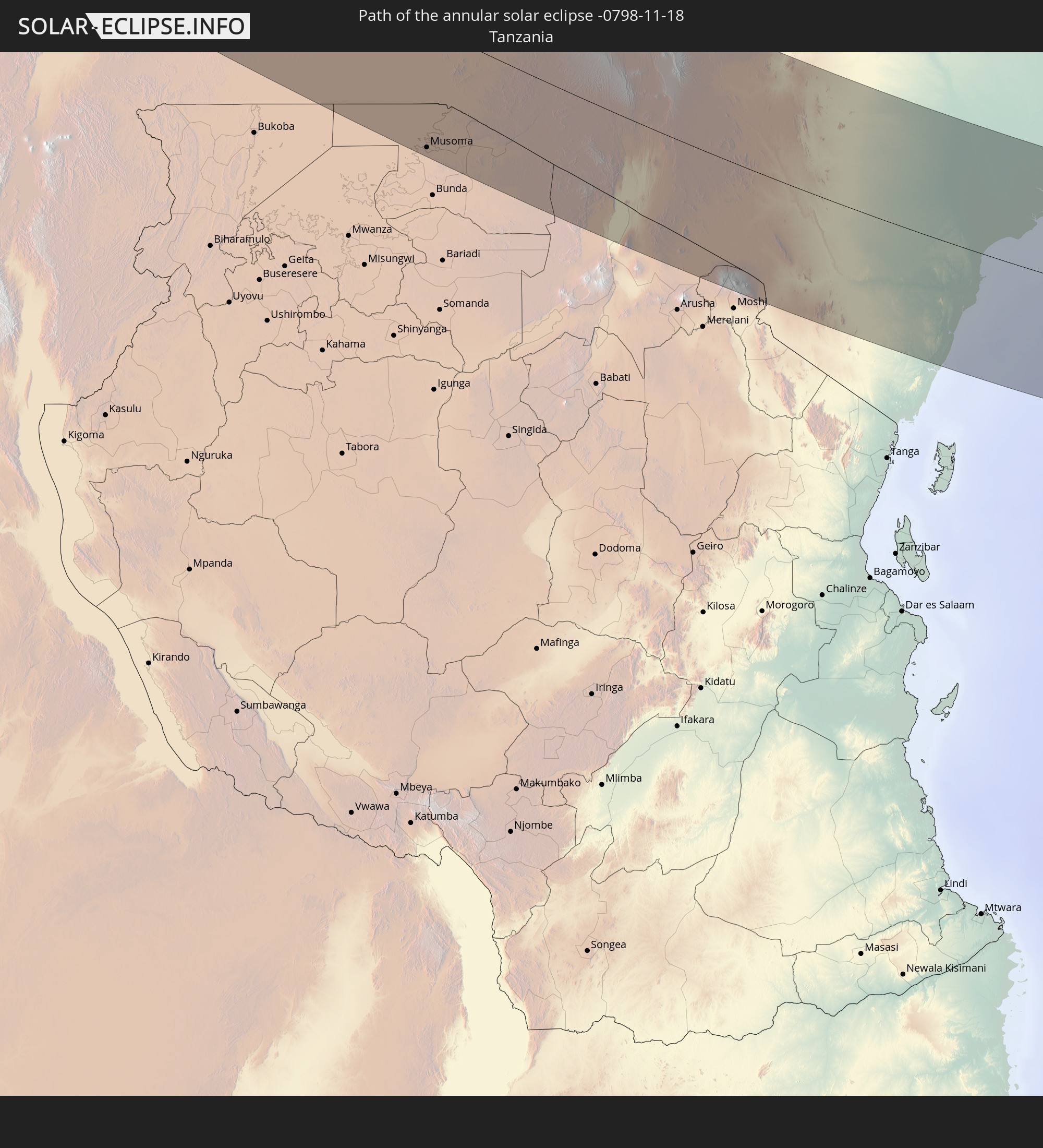
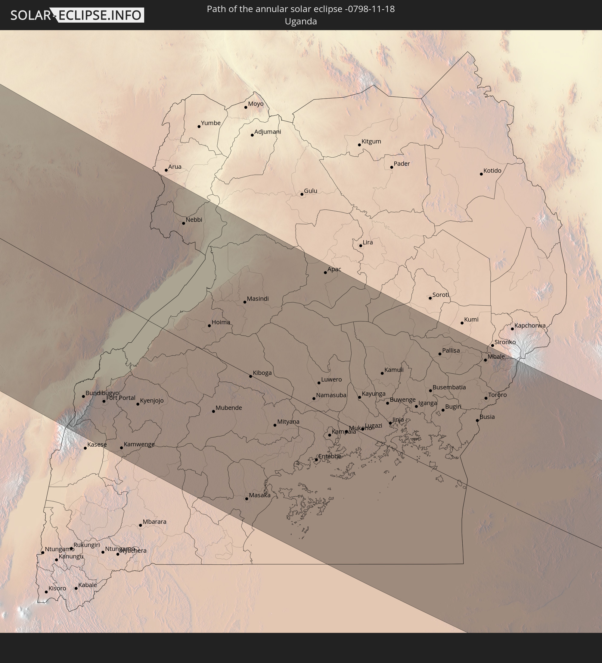
Detailed country maps
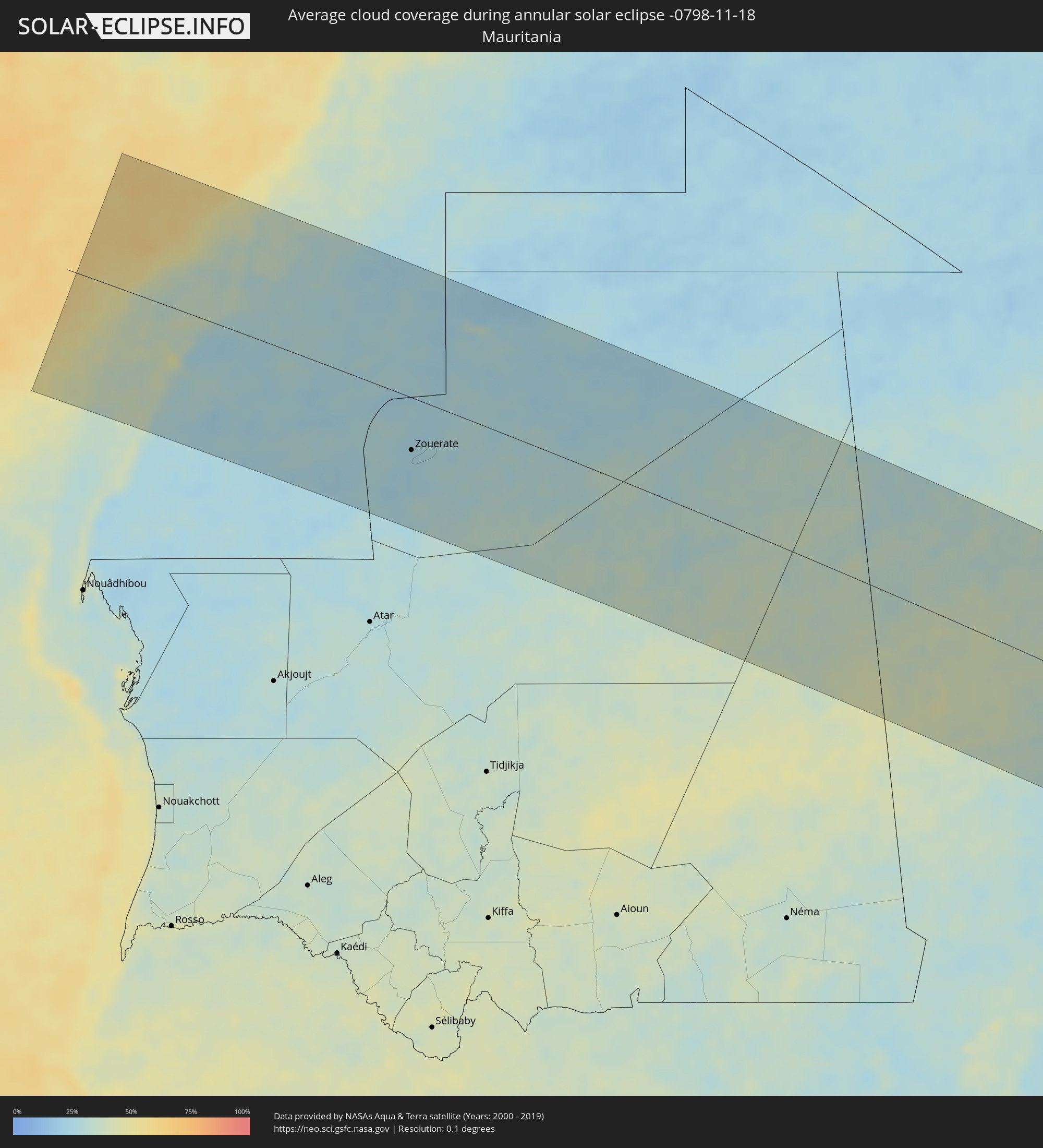 Mauritania
 Mali
Mali
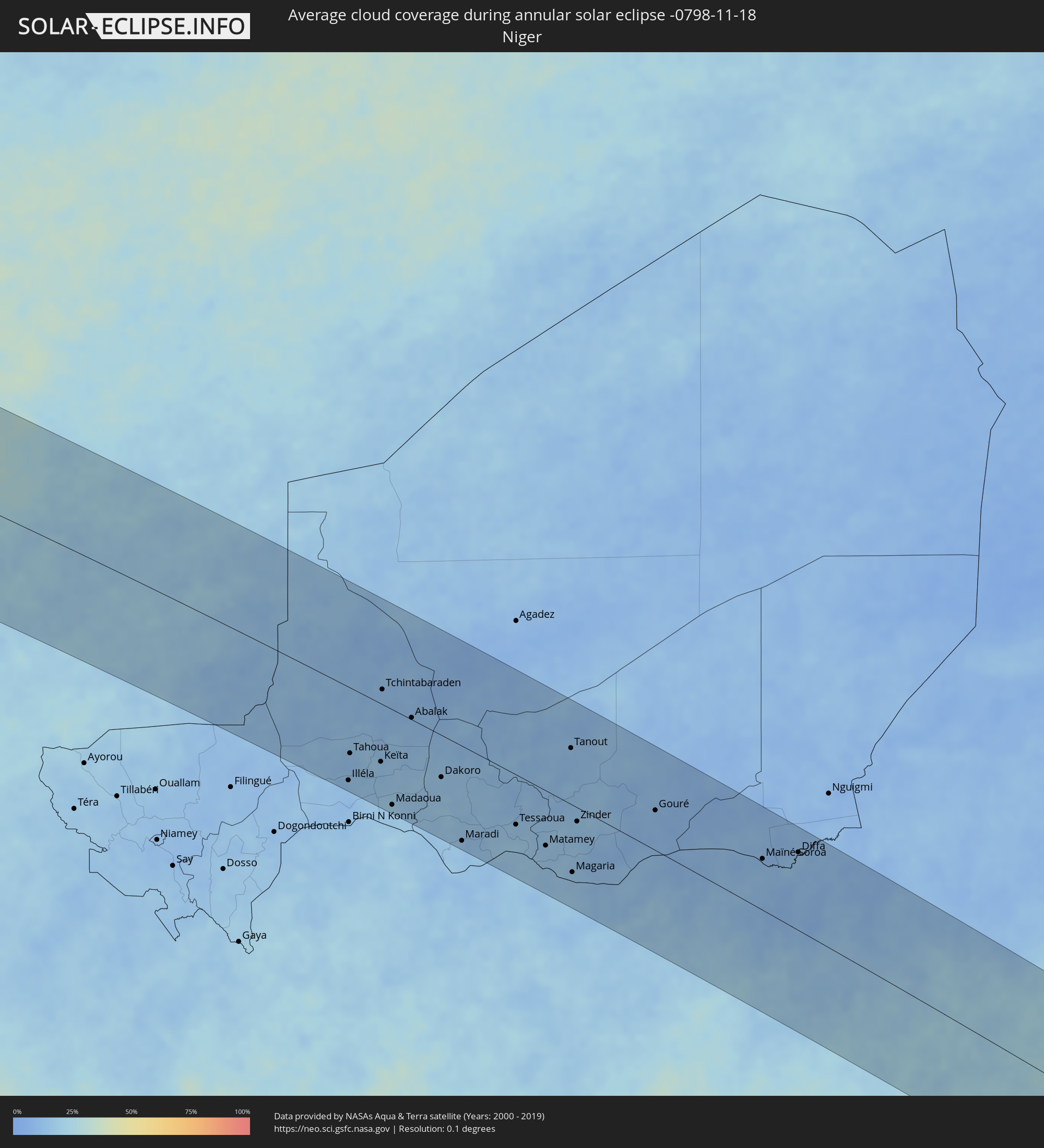 Niger
Niger
 Nigeria
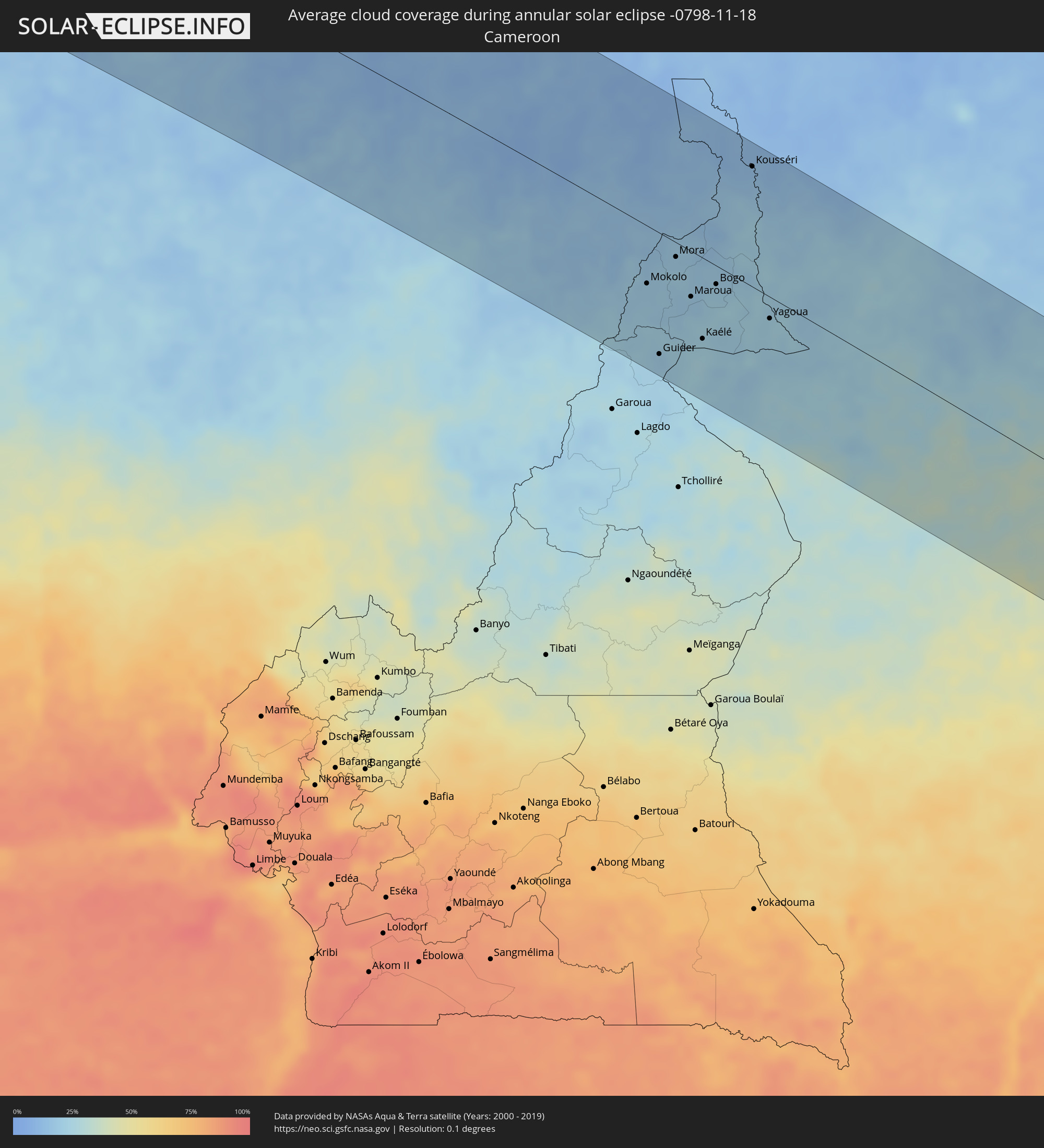 Cameroon
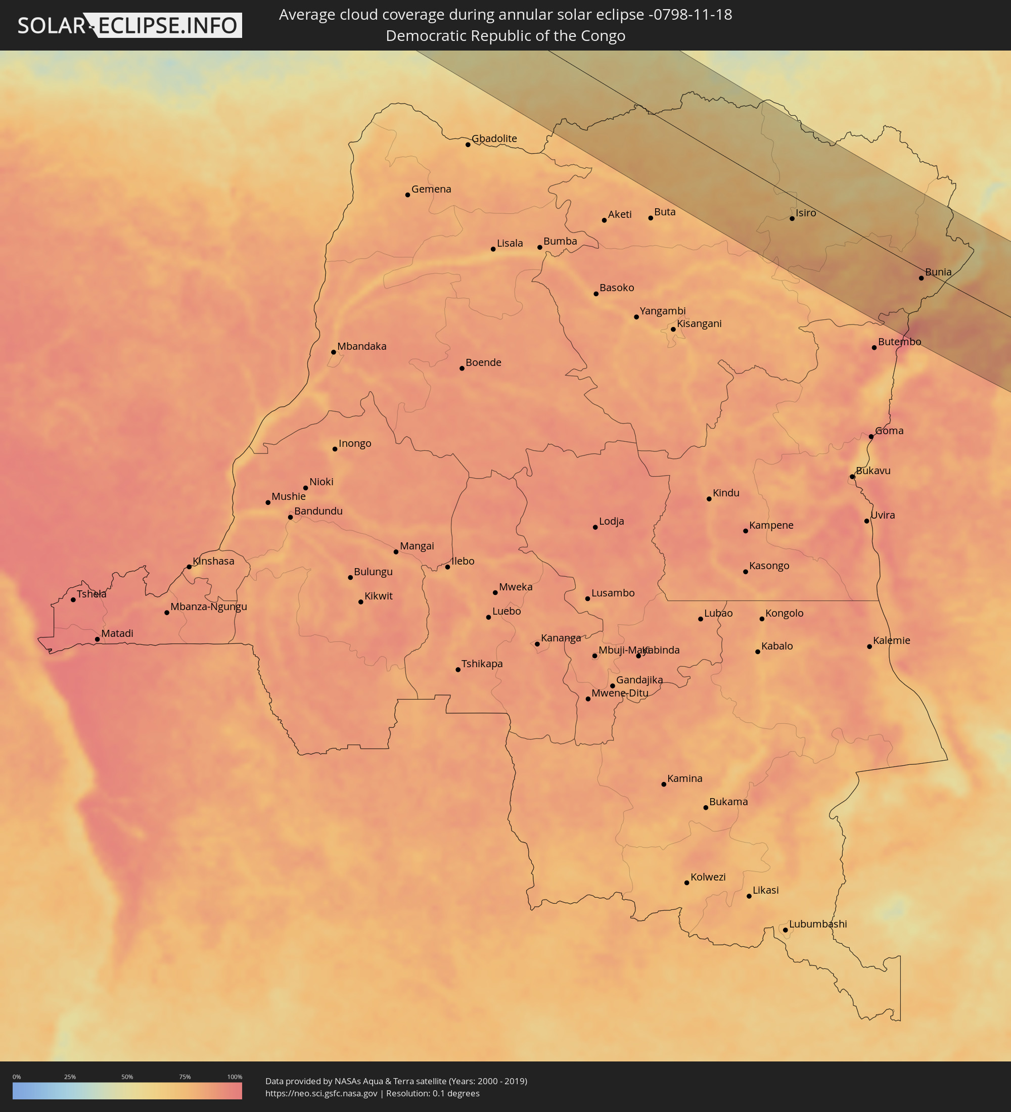 Democratic Republic of the Congo
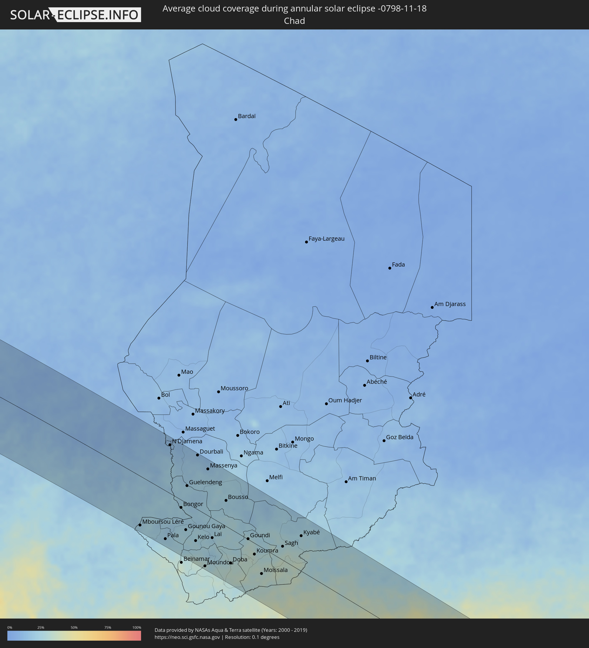 Chad
Chad
 Central African Republic
 South Sudan
 Tanzania
 Uganda
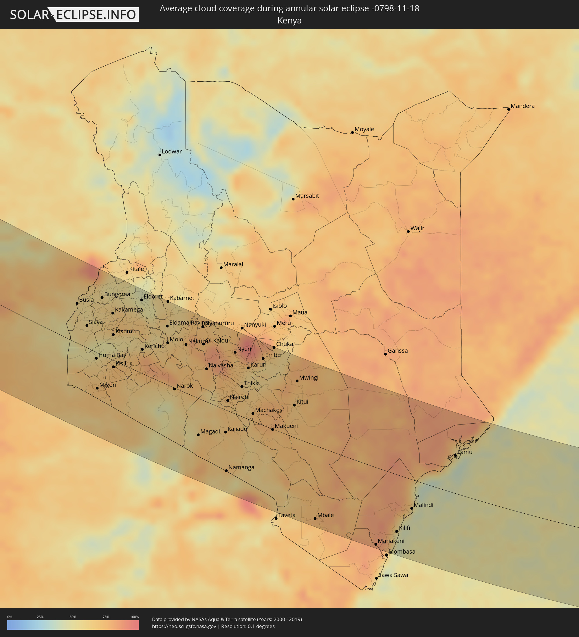 Kenya
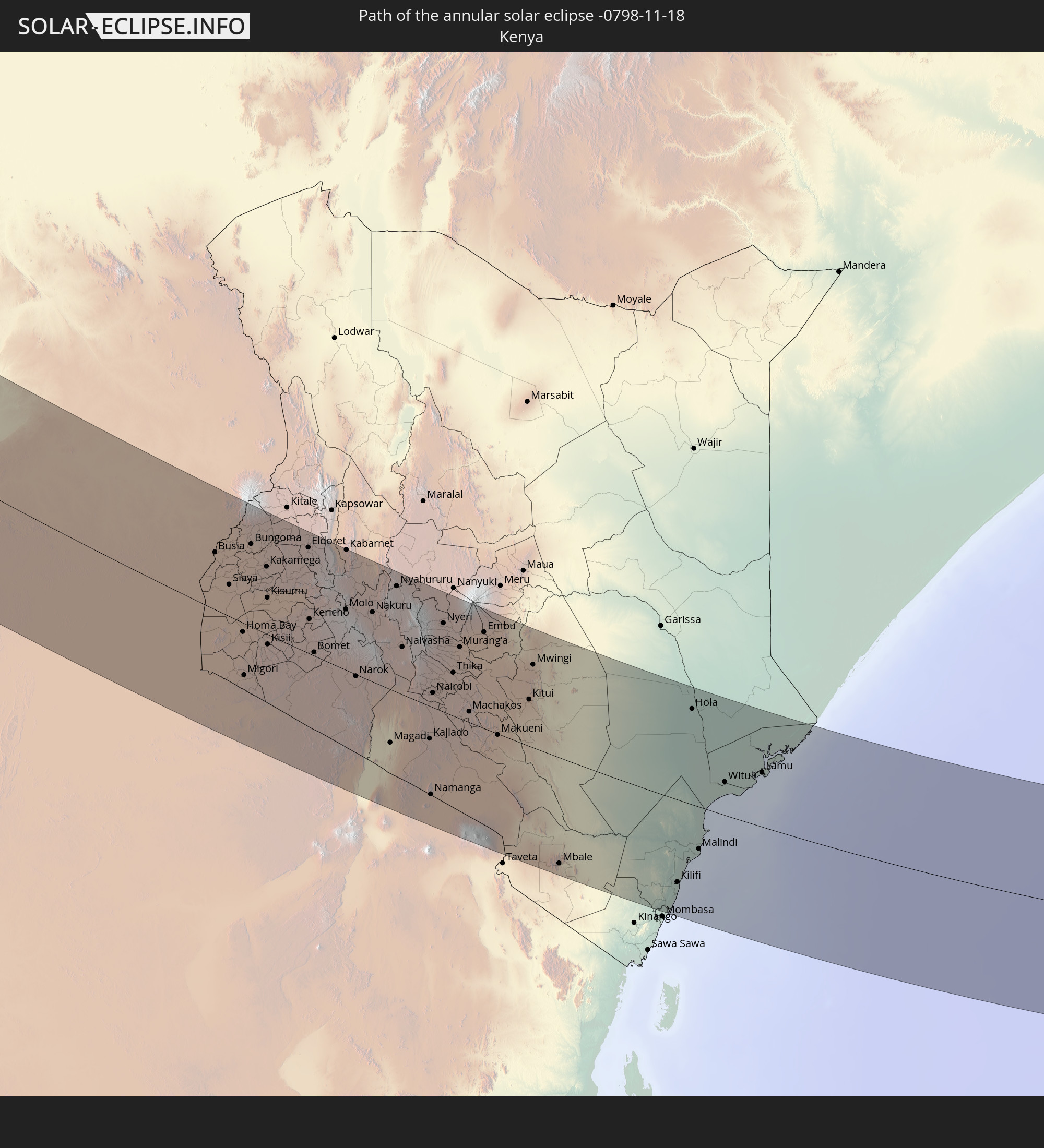
Kenya
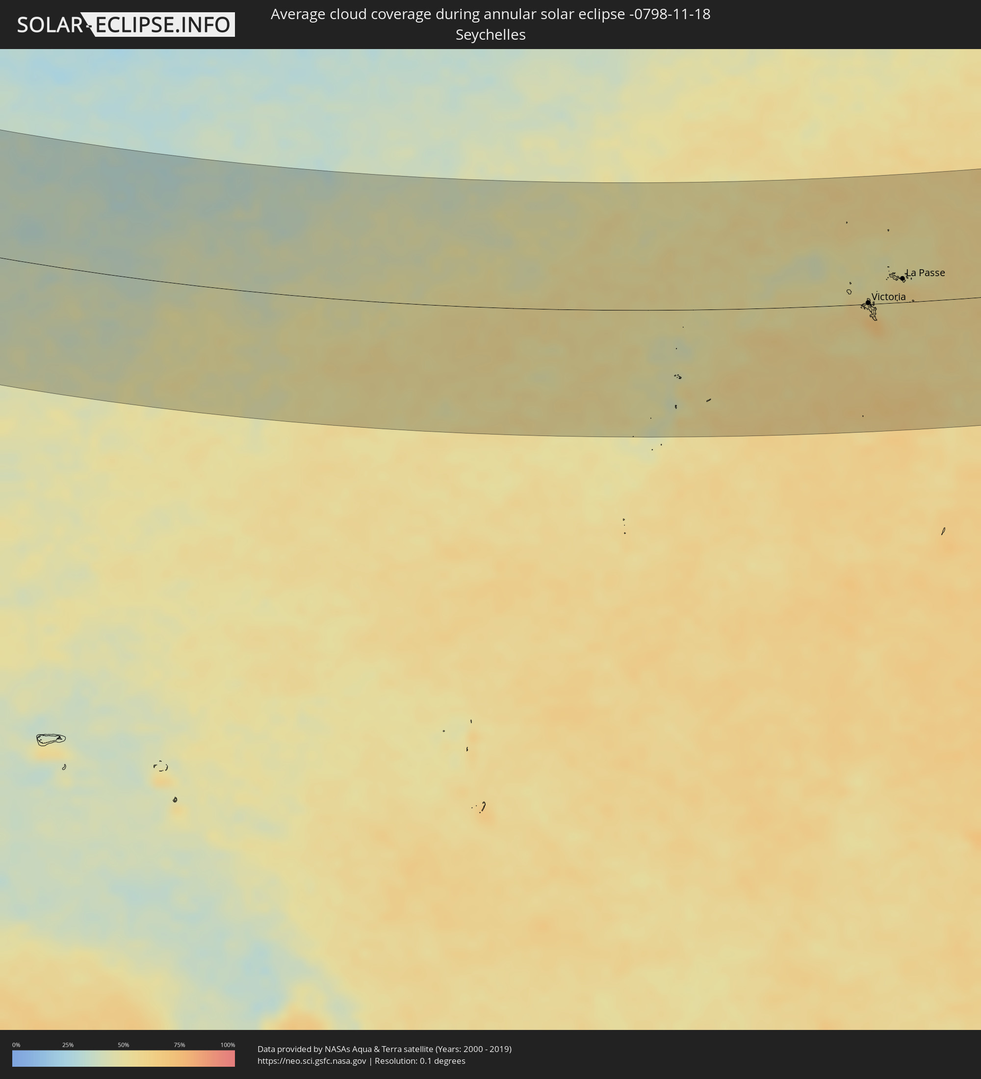 Seychelles
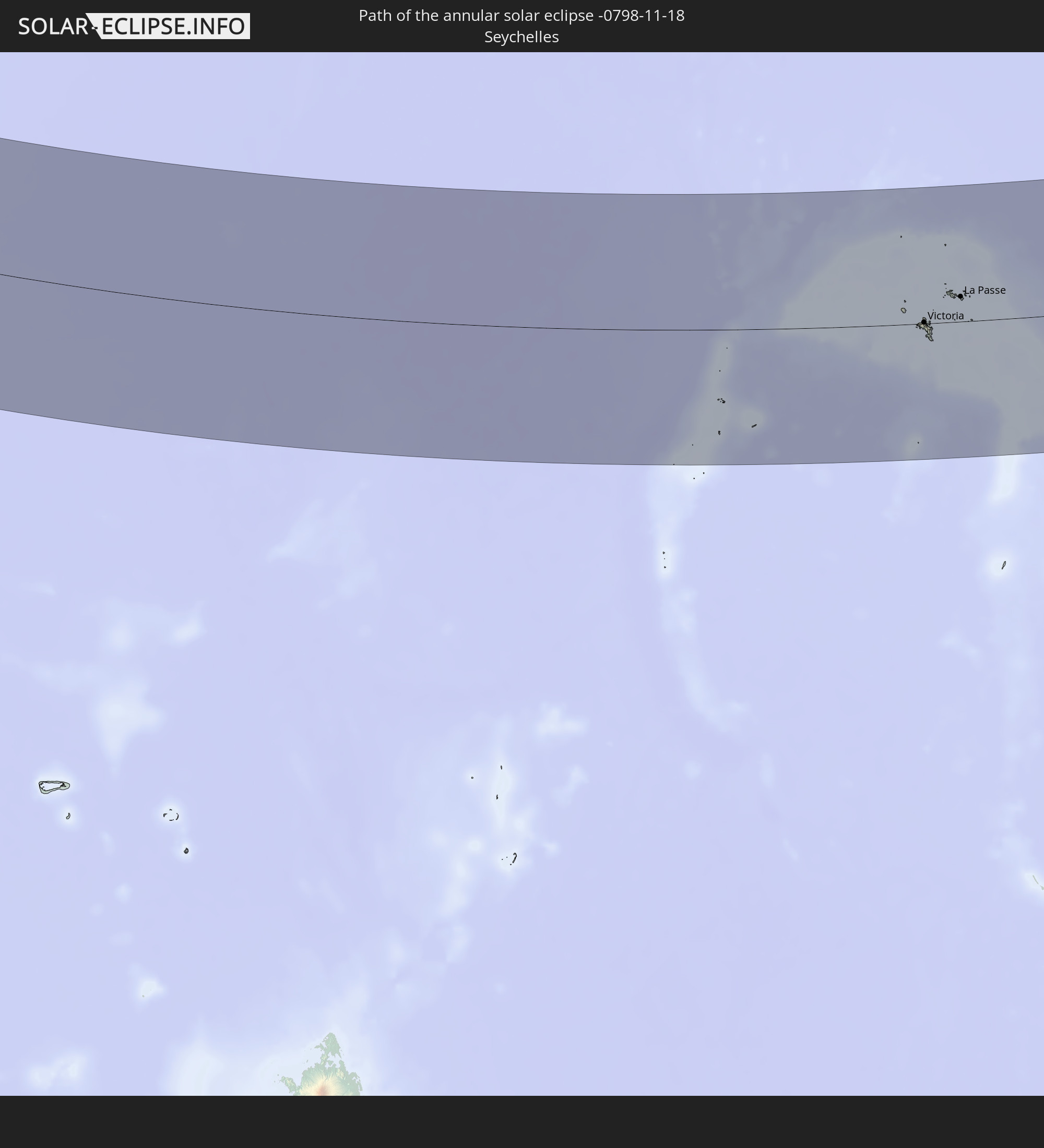
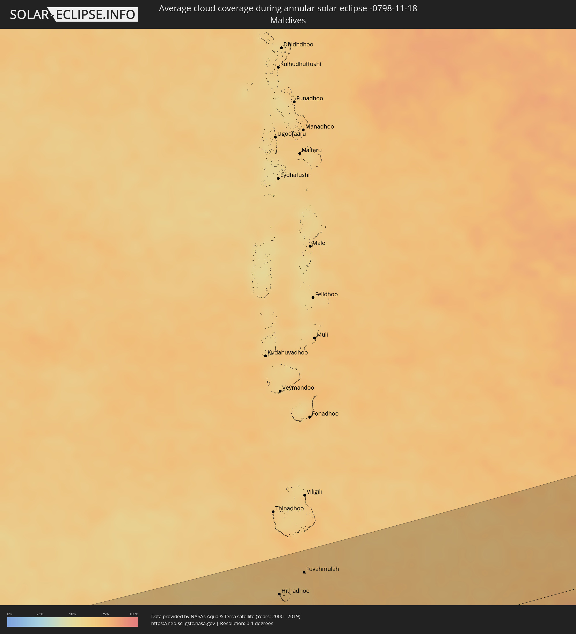 Maldives
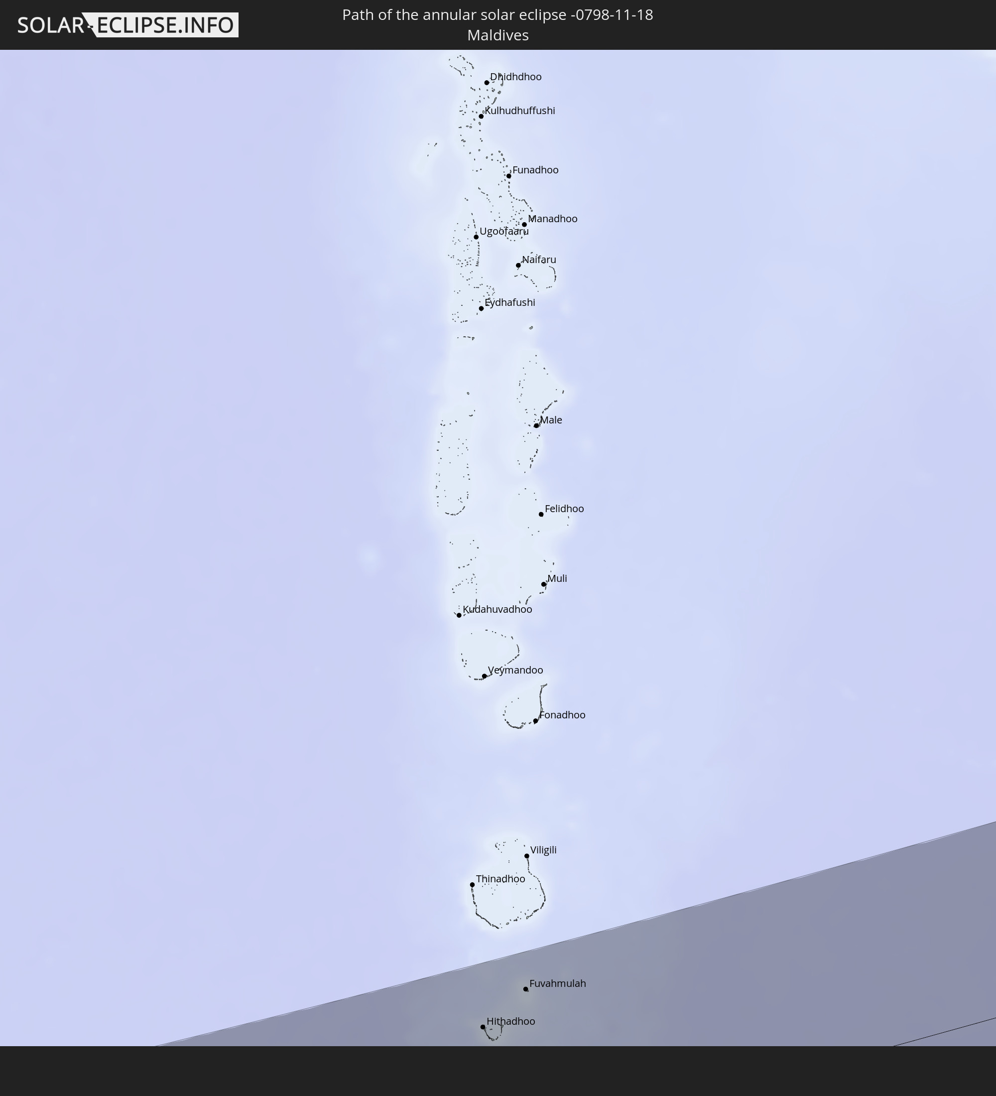
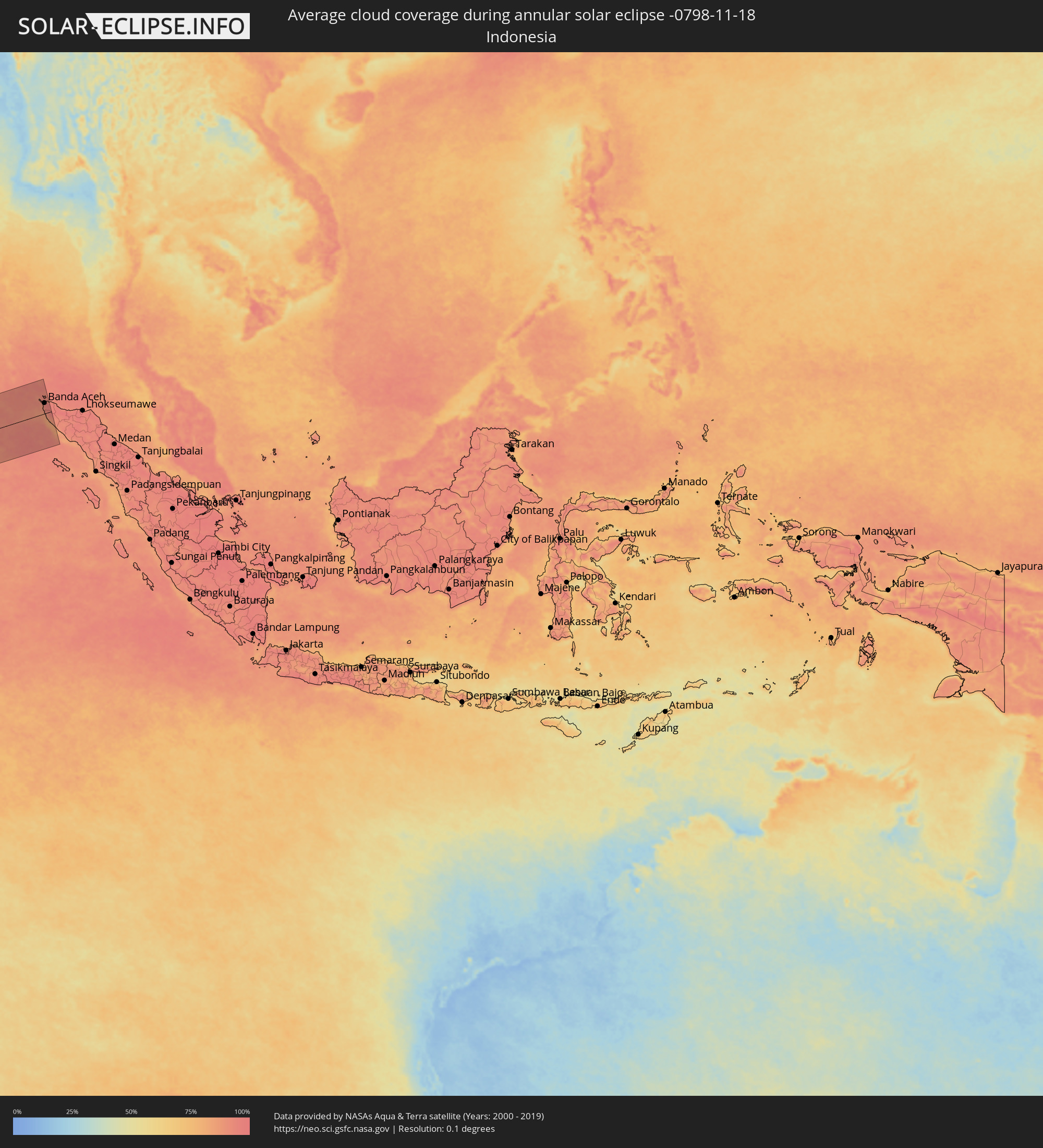 Indonesia
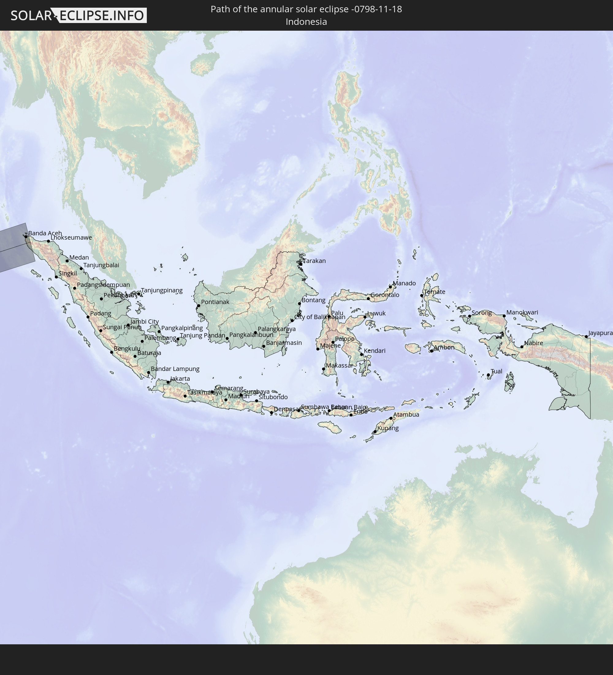
Cities inside the path of the eclipse
The following table shows all locations with a population of more than 5,000 inside the eclipse path. Cities which have more than 100,000 inhabitants are marked bold. A click at the locations opens a detailed map.
| City | Type | Eclipse duration | Local time of max. eclipse | Distance to central line | Ø Cloud coverage |
 Dakhla, Oued Ed-Dahab-Lagouira
|
annular | - | 06:39:54 UTC-00:52 | 96 km | 40% |
|
Zouerate, Tiris Zemmour
|
annular | - | 07:17:03 UTC-00:16 | 70 km | 26% |
|
Kidal, Kidal
|
annular | - | 07:24:22 UTC-00:16 | 67 km | 20% |
|
Ménaka, Gao
|
annular | - | 07:25:54 UTC-00:16 | 139 km | 16% |
|
Inékar, Gao
|
annular | - | 07:26:35 UTC-00:16 | 99 km | 12% |
|
Illéla, Tahoua
|
annular | - | 07:59:02 UTC+00:13 | 146 km | 11% |
|
Tahoua, Tahoua
|
annular | - | 07:58:52 UTC+00:13 | 103 km | 11% |
|
Madaoua, Tahoua
|
annular | - | 08:00:00 UTC+00:13 | 149 km | 18% |
|
Dakoro, Maradi
|
annular | - | 08:00:44 UTC+00:13 | 66 km | 15% |
|
Tibiri, Maradi
|
annular | - | 08:01:32 UTC+00:13 | 145 km | 17% |
|
Maradi, Maradi
|
annular | - | 08:01:38 UTC+00:13 | 148 km | 15% |
|
Mayahi, Maradi
|
annular | - | 08:02:05 UTC+00:13 | 74 km | 13% |
|
Tessaoua, Maradi
|
annular | - | 08:02:35 UTC+00:13 | 78 km | 15% |
|
Daura, Katsina
|
annular | - | 08:03:24 UTC+00:13 | 132 km | 16% |
|
Matamey, Zinder
|
annular | - | 08:03:23 UTC+00:13 | 86 km | 16% |
|
Tanout, Zinder
|
annular | - | 08:03:07 UTC+00:13 | 87 km | 11% |
|
Magaria, Zinder
|
annular | - | 08:04:12 UTC+00:13 | 105 km | 14% |
|
Zinder, Zinder
|
annular | - | 08:03:51 UTC+00:13 | 22 km | 15% |
|
Mirriah, Zinder
|
annular | - | 08:04:07 UTC+00:13 | 23 km | 13% |
|
Gumel, Jigawa
|
annular | - | 08:05:04 UTC+00:13 | 116 km | 13% |
|
Hadejia, Jigawa
|
annular | - | 08:06:04 UTC+00:13 | 99 km | 15% |
|
Nguru, Yobe
|
annular | - | 08:06:24 UTC+00:13 | 36 km | 12% |
|
Gashua, Yobe
|
annular | - | 08:07:14 UTC+00:13 | 6 km | 12% |
|
Potiskum, Yobe
|
annular | - | 08:08:04 UTC+00:13 | 116 km | 19% |
|
Daura, Yobe
|
annular | - | 08:08:40 UTC+00:13 | 114 km | 19% |
|
Geidam, Yobe
|
annular | - | 08:08:33 UTC+00:13 | 43 km | 12% |
|
Damaturu, Yobe
|
annular | - | 08:09:22 UTC+00:13 | 66 km | 13% |
|
Diffa, Diffa
|
annular | - | 08:09:20 UTC+00:13 | 121 km | 14% |
|
Maiduguri, Borno
|
annular | - | 08:11:12 UTC+00:13 | 8 km | 15% |
|
Mubi, Adamawa
|
annular | - | 08:12:35 UTC+00:13 | 139 km | 23% |
|
Bama, Borno
|
annular | - | 08:12:19 UTC+00:13 | 5 km | 17% |
|
Mokolo, Far North
|
annular | - | 08:13:06 UTC+00:13 | 64 km | 20% |
|
Dikwa, Borno
|
annular | - | 08:12:19 UTC+00:13 | 67 km | 12% |
|
Guider, North
|
annular | - | 08:14:00 UTC+00:13 | 134 km | 20% |
|
Mora, Far North
|
annular | - | 08:13:26 UTC+00:13 | 16 km | 21% |
|
Mboursou Léré, Mayo-Kebbi Ouest
|
annular | - | 09:01:07 UTC+01:00 | 139 km | 23% |
|
Gamboru, Borno
|
annular | - | 08:12:33 UTC+00:13 | 116 km | 13% |
|
Maroua, Far North
|
annular | - | 08:14:06 UTC+00:13 | 50 km | 19% |
|
Mindif, Far North
|
annular | - | 08:14:28 UTC+00:13 | 62 km | 23% |
|
Kaélé, Far North
|
annular | - | 08:14:44 UTC+00:13 | 89 km | 24% |
|
Makary, Far North
|
annular | - | 08:12:50 UTC+00:13 | 149 km | 12% |
|
Bogo, Far North
|
annular | - | 08:14:30 UTC+00:13 | 20 km | 22% |
|
Pala, Mayo-Kebbi Ouest
|
annular | - | 09:02:48 UTC+01:00 | 136 km | 21% |
|
Kousséri, Far North
|
annular | - | 08:14:11 UTC+00:13 | 132 km | 14% |
|
N'Djamena, Chari-Baguirmi
|
annular | - | 09:00:48 UTC+01:00 | 136 km | 14% |
|
Yagoua, Far North
|
annular | - | 08:15:56 UTC+00:13 | 24 km | 23% |
|
Bongor, Mayo-Kebbi Est
|
annular | - | 09:02:51 UTC+01:00 | 22 km | 22% |
|
Kelo, Tandjilé
|
annular | - | 09:04:30 UTC+01:00 | 91 km | 27% |
|
Dourbali, Chari-Baguirmi
|
annular | - | 09:02:29 UTC+01:00 | 152 km | 15% |
|
Moundou, Logone Occidental
|
annular | - | 09:05:43 UTC+01:00 | 147 km | 29% |
|
Béré, Tandjilé
|
annular | - | 09:05:09 UTC+01:00 | 71 km | 25% |
|
Laï, Tandjilé
|
annular | - | 09:05:21 UTC+01:00 | 55 km | 22% |
|
Benoy, Logone Occidental
|
annular | - | 09:05:46 UTC+01:00 | 94 km | 21% |
|
Doba, Logone Oriental
|
annular | - | 09:07:07 UTC+01:00 | 96 km | 31% |
|
Koumra, Mandoul
|
annular | - | 09:08:15 UTC+01:00 | 31 km | 31% |
|
Batangafo, Ouham
|
annular | - | 08:24:47 UTC+00:13 | 144 km | 43% |
|
Sagh, Moyen-Chari
|
annular | - | 09:09:45 UTC+01:00 | 38 km | 30% |
|
Kabo, Ouham
|
annular | - | 08:25:05 UTC+00:13 | 86 km | 40% |
|
Kyabé, Moyen-Chari
|
annular | - | 09:10:36 UTC+01:00 | 99 km | 26% |
|
Kaga Bandoro, Nana-Grébizi
|
annular | - | 08:27:03 UTC+00:13 | 122 km | 42% |
|
Ndélé, Bamingui-Bangoran
|
annular | - | 08:28:46 UTC+00:13 | 96 km | 29% |
|
Bambari, Ouaka
|
annular | - | 08:31:49 UTC+00:13 | 154 km | 53% |
|
Ippy, Ouaka
|
annular | - | 08:32:31 UTC+00:13 | 75 km | 50% |
|
Bria, Haute-Kotto
|
annular | - | 08:34:01 UTC+00:13 | 5 km | 48% |
|
Bangassou, Mbomou
|
annular | - | 08:38:19 UTC+00:13 | 129 km | 69% |
|
Rafaï, Mbomou
|
annular | - | 08:40:54 UTC+00:13 | 46 km | 63% |
|
Zemio, Haut-Mbomou
|
annular | - | 08:44:05 UTC+00:13 | 31 km | 65% |
|
Obo, Haut-Mbomou
|
annular | - | 08:47:25 UTC+00:13 | 143 km | 51% |
|
Isiro, Orientale
|
annular | - | 10:51:07 UTC+02:10 | 45 km | 71% |
|
Wamba, Orientale
|
annular | - | 10:53:11 UTC+02:10 | 84 km | 79% |
|
Watsa, Orientale
|
annular | - | 10:56:44 UTC+02:10 | 86 km | 67% |
|
Bunia, Orientale
|
annular | - | 11:01:14 UTC+02:10 | 18 km | 78% |
|
Fort Portal, Western Region
|
annular | - | 11:19:35 UTC+02:27 | 105 km | 89% |
|
Hoima, Western Region
|
annular | - | 11:22:03 UTC+02:27 | 28 km | 82% |
|
Masindi, Western Region
|
annular | - | 11:22:56 UTC+02:27 | 70 km | 75% |
|
Masaka, Central Region
|
annular | - | 11:26:01 UTC+02:27 | 127 km | 86% |
|
Mityana, Central Region
|
annular | - | 11:25:53 UTC+02:27 | 38 km | 80% |
|
Entebbe, Central Region
|
annular | - | 11:27:53 UTC+02:27 | 51 km | 75% |
|
Kampala, Central Region
|
annular | - | 11:27:59 UTC+02:27 | 19 km | 79% |
|
Mukono, Central Region
|
annular | - | 11:28:32 UTC+02:27 | 7 km | 81% |
|
Lugazi, Central Region
|
annular | - | 11:29:05 UTC+02:27 | 4 km | 79% |
|
Jinja, Eastern Region
|
annular | - | 11:30:00 UTC+02:27 | 24 km | 64% |
|
Iganga, Eastern Region
|
annular | - | 11:30:42 UTC+02:27 | 54 km | 72% |
|
Musoma, Mara
|
annular | - | 11:35:03 UTC+02:27 | 141 km | 66% |
|
Busia, Eastern Region
|
annular | - | 11:33:10 UTC+02:27 | 71 km | 58% |
|
Busia, Busia
|
annular | - | 11:33:15 UTC+02:27 | 71 km | 58% |
|
Mbale, Eastern Region
|
annular | - | 11:32:33 UTC+02:27 | 136 km | 84% |
|
Tororo, Eastern Region
|
annular | - | 11:33:09 UTC+02:27 | 98 km | 62% |
|
Tarime, Mara
|
annular | - | 11:36:53 UTC+02:27 | 99 km | 66% |
|
Sirari, Mara
|
annular | - | 11:37:08 UTC+02:27 | 84 km | 70% |
|
Mumias, Kakamega
|
annular | - | 11:34:49 UTC+02:27 | 77 km | 61% |
|
Bungoma, Bungoma
|
annular | - | 11:34:45 UTC+02:27 | 103 km | 58% |
|
Mugumu, Mara
|
annular | - | 11:38:51 UTC+02:27 | 134 km | 68% |
|
Kakamega, Kakamega
|
annular | - | 11:35:52 UTC+02:27 | 84 km | 65% |
|
Kisumu, Kisumu
|
annular | - | 11:36:29 UTC+02:27 | 46 km | 53% |
|
Eldoret, Uasin Gishu
|
annular | - | 11:37:27 UTC+02:27 | 133 km | 47% |
|
Nakuru, Nakuru
|
annular | - | 11:41:38 UTC+02:27 | 88 km | 68% |
|
Ol Kalou, Nyandarua
|
annular | - | 11:42:49 UTC+02:27 | 103 km | 80% |
|
Longido, Arusha
|
annular | - | 11:47:34 UTC+02:27 | 136 km | 59% |
|
Namanga, Arusha
|
annular | - | 11:47:38 UTC+02:27 | 113 km | 62% |
|
Nairobi, Nairobi Area
|
annular | - | 11:45:57 UTC+02:27 | 19 km | 71% |
|
Nyeri, Nyeri
|
annular | - | 11:45:12 UTC+02:27 | 113 km | 74% |
|
Thika, Nairobi Area
|
annular | - | 11:46:33 UTC+02:27 | 55 km | 70% |
|
Mbale, Vihiga
|
annular | - | 11:54:55 UTC+02:27 | 137 km | 73% |
|
Kilifi, Kilifi
|
annular | - | 12:00:53 UTC+02:27 | 108 km | 62% |
|
Malindi, Kilifi
|
annular | - | 12:01:23 UTC+02:27 | 55 km | 57% |
|
Port Glaud, Port Glaud
|
annular | - | 14:12:31 UTC+03:41 | 4 km | 59% |
|
Bel Ombre, Bel Ombre
|
annular | - | 14:12:30 UTC+03:41 | 1 km | 67% |
|
Beau Vallon, Beau Vallon
|
annular | - | 14:12:33 UTC+03:41 | 1 km | 67% |
|
Victoria, English River
|
annular | - | 14:12:36 UTC+03:41 | 1 km | 67% |
|
Anse Boileau, Anse Boileau
|
annular | - | 14:12:44 UTC+03:41 | 10 km | 66% |
|
Takamaka, Takamaka
|
annular | - | 14:12:48 UTC+03:41 | 16 km | 56% |
|
Cascade, Cascade
|
annular | - | 14:12:46 UTC+03:41 | 5 km | 66% |
|
Anse Royale, Anse Royale
|
annular | - | 14:12:51 UTC+03:41 | 12 km | 66% |
|
La Passe, Inner Islands
|
annular | - | 14:13:38 UTC+03:41 | 29 km | 60% |
|
Hithadhoo
|
annular | - | 16:01:23 UTC+04:54 | 109 km | 76% |
|
Fuvahmulah, Gnyaviyani Atoll
|
annular | - | 16:01:48 UTC+04:54 | 132 km | 68% |
|
Sabang, Aceh
|
annular | - | 18:27:33 UTC+07:07 | 90 km | 91% |
|
Banda Aceh, Aceh
|
annular | - | 18:27:38 UTC+07:07 | 53 km | 95% |