Total solar eclipse of 06/13/-0892
| Day of week: | Friday |
| Maximum duration of eclipse: | 03m47s |
| Maximum width of eclipse path: | 132 km |
| Saros cycle: | 42 |
| Coverage: | 100% |
| Magnitude: | 1.0392 |
| Gamma: | 0.0765 |
Wo kann man die Sonnenfinsternis vom 06/13/-0892 sehen?
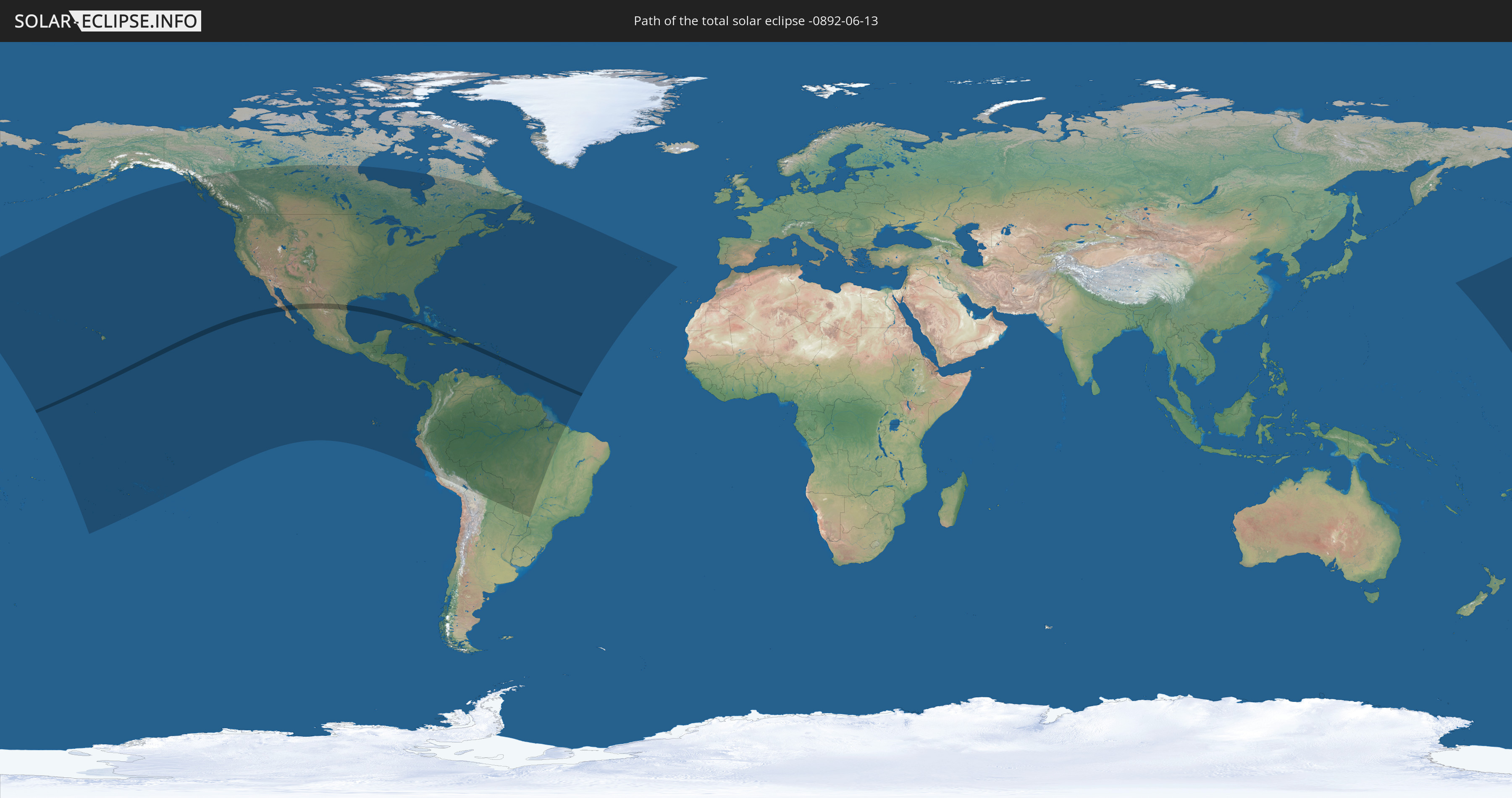
Die Sonnenfinsternis am 06/13/-0892 kann man in 53 Ländern als partielle Sonnenfinsternis beobachten.
Der Finsternispfad verläuft durch 9 Länder. Nur in diesen Ländern ist sie als total Sonnenfinsternis zu sehen.
In den folgenden Ländern ist die Sonnenfinsternis total zu sehen
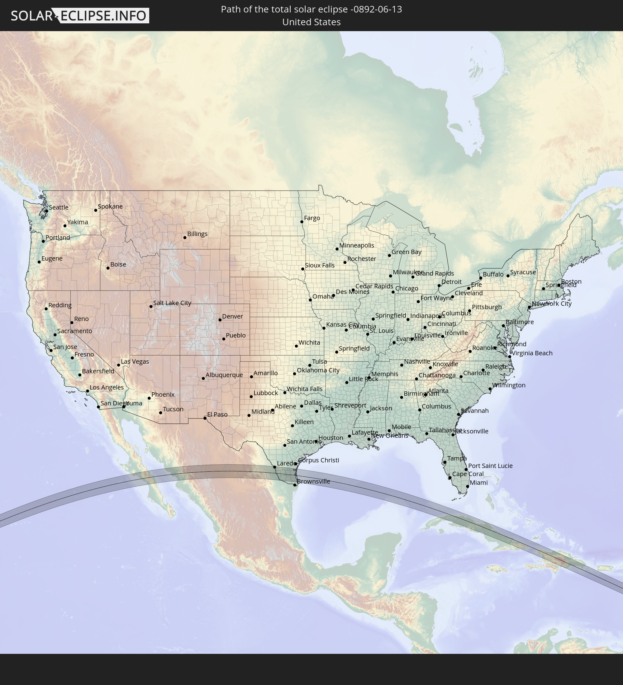 United States
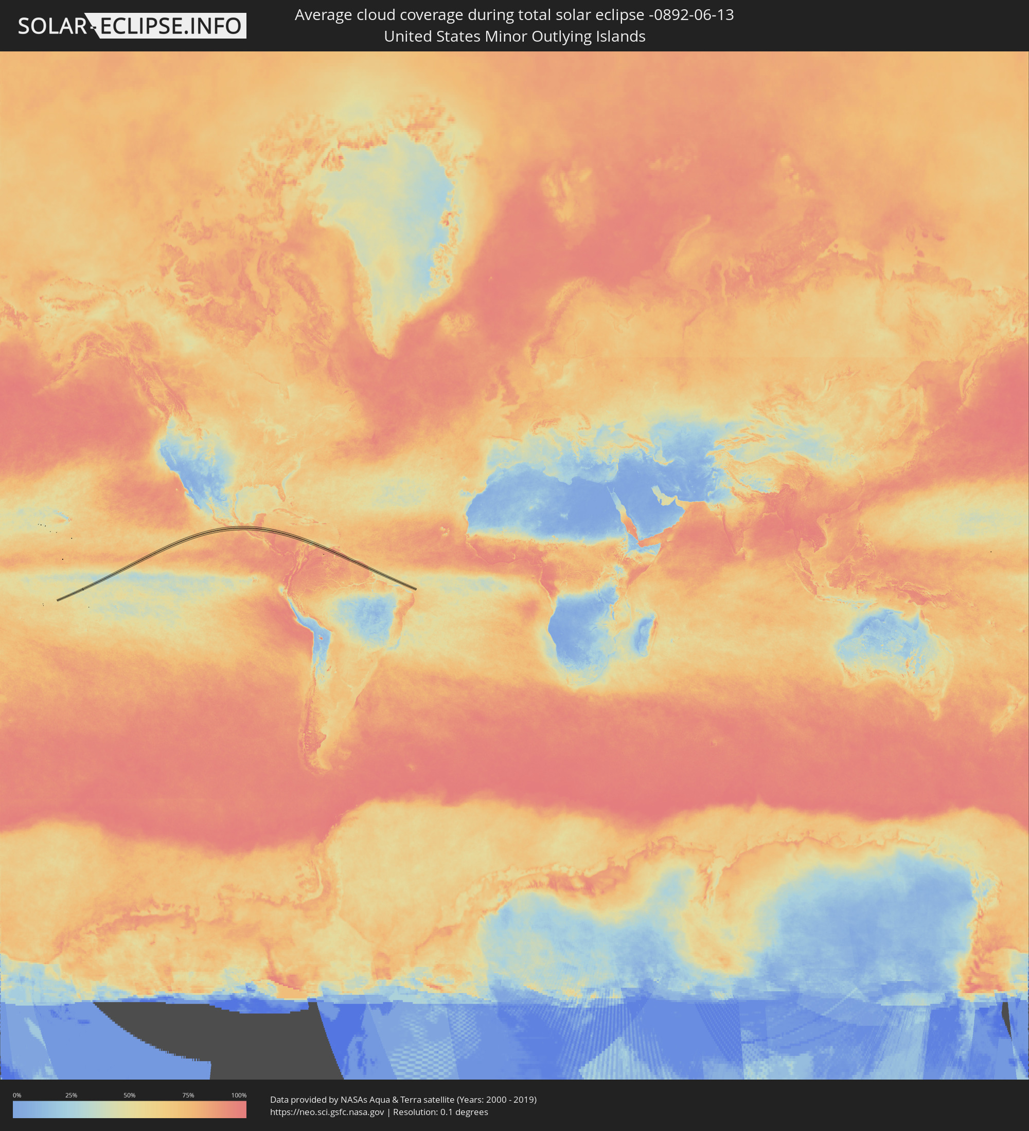
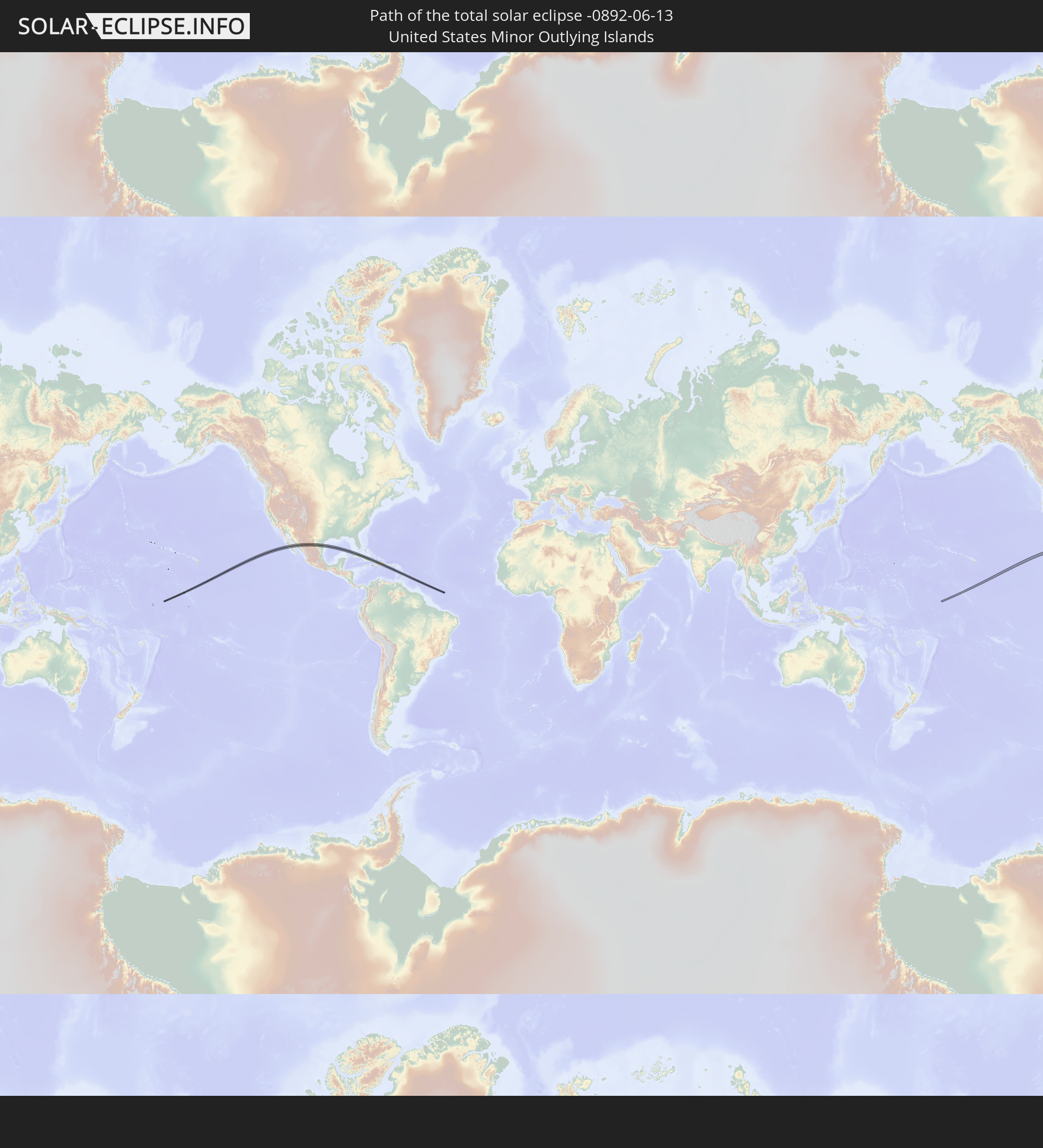 United States Minor Outlying Islands
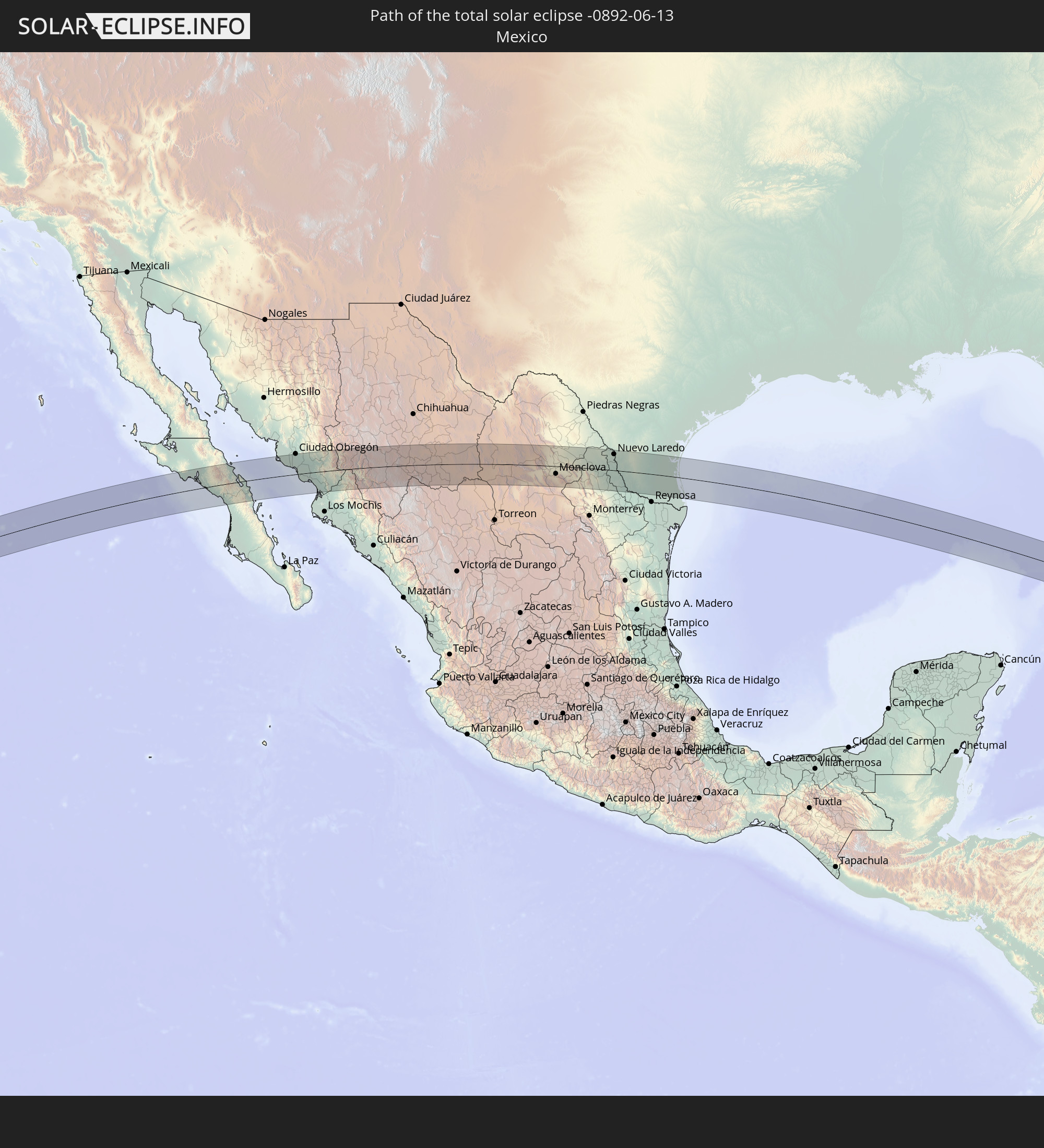 Mexico
 Cuba
Cuba
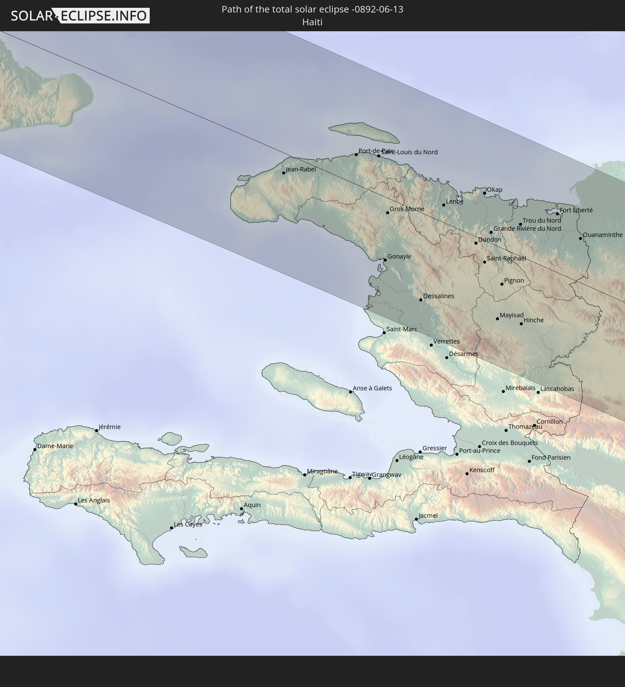 Haiti
Haiti
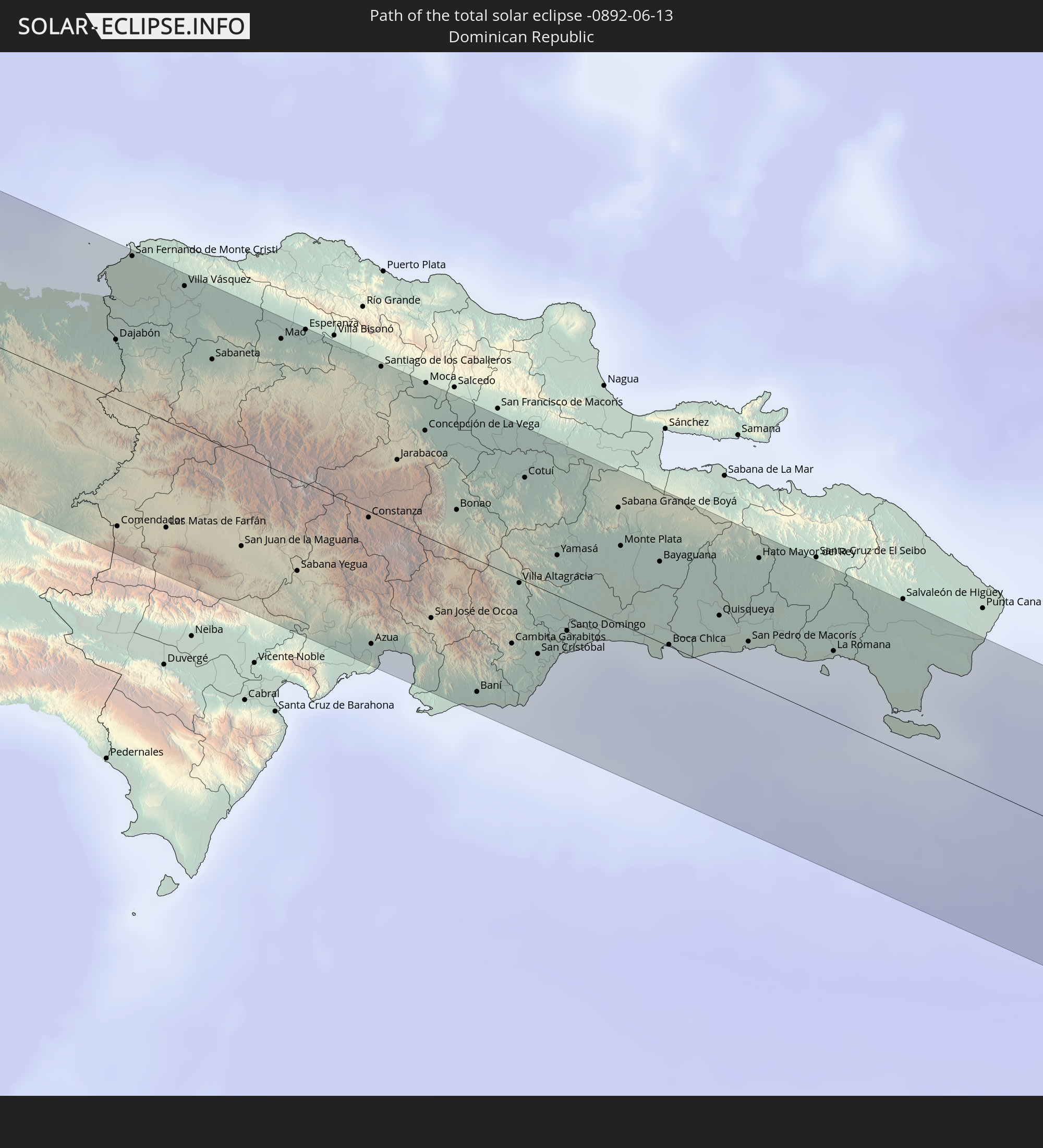 Dominican Republic
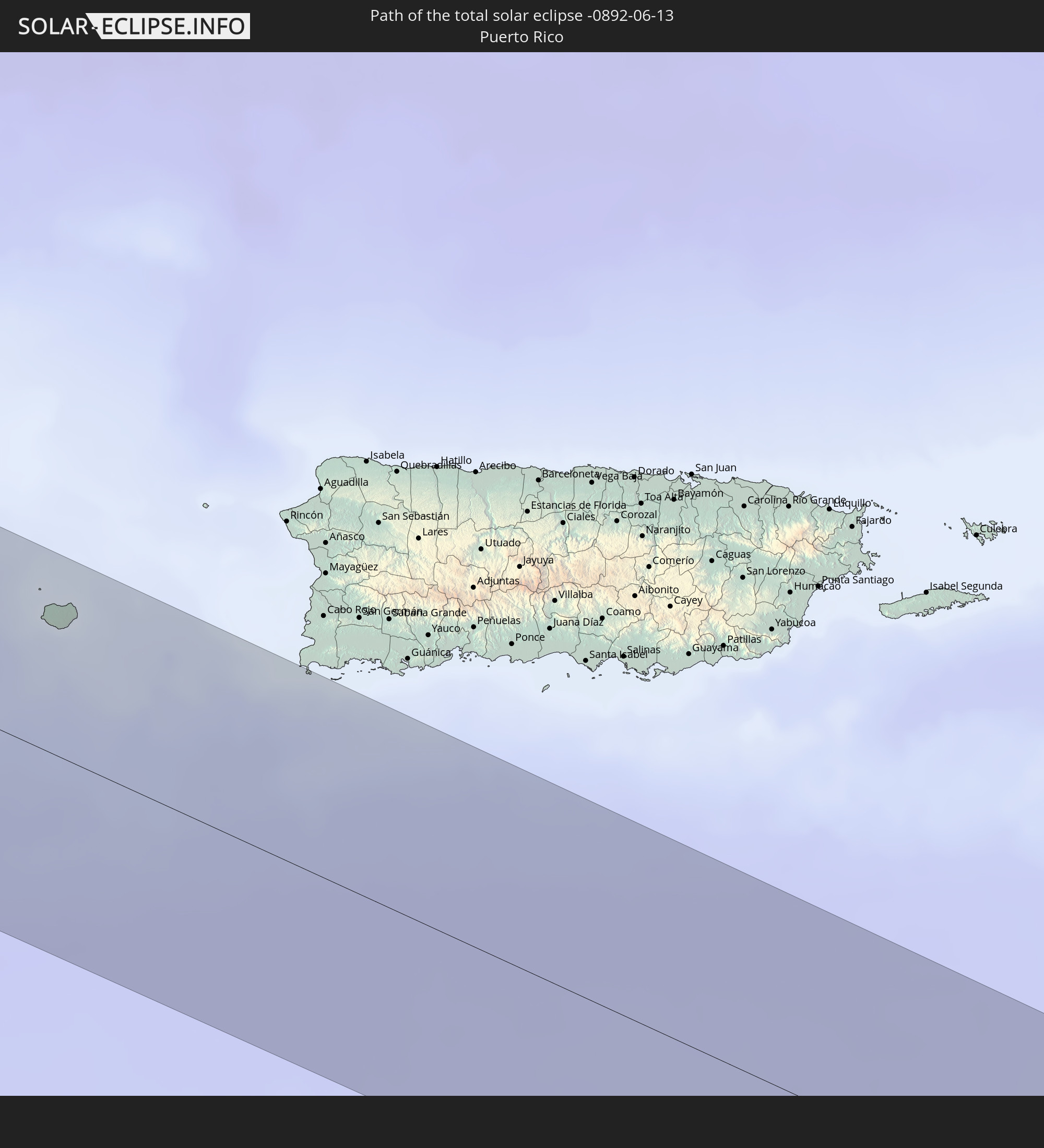 Puerto Rico
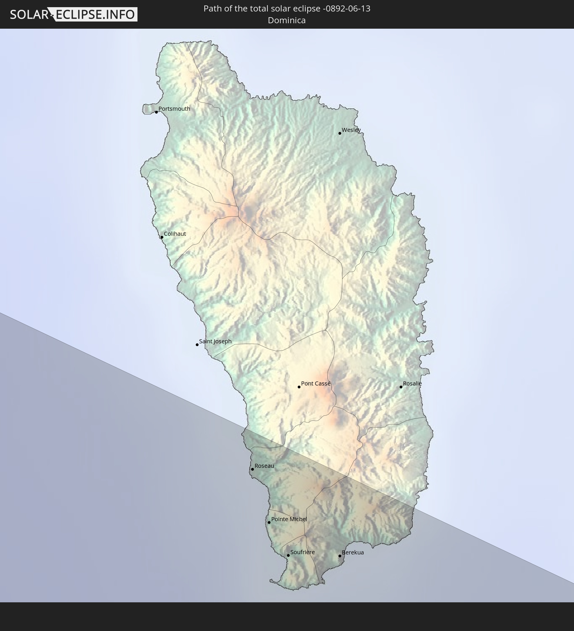 Dominica
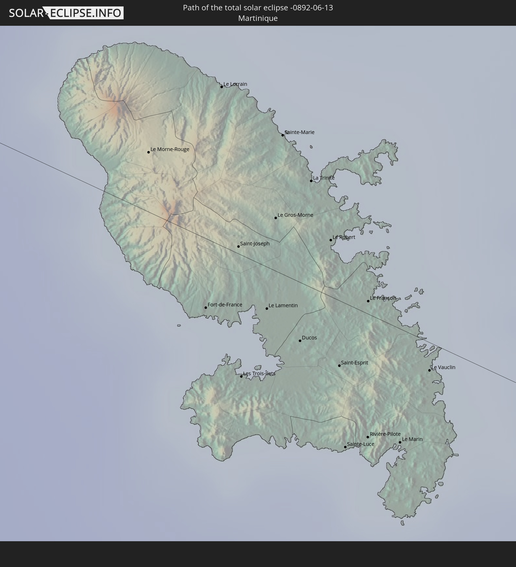 Martinique
In den folgenden Ländern ist die Sonnenfinsternis partiell zu sehen
 United States
 United States Minor Outlying Islands
 Kiribati
 Cook Islands
 French Polynesia
 Canada
 Mexico
 Greenland
 Guatemala
 Ecuador
 El Salvador
 Honduras
 Belize
 Nicaragua
 Costa Rica
 Cuba
Cuba
 Panama
 Colombia
 Cayman Islands
 Peru
Peru
 The Bahamas
 Jamaica
 Haiti
Haiti
 Brazil
 Venezuela
 Turks and Caicos Islands
 Dominican Republic
 Aruba
Aruba
 Bolivia
 Puerto Rico
 United States Virgin Islands
 Bermuda
 British Virgin Islands
 Anguilla
 Collectivity of Saint Martin
 Saint Barthélemy
 Saint Kitts and Nevis
 Paraguay
 Antigua and Barbuda
 Montserrat
 Trinidad and Tobago
 Guadeloupe
 Grenada
 Dominica
 Saint Vincent and the Grenadines
 Guyana
 Martinique
 Saint Lucia
 Barbados
 Suriname
 Saint Pierre and Miquelon
 French Guiana
 Portugal
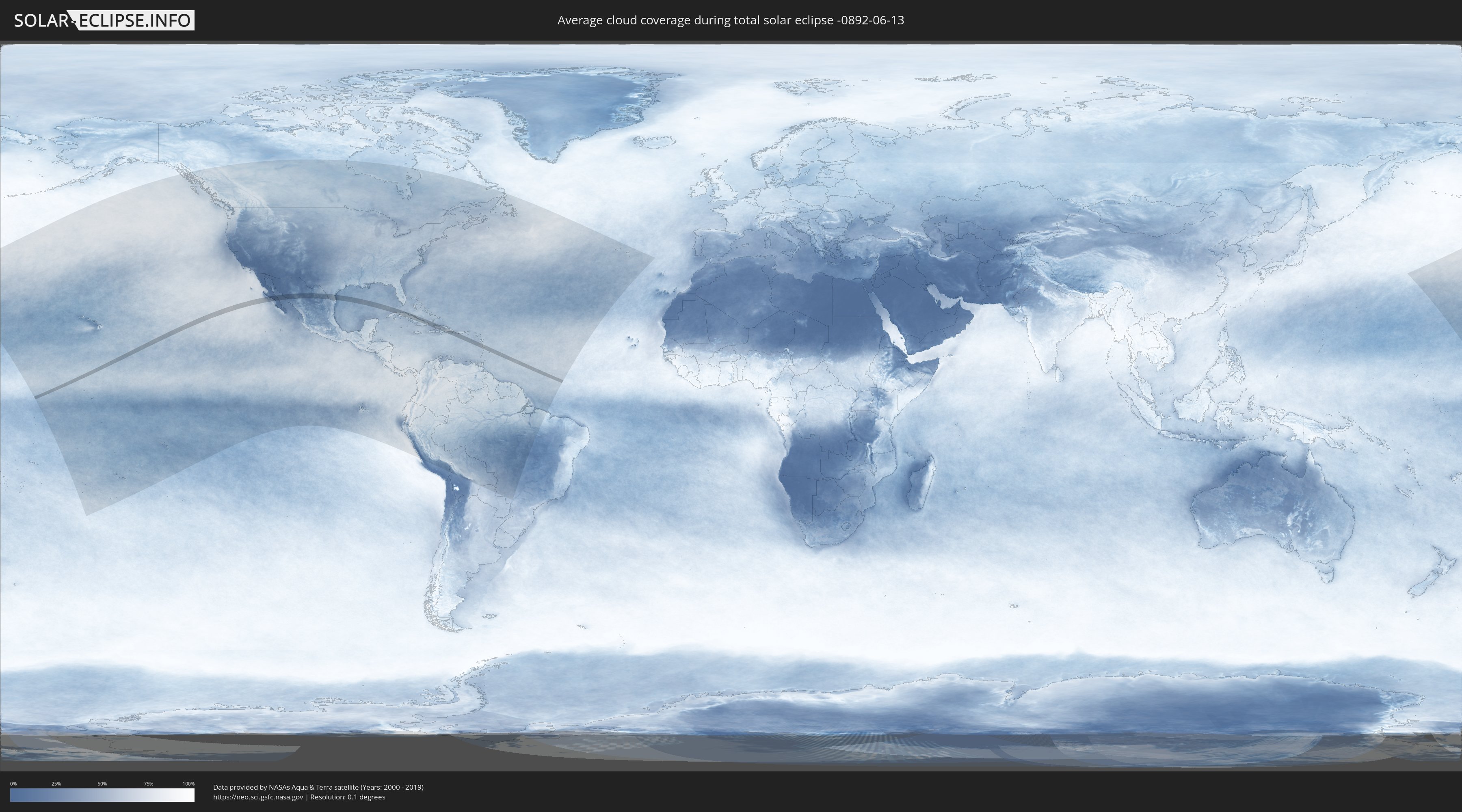
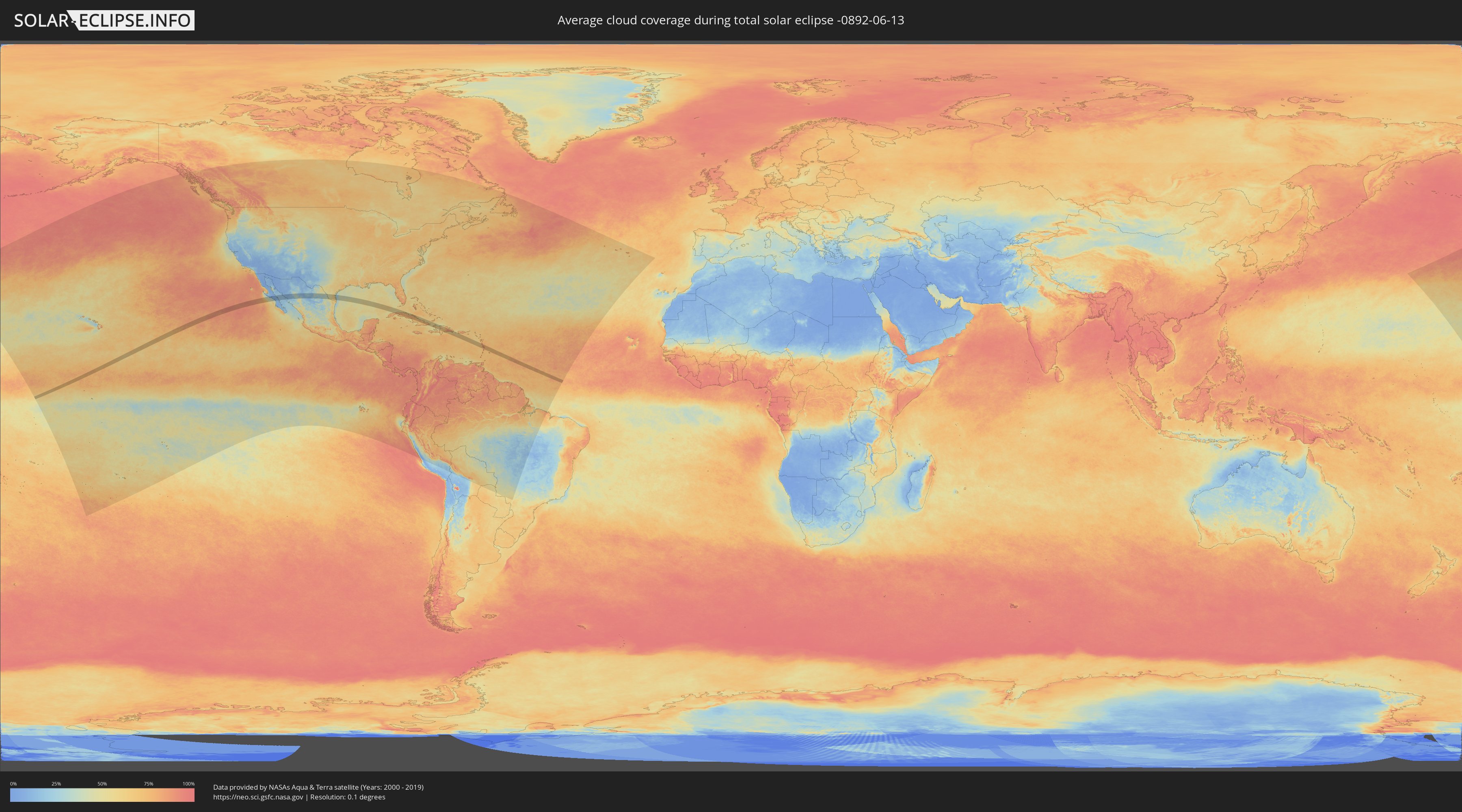
How will be the weather during the total solar eclipse on 06/13/-0892?
Where is the best place to see the total solar eclipse of 06/13/-0892?
The following maps show the average cloud coverage for the day of the total solar eclipse.
With the help of these maps, it is possible to find the place along the eclipse path, which has the best
chance of a cloudless sky.
Nevertheless, you should consider local circumstances and inform about the weather of your chosen
observation site.
The data is provided by NASAs satellites
AQUA and TERRA.
The cloud maps are averaged over a period of 19 years (2000 - 2019).
Detailed country maps
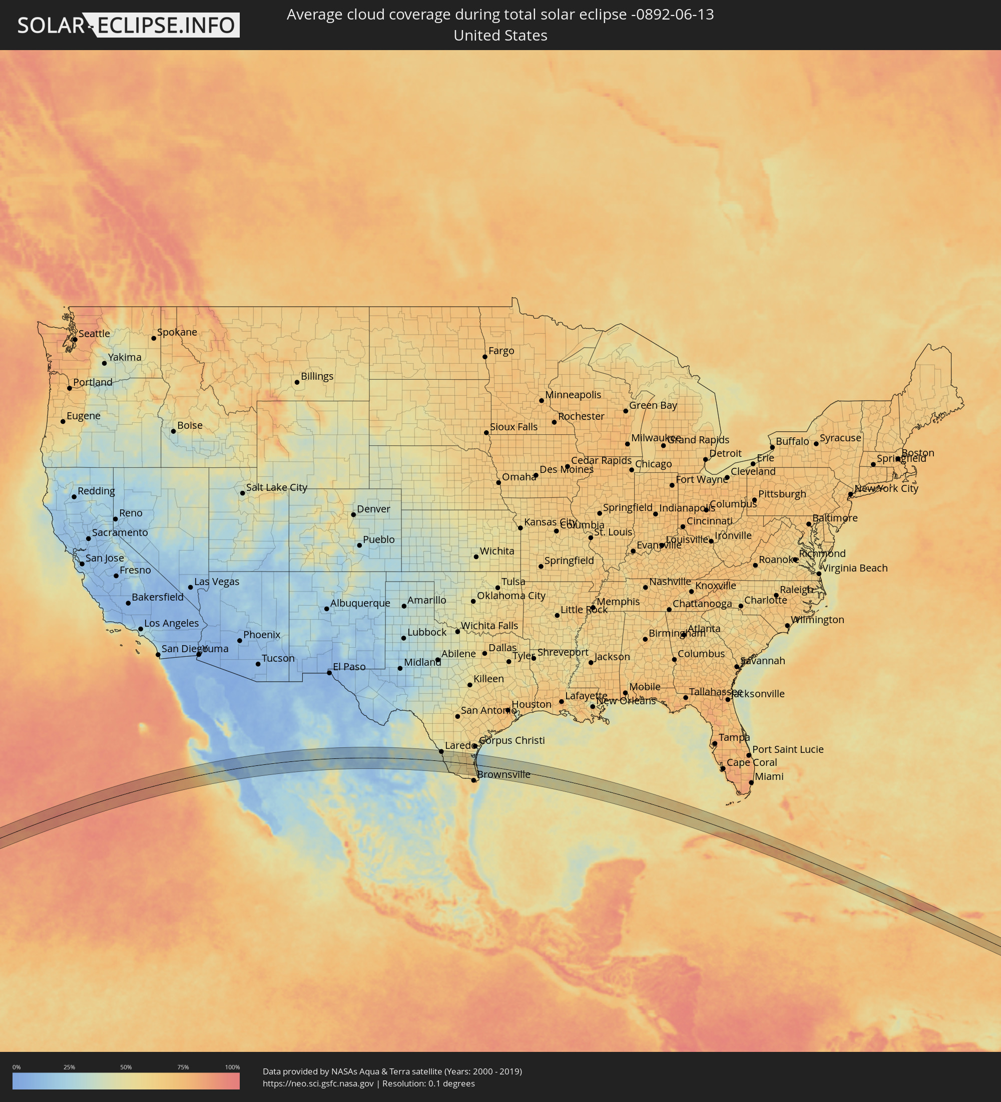 United States
 United States Minor Outlying Islands
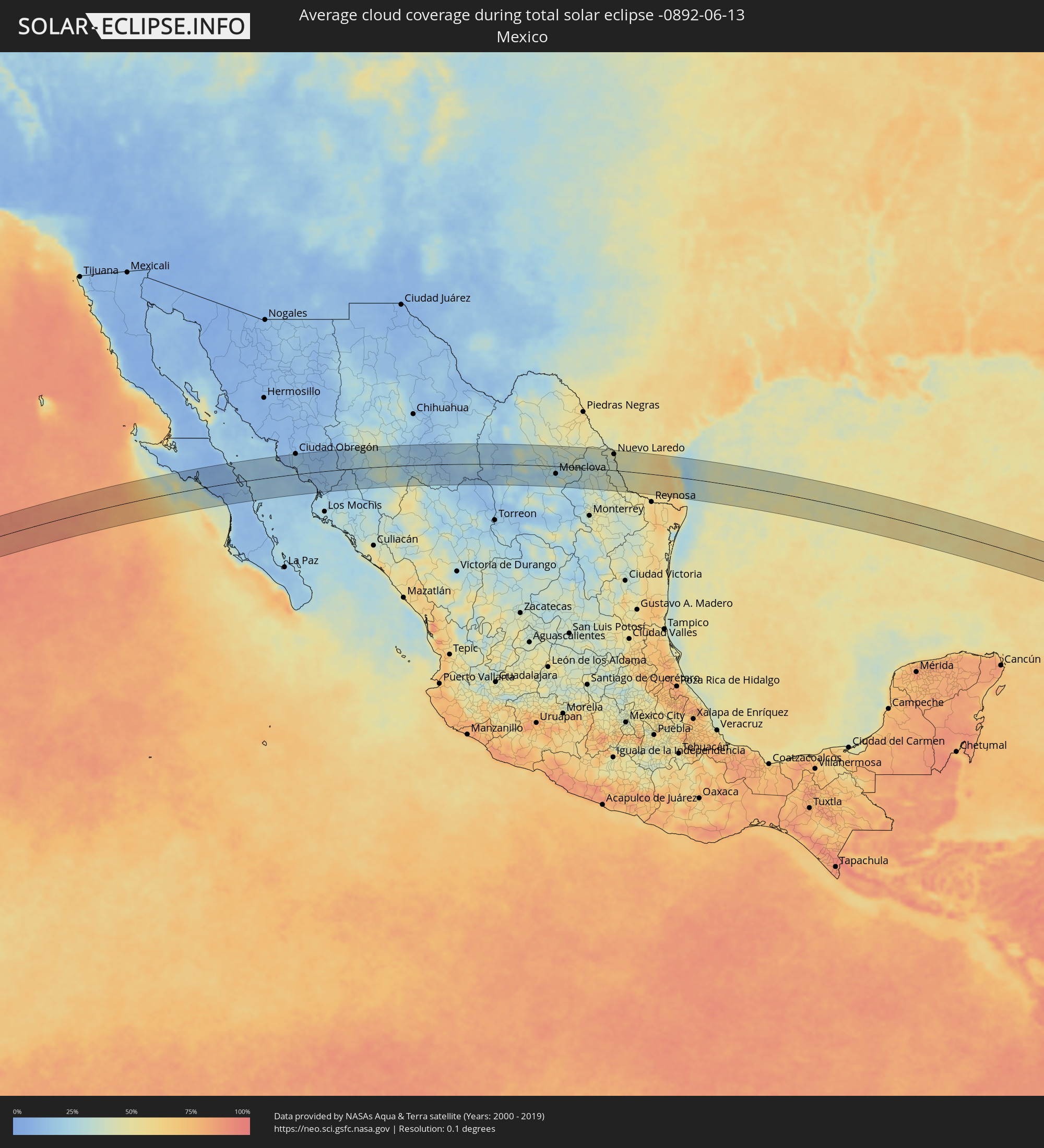 Mexico
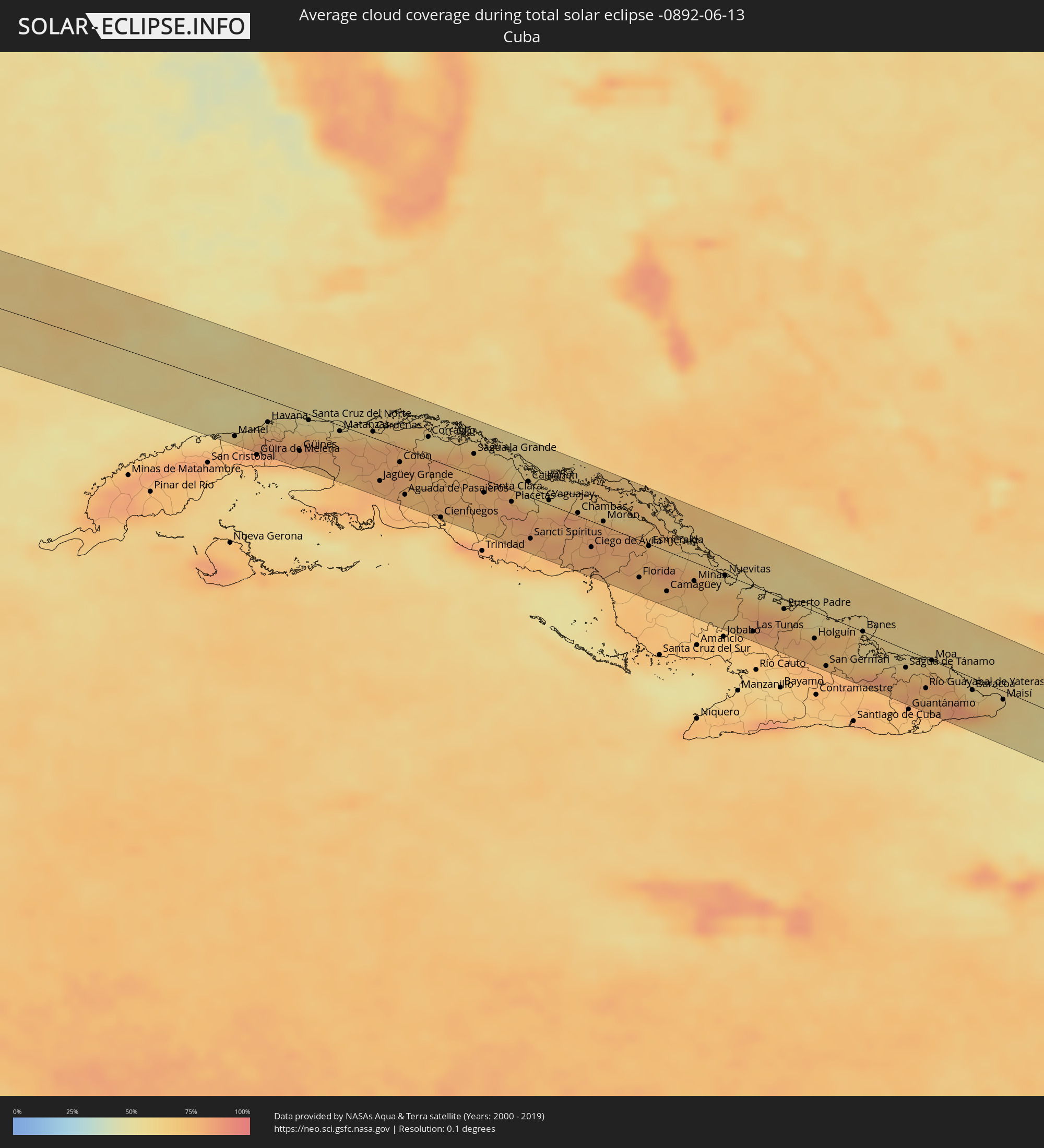 Cuba
Cuba
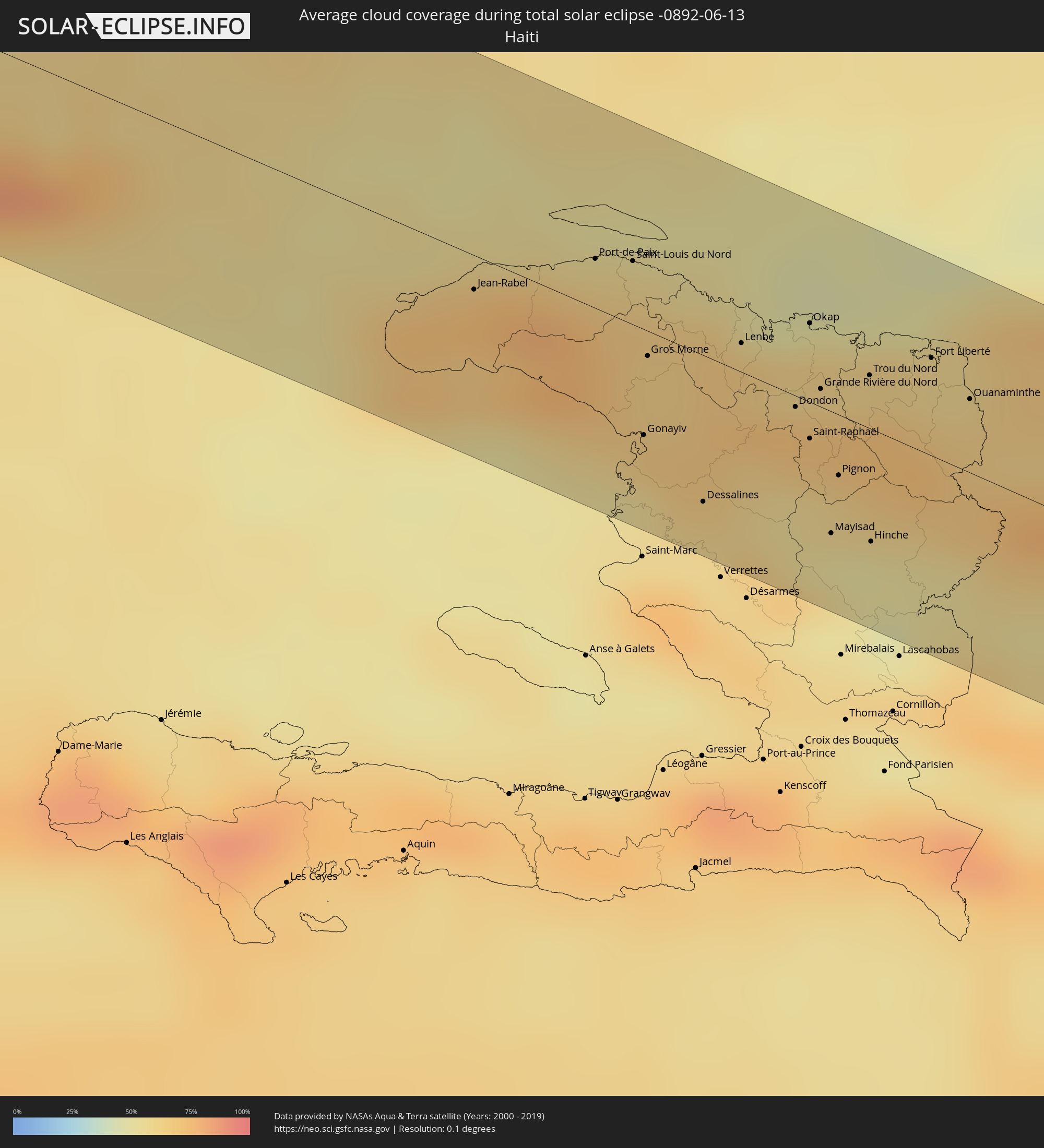 Haiti
Haiti
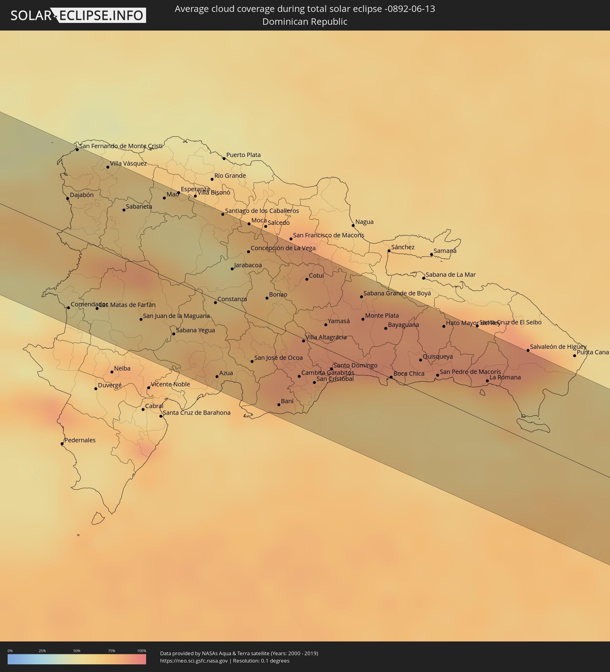 Dominican Republic
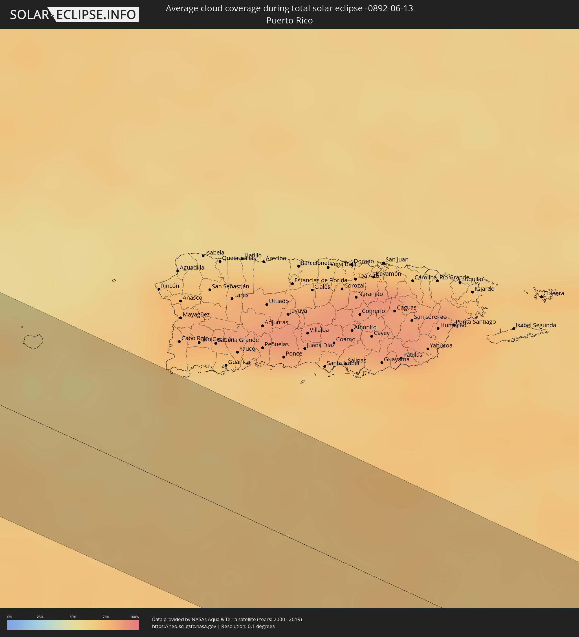 Puerto Rico
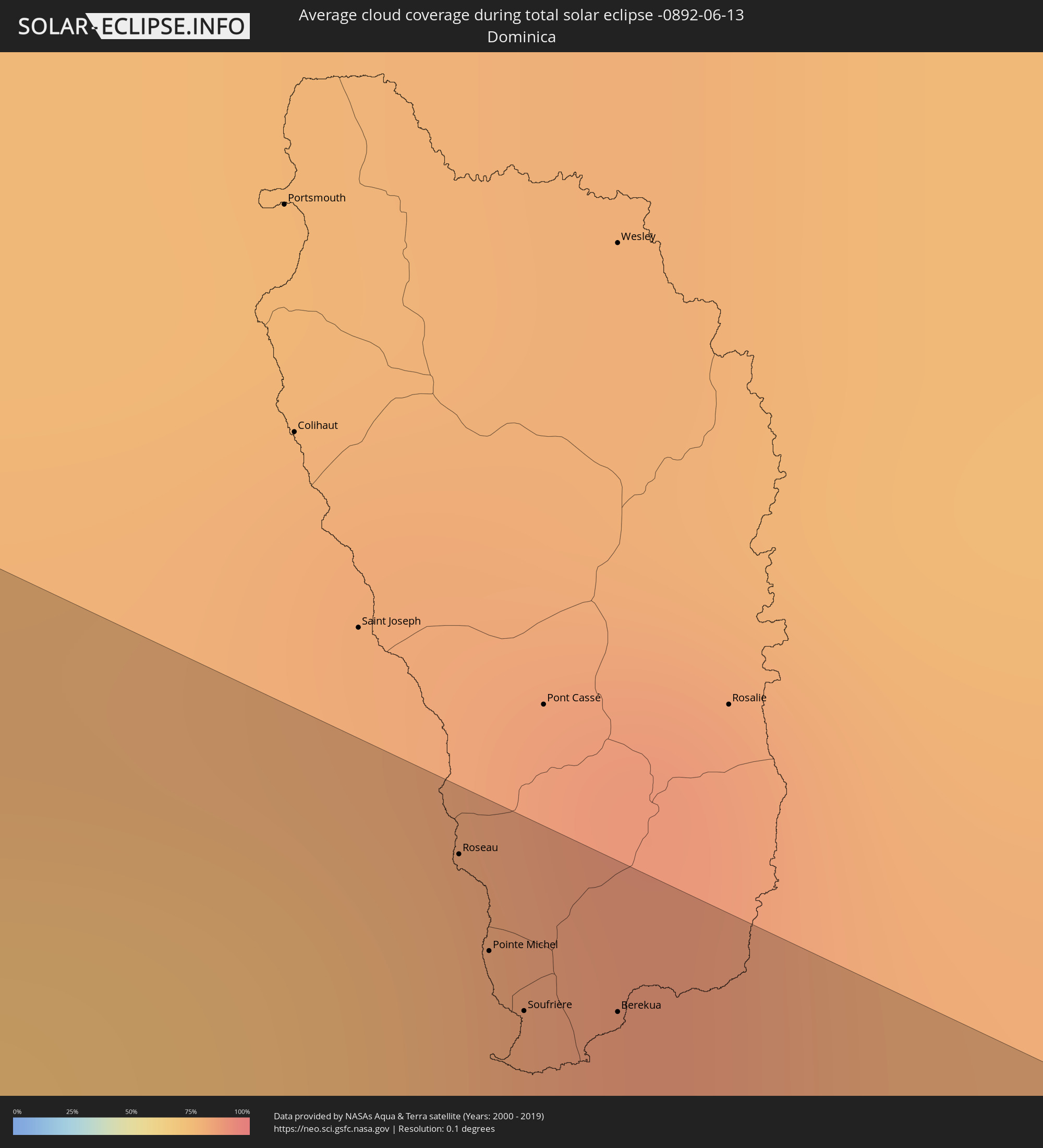 Dominica
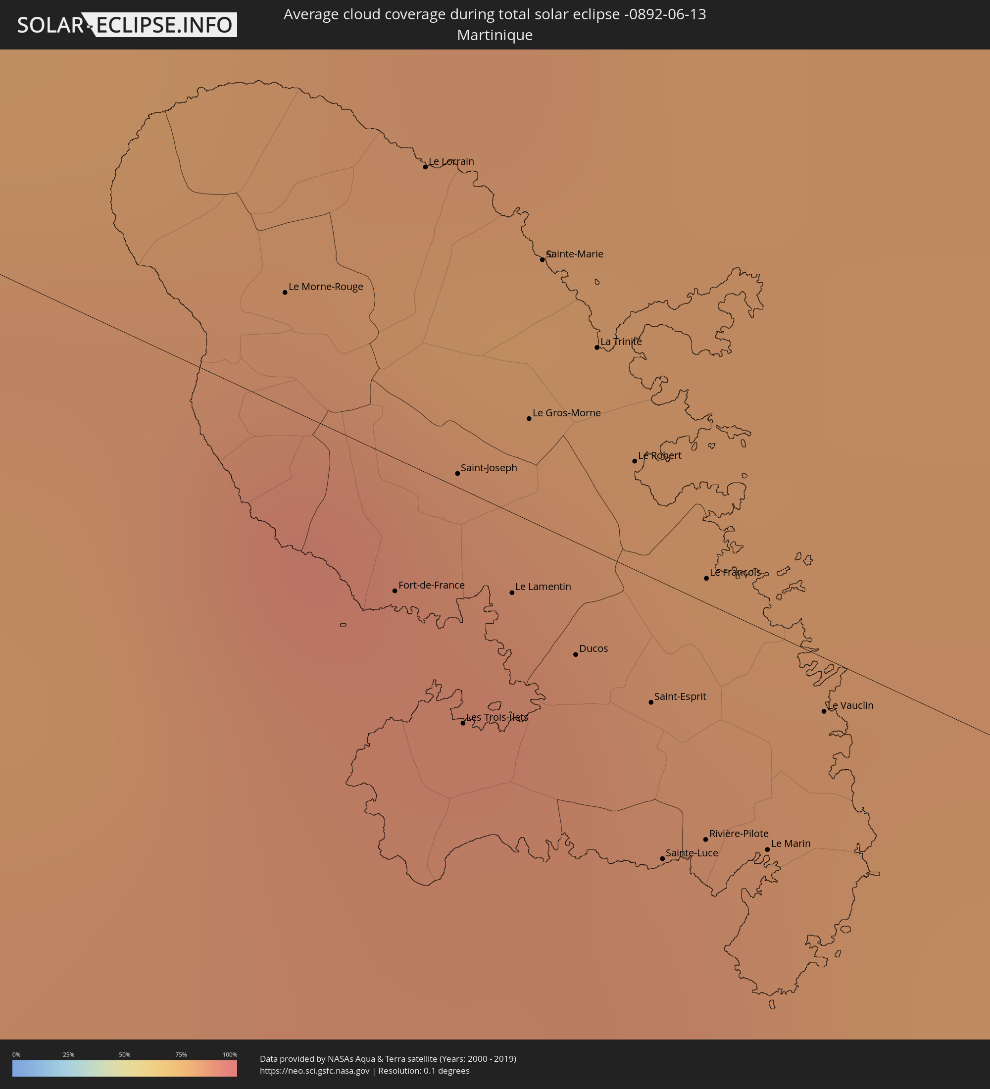 Martinique
Cities inside the path of the eclipse
The following table shows all locations with a population of more than 5,000 inside the eclipse path. Cities which have more than 100,000 inhabitants are marked bold. A click at the locations opens a detailed map.
| City | Type | Eclipse duration | Local time of max. eclipse | Distance to central line | Ø Cloud coverage |
|
San Ignacio Río Muerto, Sonora
|
total | - | 11:29:50 UTC-07:23 | 62 km | 13% |
|
Campo Sesenta, Sonora
|
total | - | 11:30:16 UTC-07:23 | 64 km | 15% |
|
Pueblo Yaqui, Sonora
|
total | - | 11:30:24 UTC-07:23 | 52 km | 17% |
|
Ciudad Obregón, Sonora
|
total | - | 11:30:43 UTC-07:23 | 66 km | 12% |
|
El Tobarito, Sonora
|
total | - | 11:30:48 UTC-07:23 | 52 km | 15% |
|
Marte R. Gómez (Tobarito), Sonora
|
total | - | 11:30:50 UTC-07:23 | 52 km | 15% |
|
Villa Juarez, Sonora
|
total | - | 11:30:52 UTC-07:23 | 25 km | 14% |
|
Bacobampo, Sonora
|
total | - | 11:31:21 UTC-07:23 | 7 km | 16% |
|
Huatabampo, Sonora
|
total | - | 11:31:19 UTC-07:23 | 11 km | 15% |
|
Etchojoa, Sonora
|
total | - | 11:31:23 UTC-07:23 | 1 km | 14% |
|
Navojoa, Sonora
|
total | - | 11:31:58 UTC-07:23 | 14 km | 12% |
|
Alamos, Sonora
|
total | - | 11:33:23 UTC-07:23 | 4 km | 13% |
|
El Fuerte de Montes Claros, Sinaloa
|
total | - | 11:52:18 UTC-07:05 | 66 km | 16% |
|
Choix, Sinaloa
|
total | - | 11:53:14 UTC-07:05 | 36 km | 16% |
|
Santa Bárbara, Chihuahua
|
total | - | 12:00:26 UTC-07:05 | 40 km | 33% |
|
Hidalgo del Parral, Chihuahua
|
total | - | 12:00:53 UTC-07:05 | 27 km | 24% |
|
Ciudad Camargo, Chihuahua
|
total | - | 12:02:21 UTC-07:05 | 55 km | 14% |
|
San Buenaventura, Coahuila
|
total | - | 12:41:37 UTC-06:36 | 8 km | 26% |
|
Ciudad Frontera, Coahuila
|
total | - | 12:41:55 UTC-06:36 | 22 km | 24% |
|
Castaños, Coahuila
|
total | - | 12:42:00 UTC-06:36 | 38 km | 30% |
|
Monclova, Coahuila
|
total | - | 12:42:00 UTC-06:36 | 25 km | 27% |
|
Minas de Barroterán, Coahuila
|
total | - | 12:42:14 UTC-06:36 | 59 km | 38% |
|
Sabinas Hidalgo, Nuevo León
|
total | - | 12:45:34 UTC-06:36 | 61 km | 39% |
|
Ciudad Anáhuac, Nuevo León
|
total | - | 12:45:29 UTC-06:36 | 21 km | 35% |
|
Anáhuac, Nuevo León
|
total | - | 12:45:29 UTC-06:36 | 21 km | 35% |
|
El Campanario y Oradel, Tamaulipas
|
total | - | 12:46:48 UTC-06:36 | 51 km | 46% |
|
Nuevo Laredo, Tamaulipas
|
total | - | 12:47:05 UTC-06:36 | 52 km | 44% |
|
Laredo, Texas
|
total | - | 13:23:42 UTC-06:00 | 55 km | 44% |
|
Zapata, Texas
|
total | - | 13:24:32 UTC-06:00 | 9 km | 38% |
|
Mier, Tamaulipas
|
total | - | 12:48:26 UTC-06:36 | 61 km | 47% |
|
Ciudad Miguel Alemán, Tamaulipas
|
total | - | 12:48:47 UTC-06:36 | 63 km | 46% |
|
Roma-Los Saenz, Texas
|
total | - | 13:25:25 UTC-06:00 | 62 km | 46% |
|
Rio Grande City, Texas
|
total | - | 13:25:58 UTC-06:00 | 63 km | 44% |
|
Edinburg, Texas
|
total | - | 13:27:47 UTC-06:00 | 64 km | 55% |
|
Elsa, Texas
|
total | - | 13:28:15 UTC-06:00 | 63 km | 55% |
|
Raymondville, Texas
|
total | - | 13:28:44 UTC-06:00 | 40 km | 62% |
|
Bauta, Artemisa
|
total | - | 14:37:01 UTC-05:29 | 46 km | 80% |
|
Havana, La Habana
|
total | - | 14:37:10 UTC-05:29 | 25 km | 79% |
|
Arroyo Naranjo, La Habana
|
total | - | 14:37:26 UTC-05:29 | 34 km | 82% |
|
San José de las Lajas, Mayabeque
|
total | - | 14:37:45 UTC-05:29 | 35 km | 82% |
|
Güines, Mayabeque
|
total | - | 14:38:06 UTC-05:29 | 43 km | 76% |
|
Matanzas, Matanzas
|
total | - | 14:38:42 UTC-05:29 | 6 km | 75% |
|
Cárdenas, Matanzas
|
total | - | 14:39:22 UTC-05:29 | 7 km | 79% |
|
Jovellanos, Matanzas
|
total | - | 14:39:37 UTC-05:29 | 17 km | 80% |
|
Jagüey Grande, Matanzas
|
total | - | 14:40:00 UTC-05:29 | 44 km | 77% |
|
Colón, Matanzas
|
total | - | 14:40:12 UTC-05:29 | 16 km | 80% |
|
Corralillo, Villa Clara
|
total | - | 14:40:29 UTC-05:29 | 23 km | 65% |
|
Cienfuegos, Cienfuegos
|
total | - | 14:41:33 UTC-05:29 | 59 km | 64% |
|
Santo Domingo, Villa Clara
|
total | - | 14:41:28 UTC-05:29 | 6 km | 76% |
|
Sagua la Grande, Villa Clara
|
total | - | 14:41:31 UTC-05:29 | 23 km | 74% |
|
Santa Clara, Villa Clara
|
total | - | 14:42:07 UTC-05:29 | 14 km | 76% |
|
Placetas, Villa Clara
|
total | - | 14:42:43 UTC-05:29 | 13 km | 80% |
|
Cabaiguán, Sancti Spíritus
|
total | - | 14:43:13 UTC-05:29 | 31 km | 79% |
|
Sancti Spíritus, Sancti Spíritus
|
total | - | 14:43:27 UTC-05:29 | 44 km | 70% |
|
Ciego de Ávila, Ciego de Ávila
|
total | - | 14:44:38 UTC-05:29 | 28 km | 79% |
|
Morón, Ciego de Ávila
|
total | - | 14:44:35 UTC-05:29 | 5 km | 81% |
|
Florida, Camagüey
|
total | - | 14:45:48 UTC-05:29 | 40 km | 75% |
|
Camagüey, Camagüey
|
total | - | 14:46:25 UTC-05:29 | 43 km | 74% |
|
Nuevitas, Camagüey
|
total | - | 14:47:14 UTC-05:29 | 1 km | 65% |
|
Las Tunas, Las Tunas
|
total | - | 14:48:18 UTC-05:29 | 49 km | 74% |
|
Puerto Padre, Las Tunas
|
total | - | 14:48:34 UTC-05:29 | 11 km | 77% |
|
Holguín, Holguín
|
total | - | 14:49:22 UTC-05:29 | 29 km | 76% |
|
Banes, Holguín
|
total | - | 14:50:03 UTC-05:29 | 0 km | 62% |
|
Moa, Holguín
|
total | - | 14:51:25 UTC-05:29 | 0 km | 69% |
|
Baracoa, Guantánamo
|
total | - | 14:52:20 UTC-05:29 | 13 km | 78% |
|
Jean-Rabel, Nord-Ouest
|
total | - | 15:35:05 UTC-04:49 | 10 km | 69% |
|
Ti Port-de-Paix, Nord-Ouest
|
total | - | 15:35:27 UTC-04:49 | 13 km | 62% |
|
Port-de-Paix, Nord-Ouest
|
total | - | 15:35:27 UTC-04:49 | 14 km | 62% |
|
Saint-Louis du Nord, Nord-Ouest
|
total | - | 15:35:35 UTC-04:49 | 18 km | 61% |
|
Gonayiv, Artibonite
|
total | - | 15:36:06 UTC-04:49 | 30 km | 56% |
|
Gros Morne, Artibonite
|
total | - | 15:35:54 UTC-04:49 | 7 km | 64% |
|
Dessalines, Artibonite
|
total | - | 15:36:30 UTC-04:49 | 42 km | 61% |
|
Lenbe, Nord
|
total | - | 15:36:12 UTC-04:49 | 8 km | 65% |
|
Dondon, Nord
|
total | - | 15:36:34 UTC-04:49 | 3 km | 68% |
|
Milot, Nord
|
total | - | 15:36:31 UTC-04:49 | 6 km | 69% |
|
Okap, Nord
|
total | - | 15:36:23 UTC-04:49 | 22 km | 51% |
|
Saint-Raphaël, Nord
|
total | - | 15:36:42 UTC-04:49 | 10 km | 59% |
|
Grande Rivière du Nord, Nord
|
total | - | 15:36:36 UTC-04:49 | 5 km | 69% |
|
Mayisad, Centre
|
total | - | 15:37:02 UTC-04:49 | 35 km | 50% |
|
Pignon, Nord
|
total | - | 15:36:54 UTC-04:49 | 17 km | 58% |
|
Trou du Nord, Nord-Est
|
total | - | 15:36:44 UTC-04:49 | 15 km | 71% |
|
Hinche, Centre
|
total | - | 15:37:11 UTC-04:49 | 32 km | 51% |
|
Fort Liberté, Nord-Est
|
total | - | 15:36:54 UTC-04:49 | 28 km | 58% |
|
Ouanaminthe, Nord-Est
|
total | - | 15:37:08 UTC-04:49 | 21 km | 63% |
|
Dajabón, Dajabón
|
total | - | 15:46:09 UTC-04:40 | 22 km | 63% |
|
Comendador, Elías Piña
|
total | - | 15:46:49 UTC-04:40 | 46 km | 61% |
|
San Fernando de Monte Cristi, Monte Cristi
|
total | - | 15:45:56 UTC-04:40 | 55 km | 68% |
|
Las Matas de Farfán, San Juan
|
total | - | 15:47:02 UTC-04:40 | 39 km | 54% |
|
Villa Vásquez, Monte Cristi
|
total | - | 15:46:16 UTC-04:40 | 52 km | 63% |
|
Sabaneta, Santiago Rodríguez
|
total | - | 15:46:39 UTC-04:40 | 30 km | 61% |
|
San Juan de la Maguana, San Juan
|
total | - | 15:47:25 UTC-04:40 | 34 km | 66% |
|
Mao, Valverde
|
total | - | 15:46:52 UTC-04:40 | 49 km | 56% |
|
Constanza, La Vega
|
total | - | 15:47:51 UTC-04:40 | 2 km | 71% |
|
Azua, Azua
|
total | - | 15:48:18 UTC-04:40 | 48 km | 68% |
|
Santiago de los Caballeros, Santiago
|
total | - | 15:47:23 UTC-04:40 | 55 km | 66% |
|
Jarabacoa, La Vega
|
total | - | 15:47:46 UTC-04:40 | 24 km | 60% |
|
Concepción de La Vega, La Vega
|
total | - | 15:47:47 UTC-04:40 | 39 km | 65% |
|
Moca, Espaillat
|
total | - | 15:47:37 UTC-04:40 | 56 km | 71% |
|
San José de Ocoa, San José de Ocoa
|
total | - | 15:48:28 UTC-04:40 | 29 km | 76% |
|
Bonao, Monseñor Nouel
|
total | - | 15:48:12 UTC-04:40 | 15 km | 71% |
|
Baní, Peravia
|
total | - | 15:48:54 UTC-04:40 | 48 km | 71% |
|
Cambita Garabitos, San Cristóbal
|
total | - | 15:48:53 UTC-04:40 | 25 km | 83% |
|
Villa Altagracia, San Cristóbal
|
total | - | 15:48:42 UTC-04:40 | 2 km | 83% |
|
Cotuí, Sánchez Ramírez
|
total | - | 15:48:21 UTC-04:40 | 38 km | 80% |
|
Santo Domingo, Nacional
|
total | - | 15:49:03 UTC-04:40 | 11 km | 77% |
|
Sabana Grande de Boyá, Monte Plata
|
total | - | 15:48:50 UTC-04:40 | 42 km | 86% |
|
Monte Plata, Monte Plata
|
total | - | 15:48:59 UTC-04:40 | 29 km | 84% |
|
Bayaguana, Monte Plata
|
total | - | 15:49:11 UTC-04:40 | 29 km | 85% |
|
Boca Chica, Santo Domingo
|
total | - | 15:49:30 UTC-04:40 | 1 km | 70% |
|
Quisqueya, San Pedro de Macorís
|
total | - | 15:49:36 UTC-04:40 | 20 km | 84% |
|
San Pedro de Macorís, San Pedro de Macorís
|
total | - | 15:49:48 UTC-04:40 | 15 km | 71% |
|
Hato Mayor del Rey, Hato Mayor
|
total | - | 15:49:33 UTC-04:40 | 47 km | 85% |
|
La Romana, La Romana
|
total | - | 15:50:09 UTC-04:40 | 26 km | 67% |
|
Roseau, Saint George
|
total | - | 16:32:49 UTC-04:06 | 49 km | 76% |
|
Pointe Michel, Saint Luke
|
total | - | 16:32:51 UTC-04:06 | 45 km | 76% |
|
Soufrière, Saint Mark
|
total | - | 16:32:53 UTC-04:06 | 43 km | 77% |
|
Berekua, Saint Patrick
|
total | - | 16:32:55 UTC-04:06 | 45 km | 80% |
|
Le Morne-Rouge, Martinique
|
total | - | 16:35:08 UTC-04:04 | 6 km | 91% |
|
Fort-de-France, Martinique
|
total | - | 16:35:18 UTC-04:04 | 7 km | 86% |
|
Le Lorrain, Martinique
|
total | - | 16:35:07 UTC-04:04 | 16 km | 91% |
|
Saint-Joseph, Martinique
|
total | - | 16:35:16 UTC-04:04 | 1 km | 88% |
|
Les Trois-Îlets, Martinique
|
total | - | 16:35:22 UTC-04:04 | 12 km | 83% |
|
Le Lamentin, Martinique
|
total | - | 16:35:20 UTC-04:04 | 4 km | 86% |
|
Le Gros-Morne, Martinique
|
total | - | 16:35:16 UTC-04:04 | 5 km | 88% |
|
Sainte-Marie, Martinique
|
total | - | 16:35:12 UTC-04:04 | 14 km | 84% |
|
Ducos, Martinique
|
total | - | 16:35:23 UTC-04:04 | 6 km | 86% |
|
La Trinité, Martinique
|
total | - | 16:35:15 UTC-04:04 | 11 km | 88% |
|
Le Robert, Martinique
|
total | - | 16:35:19 UTC-04:04 | 6 km | 83% |
|
Saint-Esprit, Martinique
|
total | - | 16:35:25 UTC-04:04 | 7 km | 85% |
|
Sainte-Luce, Martinique
|
total | - | 16:35:30 UTC-04:04 | 15 km | 83% |
|
Rivière-Pilote, Martinique
|
total | - | 16:35:30 UTC-04:04 | 13 km | 83% |
|
Le François, Martinique
|
total | - | 16:35:23 UTC-04:04 | 1 km | 85% |
|
Le Marin, Martinique
|
total | - | 16:35:31 UTC-04:04 | 12 km | 83% |
|
Le Vauclin, Martinique
|
total | - | 16:35:29 UTC-04:04 | 3 km | 79% |