Total solar eclipse of 05/22/-0947
| Day of week: | Friday |
| Maximum duration of eclipse: | 05m25s |
| Maximum width of eclipse path: | 314 km |
| Saros cycle: | 32 |
| Coverage: | 100% |
| Magnitude: | 1.078 |
| Gamma: | 0.594 |
Wo kann man die Sonnenfinsternis vom 05/22/-0947 sehen?
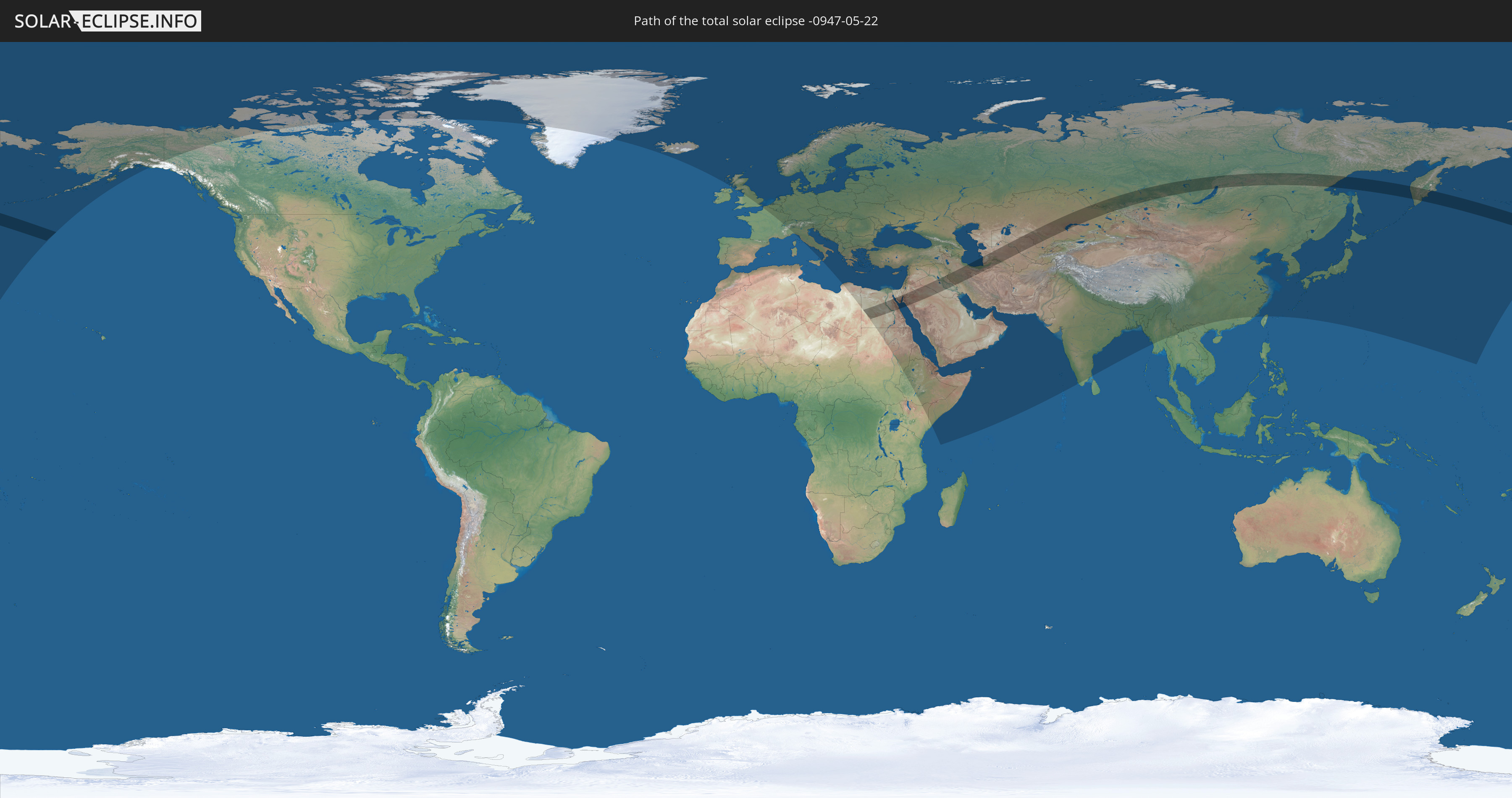
Die Sonnenfinsternis am 05/22/-0947 kann man in 95 Ländern als partielle Sonnenfinsternis beobachten.
Der Finsternispfad verläuft durch 10 Länder. Nur in diesen Ländern ist sie als total Sonnenfinsternis zu sehen.
In den folgenden Ländern ist die Sonnenfinsternis total zu sehen
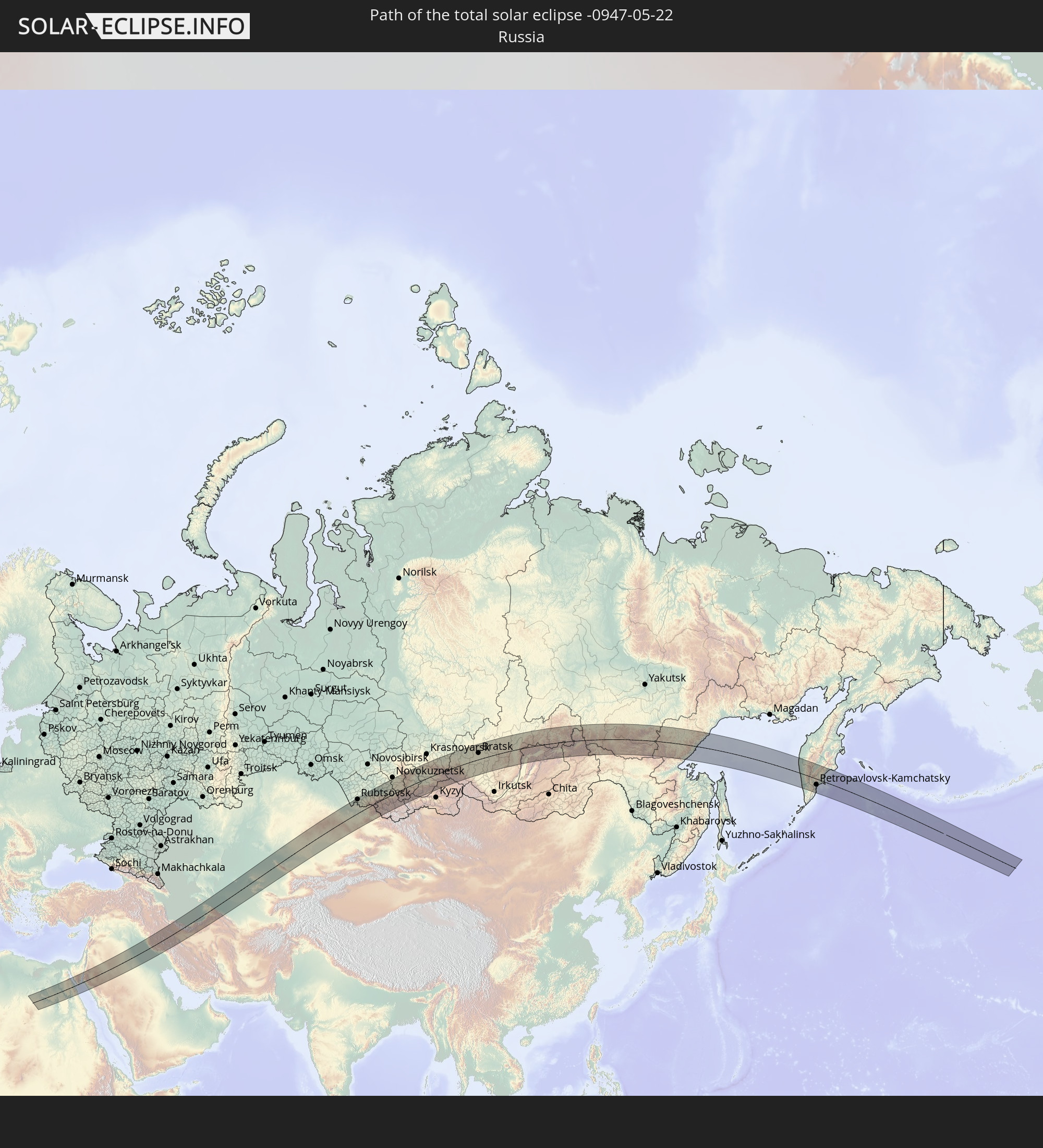 Russia
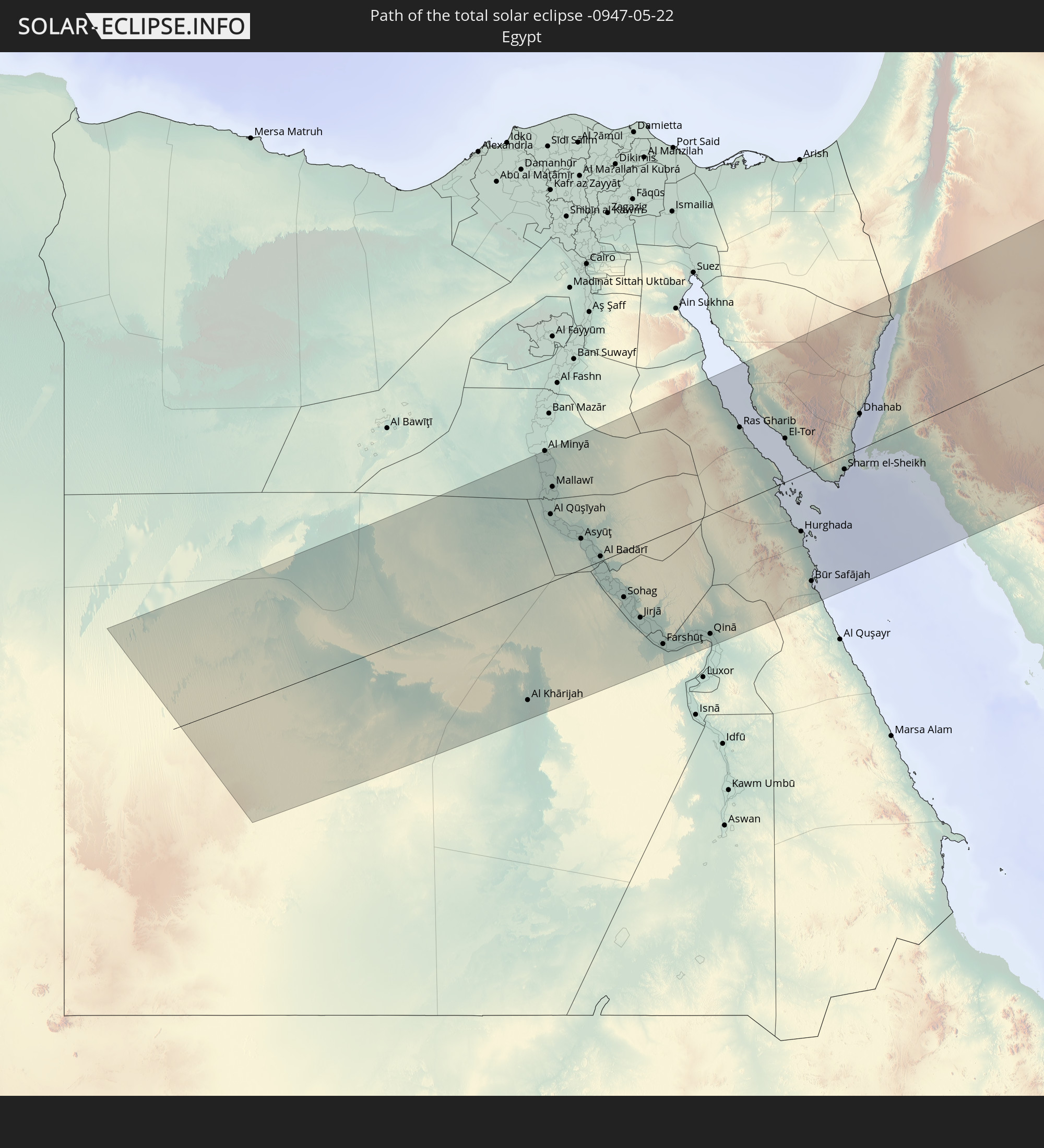 Egypt
Egypt
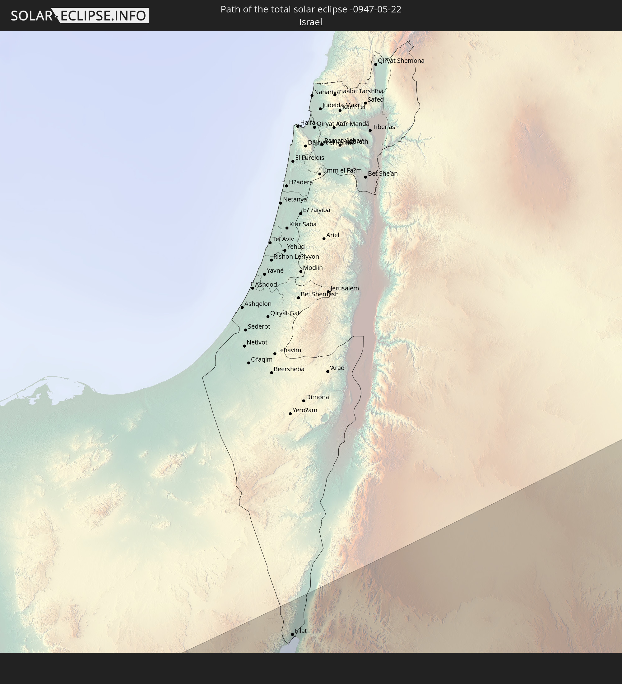 Israel
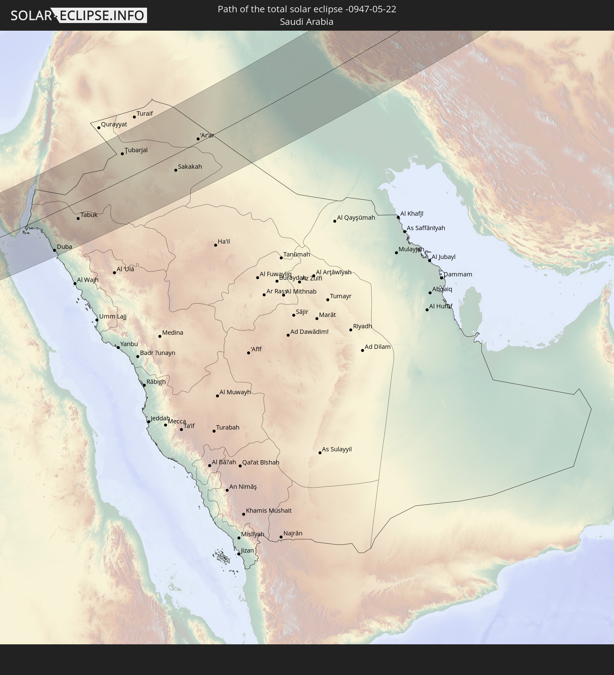 Saudi Arabia
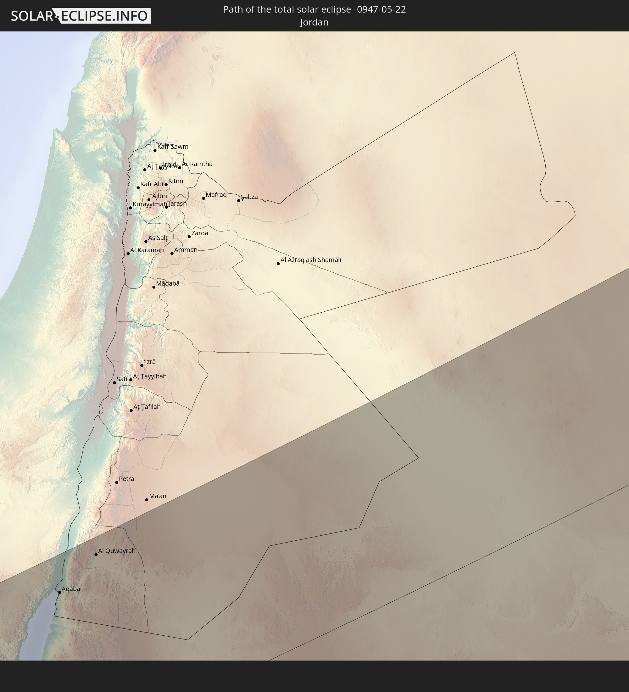 Jordan
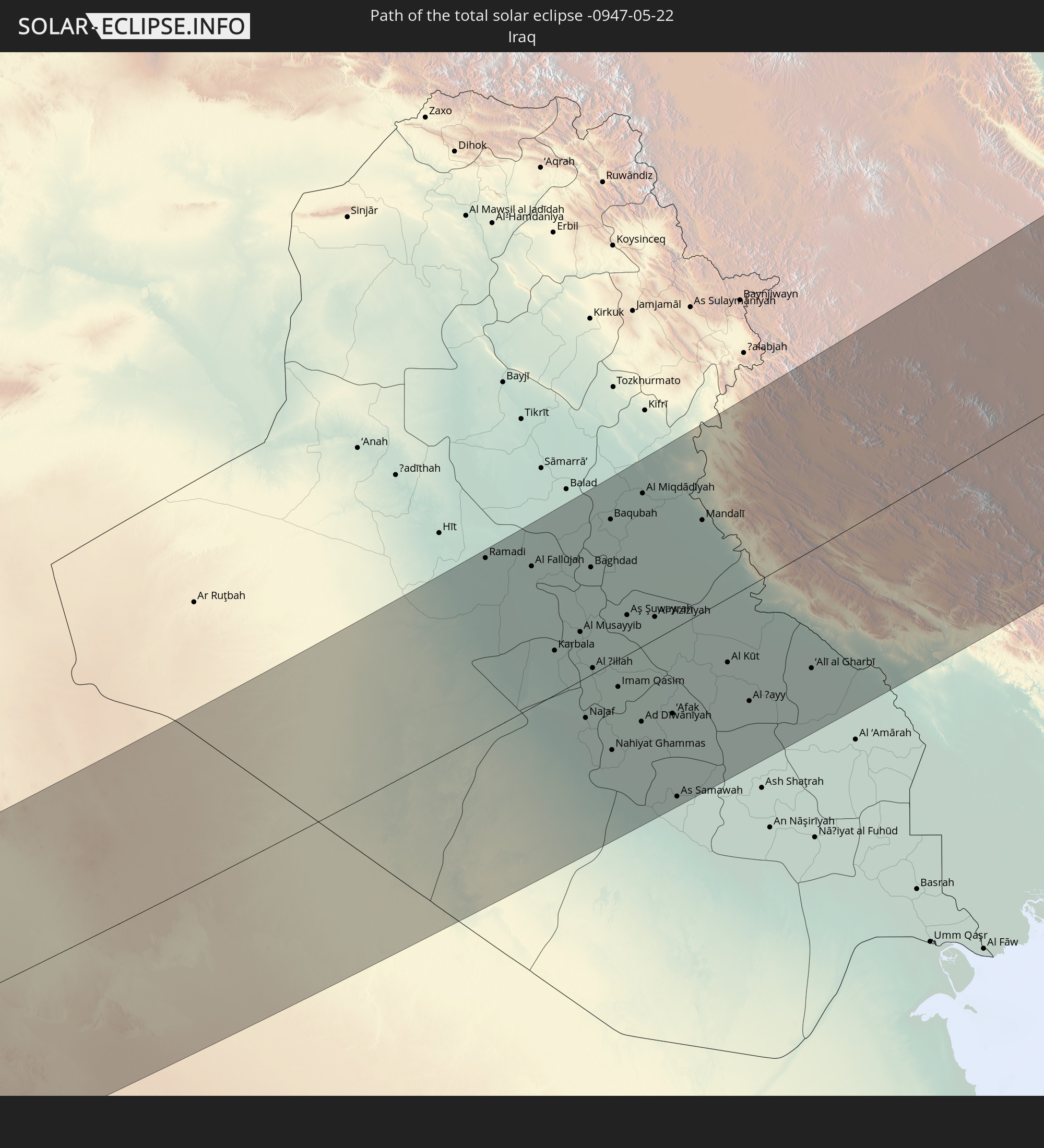 Iraq
Iraq
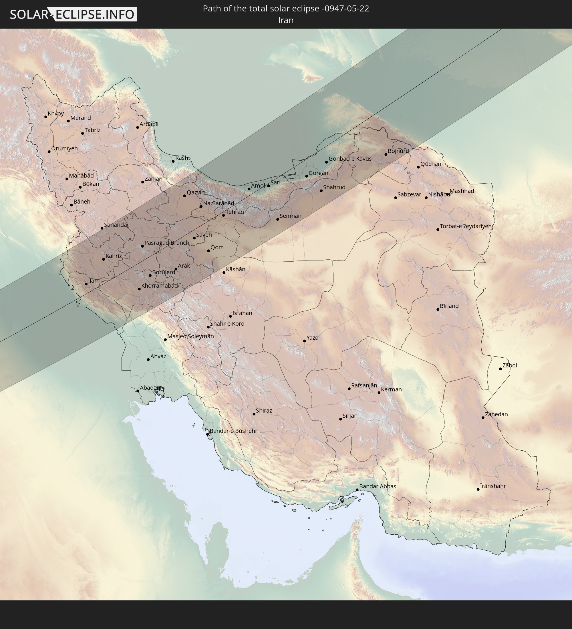 Iran
Iran
 Kazakhstan
 Turkmenistan
 Uzbekistan
In den folgenden Ländern ist die Sonnenfinsternis partiell zu sehen
 Russia
 United States
 United States Minor Outlying Islands
 Canada
 Greenland
 Iceland
 Svalbard and Jan Mayen
 United Kingdom
 Faroe Islands
 France
 Belgium
 Netherlands
 Norway
 Luxembourg
 Germany
 Switzerland
 Italy
Italy
 Denmark
 Libya
Libya
 Liechtenstein
 Austria
 Sweden
 Czechia
 San Marino
 Vatican City
 Slovenia
 Croatia
 Poland
 Bosnia and Herzegovina
 Hungary
 Slovakia
 Montenegro
 Serbia
 Albania
 Åland Islands
 Greece
 Romania
 Republic of Macedonia
 Finland
 Lithuania
 Latvia
 Estonia
 Sudan
Sudan
 Ukraine
 Bulgaria
 Belarus
 Egypt
Egypt
 Turkey
 Moldova
 Cyprus
 Ethiopia
 Kenya
Kenya
 State of Palestine
 Israel
 Saudi Arabia
 Jordan
 Lebanon
 Syria
Syria
 Eritrea
 Iraq
Iraq
 Georgia
 Somalia
 Djibouti
 Yemen
Yemen
 Armenia
 Iran
Iran
 Azerbaijan
 Kazakhstan
 Kuwait
 Bahrain
 Qatar
Qatar
 United Arab Emirates
 Oman
Oman
 Turkmenistan
 Uzbekistan
 Afghanistan
 Pakistan
 Tajikistan
 India
India
 Kyrgyzstan
 Maldives
 China
China
 Nepal
Nepal
 Mongolia
 Bangladesh
 Bhutan
 Myanmar
 Thailand
 Laos
Laos
 Vietnam
 Taiwan
 Japan
Japan
 North Korea
 South Korea
 Marshall Islands
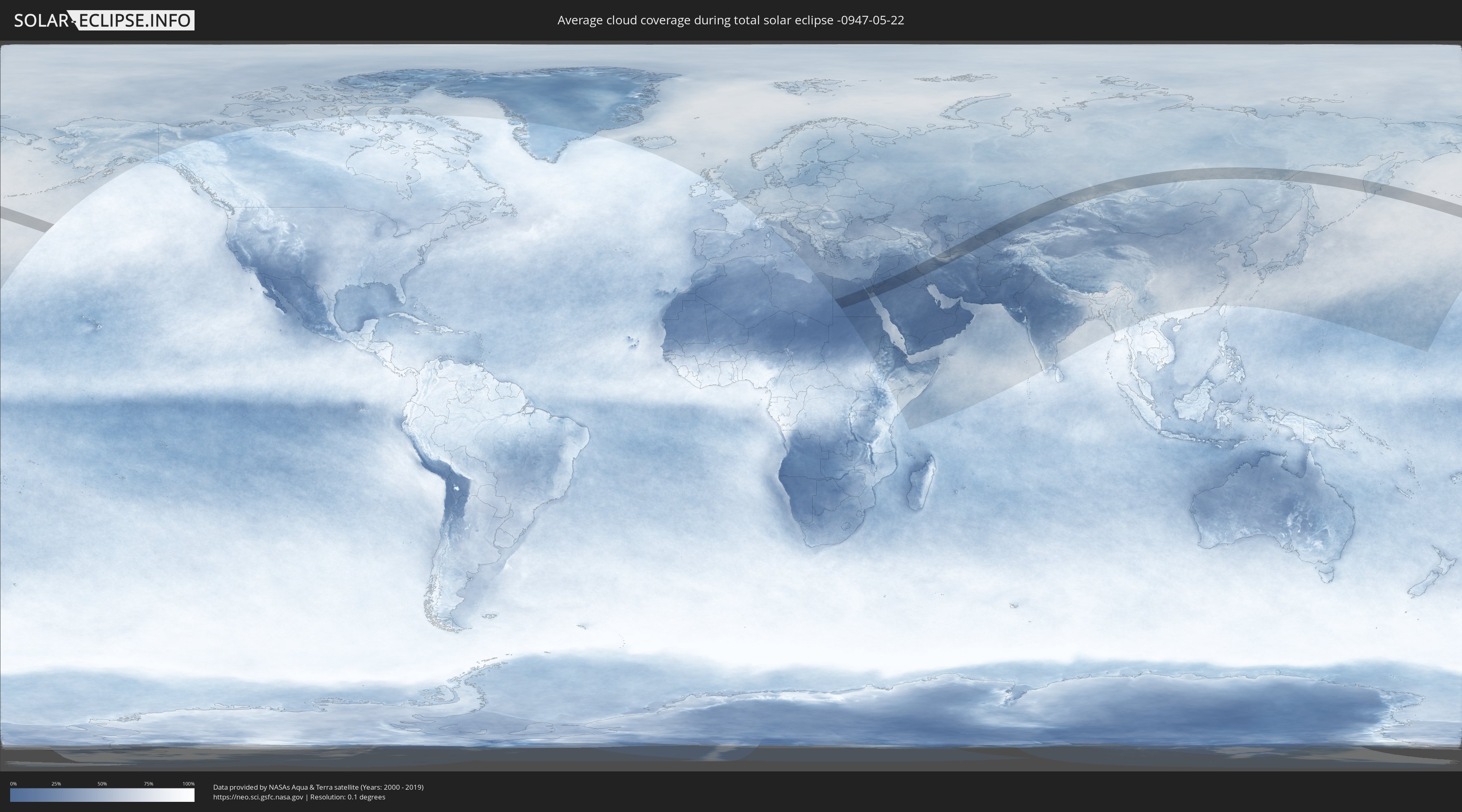
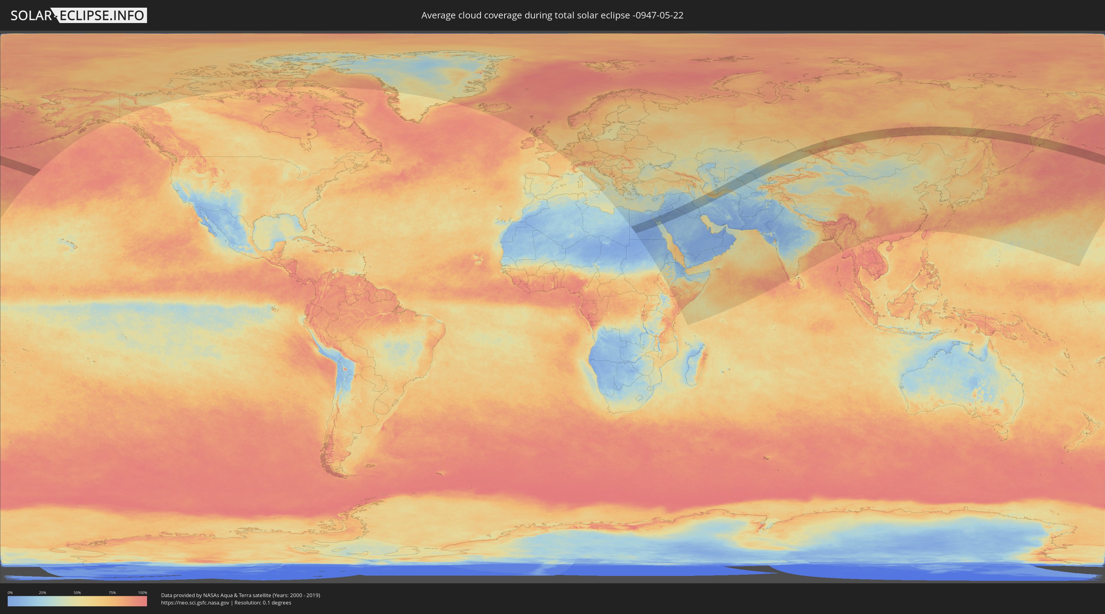
How will be the weather during the total solar eclipse on 05/22/-0947?
Where is the best place to see the total solar eclipse of 05/22/-0947?
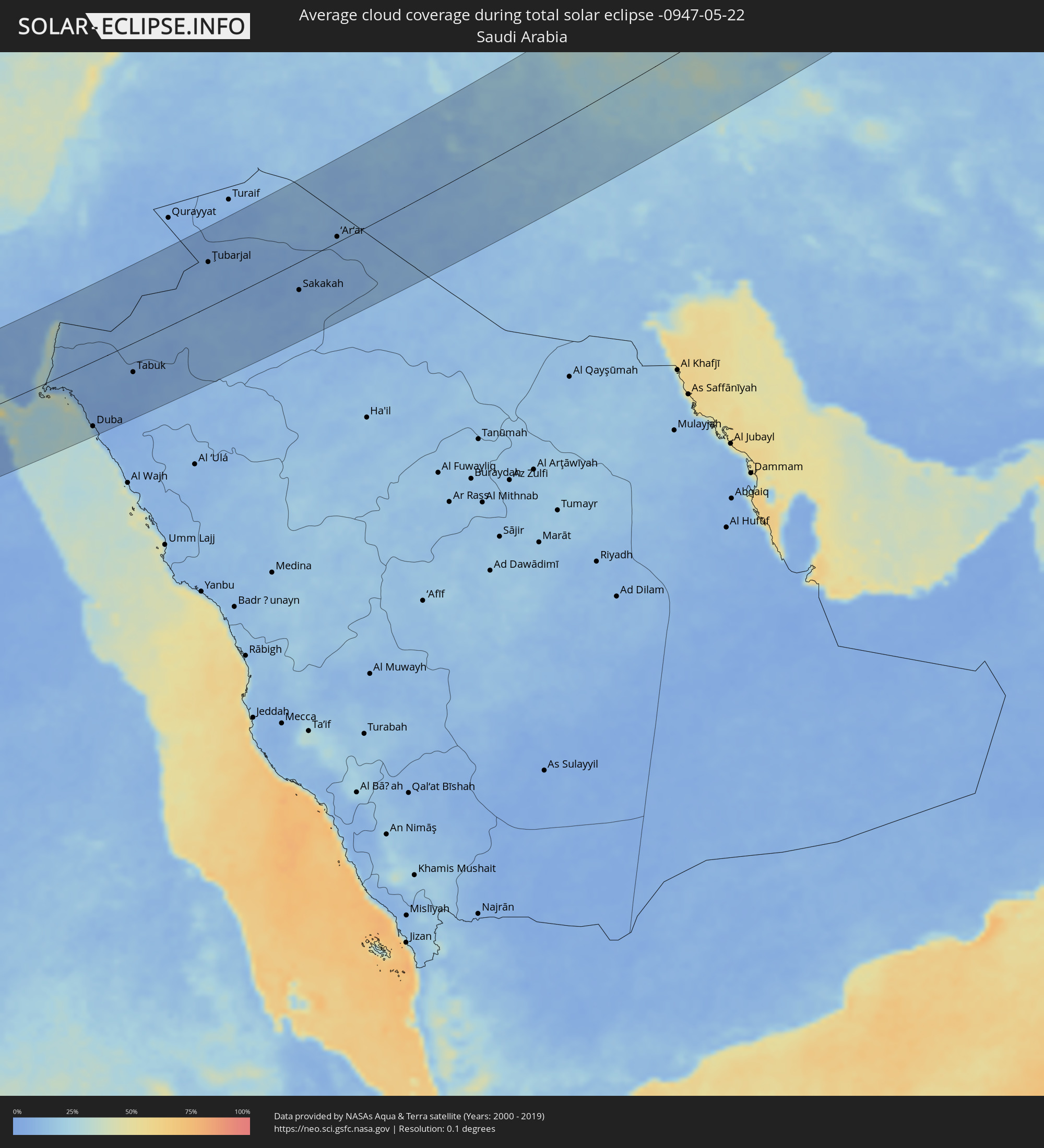
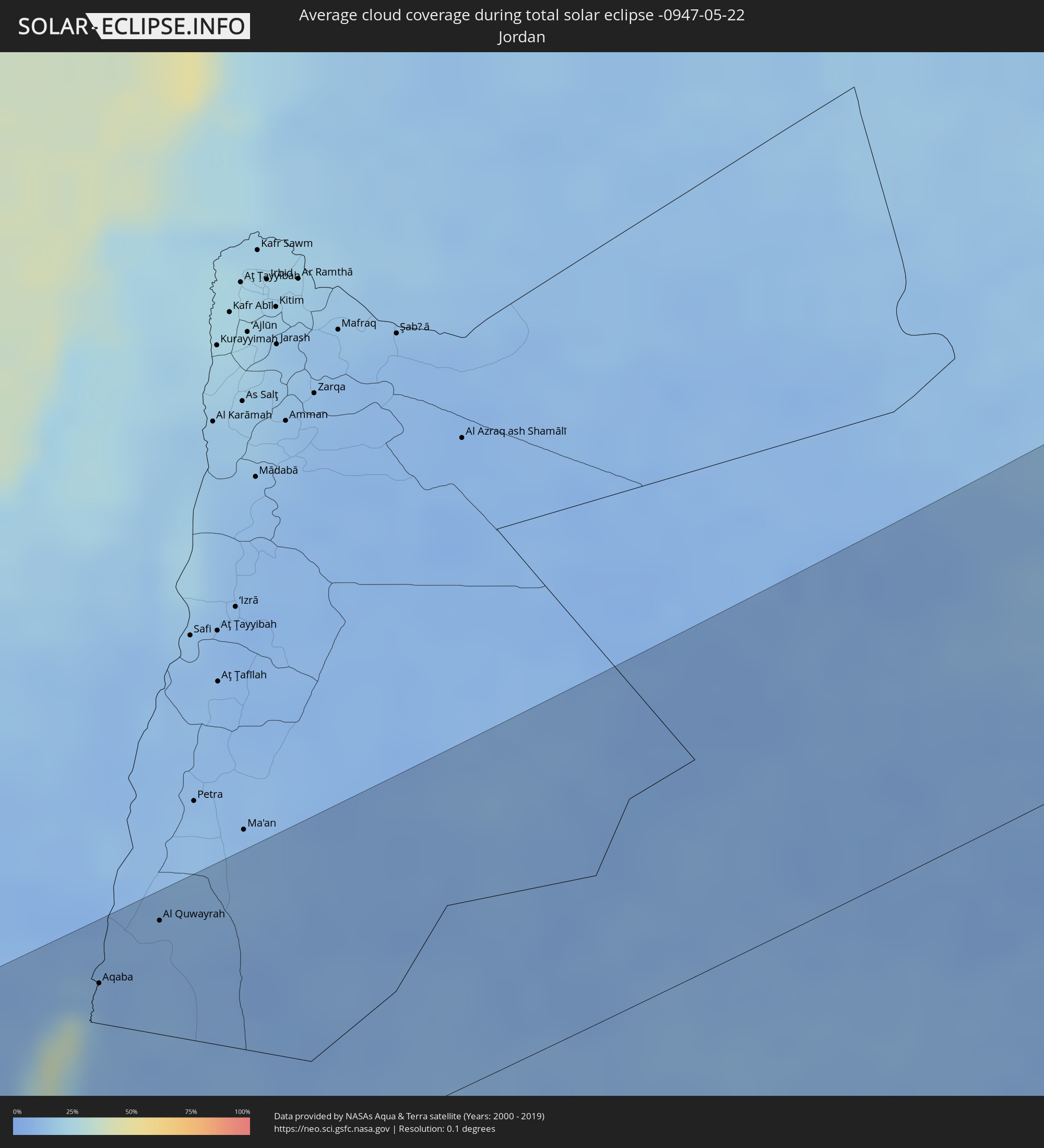
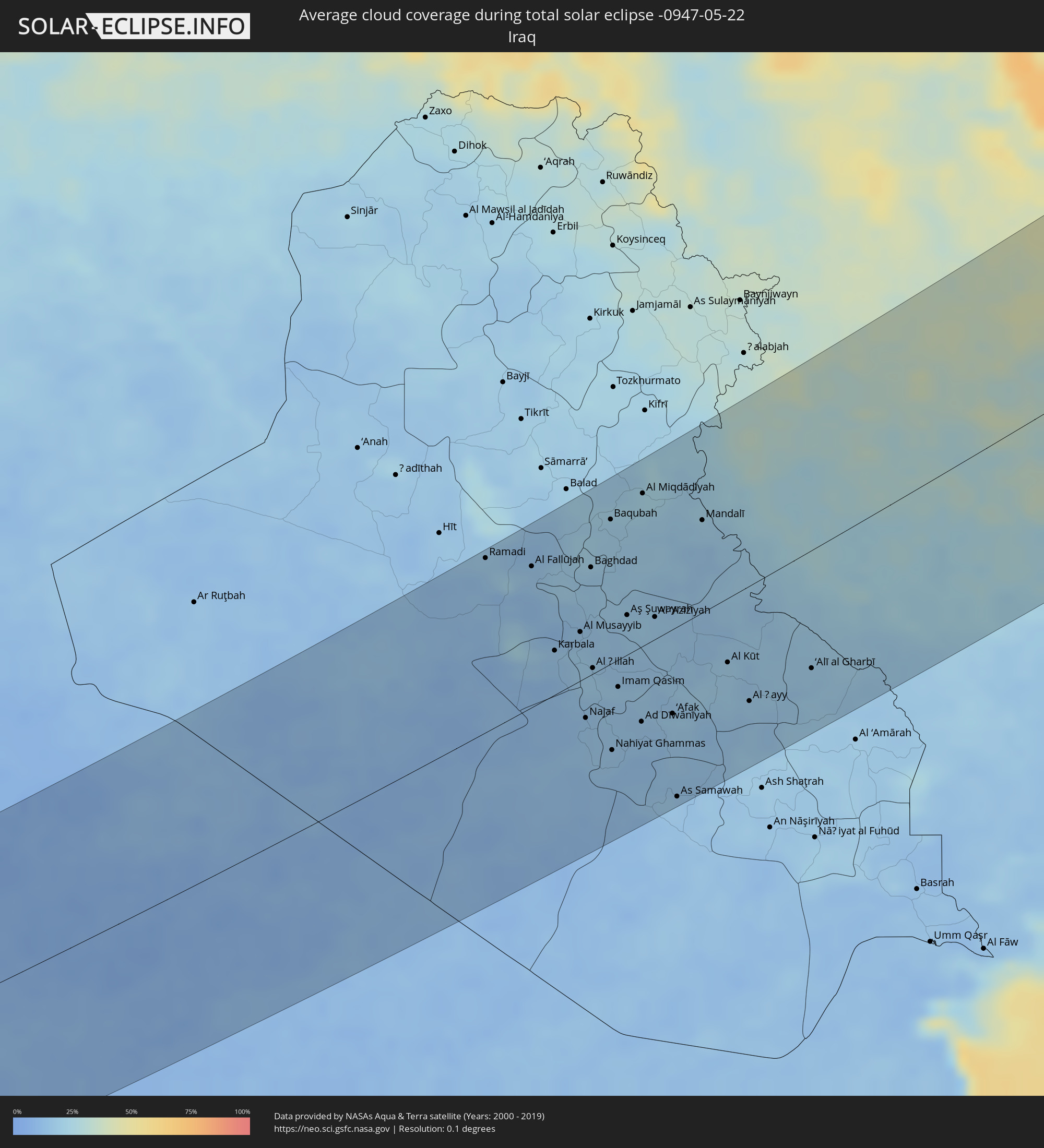
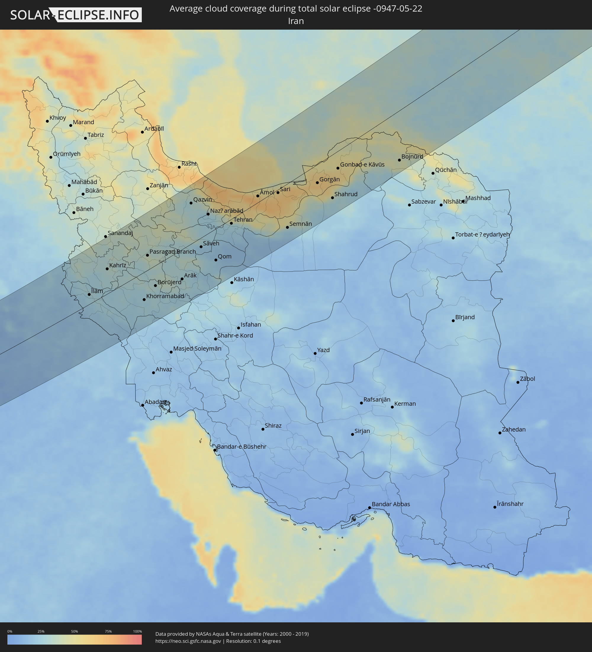
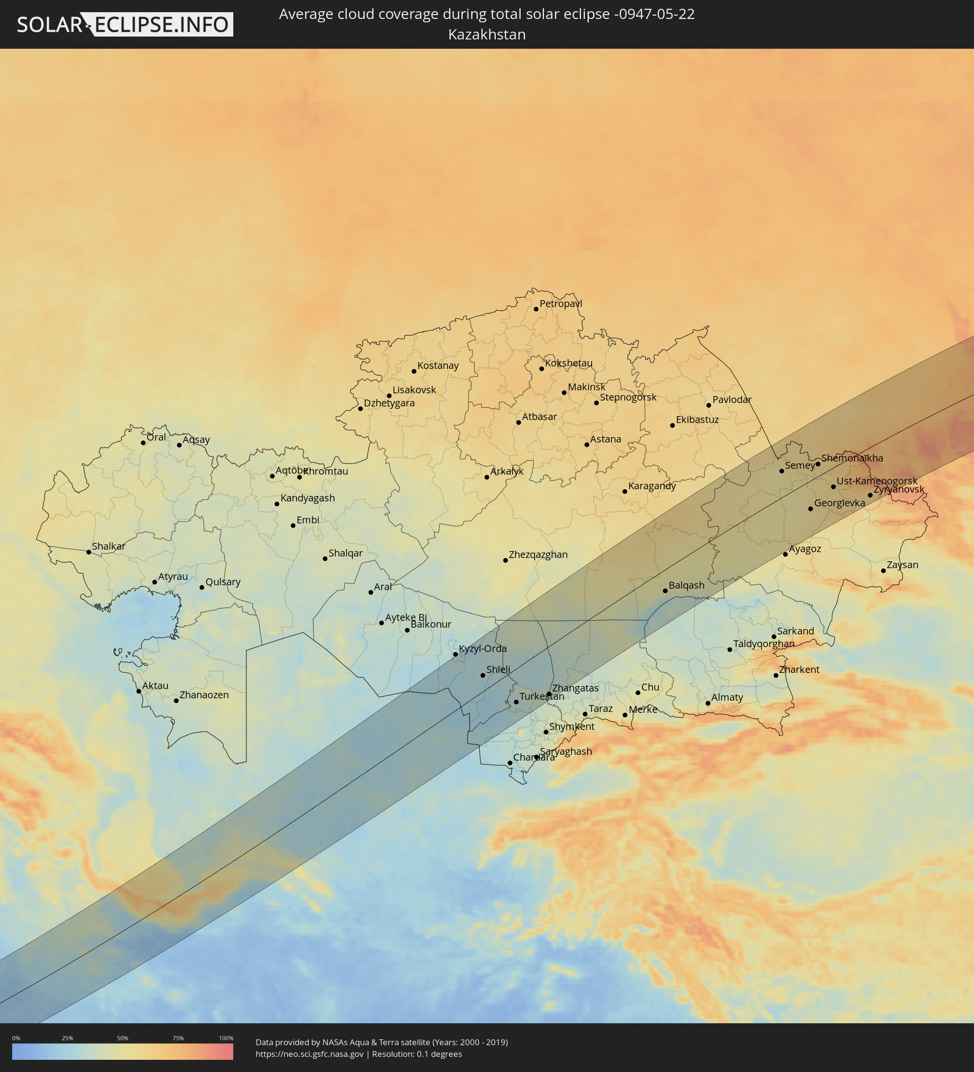
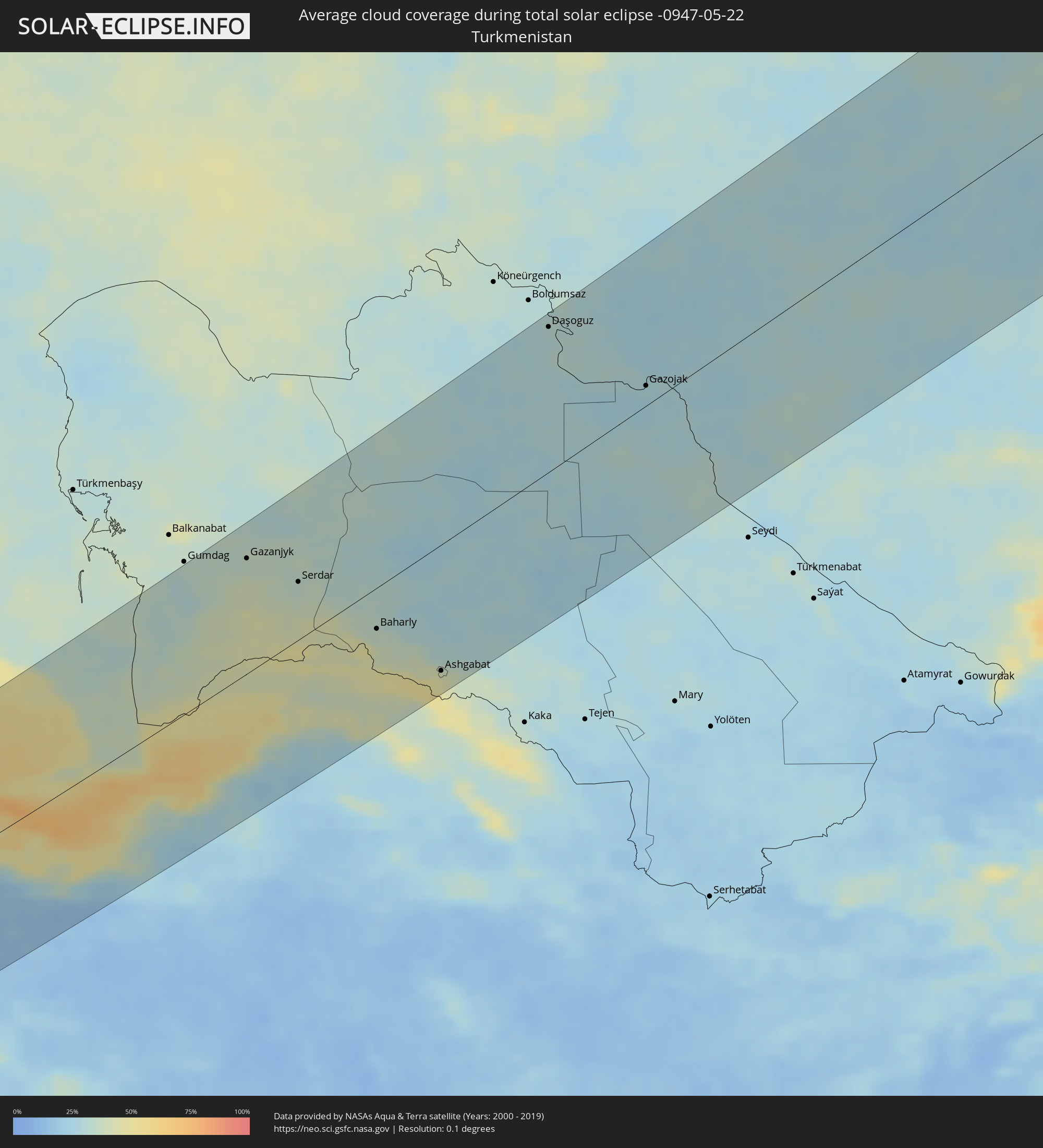
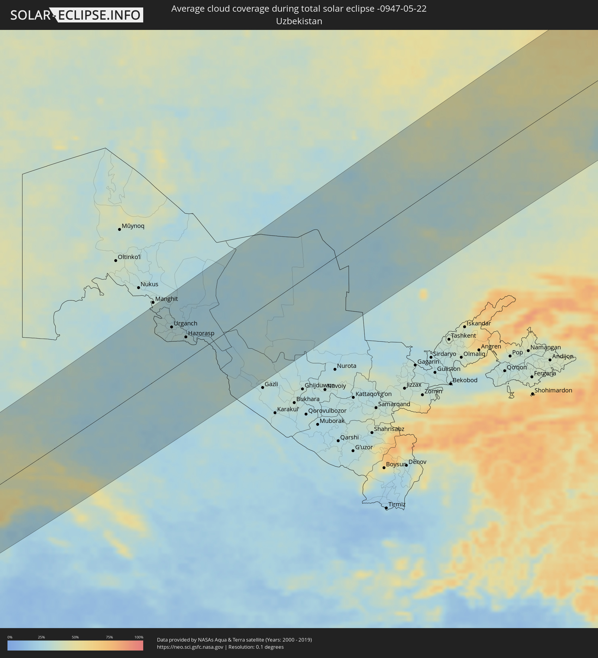
The following maps show the average cloud coverage for the day of the total solar eclipse.
With the help of these maps, it is possible to find the place along the eclipse path, which has the best
chance of a cloudless sky.
Nevertheless, you should consider local circumstances and inform about the weather of your chosen
observation site.
The data is provided by NASAs satellites
AQUA and TERRA.
The cloud maps are averaged over a period of 19 years (2000 - 2019).
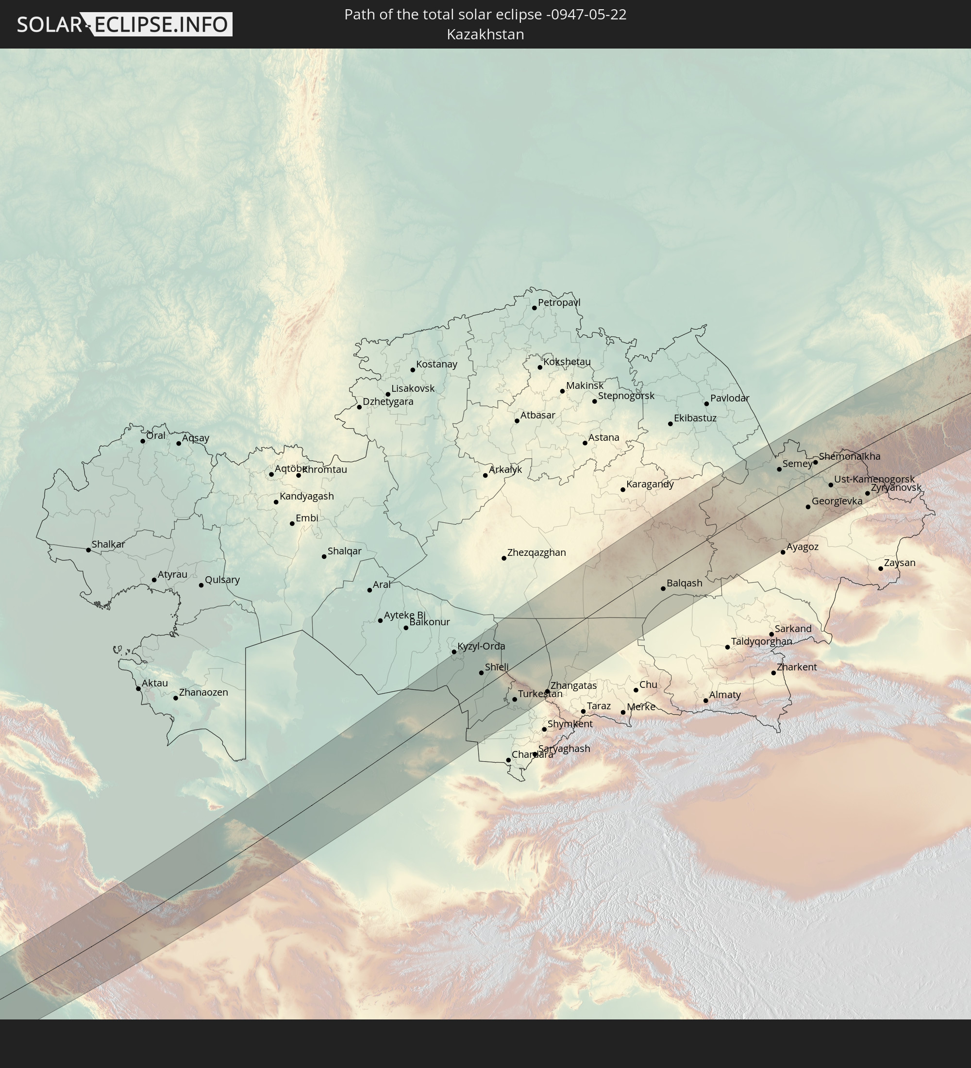
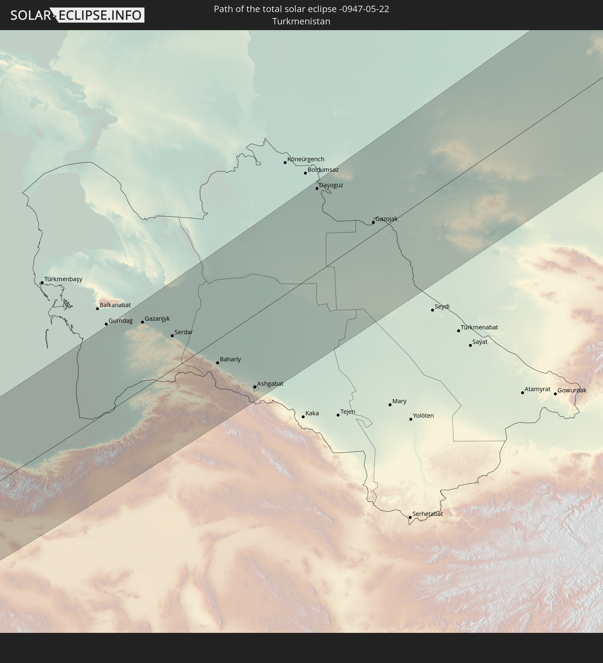
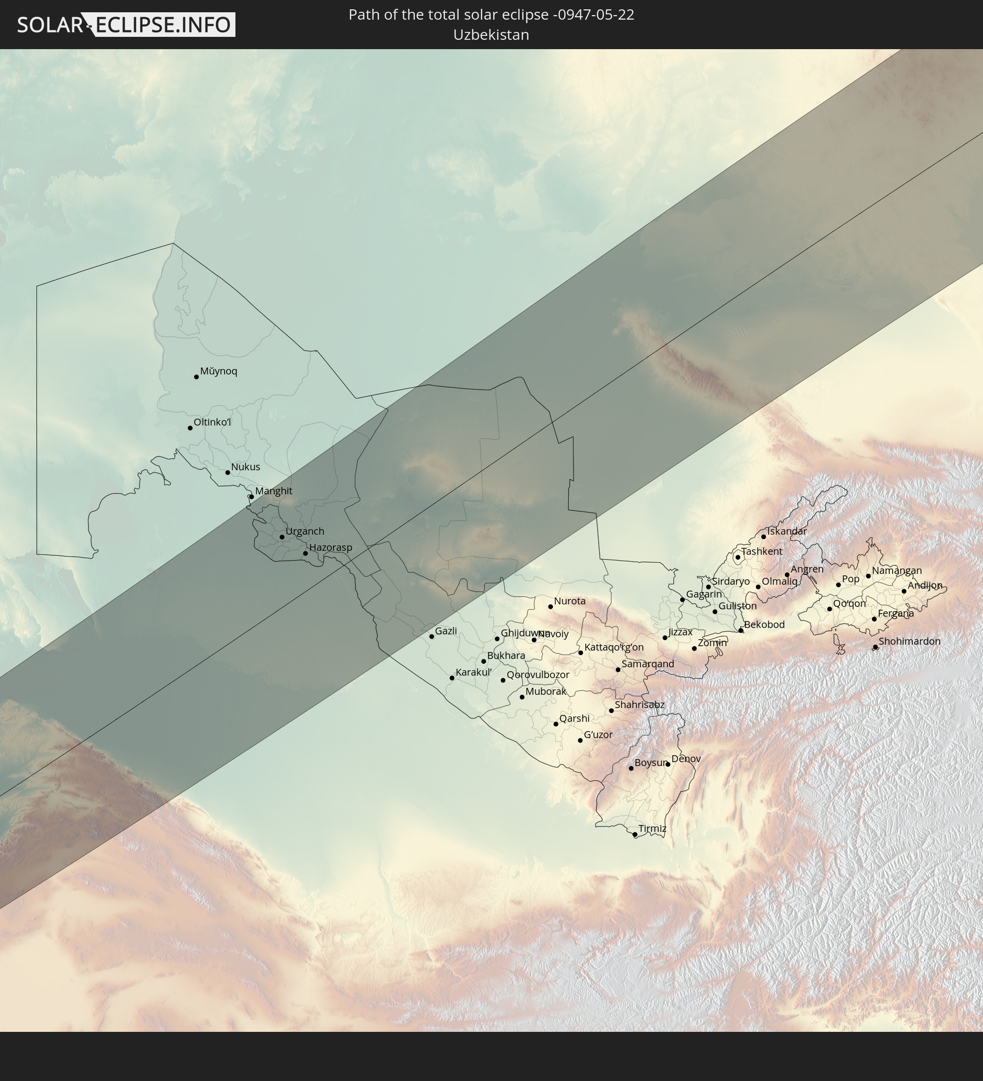
Detailed country maps
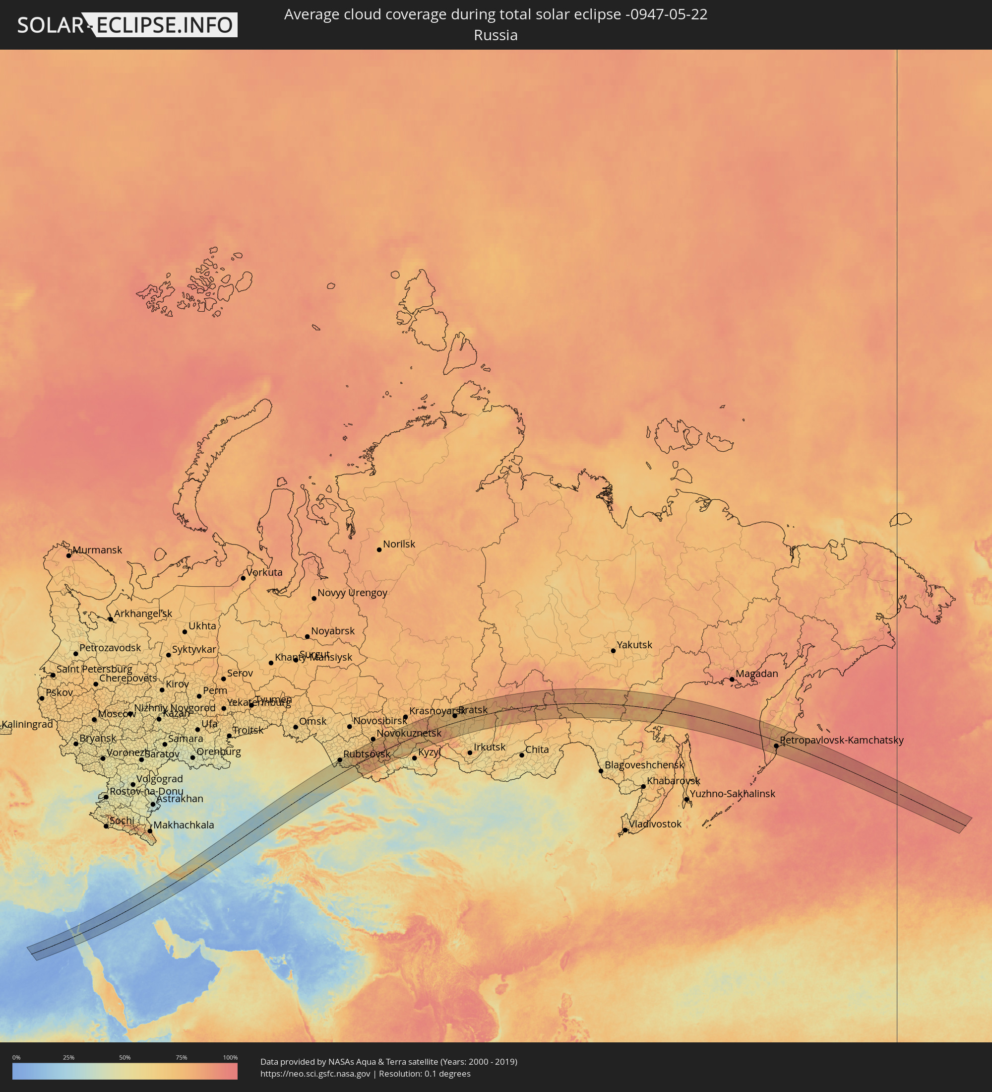 Russia
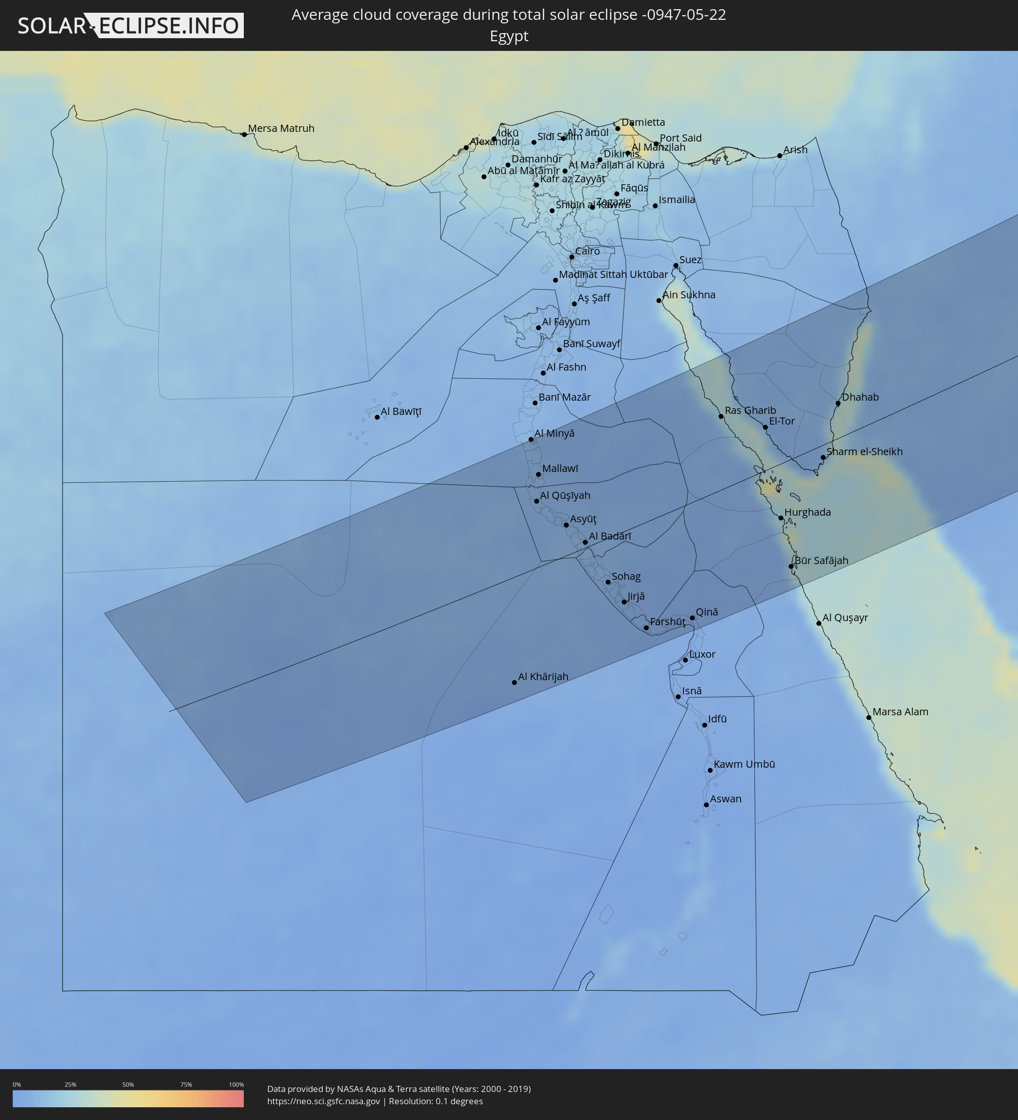 Egypt
Egypt
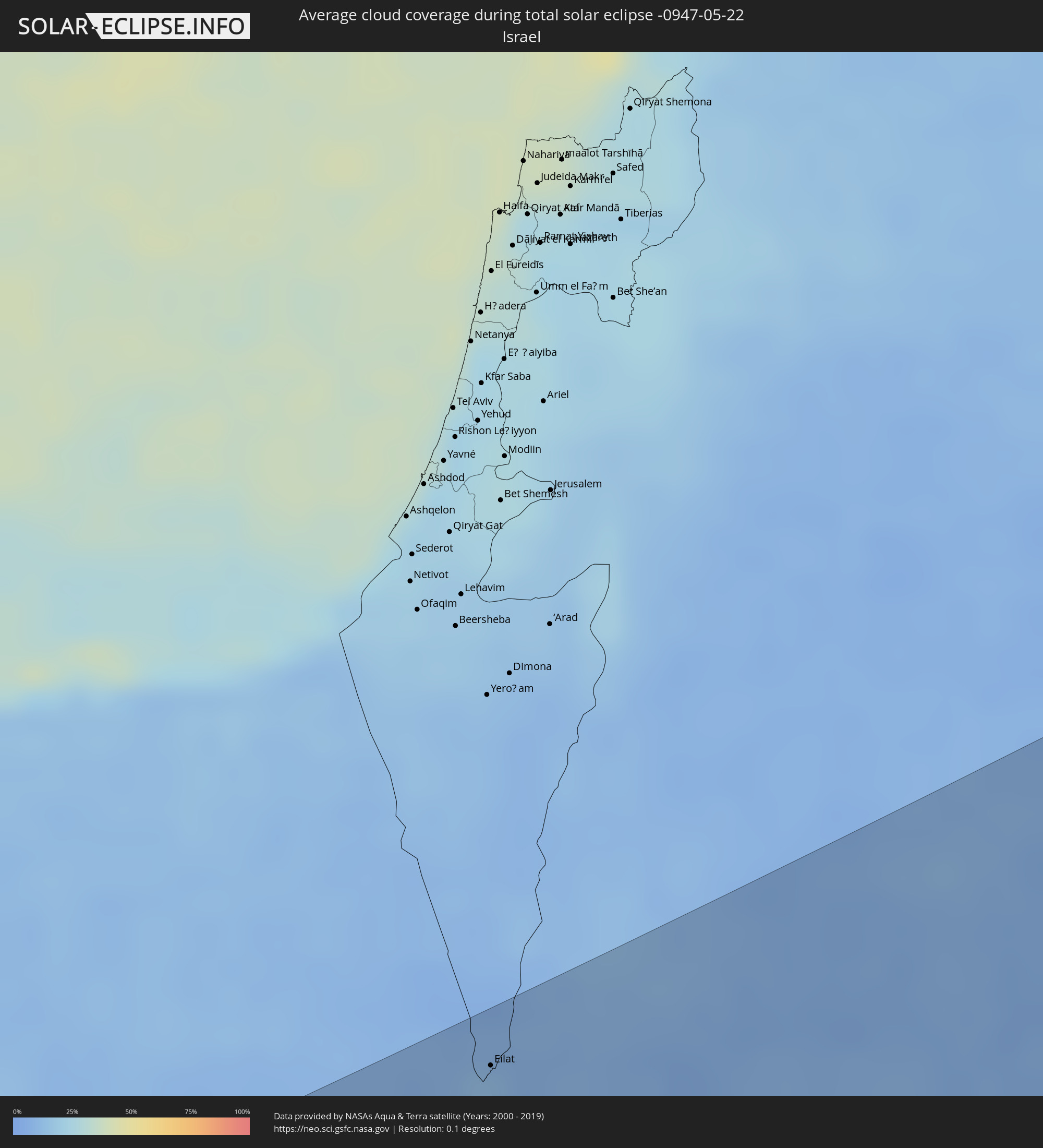 Israel
 Saudi Arabia
 Jordan
 Iraq
Iraq
 Iran
Iran
 Kazakhstan
 Turkmenistan
 Uzbekistan
Cities inside the path of the eclipse
The following table shows all locations with a population of more than 5,000 inside the eclipse path. Cities which have more than 100,000 inhabitants are marked bold. A click at the locations opens a detailed map.
| City | Type | Eclipse duration | Local time of max. eclipse | Distance to central line | Ø Cloud coverage |
|
Al Khārijah, New Valley
|
total | - | 05:29:26 UTC+02:00 | 121 km | 4% |
|
Al Minyā, Minya
|
total | - | 05:32:23 UTC+02:00 | 147 km | 9% |
|
Dayrūţ, Asyut
|
total | - | 05:31:43 UTC+02:00 | 88 km | 7% |
|
Al Qūşīyah, Asyut
|
total | - | 05:31:35 UTC+02:00 | 75 km | 6% |
|
Abū Qurqāş, Minya
|
total | - | 05:32:09 UTC+02:00 | 125 km | 7% |
|
Mallawī, Minya
|
total | - | 05:31:55 UTC+02:00 | 106 km | 7% |
|
Manfalūţ, Asyut
|
total | - | 05:31:24 UTC+02:00 | 58 km | 7% |
|
Abnūb, Asyut
|
total | - | 05:31:19 UTC+02:00 | 48 km | 8% |
|
Asyūţ, Asyut
|
total | - | 05:31:13 UTC+02:00 | 39 km | 8% |
|
Abū Tīj, Asyut
|
total | - | 05:31:01 UTC+02:00 | 20 km | 9% |
|
Juhaynah, Sohag
|
total | - | 05:30:34 UTC+02:00 | 33 km | 7% |
|
Ţahţā, Sohag
|
total | - | 05:30:40 UTC+02:00 | 23 km | 9% |
|
Sohag, Sohag
|
total | - | 05:30:23 UTC+02:00 | 50 km | 6% |
|
Al Manshāh, Sohag
|
total | - | 05:30:16 UTC+02:00 | 63 km | 6% |
|
Jirjā, Sohag
|
total | - | 05:30:06 UTC+02:00 | 81 km | 4% |
|
Al Balyanā, Sohag
|
total | - | 05:29:57 UTC+02:00 | 96 km | 6% |
|
Farshūţ, Qena
|
total | - | 05:29:43 UTC+02:00 | 122 km | 3% |
|
Dishnā, Qena
|
total | - | 05:29:43 UTC+02:00 | 125 km | 3% |
|
Qinā, Qena
|
total | - | 05:29:43 UTC+02:00 | 130 km | 4% |
|
Hurghada, Red Sea
|
total | - | 05:30:46 UTC+02:00 | 61 km | 17% |
|
Eilat, Southern District
|
total | - | 05:54:03 UTC+02:20 | 127 km | 12% |
|
Aqaba, Aqaba
|
total | - | 05:57:04 UTC+02:23 | 121 km | 17% |
|
Al Quwayrah, Ma’an
|
total | - | 05:57:22 UTC+02:23 | 137 km | 8% |
|
Duba, Tabuk
|
total | - | 06:37:28 UTC+03:06 | 128 km | 17% |
|
Tabuk, Tabuk
|
total | - | 06:38:38 UTC+03:06 | 57 km | 6% |
|
Ţubarjal, Al Jawf
|
total | - | 06:41:11 UTC+03:06 | 86 km | 6% |
|
Sakakah, Al Jawf
|
total | - | 06:40:28 UTC+03:06 | 53 km | 7% |
|
Şuwayr, Al Jawf
|
total | - | 06:40:39 UTC+03:06 | 50 km | 8% |
|
‘Ar‘ar, Northern Borders
|
total | - | 06:41:49 UTC+03:06 | 10 km | 9% |
|
Ramadi, Anbar
|
total | - | 06:36:06 UTC+02:57 | 149 km | 16% |
|
Al Fallūjah, Anbar
|
total | - | 06:36:03 UTC+02:57 | 120 km | 16% |
|
Karbala, Karbalāʼ
|
total | - | 06:35:03 UTC+02:57 | 44 km | 14% |
|
Abū Ghurayb, Mayorality of Baghdad
|
total | - | 06:36:03 UTC+02:57 | 97 km | 18% |
|
Al Hindīyah, Karbalāʼ
|
total | - | 06:34:59 UTC+02:57 | 22 km | 16% |
|
Al Musayyib, Bābil
|
total | - | 06:35:19 UTC+02:57 | 41 km | 16% |
|
Najaf, An Najaf
|
total | - | 06:34:16 UTC+02:57 | 39 km | 15% |
|
Baghdad, Mayorality of Baghdad
|
total | - | 06:36:08 UTC+02:57 | 92 km | 17% |
|
Al Ḩillah, Bābil
|
total | - | 06:34:53 UTC+02:57 | 5 km | 18% |
|
Kufa, An Najaf
|
total | - | 06:34:19 UTC+02:57 | 36 km | 15% |
|
Khāliş, Diyālá
|
total | - | 06:36:49 UTC+02:57 | 132 km | 20% |
|
Ash Shāmīyah, Al Qādisīyah
|
total | - | 06:34:12 UTC+02:57 | 52 km | 15% |
|
Baqubah, Diyālá
|
total | - | 06:36:45 UTC+02:57 | 125 km | 20% |
|
Ad Dīwānīyah, Al Qādisīyah
|
total | - | 06:34:18 UTC+02:57 | 64 km | 15% |
|
Al Miqdādīyah, Diyālá
|
total | - | 06:37:08 UTC+02:57 | 128 km | 23% |
|
Al ‘Azīzīyah, Wāsiţ
|
total | - | 06:35:37 UTC+02:57 | 26 km | 16% |
|
Ar Rumaythah, Al Muthanná
|
total | - | 06:33:41 UTC+02:57 | 122 km | 14% |
|
As Samawah, Al Muthanná
|
total | - | 06:33:26 UTC+02:57 | 145 km | 15% |
|
Al Kūt, Wāsiţ
|
total | - | 06:35:11 UTC+02:57 | 54 km | 19% |
|
Al Ḩayy, Wāsiţ
|
total | - | 06:34:44 UTC+02:57 | 98 km | 17% |
|
Īlām, Īlām
|
total | - | 07:05:03 UTC+03:25 | 28 km | 25% |
|
Kahrīz, Kermānshāh
|
total | - | 07:06:17 UTC+03:25 | 69 km | 31% |
|
Khorramabad, Lorestān
|
total | - | 07:05:16 UTC+03:25 | 78 km | 23% |
|
Pasragad Branch, Hamadān
|
total | - | 07:07:13 UTC+03:25 | 46 km | 38% |
|
Borūjerd, Lorestān
|
total | - | 07:05:59 UTC+03:25 | 57 km | 28% |
|
Malāyer, Hamadān
|
total | - | 07:06:36 UTC+03:25 | 31 km | 34% |
|
Arāk, Markazi
|
total | - | 07:06:32 UTC+03:25 | 86 km | 29% |
|
Qazvin, Qazvīn
|
total | - | 07:09:56 UTC+03:25 | 111 km | 31% |
|
Sāveh, Markazi
|
total | - | 07:08:09 UTC+03:25 | 25 km | 19% |
|
Naz̧arābād, Alborz
|
total | - | 07:09:40 UTC+03:25 | 52 km | 27% |
|
Qom, Qom
|
total | - | 07:07:45 UTC+03:25 | 87 km | 20% |
|
Karaj, Alborz
|
total | - | 07:09:36 UTC+03:25 | 25 km | 30% |
|
Tehran, Tehrān
|
total | - | 07:09:33 UTC+03:25 | 20 km | 27% |
|
Qarchak, Tehrān
|
total | - | 07:09:12 UTC+03:25 | 49 km | 23% |
|
Āmol, Māzandarān
|
total | - | 07:11:06 UTC+03:25 | 17 km | 64% |
|
Bābol, Māzandarān
|
total | - | 07:11:22 UTC+03:25 | 26 km | 55% |
|
Sari, Māzandarān
|
total | - | 07:11:33 UTC+03:25 | 9 km | 64% |
|
Gorgān, Golestān
|
total | - | 07:12:36 UTC+03:25 | 51 km | 66% |
|
Shahrud, Semnān
|
total | - | 07:12:11 UTC+03:25 | 116 km | 30% |
|
Gazanjyk, Balkan
|
total | - | 07:44:46 UTC+03:53 | 125 km | 36% |
|
Serdar, Balkan
|
total | - | 07:44:44 UTC+03:53 | 64 km | 35% |
|
Bojnūrd, Khorāsān-e Shomālī
|
total | - | 07:15:05 UTC+03:25 | 128 km | 41% |
|
Baharly, Ahal
|
total | - | 07:44:29 UTC+03:53 | 47 km | 35% |
|
Abadan, Ahal
|
total | - | 07:44:19 UTC+03:53 | 116 km | 42% |
|
Ashgabat, Ahal
|
total | - | 07:44:15 UTC+03:53 | 135 km | 41% |
|
Annau, Ahal
|
total | - | 07:44:14 UTC+03:53 | 147 km | 41% |
|
Tagta, Daşoguz
|
total | - | 07:51:18 UTC+03:53 | 135 km | 29% |
|
Daşoguz, Daşoguz
|
total | - | 07:51:38 UTC+03:53 | 148 km | 29% |
|
Showot, Xorazm
|
total | - | 08:25:55 UTC+04:27 | 116 km | 31% |
|
Qŭshkŭpir, Xorazm
|
total | - | 08:25:44 UTC+04:27 | 103 km | 32% |
|
Khiwa, Xorazm
|
total | - | 08:25:30 UTC+04:27 | 87 km | 30% |
|
Gurlan, Xorazm
|
total | - | 08:26:17 UTC+04:27 | 131 km | 31% |
|
Urganch, Xorazm
|
total | - | 08:25:58 UTC+04:27 | 94 km | 31% |
|
Beruniy, Karakalpakstan
|
total | - | 08:26:16 UTC+04:27 | 98 km | 28% |
|
Novyy Turtkul’, Karakalpakstan
|
total | - | 08:26:13 UTC+04:27 | 72 km | 28% |
|
Hazorasp, Xorazm
|
total | - | 08:25:53 UTC+04:27 | 49 km | 28% |
|
Gazojak, Lebap
|
total | - | 07:51:32 UTC+03:53 | 21 km | 28% |
|
Tasböget, Qyzylorda
|
total | - | 08:29:02 UTC+04:21 | 156 km | 31% |
|
Shīeli, Qyzylorda
|
total | - | 08:29:02 UTC+04:21 | 46 km | 29% |
|
Yanykurgan, Qyzylorda
|
total | - | 08:29:03 UTC+04:21 | 23 km | 29% |
|
Turkestan, Ongtüstik Qazaqstan
|
total | - | 08:28:57 UTC+04:21 | 103 km | 33% |
|
Kentau, Ongtüstik Qazaqstan
|
total | - | 08:29:32 UTC+04:21 | 94 km | 33% |
|
Kantagi, Ongtüstik Qazaqstan
|
total | - | 08:29:38 UTC+04:21 | 97 km | 31% |
|
Chulakkurgan, Ongtüstik Qazaqstan
|
total | - | 08:30:35 UTC+04:21 | 102 km | 33% |
|
Zhangatas, Zhambyl
|
total | - | 08:30:47 UTC+04:21 | 147 km | 36% |
|
Aktau, Qaraghandy
|
total | - | 08:41:05 UTC+04:21 | 136 km | 54% |
|
Aqadyr, Qaraghandy
|
total | - | 08:41:28 UTC+04:21 | 156 km | 58% |
|
Priozersk
|
total | - | 08:38:50 UTC+04:21 | 87 km | 35% |
|
Balqash, Qaraghandy
|
total | - | 08:41:31 UTC+04:21 | 64 km | 36% |
|
Semey, East Kazakhstan
|
total | - | 08:52:50 UTC+04:21 | 71 km | 50% |
|
Rubtsovsk, Altai Krai
|
total | - | 10:44:59 UTC+06:11 | 143 km | 60% |
|
Georgīevka, East Kazakhstan
|
total | - | 08:52:53 UTC+04:21 | 82 km | 52% |
|
Shemonaīkha, East Kazakhstan
|
total | - | 08:55:04 UTC+04:21 | 34 km | 57% |
|
Glubokoye, East Kazakhstan
|
total | - | 08:54:54 UTC+04:21 | 30 km | 55% |
|
Belūsovka, East Kazakhstan
|
total | - | 08:55:09 UTC+04:21 | 42 km | 57% |
|
Ust-Kamenogorsk, East Kazakhstan
|
total | - | 08:55:02 UTC+04:21 | 59 km | 57% |
|
Ridder, East Kazakhstan
|
total | - | 08:56:40 UTC+04:21 | 53 km | 75% |
|
Zyryanovsk, East Kazakhstan
|
total | - | 08:56:50 UTC+04:21 | 138 km | 59% |
|
Biysk, Altai Krai
|
total | - | 10:51:05 UTC+06:11 | 108 km | 67% |
|
Gorno-Altaysk, Altai Republic
|
total | - | 10:51:17 UTC+06:11 | 29 km | 70% |
|
Osinniki, Kemerovo
|
total | - | 10:54:59 UTC+06:11 | 149 km | 70% |
|
Myski, Kemerovo
|
total | - | 10:55:37 UTC+06:11 | 145 km | 71% |
|
Mezhdurechensk, Kemerovo
|
total | - | 10:55:56 UTC+06:11 | 135 km | 71% |
|
Chernogorsk, Khakasiya
|
total | - | 11:00:08 UTC+06:11 | 58 km | 67% |
|
Sayanogorsk, Khakasiya
|
total | - | 10:59:35 UTC+06:11 | 27 km | 69% |
|
Abakan, Khakasiya
|
total | - | 11:00:13 UTC+06:11 | 44 km | 67% |
|
Minusinsk, Krasnoyarskiy
|
total | - | 11:00:33 UTC+06:11 | 36 km | 68% |
|
Tayshet, Irkutsk
|
total | - | 11:56:05 UTC+06:57 | 114 km | 73% |
|
Nizhneudinsk, Irkutsk
|
total | - | 11:56:48 UTC+06:57 | 15 km | 71% |
|
Tulun, Irkutsk
|
total | - | 11:58:42 UTC+06:57 | 84 km | 69% |
|
Bratsk, Irkutsk
|
total | - | 12:00:49 UTC+06:57 | 65 km | 74% |
|
Zheleznogorsk-Ilimskiy, Irkutsk
|
total | - | 12:04:11 UTC+06:57 | 70 km | 76% |
|
Ust’-Kut, Irkutsk
|
total | - | 12:06:20 UTC+06:57 | 68 km | 77% |
|
Severobaykal’sk, Respublika Buryatiya
|
total | - | 12:10:46 UTC+06:57 | 105 km | 73% |
|
Neryungri, Sakha
|
total | - | 14:11:12 UTC+08:38 | 82 km | 78% |
|
Yelizovo, Kamtsjatka
|
total | - | 16:37:38 UTC+10:34 | 53 km | 71% |
|
Petropavlovsk-Kamchatsky, Kamtsjatka
|
total | - | 16:37:56 UTC+10:34 | 61 km | 82% |