Total solar eclipse of 04/30/-0964
| Day of week: | Thursday |
| Maximum duration of eclipse: | 05m00s |
| Maximum width of eclipse path: | 176 km |
| Saros cycle: | 42 |
| Coverage: | 100% |
| Magnitude: | 1.0517 |
| Gamma: | -0.2274 |
Wo kann man die Sonnenfinsternis vom 04/30/-0964 sehen?
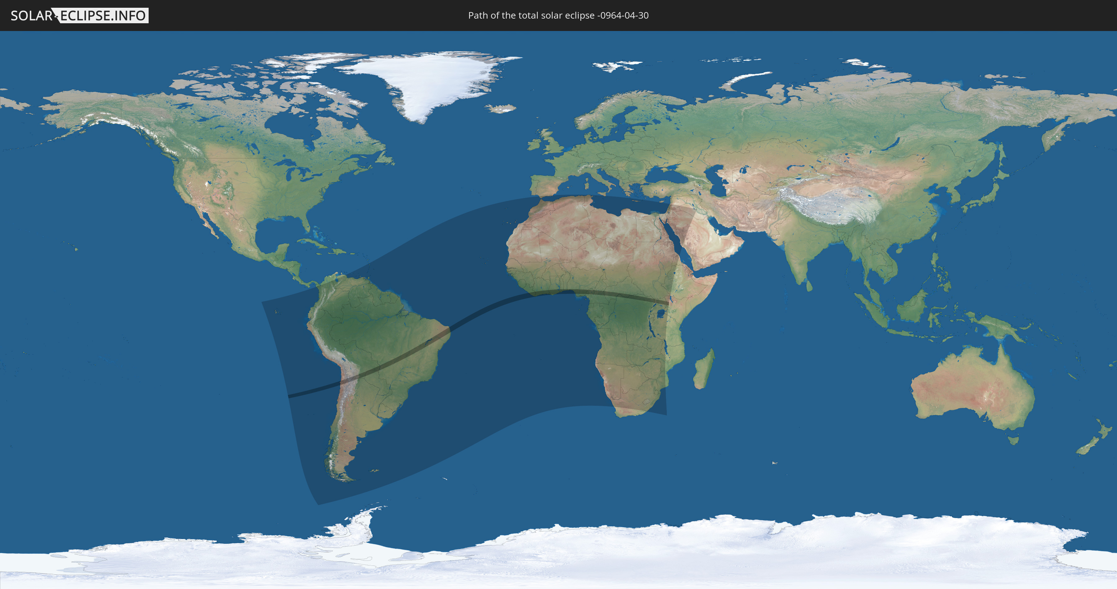
Die Sonnenfinsternis am 04/30/-0964 kann man in 83 Ländern als partielle Sonnenfinsternis beobachten.
Der Finsternispfad verläuft durch 17 Länder. Nur in diesen Ländern ist sie als total Sonnenfinsternis zu sehen.
In den folgenden Ländern ist die Sonnenfinsternis total zu sehen
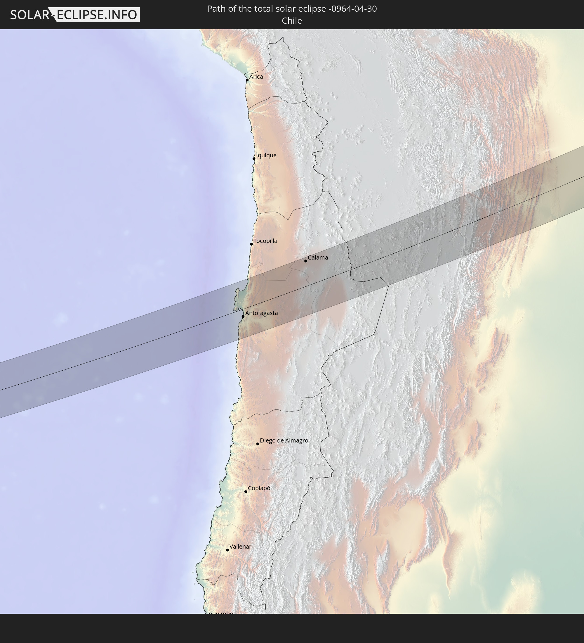 Chile
Chile
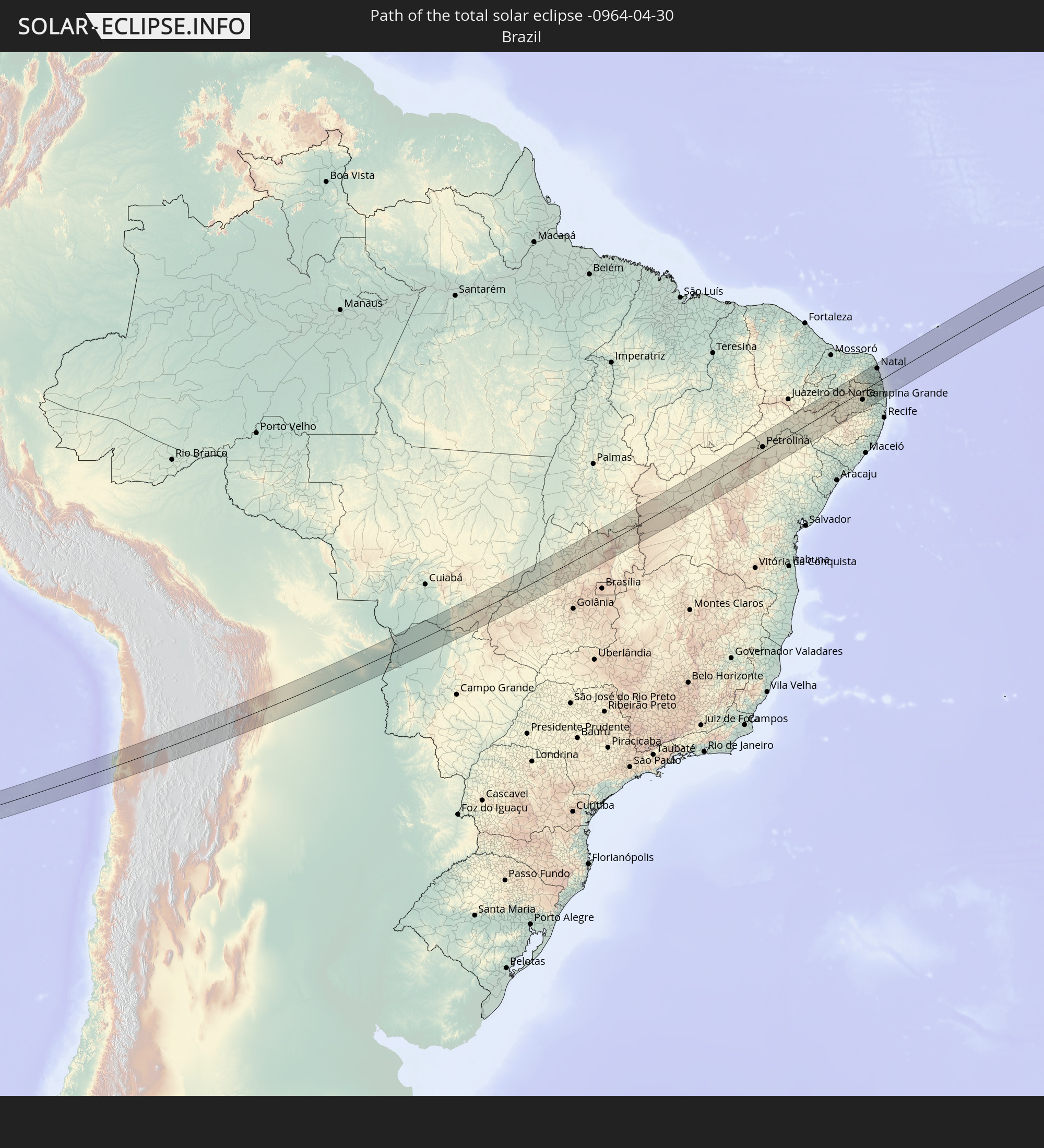 Brazil
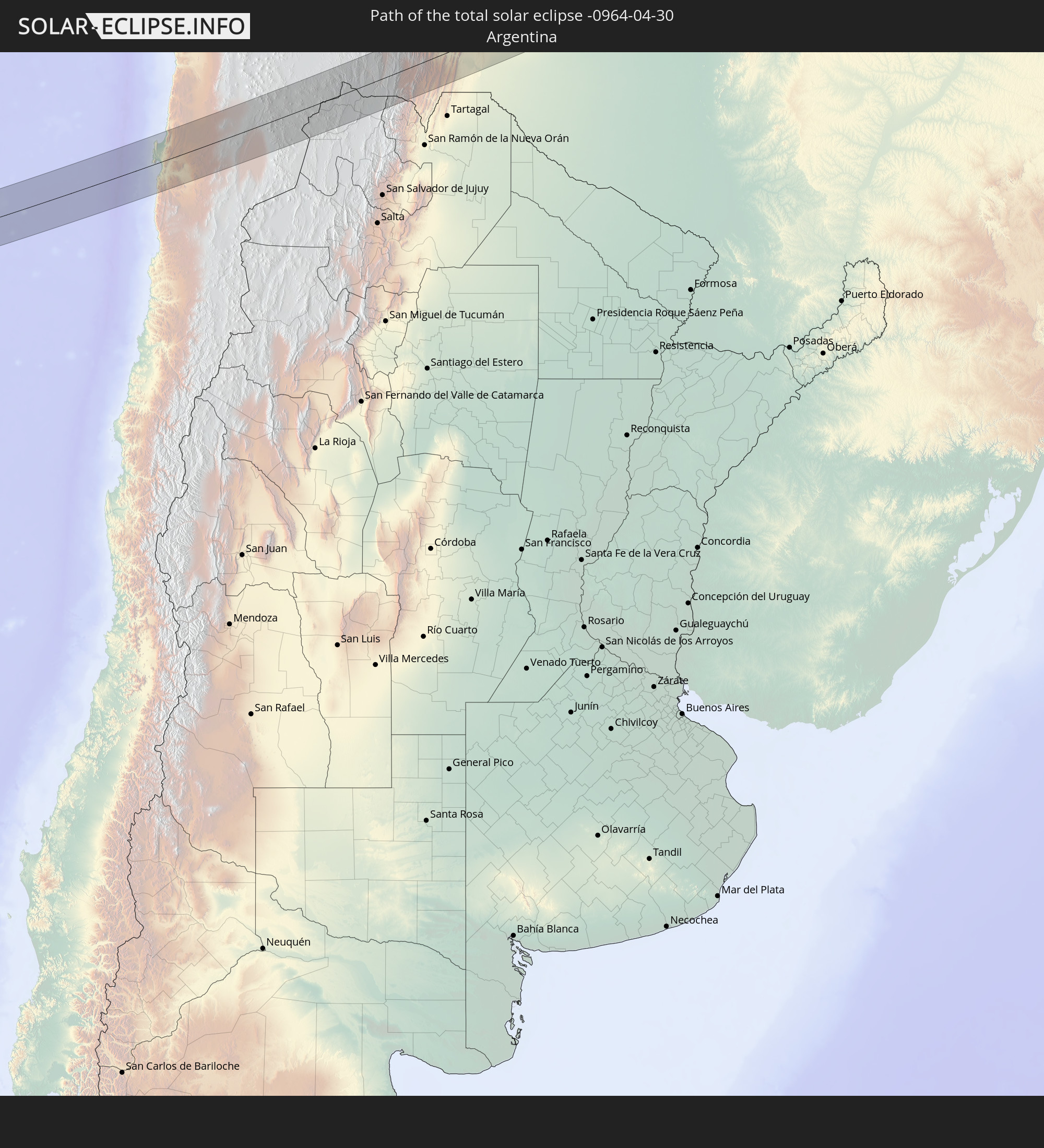 Argentina
 Bolivia
 Paraguay
 Liberia
 Ivory Coast
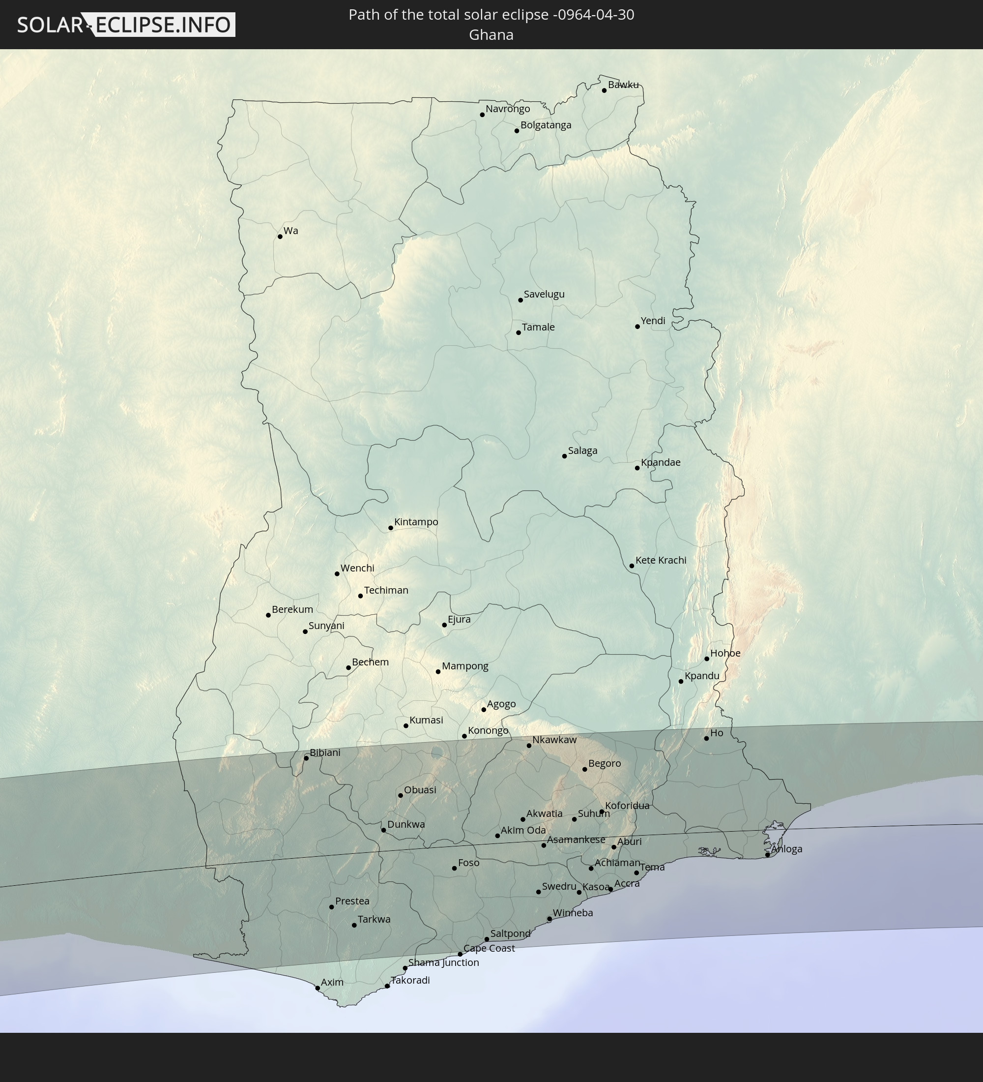 Ghana
Ghana
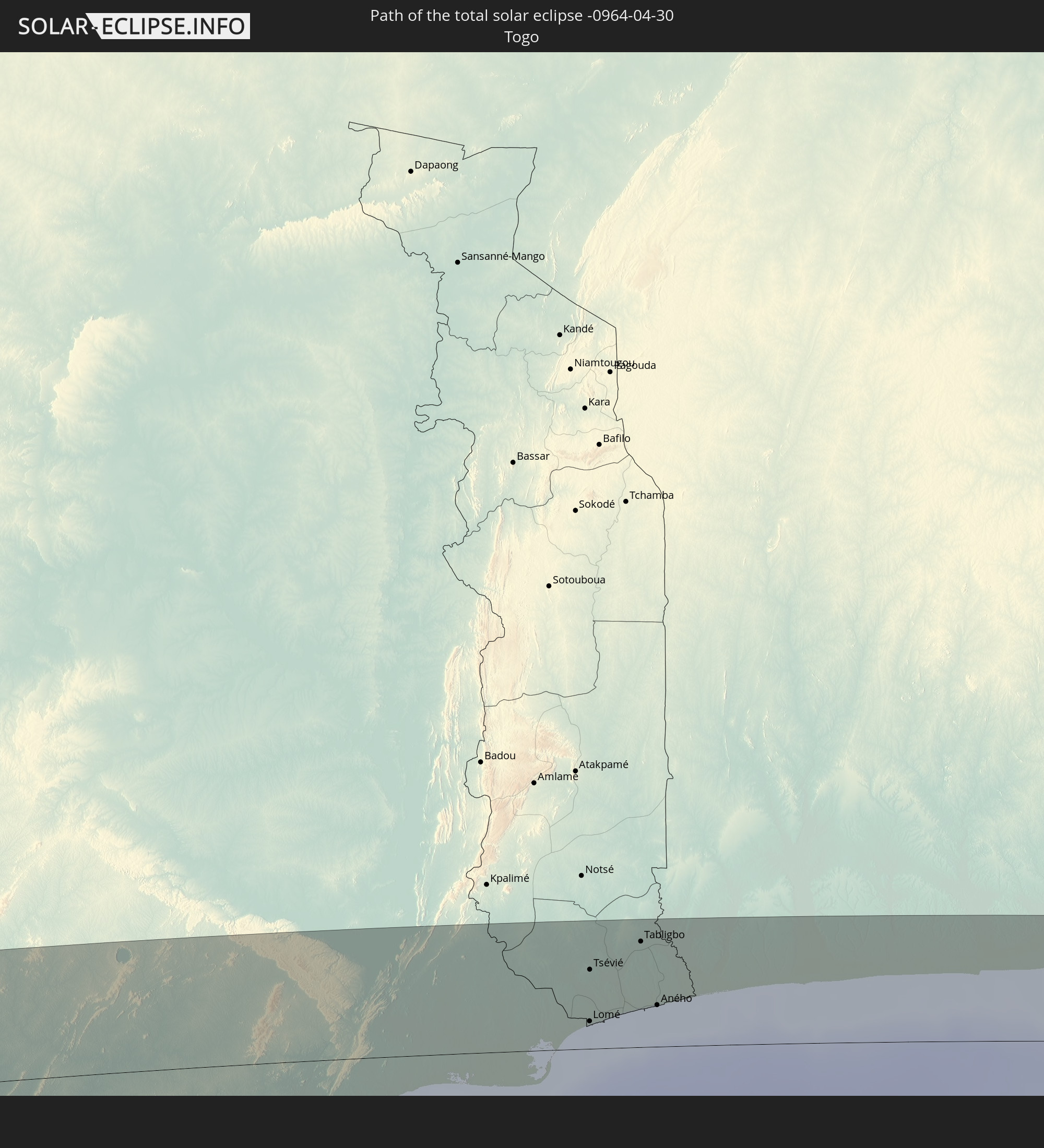 Togo
Togo
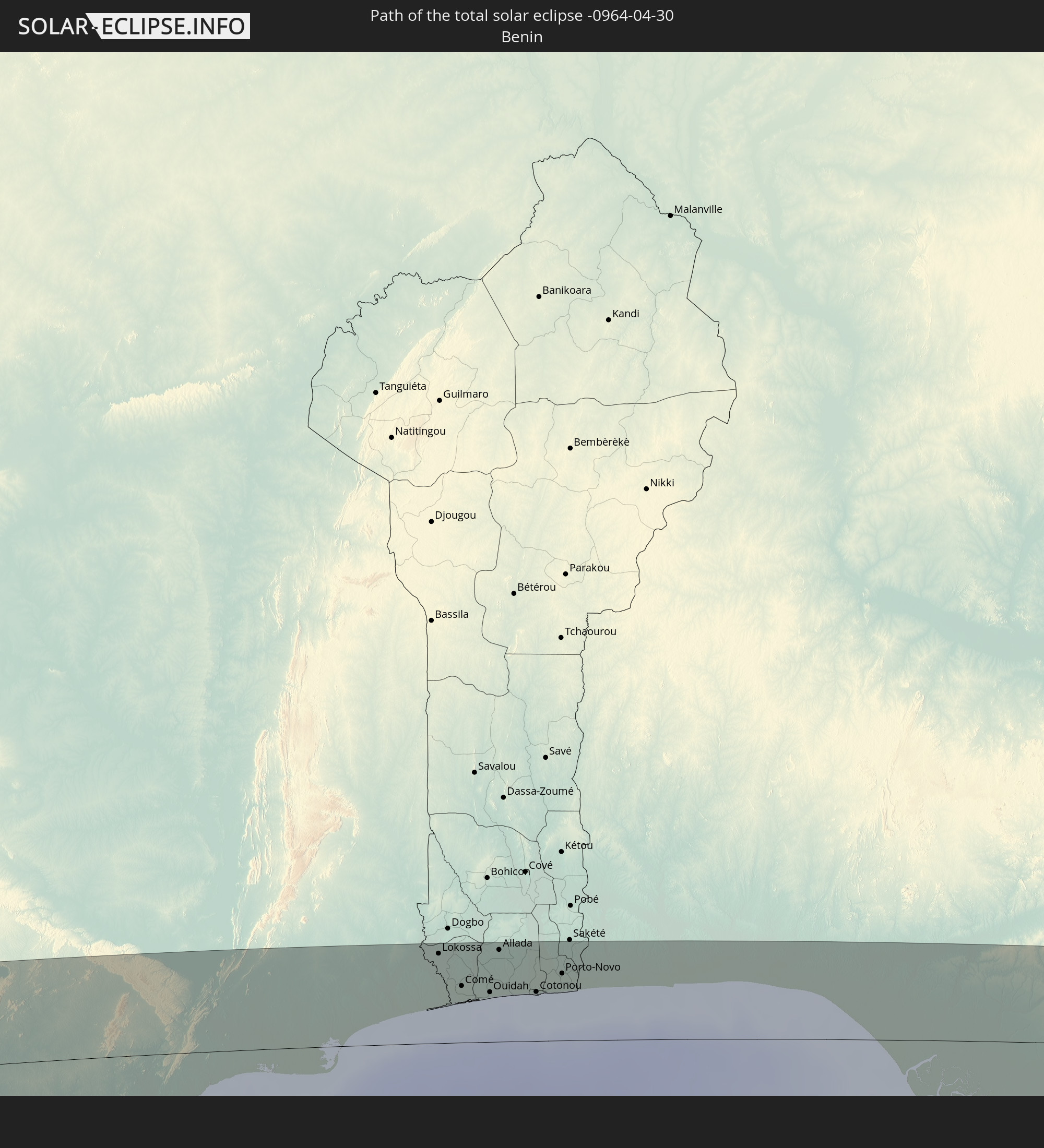 Benin
Benin
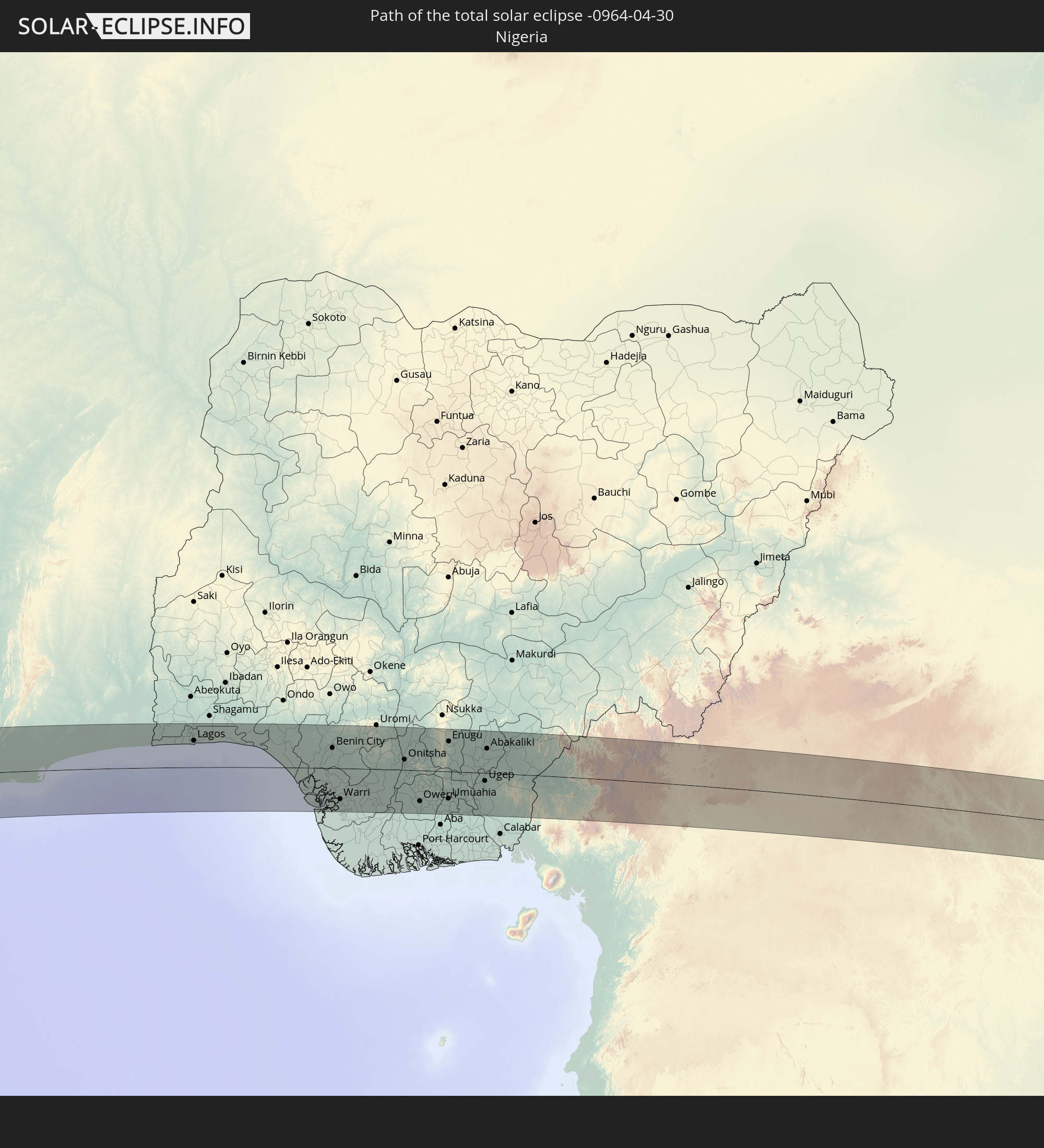 Nigeria
 Cameroon
 Democratic Republic of the Congo
 Central African Republic
 South Sudan
 Uganda
 Kenya
Kenya
In den folgenden Ländern ist die Sonnenfinsternis partiell zu sehen
 Chile
Chile
 Ecuador
 Panama
 Colombia
 Peru
Peru
 Brazil
 Argentina
 Venezuela
 Bolivia
 Paraguay
 Trinidad and Tobago
 Grenada
 Saint Vincent and the Grenadines
 Falkland Islands
 Guyana
 Martinique
 Saint Lucia
 Barbados
 Uruguay
 Suriname
 French Guiana
 Portugal
 Cabo Verde
 Spain
Spain
 Senegal
 Mauritania
 The Gambia
 Guinea-Bissau
 Guinea
 Saint Helena, Ascension and Tristan da Cunha
 Sierra Leone
 Morocco
 Mali
Mali
 Liberia
 Algeria
 Ivory Coast
 Burkina Faso
 Gibraltar
 Ghana
Ghana
 Togo
Togo
 Niger
Niger
 Benin
Benin
 Nigeria
 Equatorial Guinea
 São Tomé and Príncipe
 Italy
Italy
 Tunisia
 Cameroon
 Gabon
Gabon
 Libya
Libya
 Republic of the Congo
 Angola
 Namibia
 Democratic Republic of the Congo
 Chad
Chad
 Malta
Malta
 Central African Republic
 South Africa
 Greece
 Botswana
 Sudan
Sudan
 Zambia
 Egypt
Egypt
 Zimbabwe
 Lesotho
 Rwanda
 Burundi
 Tanzania
 Uganda
 Mozambique
 Swaziland
 Cyprus
 Malawi
 Ethiopia
 Kenya
Kenya
 State of Palestine
 Israel
 Saudi Arabia
 Jordan
 Lebanon
 Syria
Syria
 Eritrea
 Iraq
Iraq
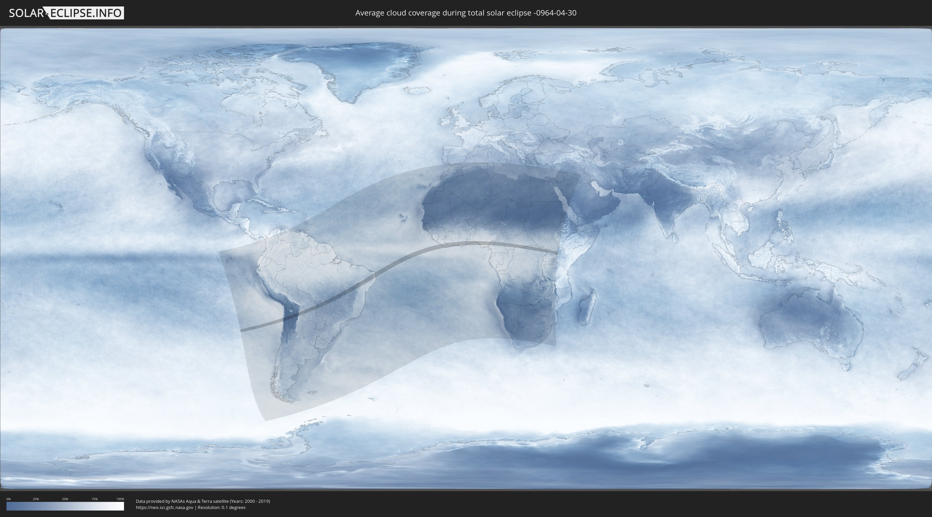
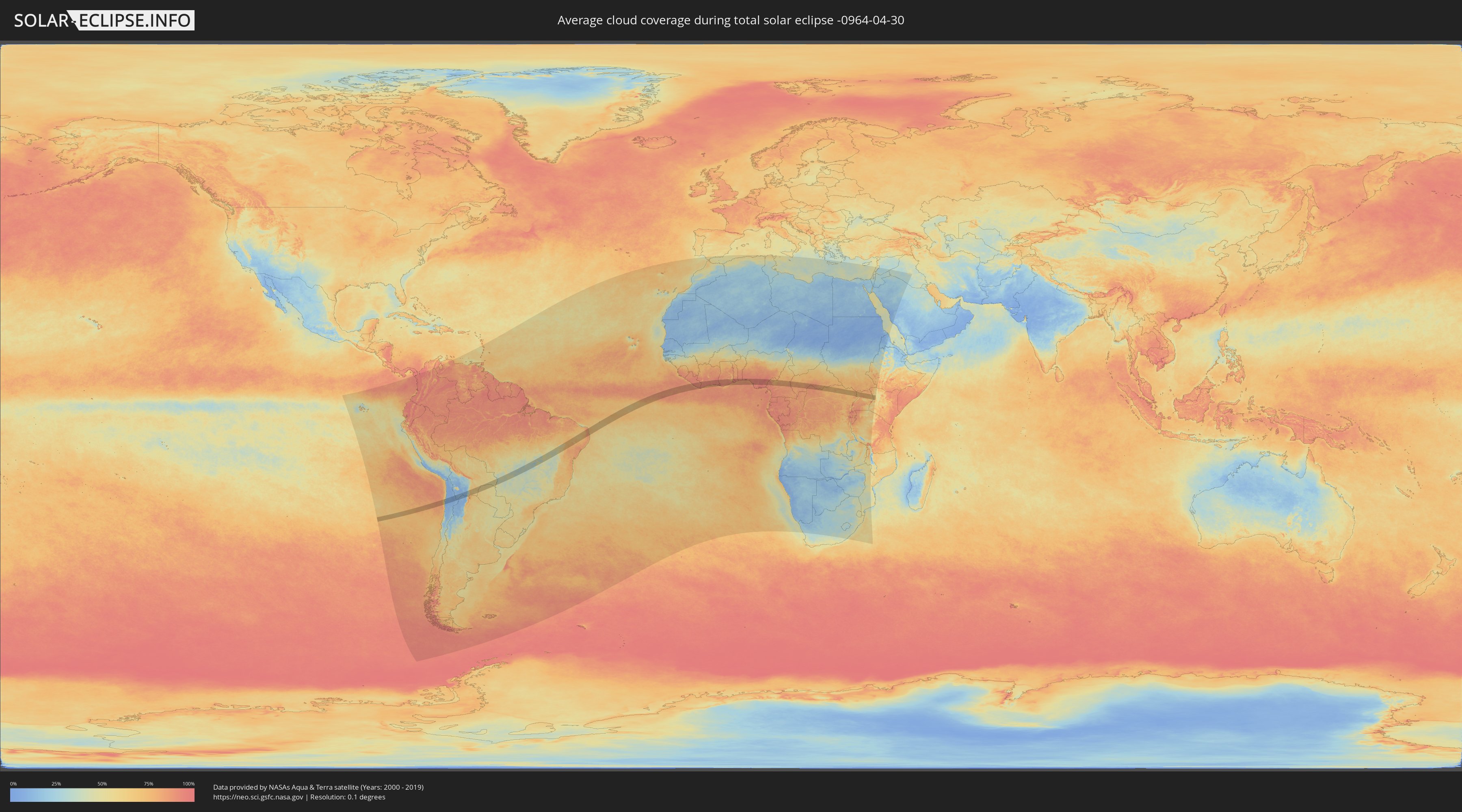
How will be the weather during the total solar eclipse on 04/30/-0964?
Where is the best place to see the total solar eclipse of 04/30/-0964?
The following maps show the average cloud coverage for the day of the total solar eclipse.
With the help of these maps, it is possible to find the place along the eclipse path, which has the best
chance of a cloudless sky.
Nevertheless, you should consider local circumstances and inform about the weather of your chosen
observation site.
The data is provided by NASAs satellites
AQUA and TERRA.
The cloud maps are averaged over a period of 19 years (2000 - 2019).
Detailed country maps
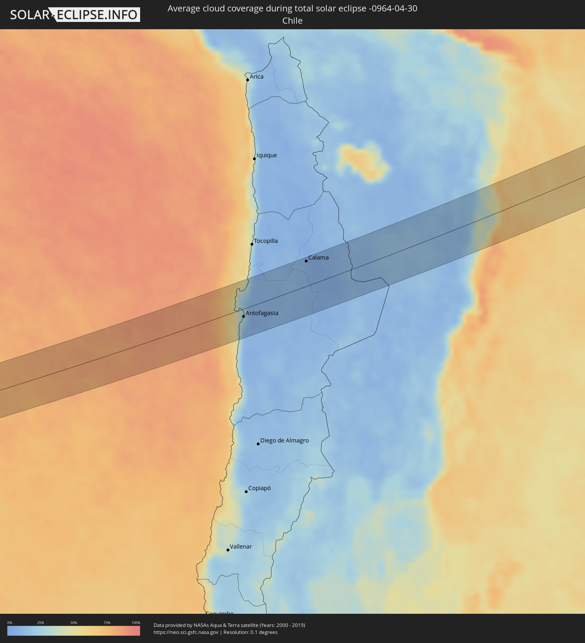 Chile
Chile
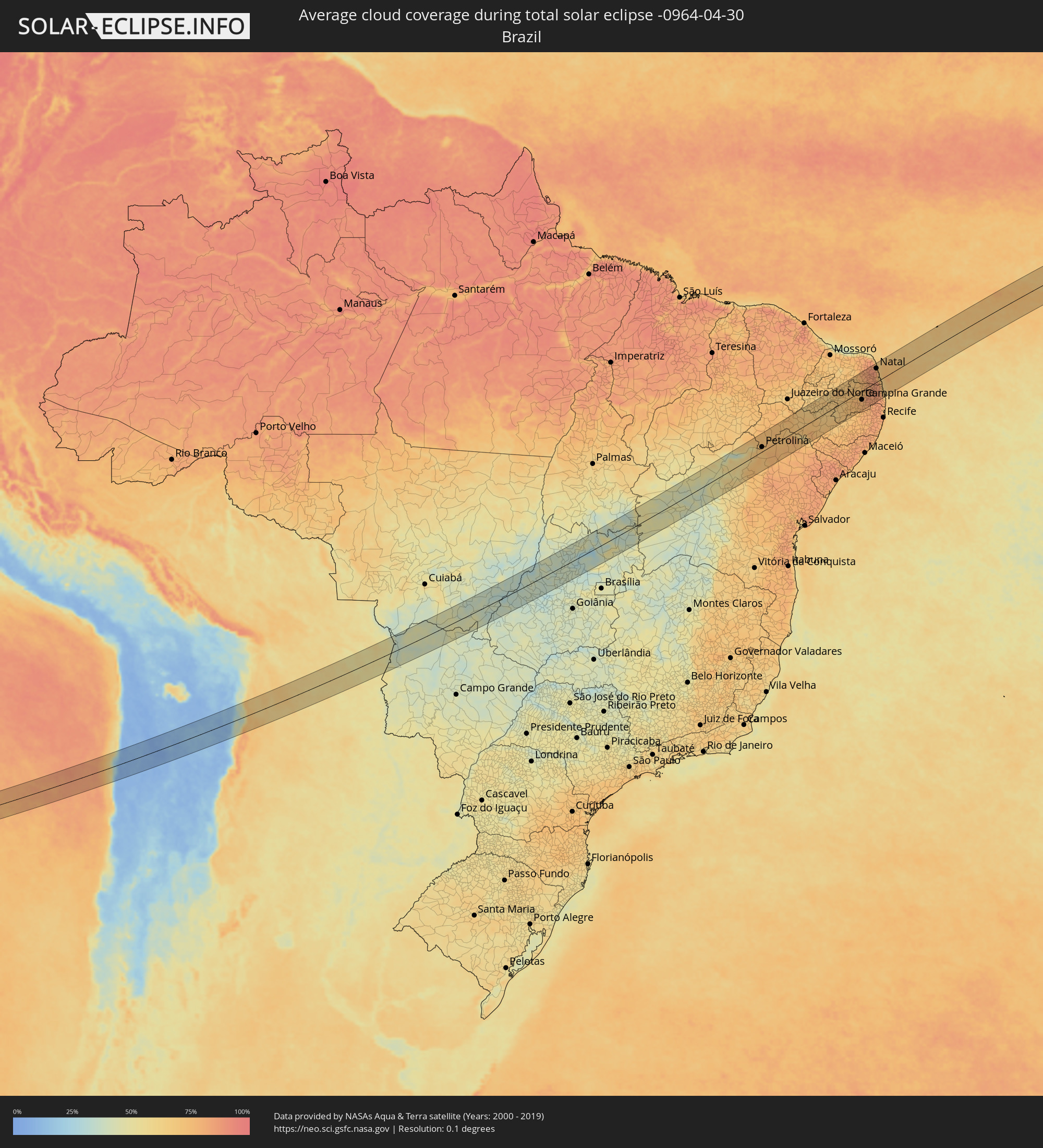 Brazil
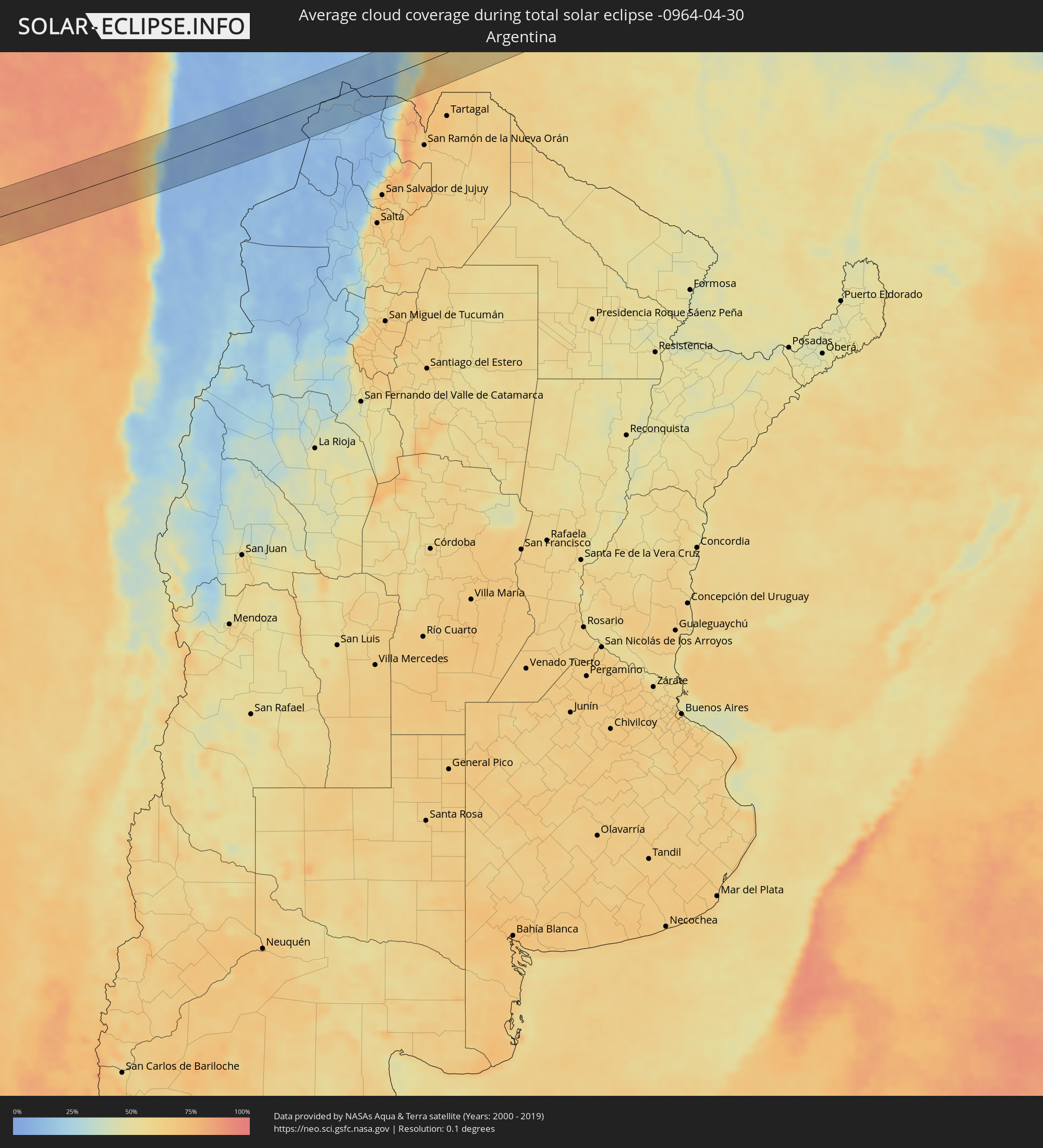 Argentina
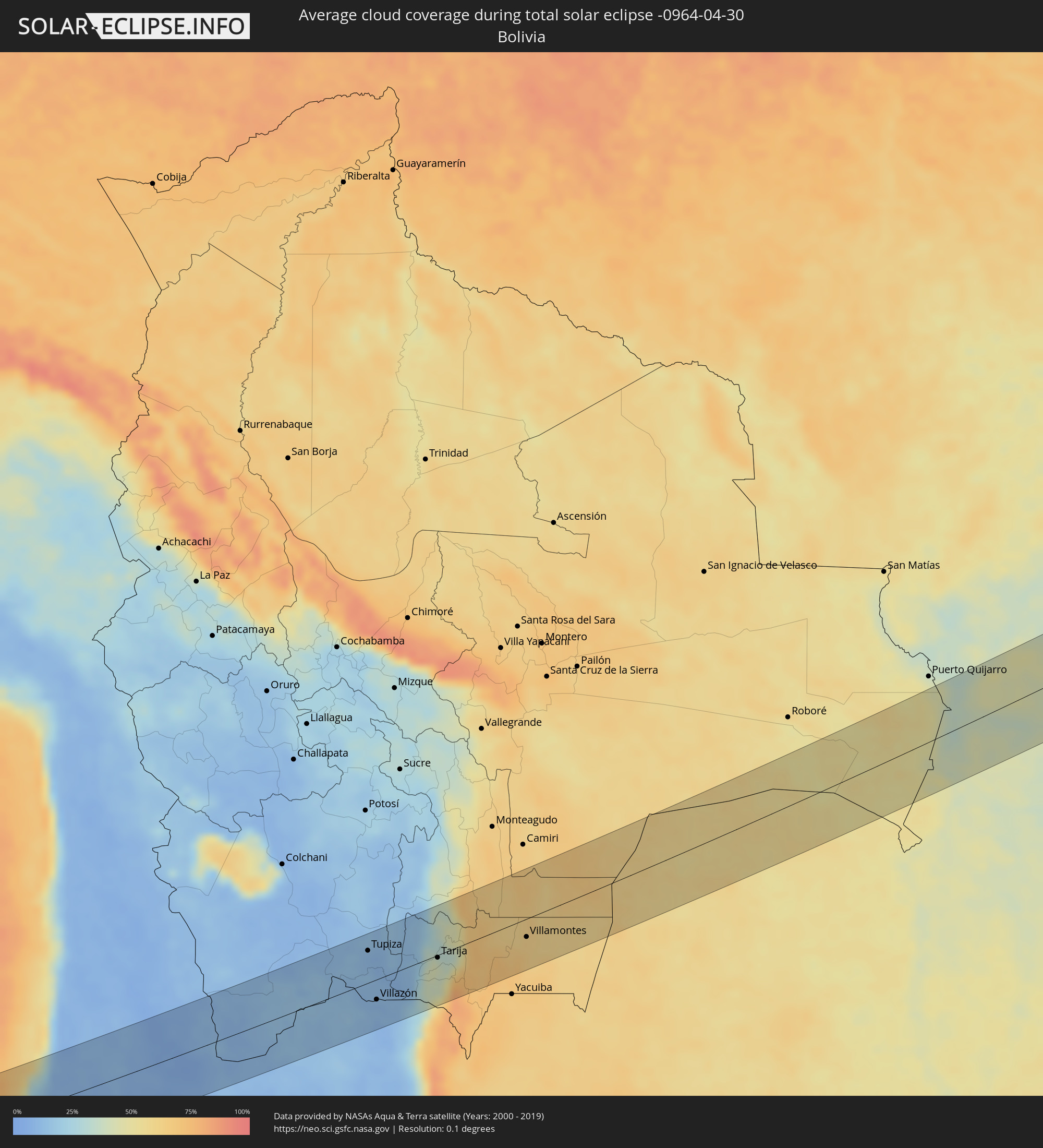 Bolivia
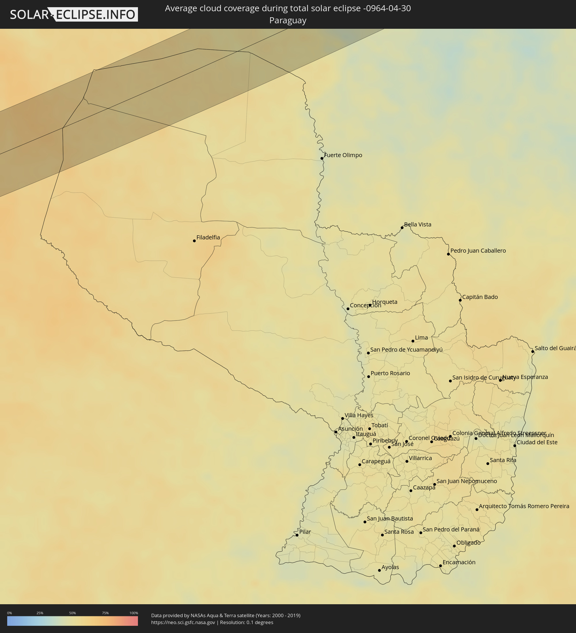 Paraguay
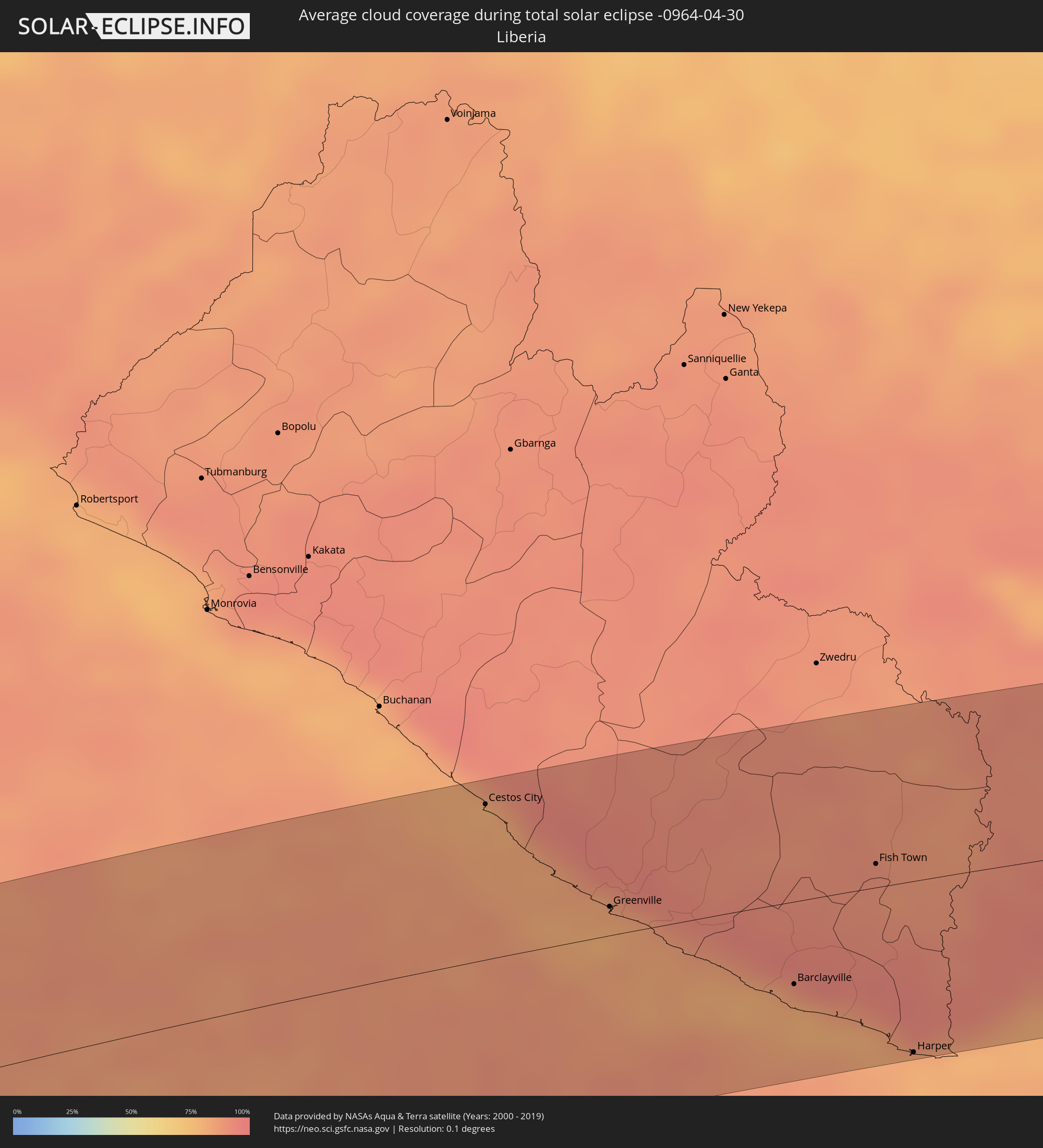 Liberia
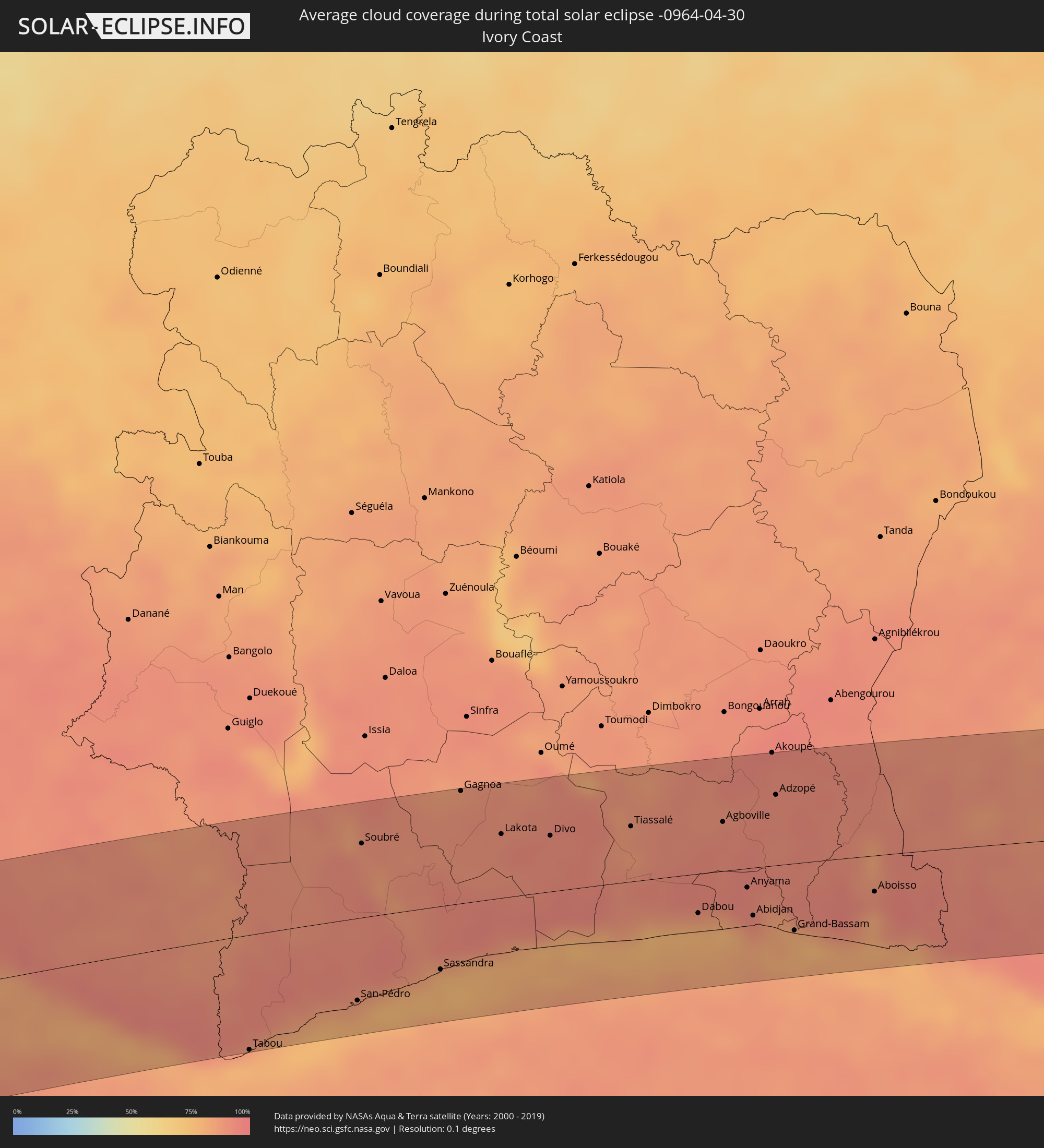 Ivory Coast
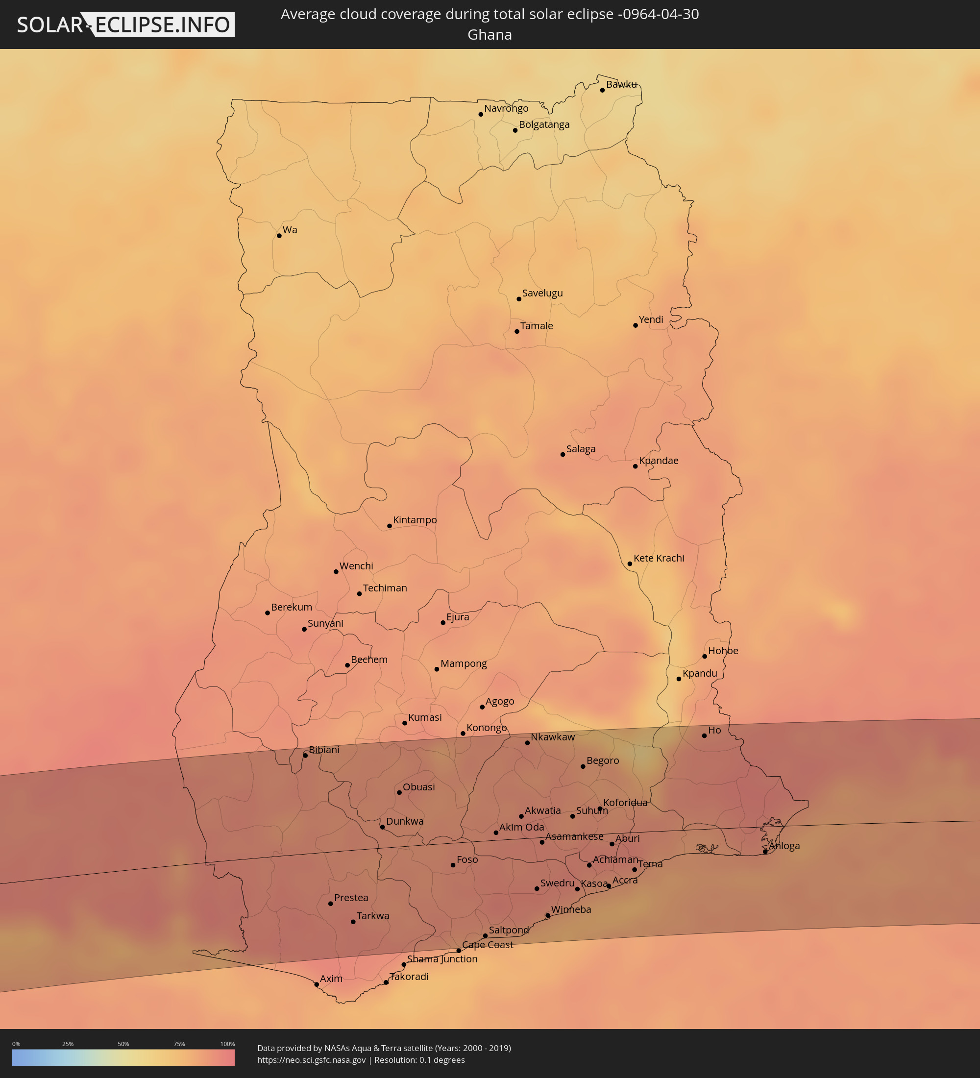 Ghana
Ghana
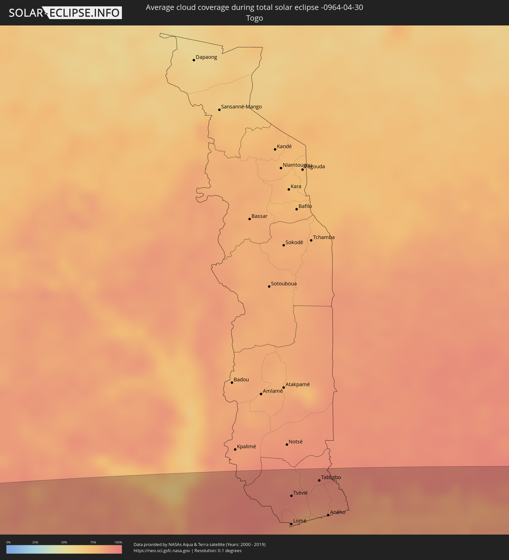 Togo
Togo
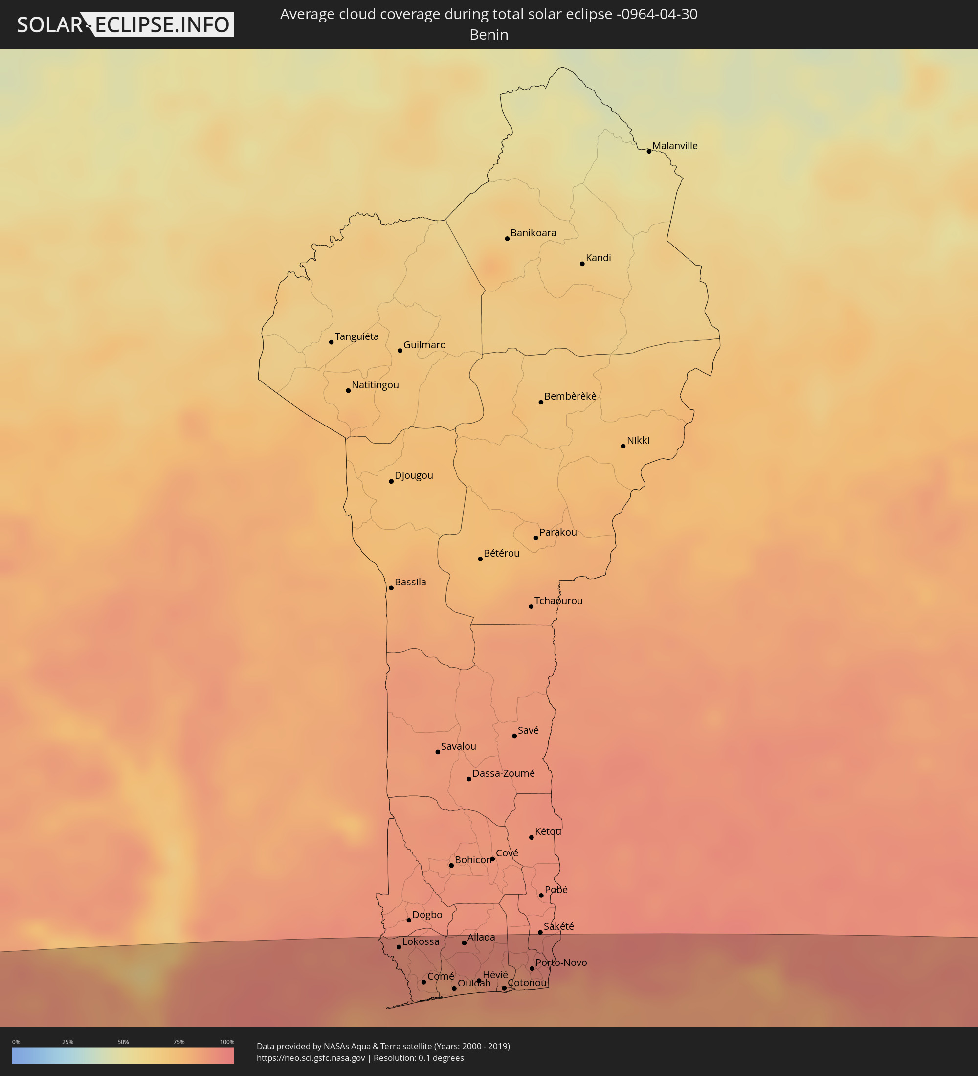 Benin
Benin
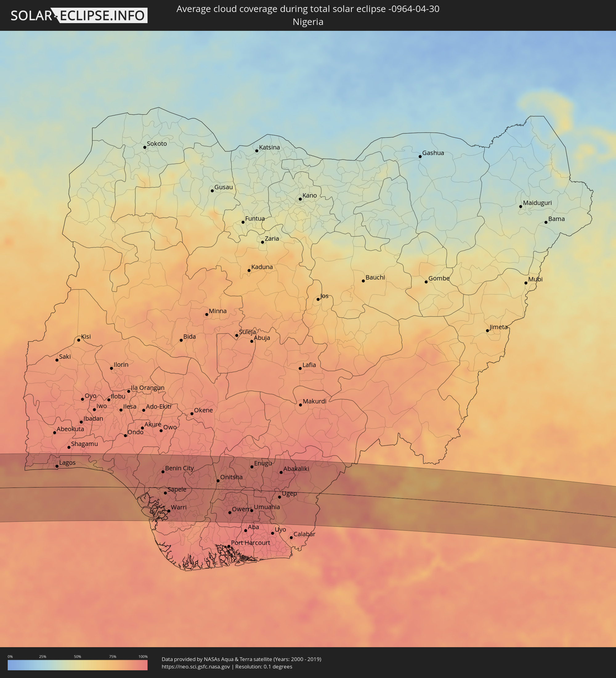 Nigeria
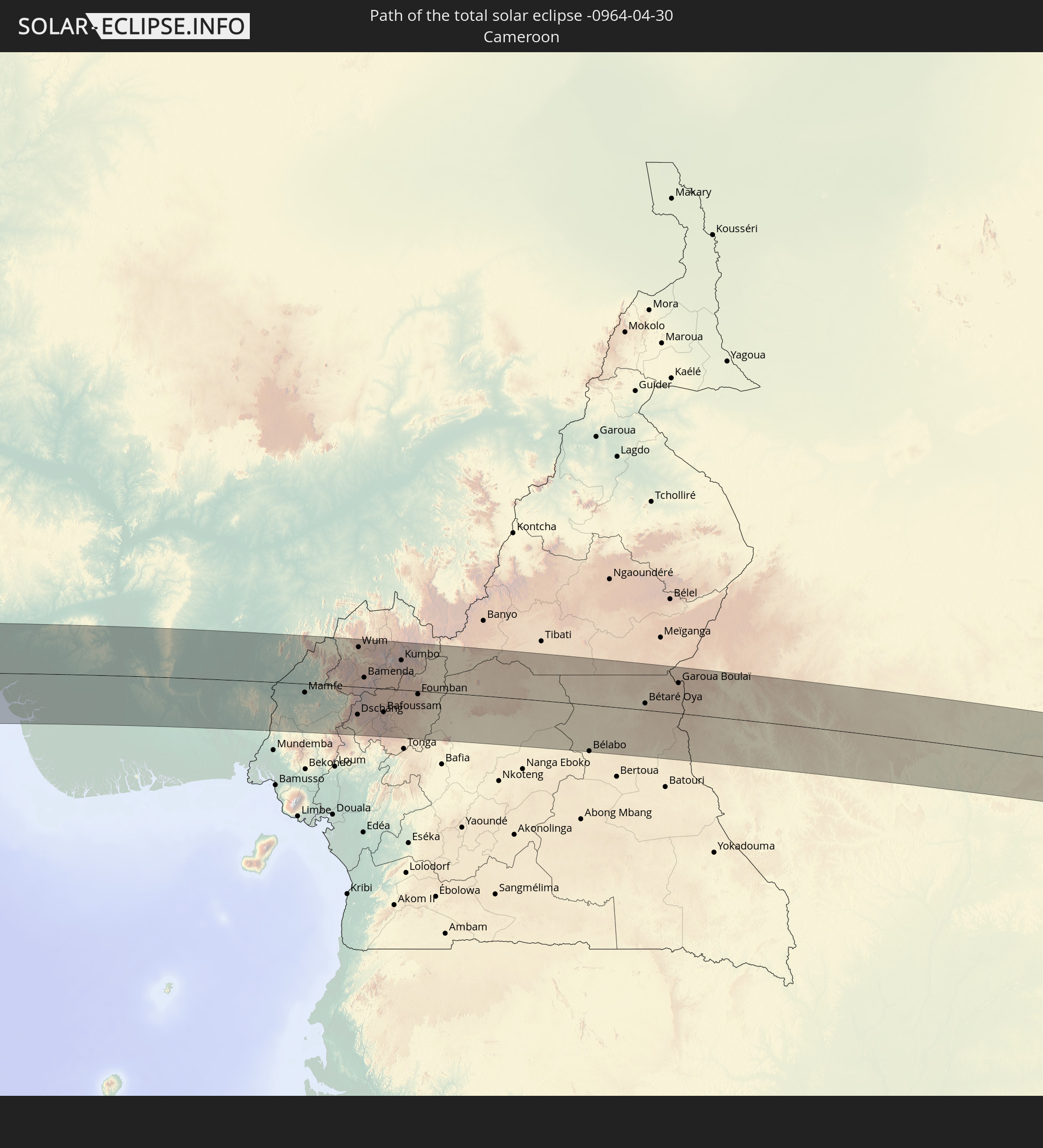
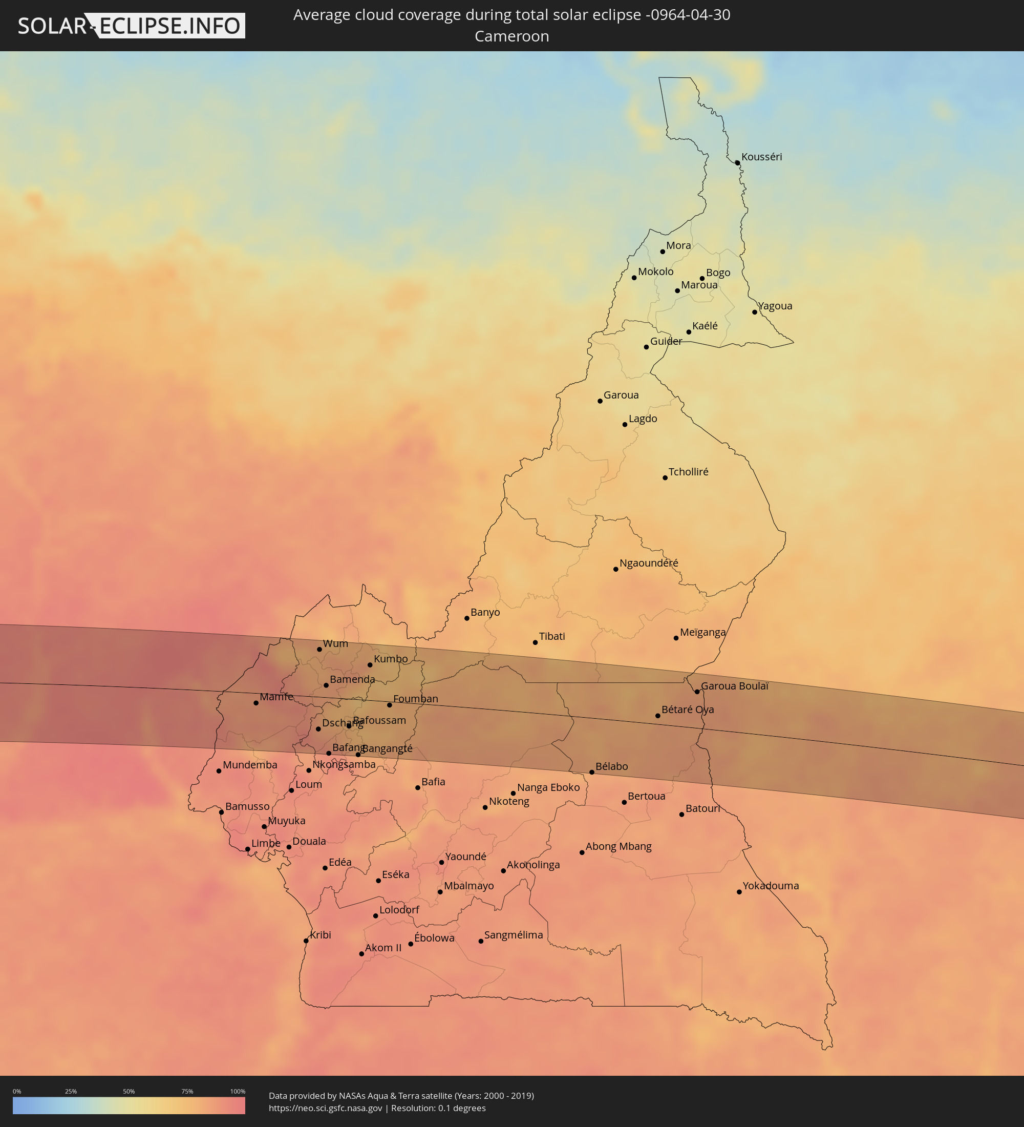 Cameroon
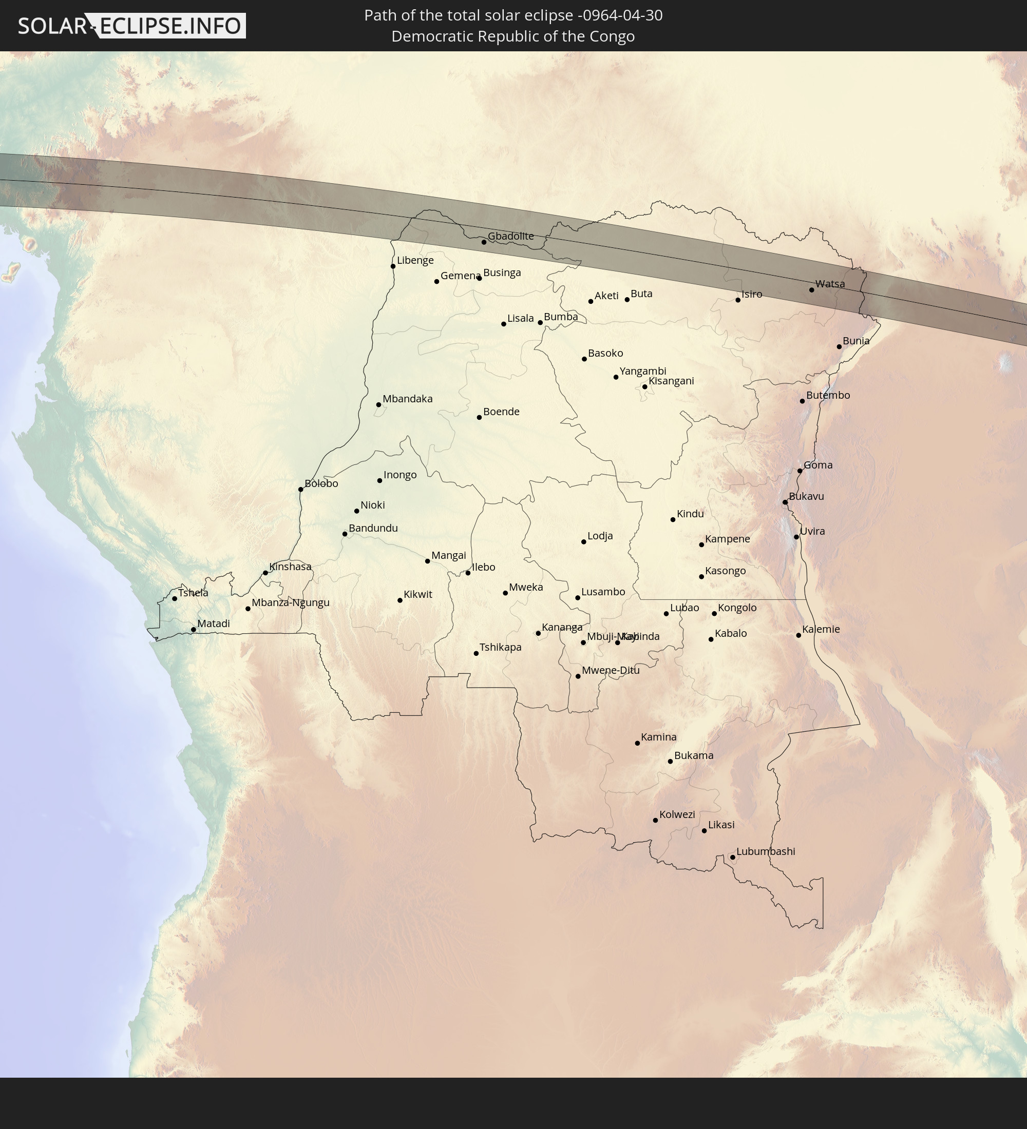
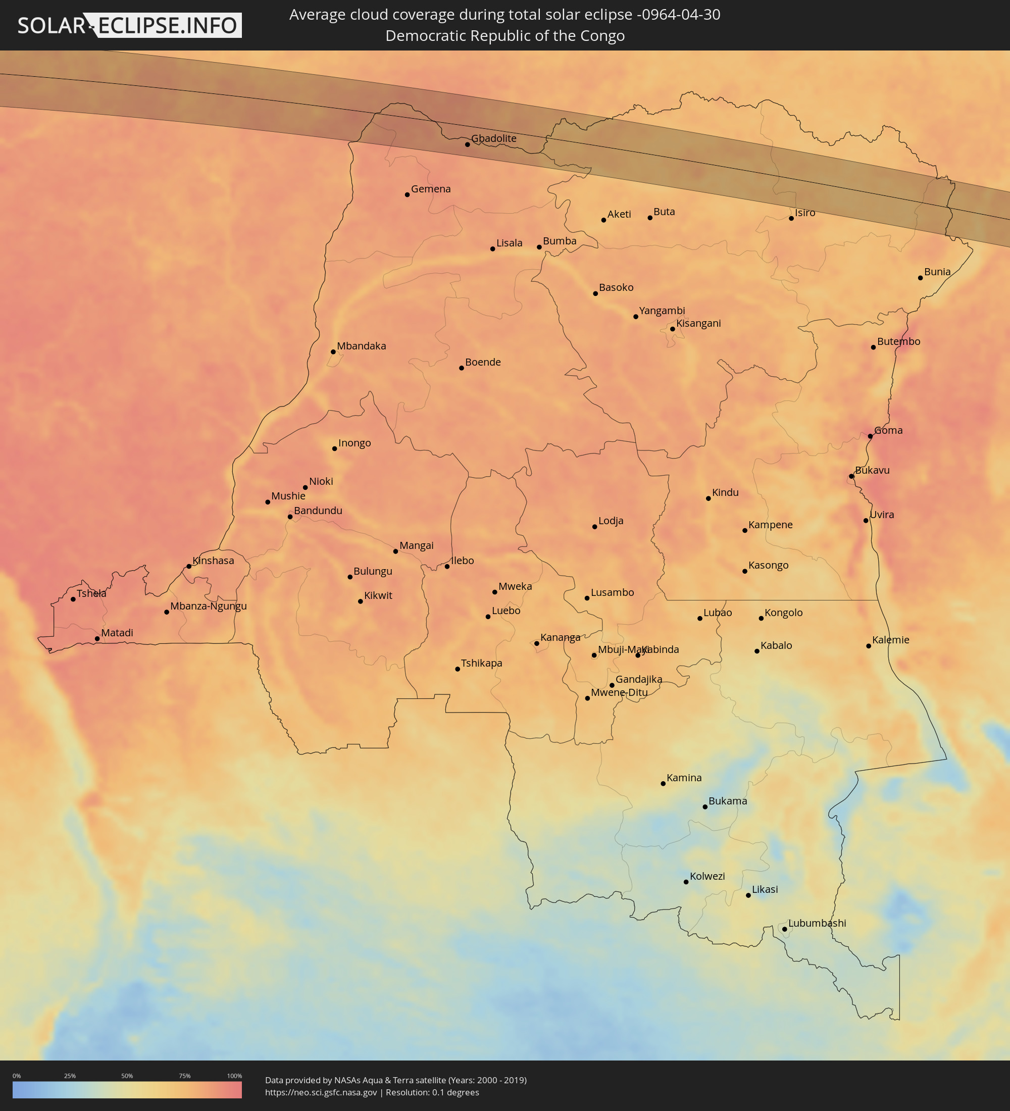 Democratic Republic of the Congo
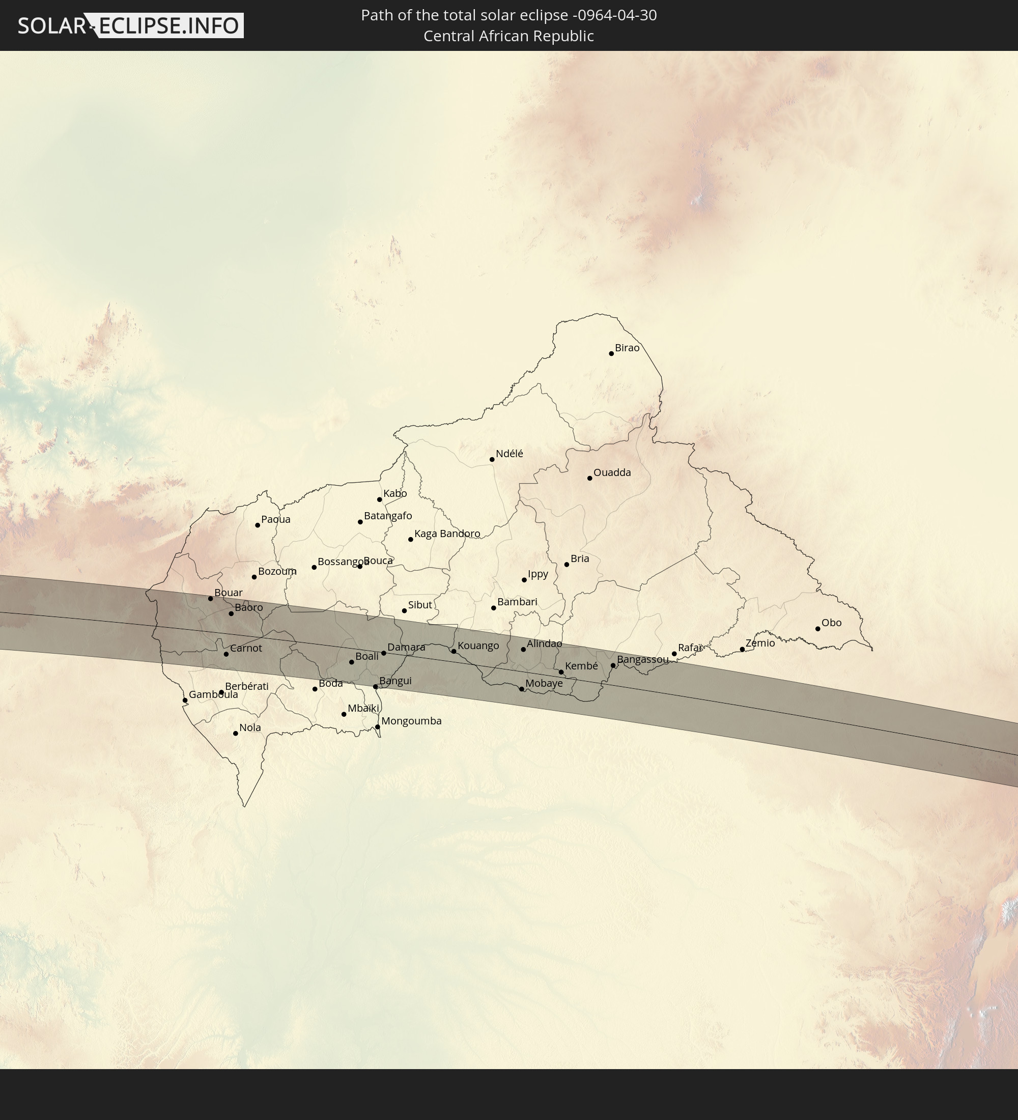
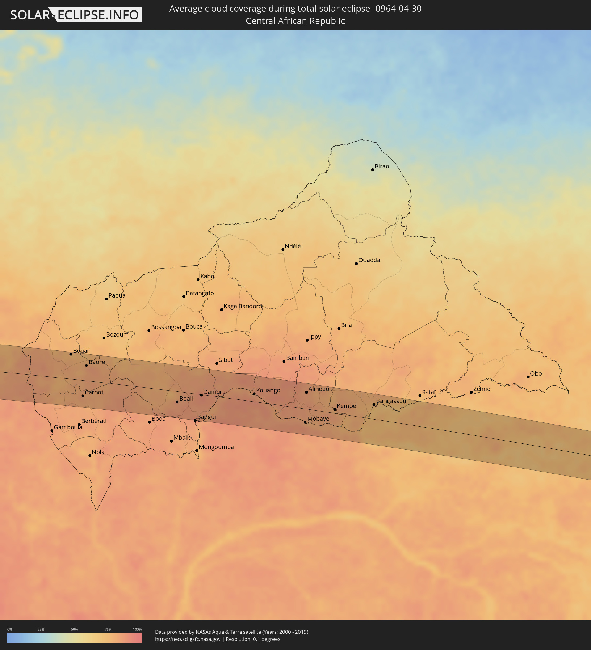 Central African Republic
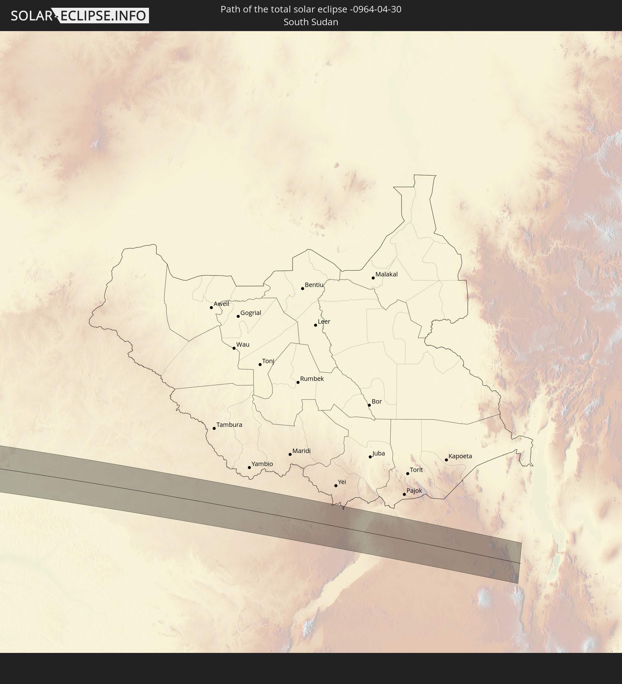
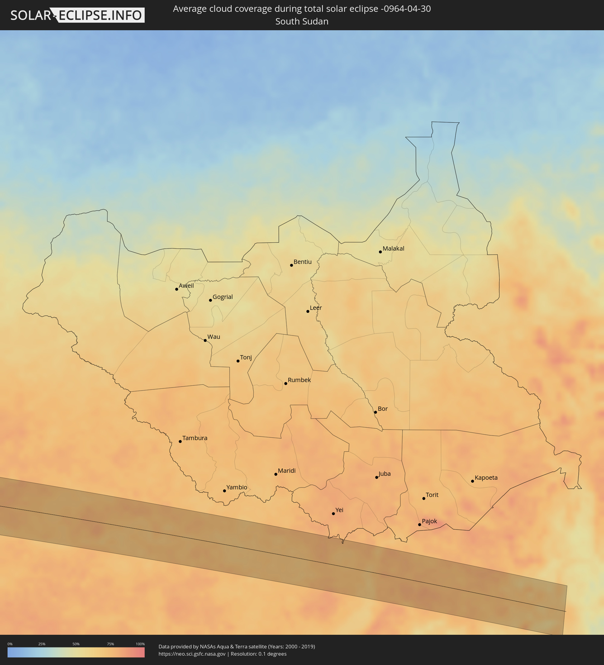 South Sudan
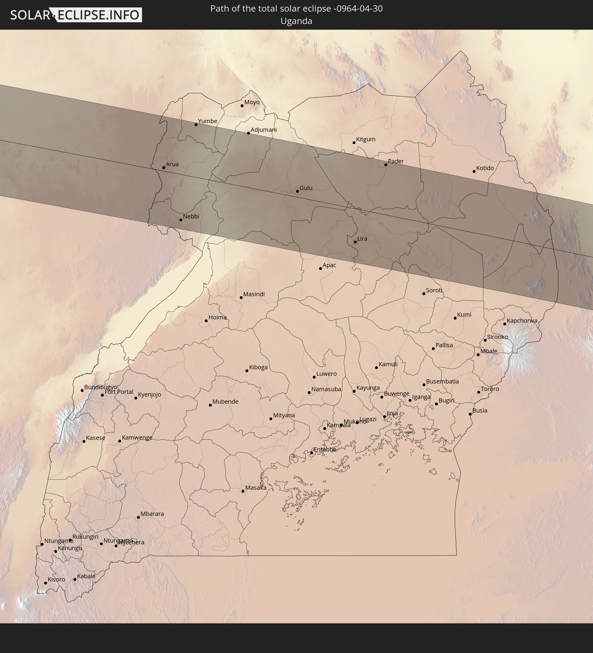
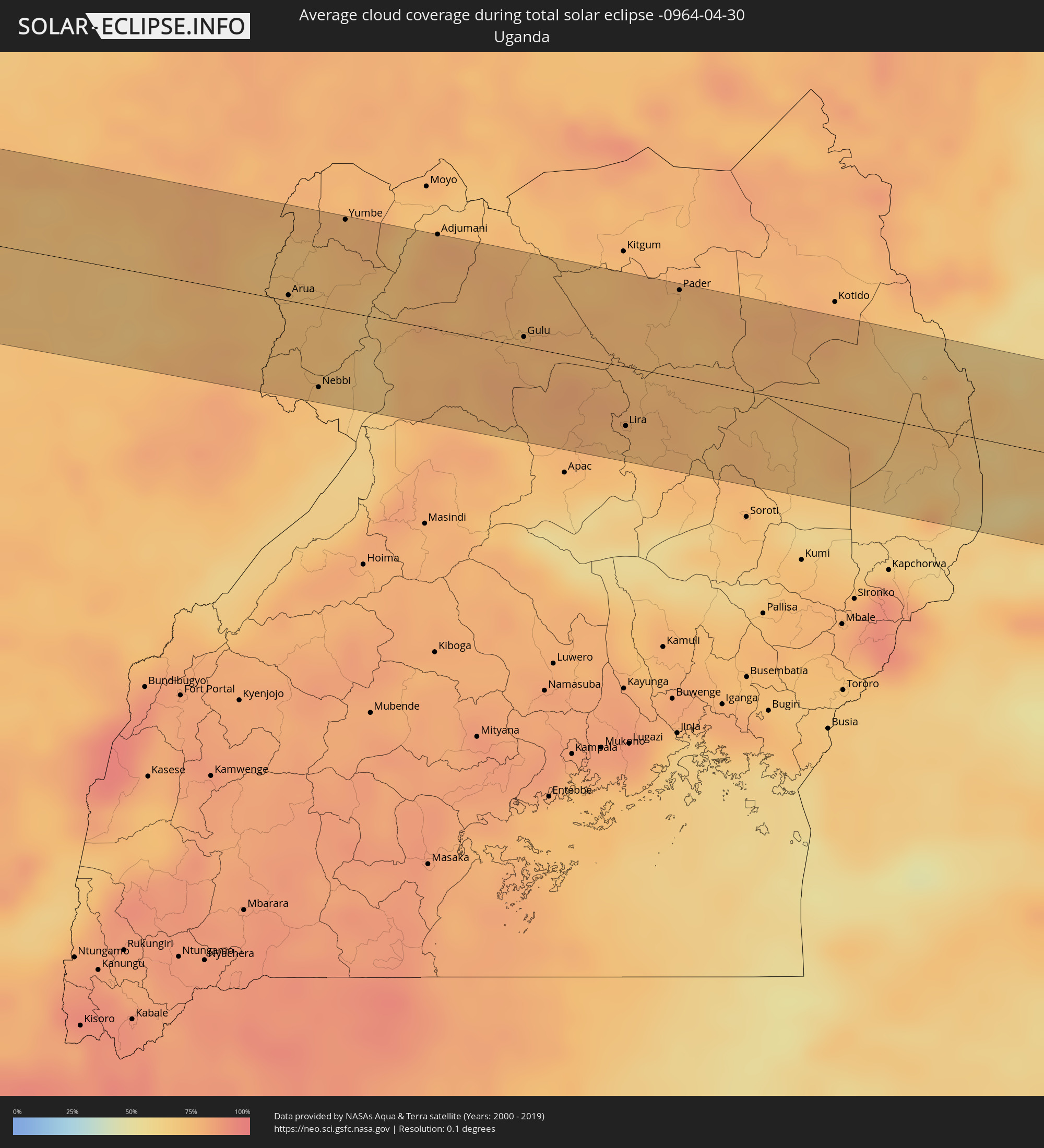 Uganda
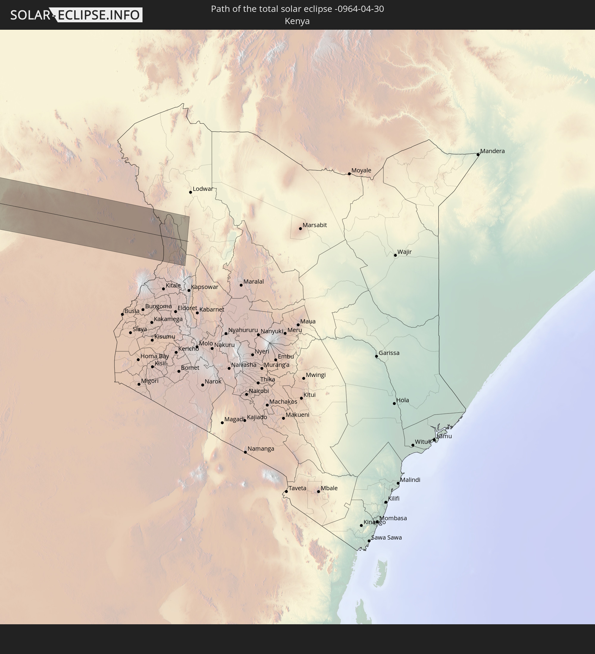
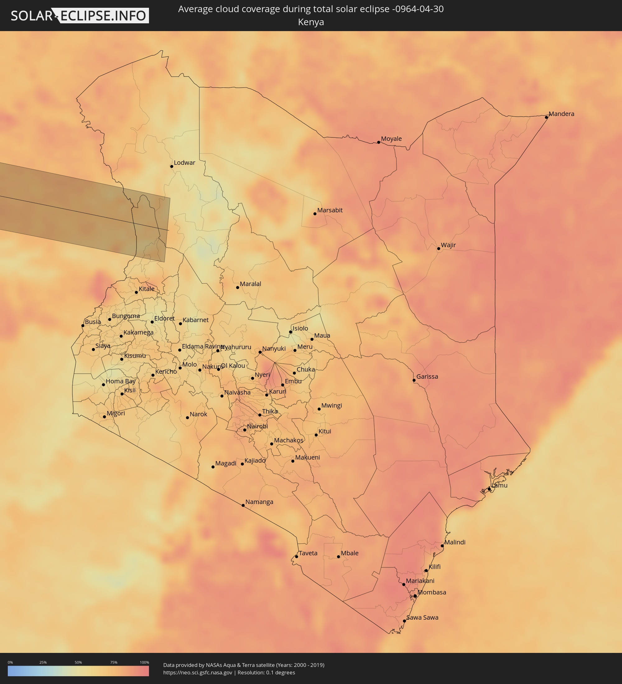 Kenya
Kenya
Cities inside the path of the eclipse
The following table shows all locations with a population of more than 5,000 inside the eclipse path. Cities which have more than 100,000 inhabitants are marked bold. A click at the locations opens a detailed map.
| City | Type | Eclipse duration | Local time of max. eclipse | Distance to central line | Ø Cloud coverage |
|
Antofagasta, Antofagasta
|
total | - | 07:30:53 UTC-04:42 | 18 km | 20% |
|
Calama, Antofagasta
|
total | - | 07:31:51 UTC-04:42 | 56 km | 8% |
|
Tupiza, Potosí
|
total | - | 07:44:28 UTC-04:32 | 44 km | 10% |
|
Villazón, Potosí
|
total | - | 07:44:28 UTC-04:32 | 27 km | 10% |
|
La Quiaca, Jujuy Province
|
total | - | 08:00:16 UTC-04:16 | 29 km | 10% |
|
Tarija, Tarija
|
total | - | 07:45:15 UTC-04:32 | 3 km | 37% |
|
Villamontes, Tarija
|
total | - | 07:46:23 UTC-04:32 | 25 km | 62% |
|
Corumbá, Mato Grosso do Sul
|
total | - | 08:47:07 UTC-03:38 | 40 km | 46% |
|
Barra do Garças, Mato Grosso
|
total | - | 08:55:49 UTC-03:38 | 19 km | 32% |
|
Uruaçu, Goiás
|
total | - | 09:33:38 UTC-03:06 | 4 km | 31% |
|
Barreiras, Bahia
|
total | - | 10:15:33 UTC-02:34 | 6 km | 45% |
|
Xique Xique, Bahia
|
total | - | 10:21:24 UTC-02:34 | 9 km | 47% |
|
Petrolina, Pernambuco
|
total | - | 10:42:08 UTC-02:19 | 20 km | 73% |
|
Salgueiro, Pernambuco
|
total | - | 10:46:50 UTC-02:19 | 67 km | 73% |
|
Serra Talhada, Pernambuco
|
total | - | 10:48:51 UTC-02:19 | 28 km | 72% |
|
Patos, Paraíba
|
total | - | 10:38:07 UTC-02:34 | 61 km | 66% |
|
Campina Grande, Paraíba
|
total | - | 10:41:18 UTC-02:34 | 39 km | 78% |
|
Guarabira, Paraíba
|
total | - | 10:42:46 UTC-02:34 | 26 km | 84% |
|
Macaíba, Rio Grande do Norte
|
total | - | 10:44:26 UTC-02:34 | 61 km | 86% |
|
Natal, Rio Grande do Norte
|
total | - | 10:44:54 UTC-02:34 | 59 km | 78% |
|
Santa Rita, Paraíba
|
total | - | 10:43:43 UTC-02:34 | 80 km | 83% |
|
Cabedelo, Paraíba
|
total | - | 10:44:16 UTC-02:34 | 75 km | 62% |
|
Cestos City, River Cess
|
total | - | 14:01:44 UTC-00:43 | 74 km | 80% |
|
Greenville, Sinoe
|
total | - | 14:02:40 UTC-00:43 | 14 km | 82% |
|
Barclayville, Grand Kru
|
total | - | 14:04:20 UTC-00:43 | 39 km | 91% |
|
Fish Town, River Gee
|
total | - | 14:05:37 UTC-00:43 | 11 km | 90% |
|
Harper, Maryland
|
total | - | 14:05:20 UTC-00:43 | 82 km | 81% |
|
San-Pédro, Bas-Sassandra
|
total | - | 14:35:09 UTC-00:16 | 60 km | 78% |
|
Soubré, Bas-Sassandra
|
total | - | 14:36:01 UTC-00:16 | 54 km | 88% |
|
Gagnoa, Gôh-Djiboua
|
total | - | 14:37:45 UTC-00:16 | 82 km | 89% |
|
Lakota, Gôh-Djiboua
|
total | - | 14:38:09 UTC-00:16 | 47 km | 91% |
|
Divo, Gôh-Djiboua
|
total | - | 14:38:51 UTC-00:16 | 41 km | 91% |
|
Dabou, Lagunes
|
total | - | 14:40:37 UTC-00:16 | 29 km | 77% |
|
Agboville, Lagunes
|
total | - | 14:41:23 UTC-00:16 | 36 km | 92% |
|
Anyama, Abidjan
|
total | - | 14:41:26 UTC-00:16 | 14 km | 94% |
|
Abidjan, Abidjan
|
total | - | 14:41:23 UTC-00:16 | 35 km | 87% |
|
Akoupé, Lagunes
|
total | - | 14:42:22 UTC-00:16 | 83 km | 93% |
|
Bingerville, Abidjan
|
total | - | 14:41:41 UTC-00:16 | 31 km | 86% |
|
Adzopé, Lagunes
|
total | - | 14:42:14 UTC-00:16 | 52 km | 92% |
|
Grand-Bassam, Comoé
|
total | - | 14:41:54 UTC-00:16 | 49 km | 79% |
|
Bonoua
|
total | - | 14:42:14 UTC-00:16 | 44 km | 83% |
|
Aboisso, Comoé
|
total | - | 14:43:11 UTC-00:16 | 26 km | 89% |
|
Prestea, Western
|
total | - | 15:00:35 UTC-00:00 | 41 km | 92% |
|
Tarkwa, Western
|
total | - | 15:00:50 UTC-00:00 | 56 km | 93% |
|
Obuasi, Ashanti
|
total | - | 15:02:01 UTC-00:00 | 41 km | 88% |
|
Akim Oda, Eastern
|
total | - | 15:03:09 UTC-00:00 | 5 km | 91% |
|
Nkawkaw, Eastern
|
total | - | 15:03:55 UTC-00:00 | 73 km | 91% |
|
Swedru, Central
|
total | - | 15:03:28 UTC-00:00 | 40 km | 91% |
|
Asamankese, Eastern
|
total | - | 15:03:44 UTC-00:00 | 4 km | 92% |
|
Winneba, Central
|
total | - | 15:03:30 UTC-00:00 | 61 km | 81% |
|
Suhum, Eastern
|
total | - | 15:04:14 UTC-00:00 | 14 km | 88% |
|
Kasoa, Central
|
total | - | 15:04:00 UTC-00:00 | 42 km | 81% |
|
Achiaman, Greater Accra
|
total | - | 15:04:15 UTC-00:00 | 24 km | 88% |
|
Koforidua, Eastern
|
total | - | 15:04:37 UTC-00:00 | 19 km | 89% |
|
Accra, Greater Accra
|
total | - | 15:04:26 UTC-00:00 | 41 km | 82% |
|
Tema, Greater Accra
|
total | - | 15:04:50 UTC-00:00 | 29 km | 83% |
|
Ho, Volta
|
total | - | 15:06:14 UTC-00:00 | 72 km | 92% |
|
Lomé, Maritime
|
total | - | 14:52:02 UTC-00:16 | 17 km | 83% |
|
Tsévié, Maritime
|
total | - | 14:52:11 UTC-00:16 | 49 km | 92% |
|
Tabligbo, Maritime
|
total | - | 14:52:46 UTC-00:16 | 66 km | 91% |
|
Vogan, Maritime
|
total | - | 14:52:42 UTC-00:16 | 38 km | 83% |
|
Aného, Maritime
|
total | - | 14:52:45 UTC-00:16 | 26 km | 84% |
|
Lokossa, Mono
|
total | - | 15:22:53 UTC+00:13 | 71 km | 91% |
|
Grand-Popo, Mono
|
total | - | 15:22:54 UTC+00:13 | 31 km | 86% |
|
Comé, Mono
|
total | - | 15:23:03 UTC+00:13 | 45 km | 86% |
|
Ouidah, Atlantique
|
total | - | 15:23:23 UTC+00:13 | 40 km | 86% |
|
Allada, Atlantique
|
total | - | 15:23:38 UTC+00:13 | 73 km | 93% |
|
Hévié, Atlantique
|
total | - | 15:23:41 UTC+00:13 | 45 km | 88% |
|
Abomey-Calavi, Atlantique
|
total | - | 15:23:53 UTC+00:13 | 48 km | 89% |
|
Cotonou, Littoral
|
total | - | 15:23:57 UTC+00:13 | 39 km | 89% |
|
Porto-Novo, Ouémé
|
total | - | 15:24:19 UTC+00:13 | 53 km | 87% |
|
Ikeja, Lagos
|
total | - | 15:25:34 UTC+00:13 | 63 km | 92% |
|
Lagos, Lagos
|
total | - | 15:25:36 UTC+00:13 | 48 km | 91% |
|
Ebute Ikorodu, Lagos
|
total | - | 15:25:49 UTC+00:13 | 64 km | 88% |
|
Benin City, Edo
|
total | - | 15:28:59 UTC+00:13 | 36 km | 95% |
|
Sapele, Delta
|
total | - | 15:28:53 UTC+00:13 | 13 km | 93% |
|
Warri, Delta
|
total | - | 15:28:49 UTC+00:13 | 55 km | 94% |
|
Onitsha, Anambra
|
total | - | 15:30:35 UTC+00:13 | 18 km | 90% |
|
Nnewi, Anambra
|
total | - | 15:30:43 UTC+00:13 | 4 km | 95% |
|
Owerri, Imo
|
total | - | 15:30:40 UTC+00:13 | 55 km | 95% |
|
Awka, Anambra
|
total | - | 15:31:00 UTC+00:13 | 26 km | 94% |
|
Umuahia, Abia
|
total | - | 15:31:19 UTC+00:13 | 48 km | 96% |
|
Enugu, Enugu
|
total | - | 15:31:40 UTC+00:13 | 54 km | 93% |
|
Amaigbo, Abia
|
total | - | 15:31:53 UTC+00:13 | 17 km | 94% |
|
Ugep, Cross River
|
total | - | 15:32:13 UTC+00:13 | 14 km | 93% |
|
Abakaliki, Ebonyi
|
total | - | 15:32:27 UTC+00:13 | 43 km | 96% |
|
Fontem, South-West
|
total | - | 15:34:23 UTC+00:13 | 41 km | 94% |
|
Bali, North-West
|
total | - | 15:34:42 UTC+00:13 | 6 km | 85% |
|
Dschang, West
|
total | - | 15:34:35 UTC+00:13 | 43 km | 89% |
|
Wum, North-West
|
total | - | 15:34:56 UTC+00:13 | 62 km | 81% |
|
Bamenda, North-West
|
total | - | 15:34:53 UTC+00:13 | 15 km | 82% |
|
Bafang, West
|
total | - | 15:34:38 UTC+00:13 | 74 km | 91% |
|
Mbouda, West
|
total | - | 15:34:54 UTC+00:13 | 21 km | 79% |
|
Fundong, North-West
|
total | - | 15:35:07 UTC+00:13 | 48 km | 84% |
|
Bafoussam, West
|
total | - | 15:35:02 UTC+00:13 | 37 km | 79% |
|
Bangangté, West
|
total | - | 15:35:03 UTC+00:13 | 73 km | 88% |
|
Foumbot, West
|
total | - | 15:35:18 UTC+00:13 | 32 km | 73% |
|
Kumbo, North-West
|
total | - | 15:35:35 UTC+00:13 | 46 km | 74% |
|
Foumban, West
|
total | - | 15:35:42 UTC+00:13 | 5 km | 76% |
|
Bélabo, East
|
total | - | 15:38:04 UTC+00:13 | 72 km | 84% |
|
Garoua Boulaï, East
|
total | - | 15:39:35 UTC+00:13 | 47 km | 84% |
|
Bouar, Nana-Mambéré
|
total | - | 15:40:34 UTC+00:13 | 64 km | 78% |
|
Carnot, Mambéré-Kadéï
|
total | - | 15:40:32 UTC+00:13 | 42 km | 81% |
|
Baoro, Nana-Mambéré
|
total | - | 15:40:49 UTC+00:13 | 39 km | 85% |
|
Boali, Ombella-M'Poko
|
total | - | 15:42:21 UTC+00:13 | 28 km | 84% |
|
Damara, Ombella-M'Poko
|
total | - | 15:42:50 UTC+00:13 | 2 km | 90% |
|
Kouango, Ouaka
|
total | - | 15:43:44 UTC+00:13 | 20 km | 83% |
|
Gbadolite, Équateur
|
total | - | 15:44:14 UTC+00:13 | 43 km | 87% |
|
Mobaye, Basse-Kotto
|
total | - | 15:44:21 UTC+00:13 | 36 km | 84% |
|
Alindao, Basse-Kotto
|
total | - | 15:44:33 UTC+00:13 | 43 km | 83% |
|
Kembé, Basse-Kotto
|
total | - | 15:44:52 UTC+00:13 | 9 km | 81% |
|
Bangassou, Mbomou
|
total | - | 15:45:25 UTC+00:13 | 38 km | 71% |
|
Bondo, Orientale
|
total | - | 17:42:23 UTC+02:10 | 49 km | 68% |
|
Watsa, Orientale
|
total | - | 17:44:27 UTC+02:10 | 23 km | 70% |
|
Arua, Northern Region
|
total | - | 18:01:43 UTC+02:27 | 4 km | 72% |
|
Paidha, Northern Region
|
total | - | 18:01:35 UTC+02:27 | 61 km | 74% |
|
Nebbi, Northern Region
|
total | - | 18:01:37 UTC+02:27 | 52 km | 73% |
|
Yumbe, Northern Region
|
total | - | 18:01:53 UTC+02:27 | 59 km | 77% |
|
Adjumani, Northern Region
|
total | - | 18:01:58 UTC+02:27 | 61 km | 79% |
|
Gulu, Northern Region
|
total | - | 18:01:55 UTC+02:27 | 6 km | 75% |
|
Lira, Northern Region
|
total | - | 18:01:53 UTC+02:27 | 38 km | 75% |
|
Pader Palwo, Northern Region
|
total | - | 18:02:03 UTC+02:27 | 27 km | 74% |
|
Pader, Northern Region
|
total | - | 18:02:07 UTC+02:27 | 56 km | 75% |
|
Moroto, Northern Region
|
total | - | 18:02:09 UTC+02:27 | 32 km | 72% |