Annular solar eclipse of 03/09/-0989
| Day of week: | Thursday |
| Maximum duration of eclipse: | 06m57s |
| Maximum width of eclipse path: | 263 km |
| Saros cycle: | 43 |
| Coverage: | 93.8% |
| Magnitude: | 0.9383 |
| Gamma: | 0.5194 |
Wo kann man die Sonnenfinsternis vom 03/09/-0989 sehen?
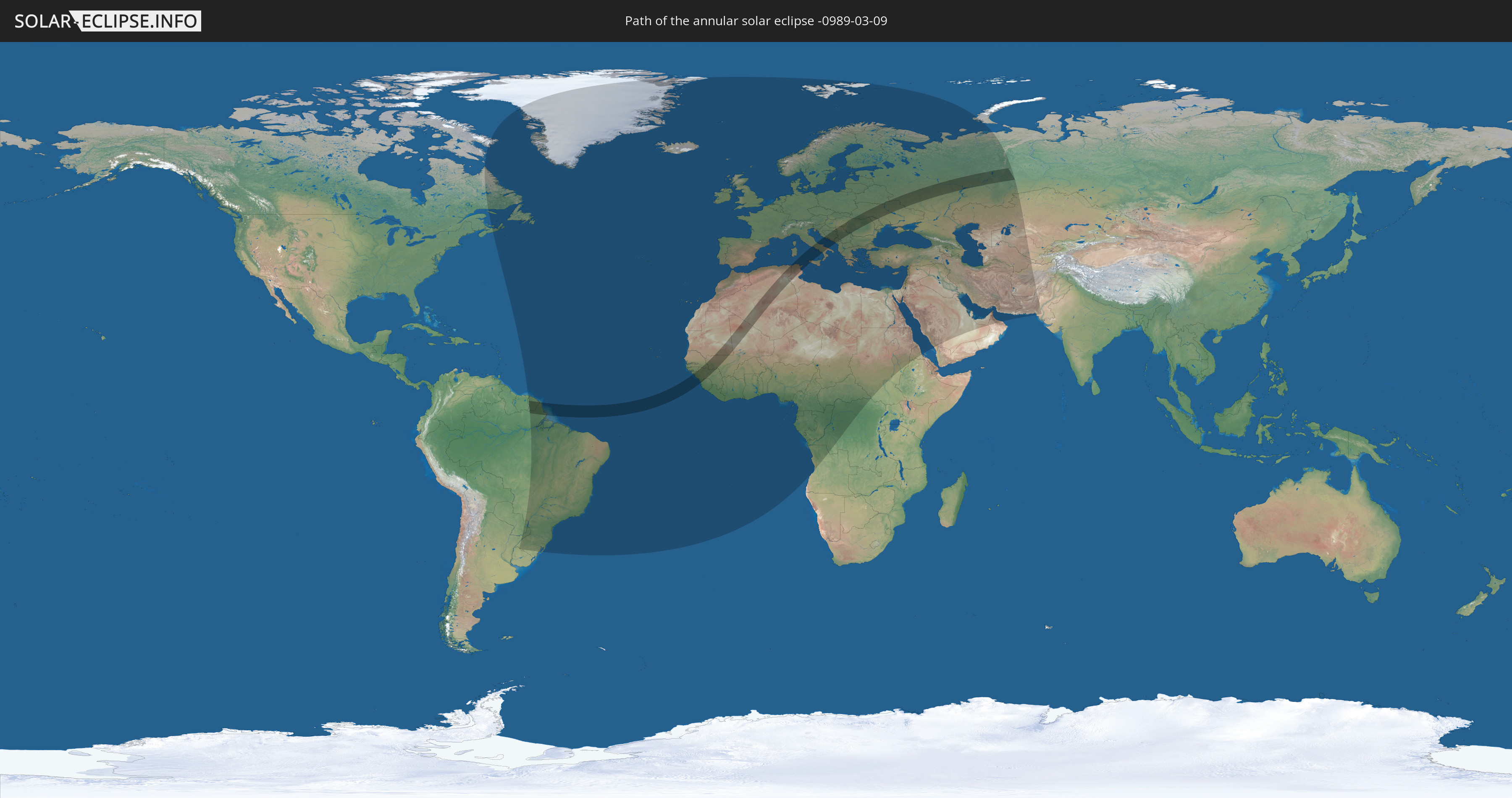
Die Sonnenfinsternis am 03/09/-0989 kann man in 117 Ländern als partielle Sonnenfinsternis beobachten.
Der Finsternispfad verläuft durch 22 Länder. Nur in diesen Ländern ist sie als annular Sonnenfinsternis zu sehen.
In den folgenden Ländern ist die Sonnenfinsternis annular zu sehen
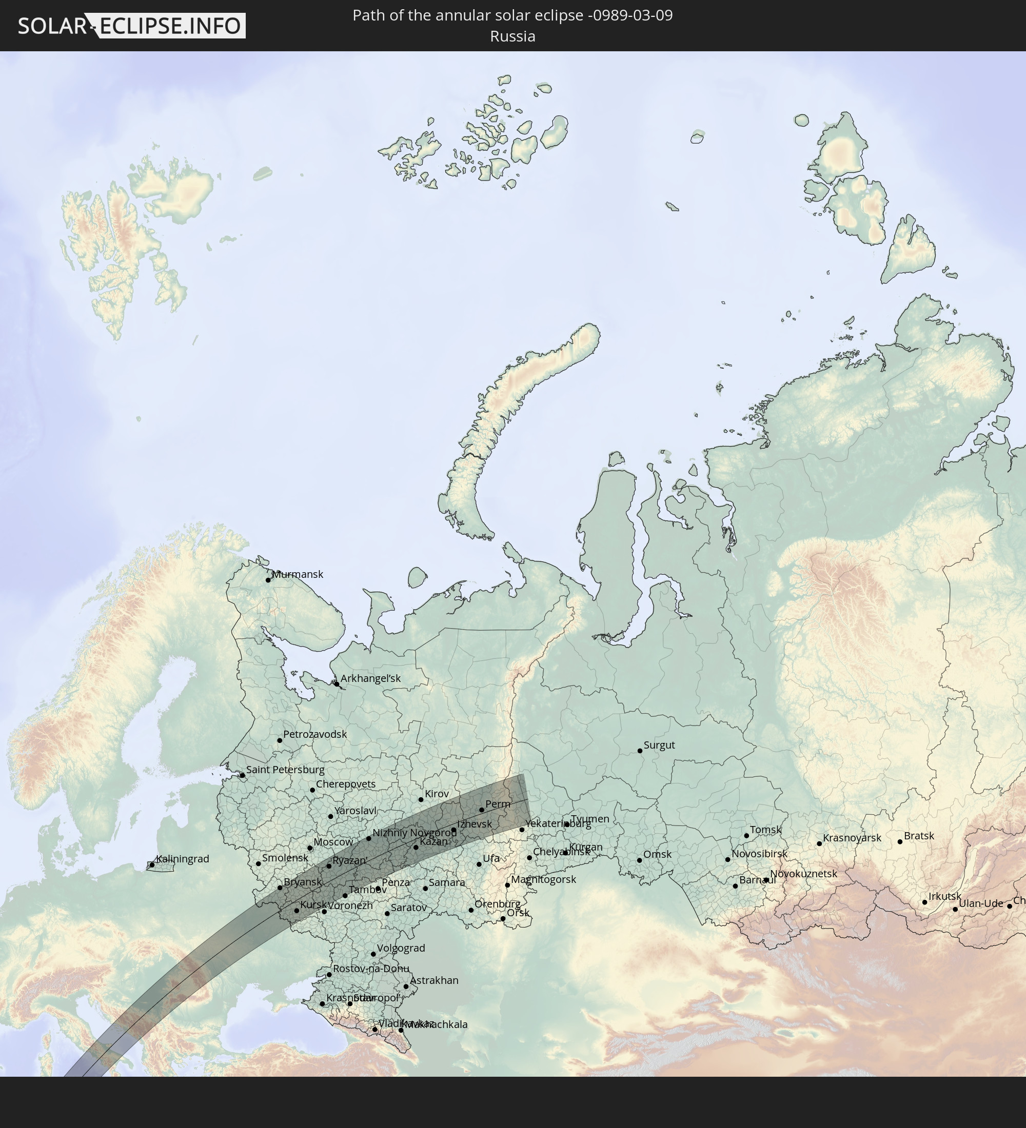 Russia
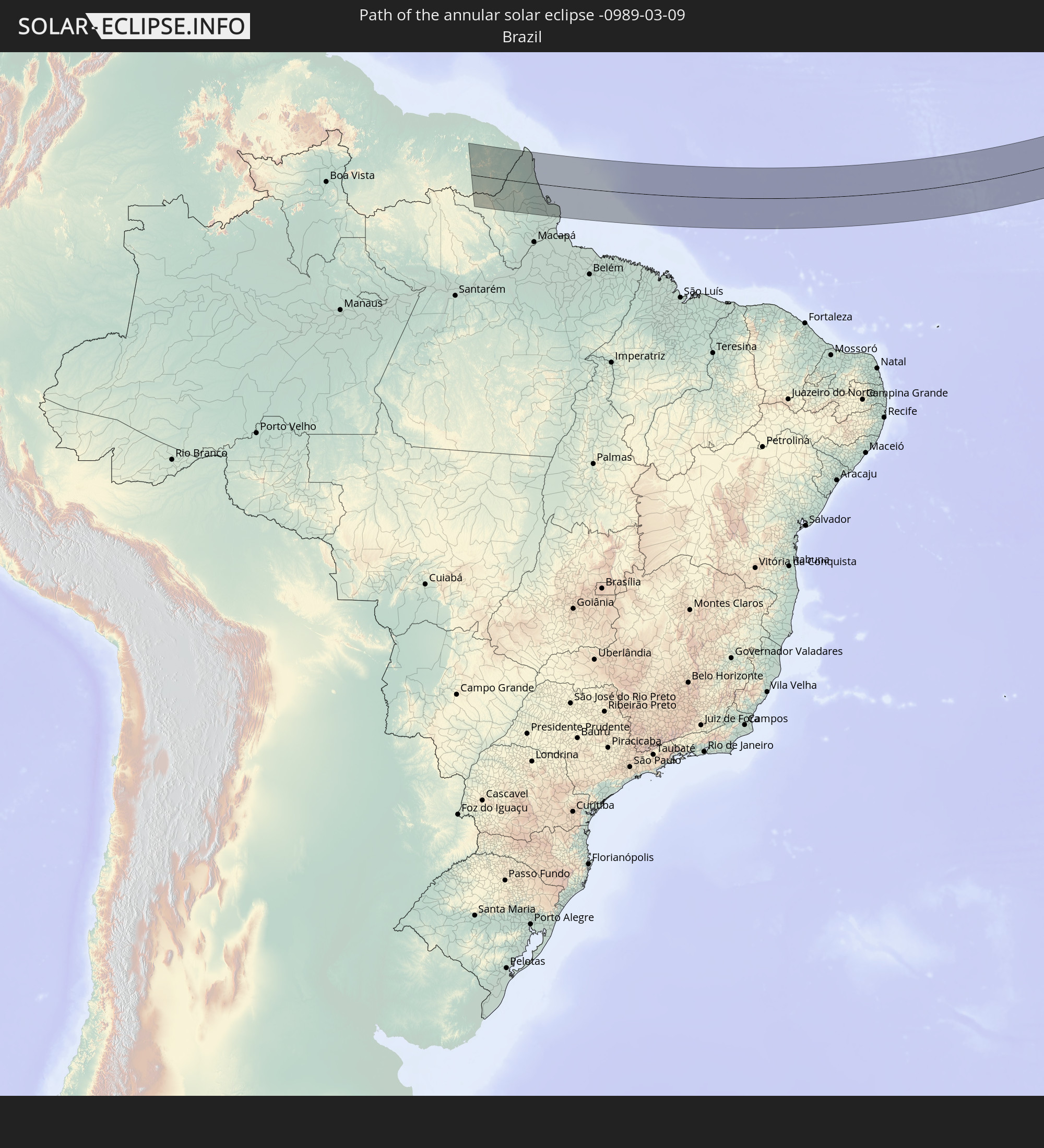 Brazil
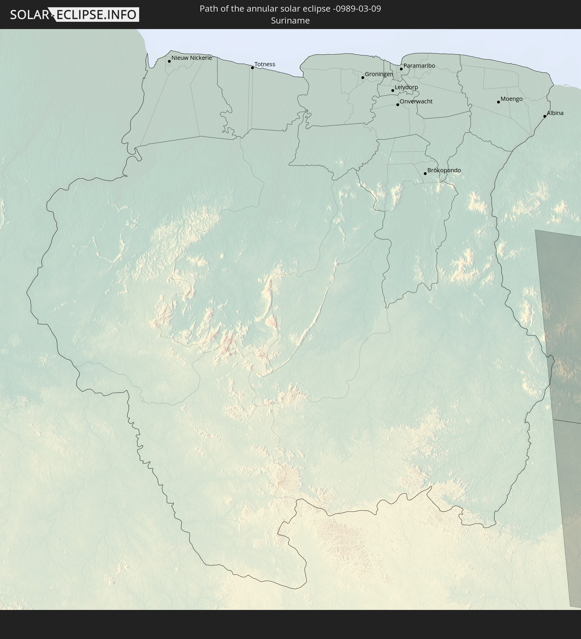 Suriname
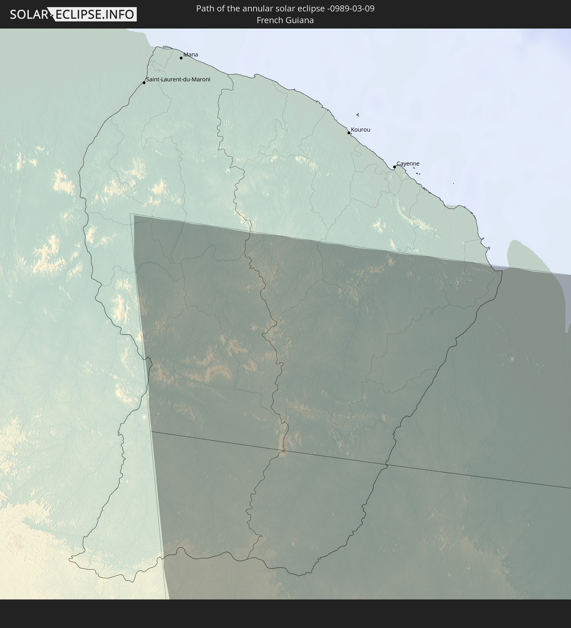 French Guiana
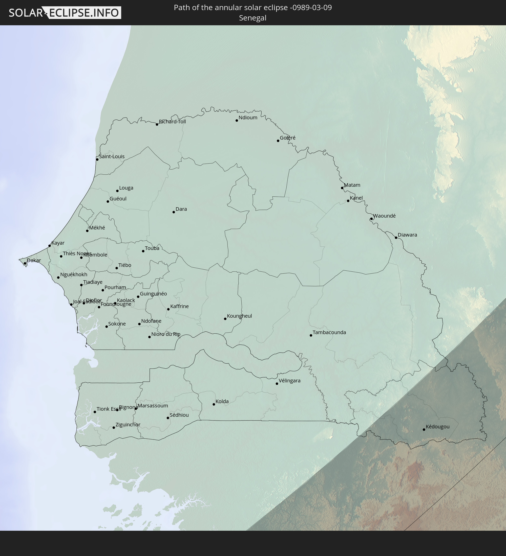 Senegal
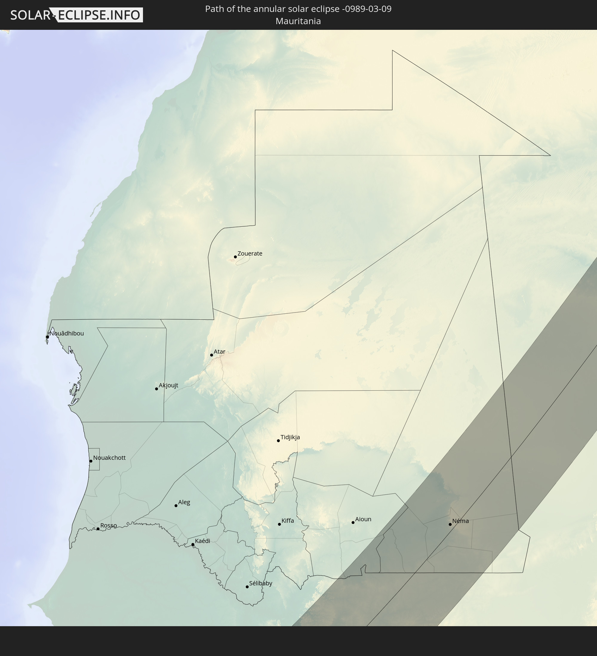 Mauritania
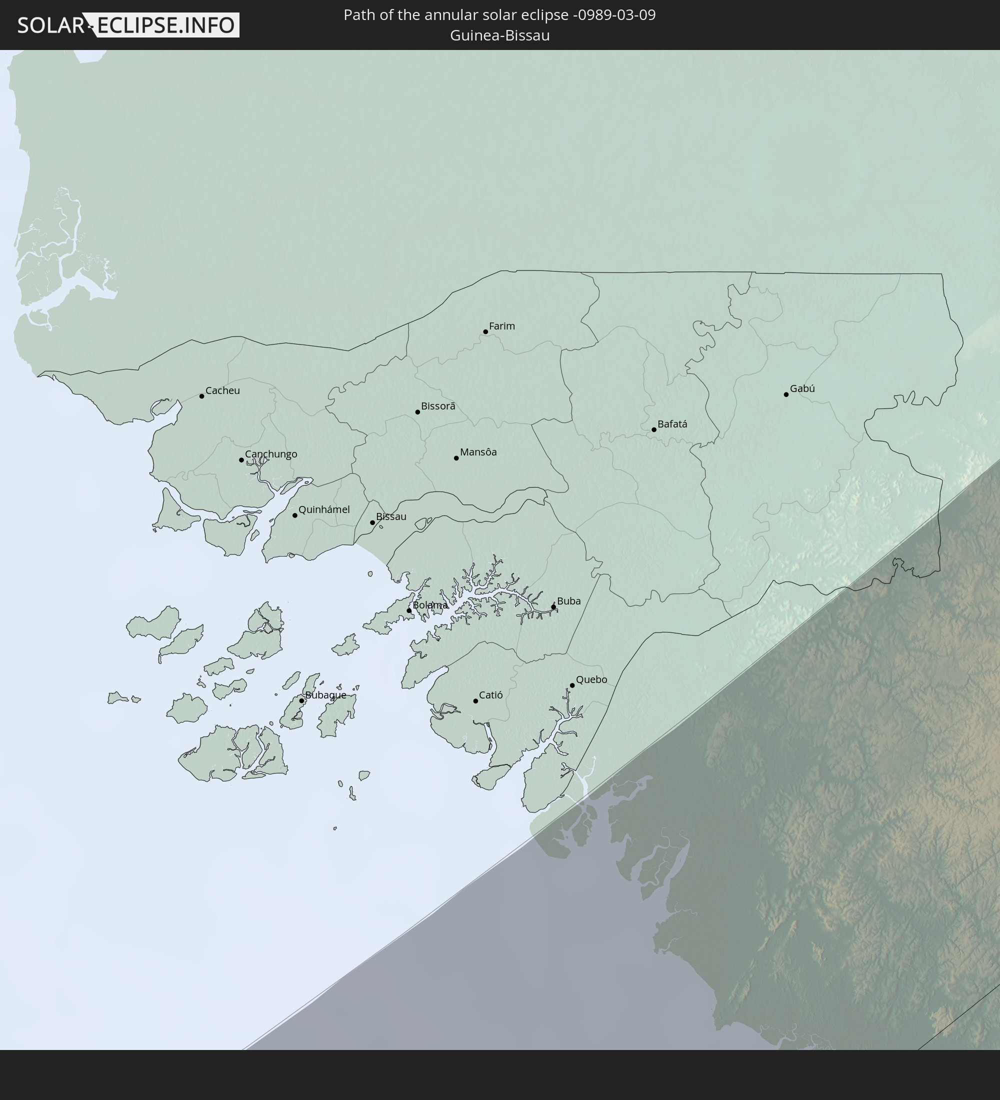 Guinea-Bissau
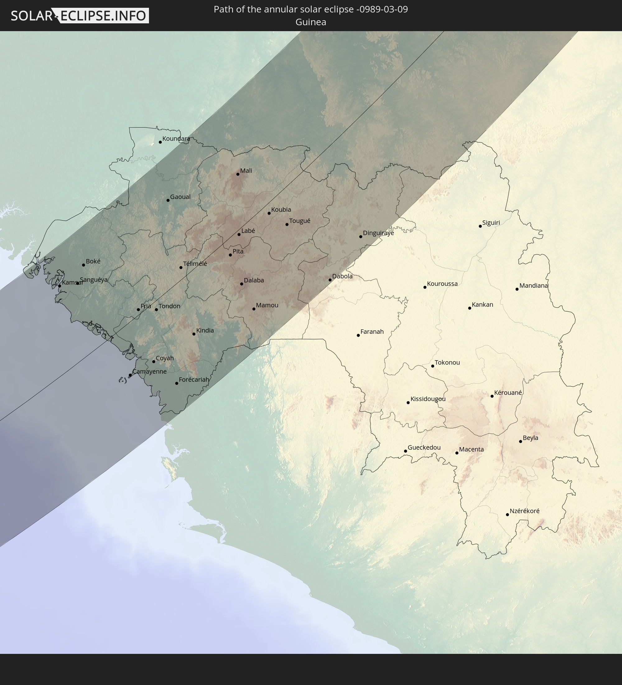 Guinea
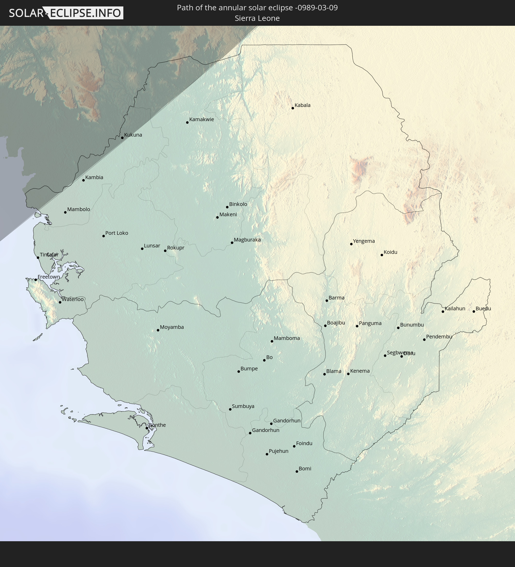 Sierra Leone
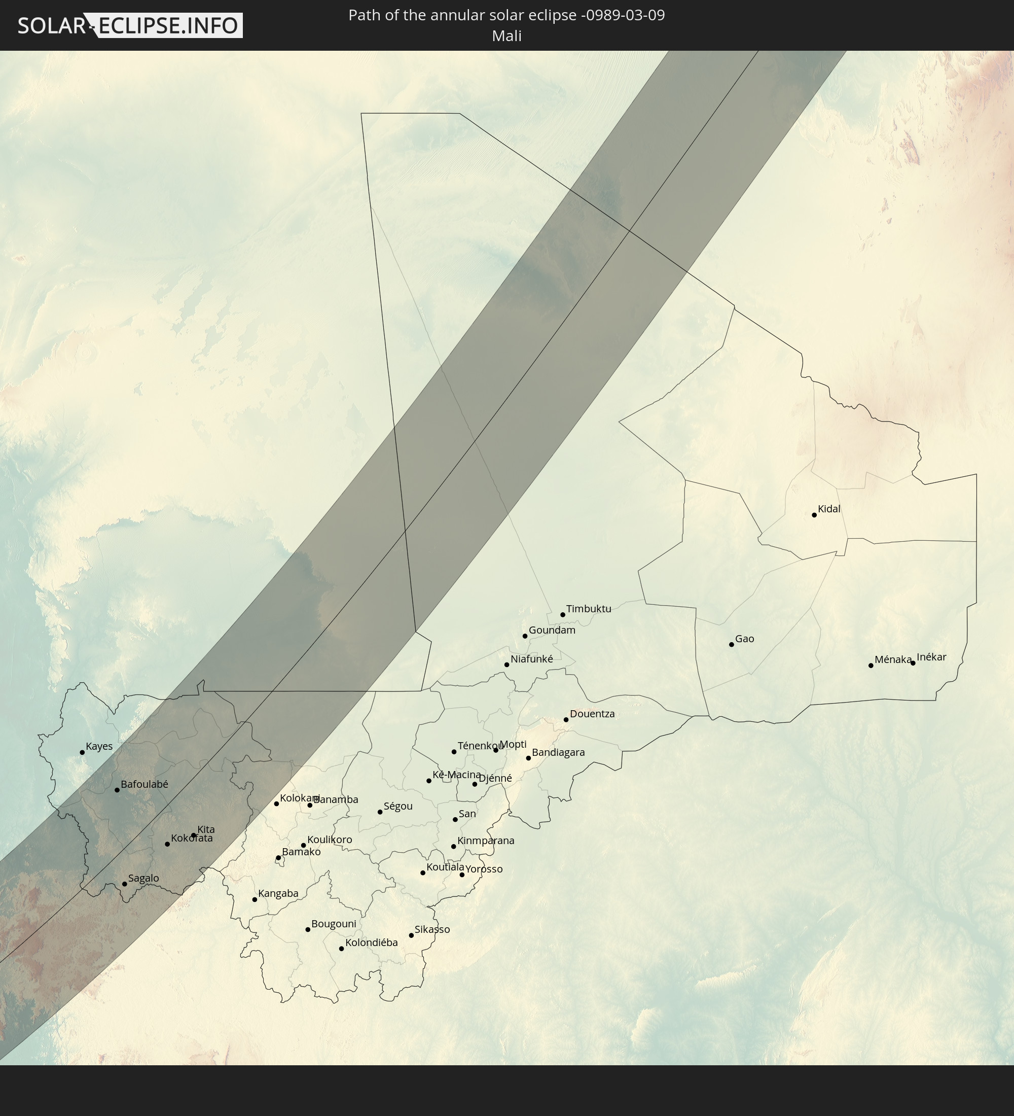 Mali
Mali
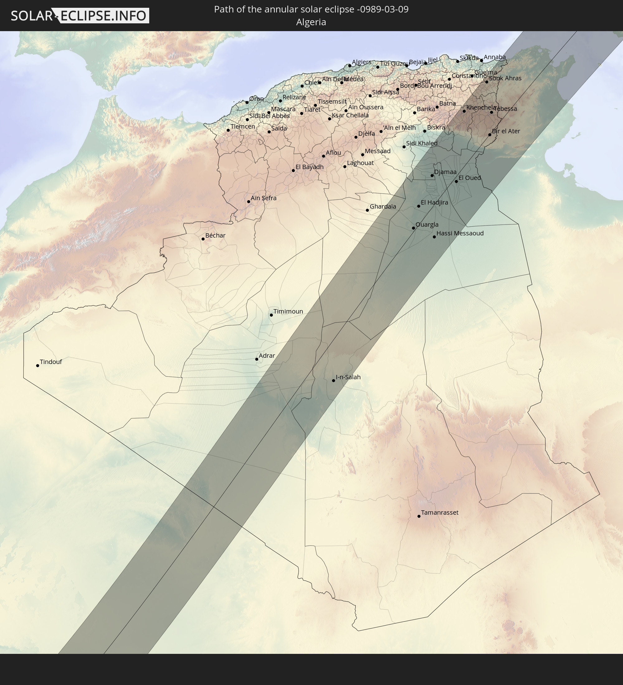 Algeria
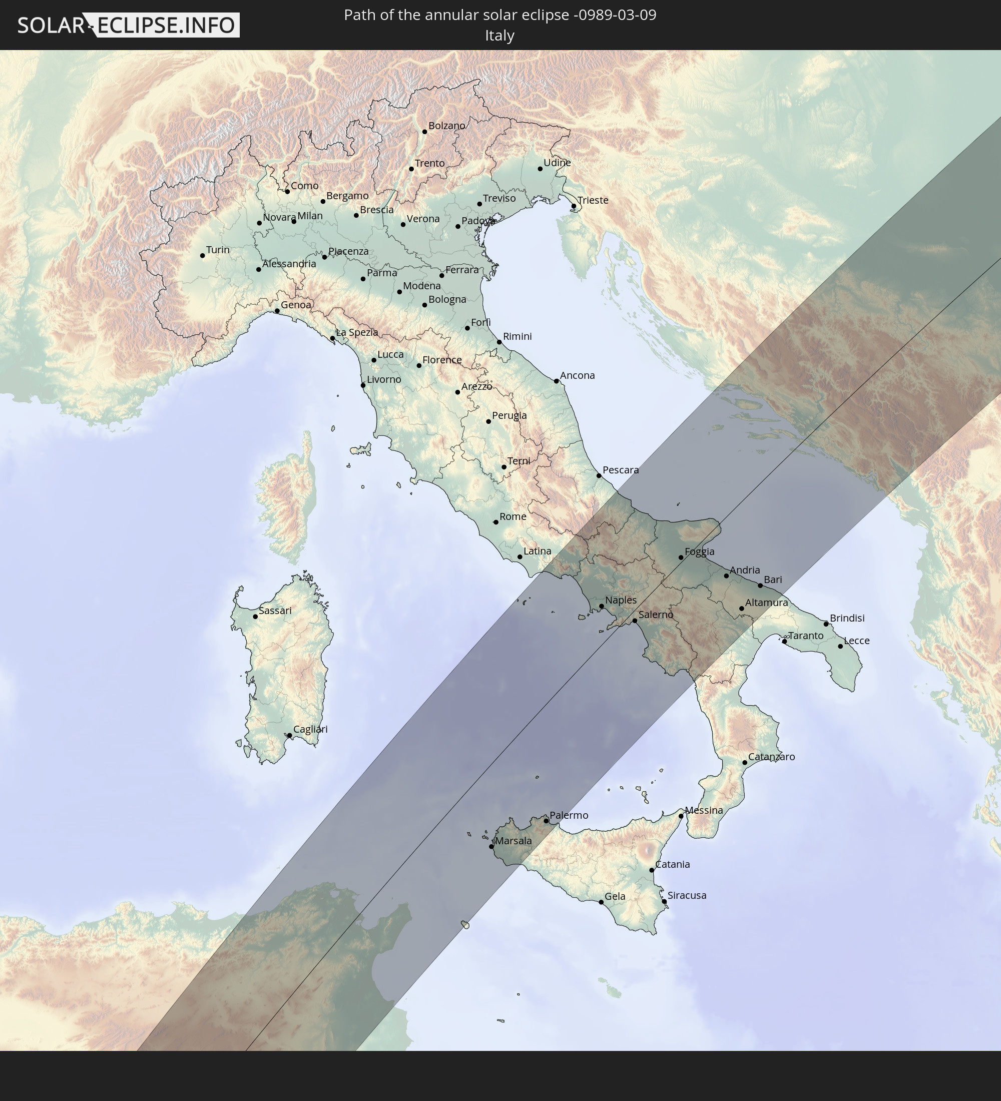 Italy
Italy
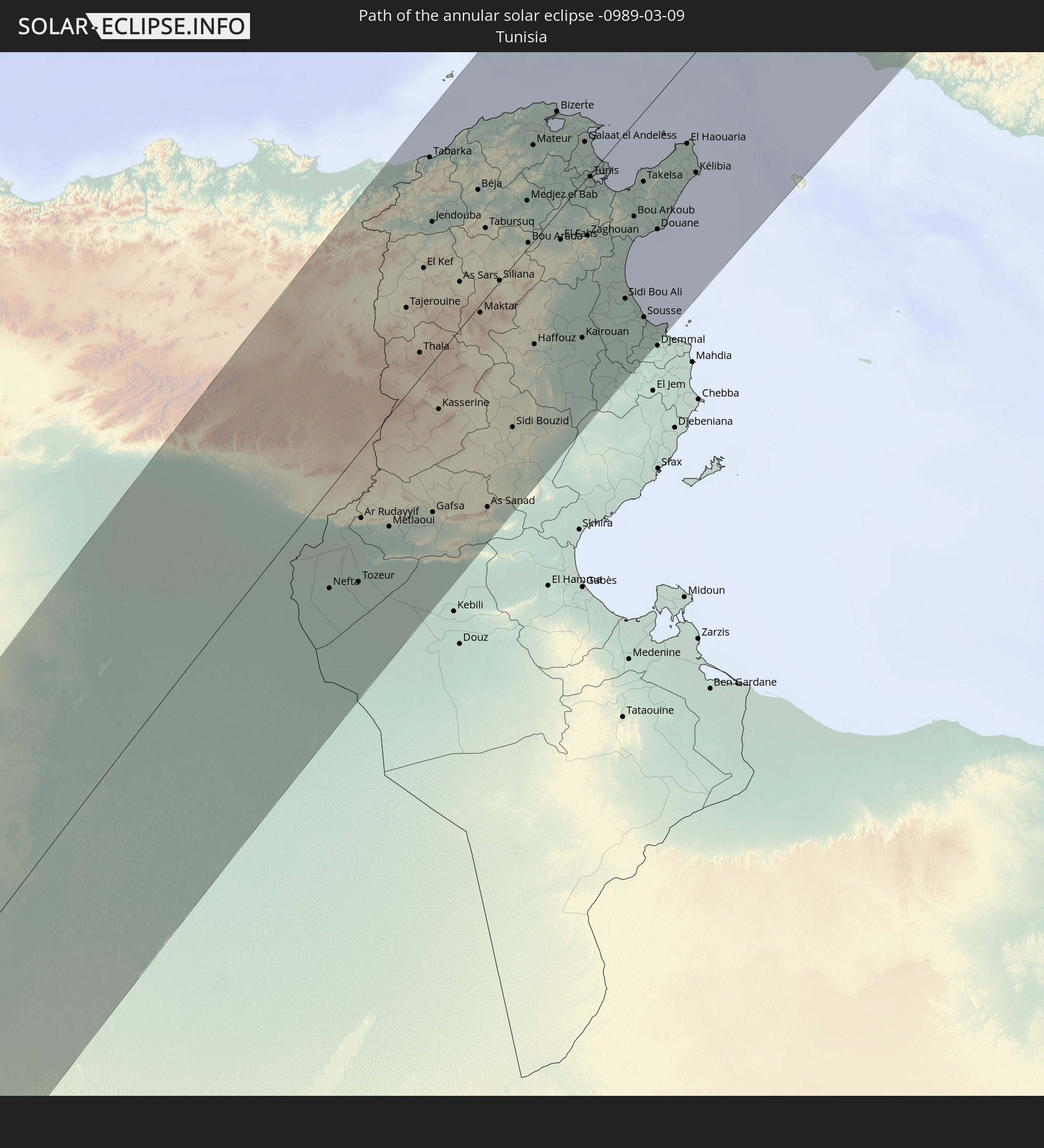 Tunisia
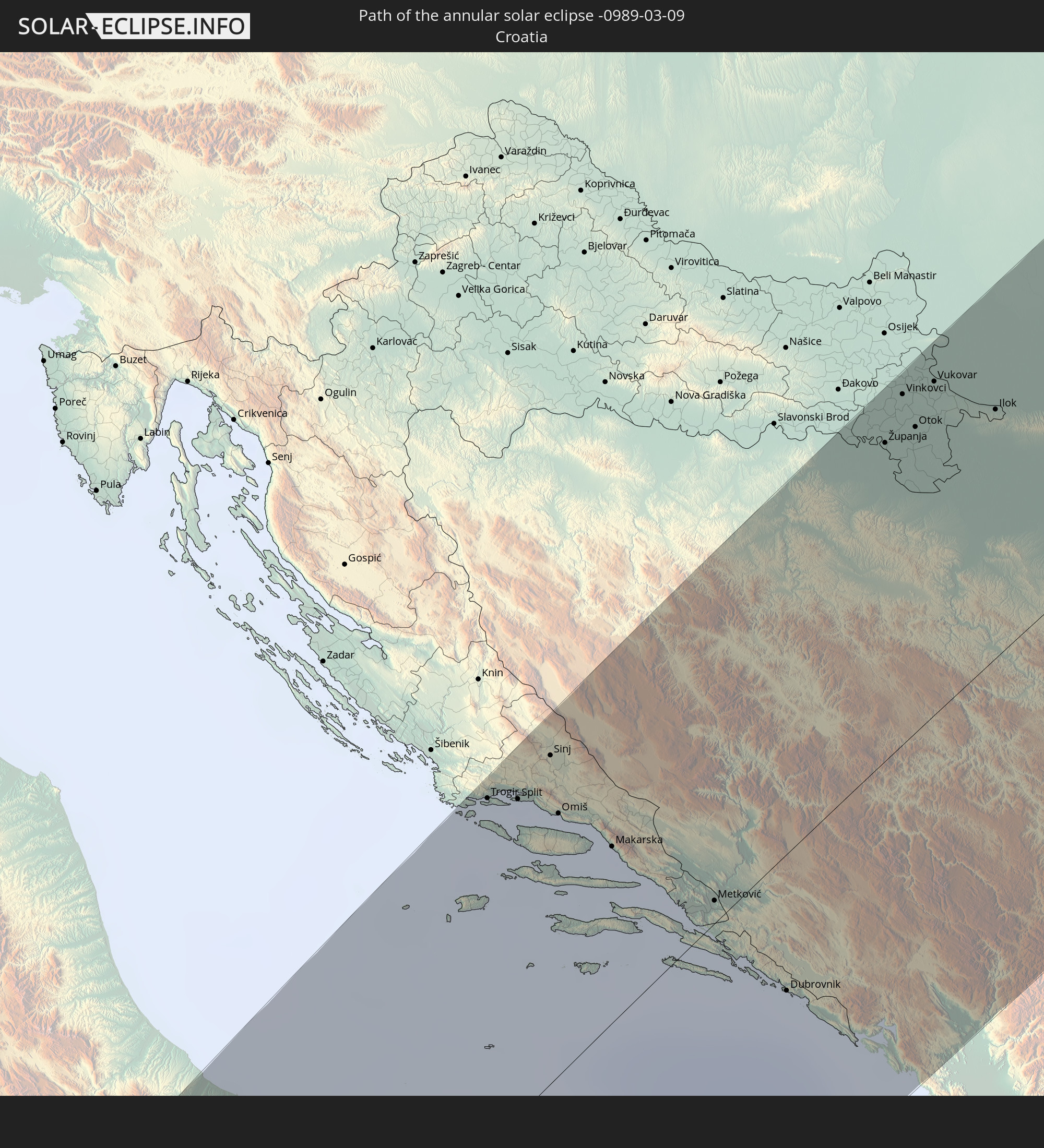 Croatia
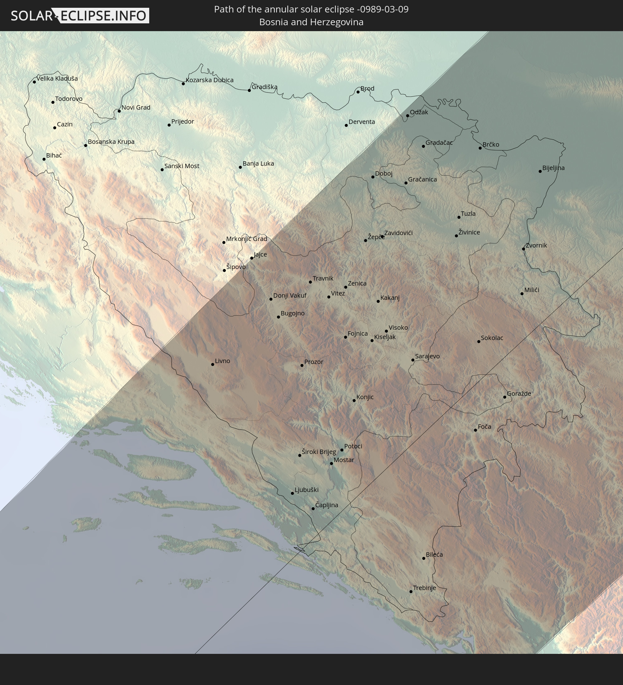 Bosnia and Herzegovina
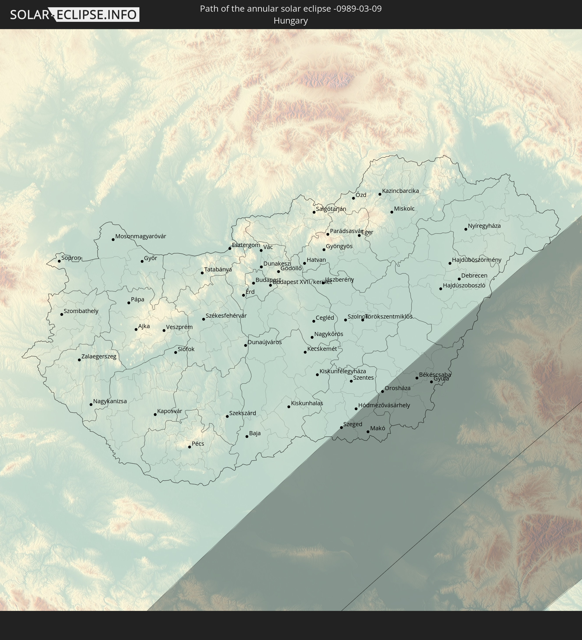 Hungary
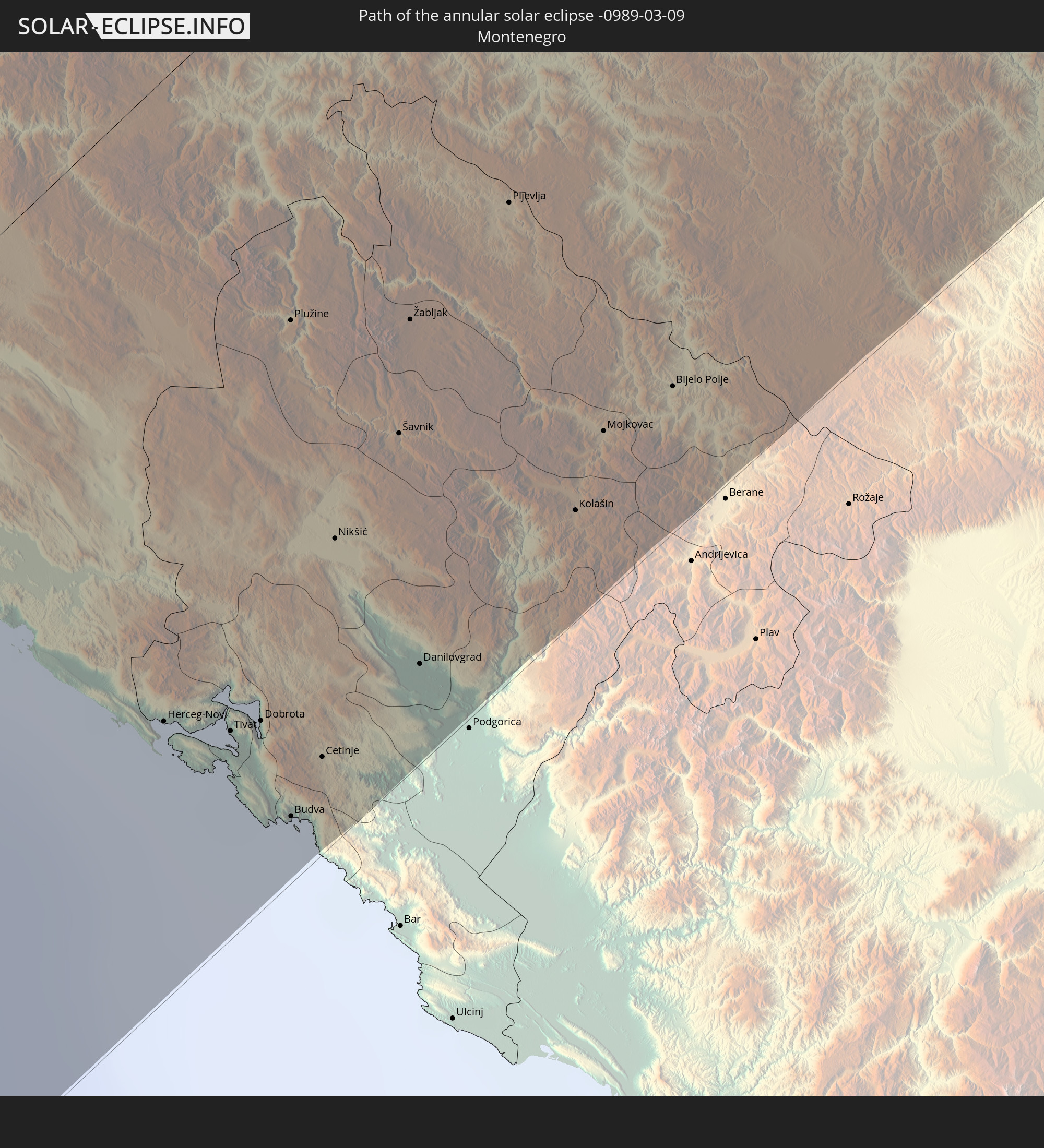 Montenegro
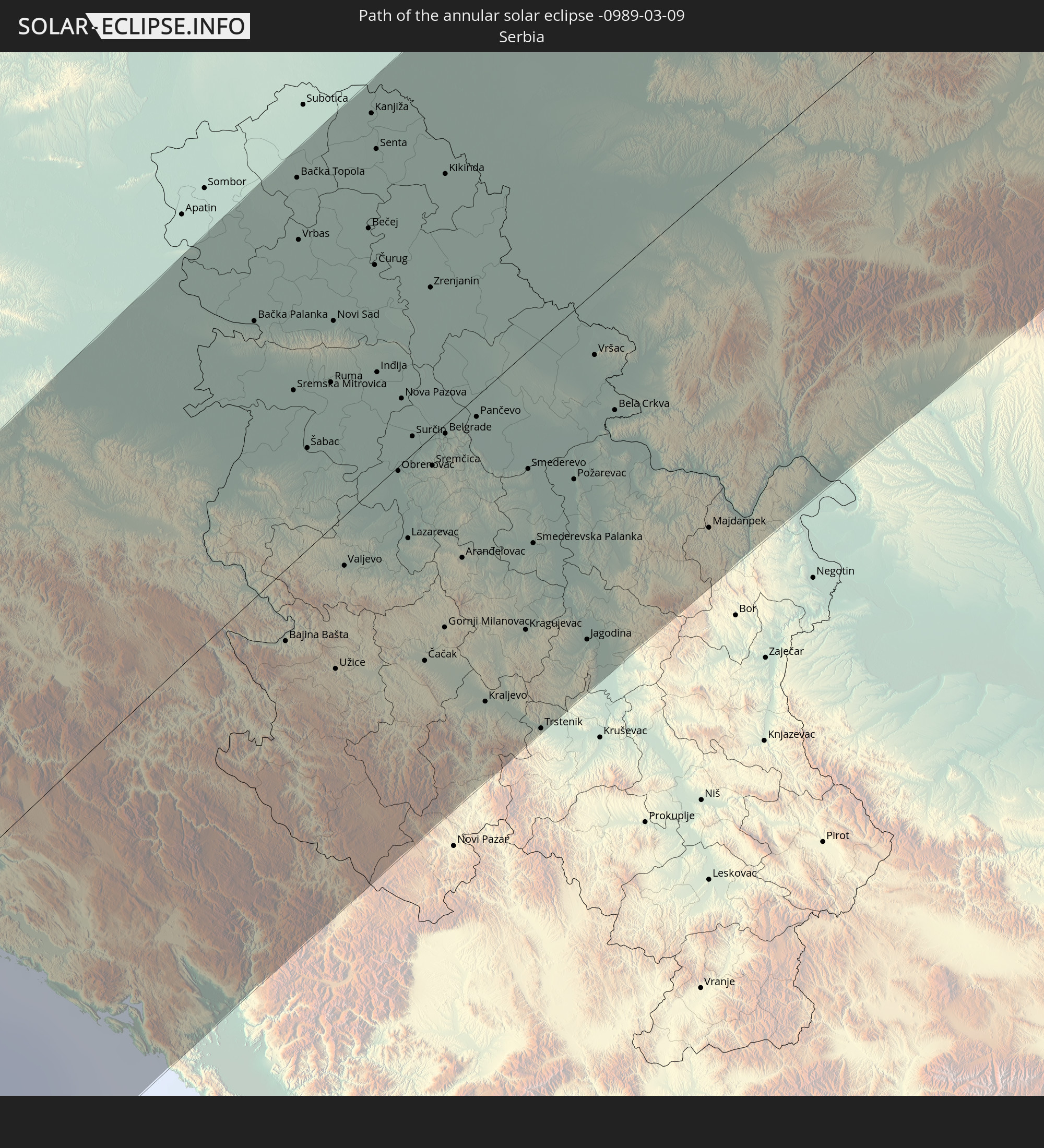 Serbia
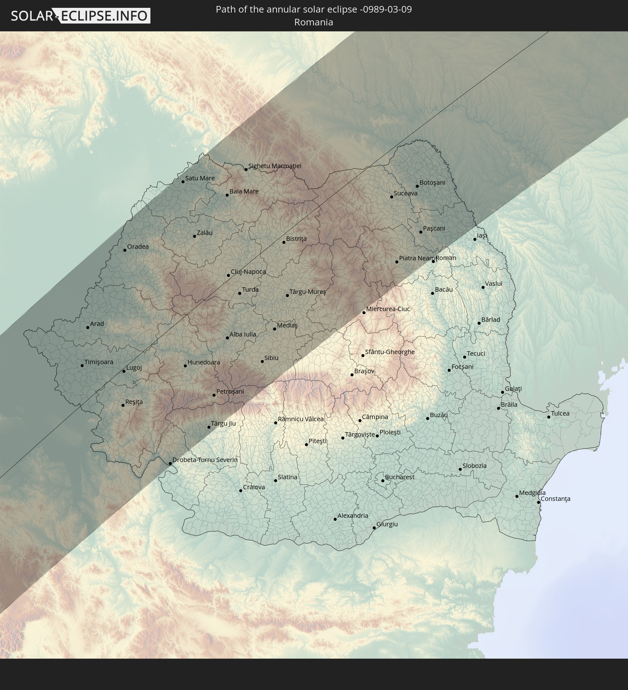 Romania
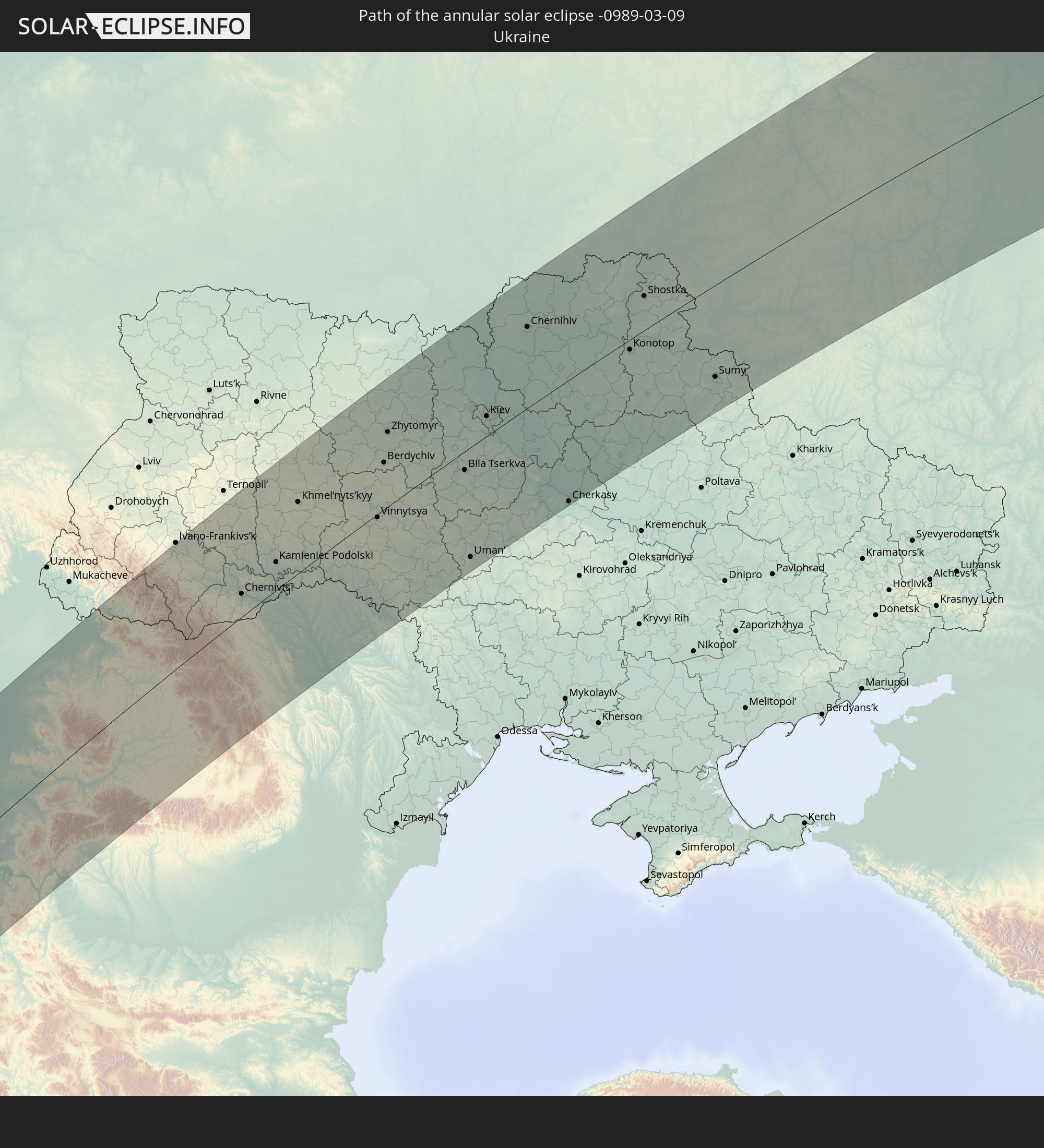 Ukraine
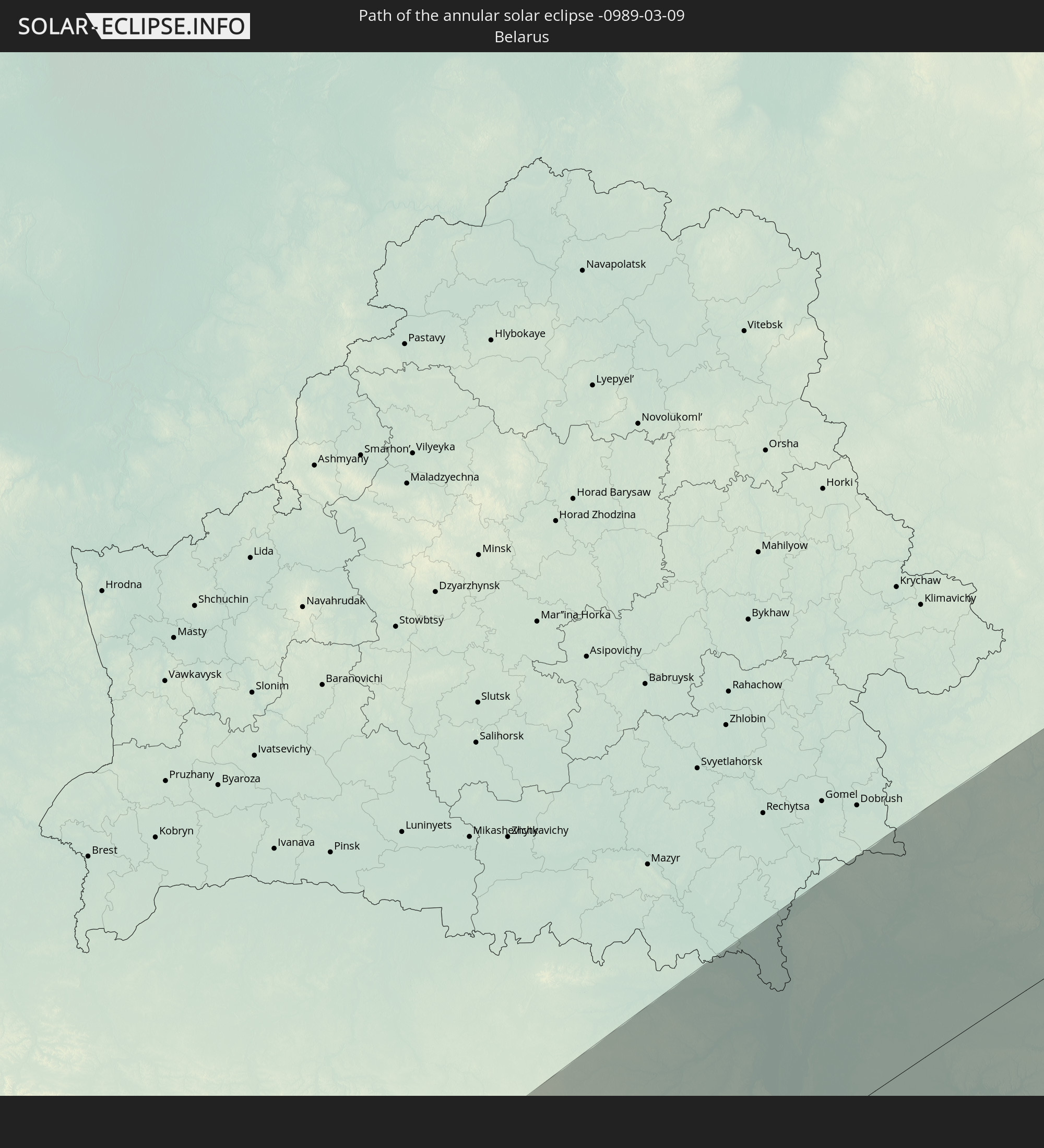 Belarus
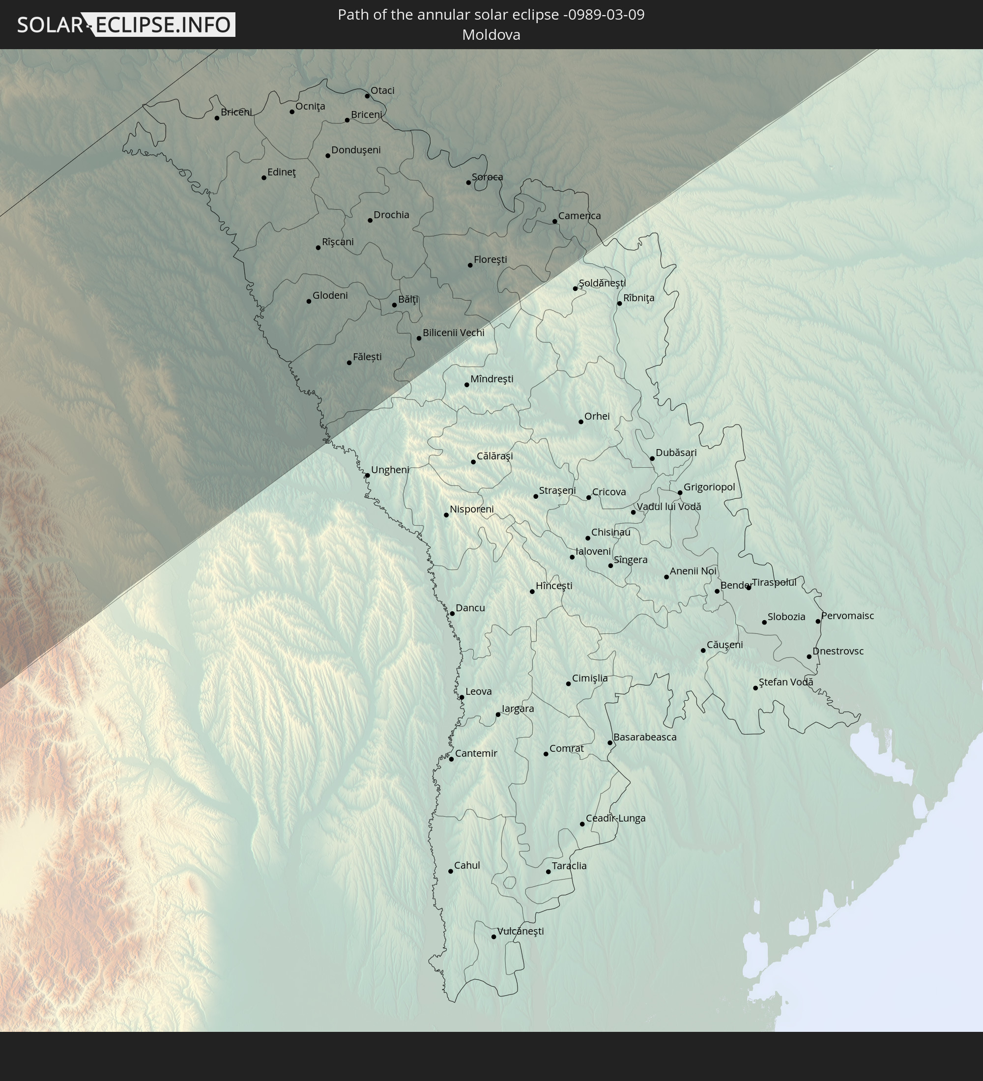 Moldova
In den folgenden Ländern ist die Sonnenfinsternis partiell zu sehen
 Russia
 Canada
 Greenland
 Brazil
 Argentina
 Paraguay
 Uruguay
 Suriname
 Saint Pierre and Miquelon
 French Guiana
 Portugal
 Cabo Verde
 Iceland
 Spain
Spain
 Senegal
 Mauritania
 The Gambia
 Guinea-Bissau
 Guinea
 Saint Helena, Ascension and Tristan da Cunha
 Sierra Leone
 Morocco
 Mali
Mali
 Liberia
 Republic of Ireland
 Svalbard and Jan Mayen
 Algeria
 United Kingdom
 Ivory Coast
 Faroe Islands
 Burkina Faso
 Gibraltar
 France
 Isle of Man
 Ghana
Ghana
 Guernsey
 Jersey
 Togo
Togo
 Niger
Niger
 Benin
Benin
 Andorra
 Belgium
 Nigeria
 Netherlands
 Norway
 Equatorial Guinea
 Luxembourg
 Germany
 Switzerland
 São Tomé and Príncipe
 Italy
Italy
 Monaco
 Tunisia
 Denmark
 Cameroon
 Gabon
Gabon
 Libya
Libya
 Liechtenstein
 Austria
 Sweden
 Republic of the Congo
 Angola
 Czechia
 Democratic Republic of the Congo
 San Marino
 Vatican City
 Slovenia
 Chad
Chad
 Croatia
 Poland
 Malta
Malta
 Central African Republic
 Bosnia and Herzegovina
 Hungary
 Slovakia
 Montenegro
 Serbia
 Albania
 Åland Islands
 Greece
 Romania
 Republic of Macedonia
 Finland
 Lithuania
 Latvia
 Estonia
 Sudan
Sudan
 Ukraine
 Bulgaria
 Belarus
 Egypt
Egypt
 Turkey
 Moldova
 Cyprus
 Ethiopia
 State of Palestine
 Israel
 Saudi Arabia
 Jordan
 Lebanon
 Syria
Syria
 Eritrea
 Iraq
Iraq
 Georgia
 Armenia
 Iran
Iran
 Azerbaijan
 Kazakhstan
 Kuwait
 Bahrain
 Qatar
Qatar
 United Arab Emirates
 Oman
Oman
 Turkmenistan
 Uzbekistan
 Afghanistan
 Pakistan
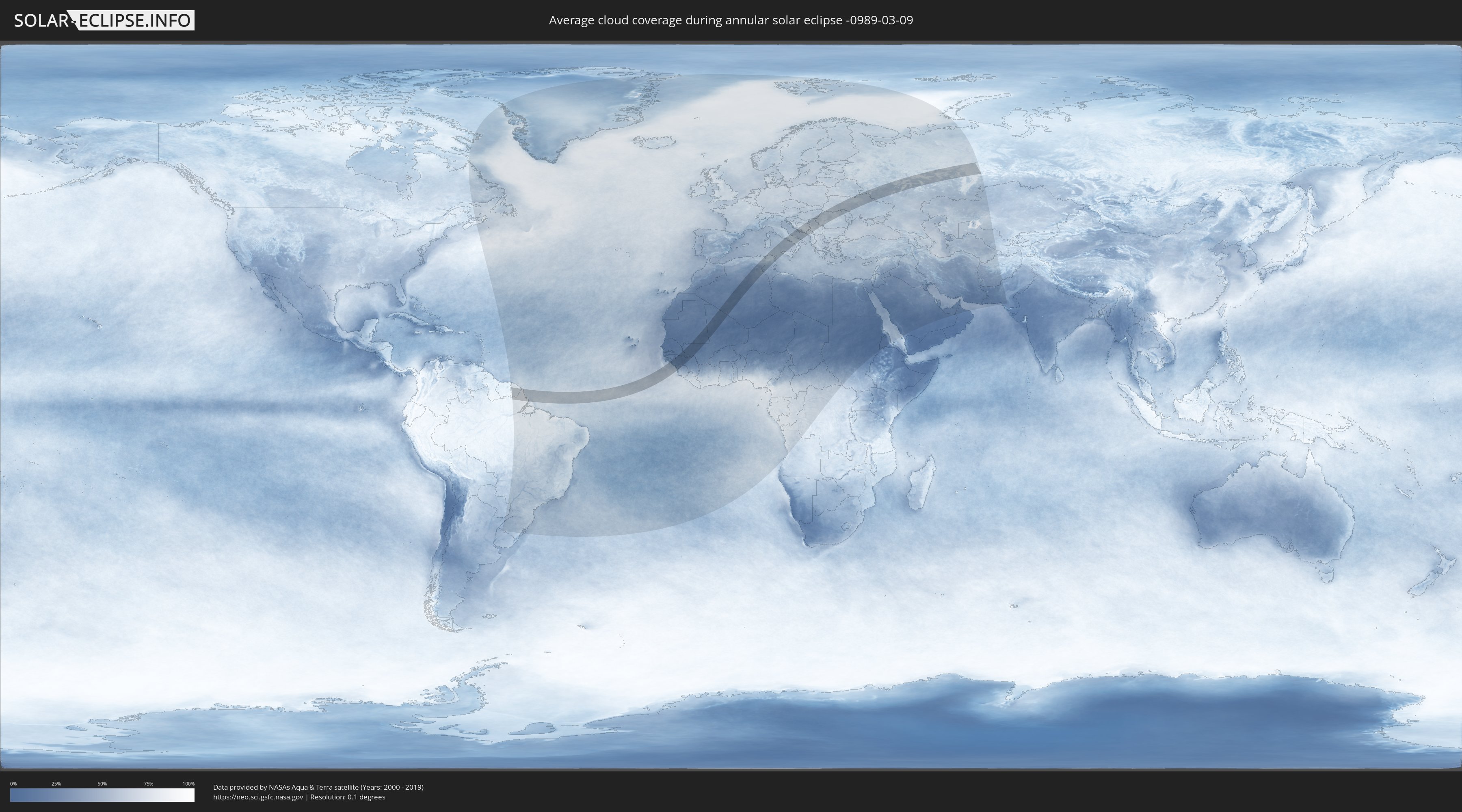
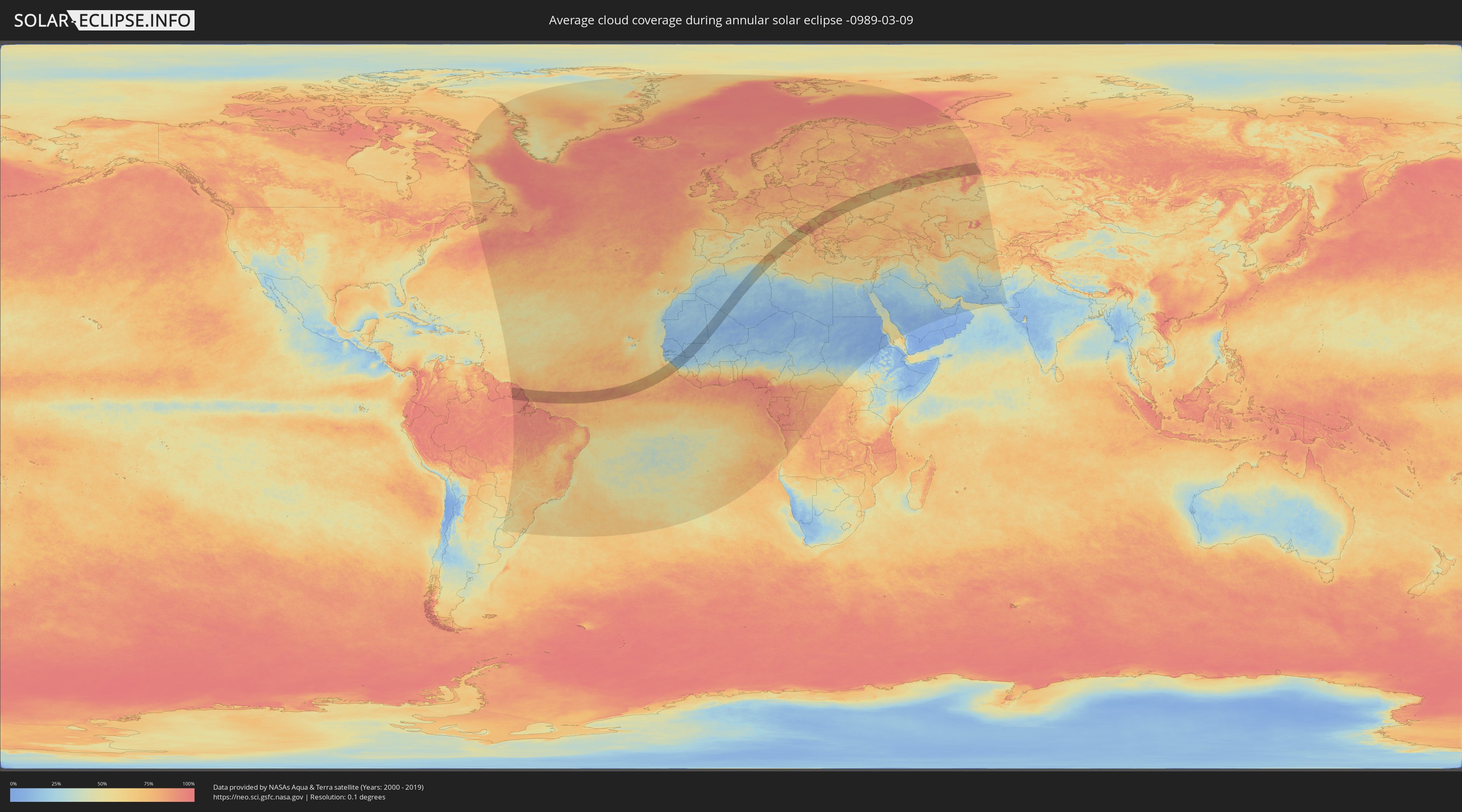
How will be the weather during the annular solar eclipse on 03/09/-0989?
Where is the best place to see the annular solar eclipse of 03/09/-0989?
The following maps show the average cloud coverage for the day of the annular solar eclipse.
With the help of these maps, it is possible to find the place along the eclipse path, which has the best
chance of a cloudless sky.
Nevertheless, you should consider local circumstances and inform about the weather of your chosen
observation site.
The data is provided by NASAs satellites
AQUA and TERRA.
The cloud maps are averaged over a period of 19 years (2000 - 2019).
Detailed country maps
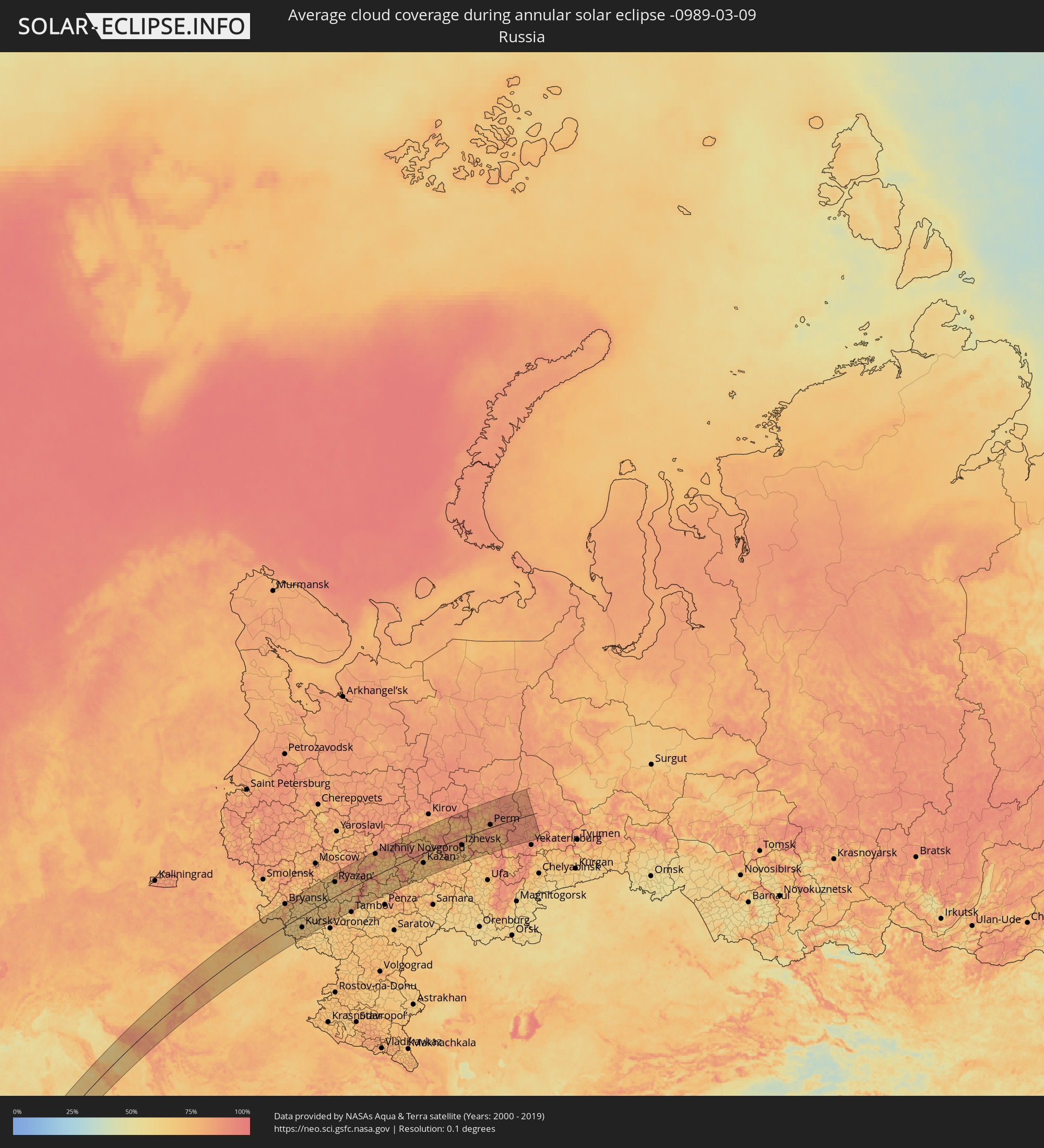 Russia
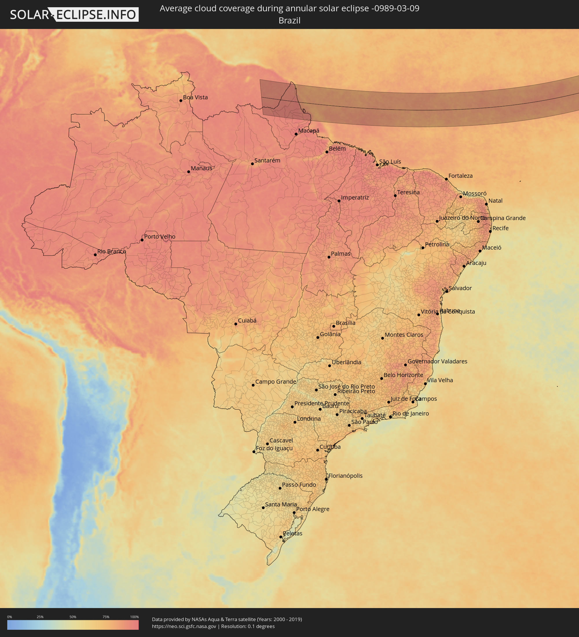 Brazil
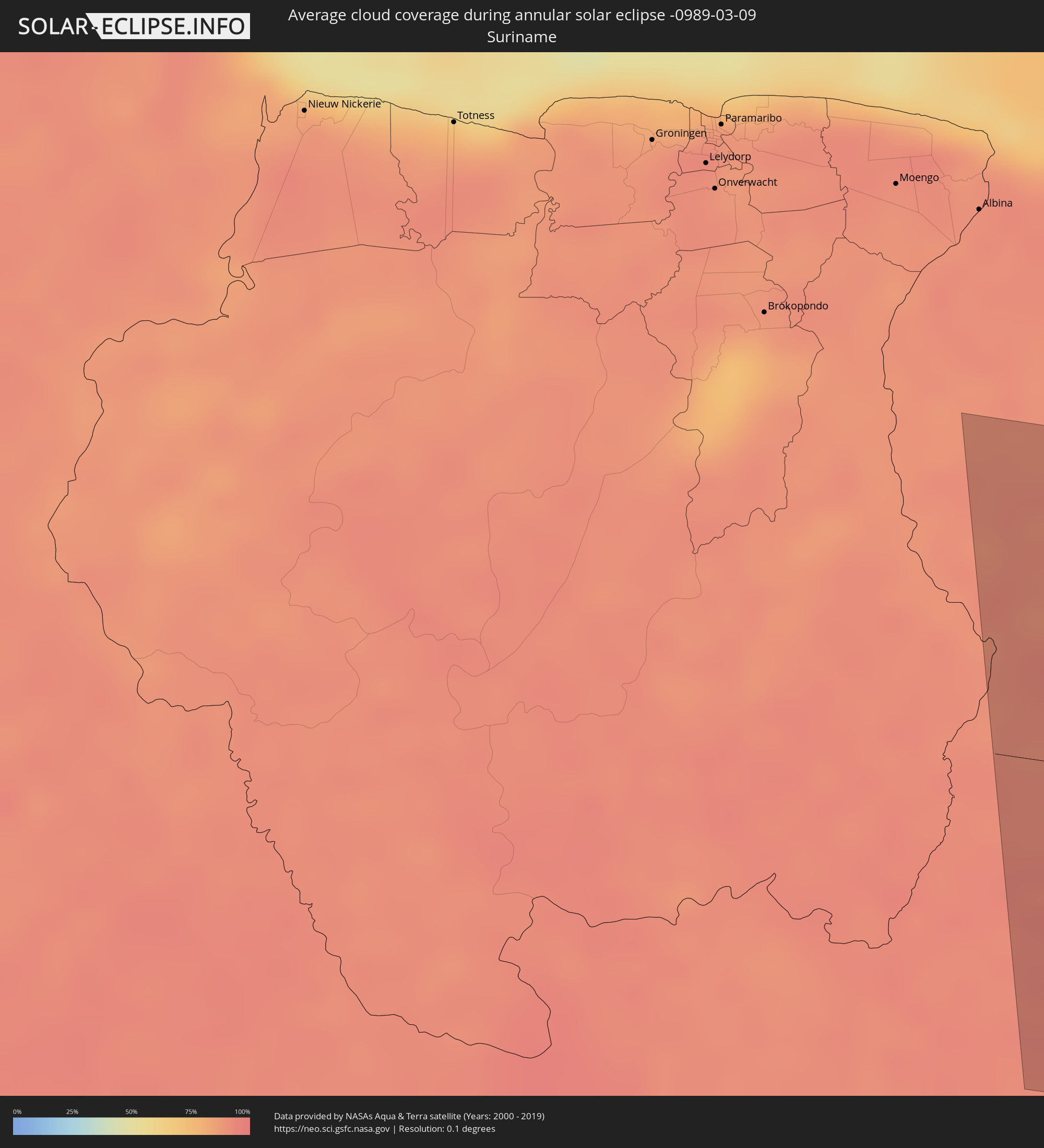 Suriname
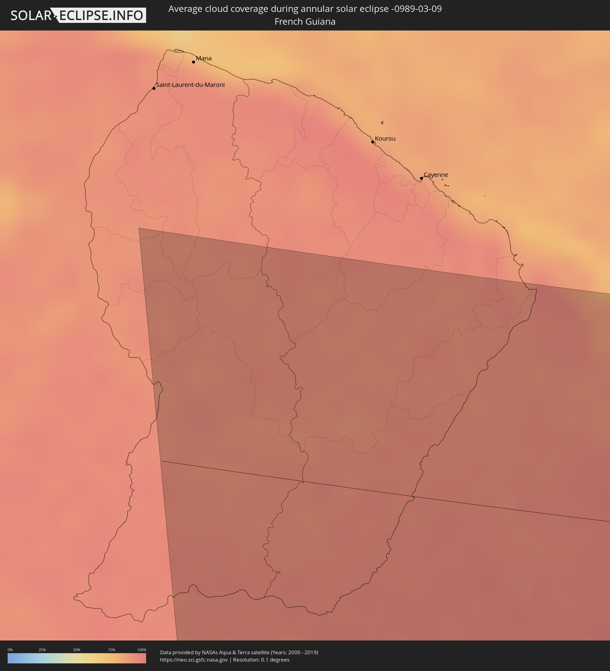 French Guiana
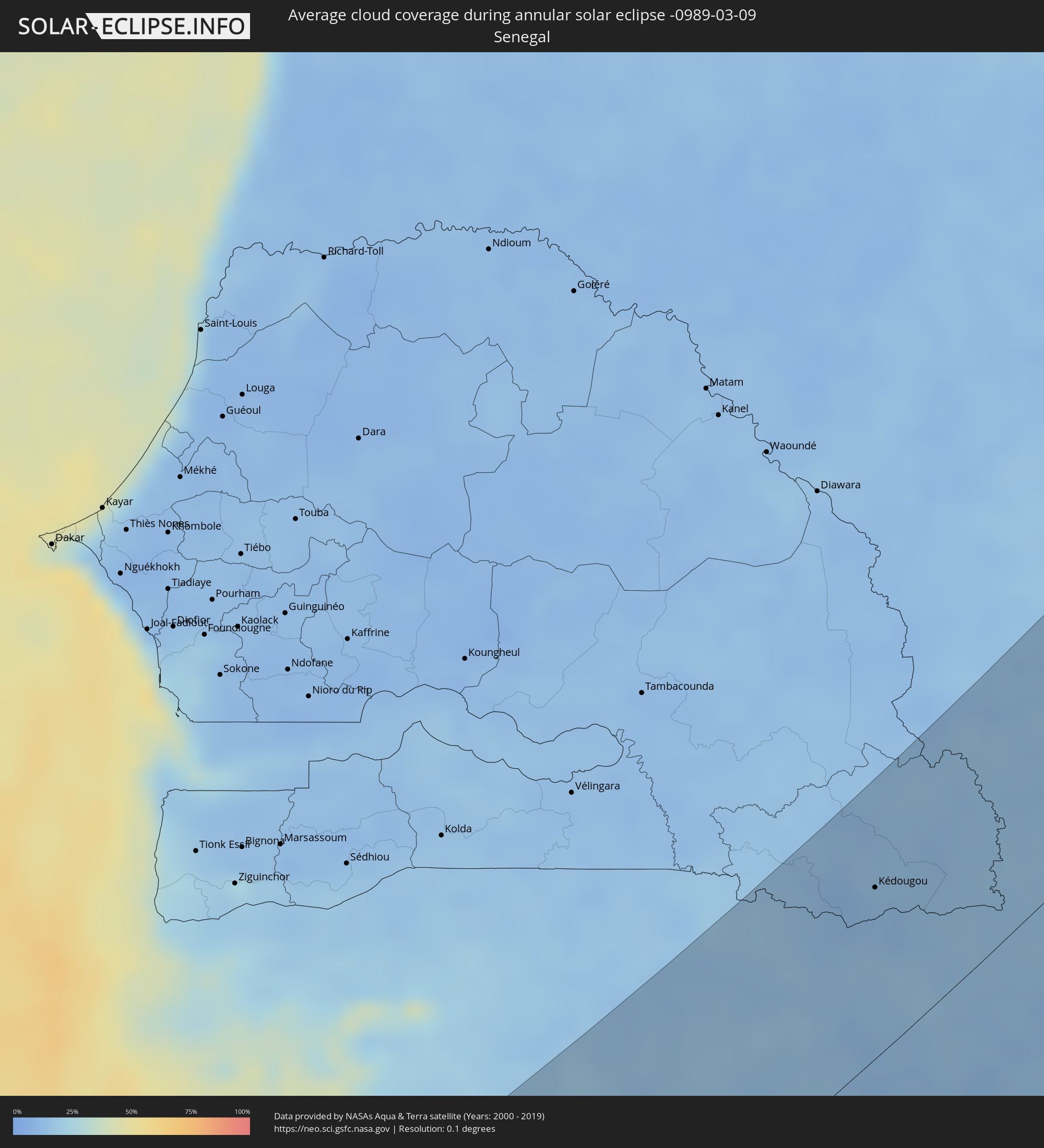 Senegal
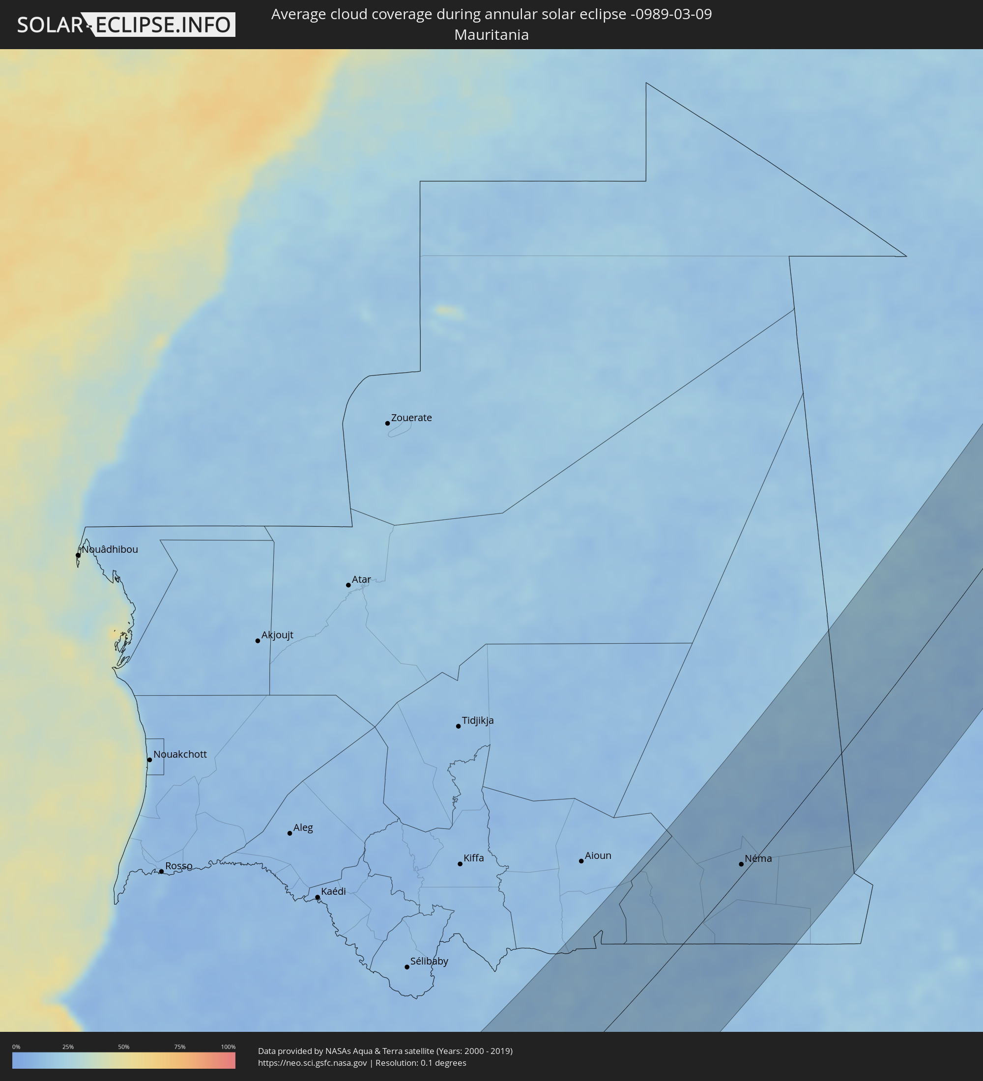 Mauritania
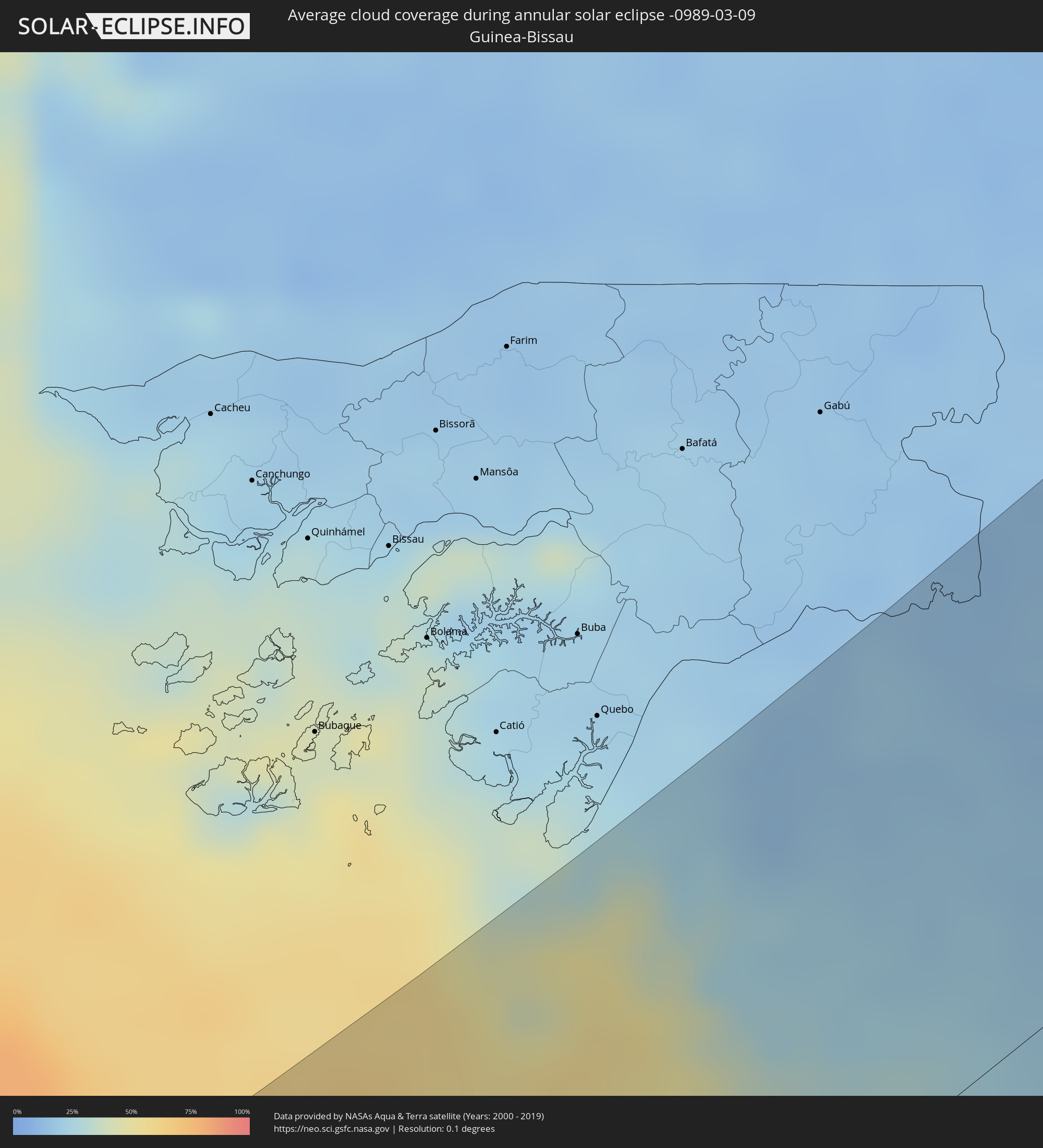 Guinea-Bissau
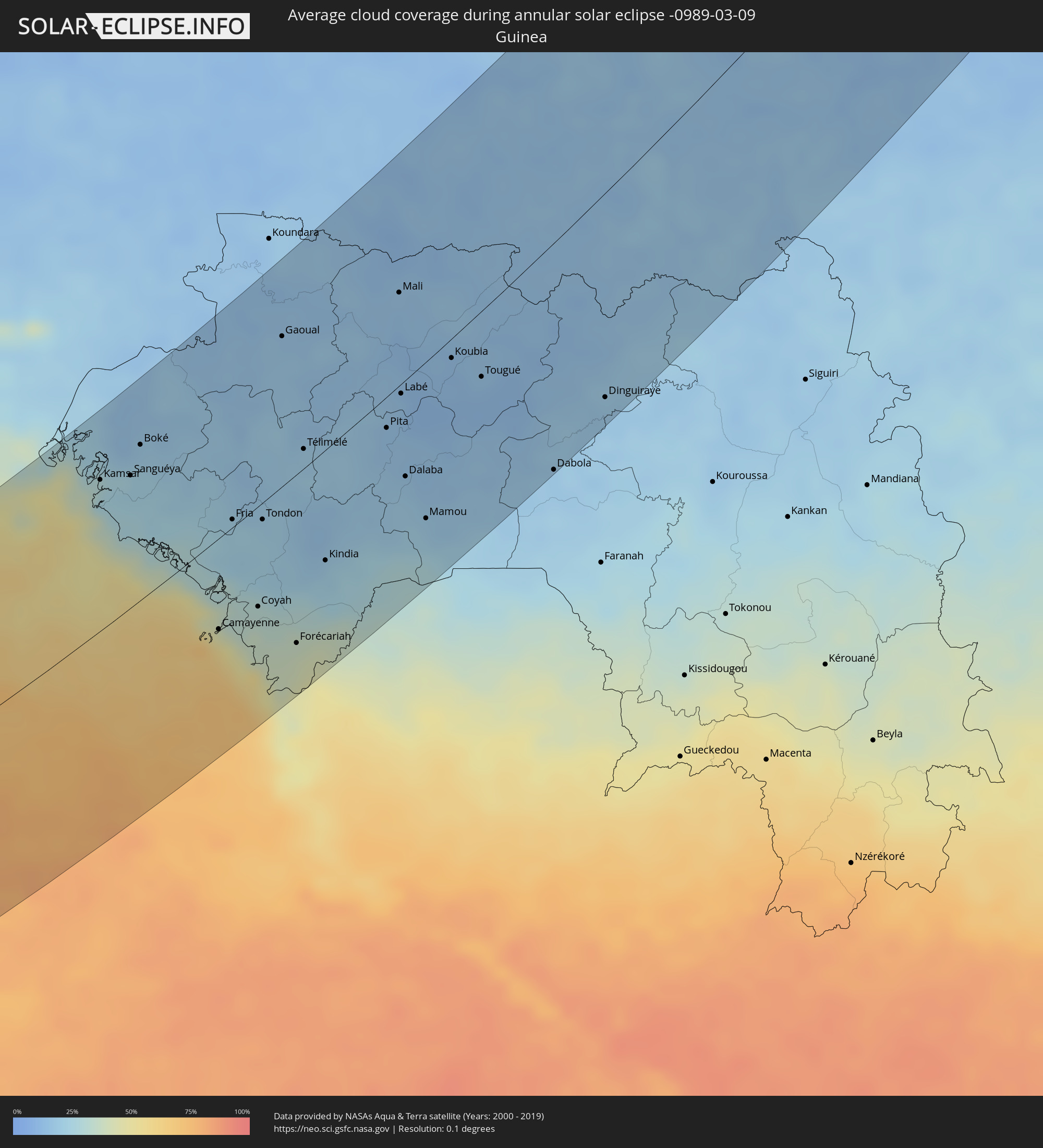 Guinea
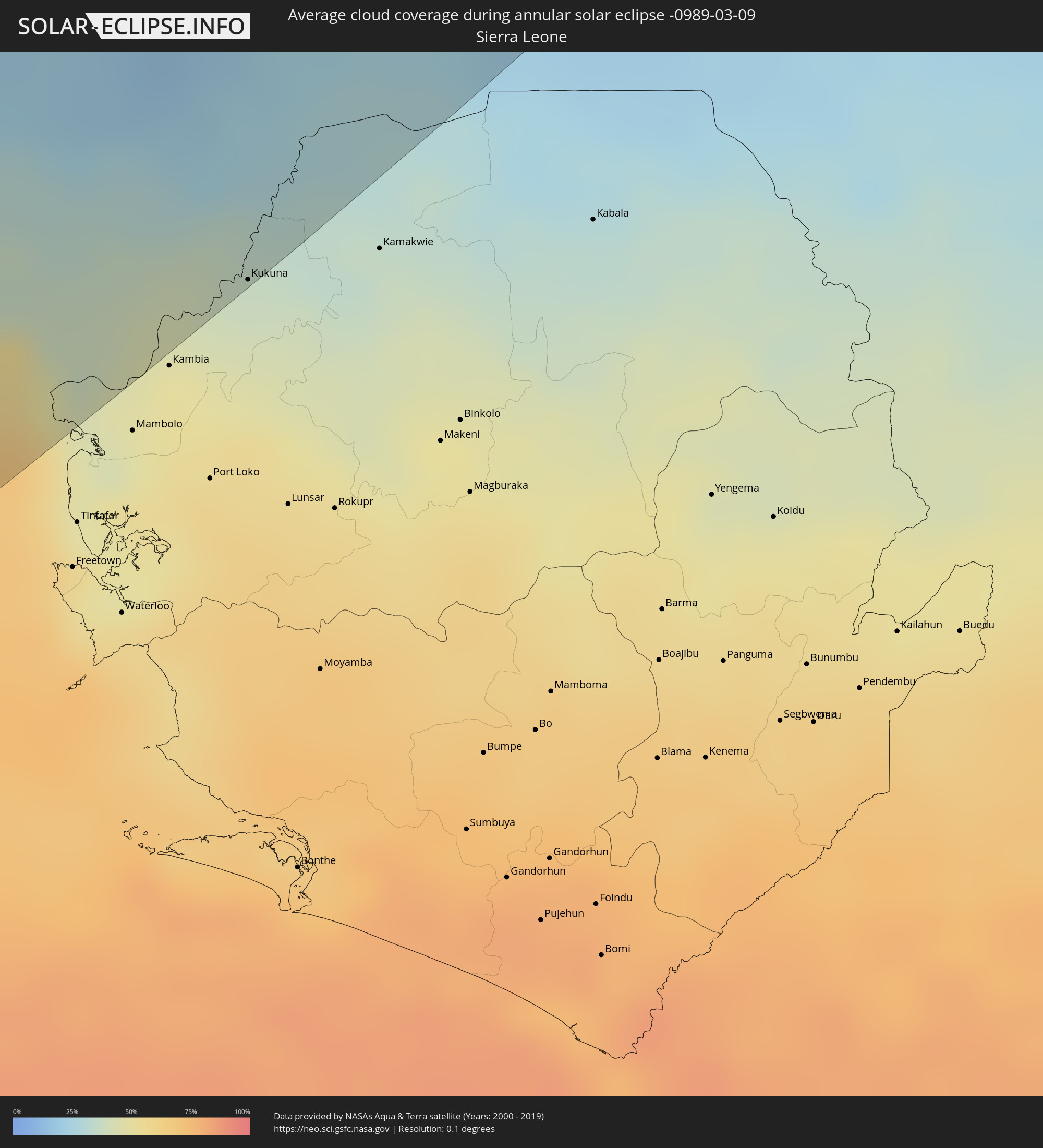 Sierra Leone
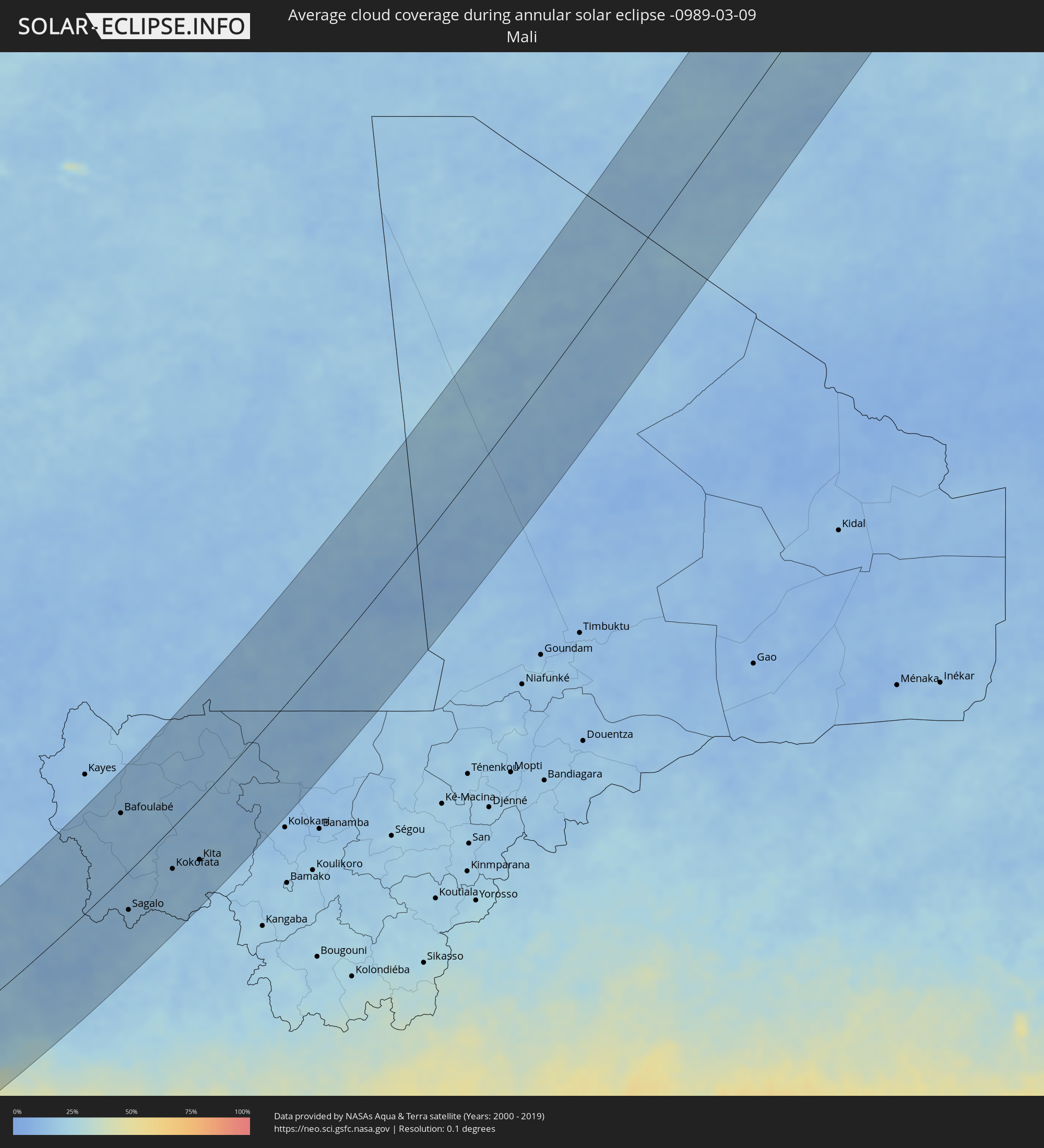 Mali
Mali
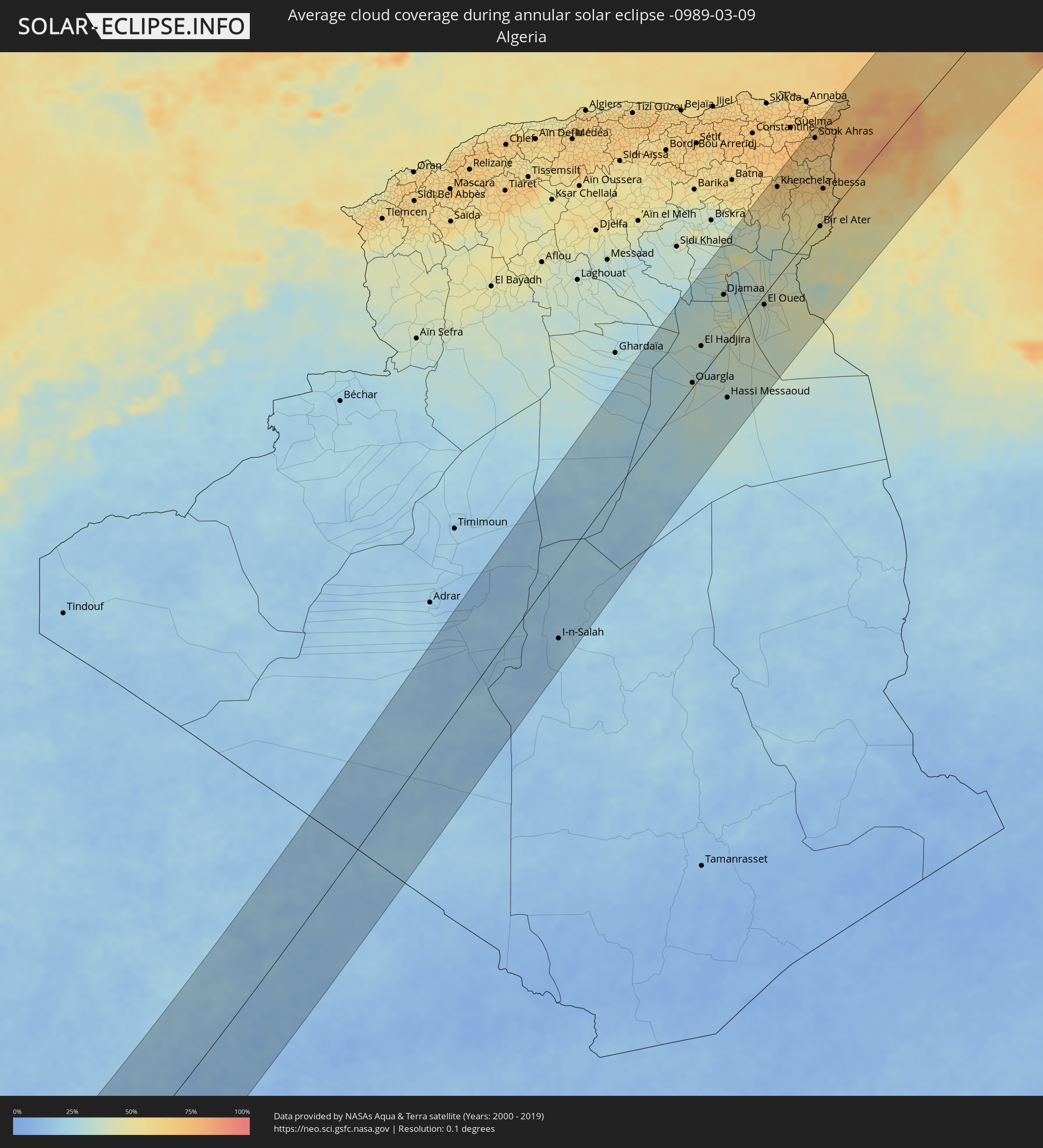 Algeria
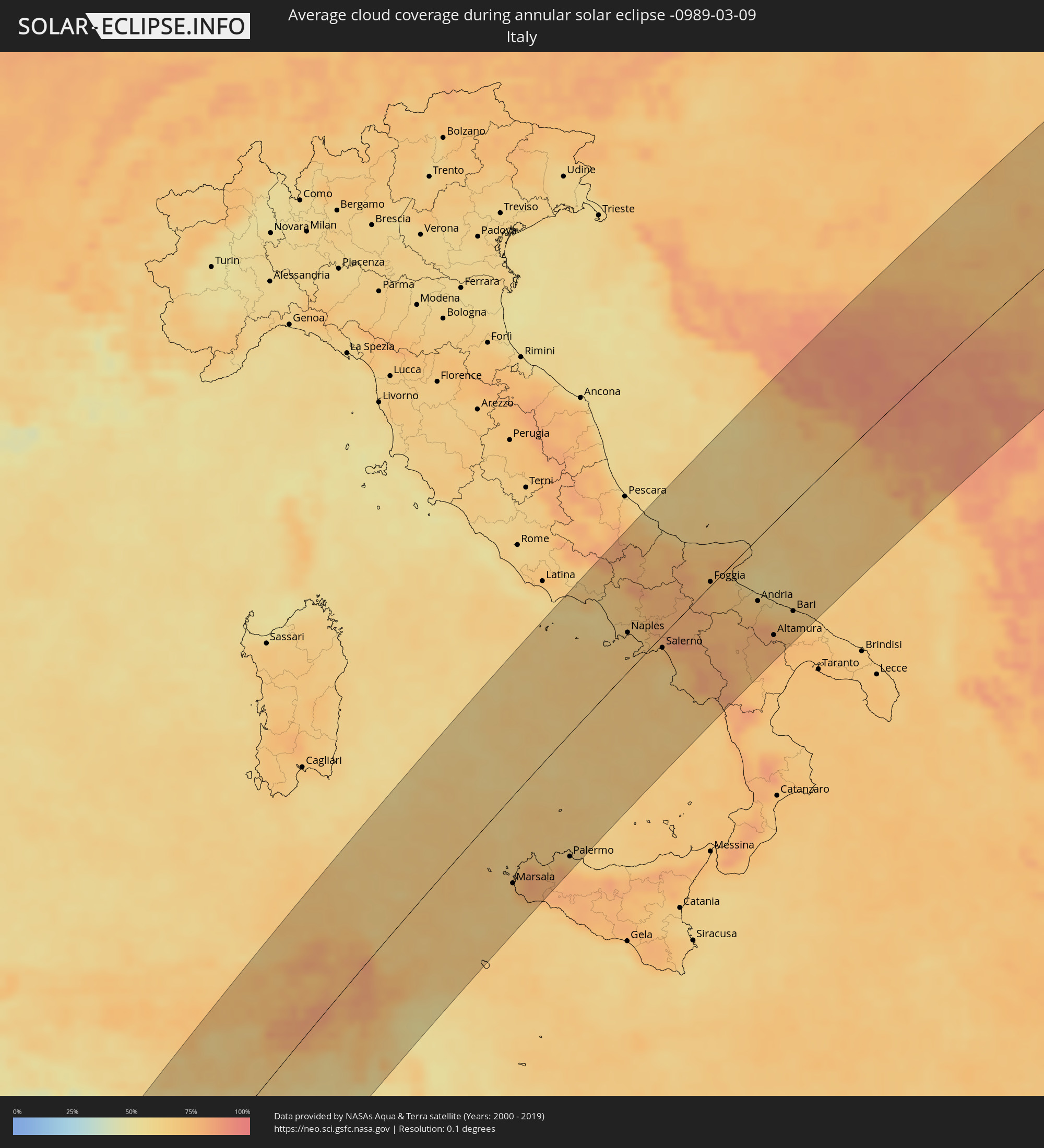 Italy
Italy
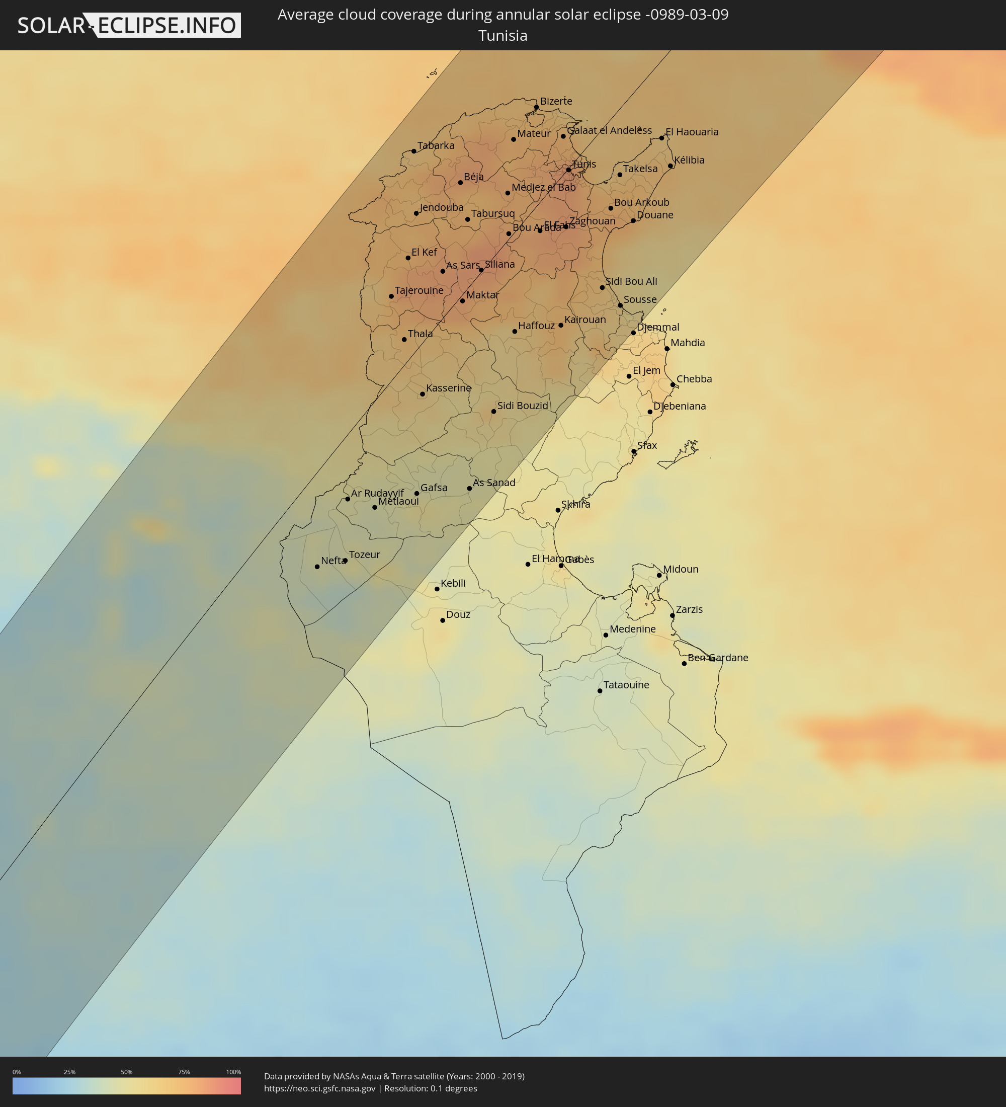 Tunisia
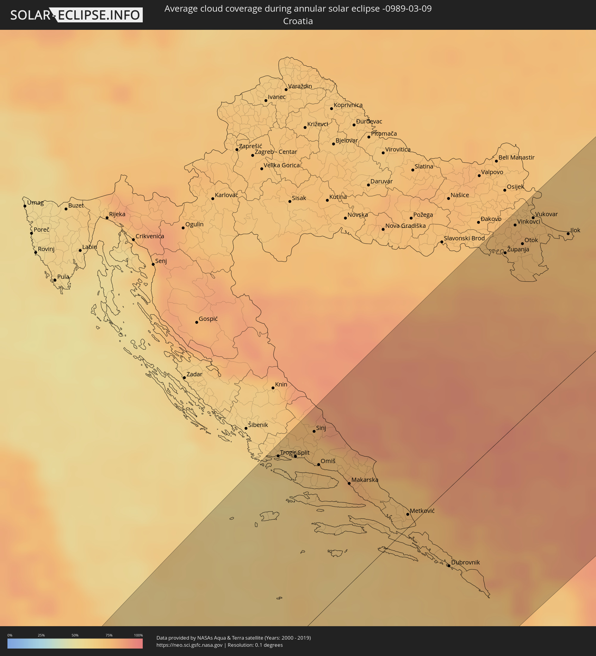 Croatia
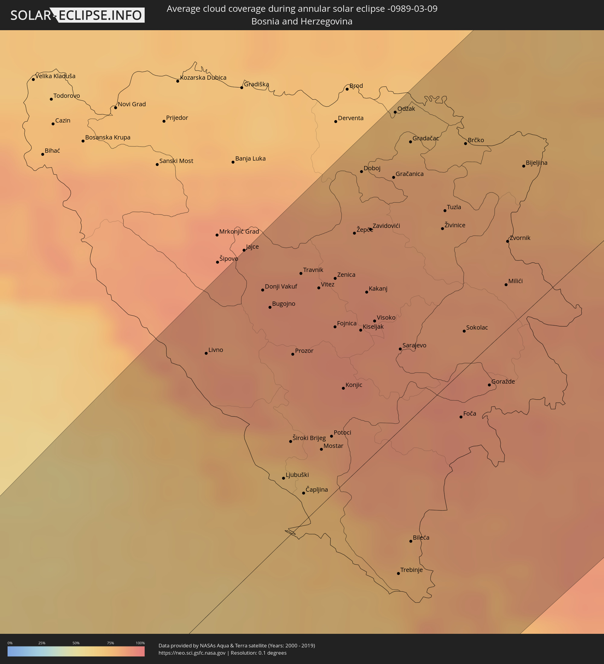 Bosnia and Herzegovina
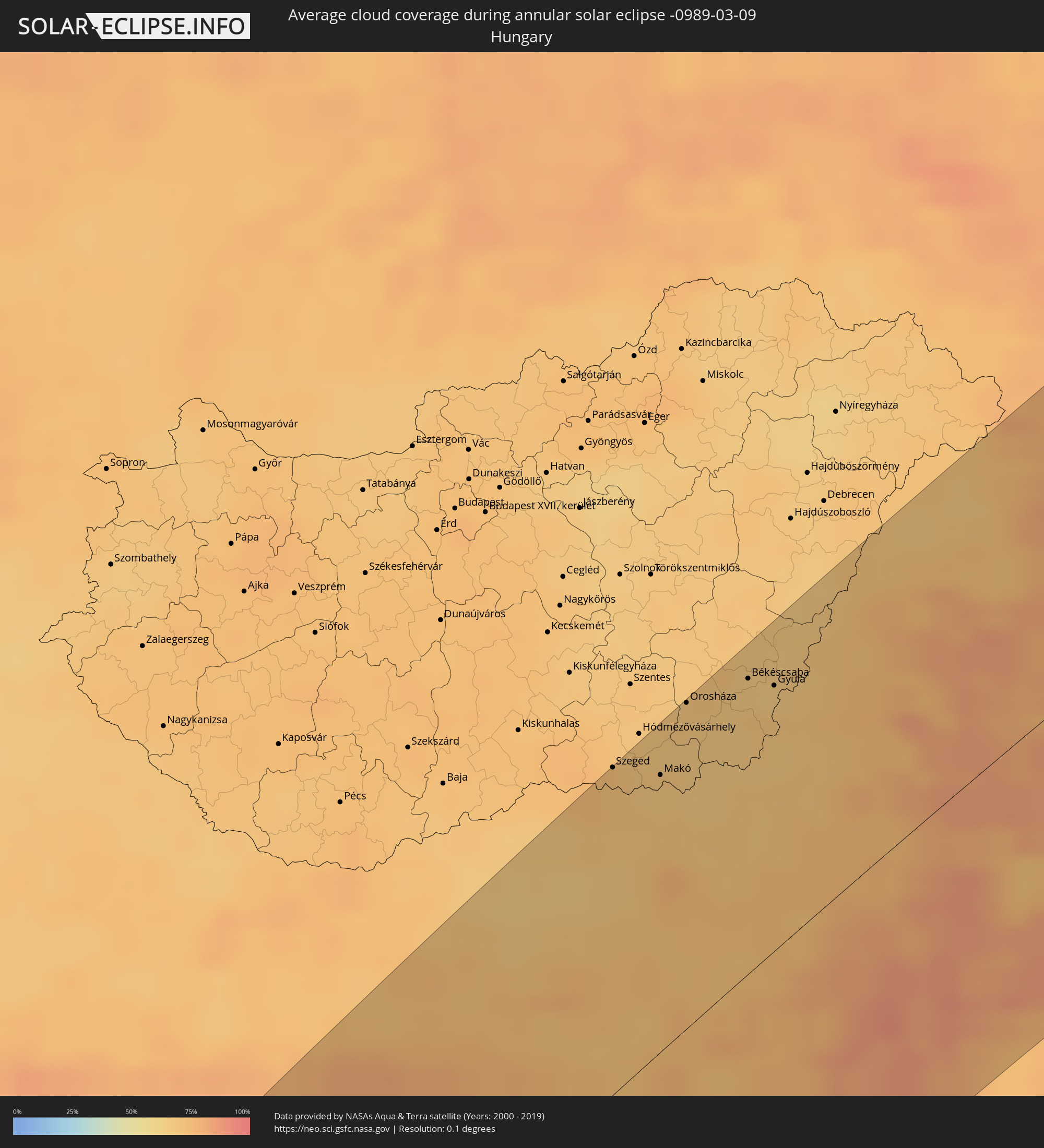 Hungary
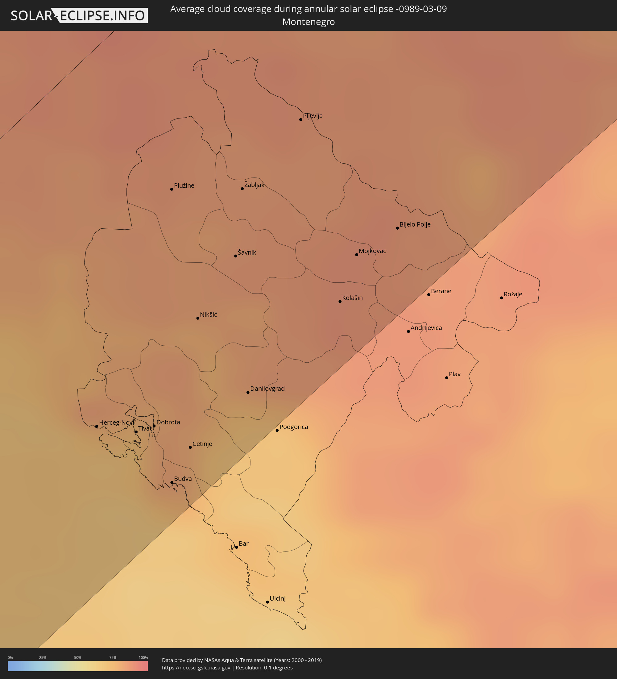 Montenegro
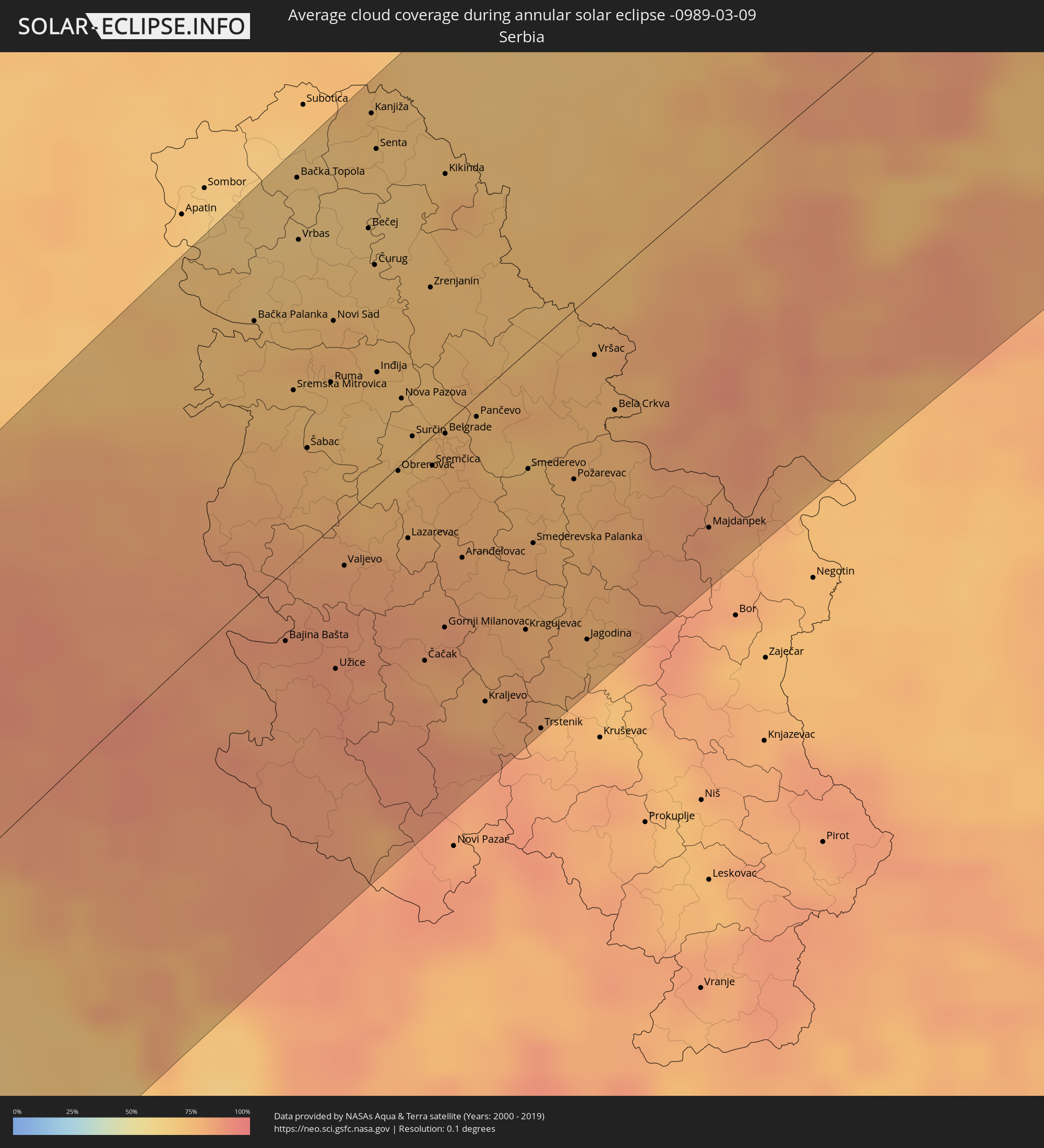 Serbia
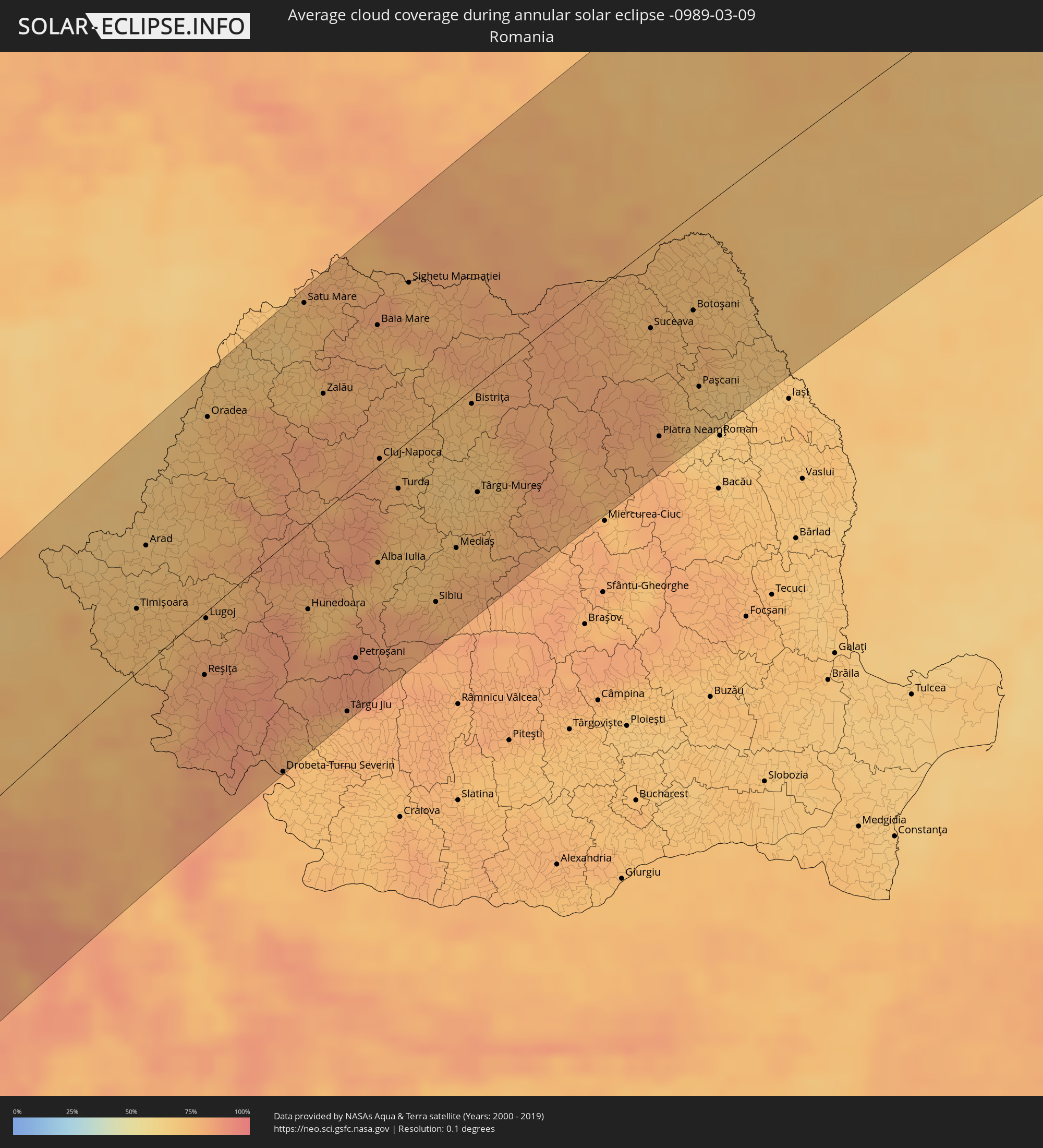 Romania
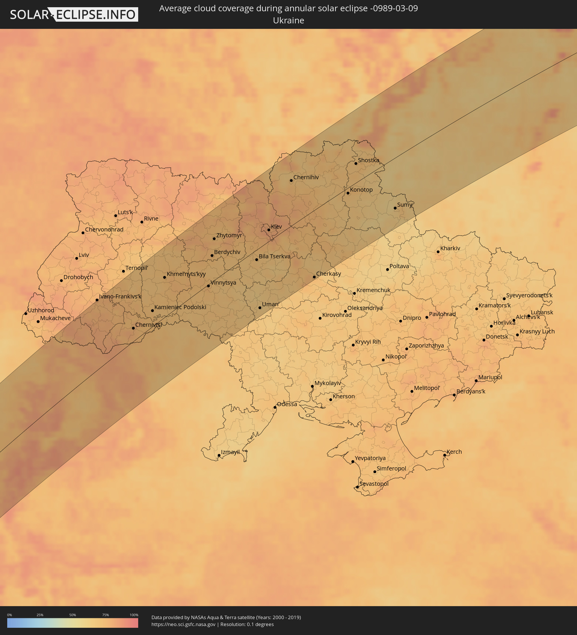 Ukraine
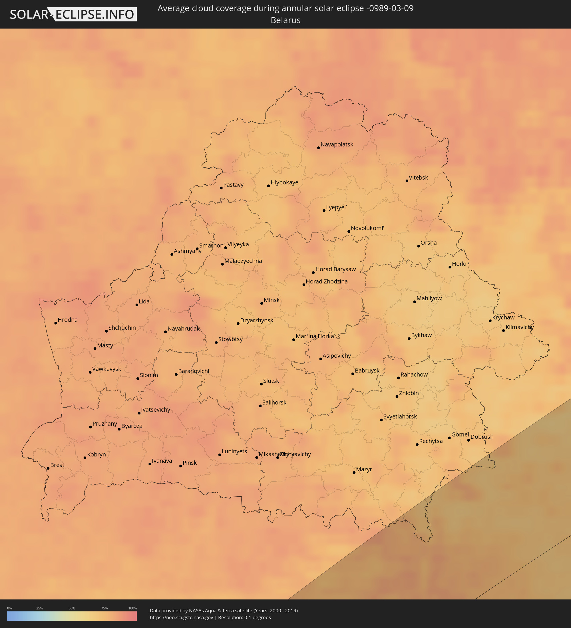 Belarus
 Moldova
Cities inside the path of the eclipse
The following table shows all locations with a population of more than 5,000 inside the eclipse path. Cities which have more than 100,000 inhabitants are marked bold. A click at the locations opens a detailed map.
| City | Type | Eclipse duration | Local time of max. eclipse | Distance to central line | Ø Cloud coverage |
|
Kamsar, Boke
|
annular | - | 10:35:33 UTC-00:16 | 101 km | 29% |
|
Boké, Boke
|
annular | - | 10:36:50 UTC-00:16 | 103 km | 22% |
|
Camayenne, Conakry
|
annular | - | 10:34:50 UTC-00:16 | 60 km | 57% |
|
Fria, Boke
|
annular | - | 10:37:00 UTC-00:16 | 5 km | 22% |
|
Coyah, Kindia
|
annular | - | 10:35:52 UTC-00:16 | 66 km | 32% |
|
Télimélé, Kindia
|
annular | - | 10:39:27 UTC-00:16 | 13 km | 19% |
|
Kindia, Kindia
|
annular | - | 10:37:48 UTC-00:16 | 71 km | 19% |
|
Kukuna, Northern Province
|
annular | - | 10:36:40 UTC-00:16 | 142 km | 38% |
|
Pita, Mamou
|
annular | - | 10:41:12 UTC-00:16 | 20 km | 14% |
|
Labé, Labe
|
annular | - | 10:42:04 UTC-00:16 | 6 km | 14% |
|
Kédougou, Kédougou
|
annular | - | 10:45:17 UTC-00:16 | 88 km | 12% |
|
Mamou, Mamou
|
annular | - | 10:40:13 UTC-00:16 | 99 km | 20% |
|
Tougué, Labe
|
annular | - | 10:43:42 UTC-00:16 | 41 km | 12% |
|
Dabola, Faranah
|
annular | - | 10:43:13 UTC-00:16 | 139 km | 17% |
|
Diré
|
annular | - | 10:47:15 UTC-00:16 | 24 km | 14% |
|
Bafoulabé, Kayes
|
annular | - | 10:51:16 UTC-00:16 | 86 km | 16% |
|
Sagalo, Kayes
|
annular | - | 10:47:38 UTC-00:16 | 51 km | 15% |
|
Kokofata
|
annular | - | 10:50:57 UTC-00:16 | 54 km | 16% |
|
Kita, Kayes
|
annular | - | 10:52:20 UTC-00:16 | 78 km | 16% |
|
Néma, Hodh ech Chargui
|
annular | - | 11:06:05 UTC-00:16 | 11 km | 13% |
|
I-n-Salah, Tamanrasset
|
annular | - | 12:15:53 UTC+00:09 | 87 km | 19% |
|
Ouargla, Ouargla
|
annular | - | 12:29:48 UTC+00:09 | 6 km | 33% |
|
Djamaa, Ouargla
|
annular | - | 12:33:28 UTC+00:09 | 63 km | 39% |
|
Hassi Messaoud, Ouargla
|
annular | - | 12:30:42 UTC+00:09 | 69 km | 31% |
|
Reguiba, El Oued
|
annular | - | 12:34:44 UTC+00:09 | 14 km | 36% |
|
El Oued, El Oued
|
annular | - | 12:34:42 UTC+00:09 | 12 km | 37% |
|
Khenchela, Khenchela
|
annular | - | 12:38:09 UTC+00:09 | 111 km | 65% |
|
Aïn Beïda, Oum el Bouaghi
|
annular | - | 12:39:02 UTC+00:09 | 118 km | 69% |
|
Cheria, Tébessa
|
annular | - | 12:38:56 UTC+00:09 | 56 km | 62% |
|
Souk Ahras, Souk Ahras
|
annular | - | 12:40:36 UTC+00:09 | 113 km | 72% |
|
Bir el Ater, Tébessa
|
annular | - | 12:38:44 UTC+00:09 | 2 km | 50% |
|
Tébessa, Tébessa
|
annular | - | 12:39:44 UTC+00:09 | 39 km | 64% |
|
Jendouba, Jundūbah
|
annular | - | 12:42:12 UTC+00:09 | 71 km | 75% |
|
Gafsa, Gafsa
|
annular | - | 12:39:29 UTC+00:09 | 76 km | 52% |
|
Kasserine, Al Qaşrayn
|
annular | - | 12:40:35 UTC+00:09 | 28 km | 61% |
|
Béja, Bājah
|
annular | - | 12:43:08 UTC+00:09 | 59 km | 73% |
|
Bizerte, Banzart
|
annular | - | 12:44:52 UTC+00:09 | 51 km | 72% |
|
Kairouan, Al Qayrawān
|
annular | - | 12:43:17 UTC+00:09 | 79 km | 72% |
|
La Mohammedia, Tūnis
|
annular | - | 12:44:37 UTC+00:09 | 11 km | 81% |
|
Tunis, Tūnis
|
annular | - | 12:44:48 UTC+00:09 | 1 km | 82% |
|
Al Marsá, Tūnis
|
annular | - | 12:45:07 UTC+00:09 | 8 km | 74% |
|
Sousse, Sūsah
|
annular | - | 12:44:20 UTC+00:09 | 105 km | 61% |
|
Douane, Nābul
|
annular | - | 12:45:17 UTC+00:09 | 68 km | 61% |
|
Monastir, Al Munastīr
|
annular | - | 12:44:35 UTC+00:09 | 122 km | 58% |
|
Marsala, Sicily
|
annular | - | 13:40:03 UTC+01:00 | 81 km | 63% |
|
Trapani, Sicily
|
annular | - | 13:40:25 UTC+01:00 | 71 km | 68% |
|
Palermo, Sicily
|
annular | - | 13:41:44 UTC+01:00 | 114 km | 76% |
|
Naples, Campania
|
annular | - | 13:45:30 UTC+01:00 | 36 km | 67% |
|
Caserta, Campania
|
annular | - | 13:45:48 UTC+01:00 | 47 km | 67% |
|
Castellammare di Stabia, Campania
|
annular | - | 13:45:43 UTC+01:00 | 9 km | 71% |
|
Salerno, Campania
|
annular | - | 13:46:07 UTC+01:00 | 11 km | 70% |
|
Foggia, Apulia
|
annular | - | 13:47:45 UTC+01:00 | 4 km | 72% |
|
Trogir, Splitsko-Dalmatinska
|
annular | - | 13:50:00 UTC+01:00 | 124 km | 62% |
|
Andria, Apulia
|
annular | - | 13:48:35 UTC+01:00 | 58 km | 72% |
|
Kaštel Stari, Splitsko-Dalmatinska
|
annular | - | 13:50:09 UTC+01:00 | 121 km | 67% |
|
Split, Splitsko-Dalmatinska
|
annular | - | 13:50:14 UTC+01:00 | 113 km | 65% |
|
Altamura, Apulia
|
annular | - | 13:48:38 UTC+01:00 | 105 km | 78% |
|
Podstrana, Splitsko-Dalmatinska
|
annular | - | 13:50:22 UTC+01:00 | 105 km | 70% |
|
Molfetta, Apulia
|
annular | - | 13:48:58 UTC+01:00 | 79 km | 66% |
|
Sinj, Splitsko-Dalmatinska
|
annular | - | 13:50:36 UTC+01:00 | 117 km | 72% |
|
Bari, Apulia
|
annular | - | 13:49:15 UTC+01:00 | 101 km | 68% |
|
Makarska, Splitsko-Dalmatinska
|
annular | - | 13:50:51 UTC+01:00 | 63 km | 72% |
|
Bugojno, Federation of Bosnia and Herzegovina
|
annular | - | 13:51:49 UTC+01:00 | 100 km | 88% |
|
Metković, Dubrovačko-Neretvanska
|
annular | - | 13:51:31 UTC+01:00 | 8 km | 72% |
|
Travnik, Federation of Bosnia and Herzegovina
|
annular | - | 13:52:10 UTC+01:00 | 101 km | 87% |
|
Mostar, Federation of Bosnia and Herzegovina
|
annular | - | 13:51:53 UTC+01:00 | 22 km | 74% |
|
Zenica, Federation of Bosnia and Herzegovina
|
annular | - | 13:52:26 UTC+01:00 | 86 km | 86% |
|
Doboj, Republic of Srspka
|
annular | - | 13:52:55 UTC+01:00 | 119 km | 81% |
|
Dubrovnik, Dubrovačko-Neretvanska
|
annular | - | 13:51:51 UTC+01:00 | 50 km | 68% |
|
Visoko, Federation of Bosnia and Herzegovina
|
annular | - | 13:52:40 UTC+01:00 | 54 km | 88% |
|
Trebinje, Republic of Srspka
|
annular | - | 13:52:12 UTC+01:00 | 59 km | 73% |
|
Sarajevo, Federation of Bosnia and Herzegovina
|
annular | - | 13:52:49 UTC+01:00 | 33 km | 87% |
|
Herceg-Novi, Herceg Novi
|
annular | - | 13:52:18 UTC+01:00 | 90 km | 74% |
|
Tuzla, Federation of Bosnia and Herzegovina
|
annular | - | 13:53:32 UTC+01:00 | 71 km | 81% |
|
Ivankovo, Vukovar-Sirmium
|
annular | - | 13:53:52 UTC+01:00 | 131 km | 74% |
|
Tivat, Tivat
|
annular | - | 13:52:30 UTC+01:00 | 101 km | 73% |
|
Županja, Vukovar-Sirmium
|
annular | - | 13:53:47 UTC+01:00 | 114 km | 73% |
|
Kotor, Kotor
|
annular | - | 13:52:34 UTC+01:00 | 106 km | 81% |
|
Dobrota
|
annular | - | 13:52:36 UTC+01:00 | 103 km | 81% |
|
Vinkovci, Vukovar-Sirmium
|
annular | - | 13:54:00 UTC+01:00 | 125 km | 75% |
|
Brčko, Brčko
|
annular | - | 13:53:50 UTC+01:00 | 91 km | 76% |
|
Budva, Budva
|
annular | - | 13:52:35 UTC+01:00 | 121 km | 73% |
|
Cetinje, Cetinje
|
annular | - | 13:52:44 UTC+01:00 | 117 km | 80% |
|
Nikšić, Opština Nikšić
|
annular | - | 13:53:00 UTC+01:00 | 87 km | 78% |
|
Goražde, Federation of Bosnia and Herzegovina
|
annular | - | 13:53:30 UTC+01:00 | 16 km | 86% |
|
Vukovar, Vukovar-Sirmium
|
annular | - | 13:54:15 UTC+01:00 | 119 km | 73% |
|
Danilovgrad, Danilovgrad
|
annular | - | 13:53:07 UTC+01:00 | 116 km | 75% |
|
Bijeljina, Republic of Srspka
|
annular | - | 13:54:17 UTC+01:00 | 60 km | 77% |
|
Pljevlja, Pljevlja
|
annular | - | 13:53:49 UTC+01:00 | 63 km | 85% |
|
Kolašin, Opština Kolašin
|
annular | - | 13:53:44 UTC+01:00 | 115 km | 88% |
|
Mojkovac, Mojkovac
|
annular | - | 13:53:53 UTC+01:00 | 107 km | 87% |
|
Šabac, Central Serbia
|
annular | - | 13:54:50 UTC+01:00 | 33 km | 75% |
|
Bijelo Polje, Bijelo Polje
|
annular | - | 13:54:08 UTC+01:00 | 110 km | 87% |
|
Novi Sad, Vojvodina
|
annular | - | 13:55:12 UTC+01:00 | 67 km | 75% |
|
Užice, Central Serbia
|
annular | - | 13:54:39 UTC+01:00 | 48 km | 87% |
|
Valjevo, Central Serbia
|
annular | - | 13:54:53 UTC+01:00 | 17 km | 83% |
|
Szeged, Csongrád
|
annular | - | 13:55:53 UTC+01:00 | 133 km | 74% |
|
Čačak, Central Serbia
|
annular | - | 13:55:15 UTC+01:00 | 72 km | 82% |
|
Zrenjanin, Vojvodina
|
annular | - | 13:55:53 UTC+01:00 | 49 km | 73% |
|
Belgrade, Central Serbia
|
annular | - | 13:55:46 UTC+01:00 | 3 km | 77% |
|
Makó, Csongrád
|
annular | - | 13:56:15 UTC+01:00 | 113 km | 69% |
|
Pančevo, Vojvodina
|
annular | - | 13:56:00 UTC+01:00 | 7 km | 75% |
|
Orosháza, Bekes
|
annular | - | 13:56:34 UTC+01:00 | 133 km | 70% |
|
Kraljevo, Central Serbia
|
annular | - | 13:55:35 UTC+01:00 | 104 km | 82% |
|
Tótkomlós, Bekes
|
annular | - | 13:56:36 UTC+01:00 | 117 km | 68% |
|
Mezőhegyes, Bekes
|
annular | - | 13:56:40 UTC+01:00 | 104 km | 67% |
|
Mezőkovácsháza, Bekes
|
annular | - | 13:56:48 UTC+01:00 | 106 km | 68% |
|
Kragujevac, Central Serbia
|
annular | - | 13:55:59 UTC+01:00 | 92 km | 80% |
|
Smederevo, Central Serbia
|
annular | - | 13:56:15 UTC+01:00 | 39 km | 74% |
|
Trstenik, Central Serbia
|
annular | - | 13:55:55 UTC+01:00 | 130 km | 83% |
|
Battonya, Bekes
|
annular | - | 13:56:52 UTC+01:00 | 91 km | 68% |
|
Békéscsaba, Bekes
|
annular | - | 13:57:04 UTC+01:00 | 120 km | 68% |
|
Békés, Bekes
|
annular | - | 13:57:08 UTC+01:00 | 126 km | 67% |
|
Timişoara, Timiş
|
annular | - | 14:41:21 UTC+01:44 | 36 km | 74% |
|
Vésztő, Bekes
|
annular | - | 13:57:18 UTC+01:00 | 132 km | 67% |
|
Arad, Arad
|
annular | - | 14:41:35 UTC+01:44 | 68 km | 71% |
|
Sarkad, Bekes
|
annular | - | 13:57:24 UTC+01:00 | 112 km | 68% |
|
Komádi, Hajdú-Bihar
|
annular | - | 13:57:35 UTC+01:00 | 127 km | 69% |
|
Oradea, Bihor
|
annular | - | 14:42:26 UTC+01:44 | 110 km | 73% |
|
Drobeta-Turnu Severin, Mehedinţi
|
annular | - | 14:42:37 UTC+01:44 | 131 km | 73% |
|
Satu Mare, Satu Mare
|
annular | - | 14:43:34 UTC+01:44 | 127 km | 73% |
|
Baia Mare, Satu Mare
|
annular | - | 14:44:17 UTC+01:44 | 80 km | 78% |
|
Cluj-Napoca, Cluj
|
annular | - | 14:44:11 UTC+01:44 | 3 km | 80% |
|
Sibiu, Sibiu
|
annular | - | 14:44:34 UTC+01:44 | 107 km | 77% |
|
Târgu-Mureş, Mureş
|
annular | - | 14:45:08 UTC+01:44 | 62 km | 72% |
|
Ivano-Frankivs’k, Ivano-Frankivsk
|
annular | - | 15:03:11 UTC+02:02 | 137 km | 76% |
|
Chernivtsi, Chernivtsi
|
annular | - | 15:04:22 UTC+02:02 | 25 km | 79% |
|
Suceava, Suceava
|
annular | - | 14:46:58 UTC+01:44 | 47 km | 75% |
|
Piatra Neamţ, Neamţ
|
annular | - | 14:46:59 UTC+01:44 | 114 km | 80% |
|
Kamieniec Podolski, Khmelnytskyi
|
annular | - | 15:04:59 UTC+02:02 | 31 km | 73% |
|
Botoşani, Botoşani
|
annular | - | 14:47:22 UTC+01:44 | 55 km | 74% |
|
Khmel’nyts’kyy, Khmelnytskyi
|
annular | - | 15:05:20 UTC+02:02 | 78 km | 73% |
|
Edineţ, Raionul Edineţ
|
annular | - | 14:58:36 UTC+01:55 | 47 km | 71% |
|
Glodeni, Glodeni
|
annular | - | 14:58:47 UTC+01:55 | 92 km | 69% |
|
Rîşcani, Rîşcani
|
annular | - | 14:58:50 UTC+01:55 | 78 km | 70% |
|
Briceni, Donduşeni
|
annular | - | 14:58:58 UTC+01:55 | 48 km | 69% |
|
Fălești, Făleşti
|
annular | - | 14:58:58 UTC+01:55 | 118 km | 70% |
|
Drochia, Drochia
|
annular | - | 14:59:04 UTC+01:55 | 82 km | 72% |
|
Bălţi, Bălţi
|
annular | - | 14:59:11 UTC+01:55 | 111 km | 73% |
|
Bilicenii Vechi, Sîngerei
|
annular | - | 14:59:17 UTC+01:55 | 126 km | 69% |
|
Sîngerei, Sîngerei
|
annular | - | 14:59:23 UTC+01:55 | 132 km | 69% |
|
Soroca, Raionul Soroca
|
annular | - | 14:59:30 UTC+01:55 | 92 km | 70% |
|
Floreşti, Floreşti
|
annular | - | 14:59:31 UTC+01:55 | 116 km | 68% |
|
Vinnytsya, Vinnyts'ka
|
annular | - | 15:06:42 UTC+02:02 | 4 km | 73% |
|
Zhytomyr, Zhytomyr
|
annular | - | 15:06:45 UTC+02:02 | 81 km | 77% |
|
Camenca, Teleneşti
|
annular | - | 14:59:53 UTC+01:55 | 121 km | 67% |
|
Bila Tserkva, Kiev
|
annular | - | 15:08:03 UTC+02:02 | 20 km | 71% |
|
Kiev, Kyiv City
|
annular | - | 15:08:17 UTC+02:02 | 22 km | 84% |
|
Chernihiv, Chernihiv
|
annular | - | 15:08:39 UTC+02:02 | 88 km | 74% |
|
Cherkasy, Cherkasy
|
annular | - | 15:09:44 UTC+02:02 | 135 km | 70% |
|
Konotop, Sumy
|
annular | - | 15:10:12 UTC+02:02 | 11 km | 69% |
|
Bryansk, Brjansk
|
annular | - | 15:38:33 UTC+02:30 | 134 km | 76% |
|
Sumy, Sumy
|
annular | - | 15:11:29 UTC+02:02 | 101 km | 65% |
|
Kursk, Kursk
|
annular | - | 15:40:25 UTC+02:30 | 74 km | 71% |
|
Tula, Tula
|
annular | - | 15:40:14 UTC+02:30 | 112 km | 78% |
|
Lipetsk, Lipetsk
|
annular | - | 15:42:13 UTC+02:30 | 106 km | 82% |
|
Ryazan’, Rjazan
|
annular | - | 15:41:13 UTC+02:30 | 87 km | 68% |
|
Nizhniy Novgorod, Nizjnij Novgorod
|
annular | - | 15:42:20 UTC+02:30 | 129 km | 79% |
|
Cheboksary, Chuvashia
|
annular | - | 15:43:54 UTC+02:30 | 23 km | 73% |
|
Kazan, Tatarstan
|
annular | - | 15:44:53 UTC+02:30 | 59 km | 77% |
|
Naberezhnyye Chelny, Tatarstan
|
annular | - | 15:46:04 UTC+02:30 | 143 km | 74% |
|
Izhevsk, Udmurtiya
|
annular | - | 16:35:27 UTC+03:20 | 43 km | 76% |
|
Perm, Perm
|
annular | - | 17:17:27 UTC+04:02 | 16 km | 80% |
|
Nizhniy Tagil, Sverdlovsk
|
annular | - | 17:18:16 UTC+04:02 | 61 km | 83% |