Annular solar eclipse of 10/12/-1047
| Day of week: | Wednesday |
| Maximum duration of eclipse: | 06m23s |
| Maximum width of eclipse path: | 274 km |
| Saros cycle: | 46 |
| Coverage: | 93.6% |
| Magnitude: | 0.9364 |
| Gamma: | -0.5307 |
Wo kann man die Sonnenfinsternis vom 10/12/-1047 sehen?
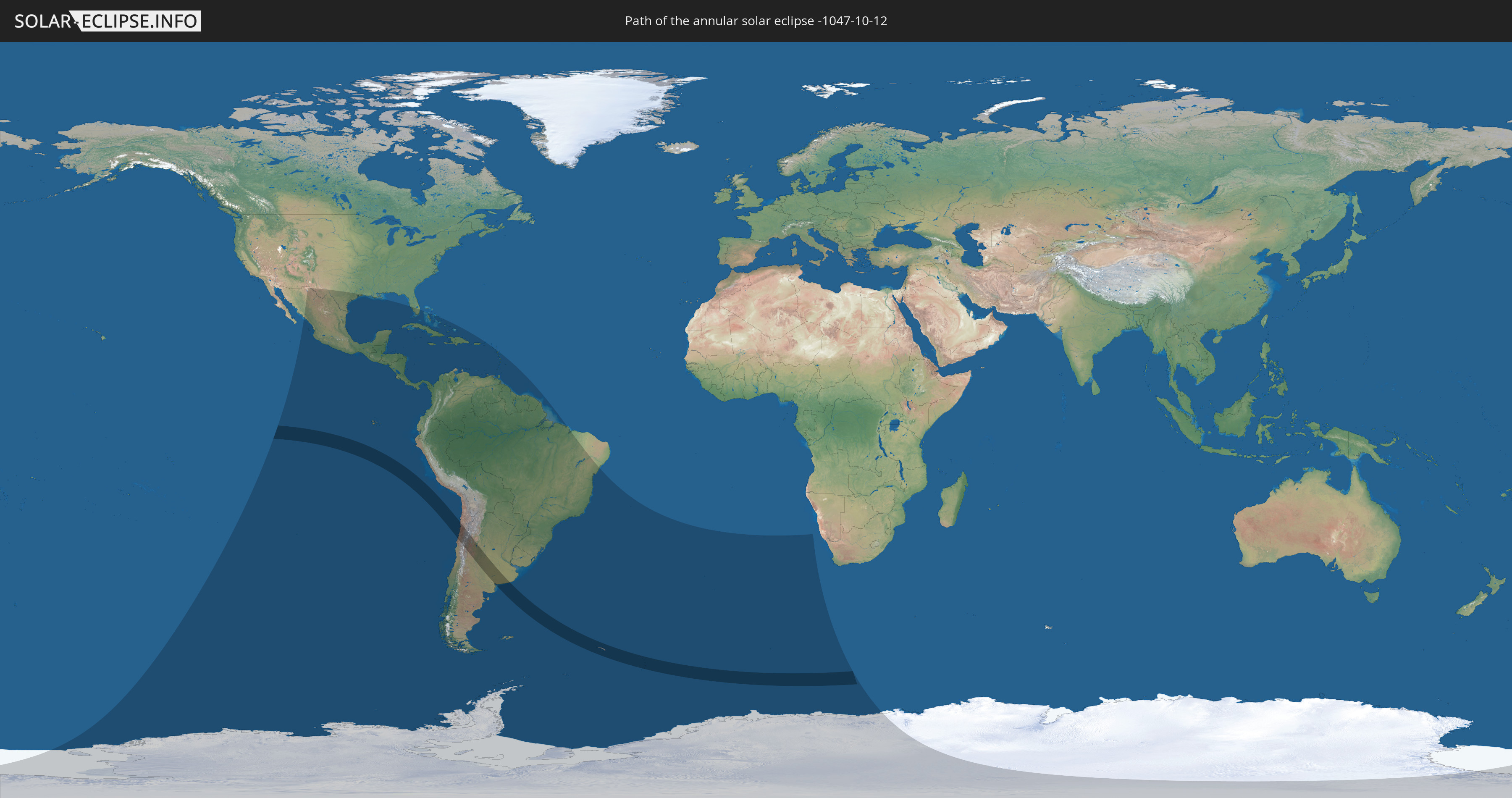
Die Sonnenfinsternis am 10/12/-1047 kann man in 50 Ländern als partielle Sonnenfinsternis beobachten.
Der Finsternispfad verläuft durch 3 Länder. Nur in diesen Ländern ist sie als annular Sonnenfinsternis zu sehen.
In den folgenden Ländern ist die Sonnenfinsternis annular zu sehen
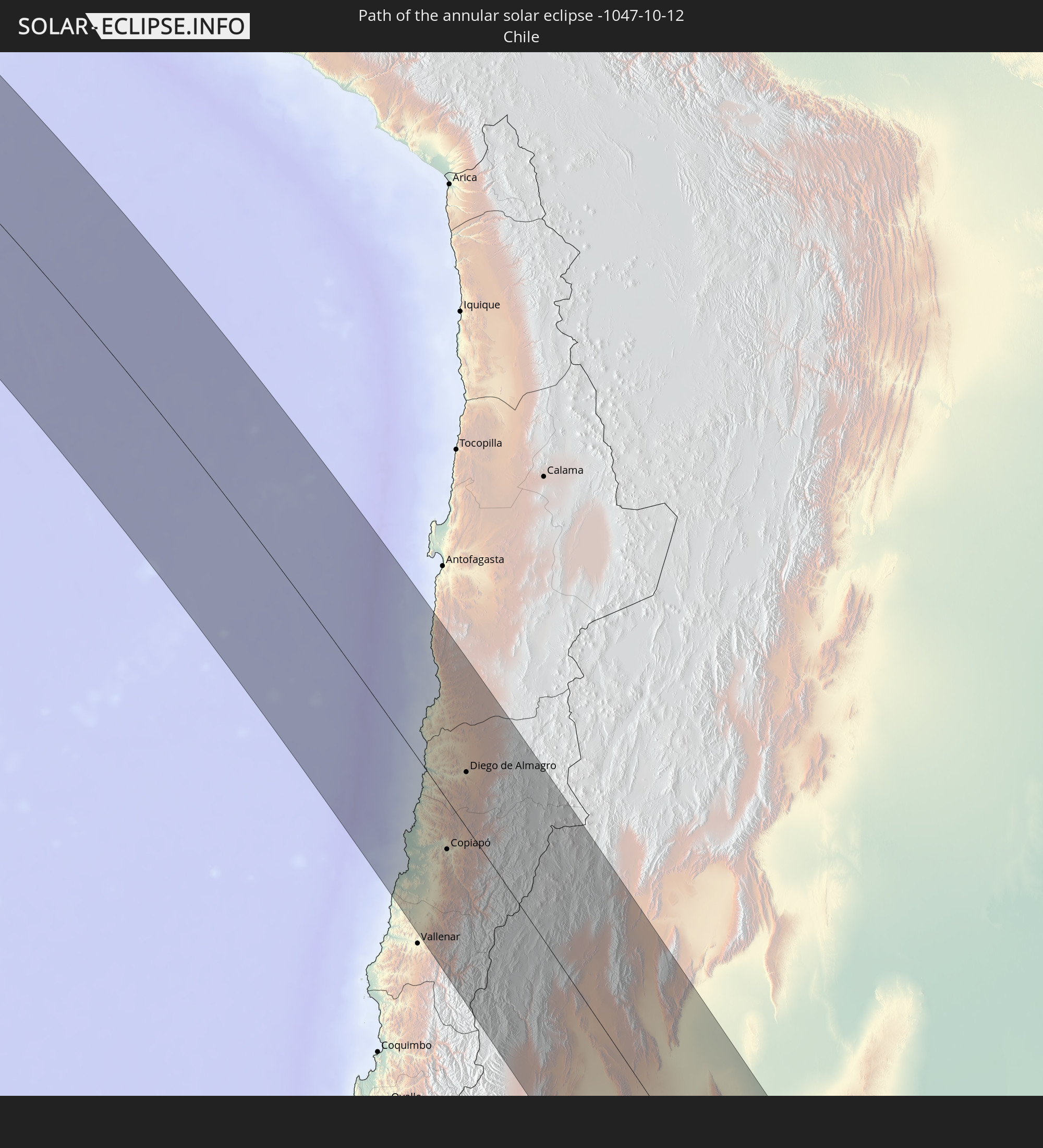 Chile
Chile
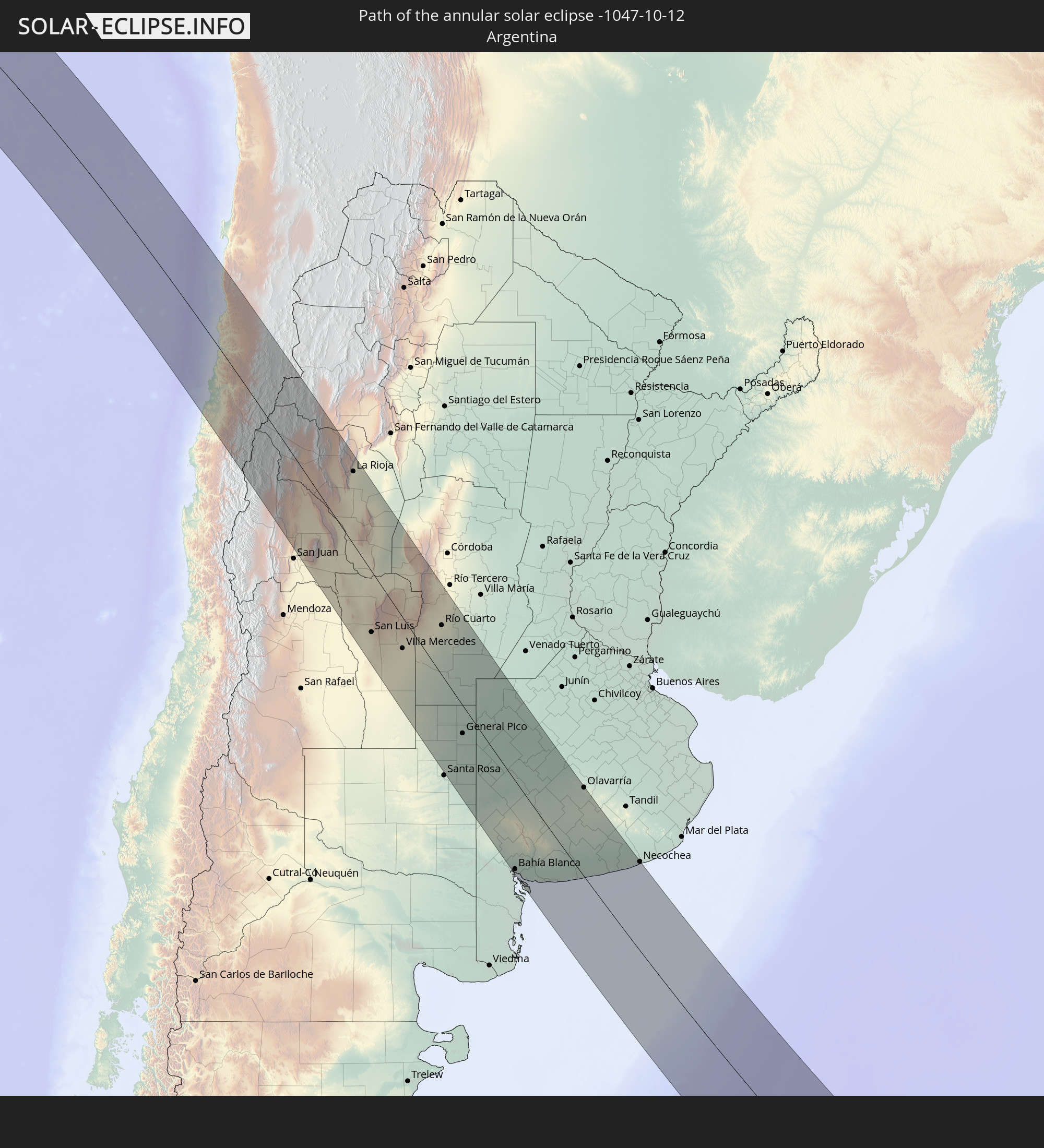 Argentina
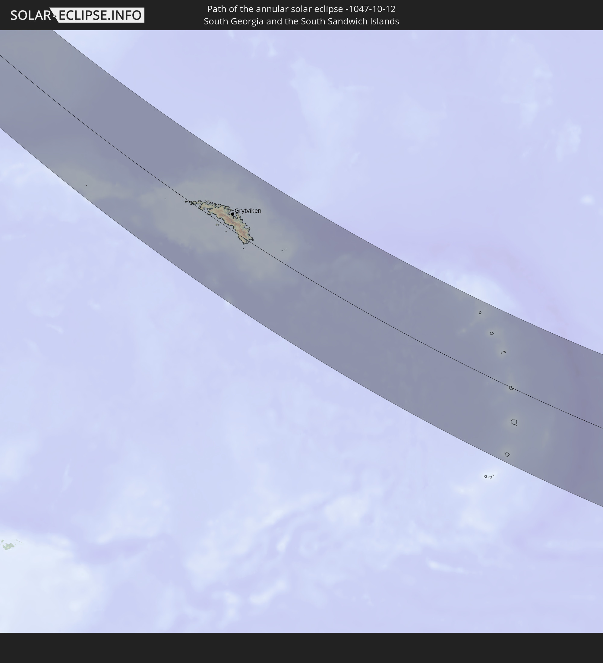 South Georgia and the South Sandwich Islands
In den folgenden Ländern ist die Sonnenfinsternis partiell zu sehen
 Antarctica
 United States
 United States Minor Outlying Islands
 Mexico
 Chile
Chile
 Guatemala
 Ecuador
 El Salvador
 Honduras
 Belize
 Nicaragua
 Costa Rica
 Cuba
Cuba
 Panama
 Colombia
 Cayman Islands
 Peru
Peru
 The Bahamas
 Jamaica
 Haiti
Haiti
 Brazil
 Argentina
 Venezuela
 Turks and Caicos Islands
 Dominican Republic
 Aruba
Aruba
 Bolivia
 Puerto Rico
 United States Virgin Islands
 British Virgin Islands
 Saint Kitts and Nevis
 Paraguay
 Antigua and Barbuda
 Montserrat
 Trinidad and Tobago
 Guadeloupe
 Grenada
 Dominica
 Saint Vincent and the Grenadines
 Falkland Islands
 Guyana
 Martinique
 Saint Lucia
 Barbados
 Uruguay
 Suriname
 French Guiana
 South Georgia and the South Sandwich Islands
 Saint Helena, Ascension and Tristan da Cunha
 Bouvet Island
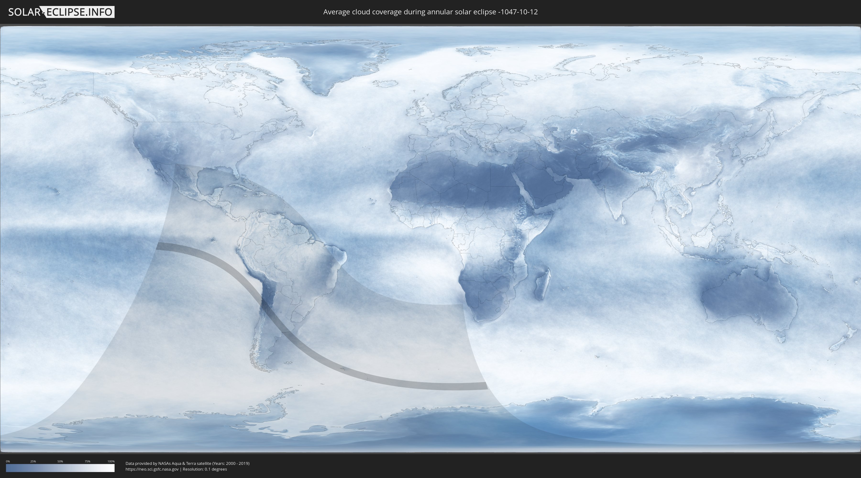
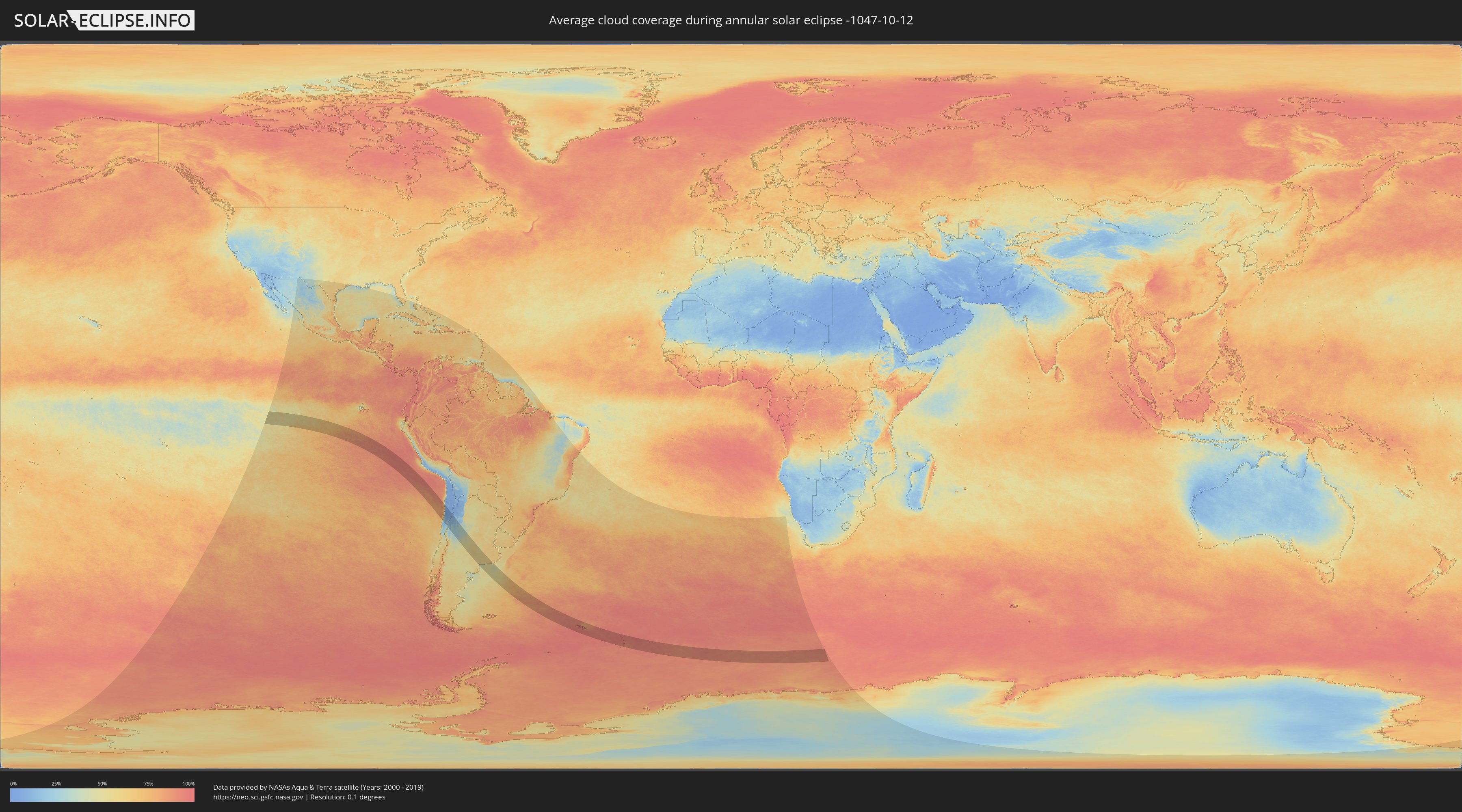
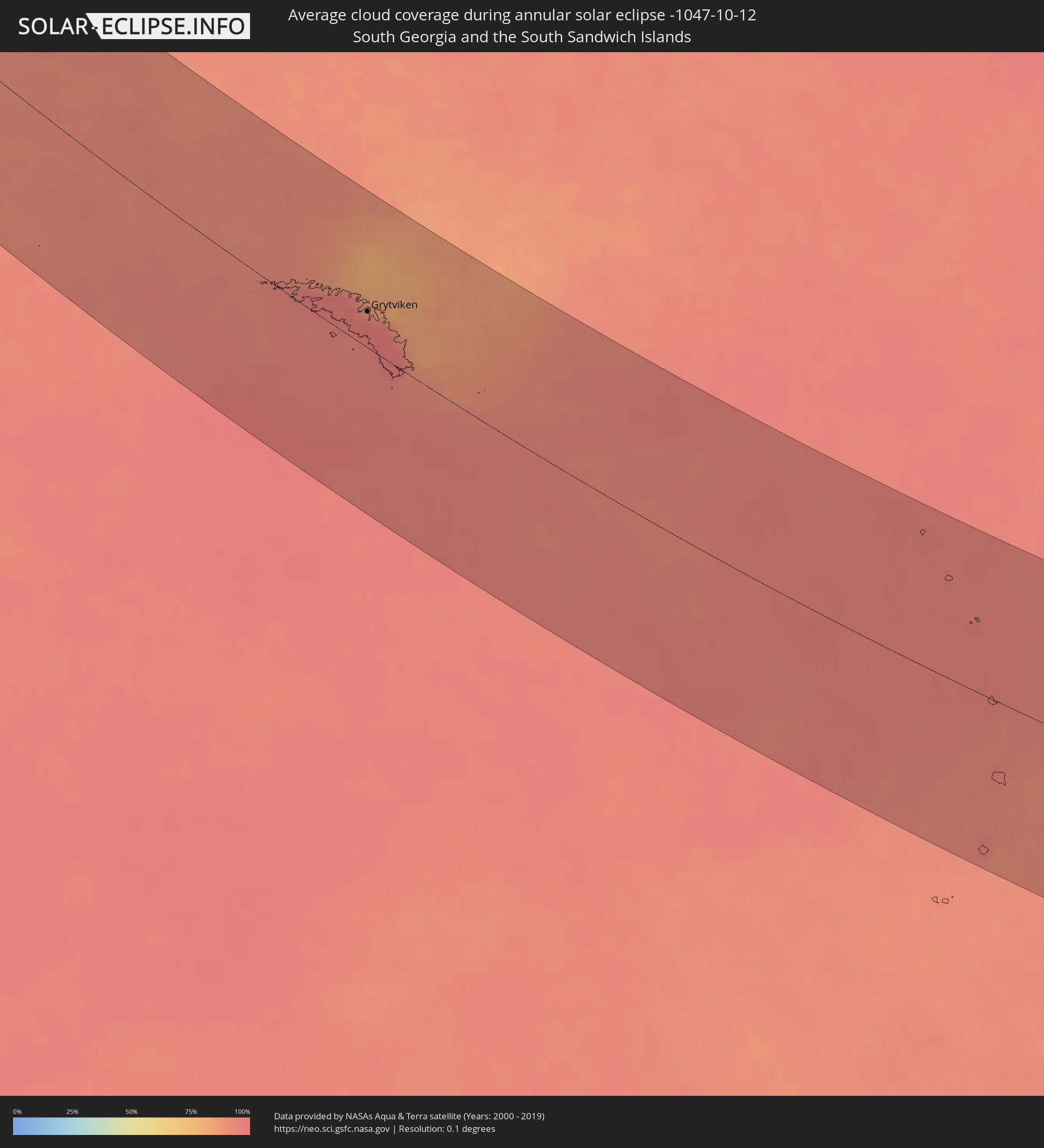
How will be the weather during the annular solar eclipse on 10/12/-1047?
Where is the best place to see the annular solar eclipse of 10/12/-1047?
The following maps show the average cloud coverage for the day of the annular solar eclipse.
With the help of these maps, it is possible to find the place along the eclipse path, which has the best
chance of a cloudless sky.
Nevertheless, you should consider local circumstances and inform about the weather of your chosen
observation site.
The data is provided by NASAs satellites
AQUA and TERRA.
The cloud maps are averaged over a period of 19 years (2000 - 2019).
Detailed country maps
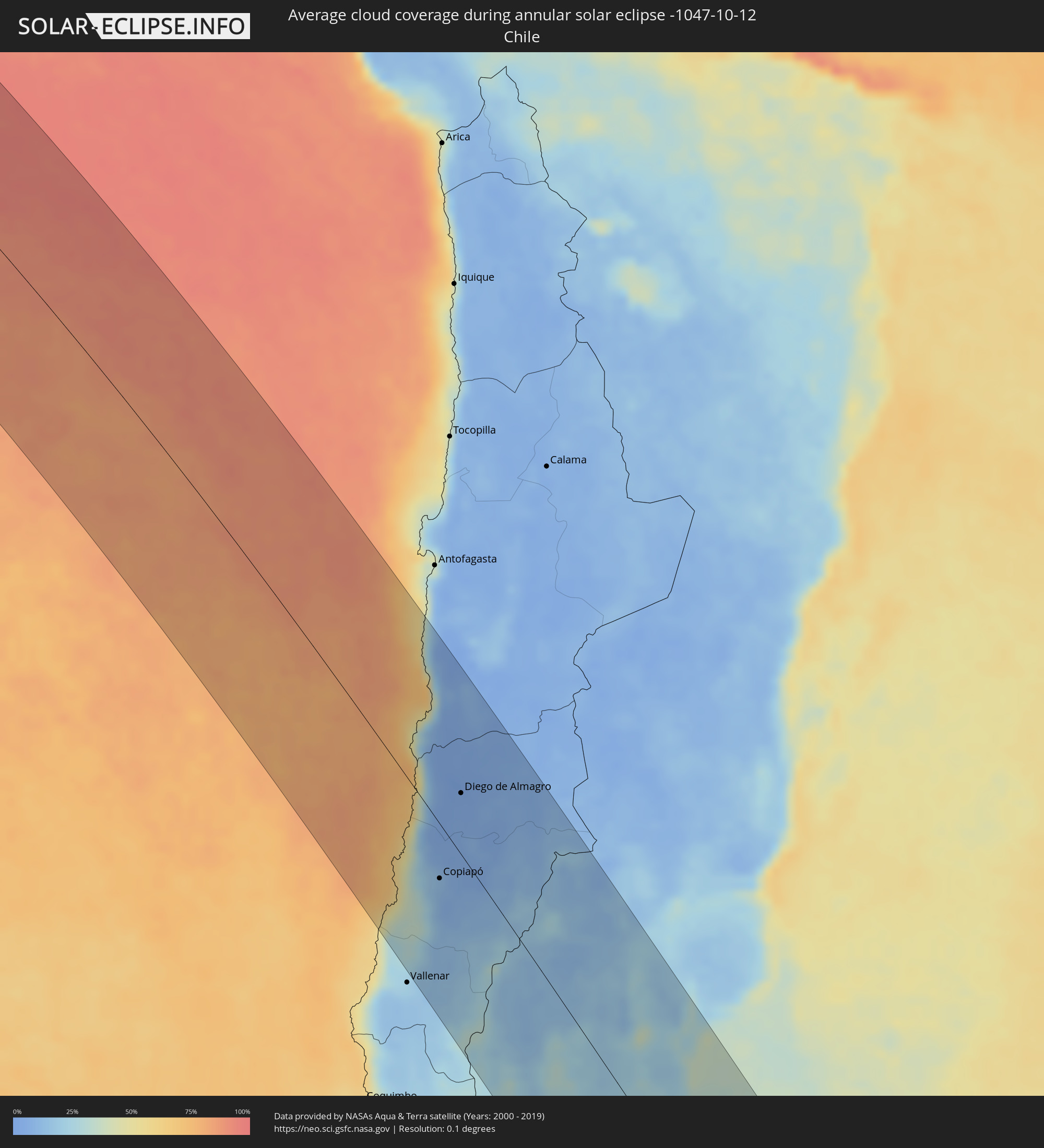 Chile
Chile
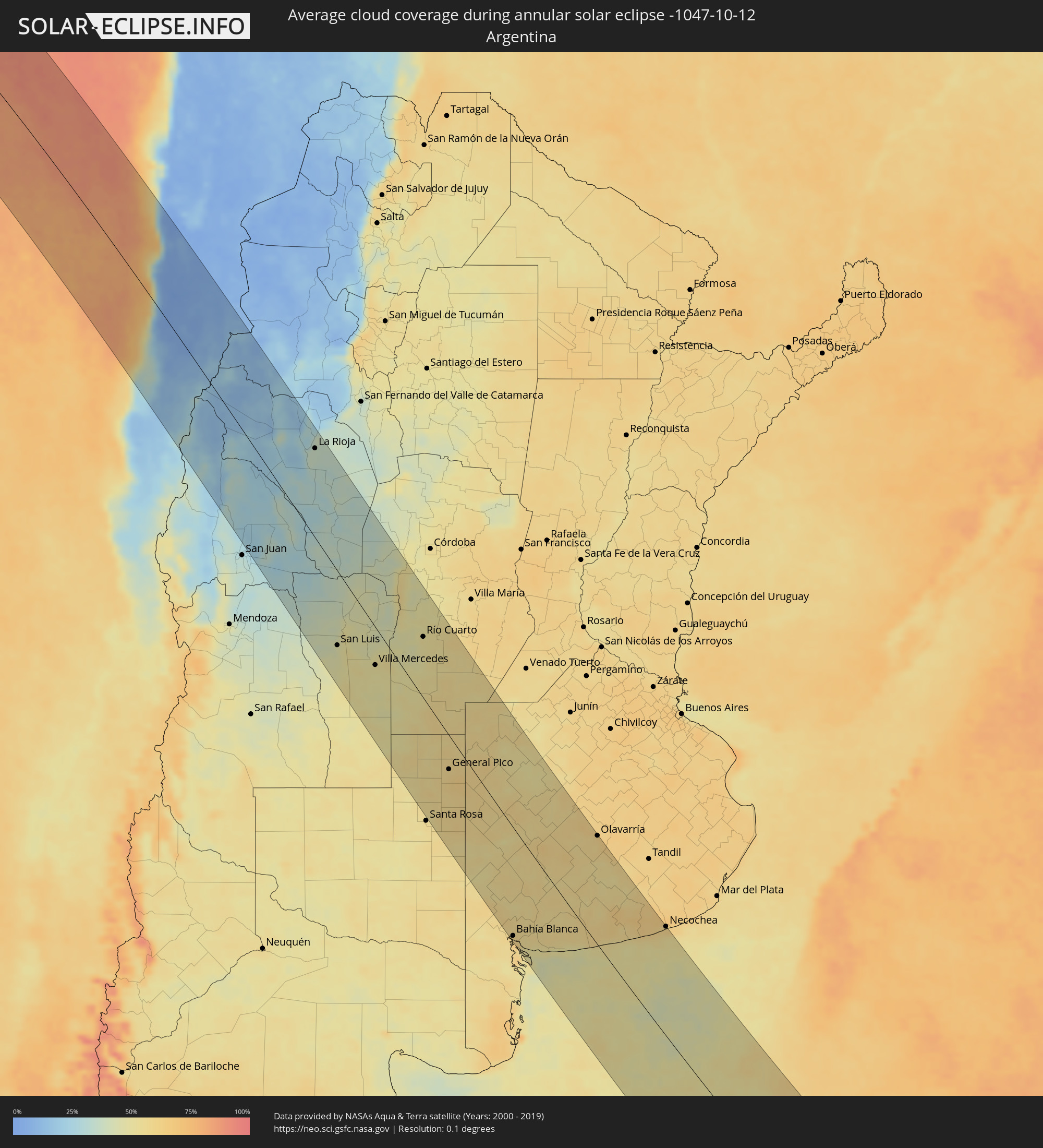 Argentina
 South Georgia and the South Sandwich Islands
Cities inside the path of the eclipse
The following table shows all locations with a population of more than 5,000 inside the eclipse path. Cities which have more than 100,000 inhabitants are marked bold. A click at the locations opens a detailed map.
| City | Type | Eclipse duration | Local time of max. eclipse | Distance to central line | Ø Cloud coverage |
|
Taltal, Antofagasta
|
annular | - | 10:04:13 UTC-04:42 | 72 km | 43% |
|
Copiapó, Atacama
|
annular | - | 10:09:09 UTC-04:42 | 41 km | 10% |
|
Diego de Almagro, Atacama
|
annular | - | 10:07:12 UTC-04:42 | 46 km | 3% |
|
San José de Jáchal, San Juan Province
|
annular | - | 10:44:22 UTC-04:16 | 92 km | 28% |
|
Chilecito, La Rioja Province
|
annular | - | 10:43:52 UTC-04:16 | 76 km | 24% |
|
San Agustín de Valle Fértil, San Juan Province
|
annular | - | 10:47:20 UTC-04:16 | 14 km | 32% |
|
La Rioja, La Rioja Province
|
annular | - | 10:45:29 UTC-04:16 | 112 km | 37% |
|
San Luis, San Luis Province
|
annular | - | 10:55:08 UTC-04:16 | 89 km | 47% |
|
Chamical, La Rioja Province
|
annular | - | 10:48:33 UTC-04:16 | 95 km | 35% |
|
La Punta, San Luis Province
|
annular | - | 10:54:56 UTC-04:16 | 81 km | 46% |
|
La Toma, San Luis Province
|
annular | - | 10:55:45 UTC-04:16 | 19 km | 45% |
|
Villa Mercedes, San Luis Province
|
annular | - | 10:57:23 UTC-04:16 | 45 km | 50% |
|
Tilisarao, San Luis Province
|
annular | - | 10:55:35 UTC-04:16 | 26 km | 41% |
|
Villa Dolores, Cordoba Province
|
annular | - | 10:54:00 UTC-04:16 | 84 km | 41% |
|
Justo Daract, San Luis Province
|
annular | - | 10:58:14 UTC-04:16 | 36 km | 50% |
|
Merlo, San Luis Province
|
annular | - | 10:55:10 UTC-04:16 | 72 km | 51% |
|
Mina Clavero, Cordoba Province
|
annular | - | 10:53:47 UTC-04:16 | 112 km | 45% |
|
Sampacho, Cordoba Province
|
annular | - | 10:57:57 UTC-04:16 | 29 km | 46% |
|
Coronel Moldes, Cordoba Province
|
annular | - | 10:58:40 UTC-04:16 | 24 km | 49% |
|
Villa Huidobro, Cordoba Province
|
annular | - | 11:01:18 UTC-04:16 | 51 km | 55% |
|
Villa General Belgrano, Cordoba Province
|
annular | - | 10:55:06 UTC-04:16 | 131 km | 47% |
|
Santa Rosa de Calamuchita, Cordoba Province
|
annular | - | 10:55:20 UTC-04:16 | 127 km | 46% |
|
Embalse, Cordoba Province
|
annular | - | 10:55:47 UTC-04:16 | 129 km | 46% |
|
Vicuña Mackenna, Cordoba Province
|
annular | - | 10:59:39 UTC-04:16 | 21 km | 53% |
|
Berrotarán, Cordoba Province
|
annular | - | 10:56:26 UTC-04:16 | 114 km | 49% |
|
Huinca Renancó, Cordoba Province
|
annular | - | 11:01:38 UTC-04:16 | 35 km | 52% |
|
Río Cuarto, Cordoba Province
|
annular | - | 10:58:00 UTC-04:16 | 74 km | 51% |
|
Eduardo Castex, La Pampa Province
|
annular | - | 11:04:01 UTC-04:16 | 97 km | 57% |
|
Las Higueras, Cordoba Province
|
annular | - | 10:58:01 UTC-04:16 | 81 km | 51% |
|
Realicó, La Pampa Province
|
annular | - | 11:02:16 UTC-04:16 | 38 km | 55% |
|
Adelia María, Cordoba Province
|
annular | - | 10:59:37 UTC-04:16 | 68 km | 52% |
|
General Levalle, Cordoba Province
|
annular | - | 11:00:37 UTC-04:16 | 51 km | 57% |
|
General Cabrera, Cordoba Province
|
annular | - | 10:58:05 UTC-04:16 | 131 km | 53% |
|
General Pico, La Pampa Province
|
annular | - | 11:04:21 UTC-04:16 | 40 km | 58% |
|
Intendente Alvear, La Pampa Province
|
annular | - | 11:03:44 UTC-04:16 | 1 km | 56% |
|
Laboulaye, Cordoba Province
|
annular | - | 11:01:43 UTC-04:16 | 84 km | 55% |
|
Rufino, Santa Fe Province
|
annular | - | 11:03:08 UTC-04:16 | 126 km | 56% |
|
Bahía Blanca, Buenos Aires
|
annular | - | 11:12:49 UTC-04:16 | 127 km | 60% |
|
Punta Alta, Buenos Aires
|
annular | - | 11:13:26 UTC-04:16 | 123 km | 52% |
|
Coronel Suárez, Buenos Aires
|
annular | - | 11:10:55 UTC-04:16 | 21 km | 54% |
|
Coronel Dorrego, Buenos Aires
|
annular | - | 11:14:23 UTC-04:16 | 57 km | 56% |
|
Olavarría, Buenos Aires
|
annular | - | 11:12:25 UTC-04:16 | 131 km | 61% |
|
Tres Arroyos, Buenos Aires
|
annular | - | 11:15:20 UTC-04:16 | 36 km | 58% |
|
Necochea, Buenos Aires
|
annular | - | 11:18:09 UTC-04:16 | 132 km | 54% |
|
Grytviken
|
annular | - | 14:22:09 UTC-02:00 | 31 km | 95% |