Total solar eclipse of 10/23/-1067
| Day of week: | Wednesday |
| Maximum duration of eclipse: | 02m13s |
| Maximum width of eclipse path: | 190 km |
| Saros cycle: | 26 |
| Coverage: | 100% |
| Magnitude: | 1.0301 |
| Gamma: | 0.8522 |
Wo kann man die Sonnenfinsternis vom 10/23/-1067 sehen?
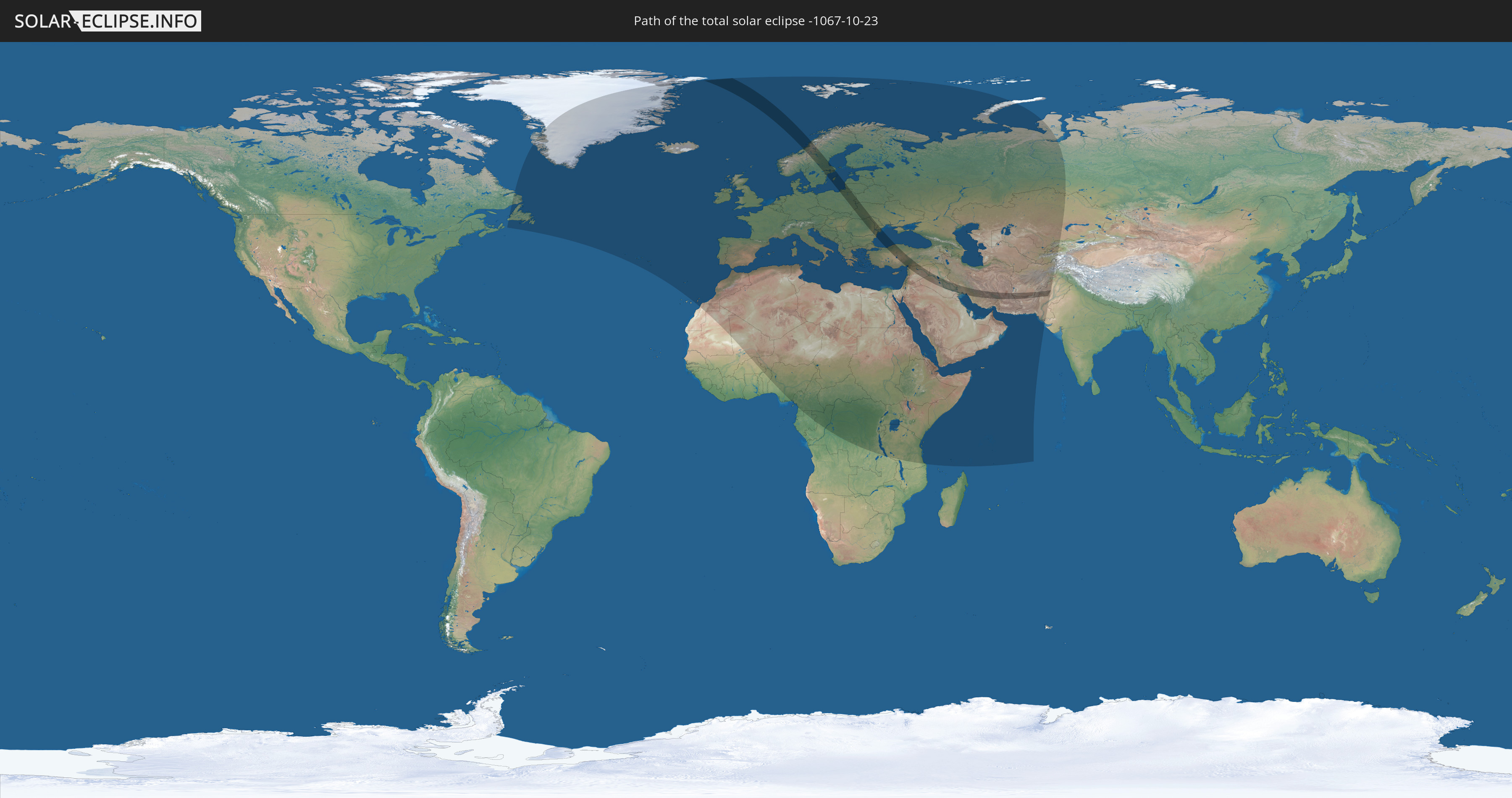
Die Sonnenfinsternis am 10/23/-1067 kann man in 112 Ländern als partielle Sonnenfinsternis beobachten.
Der Finsternispfad verläuft durch 17 Länder. Nur in diesen Ländern ist sie als total Sonnenfinsternis zu sehen.
In den folgenden Ländern ist die Sonnenfinsternis total zu sehen
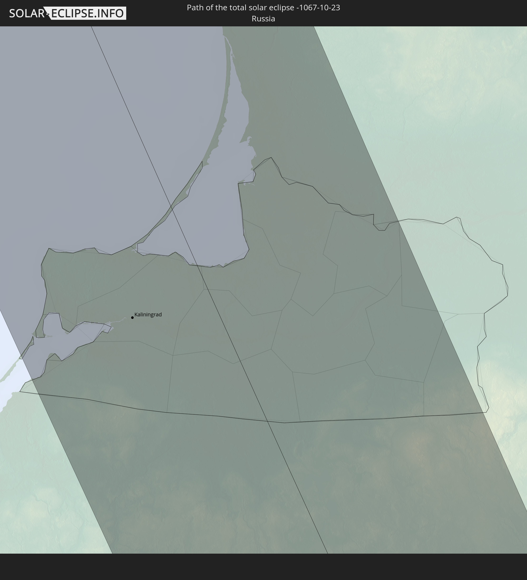 Russia
 Norway
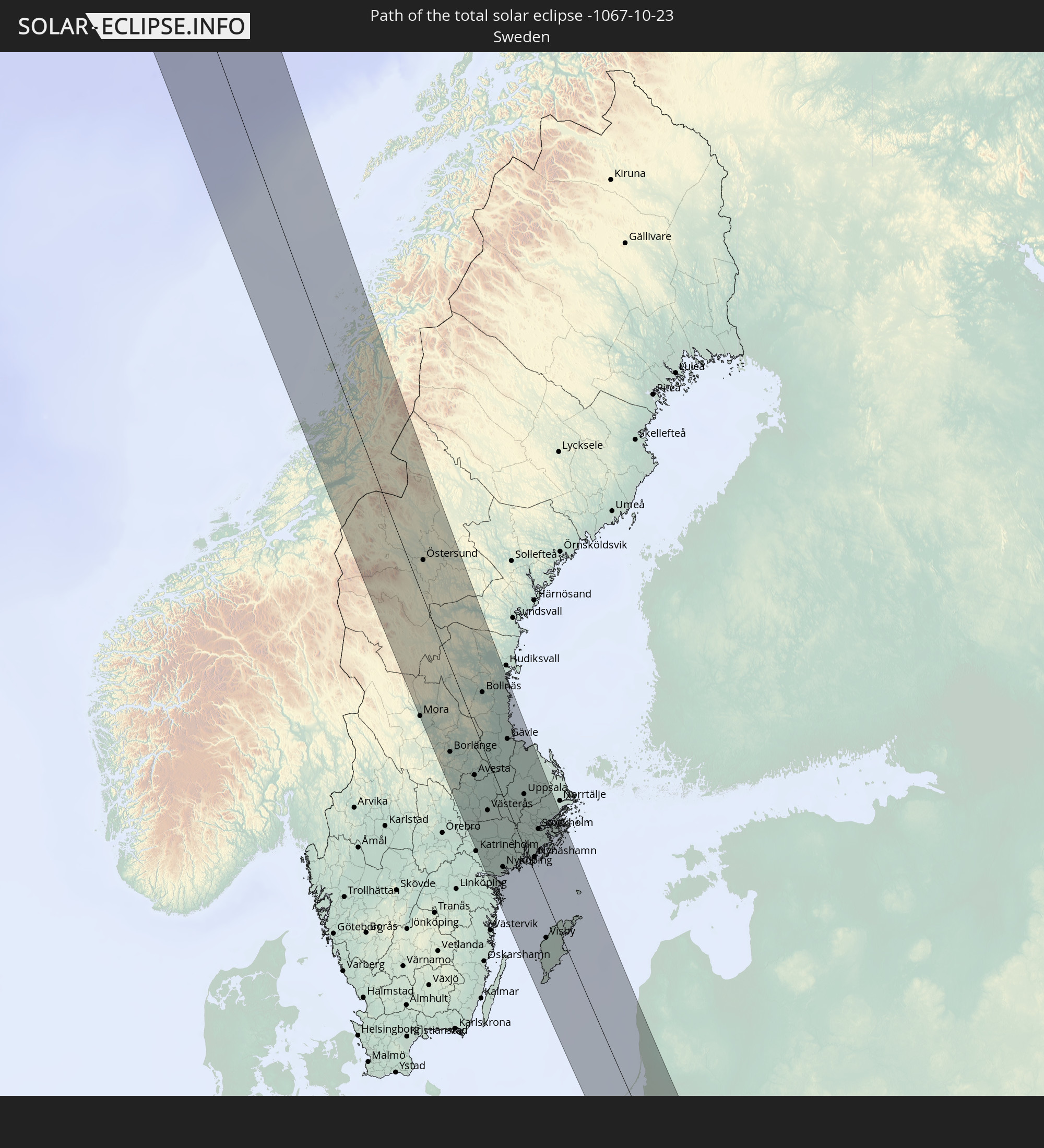 Sweden
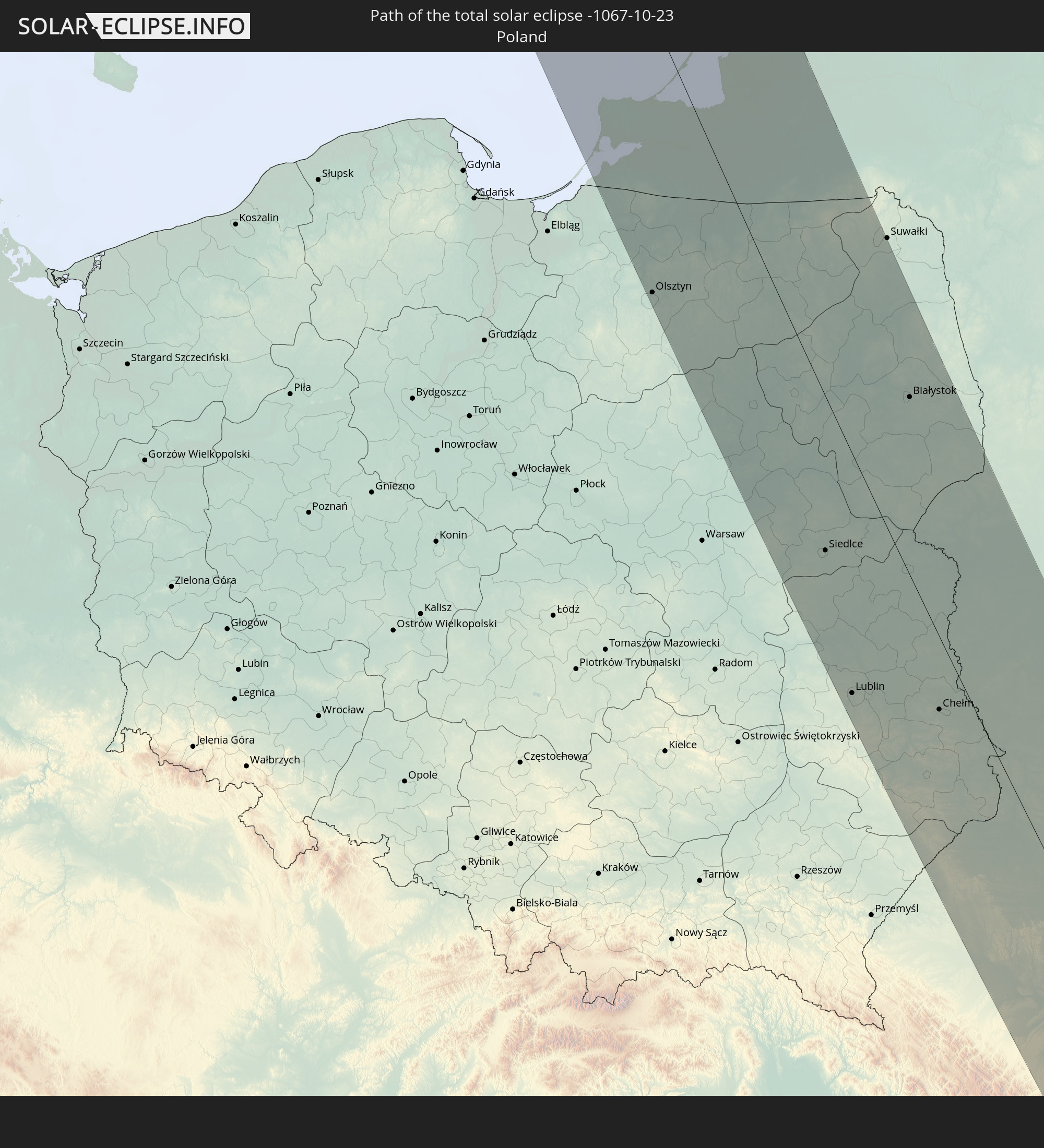 Poland
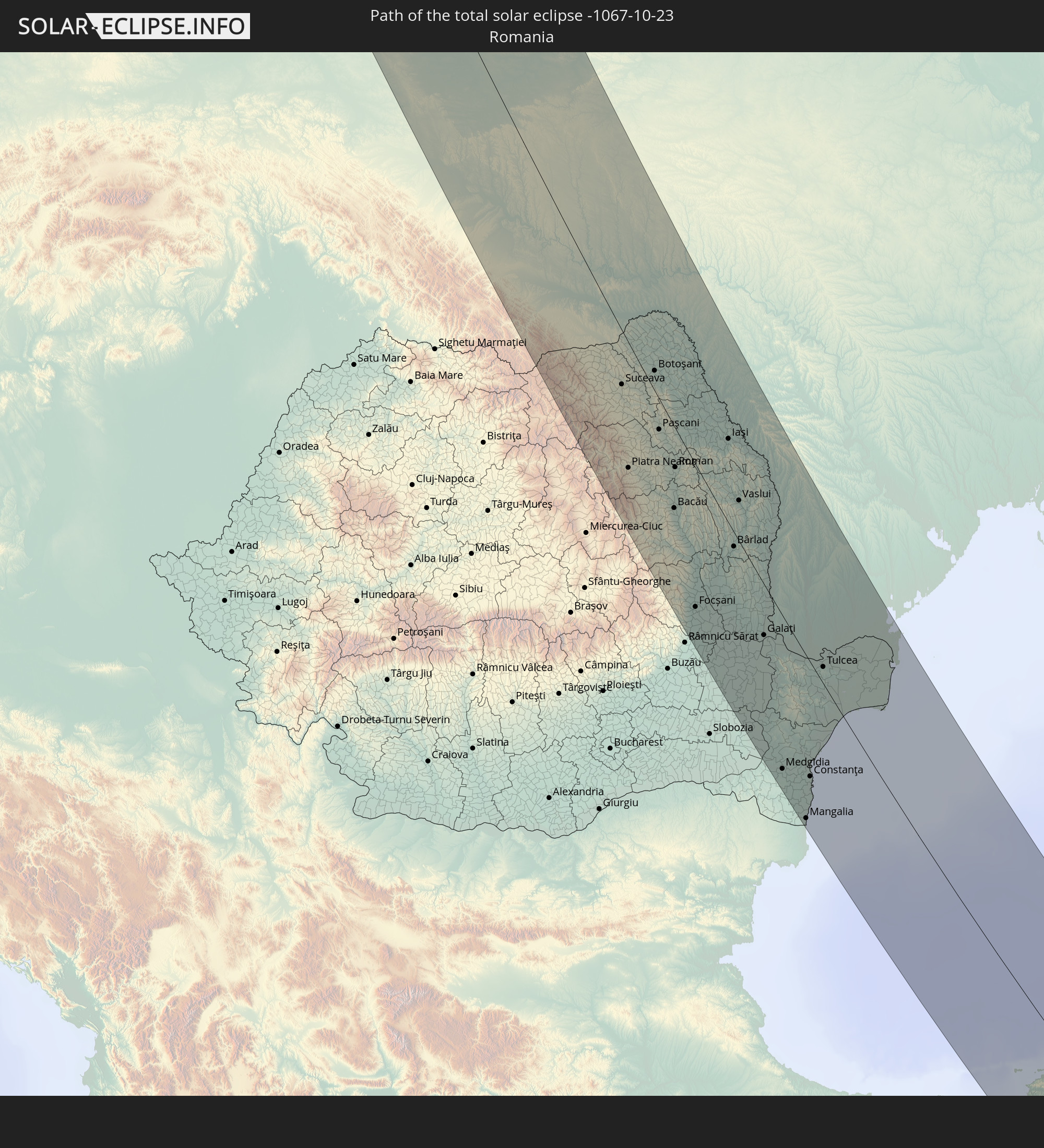 Romania
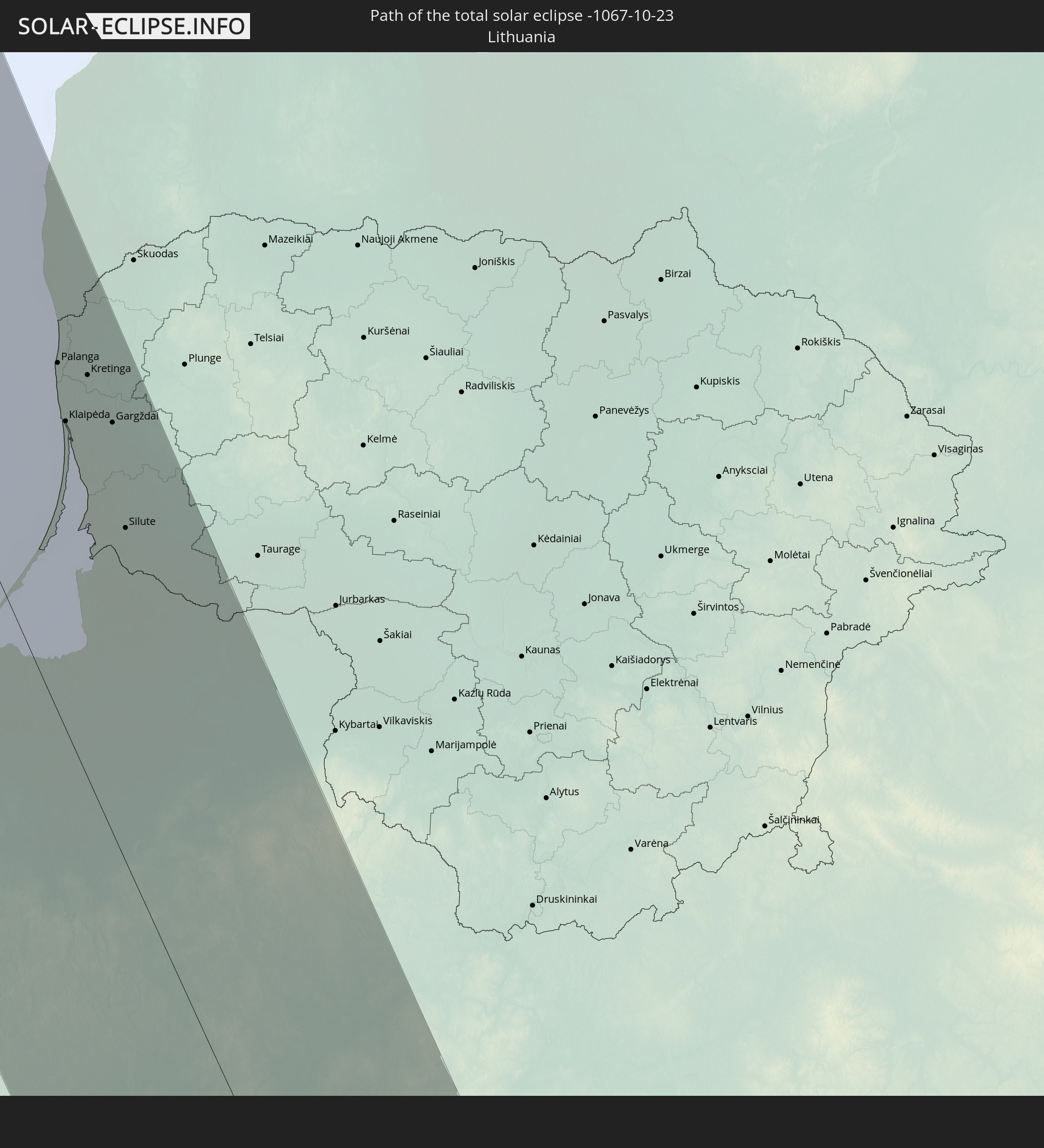 Lithuania
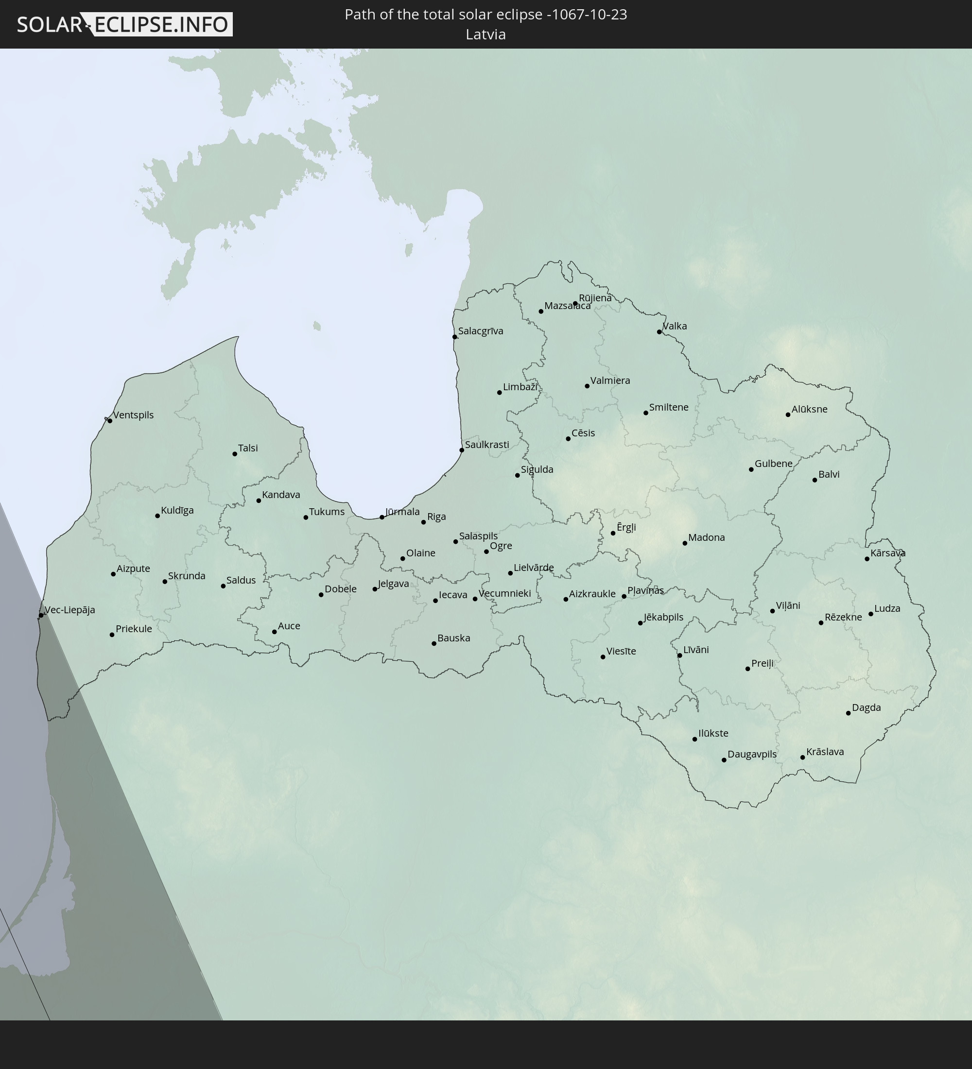 Latvia
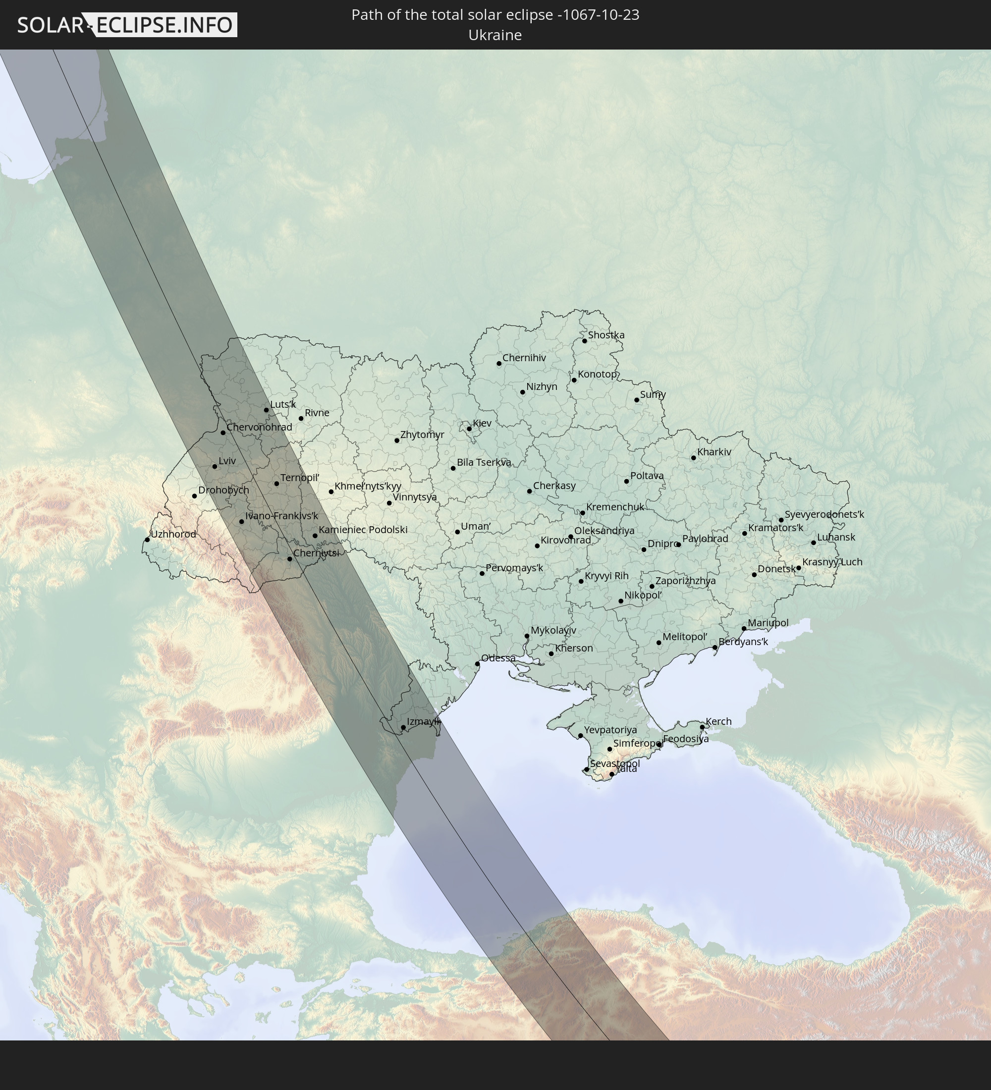 Ukraine
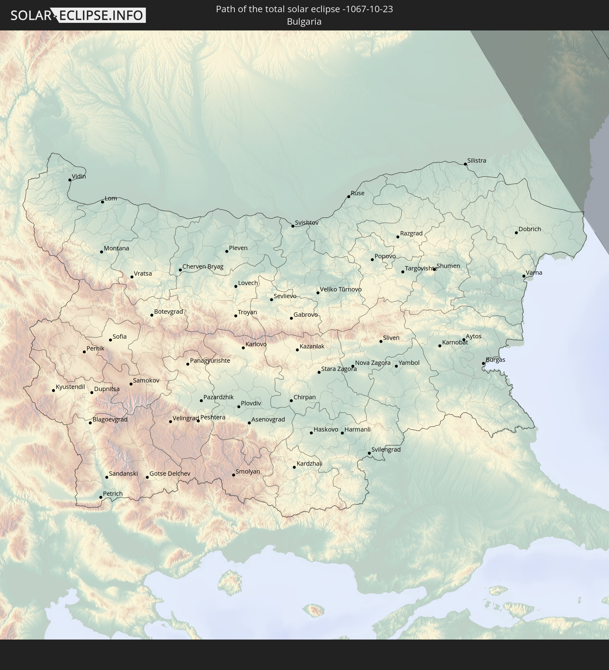 Bulgaria
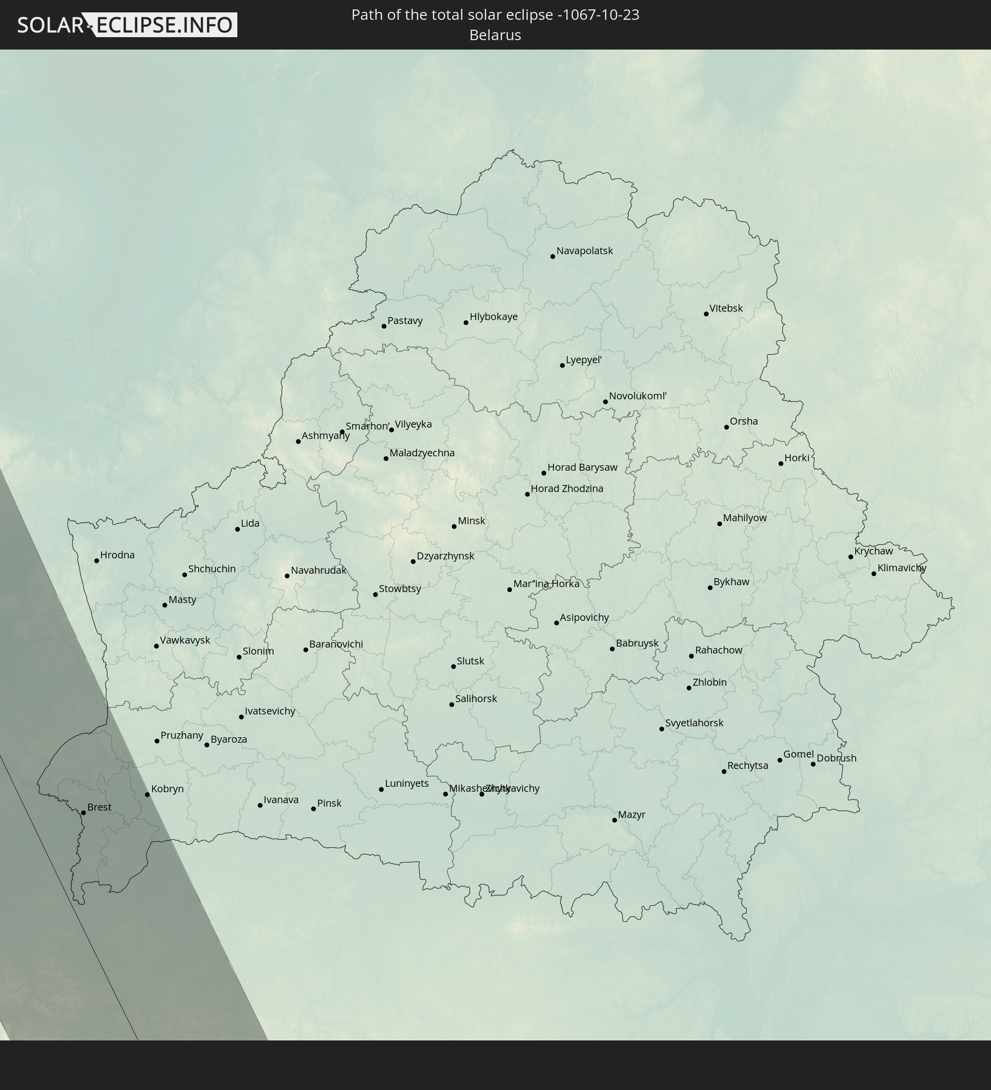 Belarus
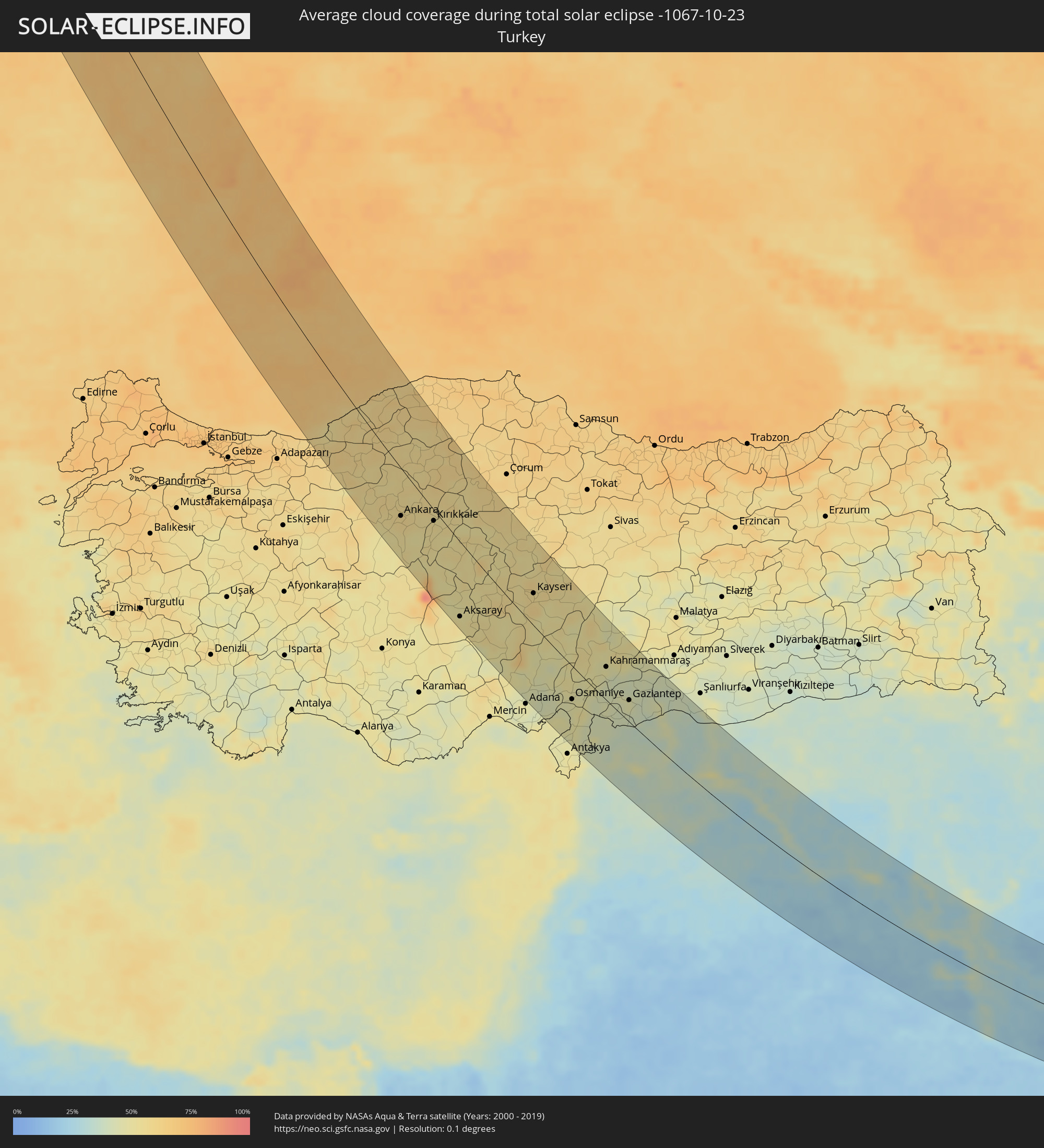
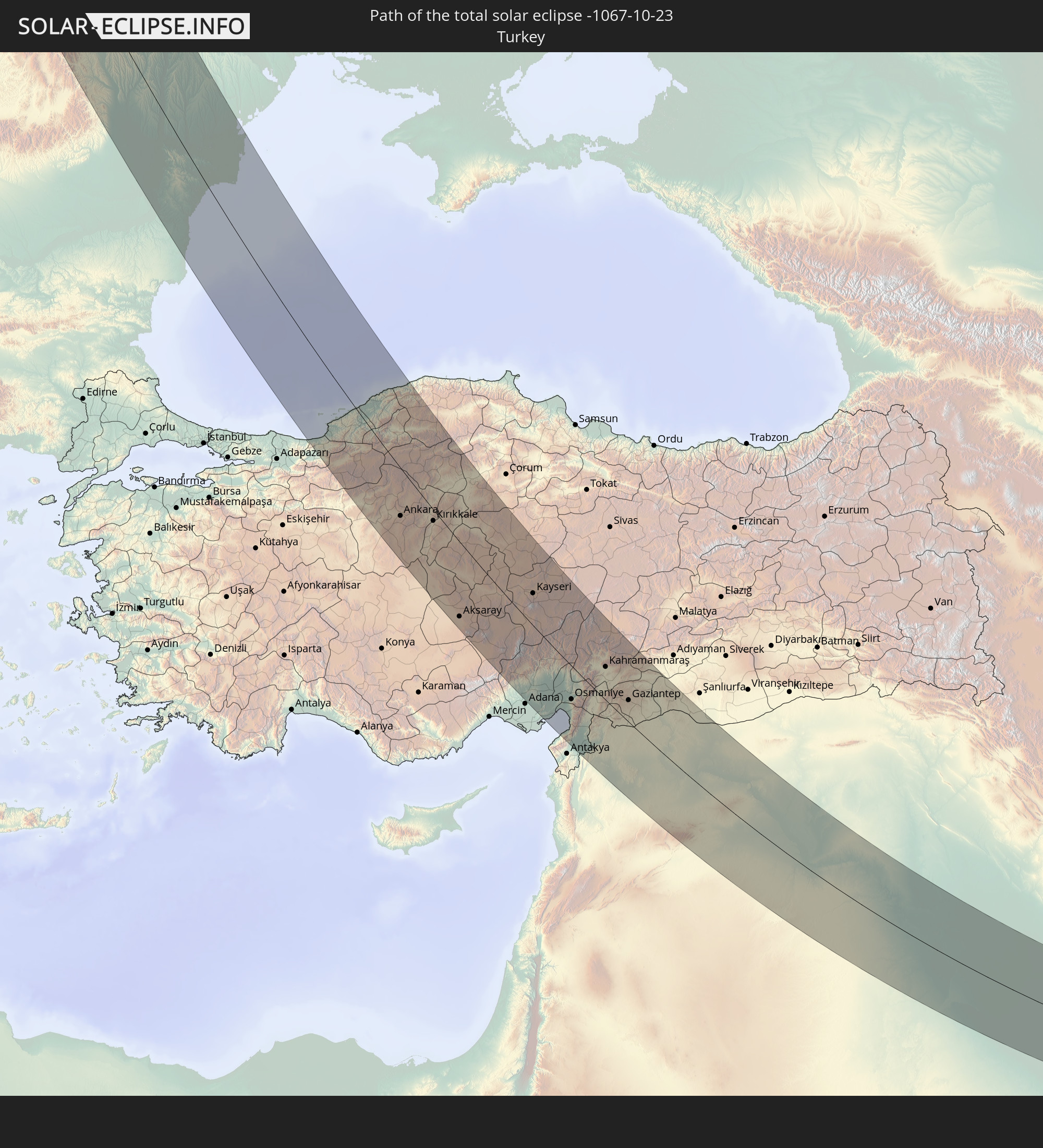 Turkey
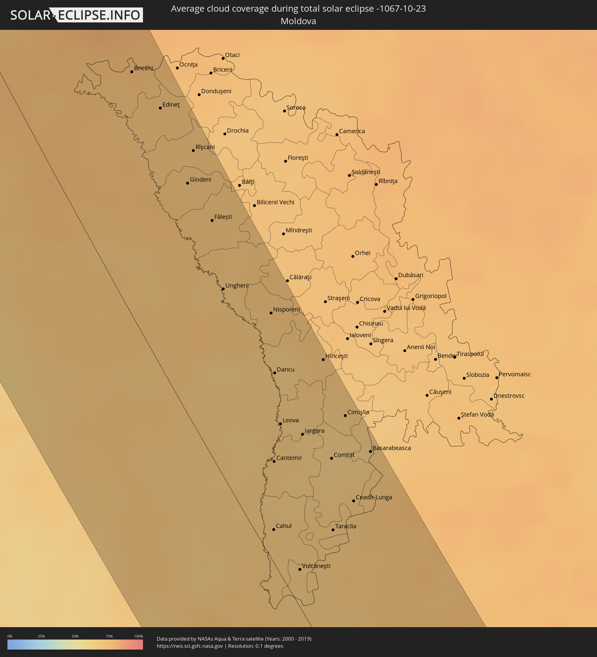
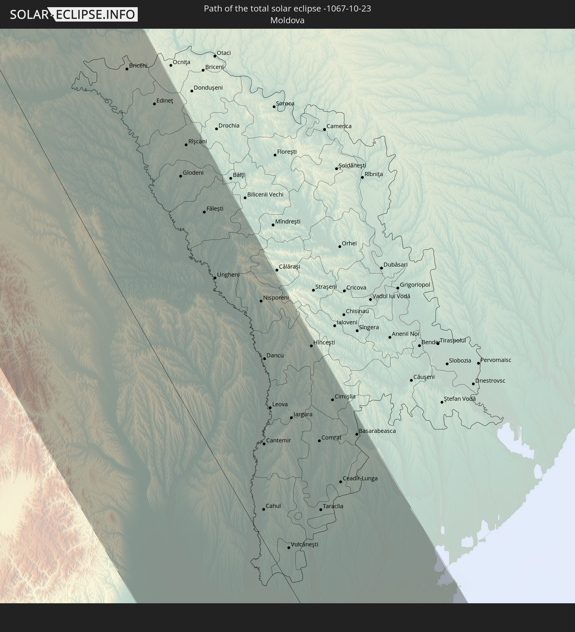 Moldova
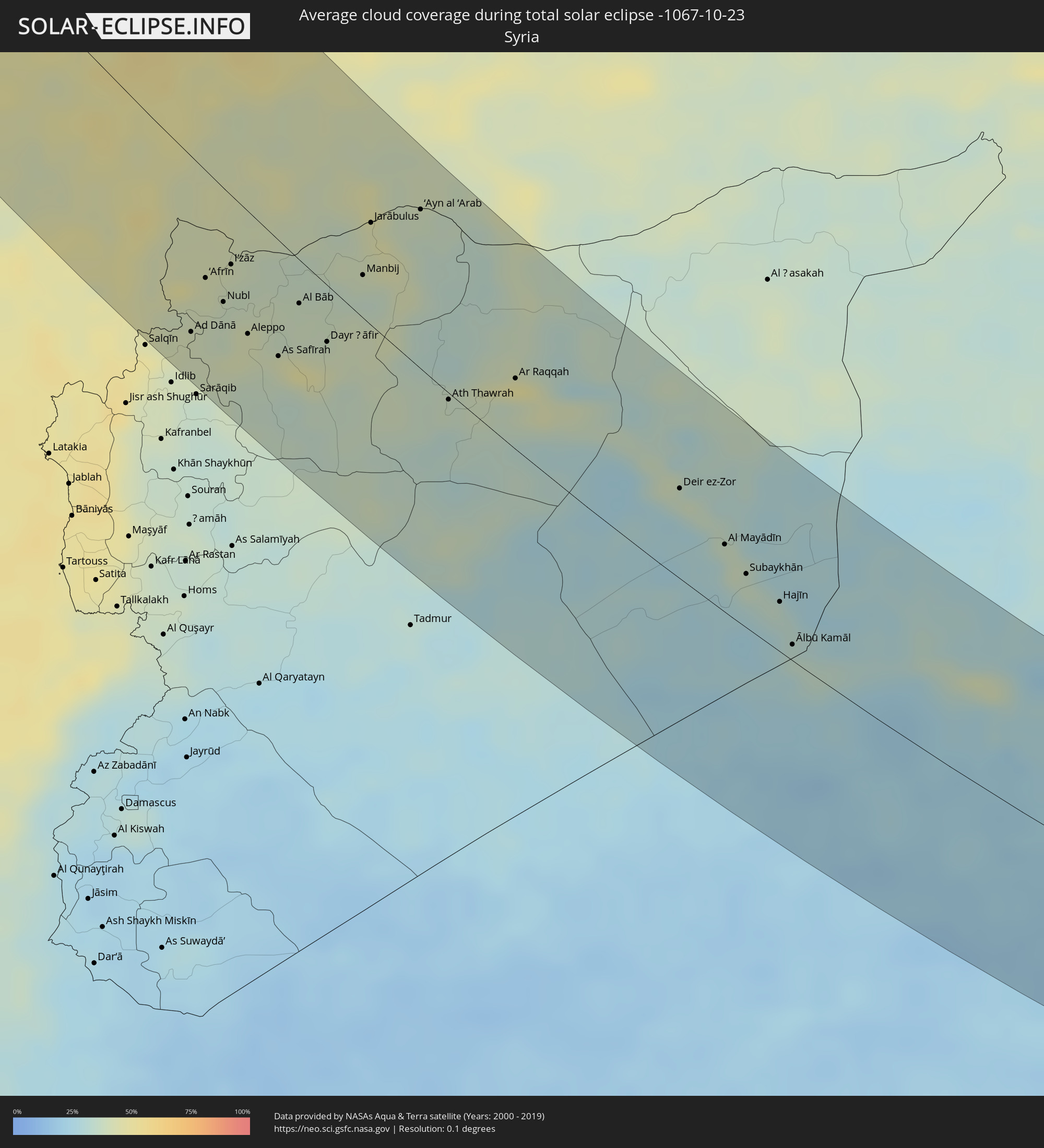
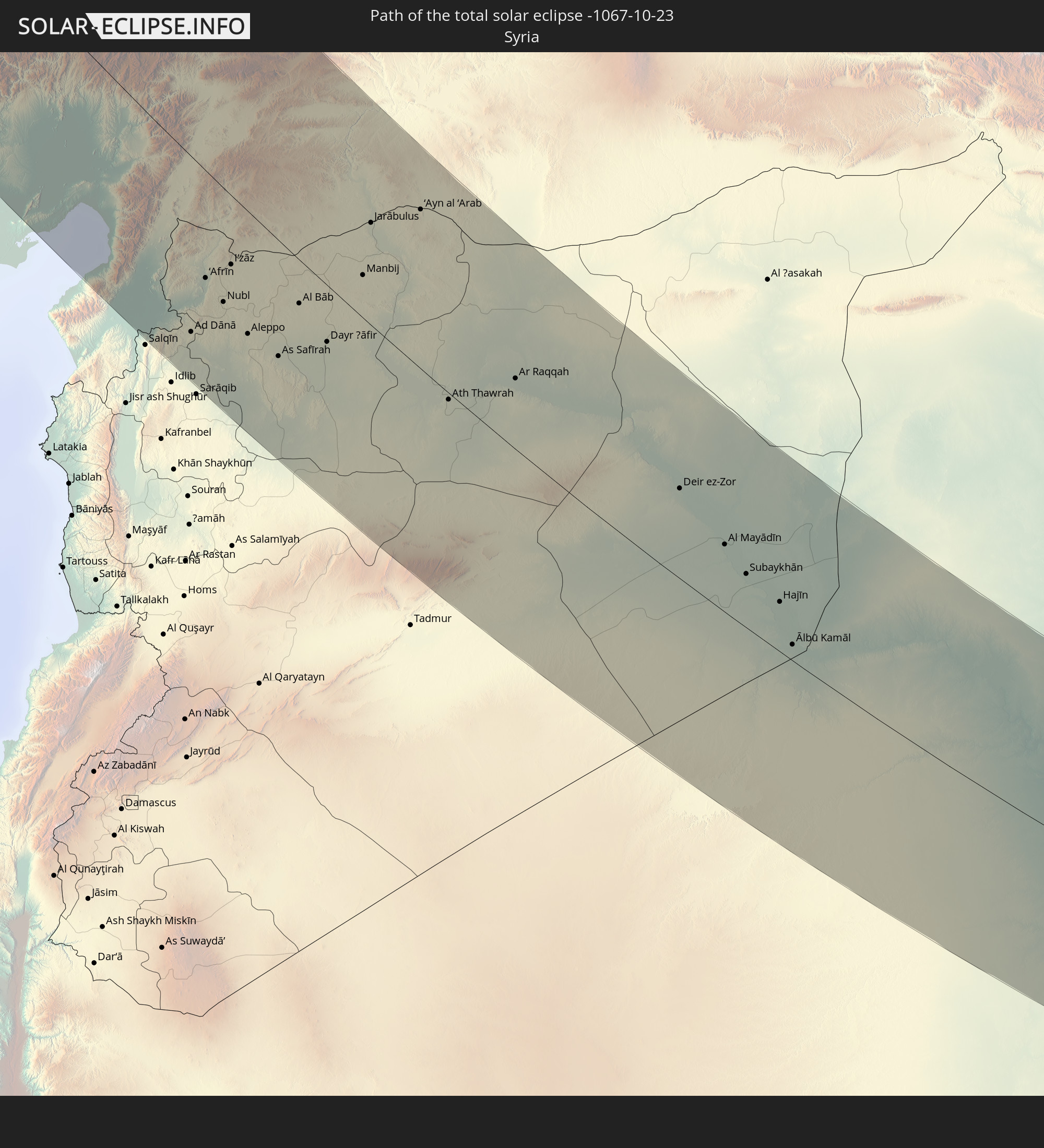 Syria
Syria
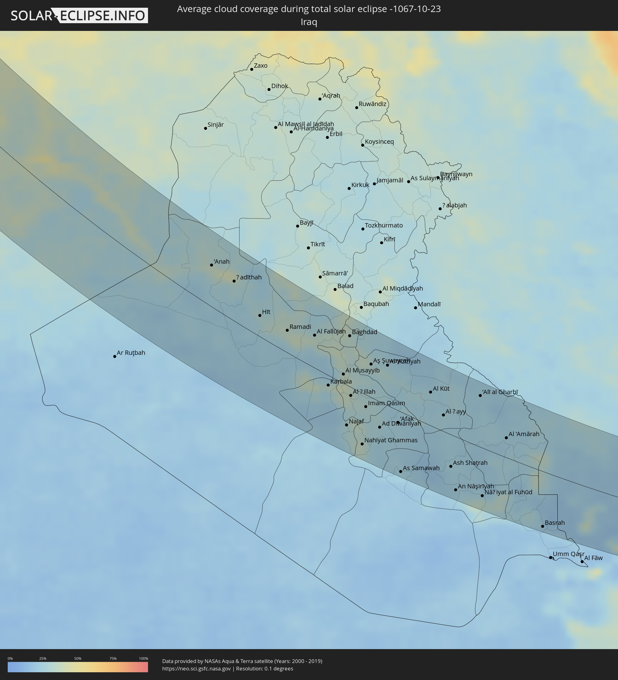
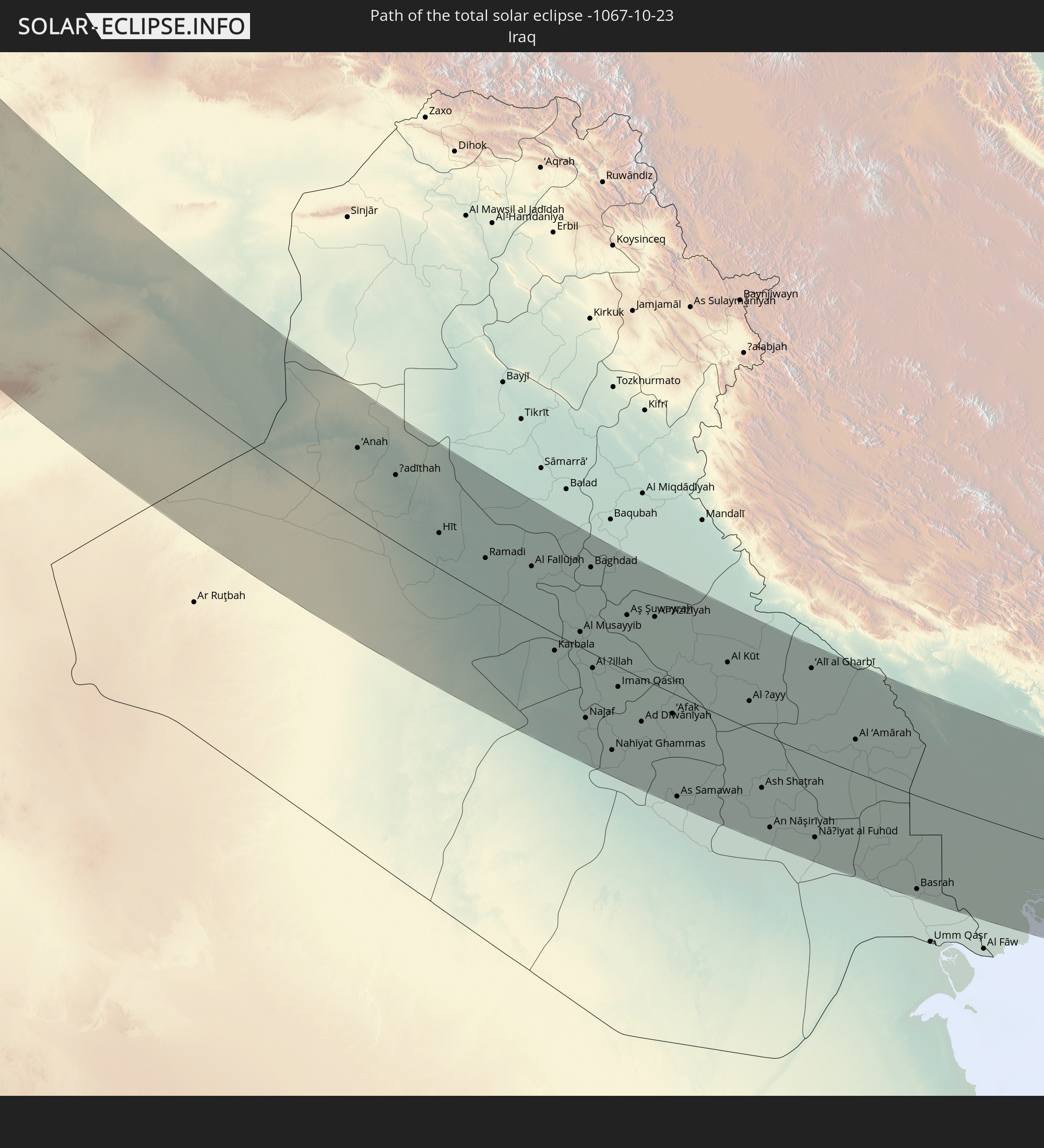 Iraq
Iraq
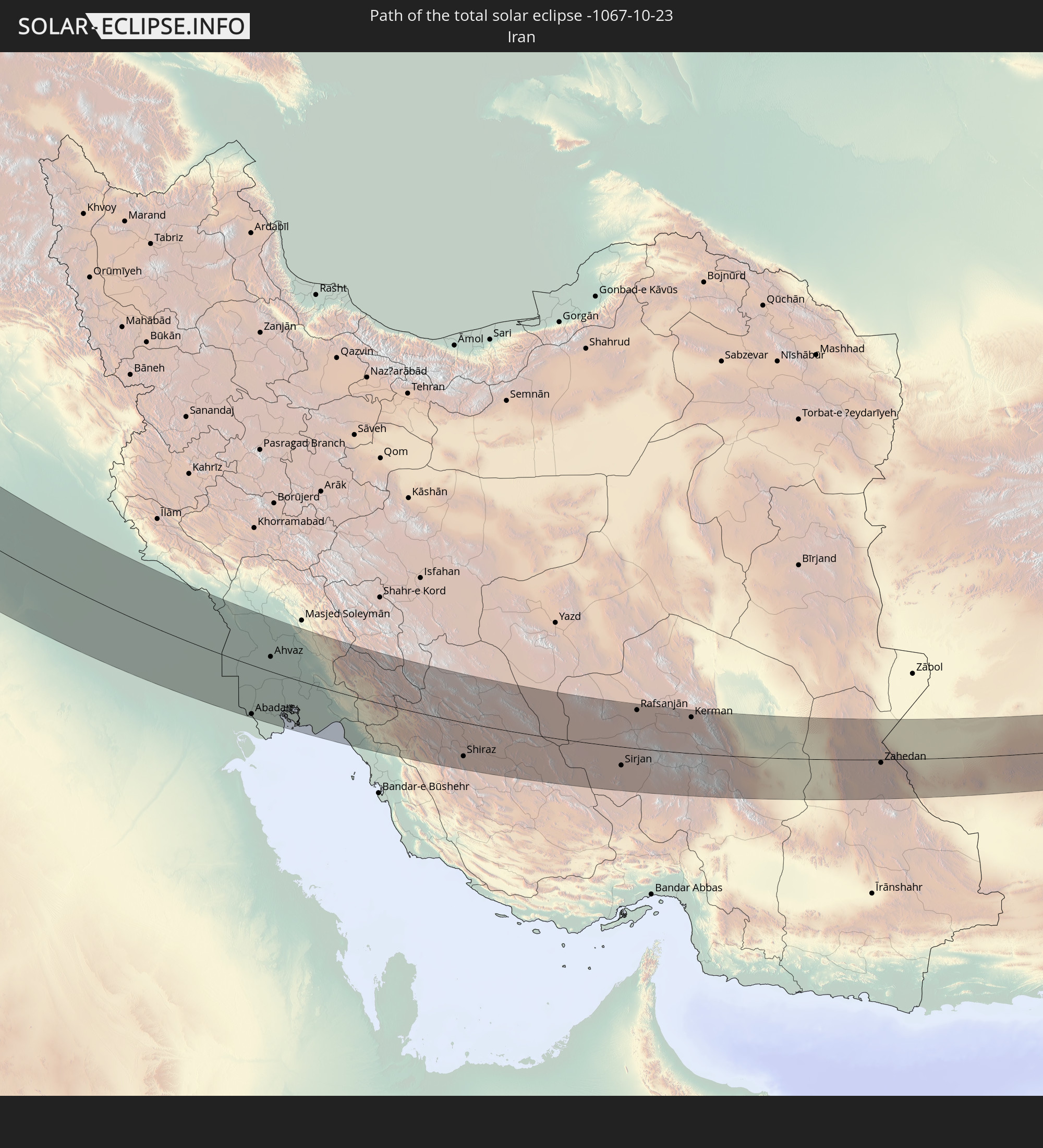 Iran
Iran
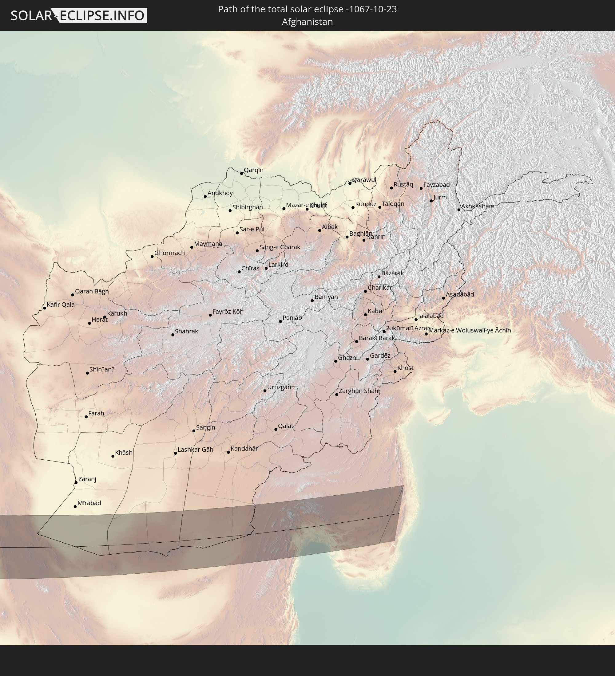 Afghanistan
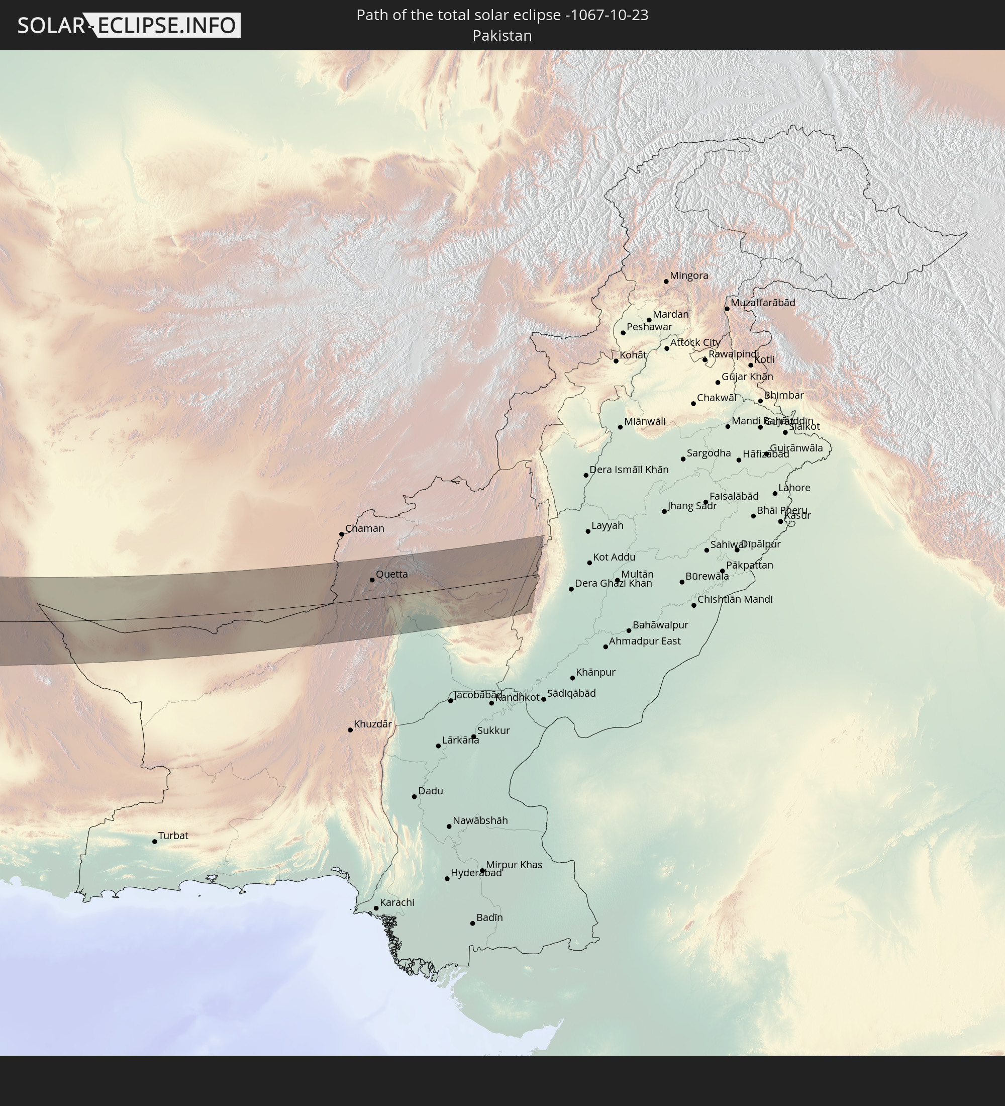 Pakistan
In den folgenden Ländern ist die Sonnenfinsternis partiell zu sehen
 Russia
 Canada
 Greenland
 Saint Pierre and Miquelon
 Portugal
 Iceland
 Spain
Spain
 Mauritania
 Morocco
 Mali
Mali
 Republic of Ireland
 Svalbard and Jan Mayen
 Algeria
 United Kingdom
 Faroe Islands
 Burkina Faso
 Gibraltar
 France
 Isle of Man
 Guernsey
 Jersey
 Niger
Niger
 Benin
Benin
 Andorra
 Belgium
 Nigeria
 Netherlands
 Norway
 Equatorial Guinea
 Luxembourg
 Germany
 Switzerland
 Italy
Italy
 Monaco
 Tunisia
 Denmark
 Cameroon
 Gabon
Gabon
 Libya
Libya
 Liechtenstein
 Austria
 Sweden
 Republic of the Congo
 Czechia
 Democratic Republic of the Congo
 San Marino
 Vatican City
 Slovenia
 Chad
Chad
 Croatia
 Poland
 Malta
Malta
 Central African Republic
 Bosnia and Herzegovina
 Hungary
 Slovakia
 Montenegro
 Serbia
 Albania
 Åland Islands
 Greece
 Romania
 Republic of Macedonia
 Finland
 Lithuania
 Latvia
 Estonia
 Sudan
Sudan
 Zambia
 Ukraine
 Bulgaria
 Belarus
 Egypt
Egypt
 Turkey
 Moldova
 Rwanda
 Burundi
 Tanzania
 Uganda
 Cyprus
 Ethiopia
 Kenya
Kenya
 State of Palestine
 Israel
 Saudi Arabia
 Jordan
 Lebanon
 Syria
Syria
 Eritrea
 Iraq
Iraq
 Georgia
 Somalia
 Djibouti
 Yemen
Yemen
 Armenia
 Iran
Iran
 Azerbaijan
 Seychelles
 Kazakhstan
 Kuwait
 Bahrain
 Qatar
Qatar
 United Arab Emirates
 Oman
Oman
 Turkmenistan
 Uzbekistan
 Mauritius
 Afghanistan
 Pakistan
 Tajikistan
 India
India
 Kyrgyzstan
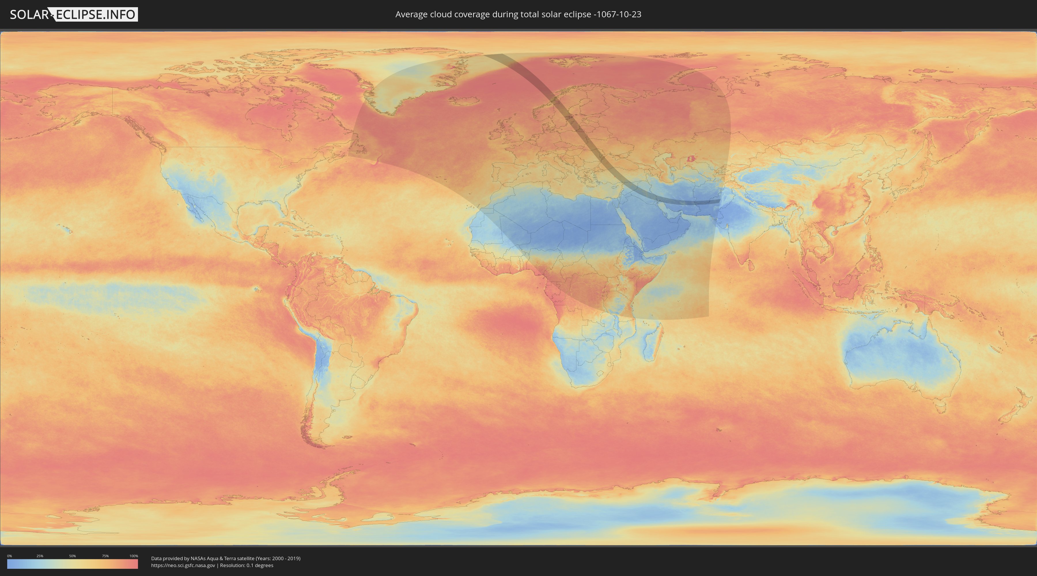
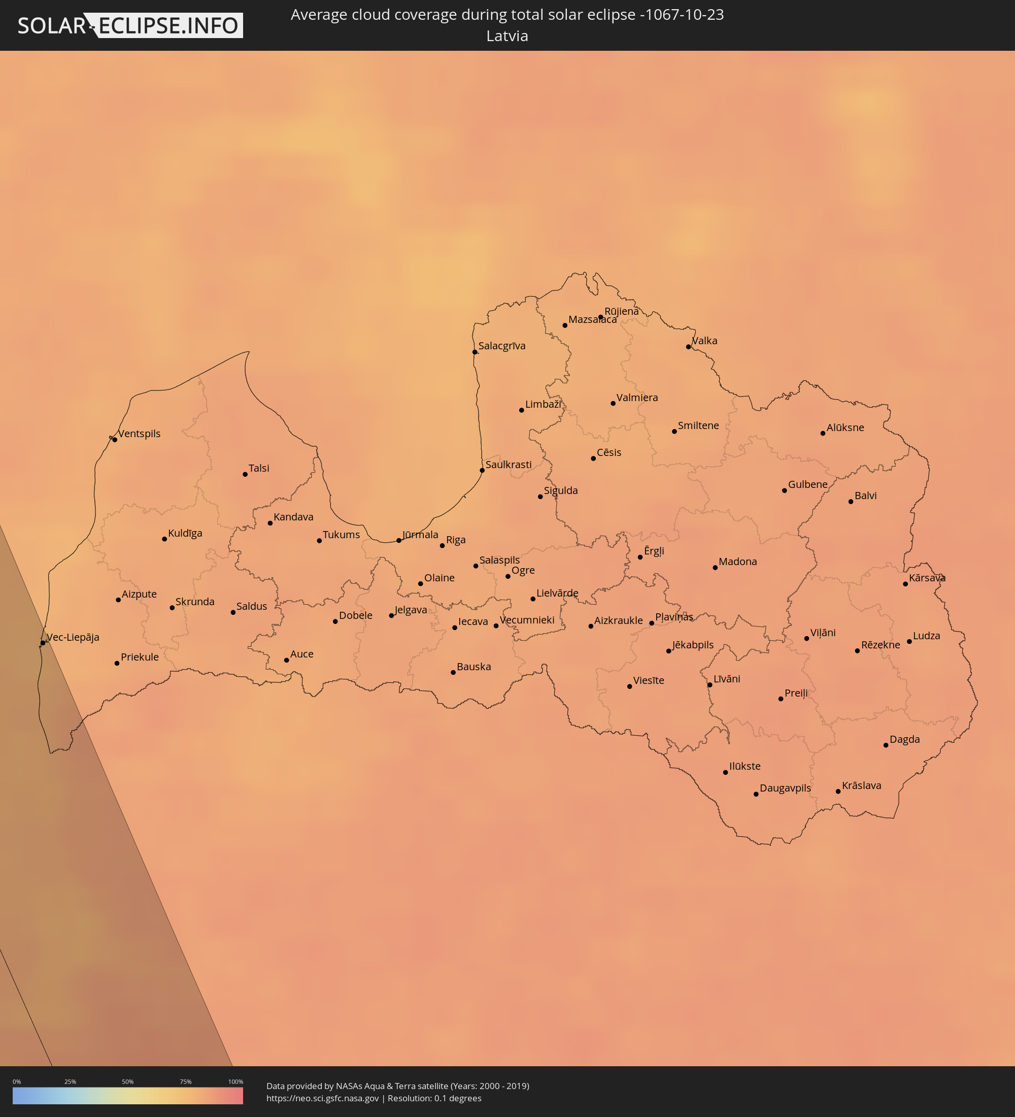
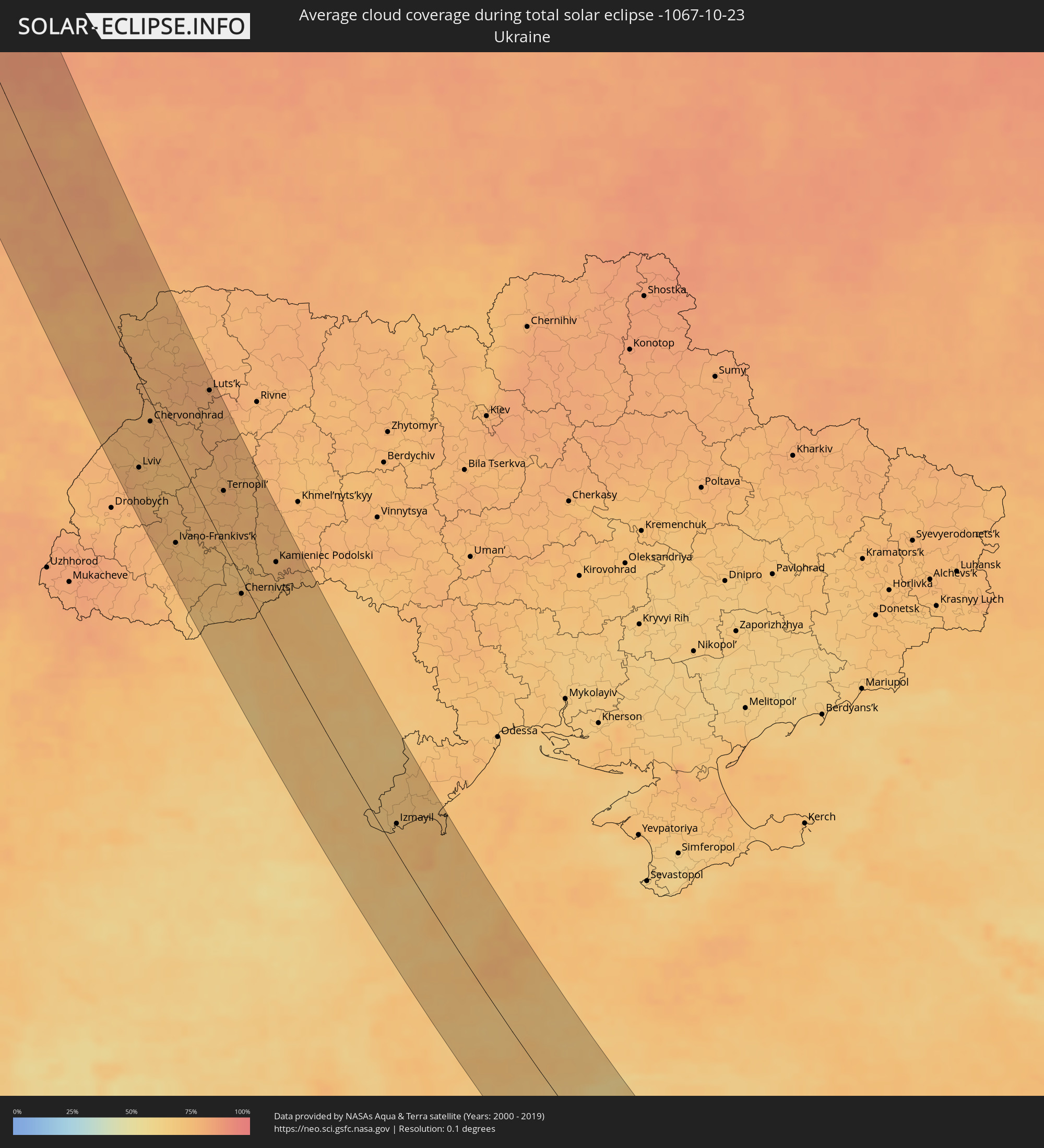
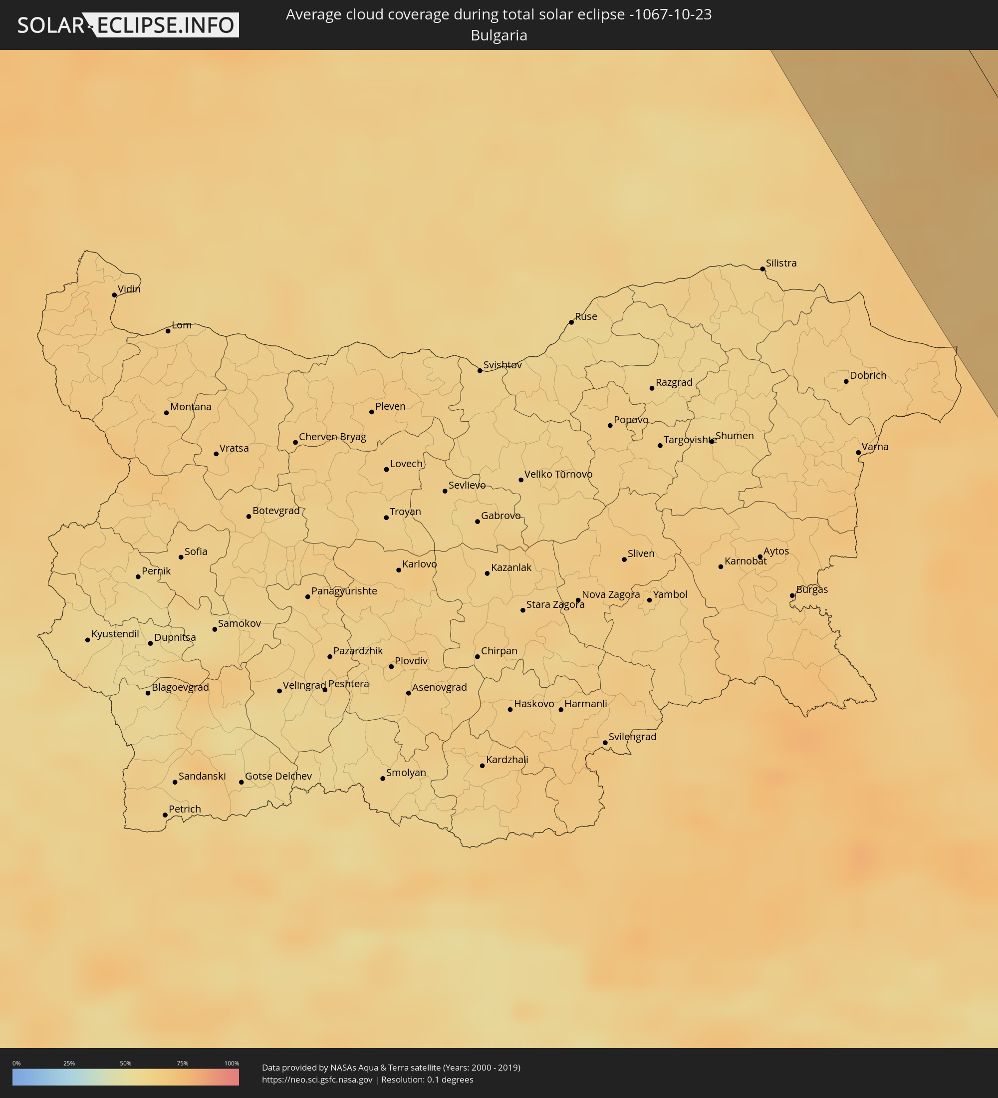
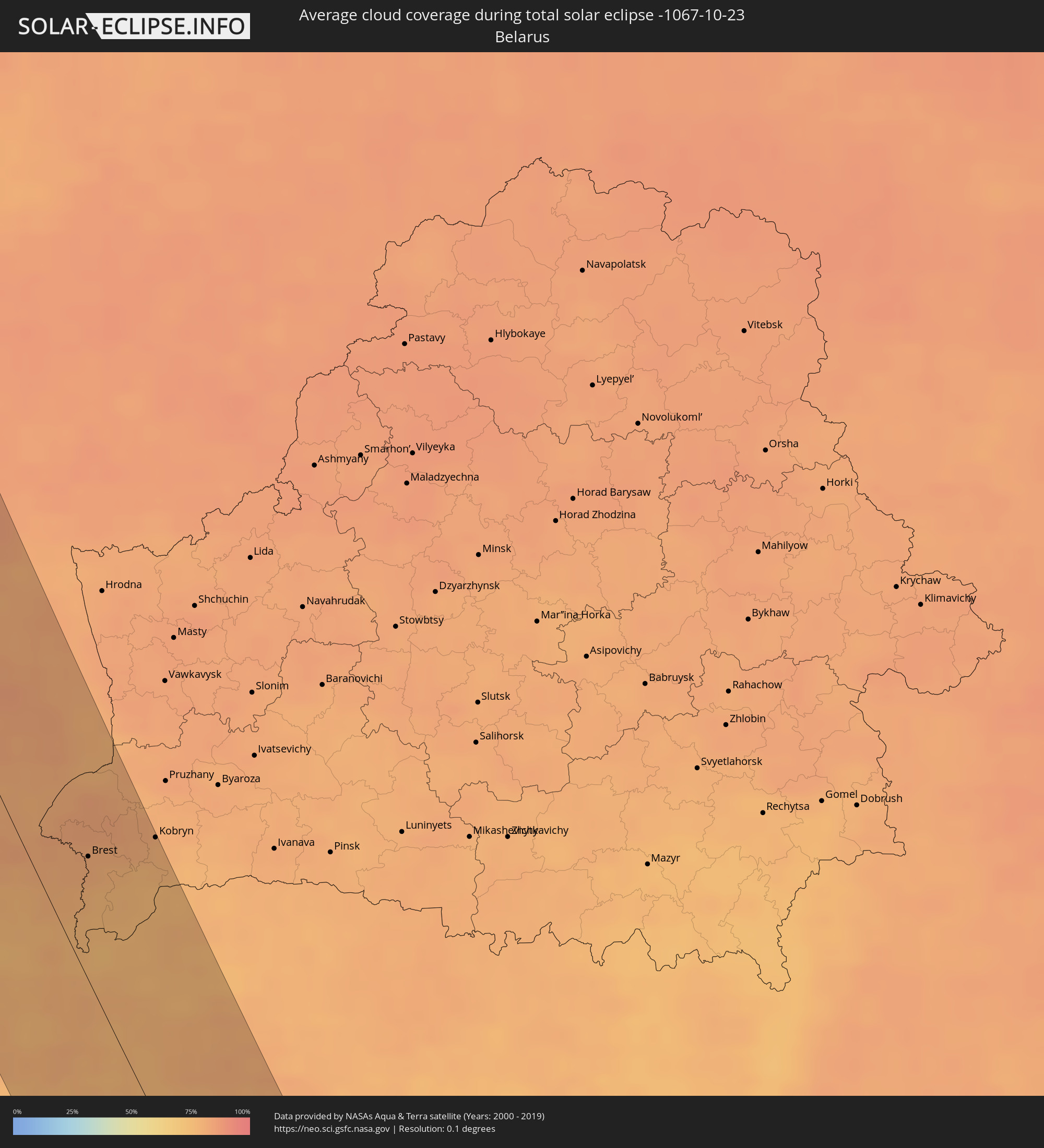
How will be the weather during the total solar eclipse on 10/23/-1067?
Where is the best place to see the total solar eclipse of 10/23/-1067?
The following maps show the average cloud coverage for the day of the total solar eclipse.
With the help of these maps, it is possible to find the place along the eclipse path, which has the best
chance of a cloudless sky.
Nevertheless, you should consider local circumstances and inform about the weather of your chosen
observation site.
The data is provided by NASAs satellites
AQUA and TERRA.
The cloud maps are averaged over a period of 19 years (2000 - 2019).

Detailed country maps
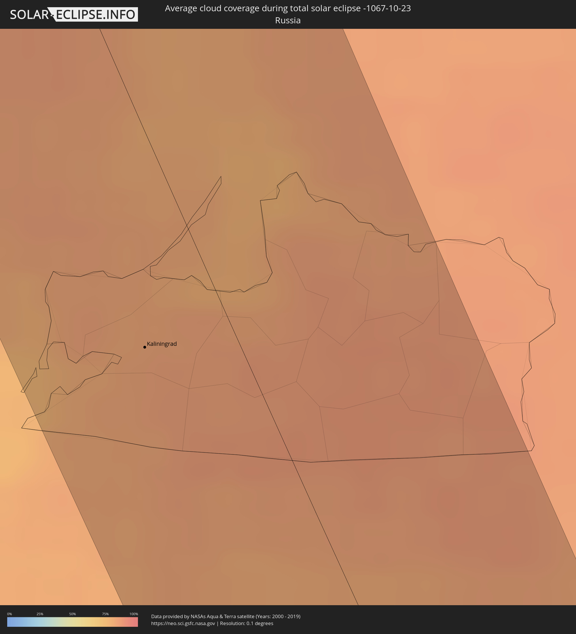 Russia
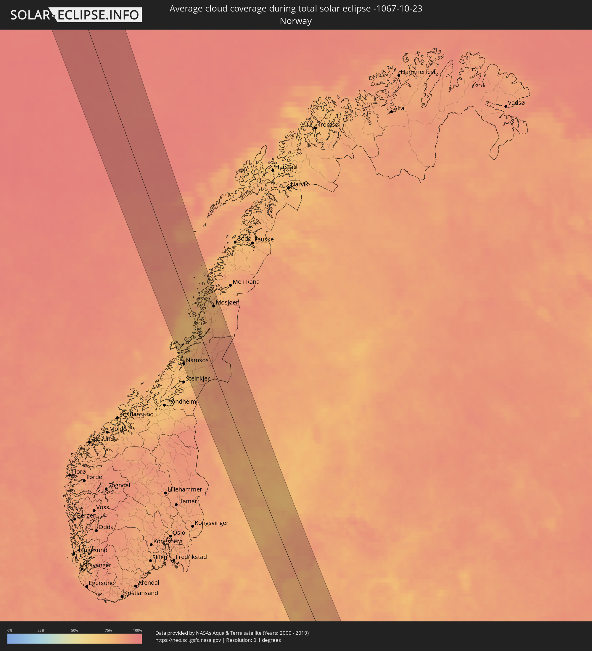 Norway
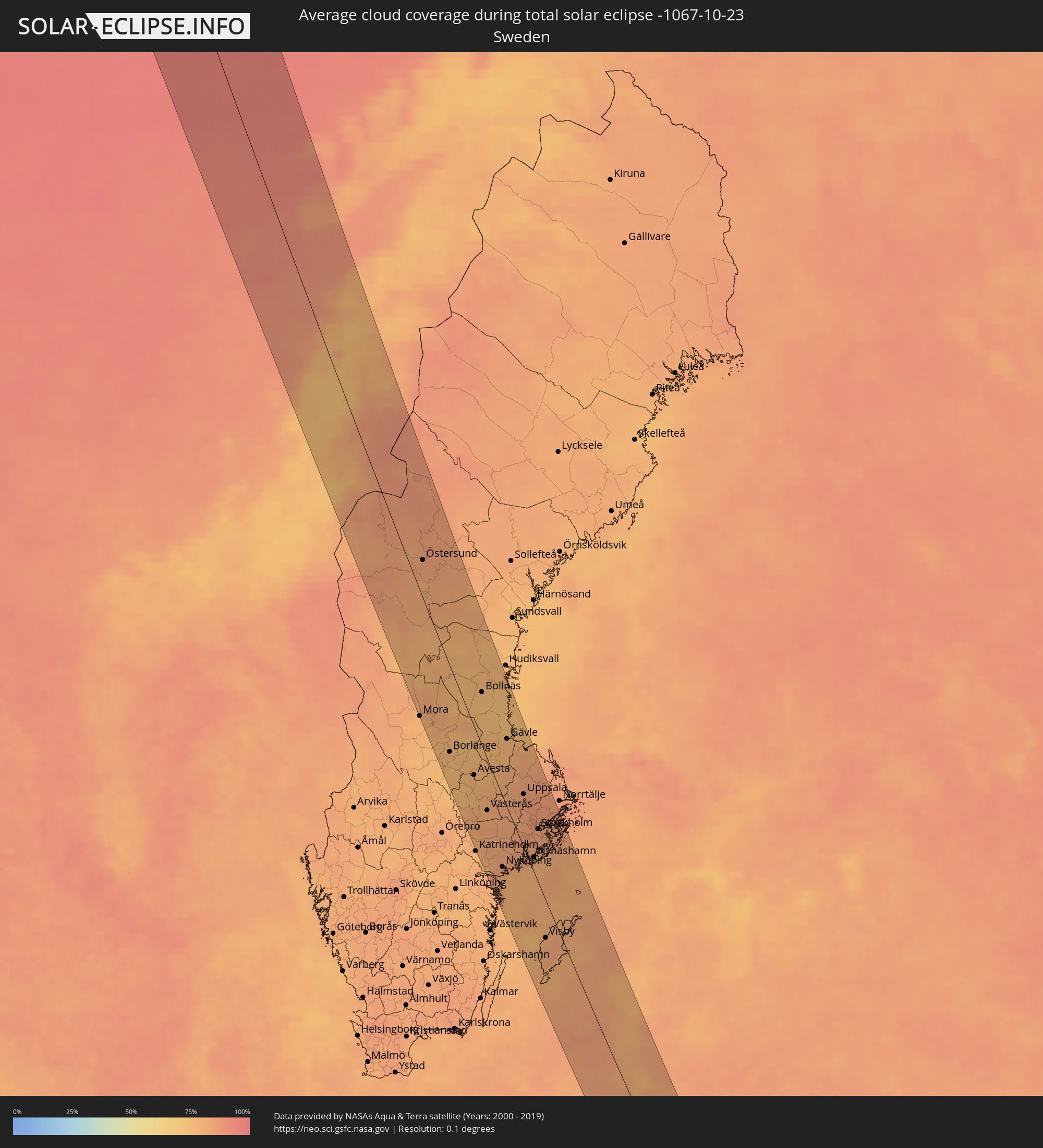 Sweden
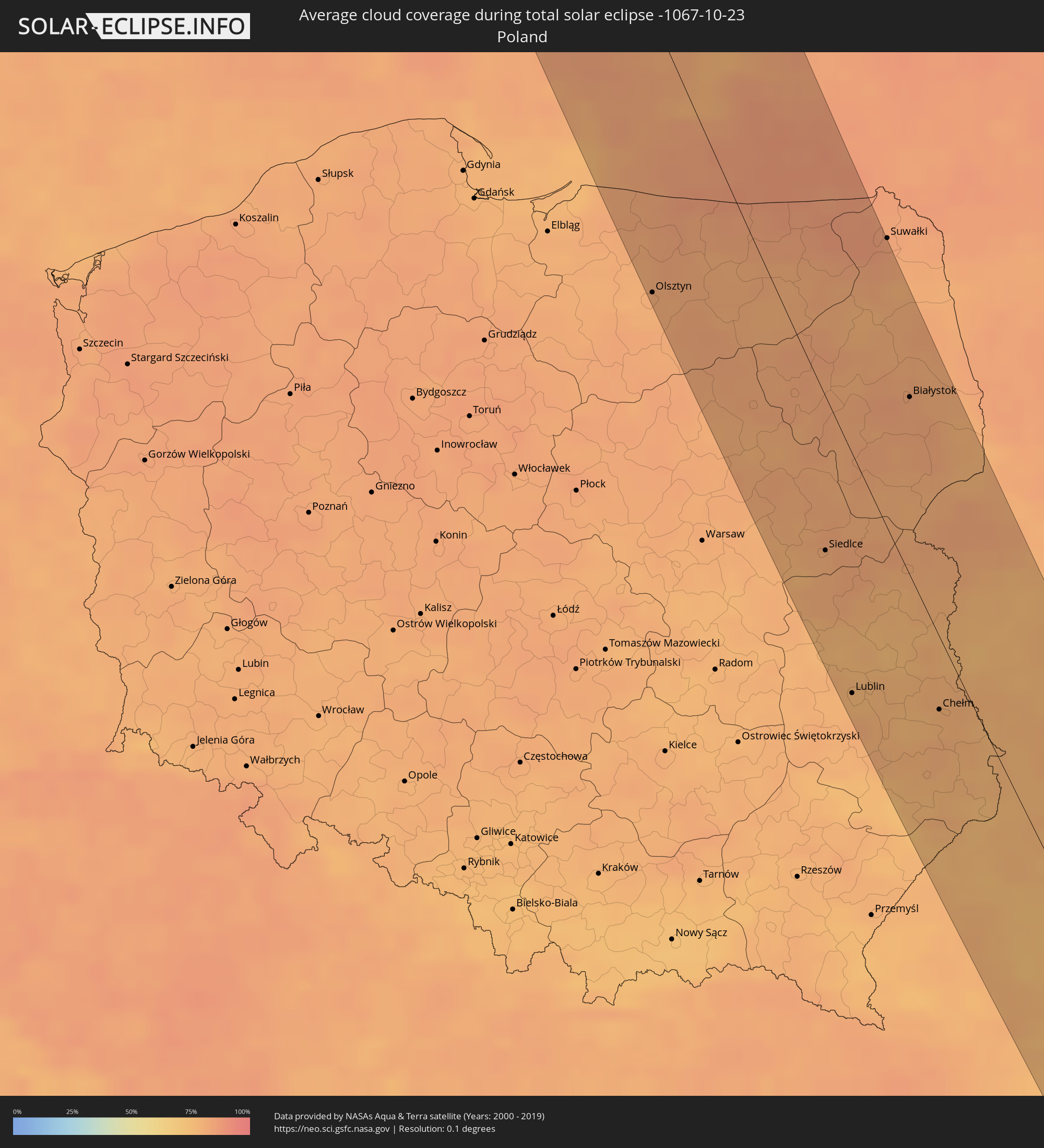 Poland
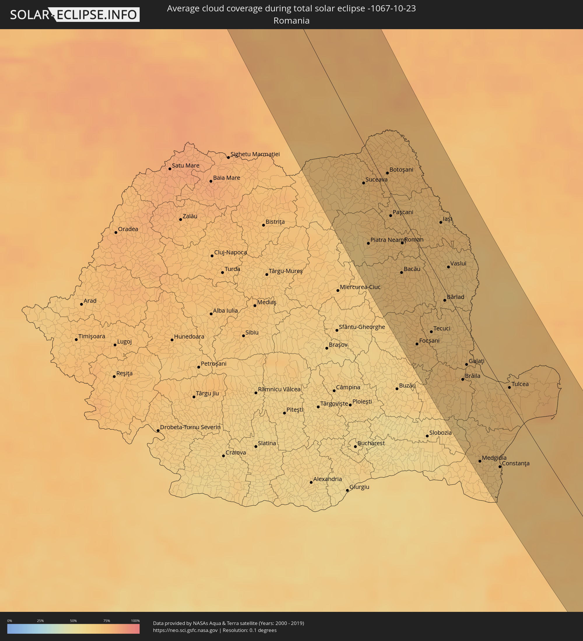 Romania
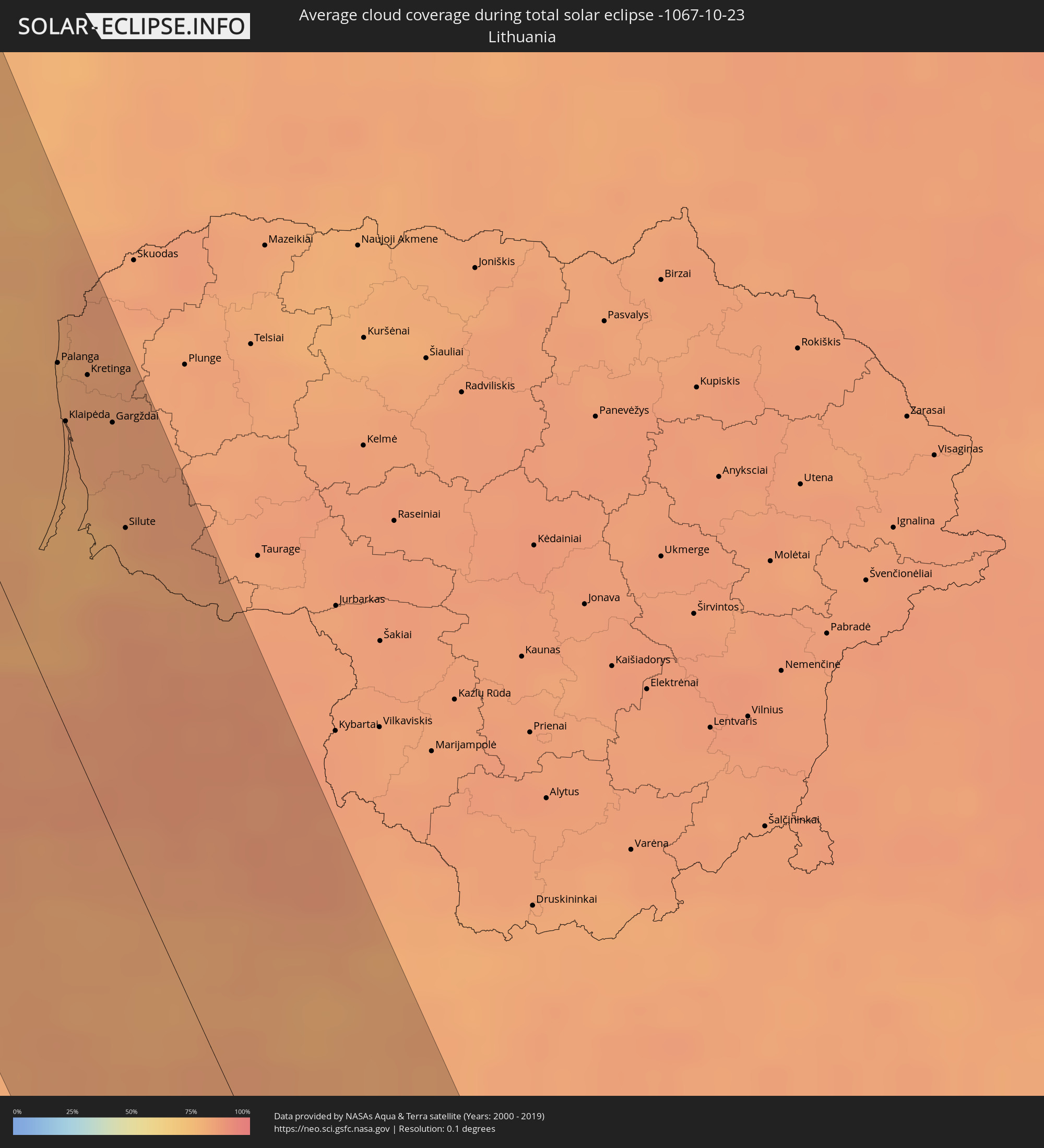 Lithuania
 Latvia
 Ukraine
 Bulgaria
 Belarus
 Turkey
 Moldova
 Syria
Syria
 Iraq
Iraq
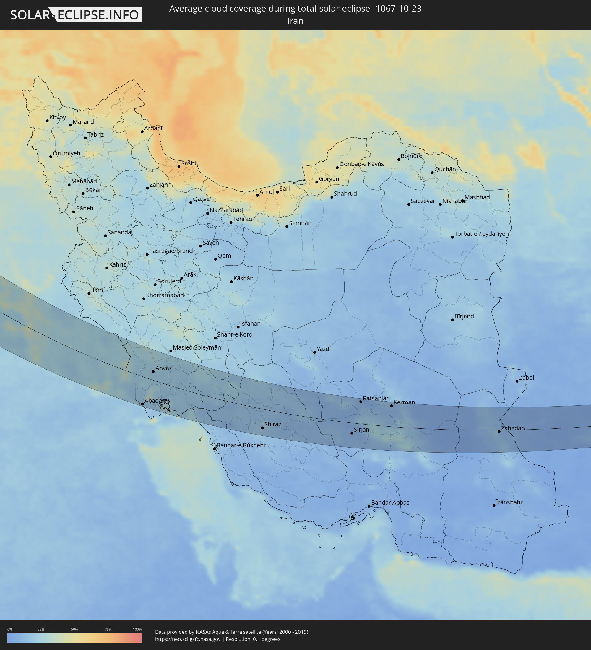 Iran
Iran
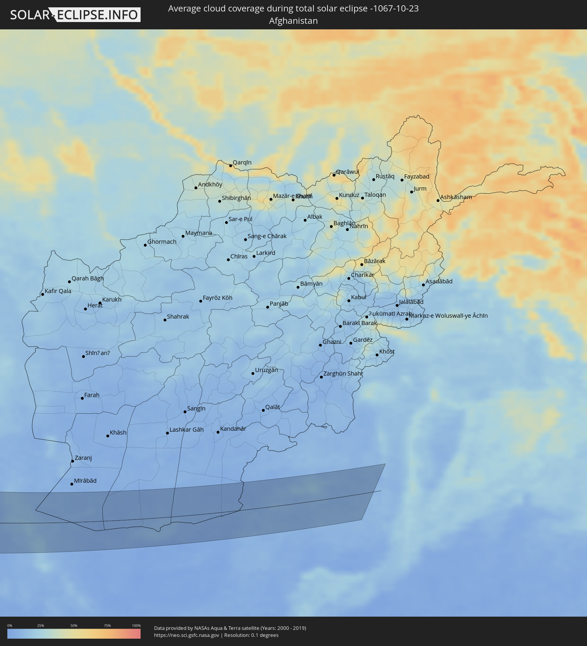 Afghanistan
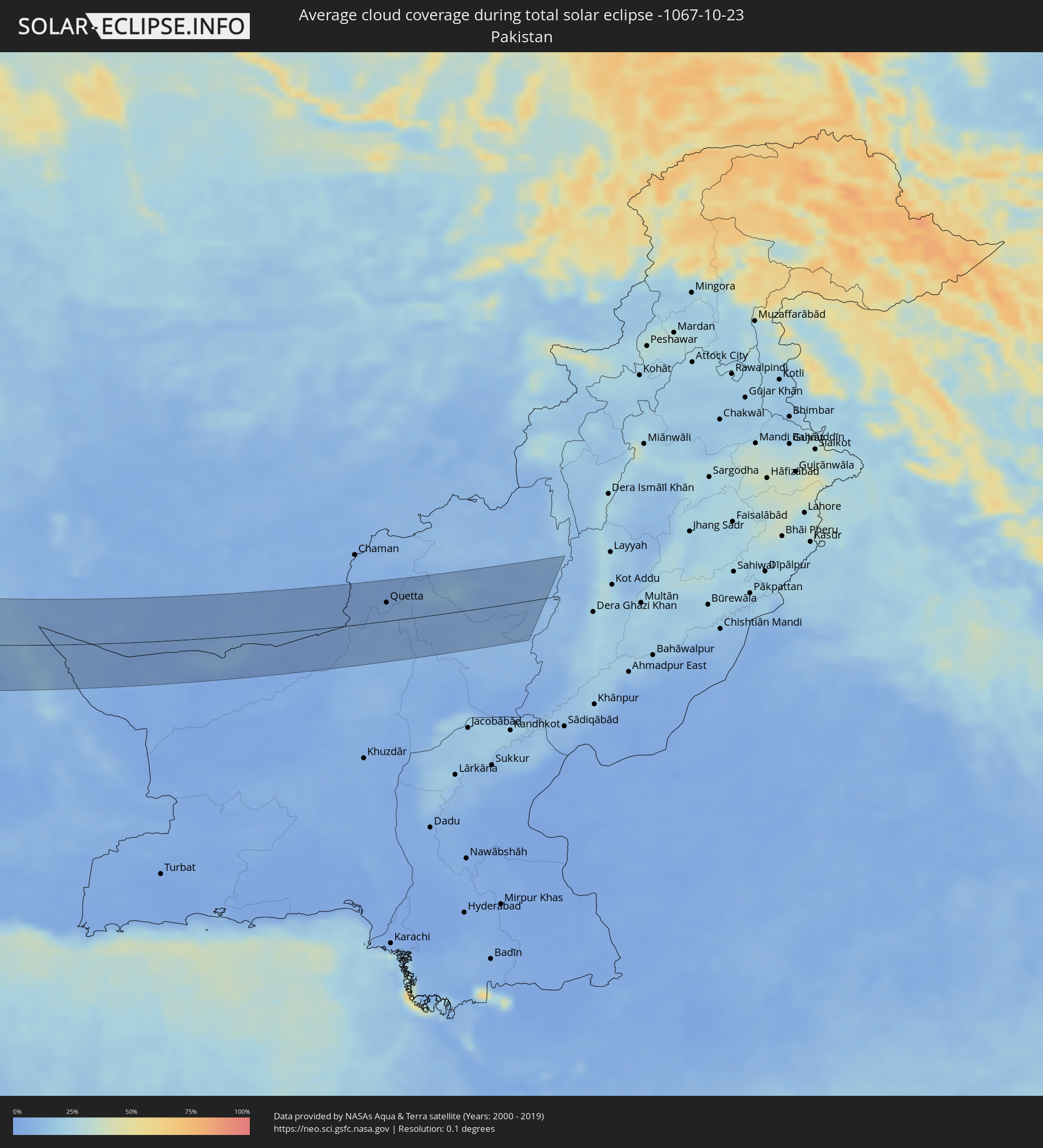 Pakistan
Cities inside the path of the eclipse
The following table shows all locations with a population of more than 5,000 inside the eclipse path. Cities which have more than 100,000 inhabitants are marked bold. A click at the locations opens a detailed map.
| City | Type | Eclipse duration | Local time of max. eclipse | Distance to central line | Ø Cloud coverage |
|
Namsos, Nord-Trøndelag
|
total | - | 12:11:24 UTC+01:00 | 70 km | 76% |
|
Sandnessjøen, Nordland
|
total | - | 12:11:37 UTC+01:00 | 42 km | 77% |
|
Mosjøen, Nordland
|
total | - | 12:12:06 UTC+01:00 | 59 km | 78% |
|
Östersund, Jämtland
|
total | - | 12:14:33 UTC+01:00 | 21 km | 83% |
|
Borlänge, Dalarna
|
total | - | 12:16:54 UTC+01:00 | 52 km | 78% |
|
Falun, Dalarna
|
total | - | 12:17:00 UTC+01:00 | 37 km | 74% |
|
Eskilstuna, Södermanland
|
total | - | 12:18:41 UTC+01:00 | 46 km | 83% |
|
Västerås, Västmanland
|
total | - | 12:18:33 UTC+01:00 | 32 km | 79% |
|
Nyköping, Södermanland
|
total | - | 12:19:38 UTC+01:00 | 46 km | 84% |
|
Gävle, Gävleborg
|
total | - | 12:18:19 UTC+01:00 | 42 km | 78% |
|
Södertälje, Stockholm
|
total | - | 12:19:52 UTC+01:00 | 6 km | 84% |
|
Uppsala, Uppsala
|
total | - | 12:19:23 UTC+01:00 | 34 km | 85% |
|
Upplands Väsby, Stockholm
|
total | - | 12:19:54 UTC+01:00 | 34 km | 85% |
|
Stockholm, Stockholm
|
total | - | 12:20:11 UTC+01:00 | 35 km | 85% |
|
Haninge, Stockholm
|
total | - | 12:20:23 UTC+01:00 | 32 km | 85% |
|
Åkersberga, Stockholm
|
total | - | 12:20:17 UTC+01:00 | 53 km | 85% |
|
Baltiysk, Kaliningrad
|
total | - | 12:26:15 UTC+01:00 | 70 km | 77% |
|
Svetlogorsk, Kaliningrad
|
total | - | 12:26:14 UTC+01:00 | 43 km | 84% |
|
Pionerskiy, Kaliningrad
|
total | - | 12:26:18 UTC+01:00 | 38 km | 83% |
|
Zelenogradsk, Kaliningrad
|
total | - | 12:26:34 UTC+01:00 | 23 km | 82% |
|
Olsztyn, Warmian-Masurian Voivodeship
|
total | - | 12:51:48 UTC+01:24 | 77 km | 80% |
|
Kaliningrad, Kaliningrad
|
total | - | 12:26:51 UTC+01:00 | 33 km | 83% |
|
Gur’yevsk, Kaliningrad
|
total | - | 12:26:53 UTC+01:00 | 24 km | 83% |
|
Bagrationovsk, Kaliningrad
|
total | - | 12:27:20 UTC+01:00 | 40 km | 83% |
|
Vec-Liepāja, Liepāja
|
total | - | 13:02:08 UTC+01:36 | 78 km | 76% |
|
Karosta, Liepāja
|
total | - | 13:02:07 UTC+01:36 | 79 km | 78% |
|
Liepāja, Liepāja
|
total | - | 13:02:09 UTC+01:36 | 77 km | 76% |
|
Nīca, Nīca
|
total | - | 13:02:22 UTC+01:36 | 72 km | 81% |
|
Gvardeysk, Kaliningrad
|
total | - | 12:27:31 UTC+01:00 | 3 km | 84% |
|
Palanga, Klaipėda County
|
total | - | 12:50:13 UTC+01:24 | 54 km | 80% |
|
Polessk, Kaliningrad
|
total | - | 12:27:20 UTC+01:00 | 9 km | 82% |
|
Klaipėda, Klaipėda County
|
total | - | 12:50:29 UTC+01:24 | 48 km | 80% |
|
Rucava, Rucavas
|
total | - | 13:02:39 UTC+01:36 | 70 km | 83% |
|
Kretinga, Klaipėda County
|
total | - | 12:50:27 UTC+01:24 | 63 km | 82% |
|
Gargždai, Klaipėda County
|
total | - | 12:50:47 UTC+01:24 | 64 km | 83% |
|
Silute, Klaipėda County
|
total | - | 12:51:14 UTC+01:24 | 53 km | 80% |
|
Ostrołęka, Masovian Voivodeship
|
total | - | 12:53:45 UTC+01:24 | 45 km | 82% |
|
Giżycko, Warmian-Masurian Voivodeship
|
total | - | 12:52:55 UTC+01:24 | 10 km | 81% |
|
Chernyakhovsk, Kaliningrad
|
total | - | 12:28:20 UTC+01:00 | 41 km | 86% |
|
Sovetsk, Kaliningrad
|
total | - | 12:27:56 UTC+01:00 | 64 km | 83% |
|
Neman, Kaliningrad
|
total | - | 12:28:09 UTC+01:00 | 71 km | 84% |
|
Łomża, Podlasie
|
total | - | 12:54:11 UTC+01:24 | 12 km | 81% |
|
Gusev, Kaliningrad
|
total | - | 12:28:48 UTC+01:00 | 61 km | 86% |
|
Siedlce, Masovian Voivodeship
|
total | - | 12:55:36 UTC+01:24 | 46 km | 80% |
|
Ełk, Warmian-Masurian Voivodeship
|
total | - | 12:53:48 UTC+01:24 | 37 km | 81% |
|
Łuków, Lublin Voivodeship
|
total | - | 12:55:59 UTC+01:24 | 52 km | 81% |
|
Lublin, Lublin Voivodeship
|
total | - | 12:57:00 UTC+01:24 | 74 km | 76% |
|
Augustów, Podlasie
|
total | - | 12:54:28 UTC+01:24 | 74 km | 80% |
|
Biała Podlaska, Lublin Voivodeship
|
total | - | 12:56:42 UTC+01:24 | 2 km | 77% |
|
Białystok, Podlasie
|
total | - | 12:55:29 UTC+01:24 | 53 km | 83% |
|
Zamość, Lublin Voivodeship
|
total | - | 12:58:27 UTC+01:24 | 58 km | 77% |
|
Chełm, Lublin Voivodeship
|
total | - | 12:58:11 UTC+01:24 | 23 km | 78% |
|
Brest, Brest
|
total | - | 13:23:17 UTC+01:50 | 37 km | 81% |
|
Kamyanyets, Brest
|
total | - | 13:23:04 UTC+01:50 | 58 km | 83% |
|
Zhabinka, Brest
|
total | - | 13:23:32 UTC+01:50 | 61 km | 80% |
|
Lviv, Lviv
|
total | - | 13:38:33 UTC+02:02 | 54 km | 77% |
|
Malaryta, Brest
|
total | - | 13:24:06 UTC+01:50 | 46 km | 76% |
|
Novovolyns’k, Volyn
|
total | - | 13:37:35 UTC+02:02 | 1 km | 77% |
|
Chervonohrad, Lviv
|
total | - | 13:38:06 UTC+02:02 | 12 km | 76% |
|
Volodymyr-Volyns’kyy, Volyn
|
total | - | 13:37:37 UTC+02:02 | 16 km | 76% |
|
Kobryn, Brest
|
total | - | 13:23:54 UTC+01:50 | 83 km | 78% |
|
Kalush, Ivano-Frankivsk
|
total | - | 13:40:03 UTC+02:02 | 74 km | 75% |
|
Kovel’, Volyn
|
total | - | 13:37:37 UTC+02:02 | 58 km | 78% |
|
Ivano-Frankivs’k, Ivano-Frankivsk
|
total | - | 13:40:34 UTC+02:02 | 57 km | 75% |
|
Kolomyya, Ivano-Frankivsk
|
total | - | 13:41:30 UTC+02:02 | 56 km | 74% |
|
Luts’k, Volyn
|
total | - | 13:38:56 UTC+02:02 | 76 km | 80% |
|
Ternopil’, Ternopil
|
total | - | 13:40:49 UTC+02:02 | 34 km | 78% |
|
Chernivtsi, Chernivtsi
|
total | - | 13:42:56 UTC+02:02 | 10 km | 74% |
|
Suceava, Suceava
|
total | - | 13:26:34 UTC+01:44 | 24 km | 71% |
|
Piatra Neamţ, Neamţ
|
total | - | 13:27:41 UTC+01:44 | 58 km | 65% |
|
Kamieniec Podolski, Khmelnytskyi
|
total | - | 13:43:11 UTC+02:02 | 53 km | 75% |
|
Botoşani, Botoşani
|
total | - | 13:26:55 UTC+01:44 | 9 km | 73% |
|
Bacău, Bacău
|
total | - | 13:28:55 UTC+01:44 | 39 km | 71% |
|
Roman, Neamţ
|
total | - | 13:28:25 UTC+01:44 | 18 km | 70% |
|
Focșani, Vrancea
|
total | - | 13:30:32 UTC+01:44 | 69 km | 69% |
|
Edineţ, Raionul Edineţ
|
total | - | 13:37:42 UTC+01:55 | 73 km | 72% |
|
Rîşcani, Rîşcani
|
total | - | 13:38:20 UTC+01:55 | 79 km | 70% |
|
Iaşi, Iaşi
|
total | - | 13:28:54 UTC+01:44 | 40 km | 70% |
|
Bârlad, Vaslui
|
total | - | 13:30:22 UTC+01:44 | 7 km | 68% |
|
Fălești, Făleşti
|
total | - | 13:39:03 UTC+01:55 | 69 km | 71% |
|
Vaslui, Vaslui
|
total | - | 13:29:51 UTC+01:44 | 20 km | 68% |
|
Ungheni, Ungheni
|
total | - | 13:39:42 UTC+01:55 | 55 km | 70% |
|
Brăila, Brăila
|
total | - | 13:32:13 UTC+01:44 | 40 km | 70% |
|
Galaţi, Galaţi
|
total | - | 13:32:01 UTC+01:44 | 25 km | 70% |
|
Nisporeni, Nisporeni
|
total | - | 13:40:21 UTC+01:55 | 74 km | 69% |
|
Cahul, Cahul
|
total | - | 13:42:07 UTC+01:55 | 10 km | 67% |
|
Leova, Leova
|
total | - | 13:41:20 UTC+01:55 | 46 km | 69% |
|
Vulcăneşti, Găgăuzia
|
total | - | 13:42:43 UTC+01:55 | 12 km | 67% |
|
Hînceşti, Hînceşti
|
total | - | 13:41:14 UTC+01:55 | 87 km | 69% |
|
Constanţa, Constanța
|
total | - | 13:34:43 UTC+01:44 | 60 km | 66% |
|
Comrat, Găgăuzia
|
total | - | 13:42:07 UTC+01:55 | 63 km | 65% |
|
Taraclia, Taraclia
|
total | - | 13:42:43 UTC+01:55 | 42 km | 68% |
|
Cimişlia, Cimişlia
|
total | - | 13:41:54 UTC+01:55 | 83 km | 65% |
|
Tulcea, Tulcea
|
total | - | 13:33:24 UTC+01:44 | 9 km | 71% |
|
Ceadîr-Lunga, Găgăuzia
|
total | - | 13:42:41 UTC+01:55 | 61 km | 68% |
|
Izmayil, Odessa
|
total | - | 13:50:51 UTC+02:02 | 22 km | 71% |
|
Bolu, Bolu
|
total | - | 13:56:44 UTC+01:56 | 77 km | 57% |
|
Zonguldak, Zonguldak
|
total | - | 13:55:47 UTC+01:56 | 17 km | 59% |
|
Karabük, Karabük
|
total | - | 13:57:17 UTC+01:56 | 23 km | 57% |
|
Ankara, Ankara
|
total | - | 13:59:46 UTC+01:56 | 50 km | 57% |
|
Kırıkkale, Kırıkkale
|
total | - | 14:00:45 UTC+01:56 | 12 km | 53% |
|
Aksaray, Aksaray
|
total | - | 14:04:00 UTC+01:56 | 84 km | 52% |
|
Kırşehir, Kırşehir
|
total | - | 14:02:50 UTC+01:56 | 18 km | 52% |
|
Kayseri, Kayseri
|
total | - | 14:05:15 UTC+01:56 | 38 km | 57% |
|
Ceyhan, Adana
|
total | - | 14:08:44 UTC+01:56 | 72 km | 45% |
|
İskenderun, Hatay
|
total | - | 14:09:59 UTC+01:56 | 85 km | 46% |
|
Osmaniye, Osmaniye
|
total | - | 14:09:12 UTC+01:56 | 41 km | 46% |
|
‘Afrīn, Aleppo
|
total | - | 14:39:16 UTC+02:25 | 48 km | 41% |
|
Kahramanmaraş, Kahramanmaraş
|
total | - | 14:09:08 UTC+01:56 | 41 km | 49% |
|
I‘zāz, Aleppo
|
total | - | 14:39:21 UTC+02:25 | 31 km | 40% |
|
Aleppo, Aleppo
|
total | - | 14:40:12 UTC+02:25 | 55 km | 41% |
|
As Safīrah, Aleppo
|
total | - | 14:40:41 UTC+02:25 | 53 km | 42% |
|
Gaziantep, Gaziantep
|
total | - | 14:10:39 UTC+01:56 | 28 km | 46% |
|
Al Bāb, Aleppo
|
total | - | 14:40:20 UTC+02:25 | 20 km | 38% |
|
Tādif, Aleppo
|
total | - | 14:40:24 UTC+02:25 | 21 km | 39% |
|
Manbij, Aleppo
|
total | - | 14:40:36 UTC+02:25 | 20 km | 35% |
|
‘Ayn al ‘Arab, Aleppo
|
total | - | 14:40:26 UTC+02:25 | 73 km | 38% |
|
Ath Thawrah, Ar-Raqqah
|
total | - | 14:42:36 UTC+02:25 | 3 km | 33% |
|
Ar Raqqah, Ar-Raqqah
|
total | - | 14:42:57 UTC+02:25 | 34 km | 49% |
|
Deir ez-Zor, Deir ez-Zor
|
total | - | 14:45:27 UTC+02:25 | 45 km | 28% |
|
Al Mayādīn, Deir ez-Zor
|
total | - | 14:46:24 UTC+02:25 | 34 km | 37% |
|
Ālbū Kamāl, Deir ez-Zor
|
total | - | 14:47:59 UTC+02:25 | 8 km | 33% |
|
Ramadi, Anbar
|
total | - | 15:25:01 UTC+02:57 | 31 km | 32% |
|
Al Fallūjah, Anbar
|
total | - | 15:25:41 UTC+02:57 | 46 km | 33% |
|
Karbala, Karbalāʼ
|
total | - | 15:27:17 UTC+02:57 | 14 km | 26% |
|
Abū Ghurayb, Mayorality of Baghdad
|
total | - | 15:26:12 UTC+02:57 | 60 km | 34% |
|
Najaf, An Najaf
|
total | - | 15:28:43 UTC+02:57 | 59 km | 28% |
|
Baghdad, Mayorality of Baghdad
|
total | - | 15:26:22 UTC+02:57 | 73 km | 33% |
|
Al Ḩillah, Bābil
|
total | - | 15:27:59 UTC+02:57 | 12 km | 31% |
|
Ad Dīwānīyah, Al Qādisīyah
|
total | - | 15:29:24 UTC+02:57 | 38 km | 26% |
|
As Samawah, Al Muthanná
|
total | - | 15:30:59 UTC+02:57 | 90 km | 20% |
|
Al Kūt, Wāsiţ
|
total | - | 15:29:23 UTC+02:57 | 50 km | 23% |
|
An Nāşirīyah, Dhi Qar
|
total | - | 15:32:29 UTC+02:57 | 82 km | 25% |
|
Al ‘Amārah, Maysan
|
total | - | 15:31:57 UTC+02:57 | 30 km | 24% |
|
Basrah, Basra Governorate
|
total | - | 15:34:58 UTC+02:57 | 87 km | 20% |
|
Khorramshahr, Khuzestan
|
total | - | 16:03:37 UTC+03:25 | 81 km | 22% |
|
Abadan, Khuzestan
|
total | - | 16:03:54 UTC+03:25 | 88 km | 20% |
|
Ahvaz, Khuzestan
|
total | - | 16:02:30 UTC+03:25 | 26 km | 19% |
|
Behbahān, Khuzestan
|
total | - | 16:05:13 UTC+03:25 | 7 km | 17% |
|
Dogonbadan, Kohgīlūyeh va Būyer Aḩmad
|
total | - | 16:06:07 UTC+03:25 | 19 km | 14% |
|
Yasuj, Kohgīlūyeh va Būyer Aḩmad
|
total | - | 16:06:14 UTC+03:25 | 32 km | 19% |
|
Kāzerūn, Fars
|
total | - | 16:08:09 UTC+03:25 | 80 km | 12% |
|
Shiraz, Fars
|
total | - | 16:08:52 UTC+03:25 | 64 km | 15% |
|
Sirjan, Kerman
|
total | - | 16:11:29 UTC+03:25 | 36 km | 9% |
|
Rafsanjān, Kerman
|
total | - | 16:10:03 UTC+03:25 | 73 km | 8% |
|
Kerman, Kerman
|
total | - | 16:10:59 UTC+03:25 | 69 km | 9% |
|
Bam, Kerman
|
total | - | 16:13:46 UTC+03:25 | 54 km | 8% |
|
Zahedan, Sistan and Baluchestan
|
total | - | 16:14:30 UTC+03:25 | 7 km | 10% |
|
Rūdbār, Nimroz
|
total | - | 16:48:31 UTC+04:00 | 62 km | 6% |
|
Nushki, Balochistān
|
total | - | 17:19:04 UTC+04:28 | 30 km | 3% |
|
Mastung, Balochistān
|
total | - | 17:18:57 UTC+04:28 | 11 km | 6% |
|
Kot Malik Barkhurdār, Balochistān
|
total | - | 17:18:21 UTC+04:28 | 32 km | 7% |
|
Quetta, Balochistān
|
total | - | 17:18:22 UTC+04:28 | 31 km | 7% |
|
Mach, Balochistān
|
total | - | 17:19:00 UTC+04:28 | 10 km | 6% |
|
Alik Ghund, Balochistān
|
total | - | 17:18:03 UTC+04:28 | 57 km | 7% |
|
Dādhar, Balochistān
|
total | - | 17:19:43 UTC+04:28 | 57 km | 7% |
|
Sibi, Balochistān
|
total | - | 17:19:40 UTC+04:28 | 52 km | 6% |
|
Harnai, Balochistān
|
total | - | 17:18:48 UTC+04:28 | 9 km | 7% |
|
Duki, Balochistān
|
total | - | 17:18:54 UTC+04:28 | 6 km | 8% |
|
Loralai, Balochistān
|
total | - | 17:18:34 UTC+04:28 | 29 km | 8% |
|
Kohlu, Balochistān
|
total | - | 17:19:29 UTC+04:28 | 32 km | 9% |
|
Bārkhān, Balochistān
|
total | - | 17:19:33 UTC+04:28 | 36 km | 9% |