Total solar eclipse of 03/18/-1074
| Day of week: | Saturday |
| Maximum duration of eclipse: | 01m46s |
| Maximum width of eclipse path: | 173 km |
| Saros cycle: | 22 |
| Coverage: | 100% |
| Magnitude: | 1.0236 |
| Gamma: | 0.8864 |
Wo kann man die Sonnenfinsternis vom 03/18/-1074 sehen?
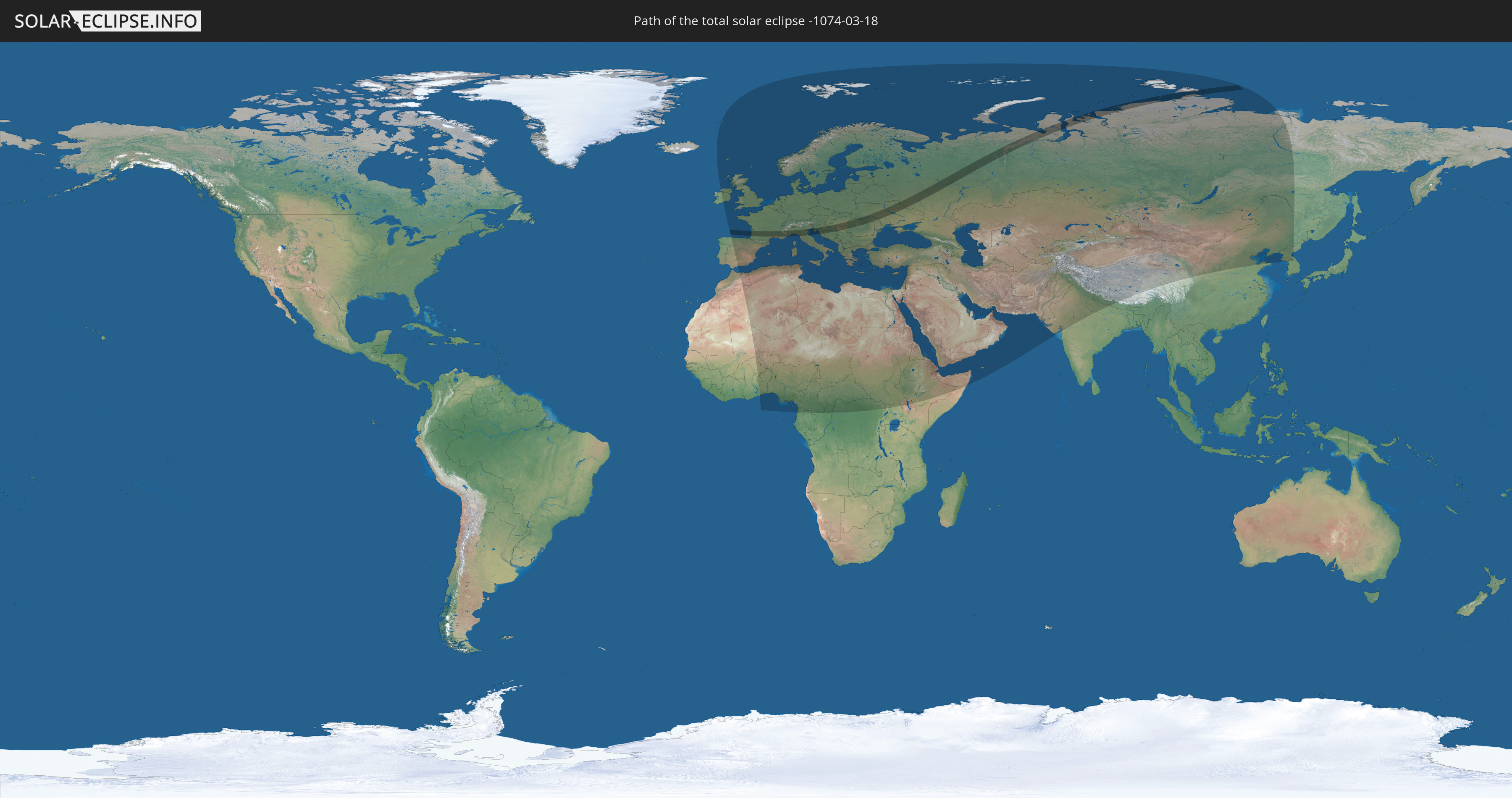
Die Sonnenfinsternis am 03/18/-1074 kann man in 106 Ländern als partielle Sonnenfinsternis beobachten.
Der Finsternispfad verläuft durch 11 Länder. Nur in diesen Ländern ist sie als total Sonnenfinsternis zu sehen.
In den folgenden Ländern ist die Sonnenfinsternis total zu sehen
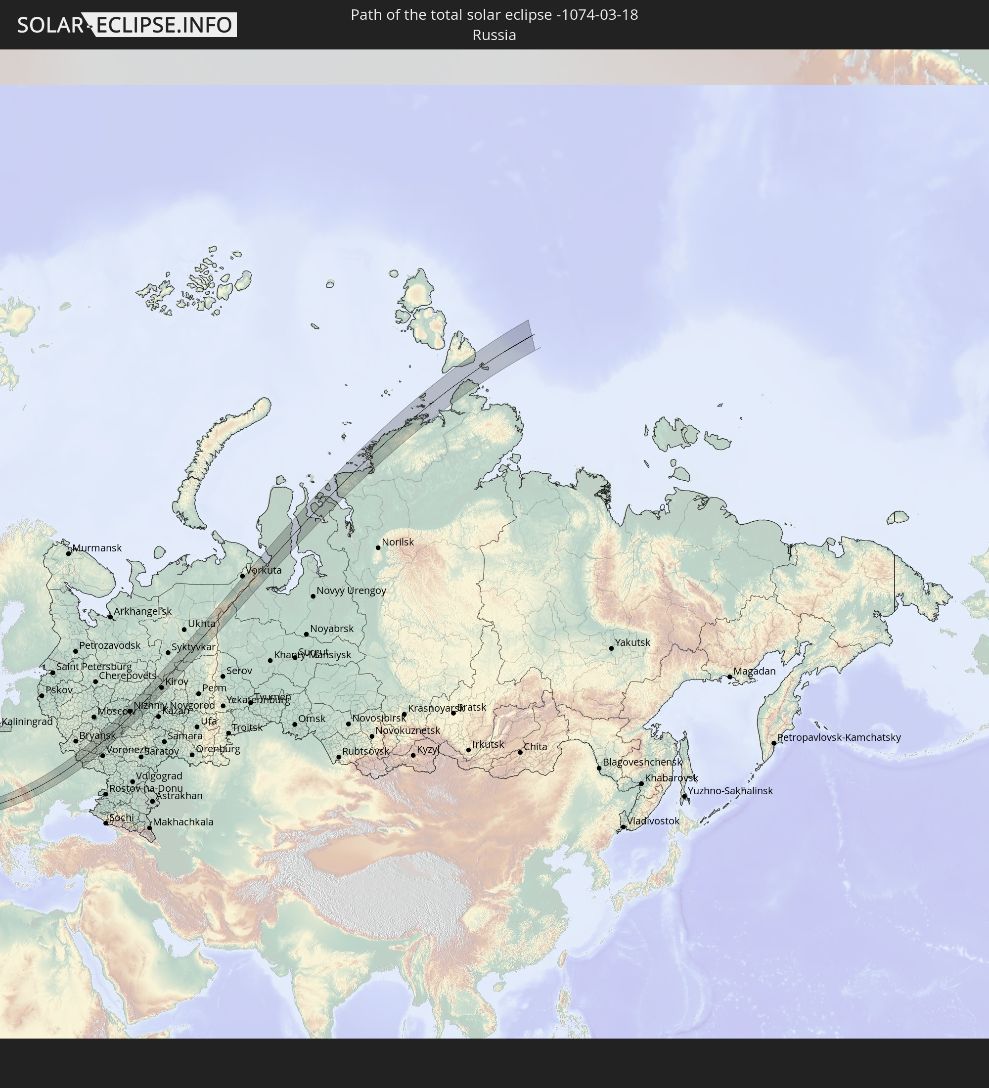 Russia
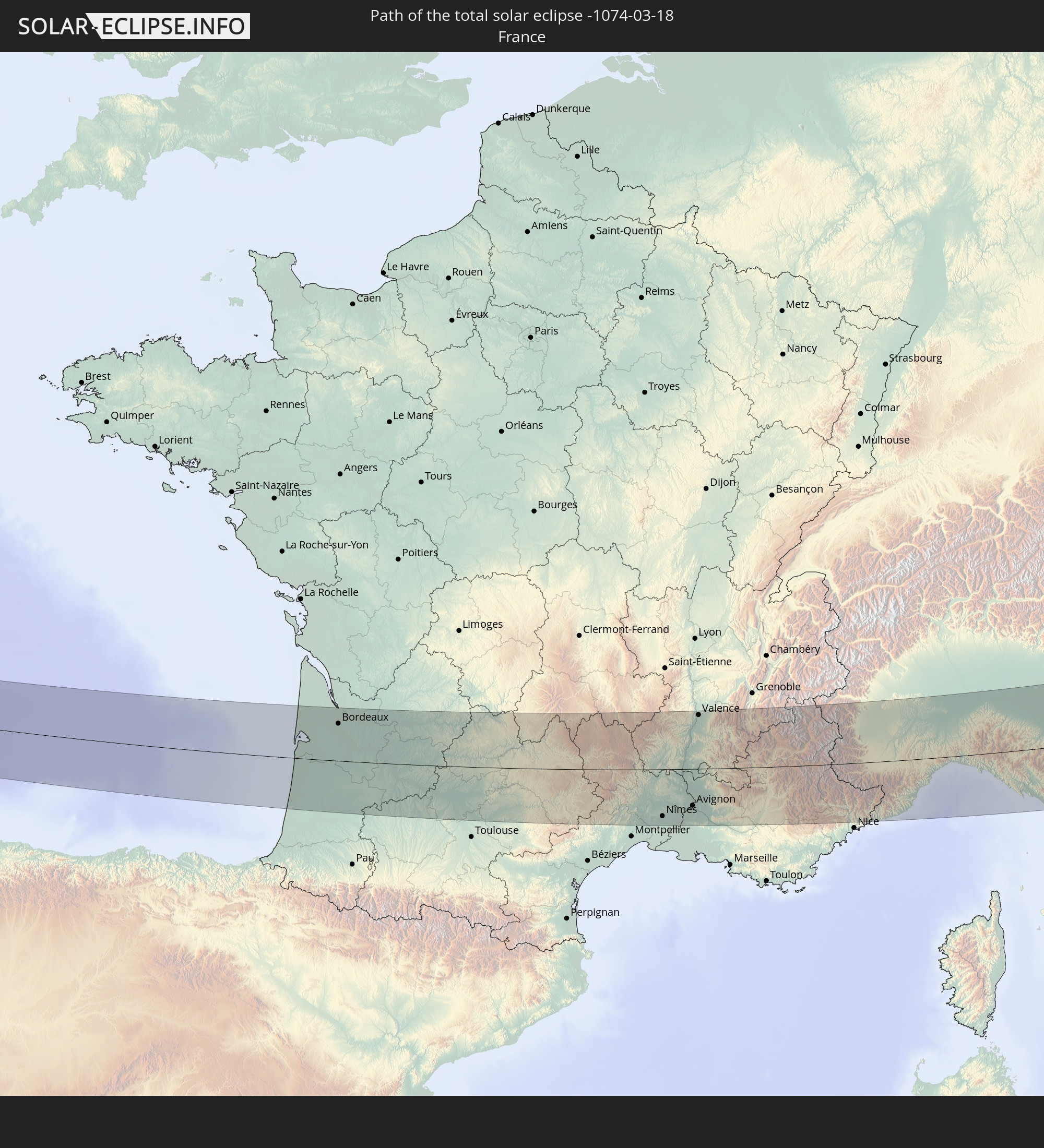 France
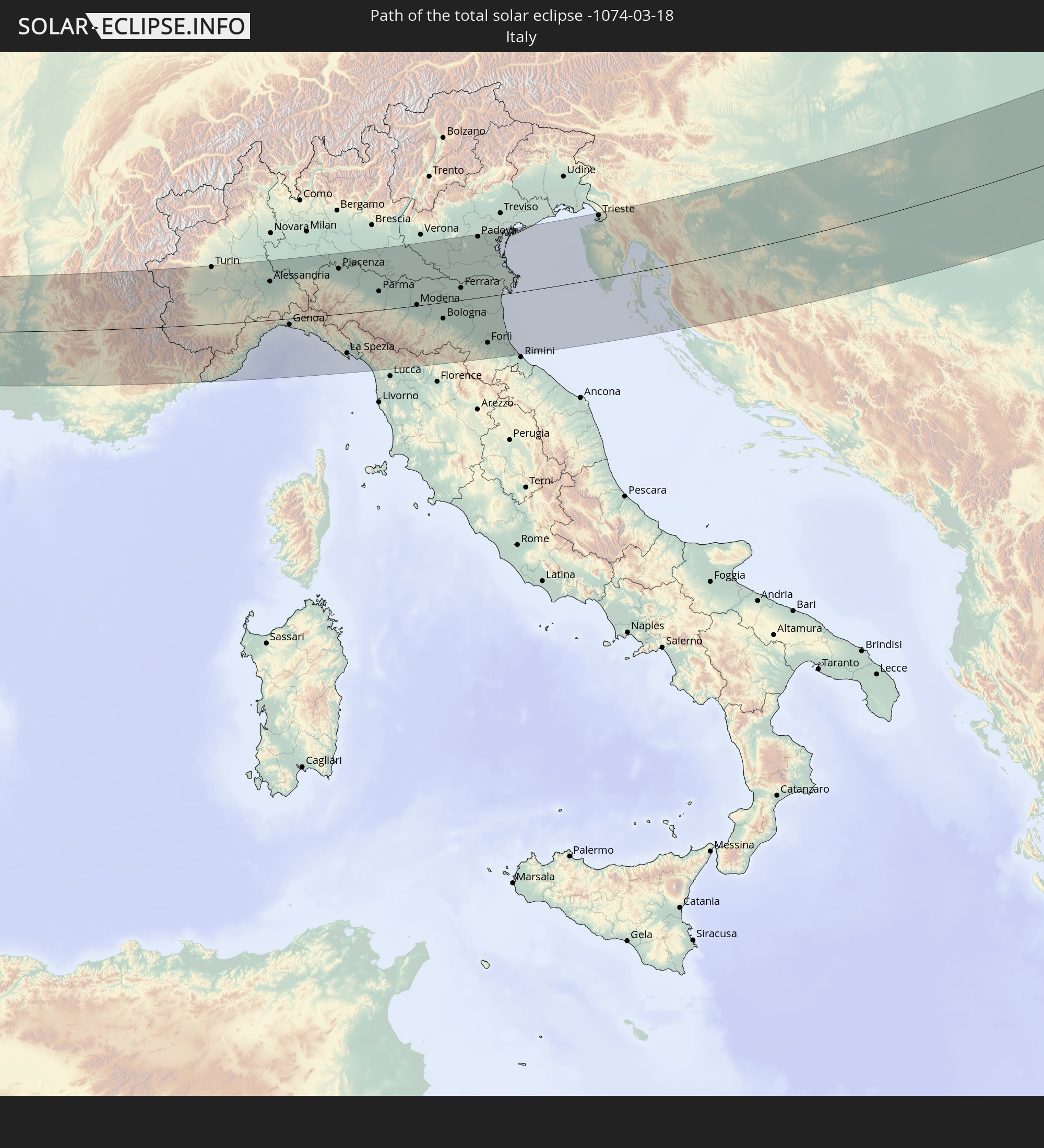 Italy
Italy
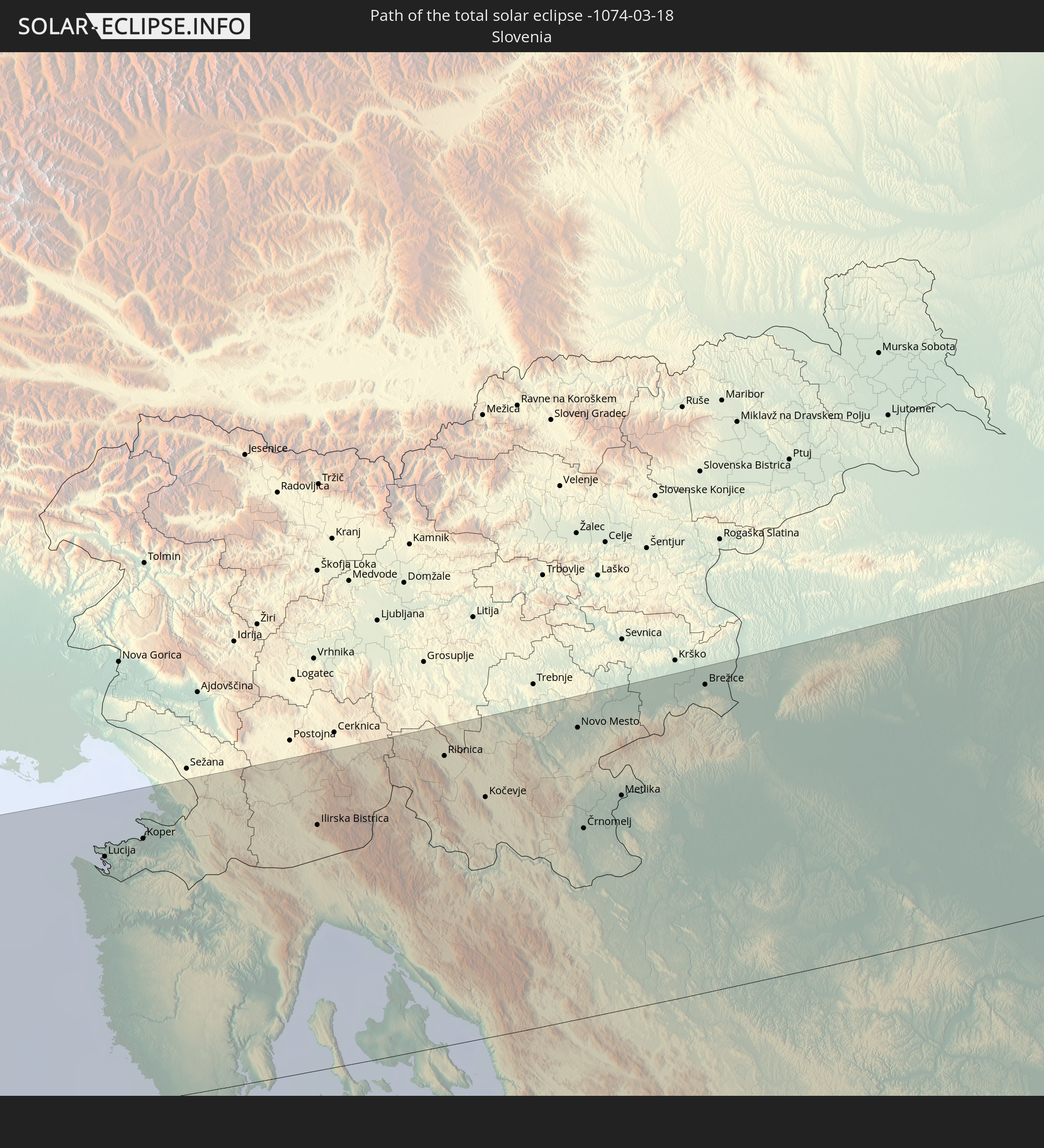 Slovenia
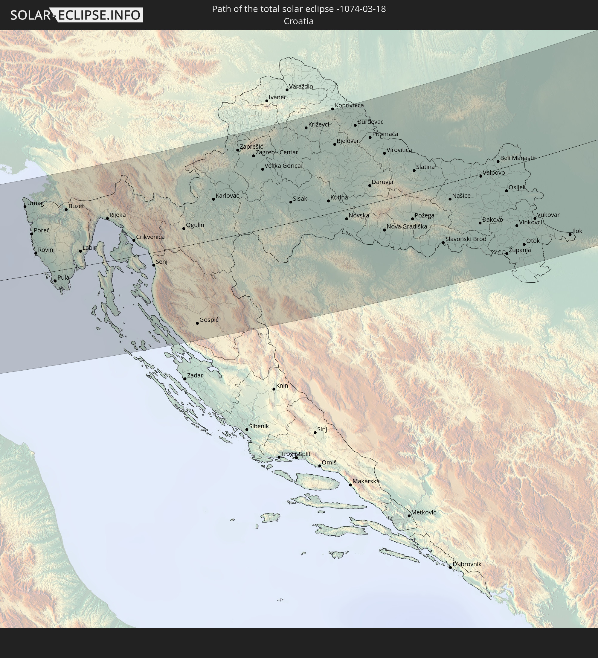 Croatia
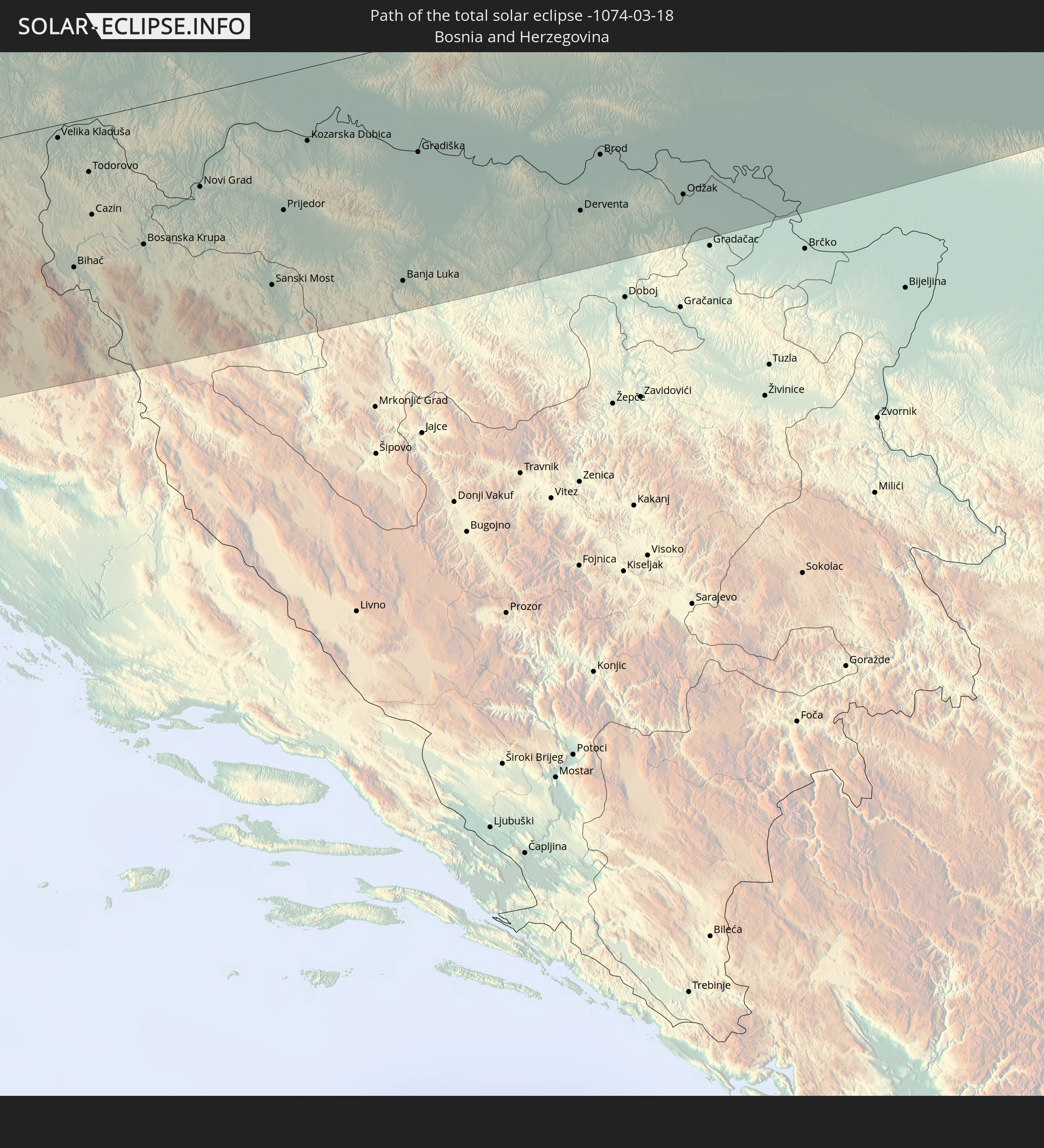 Bosnia and Herzegovina
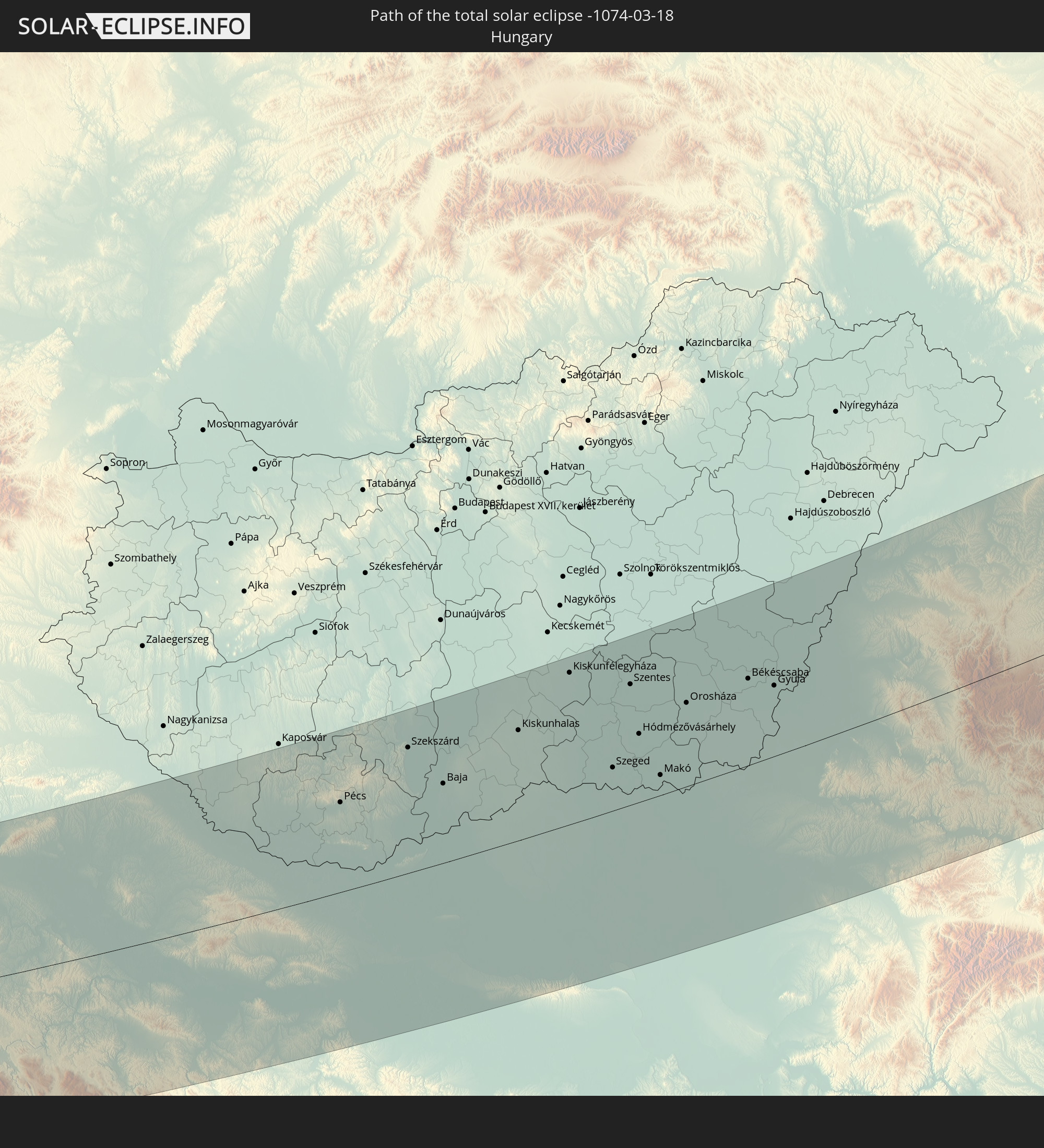 Hungary
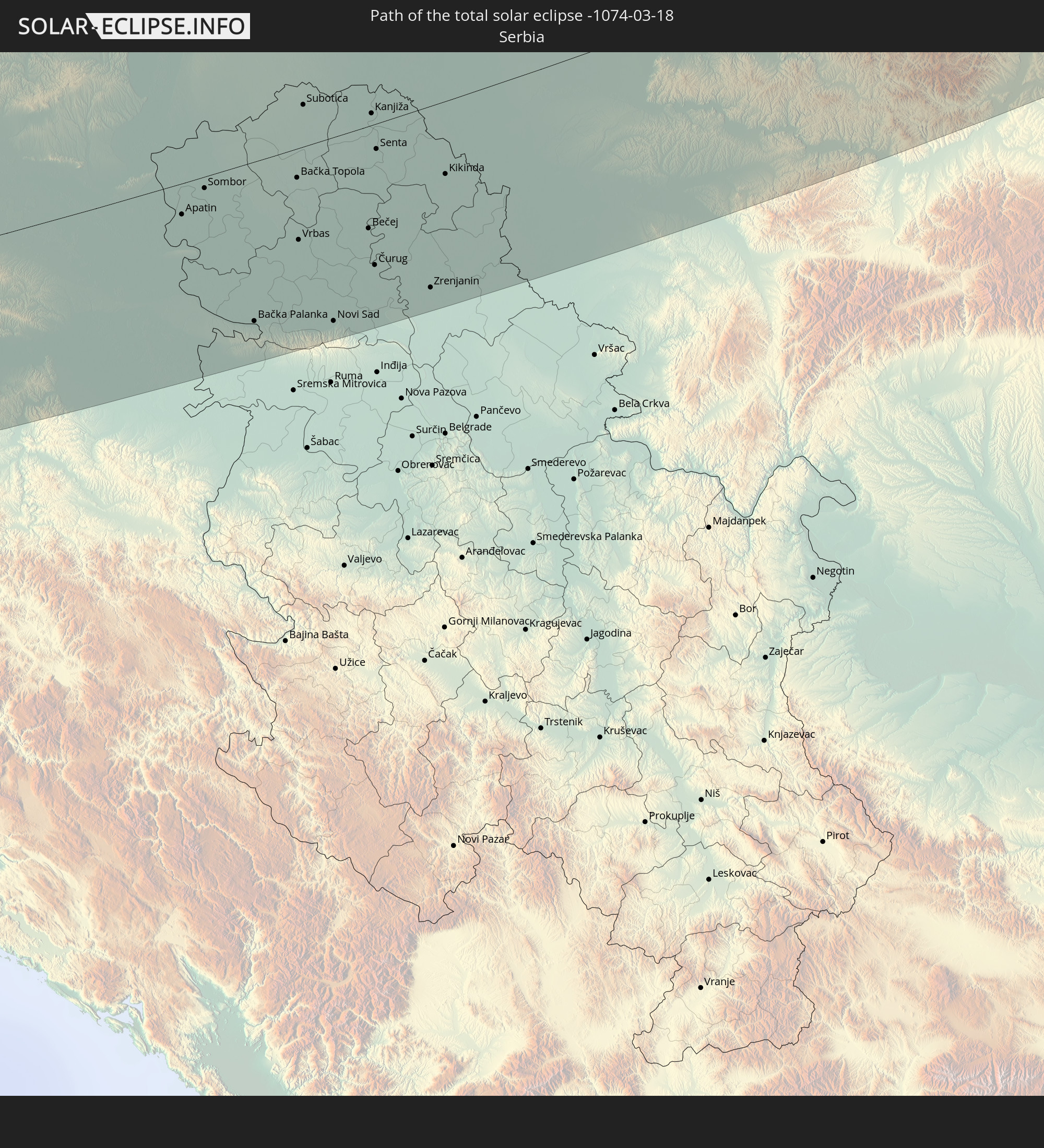 Serbia
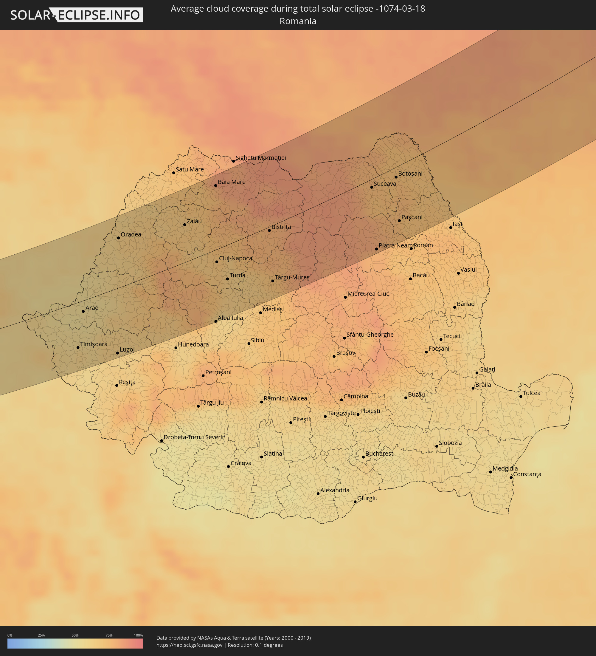
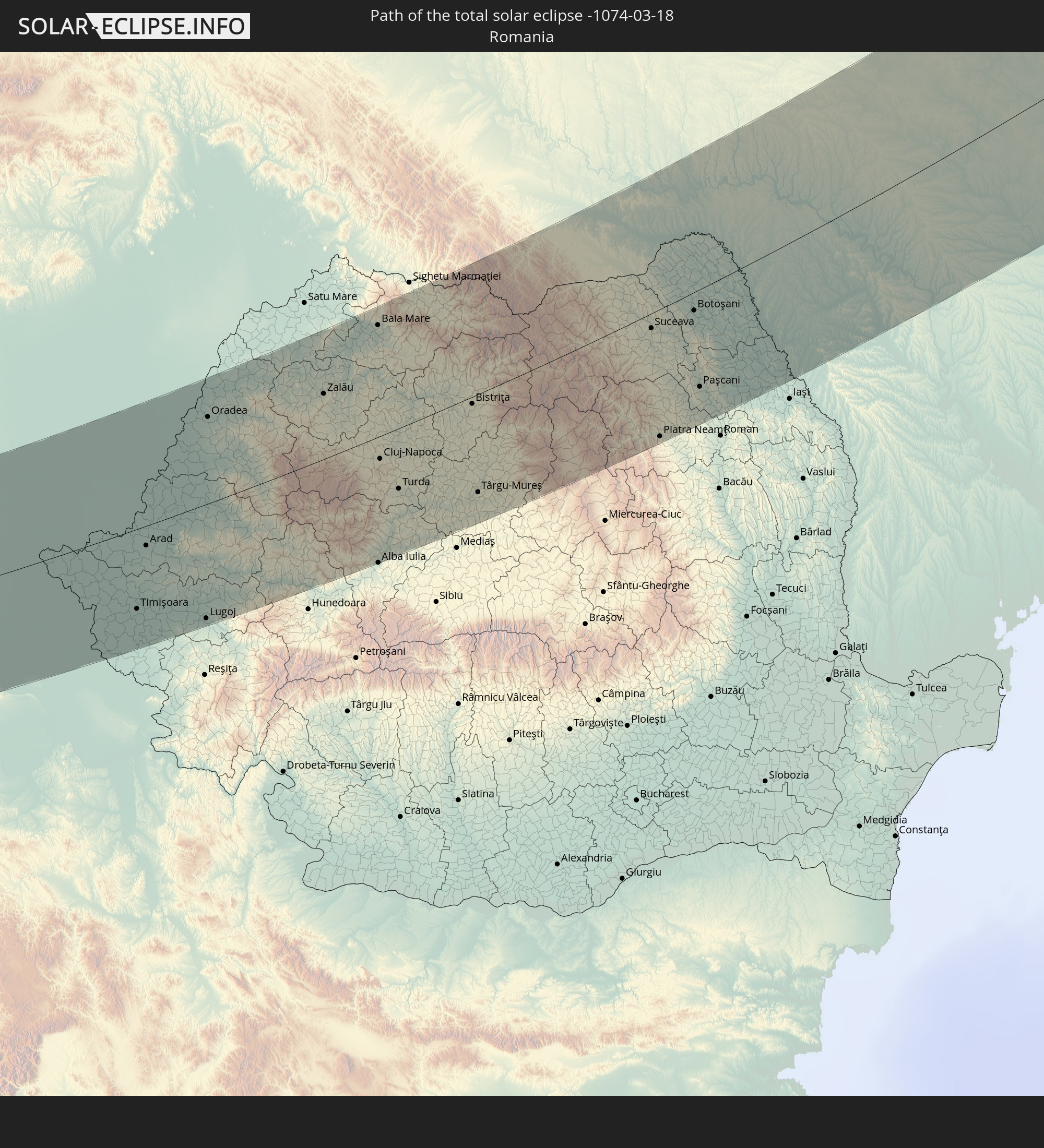 Romania
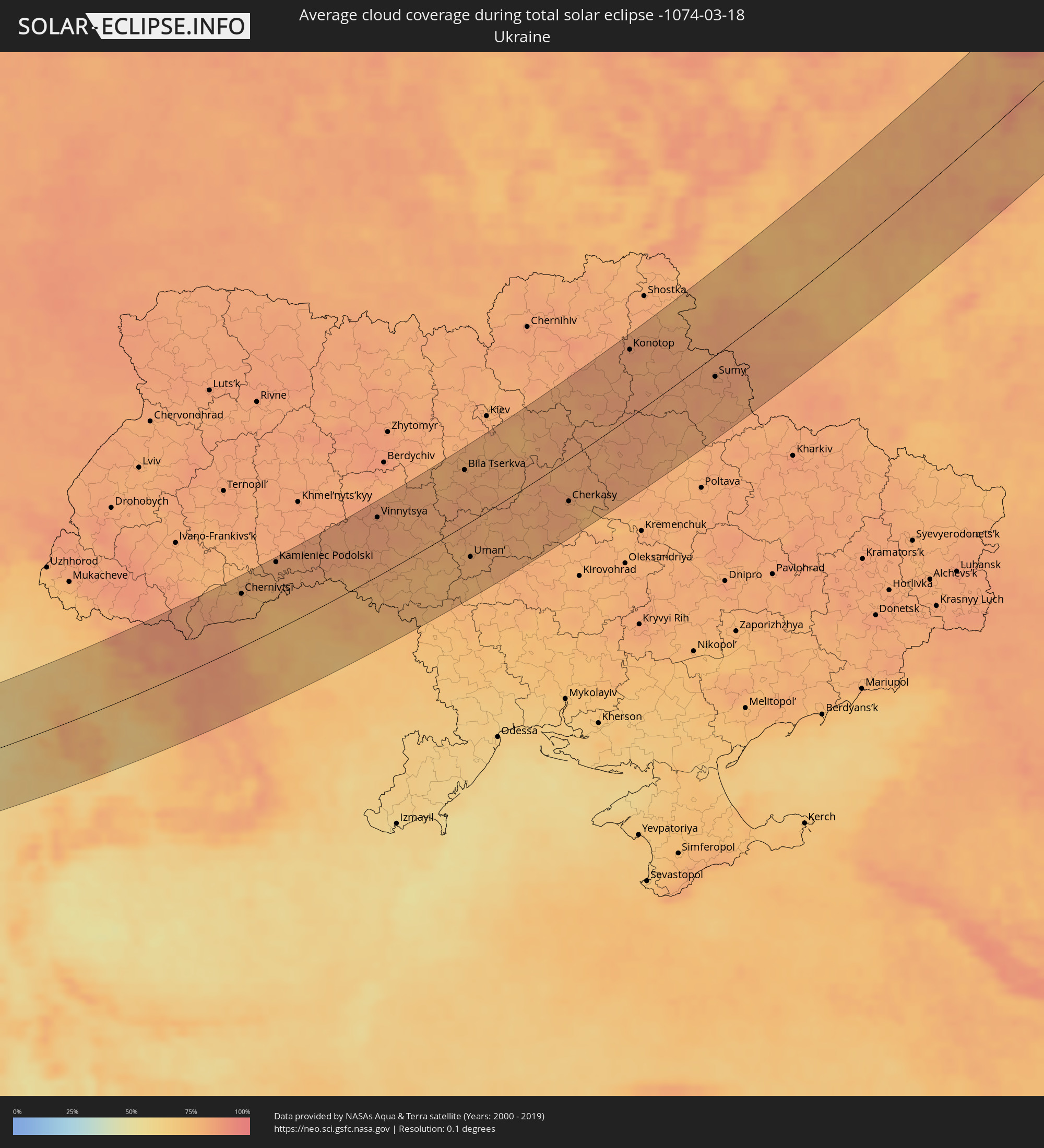
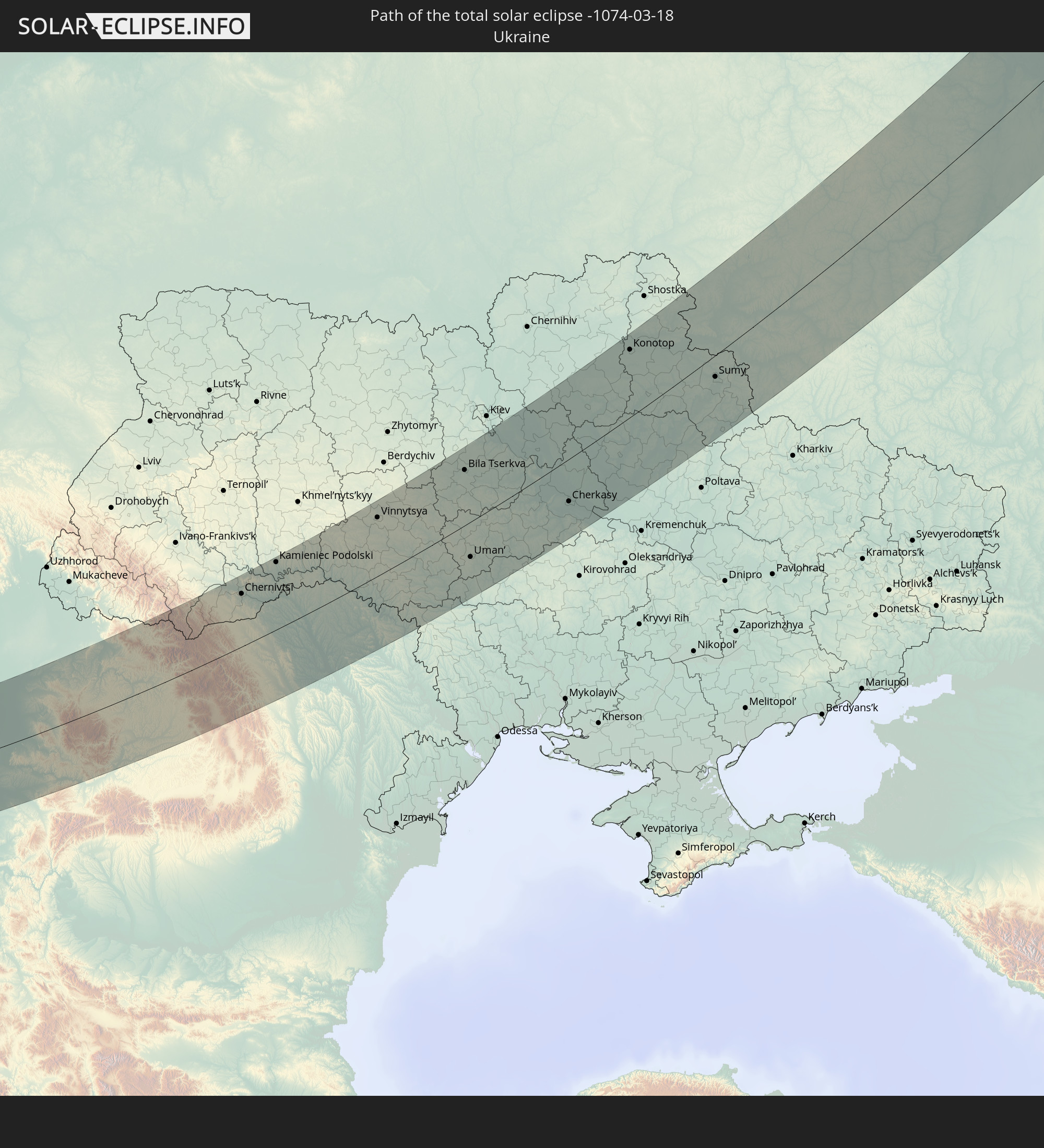 Ukraine
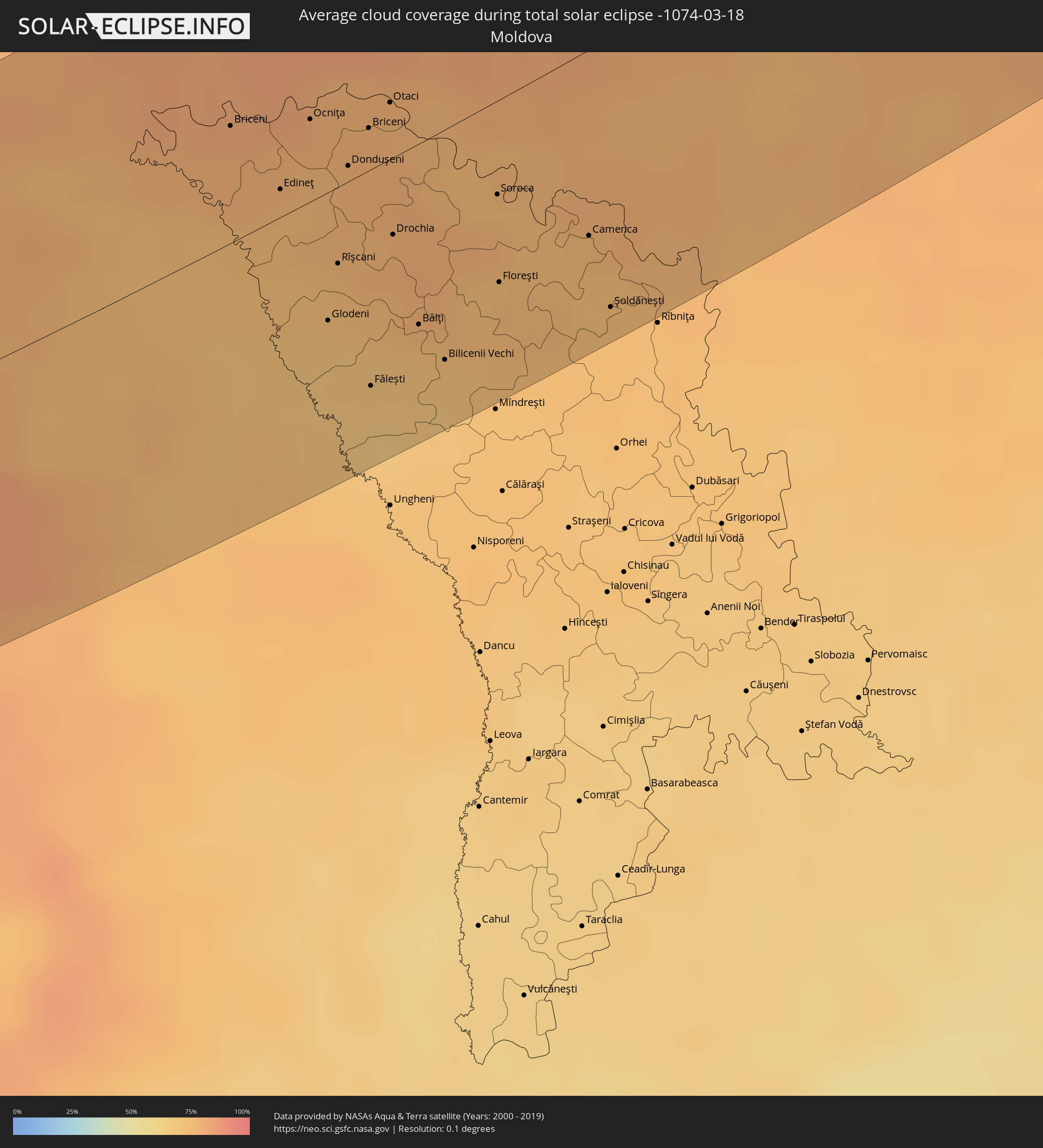
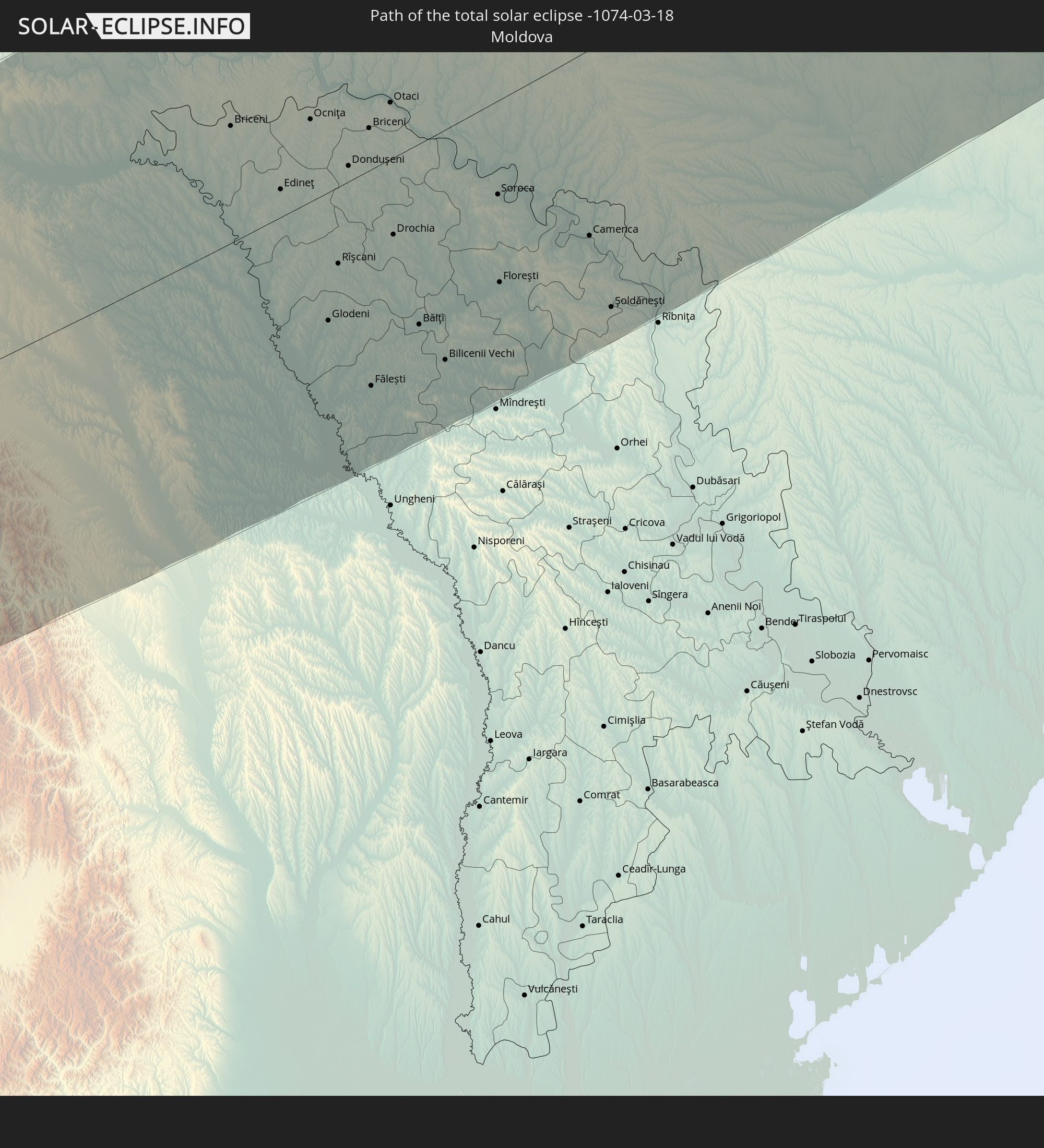 Moldova
In den folgenden Ländern ist die Sonnenfinsternis partiell zu sehen
 Russia
 Spain
Spain
 Morocco
 Mali
Mali
 Republic of Ireland
 Svalbard and Jan Mayen
 Algeria
 United Kingdom
 Faroe Islands
 Burkina Faso
 France
 Isle of Man
 Ghana
Ghana
 Guernsey
 Jersey
 Togo
Togo
 Niger
Niger
 Benin
Benin
 Andorra
 Belgium
 Nigeria
 Netherlands
 Norway
 Equatorial Guinea
 Luxembourg
 Germany
 Switzerland
 Italy
Italy
 Monaco
 Tunisia
 Denmark
 Cameroon
 Gabon
Gabon
 Libya
Libya
 Liechtenstein
 Austria
 Sweden
 Republic of the Congo
 Czechia
 Democratic Republic of the Congo
 San Marino
 Vatican City
 Slovenia
 Chad
Chad
 Croatia
 Poland
 Malta
Malta
 Central African Republic
 Bosnia and Herzegovina
 Hungary
 Slovakia
 Montenegro
 Serbia
 Albania
 Åland Islands
 Greece
 Romania
 Republic of Macedonia
 Finland
 Lithuania
 Latvia
 Estonia
 Sudan
Sudan
 Ukraine
 Bulgaria
 Belarus
 Egypt
Egypt
 Turkey
 Moldova
 Uganda
 Cyprus
 Ethiopia
 Kenya
Kenya
 State of Palestine
 Israel
 Saudi Arabia
 Jordan
 Lebanon
 Syria
Syria
 Eritrea
 Iraq
Iraq
 Georgia
 Somalia
 Djibouti
 Yemen
Yemen
 Armenia
 Iran
Iran
 Azerbaijan
 Kazakhstan
 Kuwait
 Bahrain
 Qatar
Qatar
 United Arab Emirates
 Oman
Oman
 Turkmenistan
 Uzbekistan
 Afghanistan
 Pakistan
 Tajikistan
 India
India
 Kyrgyzstan
 China
China
 Nepal
Nepal
 Mongolia
 North Korea
 South Korea
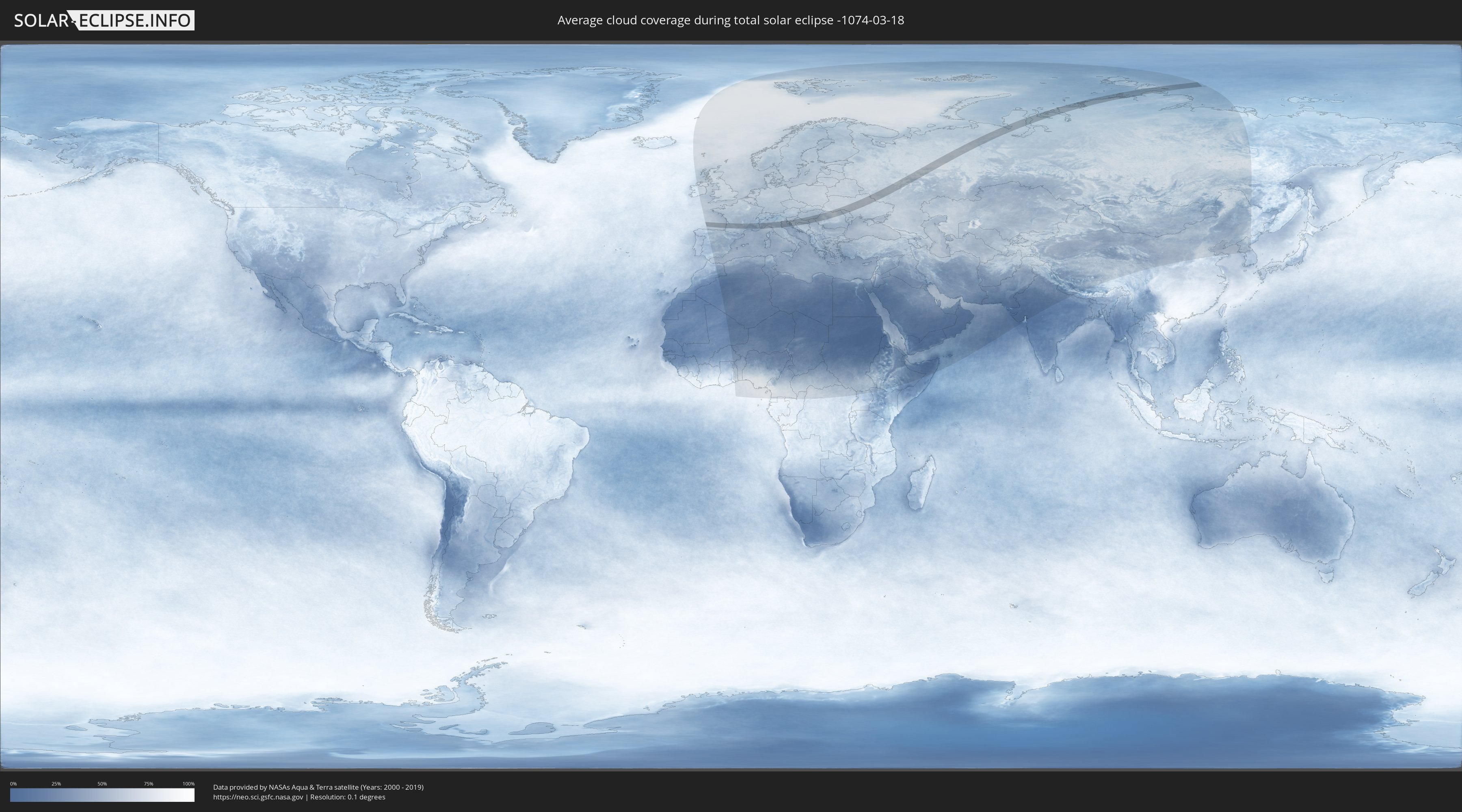
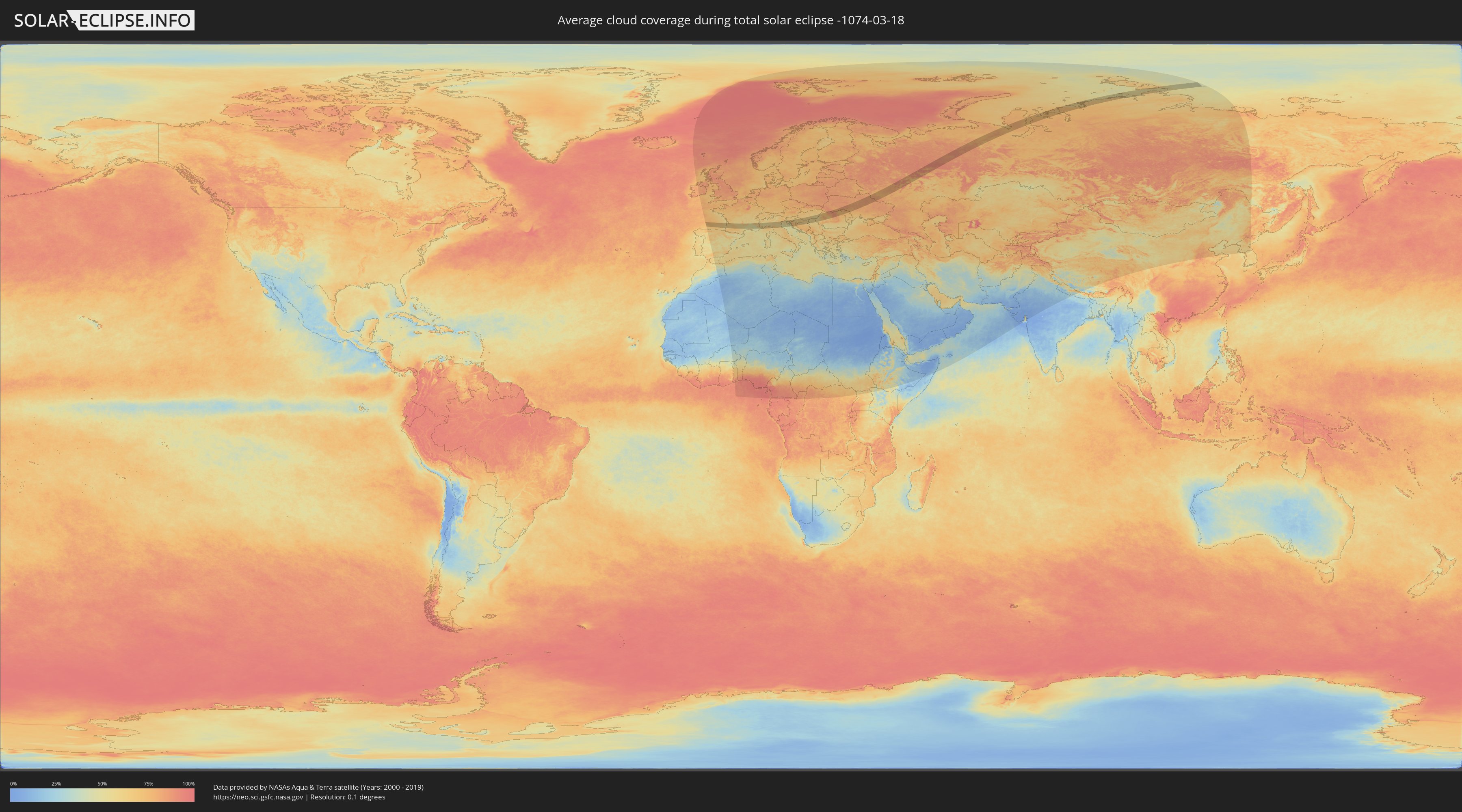
How will be the weather during the total solar eclipse on 03/18/-1074?
Where is the best place to see the total solar eclipse of 03/18/-1074?
The following maps show the average cloud coverage for the day of the total solar eclipse.
With the help of these maps, it is possible to find the place along the eclipse path, which has the best
chance of a cloudless sky.
Nevertheless, you should consider local circumstances and inform about the weather of your chosen
observation site.
The data is provided by NASAs satellites
AQUA and TERRA.
The cloud maps are averaged over a period of 19 years (2000 - 2019).
Detailed country maps
 Russia
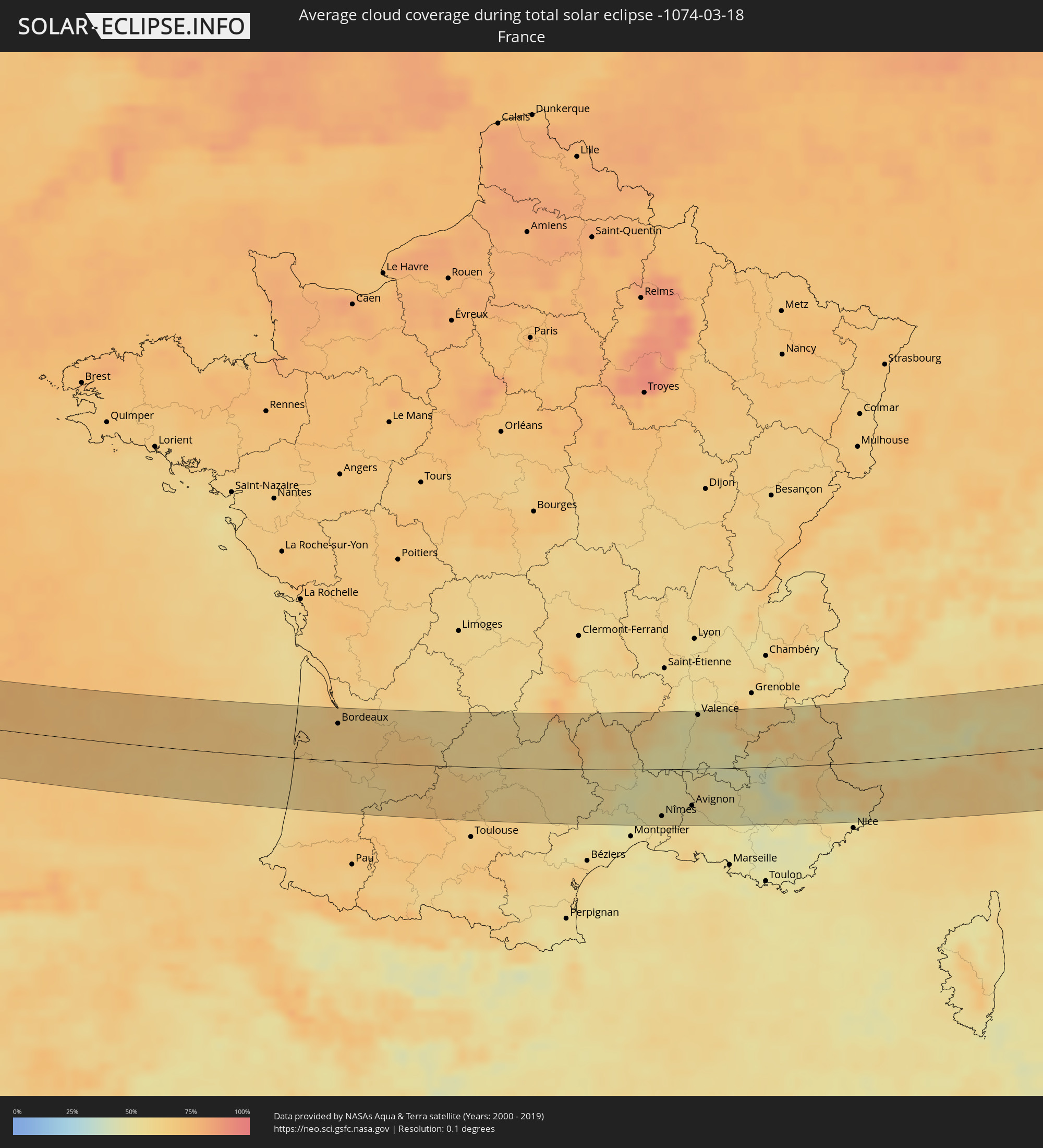 France
 Italy
Italy
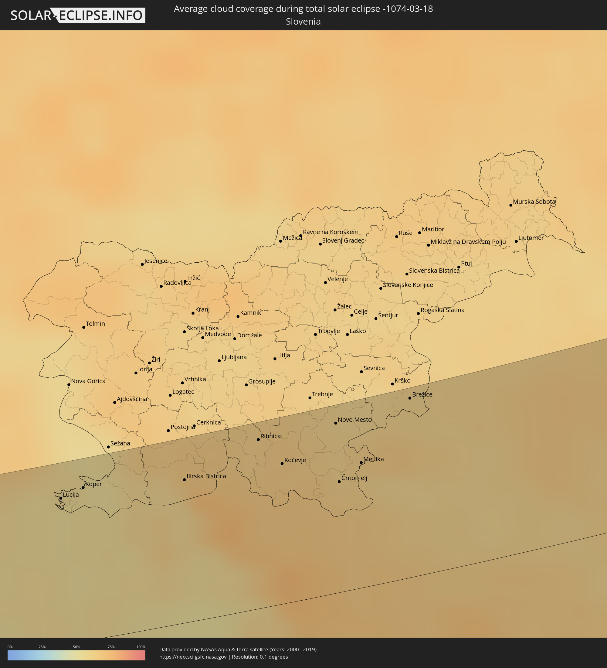 Slovenia
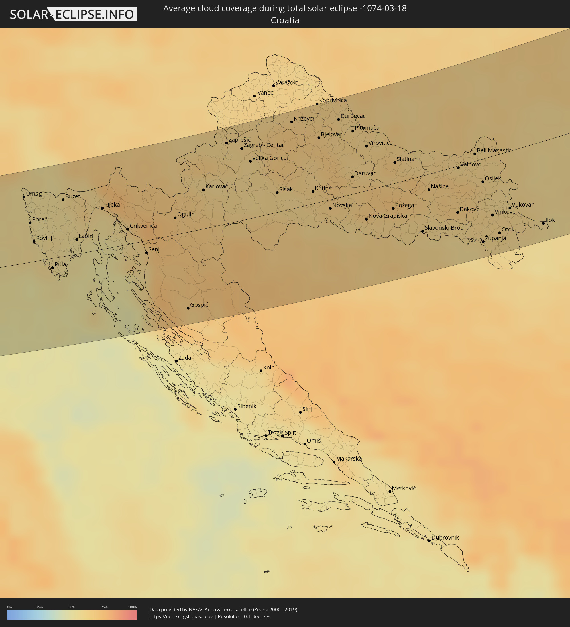 Croatia
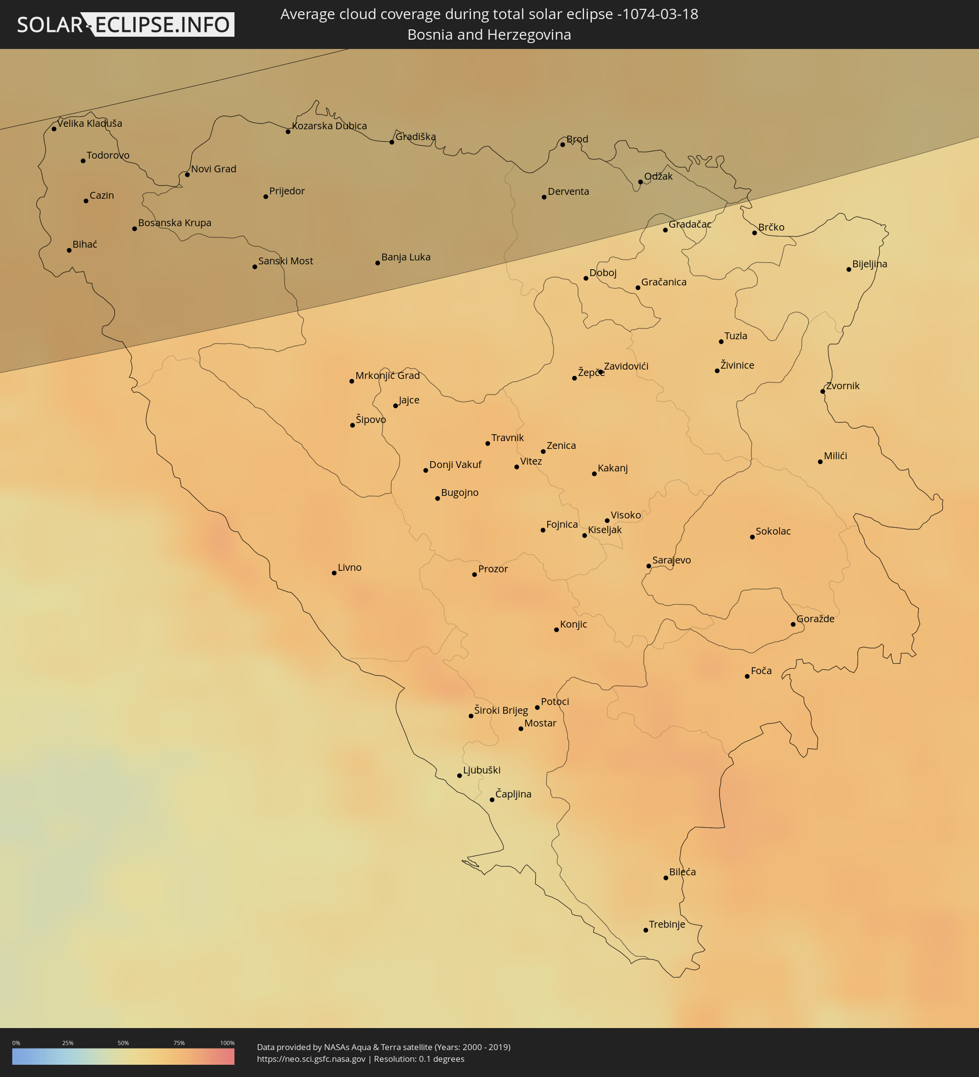 Bosnia and Herzegovina
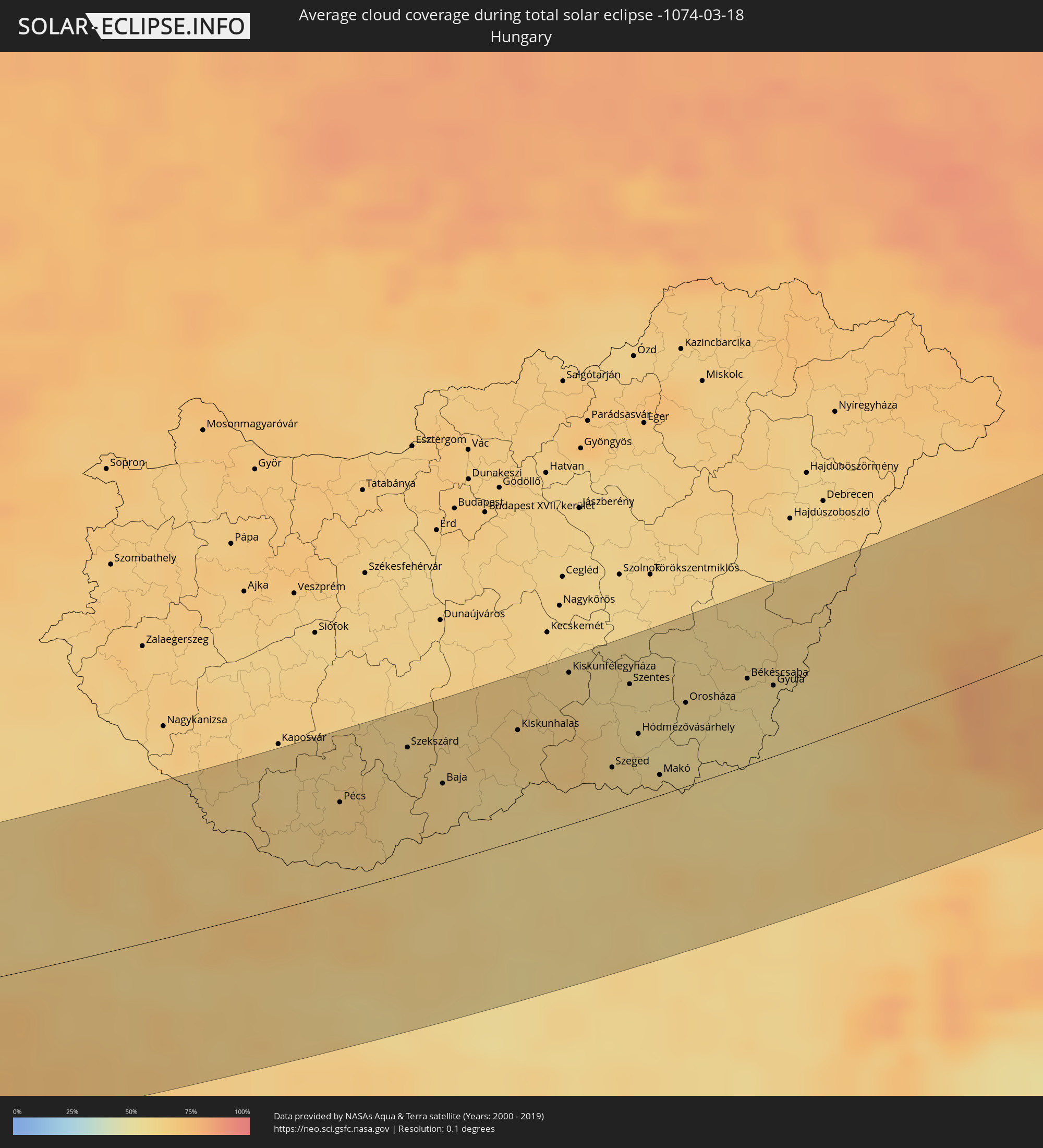 Hungary
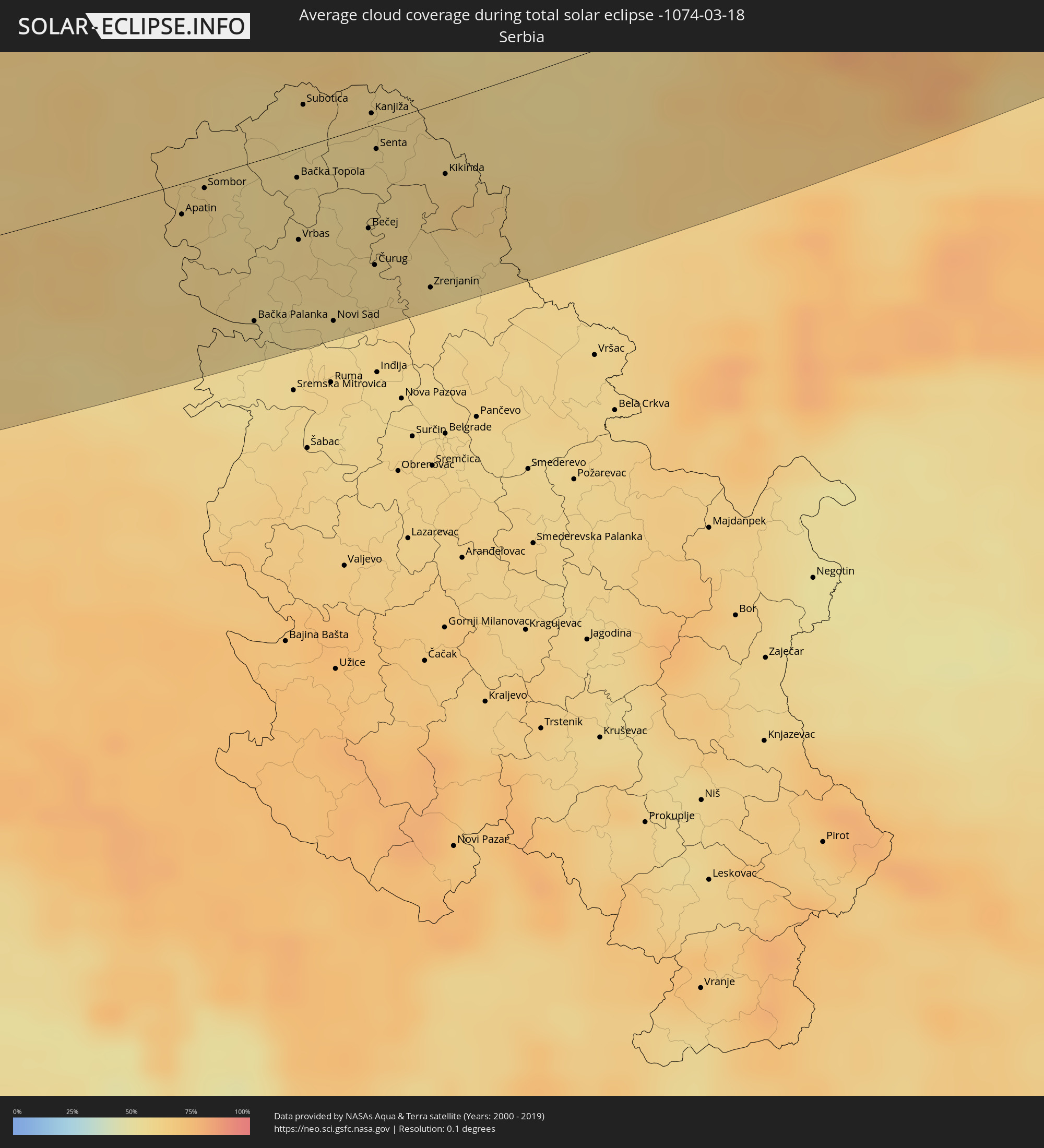 Serbia
 Romania
 Ukraine
 Moldova
Cities inside the path of the eclipse
The following table shows all locations with a population of more than 5,000 inside the eclipse path. Cities which have more than 100,000 inhabitants are marked bold. A click at the locations opens a detailed map.
| City | Type | Eclipse duration | Local time of max. eclipse | Distance to central line | Ø Cloud coverage |
|
La Teste-de-Buch, Nouvelle-Aquitaine
|
total | - | 07:08:00 UTC+00:09 | 22 km | 65% |
|
Bordeaux, Nouvelle-Aquitaine
|
total | - | 07:08:32 UTC+00:09 | 46 km | 65% |
|
Mont-de-Marsan, Nouvelle-Aquitaine
|
total | - | 07:06:55 UTC+00:09 | 61 km | 67% |
|
Bergerac, Nouvelle-Aquitaine
|
total | - | 07:08:53 UTC+00:09 | 50 km | 62% |
|
Agen, Nouvelle-Aquitaine
|
total | - | 07:07:48 UTC+00:09 | 24 km | 65% |
|
Villeneuve-sur-Lot, Nouvelle-Aquitaine
|
total | - | 07:08:11 UTC+00:09 | 16 km | 66% |
|
Montauban, Occitania
|
total | - | 07:07:44 UTC+00:09 | 41 km | 65% |
|
Albi, Occitania
|
total | - | 07:07:52 UTC+00:09 | 49 km | 63% |
|
Aurillac, Auvergne-Rhône-Alpes
|
total | - | 07:09:42 UTC+00:09 | 63 km | 57% |
|
Rodez, Occitania
|
total | - | 07:08:46 UTC+00:09 | 6 km | 59% |
|
Alès, Occitania
|
total | - | 07:08:58 UTC+00:09 | 25 km | 51% |
|
Nîmes, Occitania
|
total | - | 07:08:34 UTC+00:09 | 58 km | 57% |
|
Montélimar, Auvergne-Rhône-Alpes
|
total | - | 07:10:01 UTC+00:09 | 30 km | 48% |
|
Orange, Provence-Alpes-Côte d'Azur
|
total | - | 07:09:19 UTC+00:09 | 28 km | 54% |
|
Avignon, Provence-Alpes-Côte d'Azur
|
total | - | 07:08:59 UTC+00:09 | 47 km | 56% |
|
Valence, Auvergne-Rhône-Alpes
|
total | - | 07:10:45 UTC+00:09 | 65 km | 54% |
|
Cavaillon, Provence-Alpes-Côte d'Azur
|
total | - | 07:08:52 UTC+00:09 | 58 km | 52% |
|
Carpentras, Provence-Alpes-Côte d'Azur
|
total | - | 07:09:16 UTC+00:09 | 34 km | 54% |
|
Gap, Provence-Alpes-Côte d'Azur
|
total | - | 07:10:40 UTC+00:09 | 23 km | 50% |
|
Turin, Piedmont
|
total | - | 08:03:01 UTC+01:00 | 74 km | 53% |
|
Asti, Piedmont
|
total | - | 08:03:00 UTC+01:00 | 53 km | 49% |
|
Savona, Liguria
|
total | - | 08:02:06 UTC+01:00 | 18 km | 66% |
|
Alessandria, Piedmont
|
total | - | 08:03:14 UTC+01:00 | 50 km | 56% |
|
Genoa, Liguria
|
total | - | 08:02:33 UTC+01:00 | 10 km | 65% |
|
Piacenza, Emilia-Romagna
|
total | - | 08:04:07 UTC+01:00 | 59 km | 55% |
|
La Spezia, Liguria
|
total | - | 08:02:30 UTC+01:00 | 53 km | 60% |
|
Cremona, Lombardy
|
total | - | 08:04:28 UTC+01:00 | 63 km | 57% |
|
Massa, Tuscany
|
total | - | 08:02:34 UTC+01:00 | 60 km | 55% |
|
Parma, Emilia-Romagna
|
total | - | 08:04:03 UTC+01:00 | 26 km | 58% |
|
Reggio nell'Emilia, Emilia-Romagna
|
total | - | 08:04:03 UTC+01:00 | 15 km | 62% |
|
Modena, Emilia-Romagna
|
total | - | 08:04:09 UTC+01:00 | 6 km | 60% |
|
Bologna, Emilia-Romagna
|
total | - | 08:04:08 UTC+01:00 | 25 km | 56% |
|
Ferrara, Emilia-Romagna
|
total | - | 08:04:56 UTC+01:00 | 19 km | 57% |
|
Padova, Veneto
|
total | - | 08:06:08 UTC+01:00 | 75 km | 65% |
|
Forlì, Emilia-Romagna
|
total | - | 08:04:07 UTC+01:00 | 58 km | 58% |
|
Ravenna, Emilia-Romagna
|
total | - | 08:04:34 UTC+01:00 | 40 km | 58% |
|
Cesena, Emilia-Romagna
|
total | - | 08:04:06 UTC+01:00 | 69 km | 58% |
|
Rovinj, Istarska
|
total | - | 08:06:45 UTC+01:00 | 22 km | 57% |
|
Koper, Koper-Capodistria
|
total | - | 08:07:39 UTC+01:00 | 68 km | 55% |
|
Trieste, Friuli Venezia Giulia
|
total | - | 08:07:52 UTC+01:00 | 77 km | 54% |
|
Pula, Istarska
|
total | - | 08:06:31 UTC+01:00 | 16 km | 56% |
|
Kozina, Hrpelje-Kozina
|
total | - | 08:07:54 UTC+01:00 | 72 km | 54% |
|
Divača, Divača
|
total | - | 08:08:04 UTC+01:00 | 80 km | 58% |
|
Pivka, Pivka
|
total | - | 08:08:14 UTC+01:00 | 76 km | 60% |
|
Ilirska Bistrica, Ilirska Bistrica
|
total | - | 08:08:07 UTC+01:00 | 63 km | 61% |
|
Rijeka, Primorsko-Goranska
|
total | - | 08:07:46 UTC+01:00 | 35 km | 55% |
|
Leskova Dolina, Loška Dolina
|
total | - | 08:08:19 UTC+01:00 | 66 km | 72% |
|
Sodražica, Sodražica
|
total | - | 08:08:41 UTC+01:00 | 79 km | 65% |
|
Kočevje, Kočevje
|
total | - | 08:08:39 UTC+01:00 | 61 km | 68% |
|
Žužemberk, Žužemberk
|
total | - | 08:09:02 UTC+01:00 | 82 km | 66% |
|
Dolenjske Toplice, Dolenjske Toplice
|
total | - | 08:09:00 UTC+01:00 | 73 km | 63% |
|
Straža, Straža
|
total | - | 08:09:03 UTC+01:00 | 75 km | 63% |
|
Mirna Peč, Mirna Peč
|
total | - | 08:09:12 UTC+01:00 | 83 km | 62% |
|
Novo Mesto, Novo Mesto
|
total | - | 08:09:10 UTC+01:00 | 75 km | 62% |
|
Semič, Semič
|
total | - | 08:08:54 UTC+01:00 | 58 km | 64% |
|
Črnomelj, Črnomelj
|
total | - | 08:08:46 UTC+01:00 | 50 km | 64% |
|
Metlika, Metlika
|
total | - | 08:09:00 UTC+01:00 | 55 km | 64% |
|
Šentjernej, Šentjernej
|
total | - | 08:09:22 UTC+01:00 | 75 km | 63% |
|
Kostanjevica na Krki, Kostanjevica na Krki
|
total | - | 08:09:26 UTC+01:00 | 75 km | 65% |
|
Karlovac, Karlovačka
|
total | - | 08:08:53 UTC+01:00 | 35 km | 64% |
|
Brežice, Brežice
|
total | - | 08:09:40 UTC+01:00 | 79 km | 61% |
|
Samobor, Zagrebačka
|
total | - | 08:09:35 UTC+01:00 | 65 km | 63% |
|
Tržačka Raštela, Federation of Bosnia and Herzegovina
|
total | - | 08:08:09 UTC+01:00 | 31 km | 69% |
|
Velika Kladuša, Federation of Bosnia and Herzegovina
|
total | - | 08:08:33 UTC+01:00 | 17 km | 68% |
|
Bihać, Federation of Bosnia and Herzegovina
|
total | - | 08:07:56 UTC+01:00 | 49 km | 71% |
|
Podzvizd, Federation of Bosnia and Herzegovina
|
total | - | 08:08:35 UTC+01:00 | 13 km | 69% |
|
Cazin, Federation of Bosnia and Herzegovina
|
total | - | 08:08:16 UTC+01:00 | 32 km | 71% |
|
Vrnograč, Federation of Bosnia and Herzegovina
|
total | - | 08:08:38 UTC+01:00 | 10 km | 68% |
|
Zagreb - Centar, City of Zagreb
|
total | - | 08:09:48 UTC+01:00 | 63 km | 60% |
|
Bosanska Krupa, Federation of Bosnia and Herzegovina
|
total | - | 08:08:17 UTC+01:00 | 43 km | 68% |
|
Novi Grad, Republic of Srspka
|
total | - | 08:08:45 UTC+01:00 | 33 km | 66% |
|
Sisak, Sisačko-Moslavačka
|
total | - | 08:09:30 UTC+01:00 | 18 km | 60% |
|
Križevci, Koprivničko-Križevačka
|
total | - | 08:10:38 UTC+01:00 | 76 km | 67% |
|
Sanski Most, Federation of Bosnia and Herzegovina
|
total | - | 08:08:29 UTC+01:00 | 64 km | 67% |
|
Prijedor, Republic of Srspka
|
total | - | 08:08:54 UTC+01:00 | 43 km | 65% |
|
Kutina, Sisačko-Moslavačka
|
total | - | 08:09:50 UTC+01:00 | 18 km | 63% |
|
Kozarska Dubica, Republic of Srspka
|
total | - | 08:09:20 UTC+01:00 | 30 km | 64% |
|
Bjelovar, Bjelovarsko-Bilogorska
|
total | - | 08:10:39 UTC+01:00 | 55 km | 66% |
|
Banja Luka, Republic of Srspka
|
total | - | 08:08:56 UTC+01:00 | 73 km | 65% |
|
Gradiška, Republic of Srspka
|
total | - | 08:09:38 UTC+01:00 | 36 km | 64% |
|
Čelinac, Republic of Srspka
|
total | - | 08:08:57 UTC+01:00 | 81 km | 68% |
|
Nova Gradiška, Slavonski Brod-Posavina
|
total | - | 08:09:56 UTC+01:00 | 29 km | 62% |
|
Virovitica, Virovitičk-Podravska
|
total | - | 08:10:58 UTC+01:00 | 37 km | 62% |
|
Barcs, Somogy
|
total | - | 08:11:16 UTC+01:00 | 51 km | 61% |
|
Srbac, Republic of Srspka
|
total | - | 08:09:46 UTC+01:00 | 46 km | 63% |
|
Prnjavor, Republic of Srspka
|
total | - | 08:09:29 UTC+01:00 | 72 km | 63% |
|
Požega, Požeško-Slavonska
|
total | - | 08:10:21 UTC+01:00 | 23 km | 62% |
|
Derventa, Republic of Srspka
|
total | - | 08:09:53 UTC+01:00 | 67 km | 62% |
|
Brod, Republic of Srspka
|
total | - | 08:10:14 UTC+01:00 | 51 km | 61% |
|
Slavonski Brod, Slavonski Brod-Posavina
|
total | - | 08:10:18 UTC+01:00 | 49 km | 60% |
|
Dombóvár, Tolna
|
total | - | 08:12:34 UTC+01:00 | 81 km | 62% |
|
Pécs, Baranya
|
total | - | 08:12:08 UTC+01:00 | 48 km | 63% |
|
Odžak, Federation of Bosnia and Herzegovina
|
total | - | 08:10:19 UTC+01:00 | 69 km | 62% |
|
Đakovo, Osječko-Baranjska
|
total | - | 08:10:54 UTC+01:00 | 44 km | 60% |
|
Mohács, Baranya
|
total | - | 08:12:21 UTC+01:00 | 33 km | 61% |
|
Osijek, Osječko-Baranjska
|
total | - | 08:11:35 UTC+01:00 | 22 km | 62% |
|
Županja, Vukovar-Sirmium
|
total | - | 08:10:44 UTC+01:00 | 70 km | 60% |
|
Szekszárd, Tolna
|
total | - | 08:13:01 UTC+01:00 | 66 km | 60% |
|
Vinkovci, Vukovar-Sirmium
|
total | - | 08:11:12 UTC+01:00 | 51 km | 62% |
|
Baja, Bács-Kiskun
|
total | - | 08:12:55 UTC+01:00 | 42 km | 61% |
|
Apatin, Vojvodina
|
total | - | 08:12:03 UTC+01:00 | 14 km | 61% |
|
Kalocsa, Bács-Kiskun
|
total | - | 08:13:34 UTC+01:00 | 80 km | 62% |
|
Vukovar, Vukovar-Sirmium
|
total | - | 08:11:28 UTC+01:00 | 50 km | 61% |
|
Sombor, Vojvodina
|
total | - | 08:12:20 UTC+01:00 | 9 km | 61% |
|
Kiskőrös, Bács-Kiskun
|
total | - | 08:14:00 UTC+01:00 | 82 km | 64% |
|
Bačka Palanka, Vojvodina
|
total | - | 08:11:39 UTC+01:00 | 68 km | 57% |
|
Kiskunhalas, Bács-Kiskun
|
total | - | 08:13:51 UTC+01:00 | 59 km | 64% |
|
Bačka Topola, Vojvodina
|
total | - | 08:12:52 UTC+01:00 | 14 km | 58% |
|
Vrbas, Vojvodina
|
total | - | 08:12:27 UTC+01:00 | 38 km | 59% |
|
Subotica, Vojvodina
|
total | - | 08:13:25 UTC+01:00 | 26 km | 57% |
|
Kiskunmajsa, Bács-Kiskun
|
total | - | 08:14:10 UTC+01:00 | 57 km | 62% |
|
Novi Sad, Vojvodina
|
total | - | 08:12:03 UTC+01:00 | 77 km | 57% |
|
Kiskunfélegyháza, Bács-Kiskun
|
total | - | 08:14:40 UTC+01:00 | 79 km | 62% |
|
Sremski Karlovci, Vojvodina
|
total | - | 08:12:03 UTC+01:00 | 85 km | 59% |
|
Bečej, Vojvodina
|
total | - | 08:12:53 UTC+01:00 | 44 km | 59% |
|
Kanjiža, Vojvodina
|
total | - | 08:13:42 UTC+01:00 | 7 km | 58% |
|
Žabalj, Vojvodina
|
total | - | 08:12:28 UTC+01:00 | 71 km | 60% |
|
Čurug
|
total | - | 08:12:39 UTC+01:00 | 60 km | 58% |
|
Senta, Vojvodina
|
total | - | 08:13:28 UTC+01:00 | 11 km | 59% |
|
Bačko Petrovo Selo
|
total | - | 08:13:05 UTC+01:00 | 34 km | 60% |
|
Novi Kneževac, Vojvodina
|
total | - | 08:13:43 UTC+01:00 | 9 km | 58% |
|
Mol
|
total | - | 08:13:14 UTC+01:00 | 29 km | 58% |
|
Szeged, Csongrád
|
total | - | 08:14:07 UTC+01:00 | 29 km | 62% |
|
Szentes, Csongrád
|
total | - | 08:14:57 UTC+01:00 | 62 km | 57% |
|
Novo Miloševo
|
total | - | 08:13:19 UTC+01:00 | 40 km | 60% |
|
Hódmezővásárhely, Csongrád
|
total | - | 08:14:34 UTC+01:00 | 35 km | 59% |
|
Zrenjanin, Vojvodina
|
total | - | 08:12:47 UTC+01:00 | 76 km | 60% |
|
Kikinda, Vojvodina
|
total | - | 08:13:39 UTC+01:00 | 33 km | 65% |
|
Makó, Csongrád
|
total | - | 08:14:21 UTC+01:00 | 11 km | 61% |
|
Szarvas, Bekes
|
total | - | 08:15:34 UTC+01:00 | 78 km | 58% |
|
Orosháza, Bekes
|
total | - | 08:15:09 UTC+01:00 | 45 km | 56% |
|
Gyomaendrőd, Bekes
|
total | - | 08:15:57 UTC+01:00 | 78 km | 58% |
|
Békéscsaba, Bekes
|
total | - | 08:15:45 UTC+01:00 | 47 km | 57% |
|
Timişoara, Timiş
|
total | - | 08:58:38 UTC+01:44 | 57 km | 63% |
|
Arad, Arad
|
total | - | 08:59:28 UTC+01:44 | 24 km | 57% |
|
Lugoj, Timiş
|
total | - | 08:59:09 UTC+01:44 | 81 km | 62% |
|
Oradea, Bihor
|
total | - | 09:01:34 UTC+01:44 | 63 km | 64% |
|
Zalău, Sălaj
|
total | - | 09:02:56 UTC+01:44 | 49 km | 71% |
|
Baia Mare, Satu Mare
|
total | - | 09:04:15 UTC+01:44 | 76 km | 80% |
|
Alba Iulia, Alba
|
total | - | 09:01:29 UTC+01:44 | 88 km | 62% |
|
Cluj-Napoca, Cluj
|
total | - | 09:02:43 UTC+01:44 | 16 km | 70% |
|
Turda, Cluj
|
total | - | 09:02:33 UTC+01:44 | 42 km | 66% |
|
Dej, Cluj
|
total | - | 09:03:39 UTC+01:44 | 17 km | 75% |
|
Bistriţa, Bistriţa-Năsăud
|
total | - | 09:04:16 UTC+01:44 | 5 km | 78% |
|
Târgu-Mureş, Mureş
|
total | - | 09:03:18 UTC+01:44 | 69 km | 70% |
|
Reghin-Sat, Mureş
|
total | - | 09:03:53 UTC+01:44 | 47 km | 76% |
|
Chernivtsi, Chernivtsi
|
total | - | 09:25:26 UTC+02:02 | 68 km | 80% |
|
Suceava, Suceava
|
total | - | 09:06:58 UTC+01:44 | 19 km | 73% |
|
Fălticeni, Suceava
|
total | - | 09:06:42 UTC+01:44 | 32 km | 74% |
|
Piatra Neamţ, Neamţ
|
total | - | 09:05:50 UTC+01:44 | 85 km | 78% |
|
Dorohoi, Botoşani
|
total | - | 09:07:40 UTC+01:44 | 17 km | 75% |
|
Kamieniec Podolski, Khmelnytskyi
|
total | - | 09:26:47 UTC+02:02 | 84 km | 82% |
|
Botoşani, Botoşani
|
total | - | 09:07:37 UTC+01:44 | 14 km | 75% |
|
Paşcani, Iaşi
|
total | - | 09:06:49 UTC+01:44 | 65 km | 76% |
|
Briceni, Briceni
|
total | - | 09:19:42 UTC+01:55 | 39 km | 80% |
|
Edineţ, Raionul Edineţ
|
total | - | 09:19:37 UTC+01:55 | 15 km | 76% |
|
Ocniţa, Raionul Ocniţa
|
total | - | 09:20:07 UTC+01:55 | 26 km | 79% |
|
Glodeni, Glodeni
|
total | - | 09:19:11 UTC+01:55 | 42 km | 72% |
|
Rîşcani, Rîşcani
|
total | - | 09:19:32 UTC+01:55 | 24 km | 74% |
|
Donduşeni, Donduşeni
|
total | - | 09:20:04 UTC+01:55 | 13 km | 77% |
|
Briceni, Donduşeni
|
total | - | 09:20:22 UTC+01:55 | 22 km | 79% |
|
Fălești, Făleşti
|
total | - | 09:19:04 UTC+01:55 | 66 km | 69% |
|
Mohyliv-Podil’s’kyy, Vinnyts'ka
|
total | - | 09:27:41 UTC+02:02 | 19 km | 77% |
|
Otaci, Raionul Ocniţa
|
total | - | 09:20:36 UTC+01:55 | 18 km | 77% |
|
Drochia, Drochia
|
total | - | 09:19:57 UTC+01:55 | 27 km | 78% |
|
Bălţi, Bălţi
|
total | - | 09:19:37 UTC+01:55 | 54 km | 74% |
|
Bilicenii Vechi, Sîngerei
|
total | - | 09:19:34 UTC+01:55 | 69 km | 72% |
|
Zhmerynka, Vinnyts'ka
|
total | - | 09:29:02 UTC+02:02 | 65 km | 81% |
|
Sîngerei, Sîngerei
|
total | - | 09:19:39 UTC+01:55 | 75 km | 70% |
|
Soroca, Raionul Soroca
|
total | - | 09:20:41 UTC+01:55 | 29 km | 75% |
|
Floreşti, Floreşti
|
total | - | 09:20:14 UTC+01:55 | 54 km | 76% |
|
Vinnytsya, Vinnyts'ka
|
total | - | 09:29:45 UTC+02:02 | 70 km | 84% |
|
Camenca, Teleneşti
|
total | - | 09:20:56 UTC+01:55 | 56 km | 75% |
|
Şoldăneşti, Şoldăneşti
|
total | - | 09:20:41 UTC+01:55 | 81 km | 74% |
|
Bila Tserkva, Kiev
|
total | - | 09:32:32 UTC+02:02 | 64 km | 81% |
|
Uman’, Cherkasy
|
total | - | 09:30:55 UTC+02:02 | 41 km | 79% |
|
Boryspil’, Kiev
|
total | - | 09:34:22 UTC+02:02 | 82 km | 77% |
|
Pereyaslav-Khmel’nyts’kyy, Kiev
|
total | - | 09:34:29 UTC+02:02 | 41 km | 80% |
|
Smila, Cherkasy
|
total | - | 09:33:38 UTC+02:02 | 60 km | 81% |
|
Cherkasy, Cherkasy
|
total | - | 09:34:11 UTC+02:02 | 51 km | 80% |
|
Pryluky, Chernihiv
|
total | - | 09:36:24 UTC+02:02 | 51 km | 80% |
|
Lubny, Poltava
|
total | - | 09:36:13 UTC+02:02 | 37 km | 82% |
|
Konotop, Sumy
|
total | - | 09:38:21 UTC+02:02 | 74 km | 83% |
|
Romny, Sumy
|
total | - | 09:37:56 UTC+02:02 | 20 km | 85% |
|
Myrhorod, Poltava
|
total | - | 09:36:53 UTC+02:02 | 61 km | 81% |
|
Hlukhiv, Sumy
|
total | - | 09:39:52 UTC+02:02 | 82 km | 77% |
|
Sumy, Sumy
|
total | - | 09:39:47 UTC+02:02 | 24 km | 83% |
|
Okhtyrka, Sumy
|
total | - | 09:38:58 UTC+02:02 | 84 km | 82% |
|
Zheleznogorsk, Kursk
|
total | - | 10:10:46 UTC+02:30 | 78 km | 81% |
|
Kurchatov, Kursk
|
total | - | 10:10:07 UTC+02:30 | 20 km | 82% |
|
Kursk, Kursk
|
total | - | 10:10:53 UTC+02:30 | 13 km | 83% |
|
Livny, Orjol
|
total | - | 10:13:36 UTC+02:30 | 10 km | 78% |
|
Yefremov, Tula
|
total | - | 10:15:12 UTC+02:30 | 31 km | 81% |
|
Yelets, Lipetsk
|
total | - | 10:14:58 UTC+02:30 | 36 km | 78% |
|
Lipetsk, Lipetsk
|
total | - | 10:16:16 UTC+02:30 | 83 km | 83% |
|
Ryazan’, Rjazan
|
total | - | 10:19:04 UTC+02:30 | 83 km | 79% |
|
Murom, Vladimir
|
total | - | 10:23:02 UTC+02:30 | 57 km | 79% |
|
Vyksa, Nizjnij Novgorod
|
total | - | 10:22:54 UTC+02:30 | 29 km | 85% |
|
Pavlovo, Nizjnij Novgorod
|
total | - | 10:24:45 UTC+02:30 | 41 km | 76% |
|
Sarov, Nizjnij Novgorod
|
total | - | 10:23:50 UTC+02:30 | 57 km | 89% |
|
Dzerzhinsk, Nizjnij Novgorod
|
total | - | 10:25:29 UTC+02:30 | 46 km | 75% |
|
Novaya Balakhna, Nizjnij Novgorod
|
total | - | 10:25:56 UTC+02:30 | 62 km | 80% |
|
Arzamas, Nizjnij Novgorod
|
total | - | 10:25:00 UTC+02:30 | 39 km | 74% |
|
Nizhniy Novgorod, Nizjnij Novgorod
|
total | - | 10:26:14 UTC+02:30 | 32 km | 78% |
|
Kstovo, Nizjnij Novgorod
|
total | - | 10:26:16 UTC+02:30 | 21 km | 74% |
|
Kirov, Kirov
|
total | - | 10:35:00 UTC+02:30 | 42 km | 82% |
|
Kirovo-Chepetsk, Kirov
|
total | - | 10:35:24 UTC+02:30 | 62 km | 83% |