Total solar eclipse of 04/06/-1168
| Day of week: | Sunday |
| Maximum duration of eclipse: | 02m59s |
| Maximum width of eclipse path: | 229 km |
| Saros cycle: | 20 |
| Coverage: | 100% |
| Magnitude: | 1.0409 |
| Gamma: | 0.8047 |
Wo kann man die Sonnenfinsternis vom 04/06/-1168 sehen?
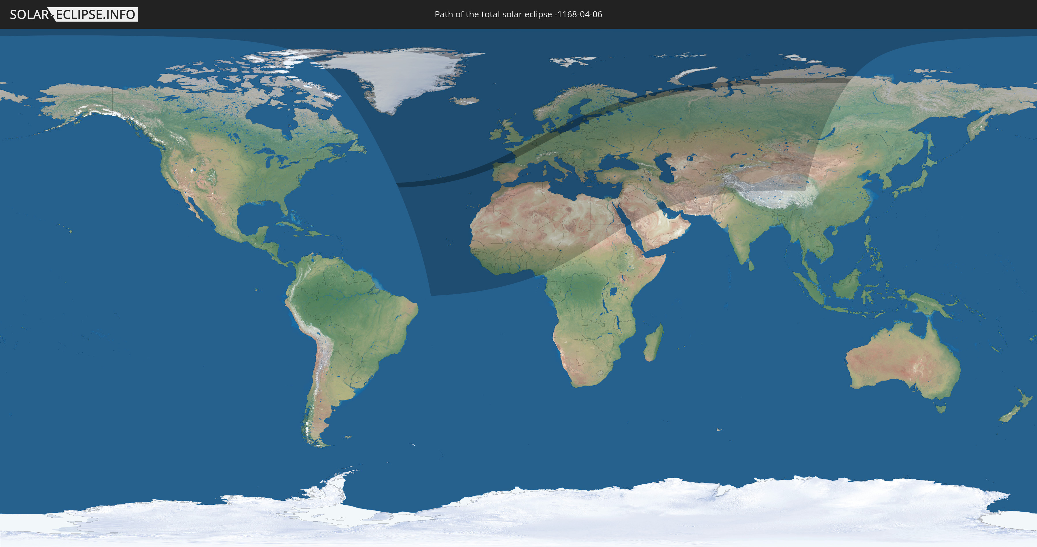
Die Sonnenfinsternis am 04/06/-1168 kann man in 101 Ländern als partielle Sonnenfinsternis beobachten.
Der Finsternispfad verläuft durch 14 Länder. Nur in diesen Ländern ist sie als total Sonnenfinsternis zu sehen.
In den folgenden Ländern ist die Sonnenfinsternis total zu sehen
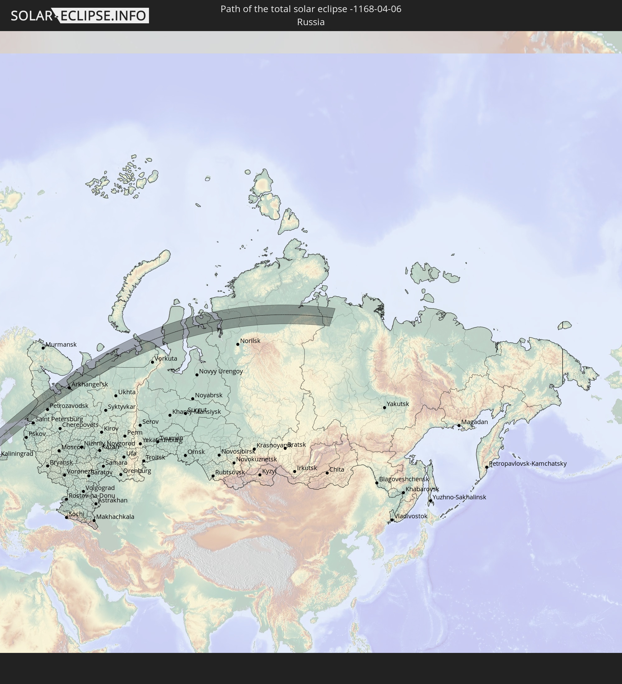 Russia
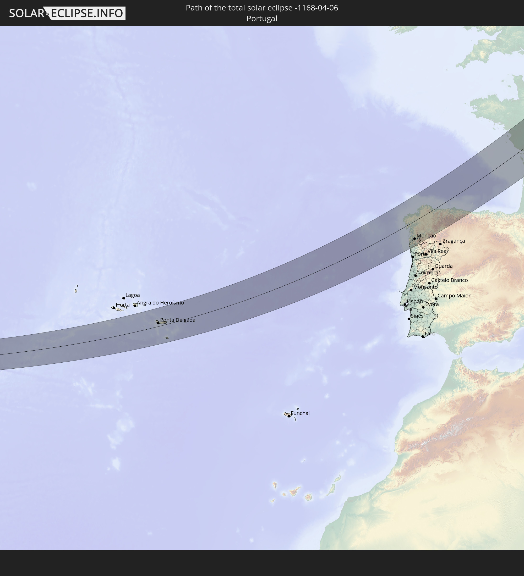 Portugal
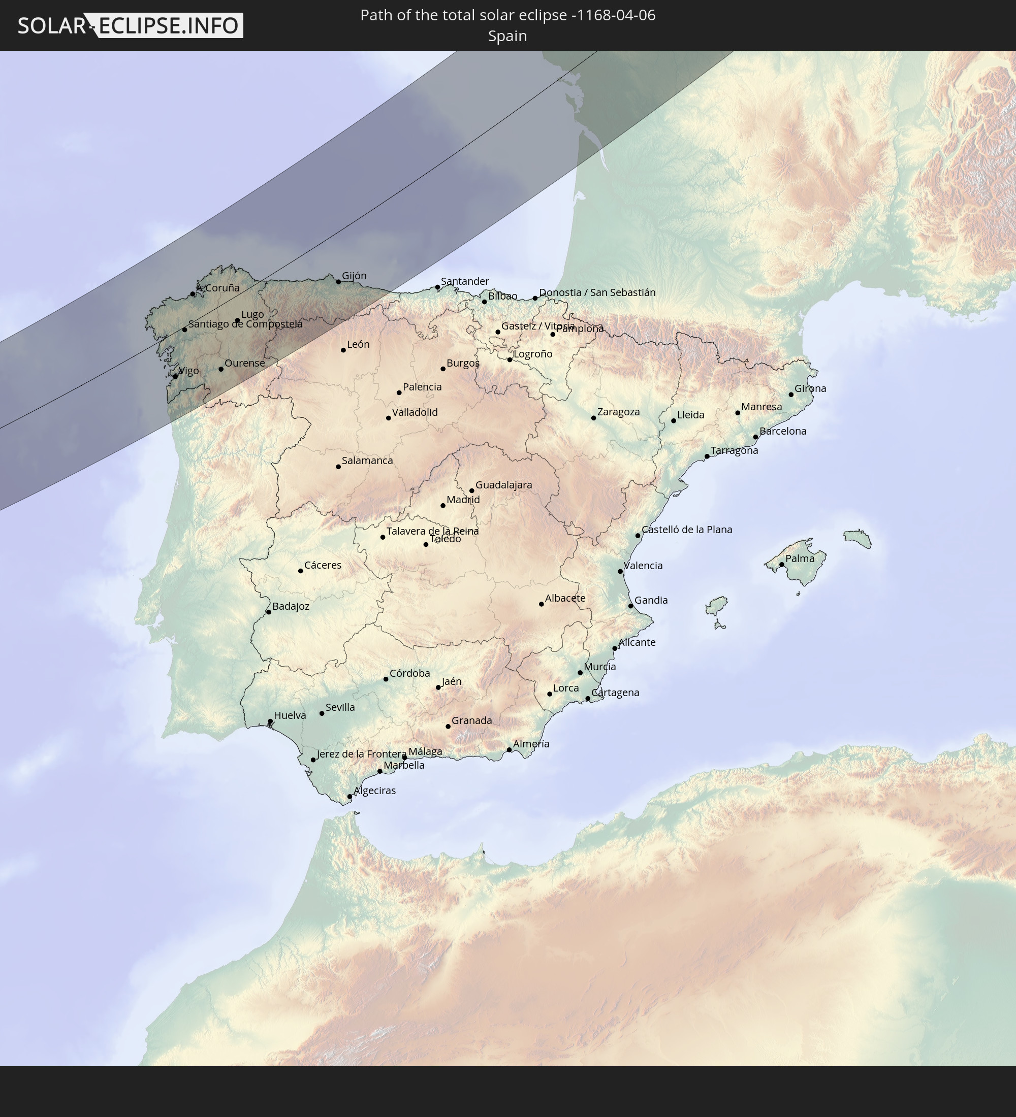 Spain
Spain
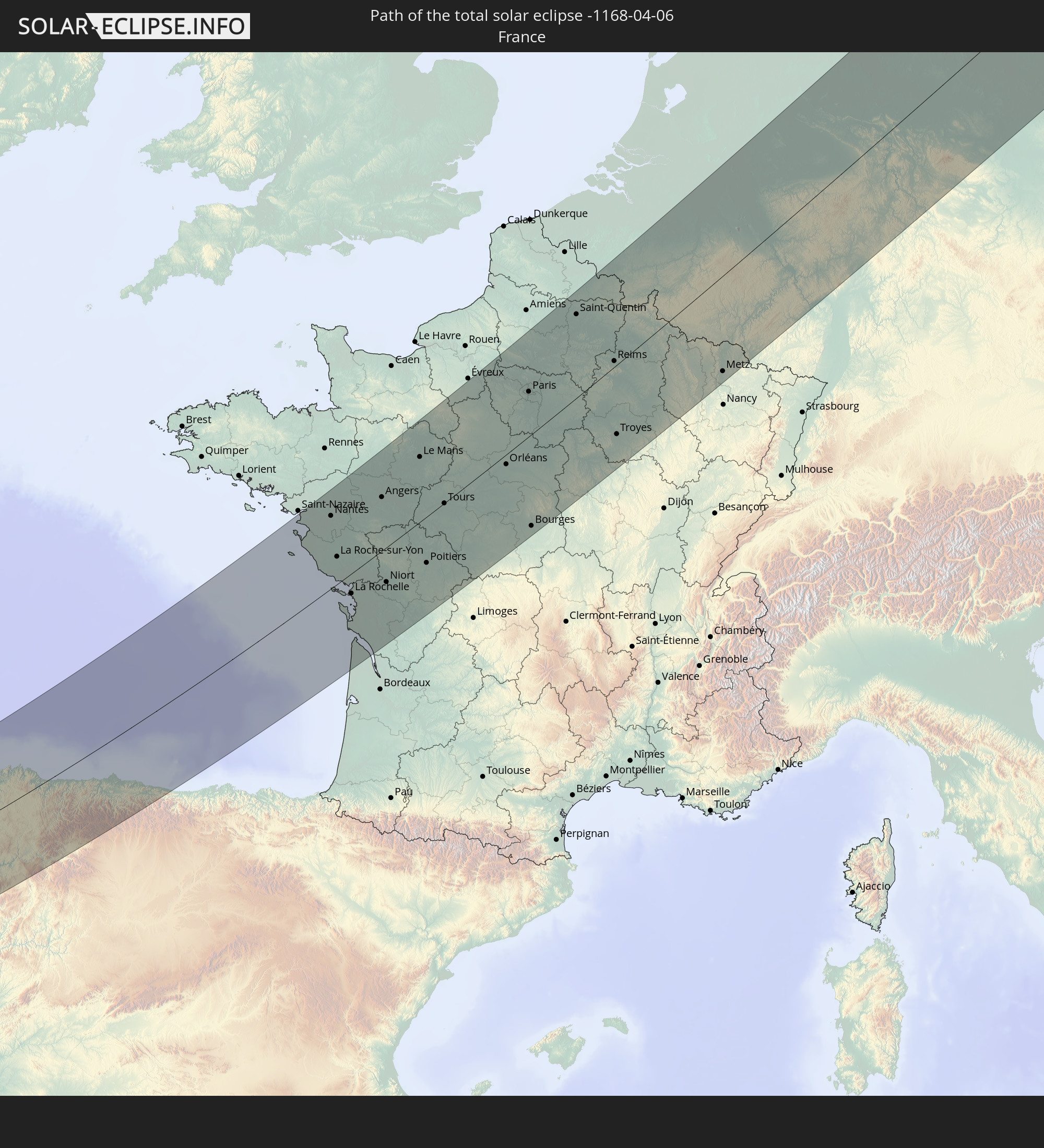 France
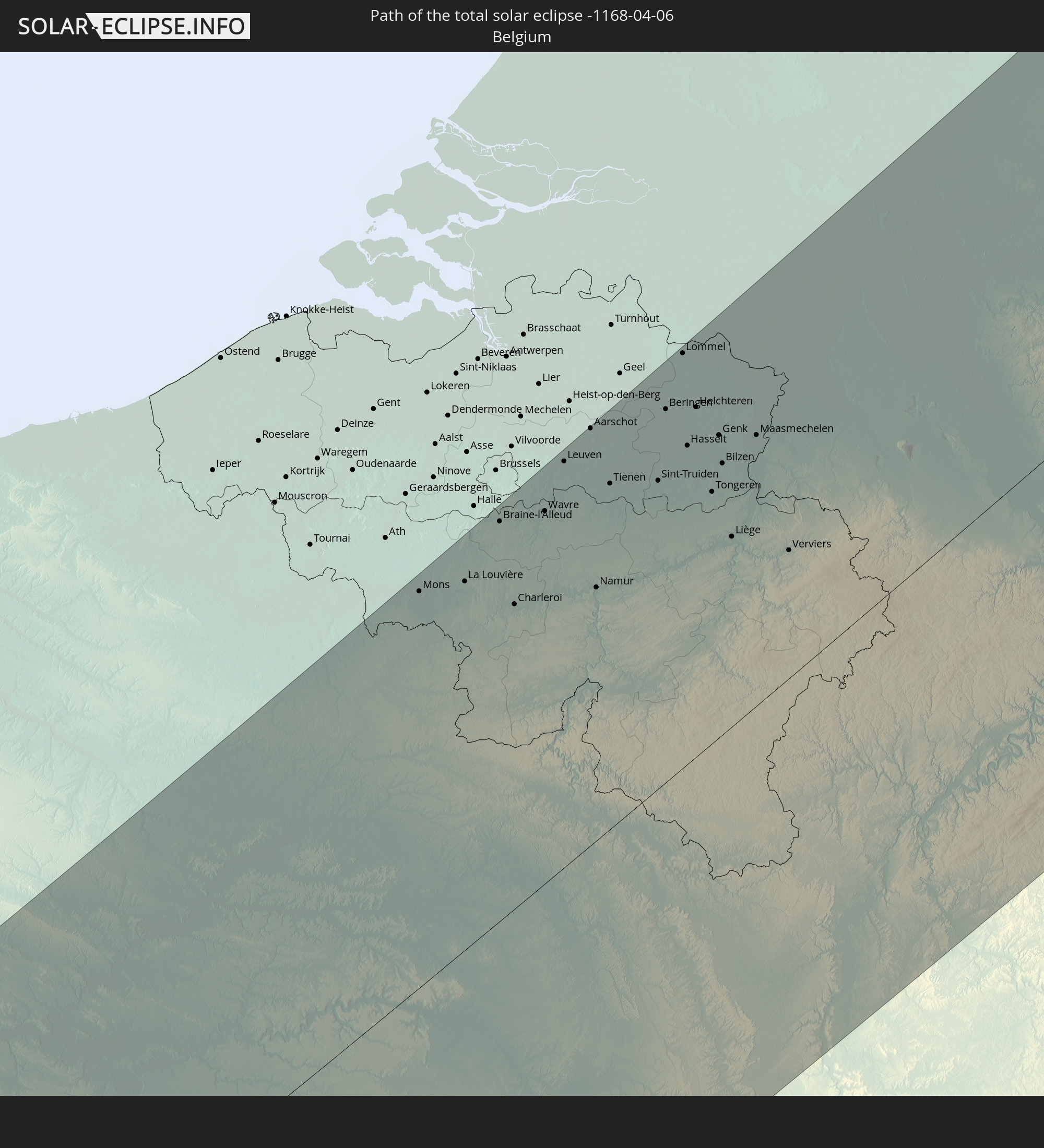 Belgium
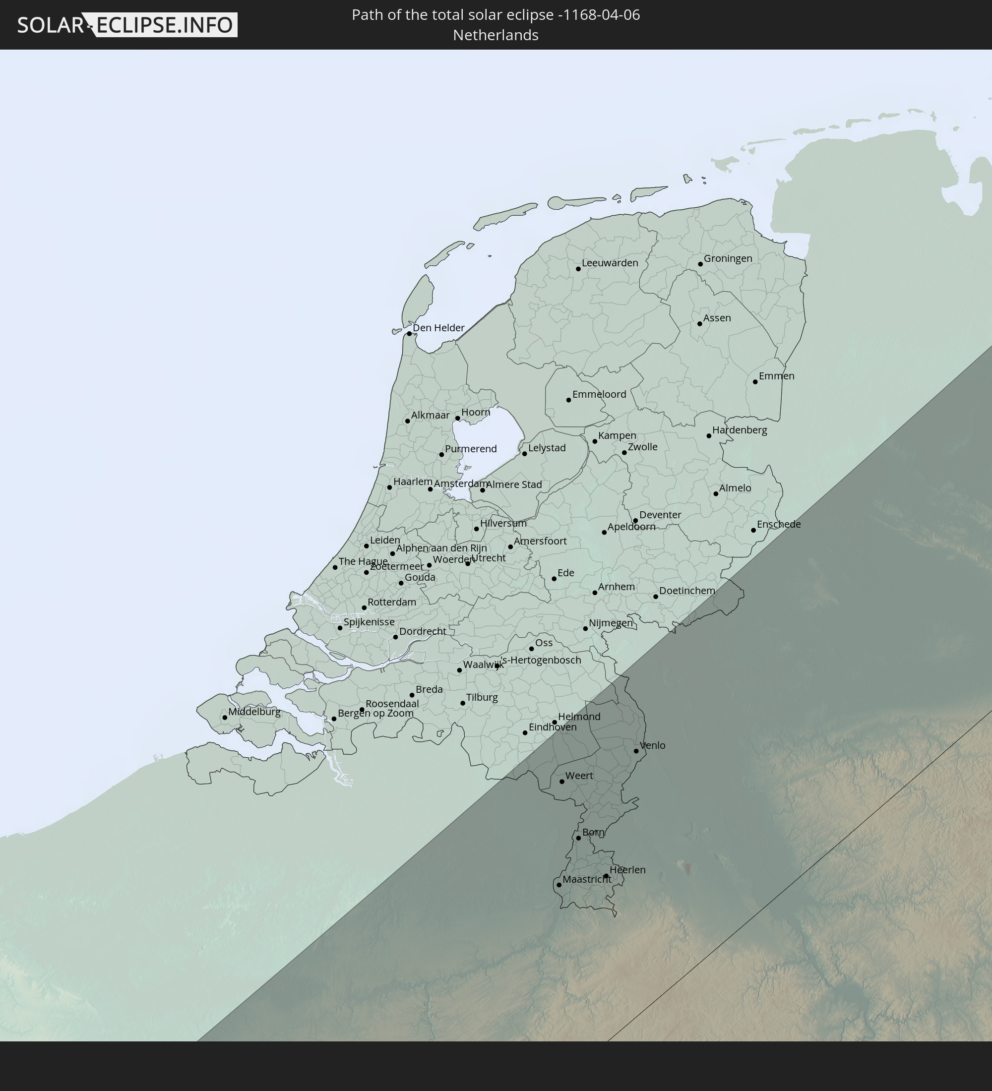 Netherlands
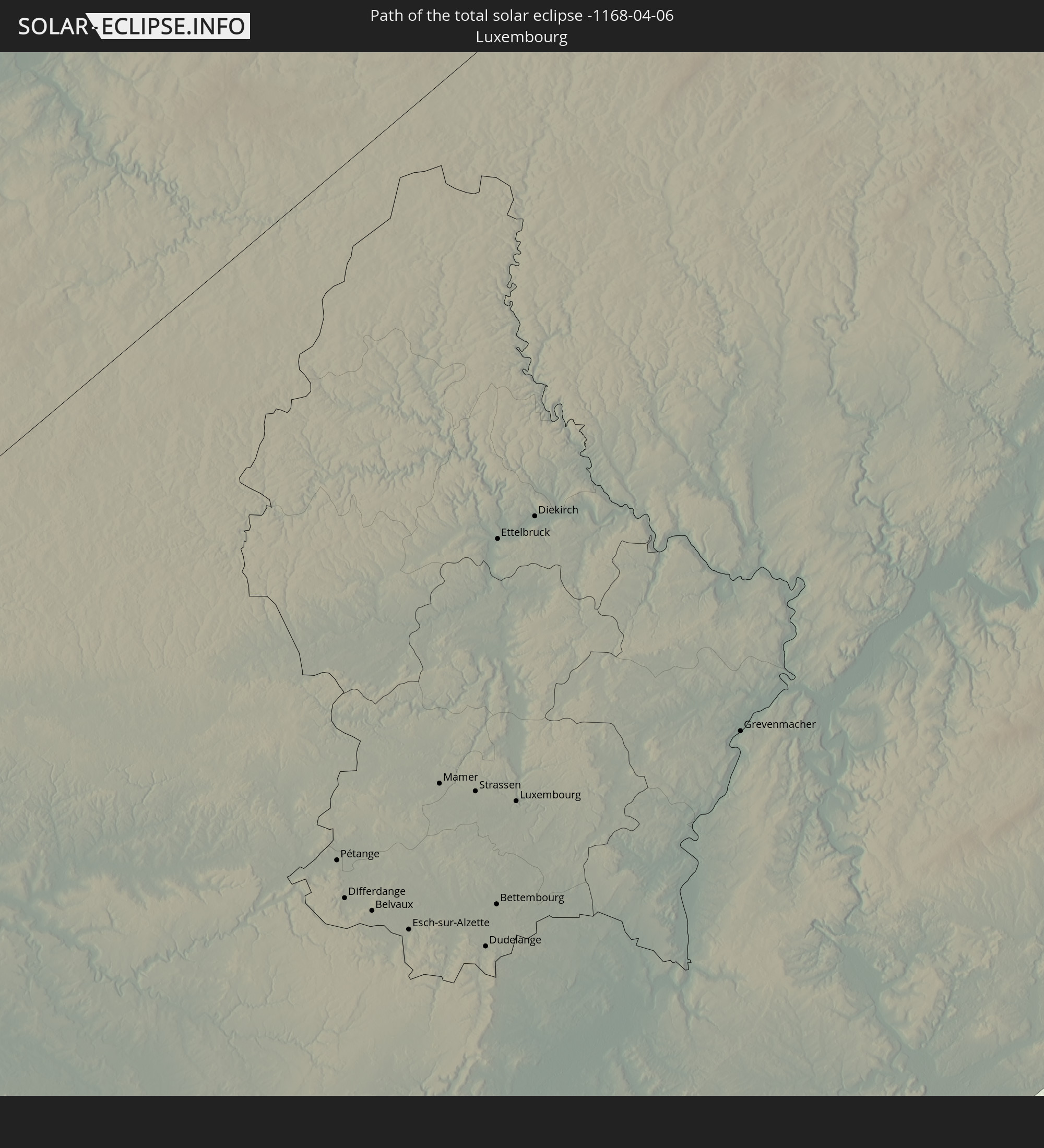 Luxembourg
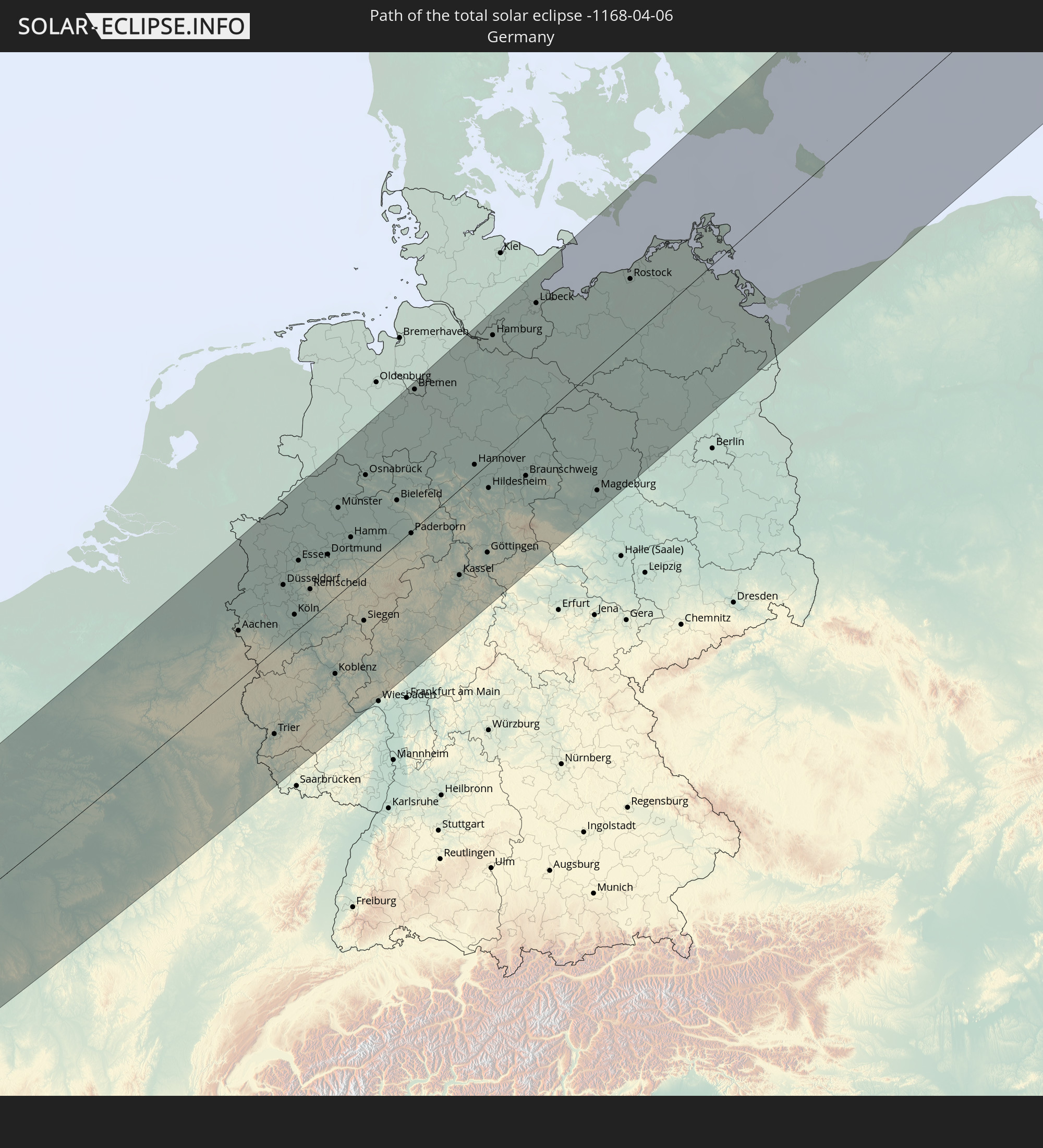 Germany
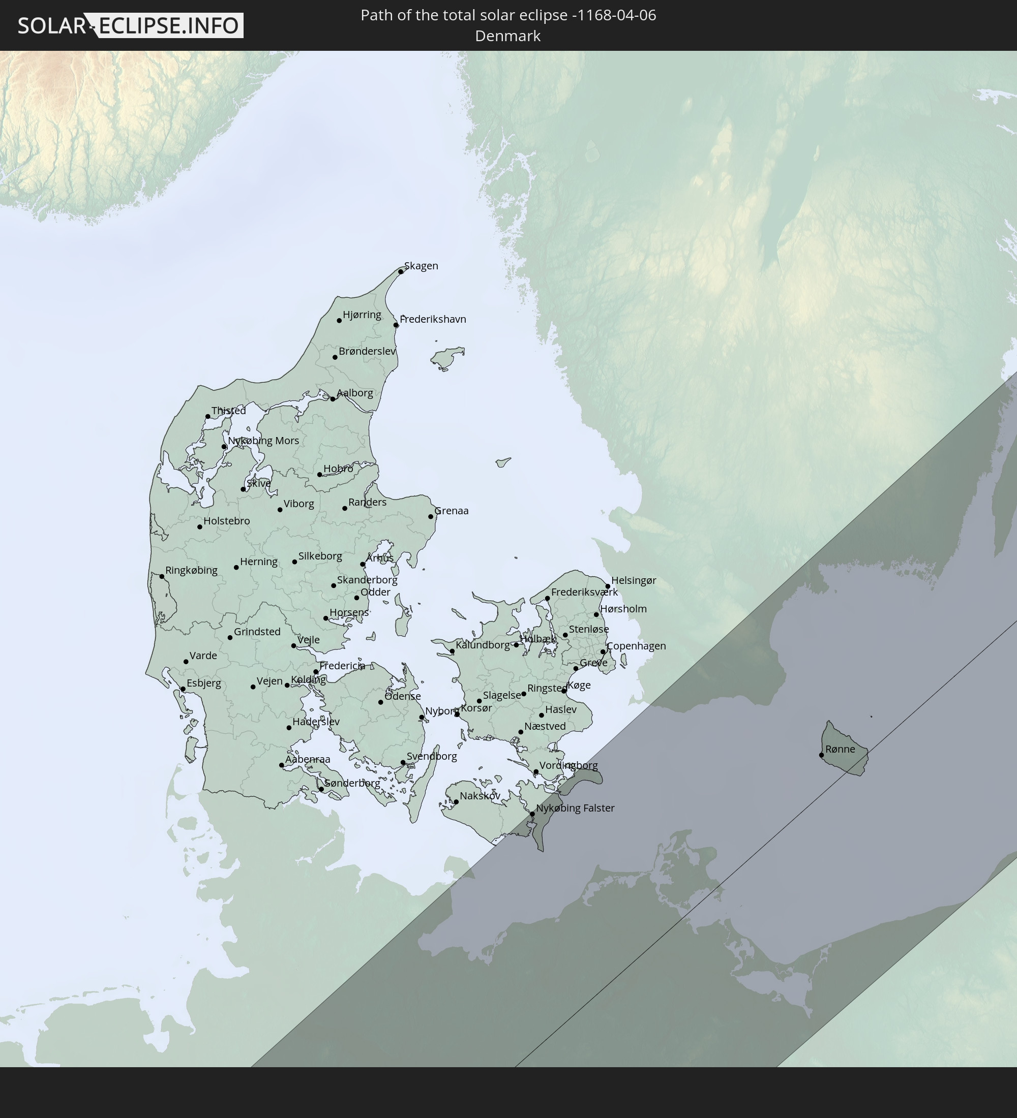 Denmark
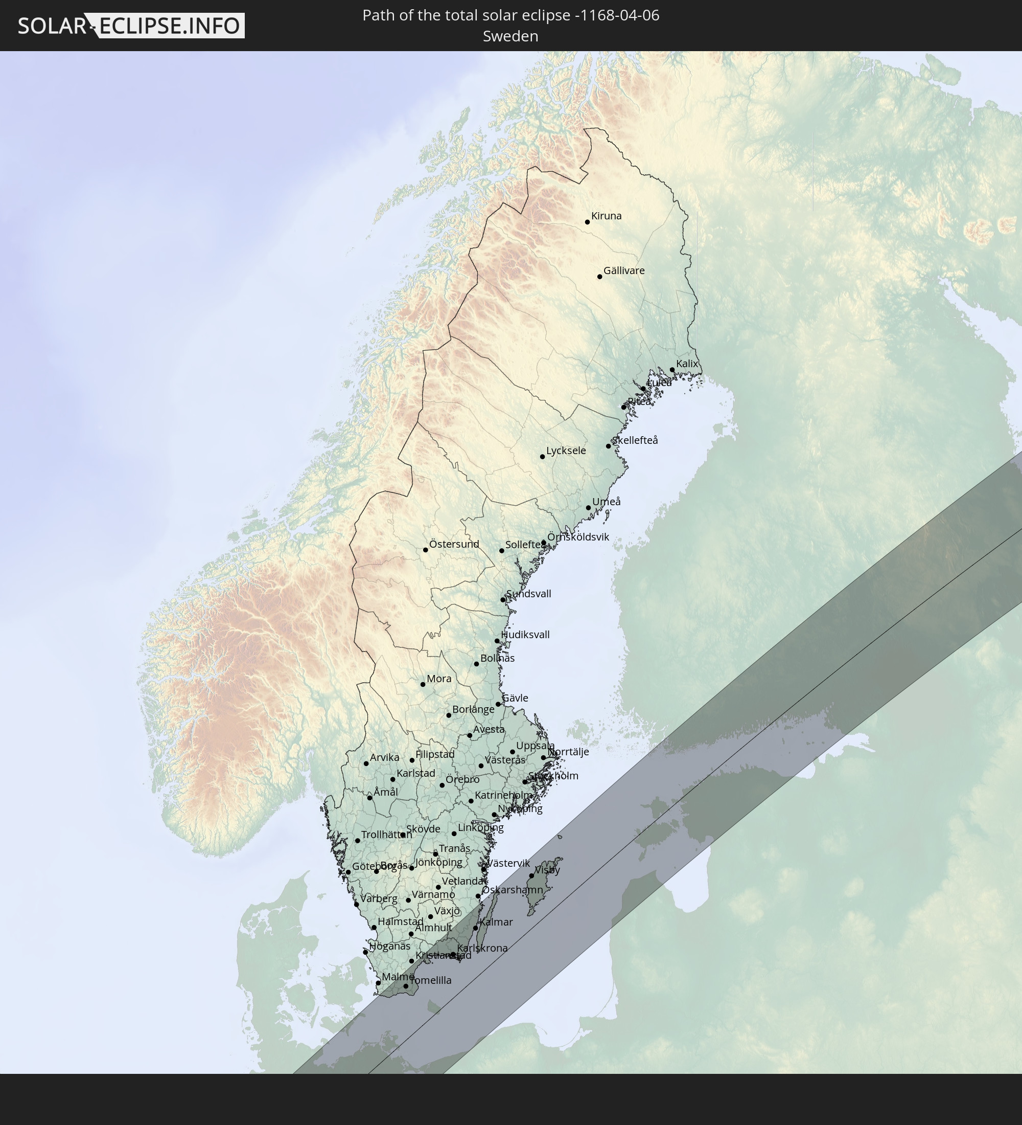 Sweden
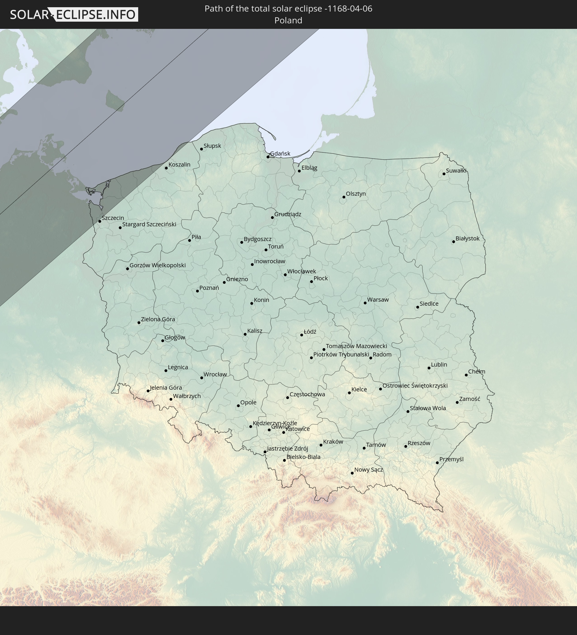 Poland
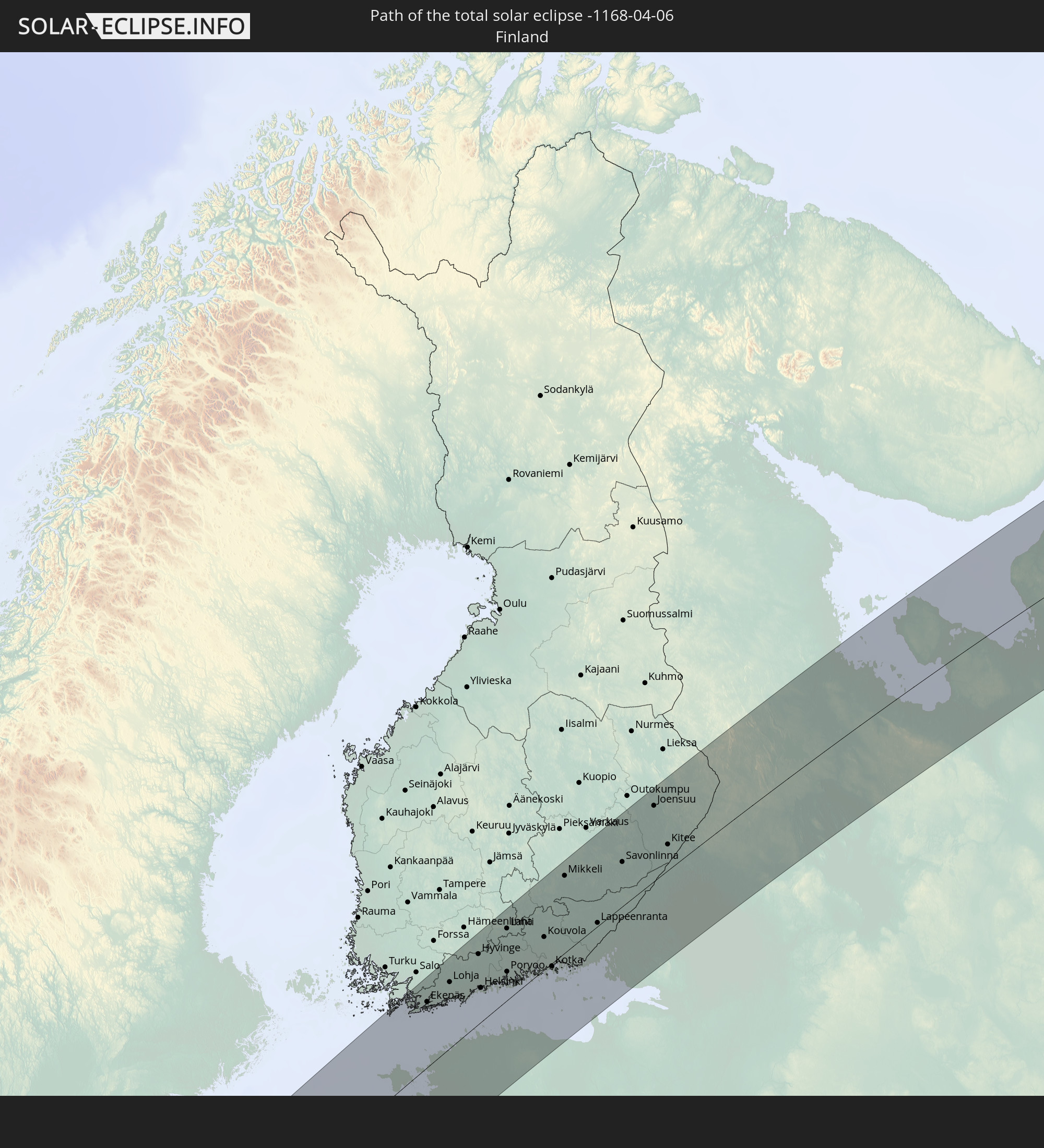 Finland
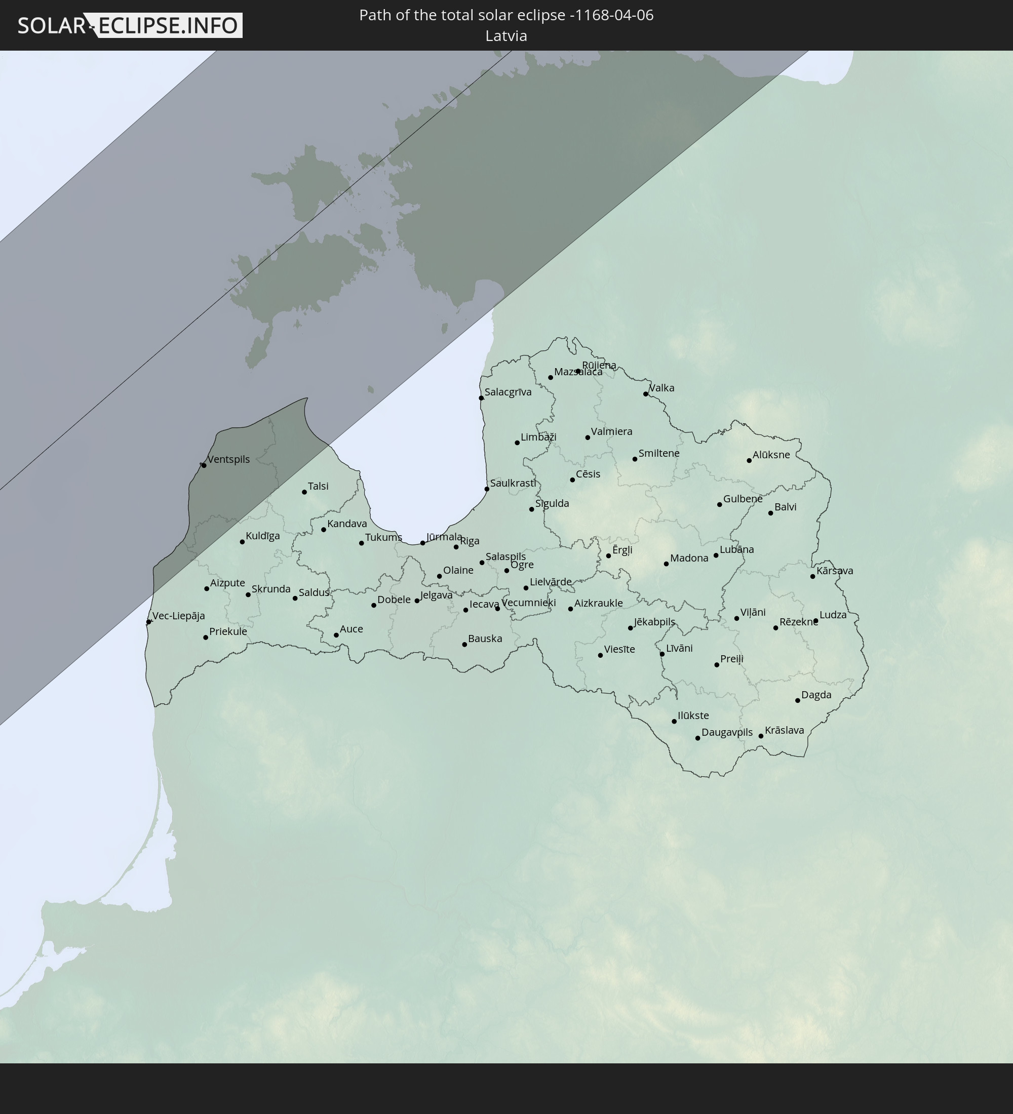 Latvia
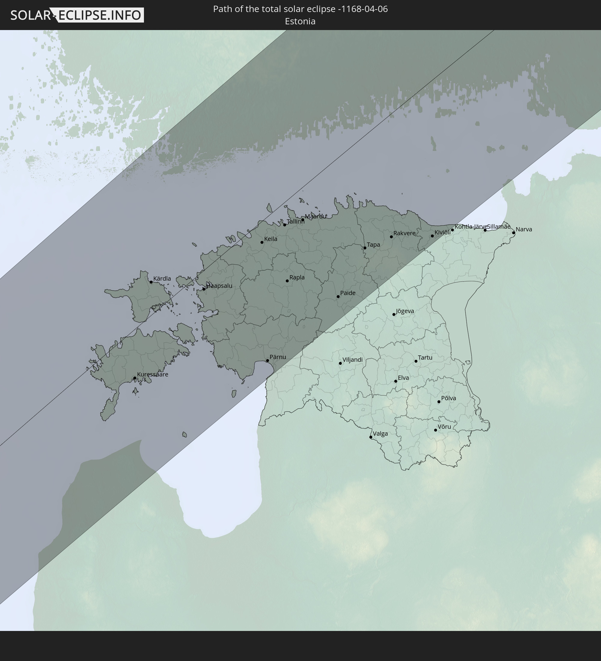 Estonia
In den folgenden Ländern ist die Sonnenfinsternis partiell zu sehen
 Russia
 Canada
 Greenland
 Portugal
 Cabo Verde
 Iceland
 Spain
Spain
 Senegal
 Mauritania
 The Gambia
 Guinea-Bissau
 Guinea
 Sierra Leone
 Morocco
 Mali
Mali
 Liberia
 Republic of Ireland
 Svalbard and Jan Mayen
 Algeria
 United Kingdom
 Ivory Coast
 Faroe Islands
 Burkina Faso
 Gibraltar
 France
 Isle of Man
 Ghana
Ghana
 Guernsey
 Jersey
 Togo
Togo
 Niger
Niger
 Benin
Benin
 Andorra
 Belgium
 Nigeria
 Netherlands
 Norway
 Luxembourg
 Germany
 Switzerland
 Italy
Italy
 Monaco
 Tunisia
 Denmark
 Cameroon
 Libya
Libya
 Liechtenstein
 Austria
 Sweden
 Czechia
 San Marino
 Vatican City
 Slovenia
 Chad
Chad
 Croatia
 Poland
 Malta
Malta
 Bosnia and Herzegovina
 Hungary
 Slovakia
 Montenegro
 Serbia
 Albania
 Åland Islands
 Greece
 Romania
 Republic of Macedonia
 Finland
 Lithuania
 Latvia
 Estonia
 Sudan
Sudan
 Ukraine
 Bulgaria
 Belarus
 Egypt
Egypt
 Turkey
 Moldova
 Cyprus
 State of Palestine
 Israel
 Saudi Arabia
 Jordan
 Lebanon
 Syria
Syria
 Iraq
Iraq
 Georgia
 Armenia
 Iran
Iran
 Azerbaijan
 Kazakhstan
 Kuwait
 Turkmenistan
 Uzbekistan
 Afghanistan
 Pakistan
 Tajikistan
 India
India
 Kyrgyzstan
 China
China
 Mongolia
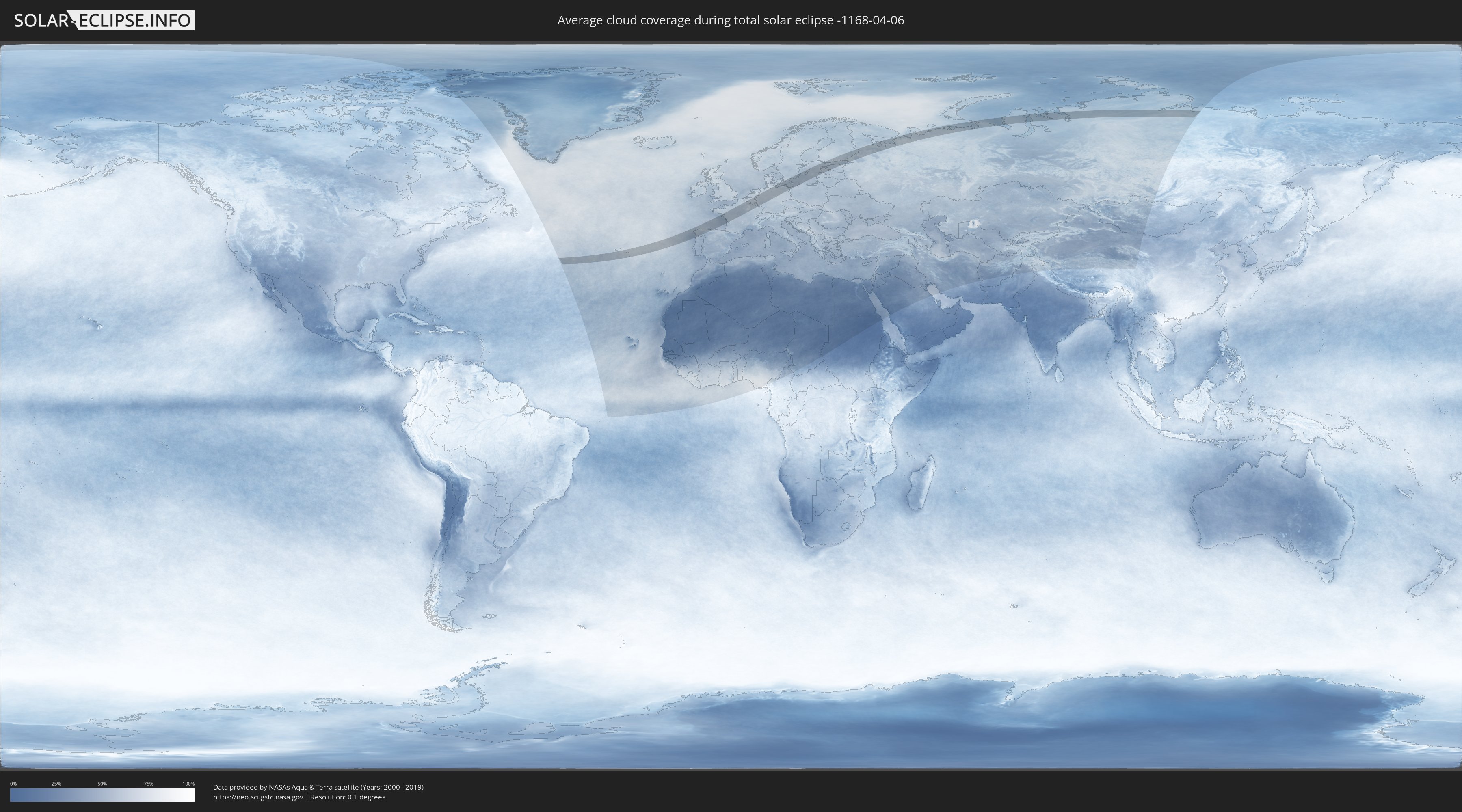
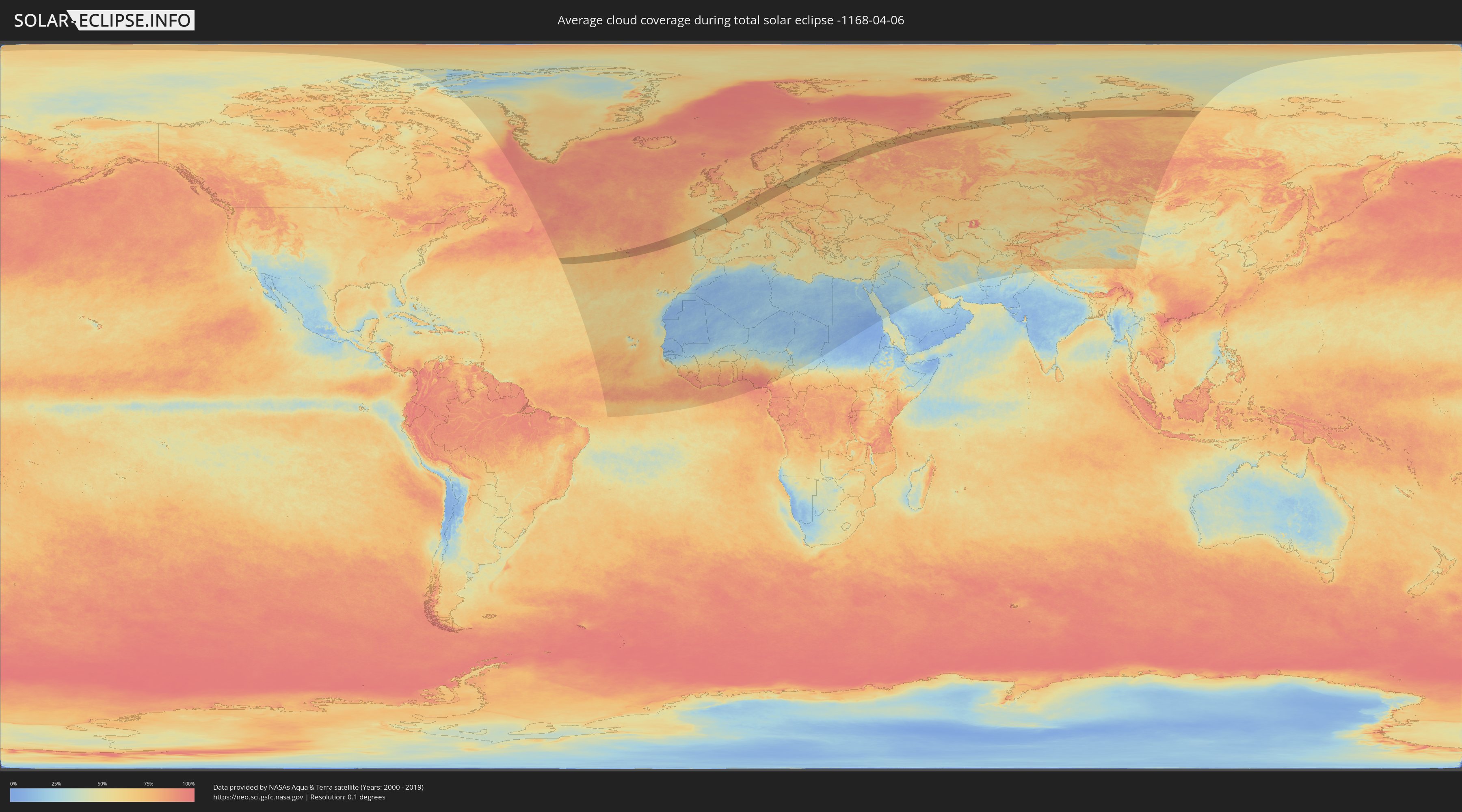
How will be the weather during the total solar eclipse on 04/06/-1168?
Where is the best place to see the total solar eclipse of 04/06/-1168?
The following maps show the average cloud coverage for the day of the total solar eclipse.
With the help of these maps, it is possible to find the place along the eclipse path, which has the best
chance of a cloudless sky.
Nevertheless, you should consider local circumstances and inform about the weather of your chosen
observation site.
The data is provided by NASAs satellites
AQUA and TERRA.
The cloud maps are averaged over a period of 19 years (2000 - 2019).
Detailed country maps
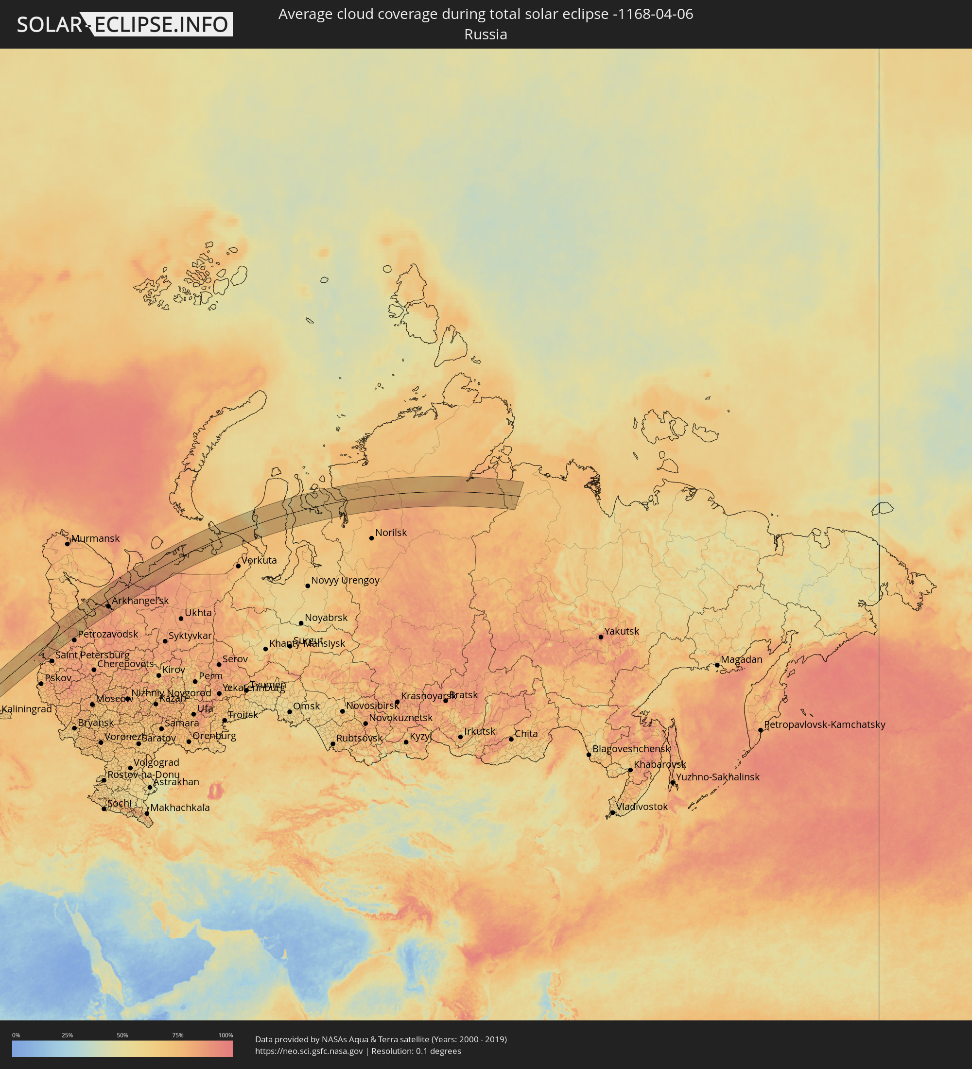 Russia
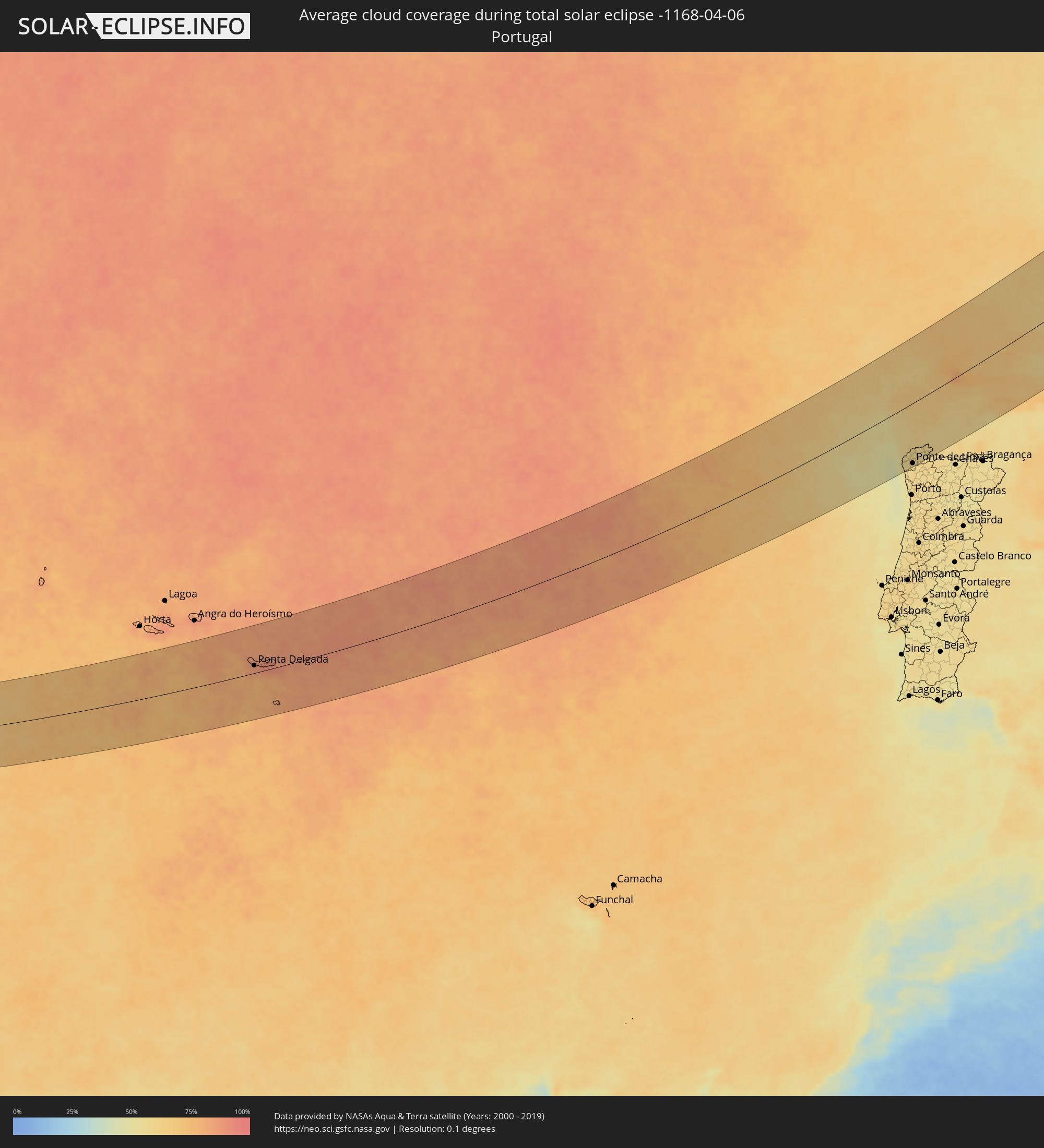 Portugal
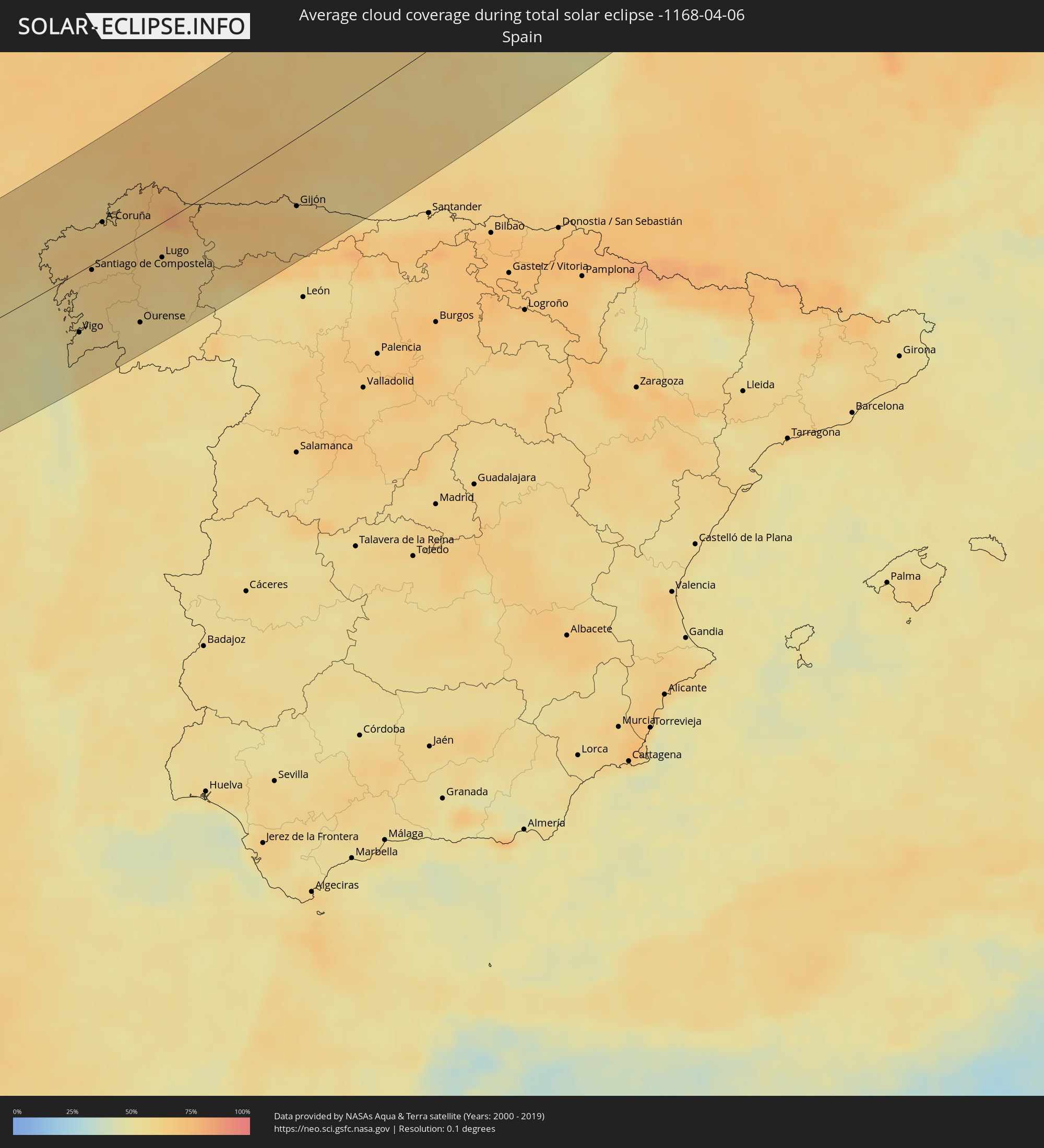 Spain
Spain
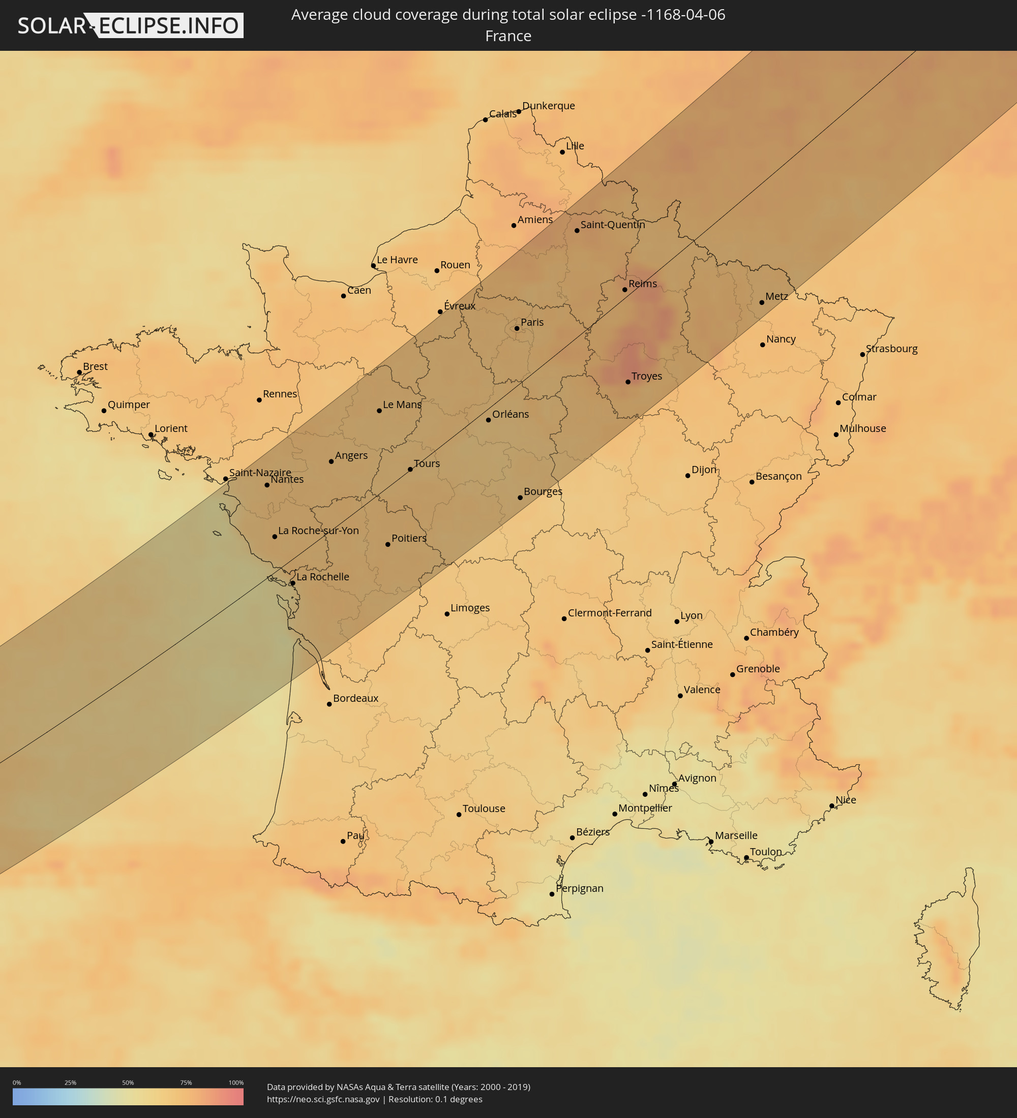 France
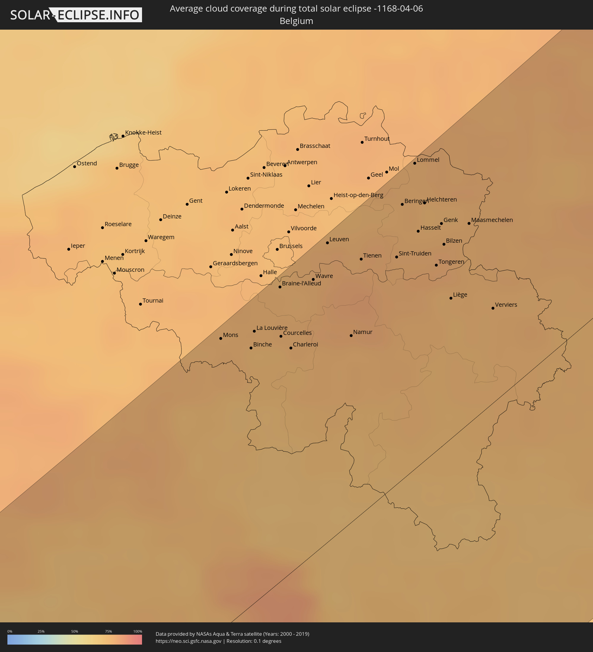 Belgium
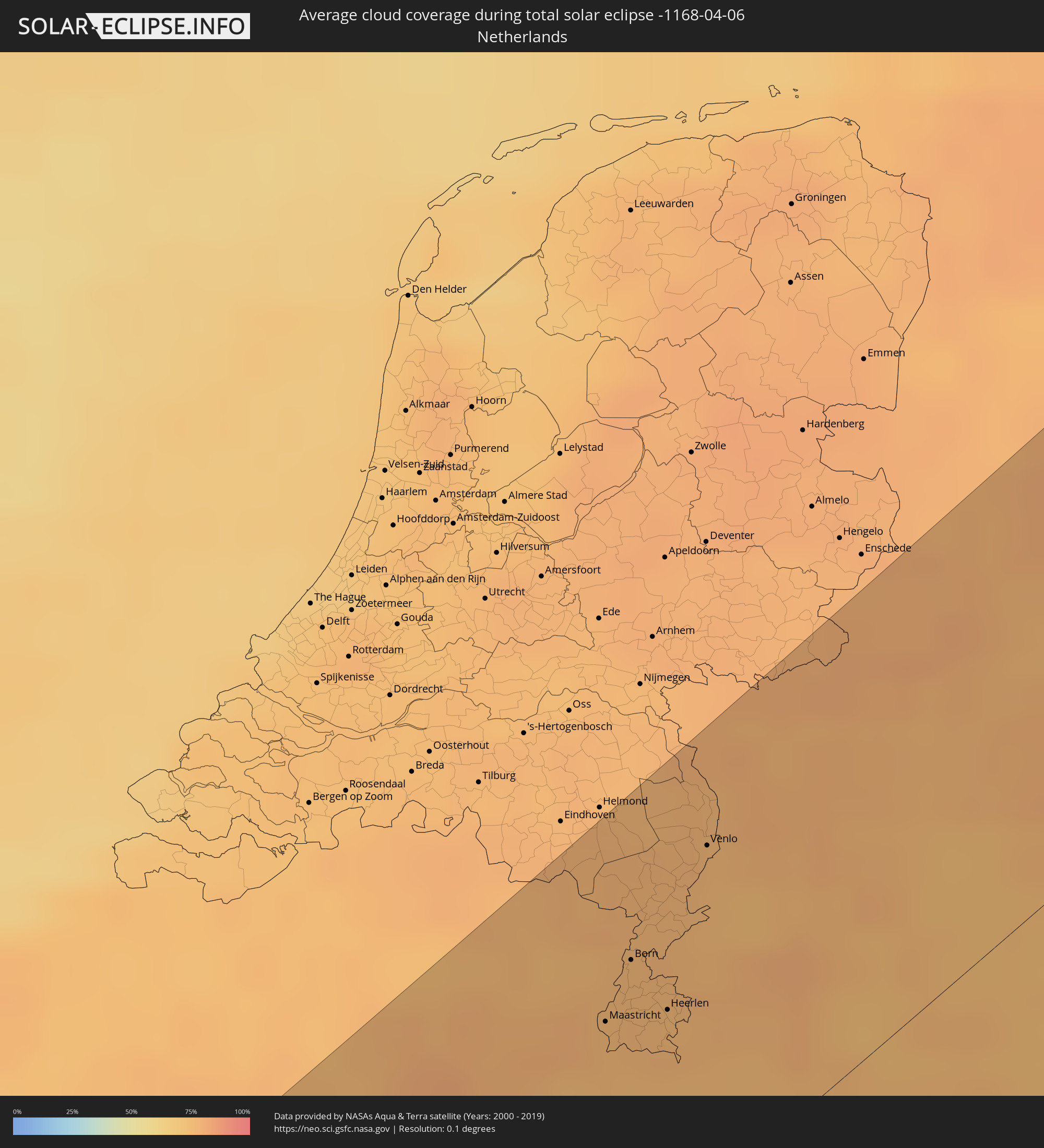 Netherlands
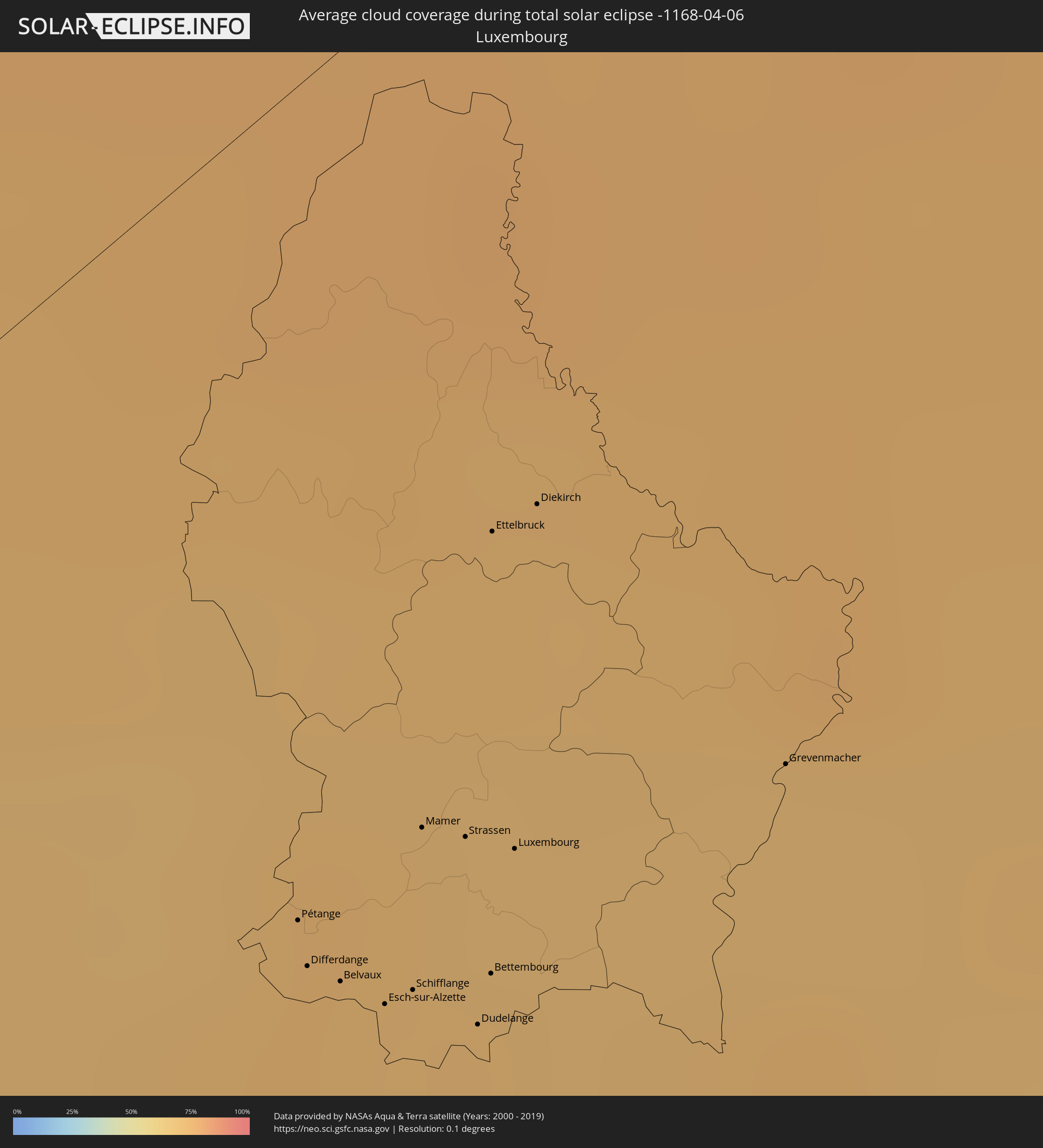 Luxembourg
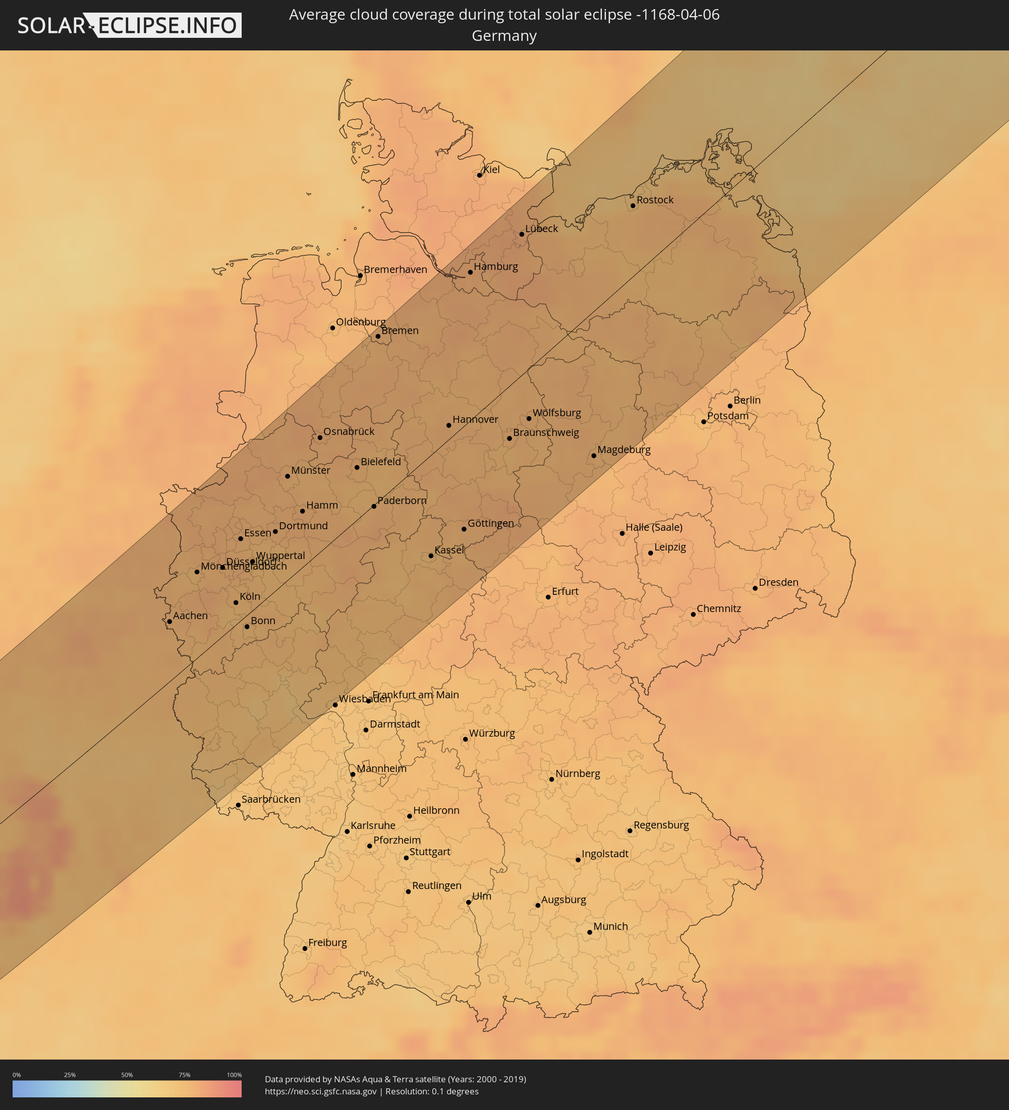 Germany
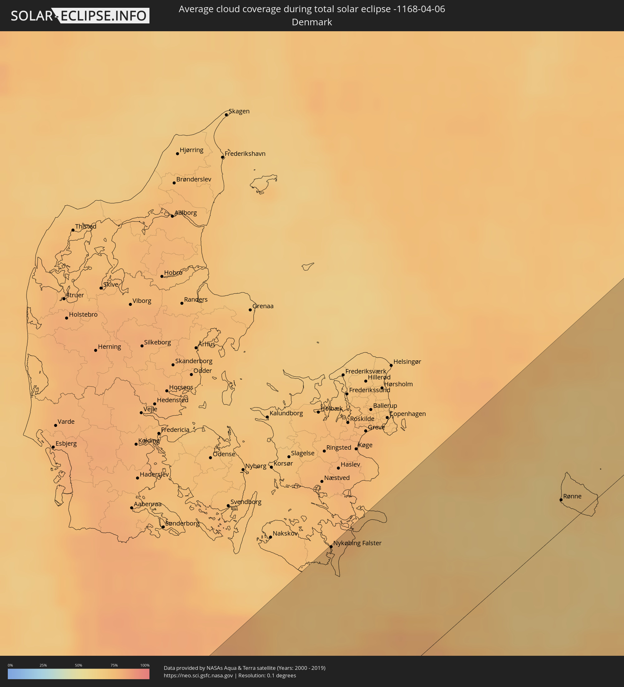 Denmark
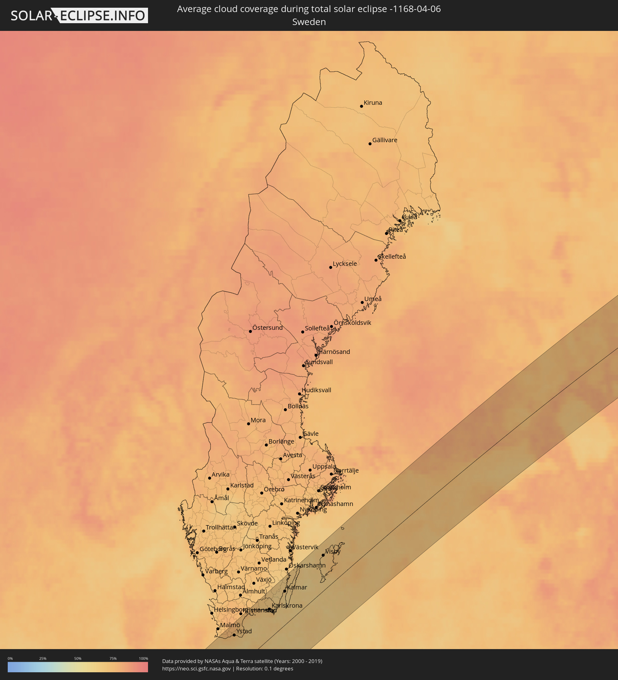 Sweden
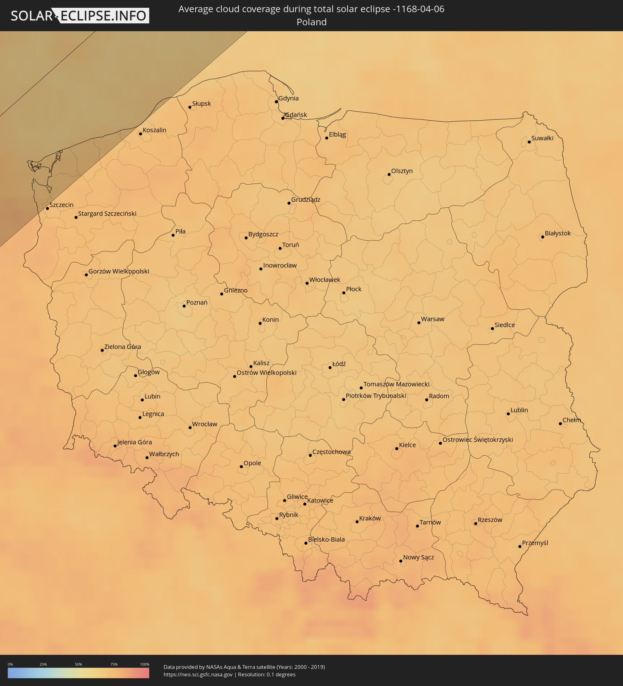 Poland
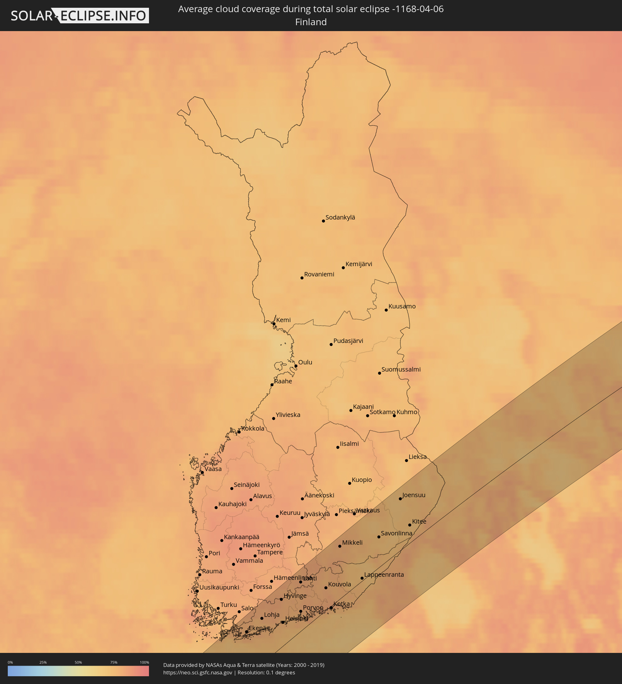 Finland
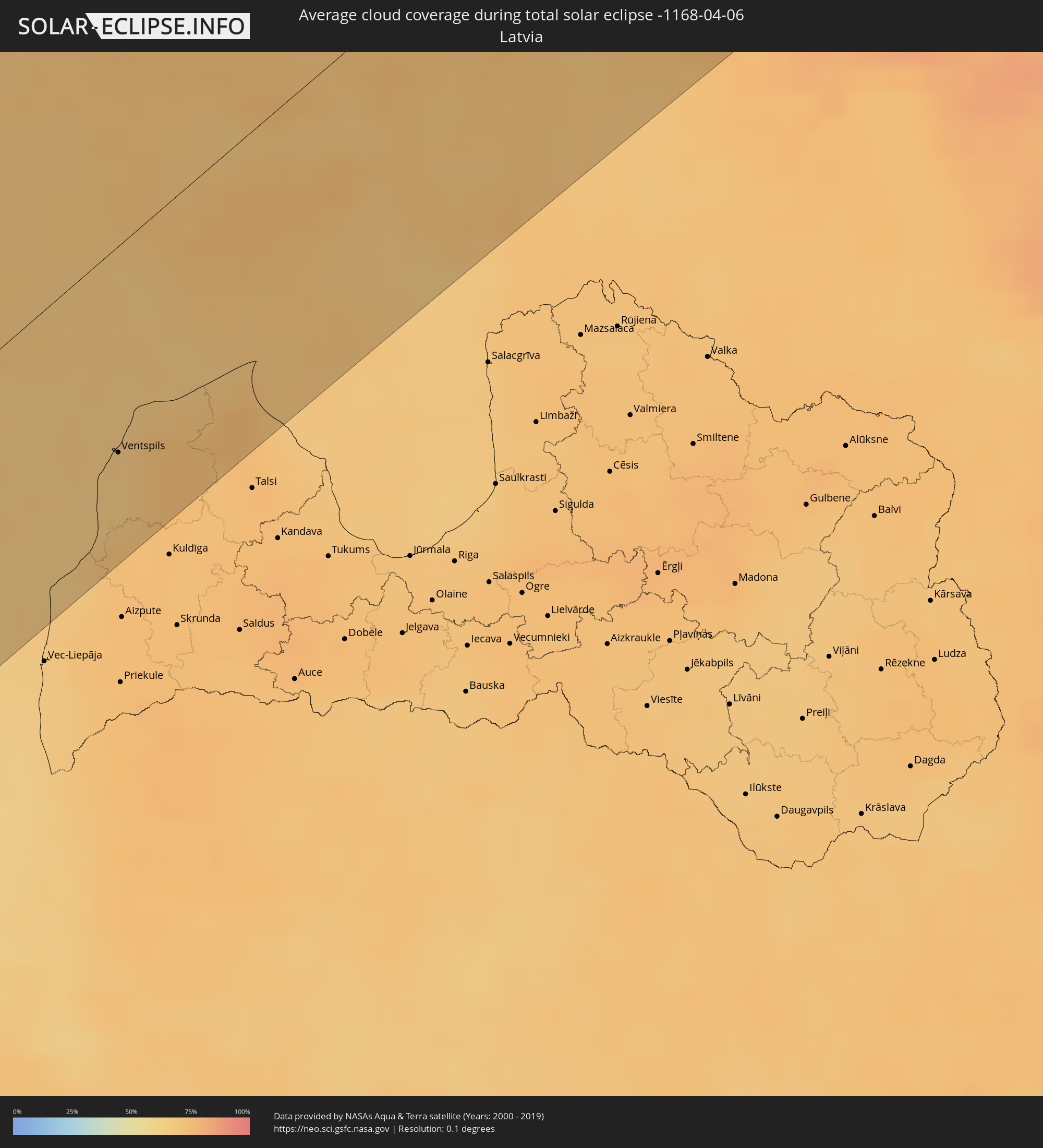 Latvia
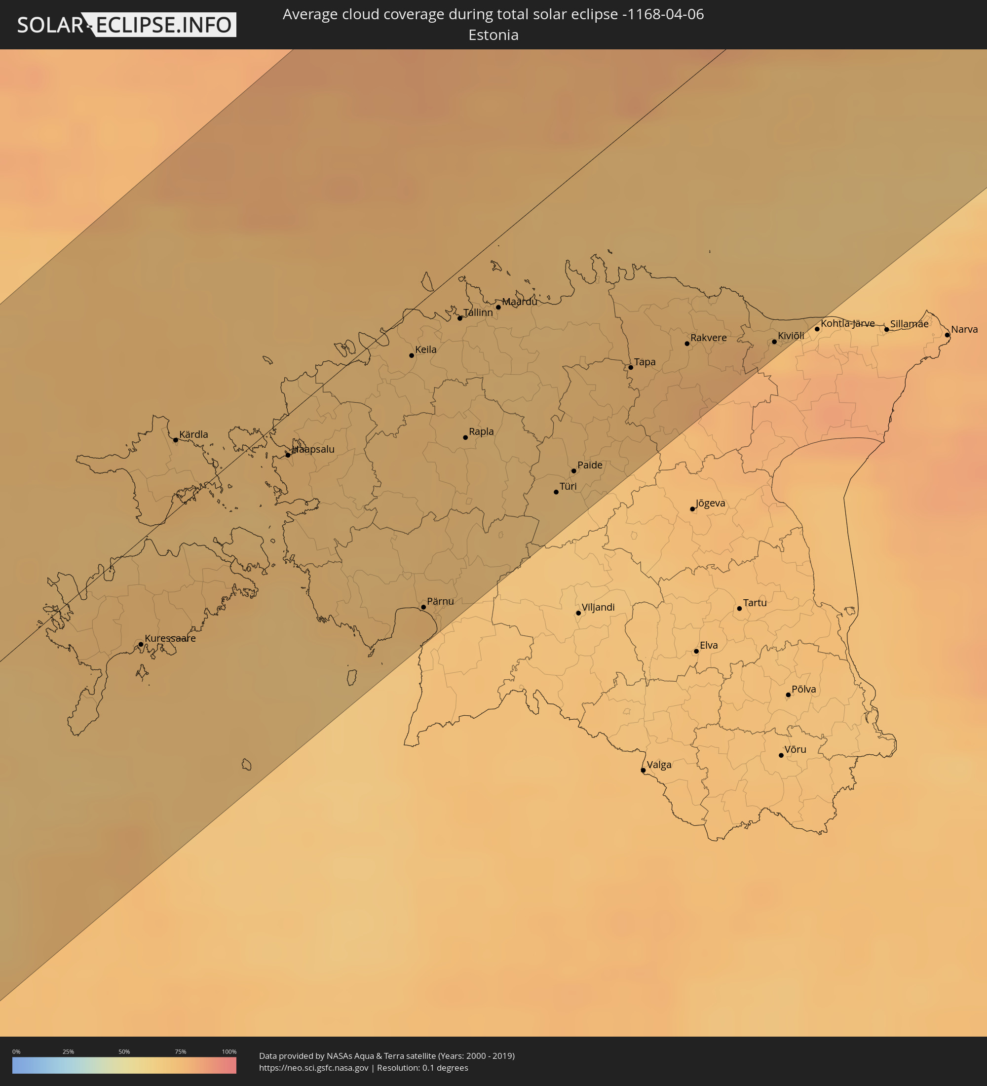 Estonia
Cities inside the path of the eclipse
The following table shows all locations with a population of more than 5,000 inside the eclipse path. Cities which have more than 100,000 inhabitants are marked bold. A click at the locations opens a detailed map.
| City | Type | Eclipse duration | Local time of max. eclipse | Distance to central line | Ø Cloud coverage |
|
Arrifes, Azores
|
total | - | 06:58:44 UTC-01:54 | 25 km | 84% |
|
Ponta Delgada, Azores
|
total | - | 06:58:41 UTC-01:54 | 20 km | 83% |
|
Rosto de Cão, Azores
|
total | - | 06:58:43 UTC-01:54 | 20 km | 84% |
|
Rabo de Peixe, Azores
|
total | - | 06:58:50 UTC-01:54 | 22 km | 86% |
|
Vila Franca do Campo, Azores
|
total | - | 06:58:45 UTC-01:54 | 13 km | 85% |
|
Viana do Castelo, Viana do Castelo
|
total | - | 08:34:48 UTC-00:36 | 108 km | 53% |
|
Meadela, Viana do Castelo
|
total | - | 08:34:51 UTC-00:36 | 109 km | 53% |
|
Darque, Viana do Castelo
|
total | - | 08:34:50 UTC-00:36 | 112 km | 53% |
|
Vilagarcía de Arousa, Galicia
|
total | - | 09:13:14 UTC+00:00 | 25 km | 58% |
|
Vigo, Galicia
|
total | - | 09:12:37 UTC+00:00 | 61 km | 60% |
|
Carballo, Galicia
|
total | - | 09:14:25 UTC+00:00 | 33 km | 68% |
|
Pontevedra, Galicia
|
total | - | 09:13:03 UTC+00:00 | 45 km | 59% |
|
Valenza, Viana do Castelo
|
total | - | 08:35:35 UTC-00:36 | 85 km | 59% |
|
Ponte de Lima, Viana do Castelo
|
total | - | 08:35:10 UTC-00:36 | 114 km | 58% |
|
Santiago de Compostela, Galicia
|
total | - | 09:13:57 UTC+00:00 | 9 km | 64% |
|
Ponteareas, Galicia
|
total | - | 09:12:43 UTC+00:00 | 75 km | 60% |
|
Monção, Viana do Castelo
|
total | - | 08:35:49 UTC-00:36 | 85 km | 58% |
|
Ribeira, Galicia
|
total | - | 09:13:48 UTC+00:00 | 24 km | 63% |
|
Mozelos, Viana do Castelo
|
total | - | 08:35:31 UTC-00:36 | 109 km | 58% |
|
A Coruña, Galicia
|
total | - | 09:14:58 UTC+00:00 | 39 km | 63% |
|
Ferrol, Galicia
|
total | - | 09:15:20 UTC+00:00 | 40 km | 64% |
|
Lalín, Galicia
|
total | - | 09:13:58 UTC+00:00 | 46 km | 63% |
|
Ourense, Galicia
|
total | - | 09:13:38 UTC+00:00 | 86 km | 57% |
|
Lugo, Galicia
|
total | - | 09:15:08 UTC+00:00 | 40 km | 61% |
|
Avilés, Asturias
|
total | - | 09:17:44 UTC+00:00 | 56 km | 66% |
|
Oviedo, Asturias
|
total | - | 09:17:28 UTC+00:00 | 75 km | 68% |
|
Gijón, Asturias
|
total | - | 09:17:58 UTC+00:00 | 66 km | 68% |
|
Nantes, Pays de la Loire
|
total | - | 09:38:08 UTC+00:09 | 89 km | 68% |
|
La Rochelle, Nouvelle-Aquitaine
|
total | - | 09:36:47 UTC+00:09 | 29 km | 57% |
|
Angers, Pays de la Loire
|
total | - | 09:39:41 UTC+00:09 | 64 km | 70% |
|
Le Mans, Pays de la Loire
|
total | - | 09:41:25 UTC+00:09 | 78 km | 69% |
|
Poitiers, Nouvelle-Aquitaine
|
total | - | 09:39:12 UTC+00:09 | 56 km | 70% |
|
Tours, Centre
|
total | - | 09:40:56 UTC+00:09 | 17 km | 67% |
|
Orléans, Centre
|
total | - | 09:43:13 UTC+00:09 | 21 km | 65% |
|
Saint-Quentin-en-Yvelines, Île-de-France
|
total | - | 09:44:46 UTC+00:09 | 59 km | 70% |
|
Cergy-Pontoise, Île-de-France
|
total | - | 09:45:16 UTC+00:09 | 79 km | 69% |
|
Paris, Île-de-France
|
total | - | 09:45:17 UTC+00:09 | 50 km | 73% |
|
Bourges, Centre
|
total | - | 09:42:28 UTC+00:09 | 106 km | 68% |
|
Noisy-le-Grand, Île-de-France
|
total | - | 09:45:32 UTC+00:09 | 40 km | 69% |
|
Mons, Wallonia
|
total | - | 09:40:20 UTC+00:00 | 113 km | 76% |
|
Reims, Grand-Est
|
total | - | 09:47:55 UTC+00:09 | 11 km | 76% |
|
Troyes, Grand-Est
|
total | - | 09:46:28 UTC+00:09 | 78 km | 75% |
|
La Louvière, Wallonia
|
total | - | 09:40:40 UTC+00:00 | 105 km | 73% |
|
Braine-l'Alleud, Wallonia
|
total | - | 09:41:11 UTC+00:00 | 113 km | 76% |
|
Charleroi, Wallonia
|
total | - | 09:40:51 UTC+00:00 | 89 km | 74% |
|
Wavre, Wallonia
|
total | - | 09:41:30 UTC+00:00 | 105 km | 76% |
|
Leuven, Flanders
|
total | - | 09:41:52 UTC+00:00 | 116 km | 78% |
|
Namur, Wallonia
|
total | - | 09:41:26 UTC+00:00 | 71 km | 75% |
|
Tienen, Flanders
|
total | - | 09:42:02 UTC+00:00 | 97 km | 79% |
|
Sint-Truiden, Flanders
|
total | - | 09:42:21 UTC+00:00 | 86 km | 77% |
|
Beringen, Flanders
|
total | - | 09:42:45 UTC+00:00 | 104 km | 76% |
|
Lommel, Flanders
|
total | - | 09:43:07 UTC+00:00 | 115 km | 76% |
|
Hasselt, Flanders
|
total | - | 09:42:42 UTC+00:00 | 89 km | 77% |
|
Liège, Wallonia
|
total | - | 09:42:32 UTC+00:00 | 53 km | 74% |
|
Maastricht, Limburg
|
total | - | 10:02:32 UTC+00:19 | 66 km | 76% |
|
Maasmechelen, Flanders
|
total | - | 09:43:11 UTC+00:00 | 75 km | 76% |
|
Weert, Limburg
|
total | - | 10:03:09 UTC+00:19 | 99 km | 78% |
|
Eijsden, Limburg
|
total | - | 10:02:28 UTC+00:19 | 58 km | 76% |
|
Asten, North Brabant
|
total | - | 10:03:26 UTC+00:19 | 109 km | 78% |
|
Stein, Limburg
|
total | - | 10:02:48 UTC+00:19 | 72 km | 76% |
|
Born, Limburg
|
total | - | 10:02:57 UTC+00:19 | 75 km | 76% |
|
Margraten, Limburg
|
total | - | 10:02:39 UTC+00:19 | 57 km | 76% |
|
Verviers, Wallonia
|
total | - | 09:42:49 UTC+00:00 | 36 km | 76% |
|
Pétange, Luxembourg
|
total | - | 10:05:53 UTC+00:24 | 53 km | 73% |
|
Differdange, Luxembourg
|
total | - | 10:05:50 UTC+00:24 | 57 km | 72% |
|
Belvaux, Luxembourg
|
total | - | 10:05:52 UTC+00:24 | 60 km | 72% |
|
Venray, Limburg
|
total | - | 10:03:52 UTC+00:19 | 109 km | 77% |
|
Esch-sur-Alzette, Luxembourg
|
total | - | 10:05:54 UTC+00:24 | 63 km | 71% |
|
Heerlen, Limburg
|
total | - | 10:02:56 UTC+00:19 | 55 km | 76% |
|
Simpelveld, Limburg
|
total | - | 10:02:51 UTC+00:19 | 51 km | 77% |
|
Roermond, Limburg
|
total | - | 10:03:24 UTC+00:19 | 81 km | 77% |
|
Schifflange, Luxembourg
|
total | - | 10:05:58 UTC+00:24 | 63 km | 71% |
|
Vaals, Limburg
|
total | - | 10:02:48 UTC+00:19 | 44 km | 77% |
|
Mamer, Luxembourg
|
total | - | 10:06:10 UTC+00:24 | 54 km | 71% |
|
Maasbree, Limburg
|
total | - | 10:03:43 UTC+00:19 | 92 km | 77% |
|
Bertrange, Luxembourg
|
total | - | 10:06:10 UTC+00:24 | 56 km | 71% |
|
Strassen, Luxembourg
|
total | - | 10:06:13 UTC+00:24 | 57 km | 71% |
|
Aachen, North Rhine-Westphalia
|
total | - | 10:43:22 UTC+01:00 | 41 km | 76% |
|
Dudelange, Luxembourg
|
total | - | 10:06:01 UTC+00:24 | 69 km | 71% |
|
Bettembourg, Luxembourg
|
total | - | 10:06:06 UTC+00:24 | 66 km | 71% |
|
Ettelbruck, Diekirch
|
total | - | 10:06:36 UTC+00:24 | 38 km | 70% |
|
Luxembourg, Luxembourg
|
total | - | 10:06:16 UTC+00:24 | 60 km | 71% |
|
Diekirch, Diekirch
|
total | - | 10:06:41 UTC+00:24 | 39 km | 71% |
|
Venlo, Limburg
|
total | - | 10:03:52 UTC+00:19 | 87 km | 75% |
|
Metz, Grand-Est
|
total | - | 09:50:19 UTC+00:09 | 106 km | 70% |
|
Mönchengladbach, North Rhine-Westphalia
|
total | - | 10:44:24 UTC+01:00 | 59 km | 74% |
|
Grevenmacher, Grevenmacher
|
total | - | 10:42:09 UTC+01:00 | 69 km | 70% |
|
Winterswijk, Gelderland
|
total | - | 10:05:24 UTC+00:19 | 114 km | 78% |
|
Duisburg, North Rhine-Westphalia
|
total | - | 10:45:09 UTC+01:00 | 66 km | 78% |
|
Düsseldorf, North Rhine-Westphalia
|
total | - | 10:44:51 UTC+01:00 | 47 km | 76% |
|
Köln, North Rhine-Westphalia
|
total | - | 10:44:38 UTC+01:00 | 15 km | 73% |
|
Essen, North Rhine-Westphalia
|
total | - | 10:45:29 UTC+01:00 | 56 km | 76% |
|
Bonn, North Rhine-Westphalia
|
total | - | 10:44:32 UTC+01:00 | 9 km | 75% |
|
Wuppertal, North Rhine-Westphalia
|
total | - | 10:45:24 UTC+01:00 | 33 km | 74% |
|
Dortmund, North Rhine-Westphalia
|
total | - | 10:46:07 UTC+01:00 | 42 km | 74% |
|
Münster, North Rhine-Westphalia
|
total | - | 10:46:56 UTC+01:00 | 72 km | 75% |
|
Bielefeld, North Rhine-Westphalia
|
total | - | 10:48:08 UTC+01:00 | 37 km | 75% |
|
Bremen, Bremen
|
total | - | 10:49:54 UTC+01:00 | 109 km | 76% |
|
Hannover, Lower Saxony
|
total | - | 10:50:04 UTC+01:00 | 19 km | 78% |
|
Hamburg, Hamburg
|
total | - | 10:52:00 UTC+01:00 | 96 km | 78% |
|
Braunschweig, Lower Saxony
|
total | - | 10:50:54 UTC+01:00 | 39 km | 75% |
|
Nykøbing Falster, Zealand
|
total | - | 10:55:43 UTC+01:00 | 112 km | 76% |
|
Trelleborg, Skåne
|
total | - | 10:57:57 UTC+01:00 | 108 km | 70% |
|
Skurup, Skåne
|
total | - | 10:58:29 UTC+01:00 | 100 km | 76% |
|
Sjöbo, Skåne
|
total | - | 10:58:54 UTC+01:00 | 105 km | 76% |
|
Ystad, Skåne
|
total | - | 10:58:48 UTC+01:00 | 84 km | 71% |
|
Tomelilla, Skåne
|
total | - | 10:59:05 UTC+01:00 | 87 km | 70% |
|
Świnoujście, West Pomeranian Voivodeship
|
total | - | 11:21:34 UTC+01:24 | 63 km | 70% |
|
Åhus, Skåne
|
total | - | 10:59:53 UTC+01:00 | 103 km | 71% |
|
Simrishamn, Skåne
|
total | - | 10:59:34 UTC+01:00 | 71 km | 69% |
|
Międzyzdroje, West Pomeranian Voivodeship
|
total | - | 11:21:51 UTC+01:24 | 72 km | 70% |
|
Bromölla, Skåne
|
total | - | 11:00:17 UTC+01:00 | 109 km | 74% |
|
Police, West Pomeranian Voivodeship
|
total | - | 11:21:33 UTC+01:24 | 106 km | 73% |
|
Sölvesborg, Blekinge
|
total | - | 11:00:23 UTC+01:00 | 103 km | 71% |
|
Wolin, West Pomeranian Voivodeship
|
total | - | 11:21:57 UTC+01:24 | 86 km | 69% |
|
Rønne, Capital Region
|
total | - | 10:59:29 UTC+01:00 | 20 km | 66% |
|
Kamień Pomorski, West Pomeranian Voivodeship
|
total | - | 11:22:17 UTC+01:24 | 80 km | 71% |
|
Karlshamn, Blekinge
|
total | - | 11:00:50 UTC+01:00 | 100 km | 73% |
|
Gryfice, West Pomeranian Voivodeship
|
total | - | 11:22:46 UTC+01:24 | 103 km | 73% |
|
Trzebiatów, West Pomeranian Voivodeship
|
total | - | 11:23:00 UTC+01:24 | 94 km | 71% |
|
Ronneby, Blekinge
|
total | - | 11:01:22 UTC+01:00 | 87 km | 68% |
|
Kołobrzeg, West Pomeranian Voivodeship
|
total | - | 11:23:32 UTC+01:24 | 97 km | 70% |
|
Karlskrona, Blekinge
|
total | - | 11:01:41 UTC+01:00 | 70 km | 67% |
|
Nybro, Kalmar
|
total | - | 11:02:39 UTC+01:00 | 103 km | 64% |
|
Kalmar, Kalmar
|
total | - | 11:03:06 UTC+01:00 | 79 km | 65% |
|
Visby, Gotland
|
total | - | 11:06:16 UTC+01:00 | 81 km | 66% |
|
Pāvilosta, Pāvilostas
|
total | - | 11:45:34 UTC+01:36 | 98 km | 67% |
|
Alsunga, Alsunga
|
total | - | 11:46:05 UTC+01:36 | 104 km | 73% |
|
Ventspils, Ventspils
|
total | - | 11:46:25 UTC+01:36 | 72 km | 67% |
|
Dundaga, Dundaga
|
total | - | 11:47:25 UTC+01:36 | 91 km | 75% |
|
Kuressaare, Saare
|
total | - | 11:50:35 UTC+01:39 | 35 km | 72% |
|
Kärdla, Hiiumaa
|
total | - | 11:51:24 UTC+01:39 | 21 km | 72% |
|
Roja, Rojas
|
total | - | 11:47:57 UTC+01:36 | 109 km | 70% |
|
Haapsalu, Lääne
|
total | - | 11:52:14 UTC+01:39 | 15 km | 72% |
|
Lohja, Uusimaa
|
total | - | 11:54:27 UTC+01:39 | 79 km | 76% |
|
Keila, Harjumaa
|
total | - | 11:53:27 UTC+01:39 | 23 km | 70% |
|
Pärnu, Pärnumaa
|
total | - | 11:52:57 UTC+01:39 | 96 km | 74% |
|
Saue, Harjumaa
|
total | - | 11:53:36 UTC+01:39 | 21 km | 71% |
|
Espoo, Uusimaa
|
total | - | 11:55:04 UTC+01:39 | 56 km | 77% |
|
Tallinn, Harjumaa
|
total | - | 11:53:54 UTC+01:39 | 16 km | 71% |
|
Rapla, Raplamaa
|
total | - | 11:53:41 UTC+01:39 | 55 km | 72% |
|
Nurmijärvi, Uusimaa
|
total | - | 11:55:22 UTC+01:39 | 71 km | 79% |
|
Hyvinge, Uusimaa
|
total | - | 11:55:32 UTC+01:39 | 83 km | 79% |
|
Helsinki, Uusimaa
|
total | - | 11:55:21 UTC+01:39 | 41 km | 77% |
|
Maardu, Harjumaa
|
total | - | 11:54:13 UTC+01:39 | 27 km | 70% |
|
Vantaa, Uusimaa
|
total | - | 11:55:32 UTC+01:39 | 48 km | 76% |
|
Järvenpää, Uusimaa
|
total | - | 11:55:41 UTC+01:39 | 63 km | 79% |
|
Türi, Järvamaa
|
total | - | 11:54:17 UTC+01:39 | 94 km | 68% |
|
Paide, Järvamaa
|
total | - | 11:54:28 UTC+01:39 | 92 km | 69% |
|
Lahti, Päijänne Tavastia
|
total | - | 11:56:33 UTC+01:39 | 85 km | 80% |
|
Porvoo, Uusimaa
|
total | - | 11:56:15 UTC+01:39 | 34 km | 78% |
|
Tapa, Lääne-Virumaa
|
total | - | 11:55:08 UTC+01:39 | 74 km | 74% |
|
Rakvere, Lääne-Virumaa
|
total | - | 11:55:37 UTC+01:39 | 81 km | 76% |
|
Kouvola, Kymenlaakso
|
total | - | 11:57:35 UTC+01:39 | 40 km | 80% |
|
Kotka, Kymenlaakso
|
total | - | 11:57:37 UTC+01:39 | 10 km | 77% |
|
Kiviõli, Ida-Virumaa
|
total | - | 11:56:18 UTC+01:39 | 103 km | 74% |
|
Mikkeli, Southern Savonia
|
total | - | 11:58:33 UTC+01:39 | 90 km | 79% |
|
Lappeenranta, South Karelia
|
total | - | 11:59:14 UTC+01:39 | 17 km | 74% |
|
Imatra, South Karelia
|
total | - | 11:59:51 UTC+01:39 | 14 km | 76% |
|
Vyborg, Leningradskaya Oblast'
|
total | - | 12:50:08 UTC+02:30 | 48 km | 80% |
|
Svetogorsk, Leningradskaya Oblast'
|
total | - | 12:50:25 UTC+02:30 | 20 km | 77% |
|
Joensuu, North Karelia
|
total | - | 12:01:22 UTC+01:39 | 87 km | 71% |
|
Priozërsk, Leningradskaya Oblast'
|
total | - | 12:51:42 UTC+02:30 | 63 km | 79% |
|
Sortavala, Republic of Karelia
|
total | - | 12:52:31 UTC+02:30 | 23 km | 73% |
|
Pitkyaranta, Republic of Karelia
|
total | - | 12:53:15 UTC+02:30 | 61 km | 75% |
|
Suoyarvi, Republic of Karelia
|
total | - | 12:54:15 UTC+02:30 | 43 km | 79% |
|
Kondopoga, Republic of Karelia
|
total | - | 12:56:10 UTC+02:30 | 91 km | 76% |
|
Segezha, Republic of Karelia
|
total | - | 12:56:24 UTC+02:30 | 46 km | 72% |
|
Medvezh’yegorsk, Republic of Karelia
|
total | - | 12:56:27 UTC+02:30 | 32 km | 77% |
|
Belomorsk, Republic of Karelia
|
total | - | 12:56:52 UTC+02:30 | 102 km | 72% |
|
Onega, Arkhangelskaya
|
total | - | 12:59:52 UTC+02:30 | 48 km | 72% |
|
Severodvinsk, Arkhangelskaya
|
total | - | 13:01:19 UTC+02:30 | 34 km | 74% |
|
Arkhangel’sk, Arkhangelskaya
|
total | - | 13:01:56 UTC+02:30 | 55 km | 78% |
|
Novodvinsk, Arkhangelskaya
|
total | - | 13:02:12 UTC+02:30 | 74 km | 81% |
|
Nar'yan-Mar, Nenetskiy Avtonomnyy Okrug
|
total | - | 13:10:07 UTC+02:30 | 42 km | 78% |