Total solar eclipse of 07/18/-1229
| Day of week: | Saturday |
| Maximum duration of eclipse: | 04m49s |
| Maximum width of eclipse path: | 281 km |
| Saros cycle: | 26 |
| Coverage: | 100% |
| Magnitude: | 1.0709 |
| Gamma: | 0.5689 |
Wo kann man die Sonnenfinsternis vom 07/18/-1229 sehen?

Die Sonnenfinsternis am 07/18/-1229 kann man in 110 Ländern als partielle Sonnenfinsternis beobachten.
Der Finsternispfad verläuft durch 12 Länder. Nur in diesen Ländern ist sie als total Sonnenfinsternis zu sehen.
In den folgenden Ländern ist die Sonnenfinsternis total zu sehen
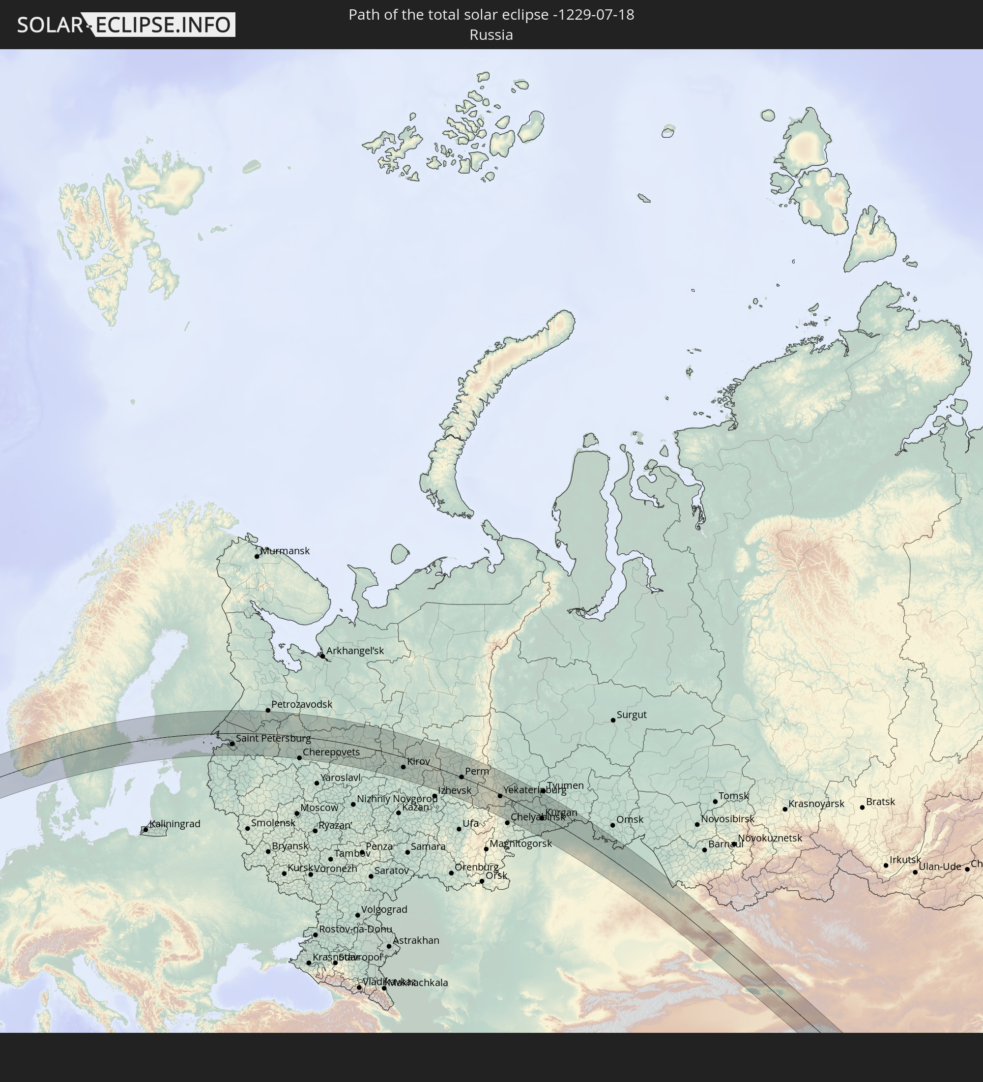 Russia
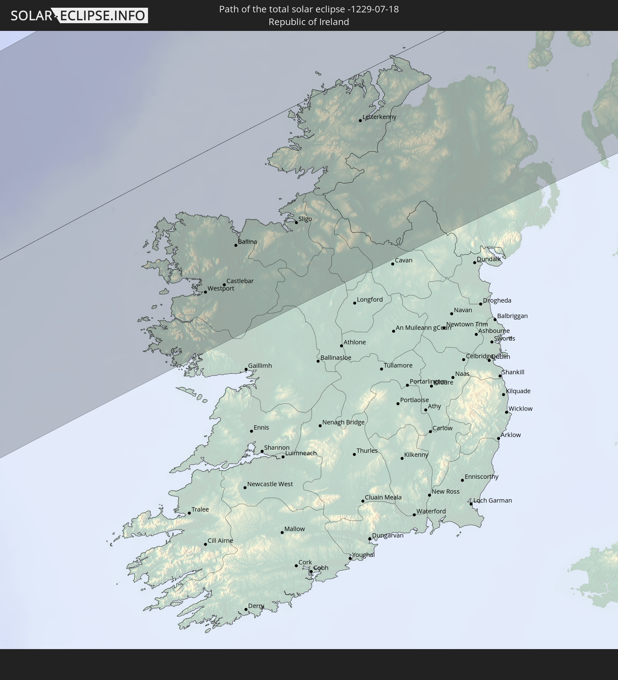 Republic of Ireland
 United Kingdom
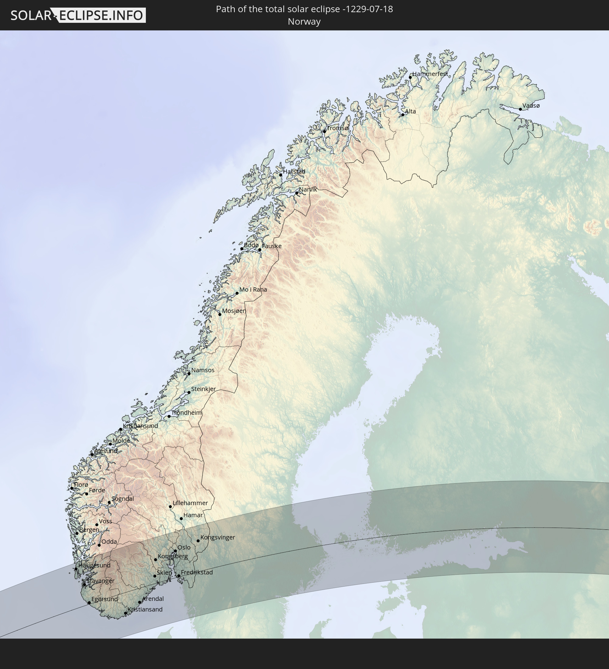 Norway
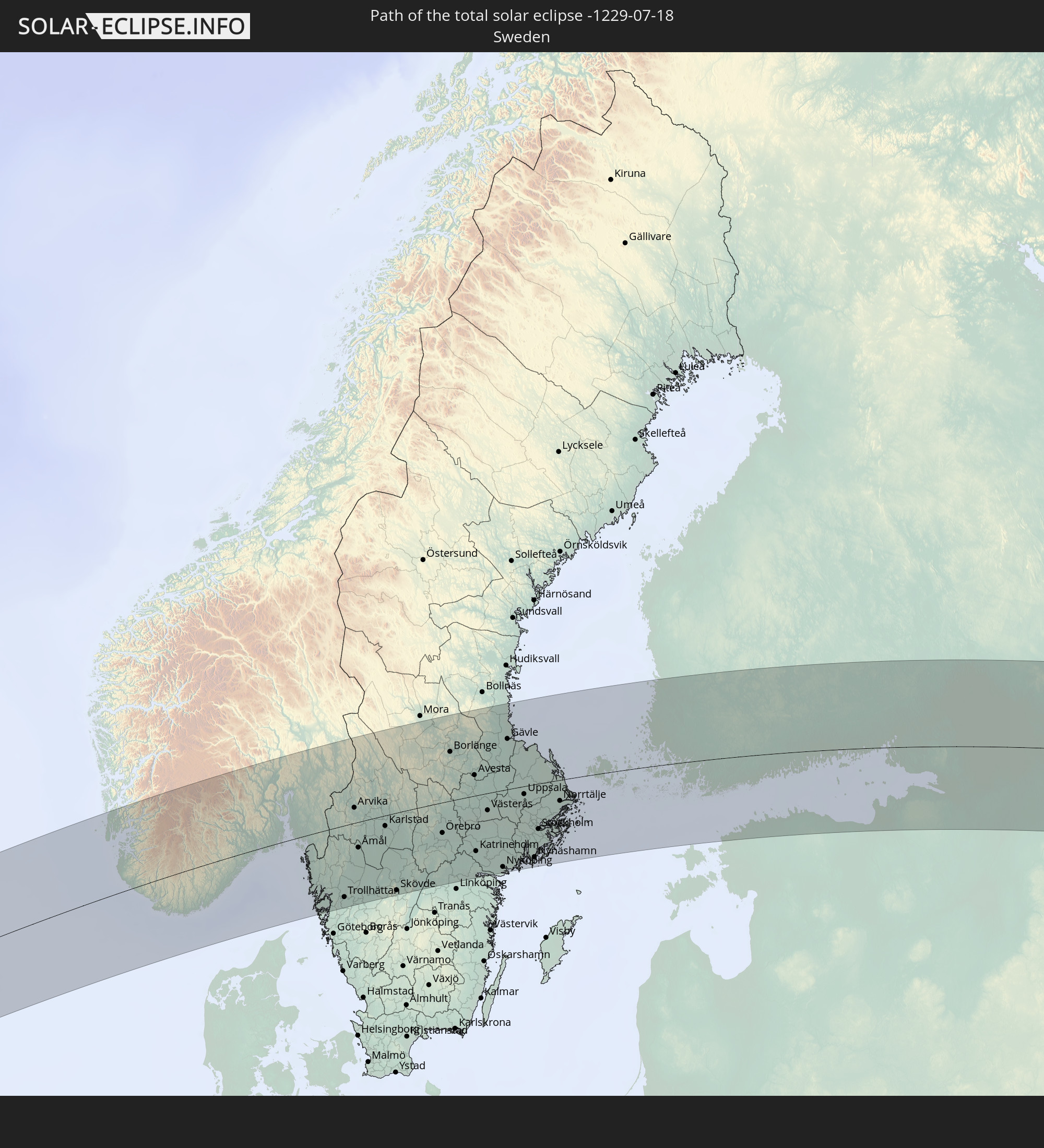 Sweden
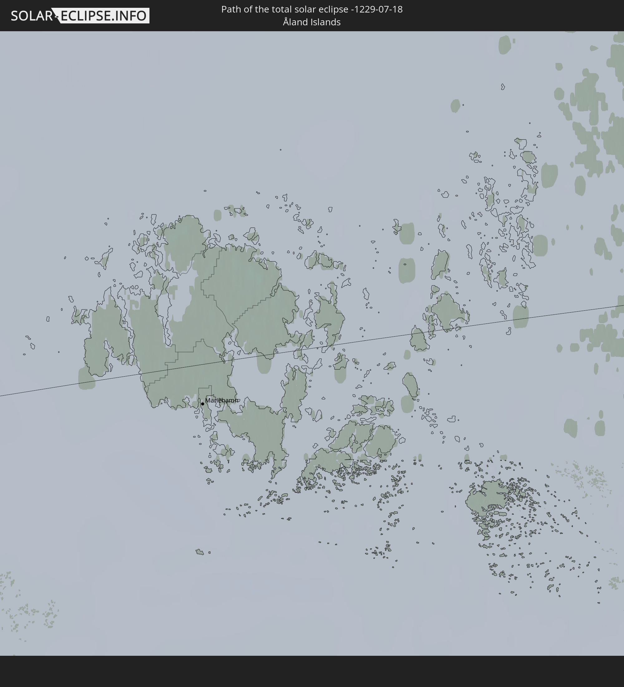 Åland Islands
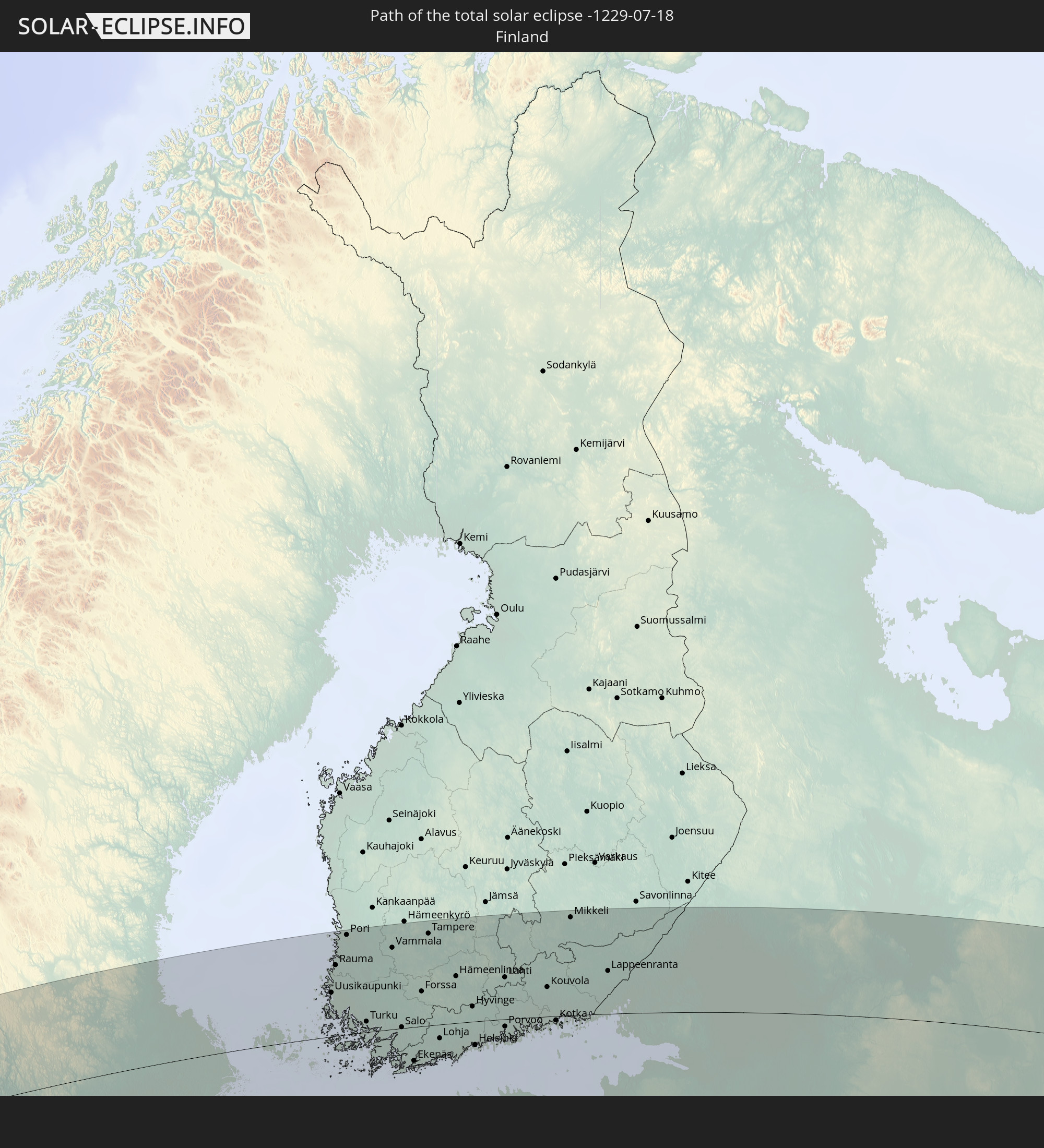 Finland
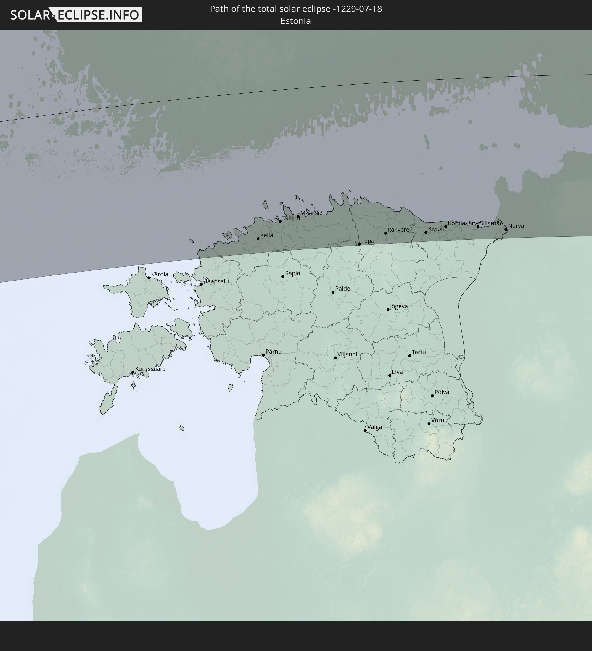 Estonia
 Kazakhstan
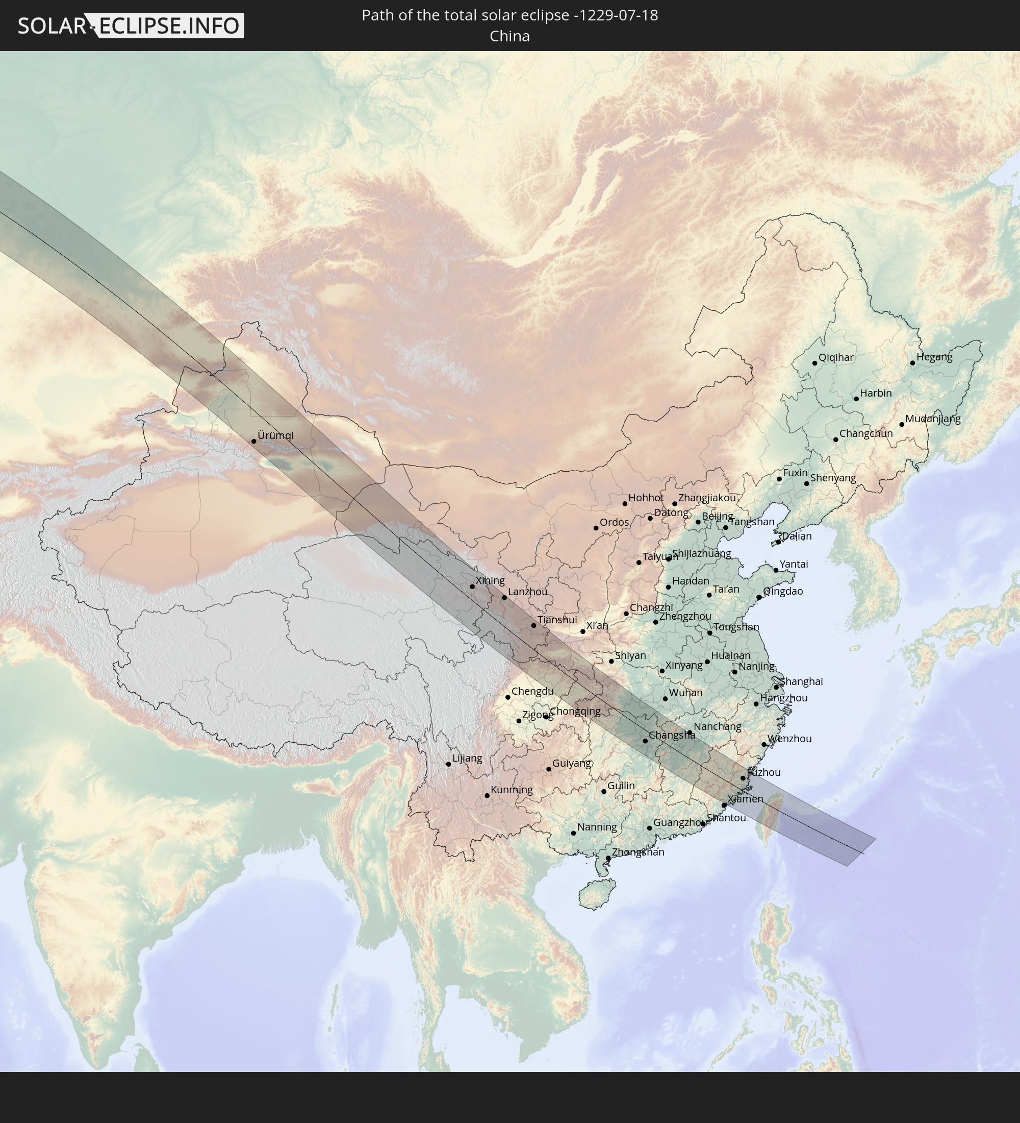 China
China
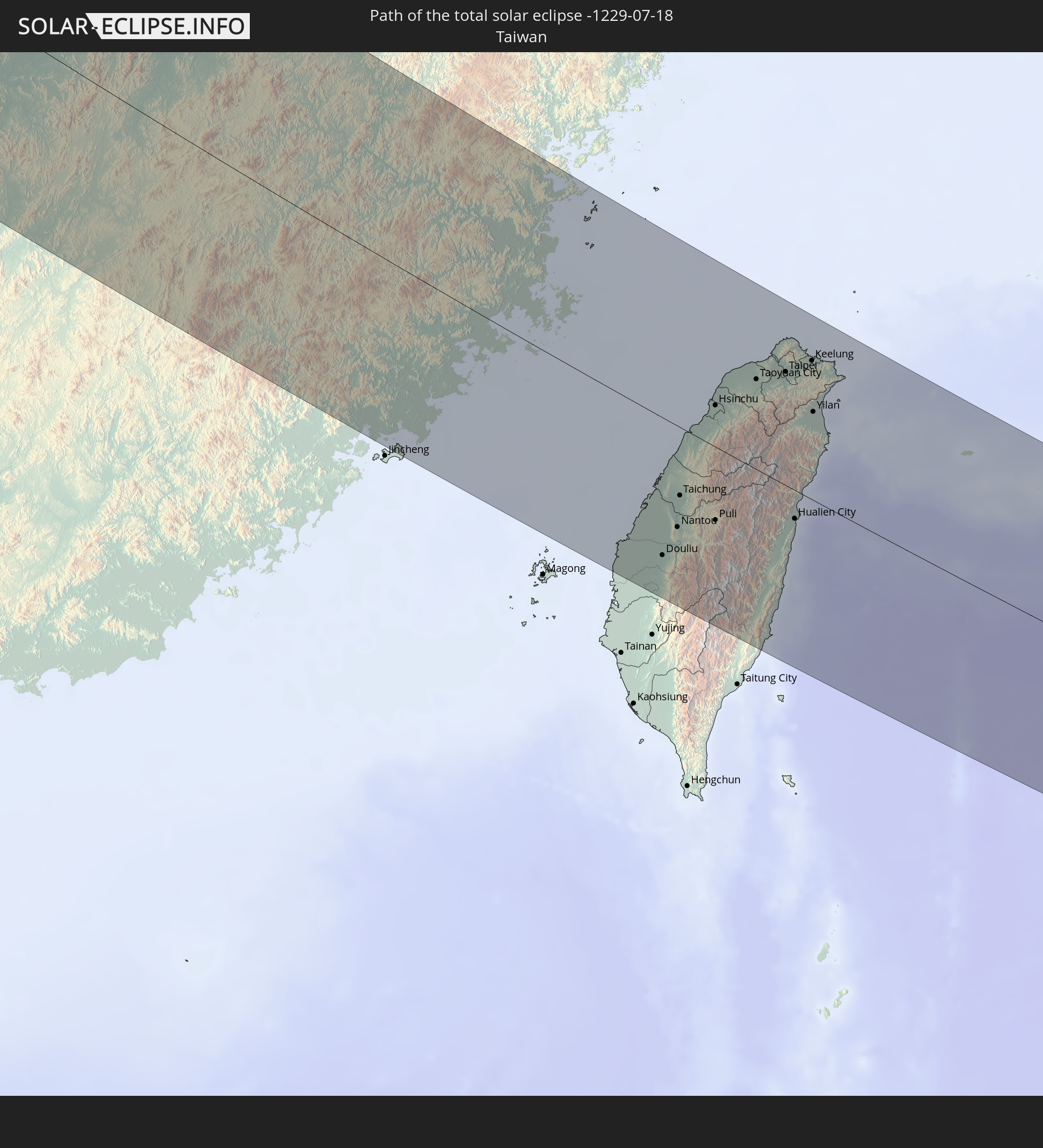 Taiwan
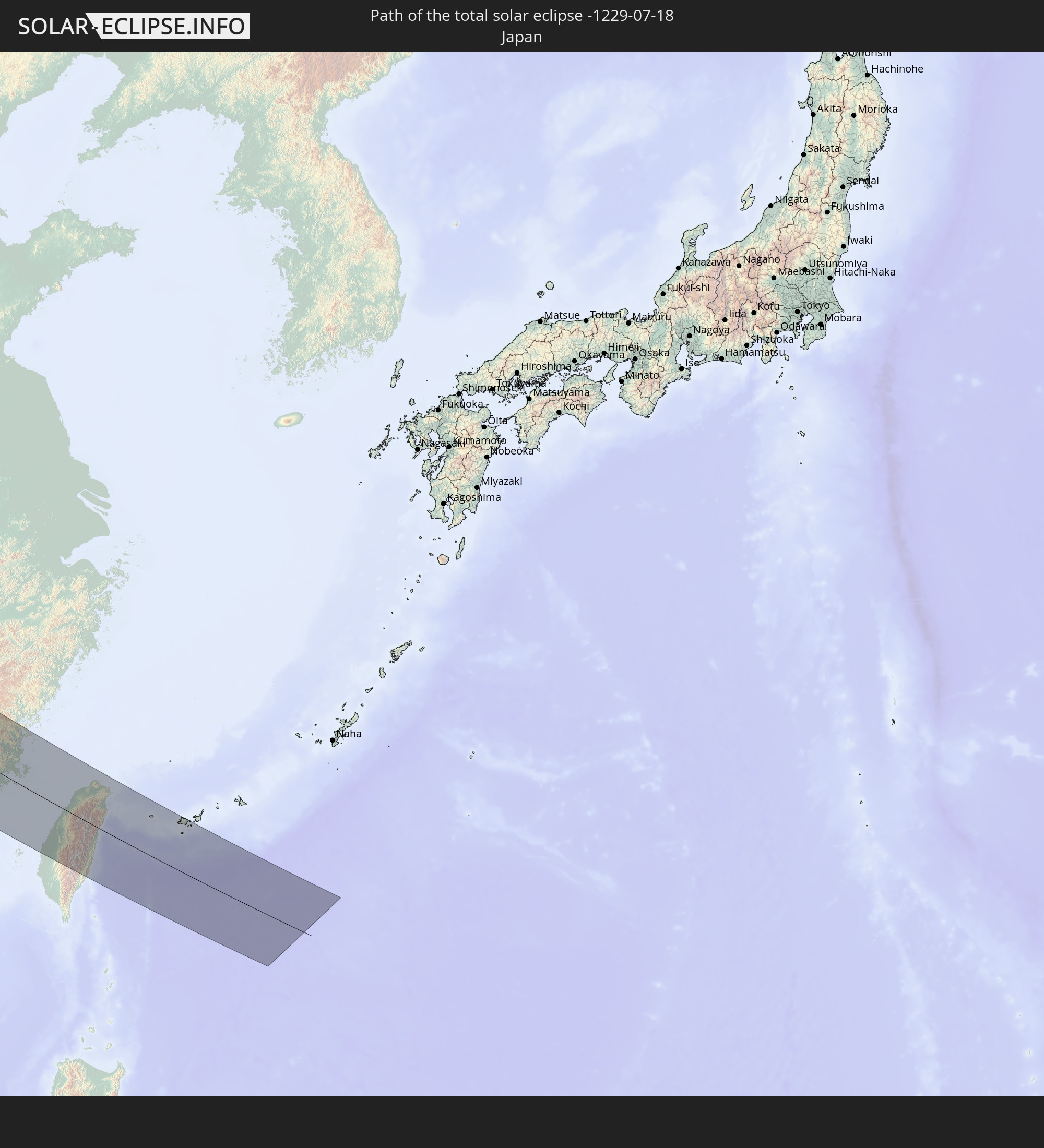 Japan
Japan
In den folgenden Ländern ist die Sonnenfinsternis partiell zu sehen
 Russia
 United States
 Canada
 Greenland
 Portugal
 Iceland
 Spain
Spain
 Senegal
 Mauritania
 Morocco
 Mali
Mali
 Republic of Ireland
 Svalbard and Jan Mayen
 Algeria
 United Kingdom
 Faroe Islands
 Gibraltar
 France
 Isle of Man
 Guernsey
 Jersey
 Andorra
 Belgium
 Netherlands
 Norway
 Luxembourg
 Germany
 Switzerland
 Italy
Italy
 Monaco
 Tunisia
 Denmark
 Libya
Libya
 Liechtenstein
 Austria
 Sweden
 Czechia
 San Marino
 Vatican City
 Slovenia
 Croatia
 Poland
 Malta
Malta
 Bosnia and Herzegovina
 Hungary
 Slovakia
 Montenegro
 Serbia
 Albania
 Åland Islands
 Greece
 Romania
 Republic of Macedonia
 Finland
 Lithuania
 Latvia
 Estonia
 Ukraine
 Bulgaria
 Belarus
 Egypt
Egypt
 Turkey
 Moldova
 Cyprus
 State of Palestine
 Israel
 Saudi Arabia
 Jordan
 Lebanon
 Syria
Syria
 Iraq
Iraq
 Georgia
 Armenia
 Iran
Iran
 Azerbaijan
 Kazakhstan
 Kuwait
 Bahrain
 Qatar
Qatar
 United Arab Emirates
 Oman
Oman
 Turkmenistan
 Uzbekistan
 Afghanistan
 Pakistan
 Tajikistan
 India
India
 Kyrgyzstan
 China
China
 Sri Lanka
 Nepal
Nepal
 Mongolia
 Bangladesh
 Bhutan
 Myanmar
 Indonesia
 Thailand
 Malaysia
 Laos
Laos
 Vietnam
 Cambodia
 Singapore
 Macau
Macau
 Hong Kong
 Brunei
 Taiwan
 Philippines
 Japan
Japan
 North Korea
 South Korea
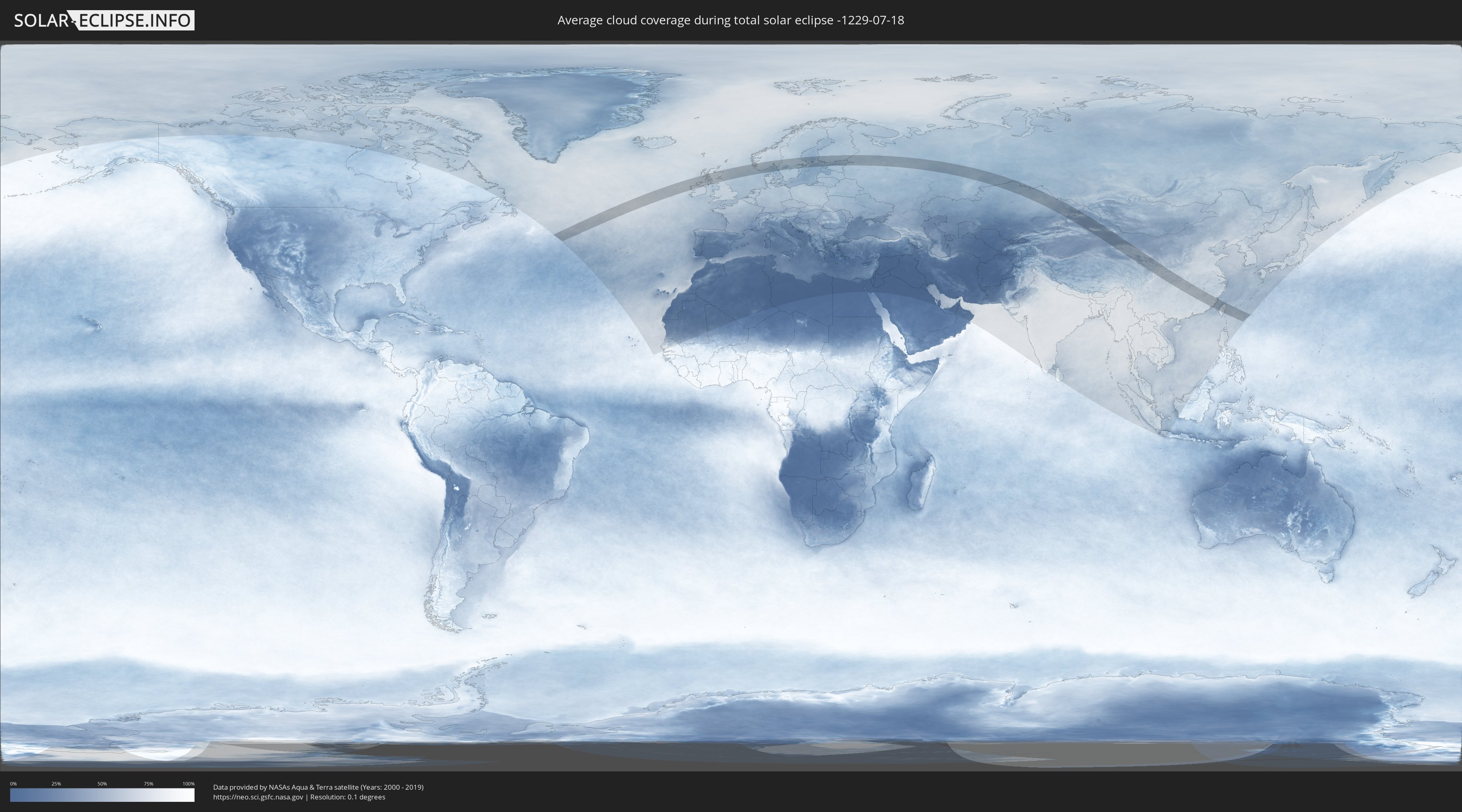
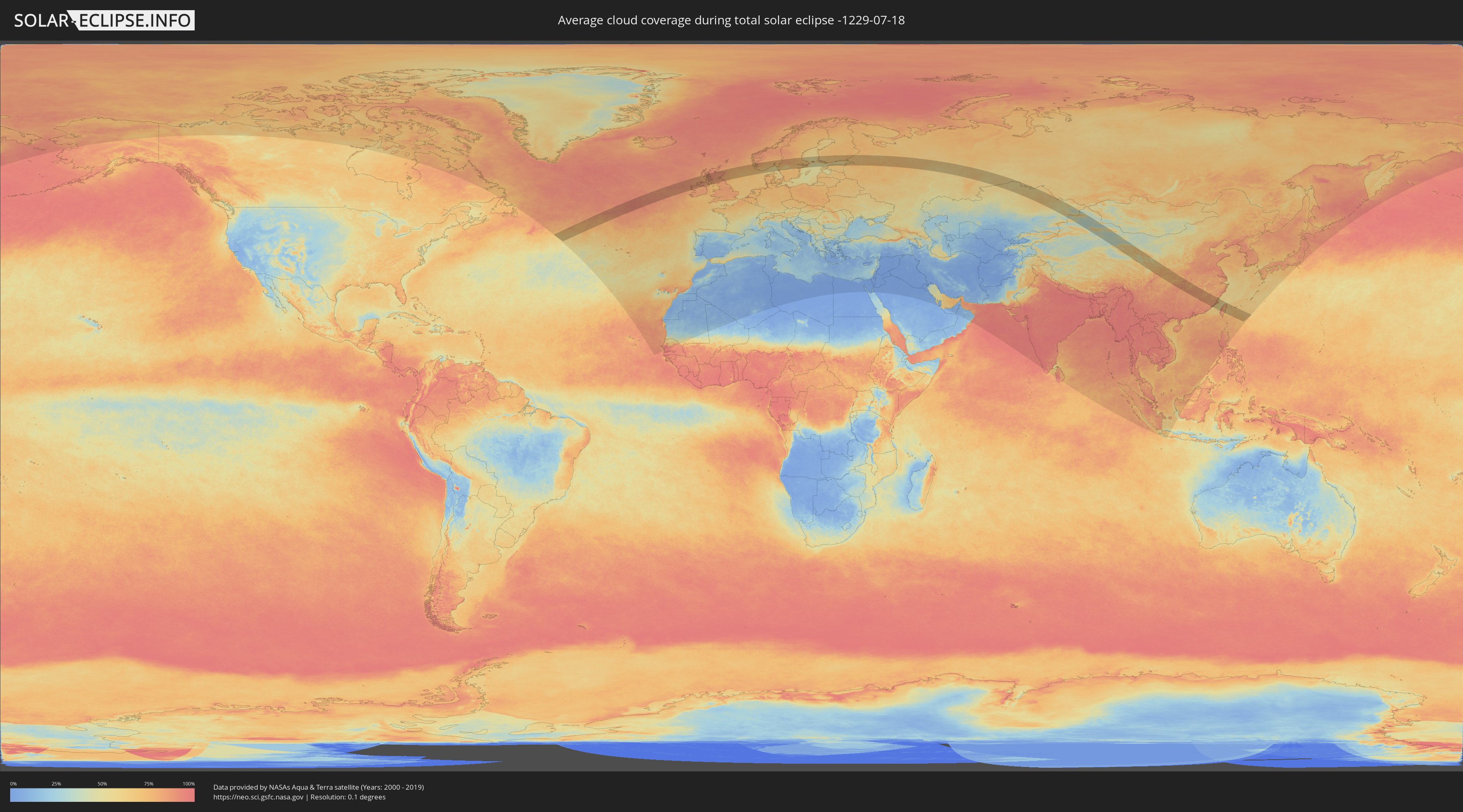
How will be the weather during the total solar eclipse on 07/18/-1229?
Where is the best place to see the total solar eclipse of 07/18/-1229?
The following maps show the average cloud coverage for the day of the total solar eclipse.
With the help of these maps, it is possible to find the place along the eclipse path, which has the best
chance of a cloudless sky.
Nevertheless, you should consider local circumstances and inform about the weather of your chosen
observation site.
The data is provided by NASAs satellites
AQUA and TERRA.
The cloud maps are averaged over a period of 19 years (2000 - 2019).
Detailed country maps
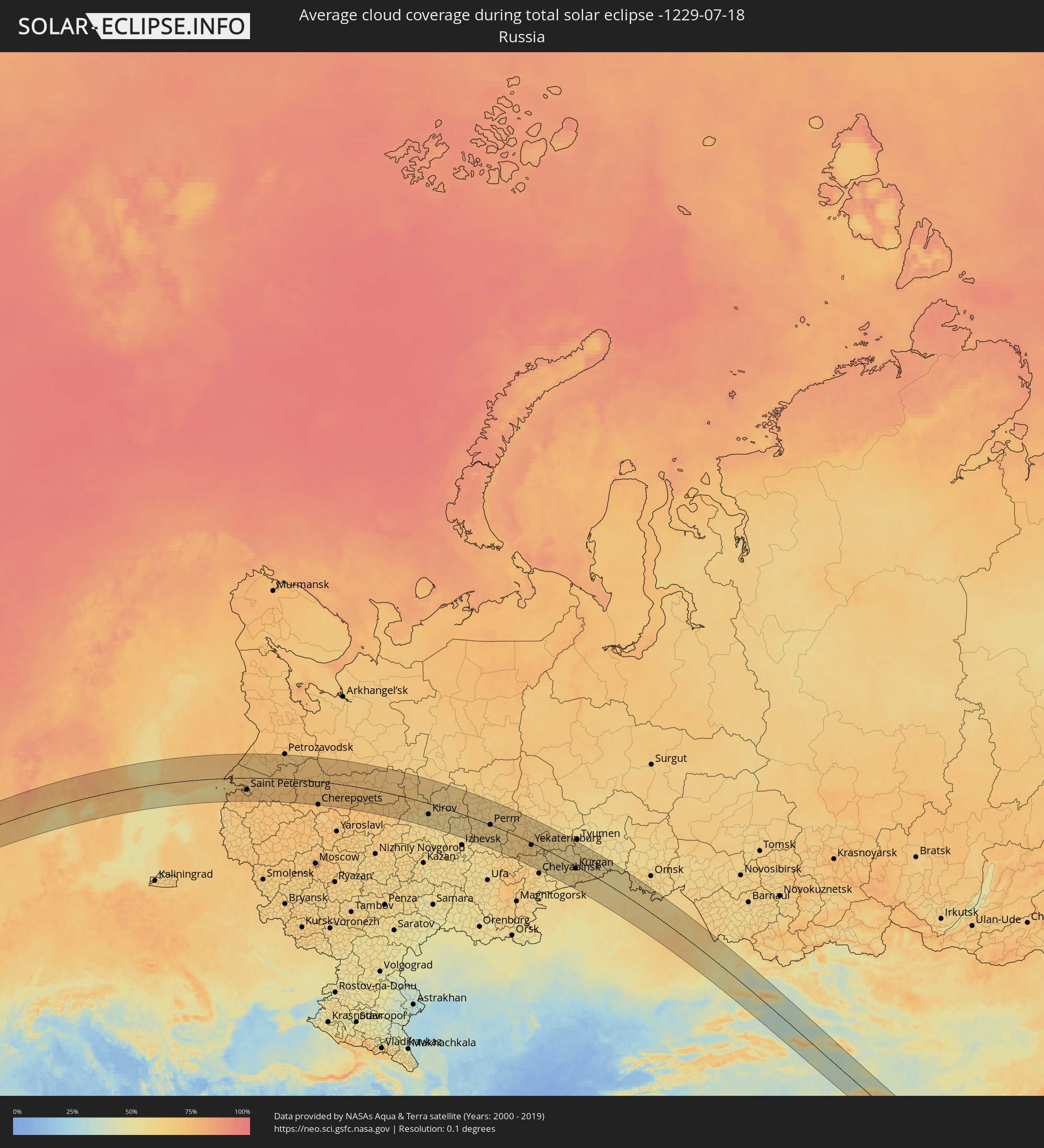 Russia
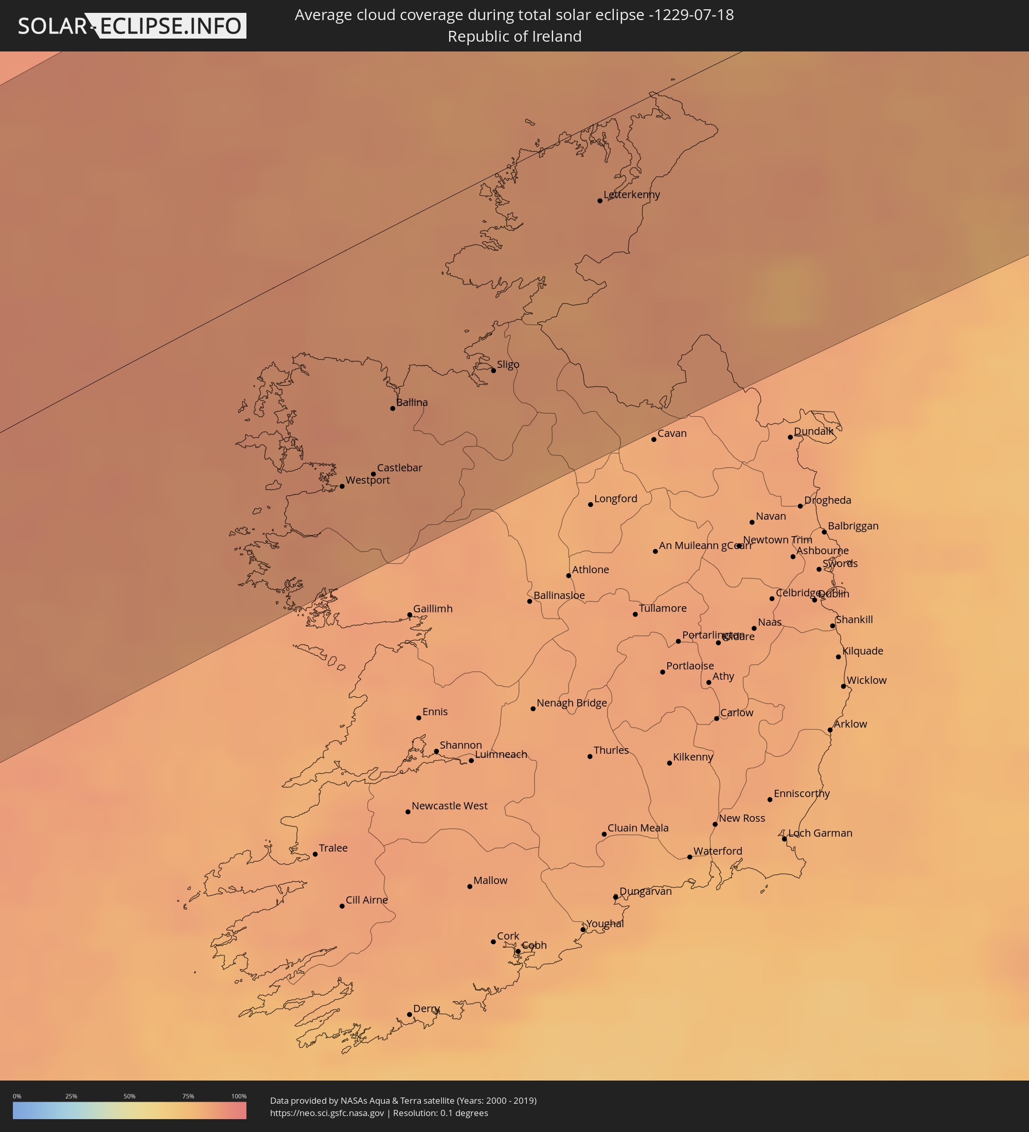 Republic of Ireland
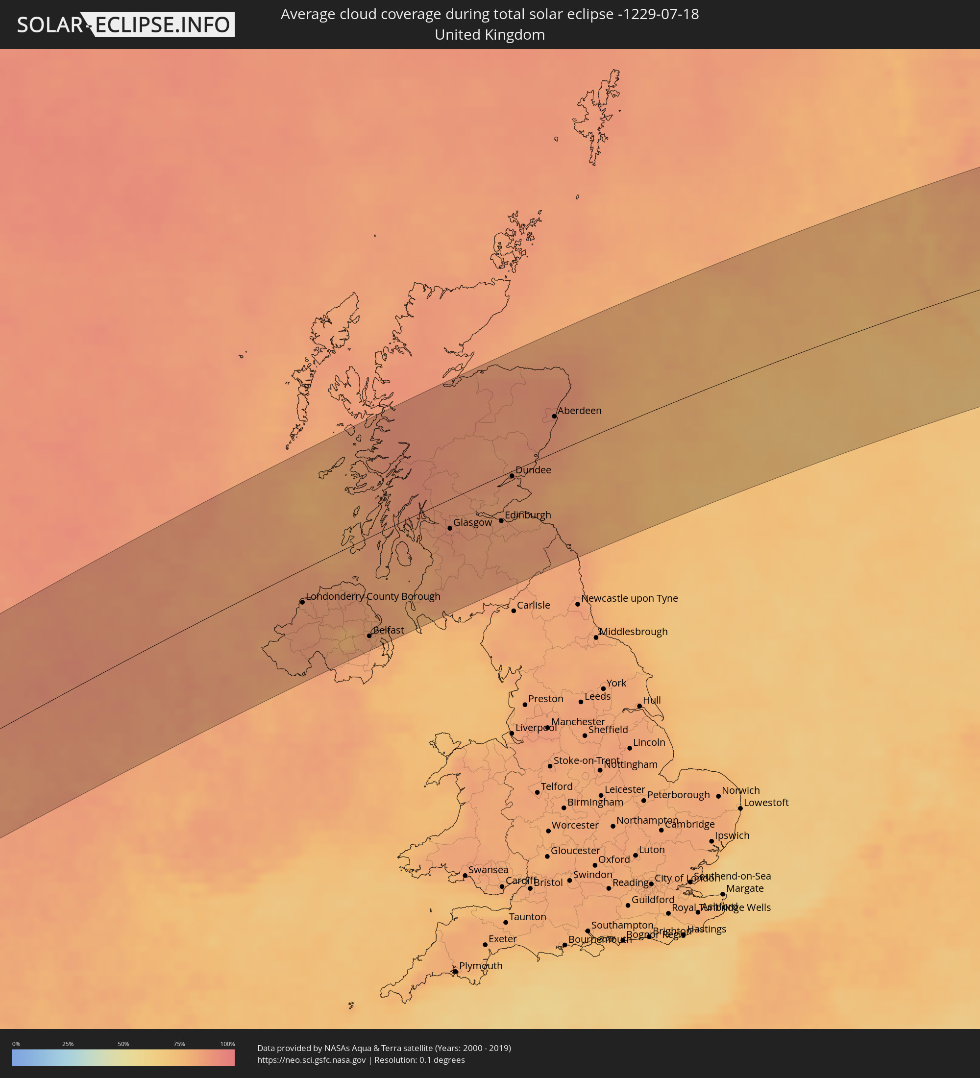 United Kingdom
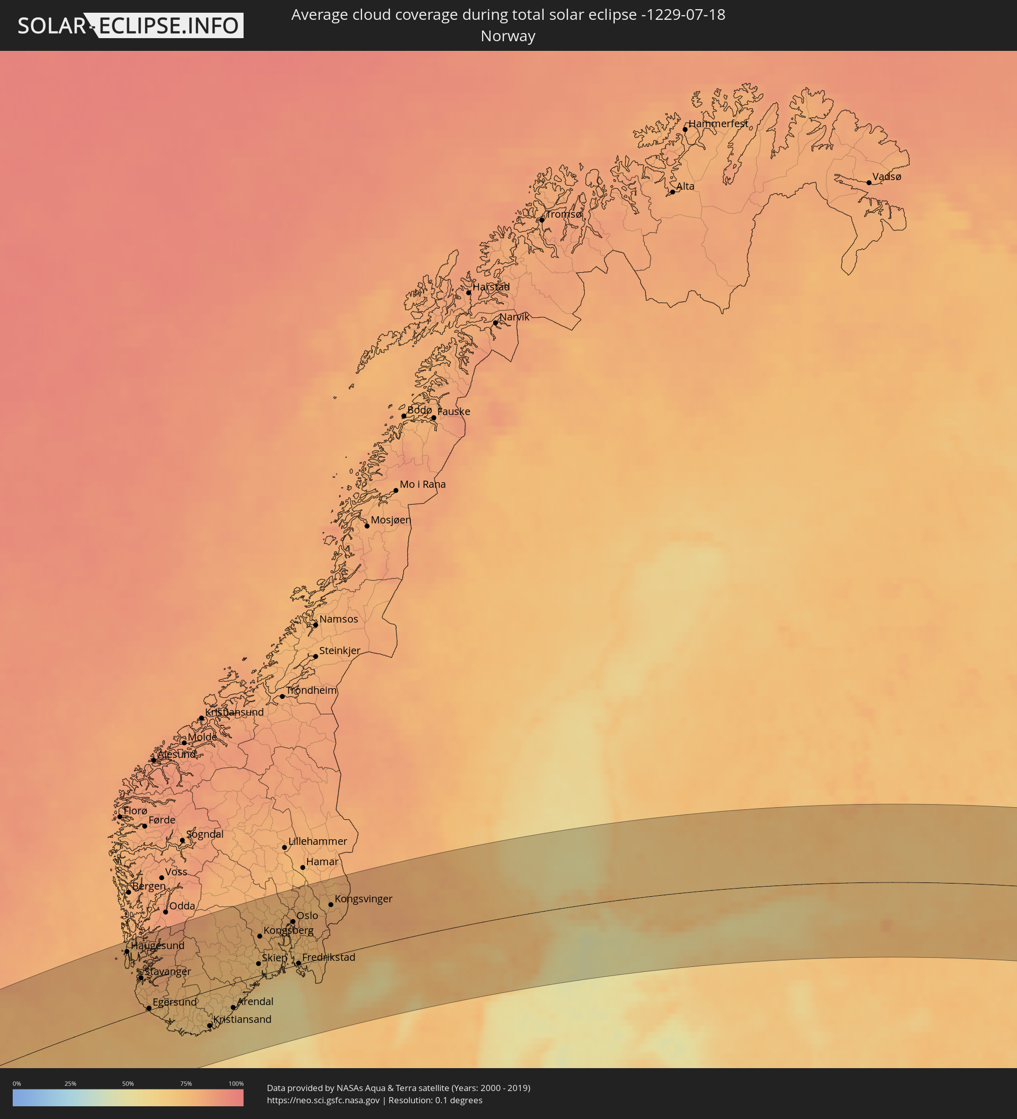 Norway
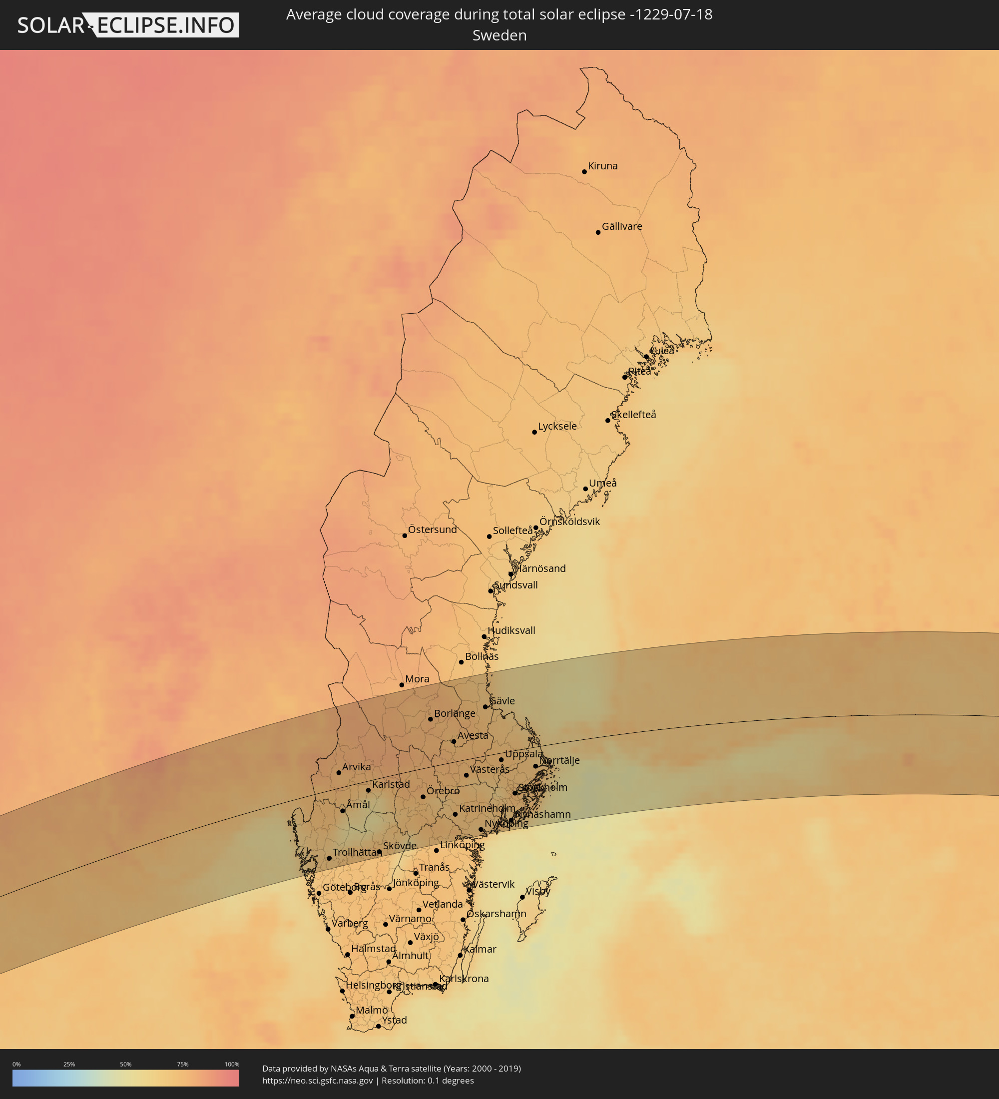 Sweden
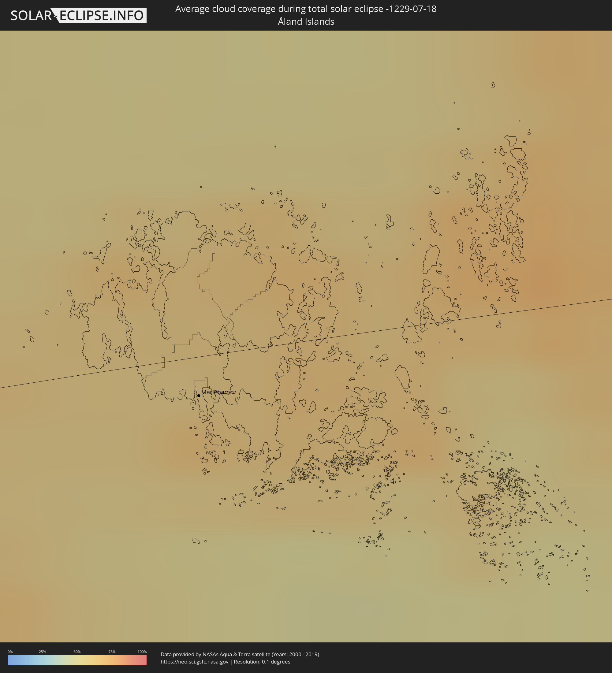 Åland Islands
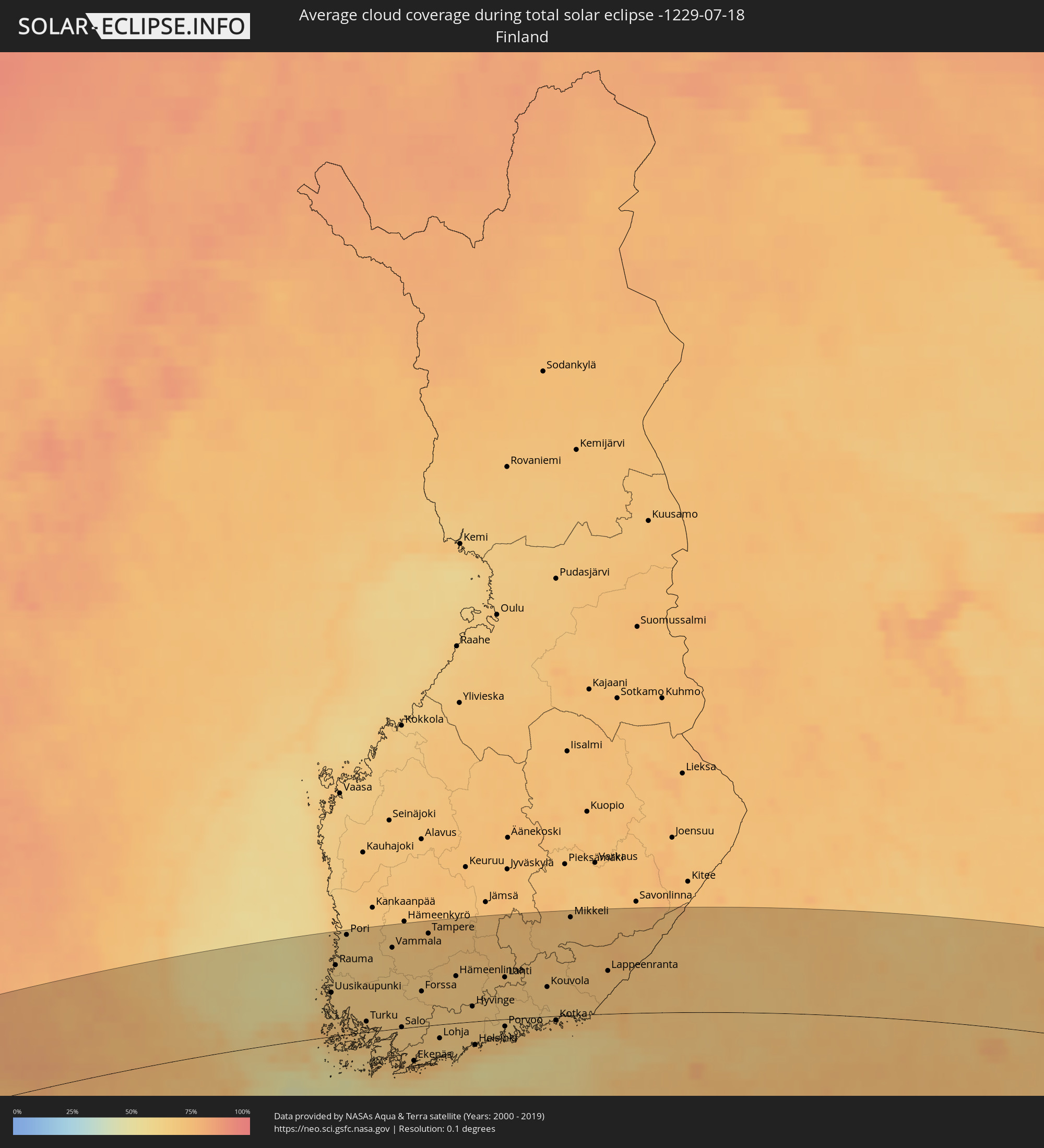 Finland
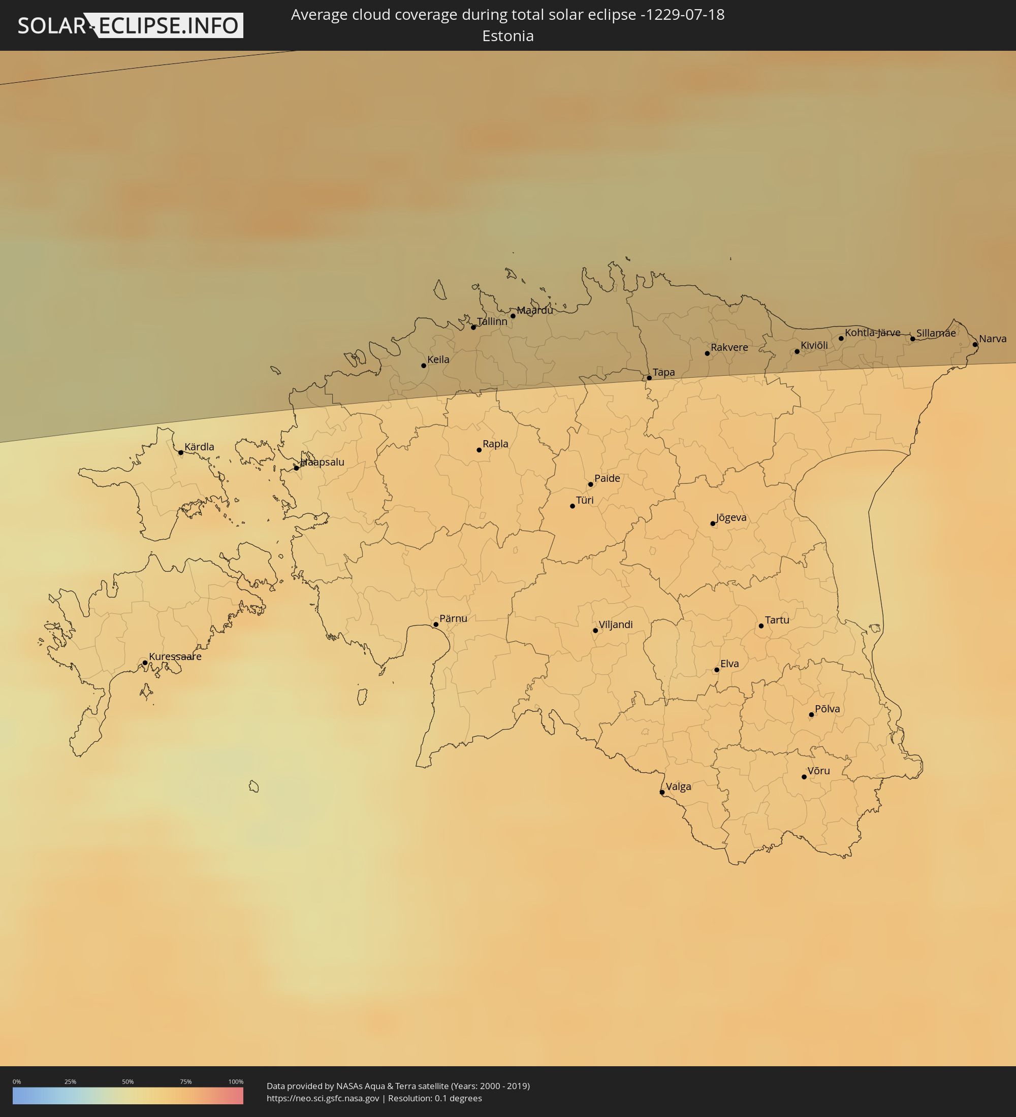 Estonia
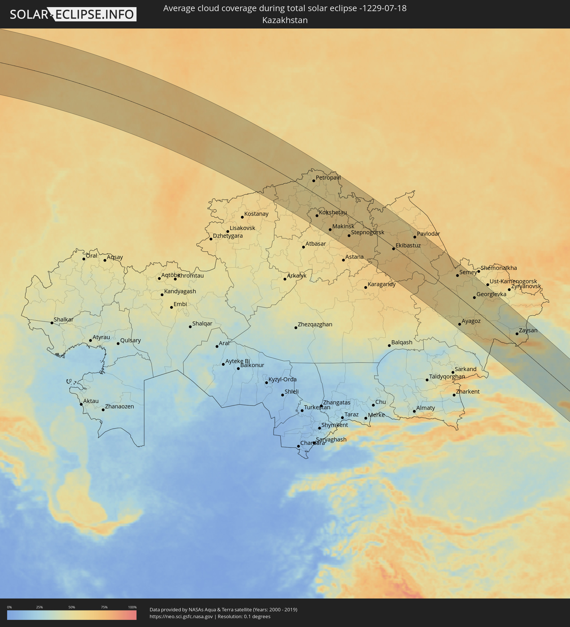 Kazakhstan
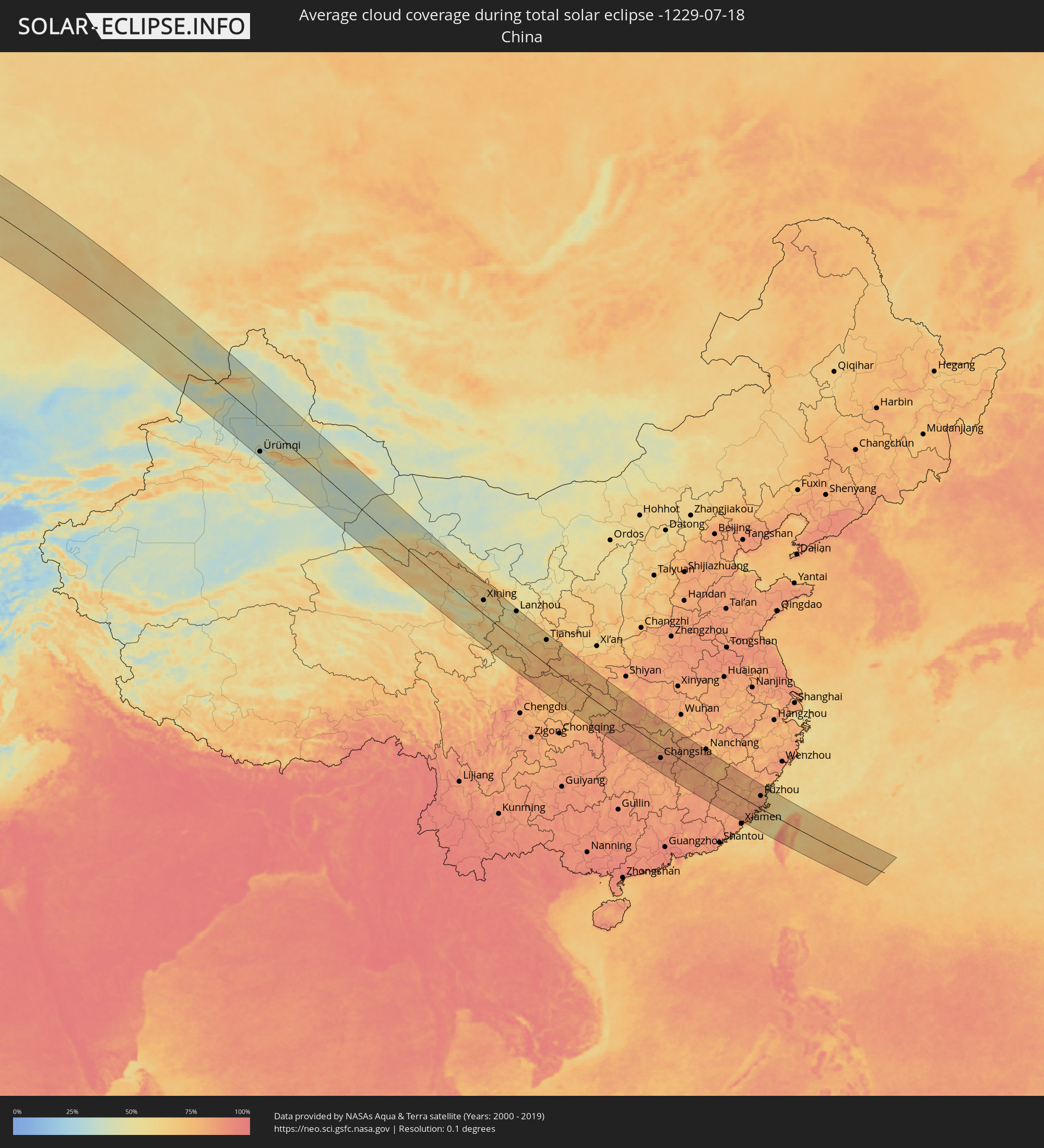 China
China
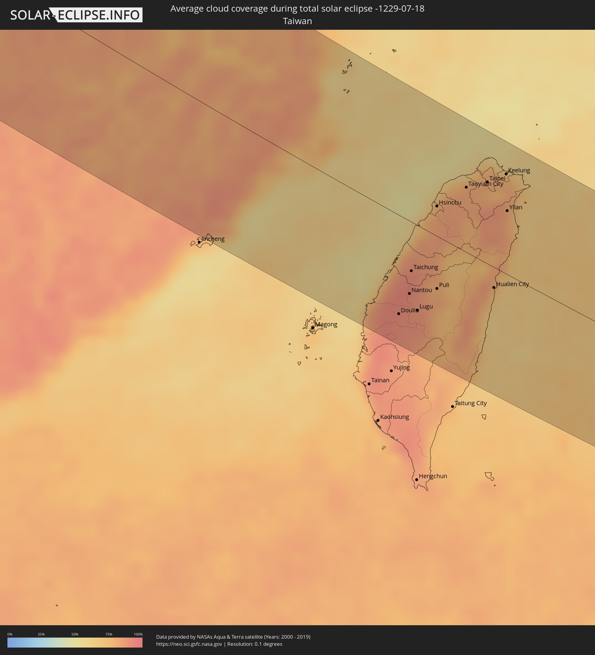 Taiwan
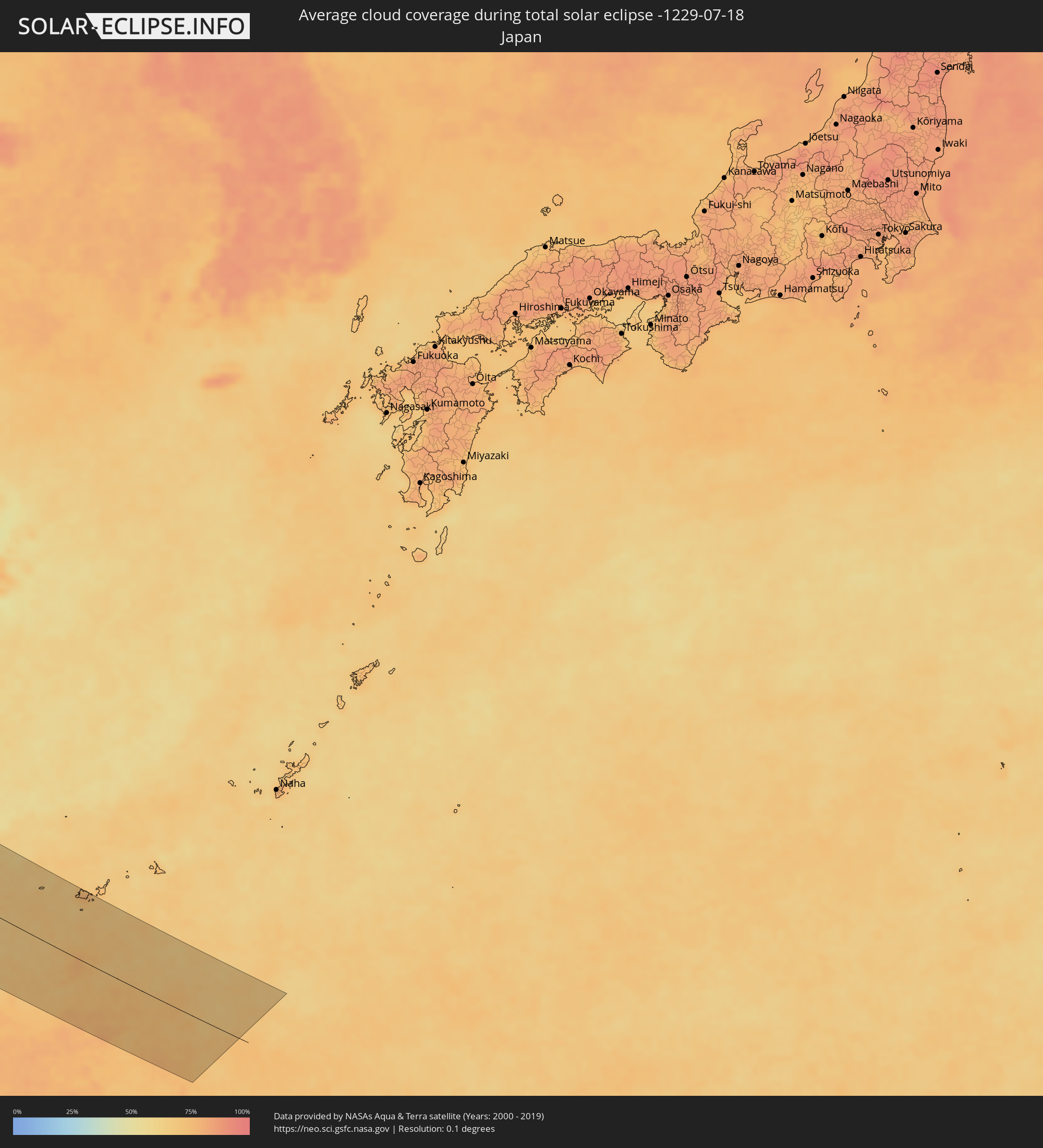 Japan
Japan
Cities inside the path of the eclipse
The following table shows all locations with a population of more than 5,000 inside the eclipse path. Cities which have more than 100,000 inhabitants are marked bold. A click at the locations opens a detailed map.
| City | Type | Eclipse duration | Local time of max. eclipse | Distance to central line | Ø Cloud coverage |
|
Westport, Connaught
|
total | - | 07:08:13 UTC-00:25 | 95 km | 84% |
|
Castlebar, Connaught
|
total | - | 07:08:22 UTC-00:25 | 96 km | 83% |
|
Ballina, Connaught
|
total | - | 07:08:47 UTC-00:25 | 74 km | 84% |
|
Sligo, Connaught
|
total | - | 07:09:14 UTC-00:25 | 78 km | 84% |
|
Letterkenny, Ulster
|
total | - | 07:10:27 UTC-00:25 | 32 km | 85% |
|
Buncrana, Ulster
|
total | - | 07:10:49 UTC-00:25 | 23 km | 83% |
|
Londonderry County Borough, Northern Ireland
|
total | - | 07:36:01 UTC+00:00 | 39 km | 84% |
|
Monaghan, Ulster
|
total | - | 07:09:45 UTC-00:25 | 124 km | 85% |
|
Craigavon, Northern Ireland
|
total | - | 07:35:36 UTC+00:00 | 121 km | 82% |
|
Belfast, Northern Ireland
|
total | - | 07:36:00 UTC+00:00 | 119 km | 83% |
|
Bangor, Northern Ireland
|
total | - | 07:36:11 UTC+00:00 | 119 km | 81% |
|
Greenock, Scotland
|
total | - | 07:38:23 UTC+00:00 | 17 km | 84% |
|
Ayr, Scotland
|
total | - | 07:37:46 UTC+00:00 | 66 km | 82% |
|
Kilmarnock, Scotland
|
total | - | 07:38:02 UTC+00:00 | 55 km | 83% |
|
Glasgow, Scotland
|
total | - | 07:38:29 UTC+00:00 | 35 km | 88% |
|
Inverness, Scotland
|
total | - | 07:40:46 UTC+00:00 | 128 km | 87% |
|
Hamilton, Scotland
|
total | - | 07:38:27 UTC+00:00 | 51 km | 86% |
|
Cumbernauld, Scotland
|
total | - | 07:38:43 UTC+00:00 | 36 km | 87% |
|
Stirling, Scotland
|
total | - | 07:38:59 UTC+00:00 | 18 km | 84% |
|
Livingston, Scotland
|
total | - | 07:38:52 UTC+00:00 | 51 km | 84% |
|
Dunfermline, Scotland
|
total | - | 07:39:08 UTC+00:00 | 37 km | 83% |
|
Perth, Scotland
|
total | - | 07:39:36 UTC+00:00 | 4 km | 86% |
|
Edinburgh, Scotland
|
total | - | 07:39:05 UTC+00:00 | 53 km | 84% |
|
Kirkcaldy, Scotland
|
total | - | 07:39:20 UTC+00:00 | 38 km | 84% |
|
Dundee, Scotland
|
total | - | 07:39:55 UTC+00:00 | 6 km | 85% |
|
Aberdeen, Scotland
|
total | - | 07:41:16 UTC+00:00 | 42 km | 87% |
|
Haugesund, Rogaland
|
total | - | 08:48:22 UTC+01:00 | 118 km | 75% |
|
Stavanger, Rogaland
|
total | - | 08:48:05 UTC+01:00 | 63 km | 75% |
|
Kristiansand, Vest-Agder
|
total | - | 08:48:31 UTC+01:00 | 66 km | 69% |
|
Arendal, Aust-Agder
|
total | - | 08:49:27 UTC+01:00 | 45 km | 66% |
|
Skien, Telemark
|
total | - | 08:50:57 UTC+01:00 | 25 km | 70% |
|
Kongsberg, Buskerud
|
total | - | 08:51:32 UTC+01:00 | 70 km | 77% |
|
Drammen, Buskerud
|
total | - | 08:52:01 UTC+01:00 | 69 km | 75% |
|
Sandefjord, Vestfold
|
total | - | 08:51:17 UTC+01:00 | 14 km | 66% |
|
Hønefoss, Buskerud
|
total | - | 08:52:34 UTC+01:00 | 114 km | 74% |
|
Tønsberg, Vestfold
|
total | - | 08:51:35 UTC+01:00 | 15 km | 69% |
|
Moss, Østfold
|
total | - | 08:51:58 UTC+01:00 | 31 km | 68% |
|
Oslo, Oslo
|
total | - | 08:52:36 UTC+01:00 | 79 km | 78% |
|
Ski, Akershus
|
total | - | 08:52:26 UTC+01:00 | 57 km | 73% |
|
Fredrikstad, Østfold
|
total | - | 08:51:55 UTC+01:00 | 4 km | 69% |
|
Lillestrøm, Akershus
|
total | - | 08:52:52 UTC+01:00 | 79 km | 78% |
|
Askim, Østfold
|
total | - | 08:52:31 UTC+01:00 | 39 km | 73% |
|
Jessheim, Akershus
|
total | - | 08:53:11 UTC+01:00 | 97 km | 74% |
|
Halden, Østfold
|
total | - | 08:52:08 UTC+01:00 | 19 km | 68% |
|
Uddevalla, Västra Götaland
|
total | - | 08:51:39 UTC+01:00 | 107 km | 68% |
|
Kongsvinger, Hedmark
|
total | - | 08:53:50 UTC+01:00 | 91 km | 77% |
|
Trollhättan, Västra Götaland
|
total | - | 08:51:50 UTC+01:00 | 120 km | 68% |
|
Karlstad, Värmland
|
total | - | 08:54:02 UTC+01:00 | 18 km | 67% |
|
Skövde, Västra Götaland
|
total | - | 08:53:12 UTC+01:00 | 129 km | 74% |
|
Karlskoga, Örebro
|
total | - | 08:54:47 UTC+01:00 | 37 km | 73% |
|
Motala, Östergötland
|
total | - | 08:54:20 UTC+01:00 | 128 km | 66% |
|
Örebro, Örebro
|
total | - | 08:55:16 UTC+01:00 | 50 km | 75% |
|
Borlänge, Dalarna
|
total | - | 08:56:46 UTC+01:00 | 80 km | 77% |
|
Falun, Dalarna
|
total | - | 08:57:02 UTC+01:00 | 90 km | 78% |
|
Norrköping, Östergötland
|
total | - | 08:55:22 UTC+01:00 | 136 km | 72% |
|
Eskilstuna, Södermanland
|
total | - | 08:56:27 UTC+01:00 | 56 km | 73% |
|
Västerås, Västmanland
|
total | - | 08:56:44 UTC+01:00 | 28 km | 70% |
|
Nyköping, Södermanland
|
total | - | 08:56:14 UTC+01:00 | 127 km | 70% |
|
Gävle, Gävleborg
|
total | - | 08:58:19 UTC+01:00 | 82 km | 70% |
|
Södertälje, Stockholm
|
total | - | 08:57:13 UTC+01:00 | 86 km | 71% |
|
Uppsala, Uppsala
|
total | - | 08:57:54 UTC+01:00 | 14 km | 75% |
|
Upplands Väsby, Stockholm
|
total | - | 08:57:47 UTC+01:00 | 55 km | 72% |
|
Stockholm, Stockholm
|
total | - | 08:57:44 UTC+01:00 | 75 km | 74% |
|
Haninge, Stockholm
|
total | - | 08:57:38 UTC+01:00 | 94 km | 70% |
|
Mariehamn, Mariehamns stad
|
total | - | 09:39:55 UTC+01:39 | 9 km | 65% |
|
Rauma, Satakunta
|
total | - | 09:42:13 UTC+01:39 | 95 km | 64% |
|
Pori, Satakunta
|
total | - | 09:42:46 UTC+01:39 | 132 km | 65% |
|
Turku, Southwest Finland
|
total | - | 09:42:18 UTC+01:39 | 18 km | 68% |
|
Tampere, Pirkanmaa
|
total | - | 09:44:31 UTC+01:39 | 121 km | 71% |
|
Lohja, Uusimaa
|
total | - | 09:43:47 UTC+01:39 | 19 km | 63% |
|
Keila, Harjumaa
|
total | - | 09:42:34 UTC+01:39 | 126 km | 63% |
|
Hämeenlinna, Häme
|
total | - | 09:44:44 UTC+01:39 | 62 km | 68% |
|
Saue, Harjumaa
|
total | - | 09:42:43 UTC+01:39 | 124 km | 65% |
|
Espoo, Uusimaa
|
total | - | 09:44:18 UTC+01:39 | 27 km | 69% |
|
Tallinn, Harjumaa
|
total | - | 09:43:00 UTC+01:39 | 112 km | 63% |
|
Nurmijärvi, Uusimaa
|
total | - | 09:44:39 UTC+01:39 | 11 km | 67% |
|
Hyvinge, Uusimaa
|
total | - | 09:44:50 UTC+01:39 | 21 km | 68% |
|
Helsinki, Uusimaa
|
total | - | 09:44:33 UTC+01:39 | 32 km | 72% |
|
Maardu, Harjumaa
|
total | - | 09:43:18 UTC+01:39 | 109 km | 60% |
|
Vantaa, Uusimaa
|
total | - | 09:44:44 UTC+01:39 | 18 km | 67% |
|
Järvenpää, Uusimaa
|
total | - | 09:44:55 UTC+01:39 | 5 km | 67% |
|
Lahti, Päijänne Tavastia
|
total | - | 09:45:50 UTC+01:39 | 57 km | 69% |
|
Porvoo, Uusimaa
|
total | - | 09:45:24 UTC+01:39 | 13 km | 64% |
|
Tapa, Lääne-Virumaa
|
total | - | 09:44:04 UTC+01:39 | 137 km | 66% |
|
Rakvere, Lääne-Virumaa
|
total | - | 09:44:31 UTC+01:39 | 129 km | 67% |
|
Kouvola, Kymenlaakso
|
total | - | 09:46:44 UTC+01:39 | 42 km | 68% |
|
Kotka, Kymenlaakso
|
total | - | 09:46:40 UTC+01:39 | 8 km | 72% |
|
Kiviõli, Ida-Virumaa
|
total | - | 09:45:09 UTC+01:39 | 130 km | 66% |
|
Mikkeli, Southern Savonia
|
total | - | 09:47:49 UTC+01:39 | 129 km | 72% |
|
Kohtla-Järve, Ida-Virumaa
|
total | - | 09:45:29 UTC+01:39 | 126 km | 66% |
|
Jõhvi, Ida-Virumaa
|
total | - | 09:45:36 UTC+01:39 | 131 km | 67% |
|
Sillamäe, Ida-Virumaa
|
total | - | 09:45:59 UTC+01:39 | 127 km | 67% |
|
Lappeenranta, South Karelia
|
total | - | 09:48:16 UTC+01:39 | 58 km | 72% |
|
Narva, Ida-Virumaa
|
total | - | 09:46:24 UTC+01:39 | 130 km | 68% |
|
Imatra, South Karelia
|
total | - | 09:48:53 UTC+01:39 | 70 km | 72% |
|
Vyborg, Leningradskaya Oblast'
|
total | - | 10:39:04 UTC+02:30 | 22 km | 69% |
|
Gatchina, Leningradskaya Oblast'
|
total | - | 10:39:49 UTC+02:30 | 110 km | 73% |
|
Saint Petersburg, St.-Petersburg
|
total | - | 10:40:12 UTC+02:30 | 71 km | 78% |
|
Kolpino, St.-Petersburg
|
total | - | 10:40:23 UTC+02:30 | 91 km | 75% |
|
Cherepovets, Vologda
|
total | - | 10:48:11 UTC+02:30 | 137 km | 71% |
|
Vologda, Vologda
|
total | - | 10:50:28 UTC+02:30 | 114 km | 73% |
|
Kirov, Kirov
|
total | - | 11:02:01 UTC+02:30 | 64 km | 63% |
|
Kirovo-Chepetsk, Kirov
|
total | - | 11:02:29 UTC+02:30 | 62 km | 61% |
|
Glazov, Udmurtiya
|
total | - | 11:55:51 UTC+03:20 | 60 km | 59% |
|
Perm, Perm
|
total | - | 12:42:23 UTC+04:02 | 16 km | 64% |
|
Pervoural’sk, Sverdlovsk
|
total | - | 12:47:36 UTC+04:02 | 26 km | 69% |
|
Nizhniy Tagil, Sverdlovsk
|
total | - | 12:46:44 UTC+04:02 | 78 km | 66% |
|
Novoural’sk, Sverdlovsk
|
total | - | 12:47:28 UTC+04:02 | 13 km | 67% |
|
Yekaterinburg, Sverdlovsk
|
total | - | 12:48:26 UTC+04:02 | 19 km | 70% |
|
Ozersk, Chelyabinsk
|
total | - | 12:49:35 UTC+04:02 | 121 km | 63% |
|
Asbest, Sverdlovsk
|
total | - | 12:49:16 UTC+04:02 | 29 km | 67% |
|
Kamensk-Ural’skiy, Sverdlovsk
|
total | - | 12:50:24 UTC+04:02 | 22 km | 61% |
|
Shadrinsk, Kurgan
|
total | - | 12:52:43 UTC+04:02 | 14 km | 58% |
|
Kurgan, Kurgan
|
total | - | 12:55:22 UTC+04:02 | 18 km | 64% |
|
Petropavl, Soltüstik Qazaqstan
|
total | - | 13:19:40 UTC+04:21 | 53 km | 56% |
|
Kokshetau, Aqmola
|
total | - | 13:22:01 UTC+04:21 | 91 km | 58% |
|
Taiynsha, Soltüstik Qazaqstan
|
total | - | 13:21:41 UTC+04:21 | 25 km | 57% |
|
Shchuchinsk, Aqmola
|
total | - | 13:23:23 UTC+04:21 | 95 km | 59% |
|
Makinsk, Aqmola
|
total | - | 13:24:03 UTC+04:21 | 115 km | 58% |
|
Bulayevo, Soltüstik Qazaqstan
|
total | - | 13:21:00 UTC+04:21 | 99 km | 55% |
|
Stepnogorsk, Aqmola
|
total | - | 13:26:05 UTC+04:21 | 87 km | 64% |
|
Yereymentau, Aqmola
|
total | - | 13:28:29 UTC+04:21 | 107 km | 63% |
|
Ekibastuz, Pavlodar
|
total | - | 13:30:40 UTC+04:21 | 12 km | 62% |
|
Irtyshsk, Pavlodar
|
total | - | 13:28:22 UTC+04:21 | 142 km | 56% |
|
Aksu, Pavlodar
|
total | - | 13:31:47 UTC+04:21 | 87 km | 61% |
|
Pavlodar, Pavlodar
|
total | - | 13:31:27 UTC+04:21 | 108 km | 61% |
|
Kūrchatov, Pavlodar
|
total | - | 13:35:22 UTC+04:21 | 44 km | 61% |
|
Semey, East Kazakhstan
|
total | - | 13:37:31 UTC+04:21 | 87 km | 56% |
|
Ayagoz, East Kazakhstan
|
total | - | 13:41:43 UTC+04:21 | 119 km | 47% |
|
Shar, East Kazakhstan
|
total | - | 13:39:36 UTC+04:21 | 51 km | 51% |
|
Georgīevka, East Kazakhstan
|
total | - | 13:40:30 UTC+04:21 | 52 km | 51% |
|
Urzhar, East Kazakhstan
|
total | - | 13:44:17 UTC+04:21 | 140 km | 43% |
|
Zaysan, East Kazakhstan
|
total | - | 13:46:27 UTC+04:21 | 51 km | 45% |
|
Ürümqi, Xinjiang Uyghur Autonomous Region
|
total | - | 17:33:01 UTC+08:00 | 121 km | 37% |
|
Turpan, Xinjiang Uyghur Autonomous Region
|
total | - | 17:35:38 UTC+08:00 | 109 km | 41% |
|
Xining, Qinghai
|
total | - | 17:52:24 UTC+08:00 | 65 km | 52% |
|
Lanzhou, Gansu
|
total | - | 17:53:50 UTC+08:00 | 132 km | 52% |
|
Tianshui, Gansu
|
total | - | 17:56:28 UTC+08:00 | 113 km | 66% |
|
Guangyuan, Sichuan
|
total | - | 17:59:40 UTC+08:00 | 71 km | 75% |
|
Yichang, Hubei
|
total | - | 18:02:27 UTC+08:00 | 80 km | 86% |
|
Changde, Hunan
|
total | - | 18:04:42 UTC+08:00 | 51 km | 86% |
|
Shashi, Hubei
|
total | - | 18:02:59 UTC+08:00 | 98 km | 81% |
|
Xiangtan, Hunan
|
total | - | 18:06:11 UTC+08:00 | 96 km | 84% |
|
Changsha, Hunan
|
total | - | 18:05:43 UTC+08:00 | 64 km | 86% |
|
Yueyang, Hunan
|
total | - | 18:04:11 UTC+08:00 | 62 km | 78% |
|
Zhuzhou, Hunan
|
total | - | 18:06:11 UTC+08:00 | 85 km | 83% |
|
Guankou, Hunan
|
total | - | 18:05:43 UTC+08:00 | 38 km | 85% |
|
Pingxiang, Jiangxi
|
total | - | 18:06:23 UTC+08:00 | 71 km | 84% |
|
Ji’an, Jiangxi
|
total | - | 18:06:53 UTC+08:00 | 60 km | 82% |
|
Sanming, Fujian
|
total | - | 18:07:29 UTC+08:00 | 13 km | 80% |
|
Putian, Fujian
|
total | - | 18:08:08 UTC+08:00 | 6 km | 85% |
|
Fuzhou, Fujian
|
total | - | 18:07:20 UTC+08:00 | 69 km | 84% |
|
Douliu, Taiwan
|
total | - | 18:09:41 UTC+08:00 | 98 km | 91% |
|
Nantou, Taiwan
|
total | - | 18:09:25 UTC+08:00 | 72 km | 89% |
|
Taichung, Taiwan
|
total | - | 18:09:10 UTC+08:00 | 49 km | 91% |
|
Zhongxing New Village, Taiwan
|
total | - | 18:09:22 UTC+08:00 | 67 km | 91% |
|
Lugu, Taiwan
|
total | - | 18:09:35 UTC+08:00 | 86 km | 88% |
|
Hsinchu, Taiwan
|
total | - | 18:08:21 UTC+08:00 | 36 km | 81% |
|
Puli, Taiwan
|
total | - | 18:09:17 UTC+08:00 | 58 km | 80% |
|
Daxi, Taiwan
|
total | - | 18:08:10 UTC+08:00 | 53 km | 82% |
|
Taoyuan City, Taiwan
|
total | - | 18:08:02 UTC+08:00 | 64 km | 82% |
|
Banqiao, Taipei
|
total | - | 18:07:58 UTC+08:00 | 75 km | 80% |
|
Taipei, Taipei
|
total | - | 18:07:55 UTC+08:00 | 83 km | 80% |
|
Hualien City, Taiwan
|
total | - | 18:09:04 UTC+08:00 | 31 km | 75% |
|
Keelung, Taiwan
|
total | - | 18:07:46 UTC+08:00 | 102 km | 79% |
|
Yilan, Taiwan
|
total | - | 18:08:10 UTC+08:00 | 63 km | 78% |