Annular solar eclipse of 12/09/-1283
| Day of week: | Saturday |
| Maximum duration of eclipse: | 11m11s |
| Maximum width of eclipse path: | 303 km |
| Saros cycle: | 31 |
| Coverage: | 92.1% |
| Magnitude: | 0.9205 |
| Gamma: | 0.1275 |
Wo kann man die Sonnenfinsternis vom 12/09/-1283 sehen?
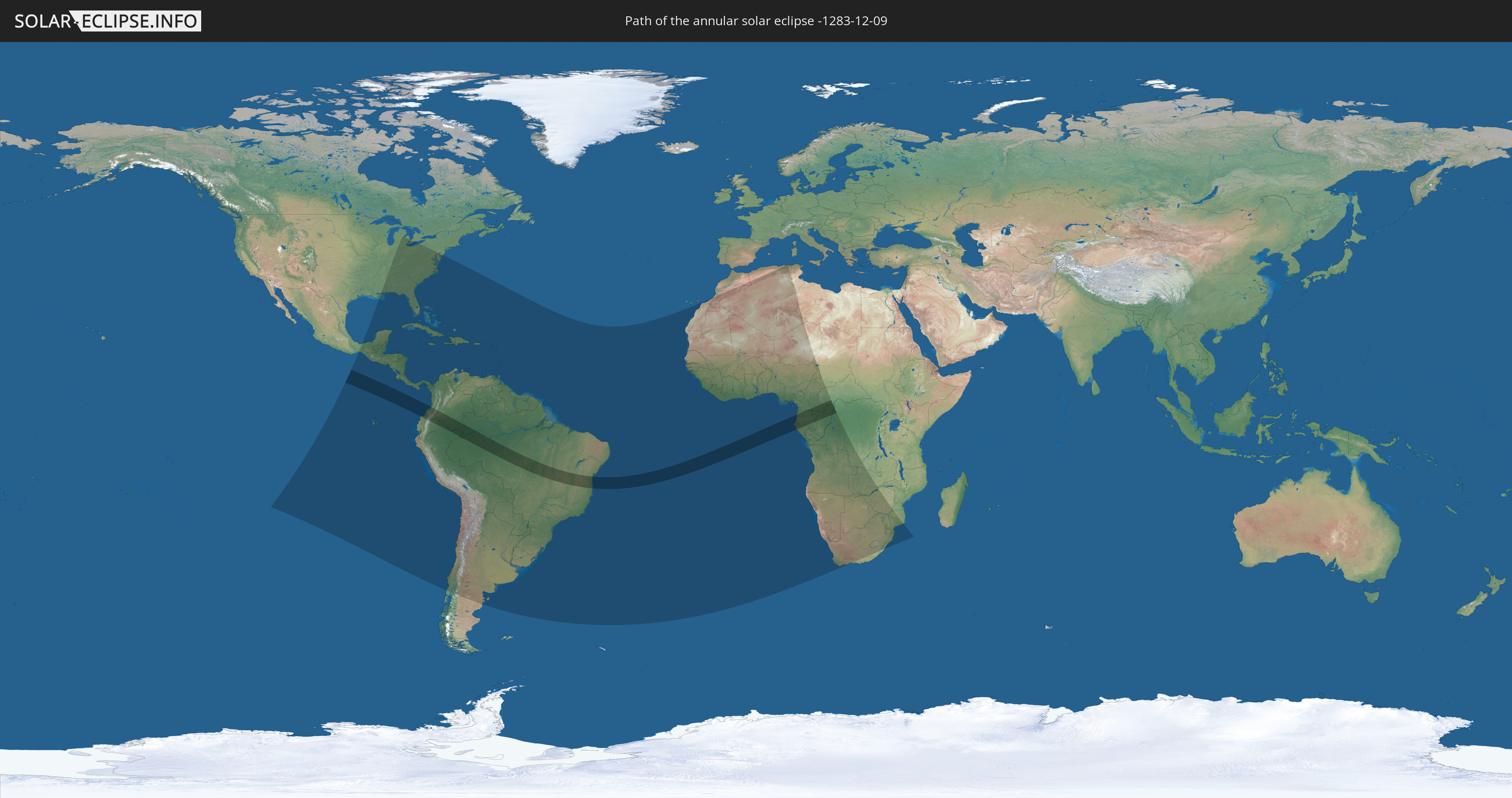
Die Sonnenfinsternis am 12/09/-1283 kann man in 88 Ländern als partielle Sonnenfinsternis beobachten.
Der Finsternispfad verläuft durch 11 Länder. Nur in diesen Ländern ist sie als annular Sonnenfinsternis zu sehen.
In den folgenden Ländern ist die Sonnenfinsternis annular zu sehen
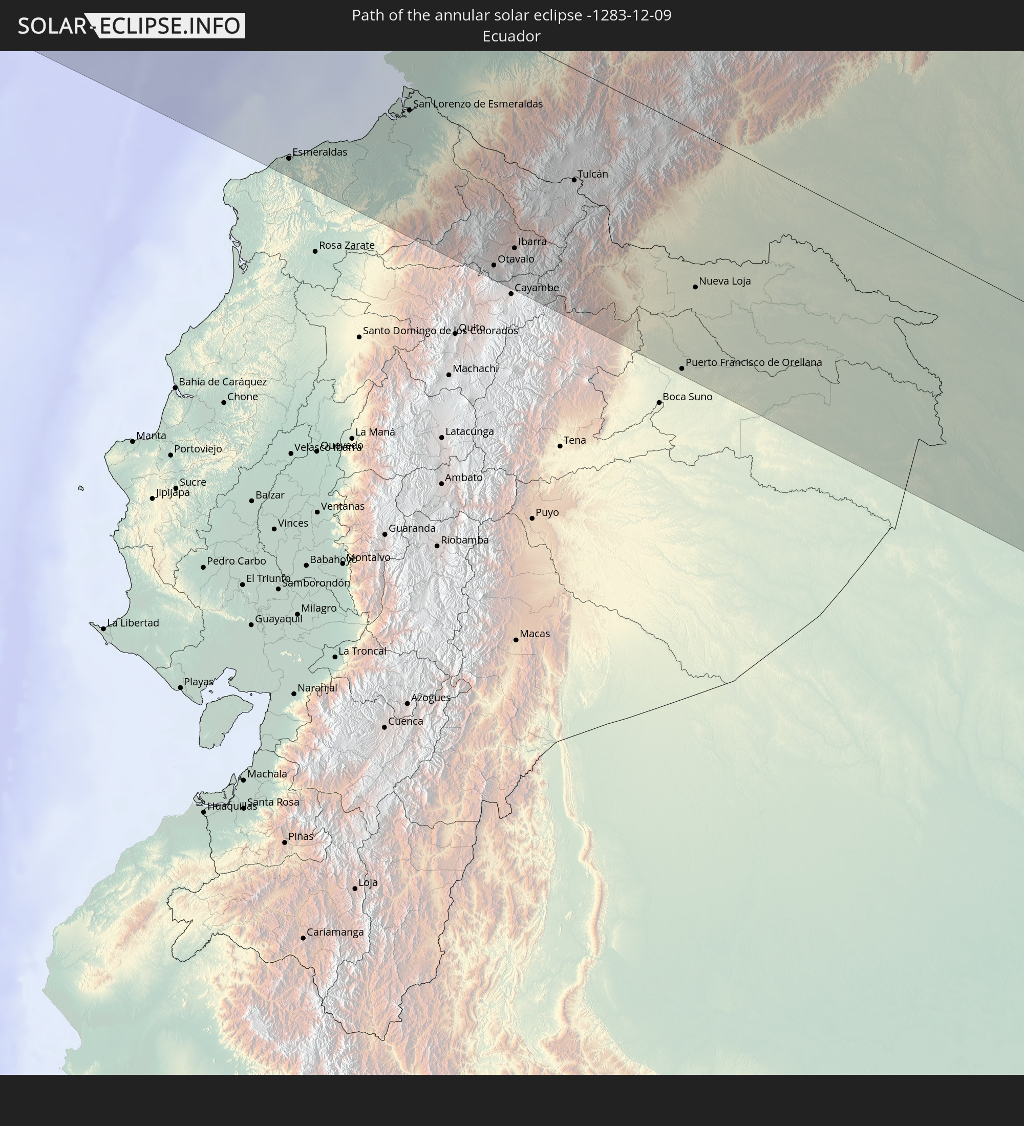 Ecuador
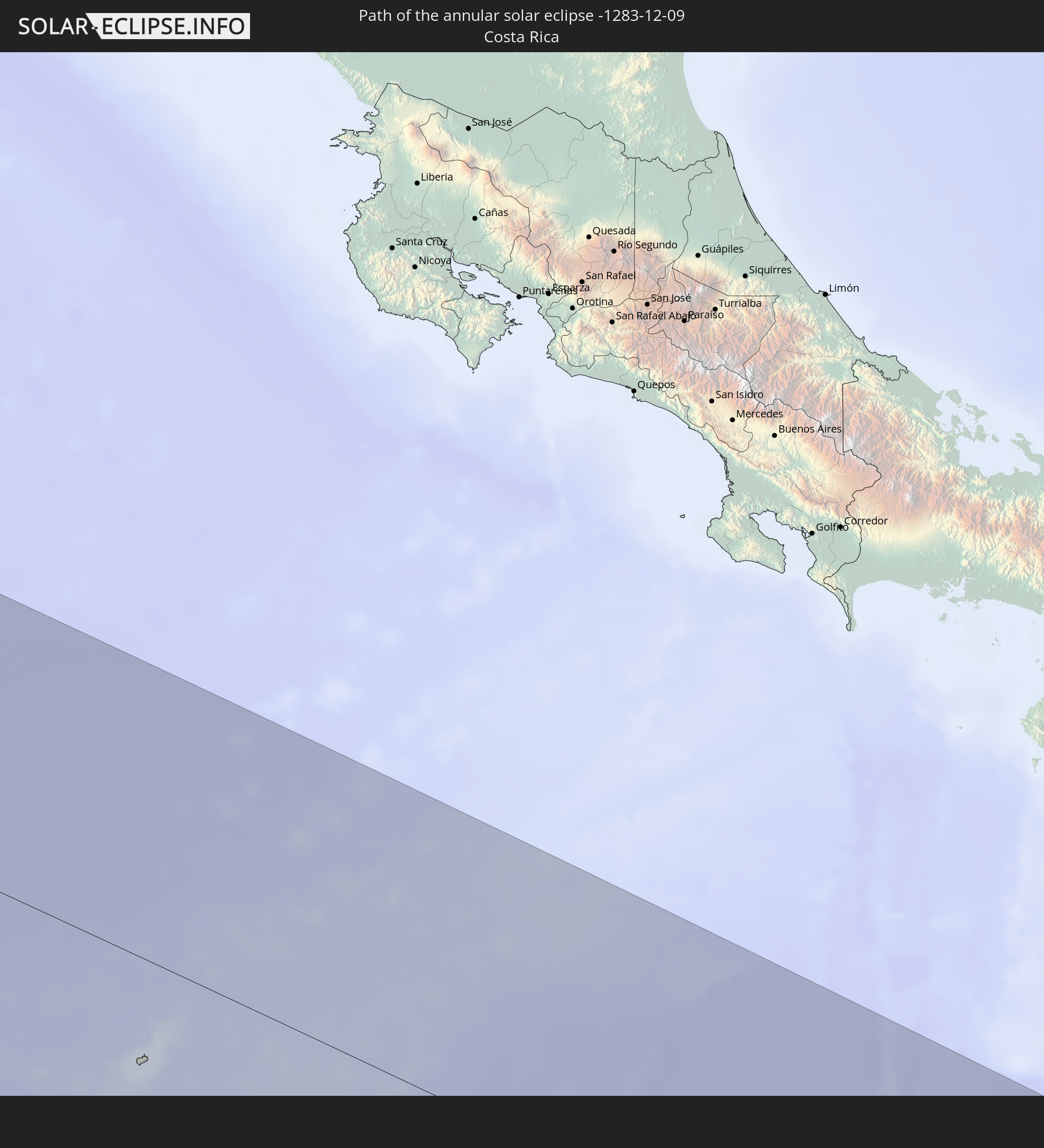 Costa Rica
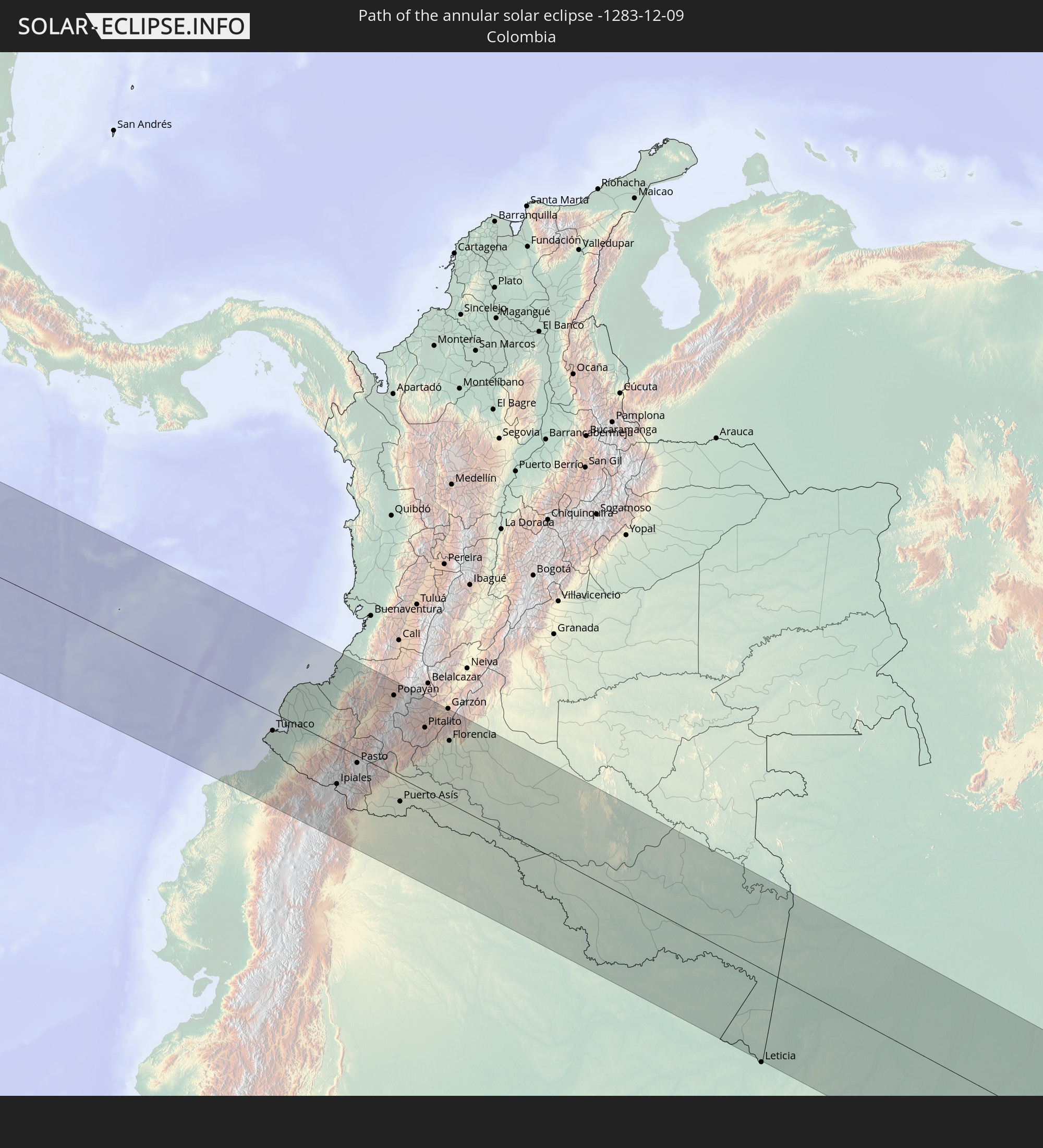 Colombia
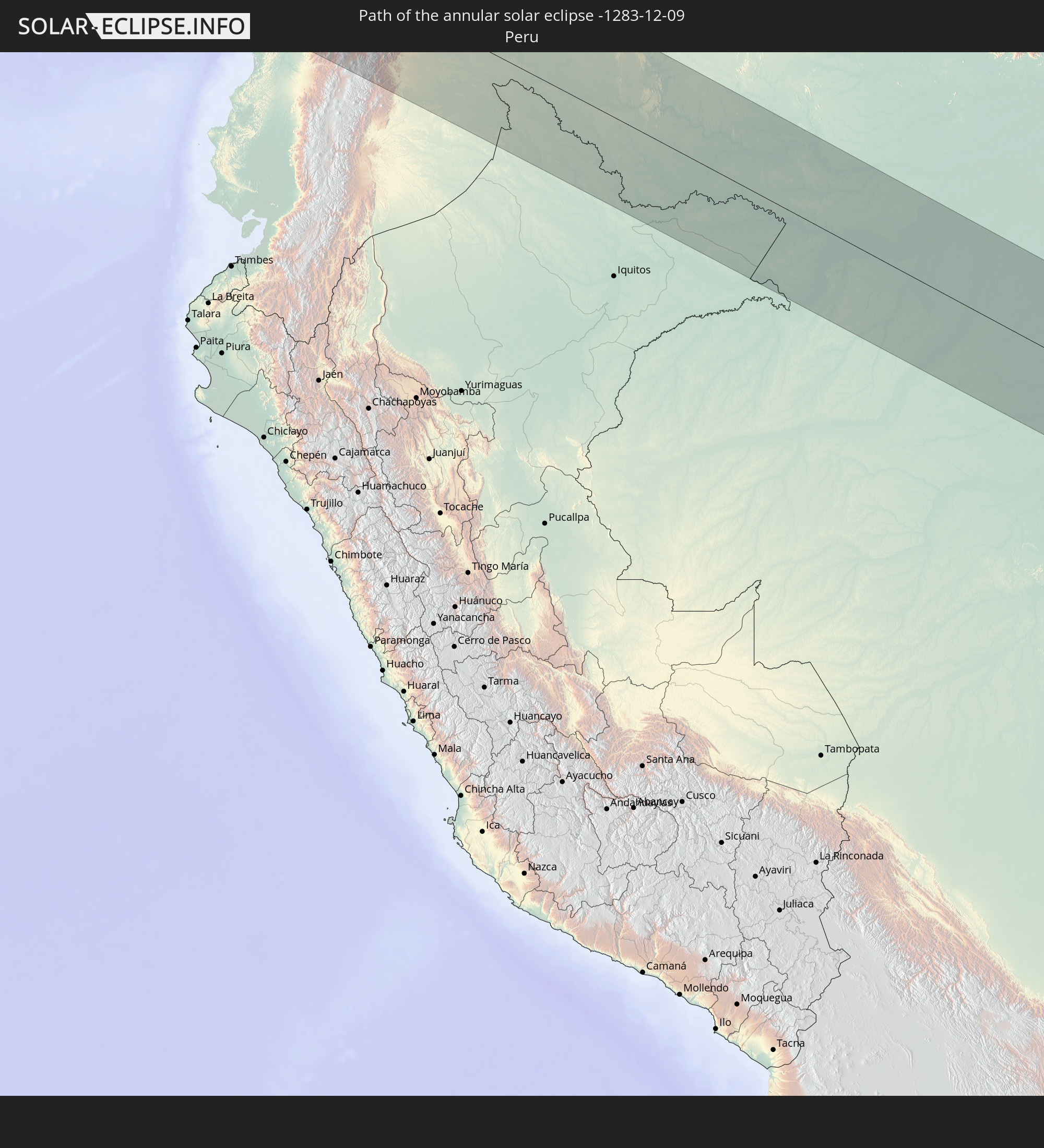 Peru
Peru
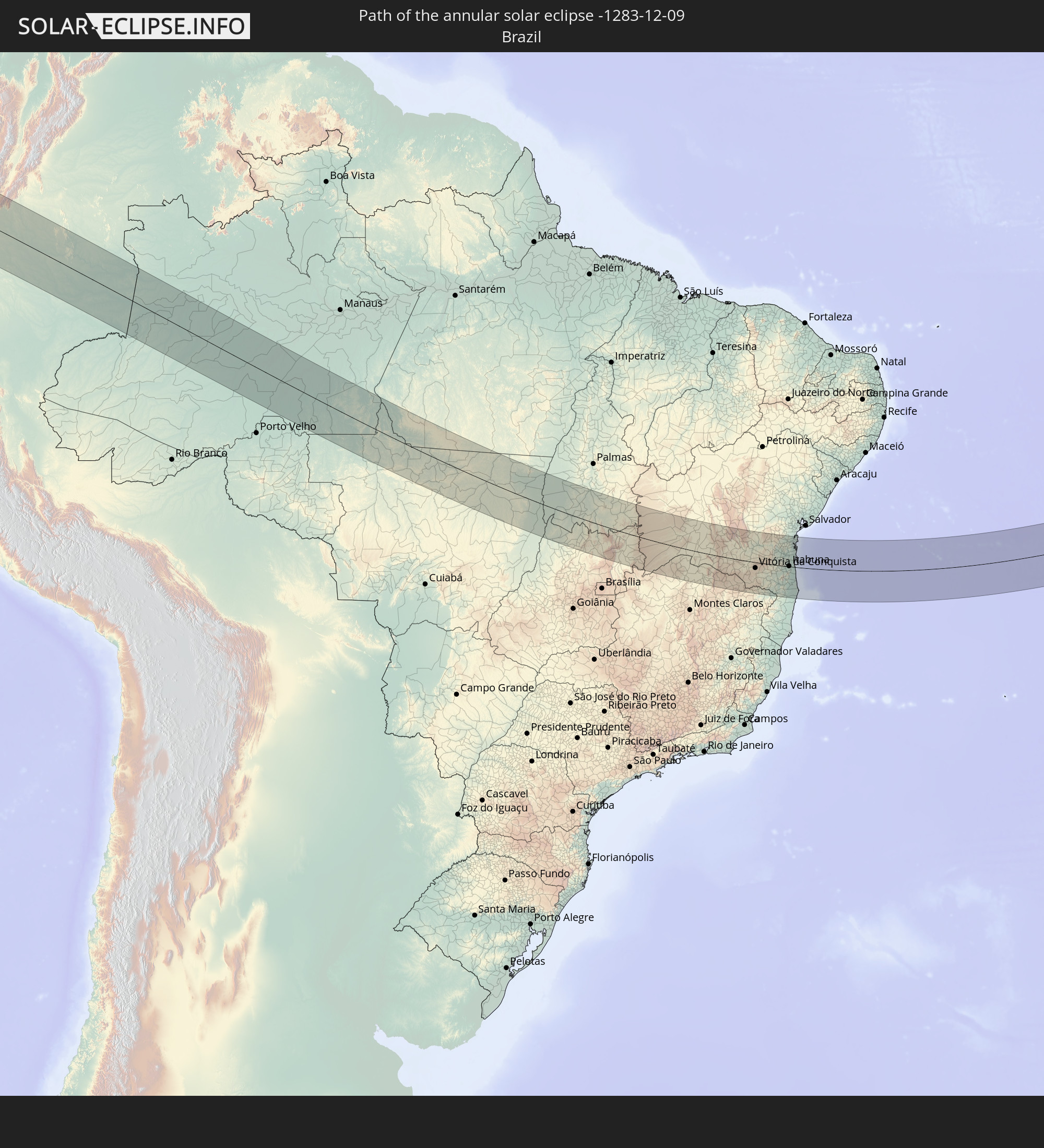 Brazil
 Equatorial Guinea
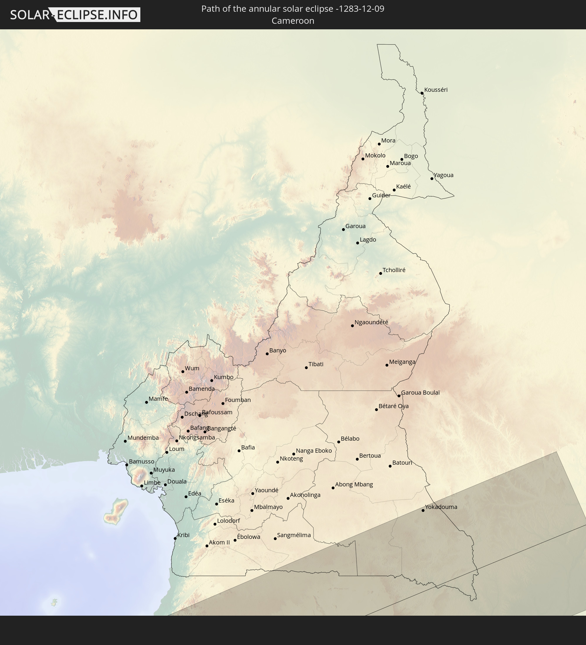 Cameroon
 Gabon
Gabon
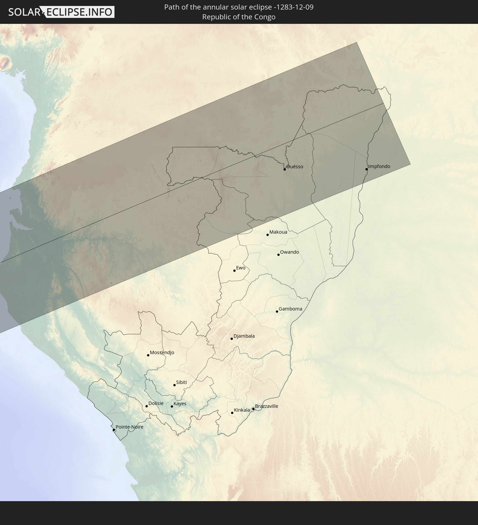 Republic of the Congo
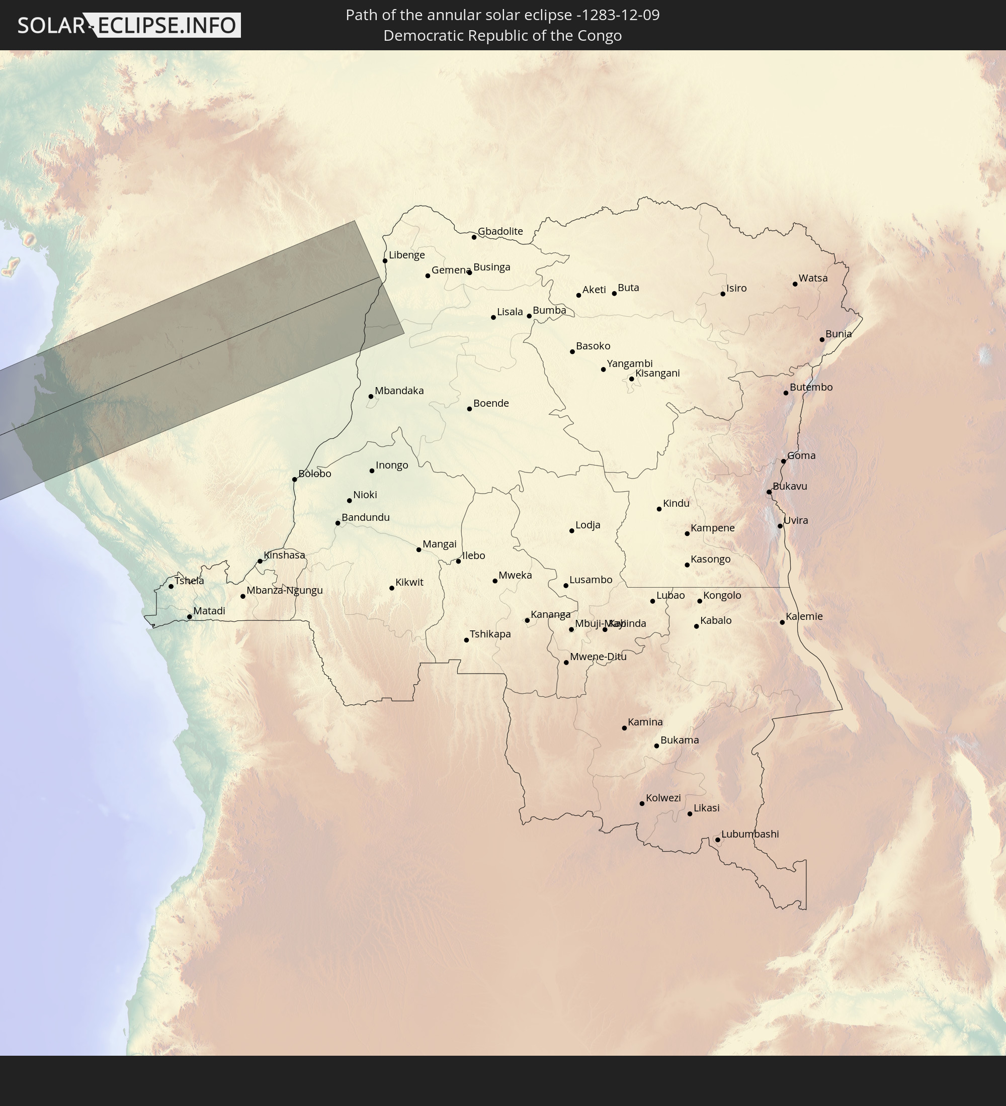 Democratic Republic of the Congo
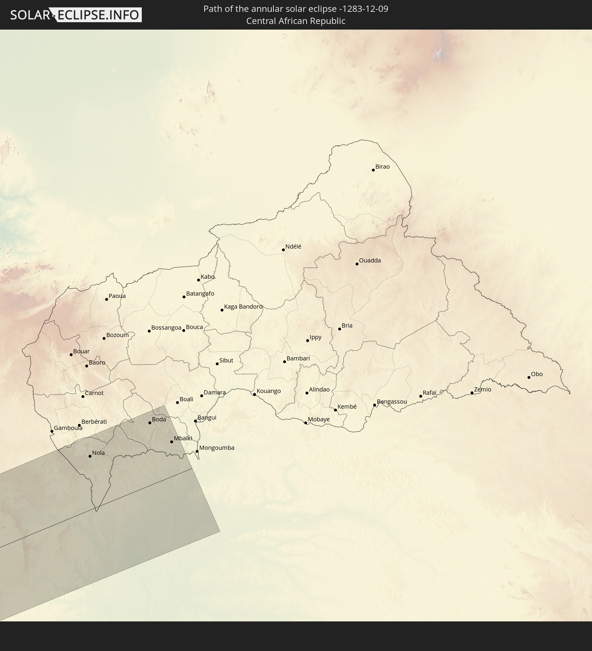 Central African Republic
In den folgenden Ländern ist die Sonnenfinsternis partiell zu sehen
 United States
 United States Minor Outlying Islands
 Canada
 Mexico
 Chile
Chile
 Guatemala
 Ecuador
 El Salvador
 Honduras
 Belize
 Nicaragua
 Costa Rica
 Cuba
Cuba
 Panama
 Colombia
 Cayman Islands
 Peru
Peru
 The Bahamas
 Jamaica
 Haiti
Haiti
 Brazil
 Argentina
 Venezuela
 Turks and Caicos Islands
 Dominican Republic
 Aruba
Aruba
 Bolivia
 Puerto Rico
 United States Virgin Islands
 Bermuda
 British Virgin Islands
 Anguilla
 Collectivity of Saint Martin
 Saint Barthélemy
 Saint Kitts and Nevis
 Paraguay
 Antigua and Barbuda
 Montserrat
 Trinidad and Tobago
 Guadeloupe
 Grenada
 Dominica
 Saint Vincent and the Grenadines
 Guyana
 Martinique
 Saint Lucia
 Barbados
 Uruguay
 Suriname
 French Guiana
 Cabo Verde
 Senegal
 Mauritania
 The Gambia
 Guinea-Bissau
 Guinea
 Saint Helena, Ascension and Tristan da Cunha
 Sierra Leone
 Morocco
 Mali
Mali
 Liberia
 Algeria
 Ivory Coast
 Burkina Faso
 Ghana
Ghana
 Togo
Togo
 Niger
Niger
 Benin
Benin
 Nigeria
 Equatorial Guinea
 São Tomé and Príncipe
 Tunisia
 Cameroon
 Gabon
Gabon
 Libya
Libya
 Republic of the Congo
 Angola
 Namibia
 Democratic Republic of the Congo
 Chad
Chad
 Central African Republic
 South Africa
 Botswana
 Zambia
 Zimbabwe
 Lesotho
 Mozambique
 Swaziland
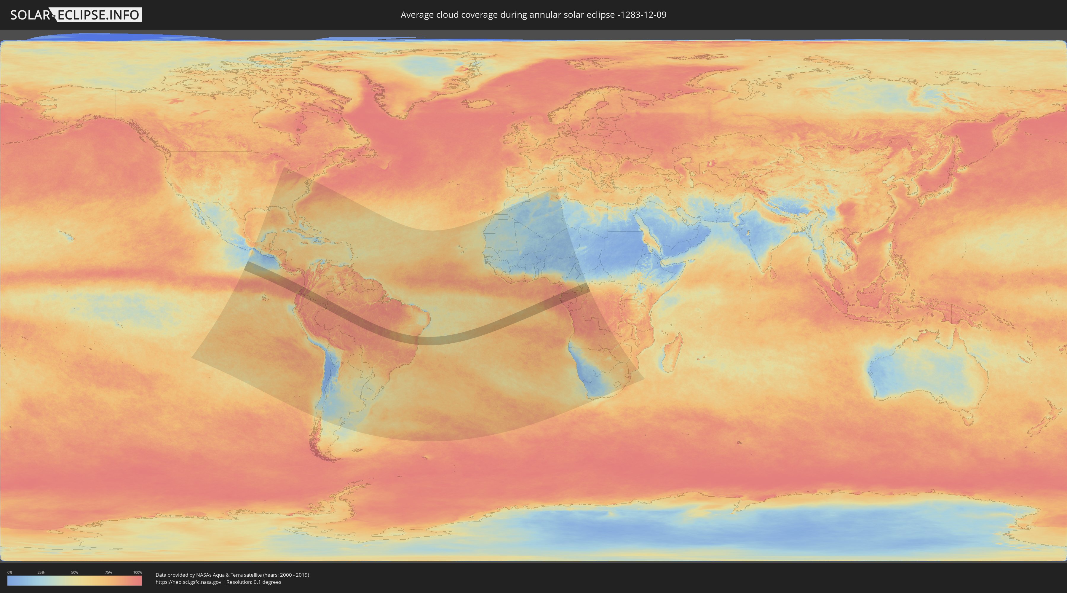
How will be the weather during the annular solar eclipse on 12/09/-1283?
Where is the best place to see the annular solar eclipse of 12/09/-1283?
The following maps show the average cloud coverage for the day of the annular solar eclipse.
With the help of these maps, it is possible to find the place along the eclipse path, which has the best
chance of a cloudless sky.
Nevertheless, you should consider local circumstances and inform about the weather of your chosen
observation site.
The data is provided by NASAs satellites
AQUA and TERRA.
The cloud maps are averaged over a period of 19 years (2000 - 2019).

Detailed country maps
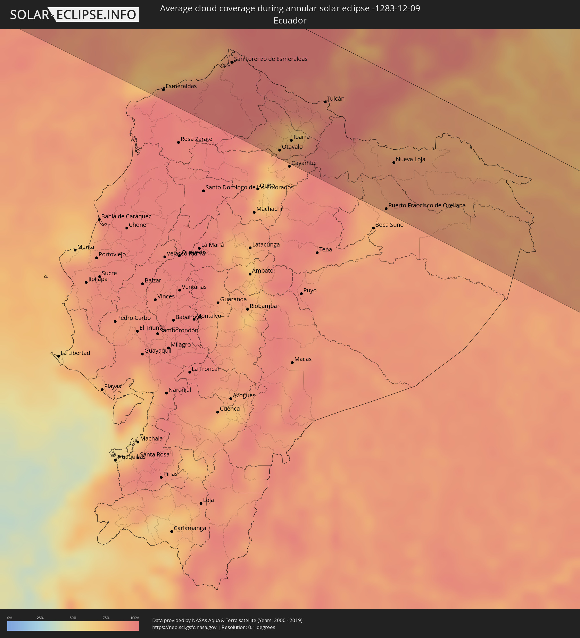 Ecuador
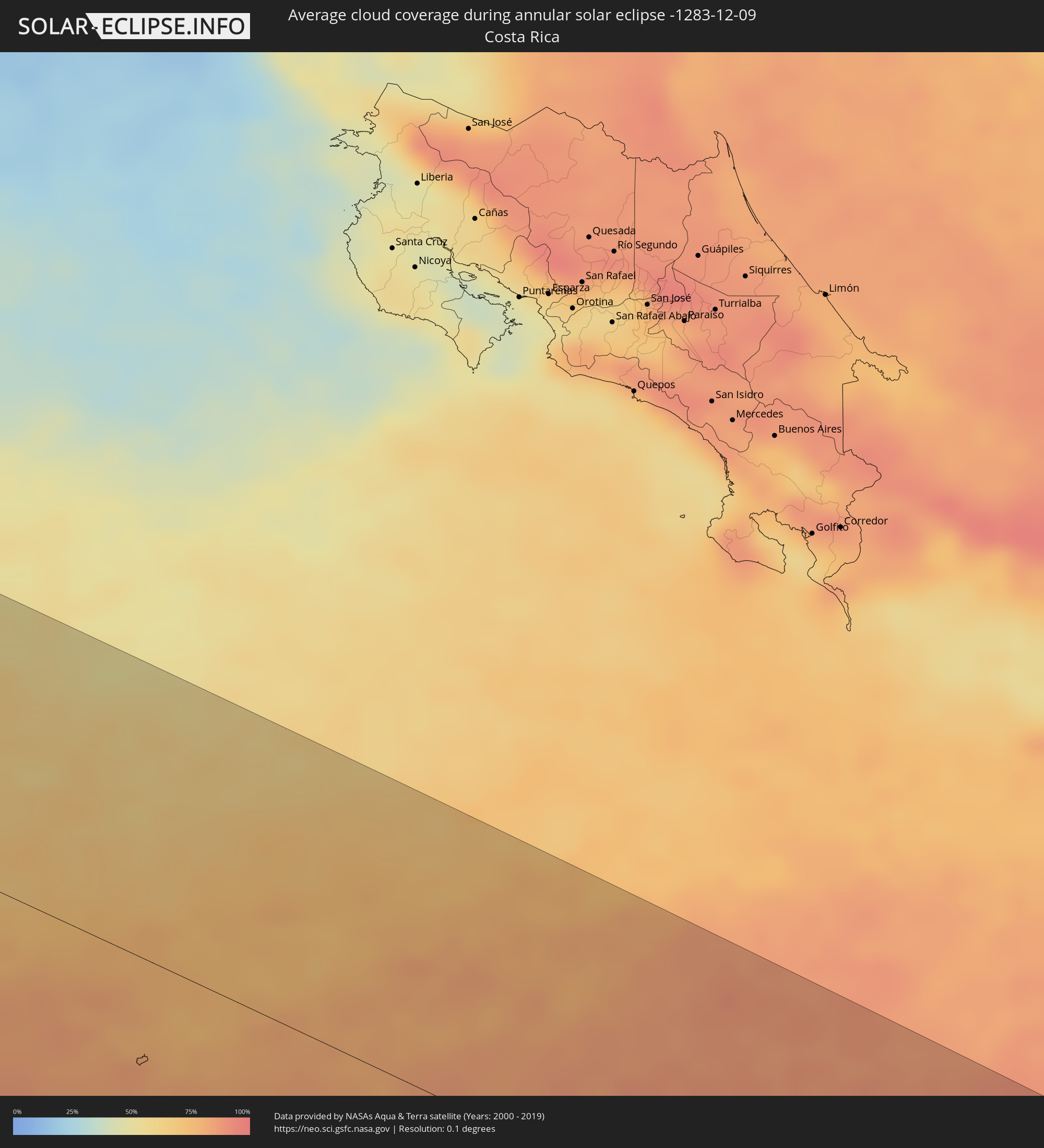 Costa Rica
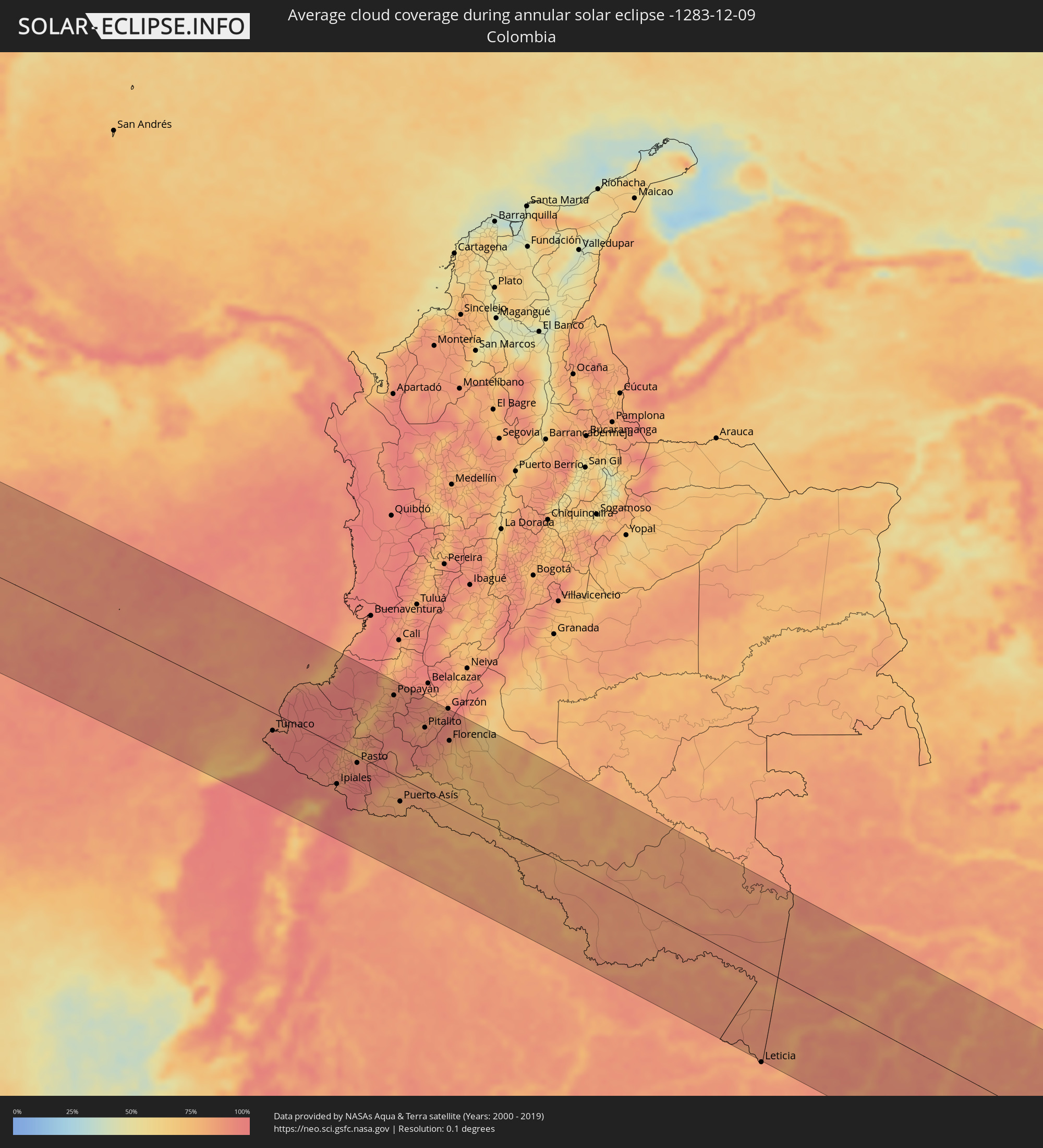 Colombia
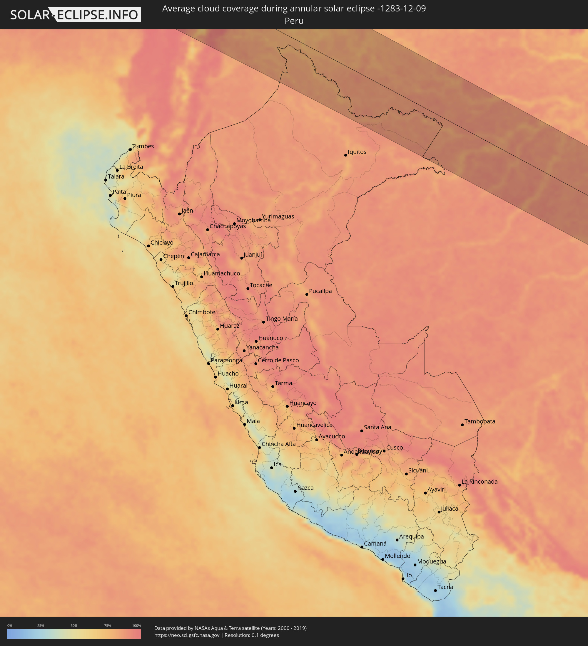 Peru
Peru
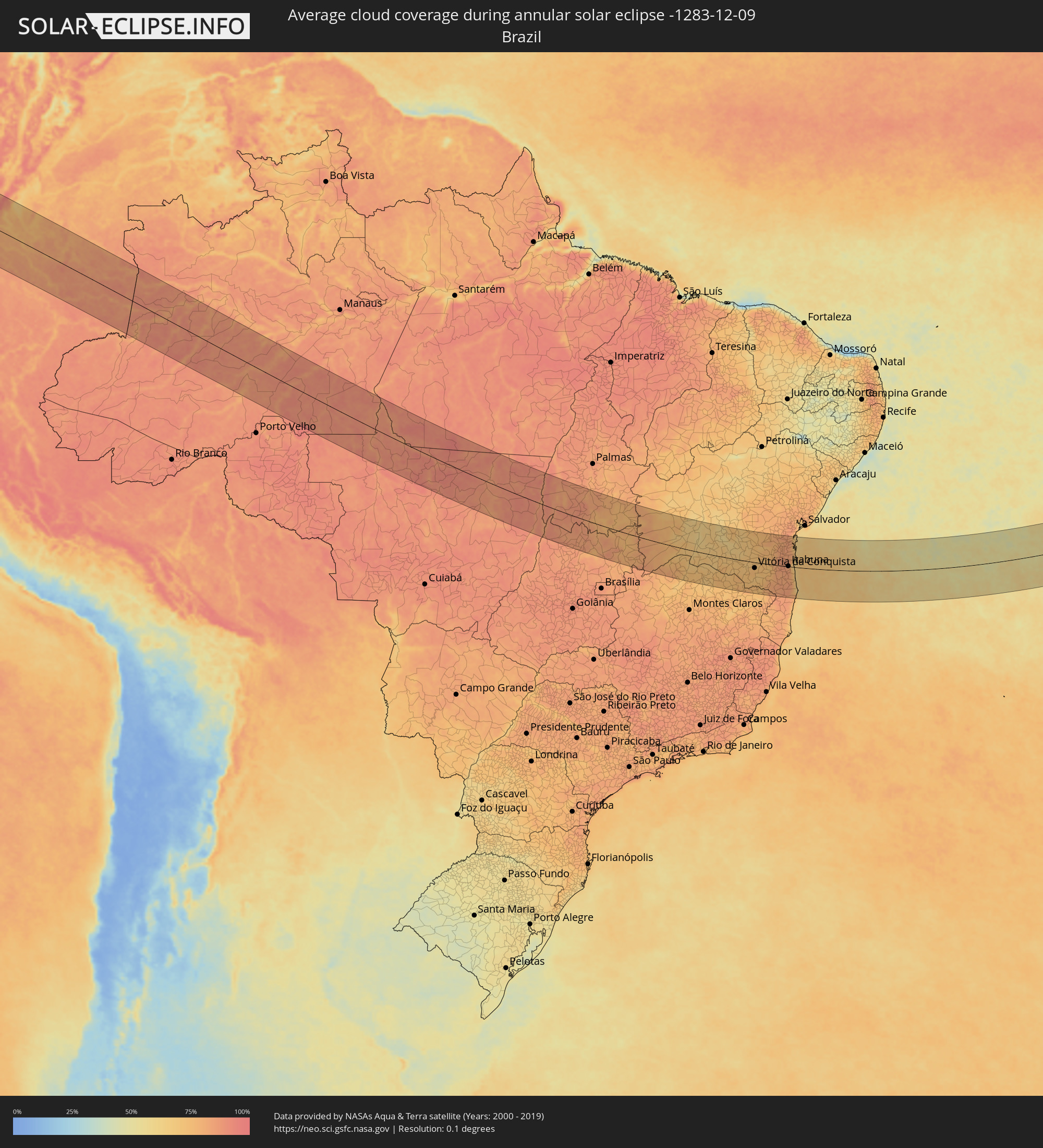 Brazil
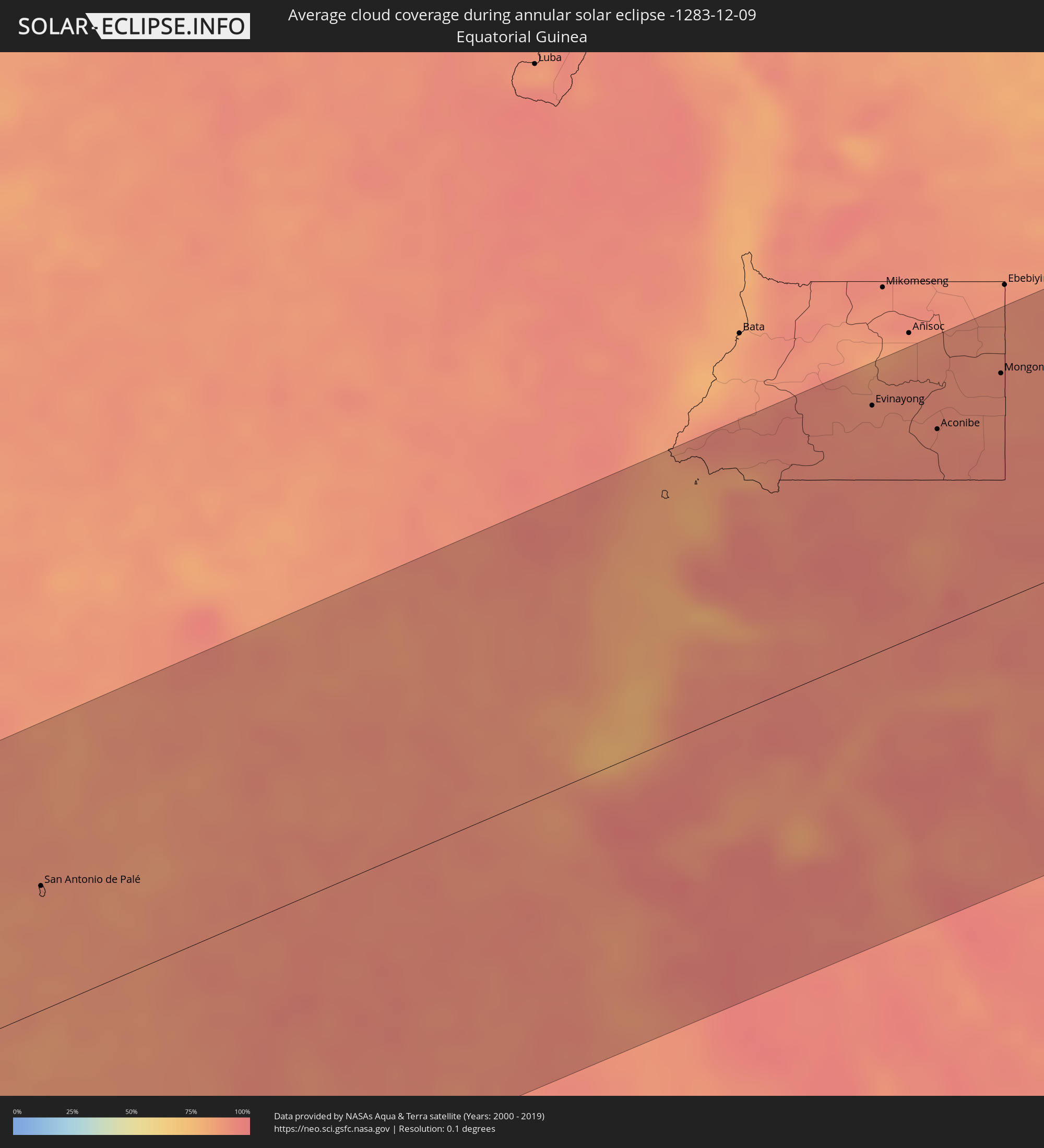 Equatorial Guinea
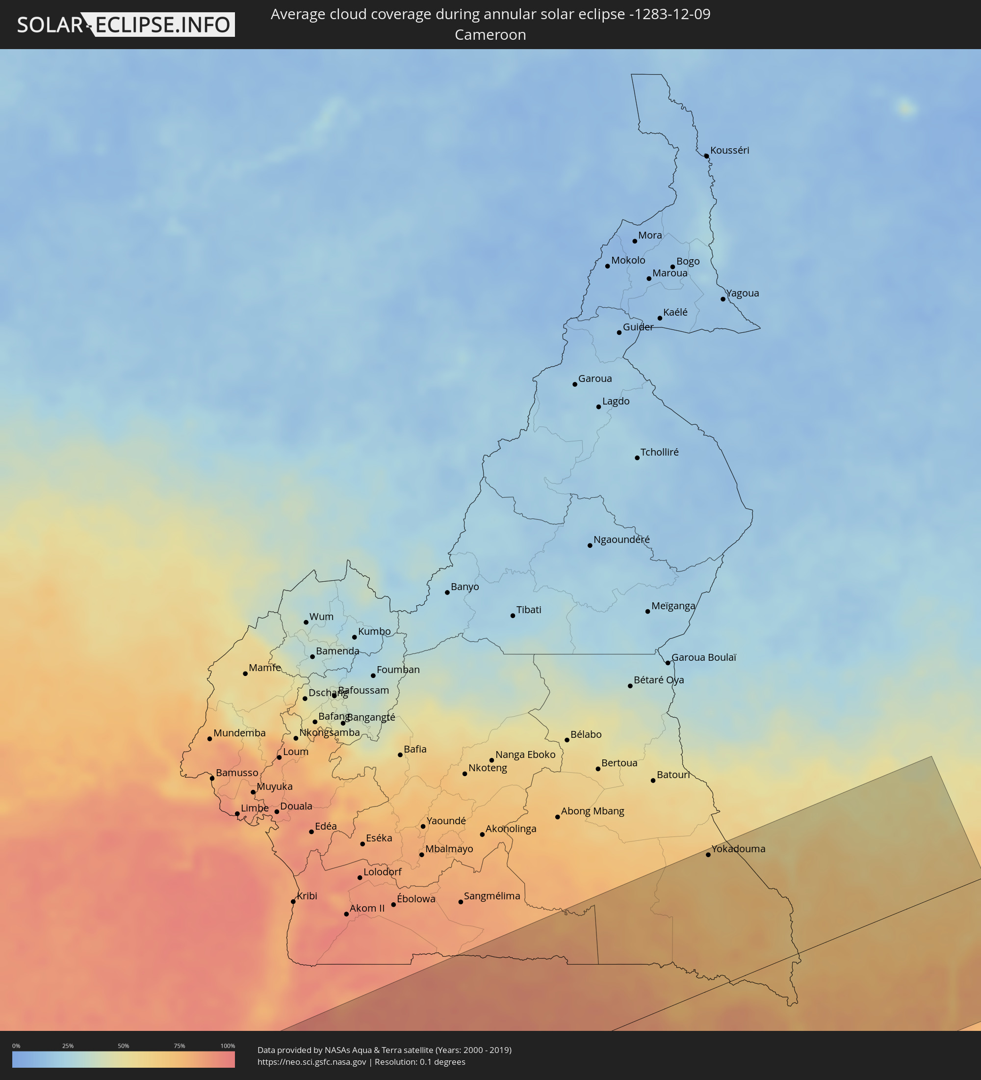 Cameroon
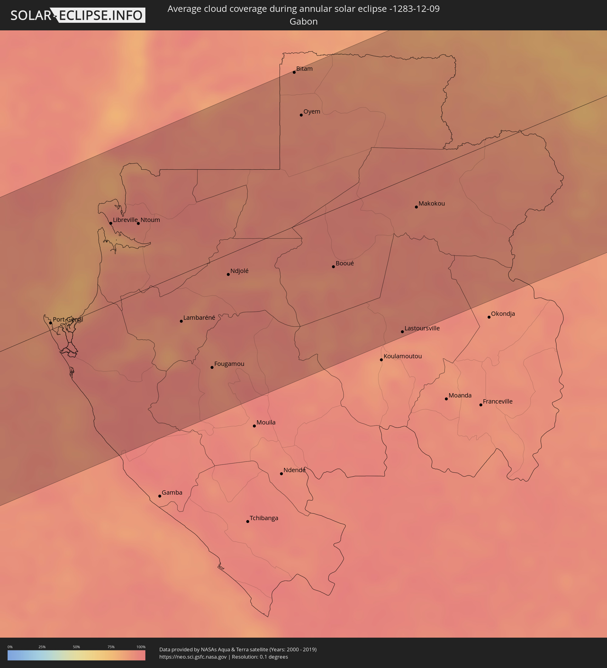 Gabon
Gabon
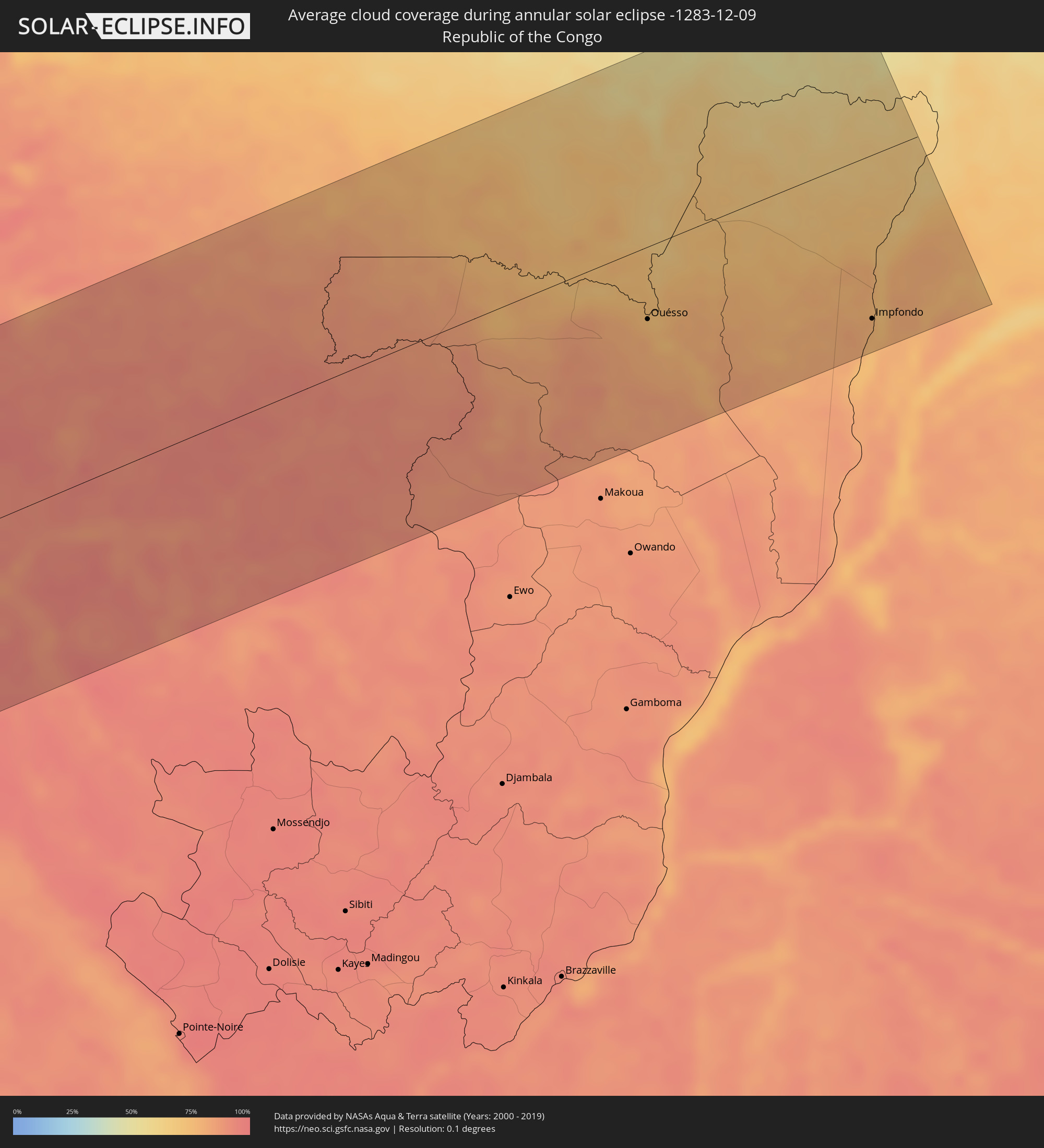 Republic of the Congo
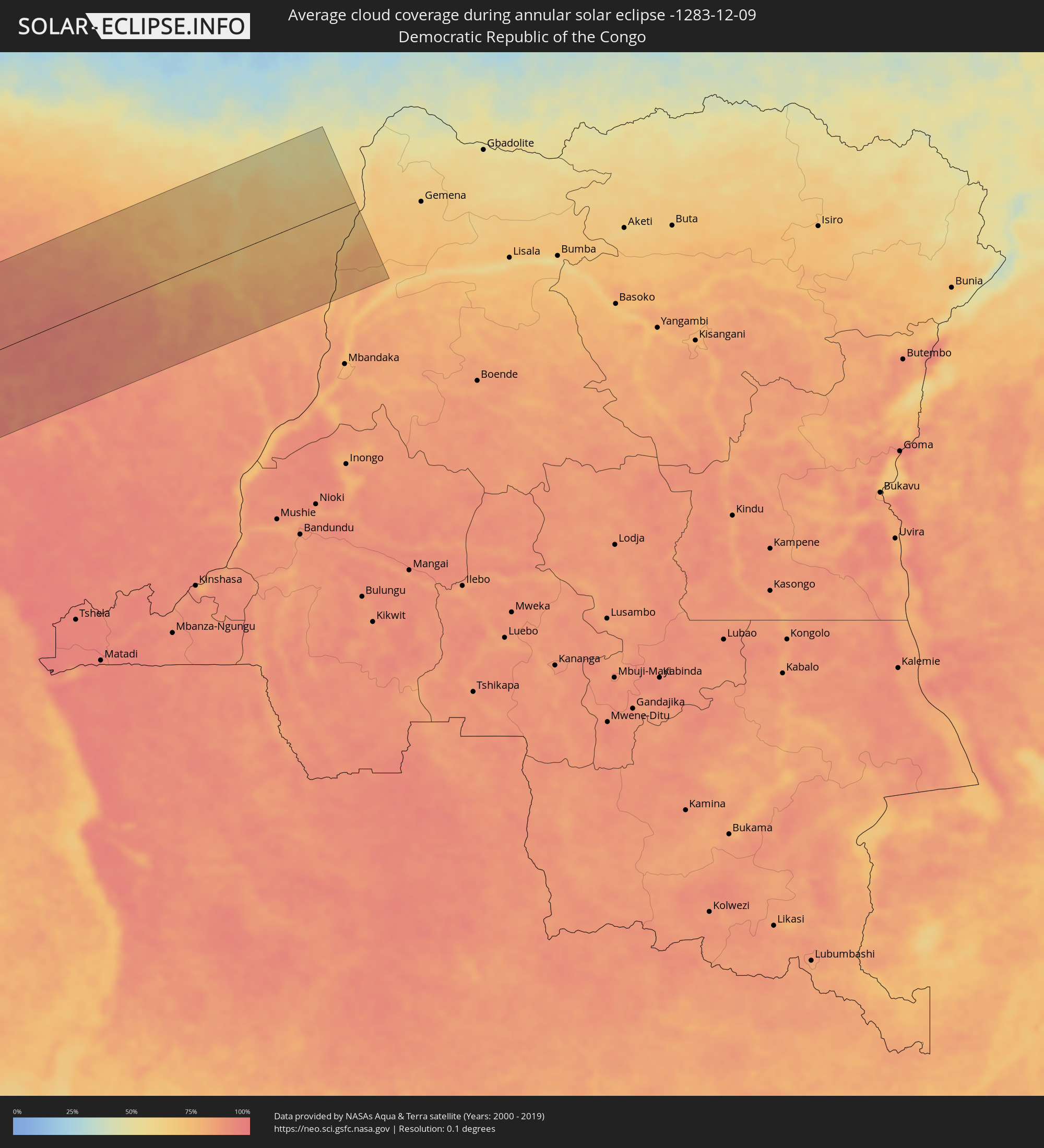 Democratic Republic of the Congo
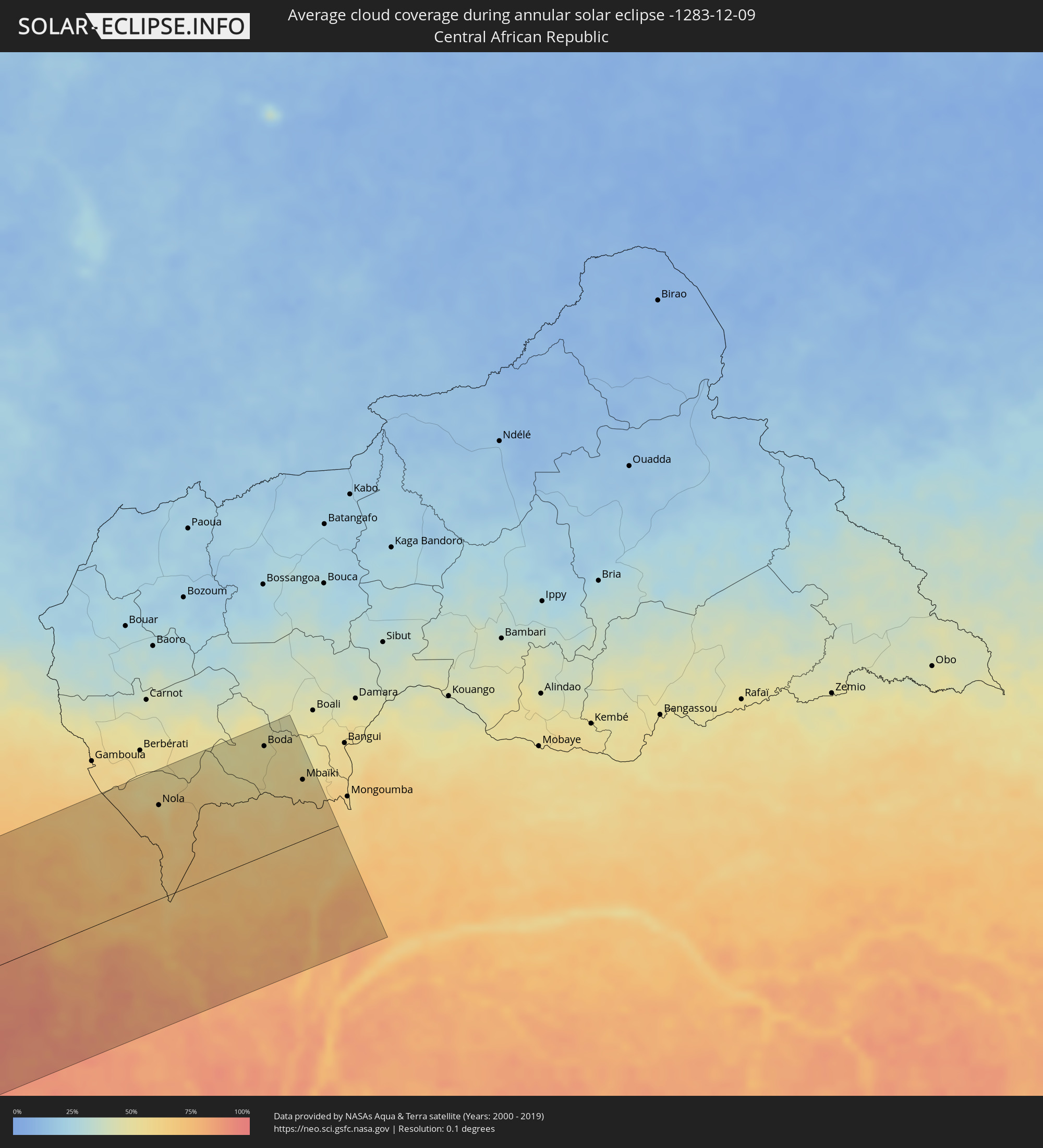 Central African Republic
Cities inside the path of the eclipse
The following table shows all locations with a population of more than 5,000 inside the eclipse path. Cities which have more than 100,000 inhabitants are marked bold. A click at the locations opens a detailed map.
| City | Type | Eclipse duration | Local time of max. eclipse | Distance to central line | Ø Cloud coverage |
|
Esmeraldas, Esmeraldas
|
annular | - | 07:36:27 UTC-05:14 | 158 km | 87% |
|
Valdez, Esmeraldas
|
annular | - | 07:36:45 UTC-05:14 | 96 km | 91% |
|
San Lorenzo de Esmeraldas, Esmeraldas
|
annular | - | 07:36:51 UTC-05:14 | 84 km | 95% |
|
Tumaco, Nariño
|
annular | - | 07:54:16 UTC-04:56 | 33 km | 94% |
|
Cotacachi, Imbabura
|
annular | - | 07:37:57 UTC-05:14 | 153 km | 77% |
|
Otavalo, Imbabura
|
annular | - | 07:38:00 UTC-05:14 | 160 km | 88% |
|
Atuntaqui, Imbabura
|
annular | - | 07:37:58 UTC-05:14 | 148 km | 84% |
|
Ibarra, Imbabura
|
annular | - | 07:38:02 UTC-05:14 | 141 km | 77% |
|
El Charco, Nariño
|
annular | - | 07:54:24 UTC-04:56 | 70 km | 95% |
|
Pimampiro, Imbabura
|
annular | - | 07:38:09 UTC-05:14 | 128 km | 89% |
|
Guapi, Cauca
|
annular | - | 07:54:31 UTC-04:56 | 91 km | 94% |
|
San Gabriel, Carchi
|
annular | - | 07:38:06 UTC-05:14 | 102 km | 88% |
|
Tulcán, Carchi
|
annular | - | 07:38:03 UTC-05:14 | 75 km | 89% |
|
Ipiales, Nariño
|
annular | - | 07:55:49 UTC-04:56 | 70 km | 89% |
|
Túquerres, Nariño
|
annular | - | 07:55:40 UTC-04:56 | 42 km | 89% |
|
Samaniego, Nariño
|
annular | - | 07:55:32 UTC-04:56 | 17 km | 85% |
|
Olaya Herrera, Nariño
|
annular | - | 07:55:40 UTC-04:56 | 20 km | 86% |
|
Sandoná, Nariño
|
annular | - | 07:55:40 UTC-04:56 | 15 km | 86% |
|
Pasto, Nariño
|
annular | - | 07:55:52 UTC-04:56 | 13 km | 91% |
|
La Unión, Nariño
|
annular | - | 07:55:45 UTC-04:56 | 33 km | 89% |
|
Patía, Cauca
|
annular | - | 07:55:31 UTC-04:56 | 83 km | 74% |
|
Puerto Francisco de Orellana, Orellana
|
annular | - | 07:39:35 UTC-05:14 | 164 km | 81% |
|
Sibundoy, Putumayo
|
annular | - | 07:56:11 UTC-04:56 | 4 km | 91% |
|
Valle del Guamuez, Putumayo
|
annular | - | 07:56:42 UTC-04:56 | 70 km | 84% |
|
Nueva Loja, Sucumbios
|
annular | - | 07:39:15 UTC-05:14 | 105 km | 87% |
|
Orito, Putumayo
|
annular | - | 07:56:36 UTC-04:56 | 46 km | 82% |
|
Villa Rica, Cauca
|
annular | - | 07:55:24 UTC-04:56 | 138 km | 80% |
|
Mocoa, Putumayo
|
annular | - | 07:56:28 UTC-04:56 | 13 km | 92% |
|
Popayán, Cauca
|
annular | - | 07:55:40 UTC-04:56 | 142 km | 91% |
|
Puerto Asís, Putumayo
|
annular | - | 07:57:02 UTC-04:56 | 42 km | 79% |
|
San Agustín, Huila
|
annular | - | 07:56:19 UTC-04:56 | 105 km | 86% |
|
Pitalito, Huila
|
annular | - | 07:56:32 UTC-04:56 | 113 km | 85% |
|
Curillo, Caquetá
|
annular | - | 07:57:12 UTC-04:56 | 39 km | 76% |
|
Florencia, Caquetá
|
annular | - | 07:57:06 UTC-04:56 | 112 km | 80% |
|
El Doncello, Caquetá
|
annular | - | 07:57:22 UTC-04:56 | 135 km | 79% |
|
Puerto Rico, Caquetá
|
annular | - | 07:57:21 UTC-04:56 | 166 km | 65% |
|
Puerto Leguízamo, Putumayo
|
annular | - | 07:59:12 UTC-04:56 | 24 km | 78% |
|
Humaitá, Amazonas
|
annular | - | 09:17:20 UTC-04:02 | 128 km | 85% |
|
Porangatu, Goiás
|
annular | - | 10:58:34 UTC-03:06 | 93 km | 84% |
|
Gurupi, Tocantins
|
annular | - | 11:29:22 UTC-02:34 | 89 km | 87% |
|
Posse, Goiás
|
annular | - | 11:09:06 UTC-03:06 | 71 km | 80% |
|
Santa Maria da Vitória, Bahia
|
annular | - | 11:49:07 UTC-02:34 | 64 km | 66% |
|
Bom Jesus da Lapa, Bahia
|
annular | - | 11:52:01 UTC-02:34 | 98 km | 59% |
|
Guanambi, Bahia
|
annular | - | 11:55:16 UTC-02:34 | 6 km | 67% |
|
Caetité, Bahia
|
annular | - | 11:56:22 UTC-02:34 | 30 km | 69% |
|
Brumado, Bahia
|
annular | - | 11:59:39 UTC-02:34 | 31 km | 68% |
|
Vitória da Conquista, Bahia
|
annular | - | 12:03:20 UTC-02:34 | 28 km | 74% |
|
Itambé, Bahia
|
annular | - | 12:04:23 UTC-02:34 | 67 km | 70% |
|
Maracás, Bahia
|
annular | - | 12:04:09 UTC-02:34 | 135 km | 74% |
|
Poções, Bahia
|
annular | - | 12:05:01 UTC-02:34 | 16 km | 74% |
|
Itapetinga, Bahia
|
annular | - | 12:05:52 UTC-02:34 | 62 km | 75% |
|
Jequié, Bahia
|
annular | - | 12:05:47 UTC-02:34 | 94 km | 76% |
|
Jaguaquara, Bahia
|
annular | - | 12:06:05 UTC-02:34 | 132 km | 80% |
|
Ipiaú, Bahia
|
annular | - | 12:07:19 UTC-02:34 | 68 km | 83% |
|
Coaraci, Bahia
|
annular | - | 12:08:19 UTC-02:34 | 14 km | 84% |
|
Gandu, Bahia
|
annular | - | 12:08:09 UTC-02:34 | 114 km | 82% |
|
Ubaitaba, Bahia
|
annular | - | 12:09:05 UTC-02:34 | 53 km | 83% |
|
Uruçuca, Bahia
|
annular | - | 12:09:22 UTC-02:34 | 23 km | 81% |
|
Itabuna, Bahia
|
annular | - | 12:09:28 UTC-02:34 | 1 km | 82% |
|
Una, Bahia
|
annular | - | 12:10:30 UTC-02:34 | 52 km | 75% |
|
Ilhéus, Bahia
|
annular | - | 12:10:26 UTC-02:34 | 3 km | 64% |
|
Canavieiras, Bahia
|
annular | - | 12:11:09 UTC-02:34 | 94 km | 62% |
|
San Antonio de Palé, Annobón Province
|
annular | - | 16:47:10 UTC+00:13 | 75 km | 86% |
|
Port-Gentil, Ogooué-Maritime
|
annular | - | 16:48:42 UTC+00:13 | 7 km | 91% |
|
Libreville, Estuaire
|
annular | - | 16:49:15 UTC+00:13 | 92 km | 88% |
|
Ntoum, Estuaire
|
annular | - | 16:49:20 UTC+00:13 | 78 km | 93% |
|
Lambaréné, Moyen-Ogooué
|
annular | - | 16:49:09 UTC+00:13 | 54 km | 88% |
|
Evinayong, Centro Sur
|
annular | - | 16:49:49 UTC+00:13 | 151 km | 90% |
|
Fougamou, Ngouni
|
annular | - | 16:49:05 UTC+00:13 | 122 km | 89% |
|
Ndjolé, Moyen-Ogooué
|
annular | - | 16:49:27 UTC+00:13 | 24 km | 92% |
|
Aconibe, Wele-Nzas
|
annular | - | 16:49:52 UTC+00:13 | 120 km | 91% |
|
Mongomo, Wele-Nzas
|
annular | - | 16:50:02 UTC+00:13 | 138 km | 91% |
|
Bitam, Woleu-Ntem
|
annular | - | 16:50:10 UTC+00:13 | 176 km | 90% |
|
Oyem, Woleu-Ntem
|
annular | - | 16:50:05 UTC+00:13 | 123 km | 91% |
|
Booué, Ogooué-Ivindo
|
annular | - | 16:49:44 UTC+00:13 | 66 km | 89% |
|
Lastoursville, Ogooué-Lolo
|
annular | - | 16:49:41 UTC+00:13 | 173 km | 88% |
|
Makokou, Ogooué-Ivindo
|
annular | - | 16:50:05 UTC+00:13 | 37 km | 90% |
|
Yokadouma, East
|
annular | - | 16:50:53 UTC+00:13 | 172 km | 65% |
|
Nola, Sangha-Mbaéré
|
annular | - | 16:50:56 UTC+00:13 | 130 km | 61% |
|
Ouésso, Sangha
|
annular | - | 16:50:38 UTC+00:13 | 67 km | 75% |
|
Boda, Lobaye
|
annular | - | 16:51:02 UTC+00:13 | 152 km | 51% |
|
Mbaïki, Lobaye
|
annular | - | 16:50:58 UTC+00:13 | 84 km | 56% |
|
Impfondo, Likouala
|
annular | - | 16:50:38 UTC+00:13 | 151 km | 74% |