Total solar eclipse of 05/14/-1337
| Day of week: | Tuesday |
| Maximum duration of eclipse: | 06m51s |
| Maximum width of eclipse path: | 261 km |
| Saros cycle: | 26 |
| Coverage: | 100% |
| Magnitude: | 1.0801 |
| Gamma: | 0.1487 |
Wo kann man die Sonnenfinsternis vom 05/14/-1337 sehen?
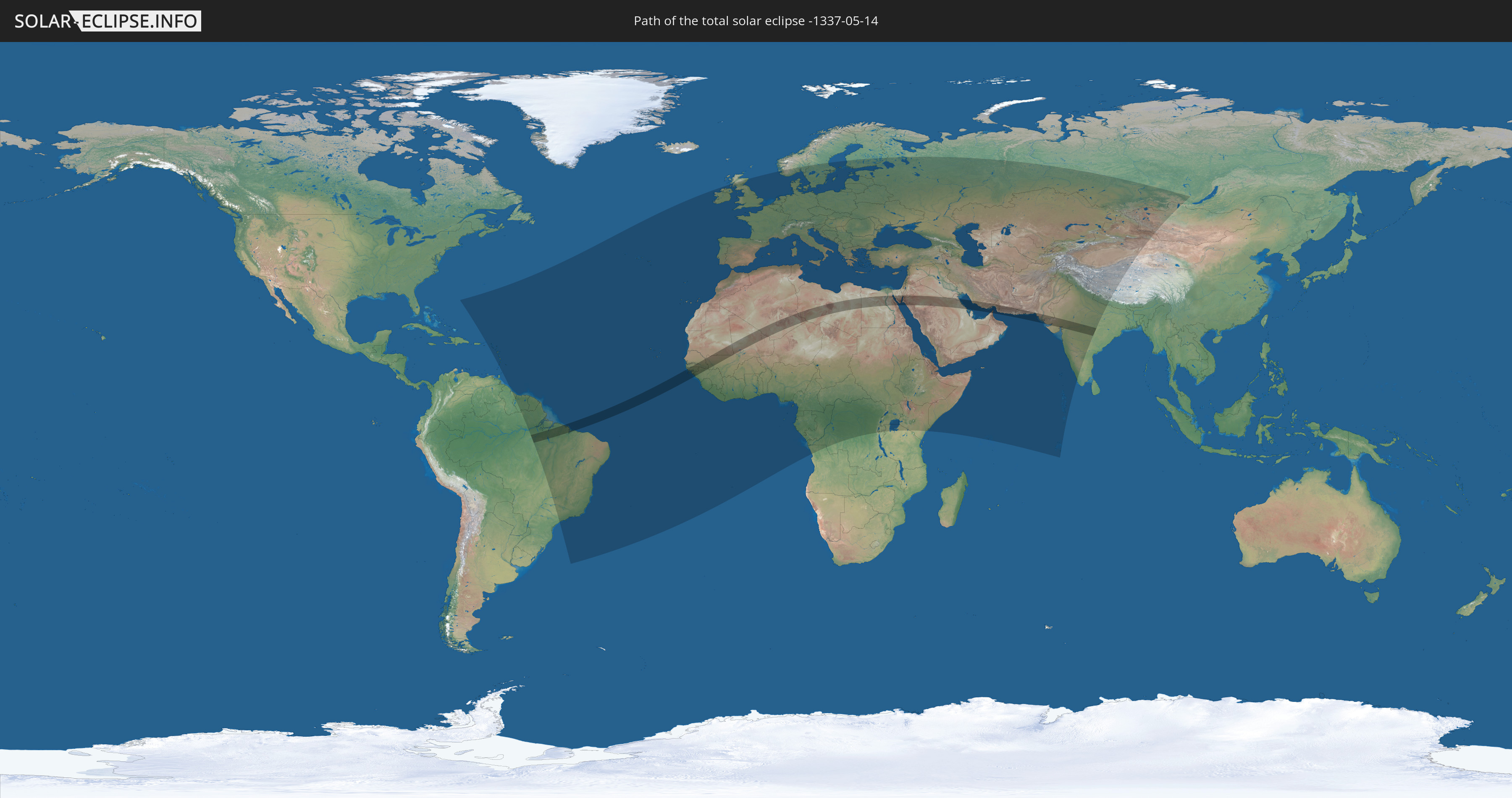
Die Sonnenfinsternis am 05/14/-1337 kann man in 139 Ländern als partielle Sonnenfinsternis beobachten.
Der Finsternispfad verläuft durch 20 Länder. Nur in diesen Ländern ist sie als total Sonnenfinsternis zu sehen.
In den folgenden Ländern ist die Sonnenfinsternis total zu sehen
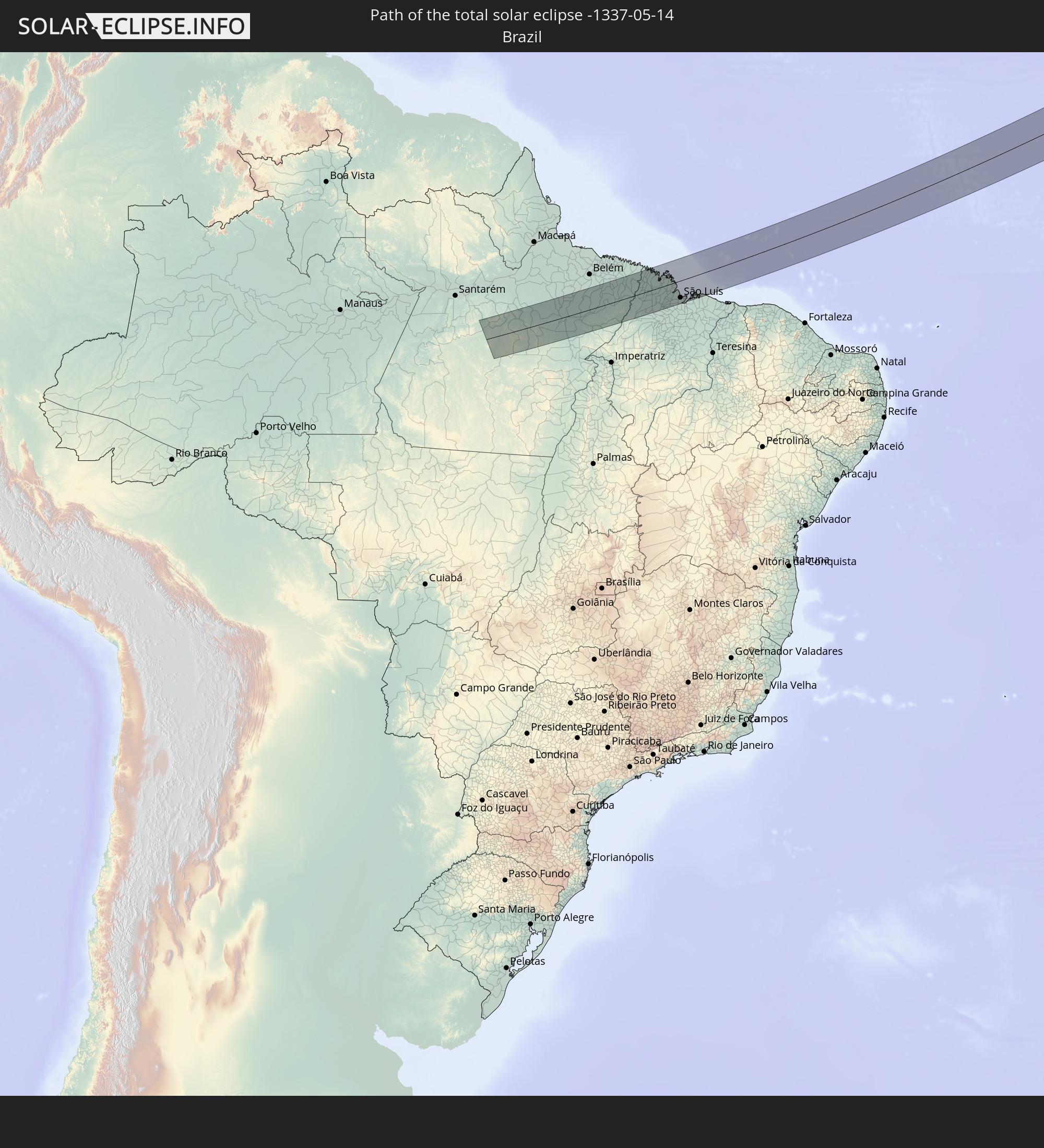 Brazil
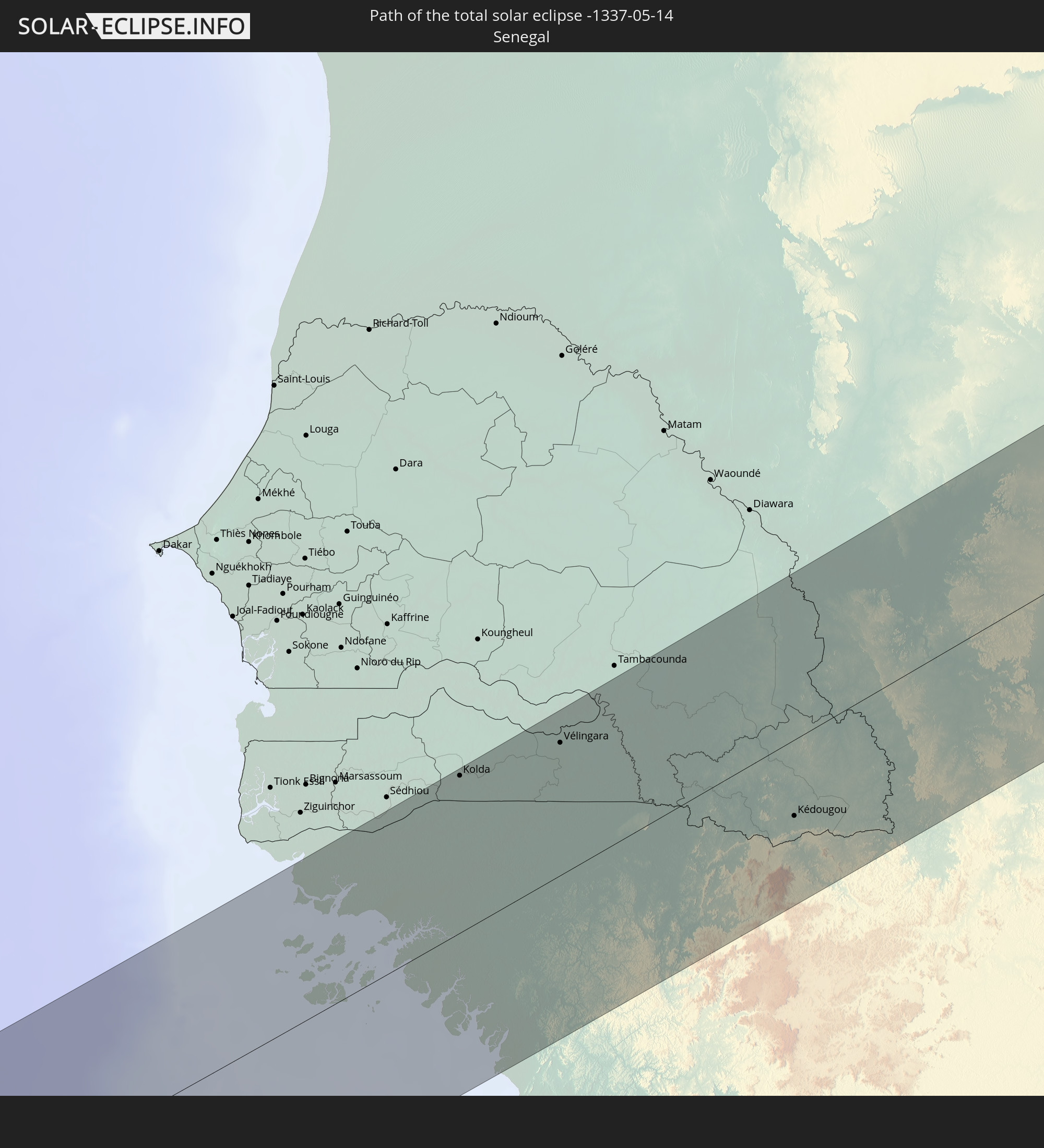 Senegal
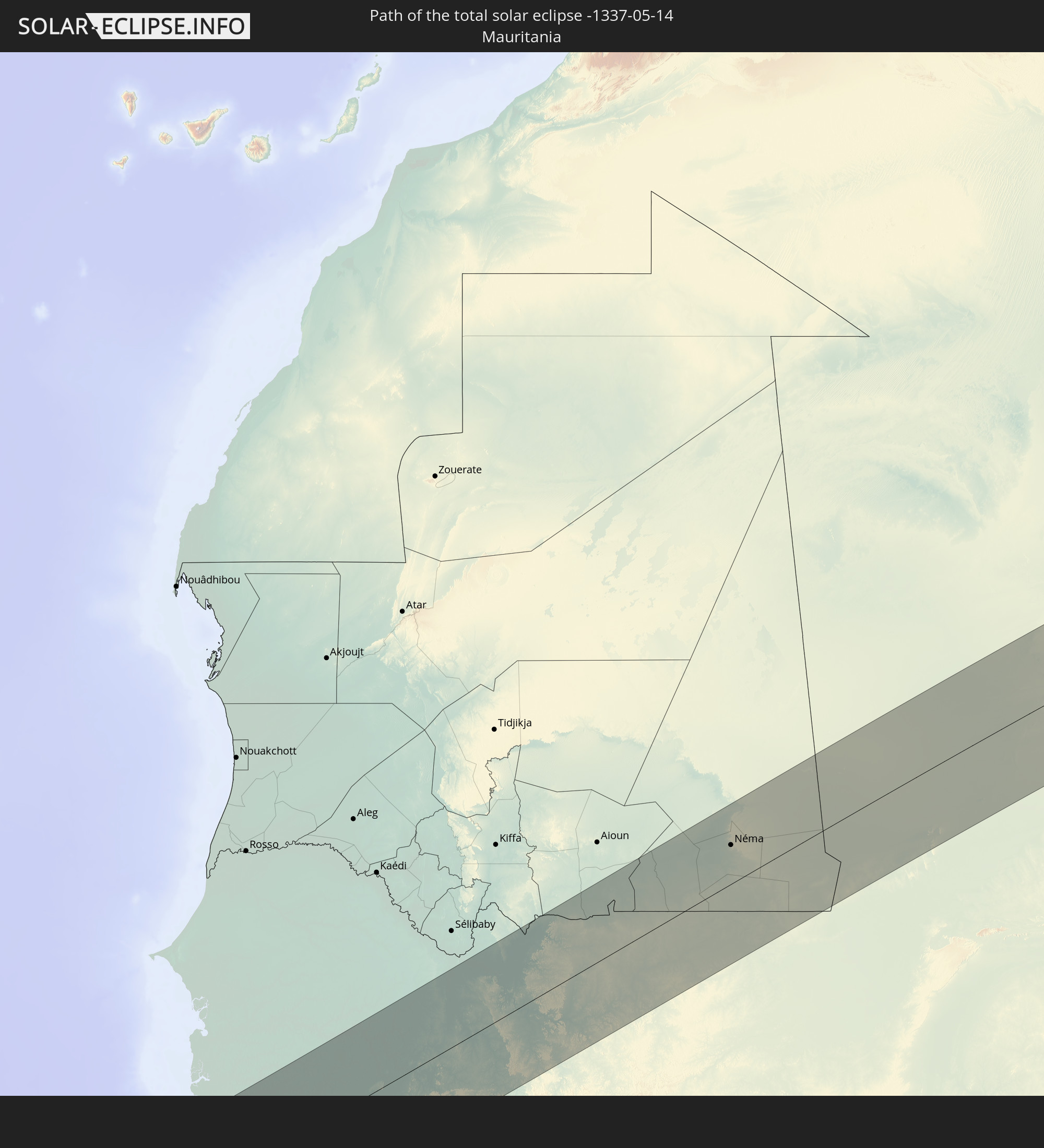 Mauritania
 The Gambia
 Guinea-Bissau
 Guinea
 Mali
Mali
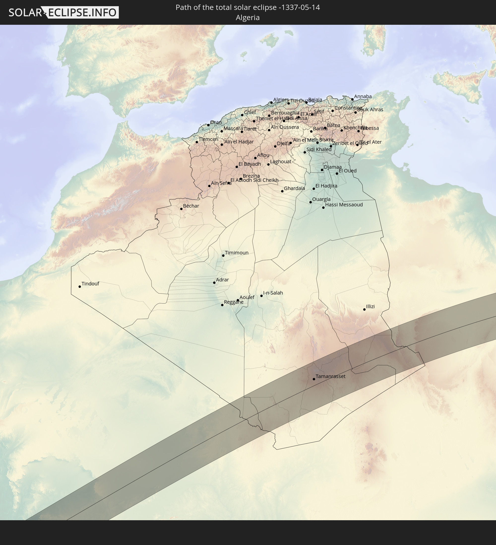 Algeria
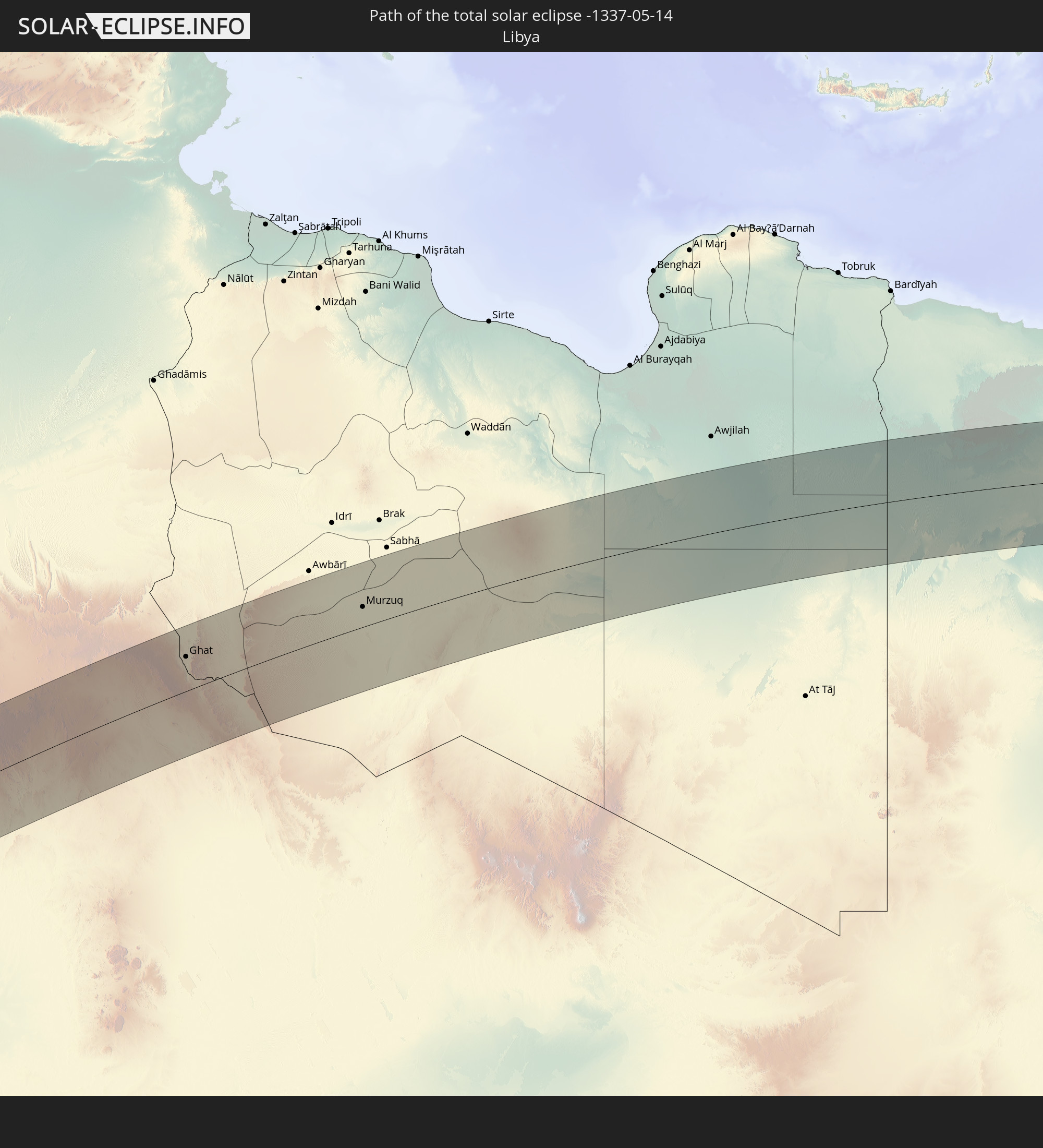 Libya
Libya
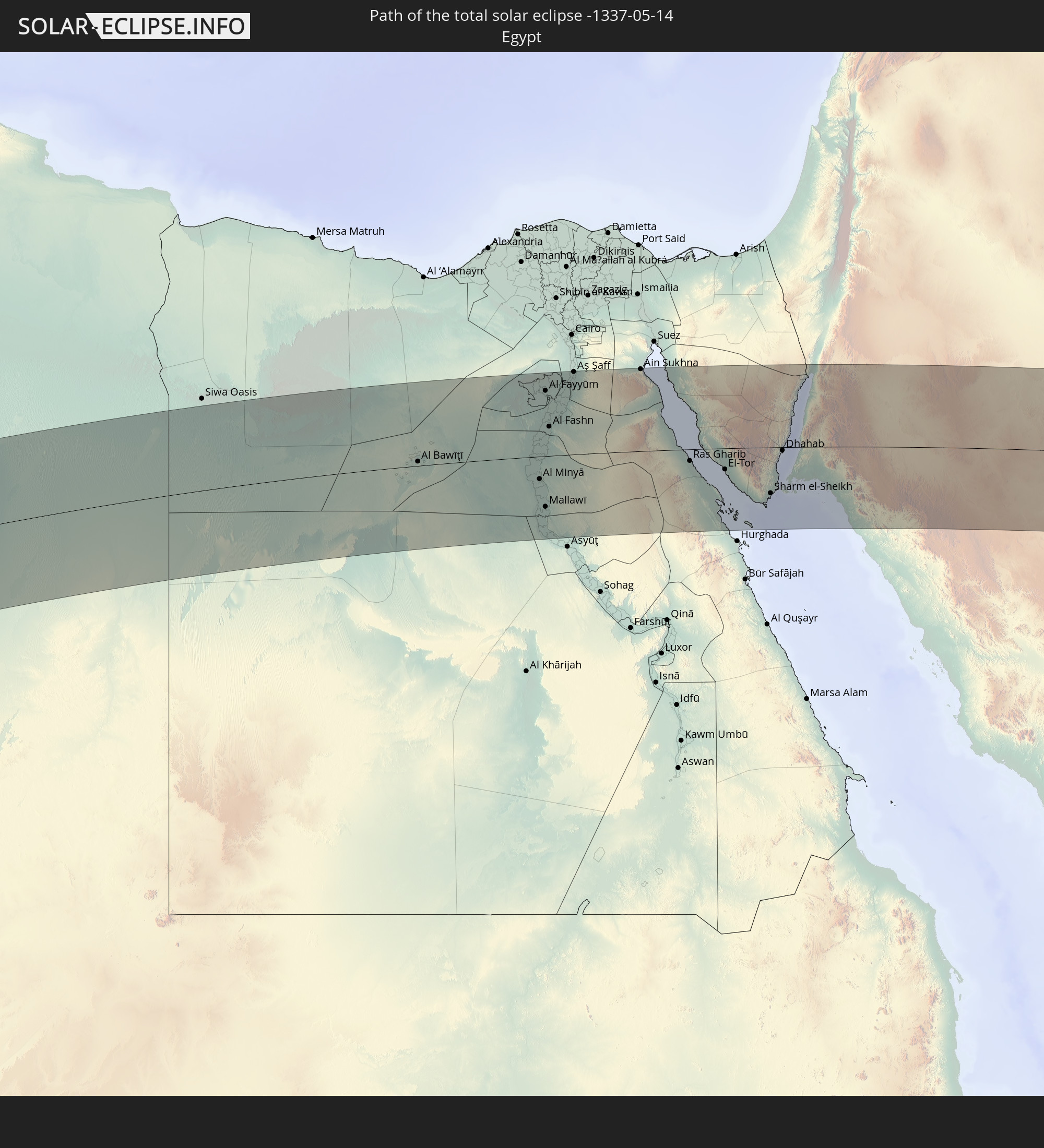 Egypt
Egypt
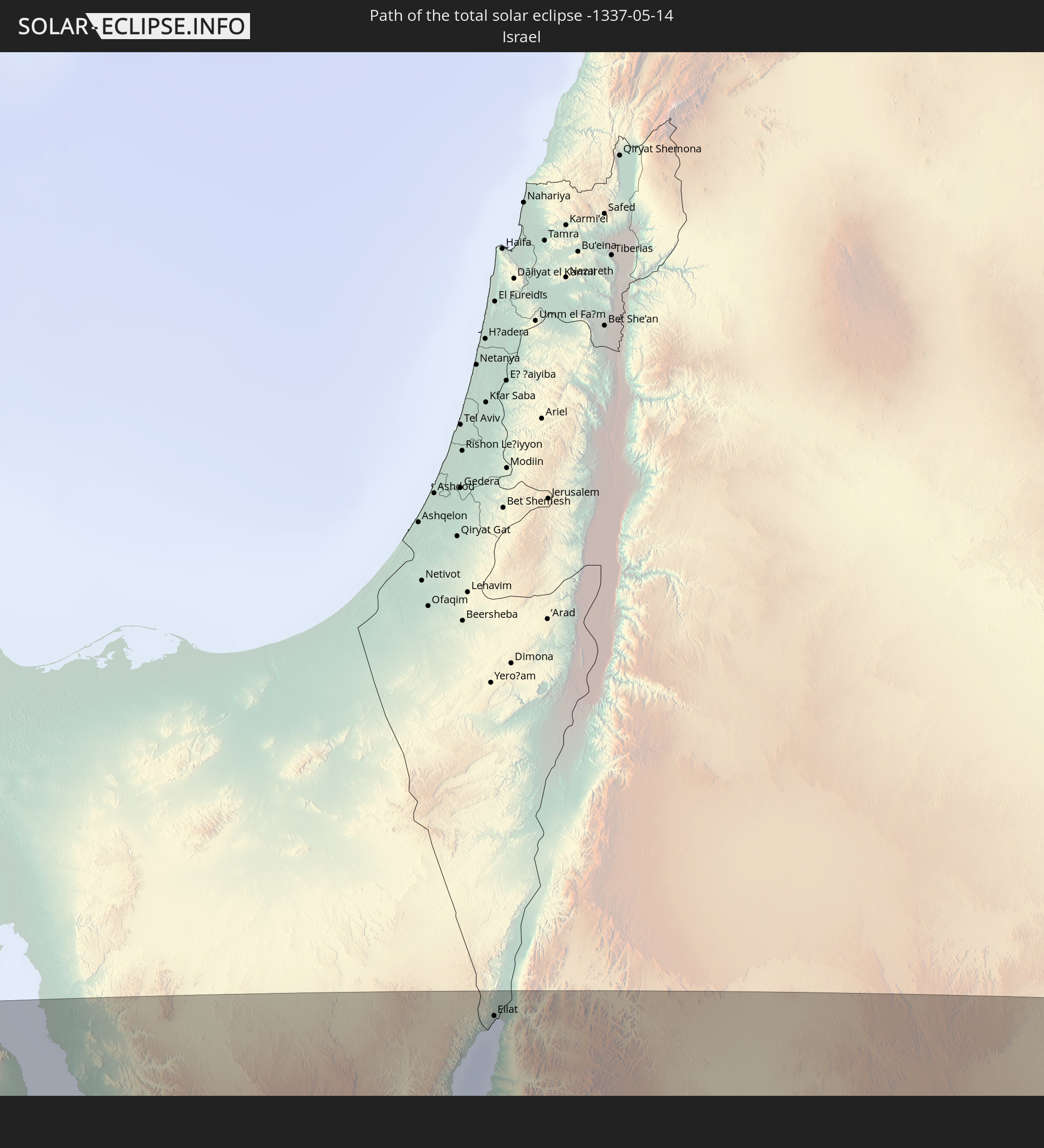 Israel
 Saudi Arabia
 Jordan
 Iraq
Iraq
 Iran
Iran
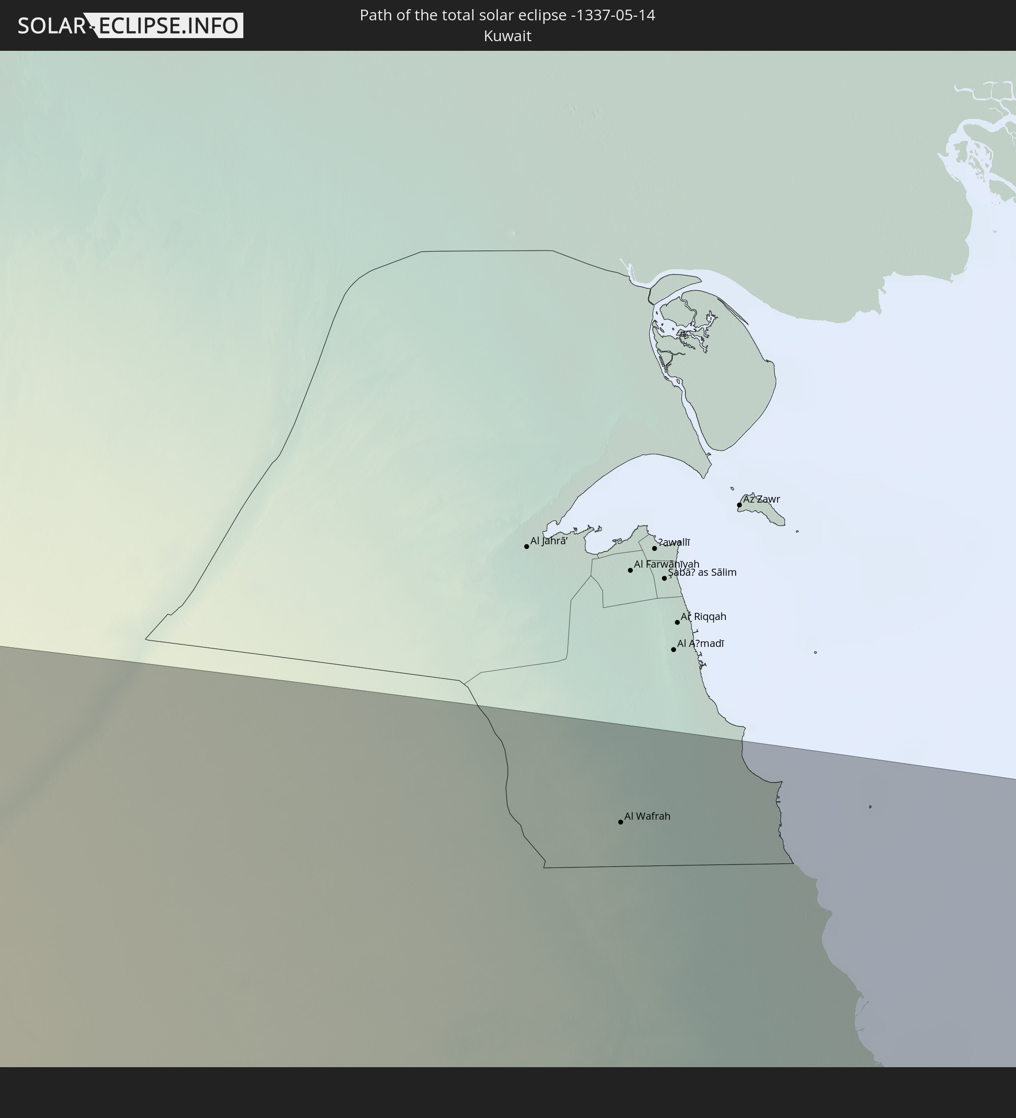 Kuwait
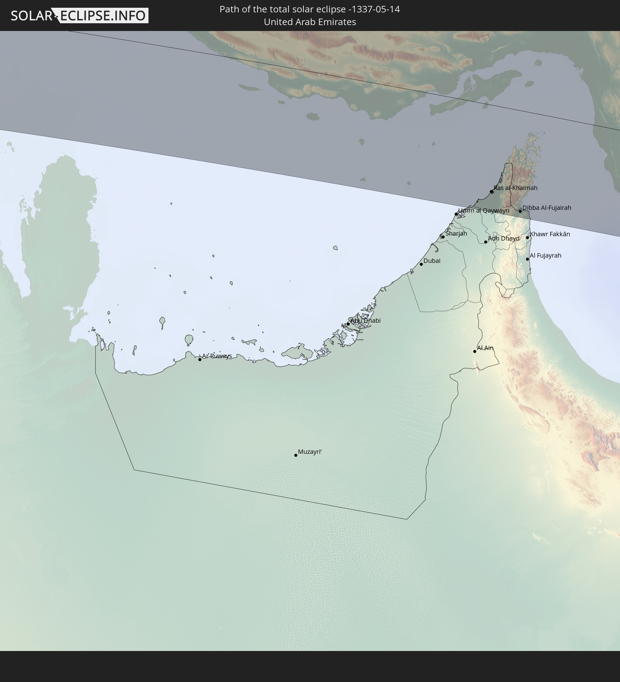 United Arab Emirates
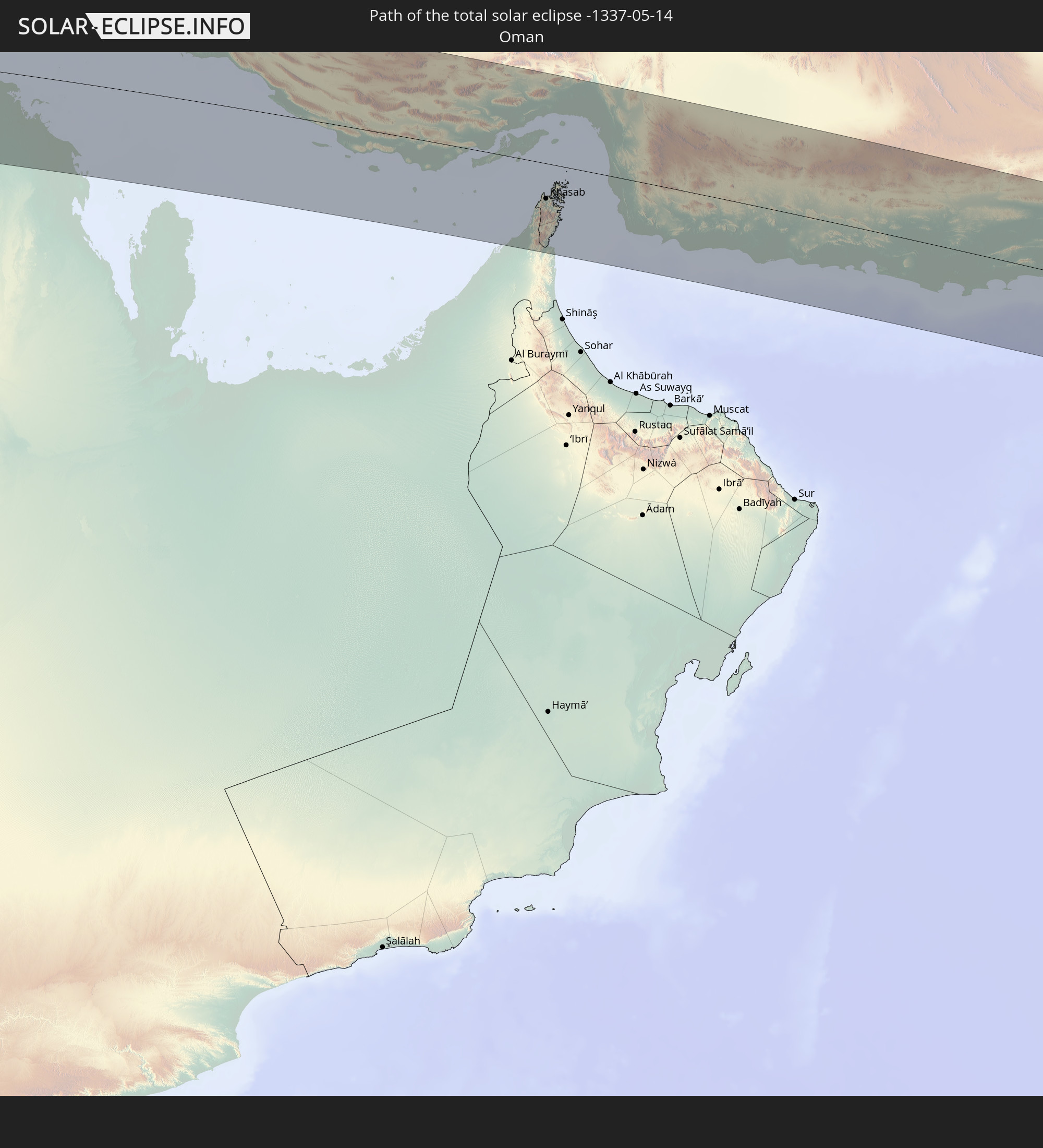 Oman
Oman
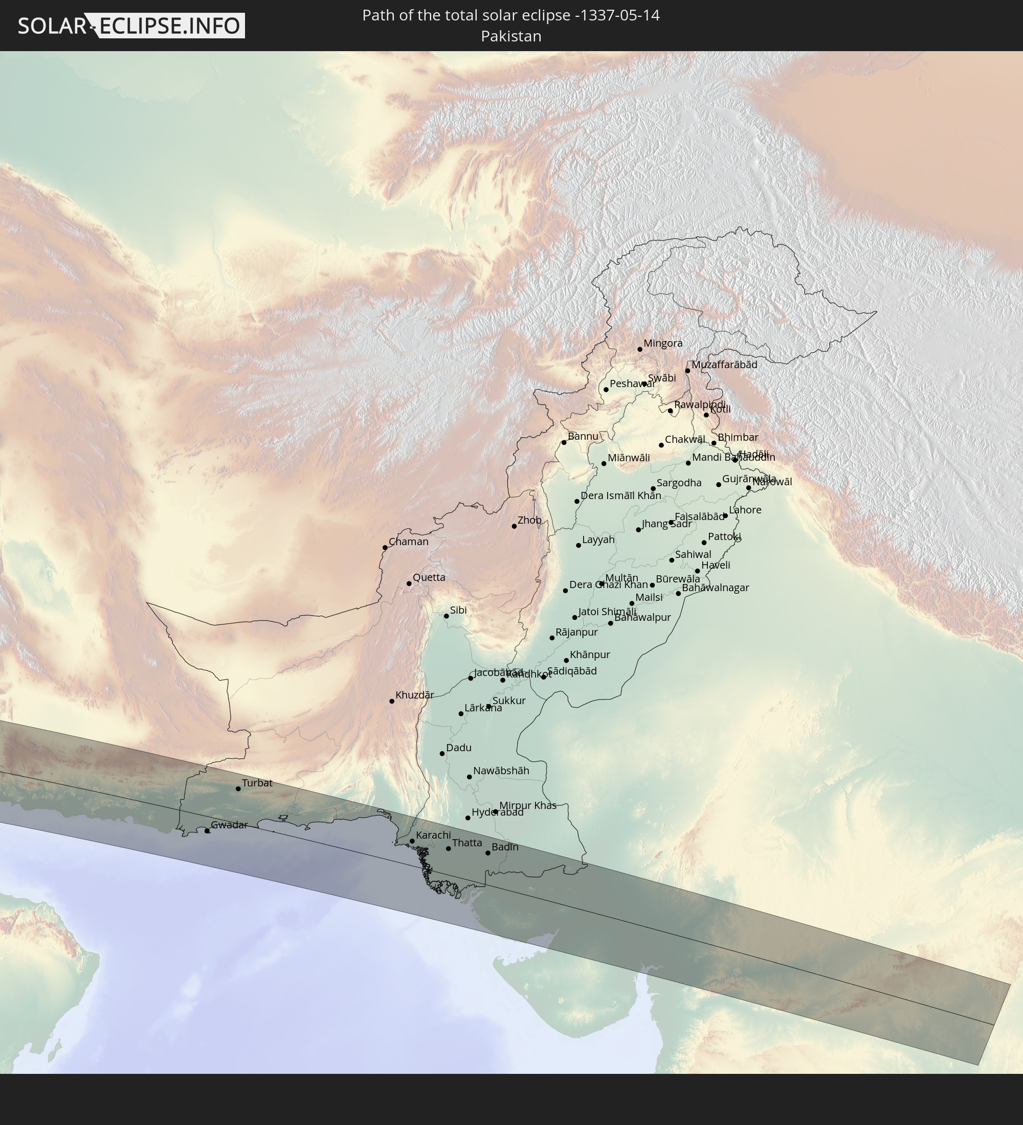 Pakistan
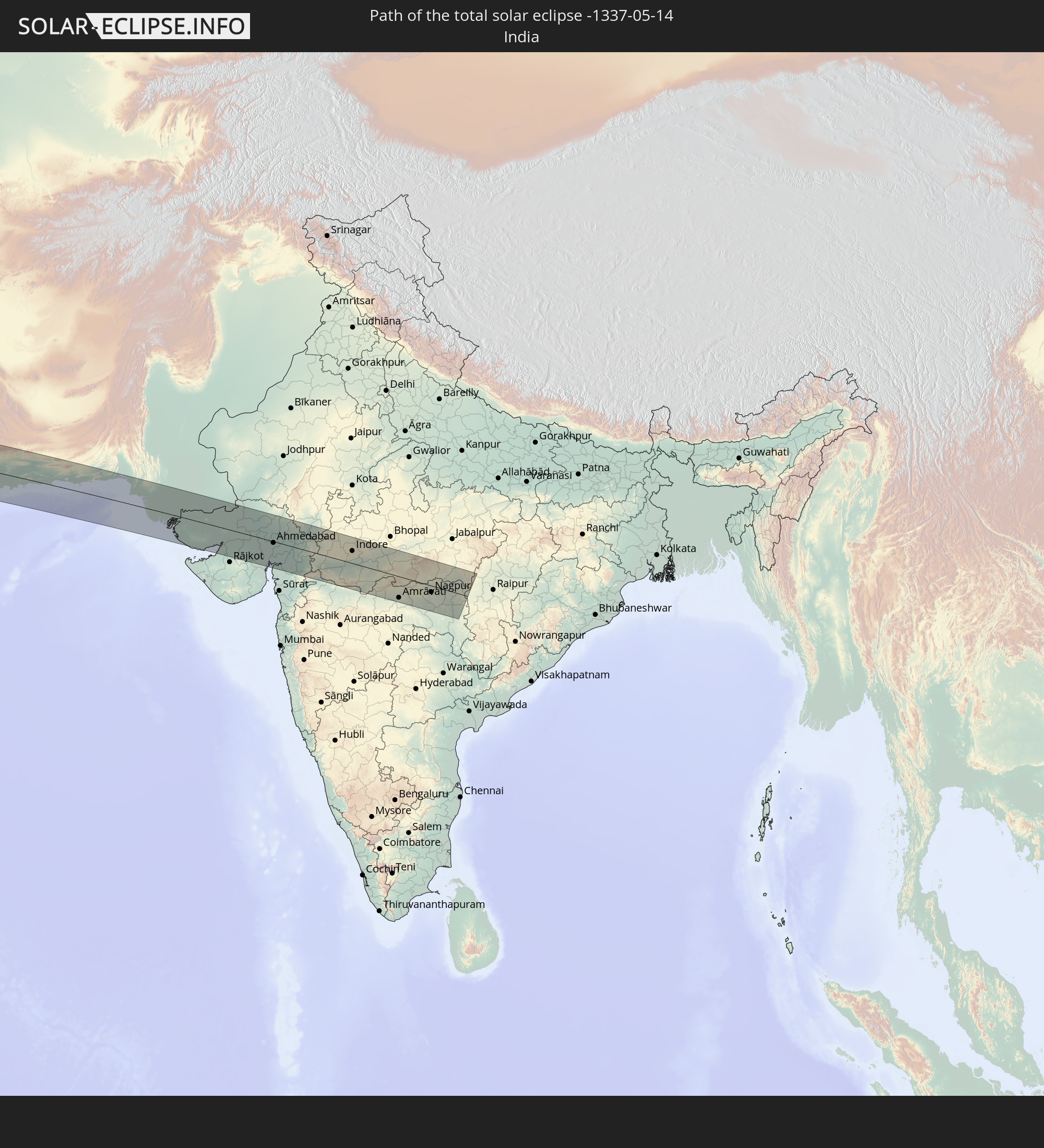 India
India
In den folgenden Ländern ist die Sonnenfinsternis partiell zu sehen
 Russia
 Brazil
 British Virgin Islands
 Anguilla
 Collectivity of Saint Martin
 Saint Barthélemy
 Saint Kitts and Nevis
 Antigua and Barbuda
 Montserrat
 Guadeloupe
 Dominica
 Saint Vincent and the Grenadines
 Guyana
 Martinique
 Saint Lucia
 Barbados
 Suriname
 French Guiana
 Portugal
 Cabo Verde
 Spain
Spain
 Senegal
 Mauritania
 The Gambia
 Guinea-Bissau
 Guinea
 Saint Helena, Ascension and Tristan da Cunha
 Sierra Leone
 Morocco
 Mali
Mali
 Liberia
 Republic of Ireland
 Algeria
 United Kingdom
 Ivory Coast
 Burkina Faso
 Gibraltar
 France
 Isle of Man
 Ghana
Ghana
 Guernsey
 Jersey
 Togo
Togo
 Niger
Niger
 Benin
Benin
 Andorra
 Belgium
 Nigeria
 Netherlands
 Norway
 Equatorial Guinea
 Luxembourg
 Germany
 Switzerland
 São Tomé and Príncipe
 Italy
Italy
 Monaco
 Tunisia
 Denmark
 Cameroon
 Gabon
Gabon
 Libya
Libya
 Liechtenstein
 Austria
 Sweden
 Republic of the Congo
 Angola
 Czechia
 Democratic Republic of the Congo
 San Marino
 Vatican City
 Slovenia
 Chad
Chad
 Croatia
 Poland
 Malta
Malta
 Central African Republic
 Bosnia and Herzegovina
 Hungary
 Slovakia
 Montenegro
 Serbia
 Albania
 Åland Islands
 Greece
 Romania
 Republic of Macedonia
 Finland
 Lithuania
 Latvia
 Estonia
 Sudan
Sudan
 Ukraine
 Bulgaria
 Belarus
 Egypt
Egypt
 Turkey
 Moldova
 Rwanda
 Burundi
 Tanzania
 Uganda
 Cyprus
 Ethiopia
 Kenya
Kenya
 State of Palestine
 Israel
 Saudi Arabia
 Jordan
 Lebanon
 Syria
Syria
 Eritrea
 Iraq
Iraq
 Georgia
 Somalia
 Djibouti
 Yemen
Yemen
 Armenia
 Iran
Iran
 Azerbaijan
 Seychelles
 Kazakhstan
 Kuwait
 Bahrain
 Qatar
Qatar
 United Arab Emirates
 Oman
Oman
 Turkmenistan
 Uzbekistan
 Afghanistan
 Pakistan
 Tajikistan
 India
India
 Kyrgyzstan
 British Indian Ocean Territory
 Maldives
 China
China
 Nepal
Nepal
 Mongolia
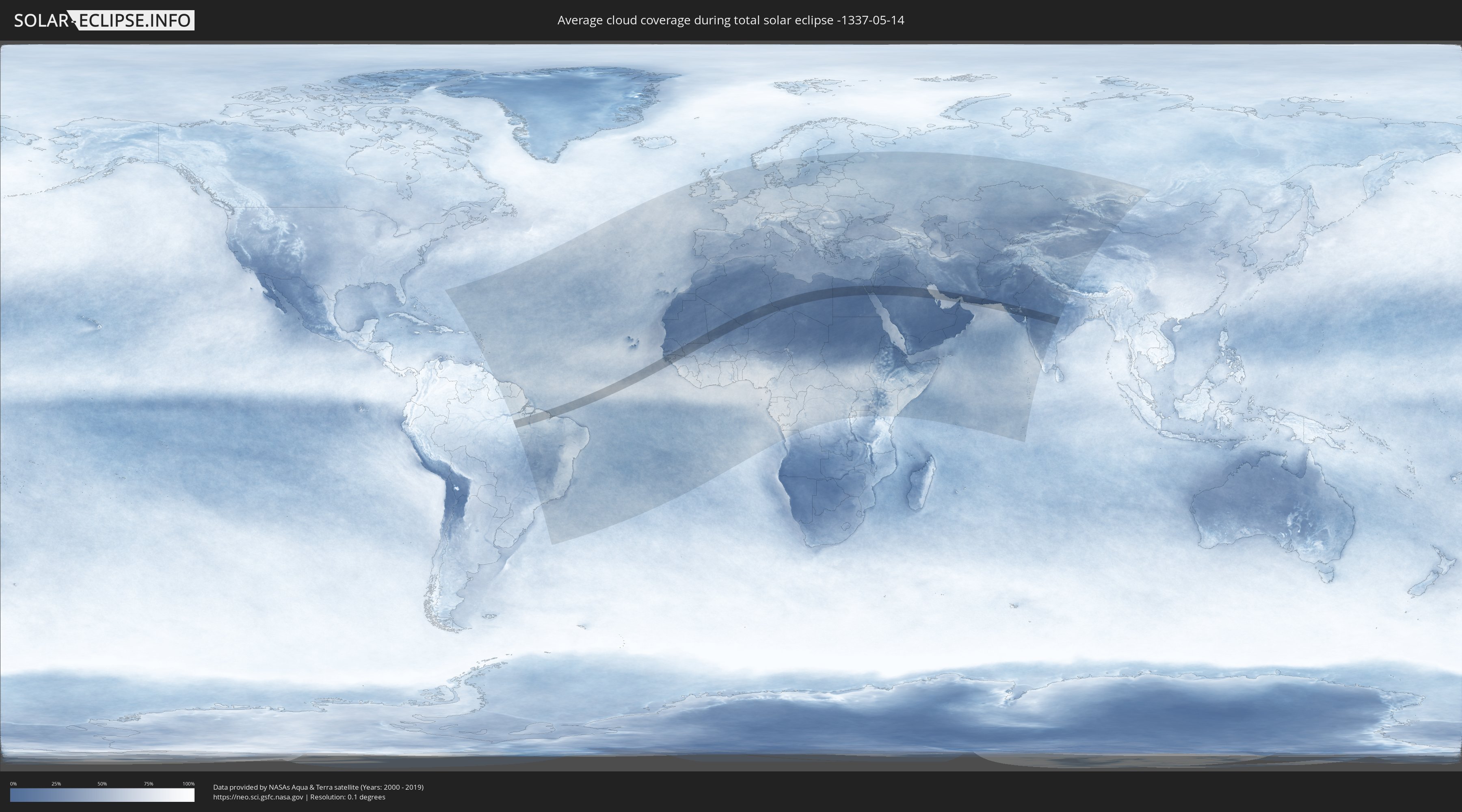
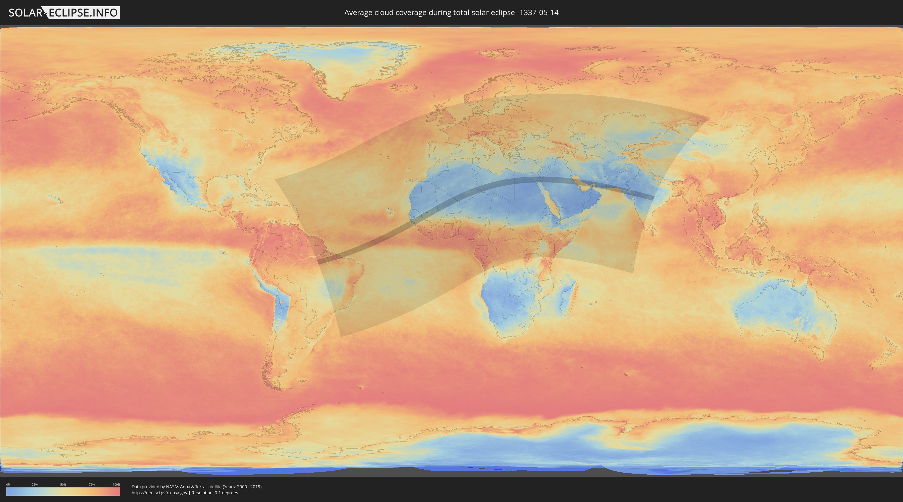
How will be the weather during the total solar eclipse on 05/14/-1337?
Where is the best place to see the total solar eclipse of 05/14/-1337?
The following maps show the average cloud coverage for the day of the total solar eclipse.
With the help of these maps, it is possible to find the place along the eclipse path, which has the best
chance of a cloudless sky.
Nevertheless, you should consider local circumstances and inform about the weather of your chosen
observation site.
The data is provided by NASAs satellites
AQUA and TERRA.
The cloud maps are averaged over a period of 19 years (2000 - 2019).
Detailed country maps
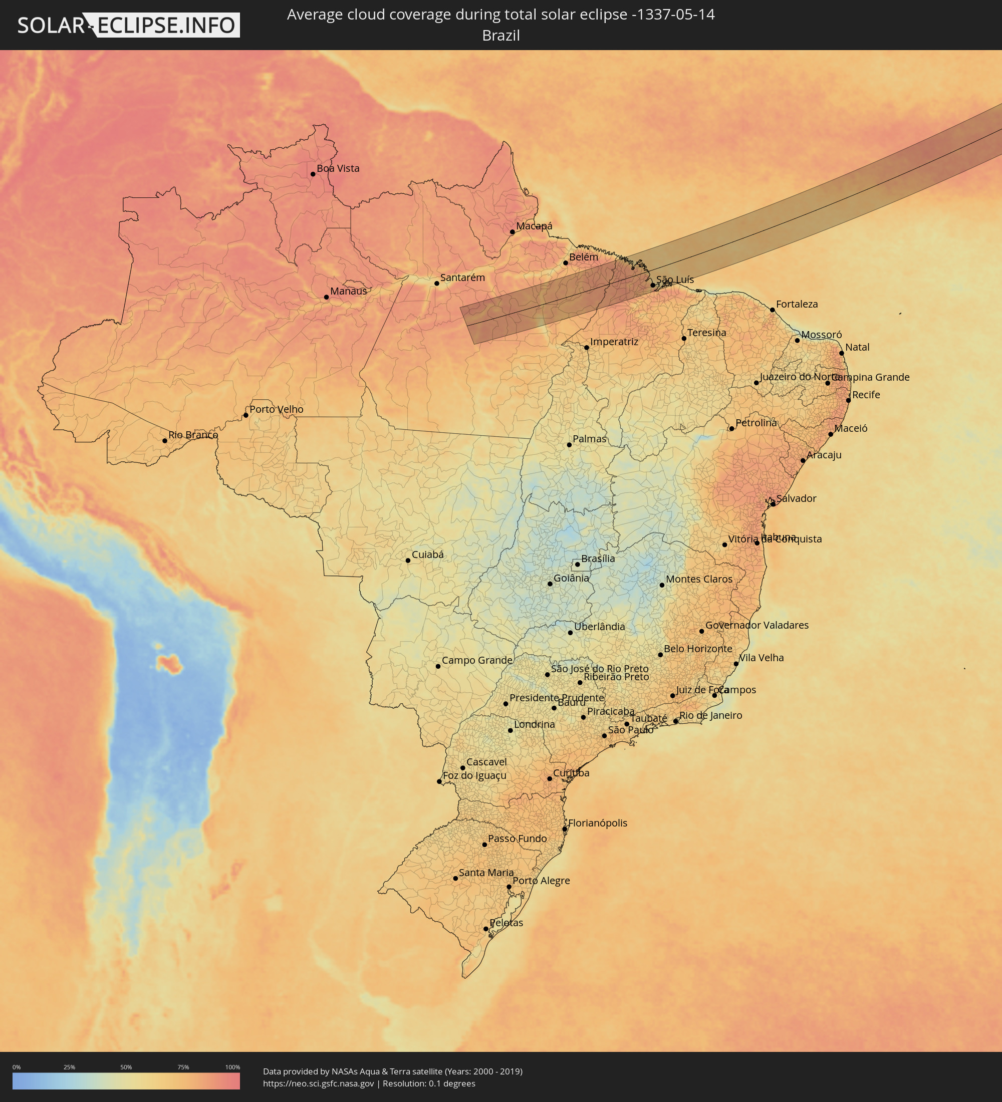 Brazil
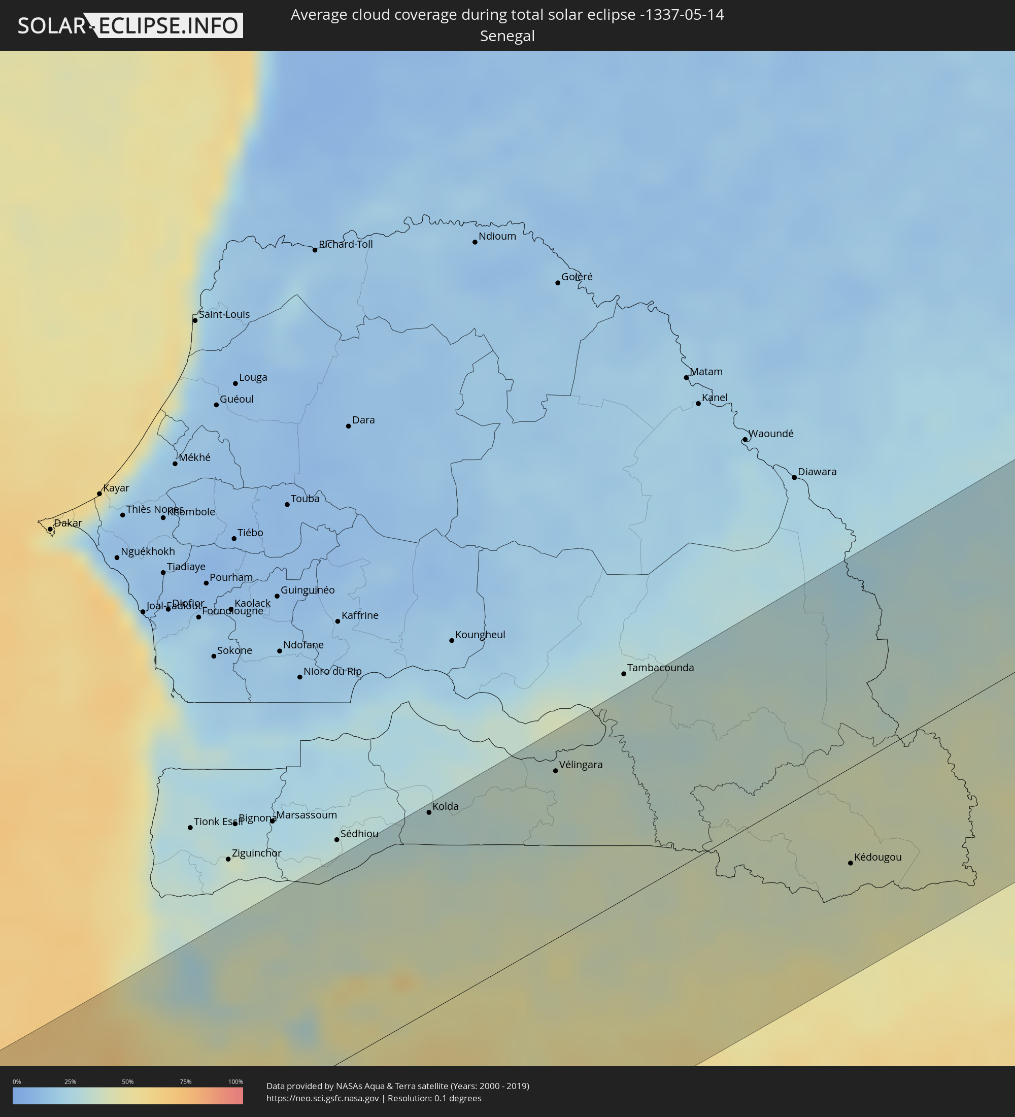 Senegal
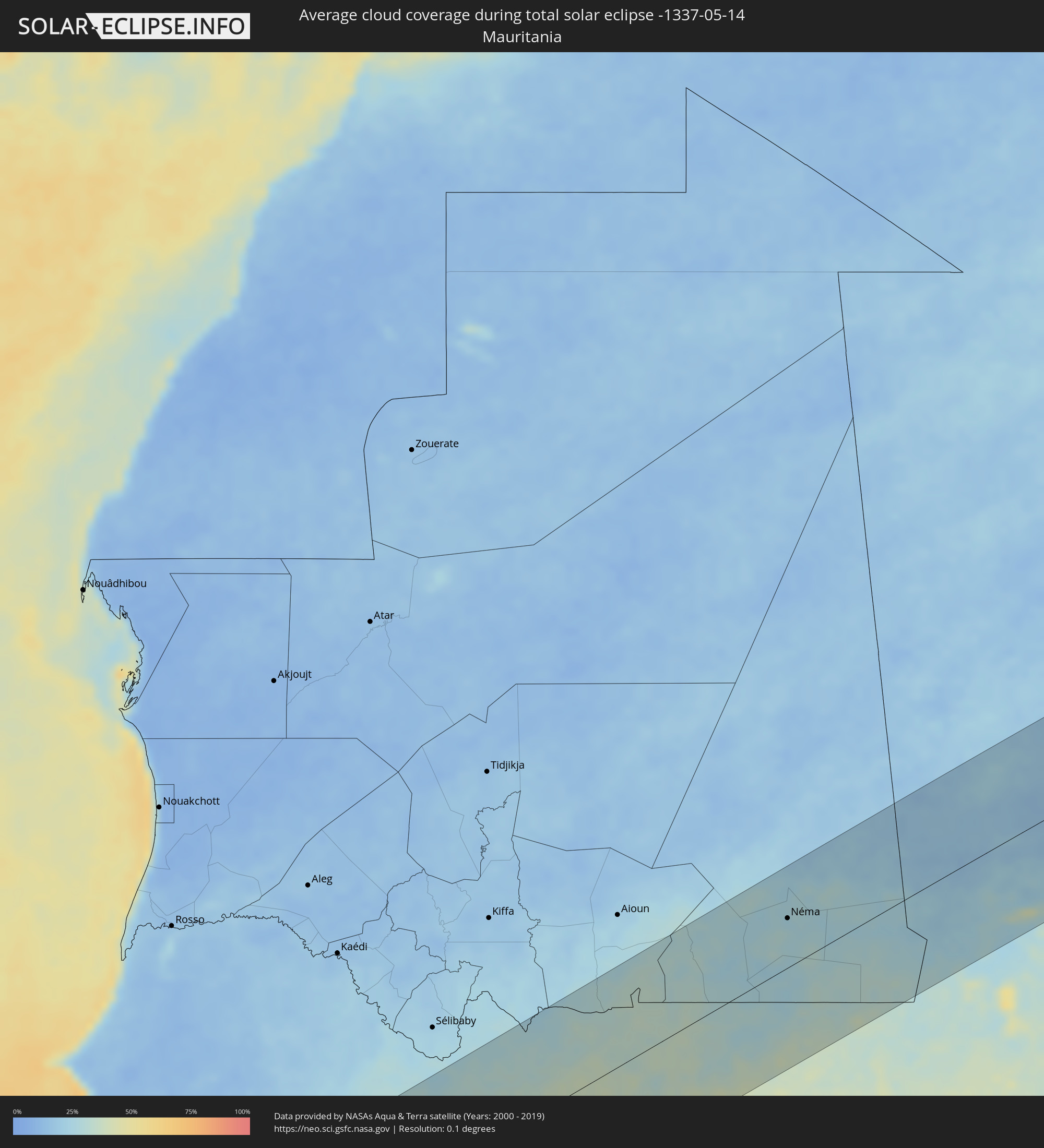 Mauritania
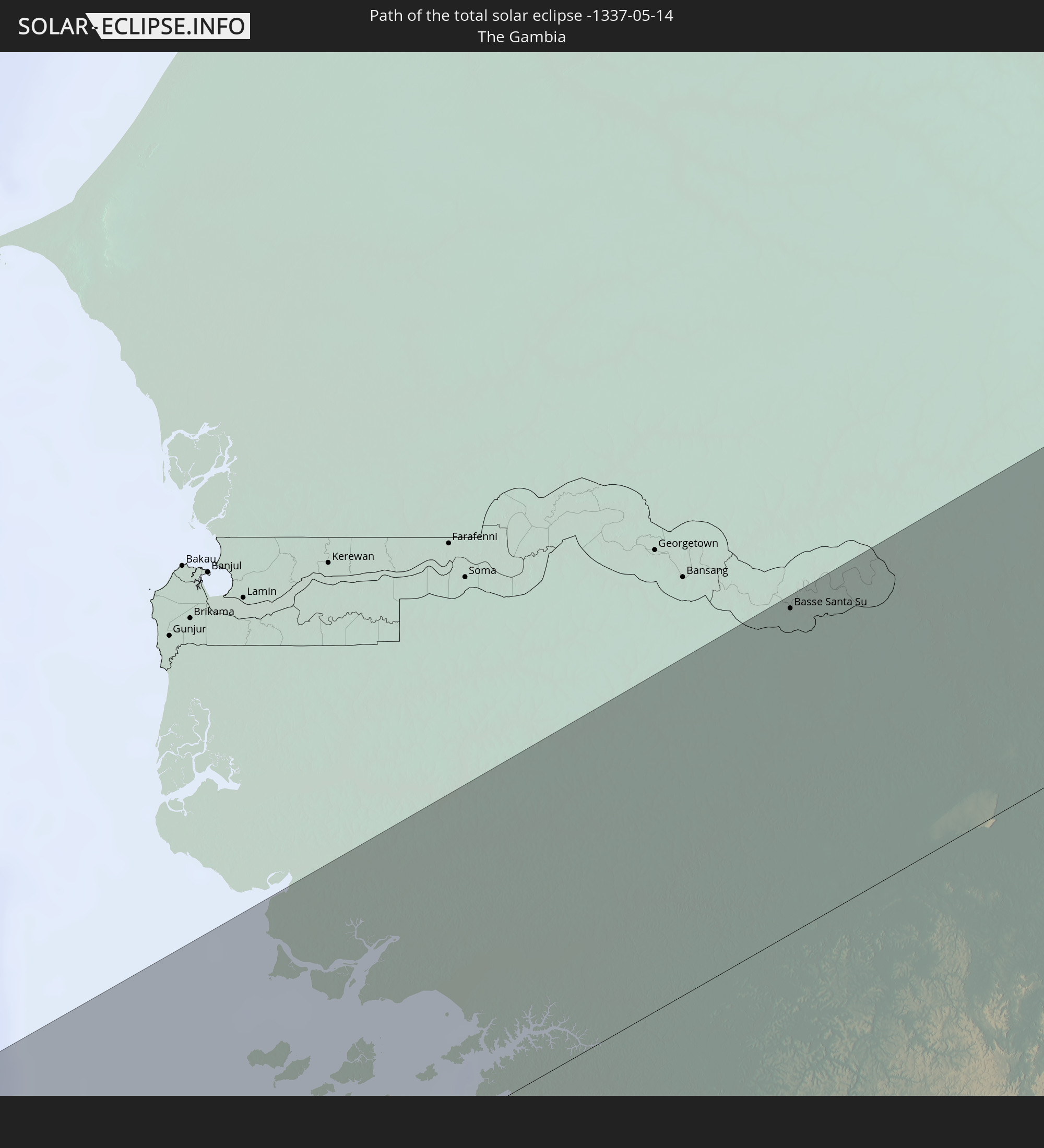
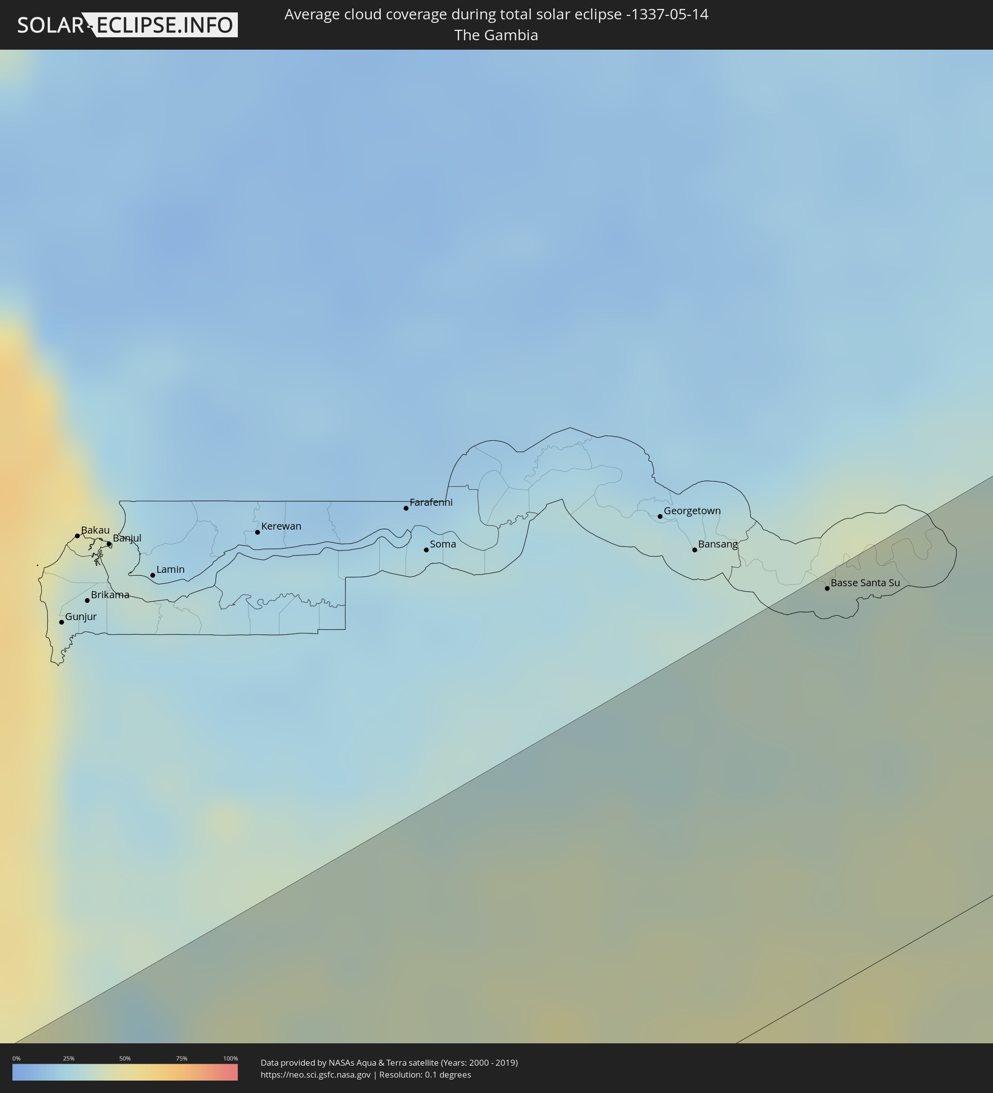 The Gambia
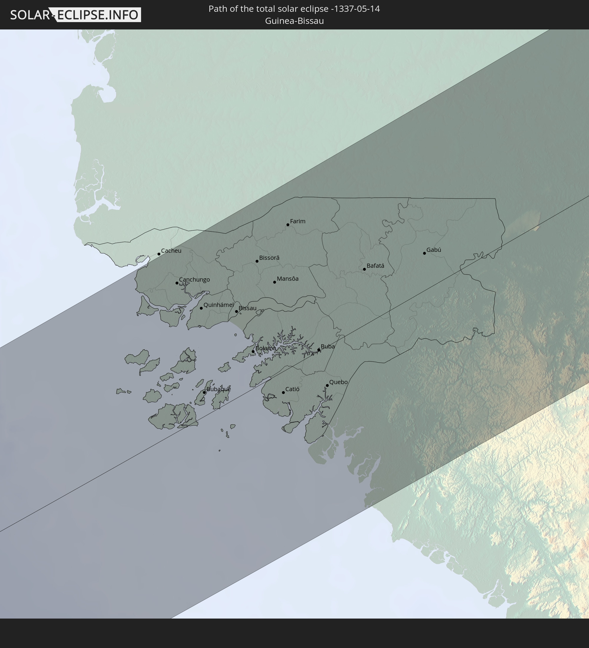
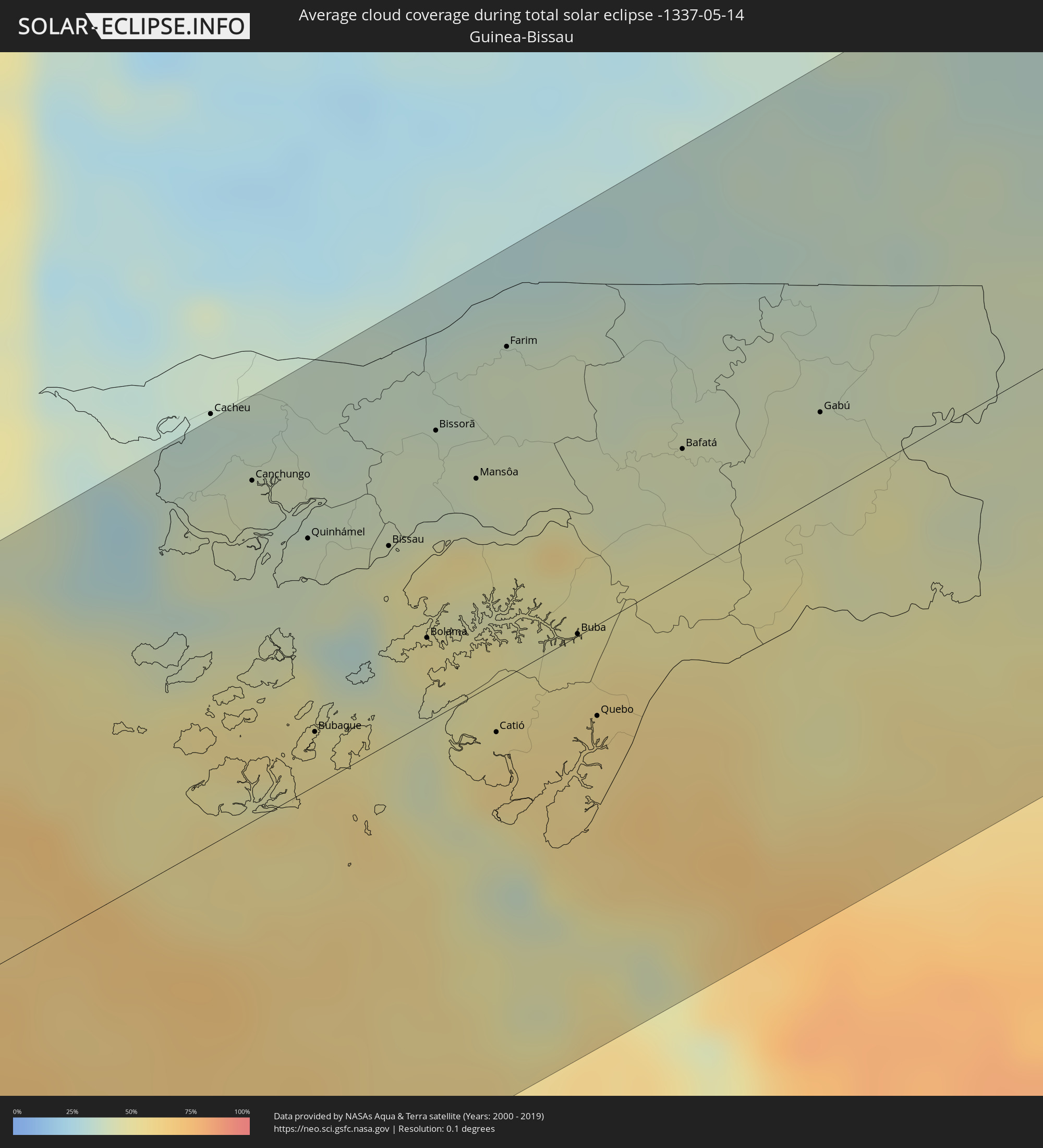 Guinea-Bissau
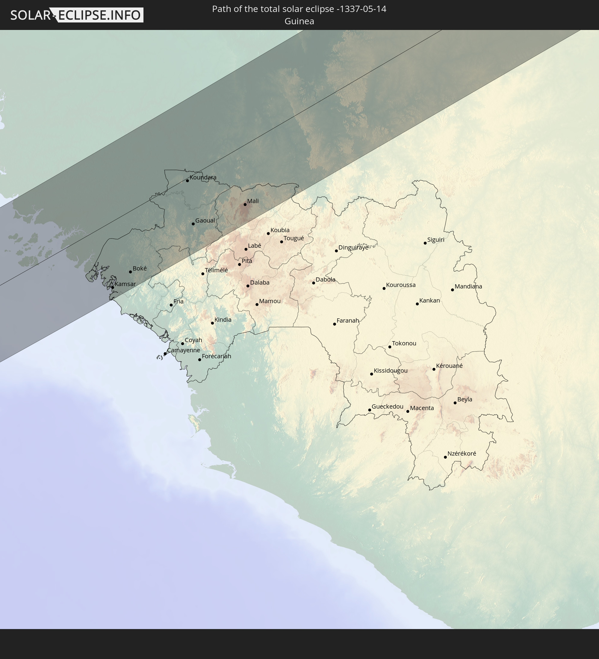
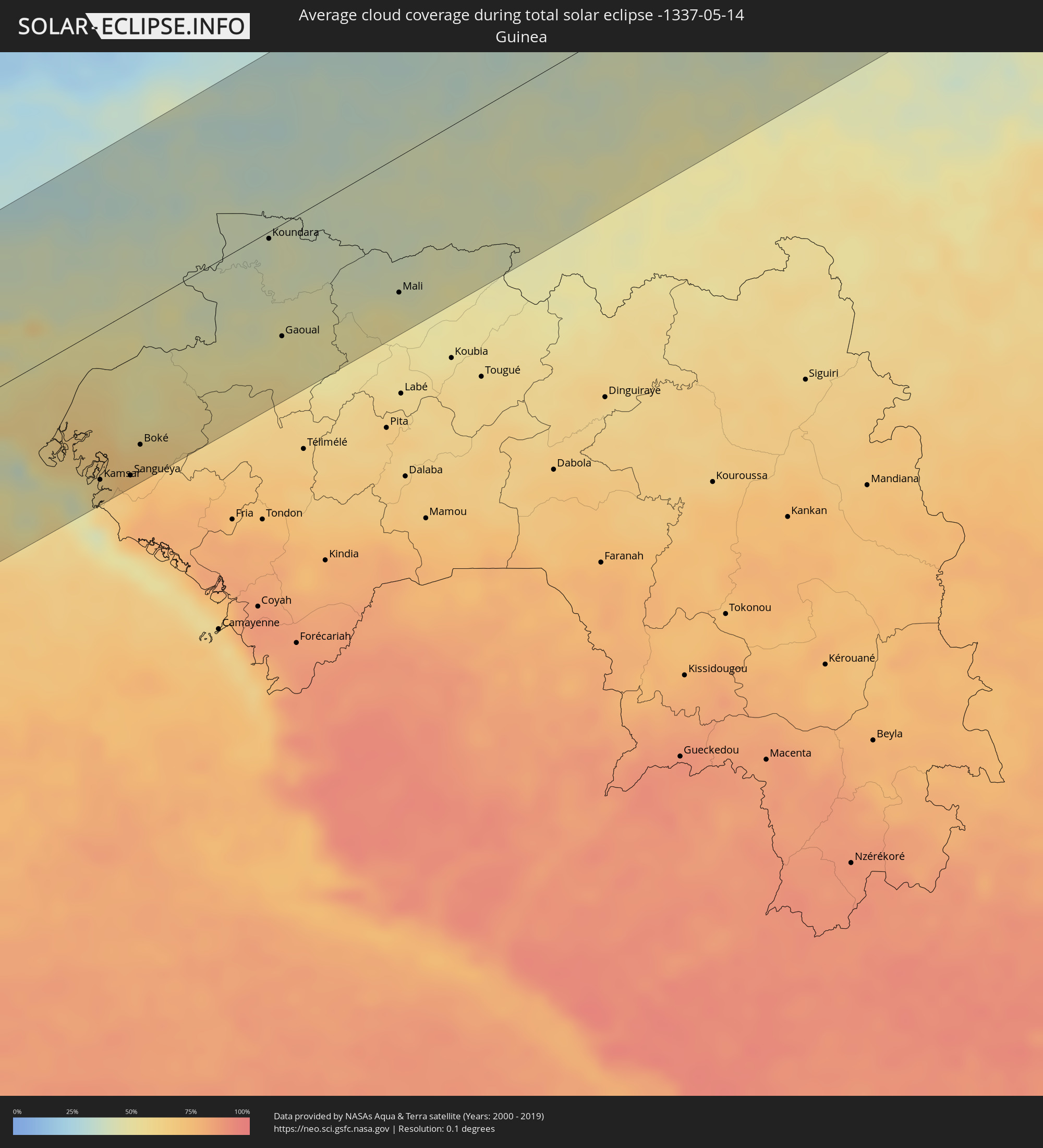 Guinea
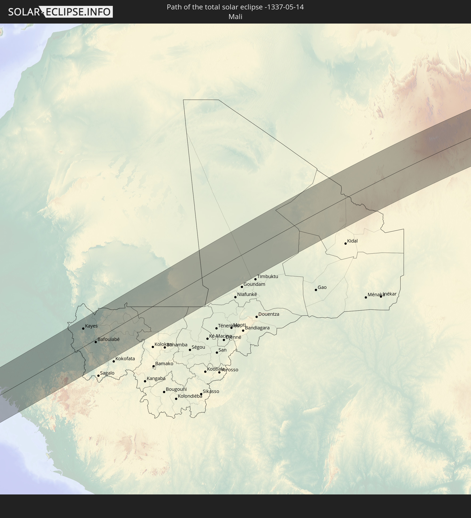
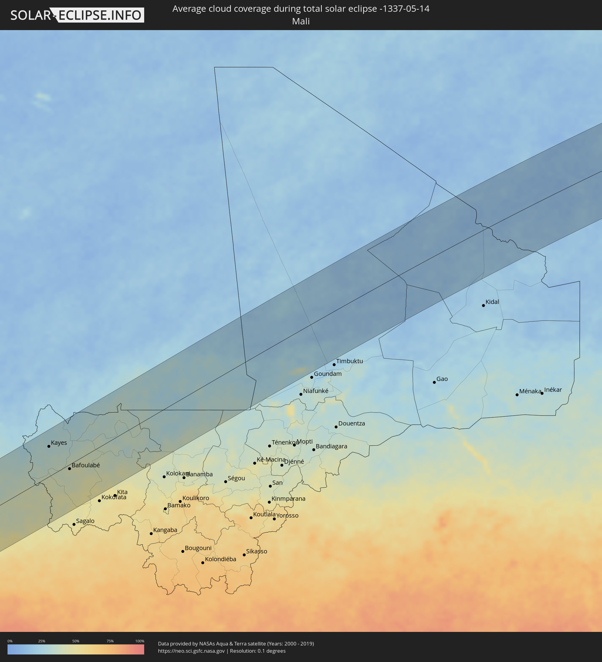 Mali
Mali
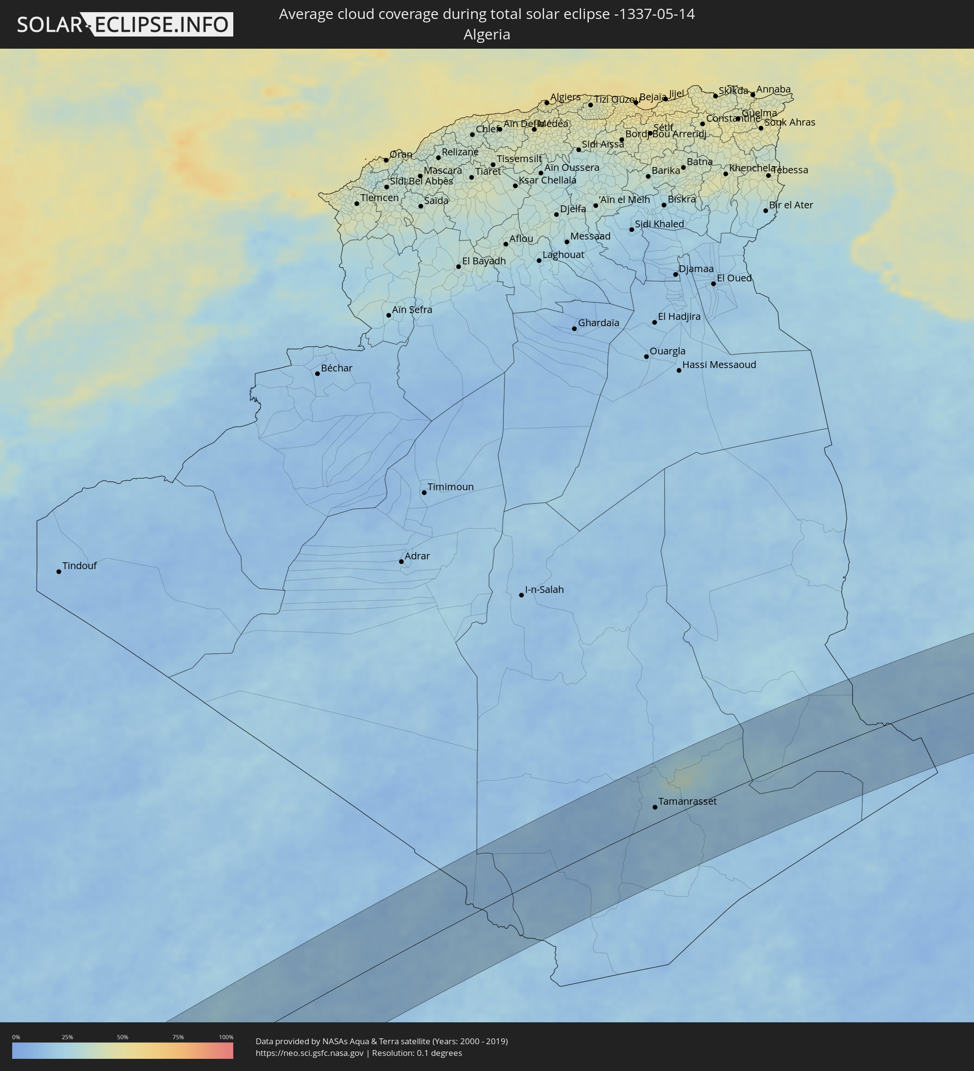 Algeria
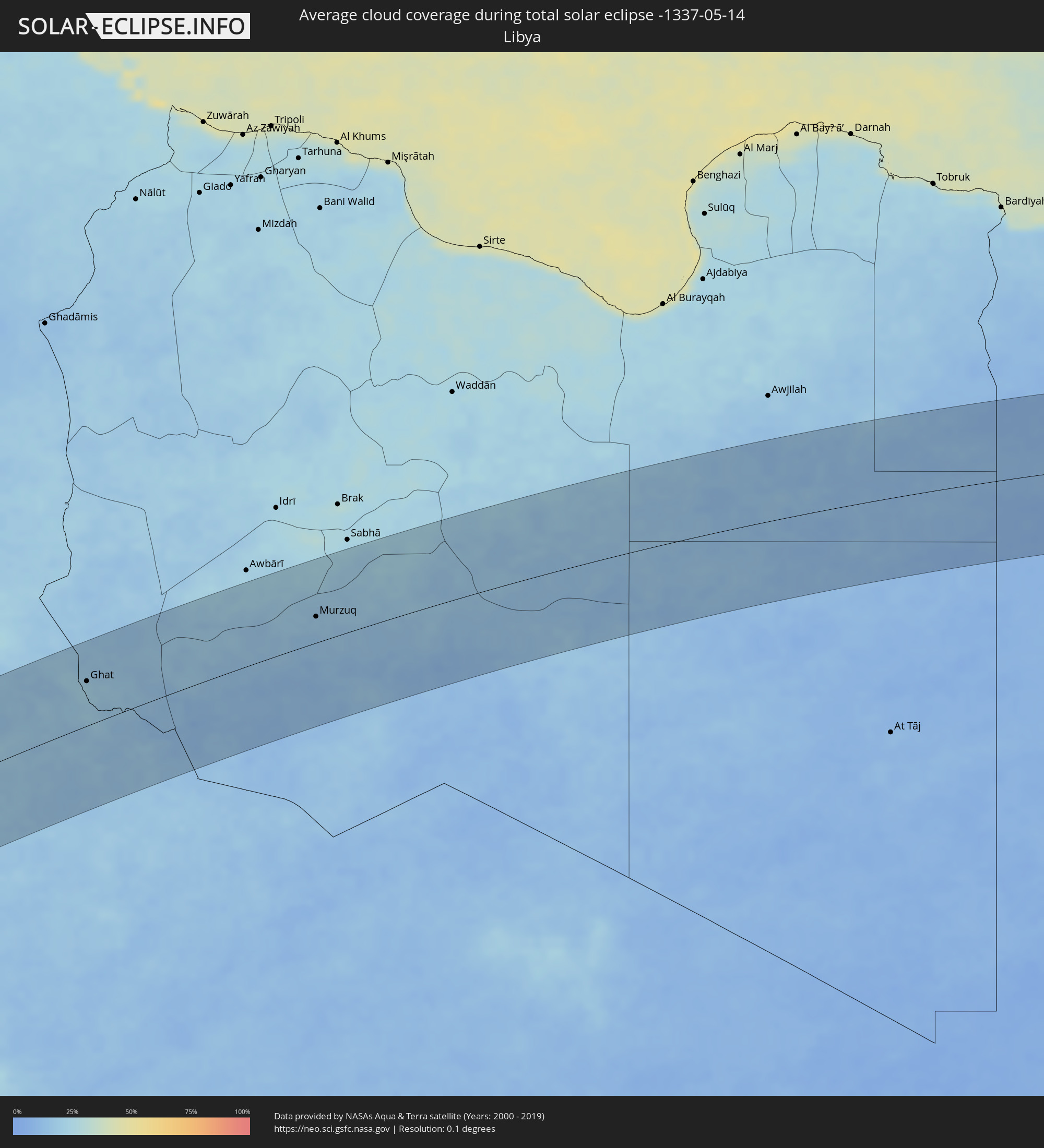 Libya
Libya
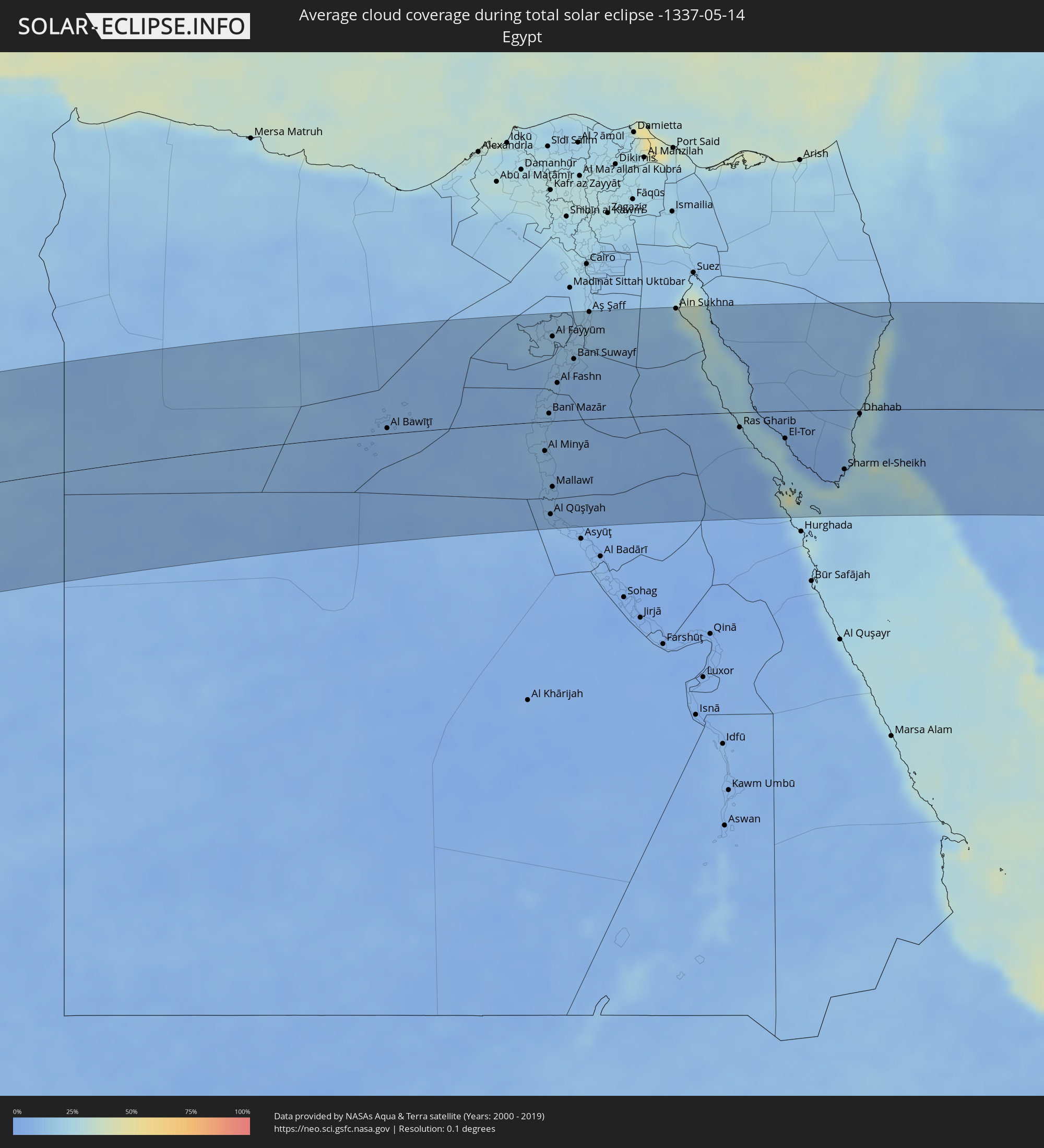 Egypt
Egypt
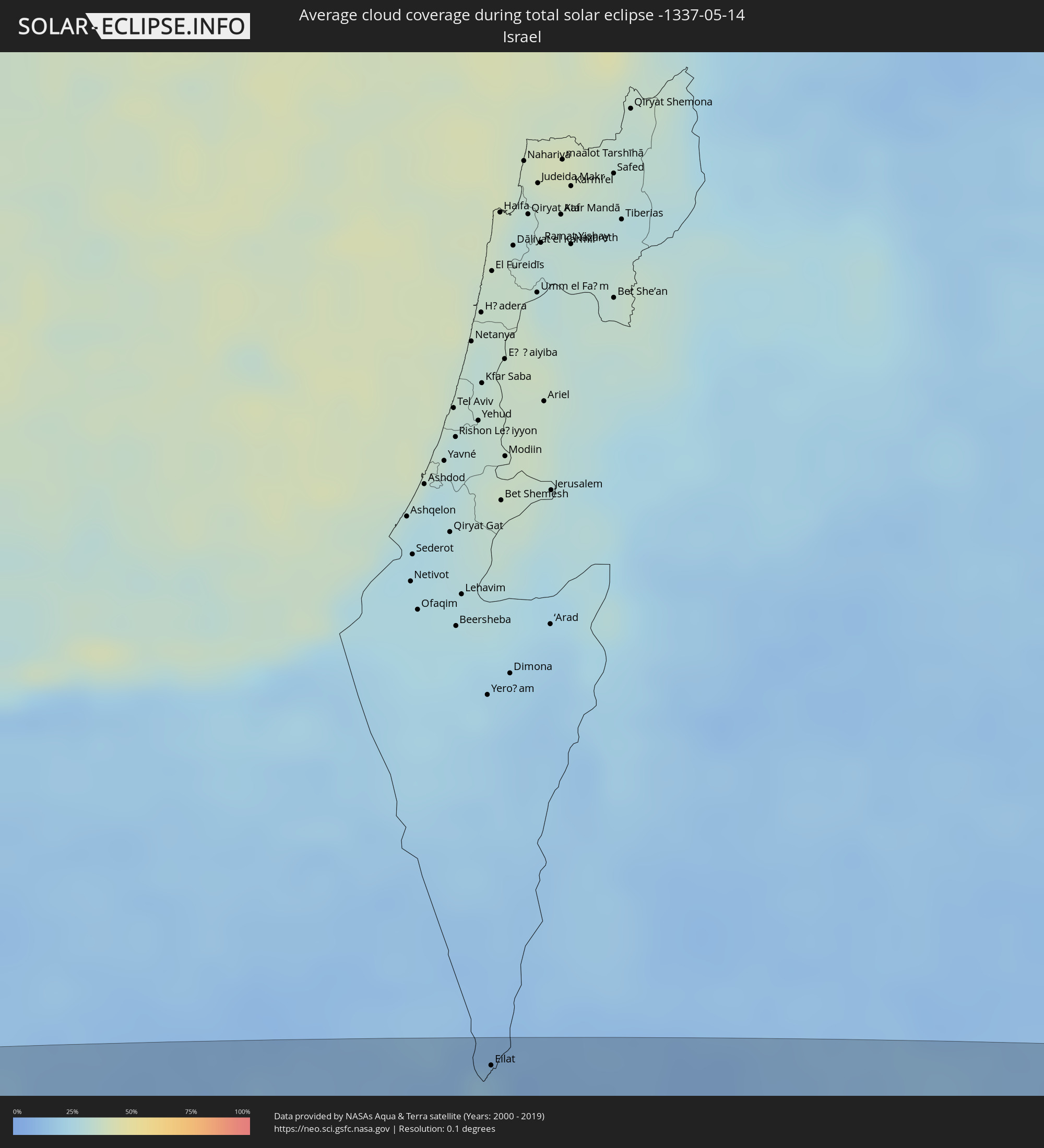 Israel
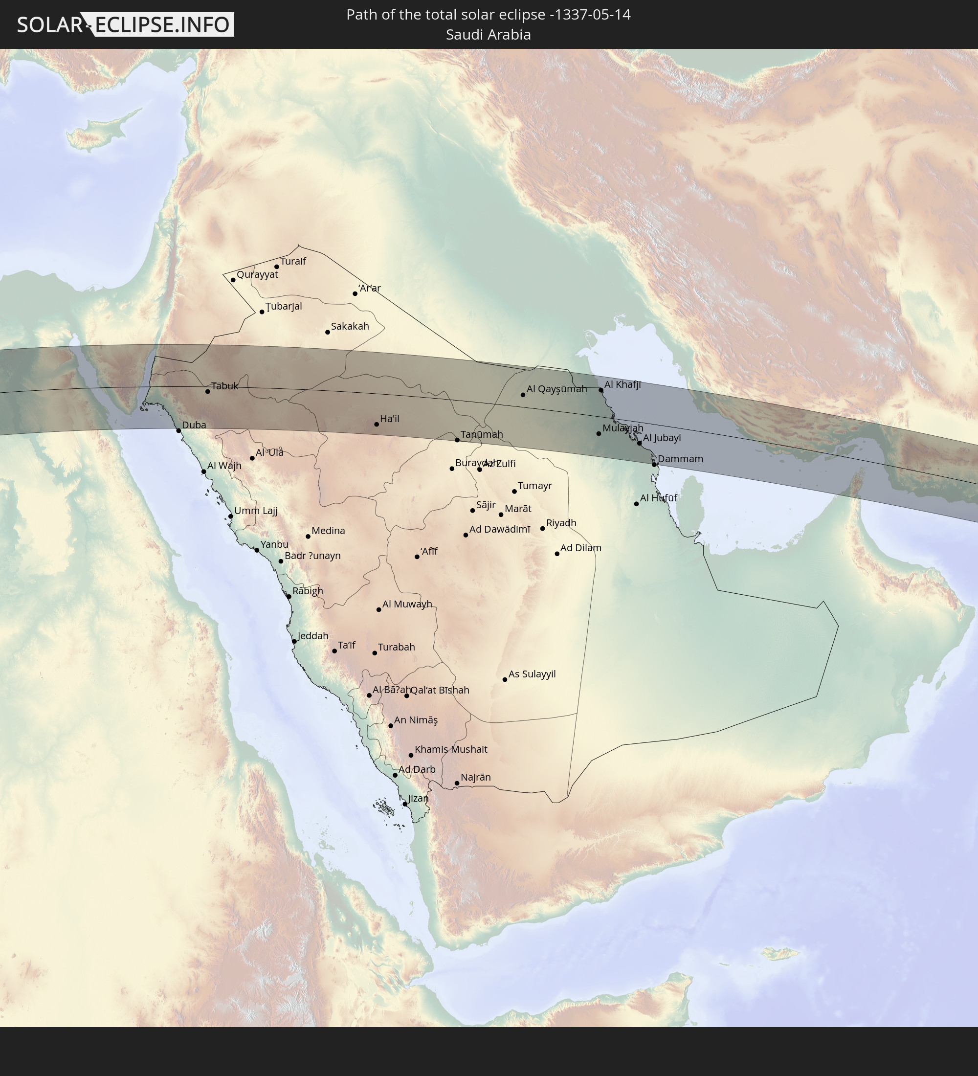
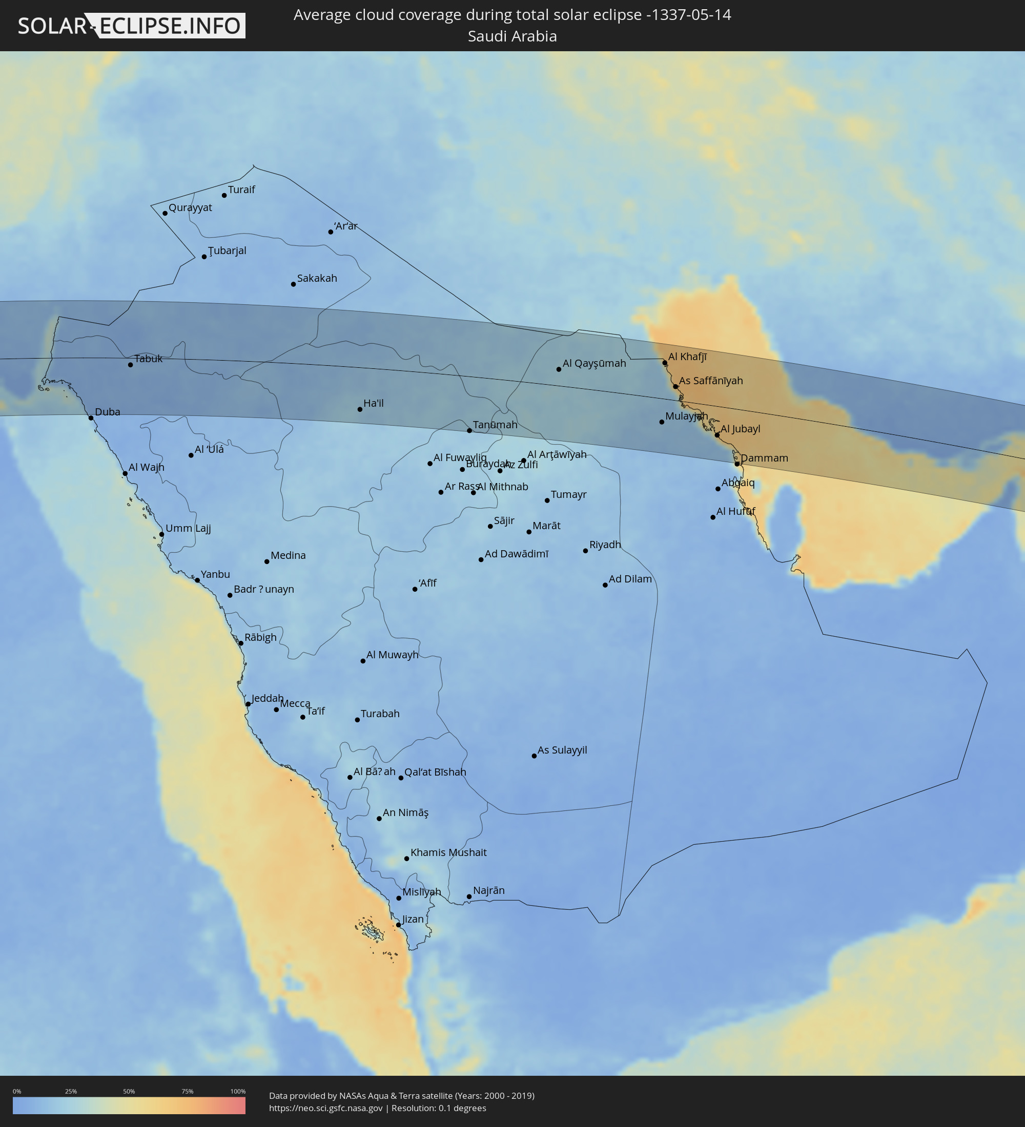 Saudi Arabia
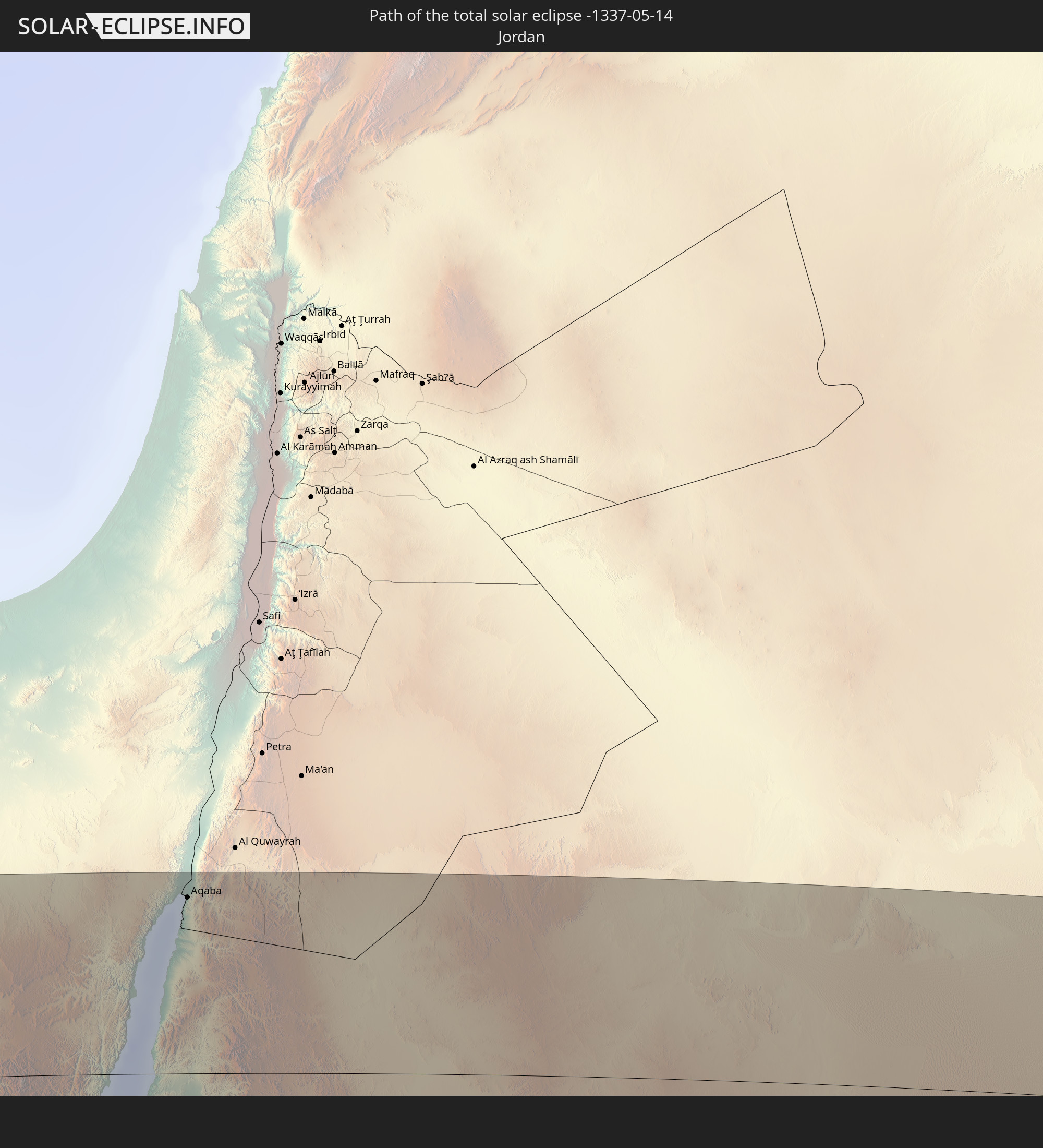
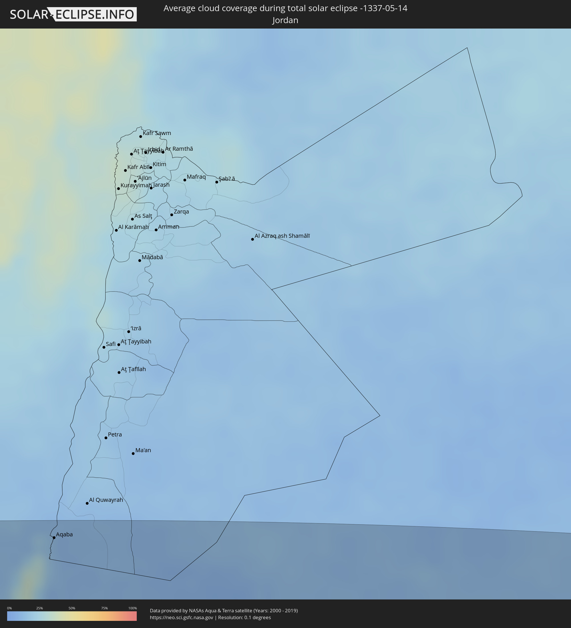 Jordan
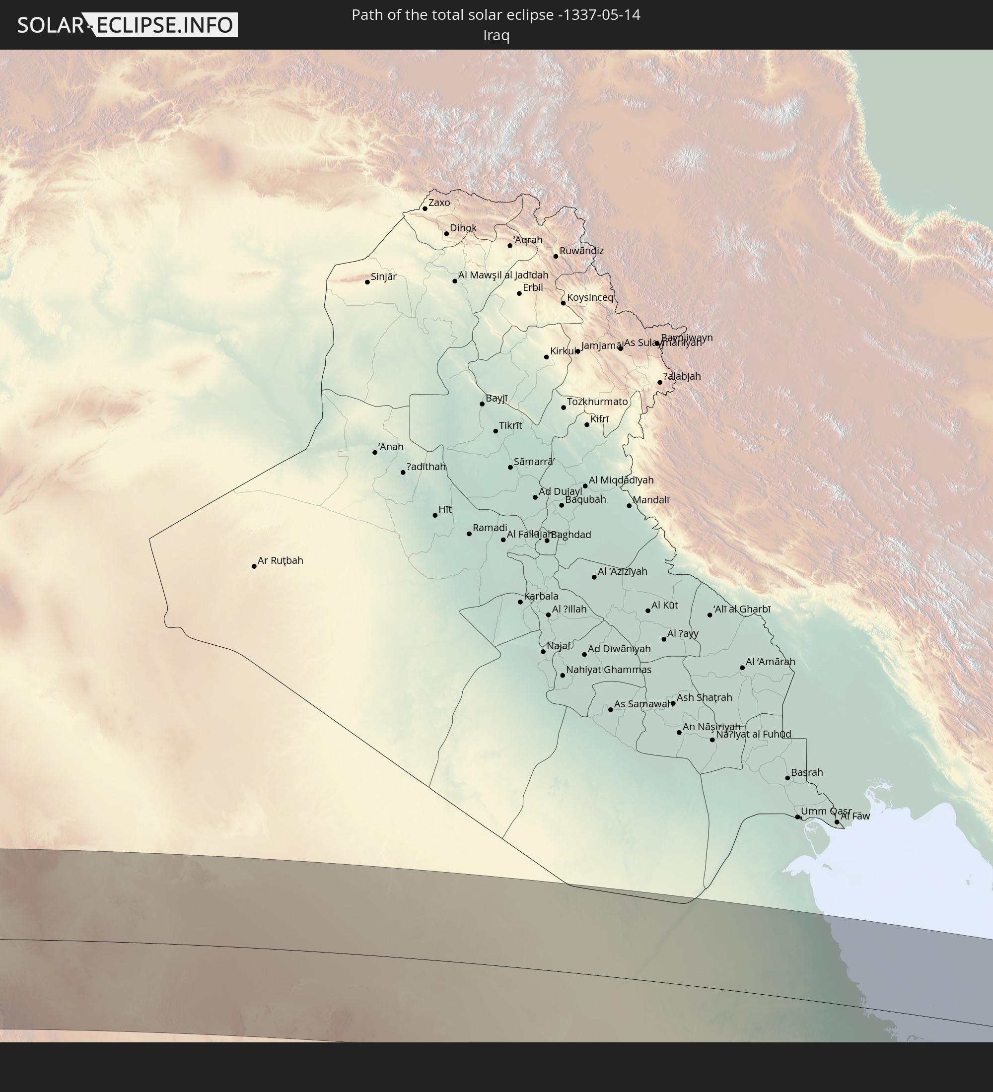
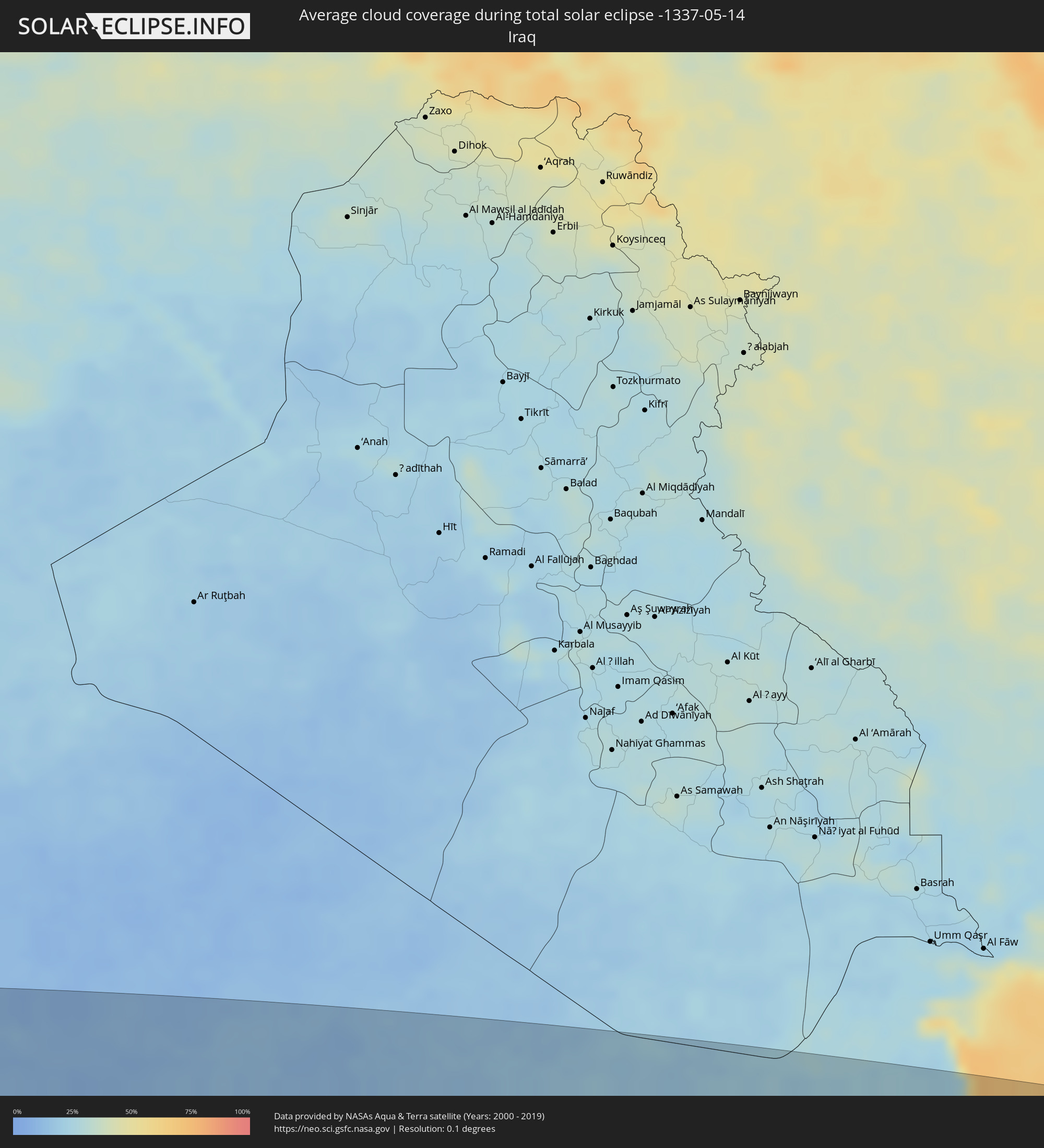 Iraq
Iraq
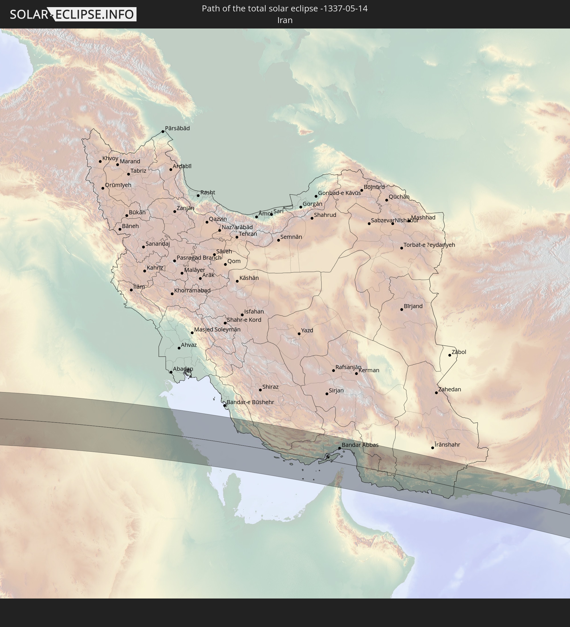
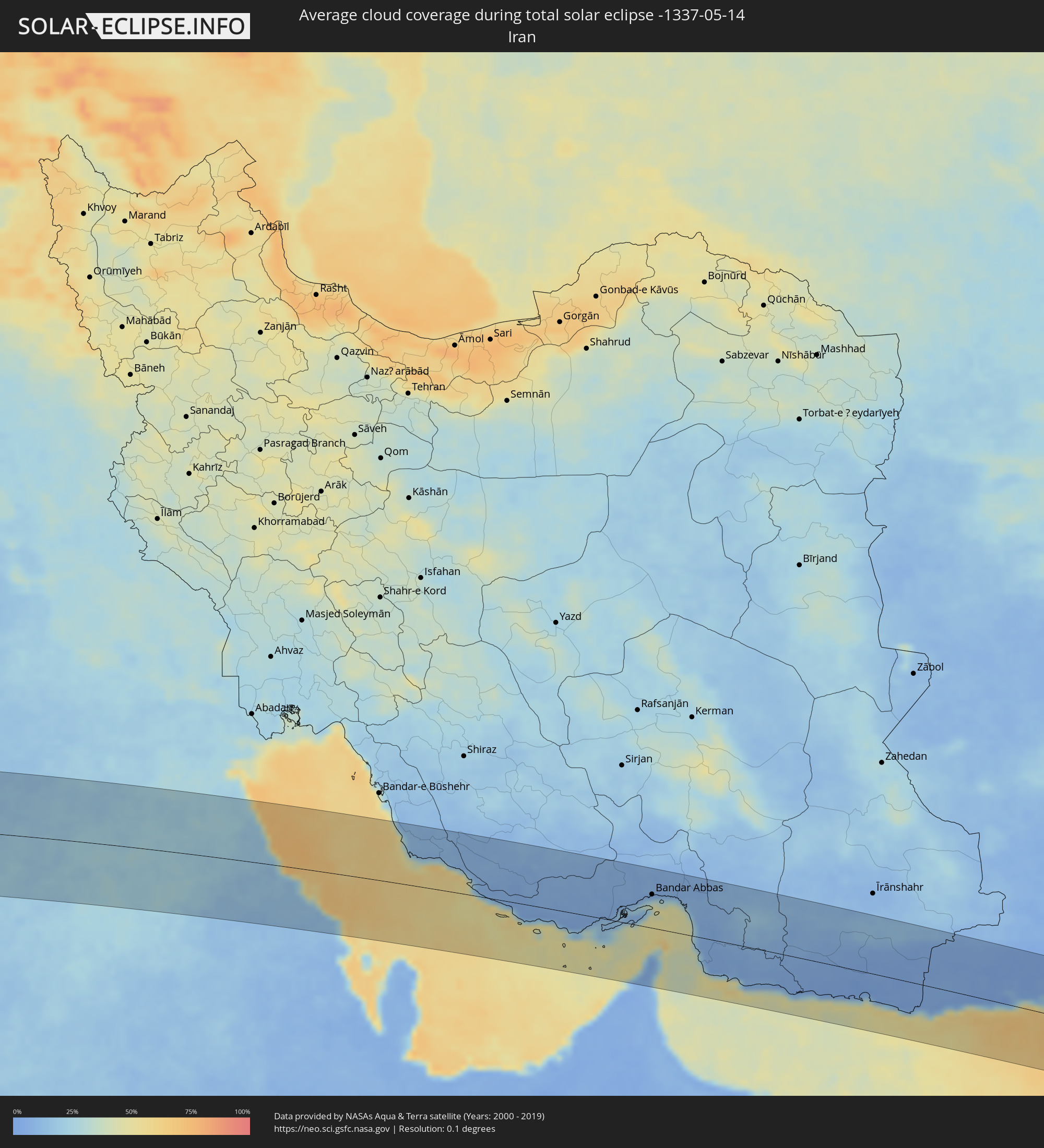 Iran
Iran
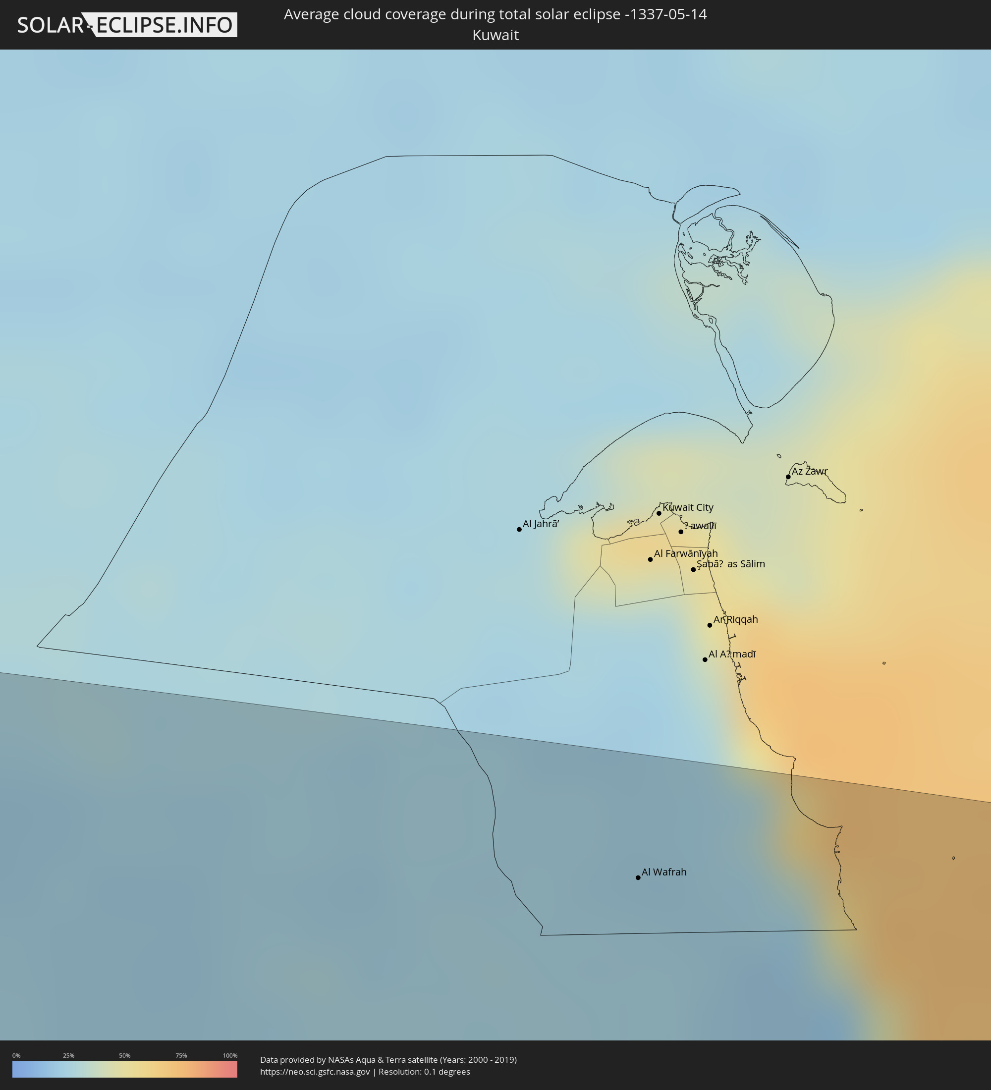 Kuwait
 United Arab Emirates
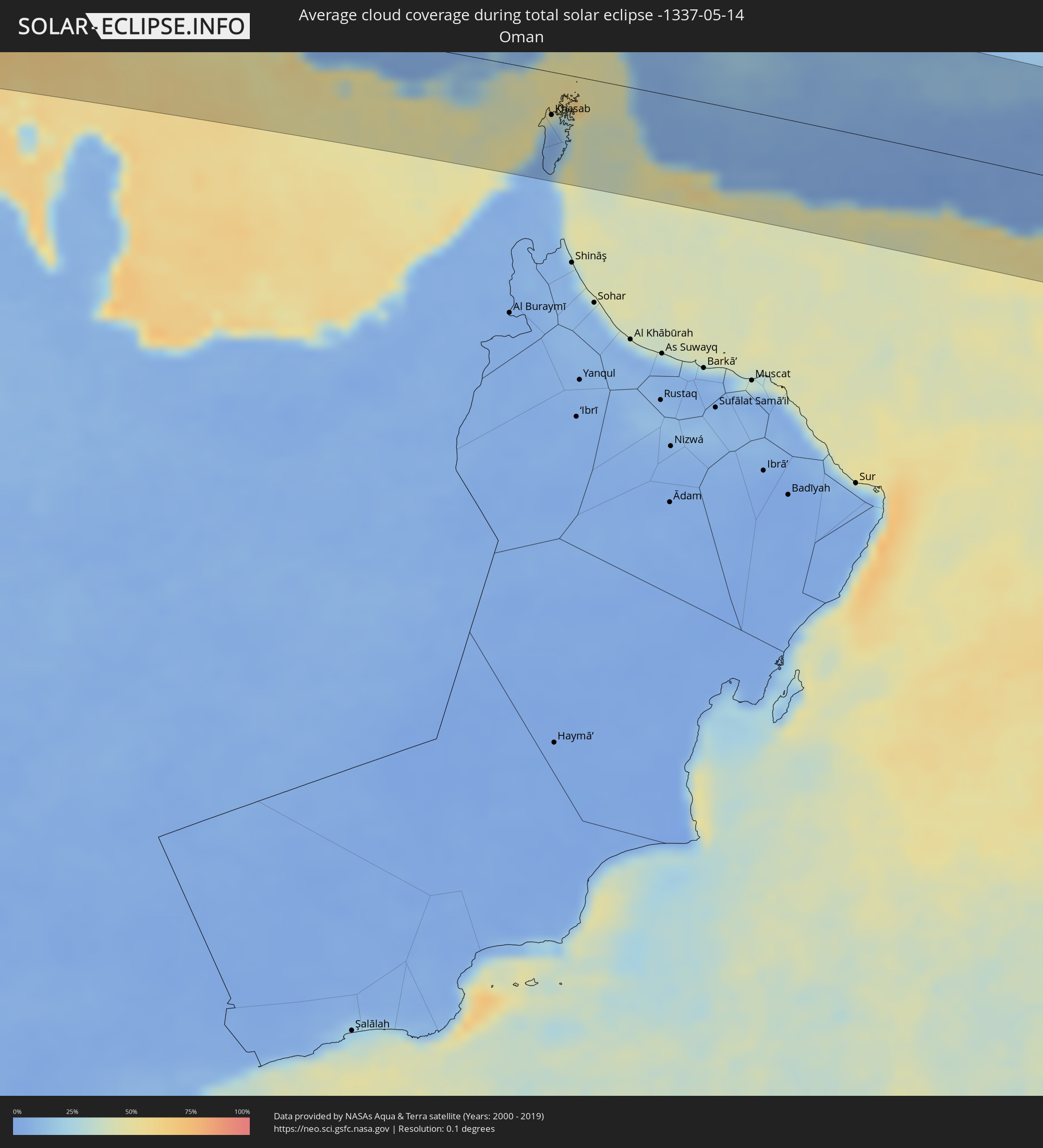 Oman
Oman
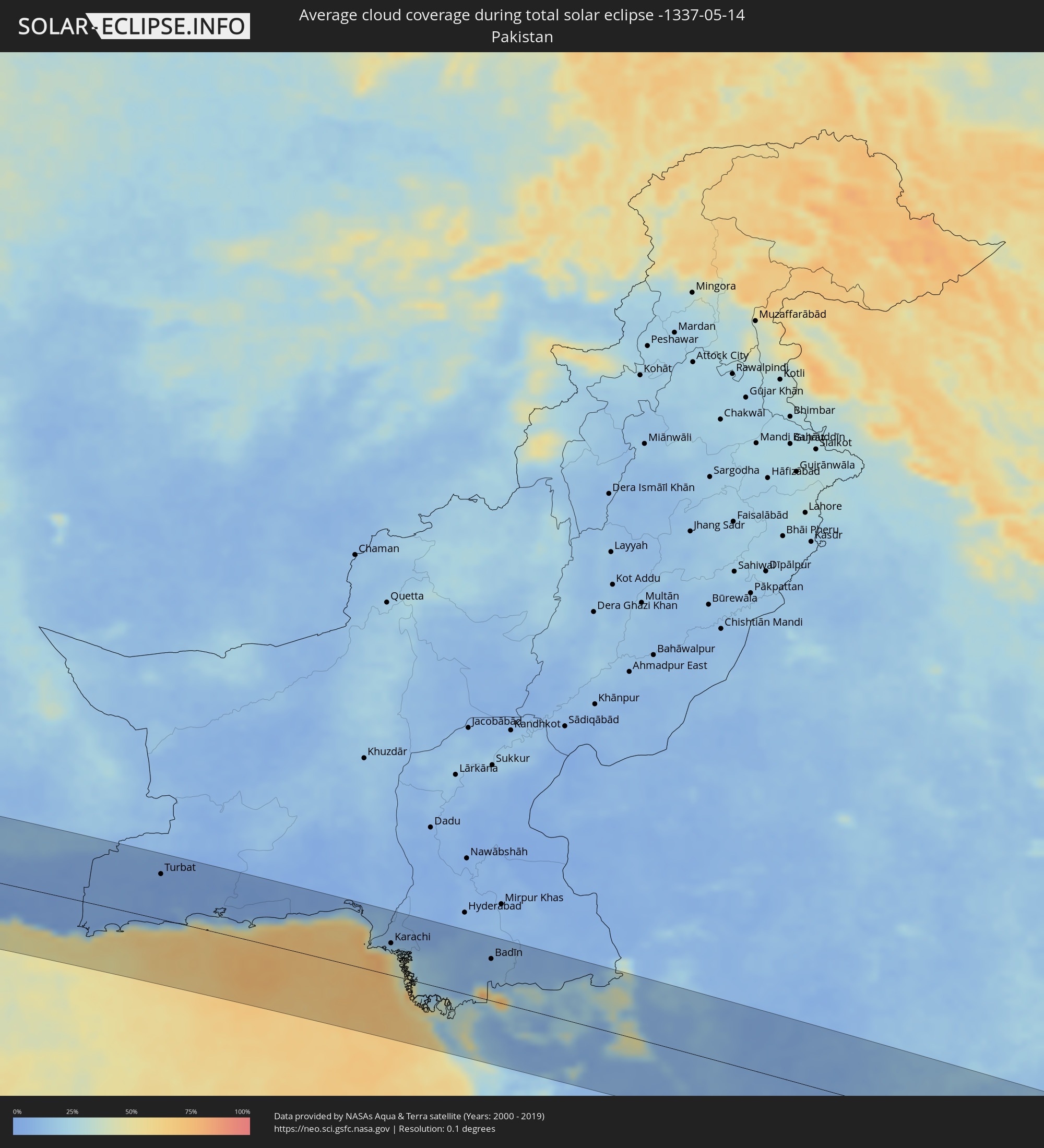 Pakistan
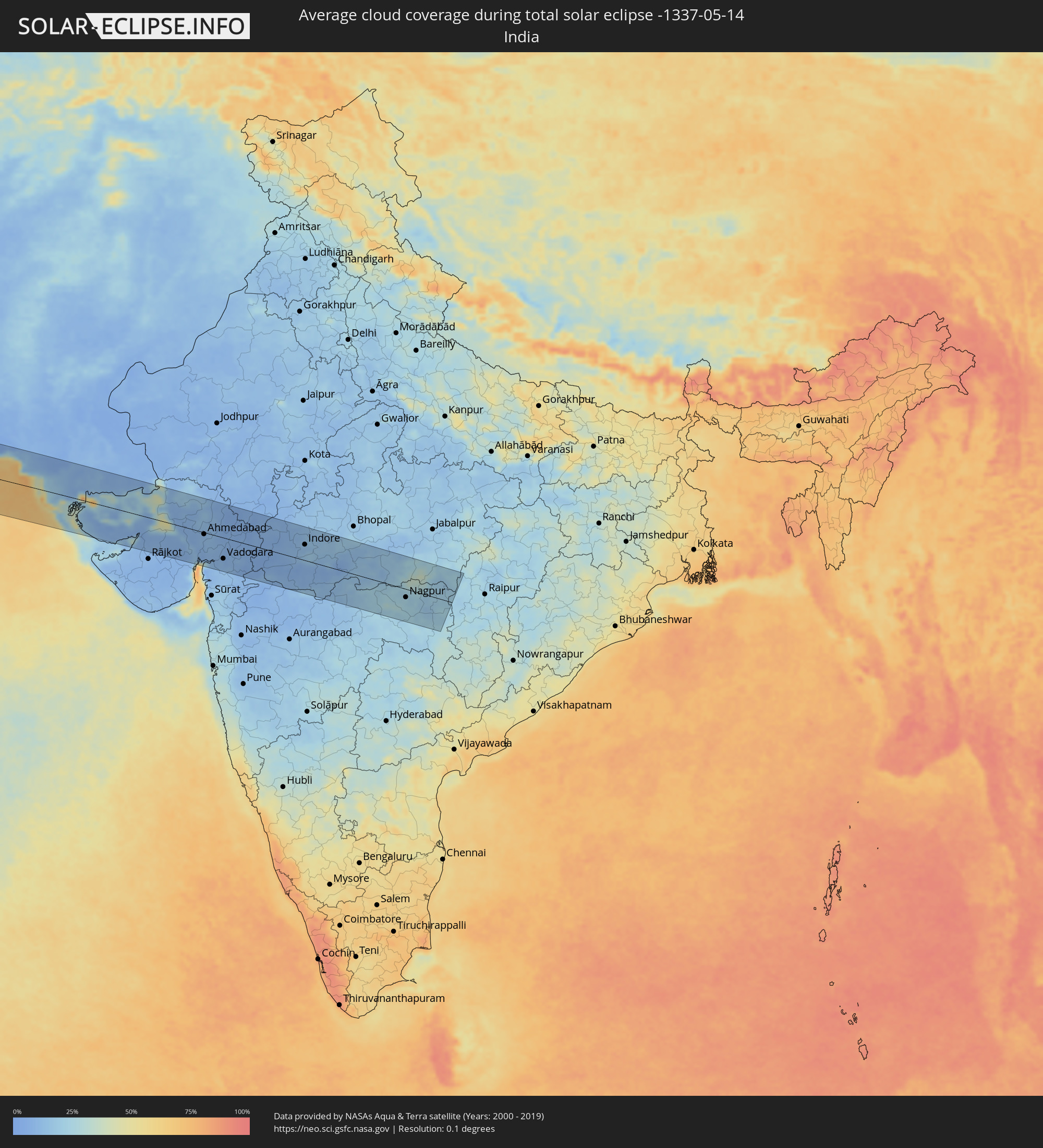 India
India
Cities inside the path of the eclipse
The following table shows all locations with a population of more than 5,000 inside the eclipse path. Cities which have more than 100,000 inhabitants are marked bold. A click at the locations opens a detailed map.
| City | Type | Eclipse duration | Local time of max. eclipse | Distance to central line | Ø Cloud coverage |
|
Altamira, Pará
|
total | - | 06:16:29 UTC-03:13 | 102 km | 79% |
|
Tucuruí, Pará
|
total | - | 06:16:05 UTC-03:13 | 36 km | 64% |
|
Mocajuba, Pará
|
total | - | 06:16:40 UTC-03:13 | 85 km | 77% |
|
Tomé Açu, Pará
|
total | - | 06:16:47 UTC-03:13 | 59 km | 82% |
|
Paragominas, Pará
|
total | - | 06:16:31 UTC-03:13 | 21 km | 85% |
|
Capitão Poço, Pará
|
total | - | 06:17:13 UTC-03:13 | 94 km | 85% |
|
Pinheiro, Maranhão
|
total | - | 06:56:54 UTC-02:34 | 55 km | 80% |
|
Cururupu, Maranhão
|
total | - | 06:57:19 UTC-02:34 | 11 km | 82% |
|
São Bento, Maranhão
|
total | - | 06:56:50 UTC-02:34 | 83 km | 75% |
|
São Luís, Maranhão
|
total | - | 06:56:59 UTC-02:34 | 83 km | 85% |
|
São José de Ribamar, Maranhão
|
total | - | 06:57:01 UTC-02:34 | 95 km | 76% |
|
Canchungo, Cacheu
|
total | - | 09:03:49 UTC-01:02 | 103 km | 38% |
|
Bubaque, Bolama and Bijagos
|
total | - | 09:03:03 UTC-01:02 | 16 km | 53% |
|
Bissau, Bissau
|
total | - | 09:04:10 UTC-01:02 | 60 km | 48% |
|
Bolama, Bolama and Bijagos
|
total | - | 09:03:58 UTC-01:02 | 25 km | 51% |
|
Bissorã, Oio
|
total | - | 09:04:53 UTC-01:02 | 86 km | 39% |
|
Mansôa, Oio
|
total | - | 09:04:52 UTC-01:02 | 65 km | 41% |
|
Catió, Tombali
|
total | - | 09:03:54 UTC-01:02 | 15 km | 55% |
|
Buba, Quinara
|
total | - | 09:04:42 UTC-01:02 | 1 km | 52% |
|
Kolda, Kolda
|
total | - | 09:52:44 UTC-00:16 | 123 km | 31% |
|
Quebo, Tombali
|
total | - | 09:04:27 UTC-01:02 | 28 km | 58% |
|
Bafatá, Bafatá
|
total | - | 09:05:59 UTC-01:02 | 38 km | 42% |
|
Kamsar, Boke
|
total | - | 09:50:15 UTC-00:16 | 110 km | 61% |
|
Sanguéya, Boke
|
total | - | 09:50:39 UTC-00:16 | 119 km | 69% |
|
Boké, Boke
|
total | - | 09:51:05 UTC-00:16 | 101 km | 68% |
|
Gabú, Gabú
|
total | - | 09:06:49 UTC-01:02 | 25 km | 43% |
|
Basse Santa Su, Upper River
|
total | - | 09:54:28 UTC-00:16 | 124 km | 33% |
|
Sabi, Upper River
|
total | - | 09:54:23 UTC-00:16 | 116 km | 35% |
|
Vélingara, Kolda
|
total | - | 09:54:24 UTC-00:16 | 103 km | 34% |
|
Koundara, Boke
|
total | - | 09:54:46 UTC-00:16 | 5 km | 40% |
|
Gaoual, Boke
|
total | - | 09:53:54 UTC-00:16 | 81 km | 50% |
|
Youkounkoun, Boke
|
total | - | 09:55:07 UTC-00:16 | 10 km | 43% |
|
Mali, Labe
|
total | - | 09:55:50 UTC-00:16 | 99 km | 49% |
|
Kédougou, Kédougou
|
total | - | 09:56:42 UTC-00:16 | 59 km | 39% |
|
Kayes, Kayes
|
total | - | 10:00:37 UTC-00:16 | 82 km | 31% |
|
Bafoulabé, Kayes
|
total | - | 10:00:45 UTC-00:16 | 12 km | 40% |
|
Néma, Hodh ech Chargui
|
total | - | 10:11:27 UTC-00:16 | 63 km | 26% |
|
Tamanrasset, Tamanrasset
|
total | - | 11:14:10 UTC+00:09 | 33 km | 19% |
|
Ghat, Sha‘bīyat Ghāt
|
total | - | 12:11:33 UTC+00:52 | 69 km | 21% |
|
Murzuq, Murzuq
|
total | - | 12:21:43 UTC+00:52 | 41 km | 18% |
|
Ibshawāy, Faiyum
|
total | - | 14:08:10 UTC+02:00 | 105 km | 16% |
|
Samālūţ, Minya
|
total | - | 14:08:18 UTC+02:00 | 11 km | 13% |
|
Al Minyā, Minya
|
total | - | 14:08:24 UTC+02:00 | 34 km | 12% |
|
Banī Mazār, Minya
|
total | - | 14:08:28 UTC+02:00 | 9 km | 11% |
|
Al Qūşīyah, Asyut
|
total | - | 14:08:34 UTC+02:00 | 109 km | 10% |
|
Abū Qurqāş, Minya
|
total | - | 14:08:35 UTC+02:00 | 55 km | 11% |
|
Mallawī, Minya
|
total | - | 14:08:36 UTC+02:00 | 77 km | 11% |
|
Al Fayyūm, Faiyum
|
total | - | 14:08:29 UTC+02:00 | 99 km | 16% |
|
Al Fashn, Beni Suweif
|
total | - | 14:08:38 UTC+02:00 | 44 km | 11% |
|
Manfalūţ, Asyut
|
total | - | 14:08:52 UTC+02:00 | 124 km | 9% |
|
Banī Suwayf, Beni Suweif
|
total | - | 14:09:00 UTC+02:00 | 71 km | 13% |
|
Eilat, Southern District
|
total | - | 14:36:35 UTC+02:20 | 112 km | 17% |
|
Aqaba, Aqaba
|
total | - | 14:39:46 UTC+02:23 | 109 km | 16% |
|
Tabuk, Tabuk
|
total | - | 15:25:52 UTC+03:06 | 16 km | 11% |
|
Ha'il, Ḩāʼil
|
total | - | 15:34:10 UTC+03:06 | 93 km | 19% |
|
Tanūmah, Al-Qassim
|
total | - | 15:37:44 UTC+03:06 | 120 km | 19% |
|
Al Qayşūmah, Eastern Province
|
total | - | 15:39:41 UTC+03:06 | 35 km | 24% |
|
Al Wafrah, Al Aḩmadī
|
total | - | 15:41:35 UTC+03:06 | 92 km | 24% |
|
Al Khafjī, Eastern Province
|
total | - | 15:42:19 UTC+03:06 | 77 km | 37% |
|
Al Jubayl, Eastern Province
|
total | - | 15:44:20 UTC+03:06 | 64 km | 38% |
|
Umm as Sāhik, Eastern Province
|
total | - | 15:44:47 UTC+03:06 | 100 km | 17% |
|
Al Awjām, Eastern Province
|
total | - | 15:44:51 UTC+03:06 | 110 km | 14% |
|
Şafwá, Eastern Province
|
total | - | 15:44:49 UTC+03:06 | 100 km | 26% |
|
Al Qaţīf, Eastern Province
|
total | - | 15:44:58 UTC+03:06 | 113 km | 17% |
|
Raḩīmah, Eastern Province
|
total | - | 15:44:54 UTC+03:06 | 92 km | 55% |
|
Kīsh, Hormozgan
|
total | - | 16:07:34 UTC+03:25 | 45 km | 37% |
|
Gerāsh, Fars
|
total | - | 16:07:01 UTC+03:25 | 79 km | 9% |
|
Bandar-e Lengeh, Hormozgan
|
total | - | 16:08:16 UTC+03:25 | 30 km | 32% |
|
Ras al-Khaimah, Raʼs al Khaymah
|
total | - | 16:25:00 UTC+03:41 | 94 km | 26% |
|
Khasab, Musandam
|
total | - | 16:25:01 UTC+03:41 | 46 km | 14% |
|
Dibba Al-Fujairah, Al Fujayrah
|
total | - | 16:25:21 UTC+03:41 | 109 km | 18% |
|
Qeshm, Hormozgan
|
total | - | 16:09:07 UTC+03:25 | 39 km | 43% |
|
Dibba Al-Hisn, Al Fujayrah
|
total | - | 16:25:21 UTC+03:41 | 106 km | 18% |
|
Bandar Abbas, Hormozgan
|
total | - | 16:08:59 UTC+03:25 | 65 km | 32% |
|
Mīnāb, Hormozgan
|
total | - | 16:09:36 UTC+03:25 | 74 km | 9% |
|
Chabahar, Sistan and Baluchestan
|
total | - | 16:12:55 UTC+03:25 | 53 km | 52% |
|
Qaşr-e Qand, Sistan and Baluchestan
|
total | - | 16:12:26 UTC+03:25 | 53 km | 5% |
|
Gwadar, Balochistān
|
total | - | 17:16:22 UTC+04:28 | 34 km | 57% |
|
Turbat, Balochistān
|
total | - | 17:16:12 UTC+04:28 | 78 km | 2% |
|
Pasni, Balochistān
|
total | - | 17:16:50 UTC+04:28 | 7 km | 34% |
|
Karachi, Sindh
|
total | - | 17:18:25 UTC+04:28 | 55 km | 21% |
|
Ghāro, Sindh
|
total | - | 17:18:39 UTC+04:28 | 50 km | 19% |
|
Thatta, Sindh
|
total | - | 17:18:45 UTC+04:28 | 59 km | 14% |
|
Mātli, Sindh
|
total | - | 17:18:47 UTC+04:28 | 109 km | 6% |
|
Talhār, Sindh
|
total | - | 17:18:55 UTC+04:28 | 96 km | 9% |
|
Badīn, Sindh
|
total | - | 17:19:03 UTC+04:28 | 72 km | 9% |
|
Naukot, Sindh
|
total | - | 17:19:04 UTC+04:28 | 108 km | 8% |
|
Mithi, Sindh
|
total | - | 17:19:13 UTC+04:28 | 105 km | 8% |
|
Ahmedabad, Gujarat
|
total | - | 18:13:35 UTC+05:21 | 6 km | 11% |
|
Vadodara, Gujarat
|
total | - | 18:14:01 UTC+05:21 | 67 km | 10% |
|
Ratlām, Madhya Pradesh
|
total | - | 18:13:38 UTC+05:21 | 94 km | 10% |
|
Māndu, Madhya Pradesh
|
total | - | 18:14:08 UTC+05:21 | 0 km | 9% |
|
Ujjain, Madhya Pradesh
|
total | - | 18:13:44 UTC+05:21 | 98 km | 12% |
|
Indore, Madhya Pradesh
|
total | - | 18:13:59 UTC+05:21 | 50 km | 12% |
|
Dewas, Madhya Pradesh
|
total | - | 18:13:51 UTC+05:21 | 83 km | 14% |
|
Burhānpur, Madhya Pradesh
|
total | - | 18:14:39 UTC+05:21 | 90 km | 14% |
|
Punāsa, Madhya Pradesh
|
total | - | 18:14:13 UTC+05:21 | 14 km | 9% |
|
Amrāvati, Maharashtra
|
total | - | 18:14:48 UTC+05:21 | 87 km | 20% |
|
Nagpur, Maharashtra
|
total | - | 18:14:38 UTC+05:21 | 26 km | 22% |