Annular solar eclipse of 10/05/-1391
| Day of week: | Tuesday |
| Maximum duration of eclipse: | 10m27s |
| Maximum width of eclipse path: | 304 km |
| Saros cycle: | 31 |
| Coverage: | 92.1% |
| Magnitude: | 0.9207 |
| Gamma: | 0.1637 |
Wo kann man die Sonnenfinsternis vom 10/05/-1391 sehen?
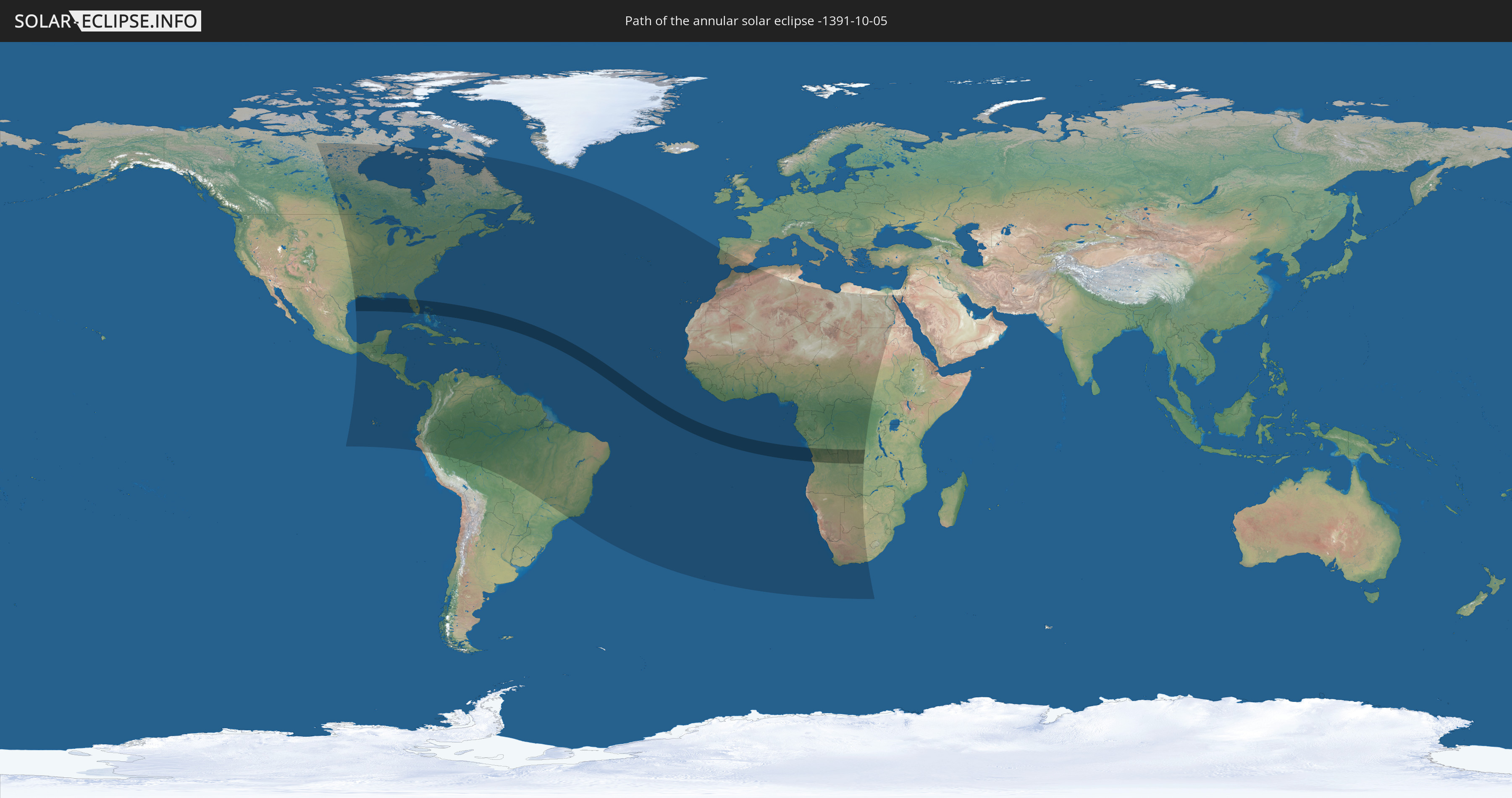
Die Sonnenfinsternis am 10/05/-1391 kann man in 89 Ländern als partielle Sonnenfinsternis beobachten.
Der Finsternispfad verläuft durch 4 Länder. Nur in diesen Ländern ist sie als annular Sonnenfinsternis zu sehen.
In den folgenden Ländern ist die Sonnenfinsternis annular zu sehen
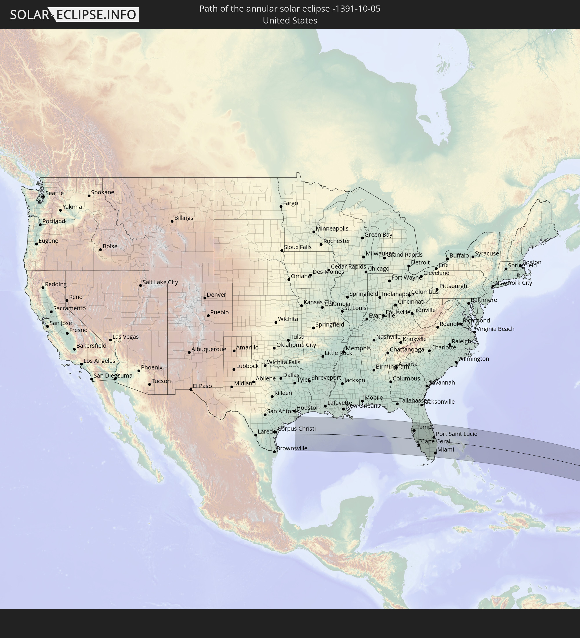 United States
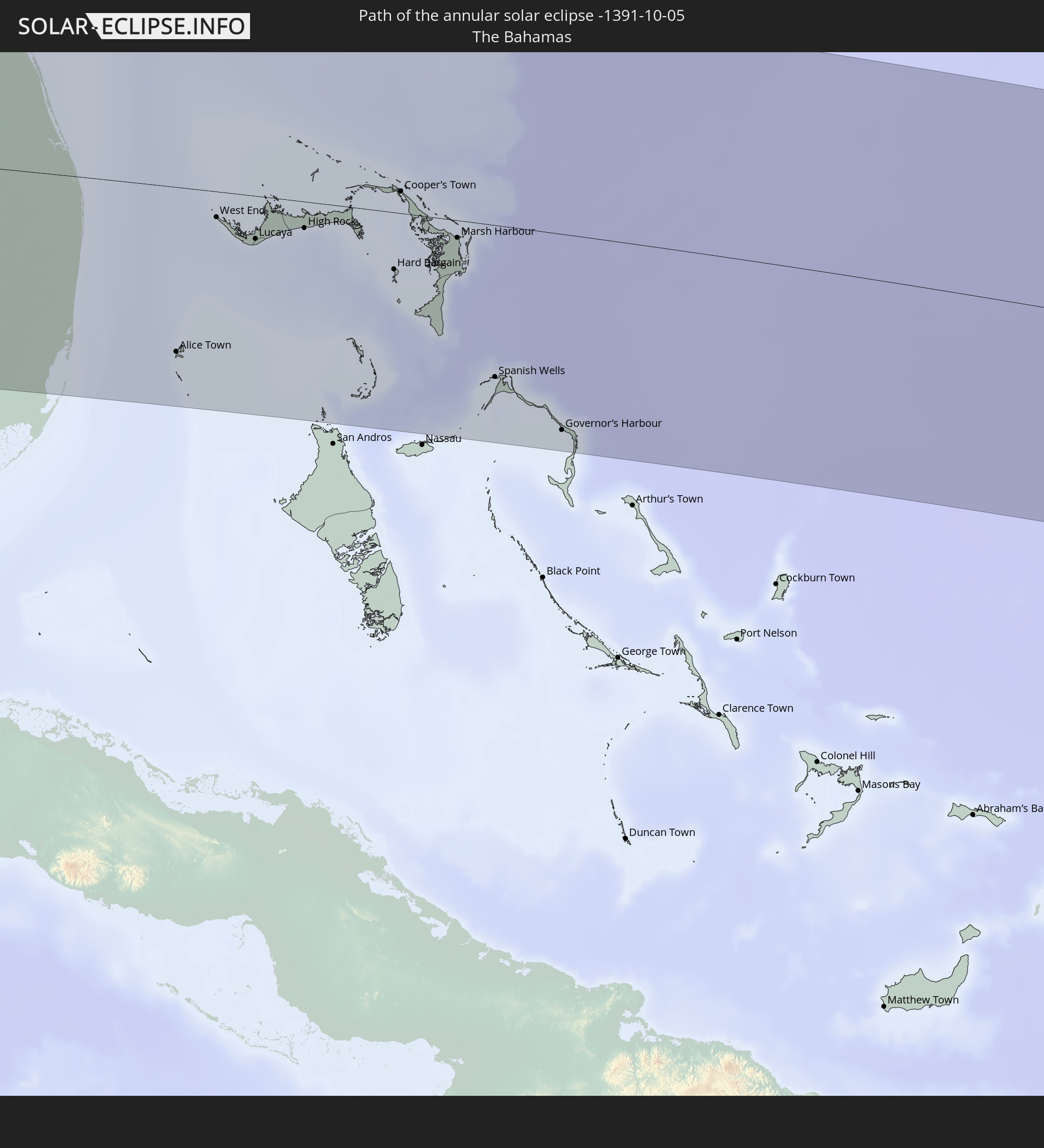 The Bahamas
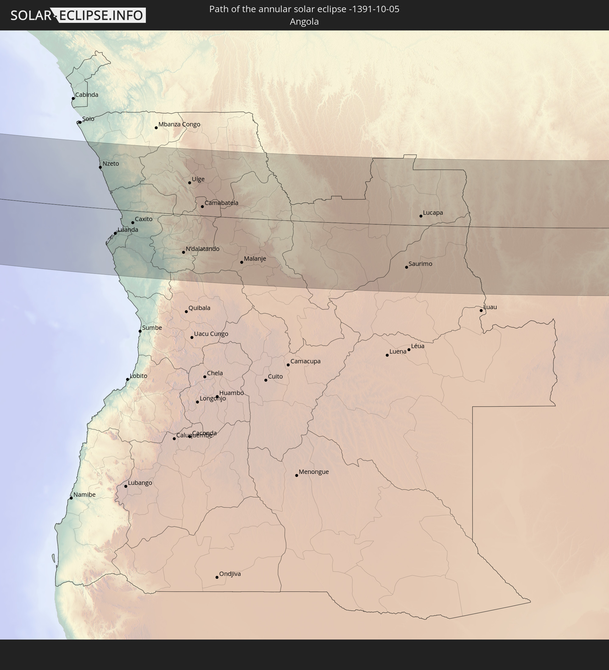 Angola
 Democratic Republic of the Congo
In den folgenden Ländern ist die Sonnenfinsternis partiell zu sehen
 United States
 United States Minor Outlying Islands
 Canada
 Mexico
 Greenland
 Guatemala
 Ecuador
 El Salvador
 Honduras
 Belize
 Nicaragua
 Costa Rica
 Cuba
Cuba
 Panama
 Colombia
 Cayman Islands
 Peru
Peru
 The Bahamas
 Jamaica
 Haiti
Haiti
 Brazil
 Venezuela
 Turks and Caicos Islands
 Dominican Republic
 Aruba
Aruba
 Bolivia
 Puerto Rico
 United States Virgin Islands
 Bermuda
 British Virgin Islands
 Anguilla
 Collectivity of Saint Martin
 Saint Barthélemy
 Saint Kitts and Nevis
 Antigua and Barbuda
 Montserrat
 Trinidad and Tobago
 Guadeloupe
 Grenada
 Dominica
 Saint Vincent and the Grenadines
 Guyana
 Martinique
 Saint Lucia
 Barbados
 Suriname
 Saint Pierre and Miquelon
 French Guiana
 Portugal
 Cabo Verde
 Spain
Spain
 Senegal
 Mauritania
 The Gambia
 Guinea-Bissau
 Guinea
 Saint Helena, Ascension and Tristan da Cunha
 Sierra Leone
 Morocco
 Mali
Mali
 Liberia
 Algeria
 Ivory Coast
 Burkina Faso
 Gibraltar
 Ghana
Ghana
 Togo
Togo
 Niger
Niger
 Benin
Benin
 Nigeria
 Equatorial Guinea
 São Tomé and Príncipe
 Tunisia
 Cameroon
 Gabon
Gabon
 Libya
Libya
 Republic of the Congo
 Angola
 Namibia
 Democratic Republic of the Congo
 Chad
Chad
 Central African Republic
 South Africa
 Botswana
 Sudan
Sudan
 Zambia
 Egypt
Egypt
 Zimbabwe
 Israel
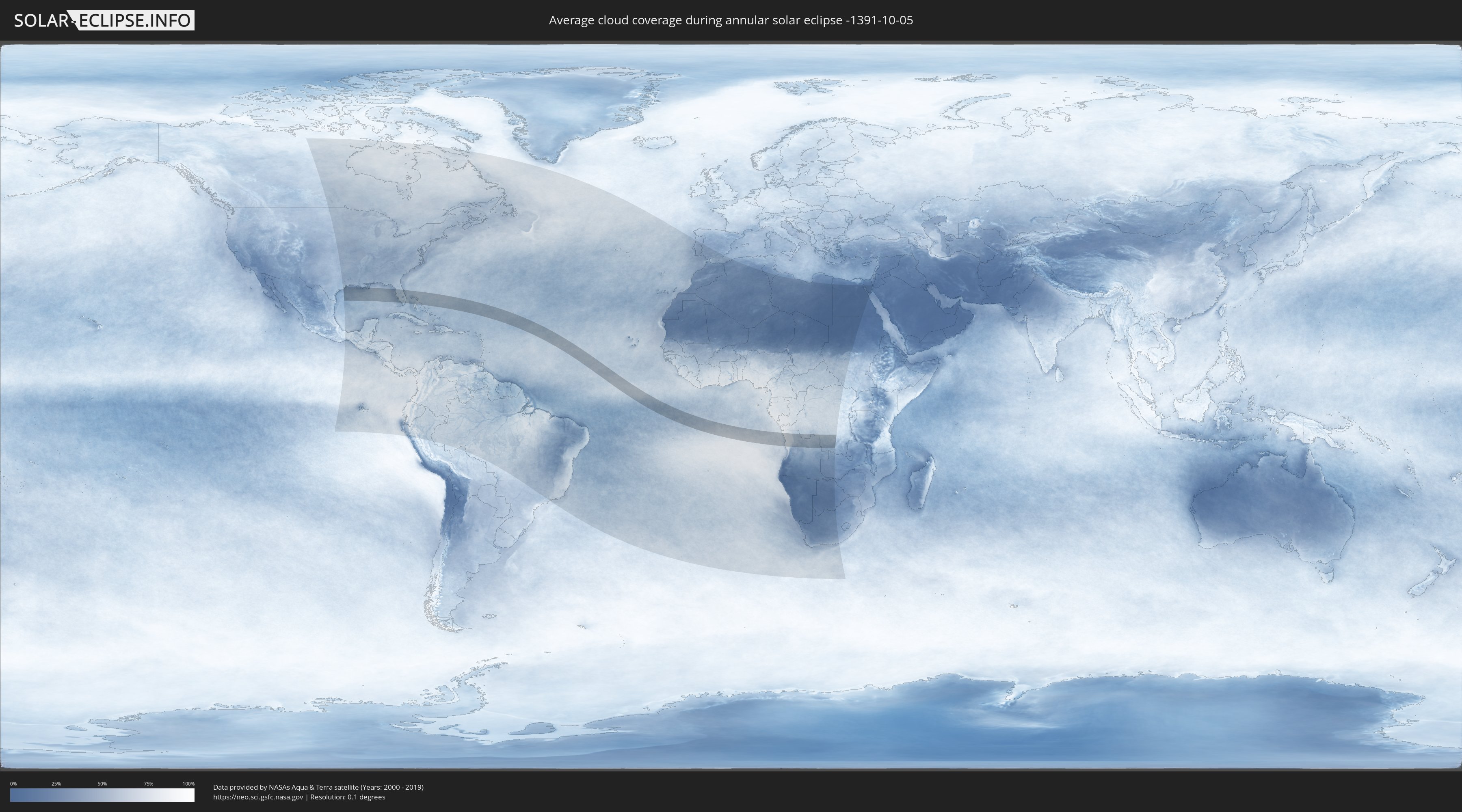
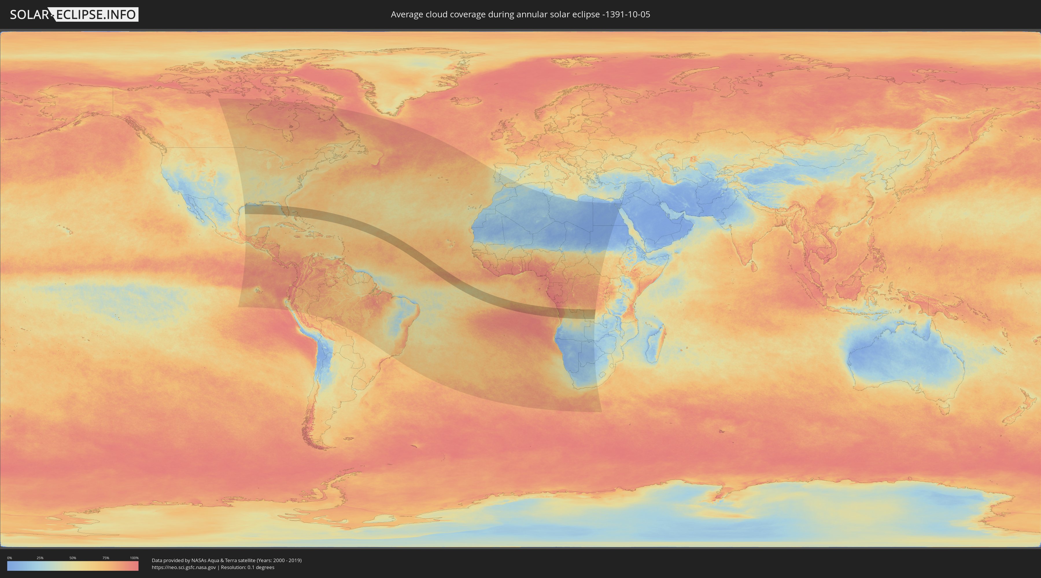
How will be the weather during the annular solar eclipse on 10/05/-1391?
Where is the best place to see the annular solar eclipse of 10/05/-1391?
The following maps show the average cloud coverage for the day of the annular solar eclipse.
With the help of these maps, it is possible to find the place along the eclipse path, which has the best
chance of a cloudless sky.
Nevertheless, you should consider local circumstances and inform about the weather of your chosen
observation site.
The data is provided by NASAs satellites
AQUA and TERRA.
The cloud maps are averaged over a period of 19 years (2000 - 2019).
Detailed country maps
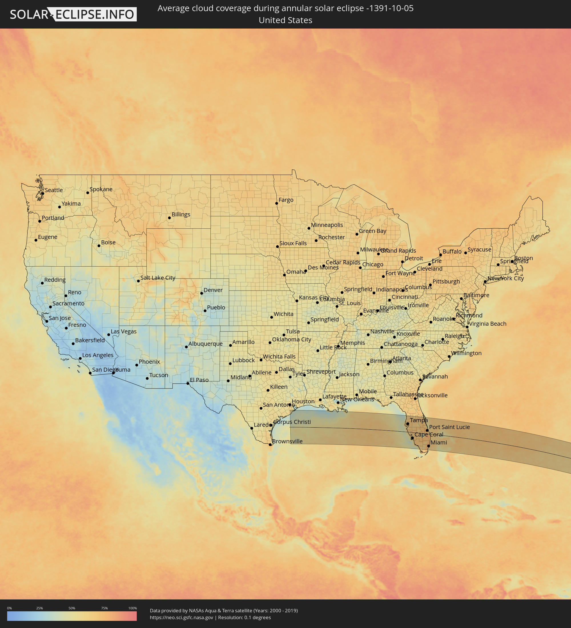 United States
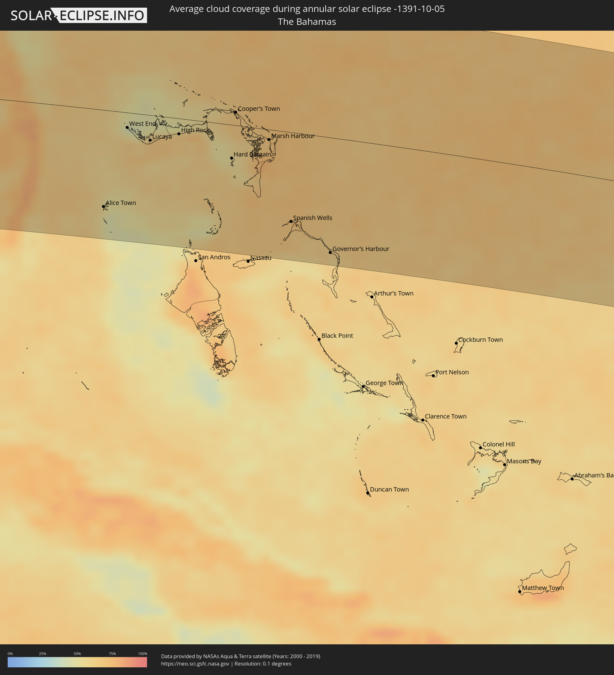 The Bahamas
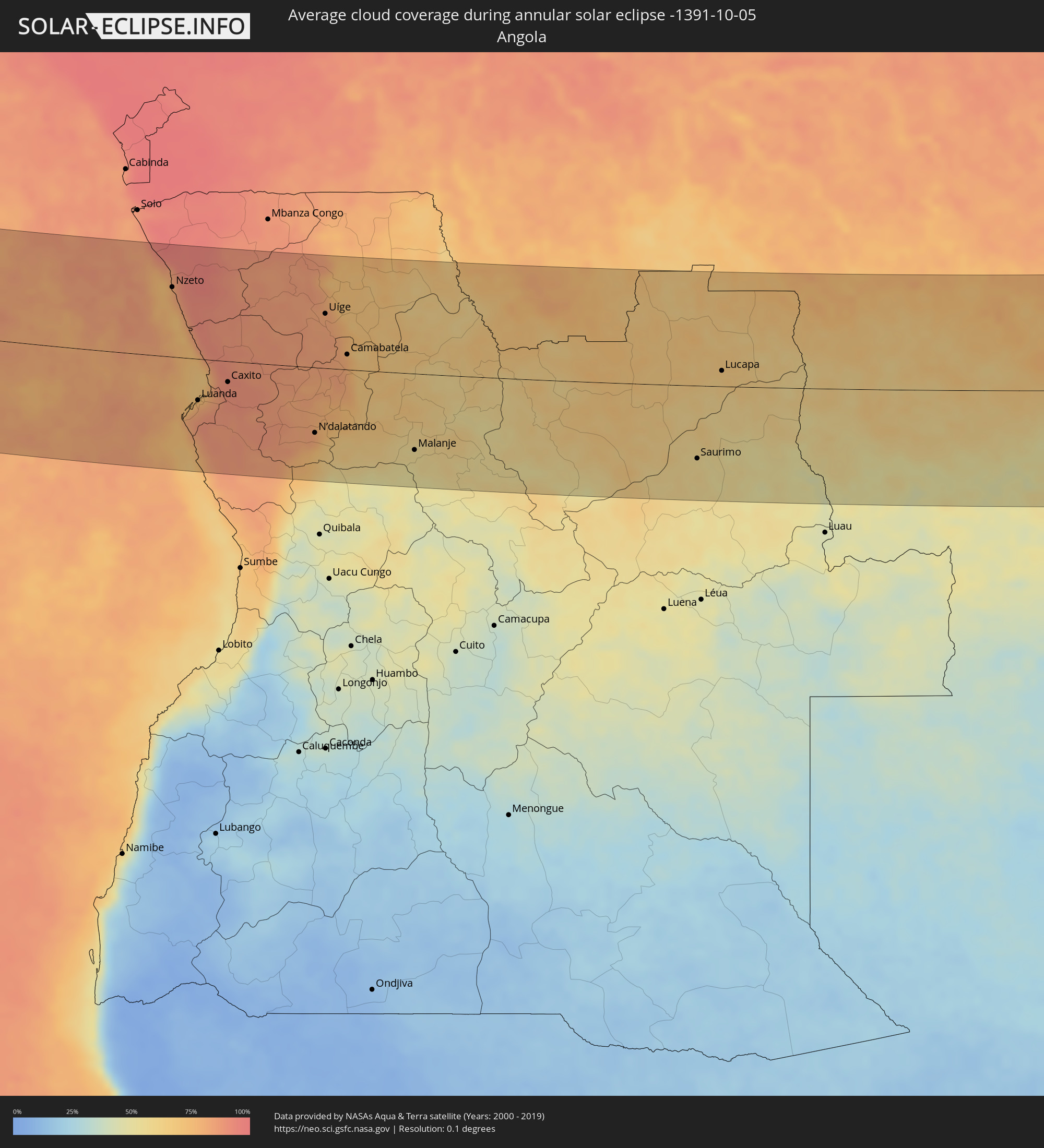 Angola
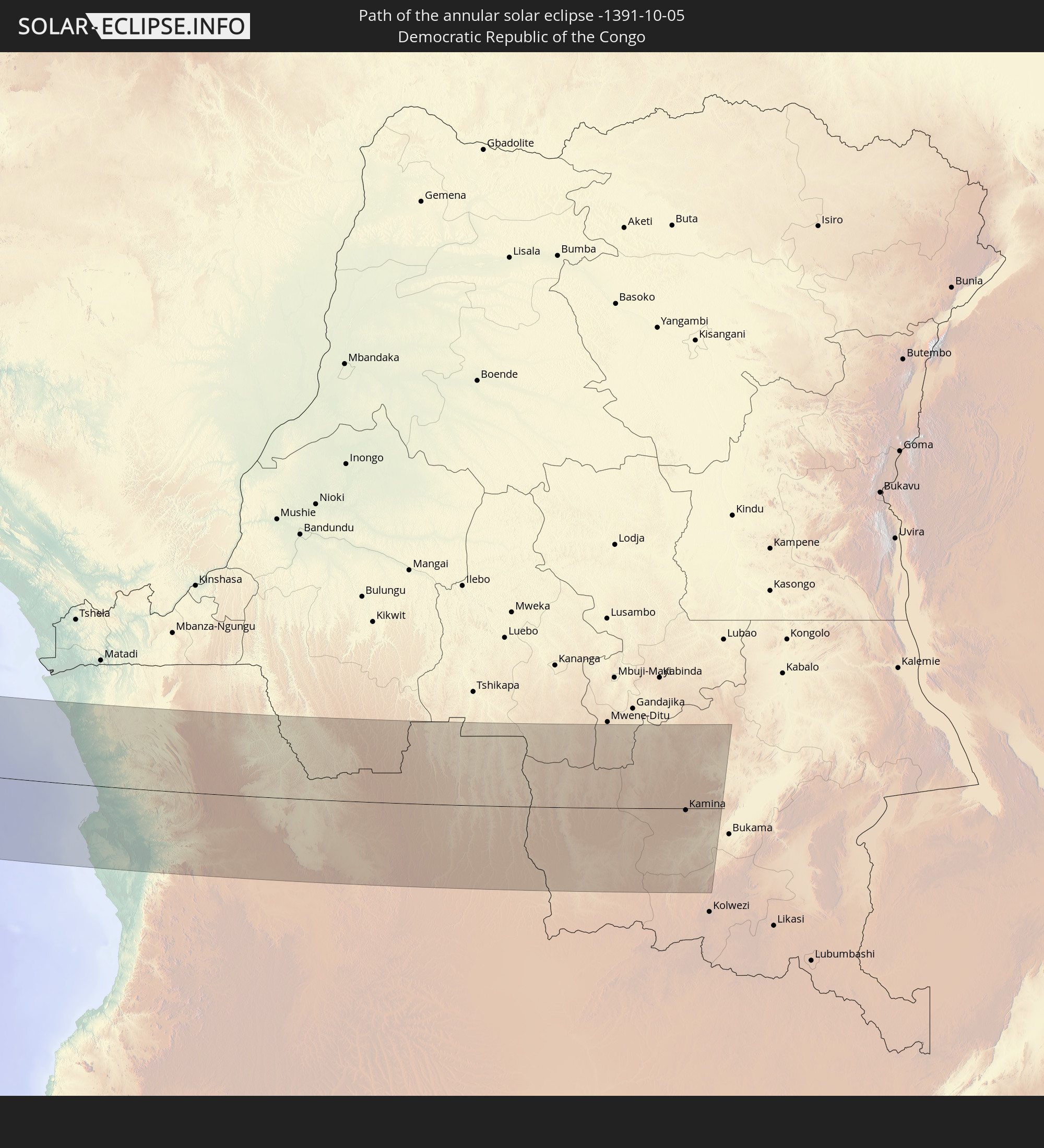
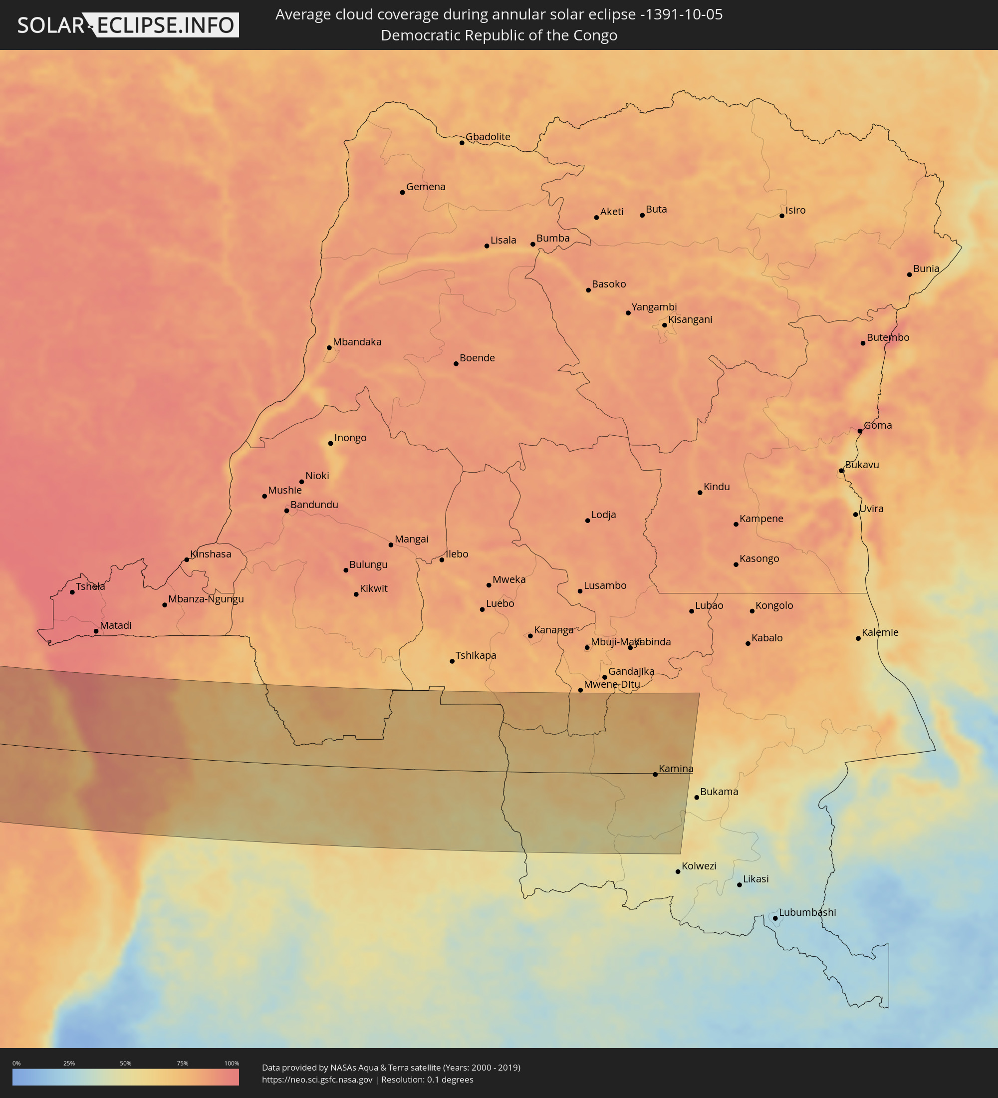 Democratic Republic of the Congo
Cities inside the path of the eclipse
The following table shows all locations with a population of more than 5,000 inside the eclipse path. Cities which have more than 100,000 inhabitants are marked bold. A click at the locations opens a detailed map.
| City | Type | Eclipse duration | Local time of max. eclipse | Distance to central line | Ø Cloud coverage |
|
Clearwater, Florida
|
annular | - | 07:19:53 UTC-05:00 | 85 km | 61% |
|
East Lake, Florida
|
annular | - | 07:19:58 UTC-05:00 | 102 km | 64% |
|
Bayonet Point, Florida
|
annular | - | 07:20:02 UTC-05:00 | 126 km | 62% |
|
St. Petersburg, Florida
|
annular | - | 07:19:52 UTC-05:00 | 64 km | 58% |
|
Bradenton, Florida
|
annular | - | 07:19:51 UTC-05:00 | 35 km | 65% |
|
Sarasota, Florida
|
annular | - | 07:19:50 UTC-05:00 | 17 km | 62% |
|
Greater Northdale, Florida
|
annular | - | 07:20:02 UTC-05:00 | 103 km | 68% |
|
Spring Hill, Florida
|
annular | - | 07:20:09 UTC-05:00 | 144 km | 67% |
|
Tampa, Florida
|
annular | - | 07:20:01 UTC-05:00 | 86 km | 58% |
|
Wesley Chapel, Florida
|
annular | - | 07:20:10 UTC-05:00 | 119 km | 67% |
|
Brandon, Florida
|
annular | - | 07:20:06 UTC-05:00 | 86 km | 69% |
|
North Port, Florida
|
annular | - | 07:19:53 UTC-05:00 | 12 km | 56% |
|
Plant City, Florida
|
annular | - | 07:20:12 UTC-05:00 | 97 km | 67% |
|
Port Charlotte, Florida
|
annular | - | 07:19:56 UTC-05:00 | 19 km | 59% |
|
Lakeland, Florida
|
annular | - | 07:20:17 UTC-05:00 | 100 km | 63% |
|
Cape Coral, Florida
|
annular | - | 07:19:55 UTC-05:00 | 63 km | 65% |
|
Bonita Springs, Florida
|
annular | - | 07:19:57 UTC-05:00 | 87 km | 64% |
|
Clermont, Florida
|
annular | - | 07:20:31 UTC-05:00 | 158 km | 66% |
|
Winter Haven, Florida
|
annular | - | 07:20:23 UTC-05:00 | 100 km | 64% |
|
Golden Gate, Florida
|
annular | - | 07:19:58 UTC-05:00 | 103 km | 70% |
|
Four Corners, Florida
|
annular | - | 07:20:30 UTC-05:00 | 136 km | 70% |
|
Lehigh Acres, Florida
|
annular | - | 07:20:05 UTC-05:00 | 54 km | 70% |
|
Apopka, Florida
|
annular | - | 07:20:40 UTC-05:00 | 175 km | 69% |
|
Poinciana, Florida
|
annular | - | 07:20:33 UTC-05:00 | 116 km | 63% |
|
Immokalee, Florida
|
annular | - | 07:20:09 UTC-05:00 | 75 km | 70% |
|
Kissimmee, Florida
|
annular | - | 07:20:37 UTC-05:00 | 134 km | 62% |
|
Orlando, Florida
|
annular | - | 07:20:42 UTC-05:00 | 161 km | 73% |
|
Alafaya, Florida
|
annular | - | 07:20:47 UTC-05:00 | 165 km | 73% |
|
Titusville, Florida
|
annular | - | 07:21:00 UTC-05:00 | 174 km | 68% |
|
Rockledge, Florida
|
annular | - | 07:20:58 UTC-05:00 | 146 km | 66% |
|
Merritt Island, Florida
|
annular | - | 07:21:03 UTC-05:00 | 167 km | 67% |
|
Palm Bay, Florida
|
annular | - | 07:20:57 UTC-05:00 | 112 km | 68% |
|
Homestead, Florida
|
annular | - | 07:20:28 UTC-05:00 | 171 km | 76% |
|
Sebastian, Florida
|
annular | - | 07:20:58 UTC-05:00 | 89 km | 66% |
|
Vero Beach South, Florida
|
annular | - | 07:20:56 UTC-05:00 | 68 km | 65% |
|
Weston, Florida
|
annular | - | 07:20:37 UTC-05:00 | 100 km | 73% |
|
Doral, Florida
|
annular | - | 07:20:36 UTC-05:00 | 131 km | 78% |
|
Port Saint Lucie, Florida
|
annular | - | 07:20:54 UTC-05:00 | 33 km | 75% |
|
Fort Pierce, Florida
|
annular | - | 07:20:57 UTC-05:00 | 50 km | 66% |
|
Kendall, Florida
|
annular | - | 07:20:36 UTC-05:00 | 146 km | 64% |
|
Coral Springs, Florida
|
annular | - | 07:20:44 UTC-05:00 | 80 km | 75% |
|
Palm City, Florida
|
annular | - | 07:20:55 UTC-05:00 | 20 km | 71% |
|
Wellington, Florida
|
annular | - | 07:20:49 UTC-05:00 | 37 km | 80% |
|
Pembroke Pines, Florida
|
annular | - | 07:20:42 UTC-05:00 | 109 km | 74% |
|
Miami, Florida
|
annular | - | 07:20:41 UTC-05:00 | 134 km | 66% |
|
Fort Lauderdale, Florida
|
annular | - | 07:20:46 UTC-05:00 | 95 km | 66% |
|
Jupiter, Florida
|
annular | - | 07:20:58 UTC-05:00 | 5 km | 70% |
|
Boca Raton, Florida
|
annular | - | 07:20:51 UTC-05:00 | 68 km | 70% |
|
Boynton Beach, Florida
|
annular | - | 07:20:53 UTC-05:00 | 50 km | 70% |
|
West Palm Beach, Florida
|
annular | - | 07:20:56 UTC-05:00 | 28 km | 70% |
|
Alice Town, Bimini
|
annular | - | 07:11:42 UTC-05:09 | 130 km | 54% |
|
West End, West Grand Bahama
|
annular | - | 07:12:03 UTC-05:09 | 20 km | 57% |
|
Freeport, Freeport
|
annular | - | 07:12:12 UTC-05:09 | 34 km | 66% |
|
Lucaya, Freeport
|
annular | - | 07:12:13 UTC-05:09 | 34 km | 66% |
|
High Rock, East Grand Bahama
|
annular | - | 12:21:59 UTC+00:00 | 21 km | 64% |
|
Hard Bargain, Moore’s Island
|
annular | - | 07:12:54 UTC-05:09 | 45 km | 61% |
|
Cooper’s Town, North Abaco
|
annular | - | 07:13:01 UTC-05:09 | 17 km | 67% |
|
Marsh Harbour, Central Abaco
|
annular | - | 07:13:16 UTC-05:09 | 14 km | 74% |
|
Spanish Wells, Spanish Wells
|
annular | - | 07:13:21 UTC-05:09 | 120 km | 69% |
|
Governor’s Harbour, Central Eleuthera
|
annular | - | 12:23:12 UTC+00:00 | 155 km | 59% |
|
Nzeto, Zaire
|
annular | - | 16:21:57 UTC+00:13 | 110 km | 84% |
|
Luanda, Luanda
|
annular | - | 16:22:57 UTC+00:13 | 65 km | 80% |
|
Caxito, Bengo
|
annular | - | 16:23:02 UTC+00:13 | 33 km | 90% |
|
N’dalatando, Cuanza Norte
|
annular | - | 16:23:55 UTC+00:13 | 103 km | 79% |
|
Uíge, Uíge
|
annular | - | 16:23:12 UTC+00:13 | 86 km | 82% |
|
Camabatela, Cuanza Norte
|
annular | - | 16:23:37 UTC+00:13 | 24 km | 75% |
|
Malanje, Malanje
|
annular | - | 16:24:34 UTC+00:13 | 120 km | 55% |
|
Saurimo, Lunda Sul
|
annular | - | 16:25:41 UTC+00:13 | 115 km | 58% |
|
Lucapa, Luanda Norte
|
annular | - | 16:25:17 UTC+00:13 | 25 km | 64% |
|
Kamina, Katanga
|
annular | - | 18:22:36 UTC+02:10 | 4 km | 67% |