Total solar eclipse of 10/16/-1457
| Day of week: | Monday |
| Maximum duration of eclipse: | 03m46s |
| Maximum width of eclipse path: | 170 km |
| Saros cycle: | 20 |
| Coverage: | 100% |
| Magnitude: | 1.0465 |
| Gamma: | 0.4335 |
Wo kann man die Sonnenfinsternis vom 10/16/-1457 sehen?
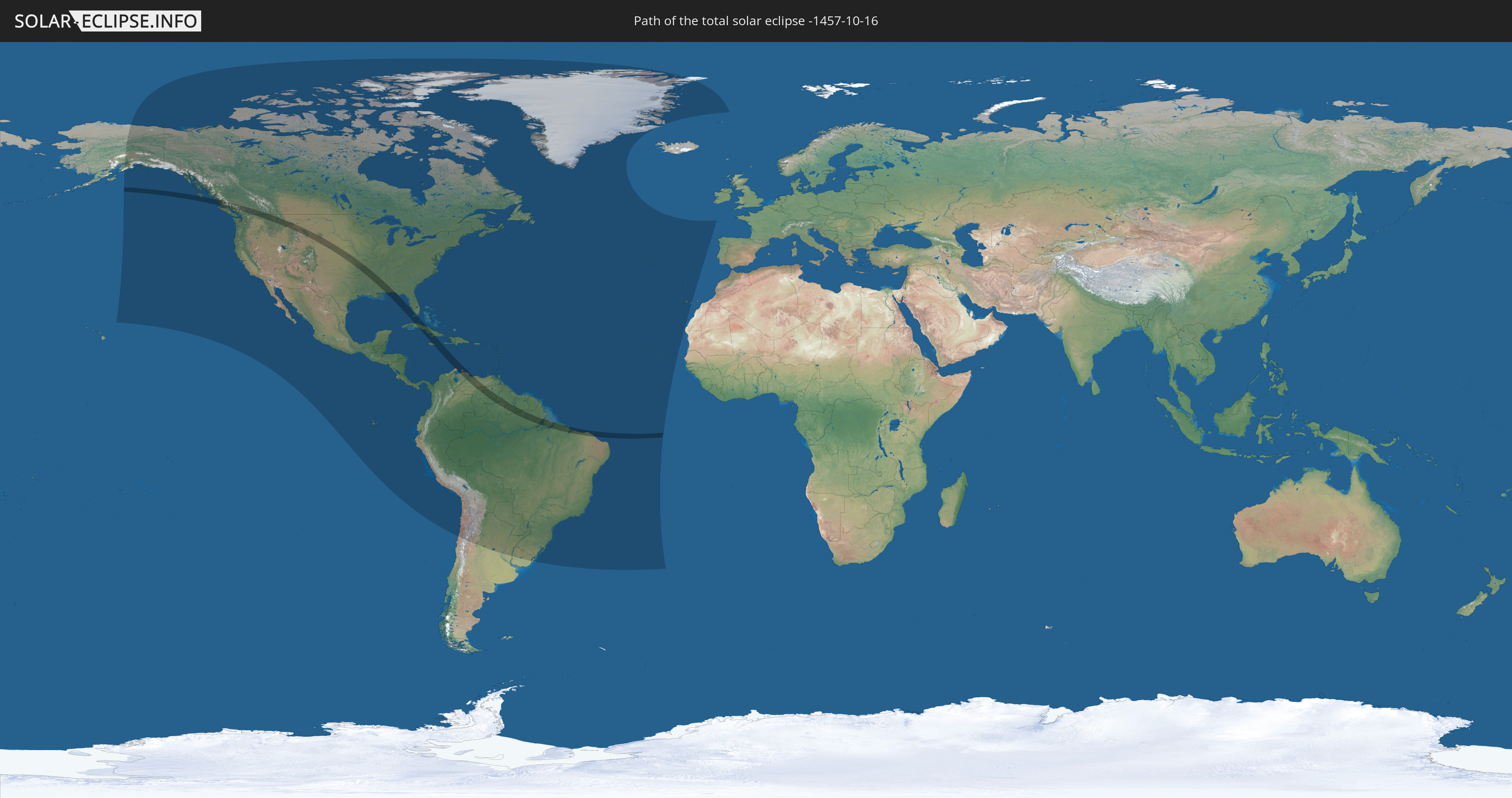
Die Sonnenfinsternis am 10/16/-1457 kann man in 55 Ländern als partielle Sonnenfinsternis beobachten.
Der Finsternispfad verläuft durch 11 Länder. Nur in diesen Ländern ist sie als total Sonnenfinsternis zu sehen.
In den folgenden Ländern ist die Sonnenfinsternis total zu sehen
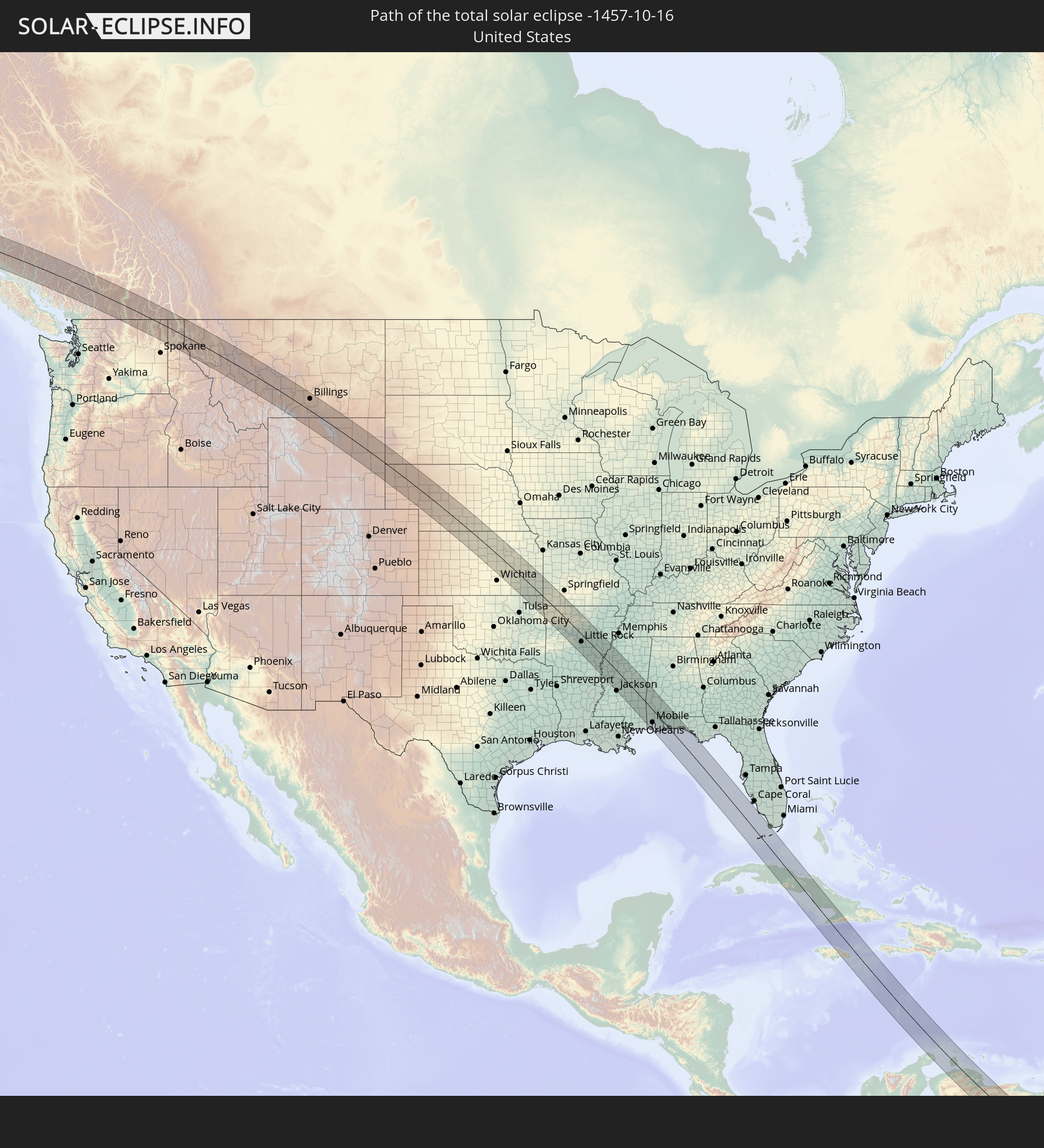 United States
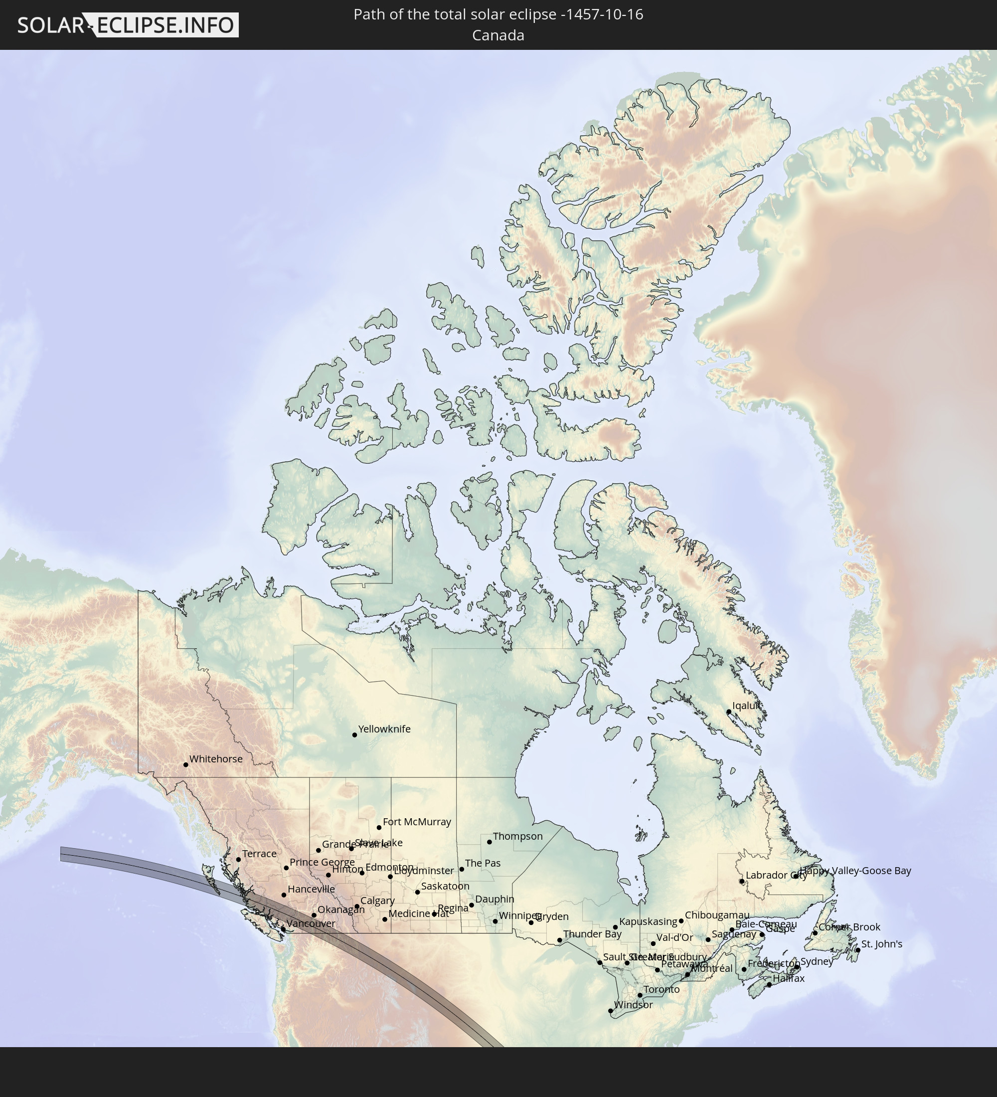 Canada
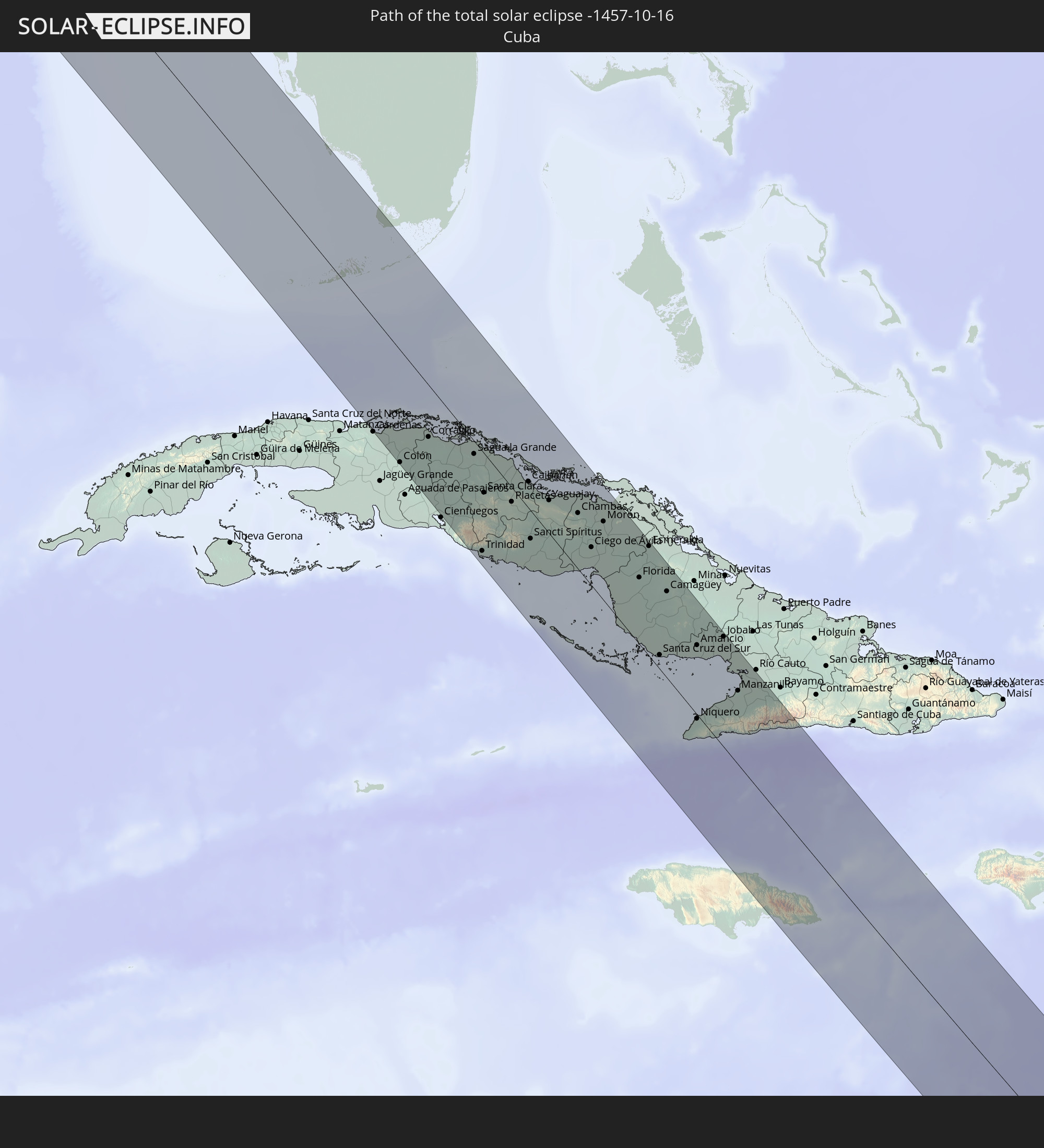 Cuba
Cuba
 Colombia
 The Bahamas
 Jamaica
 Brazil
 Venezuela
 Aruba
Aruba
 Guyana
 Suriname
In den folgenden Ländern ist die Sonnenfinsternis partiell zu sehen
 United States
 United States Minor Outlying Islands
 Canada
 Mexico
 Chile
Chile
 Greenland
 Guatemala
 Ecuador
 El Salvador
 Honduras
 Belize
 Nicaragua
 Costa Rica
 Cuba
Cuba
 Panama
 Colombia
 Cayman Islands
 Peru
Peru
 The Bahamas
 Jamaica
 Haiti
Haiti
 Brazil
 Argentina
 Venezuela
 Turks and Caicos Islands
 Dominican Republic
 Aruba
Aruba
 Bolivia
 Puerto Rico
 United States Virgin Islands
 Bermuda
 British Virgin Islands
 Anguilla
 Collectivity of Saint Martin
 Saint Barthélemy
 Saint Kitts and Nevis
 Paraguay
 Antigua and Barbuda
 Montserrat
 Trinidad and Tobago
 Guadeloupe
 Grenada
 Dominica
 Saint Vincent and the Grenadines
 Guyana
 Martinique
 Saint Lucia
 Barbados
 Uruguay
 Suriname
 Saint Pierre and Miquelon
 French Guiana
 Portugal
 Cabo Verde
 Spain
Spain
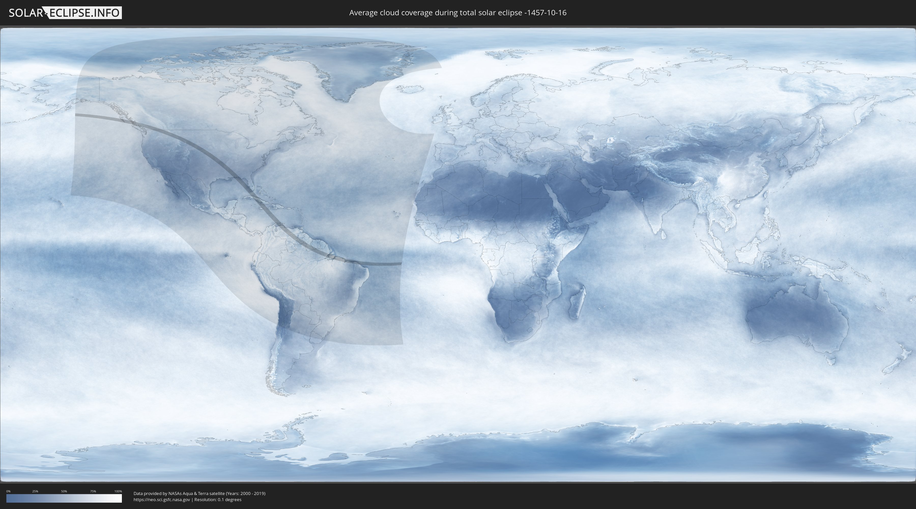
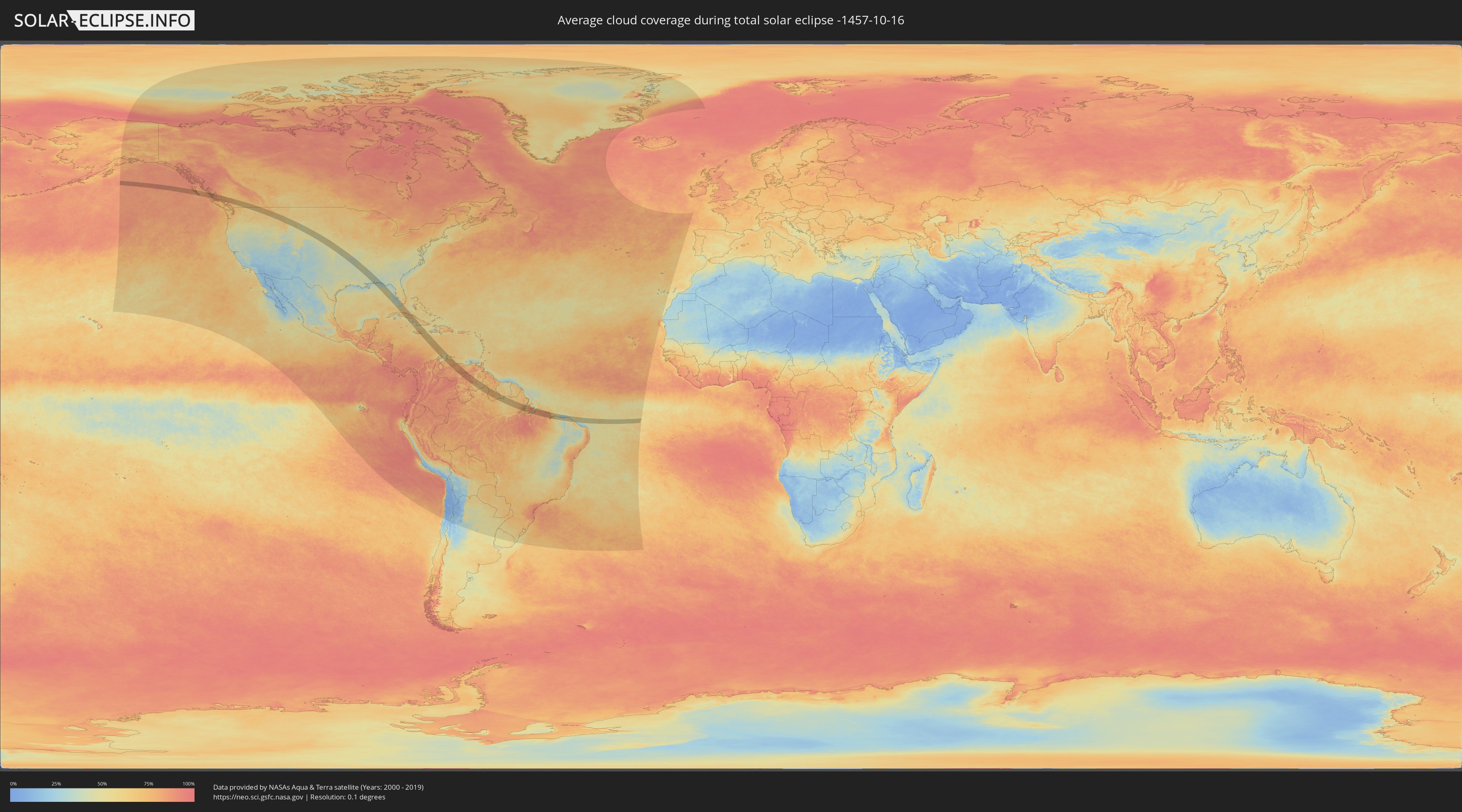
How will be the weather during the total solar eclipse on 10/16/-1457?
Where is the best place to see the total solar eclipse of 10/16/-1457?
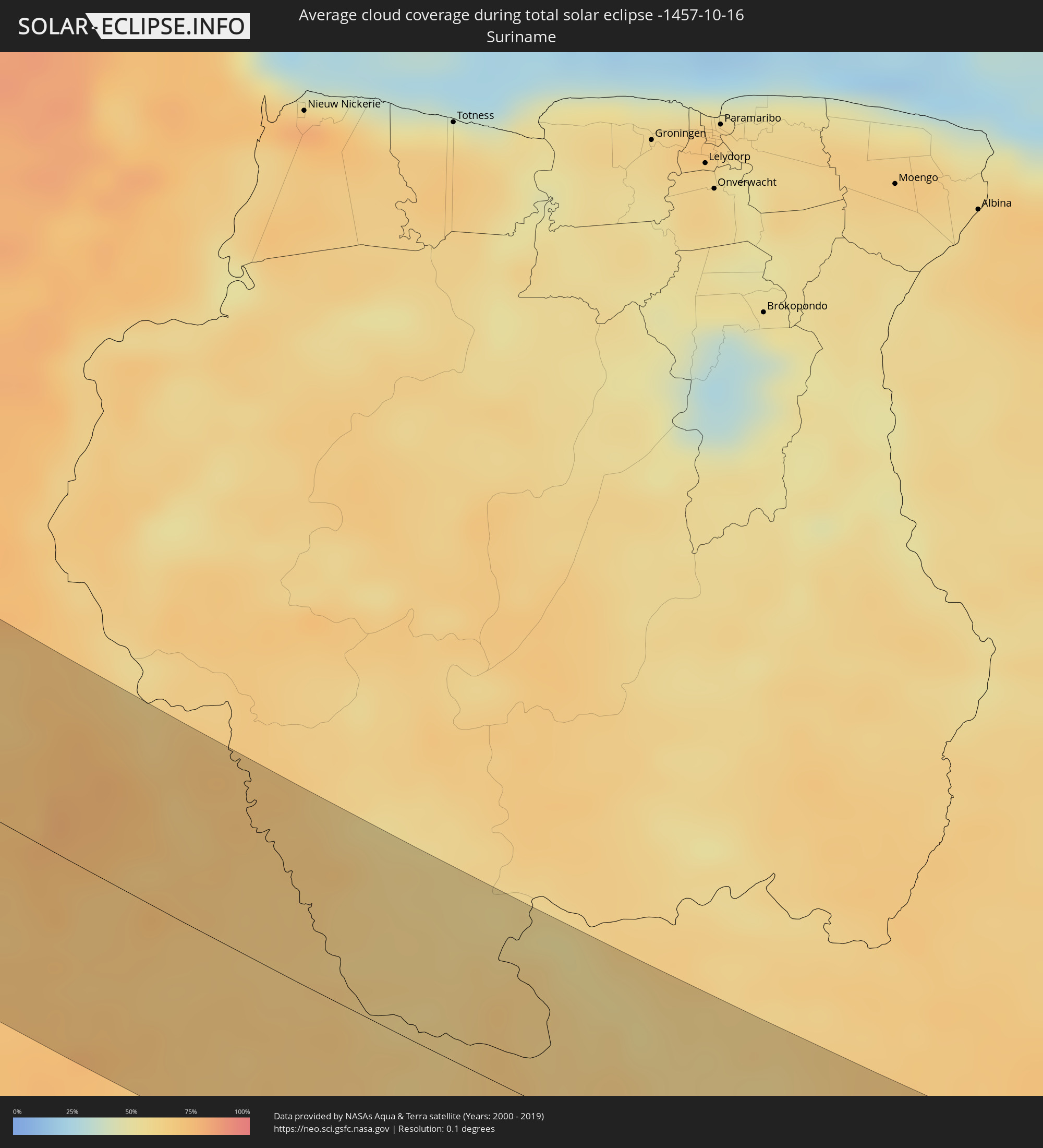
The following maps show the average cloud coverage for the day of the total solar eclipse.
With the help of these maps, it is possible to find the place along the eclipse path, which has the best
chance of a cloudless sky.
Nevertheless, you should consider local circumstances and inform about the weather of your chosen
observation site.
The data is provided by NASAs satellites
AQUA and TERRA.
The cloud maps are averaged over a period of 19 years (2000 - 2019).
Detailed country maps
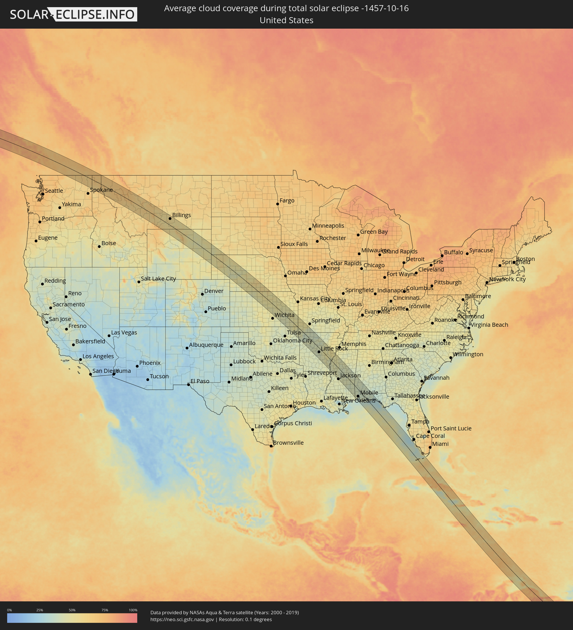 United States
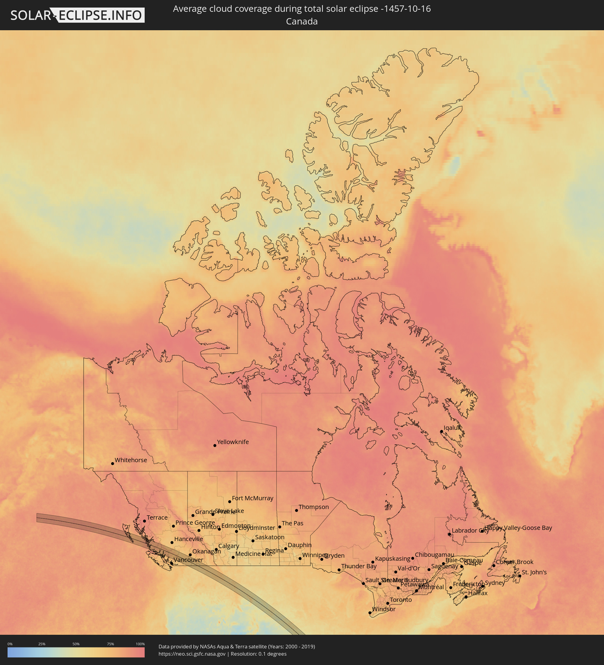 Canada
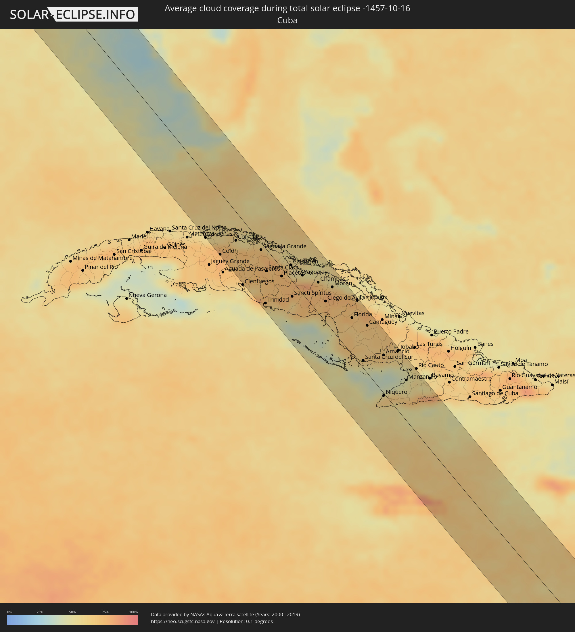 Cuba
Cuba
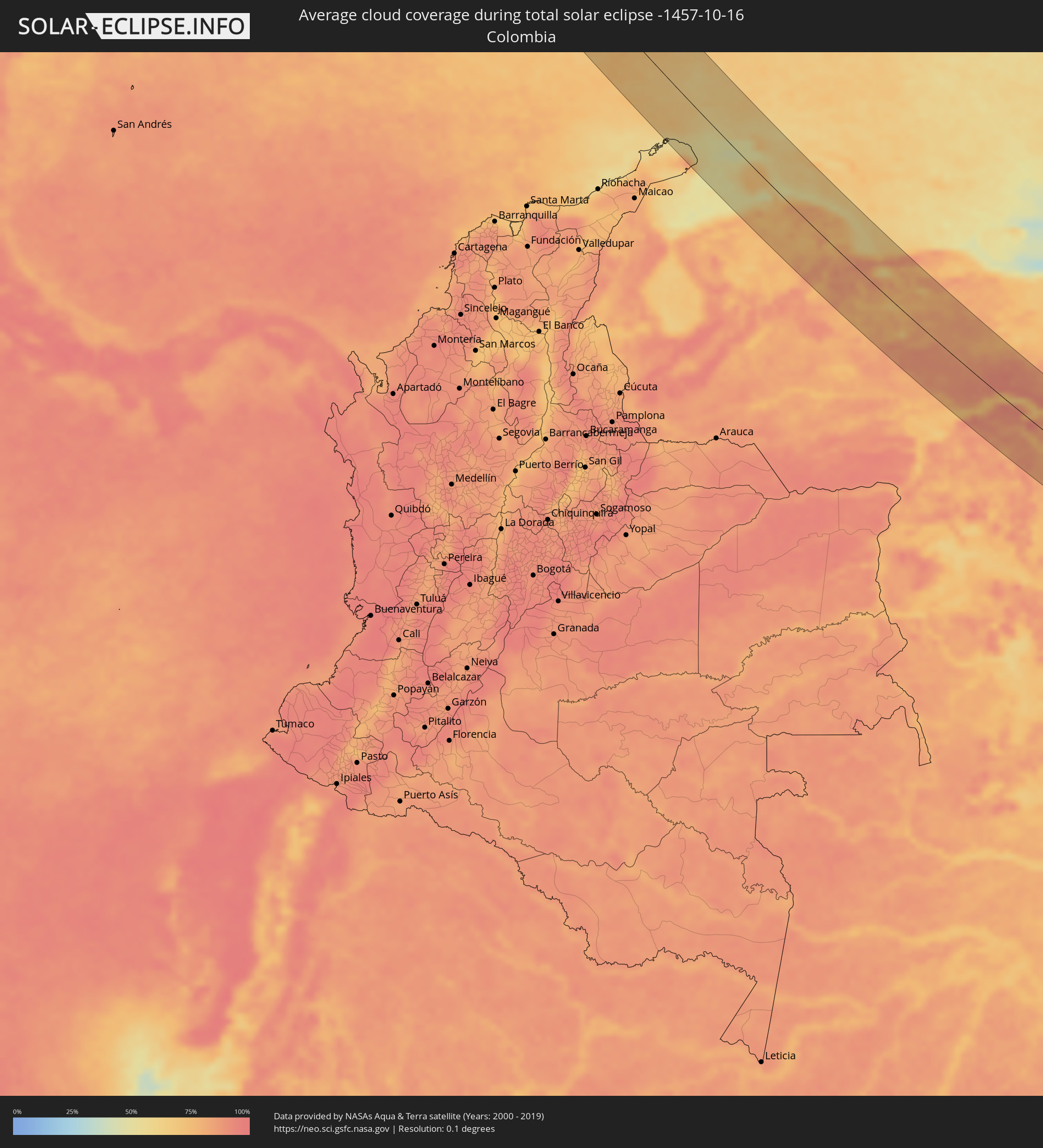 Colombia
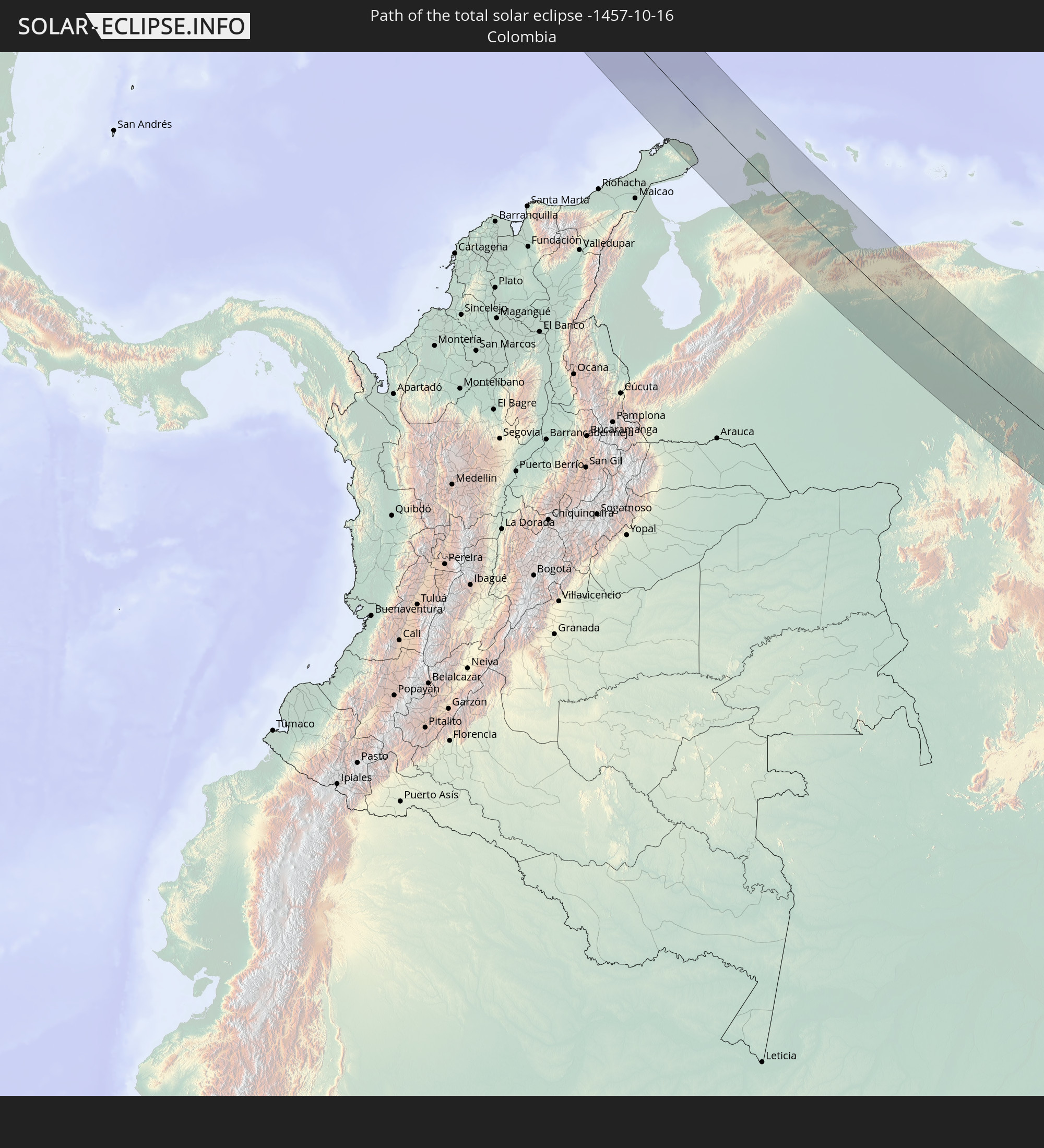
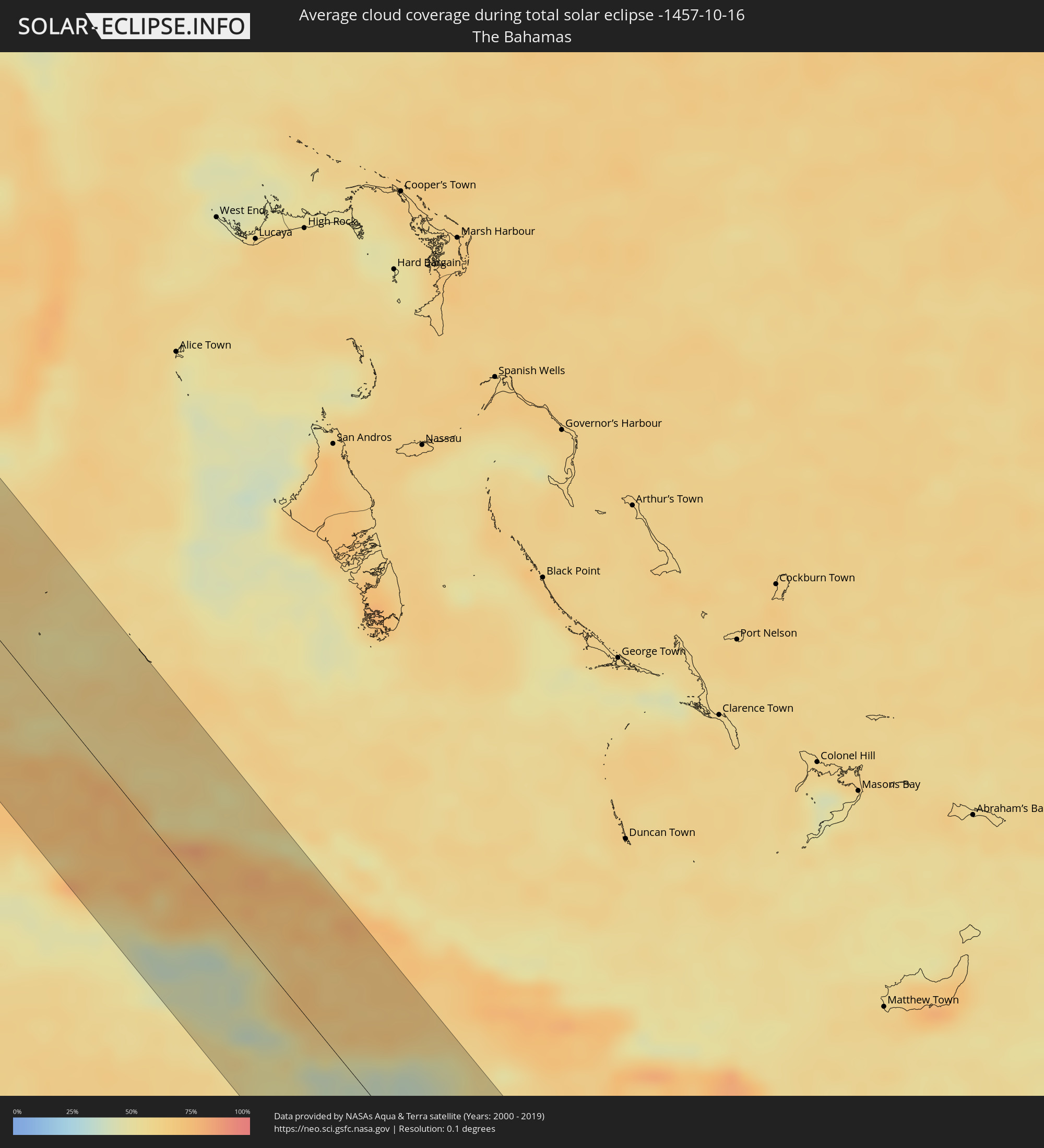 The Bahamas
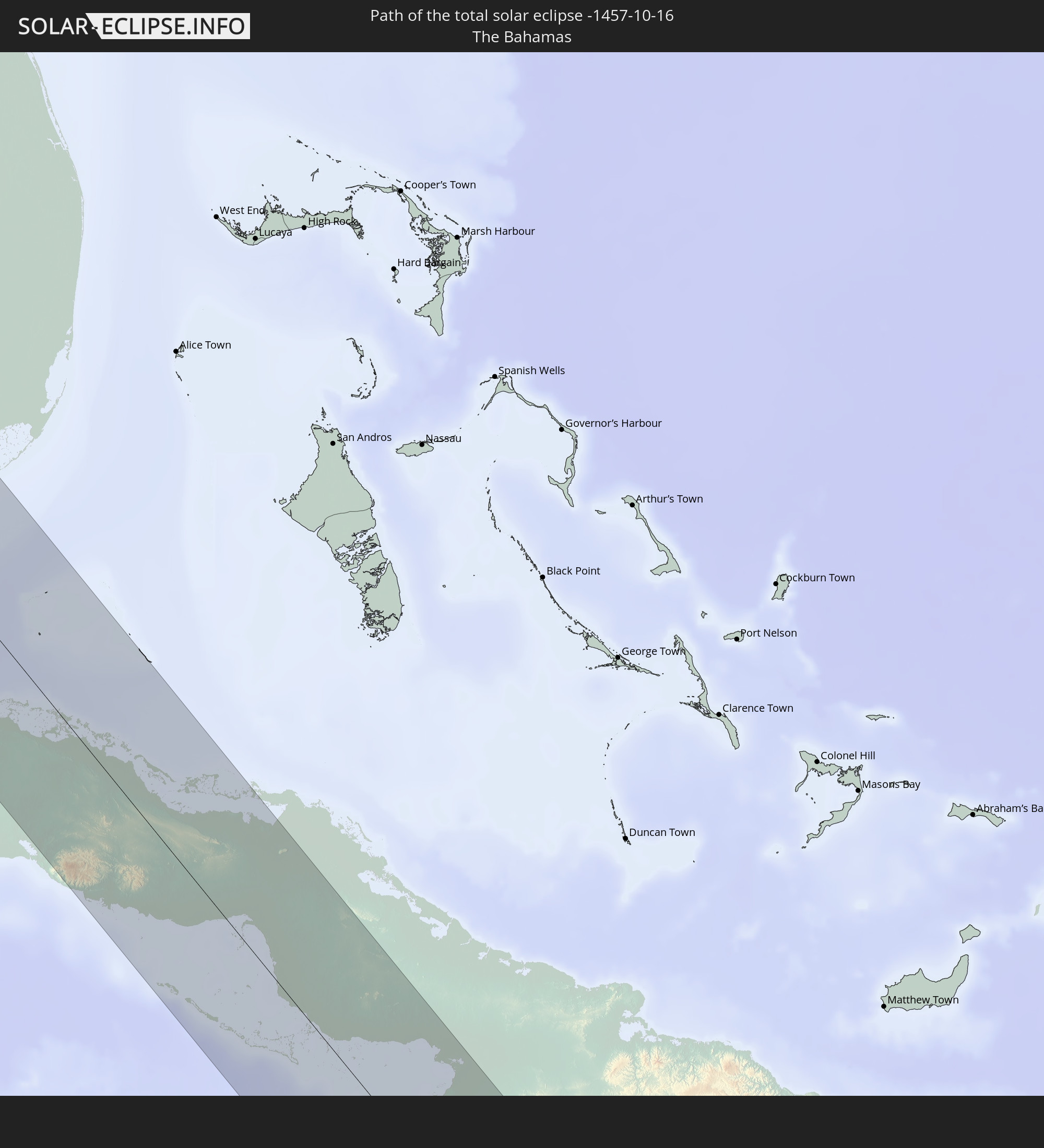
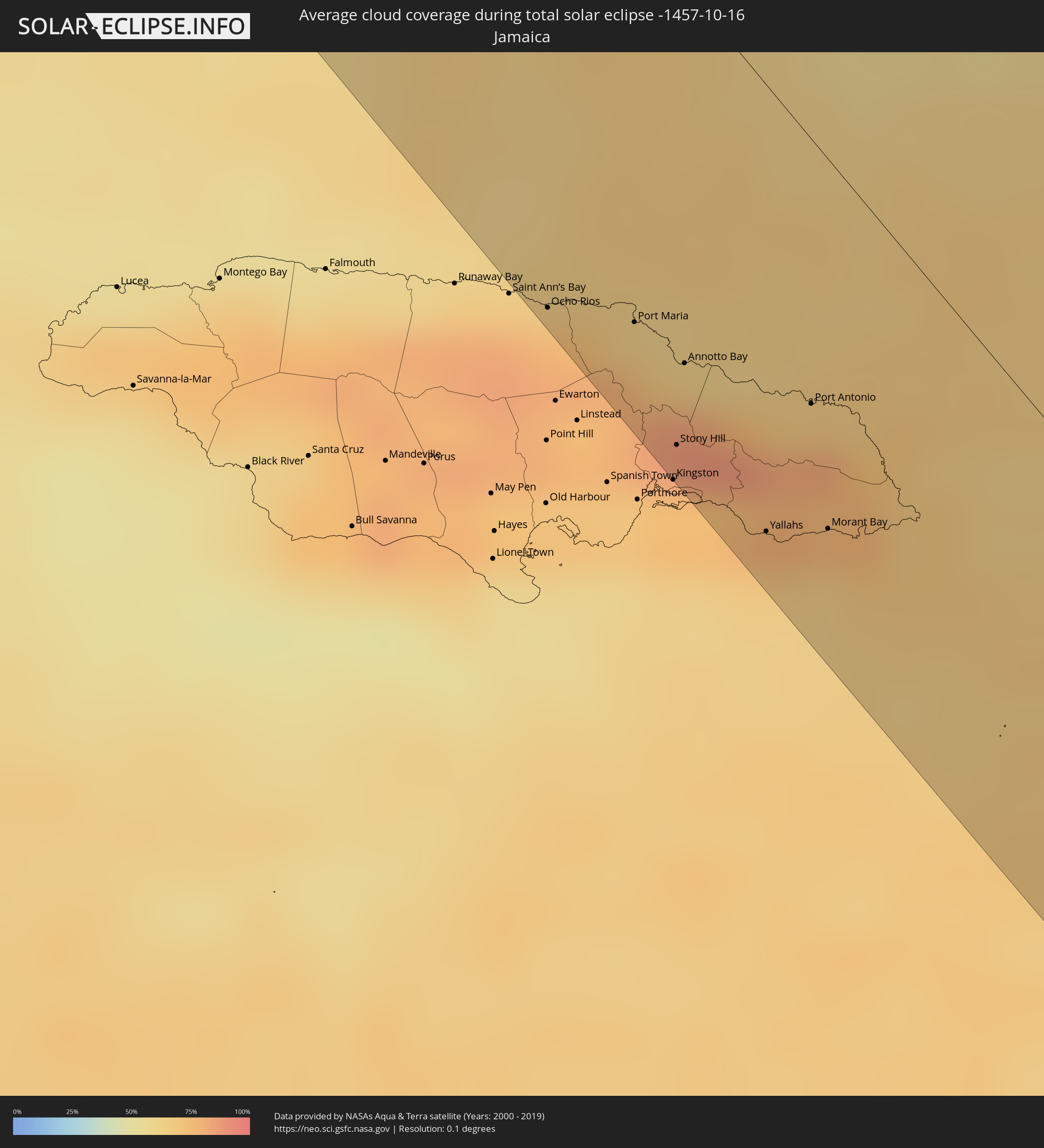 Jamaica
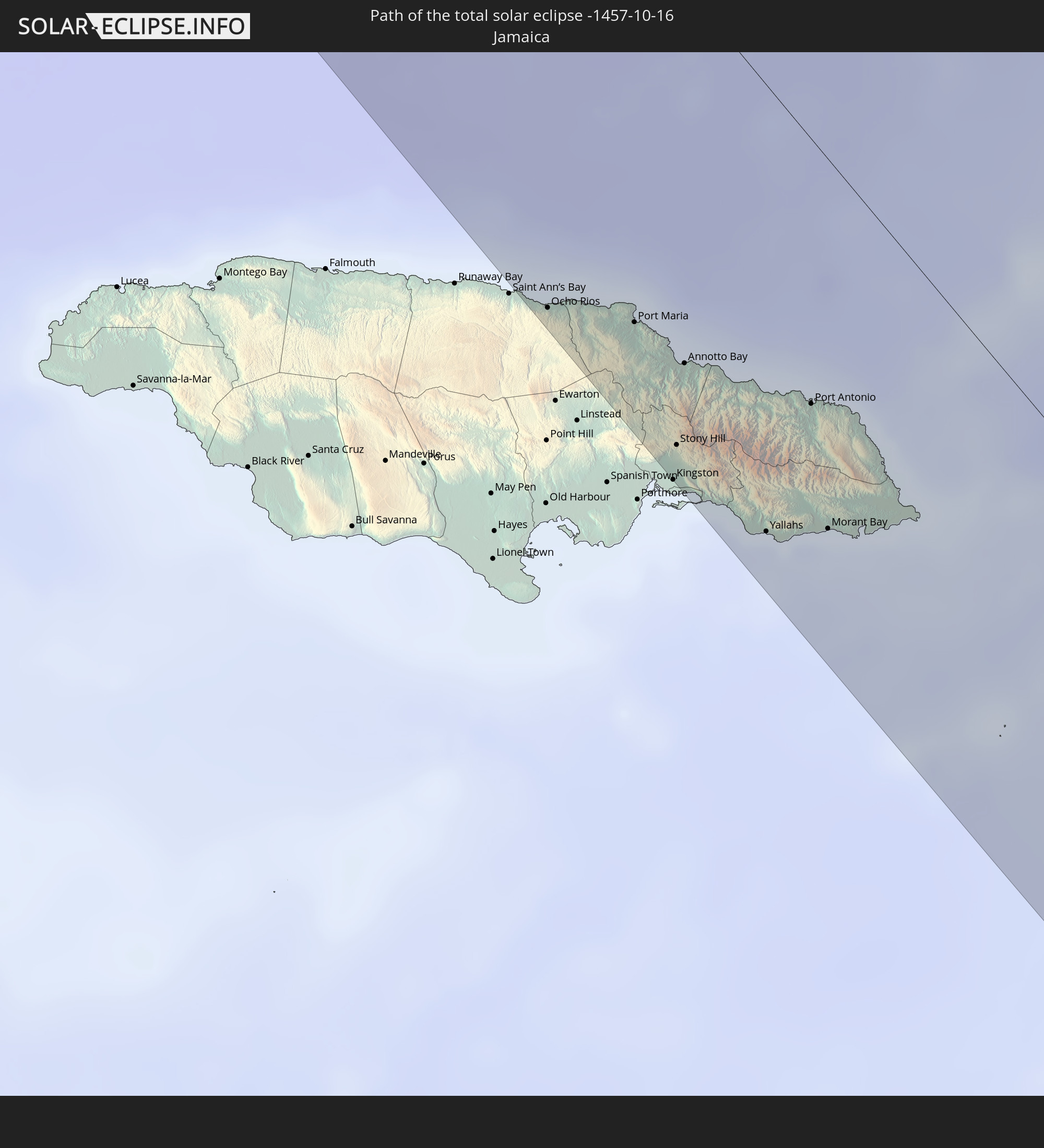
 Brazil
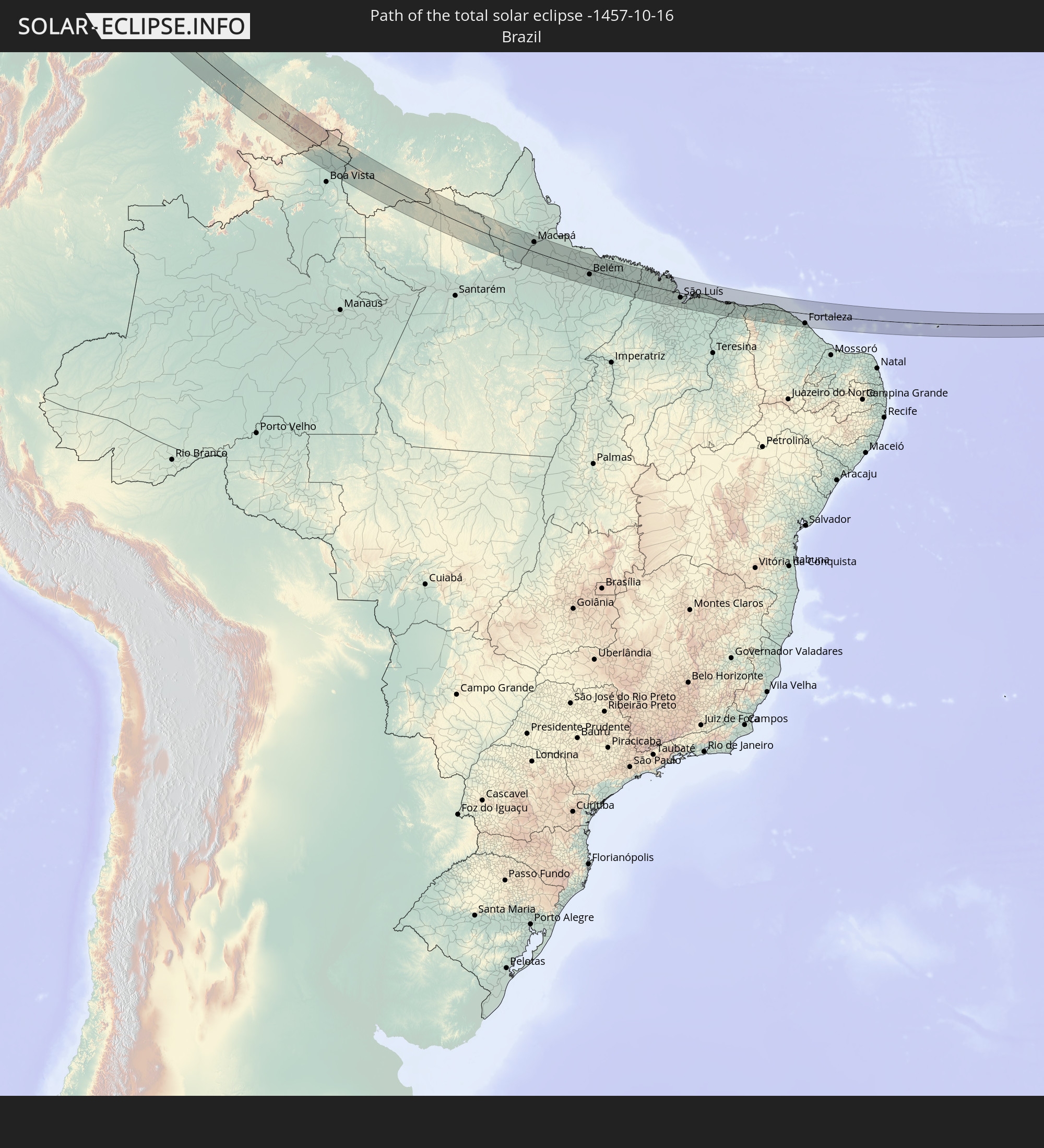
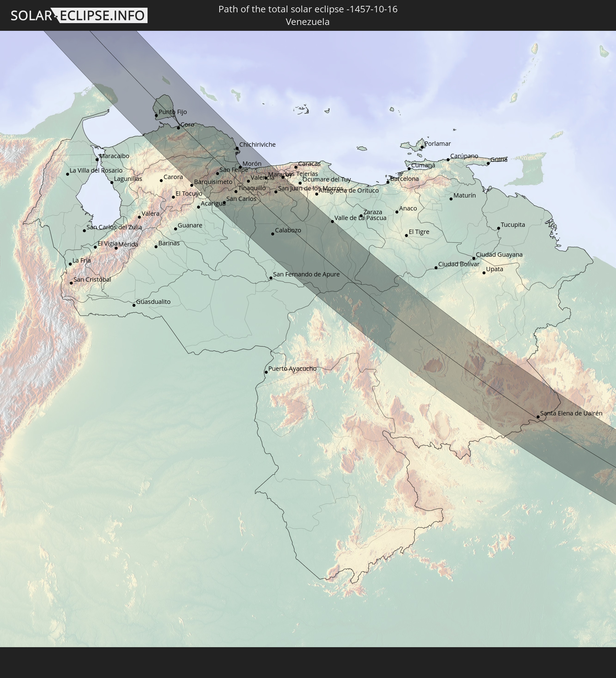
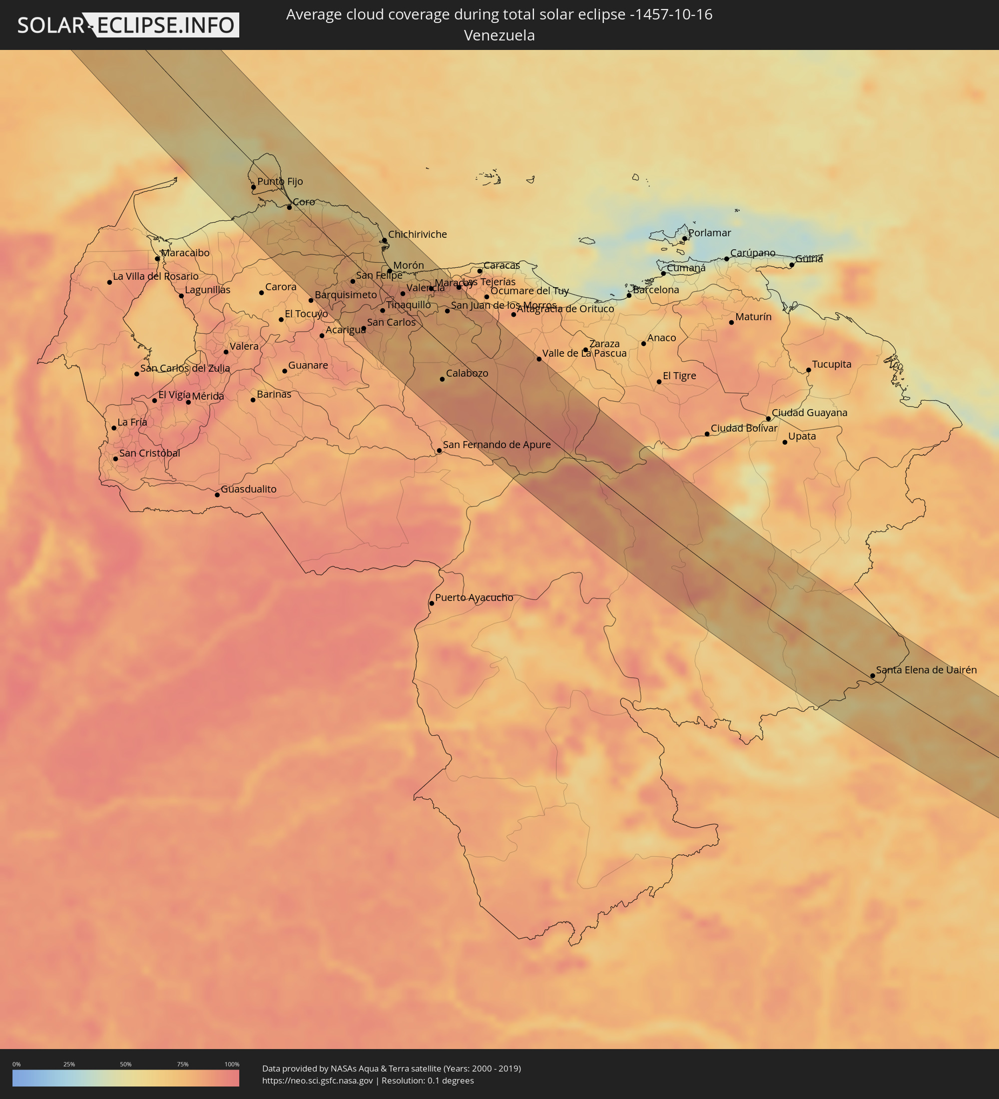 Venezuela
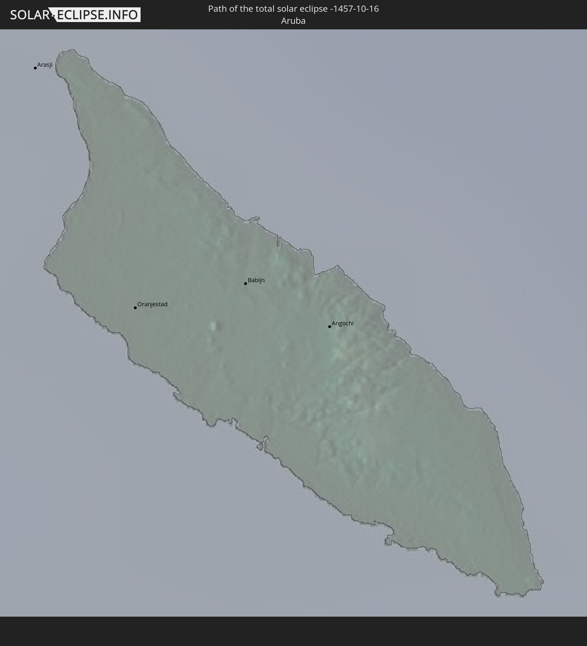
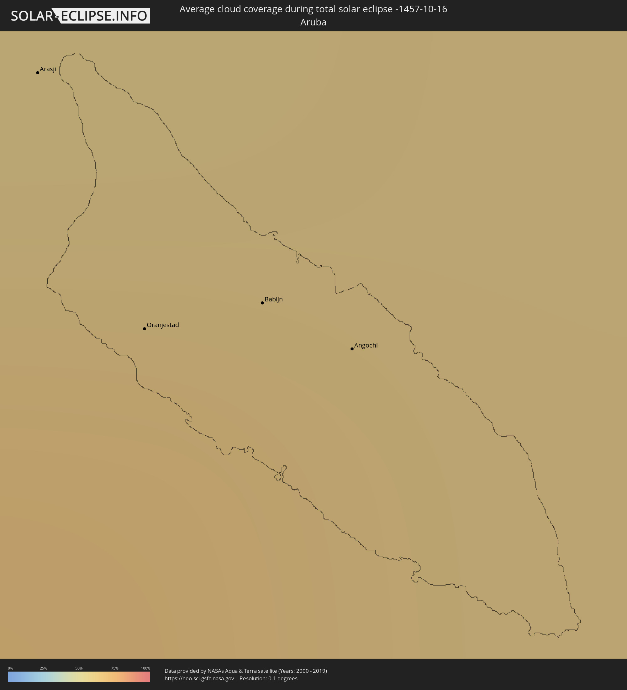 Aruba
Aruba
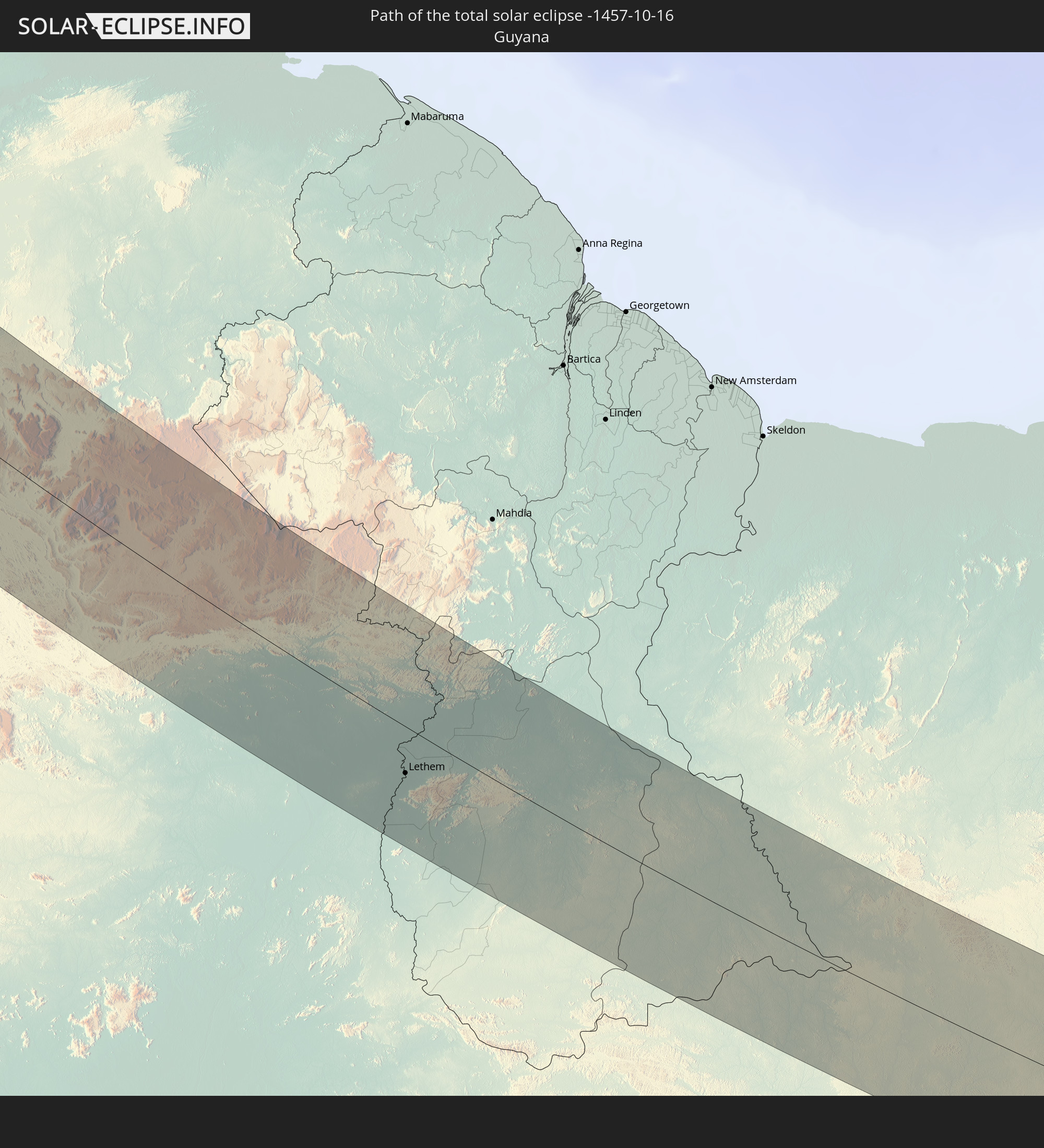
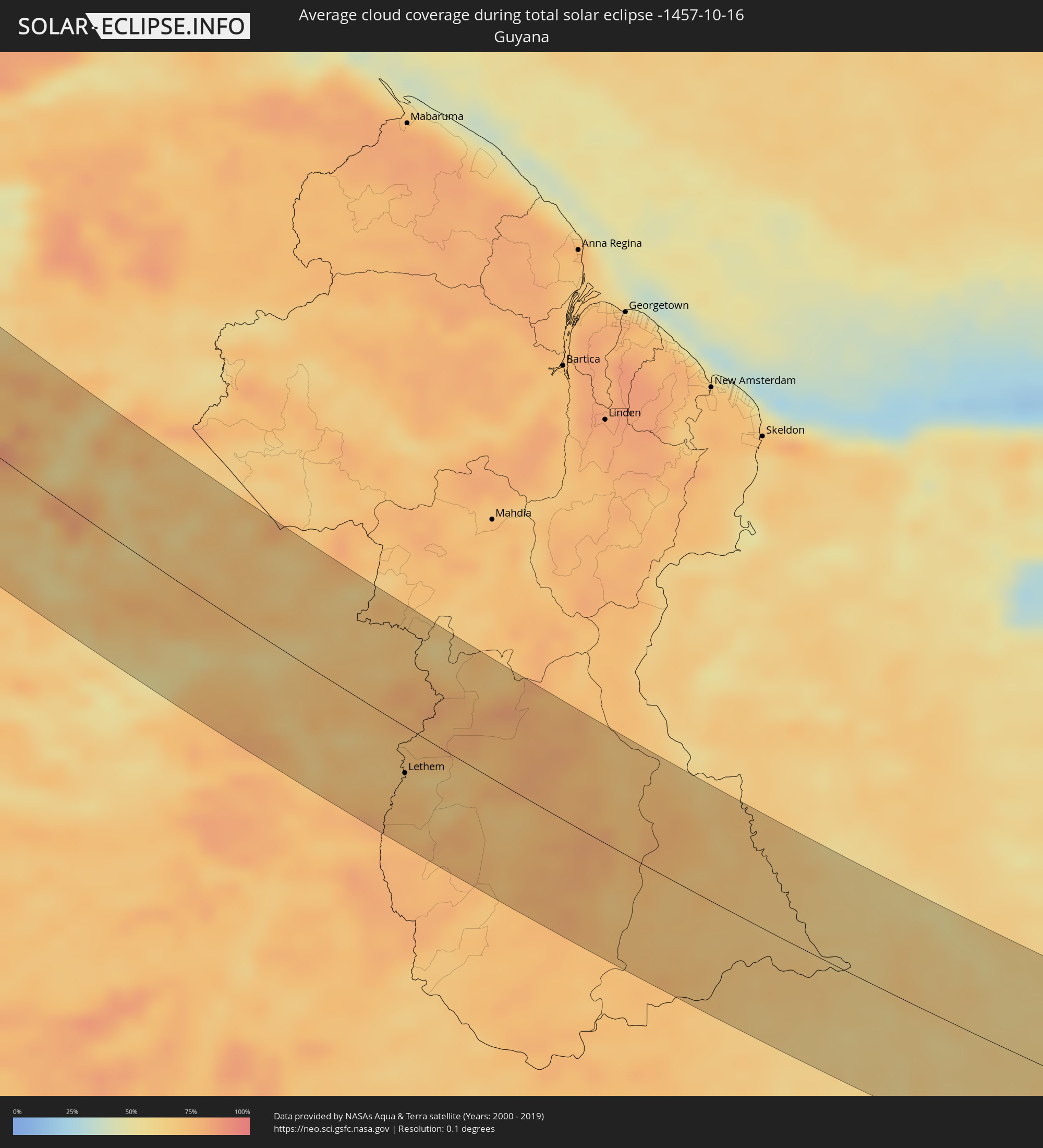 Guyana
 Suriname
Cities inside the path of the eclipse
The following table shows all locations with a population of more than 5,000 inside the eclipse path. Cities which have more than 100,000 inhabitants are marked bold. A click at the locations opens a detailed map.
| City | Type | Eclipse duration | Local time of max. eclipse | Distance to central line | Ø Cloud coverage |
|
Whistler, British Columbia
|
total | - | 08:22:44 UTC-08:00 | 42 km | 71% |
|
Merritt, British Columbia
|
total | - | 08:24:01 UTC-08:00 | 21 km | 69% |
|
Summerland, British Columbia
|
total | - | 08:24:35 UTC-08:00 | 4 km | 66% |
|
Penticton, British Columbia
|
total | - | 08:24:36 UTC-08:00 | 5 km | 67% |
|
West Kelowna, British Columbia
|
total | - | 08:24:42 UTC-08:00 | 33 km | 69% |
|
Kelowna, British Columbia
|
total | - | 08:24:46 UTC-08:00 | 38 km | 68% |
|
Trail, British Columbia
|
total | - | 08:25:46 UTC-08:00 | 17 km | 64% |
|
Castlegar, British Columbia
|
total | - | 08:25:50 UTC-08:00 | 38 km | 64% |
|
Helena, Montana
|
total | - | 09:29:50 UTC-07:00 | 22 km | 61% |
|
Billings, Montana
|
total | - | 09:32:58 UTC-07:00 | 46 km | 57% |
|
Gillette, Wyoming
|
total | - | 09:36:08 UTC-07:00 | 43 km | 48% |
|
North Platte, Nebraska
|
total | - | 10:42:30 UTC-06:00 | 3 km | 50% |
|
Kearney, Nebraska
|
total | - | 10:44:42 UTC-06:00 | 51 km | 57% |
|
Salina, Kansas
|
total | - | 10:47:44 UTC-06:00 | 23 km | 47% |
|
Manhattan, Kansas
|
total | - | 10:48:47 UTC-06:00 | 65 km | 50% |
|
Emporia, Kansas
|
total | - | 10:49:52 UTC-06:00 | 24 km | 46% |
|
Joplin, Missouri
|
total | - | 10:53:10 UTC-06:00 | 17 km | 50% |
|
Bella Vista, Arkansas
|
total | - | 10:54:02 UTC-06:00 | 17 km | 42% |
|
Fayetteville, Arkansas
|
total | - | 10:54:36 UTC-06:00 | 43 km | 41% |
|
Rogers, Arkansas
|
total | - | 10:54:23 UTC-06:00 | 19 km | 42% |
|
Russellville, Arkansas
|
total | - | 10:56:47 UTC-06:00 | 41 km | 40% |
|
Benton, Arkansas
|
total | - | 10:58:18 UTC-06:00 | 62 km | 40% |
|
Conway, Arkansas
|
total | - | 10:57:56 UTC-06:00 | 12 km | 42% |
|
Little Rock, Arkansas
|
total | - | 10:58:31 UTC-06:00 | 28 km | 43% |
|
Jacksonville, Arkansas
|
total | - | 10:58:38 UTC-06:00 | 7 km | 43% |
|
Pine Bluff, Arkansas
|
total | - | 10:59:29 UTC-06:00 | 50 km | 44% |
|
Greenville, Mississippi
|
total | - | 11:01:46 UTC-06:00 | 51 km | 42% |
|
Jackson, Mississippi
|
total | - | 11:04:24 UTC-06:00 | 77 km | 44% |
|
Meridian, Mississippi
|
total | - | 11:06:31 UTC-06:00 | 30 km | 42% |
|
Mobile, Alabama
|
total | - | 11:09:43 UTC-06:00 | 48 km | 36% |
|
Cantonment, Florida
|
total | - | 11:10:55 UTC-06:00 | 4 km | 40% |
|
East Pensacola Heights, Florida
|
total | - | 11:11:25 UTC-06:00 | 6 km | 43% |
|
Navarre, Florida
|
total | - | 11:11:57 UTC-06:00 | 15 km | 38% |
|
Colón, Matanzas
|
total | - | 12:04:29 UTC-05:29 | 81 km | 76% |
|
Corralillo, Villa Clara
|
total | - | 12:04:33 UTC-05:29 | 37 km | 64% |
|
Santo Domingo, Villa Clara
|
total | - | 12:05:51 UTC-05:29 | 38 km | 70% |
|
Cumanayagua, Cienfuegos
|
total | - | 12:06:42 UTC-05:29 | 65 km | 59% |
|
Ranchuelo, Villa Clara
|
total | - | 12:06:24 UTC-05:29 | 46 km | 73% |
|
Sagua la Grande, Villa Clara
|
total | - | 12:05:44 UTC-05:29 | 9 km | 71% |
|
Cifuentes, Villa Clara
|
total | - | 12:06:04 UTC-05:29 | 18 km | 71% |
|
Trinidad, Sancti Spíritus
|
total | - | 12:07:43 UTC-05:29 | 73 km | 58% |
|
Manicaragua, Villa Clara
|
total | - | 12:07:05 UTC-05:29 | 48 km | 68% |
|
Santa Clara, Villa Clara
|
total | - | 12:06:39 UTC-05:29 | 29 km | 71% |
|
Condado, Sancti Spíritus
|
total | - | 12:07:50 UTC-05:29 | 56 km | 64% |
|
Camajuaní, Villa Clara
|
total | - | 12:06:53 UTC-05:29 | 6 km | 70% |
|
Placetas, Villa Clara
|
total | - | 12:07:21 UTC-05:29 | 10 km | 73% |
|
Cabaiguán, Sancti Spíritus
|
total | - | 12:08:03 UTC-05:29 | 14 km | 75% |
|
Caibarién, Villa Clara
|
total | - | 12:07:18 UTC-05:29 | 19 km | 68% |
|
Sancti Spíritus, Sancti Spíritus
|
total | - | 12:08:25 UTC-05:29 | 20 km | 60% |
|
Yaguajay, Sancti Spíritus
|
total | - | 12:08:03 UTC-05:29 | 24 km | 80% |
|
Ciego de Ávila, Ciego de Ávila
|
total | - | 12:09:45 UTC-05:29 | 28 km | 73% |
|
Morón, Ciego de Ávila
|
total | - | 12:09:29 UTC-05:29 | 58 km | 78% |
|
Florida, Camagüey
|
total | - | 12:11:15 UTC-05:29 | 49 km | 70% |
|
Camagüey, Camagüey
|
total | - | 12:12:03 UTC-05:29 | 64 km | 69% |
|
Amancio, Las Tunas
|
total | - | 12:13:42 UTC-05:29 | 51 km | 61% |
|
Jobabo, Las Tunas
|
total | - | 12:14:03 UTC-05:29 | 82 km | 61% |
|
Manzanillo, Granma
|
total | - | 12:15:23 UTC-05:29 | 55 km | 51% |
|
Ocho Rios, St Ann
|
total | - | 12:41:34 UTC-05:07 | 81 km | 77% |
|
Bartolomé Masó, Granma
|
total | - | 12:16:02 UTC-05:29 | 57 km | 60% |
|
Port Maria, St. Mary
|
total | - | 12:42:01 UTC-05:07 | 66 km | 66% |
|
Half Way Tree, St. Andrew
|
total | - | 12:42:52 UTC-05:07 | 84 km | 73% |
|
Constant Spring, St. Andrew
|
total | - | 12:42:48 UTC-05:07 | 81 km | 84% |
|
Kingston, Kingston
|
total | - | 12:42:54 UTC-05:07 | 85 km | 73% |
|
Stony Hill, St. Andrew
|
total | - | 12:42:45 UTC-05:07 | 78 km | 84% |
|
New Kingston, St. Andrew
|
total | - | 12:42:54 UTC-05:07 | 83 km | 73% |
|
Annotto Bay, St. Mary
|
total | - | 12:42:25 UTC-05:07 | 63 km | 69% |
|
Yallahs, St. Thomas
|
total | - | 12:43:33 UTC-05:07 | 75 km | 66% |
|
Port Antonio, Portland
|
total | - | 12:43:09 UTC-05:07 | 44 km | 69% |
|
Morant Bay, St. Thomas
|
total | - | 12:43:48 UTC-05:07 | 62 km | 65% |
|
Punta Cardón, Falcón
|
total | - | 13:46:27 UTC-04:27 | 31 km | 61% |
|
Punto Fijo, Falcón
|
total | - | 13:46:24 UTC-04:27 | 27 km | 61% |
|
Arasji
|
total | - | 13:36:41 UTC-04:35 | 55 km | 65% |
|
Oranjestad
|
total | - | 13:36:57 UTC-04:35 | 51 km | 68% |
|
Babijn
|
total | - | 13:37:00 UTC-04:35 | 55 km | 68% |
|
Angochi
|
total | - | 13:37:05 UTC-04:35 | 56 km | 68% |
|
Coro, Falcón
|
total | - | 13:47:53 UTC-04:27 | 10 km | 71% |
|
Los Rastrojos, Lara
|
total | - | 13:51:20 UTC-04:27 | 87 km | 83% |
|
Yaritagua, Yaracuy
|
total | - | 13:51:26 UTC-04:27 | 73 km | 85% |
|
Chivacoa, Yaracuy
|
total | - | 13:51:40 UTC-04:27 | 49 km | 83% |
|
San Felipe, Yaracuy
|
total | - | 13:51:34 UTC-04:27 | 23 km | 82% |
|
San Carlos, Cojedes
|
total | - | 13:53:10 UTC-04:27 | 66 km | 85% |
|
Tinaquillo, Cojedes
|
total | - | 13:53:08 UTC-04:27 | 25 km | 84% |
|
Morón, Carabobo
|
total | - | 13:52:12 UTC-04:27 | 29 km | 82% |
|
Puerto Cabello, Carabobo
|
total | - | 13:52:32 UTC-04:27 | 41 km | 78% |
|
Valencia, Carabobo
|
total | - | 13:53:10 UTC-04:27 | 17 km | 82% |
|
Tacarigua, Carabobo
|
total | - | 13:53:28 UTC-04:27 | 18 km | 83% |
|
Guacara, Carabobo
|
total | - | 13:53:16 UTC-04:27 | 32 km | 73% |
|
San Joaquín, Carabobo
|
total | - | 13:53:21 UTC-04:27 | 42 km | 66% |
|
Güigüe, Carabobo
|
total | - | 13:53:42 UTC-04:27 | 28 km | 79% |
|
Mariara, Carabobo
|
total | - | 13:53:24 UTC-04:27 | 50 km | 65% |
|
Maracay, Aragua
|
total | - | 13:53:44 UTC-04:27 | 54 km | 68% |
|
Villa de Cura, Aragua
|
total | - | 13:54:17 UTC-04:27 | 46 km | 77% |
|
Cagua, Aragua
|
total | - | 13:54:03 UTC-04:27 | 60 km | 75% |
|
Calabozo, Guárico
|
total | - | 13:56:33 UTC-04:27 | 42 km | 85% |
|
San Mateo, Aragua
|
total | - | 13:54:03 UTC-04:27 | 65 km | 80% |
|
San Juan de los Morros, Guárico
|
total | - | 13:54:46 UTC-04:27 | 45 km | 77% |
|
La Victoria, Aragua
|
total | - | 13:54:12 UTC-04:27 | 72 km | 79% |
|
Valle de La Pascua, Guárico
|
total | - | 13:58:21 UTC-04:27 | 86 km | 83% |
|
Lethem, Upper Takutu-Upper Essequibo
|
total | - | 14:53:37 UTC-03:52 | 33 km | 68% |
|
Santana, Amapá
|
total | - | 19:02:39 UTC+00:00 | 32 km | 51% |
|
Macapá, Amapá
|
total | - | 16:28:39 UTC-02:34 | 47 km | 54% |
|
Abaetetuba, Pará
|
total | - | 15:53:20 UTC-03:13 | 63 km | 79% |
|
Belém, Pará
|
total | - | 15:53:23 UTC-03:13 | 23 km | 73% |
|
Ananindeua, Pará
|
total | - | 15:53:24 UTC-03:13 | 9 km | 81% |
|
Vigia, Pará
|
total | - | 15:52:59 UTC-03:13 | 52 km | 85% |
|
Castanhal, Pará
|
total | - | 15:53:45 UTC-03:13 | 13 km | 84% |
|
Igarapé Açu, Pará
|
total | - | 15:53:50 UTC-03:13 | 39 km | 87% |
|
São Miguel do Guamá, Pará
|
total | - | 15:54:35 UTC-03:13 | 10 km | 81% |
|
Capanema, Pará
|
total | - | 15:54:21 UTC-03:13 | 45 km | 87% |
|
Capitão Poço, Pará
|
total | - | 15:55:08 UTC-03:13 | 10 km | 86% |
|
Bragança, Pará
|
total | - | 15:54:34 UTC-03:13 | 73 km | 86% |
|
Pinheiro, Maranhão
|
total | - | 16:37:45 UTC-02:34 | 41 km | 83% |
|
Cururupu, Maranhão
|
total | - | 16:37:08 UTC-02:34 | 39 km | 84% |
|
São Luís, Maranhão
|
total | - | 16:38:24 UTC-02:34 | 24 km | 76% |
|
São José de Ribamar, Maranhão
|
total | - | 16:38:39 UTC-02:34 | 22 km | 63% |
|
Parnaíba, Piauí
|
total | - | 16:40:46 UTC-02:34 | 12 km | 42% |
|
Camocim, Ceará
|
total | - | 16:41:26 UTC-02:34 | 5 km | 48% |
|
Granja, Ceará
|
total | - | 16:41:40 UTC-02:34 | 19 km | 55% |
|
Acaraú, Ceará
|
total | - | 16:41:54 UTC-02:34 | 19 km | 53% |
|
Itapagé, Ceará
|
total | - | 16:43:03 UTC-02:34 | 61 km | 52% |
|
Itapipoca, Ceará
|
total | - | 16:42:52 UTC-02:34 | 40 km | 56% |
|
Trairi, Ceará
|
total | - | 16:42:51 UTC-02:34 | 12 km | 46% |
|
São Gonçalo do Amarante, Ceará
|
total | - | 16:43:21 UTC-02:34 | 44 km | 57% |
|
Fortaleza, Ceará
|
total | - | 16:43:43 UTC-02:34 | 50 km | 45% |