Total solar eclipse of 09/22/-1520
| Day of week: | Friday |
| Maximum duration of eclipse: | 02m24s |
| Maximum width of eclipse path: | 403 km |
| Saros cycle: | 39 |
| Coverage: | 100% |
| Magnitude: | 1.04 |
| Gamma: | 0.9413 |
Wo kann man die Sonnenfinsternis vom 09/22/-1520 sehen?
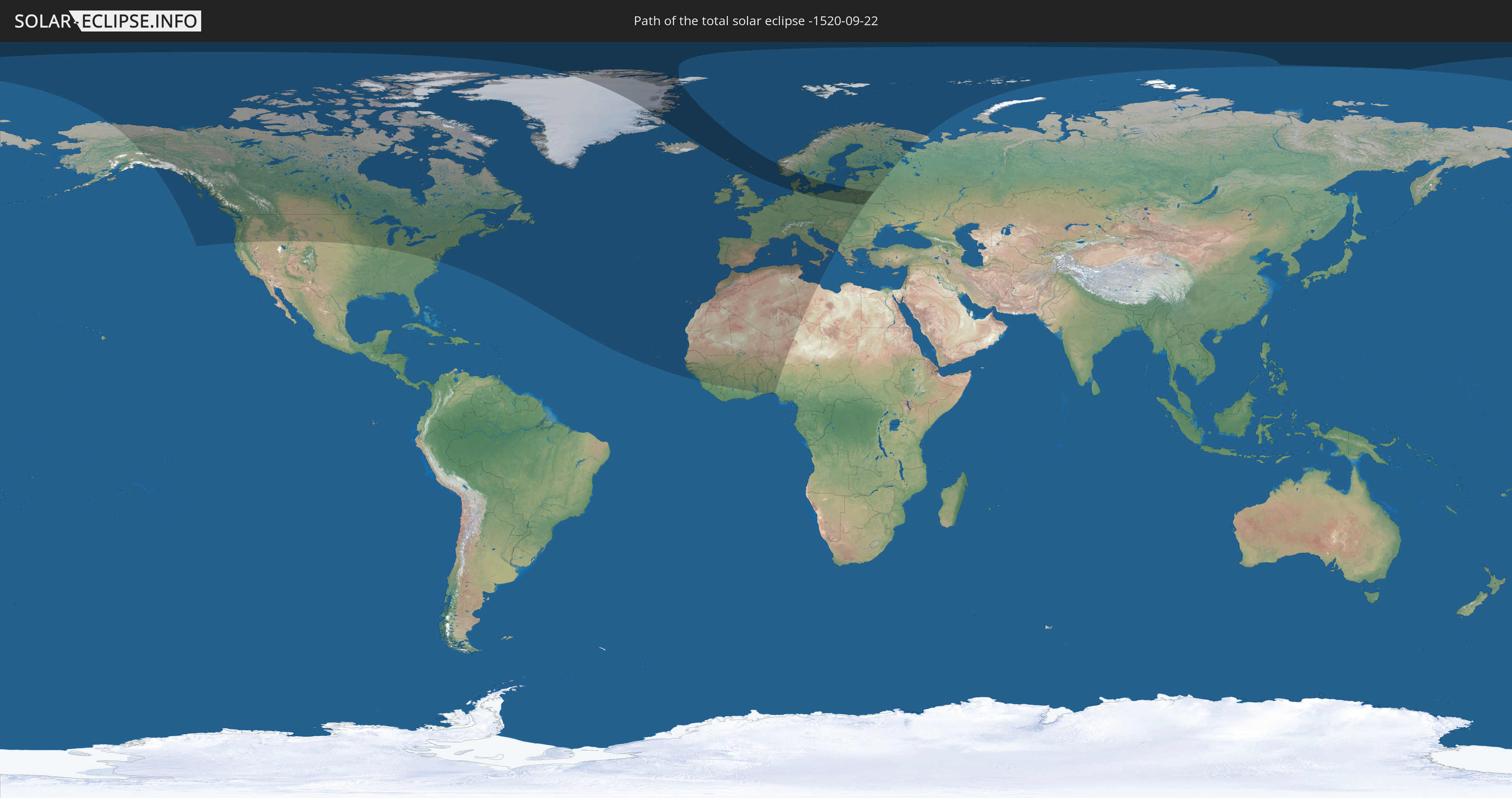
Die Sonnenfinsternis am 09/22/-1520 kann man in 71 Ländern als partielle Sonnenfinsternis beobachten.
Der Finsternispfad verläuft durch 12 Länder. Nur in diesen Ländern ist sie als total Sonnenfinsternis zu sehen.
In den folgenden Ländern ist die Sonnenfinsternis total zu sehen
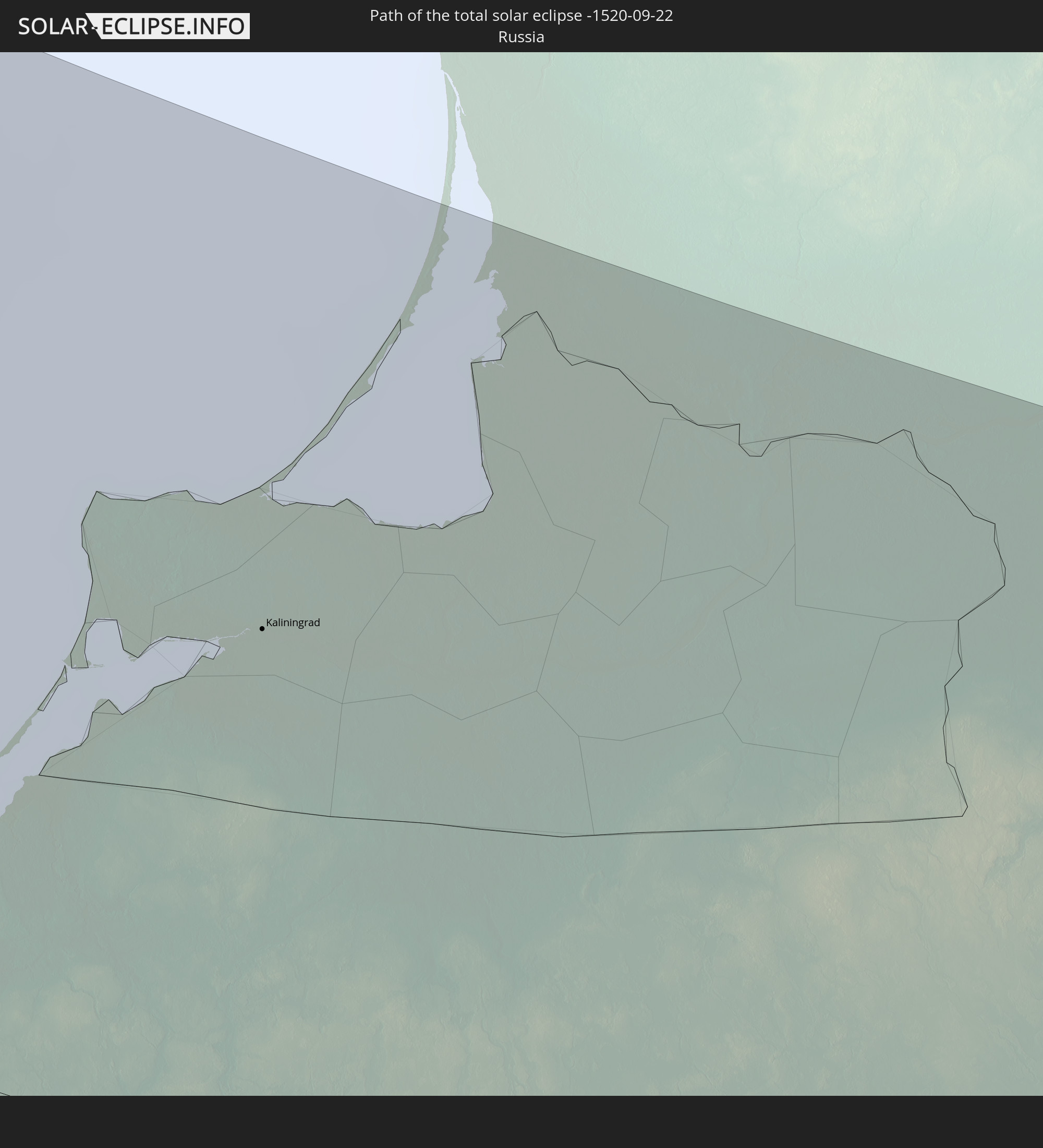 Russia
 Greenland
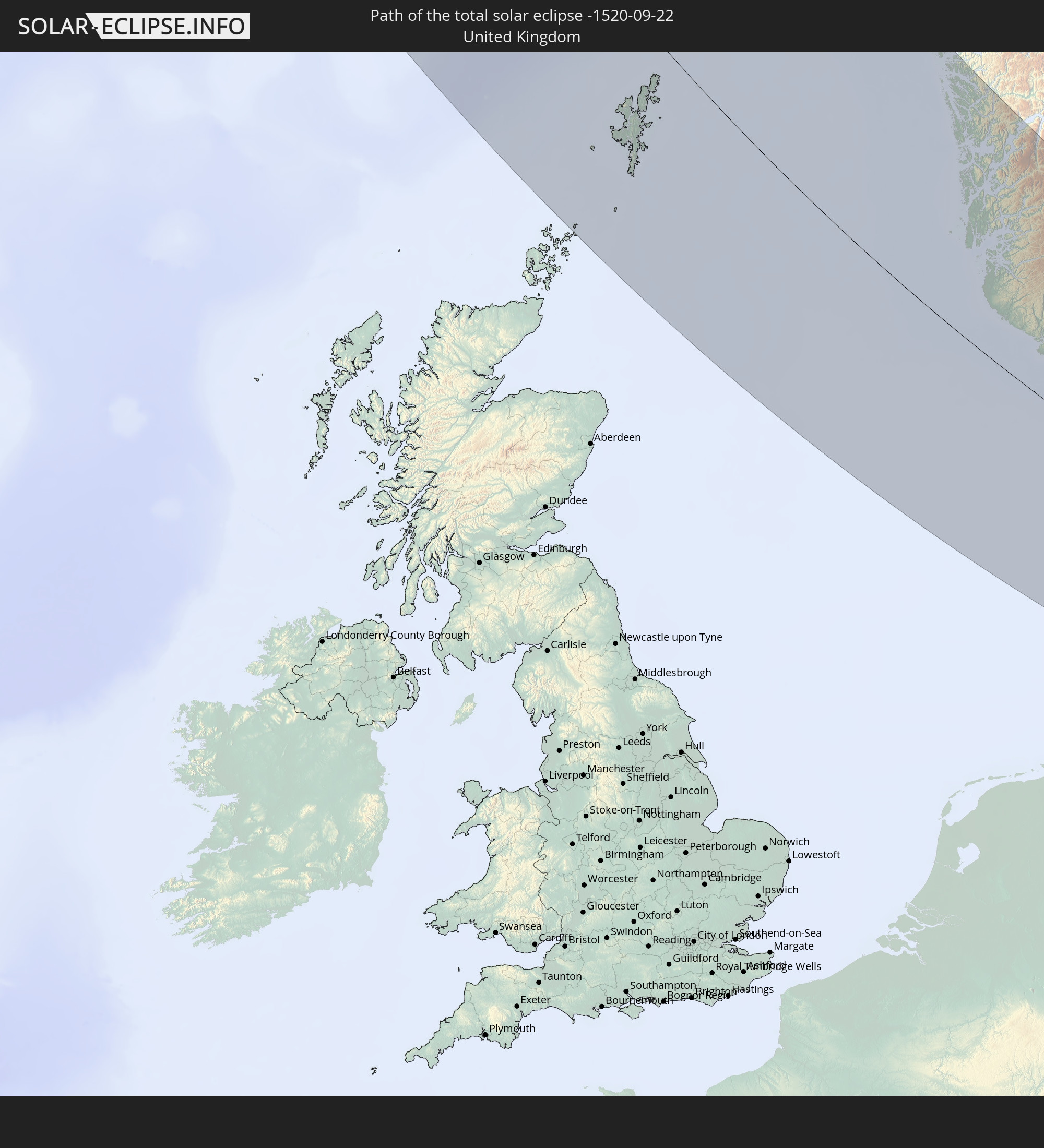 United Kingdom
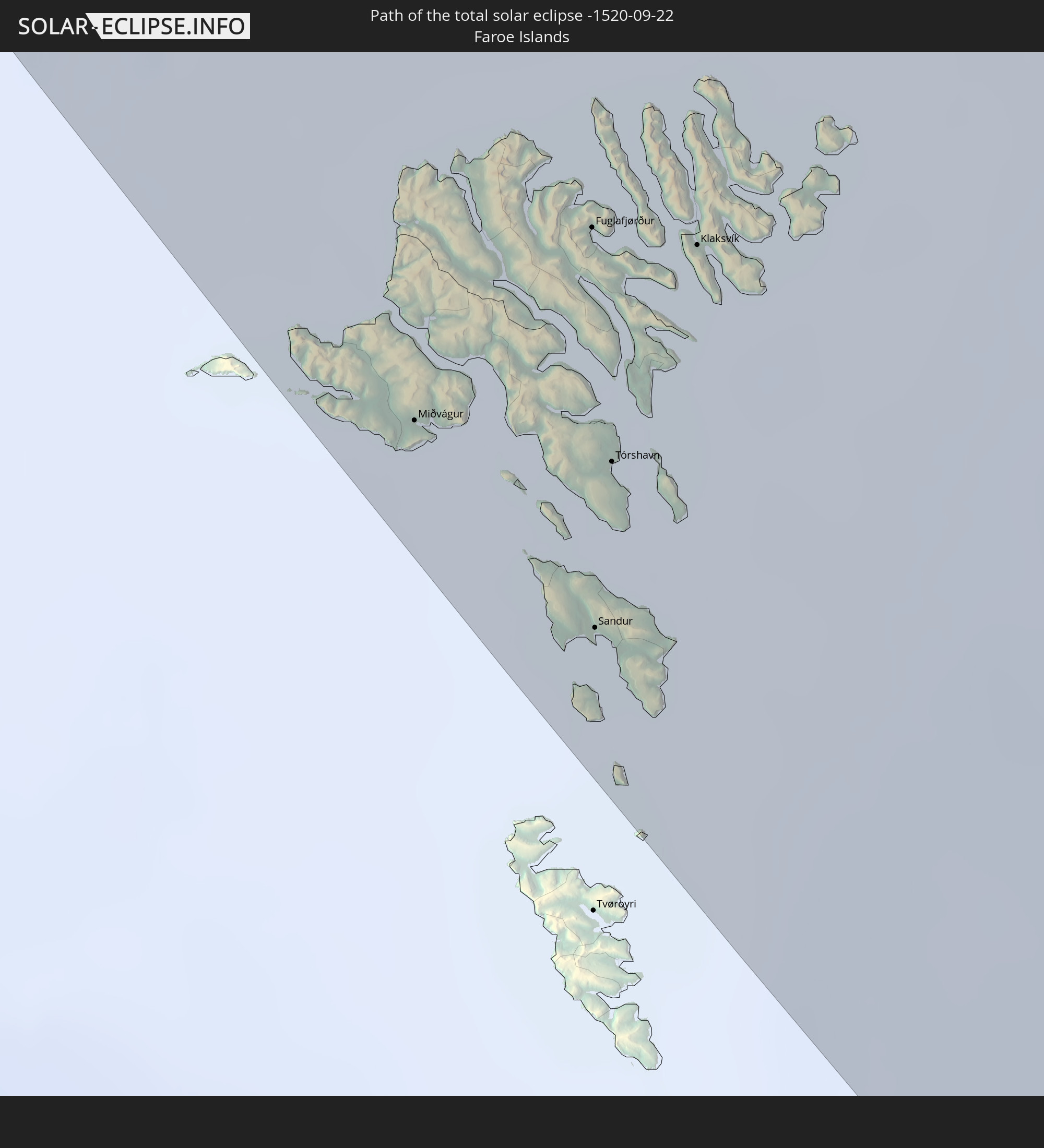 Faroe Islands
 Norway
 Germany
 Denmark
 Sweden
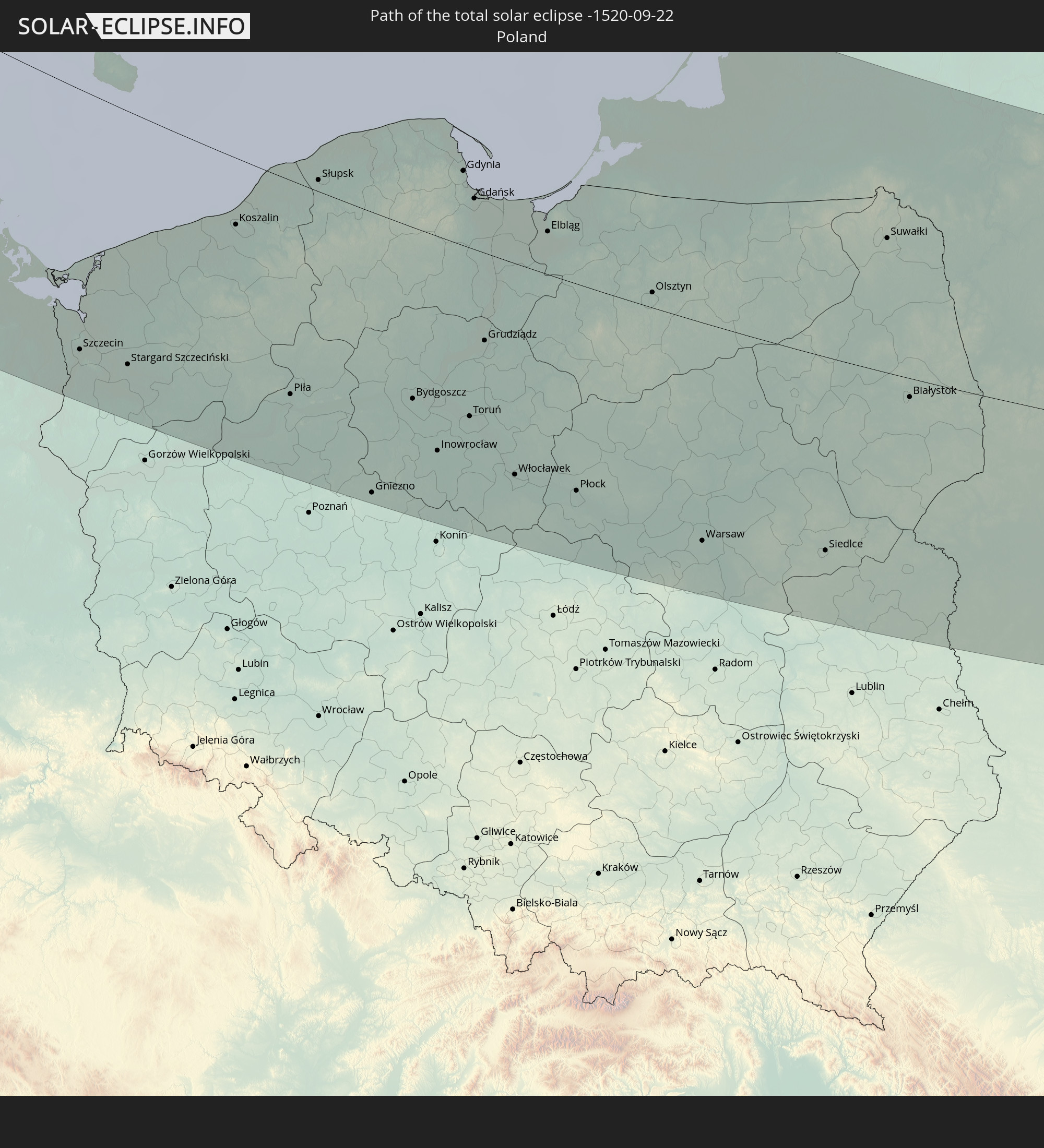 Poland
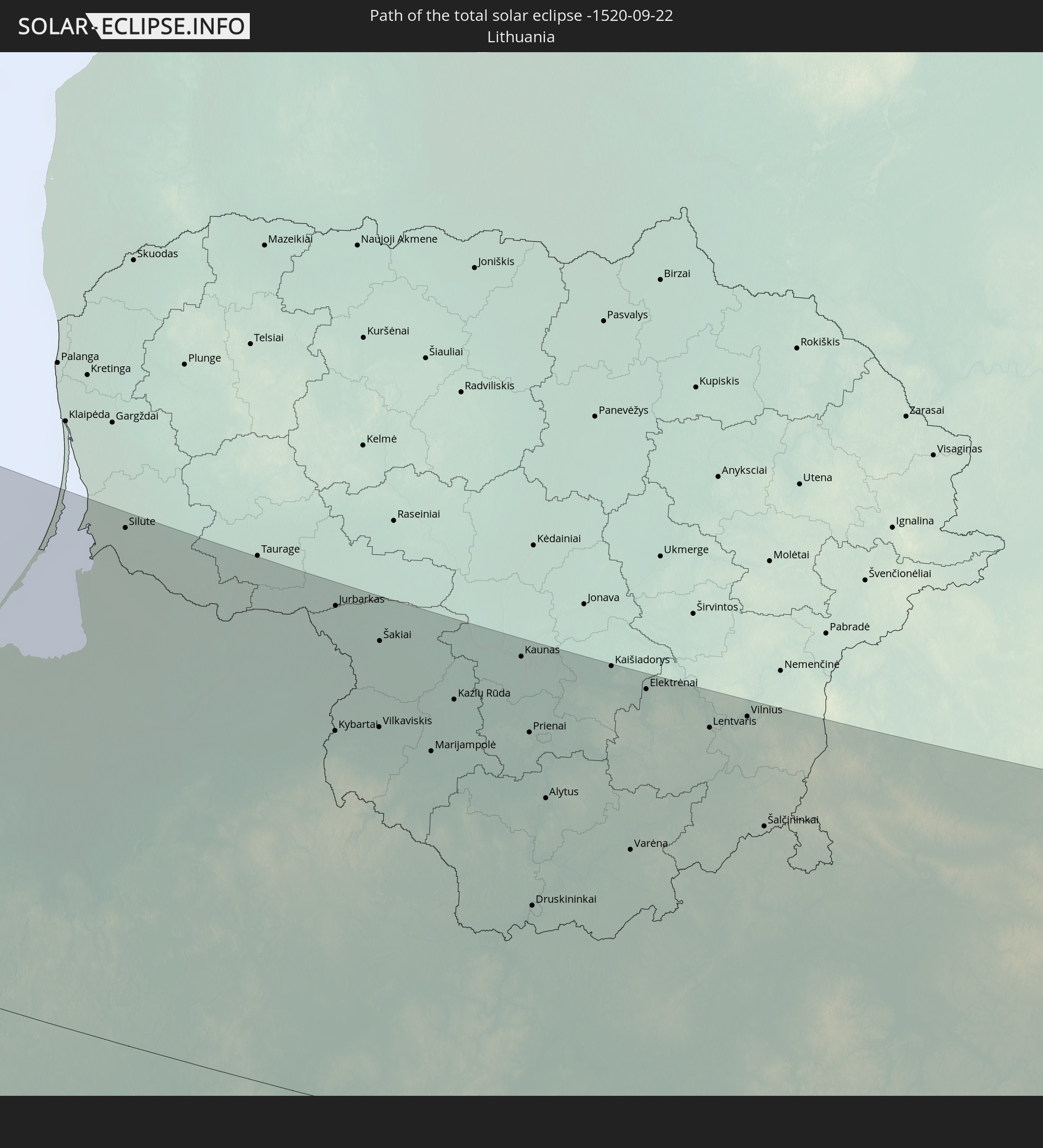 Lithuania
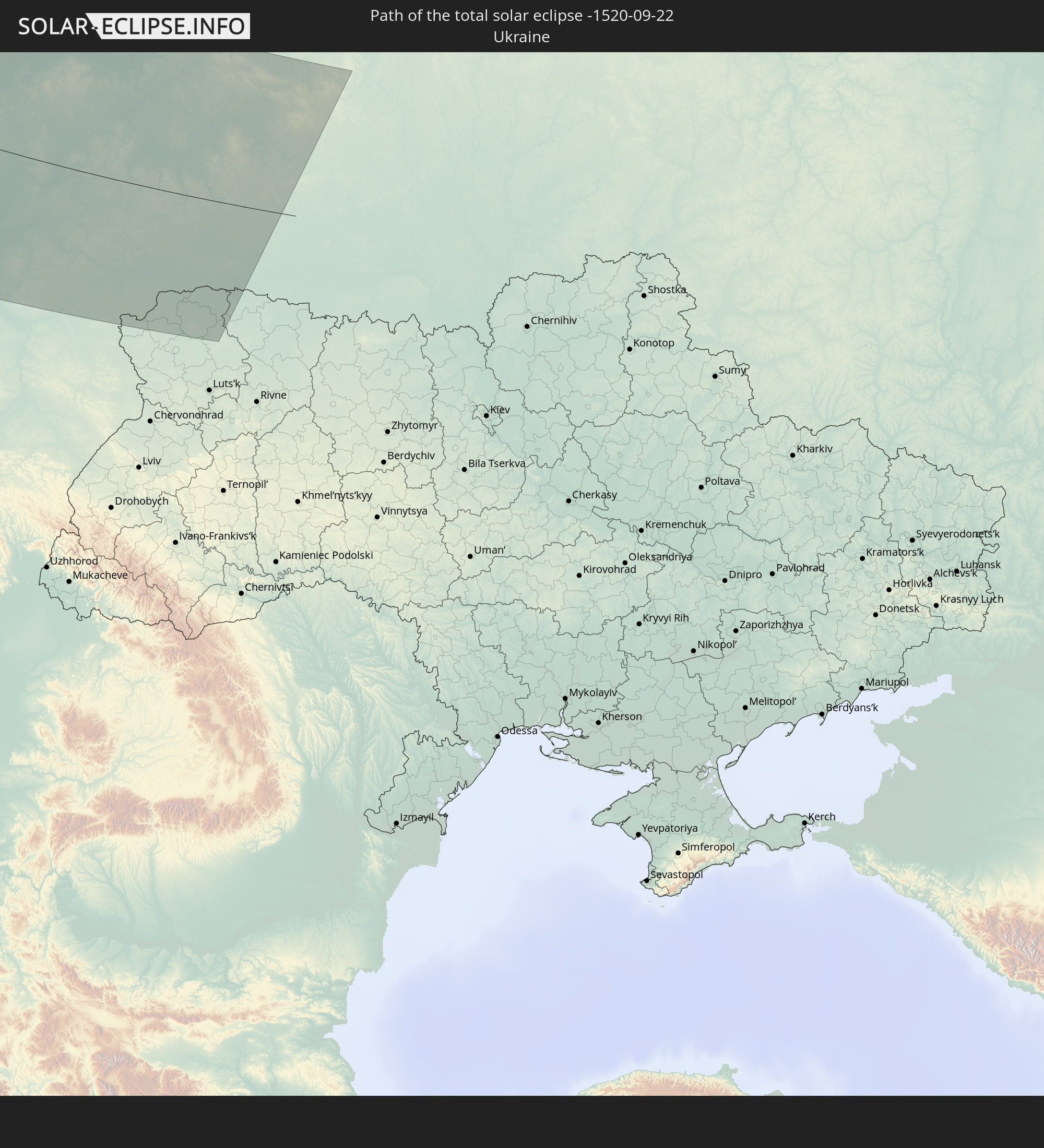 Ukraine
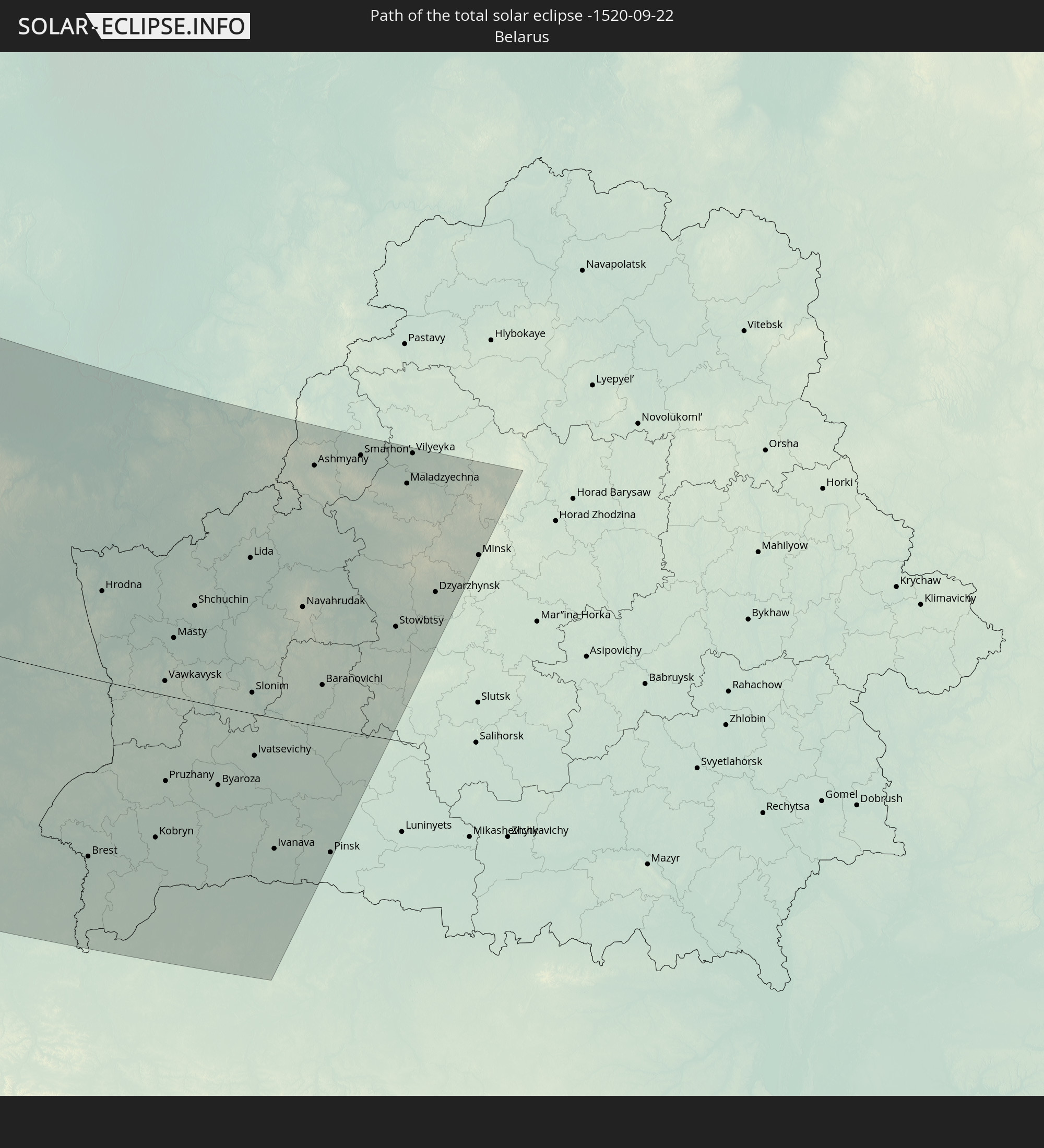 Belarus
In den folgenden Ländern ist die Sonnenfinsternis partiell zu sehen
 Russia
 United States
 Canada
 Greenland
 Saint Pierre and Miquelon
 Portugal
 Cabo Verde
 Iceland
 Spain
Spain
 Senegal
 Mauritania
 The Gambia
 Guinea-Bissau
 Guinea
 Sierra Leone
 Morocco
 Mali
Mali
 Liberia
 Republic of Ireland
 Svalbard and Jan Mayen
 Algeria
 United Kingdom
 Ivory Coast
 Faroe Islands
 Burkina Faso
 Gibraltar
 France
 Isle of Man
 Ghana
Ghana
 Guernsey
 Jersey
 Togo
Togo
 Niger
Niger
 Benin
Benin
 Andorra
 Belgium
 Nigeria
 Netherlands
 Norway
 Luxembourg
 Germany
 Switzerland
 Italy
Italy
 Monaco
 Tunisia
 Denmark
 Libya
Libya
 Liechtenstein
 Austria
 Sweden
 Czechia
 San Marino
 Vatican City
 Slovenia
 Croatia
 Poland
 Malta
Malta
 Bosnia and Herzegovina
 Hungary
 Slovakia
 Montenegro
 Serbia
 Albania
 Åland Islands
 Romania
 Finland
 Lithuania
 Latvia
 Estonia
 Ukraine
 Belarus
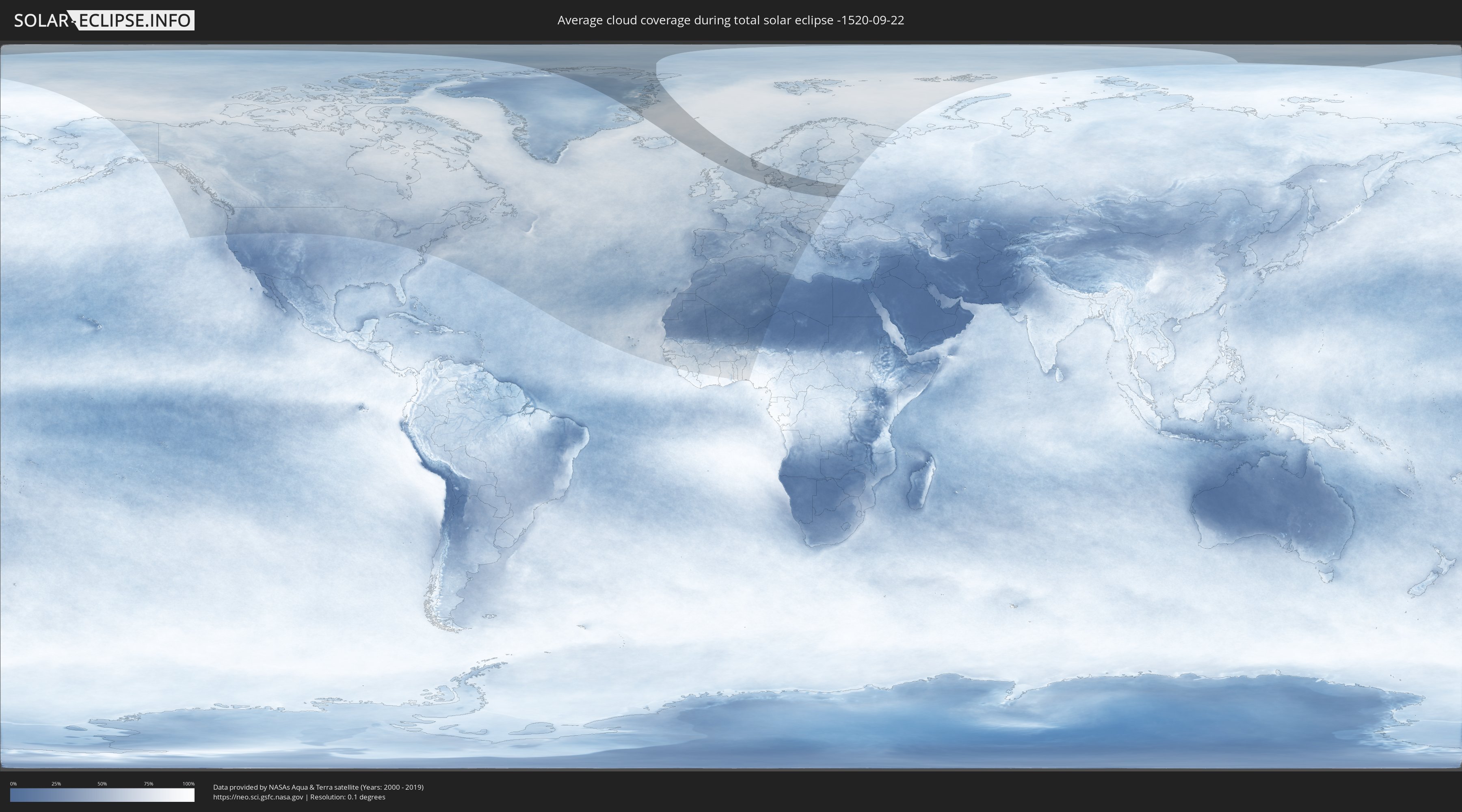
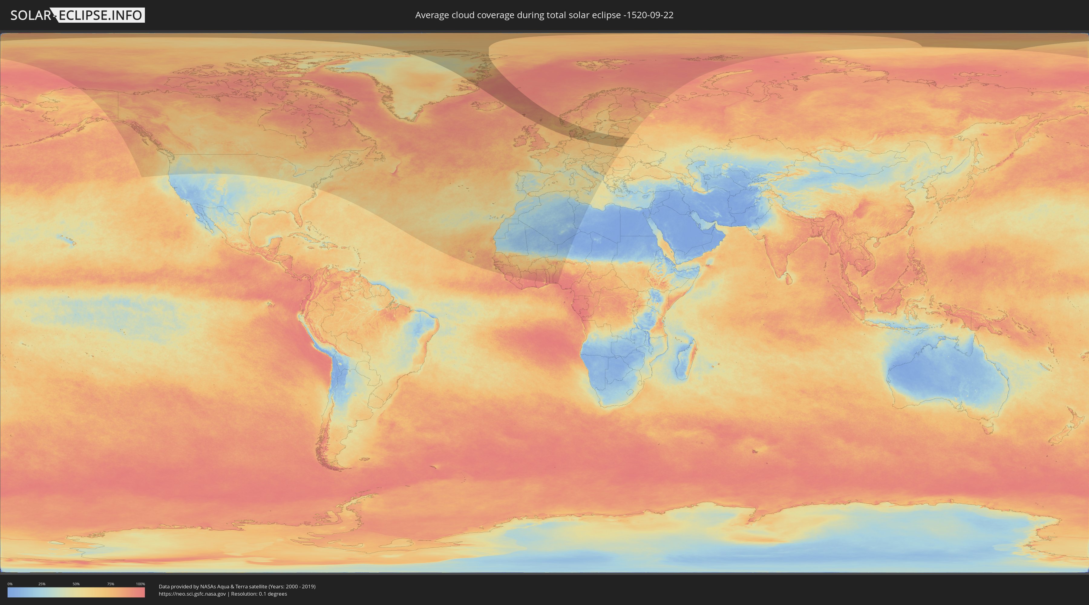
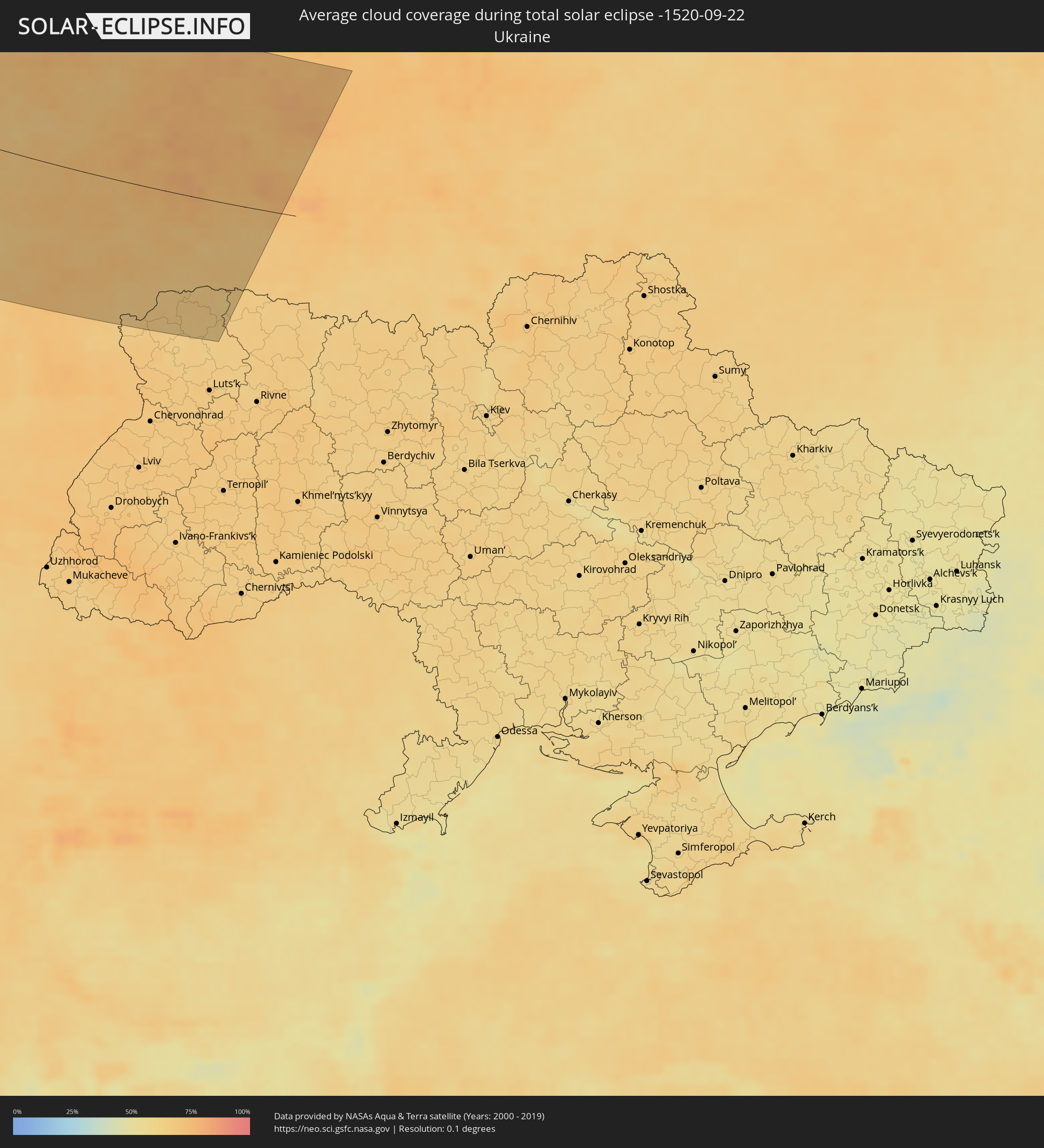
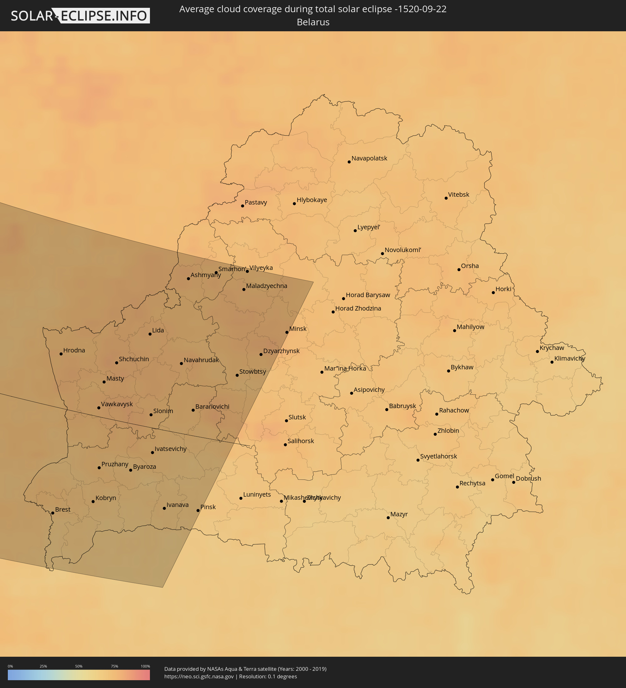
How will be the weather during the total solar eclipse on 09/22/-1520?
Where is the best place to see the total solar eclipse of 09/22/-1520?
The following maps show the average cloud coverage for the day of the total solar eclipse.
With the help of these maps, it is possible to find the place along the eclipse path, which has the best
chance of a cloudless sky.
Nevertheless, you should consider local circumstances and inform about the weather of your chosen
observation site.
The data is provided by NASAs satellites
AQUA and TERRA.
The cloud maps are averaged over a period of 19 years (2000 - 2019).
Detailed country maps
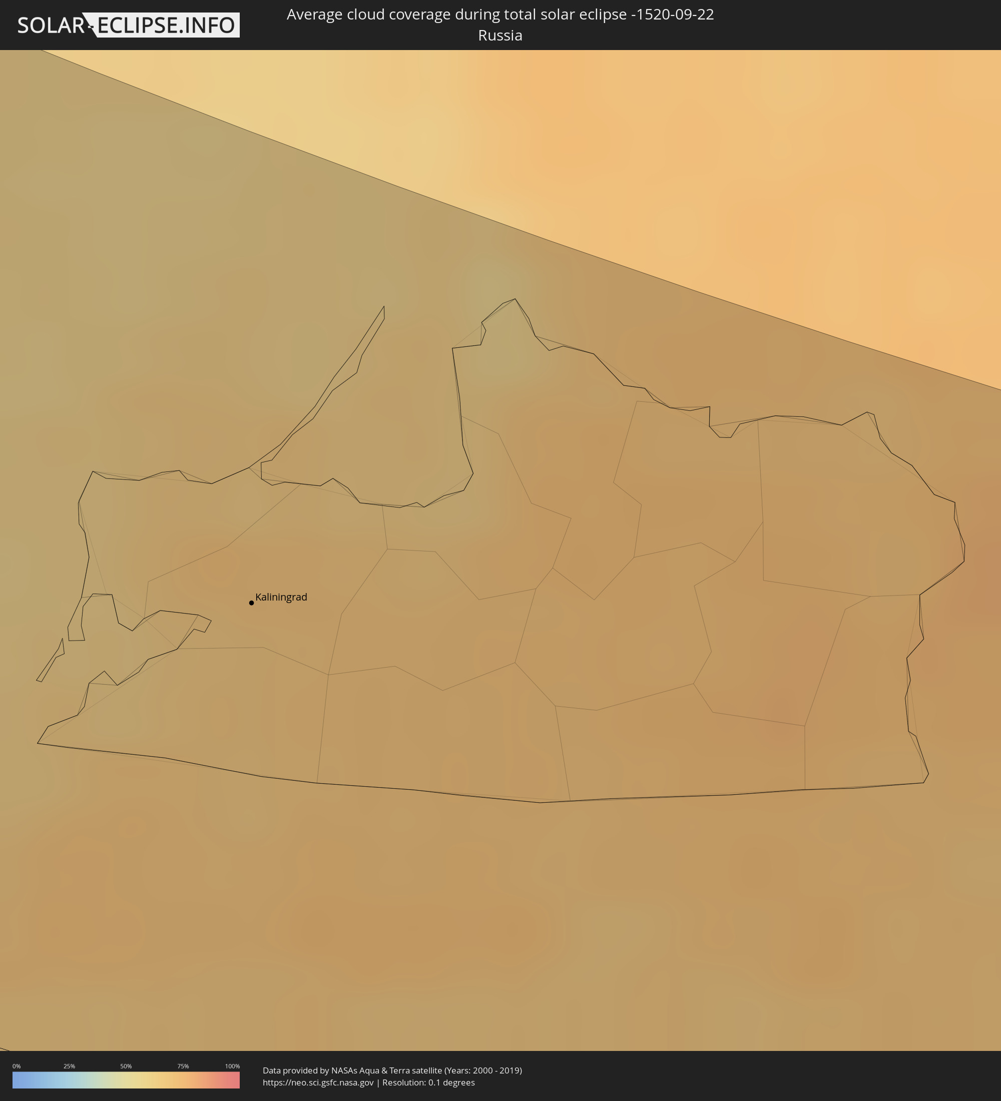 Russia
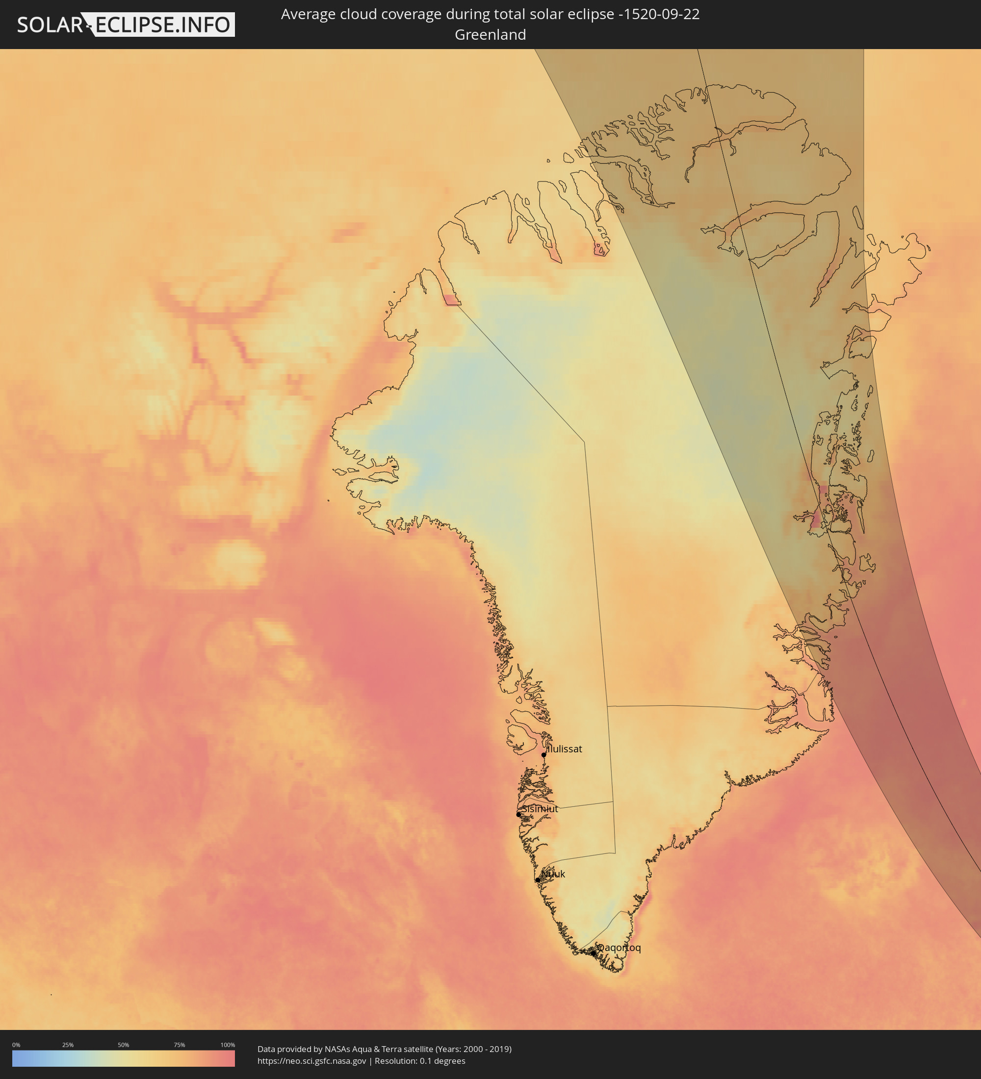 Greenland
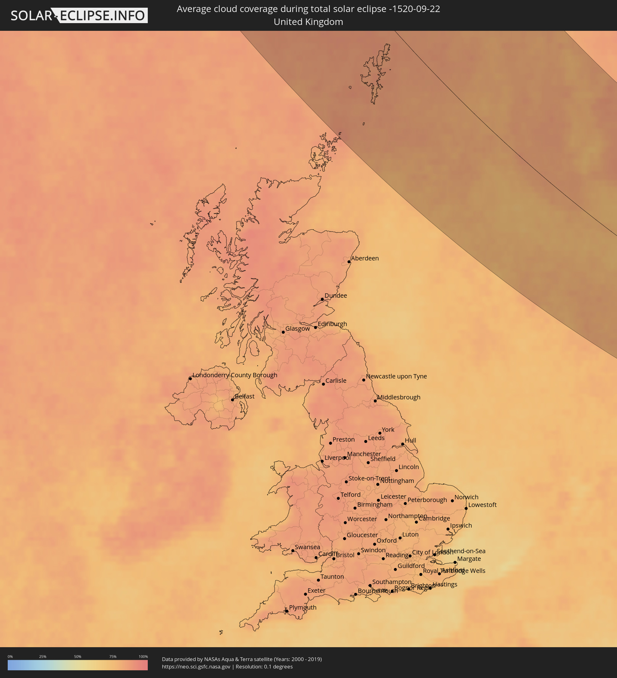 United Kingdom
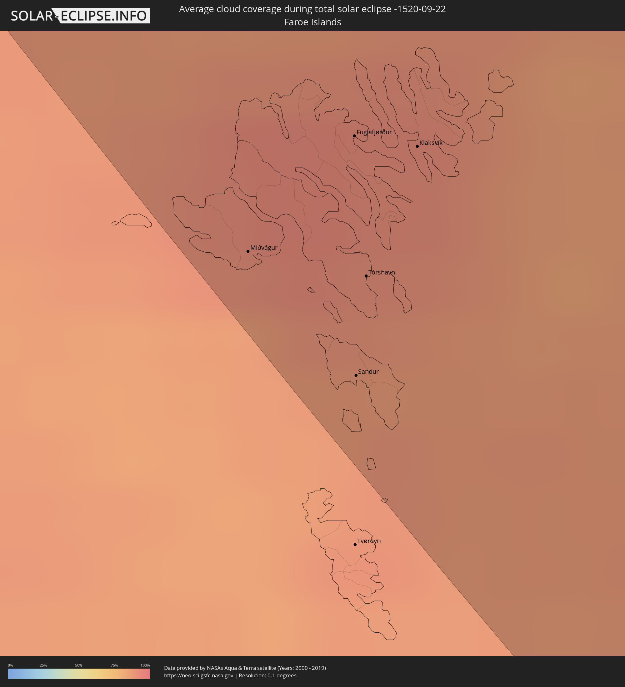 Faroe Islands
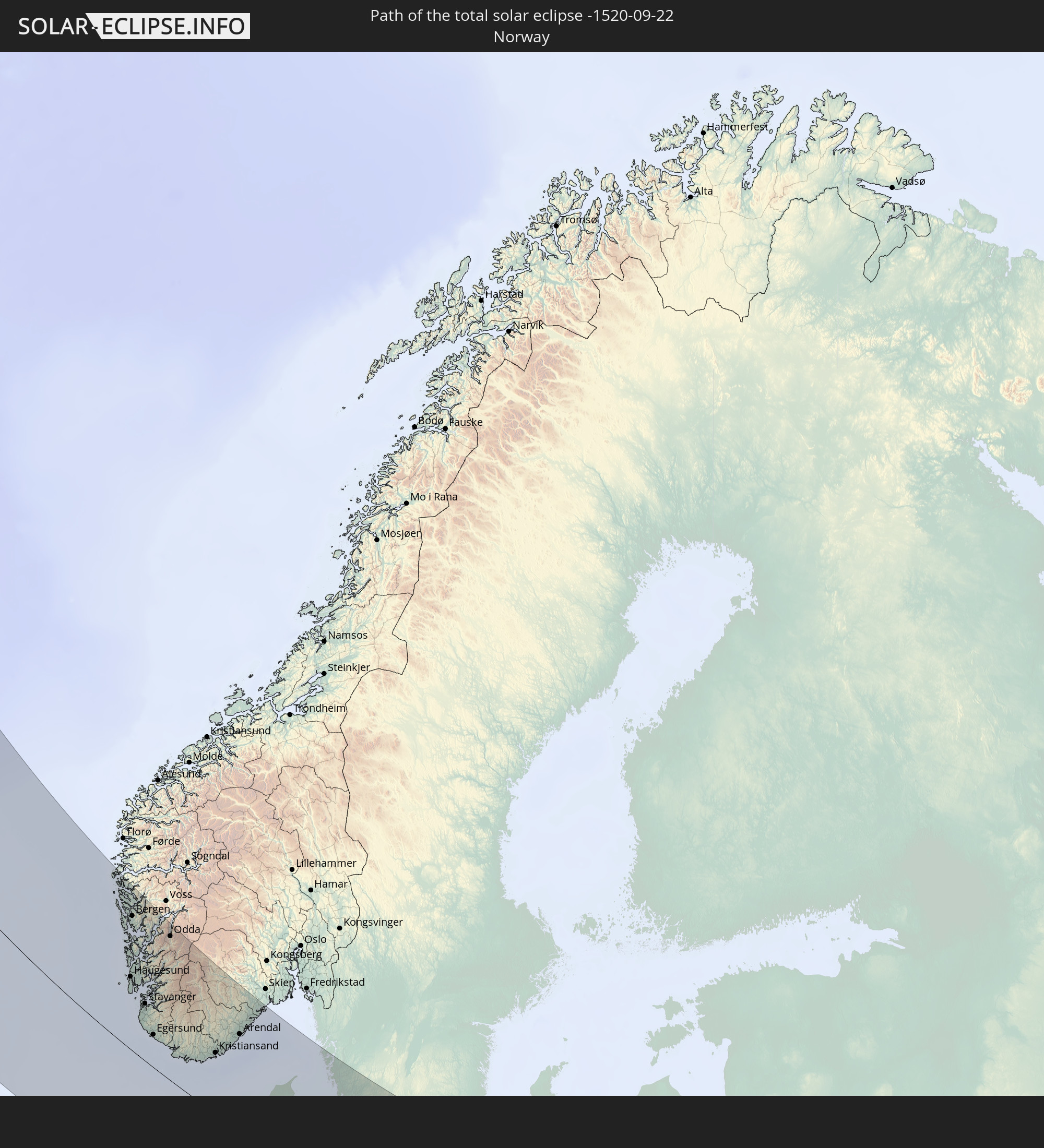
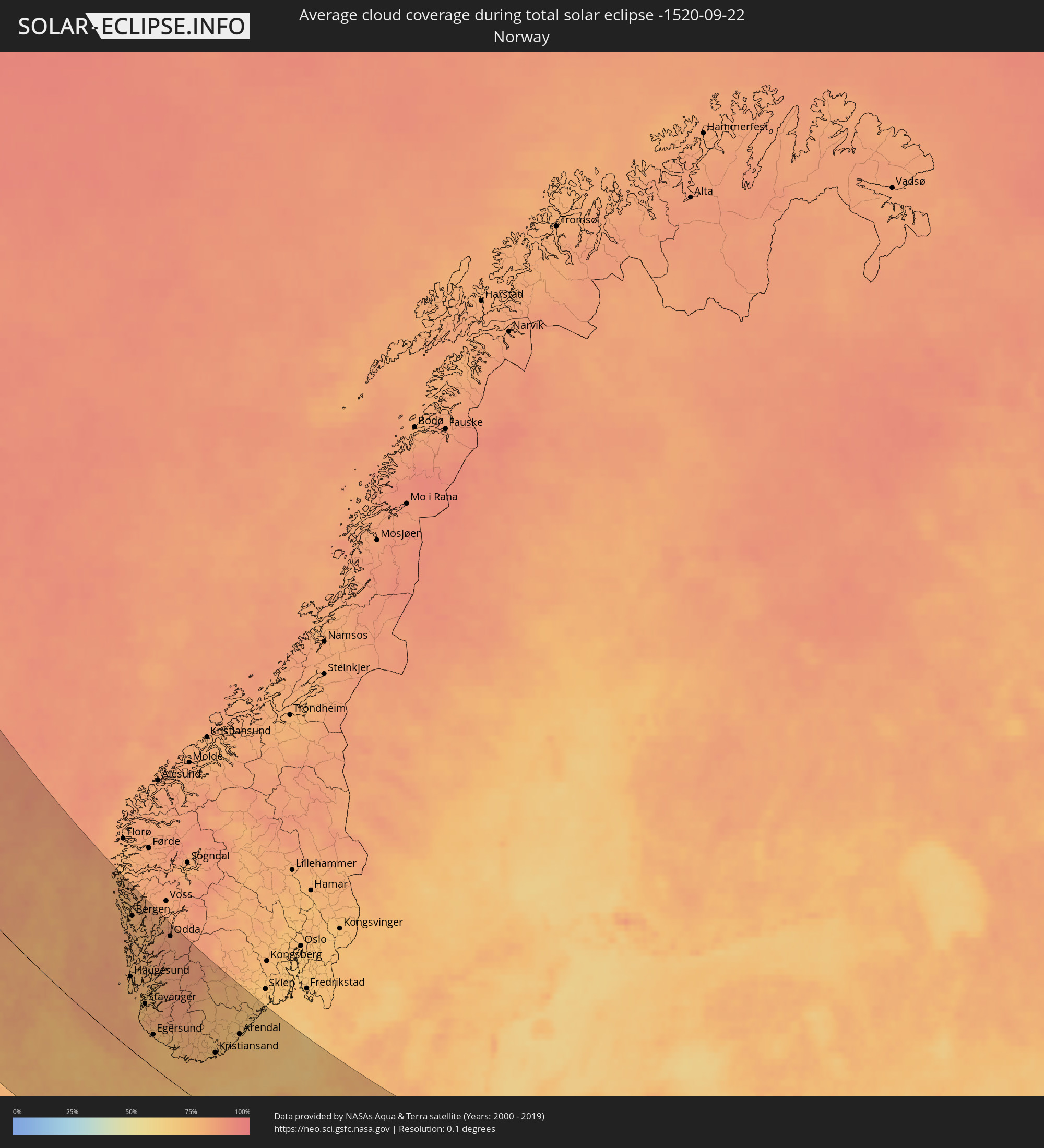 Norway
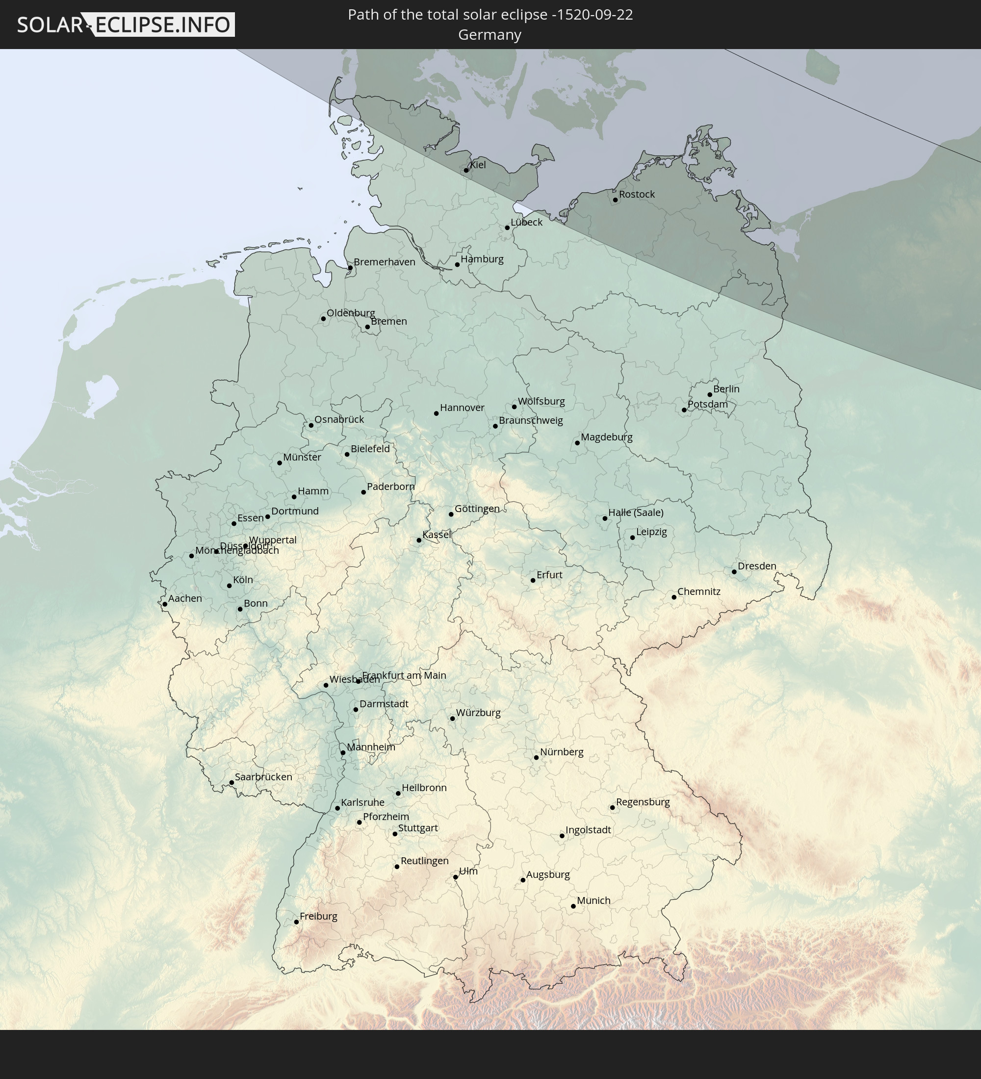
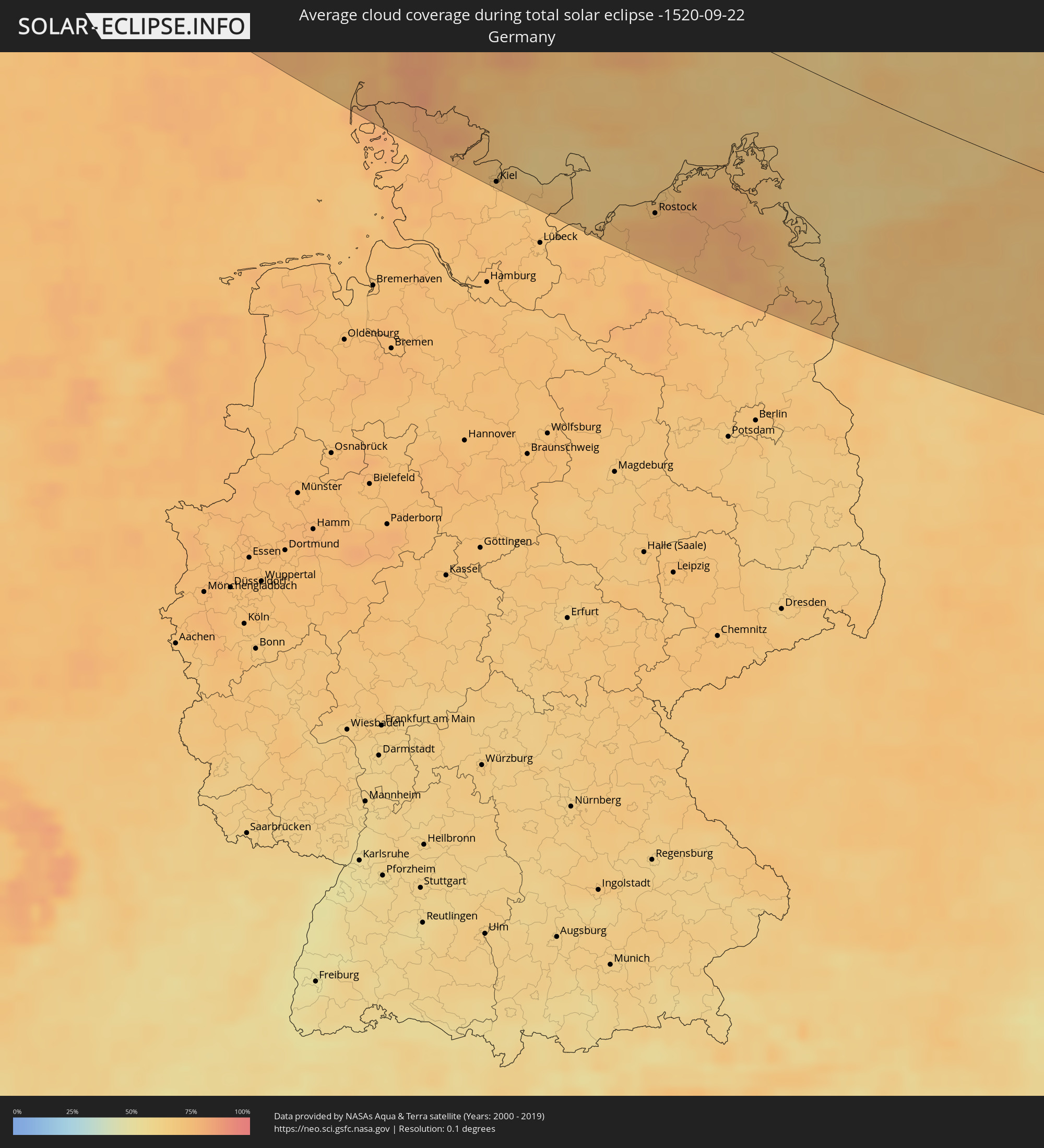 Germany
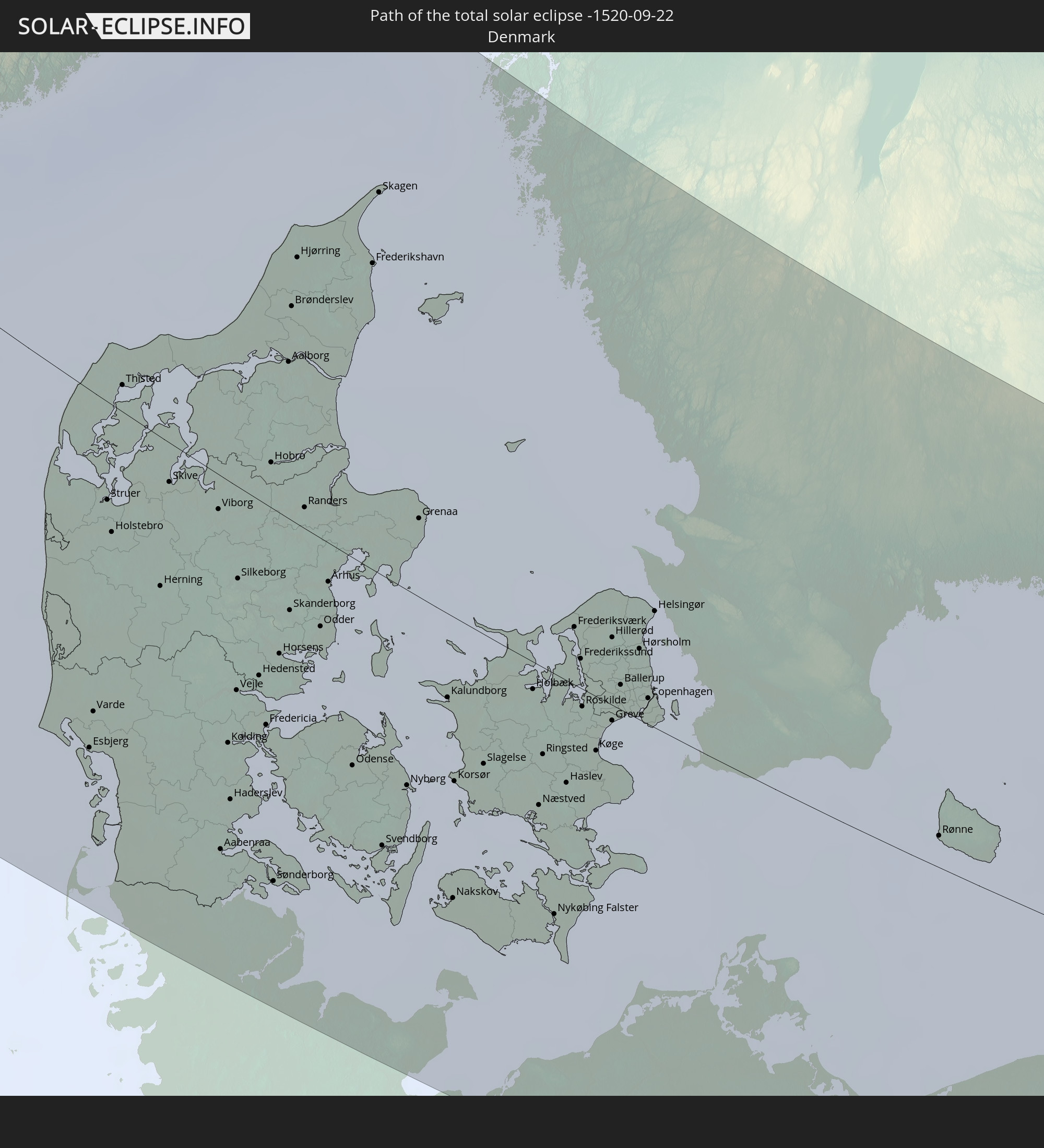
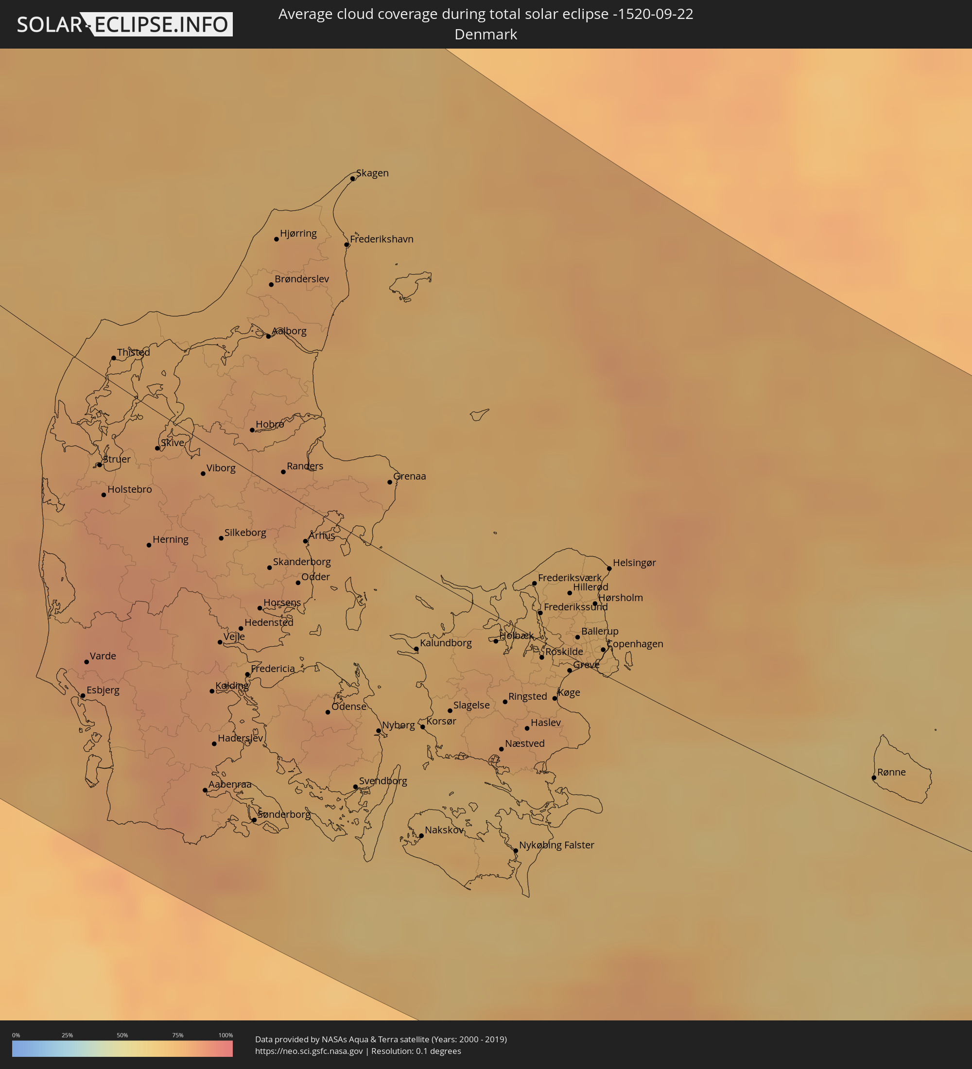 Denmark
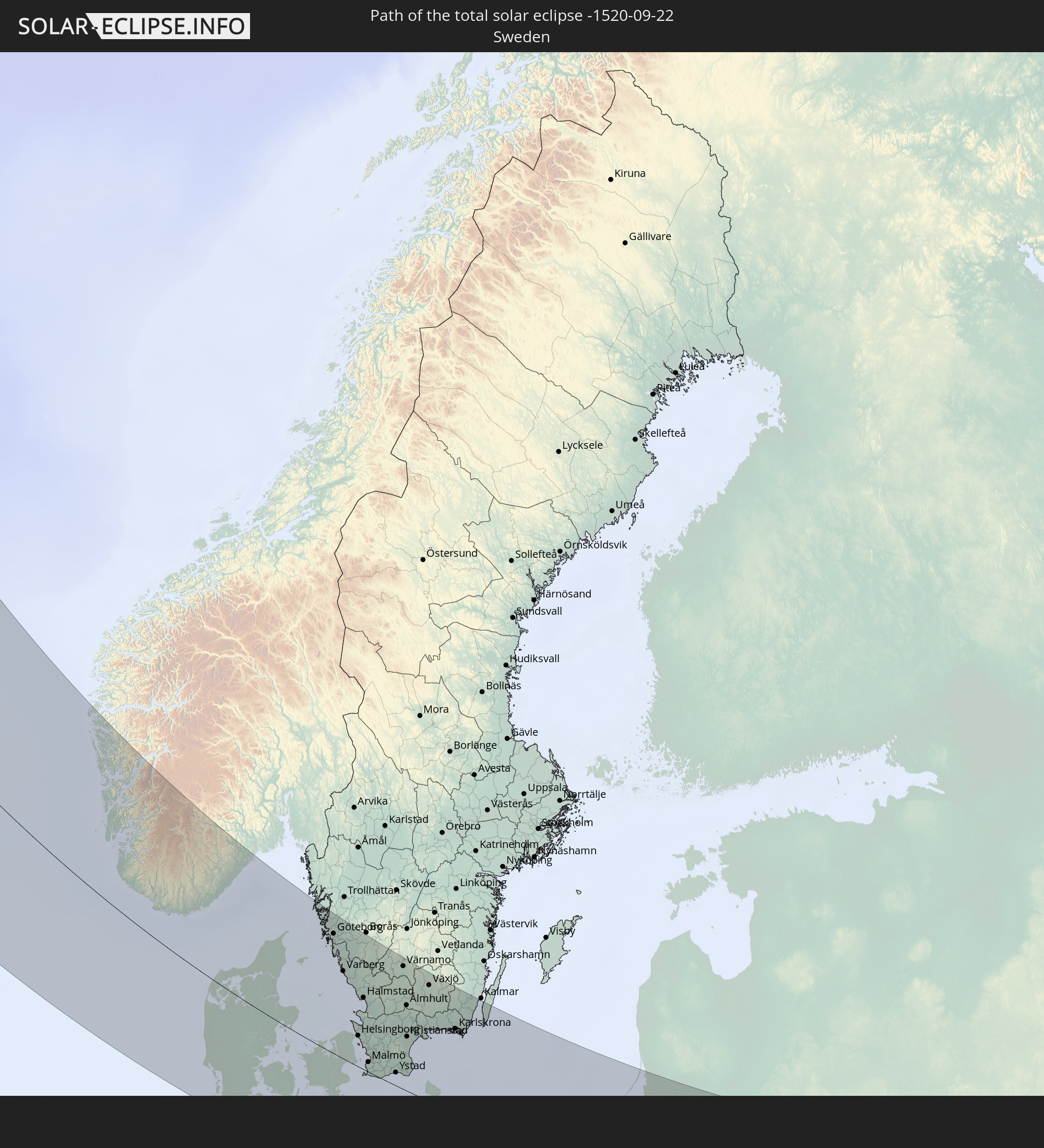
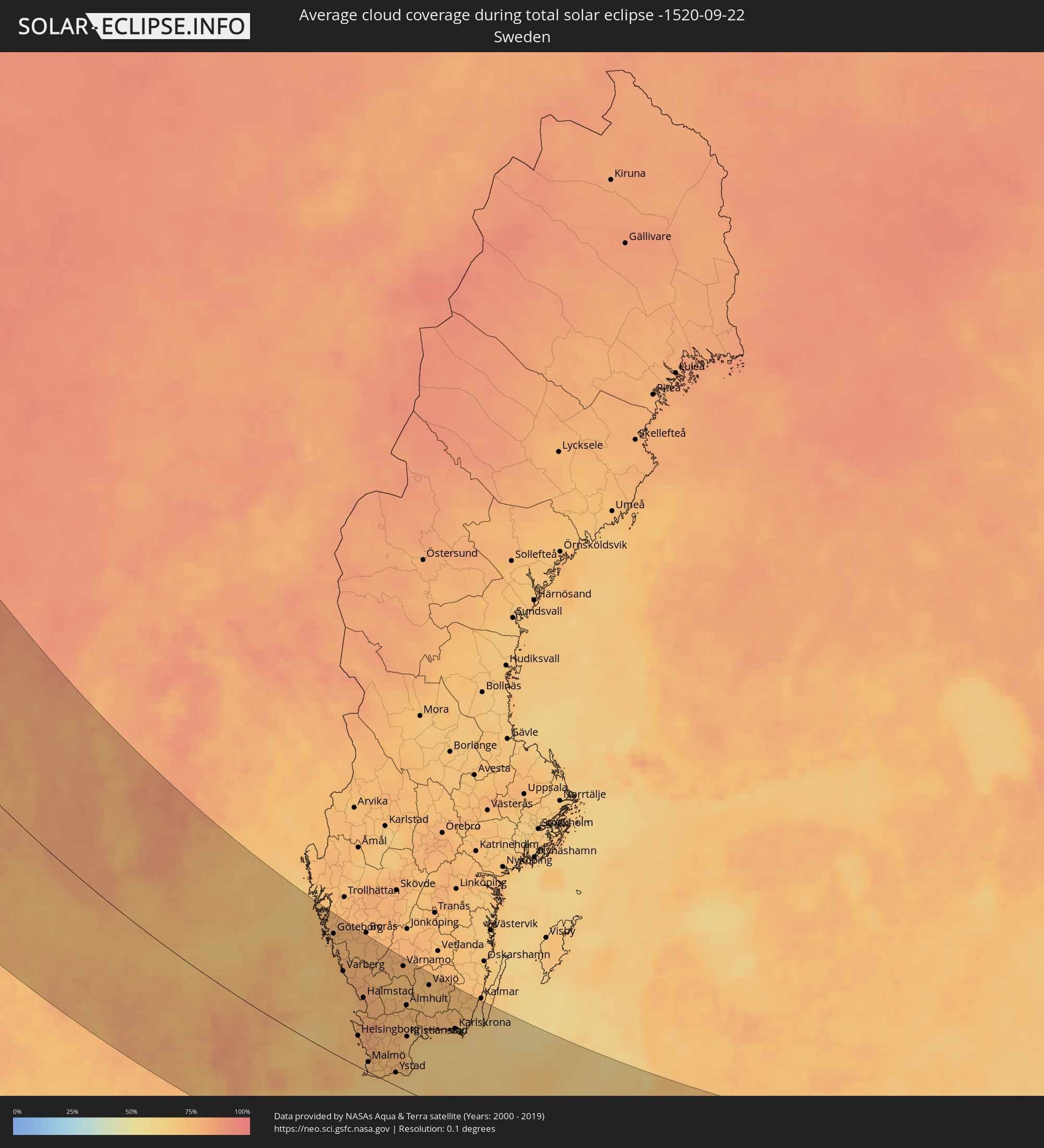 Sweden
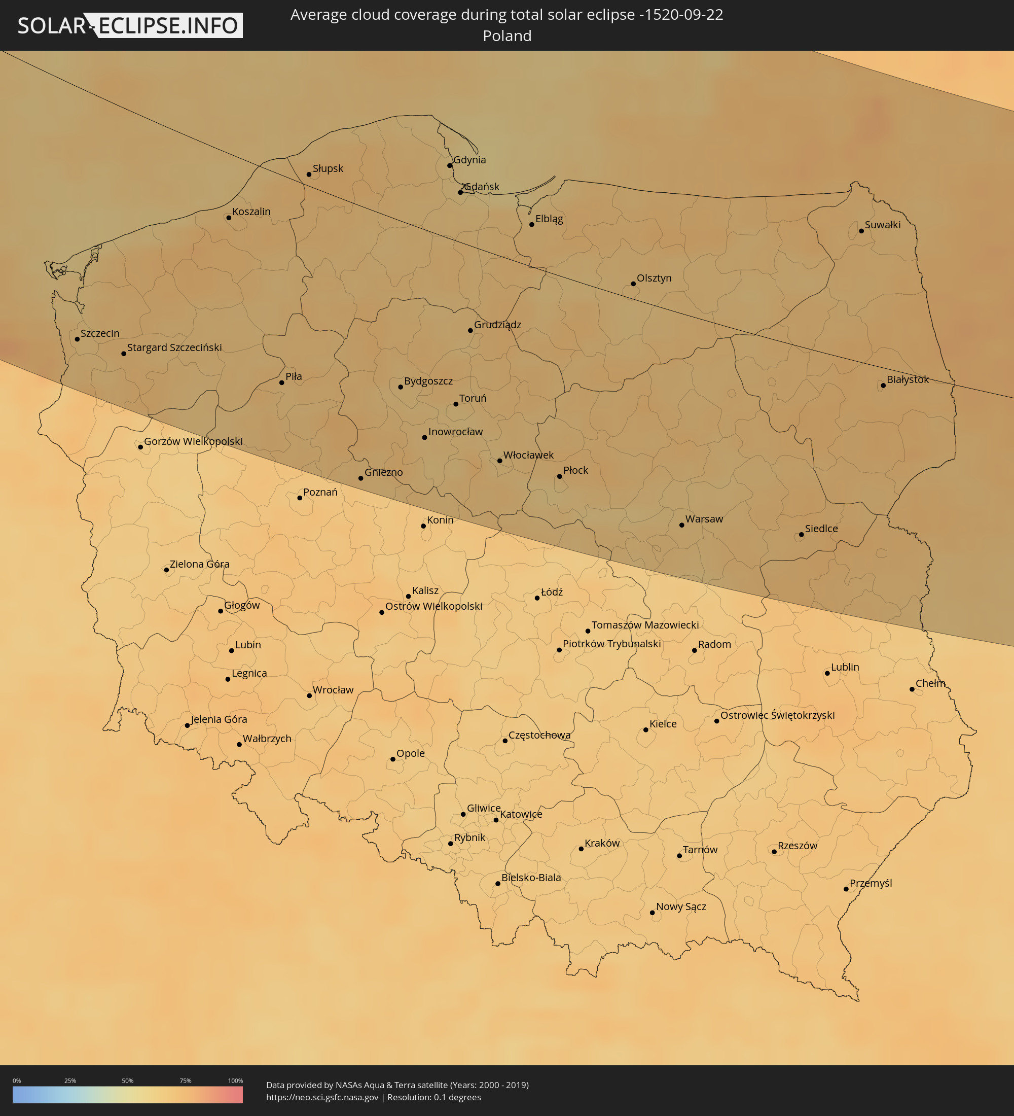 Poland
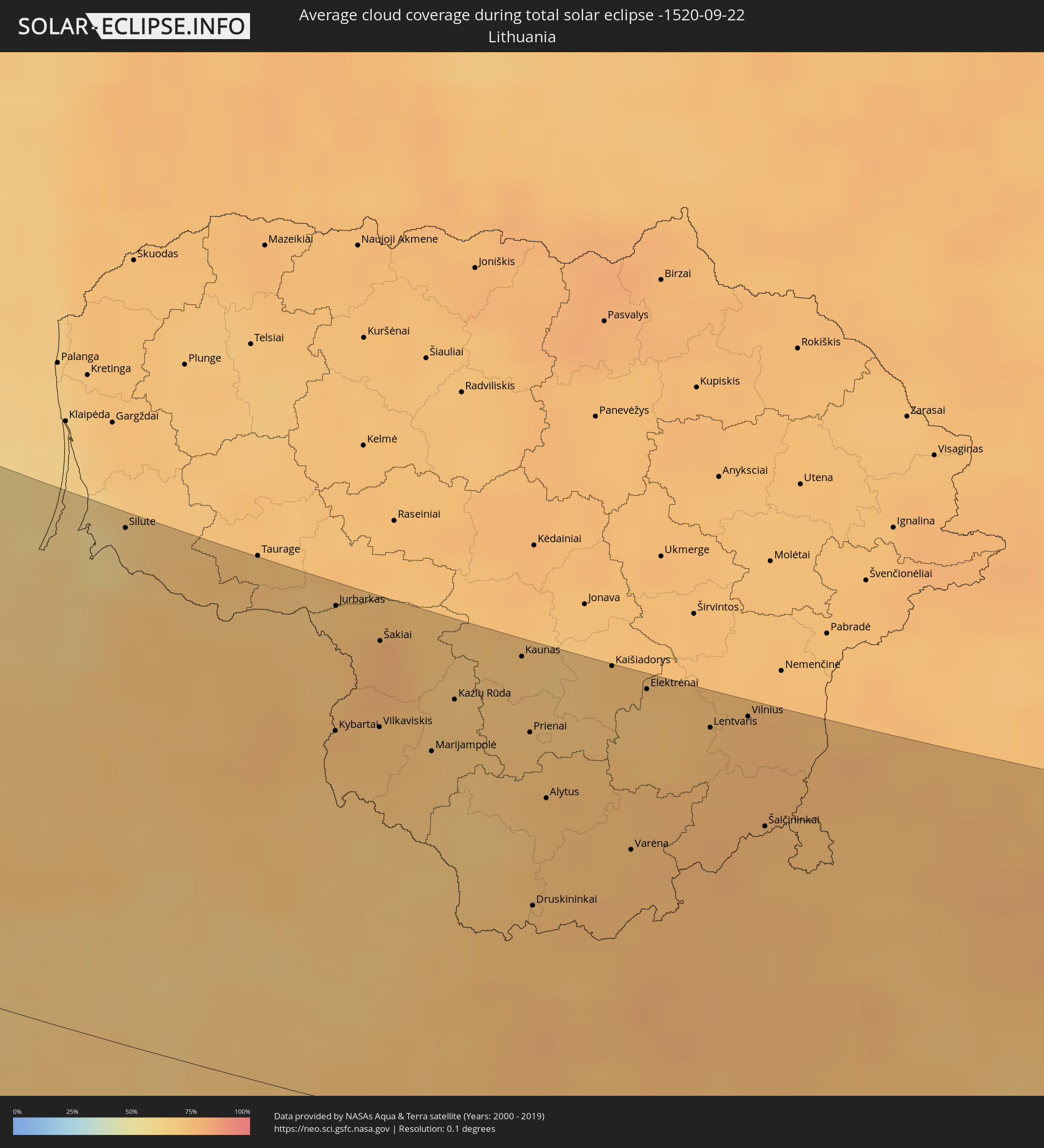 Lithuania
 Ukraine
 Belarus
Cities inside the path of the eclipse
The following table shows all locations with a population of more than 5,000 inside the eclipse path. Cities which have more than 100,000 inhabitants are marked bold. A click at the locations opens a detailed map.
| City | Type | Eclipse duration | Local time of max. eclipse | Distance to central line | Ø Cloud coverage |
|
Miðvágur, Vágar
|
total | - | 15:53:17 UTC-00:27 | 195 km | 90% |
|
Fuglafjørður, Eysturoy
|
total | - | 15:53:07 UTC-00:27 | 167 km | 92% |
|
Sandur, Sandoy
|
total | - | 15:53:49 UTC-00:27 | 194 km | 87% |
|
Tórshavn, Streymoy
|
total | - | 15:53:33 UTC-00:27 | 180 km | 89% |
|
Klaksvík, Norðoyar
|
total | - | 15:53:14 UTC-00:27 | 158 km | 91% |
|
Lerwick, Scotland
|
total | - | 16:26:07 UTC+00:00 | 89 km | 83% |
|
Shetland, Scotland
|
total | - | 16:26:07 UTC+00:00 | 89 km | 83% |
|
Askøy, Hordaland
|
total | - | 17:27:31 UTC+01:00 | 179 km | 77% |
|
Haugesund, Rogaland
|
total | - | 17:29:20 UTC+01:00 | 103 km | 76% |
|
Kopervik, Rogaland
|
total | - | 17:29:35 UTC+01:00 | 95 km | 76% |
|
Bergen, Hordaland
|
total | - | 17:27:34 UTC+01:00 | 184 km | 77% |
|
Indre Arna, Hordaland
|
total | - | 17:27:33 UTC+01:00 | 192 km | 80% |
|
Leirvik, Hordaland
|
total | - | 17:28:44 UTC+01:00 | 142 km | 79% |
|
Tananger, Rogaland
|
total | - | 17:30:17 UTC+01:00 | 76 km | 75% |
|
Bryne, Rogaland
|
total | - | 17:30:40 UTC+01:00 | 60 km | 79% |
|
Stavanger, Rogaland
|
total | - | 17:30:15 UTC+01:00 | 84 km | 74% |
|
Hommersåk, Rogaland
|
total | - | 17:30:22 UTC+01:00 | 84 km | 79% |
|
Egersund, Rogaland
|
total | - | 17:31:16 UTC+01:00 | 49 km | 76% |
|
Flekkefjord, Vest-Agder
|
total | - | 17:31:41 UTC+01:00 | 59 km | 74% |
|
Mandal, Vest-Agder
|
total | - | 17:32:20 UTC+01:00 | 66 km | 76% |
|
Søgne, Vest-Agder
|
total | - | 17:32:17 UTC+01:00 | 82 km | 76% |
|
Vennesla, Vest-Agder
|
total | - | 17:32:00 UTC+01:00 | 104 km | 74% |
|
Kristiansand, Vest-Agder
|
total | - | 17:32:14 UTC+01:00 | 94 km | 76% |
|
Lillesand, Aust-Agder
|
total | - | 17:32:07 UTC+01:00 | 117 km | 75% |
|
Esbjerg, South Denmark
|
total | - | 17:37:09 UTC+01:00 | 138 km | 81% |
|
Grimstad, Aust-Agder
|
total | - | 17:31:59 UTC+01:00 | 133 km | 74% |
|
Arendal, Aust-Agder
|
total | - | 17:31:48 UTC+01:00 | 150 km | 71% |
|
Herning, Central Jutland
|
total | - | 17:36:02 UTC+01:00 | 57 km | 83% |
|
Viborg, Central Jutland
|
total | - | 17:35:32 UTC+01:00 | 13 km | 78% |
|
Flensburg, Schleswig-Holstein
|
total | - | 17:38:32 UTC+01:00 | 172 km | 79% |
|
Kolding, South Denmark
|
total | - | 17:37:16 UTC+01:00 | 103 km | 80% |
|
Vejle, South Denmark
|
total | - | 17:36:53 UTC+01:00 | 81 km | 82% |
|
Silkeborg, Central Jutland
|
total | - | 17:36:04 UTC+01:00 | 37 km | 78% |
|
Schleswig, Schleswig-Holstein
|
total | - | 17:39:01 UTC+01:00 | 194 km | 75% |
|
Fredericia, South Denmark
|
total | - | 17:37:11 UTC+01:00 | 86 km | 77% |
|
Eckernförde, Schleswig-Holstein
|
total | - | 17:39:09 UTC+01:00 | 191 km | 73% |
|
Horsens, Central Jutland
|
total | - | 17:36:40 UTC+01:00 | 57 km | 78% |
|
Aalborg, North Denmark
|
total | - | 17:34:33 UTC+01:00 | 60 km | 79% |
|
Randers, Central Jutland
|
total | - | 17:35:37 UTC+01:00 | 9 km | 81% |
|
Kiel, Schleswig-Holstein
|
total | - | 17:39:27 UTC+01:00 | 196 km | 71% |
|
Århus, Central Jutland
|
total | - | 17:36:11 UTC+01:00 | 19 km | 76% |
|
Odense, South Denmark
|
total | - | 17:37:34 UTC+01:00 | 83 km | 81% |
|
Eutin, Schleswig-Holstein
|
total | - | 17:39:50 UTC+01:00 | 199 km | 72% |
|
Fehmarn, Schleswig-Holstein
|
total | - | 17:39:23 UTC+01:00 | 153 km | 64% |
|
Wismar, Mecklenburg-Vorpommern
|
total | - | 17:40:22 UTC+01:00 | 199 km | 73% |
|
Næstved, Zealand
|
total | - | 17:38:02 UTC+01:00 | 59 km | 74% |
|
Göteborg, Västra Götaland
|
total | - | 17:33:38 UTC+01:00 | 188 km | 76% |
|
Kungälv, Västra Götaland
|
total | - | 17:33:21 UTC+01:00 | 204 km | 76% |
|
Kungsbacka, Halland
|
total | - | 17:34:03 UTC+01:00 | 171 km | 76% |
|
Roskilde, Zealand
|
total | - | 17:37:20 UTC+01:00 | 12 km | 75% |
|
Rostock, Mecklenburg-Vorpommern
|
total | - | 17:40:06 UTC+01:00 | 160 km | 75% |
|
Güstrow, Mecklenburg-Vorpommern
|
total | - | 17:40:37 UTC+01:00 | 188 km | 73% |
|
Køge, Zealand
|
total | - | 17:37:41 UTC+01:00 | 25 km | 76% |
|
Varberg, Halland
|
total | - | 17:34:45 UTC+01:00 | 140 km | 75% |
|
Greve, Zealand
|
total | - | 17:37:28 UTC+01:00 | 13 km | 75% |
|
Ribnitz-Damgarten, Mecklenburg-Vorpommern
|
total | - | 17:39:51 UTC+01:00 | 135 km | 78% |
|
Falkenberg, Halland
|
total | - | 17:35:08 UTC+01:00 | 128 km | 76% |
|
Hørsholm, Capital Region
|
total | - | 17:36:58 UTC+01:00 | 33 km | 70% |
|
Copenhagen, Capital Region
|
total | - | 17:37:20 UTC+01:00 | 11 km | 71% |
|
Helsingør, Capital Region
|
total | - | 17:36:42 UTC+01:00 | 50 km | 76% |
|
Helsingborg, Skåne
|
total | - | 17:36:41 UTC+01:00 | 53 km | 76% |
|
Landskrona, Skåne
|
total | - | 17:37:01 UTC+01:00 | 38 km | 74% |
|
Halmstad, Halland
|
total | - | 17:35:35 UTC+01:00 | 117 km | 79% |
|
Ängelholm, Skåne
|
total | - | 17:36:21 UTC+01:00 | 76 km | 80% |
|
Malmö, Skåne
|
total | - | 17:37:30 UTC+01:00 | 18 km | 73% |
|
Demmin, Mecklenburg-Vorpommern
|
total | - | 17:40:30 UTC+01:00 | 152 km | 79% |
|
Stralsund, Mecklenburg-Vorpommern
|
total | - | 17:39:48 UTC+01:00 | 111 km | 76% |
|
Trelleborg, Skåne
|
total | - | 17:37:55 UTC+01:00 | 12 km | 71% |
|
Lund, Skåne
|
total | - | 17:37:20 UTC+01:00 | 32 km | 76% |
|
Neubrandenburg, Mecklenburg-Vorpommern
|
total | - | 17:41:07 UTC+01:00 | 181 km | 75% |
|
Greifswald, Mecklenburg-Vorpommern
|
total | - | 17:40:12 UTC+01:00 | 125 km | 77% |
|
Bergen auf Rügen, Mecklenburg-Vorpommern
|
total | - | 17:39:38 UTC+01:00 | 90 km | 71% |
|
Anklam, Mecklenburg-Vorpommern
|
total | - | 17:40:38 UTC+01:00 | 140 km | 74% |
|
Hässleholm, Skåne
|
total | - | 17:36:35 UTC+01:00 | 93 km | 76% |
|
Wolgast, Mecklenburg-Vorpommern
|
total | - | 17:40:18 UTC+01:00 | 118 km | 66% |
|
Ystad, Skåne
|
total | - | 17:37:53 UTC+01:00 | 25 km | 70% |
|
Prenzlau, Brandenburg
|
total | - | 17:41:35 UTC+01:00 | 190 km | 69% |
|
Pasewalk, Mecklenburg-Vorpommern
|
total | - | 17:41:16 UTC+01:00 | 167 km | 76% |
|
Värnamo, Jönköping
|
total | - | 17:34:47 UTC+01:00 | 202 km | 75% |
|
Kristianstad, Skåne
|
total | - | 17:36:50 UTC+01:00 | 92 km | 70% |
|
Szczecin, West Pomeranian Voivodeship
|
total | - | 18:05:26 UTC+01:24 | 161 km | 67% |
|
Växjö, Kronoberg
|
total | - | 17:35:23 UTC+01:00 | 194 km | 72% |
|
Karlshamn, Blekinge
|
total | - | 17:36:38 UTC+01:00 | 125 km | 75% |
|
Stargard Szczeciński, West Pomeranian Voivodeship
|
total | - | 18:05:37 UTC+01:24 | 158 km | 68% |
|
Karlskrona, Blekinge
|
total | - | 17:36:42 UTC+01:00 | 144 km | 70% |
|
Koszalin, West Pomeranian Voivodeship
|
total | - | 18:04:10 UTC+01:24 | 42 km | 72% |
|
Piła, Greater Poland Voivodeship
|
total | - | 18:05:58 UTC+01:24 | 136 km | 68% |
|
Słupsk, Pomeranian Voivodeship
|
total | - | 18:03:43 UTC+01:24 | 7 km | 73% |
|
Gniezno, Greater Poland Voivodeship
|
total | - | 18:07:01 UTC+01:24 | 182 km | 68% |
|
Bydgoszcz, Kujawsko-Pomorskie
|
total | - | 18:06:01 UTC+01:24 | 111 km | 66% |
|
Inowrocław, Kujawsko-Pomorskie
|
total | - | 18:06:34 UTC+01:24 | 139 km | 65% |
|
Gdynia, Pomeranian Voivodeship
|
total | - | 18:03:37 UTC+01:24 | 50 km | 64% |
|
Toruń, Kujawsko-Pomorskie
|
total | - | 18:06:11 UTC+01:24 | 110 km | 63% |
|
Gdańsk, Pomeranian Voivodeship
|
total | - | 18:03:54 UTC+01:24 | 32 km | 64% |
|
Grudziądz, Kujawsko-Pomorskie
|
total | - | 18:05:23 UTC+01:24 | 57 km | 66% |
|
Włocławek, Kujawsko-Pomorskie
|
total | - | 18:06:48 UTC+01:24 | 139 km | 68% |
|
Elbląg, Warmian-Masurian Voivodeship
|
total | - | 18:04:14 UTC+01:24 | 32 km | 67% |
|
Płock, Masovian Voivodeship
|
total | - | 18:06:56 UTC+01:24 | 137 km | 62% |
|
Baltiysk, Kaliningrad
|
total | - | 17:39:21 UTC+01:00 | 91 km | 62% |
|
Mamonovo, Kaliningrad
|
total | - | 17:39:41 UTC+01:00 | 72 km | 66% |
|
Yantarnyy, Kaliningrad
|
total | - | 17:38:59 UTC+01:00 | 115 km | 62% |
|
Svetlyy, Kaliningrad
|
total | - | 17:39:19 UTC+01:00 | 98 km | 63% |
|
Svetlogorsk, Kaliningrad
|
total | - | 17:38:51 UTC+01:00 | 126 km | 68% |
|
Pionerskiy, Kaliningrad
|
total | - | 17:38:50 UTC+01:00 | 129 km | 66% |
|
Zelenogradsk, Kaliningrad
|
total | - | 17:38:49 UTC+01:00 | 135 km | 64% |
|
Olsztyn, Warmian-Masurian Voivodeship
|
total | - | 18:04:49 UTC+01:24 | 11 km | 66% |
|
Kaliningrad, Kaliningrad
|
total | - | 17:39:14 UTC+01:00 | 109 km | 68% |
|
Gur’yevsk, Kaliningrad
|
total | - | 17:39:07 UTC+01:00 | 118 km | 70% |
|
Bagrationovsk, Kaliningrad
|
total | - | 17:39:47 UTC+01:00 | 79 km | 69% |
|
Warsaw, Masovian Voivodeship
|
total | - | 18:07:23 UTC+01:24 | 146 km | 67% |
|
Gvardeysk, Kaliningrad
|
total | - | 17:39:19 UTC+01:00 | 113 km | 71% |
|
Polessk, Kaliningrad
|
total | - | 17:38:57 UTC+01:00 | 137 km | 67% |
|
Silute, Klaipėda County
|
total | - | 18:02:06 UTC+01:24 | 196 km | 63% |
|
Slavsk, Kaliningrad
|
total | - | 17:38:37 UTC+01:00 | 167 km | 73% |
|
Chernyakhovsk, Kaliningrad
|
total | - | 17:39:18 UTC+01:00 | 127 km | 73% |
|
Sovetsk, Kaliningrad
|
total | - | 17:38:32 UTC+01:00 | 175 km | 70% |
|
Ozërsk, Kaliningrad
|
total | - | 17:39:40 UTC+01:00 | 106 km | 71% |
|
Neman, Kaliningrad
|
total | - | 17:38:36 UTC+01:00 | 173 km | 73% |
|
Gusev, Kaliningrad
|
total | - | 17:39:20 UTC+01:00 | 129 km | 74% |
|
Siedlce, Masovian Voivodeship
|
total | - | 18:07:23 UTC+01:24 | 132 km | 70% |
|
Nesterov, Kaliningrad
|
total | - | 17:39:15 UTC+01:00 | 139 km | 73% |
|
Jurbarkas, Tauragė County
|
total | - | 18:02:29 UTC+01:24 | 190 km | 71% |
|
Vilkaviskis
|
total | - | 18:03:10 UTC+01:24 | 149 km | 74% |
|
Białystok, Podlasie
|
total | - | 18:05:42 UTC+01:24 | 19 km | 72% |
|
Marijampolė, Marijampolė County
|
total | - | 18:03:17 UTC+01:24 | 146 km | 71% |
|
Kazlų Rūda, Marijampolė County
|
total | - | 18:02:58 UTC+01:24 | 167 km | 70% |
|
Brest, Brest
|
total | - | 18:33:21 UTC+01:50 | 117 km | 67% |
|
Hrodna, Grodnenskaya
|
total | - | 18:30:43 UTC+01:50 | 58 km | 74% |
|
Garliava, Kaunas County
|
total | - | 18:02:49 UTC+01:24 | 181 km | 70% |
|
Kaunas, Kaunas County
|
total | - | 18:02:41 UTC+01:24 | 190 km | 71% |
|
Prienai
|
total | - | 18:03:07 UTC+01:24 | 162 km | 71% |
|
Druskininkai, Alytus County
|
total | - | 18:04:09 UTC+01:24 | 95 km | 74% |
|
Alytus, Alytus County
|
total | - | 18:03:30 UTC+01:24 | 138 km | 73% |
|
Kobryn, Brest
|
total | - | 18:33:04 UTC+01:50 | 95 km | 68% |
|
Kaišiadorys
|
total | - | 18:02:41 UTC+01:24 | 195 km | 74% |
|
Vawkavysk, Grodnenskaya
|
total | - | 18:31:31 UTC+01:50 | 9 km | 75% |
|
Pruzhany, Brest
|
total | - | 18:32:30 UTC+01:50 | 56 km | 73% |
|
Ratne, Volyn
|
total | - | 18:46:00 UTC+02:02 | 152 km | 65% |
|
Masty, Grodnenskaya
|
total | - | 18:31:05 UTC+01:50 | 38 km | 75% |
|
Varėna, Alytus County
|
total | - | 18:03:45 UTC+01:24 | 126 km | 75% |
|
Elektrėnai, Vilnius County
|
total | - | 18:02:48 UTC+01:24 | 189 km | 71% |
|
Shchuchin, Grodnenskaya
|
total | - | 18:30:45 UTC+01:50 | 62 km | 77% |
|
Kamin’-Kashyrs’kyy, Volyn
|
total | - | 18:46:01 UTC+02:02 | 151 km | 64% |
|
Byaroza, Brest
|
total | - | 18:32:28 UTC+01:50 | 52 km | 70% |
|
Lentvaris, Vilnius County
|
total | - | 18:02:59 UTC+01:24 | 180 km | 75% |
|
Grigiškės
|
total | - | 18:02:55 UTC+01:24 | 184 km | 75% |
|
Pilaitė, Vilnius County
|
total | - | 18:02:53 UTC+01:24 | 187 km | 75% |
|
Vilnius, Vilnius County
|
total | - | 18:02:53 UTC+01:24 | 188 km | 76% |
|
Lida, Grodnenskaya
|
total | - | 18:30:13 UTC+01:50 | 100 km | 75% |
|
Rasos, Vilnius County
|
total | - | 18:02:54 UTC+01:24 | 187 km | 76% |
|
Slonim, Grodnenskaya
|
total | - | 18:31:31 UTC+01:50 | 20 km | 74% |
|
Ivatsevichy, Brest
|
total | - | 18:32:08 UTC+01:50 | 28 km | 71% |
|
Šalčininkai
|
total | - | 18:03:31 UTC+01:24 | 147 km | 75% |
|
Navahrudak, Grodnenskaya
|
total | - | 18:30:37 UTC+01:50 | 76 km | 75% |
|
Baranovichi, Brest
|
total | - | 18:31:21 UTC+01:50 | 28 km | 71% |
|
Pinsk, Brest
|
total | - | 18:32:58 UTC+01:50 | 83 km | 66% |
|
Smarhon’, Grodnenskaya
|
total | - | 18:29:05 UTC+01:50 | 180 km | 76% |
|
Maladzyechna, Minsk
|
total | - | 18:29:17 UTC+01:50 | 167 km | 75% |
|
Vilyeyka, Minsk
|
total | - | 18:29:00 UTC+01:50 | 187 km | 75% |
|
Dzyarzhynsk, Minsk
|
total | - | 18:30:17 UTC+01:50 | 101 km | 73% |
|
Minsk, Minsk City
|
total | - | 18:29:52 UTC+01:50 | 131 km | 74% |