Total solar eclipse of 06/08/-1673
| Day of week: | Tuesday |
| Maximum duration of eclipse: | 06m49s |
| Maximum width of eclipse path: | 241 km |
| Saros cycle: | 20 |
| Coverage: | 100% |
| Magnitude: | 1.0742 |
| Gamma: | -0.0714 |
Wo kann man die Sonnenfinsternis vom 06/08/-1673 sehen?
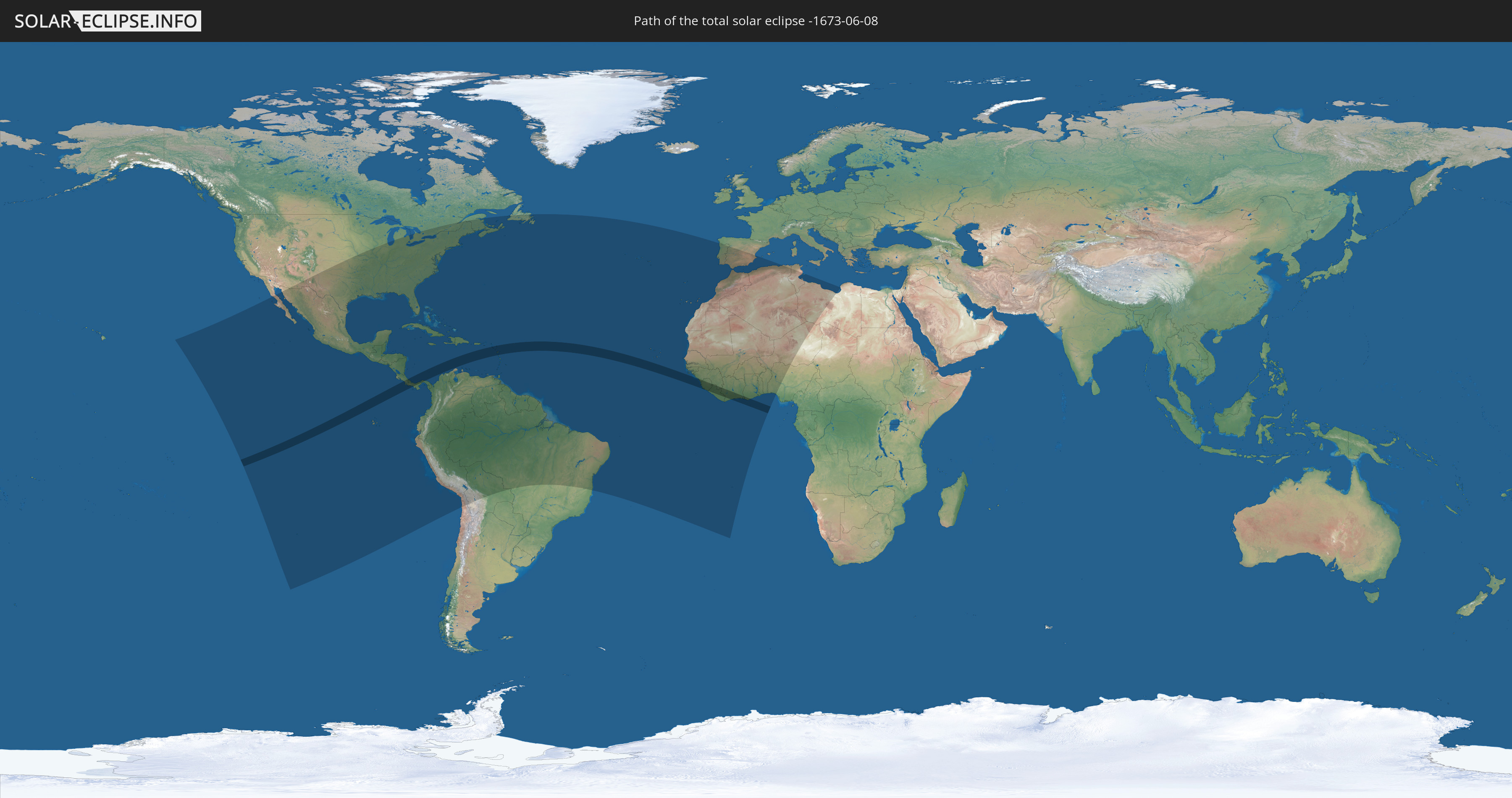
Die Sonnenfinsternis am 06/08/-1673 kann man in 72 Ländern als partielle Sonnenfinsternis beobachten.
Der Finsternispfad verläuft durch 12 Länder. Nur in diesen Ländern ist sie als total Sonnenfinsternis zu sehen.
In den folgenden Ländern ist die Sonnenfinsternis total zu sehen
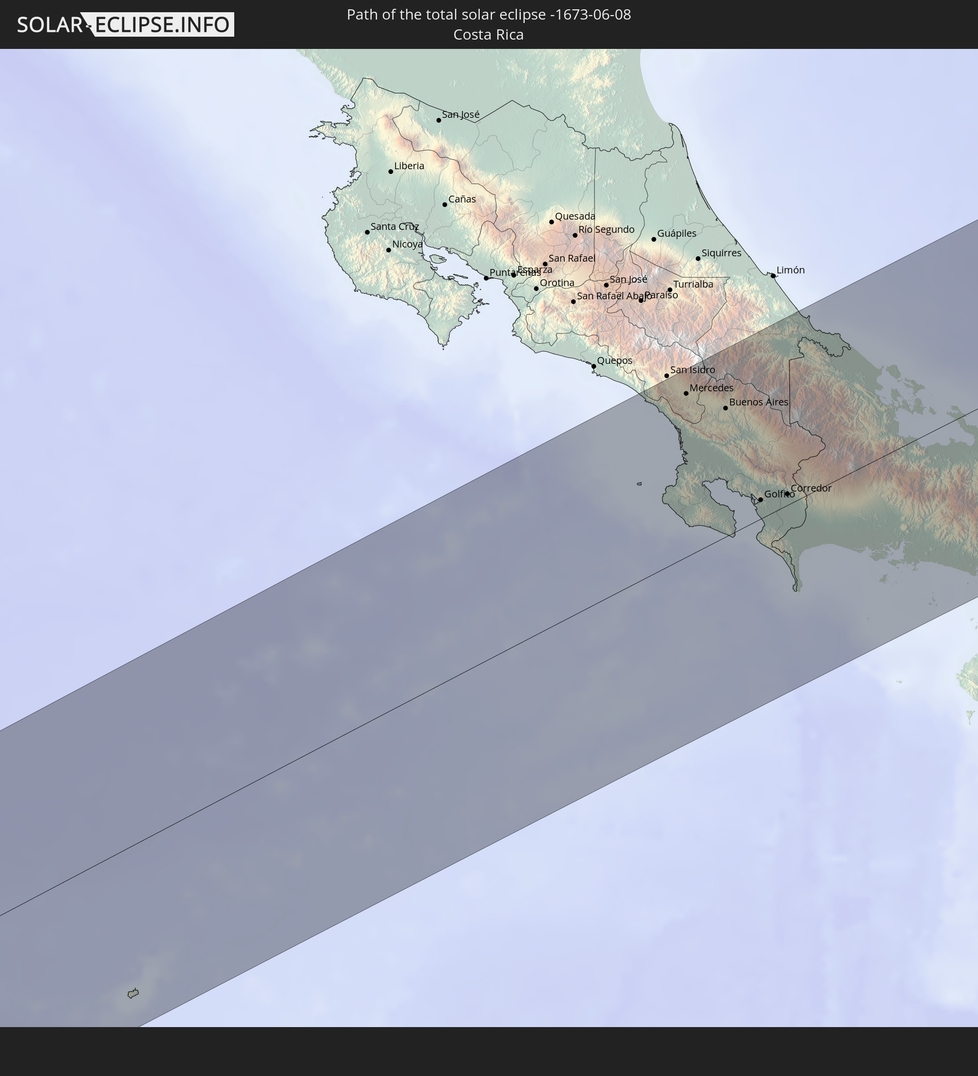 Costa Rica
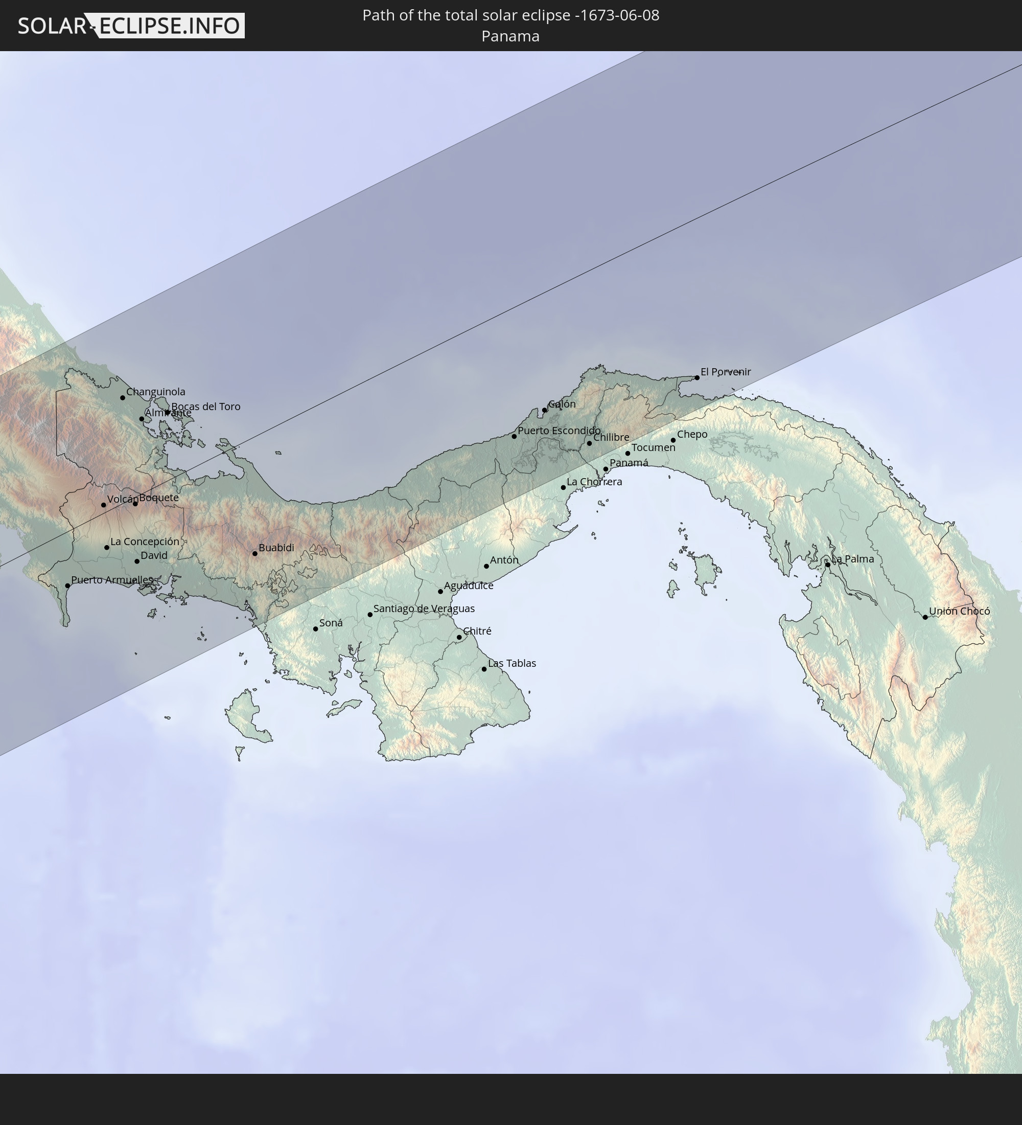 Panama
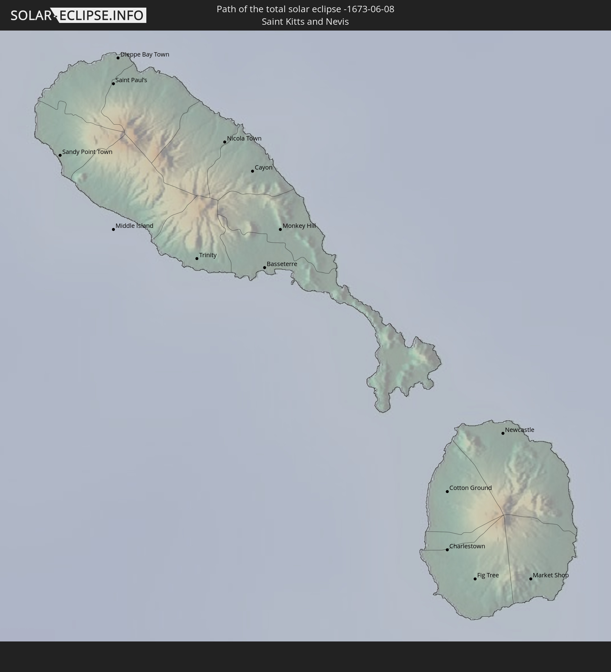 Saint Kitts and Nevis
 Antigua and Barbuda
 Montserrat
 Guadeloupe
 Dominica
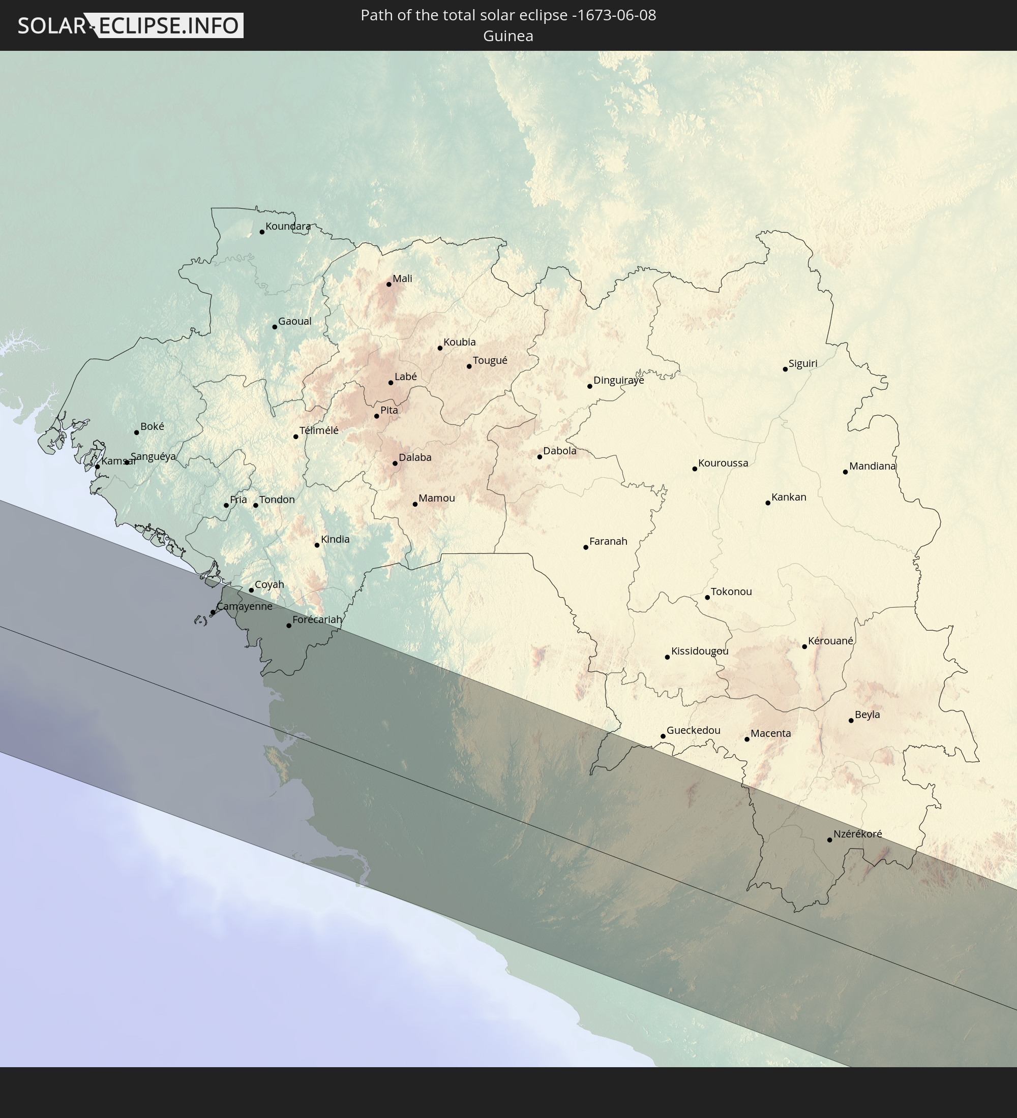 Guinea
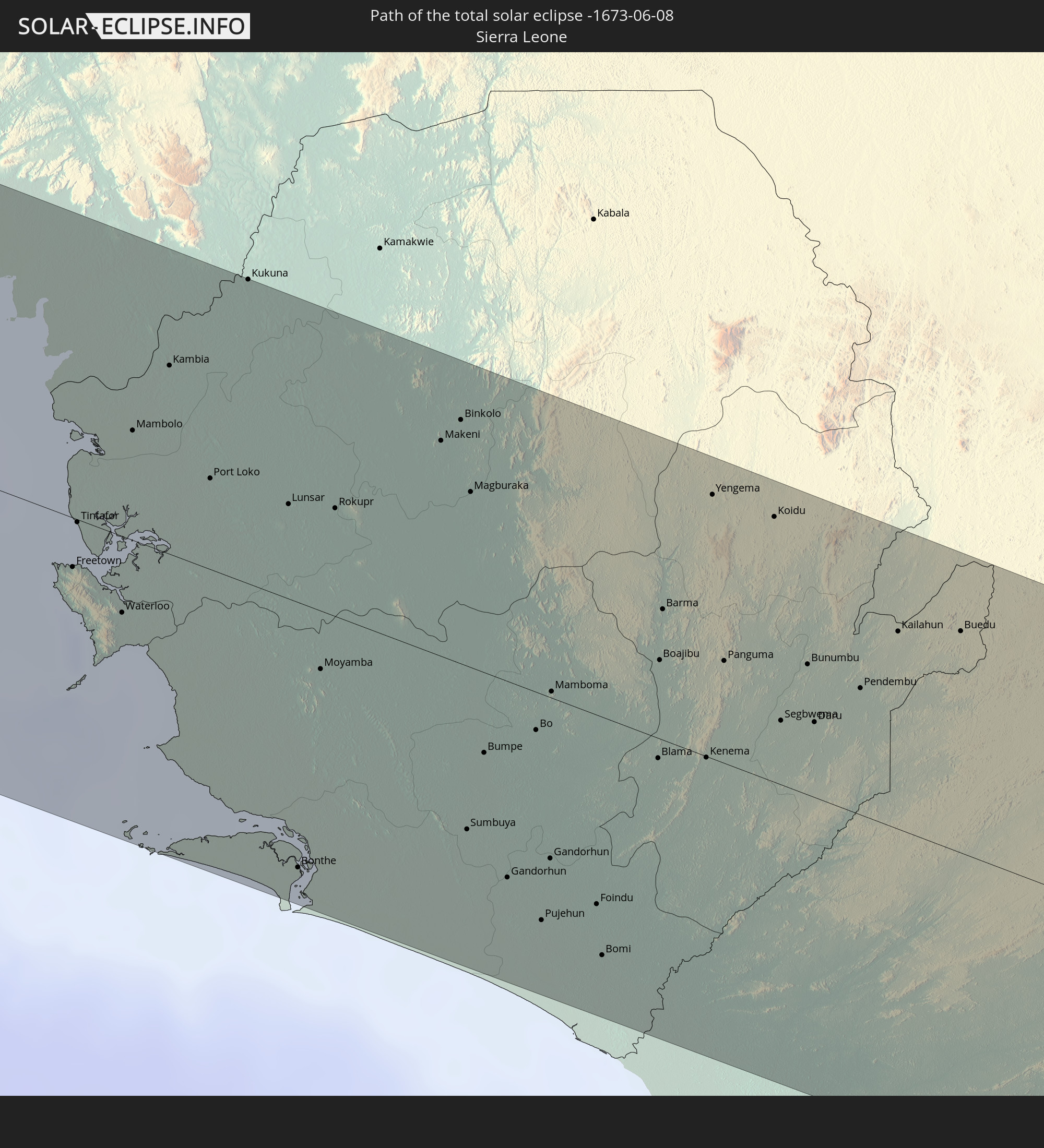 Sierra Leone
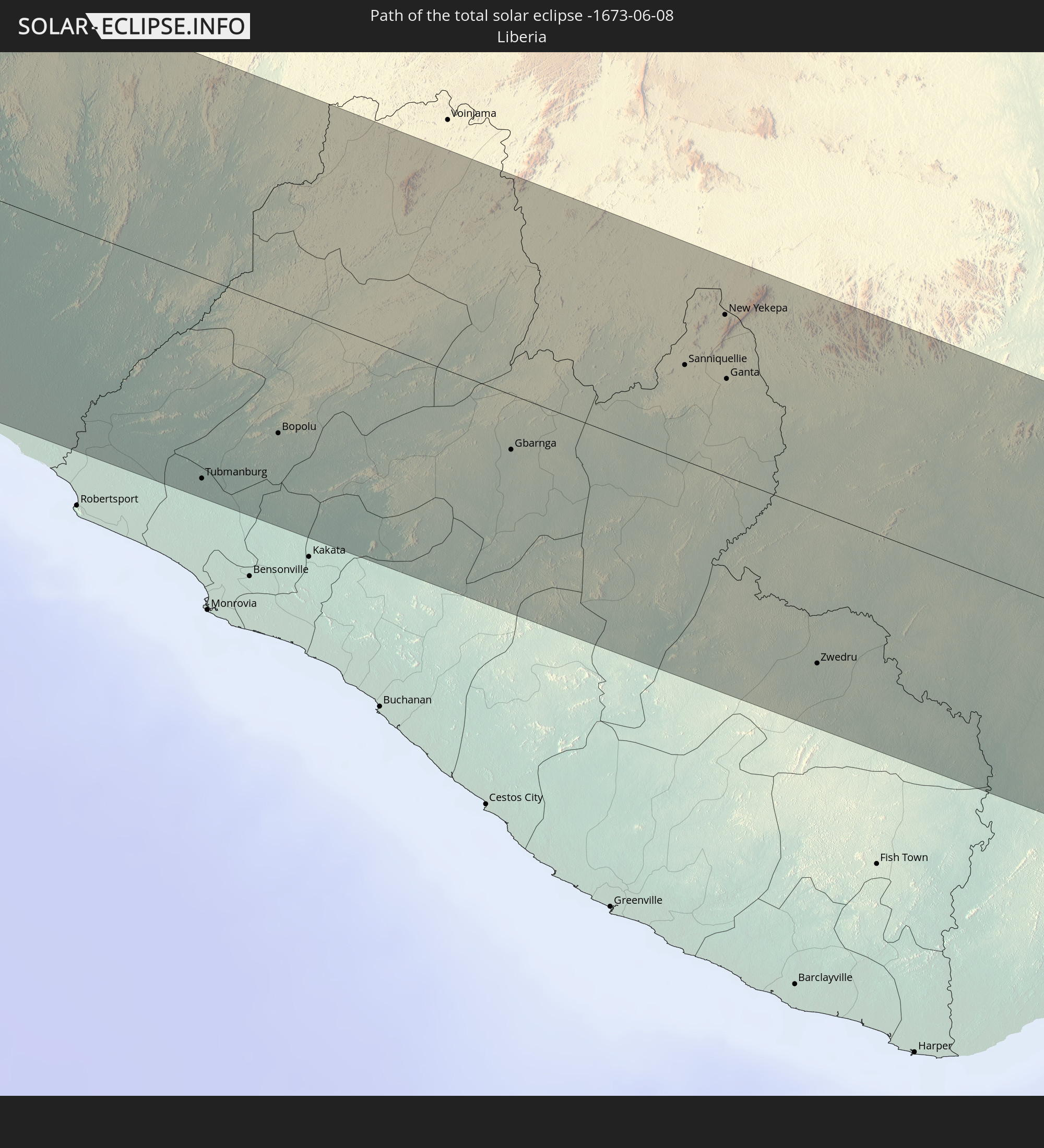 Liberia
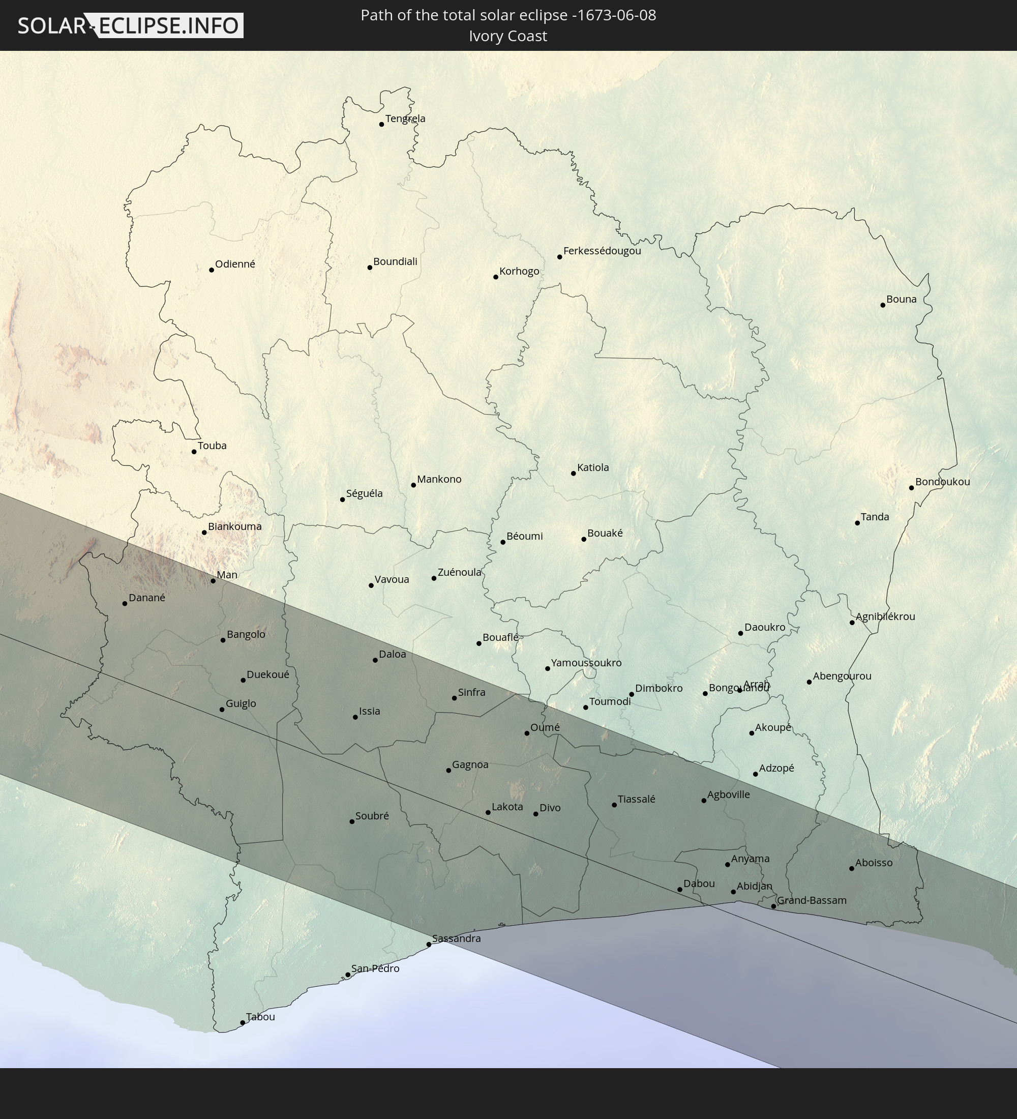 Ivory Coast
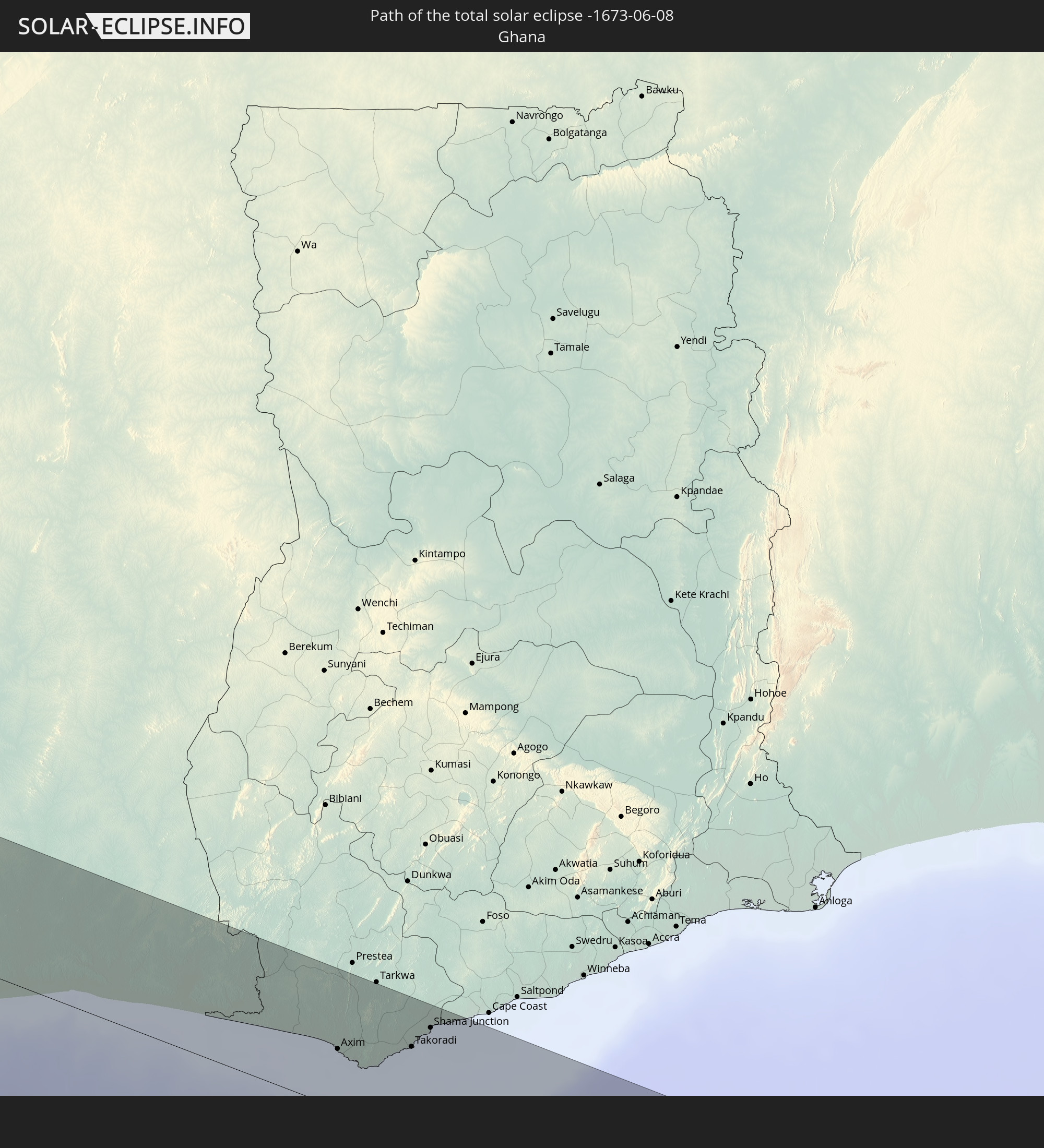 Ghana
Ghana
In den folgenden Ländern ist die Sonnenfinsternis partiell zu sehen
 United States
 United States Minor Outlying Islands
 Canada
 Mexico
 Chile
Chile
 Guatemala
 Ecuador
 El Salvador
 Honduras
 Belize
 Nicaragua
 Costa Rica
 Cuba
Cuba
 Panama
 Colombia
 Cayman Islands
 Peru
Peru
 The Bahamas
 Jamaica
 Haiti
Haiti
 Brazil
 Venezuela
 Turks and Caicos Islands
 Dominican Republic
 Aruba
Aruba
 Bolivia
 Puerto Rico
 United States Virgin Islands
 Bermuda
 British Virgin Islands
 Anguilla
 Collectivity of Saint Martin
 Saint Barthélemy
 Saint Kitts and Nevis
 Antigua and Barbuda
 Montserrat
 Trinidad and Tobago
 Guadeloupe
 Grenada
 Dominica
 Saint Vincent and the Grenadines
 Guyana
 Martinique
 Saint Lucia
 Barbados
 Suriname
 Saint Pierre and Miquelon
 French Guiana
 Portugal
 Cabo Verde
 Spain
Spain
 Senegal
 Mauritania
 The Gambia
 Guinea-Bissau
 Guinea
 Saint Helena, Ascension and Tristan da Cunha
 Sierra Leone
 Morocco
 Mali
Mali
 Liberia
 Algeria
 Ivory Coast
 Burkina Faso
 Gibraltar
 Ghana
Ghana
 Togo
Togo
 Niger
Niger
 Benin
Benin
 Nigeria
 Tunisia
 Libya
Libya
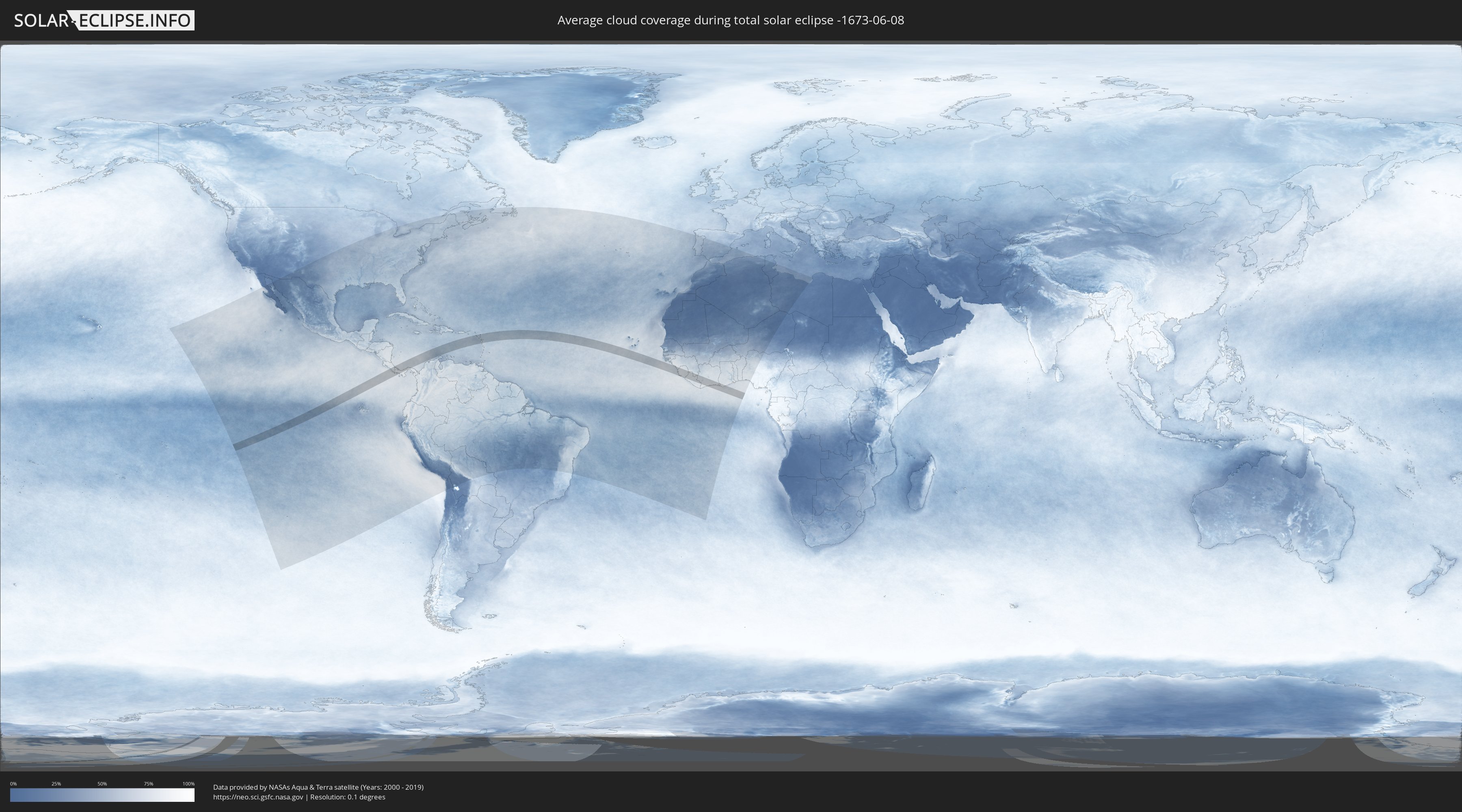
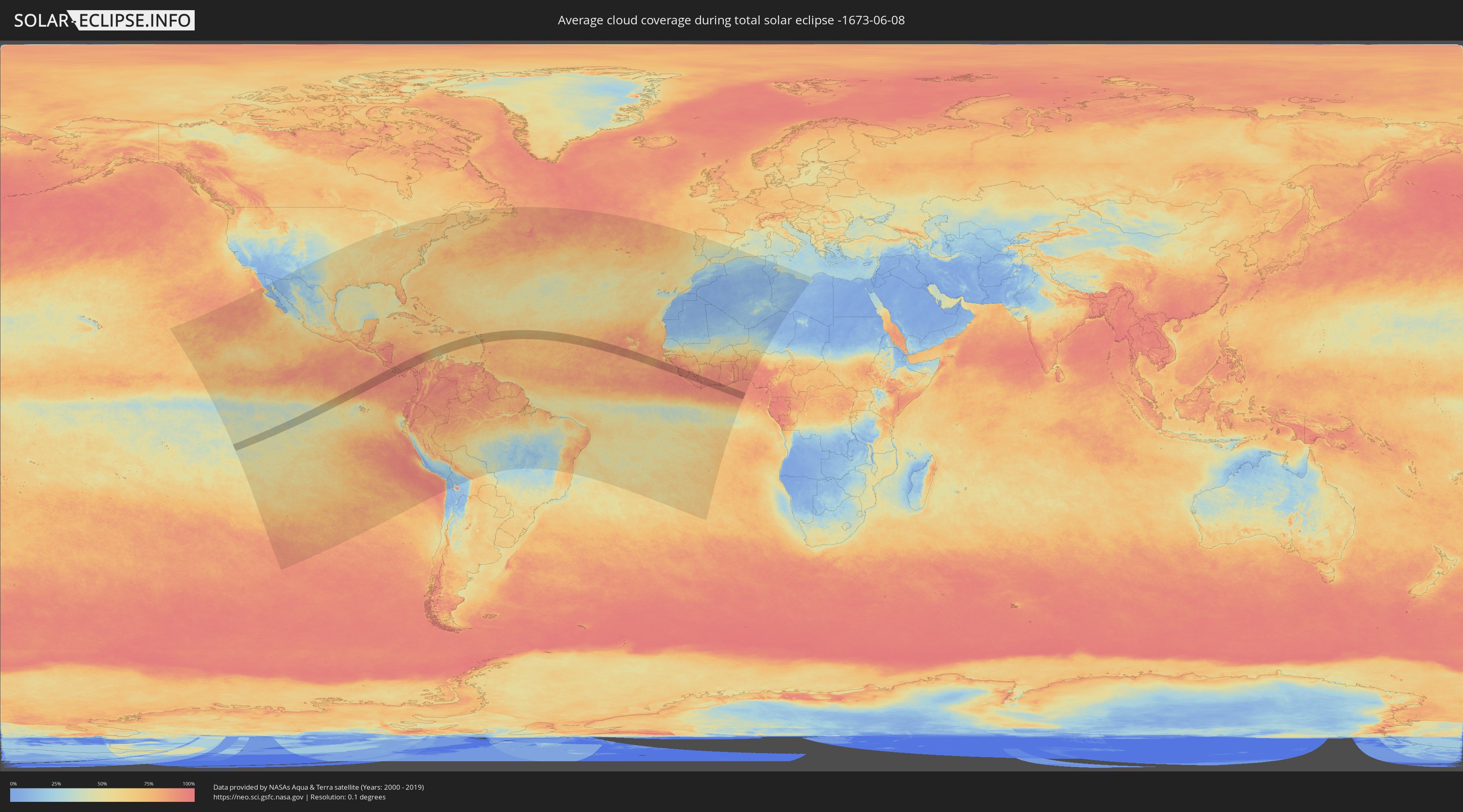
How will be the weather during the total solar eclipse on 06/08/-1673?
Where is the best place to see the total solar eclipse of 06/08/-1673?
The following maps show the average cloud coverage for the day of the total solar eclipse.
With the help of these maps, it is possible to find the place along the eclipse path, which has the best
chance of a cloudless sky.
Nevertheless, you should consider local circumstances and inform about the weather of your chosen
observation site.
The data is provided by NASAs satellites
AQUA and TERRA.
The cloud maps are averaged over a period of 19 years (2000 - 2019).
Detailed country maps
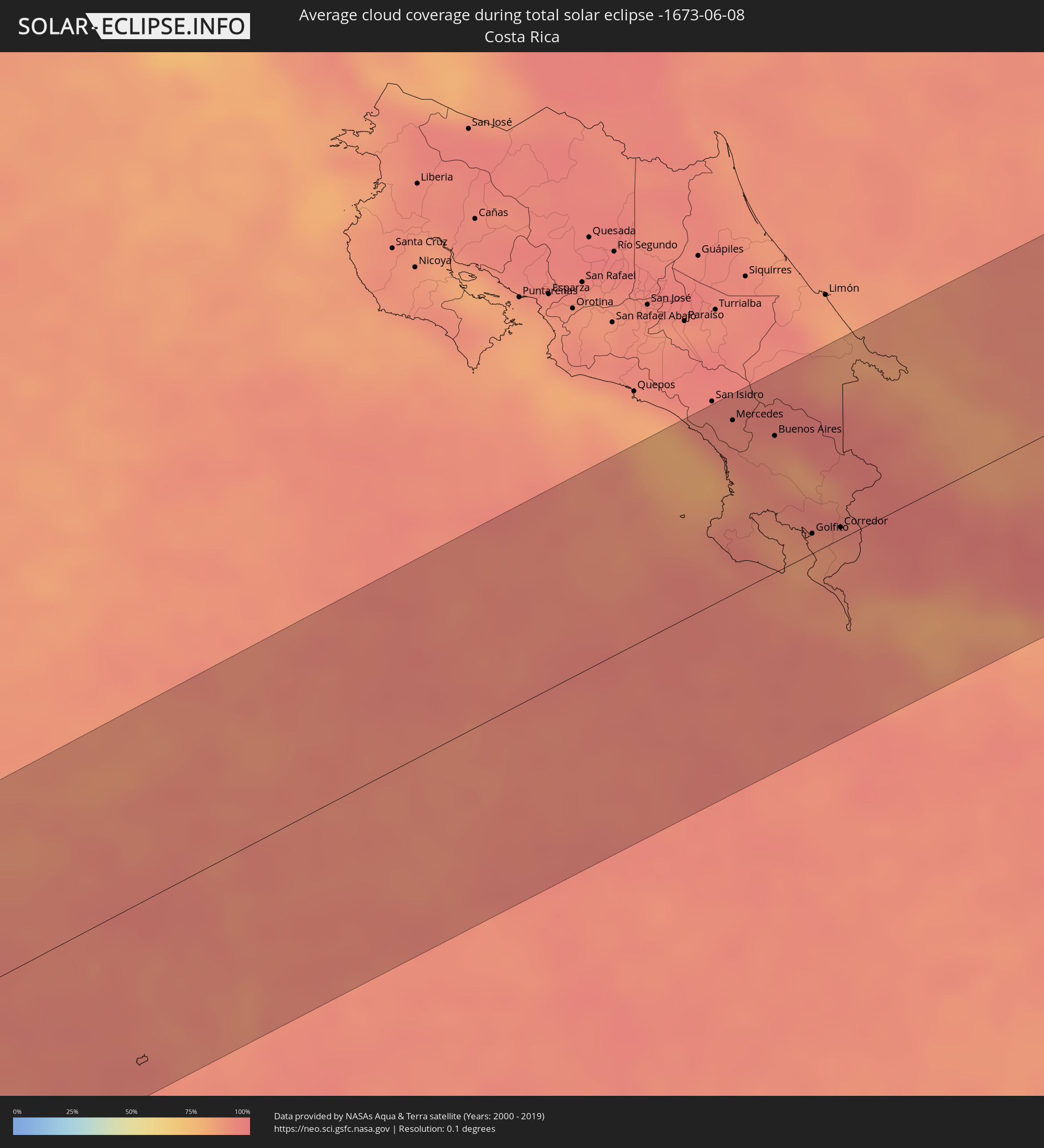 Costa Rica
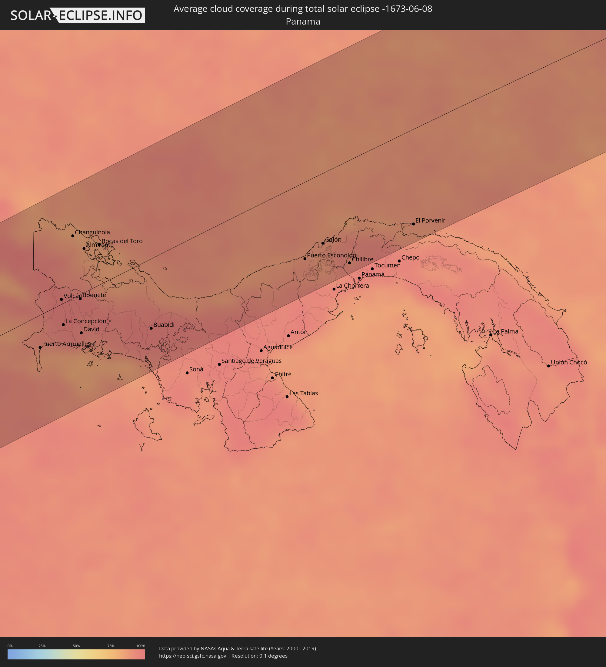 Panama
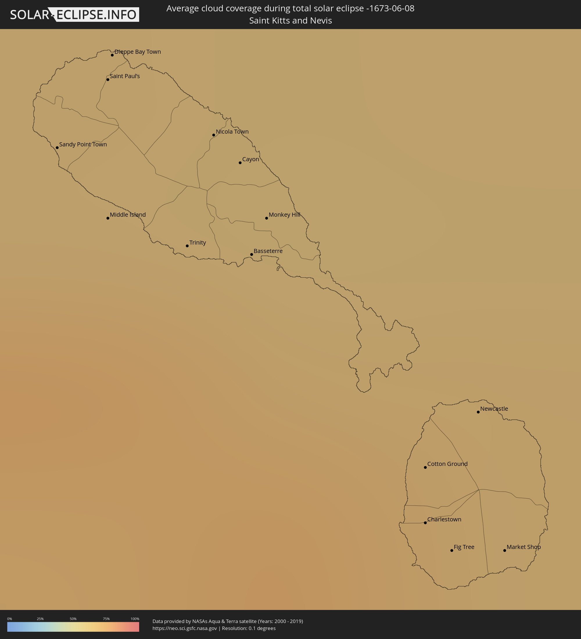 Saint Kitts and Nevis
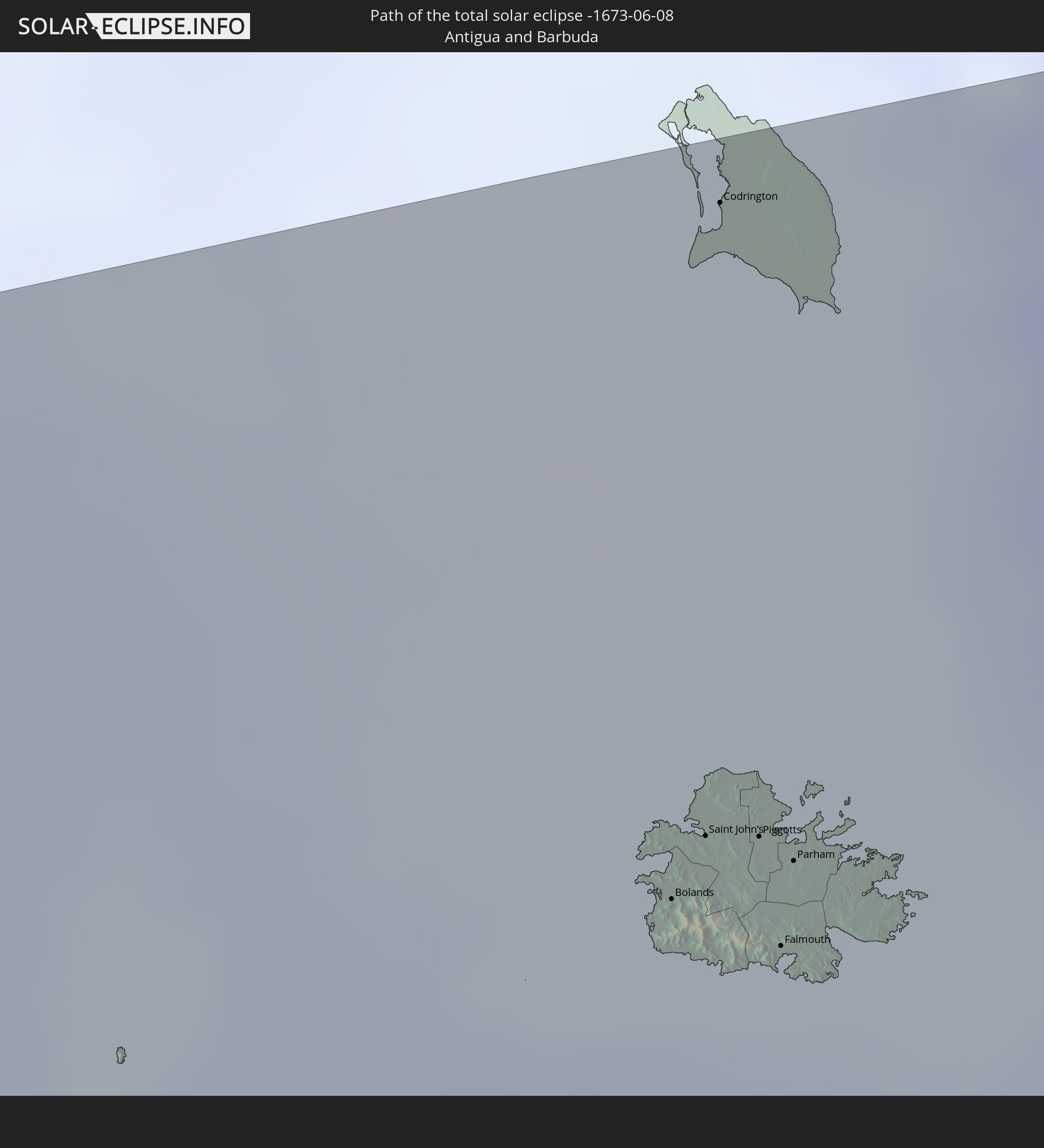
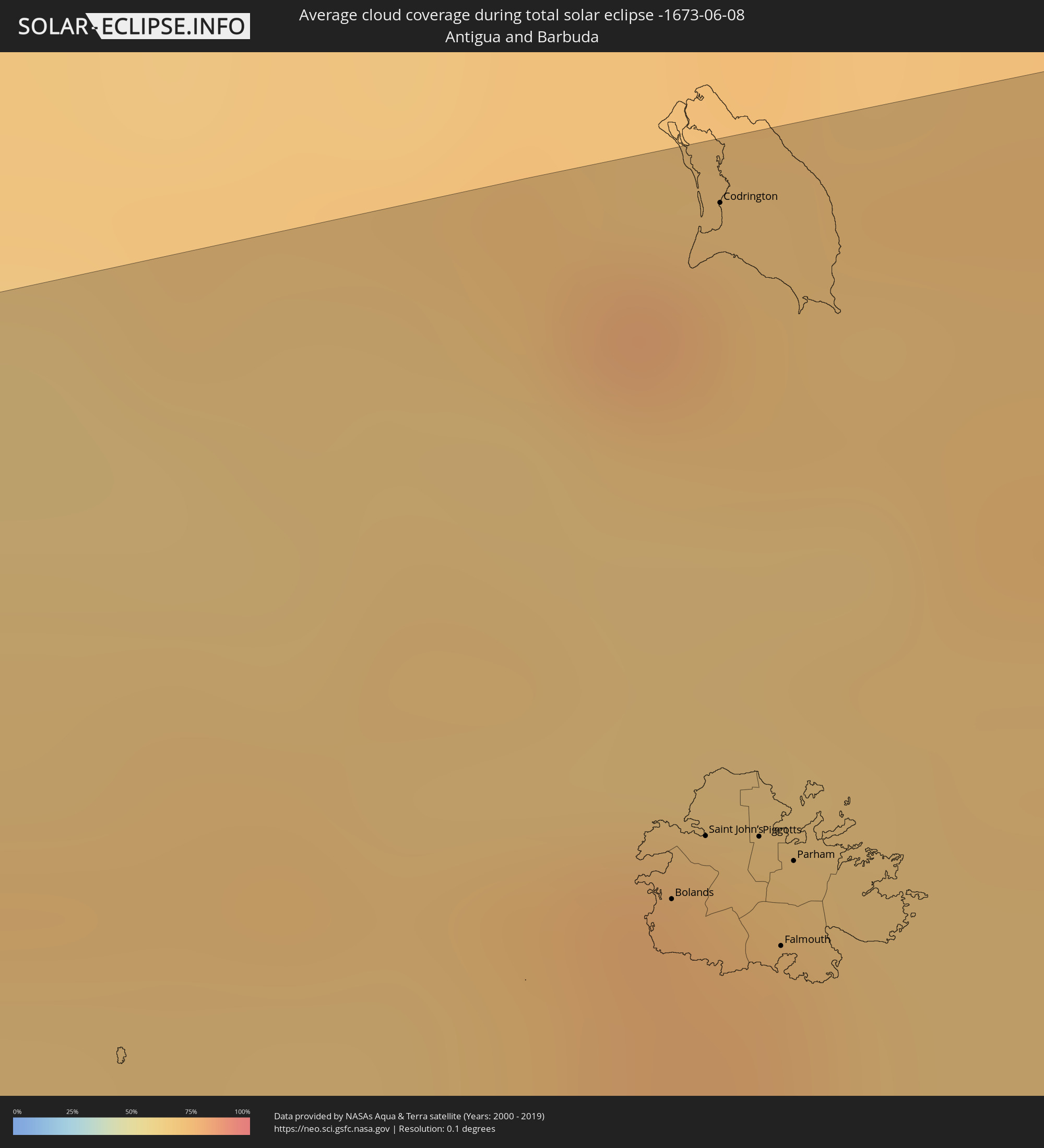 Antigua and Barbuda
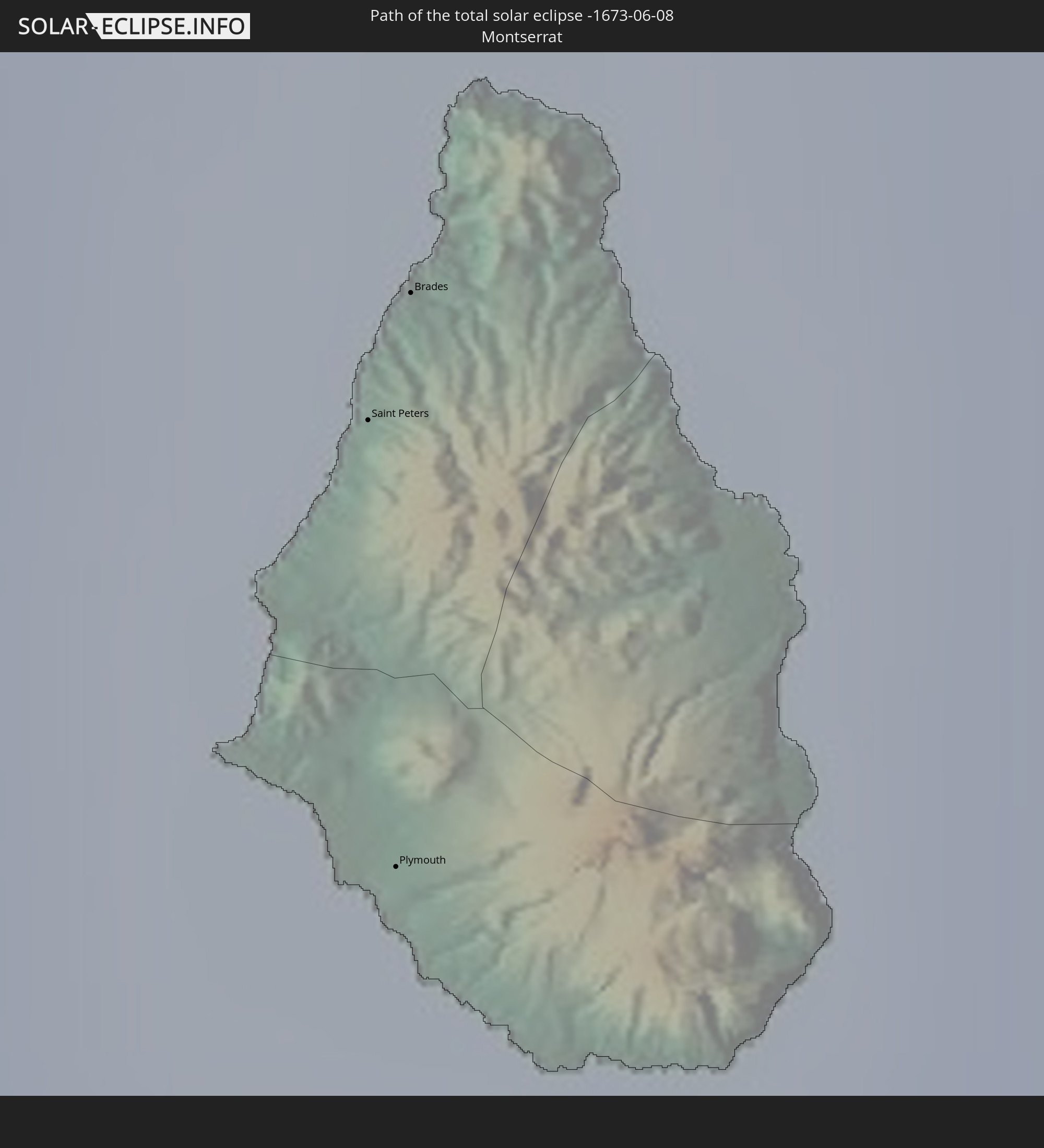
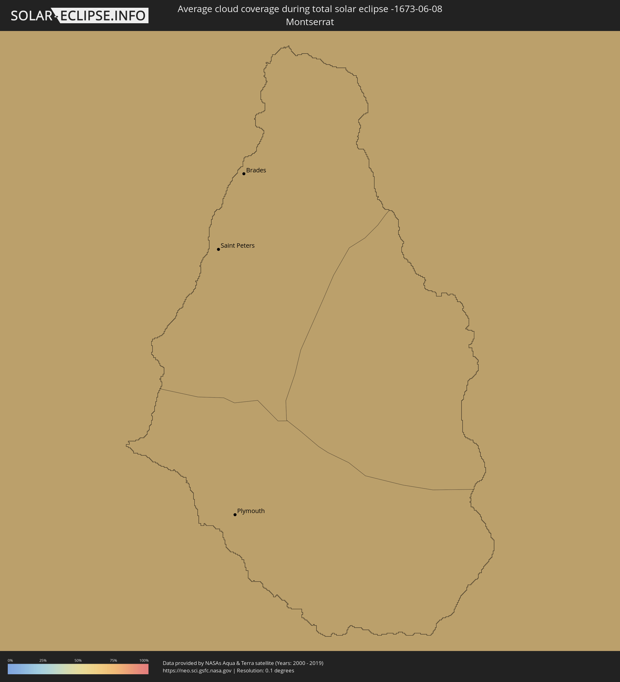 Montserrat
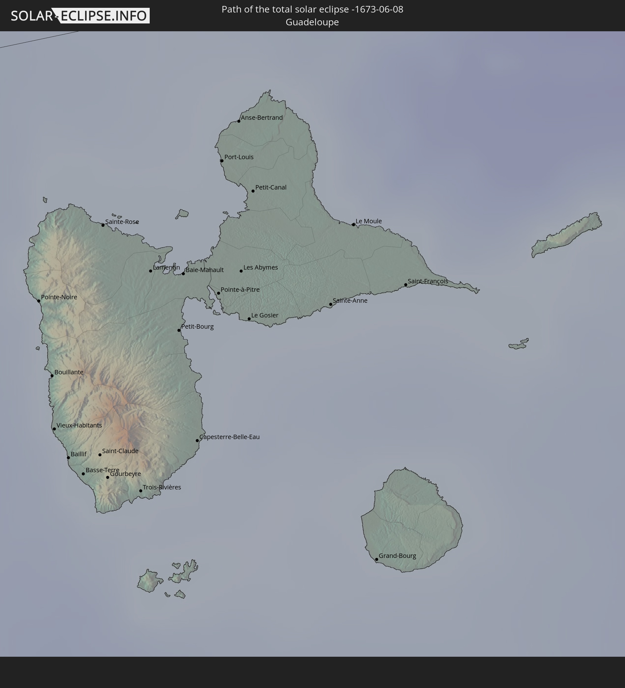
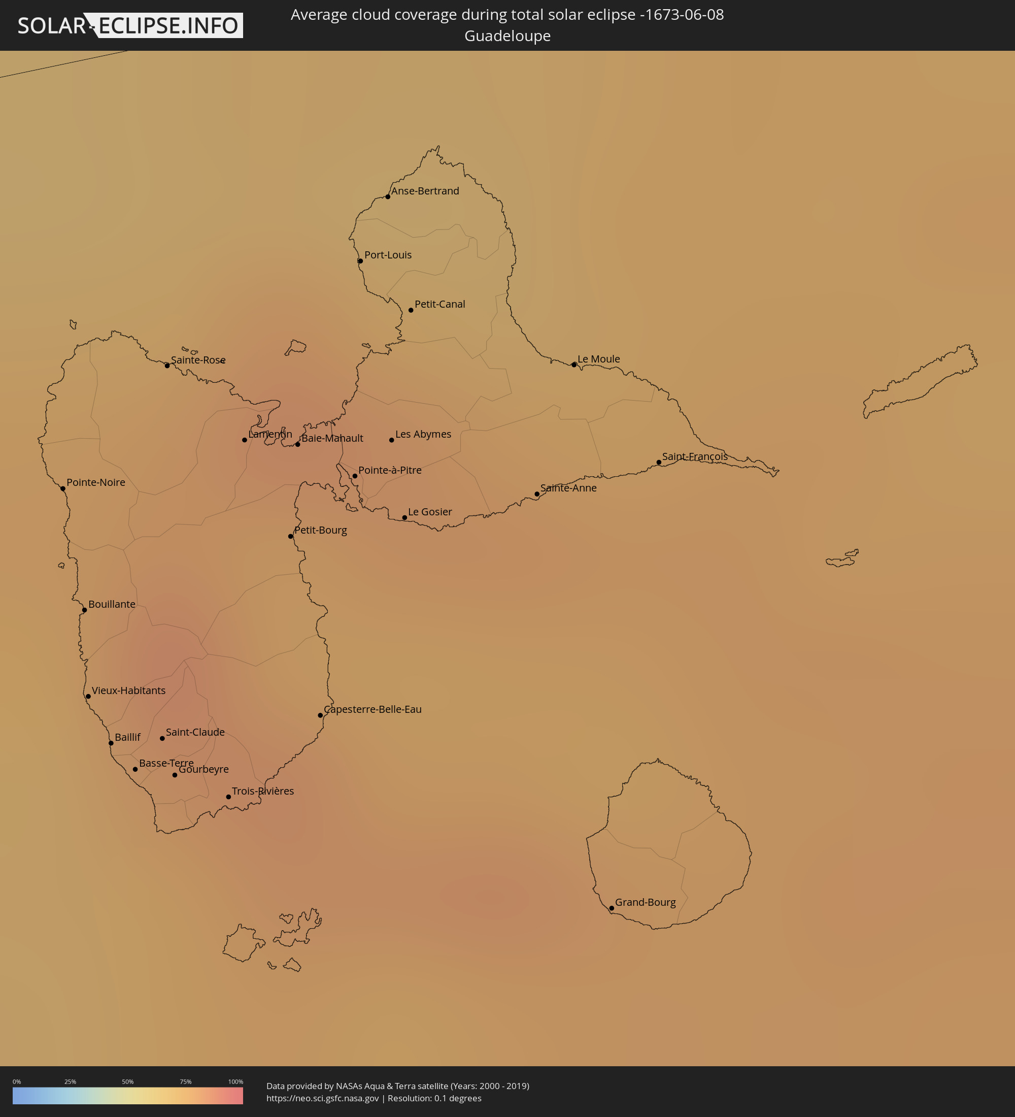 Guadeloupe
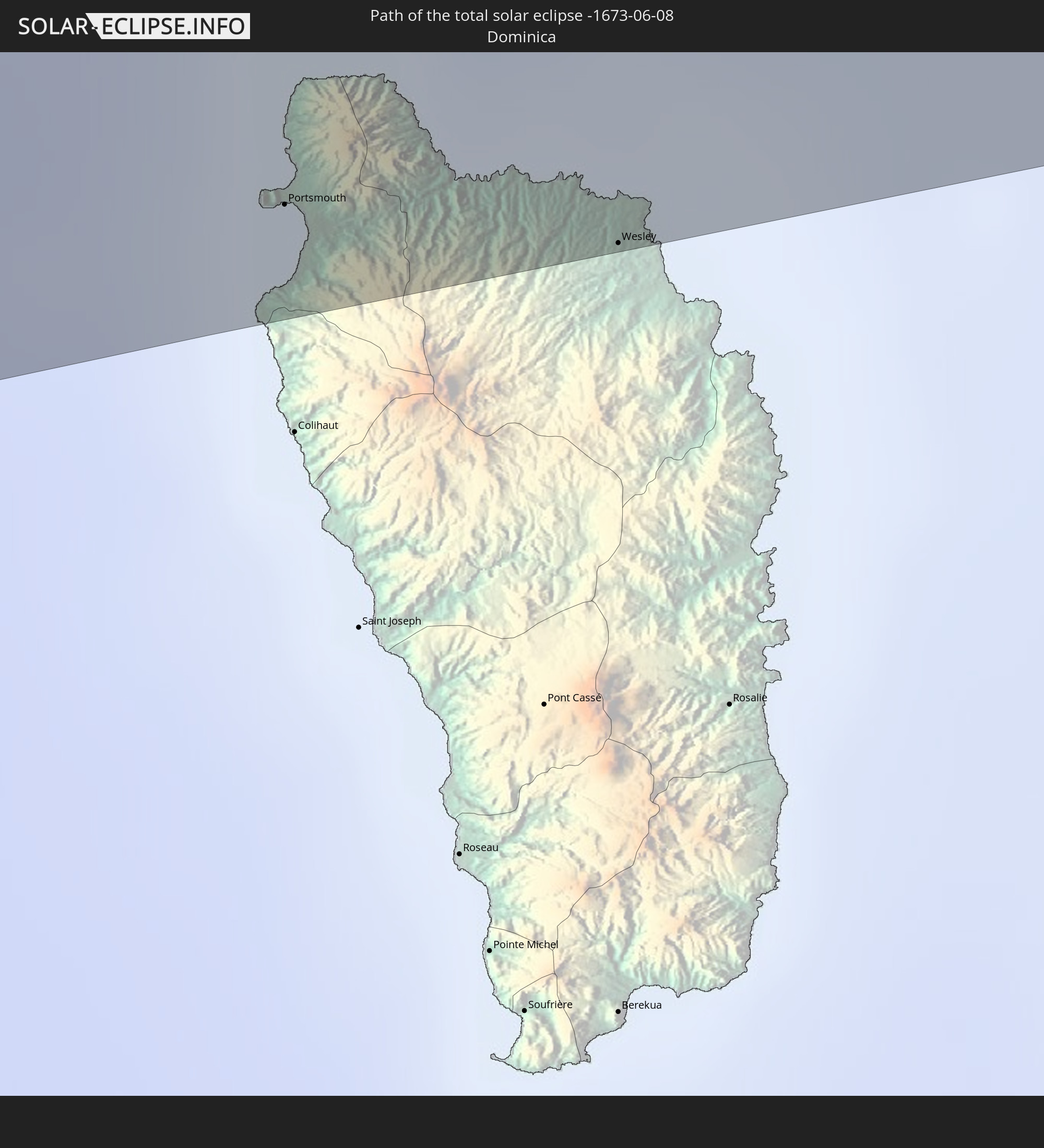
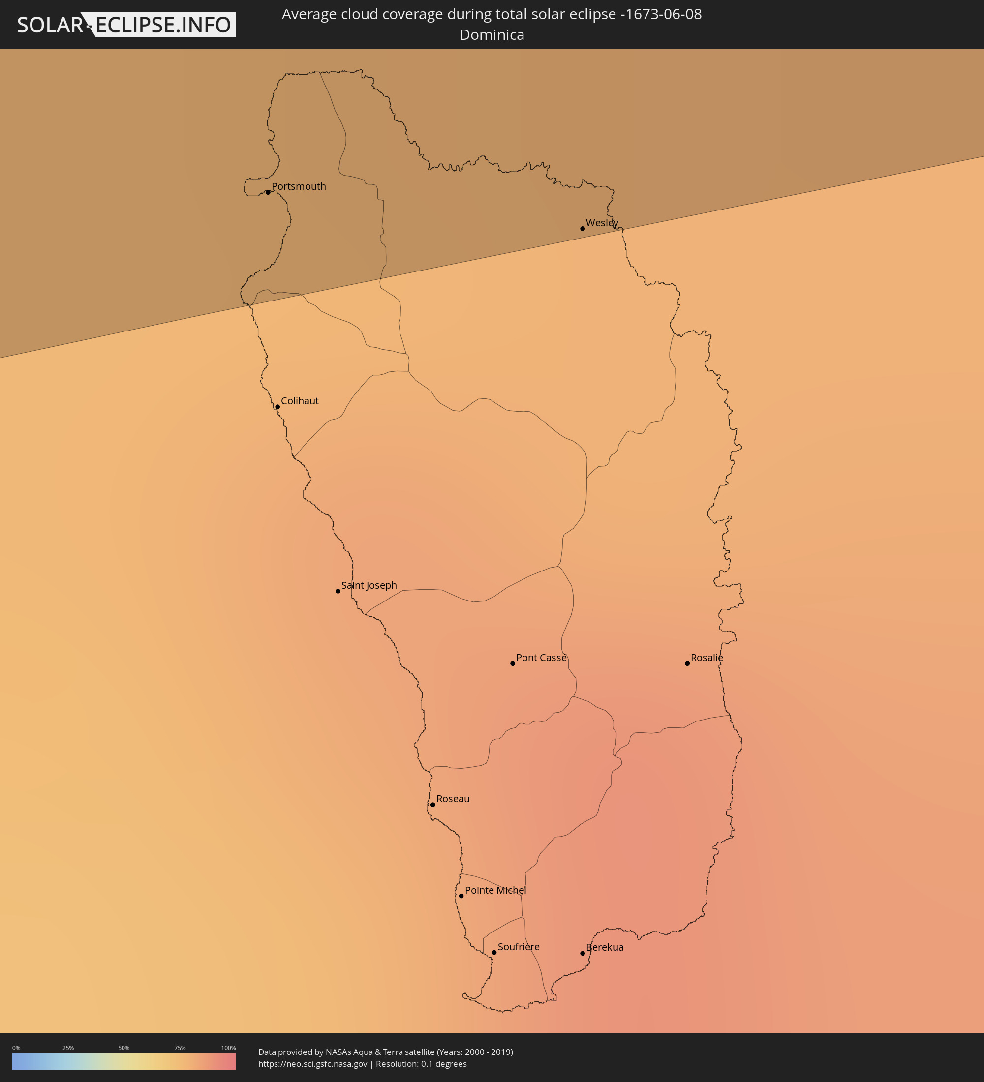 Dominica
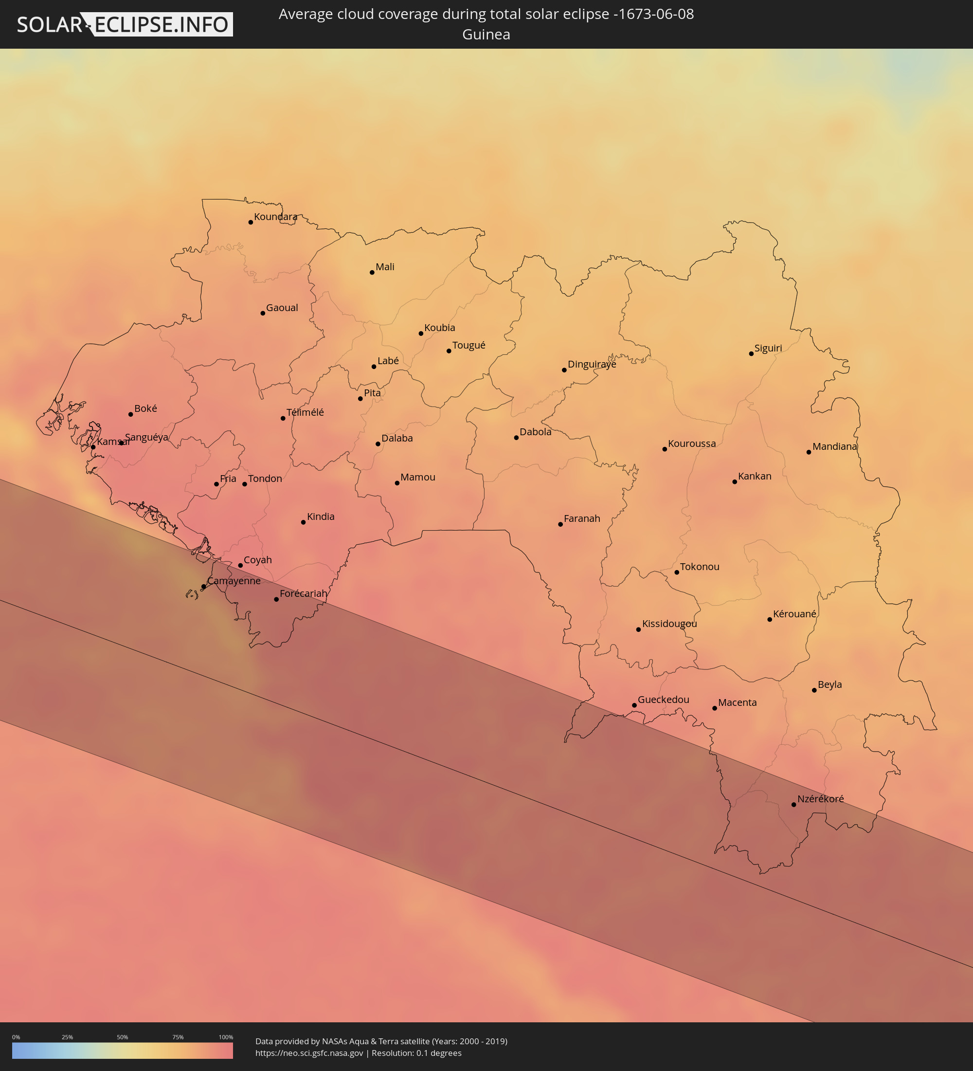 Guinea
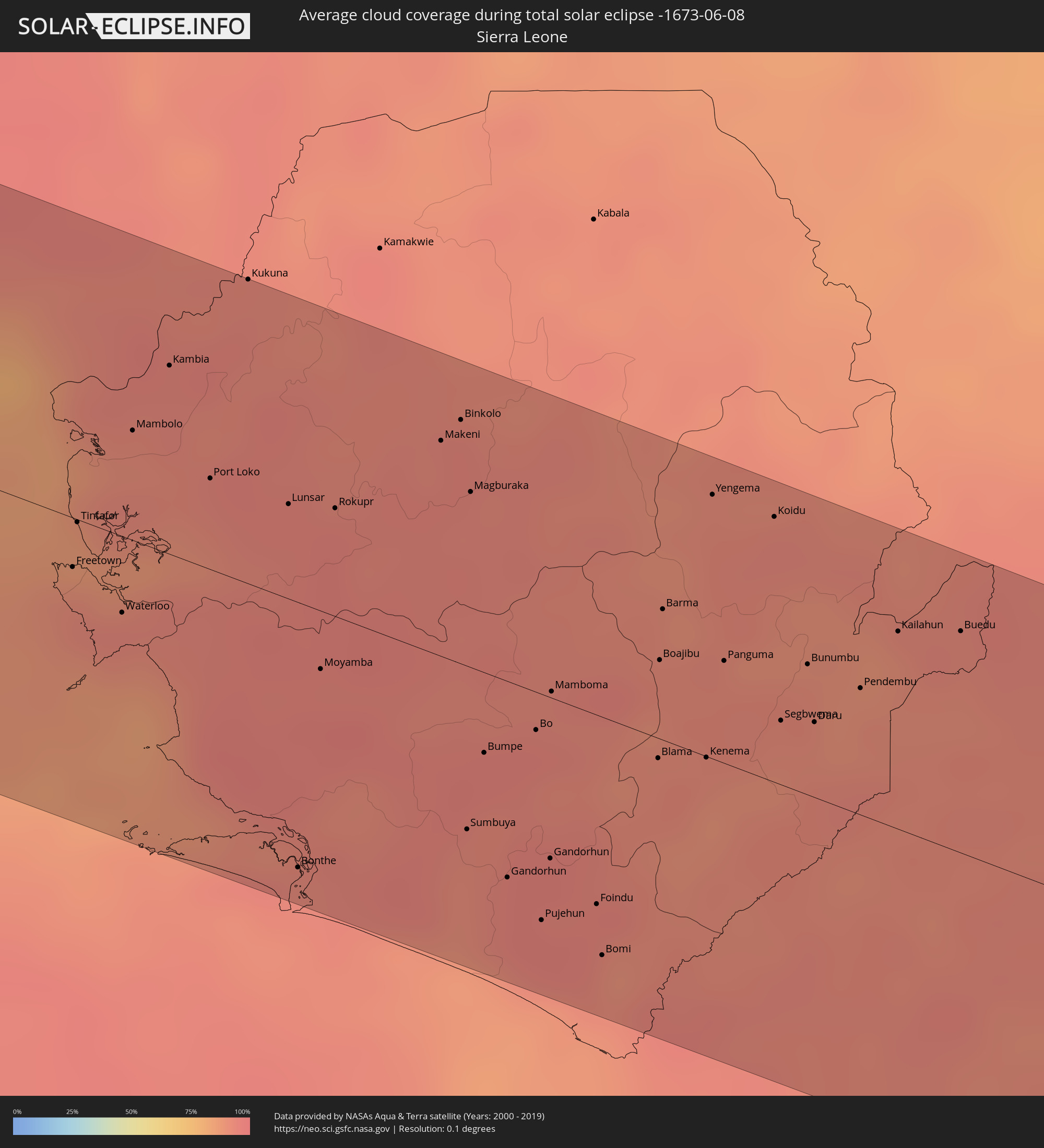 Sierra Leone
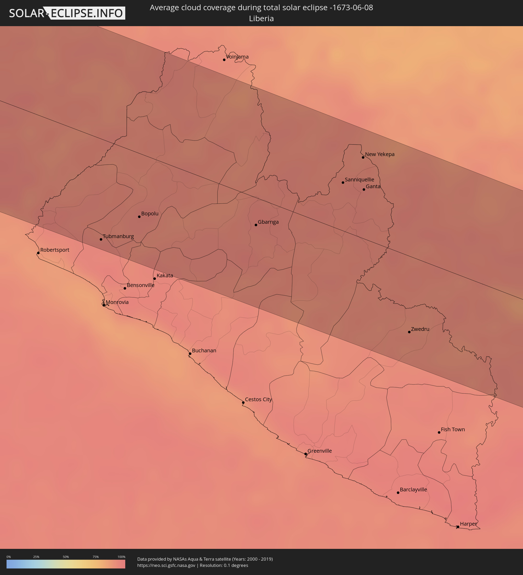 Liberia
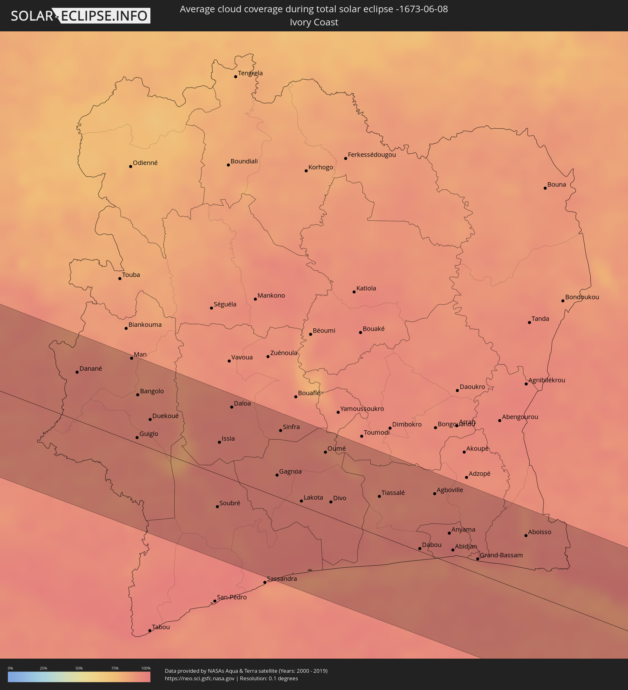 Ivory Coast
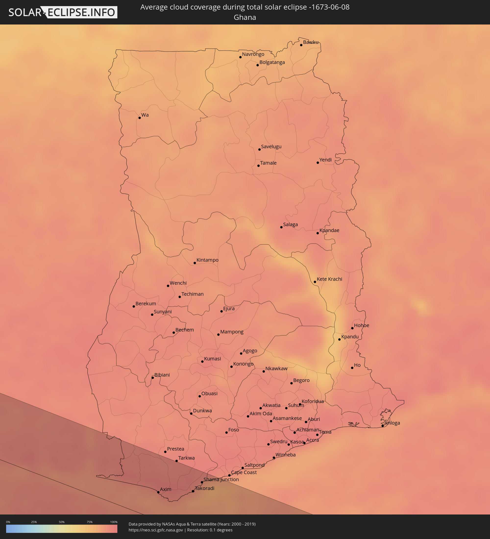 Ghana
Ghana
Cities inside the path of the eclipse
The following table shows all locations with a population of more than 5,000 inside the eclipse path. Cities which have more than 100,000 inhabitants are marked bold. A click at the locations opens a detailed map.
| City | Type | Eclipse duration | Local time of max. eclipse | Distance to central line | Ø Cloud coverage |
|
Daniel Flores, San José
|
total | - | 09:18:56 UTC-05:36 | 112 km | 94% |
|
Mercedes, San José
|
total | - | 09:19:01 UTC-05:36 | 100 km | 92% |
|
Buenos Aires, Puntarenas
|
total | - | 09:19:22 UTC-05:36 | 79 km | 89% |
|
Golfito, Puntarenas
|
total | - | 09:19:11 UTC-05:36 | 11 km | 87% |
|
Corredor, Puntarenas
|
total | - | 09:19:32 UTC-05:36 | 7 km | 90% |
|
Puerto Armuelles, Chiriquí
|
total | - | 09:35:55 UTC-05:19 | 34 km | 88% |
|
Volcán, Chiriquí
|
total | - | 09:36:52 UTC-05:19 | 4 km | 97% |
|
La Concepción, Chiriquí
|
total | - | 09:36:37 UTC-05:19 | 22 km | 95% |
|
Guabito, Bocas del Toro
|
total | - | 09:37:40 UTC-05:19 | 74 km | 87% |
|
Changuinola, Bocas del Toro
|
total | - | 09:37:47 UTC-05:19 | 64 km | 89% |
|
Boquete, Chiriquí
|
total | - | 09:37:14 UTC-05:19 | 5 km | 97% |
|
Pedregal, Chiriquí
|
total | - | 09:36:49 UTC-05:19 | 46 km | 91% |
|
David, Chiriquí
|
total | - | 09:36:53 UTC-05:19 | 40 km | 91% |
|
Almirante, Bocas del Toro
|
total | - | 09:37:52 UTC-05:19 | 45 km | 86% |
|
Las Lomas, Chiriquí
|
total | - | 09:36:58 UTC-05:19 | 42 km | 91% |
|
Bocas del Toro, Bocas del Toro
|
total | - | 09:38:13 UTC-05:19 | 41 km | 84% |
|
Puerto Escondido, Colón
|
total | - | 09:42:21 UTC-05:19 | 80 km | 91% |
|
Colón, Colón
|
total | - | 09:42:54 UTC-05:19 | 73 km | 89% |
|
Sabanitas, Colón
|
total | - | 09:43:05 UTC-05:19 | 78 km | 90% |
|
Chilibre, Panamá
|
total | - | 09:43:16 UTC-05:19 | 106 km | 94% |
|
Alcalde Díaz, Panamá
|
total | - | 09:43:23 UTC-05:19 | 113 km | 93% |
|
La Cabima, Panamá
|
total | - | 09:43:25 UTC-05:19 | 114 km | 95% |
|
Sandy Point Town, Saint Anne Sandy Point
|
total | - | 11:48:15 UTC-04:06 | 109 km | 75% |
|
Saint Paul’s, Saint Paul Capesterre
|
total | - | 11:48:22 UTC-04:06 | 112 km | 75% |
|
Middle Island, Saint Thomas Middle Island
|
total | - | 11:48:18 UTC-04:06 | 103 km | 72% |
|
Dieppe Bay Town, Saint John Capesterre
|
total | - | 11:48:23 UTC-04:06 | 114 km | 75% |
|
Trinity, Trinity Palmetto Point
|
total | - | 11:48:27 UTC-04:06 | 100 km | 72% |
|
Nicola Town, Christ Church Nichola Town
|
total | - | 11:48:32 UTC-04:06 | 107 km | 75% |
|
Cayon, Saint Mary Cayon
|
total | - | 11:48:34 UTC-04:06 | 105 km | 68% |
|
Basseterre, Saint George Basseterre
|
total | - | 11:48:33 UTC-04:06 | 99 km | 74% |
|
Monkey Hill, Saint Peter Basseterre
|
total | - | 11:48:36 UTC-04:06 | 101 km | 74% |
|
Charlestown, Saint Paul Charlestown
|
total | - | 11:48:46 UTC-04:06 | 79 km | 66% |
|
Cotton Ground, Saint Thomas Lowland
|
total | - | 11:48:47 UTC-04:06 | 82 km | 73% |
|
Fig Tree, Saint John Figtree
|
total | - | 11:48:48 UTC-04:06 | 76 km | 66% |
|
Newcastle, Saint James Windwa
|
total | - | 11:48:54 UTC-04:06 | 85 km | 73% |
|
Market Shop, Saint George Gingerland
|
total | - | 11:48:54 UTC-04:06 | 76 km | 66% |
|
Saint Peters, Saint Peter
|
total | - | 11:49:42 UTC-04:06 | 30 km | 75% |
|
Plymouth, Saint Anthony
|
total | - | 11:49:40 UTC-04:06 | 23 km | 69% |
|
Brades, Saint Peter
|
total | - | 11:49:44 UTC-04:06 | 32 km | 75% |
|
Bolands, Saint Mary
|
total | - | 11:50:53 UTC-04:06 | 55 km | 77% |
|
Saint John’s, Saint John
|
total | - | 11:51:00 UTC-04:06 | 60 km | 77% |
|
Codrington, Barbuda
|
total | - | 11:51:22 UTC-04:06 | 115 km | 71% |
|
Piggotts, Saint George
|
total | - | 11:51:08 UTC-04:06 | 58 km | 77% |
|
Pointe-Noire, Guadeloupe
|
total | - | 11:50:37 UTC-04:06 | 38 km | 74% |
|
Falmouth, Saint Paul
|
total | - | 11:51:08 UTC-04:06 | 48 km | 68% |
|
Parham, Saint Peter
|
total | - | 11:51:13 UTC-04:06 | 56 km | 77% |
|
Bouillante, Guadeloupe
|
total | - | 11:50:36 UTC-04:06 | 50 km | 71% |
|
Vieux-Habitants, Guadeloupe
|
total | - | 11:50:34 UTC-04:06 | 58 km | 71% |
|
Baillif, Guadeloupe
|
total | - | 11:50:36 UTC-04:06 | 62 km | 75% |
|
Basse-Terre, Guadeloupe
|
total | - | 11:50:39 UTC-04:06 | 65 km | 75% |
|
Saint-Claude, Guadeloupe
|
total | - | 11:50:44 UTC-04:06 | 63 km | 75% |
|
Sainte-Rose, Guadeloupe
|
total | - | 11:50:57 UTC-04:06 | 29 km | 79% |
|
Gourbeyre, Guadeloupe
|
total | - | 11:50:45 UTC-04:06 | 66 km | 75% |
|
Trois-Rivières, Guadeloupe
|
total | - | 11:50:52 UTC-04:06 | 69 km | 80% |
|
Lamentin, Guadeloupe
|
total | - | 11:51:06 UTC-04:06 | 37 km | 76% |
|
Capesterre-Belle-Eau, Guadeloupe
|
total | - | 11:51:09 UTC-04:06 | 64 km | 80% |
|
Pointe-à-Pitre, Guadeloupe
|
total | - | 11:51:22 UTC-04:06 | 43 km | 73% |
|
Les Abymes, Guadeloupe
|
total | - | 11:51:29 UTC-04:06 | 40 km | 79% |
|
Petit-Canal, Guadeloupe
|
total | - | 11:51:36 UTC-04:06 | 29 km | 80% |
|
Portsmouth, Saint John
|
total | - | 11:51:10 UTC-04:06 | 116 km | 76% |
|
Le Moule, Guadeloupe
|
total | - | 11:51:59 UTC-04:06 | 37 km | 77% |
|
Wesley, Saint Andrew
|
total | - | 11:51:36 UTC-04:06 | 121 km | 79% |
|
Grand-Bourg, Guadeloupe
|
total | - | 11:51:48 UTC-04:06 | 86 km | 77% |
|
Saint-François, Guadeloupe
|
total | - | 11:52:09 UTC-04:06 | 47 km | 77% |
|
Camayenne, Conakry
|
total | - | 17:18:36 UTC-00:16 | 76 km | 82% |
|
Conakry, Conakry
|
total | - | 17:18:36 UTC-00:16 | 76 km | 82% |
|
Freetown, Western Area
|
total | - | 17:19:16 UTC-00:16 | 16 km | 91% |
|
Forécariah, Kindia
|
total | - | 17:18:59 UTC-00:16 | 88 km | 94% |
|
Waterloo, Western Area
|
total | - | 17:19:24 UTC-00:16 | 25 km | 91% |
|
Kambia, Northern Province
|
total | - | 17:19:12 UTC-00:16 | 62 km | 94% |
|
Port Loko, Northern Province
|
total | - | 17:19:24 UTC-00:16 | 30 km | 93% |
|
Lunsar, Northern Province
|
total | - | 17:19:34 UTC-00:16 | 31 km | 94% |
|
Rokupr, Northern Province
|
total | - | 17:19:39 UTC-00:16 | 36 km | 95% |
|
Makeni, Northern Province
|
total | - | 17:19:45 UTC-00:16 | 71 km | 94% |
|
Magburaka, Northern Province
|
total | - | 17:19:52 UTC-00:16 | 58 km | 94% |
|
Bumpe, Southern Province
|
total | - | 17:20:11 UTC-00:16 | 27 km | 95% |
|
Gandorhun, Southern Province
|
total | - | 17:20:22 UTC-00:16 | 65 km | 96% |
|
Bo, Southern Province
|
total | - | 17:20:15 UTC-00:16 | 13 km | 95% |
|
Gandorhun, Southern Province
|
total | - | 17:20:25 UTC-00:16 | 54 km | 96% |
|
Kenema, Eastern Province
|
total | - | 17:20:33 UTC-00:16 | 0 km | 91% |
|
Yengema, Eastern Province
|
total | - | 17:20:15 UTC-00:16 | 88 km | 92% |
|
Koidu, Eastern Province
|
total | - | 17:20:22 UTC-00:16 | 88 km | 93% |
|
Segbwema, Eastern Province
|
total | - | 17:20:37 UTC-00:16 | 21 km | 91% |
|
Tubmanburg, Bomi
|
total | - | 16:54:03 UTC-00:43 | 91 km | 94% |
|
Kailahun, Eastern Province
|
total | - | 17:20:41 UTC-00:16 | 66 km | 91% |
|
Bopolu, Gbarpolu
|
total | - | 16:54:08 UTC-00:43 | 57 km | 94% |
|
Gbarnga, Bong
|
total | - | 16:54:35 UTC-00:43 | 25 km | 93% |
|
Nzérékoré, Nzerekore
|
total | - | 17:21:35 UTC-00:16 | 80 km | 94% |
|
Sanniquellie, Nimba
|
total | - | 16:54:45 UTC-00:43 | 43 km | 94% |
|
New Yekepa, Nimba
|
total | - | 16:54:45 UTC-00:43 | 73 km | 92% |
|
Ganta, Nimba
|
total | - | 16:54:51 UTC-00:43 | 44 km | 93% |
|
Danané, Montagnes
|
total | - | 17:21:59 UTC-00:16 | 54 km | 92% |
|
Zwedru, Grand Gedeh
|
total | - | 16:55:21 UTC-00:43 | 69 km | 92% |
|
Man, Montagnes
|
total | - | 17:22:09 UTC-00:16 | 94 km | 92% |
|
Guiglo, Montagnes
|
total | - | 17:22:26 UTC-00:16 | 6 km | 92% |
|
Duekoué, Montagnes
|
total | - | 17:22:25 UTC-00:16 | 32 km | 93% |
|
Soubré, Bas-Sassandra
|
total | - | 17:22:55 UTC-00:16 | 38 km | 92% |
|
Issia, Sassandra-Marahoué
|
total | - | 17:22:43 UTC-00:16 | 37 km | 94% |
|
Daloa, Sassandra-Marahoué
|
total | - | 17:22:39 UTC-00:16 | 82 km | 94% |
|
Gagnoa, Gôh-Djiboua
|
total | - | 17:23:00 UTC-00:16 | 24 km | 94% |
|
Sinfra, Zanzan
|
total | - | 17:22:52 UTC-00:16 | 77 km | 92% |
|
Oumé, Gôh-Djiboua
|
total | - | 17:23:03 UTC-00:16 | 72 km | 93% |
|
Divo, Gôh-Djiboua
|
total | - | 17:23:13 UTC-00:16 | 17 km | 95% |
|
Dabou, Lagunes
|
total | - | 17:23:34 UTC-00:16 | 3 km | 90% |
|
Agboville, Lagunes
|
total | - | 17:23:26 UTC-00:16 | 72 km | 92% |
|
Anyama, Abidjan
|
total | - | 17:23:35 UTC-00:16 | 33 km | 96% |
|
Abidjan, Abidjan
|
total | - | 17:23:38 UTC-00:16 | 16 km | 93% |
|
Bingerville, Abidjan
|
total | - | 17:23:39 UTC-00:16 | 25 km | 93% |
|
Grand-Bassam, Comoé
|
total | - | 17:23:43 UTC-00:16 | 16 km | 87% |
|
Axim, Western
|
total | - | 17:39:17 UTC-00:00 | 40 km | 94% |
|
Takoradi, Western
|
total | - | 17:39:20 UTC-00:00 | 61 km | 89% |
|
Sekondi-Takoradi, Western
|
total | - | 17:39:20 UTC-00:00 | 68 km | 85% |
|
Shama Junction, Western
|
total | - | 17:39:19 UTC-00:00 | 79 km | 83% |