Annular solar eclipse of 05/26/-1756
| Day of week: | Friday |
| Maximum duration of eclipse: | 04m46s |
| Maximum width of eclipse path: | 164 km |
| Saros cycle: | 19 |
| Coverage: | 95.6% |
| Magnitude: | 0.956 |
| Gamma: | 0.2263 |
Wo kann man die Sonnenfinsternis vom 05/26/-1756 sehen?
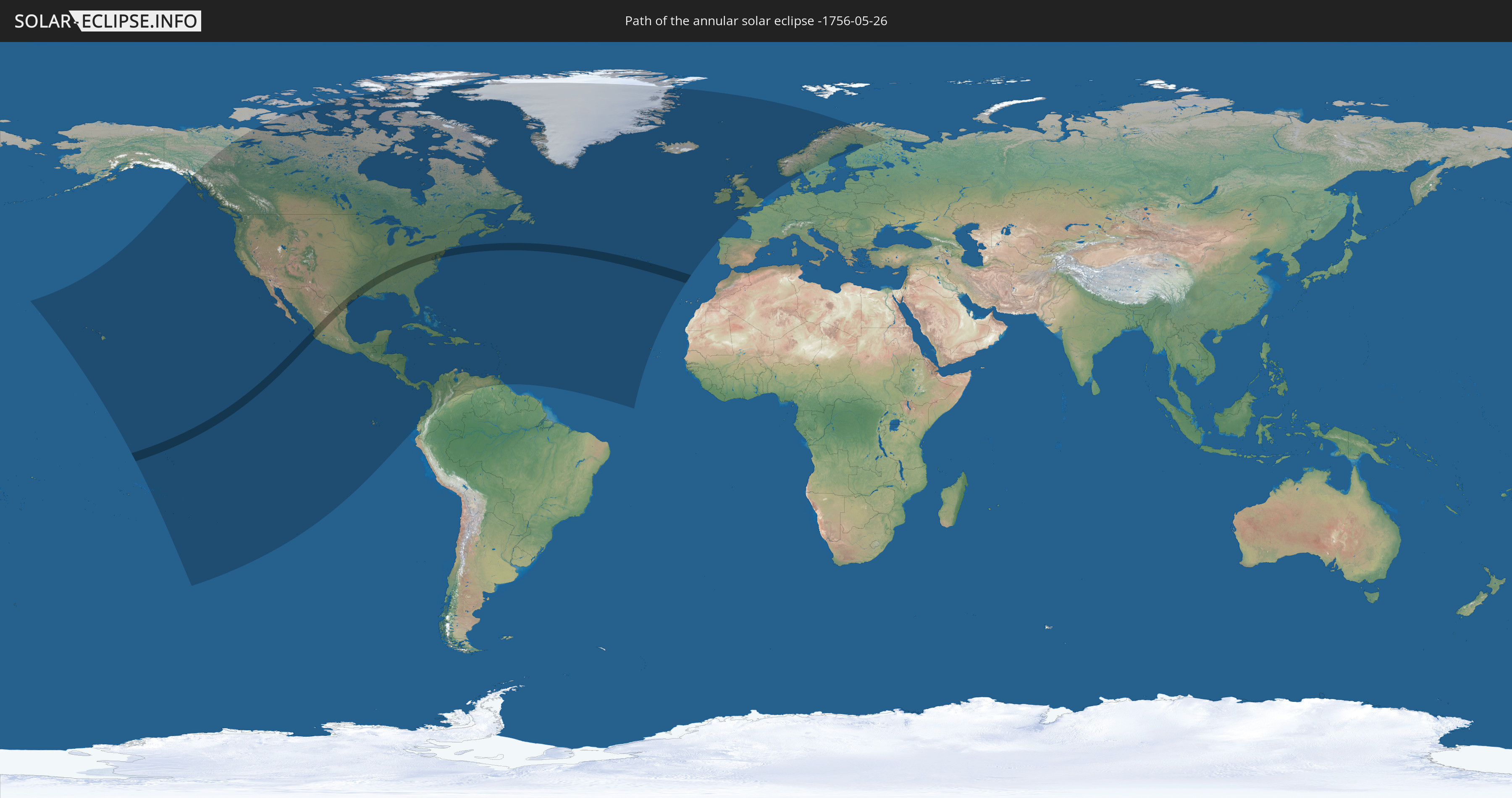
Die Sonnenfinsternis am 05/26/-1756 kann man in 62 Ländern als partielle Sonnenfinsternis beobachten.
Der Finsternispfad verläuft durch 3 Länder. Nur in diesen Ländern ist sie als annular Sonnenfinsternis zu sehen.
In den folgenden Ländern ist die Sonnenfinsternis annular zu sehen
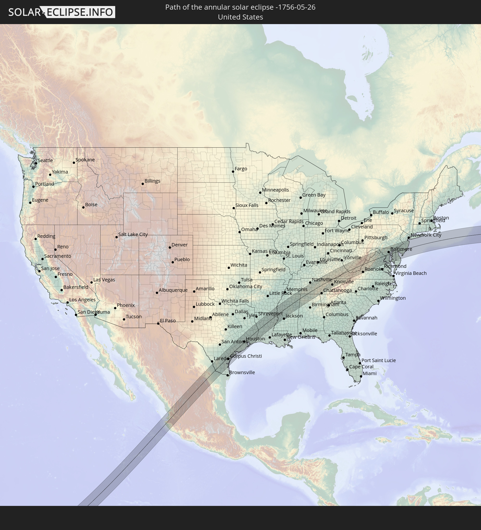 United States
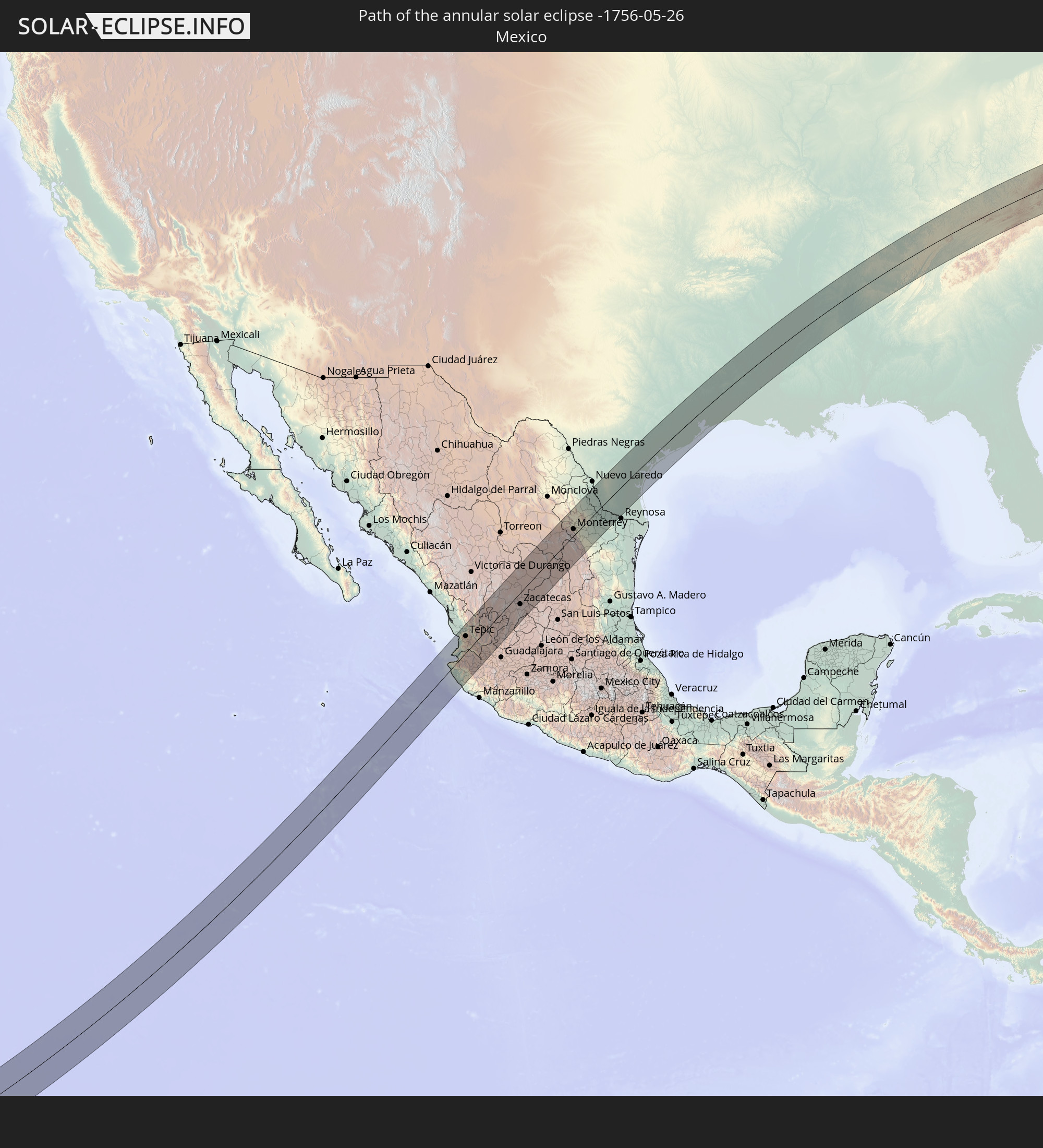 Mexico
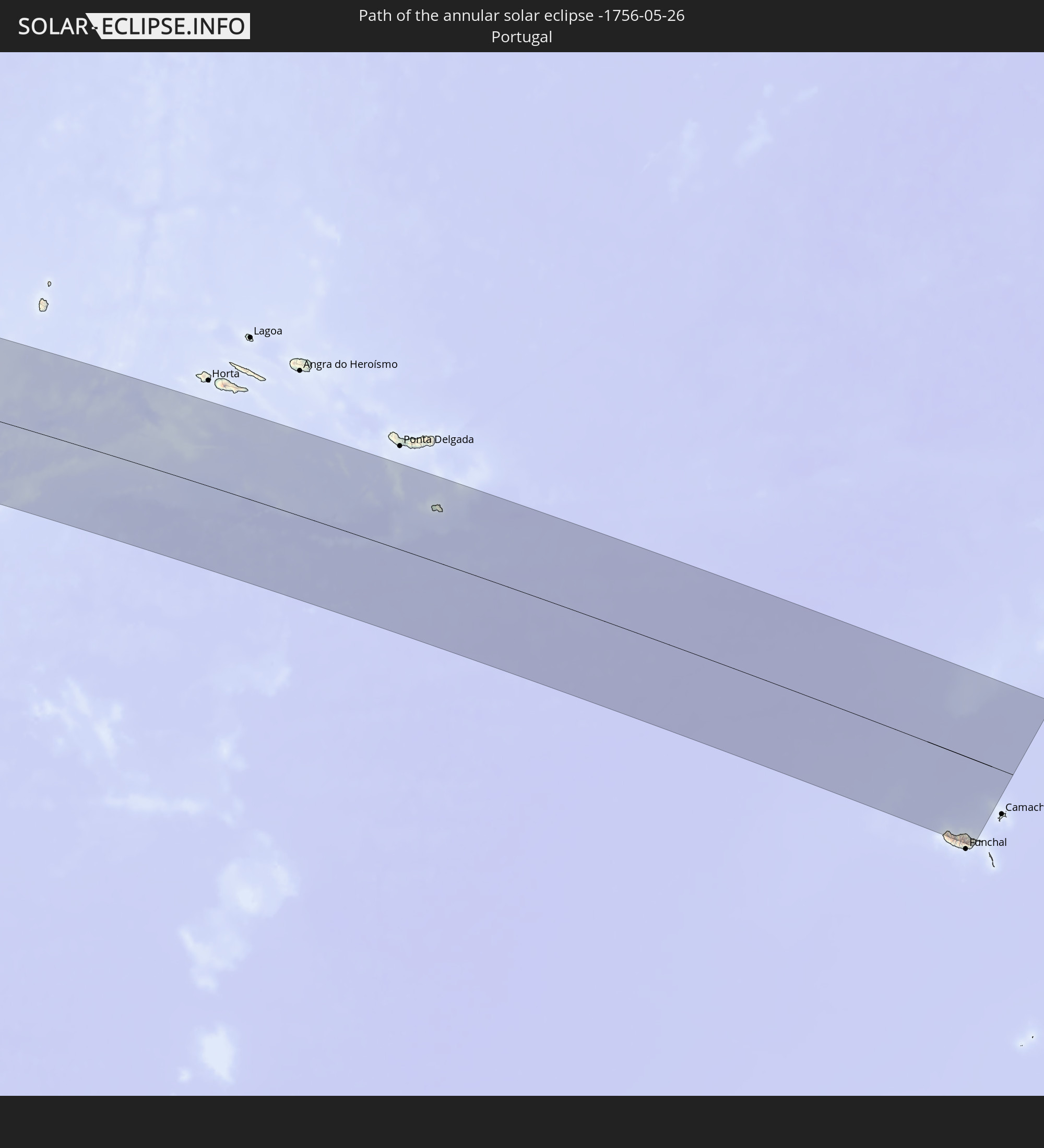 Portugal
In den folgenden Ländern ist die Sonnenfinsternis partiell zu sehen
 Russia
 United States
 United States Minor Outlying Islands
 Kiribati
 French Polynesia
 Canada
 Pitcairn Islands
 Mexico
 Chile
Chile
 Greenland
 Guatemala
 Ecuador
 El Salvador
 Honduras
 Belize
 Nicaragua
 Costa Rica
 Cuba
Cuba
 Panama
 Colombia
 Cayman Islands
 The Bahamas
 Jamaica
 Haiti
Haiti
 Venezuela
 Turks and Caicos Islands
 Dominican Republic
 Aruba
Aruba
 Puerto Rico
 United States Virgin Islands
 Bermuda
 British Virgin Islands
 Anguilla
 Collectivity of Saint Martin
 Saint Barthélemy
 Saint Kitts and Nevis
 Antigua and Barbuda
 Montserrat
 Trinidad and Tobago
 Guadeloupe
 Grenada
 Dominica
 Saint Vincent and the Grenadines
 Guyana
 Martinique
 Saint Lucia
 Barbados
 Saint Pierre and Miquelon
 Portugal
 Cabo Verde
 Iceland
 Spain
Spain
 Republic of Ireland
 Svalbard and Jan Mayen
 United Kingdom
 Faroe Islands
 France
 Isle of Man
 Guernsey
 Norway
 Sweden
 Finland
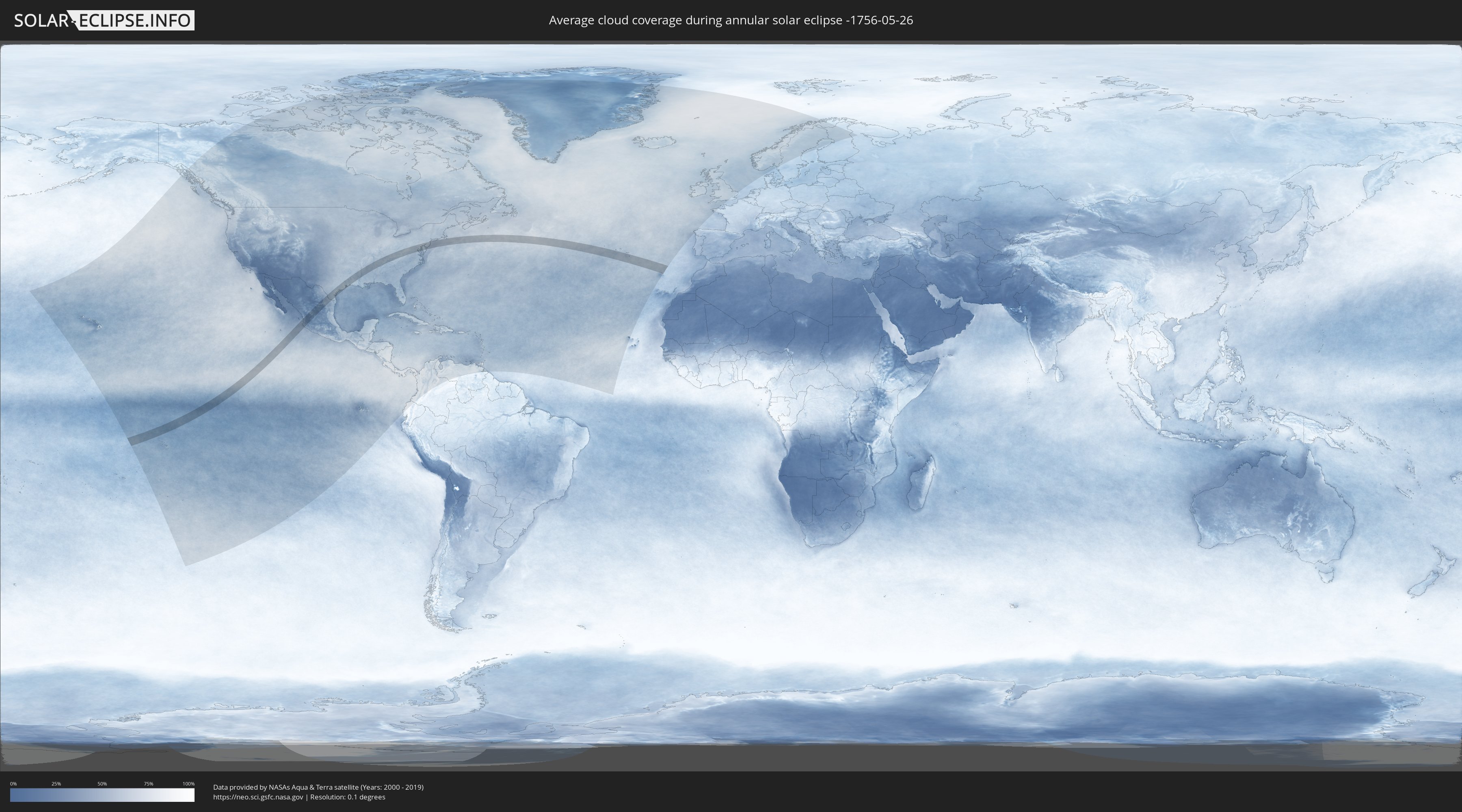
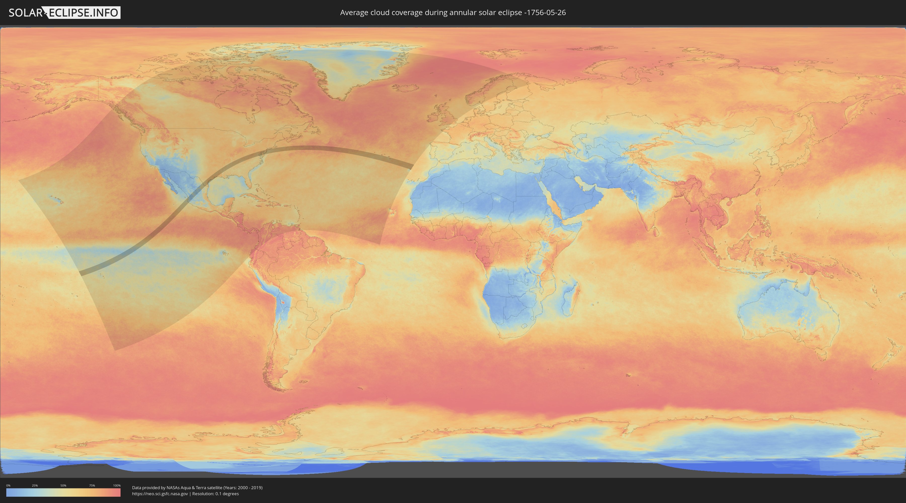
How will be the weather during the annular solar eclipse on 05/26/-1756?
Where is the best place to see the annular solar eclipse of 05/26/-1756?
The following maps show the average cloud coverage for the day of the annular solar eclipse.
With the help of these maps, it is possible to find the place along the eclipse path, which has the best
chance of a cloudless sky.
Nevertheless, you should consider local circumstances and inform about the weather of your chosen
observation site.
The data is provided by NASAs satellites
AQUA and TERRA.
The cloud maps are averaged over a period of 19 years (2000 - 2019).
Detailed country maps
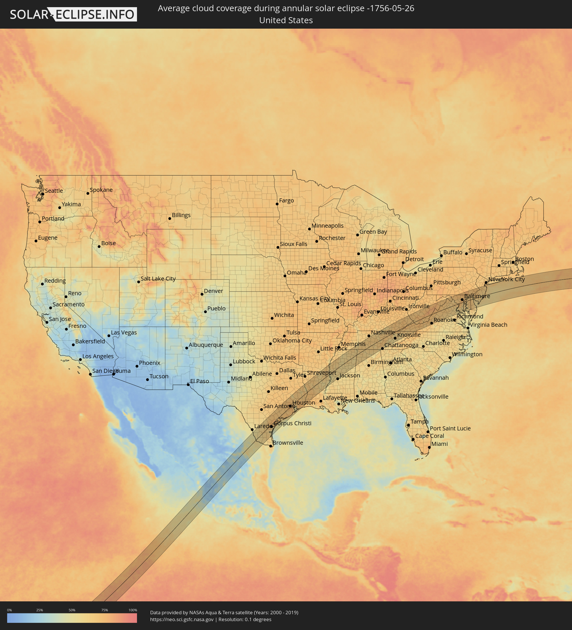 United States
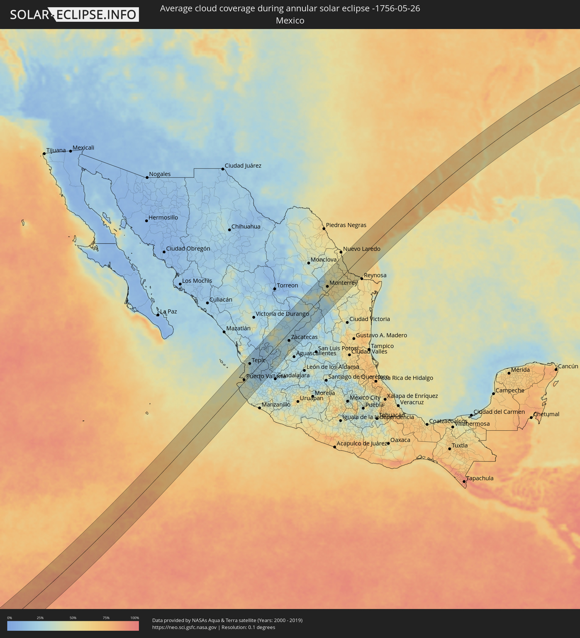 Mexico
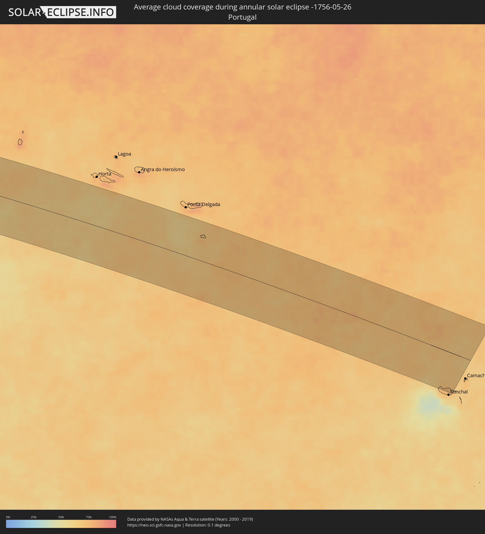 Portugal
Cities inside the path of the eclipse
The following table shows all locations with a population of more than 5,000 inside the eclipse path. Cities which have more than 100,000 inhabitants are marked bold. A click at the locations opens a detailed map.
| City | Type | Eclipse duration | Local time of max. eclipse | Distance to central line | Ø Cloud coverage |
|
Bucerías, Nayarit
|
annular | - | 10:31:22 UTC-06:36 | 27 km | 45% |
|
San Blas, Nayarit
|
annular | - | 10:04:16 UTC-07:05 | 81 km | 38% |
|
Las Jarretaderas, Nayarit
|
annular | - | 10:31:19 UTC-06:36 | 17 km | 52% |
|
Tomatlán, Jalisco
|
annular | - | 10:29:33 UTC-06:36 | 41 km | 40% |
|
Valle de Banderas, Nayarit
|
annular | - | 10:31:38 UTC-06:36 | 24 km | 42% |
|
Puerto Vallarta, Jalisco
|
annular | - | 10:31:13 UTC-06:36 | 8 km | 41% |
|
Ixtapa, Jalisco
|
annular | - | 10:31:30 UTC-06:36 | 14 km | 43% |
|
San Juan de Abajo, Nayarit
|
annular | - | 10:31:45 UTC-06:36 | 20 km | 42% |
|
Las Varas, Nayarit
|
annular | - | 10:03:39 UTC-07:05 | 43 km | 44% |
|
Compostela, Nayarit
|
annular | - | 10:04:12 UTC-07:05 | 29 km | 26% |
|
Tepic, Nayarit
|
annular | - | 10:04:51 UTC-07:05 | 49 km | 29% |
|
Puga, Nayarit
|
annular | - | 10:05:09 UTC-07:05 | 49 km | 24% |
|
Talpa de Allende, Jalisco
|
annular | - | 10:31:21 UTC-06:36 | 41 km | 27% |
|
Mascota, Jalisco
|
annular | - | 10:31:45 UTC-06:36 | 33 km | 25% |
|
El Salto, Jalisco
|
annular | - | 10:31:47 UTC-06:36 | 70 km | 32% |
|
Ahuacatlán, Nayarit
|
annular | - | 10:04:28 UTC-07:05 | 17 km | 20% |
|
Jala, Nayarit
|
annular | - | 10:04:41 UTC-07:05 | 17 km | 19% |
|
Ixtlán del Río, Nayarit
|
annular | - | 10:04:38 UTC-07:05 | 27 km | 22% |
|
Etzatlán, Jalisco
|
annular | - | 10:33:34 UTC-06:36 | 70 km | 22% |
|
Ahualulco de Mercado, Jalisco
|
annular | - | 10:33:35 UTC-06:36 | 83 km | 25% |
|
Tequila, Jalisco
|
annular | - | 10:34:16 UTC-06:36 | 80 km | 21% |
|
Valparaíso, Zacatecas
|
annular | - | 10:39:16 UTC-06:36 | 41 km | 30% |
|
Tlaltenango de Sánchez Román, Zacatecas
|
annular | - | 10:37:23 UTC-06:36 | 53 km | 29% |
|
Colotlán, Jalisco
|
annular | - | 10:38:14 UTC-06:36 | 31 km | 21% |
|
Río Grande, Zacatecas
|
annular | - | 10:42:47 UTC-06:36 | 80 km | 18% |
|
Jerez de García Salinas, Zacatecas
|
annular | - | 10:40:02 UTC-06:36 | 12 km | 30% |
|
Tabasco, Zacatecas
|
annular | - | 10:38:17 UTC-06:36 | 77 km | 24% |
|
Villanueva, Zacatecas
|
annular | - | 10:39:31 UTC-06:36 | 42 km | 26% |
|
Fresnillo, Zacatecas
|
annular | - | 10:41:31 UTC-06:36 | 19 km | 30% |
|
Cañitas de Felipe Pescador, Zacatecas
|
annular | - | 10:42:48 UTC-06:36 | 40 km | 21% |
|
Víctor Rosales, Zacatecas
|
annular | - | 10:41:17 UTC-06:36 | 11 km | 27% |
|
Zacatecas, Zacatecas
|
annular | - | 10:41:04 UTC-06:36 | 34 km | 31% |
|
Tacoaleche, Zacatecas
|
annular | - | 10:41:31 UTC-06:36 | 43 km | 27% |
|
Trancoso, Zacatecas
|
annular | - | 10:41:23 UTC-06:36 | 52 km | 28% |
|
San Pedro Piedra Gorda, Zacatecas
|
annular | - | 10:40:43 UTC-06:36 | 76 km | 32% |
|
Luis Moya, Zacatecas
|
annular | - | 10:40:52 UTC-06:36 | 84 km | 29% |
|
Los Zacatones, San Luis Potosí
|
annular | - | 10:42:30 UTC-06:36 | 59 km | 21% |
|
Concepcion del Oro, Zacatecas
|
annular | - | 10:47:40 UTC-06:36 | 19 km | 38% |
|
Saltillo, Coahuila
|
annular | - | 10:50:23 UTC-06:36 | 50 km | 39% |
|
Arteaga, Coahuila
|
annular | - | 10:50:45 UTC-06:36 | 40 km | 37% |
|
García, Nuevo León
|
annular | - | 10:52:06 UTC-06:36 | 50 km | 36% |
|
Valle de Lincoln, Nuevo León
|
annular | - | 10:52:17 UTC-06:36 | 40 km | 42% |
|
Parque Industrial Ciudad Mitras, Nuevo León
|
annular | - | 10:52:20 UTC-06:36 | 38 km | 49% |
|
Mitras Poniente, Nuevo León
|
annular | - | 10:52:21 UTC-06:36 | 35 km | 49% |
|
Monterrey, Nuevo León
|
annular | - | 10:52:19 UTC-06:36 | 20 km | 49% |
|
Emiliano Zapata, Nuevo León
|
annular | - | 10:52:57 UTC-06:36 | 35 km | 50% |
|
Sabinas Hidalgo, Nuevo León
|
annular | - | 10:54:32 UTC-06:36 | 74 km | 45% |
|
Real del Sol, Nuevo León
|
annular | - | 10:53:13 UTC-06:36 | 30 km | 50% |
|
Ciénega de Flores, Nuevo León
|
annular | - | 10:53:17 UTC-06:36 | 30 km | 45% |
|
Apodaca, Nuevo León
|
annular | - | 10:52:50 UTC-06:36 | 15 km | 53% |
|
Fraccionamiento Real Palmas, Nuevo León
|
annular | - | 10:53:11 UTC-06:36 | 26 km | 50% |
|
Santiago, Nuevo León
|
annular | - | 10:52:04 UTC-06:36 | 12 km | 57% |
|
Misión San Pablo, Nuevo León
|
annular | - | 10:52:49 UTC-06:36 | 12 km | 55% |
|
Héctor Caballero, Nuevo León
|
annular | - | 10:52:36 UTC-06:36 | 3 km | 55% |
|
General Zuazua, Nuevo León
|
annular | - | 10:53:16 UTC-06:36 | 21 km | 47% |
|
Juárez, Nuevo León
|
annular | - | 10:52:42 UTC-06:36 | 2 km | 55% |
|
Galeana, Nuevo León
|
annular | - | 10:50:47 UTC-06:36 | 63 km | 32% |
|
Allende, Nuevo León
|
annular | - | 10:51:59 UTC-06:36 | 33 km | 57% |
|
Cadereyta, Nuevo León
|
annular | - | 10:52:46 UTC-06:36 | 12 km | 56% |
|
Montemorelos, Nuevo León
|
annular | - | 10:52:09 UTC-06:36 | 53 km | 50% |
|
General Teran, Nuevo León
|
annular | - | 10:52:36 UTC-06:36 | 58 km | 47% |
|
Hidalgo, Nuevo León
|
annular | - | 10:54:08 UTC-06:36 | 17 km | 52% |
|
China, Nuevo León
|
annular | - | 10:54:33 UTC-06:36 | 57 km | 49% |
|
Mier, Tamaulipas
|
annular | - | 10:56:25 UTC-06:36 | 6 km | 58% |
|
Ciudad Miguel Alemán, Tamaulipas
|
annular | - | 10:56:36 UTC-06:36 | 17 km | 56% |
|
Camargo, Tamaulipas
|
annular | - | 10:56:38 UTC-06:36 | 41 km | 53% |
|
Ciudad Díaz Ordaz, Tamaulipas
|
annular | - | 10:57:05 UTC-06:36 | 61 km | 52% |
|
Mission, Texas
|
annular | - | 11:34:13 UTC-06:00 | 81 km | 54% |
|
Corpus Christi, Texas
|
annular | - | 11:39:48 UTC-06:00 | 20 km | 64% |
|
Victoria, Texas
|
annular | - | 11:42:53 UTC-06:00 | 34 km | 69% |
|
Cypress, Texas
|
annular | - | 11:48:13 UTC-06:00 | 43 km | 74% |
|
Sugar Land, Texas
|
annular | - | 11:47:35 UTC-06:00 | 10 km | 73% |
|
The Woodlands, Texas
|
annular | - | 11:49:04 UTC-06:00 | 45 km | 75% |
|
Conroe, Texas
|
annular | - | 11:49:28 UTC-06:00 | 56 km | 72% |
|
Houston, Texas
|
annular | - | 11:48:29 UTC-06:00 | 4 km | 74% |
|
Pearland, Texas
|
annular | - | 11:48:13 UTC-06:00 | 17 km | 77% |
|
Pasadena, Texas
|
annular | - | 11:48:40 UTC-06:00 | 12 km | 74% |
|
Atascocita, Texas
|
annular | - | 11:49:24 UTC-06:00 | 12 km | 66% |
|
League City, Texas
|
annular | - | 11:48:31 UTC-06:00 | 34 km | 74% |
|
Baytown, Texas
|
annular | - | 11:49:16 UTC-06:00 | 23 km | 65% |
|
Galveston, Texas
|
annular | - | 11:48:43 UTC-06:00 | 71 km | 59% |
|
Beaumont, Texas
|
annular | - | 11:51:56 UTC-06:00 | 50 km | 75% |
|
Port Arthur, Texas
|
annular | - | 11:51:52 UTC-06:00 | 77 km | 71% |
|
Alexandria, Louisiana
|
annular | - | 11:58:09 UTC-06:00 | 47 km | 63% |
|
Monroe, Louisiana
|
annular | - | 12:01:13 UTC-06:00 | 38 km | 63% |
|
Greenville, Mississippi
|
annular | - | 12:05:15 UTC-06:00 | 57 km | 60% |
|
Tupelo, Mississippi
|
annular | - | 12:12:01 UTC-06:00 | 7 km | 62% |
|
Florence, Alabama
|
annular | - | 12:15:13 UTC-06:00 | 5 km | 63% |
|
Columbia, Tennessee
|
annular | - | 12:17:54 UTC-06:00 | 51 km | 65% |
|
Decatur, Alabama
|
annular | - | 12:16:29 UTC-06:00 | 47 km | 61% |
|
Franklin, Tennessee
|
annular | - | 12:18:44 UTC-06:00 | 72 km | 66% |
|
Madison, Alabama
|
annular | - | 12:17:10 UTC-06:00 | 50 km | 59% |
|
Huntsville, Alabama
|
annular | - | 12:17:35 UTC-06:00 | 55 km | 60% |
|
Smyrna, Tennessee
|
annular | - | 12:19:36 UTC-06:00 | 61 km | 68% |
|
Murfreesboro, Tennessee
|
annular | - | 12:19:41 UTC-06:00 | 42 km | 66% |
|
Knoxville, Tennessee
|
annular | - | 13:25:23 UTC-05:00 | 57 km | 60% |
|
Kingsport, Tennessee
|
annular | - | 13:29:10 UTC-05:00 | 56 km | 66% |
|
Blacksburg, Virginia
|
annular | - | 13:34:41 UTC-05:00 | 69 km | 69% |
|
Roanoke, Virginia
|
annular | - | 13:35:45 UTC-05:00 | 81 km | 67% |
|
Harrisonburg, Virginia
|
annular | - | 13:39:06 UTC-05:00 | 4 km | 70% |
|
Charlottesville, Virginia
|
annular | - | 13:39:36 UTC-05:00 | 52 km | 64% |
|
Linton Hall, Virginia
|
annular | - | 13:42:04 UTC-05:00 | 4 km | 67% |
|
Ashburn, Virginia
|
annular | - | 13:42:26 UTC-05:00 | 23 km | 69% |
|
Centreville, Virginia
|
annular | - | 13:42:25 UTC-05:00 | 0 km | 65% |
|
Frederick, Maryland
|
annular | - | 13:42:51 UTC-05:00 | 59 km | 70% |
|
Reston, Virginia
|
annular | - | 13:42:41 UTC-05:00 | 11 km | 67% |
|
Dale City, Virginia
|
annular | - | 13:42:32 UTC-05:00 | 25 km | 59% |
|
Germantown, Maryland
|
annular | - | 13:42:58 UTC-05:00 | 30 km | 66% |
|
Annandale, Virginia
|
annular | - | 13:42:54 UTC-05:00 | 8 km | 65% |
|
Aspen Hill, Maryland
|
annular | - | 13:43:19 UTC-05:00 | 14 km | 69% |
|
Washington, D.C., Washington, D.C.
|
annular | - | 13:43:16 UTC-05:00 | 6 km | 70% |
|
Waldorf, Maryland
|
annular | - | 13:43:18 UTC-05:00 | 37 km | 64% |
|
Clinton, Maryland
|
annular | - | 13:43:28 UTC-05:00 | 24 km | 69% |
|
Columbia, Maryland
|
annular | - | 13:43:54 UTC-05:00 | 24 km | 75% |
|
Bowie, Maryland
|
annular | - | 13:43:56 UTC-05:00 | 10 km | 68% |
|
Severn, Maryland
|
annular | - | 13:44:07 UTC-05:00 | 10 km | 72% |
|
Baltimore, Maryland
|
annular | - | 13:44:24 UTC-05:00 | 23 km | 74% |
|
Annapolis, Maryland
|
annular | - | 13:44:27 UTC-05:00 | 13 km | 61% |
|
South Bel Air, Maryland
|
annular | - | 13:45:06 UTC-05:00 | 41 km | 69% |
|
Newark, Delaware
|
annular | - | 13:46:22 UTC-05:00 | 41 km | 69% |
|
Wilmington, Delaware
|
annular | - | 13:46:48 UTC-05:00 | 43 km | 62% |
|
Dover, Delaware
|
annular | - | 13:46:32 UTC-05:00 | 20 km | 69% |
|
Chester, Pennsylvania
|
annular | - | 13:47:14 UTC-05:00 | 49 km | 68% |
|
Norristown, Pennsylvania
|
annular | - | 13:47:24 UTC-05:00 | 77 km | 72% |
|
Philadelphia, Pennsylvania
|
annular | - | 13:47:40 UTC-05:00 | 55 km | 70% |
|
Vineland, New Jersey
|
annular | - | 13:47:42 UTC-05:00 | 2 km | 67% |
|
Mount Laurel, New Jersey
|
annular | - | 13:48:11 UTC-05:00 | 46 km | 69% |
|
Jackson, New Jersey
|
annular | - | 13:48:10 UTC-05:00 | 28 km | 68% |
|
Trenton, New Jersey
|
annular | - | 13:48:36 UTC-05:00 | 72 km | 67% |
|
Atlantic City, New Jersey
|
annular | - | 13:48:51 UTC-05:00 | 26 km | 62% |
|
Marlboro, New Jersey
|
annular | - | 13:49:37 UTC-05:00 | 71 km | 68% |
|
Lakewood, New Jersey
|
annular | - | 13:49:35 UTC-05:00 | 47 km | 64% |
|
Toms River, New Jersey
|
annular | - | 13:49:33 UTC-05:00 | 31 km | 64% |
|
Long Beach, New York
|
annular | - | 13:50:51 UTC-05:00 | 87 km | 67% |
|
São Vicente, Madeira
|
annular | - | 19:06:57 UTC-00:36 | 112 km | 71% |
|
Santana, Madeira
|
annular | - | 19:06:55 UTC-00:36 | 107 km | 72% |
|
Santa Cruz, Madeira
|
annular | - | 19:06:58 UTC-00:36 | 116 km | 69% |