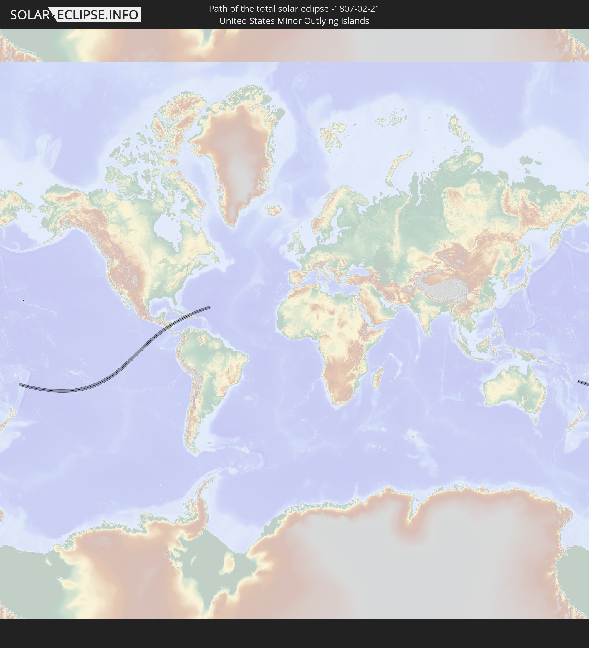
Total solar eclipse of 02/21/-1807
| Day of week: | Tuesday |
| Maximum duration of eclipse: | 05m31s |
| Maximum width of eclipse path: | 214 km |
| Saros cycle: | 11 |
| Coverage: | 100% |
| Magnitude: | 1.0654 |
| Gamma: | 0.0323 |
Wo kann man die Sonnenfinsternis vom 02/21/-1807 sehen?

Die Sonnenfinsternis am 02/21/-1807 kann man in 60 Ländern als partielle Sonnenfinsternis beobachten.
Der Finsternispfad verläuft durch 8 Länder. Nur in diesen Ländern ist sie als total Sonnenfinsternis zu sehen.
In den folgenden Ländern ist die Sonnenfinsternis total zu sehen
 United States Minor Outlying Islands
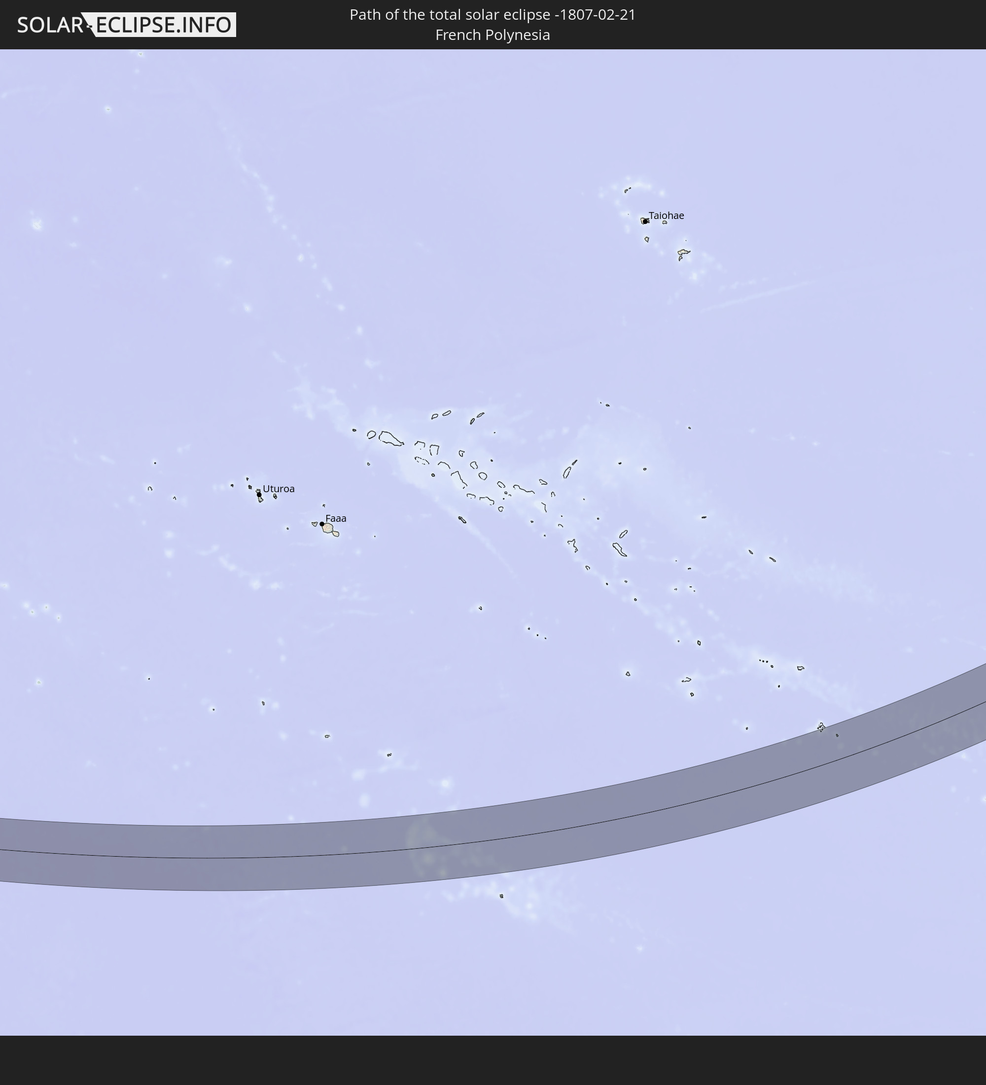 French Polynesia
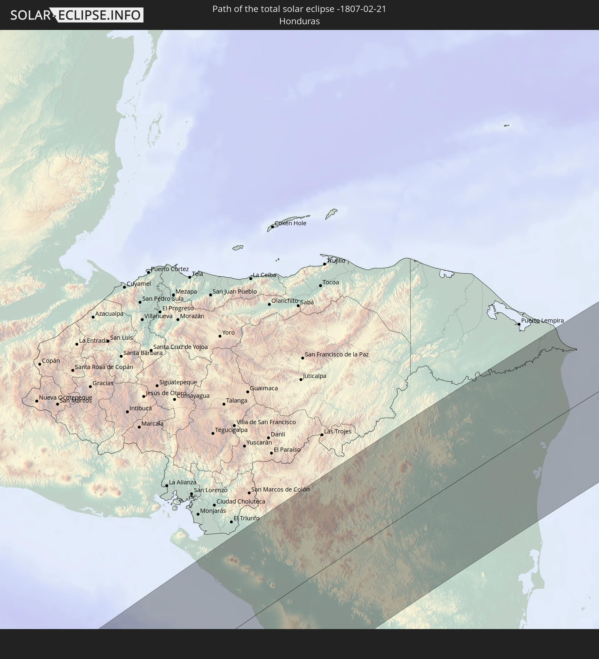 Honduras
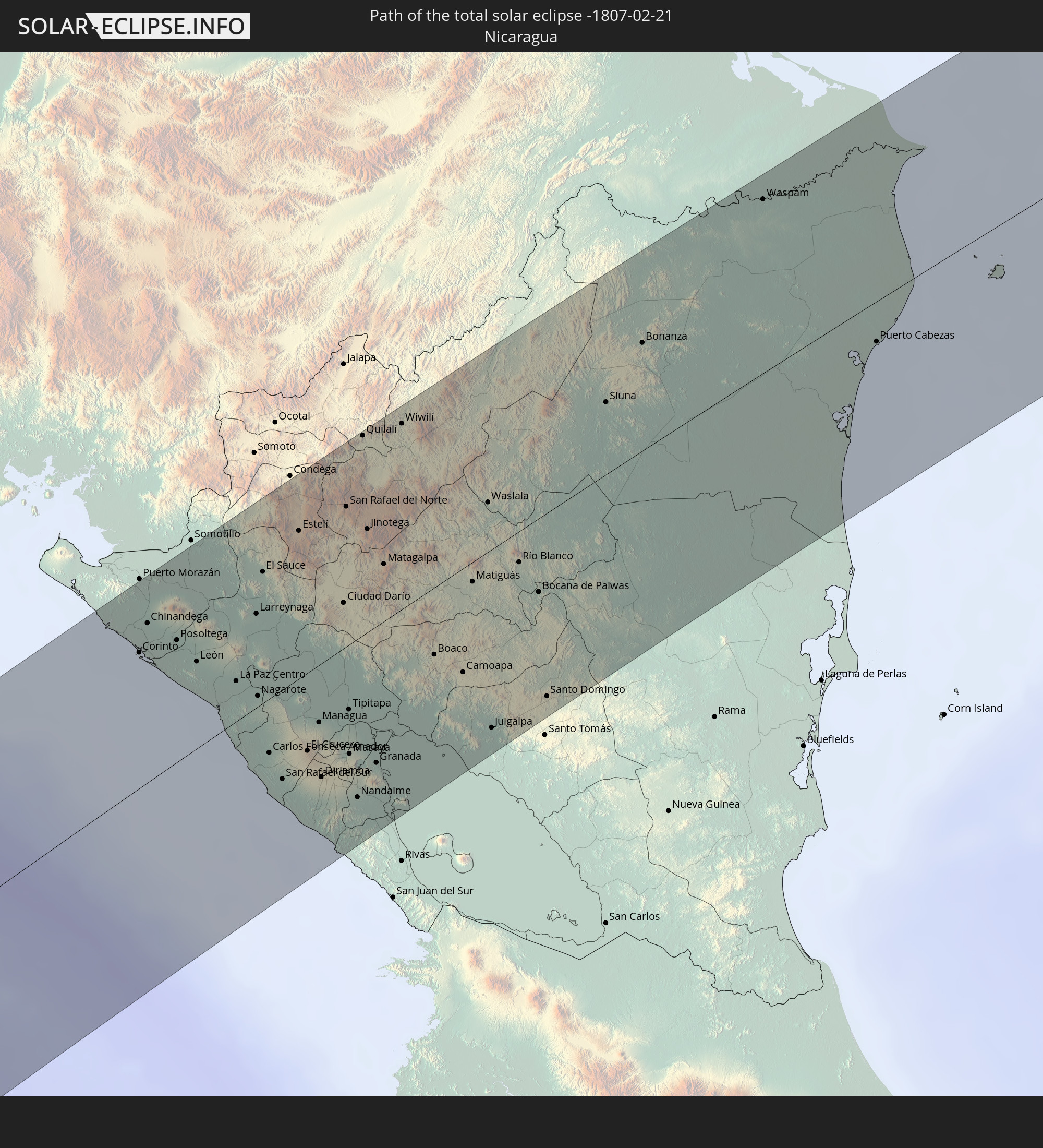 Nicaragua
 Jamaica
 Haiti
Haiti
 Turks and Caicos Islands
 Dominican Republic
In den folgenden Ländern ist die Sonnenfinsternis partiell zu sehen
 Fiji
Fiji
 United States
 New Zealand
 United States Minor Outlying Islands
 Wallis and Futuna
 Tonga
Tonga
 Kiribati
 Samoa
Samoa
 Tokelau
 American Samoa
 Niue
Niue
 Cook Islands
 French Polynesia
 Canada
 Pitcairn Islands
 Mexico
 Chile
Chile
 Guatemala
 Ecuador
 El Salvador
 Honduras
 Belize
 Nicaragua
 Costa Rica
 Cuba
Cuba
 Panama
 Colombia
 Cayman Islands
 Peru
Peru
 The Bahamas
 Jamaica
 Haiti
Haiti
 Brazil
 Venezuela
 Turks and Caicos Islands
 Dominican Republic
 Aruba
Aruba
 Bolivia
 Puerto Rico
 United States Virgin Islands
 Bermuda
 British Virgin Islands
 Anguilla
 Collectivity of Saint Martin
 Saint Barthélemy
 Saint Kitts and Nevis
 Antigua and Barbuda
 Montserrat
 Trinidad and Tobago
 Guadeloupe
 Grenada
 Dominica
 Saint Vincent and the Grenadines
 Guyana
 Martinique
 Saint Lucia
 Barbados
 Suriname
 French Guiana
 Tuvalu
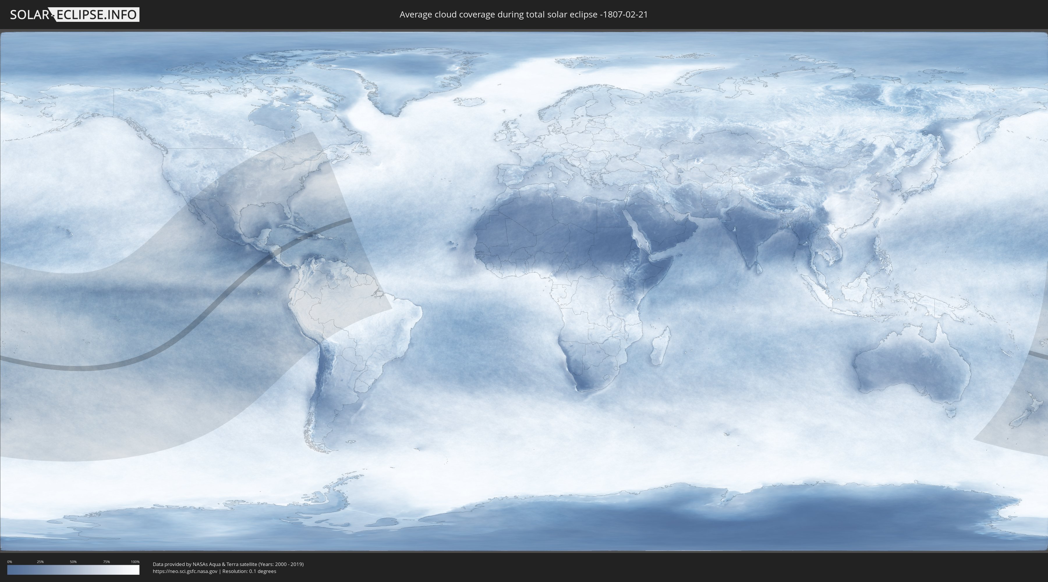
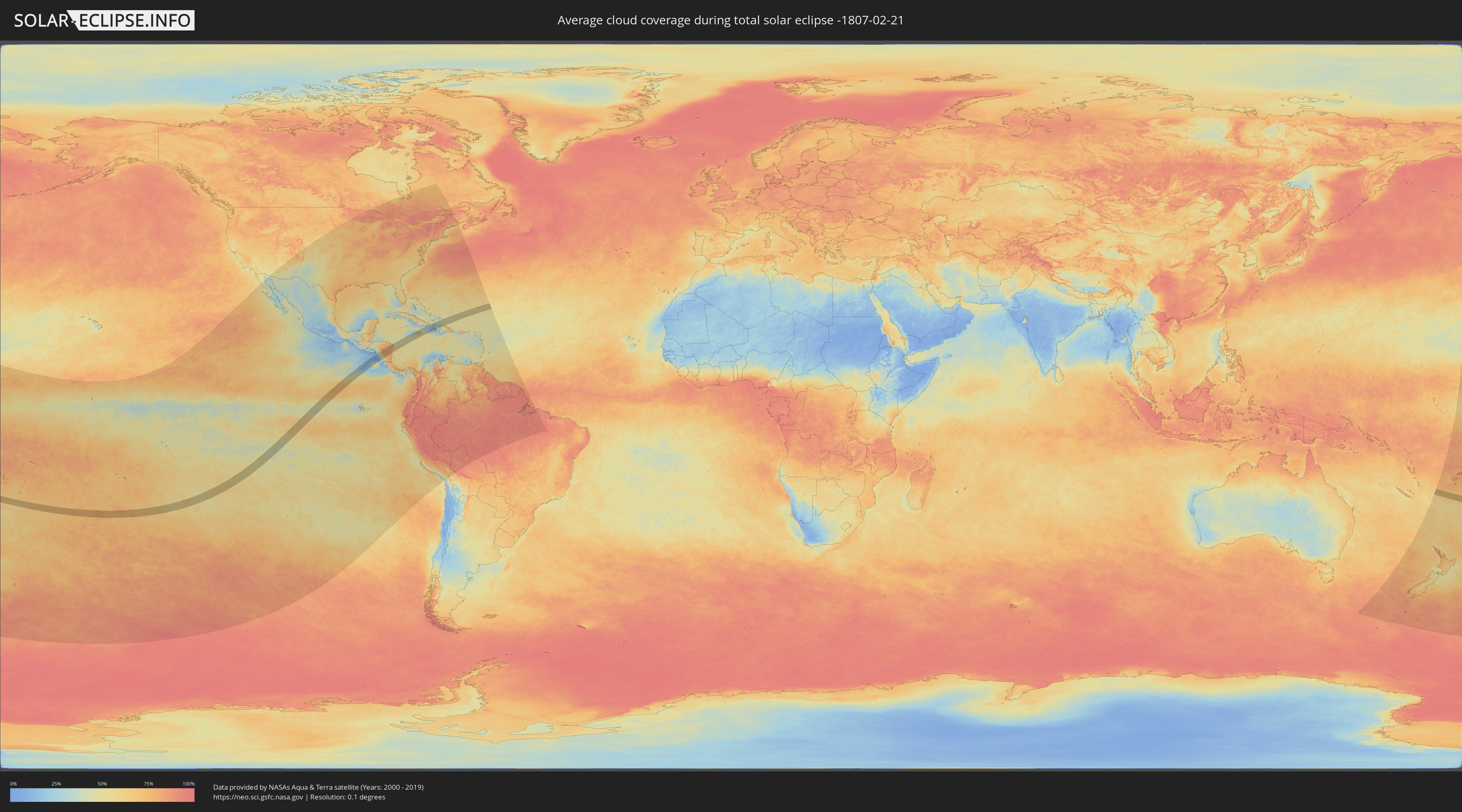
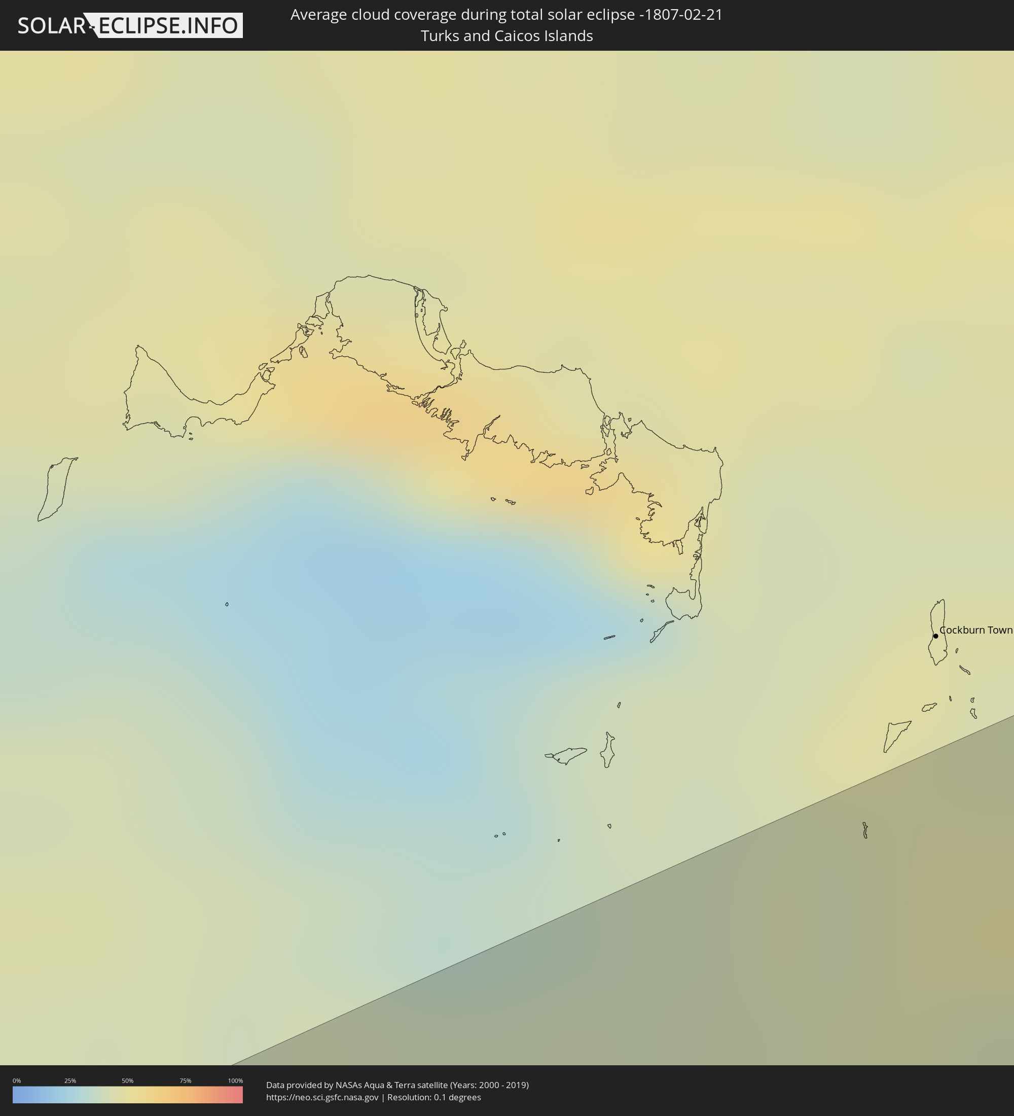
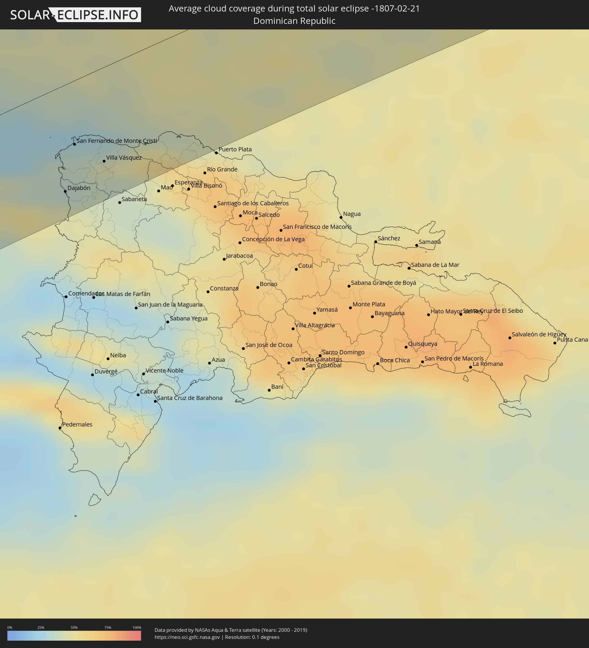
How will be the weather during the total solar eclipse on 02/21/-1807?
Where is the best place to see the total solar eclipse of 02/21/-1807?
The following maps show the average cloud coverage for the day of the total solar eclipse.
With the help of these maps, it is possible to find the place along the eclipse path, which has the best
chance of a cloudless sky.
Nevertheless, you should consider local circumstances and inform about the weather of your chosen
observation site.
The data is provided by NASAs satellites
AQUA and TERRA.
The cloud maps are averaged over a period of 19 years (2000 - 2019).
Detailed country maps
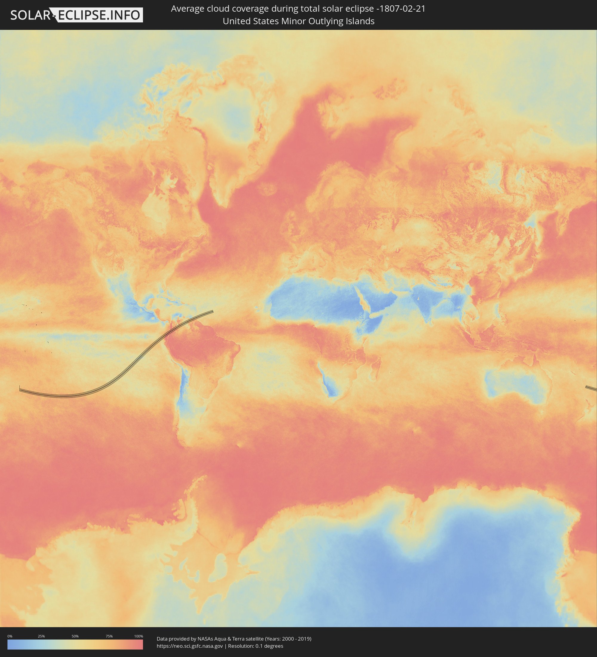 United States Minor Outlying Islands
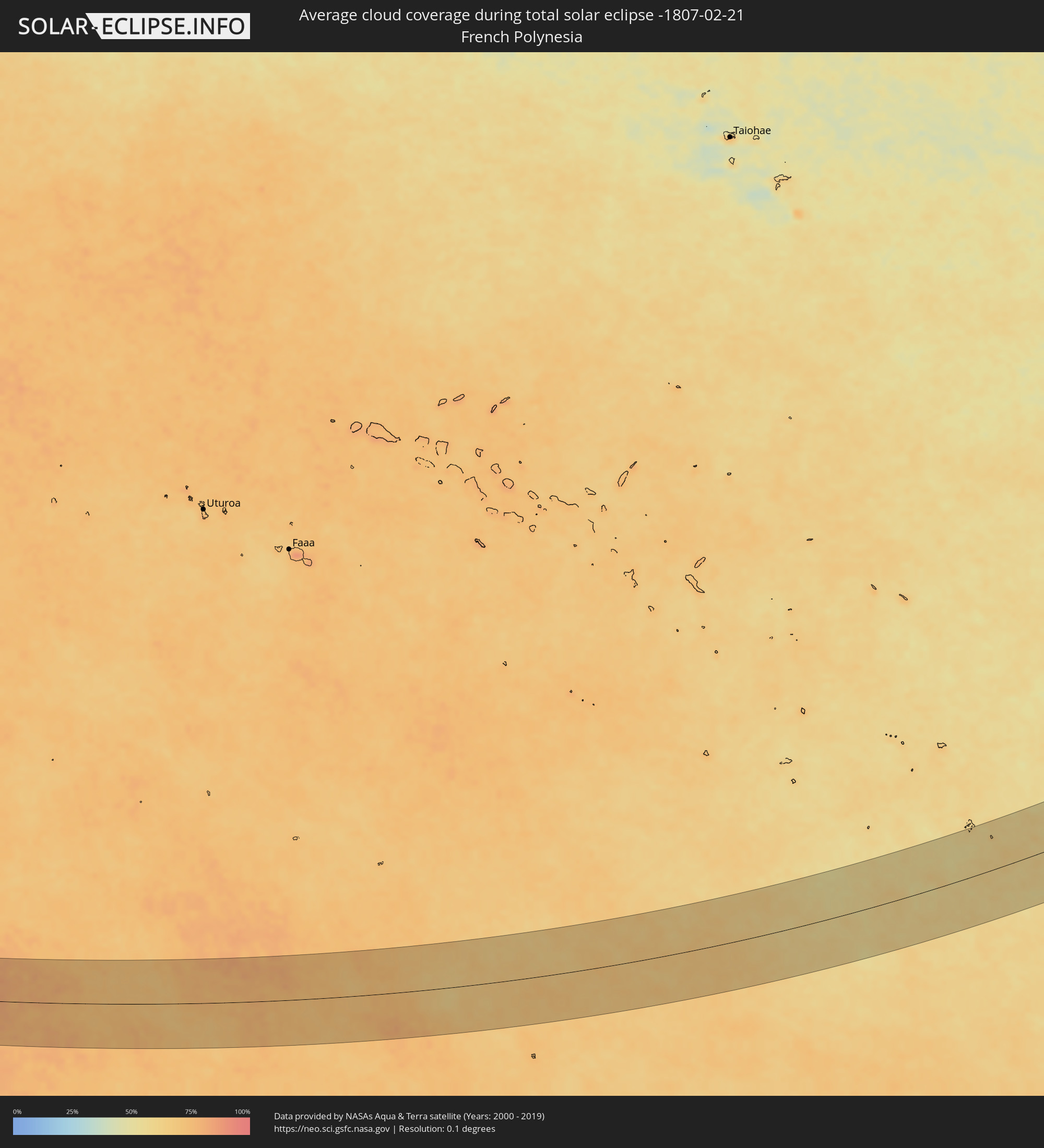 French Polynesia
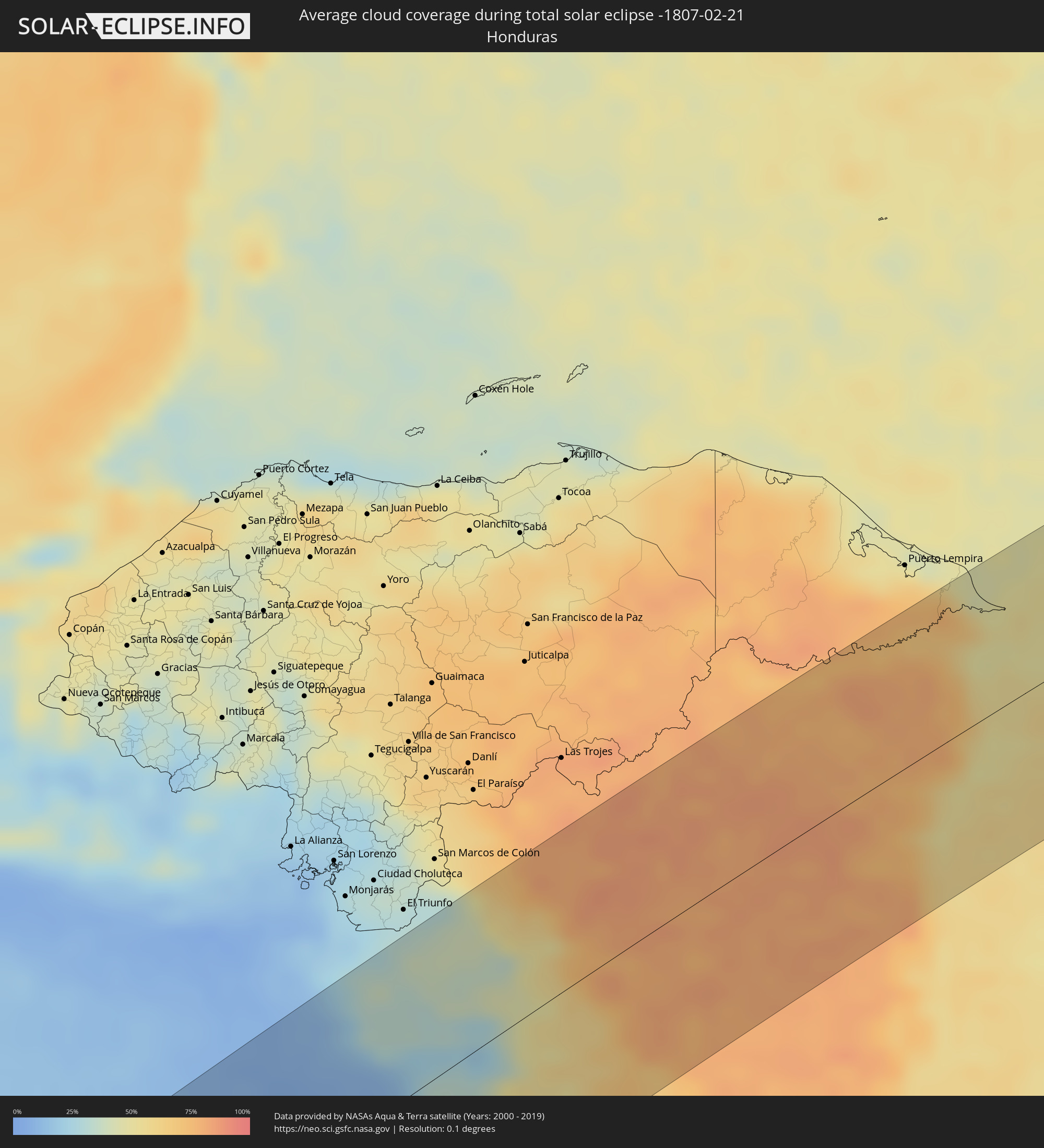 Honduras
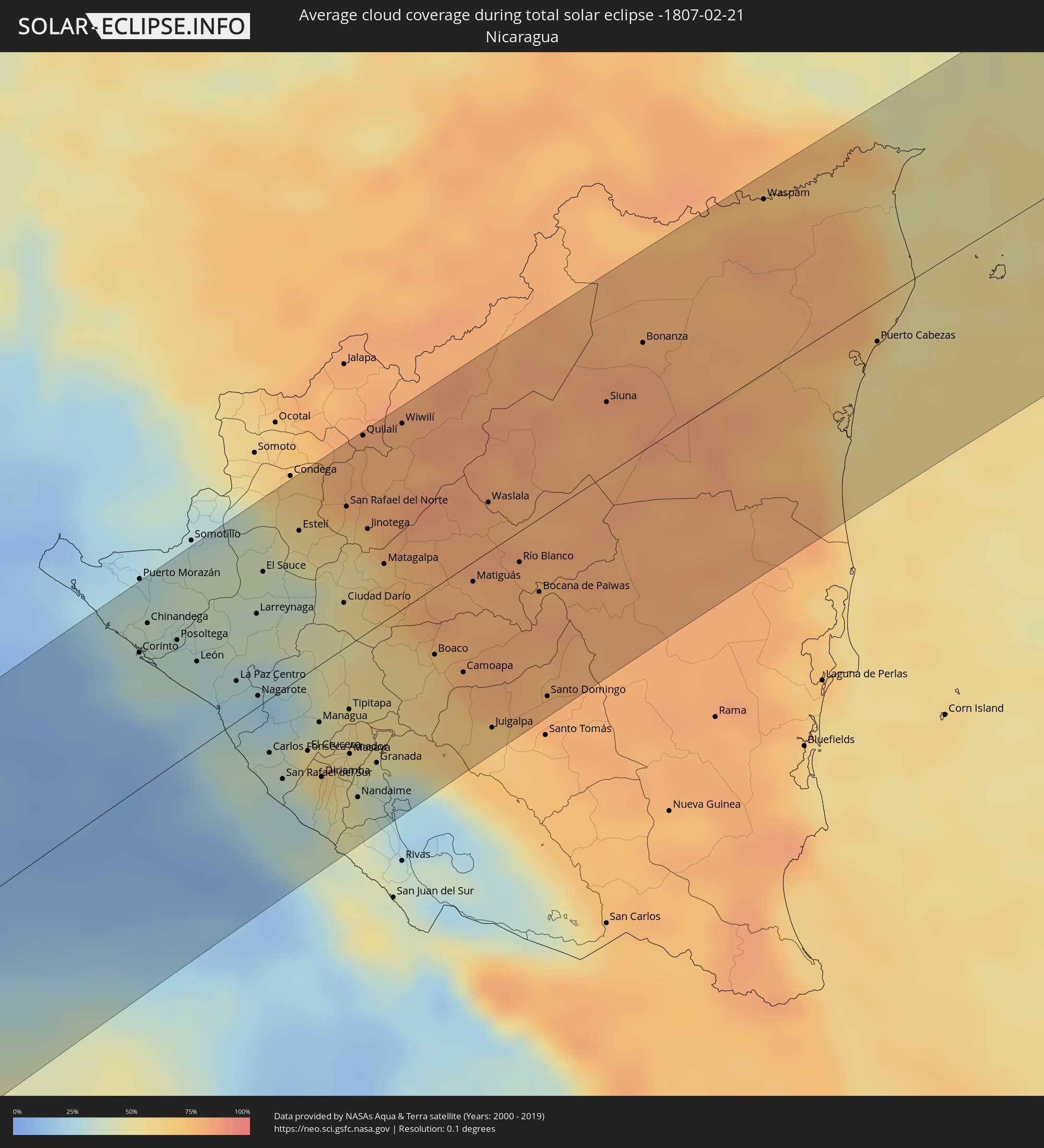 Nicaragua
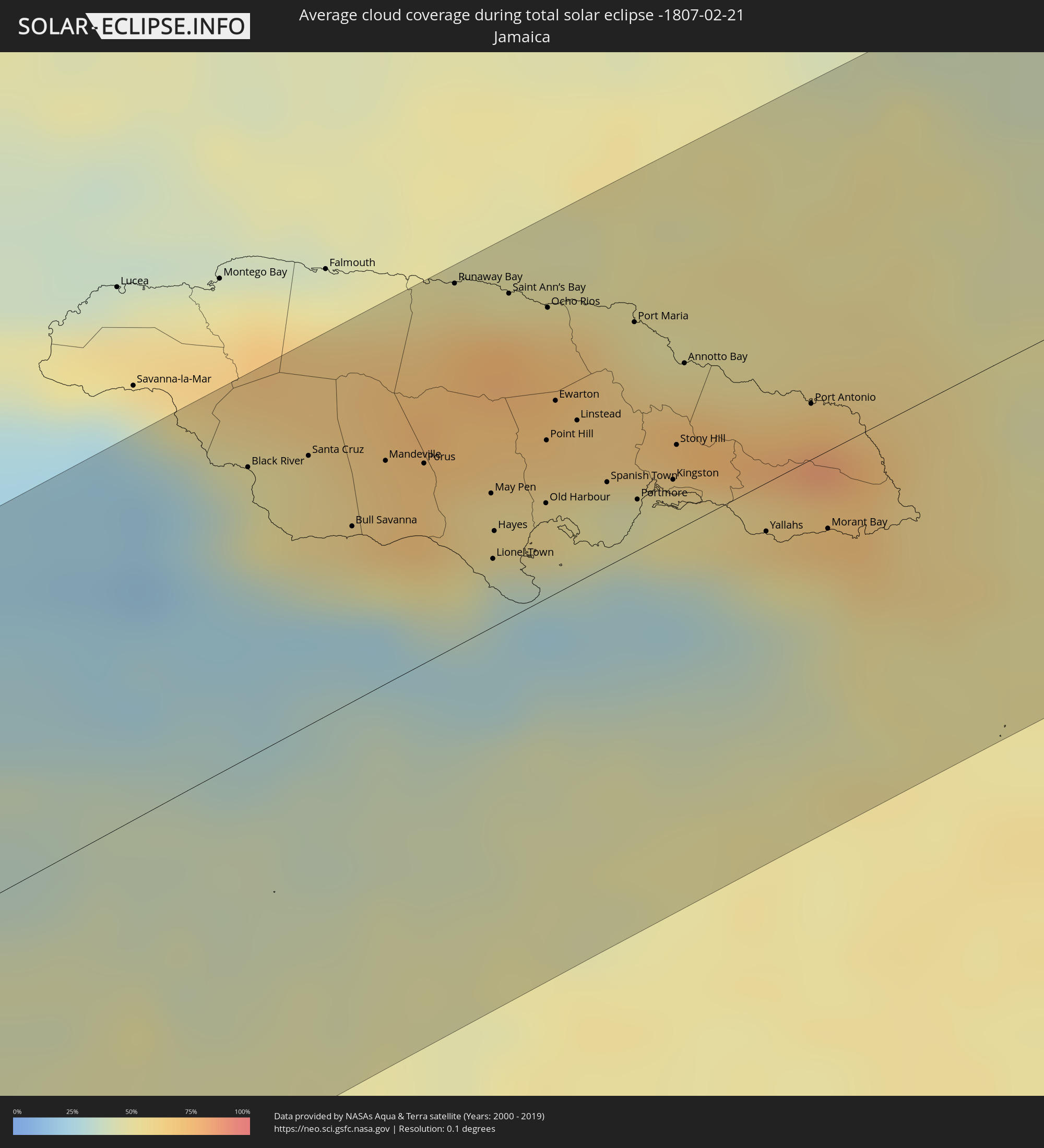 Jamaica
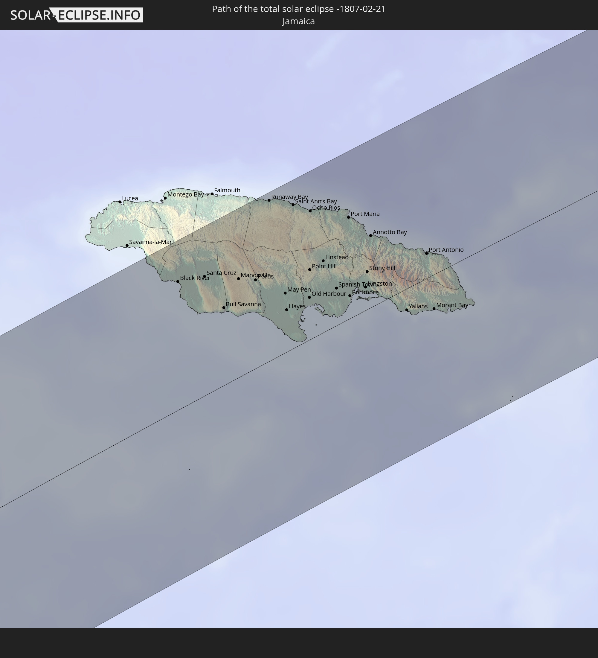
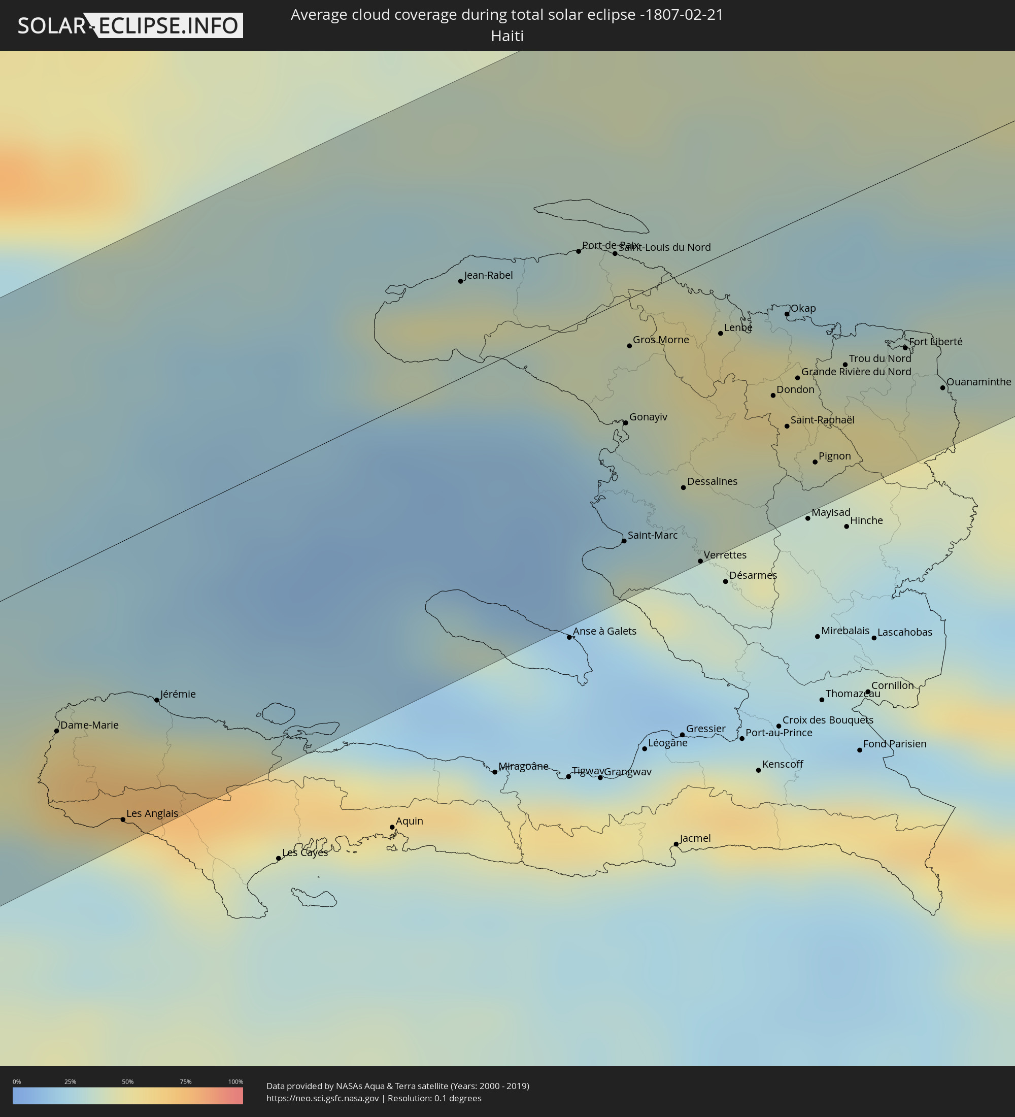 Haiti
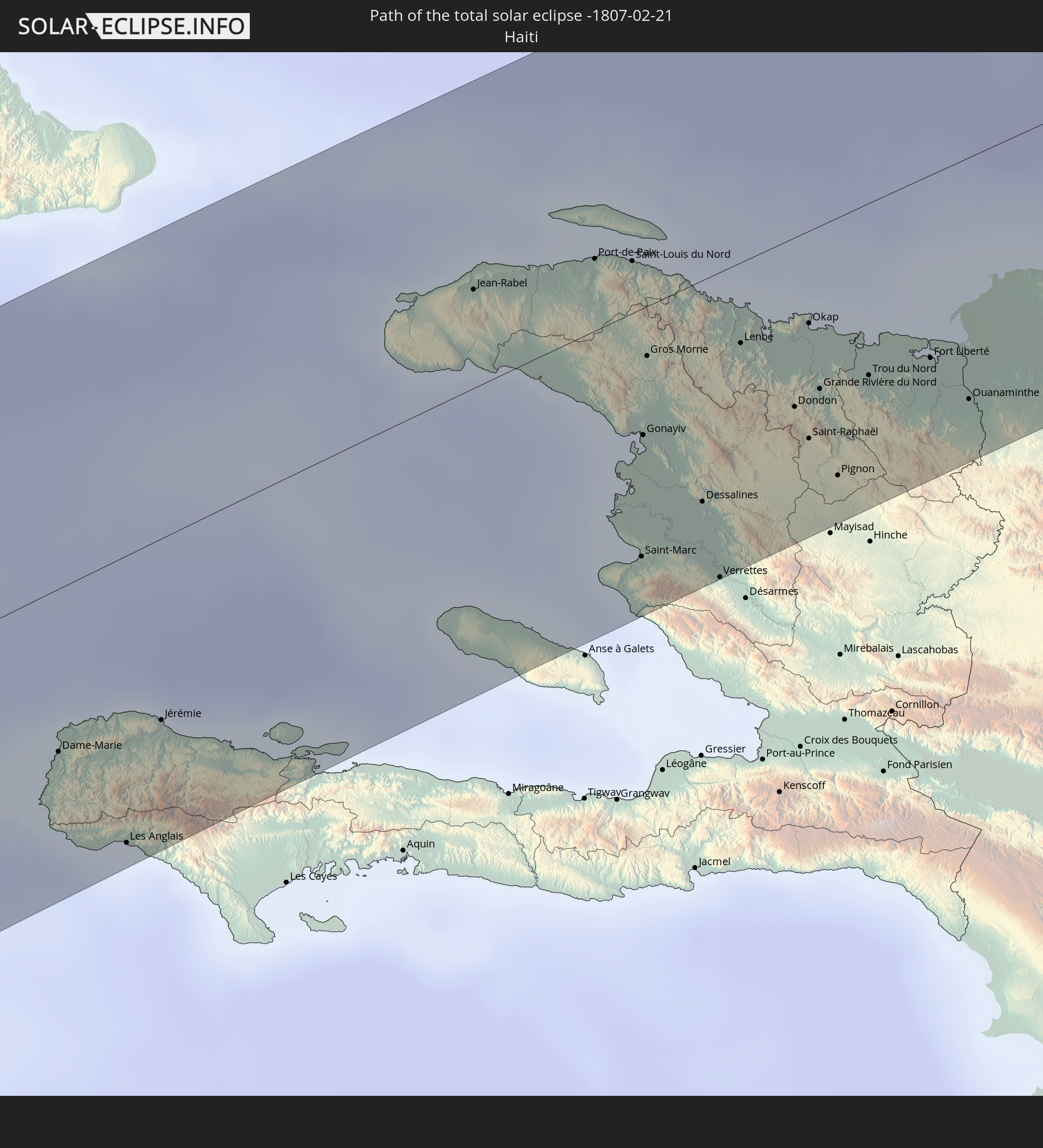
Haiti
 Turks and Caicos Islands
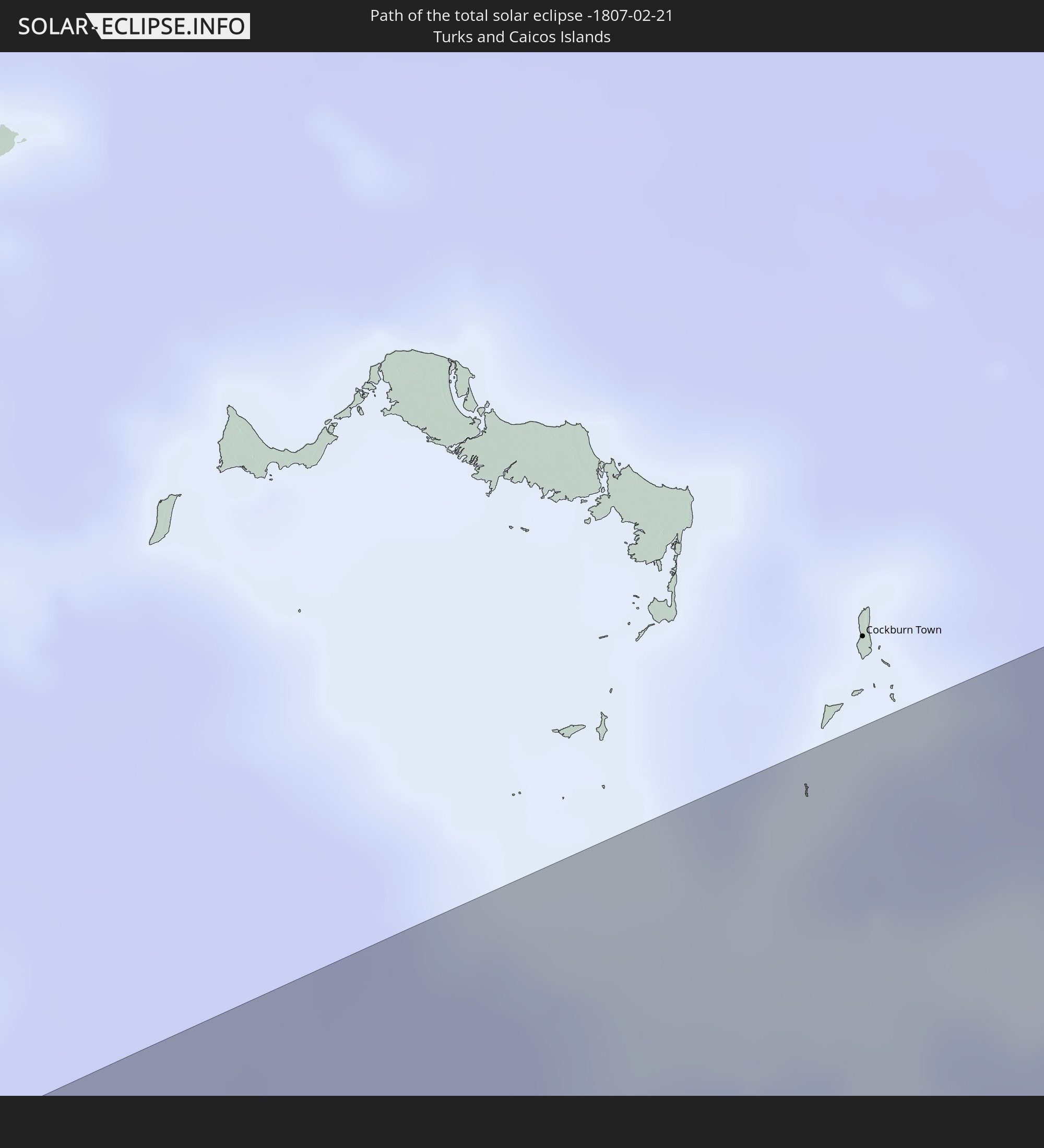
 Dominican Republic
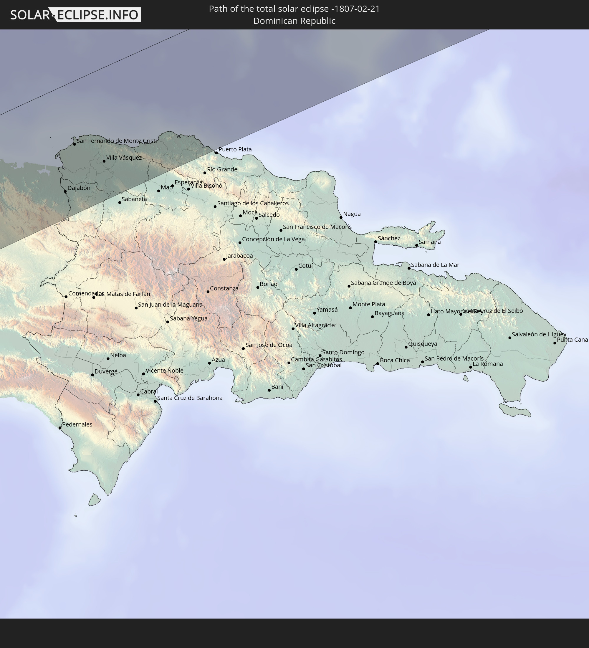
Cities inside the path of the eclipse
The following table shows all locations with a population of more than 5,000 inside the eclipse path. Cities which have more than 100,000 inhabitants are marked bold. A click at the locations opens a detailed map.
| City | Type | Eclipse duration | Local time of max. eclipse | Distance to central line | Ø Cloud coverage |
|
Corinto, Chinandega
|
total | - | 15:45:36 UTC-05:45 | 62 km | 31% |
|
El Viejo, Chinandega
|
total | - | 15:45:47 UTC-05:45 | 79 km | 35% |
|
El Realejo, Chinandega
|
total | - | 15:45:40 UTC-05:45 | 67 km | 31% |
|
Chinandega, Chinandega
|
total | - | 15:45:46 UTC-05:45 | 73 km | 33% |
|
Chichigalpa, Chinandega
|
total | - | 15:45:48 UTC-05:45 | 62 km | 33% |
|
Posoltega, Chinandega
|
total | - | 15:45:49 UTC-05:45 | 56 km | 32% |
|
León, León
|
total | - | 15:45:48 UTC-05:45 | 40 km | 24% |
|
Telica, León
|
total | - | 15:45:53 UTC-05:45 | 47 km | 32% |
|
La Paz Centro, León
|
total | - | 15:45:52 UTC-05:45 | 19 km | 28% |
|
Larreynaga, León
|
total | - | 15:46:15 UTC-05:45 | 43 km | 36% |
|
Nagarote, León
|
total | - | 15:45:53 UTC-05:45 | 5 km | 28% |
|
El Sauce, León
|
total | - | 15:46:28 UTC-05:45 | 61 km | 39% |
|
San Rafael del Sur, Managua
|
total | - | 15:45:36 UTC-05:45 | 41 km | 29% |
|
Estelí, Estelí
|
total | - | 15:46:48 UTC-05:45 | 68 km | 50% |
|
Ciudad Sandino, Managua
|
total | - | 15:45:58 UTC-05:45 | 18 km | 49% |
|
El Crucero, Managua
|
total | - | 15:45:50 UTC-05:45 | 36 km | 47% |
|
Managua, Managua
|
total | - | 15:46:00 UTC-05:45 | 27 km | 53% |
|
Diriamba, Carazo
|
total | - | 15:45:46 UTC-05:45 | 53 km | 46% |
|
Dolores, Carazo
|
total | - | 15:45:47 UTC-05:45 | 54 km | 46% |
|
Ticuantepe, Managua
|
total | - | 15:45:56 UTC-05:45 | 39 km | 61% |
|
San Marcos, Carazo
|
total | - | 15:45:50 UTC-05:45 | 50 km | 46% |
|
Jinotepe, Carazo
|
total | - | 15:45:47 UTC-05:45 | 56 km | 40% |
|
La Concepción, Masaya
|
total | - | 15:45:52 UTC-05:45 | 48 km | 46% |
|
Masatepe, Masaya
|
total | - | 15:45:53 UTC-05:45 | 53 km | 52% |
|
Ciudad Darío, Matagalpa
|
total | - | 15:46:39 UTC-05:45 | 21 km | 52% |
|
Nindirí, Masaya
|
total | - | 15:45:59 UTC-05:45 | 46 km | 51% |
|
Nandasmo, Masaya
|
total | - | 15:45:55 UTC-05:45 | 54 km | 52% |
|
Tipitapa, Managua
|
total | - | 15:46:11 UTC-05:45 | 30 km | 54% |
|
Niquinohomo, Masaya
|
total | - | 15:45:55 UTC-05:45 | 57 km | 52% |
|
Masaya, Masaya
|
total | - | 15:45:59 UTC-05:45 | 51 km | 51% |
|
Nandaime, Granada
|
total | - | 15:45:49 UTC-05:45 | 73 km | 49% |
|
Diriomo, Granada
|
total | - | 15:45:55 UTC-05:45 | 62 km | 52% |
|
Quilalí, Nueva Segovia
|
total | - | 15:47:28 UTC-05:45 | 92 km | 80% |
|
Jinotega, Jinotega
|
total | - | 15:47:05 UTC-05:45 | 48 km | 65% |
|
Granada, Granada
|
total | - | 15:46:03 UTC-05:45 | 63 km | 44% |
|
Matagalpa, Matagalpa
|
total | - | 15:46:59 UTC-05:45 | 26 km | 70% |
|
Wiwilí, Nueva Segovia
|
total | - | 15:47:40 UTC-05:45 | 86 km | 80% |
|
San Lorenzo, Boaco
|
total | - | 15:46:41 UTC-05:45 | 39 km | 65% |
|
Boaco, Boaco
|
total | - | 15:46:46 UTC-05:45 | 31 km | 61% |
|
Camoapa, Boaco
|
total | - | 15:46:48 UTC-05:45 | 48 km | 71% |
|
Matiguás, Matagalpa
|
total | - | 15:47:15 UTC-05:45 | 9 km | 78% |
|
Waslala, Atlántico Norte (RAAN)
|
total | - | 15:47:39 UTC-05:45 | 23 km | 81% |
|
Juigalpa, Chontales
|
total | - | 15:46:40 UTC-05:45 | 83 km | 70% |
|
Río Blanco, Matagalpa
|
total | - | 15:47:31 UTC-05:45 | 14 km | 79% |
|
Bocana de Paiwas, Atlántico Sur
|
total | - | 15:47:27 UTC-05:45 | 34 km | 80% |
|
Santo Domingo, Chontales
|
total | - | 15:47:01 UTC-05:45 | 85 km | 79% |
|
Siuna, Atlántico Norte (RAAN)
|
total | - | 15:48:31 UTC-05:45 | 34 km | 81% |
|
Bonanza, Atlántico Norte (RAAN)
|
total | - | 15:48:54 UTC-05:45 | 50 km | 83% |
|
Waspam, Atlántico Norte (RAAN)
|
total | - | 15:49:54 UTC-05:45 | 81 km | 80% |
|
Puerto Cabezas, Atlántico Norte (RAAN)
|
total | - | 15:49:44 UTC-05:45 | 19 km | 52% |
|
Black River, St. Elizabeth
|
total | - | 16:33:37 UTC-05:07 | 67 km | 49% |
|
Santa Cruz, St. Elizabeth
|
total | - | 16:33:42 UTC-05:07 | 62 km | 55% |
|
Bull Savanna, St. Elizabeth
|
total | - | 16:33:39 UTC-05:07 | 41 km | 44% |
|
Mandeville, Manchester
|
total | - | 16:33:46 UTC-05:07 | 52 km | 66% |
|
Porus, Manchester
|
total | - | 16:33:49 UTC-05:07 | 46 km | 69% |
|
Runaway Bay, St Ann
|
total | - | 16:34:05 UTC-05:07 | 84 km | 56% |
|
May Pen, Clarendon
|
total | - | 16:33:51 UTC-05:07 | 31 km | 56% |
|
Lionel Town, Clarendon
|
total | - | 16:33:46 UTC-05:07 | 16 km | 30% |
|
Hayes, Clarendon
|
total | - | 16:33:48 UTC-05:07 | 22 km | 38% |
|
Saint Ann’s Bay, St Ann
|
total | - | 16:34:08 UTC-05:07 | 75 km | 75% |
|
Old Harbour, Saint Catherine
|
total | - | 16:33:54 UTC-05:07 | 22 km | 36% |
|
Point Hill, Saint Catherine
|
total | - | 16:33:59 UTC-05:07 | 37 km | 66% |
|
Ocho Rios, St Ann
|
total | - | 16:34:09 UTC-05:07 | 67 km | 69% |
|
Old Harbour Bay, Saint Catherine
|
total | - | 16:33:53 UTC-05:07 | 18 km | 36% |
|
Ewarton, Saint Catherine
|
total | - | 16:34:02 UTC-05:07 | 45 km | 71% |
|
Linstead, Saint Catherine
|
total | - | 16:34:02 UTC-05:07 | 38 km | 65% |
|
Bog Walk, Saint Catherine
|
total | - | 16:34:02 UTC-05:07 | 33 km | 65% |
|
Spanish Town, Saint Catherine
|
total | - | 16:33:59 UTC-05:07 | 20 km | 50% |
|
Port Maria, St. Mary
|
total | - | 16:34:13 UTC-05:07 | 53 km | 55% |
|
Portmore, Saint Catherine
|
total | - | 16:34:00 UTC-05:07 | 12 km | 46% |
|
Half Way Tree, St. Andrew
|
total | - | 16:34:04 UTC-05:07 | 14 km | 50% |
|
Constant Spring, St. Andrew
|
total | - | 16:34:05 UTC-05:07 | 17 km | 66% |
|
Kingston, Kingston
|
total | - | 16:34:04 UTC-05:07 | 12 km | 50% |
|
Stony Hill, St. Andrew
|
total | - | 16:34:07 UTC-05:07 | 20 km | 66% |
|
New Kingston, St. Andrew
|
total | - | 16:34:04 UTC-05:07 | 13 km | 50% |
|
Annotto Bay, St. Mary
|
total | - | 16:34:14 UTC-05:07 | 38 km | 58% |
|
Yallahs, St. Thomas
|
total | - | 16:34:06 UTC-05:07 | 11 km | 44% |
|
Port Antonio, Portland
|
total | - | 16:34:18 UTC-05:07 | 13 km | 69% |
|
Morant Bay, St. Thomas
|
total | - | 16:34:10 UTC-05:07 | 18 km | 54% |
|
Dame-Marie, GrandʼAnse
|
total | - | 16:53:28 UTC-04:49 | 46 km | 56% |
|
Les Anglais, Sud
|
total | - | 16:53:25 UTC-04:49 | 81 km | 45% |
|
Jérémie, GrandʼAnse
|
total | - | 16:53:37 UTC-04:49 | 51 km | 32% |
|
Jean-Rabel, Nord-Ouest
|
total | - | 16:54:30 UTC-04:49 | 28 km | 35% |
|
Ti Port-de-Paix, Nord-Ouest
|
total | - | 16:54:39 UTC-04:49 | 20 km | 37% |
|
Port-de-Paix, Nord-Ouest
|
total | - | 16:54:39 UTC-04:49 | 20 km | 37% |
|
Saint-Louis du Nord, Nord-Ouest
|
total | - | 16:54:41 UTC-04:49 | 15 km | 45% |
|
Saint-Marc, Artibonite
|
total | - | 16:54:19 UTC-04:49 | 70 km | 39% |
|
Gonayiv, Artibonite
|
total | - | 16:54:28 UTC-04:49 | 36 km | 26% |
|
Gros Morne, Artibonite
|
total | - | 16:54:35 UTC-04:49 | 14 km | 39% |
|
Dessalines, Artibonite
|
total | - | 16:54:27 UTC-04:49 | 62 km | 32% |
|
Verrettes, Artibonite
|
total | - | 16:54:22 UTC-04:49 | 86 km | 32% |
|
Lenbe, Nord
|
total | - | 16:54:41 UTC-04:49 | 23 km | 54% |
|
Dondon, Nord
|
total | - | 16:54:39 UTC-04:49 | 48 km | 45% |
|
Milot, Nord
|
total | - | 16:54:41 UTC-04:49 | 41 km | 53% |
|
Okap, Nord
|
total | - | 16:54:46 UTC-04:49 | 26 km | 28% |
|
Saint-Raphaël, Nord
|
total | - | 16:54:37 UTC-04:49 | 58 km | 35% |
|
Grande Rivière du Nord, Nord
|
total | - | 16:54:41 UTC-04:49 | 46 km | 53% |
|
Pignon, Nord
|
total | - | 16:54:36 UTC-04:49 | 73 km | 35% |
|
Trou du Nord, Nord-Est
|
total | - | 16:54:45 UTC-04:49 | 48 km | 51% |
|
Fort Liberté, Nord-Est
|
total | - | 16:54:49 UTC-04:49 | 52 km | 35% |
|
Ouanaminthe, Nord-Est
|
total | - | 16:54:48 UTC-04:49 | 68 km | 45% |
|
Dajabón, Dajabón
|
total | - | 17:03:49 UTC-04:40 | 69 km | 45% |
|
San Fernando de Monte Cristi, Monte Cristi
|
total | - | 17:03:57 UTC-04:40 | 41 km | 36% |
|
Loma de Cabrera, Dajabón
|
total | - | 17:03:47 UTC-04:40 | 85 km | 45% |
|
Las Matas de Santa Cruz, Monte Cristi
|
total | - | 17:03:55 UTC-04:40 | 65 km | 38% |
|
Villa Vásquez, Monte Cristi
|
total | - | 17:03:58 UTC-04:40 | 61 km | 38% |