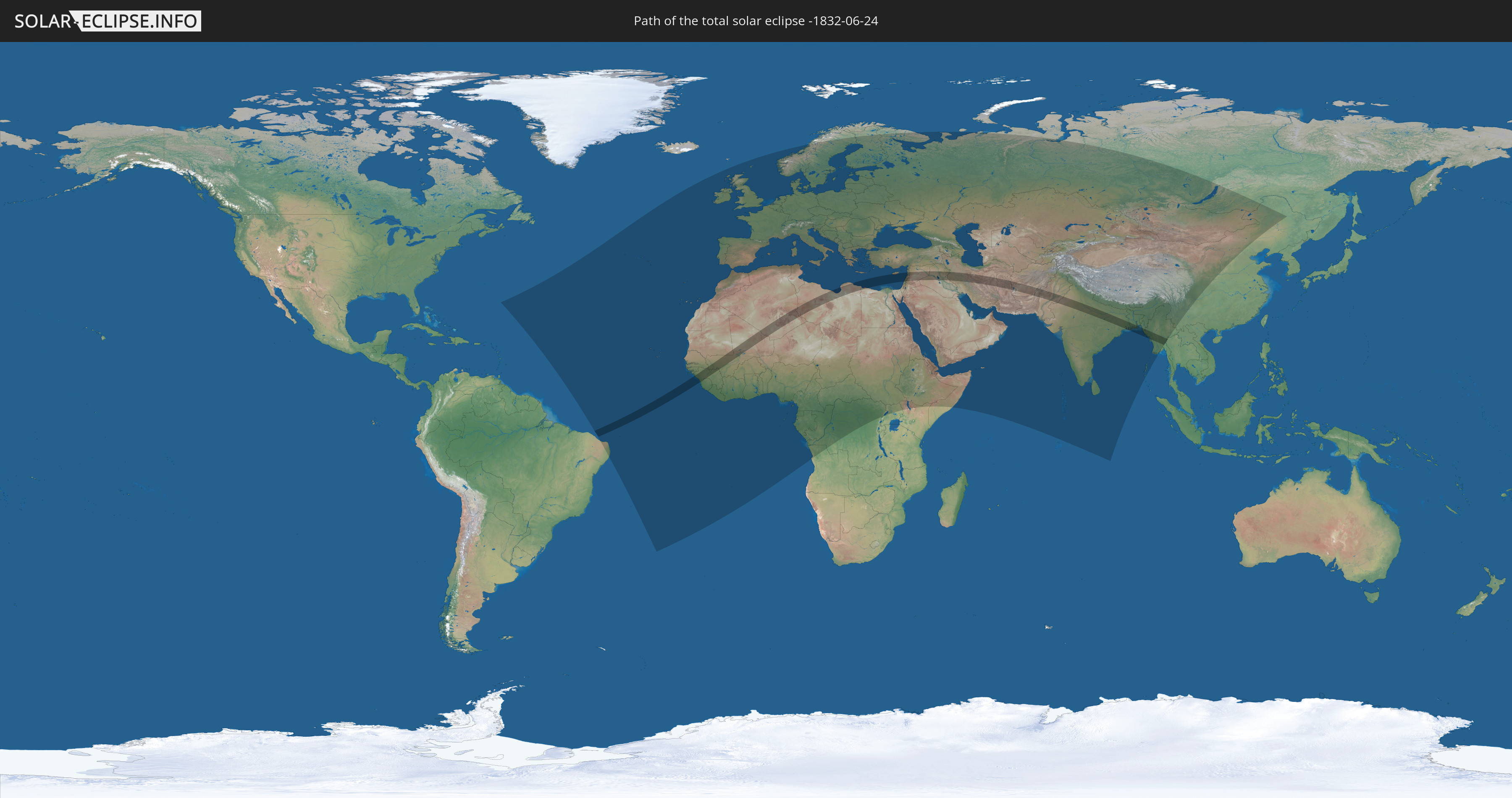
Total solar eclipse of 06/24/-1832
| Day of week: | Wednesday |
| Maximum duration of eclipse: | 05m46s |
| Maximum width of eclipse path: | 226 km |
| Saros cycle: | 17 |
| Coverage: | 100% |
| Magnitude: | 1.0685 |
| Gamma: | 0.1456 |
Wo kann man die Sonnenfinsternis vom 06/24/-1832 sehen?
Die Sonnenfinsternis am 06/24/-1832 kann man in 123 Ländern als partielle Sonnenfinsternis beobachten.
Der Finsternispfad verläuft durch 21 Länder. Nur in diesen Ländern ist sie als total Sonnenfinsternis zu sehen.
In den folgenden Ländern ist die Sonnenfinsternis total zu sehen
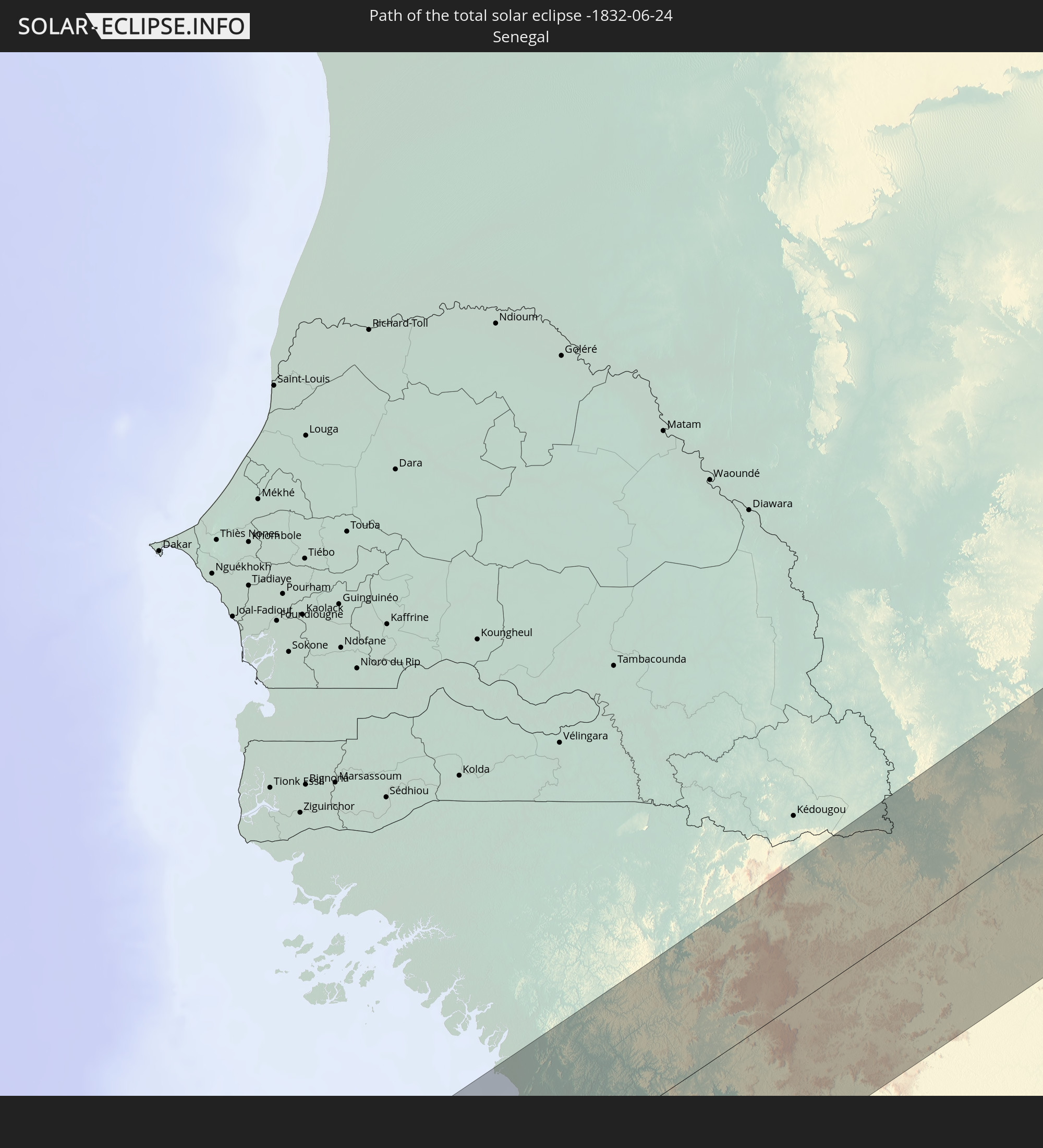 Senegal
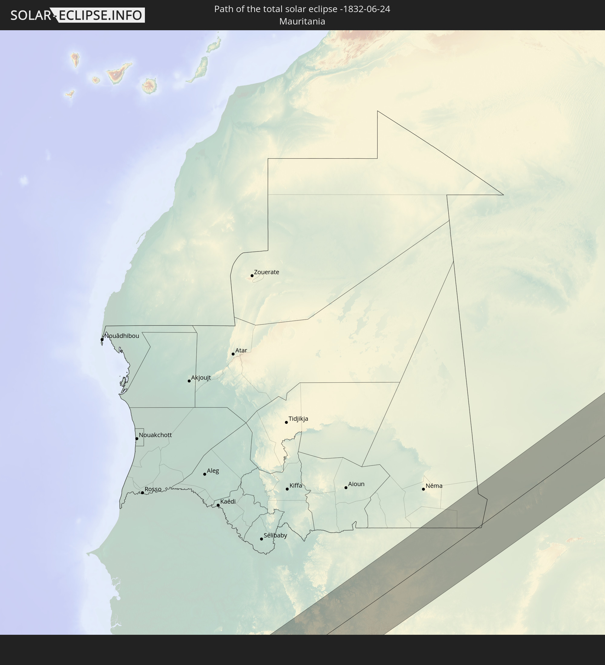 Mauritania
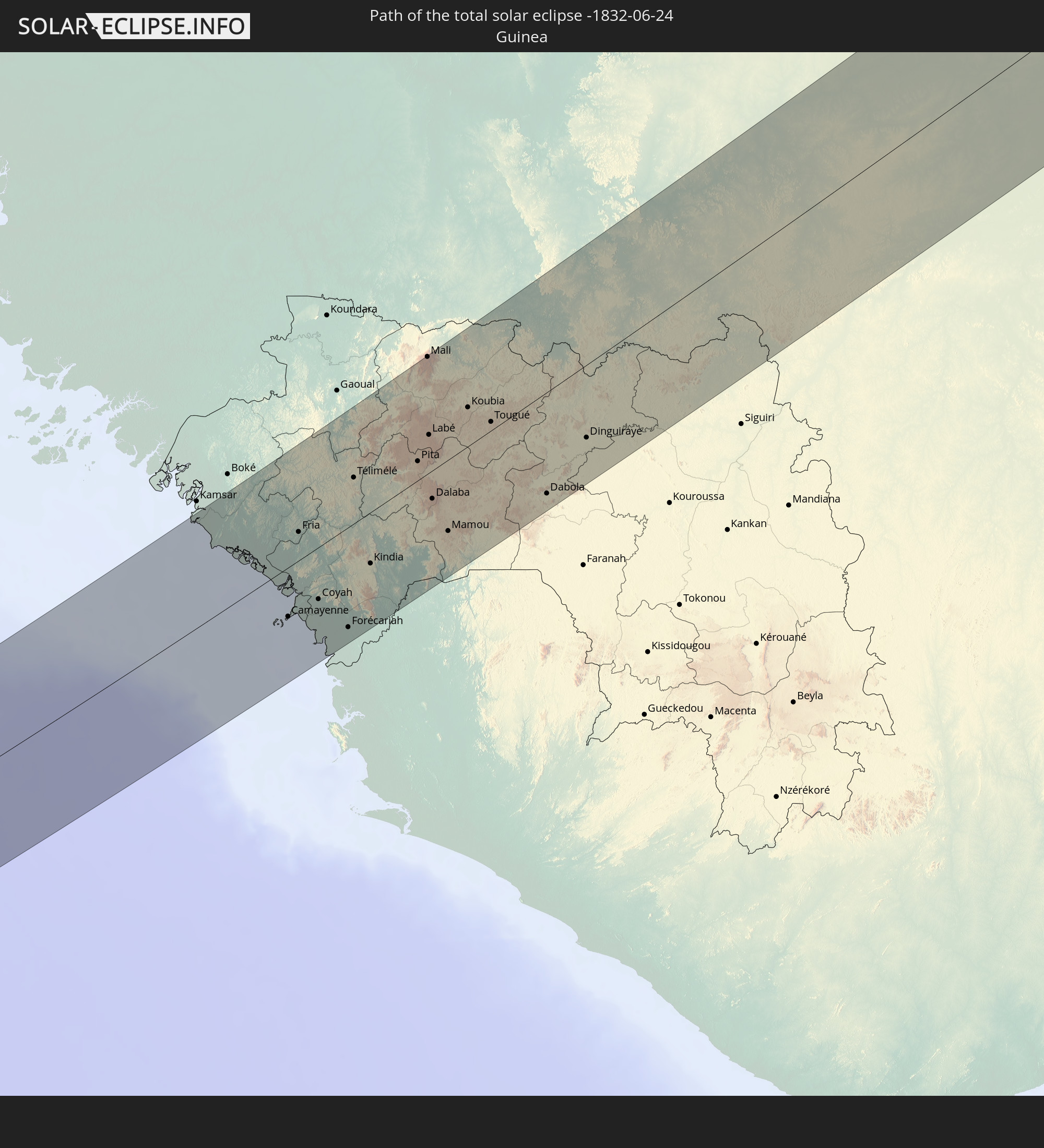 Guinea
 Sierra Leone
 Mali
Mali
 Algeria
 Libya
Libya
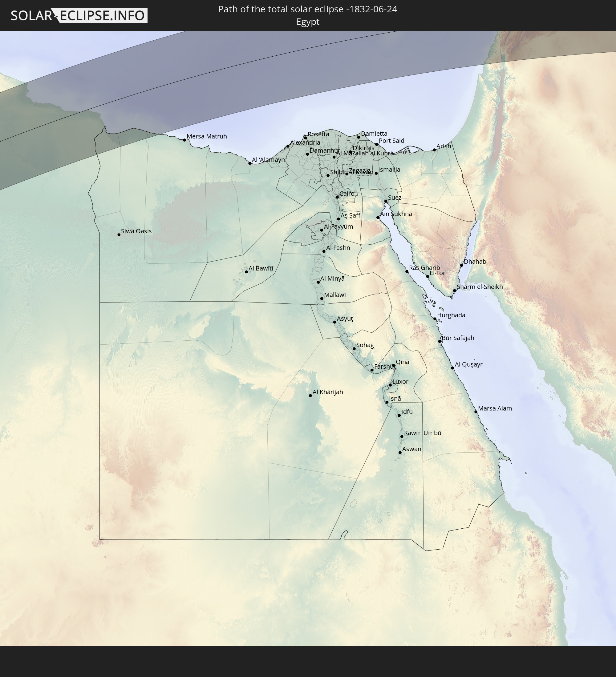 Egypt
Egypt
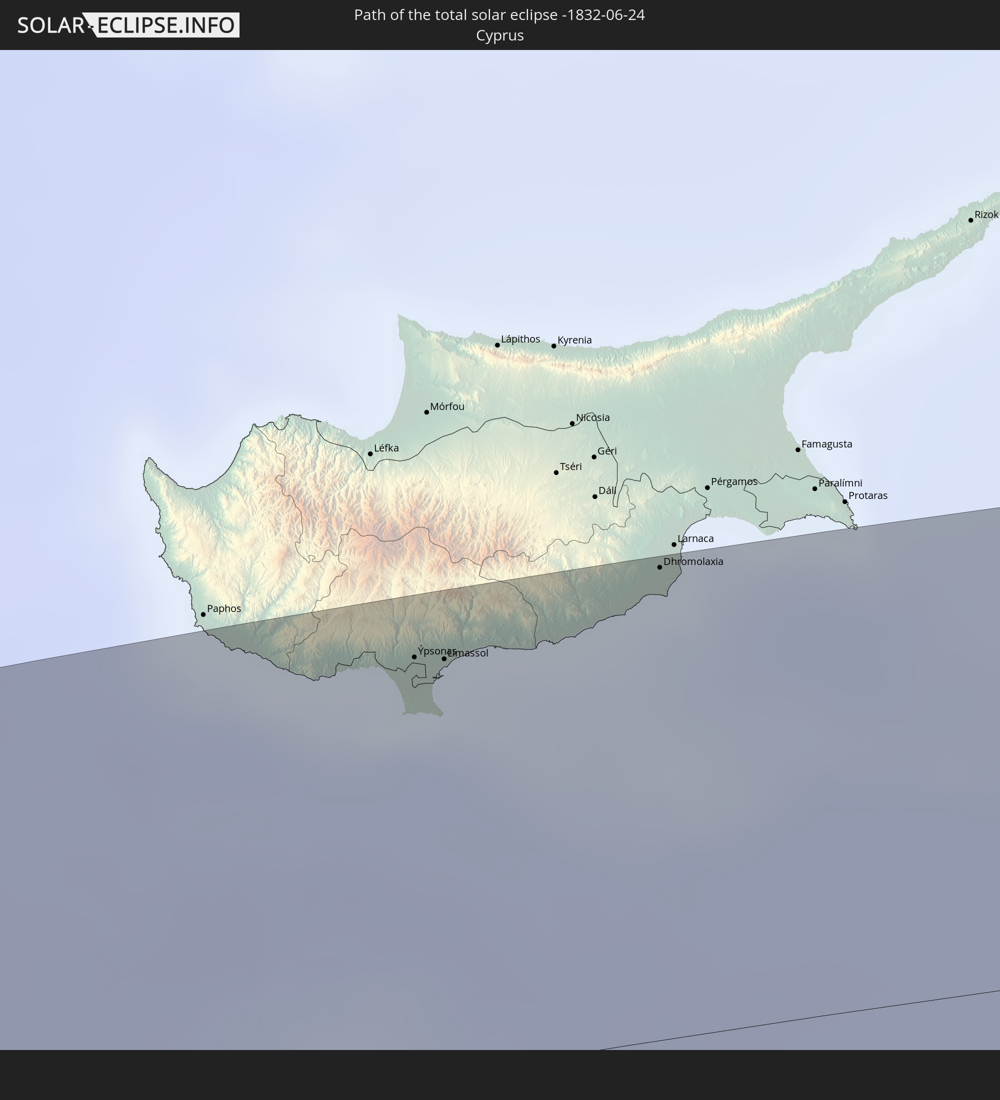 Cyprus
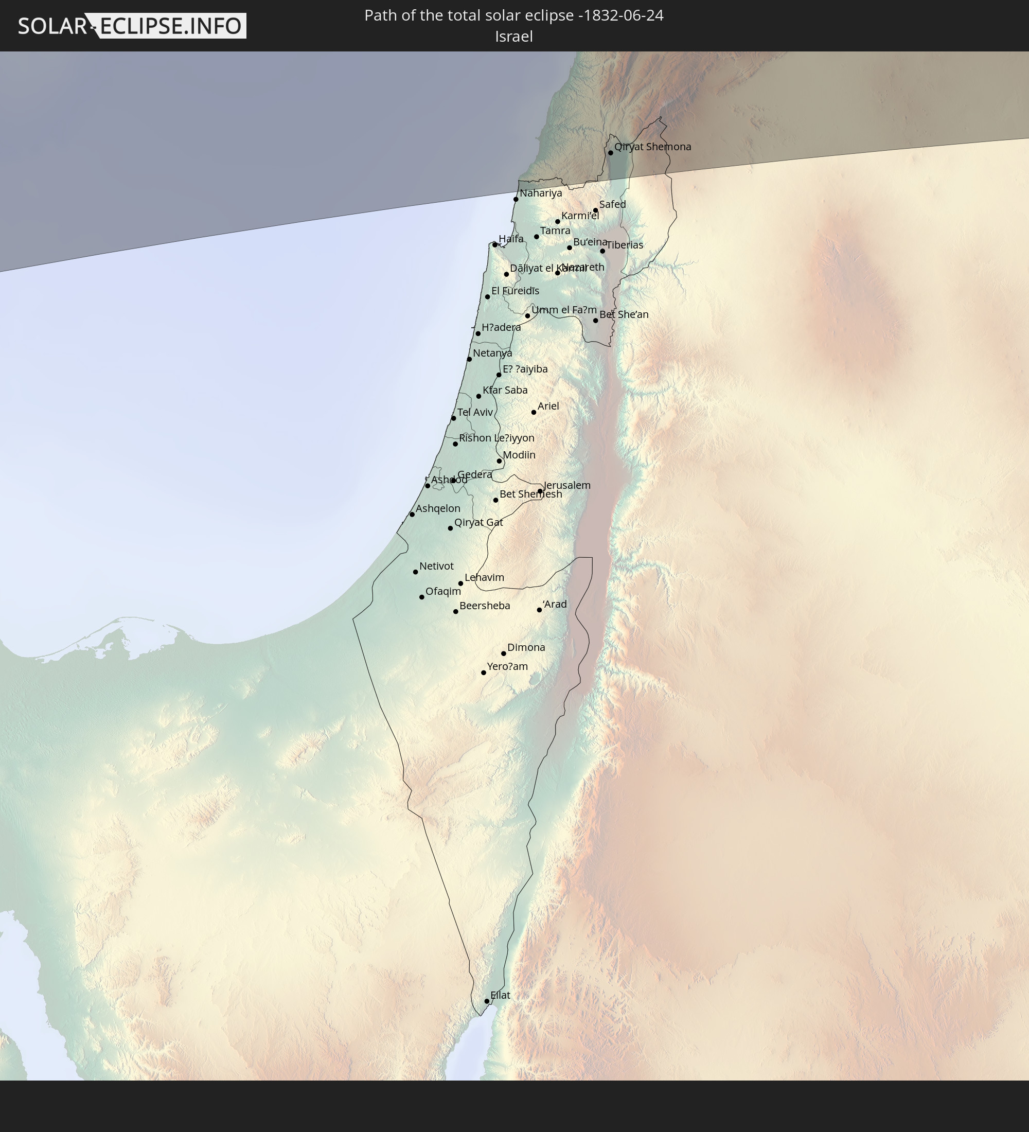 Israel
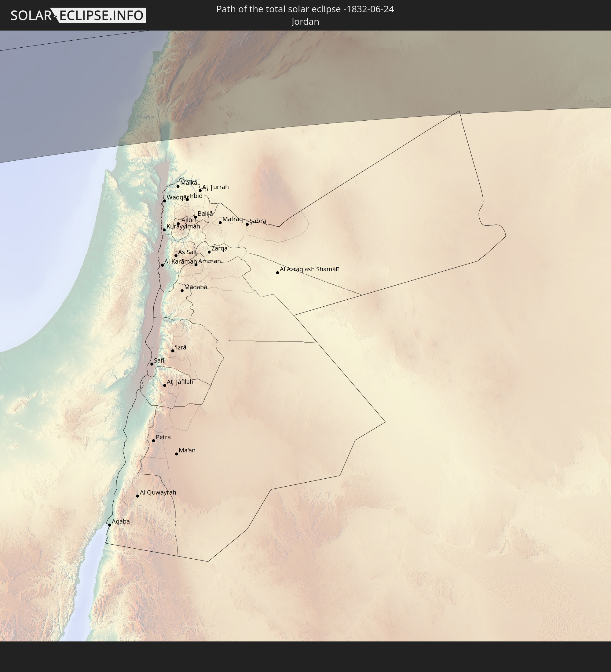 Jordan
 Lebanon
 Syria
Syria
 Iraq
Iraq
 Iran
Iran
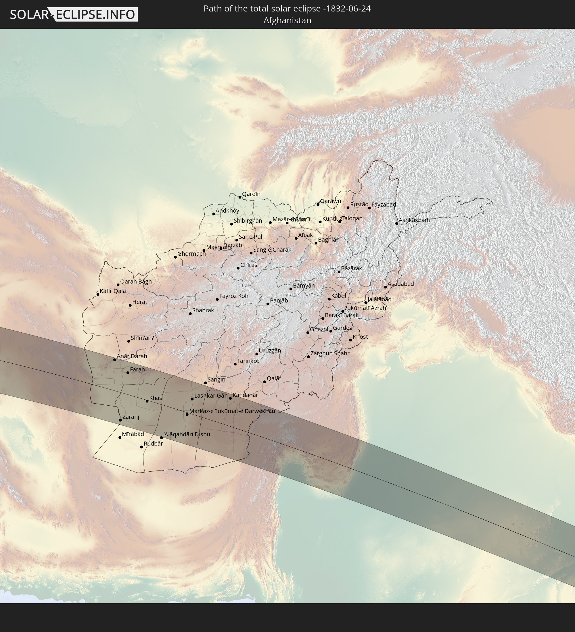 Afghanistan
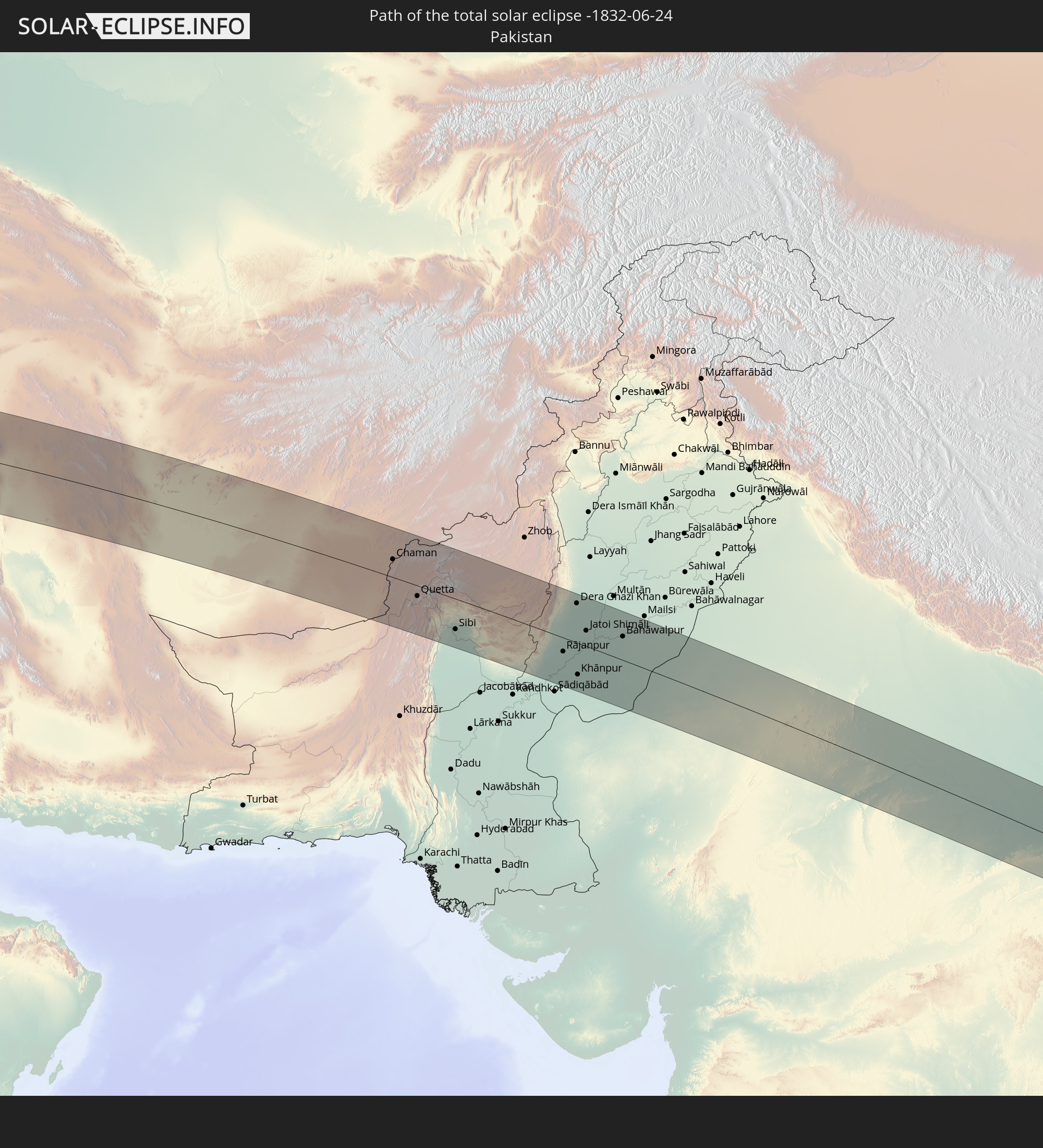 Pakistan
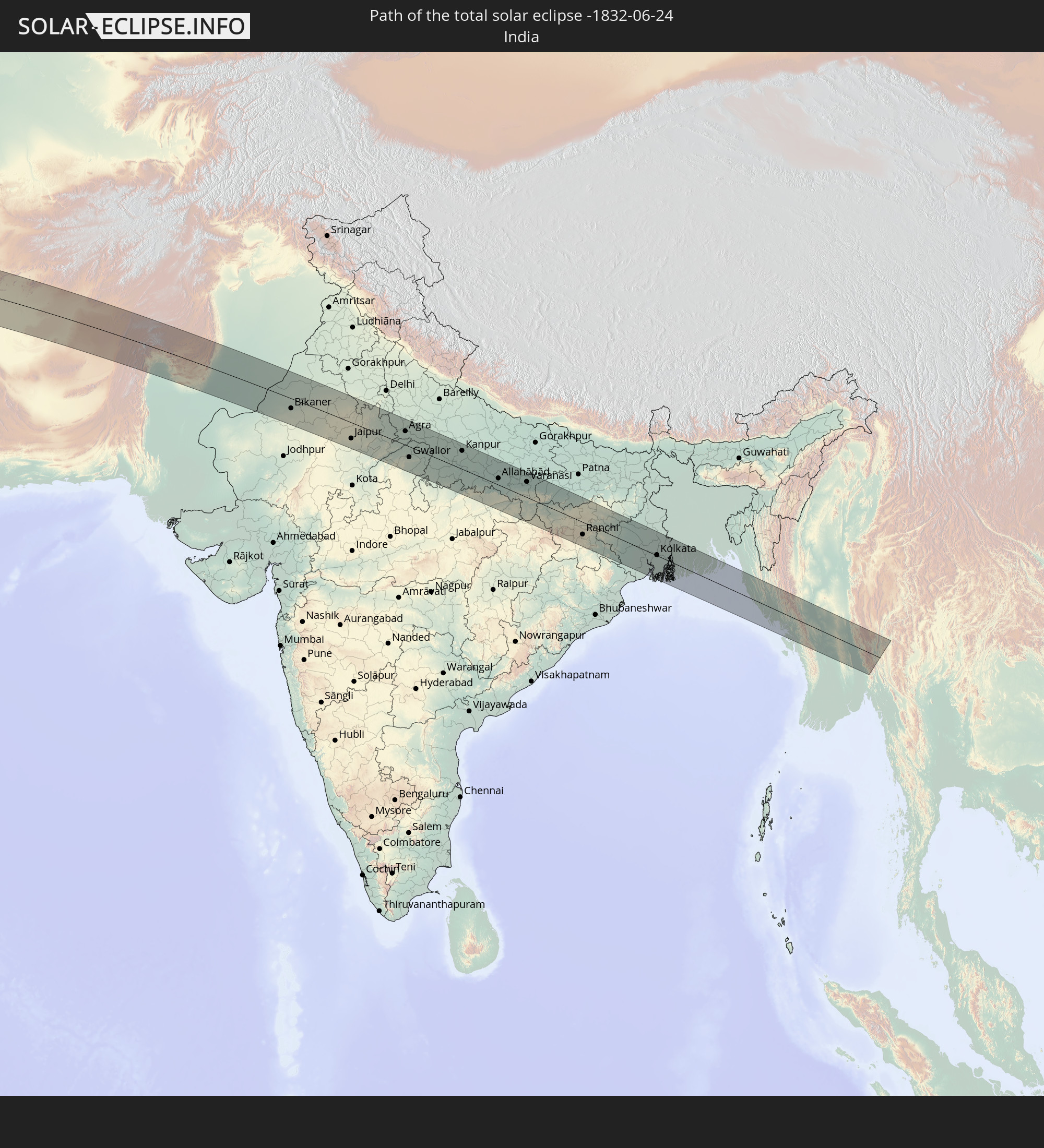 India
India
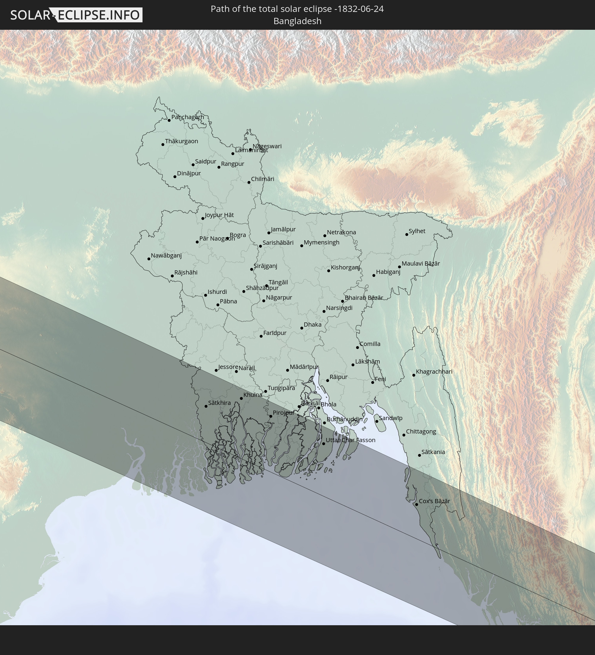 Bangladesh
 Myanmar
 Thailand
In den folgenden Ländern ist die Sonnenfinsternis partiell zu sehen
 Russia
 Brazil
 Portugal
 Cabo Verde
 Spain
Spain
 Senegal
 Mauritania
 The Gambia
 Guinea-Bissau
 Guinea
 Saint Helena, Ascension and Tristan da Cunha
 Sierra Leone
 Morocco
 Mali
Mali
 Liberia
 Republic of Ireland
 Algeria
 United Kingdom
 Ivory Coast
 Burkina Faso
 Gibraltar
 France
 Isle of Man
 Ghana
Ghana
 Guernsey
 Jersey
 Togo
Togo
 Niger
Niger
 Benin
Benin
 Andorra
 Belgium
 Nigeria
 Netherlands
 Norway
 Equatorial Guinea
 Luxembourg
 Germany
 Switzerland
 São Tomé and Príncipe
 Italy
Italy
 Monaco
 Tunisia
 Denmark
 Cameroon
 Gabon
Gabon
 Libya
Libya
 Liechtenstein
 Austria
 Sweden
 Republic of the Congo
 Angola
 Czechia
 Democratic Republic of the Congo
 San Marino
 Vatican City
 Slovenia
 Chad
Chad
 Croatia
 Poland
 Malta
Malta
 Central African Republic
 Bosnia and Herzegovina
 Hungary
 Slovakia
 Montenegro
 Serbia
 Albania
 Åland Islands
 Greece
 Romania
 Republic of Macedonia
 Finland
 Lithuania
 Latvia
 Estonia
 Sudan
Sudan
 Ukraine
 Bulgaria
 Belarus
 Egypt
Egypt
 Turkey
 Moldova
 Uganda
 Cyprus
 Ethiopia
 Kenya
Kenya
 State of Palestine
 Israel
 Saudi Arabia
 Jordan
 Lebanon
 Syria
Syria
 Eritrea
 Iraq
Iraq
 Georgia
 Somalia
 Djibouti
 Yemen
Yemen
 Armenia
 Iran
Iran
 Azerbaijan
 Kazakhstan
 Kuwait
 Bahrain
 Qatar
Qatar
 United Arab Emirates
 Oman
Oman
 Turkmenistan
 Uzbekistan
 Afghanistan
 Pakistan
 Tajikistan
 India
India
 Kyrgyzstan
 Maldives
 China
China
 Sri Lanka
 Nepal
Nepal
 Mongolia
 Bangladesh
 Bhutan
 Myanmar
 Thailand
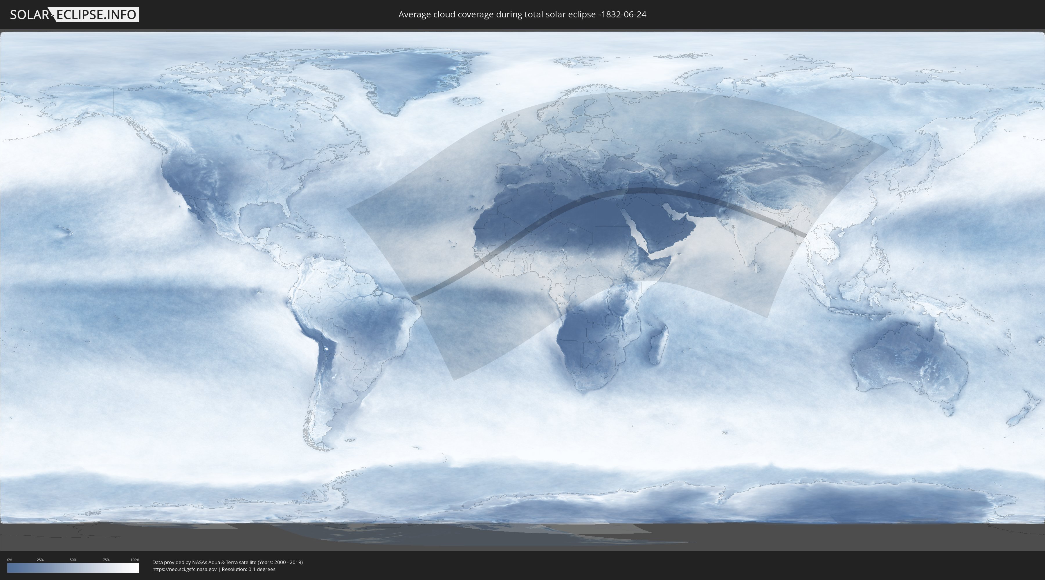
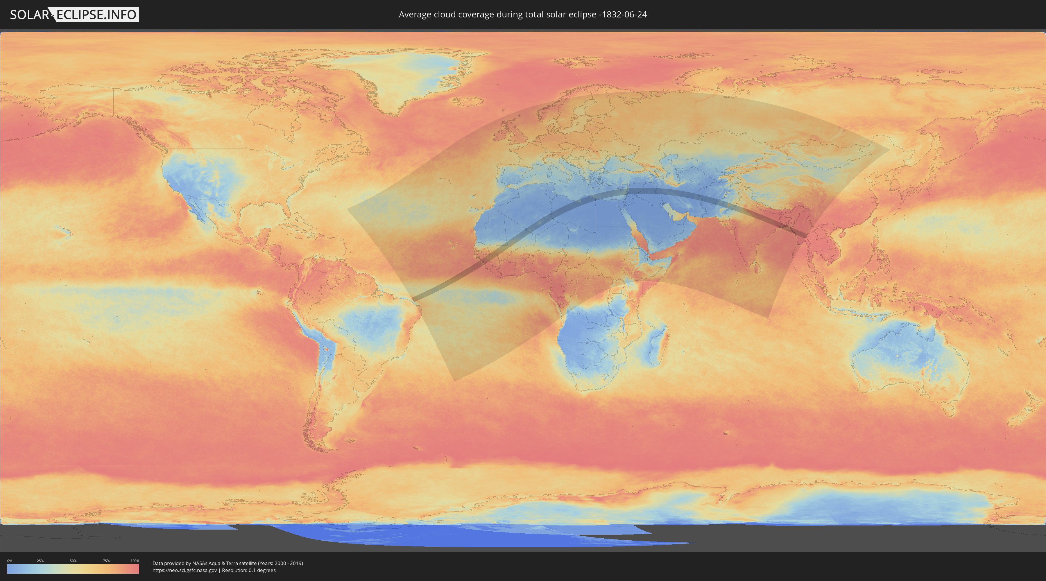
How will be the weather during the total solar eclipse on 06/24/-1832?
Where is the best place to see the total solar eclipse of 06/24/-1832?
The following maps show the average cloud coverage for the day of the total solar eclipse.
With the help of these maps, it is possible to find the place along the eclipse path, which has the best
chance of a cloudless sky.
Nevertheless, you should consider local circumstances and inform about the weather of your chosen
observation site.
The data is provided by NASAs satellites
AQUA and TERRA.
The cloud maps are averaged over a period of 19 years (2000 - 2019).
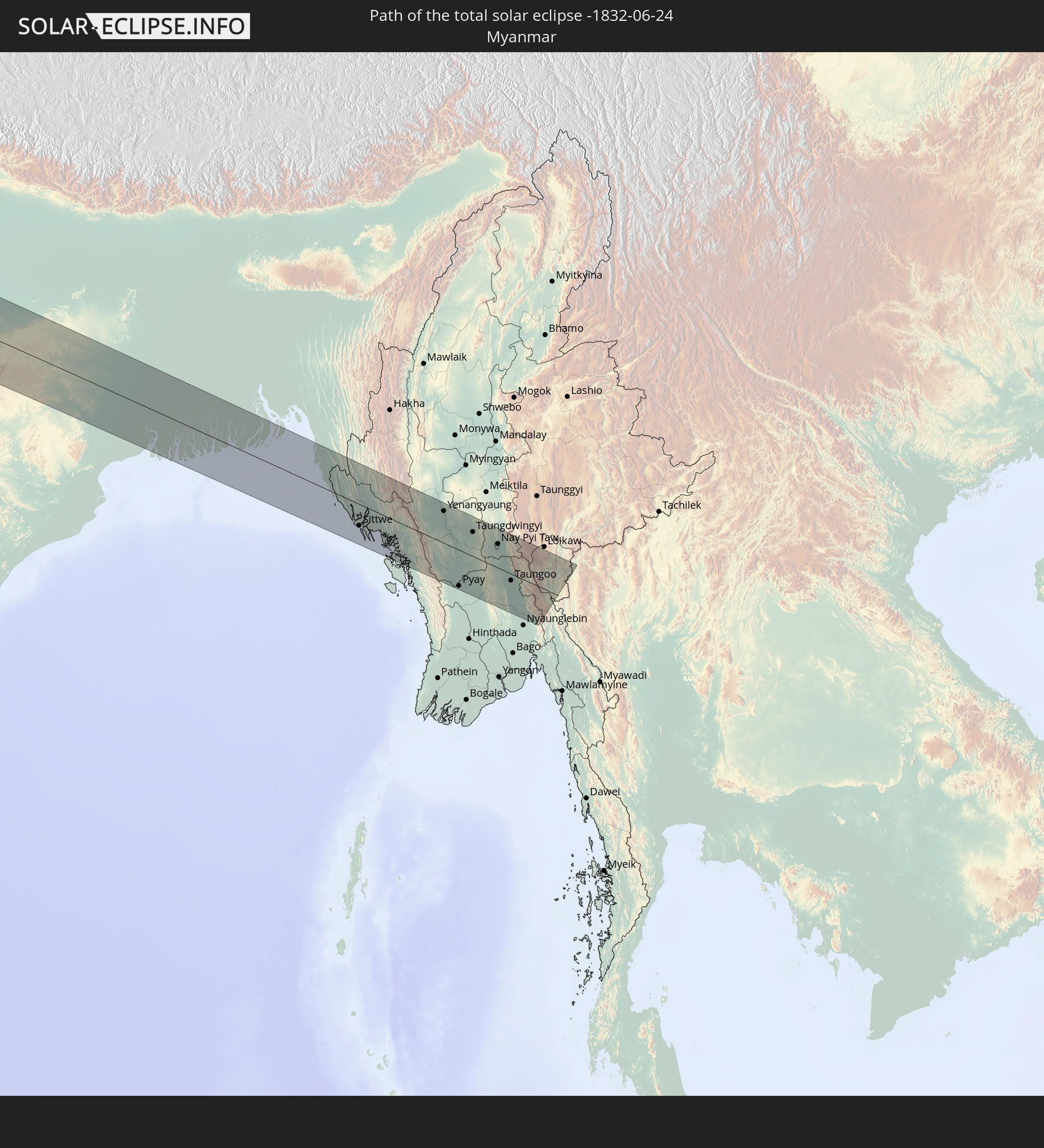
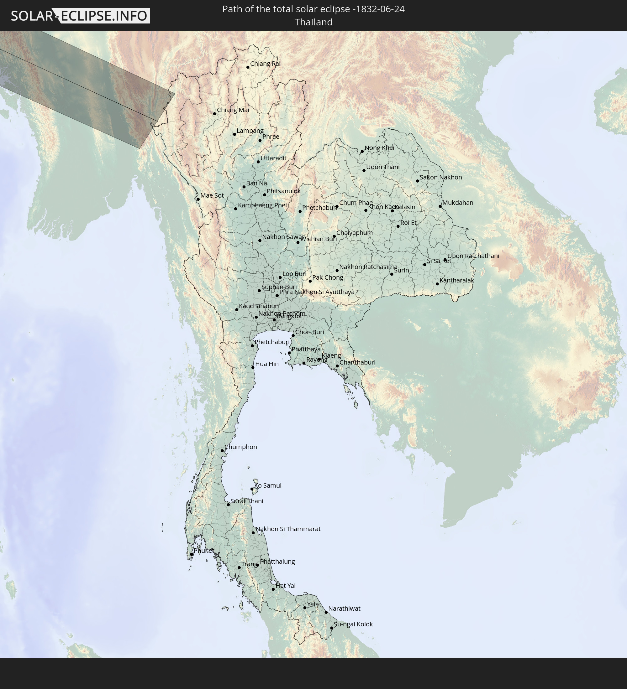
Detailed country maps
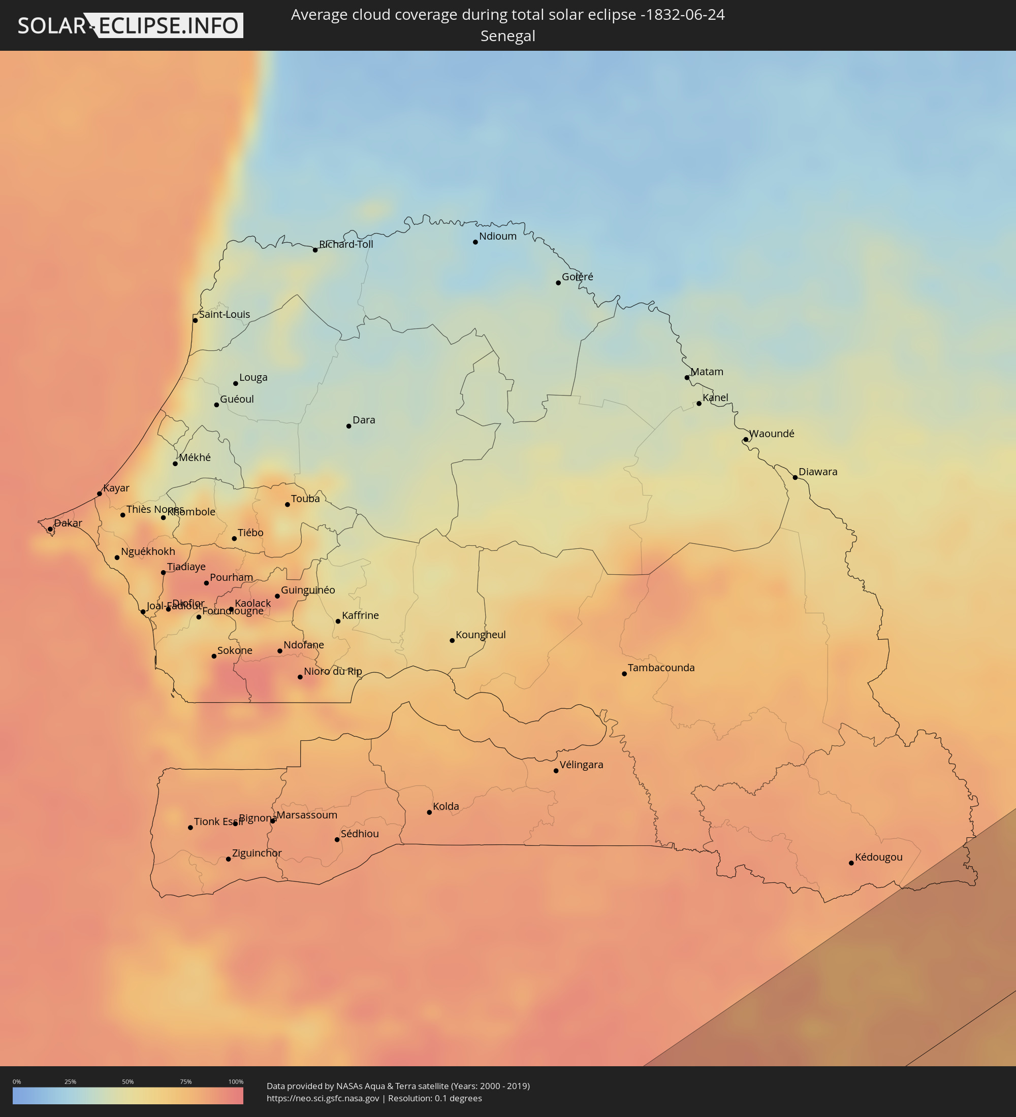 Senegal
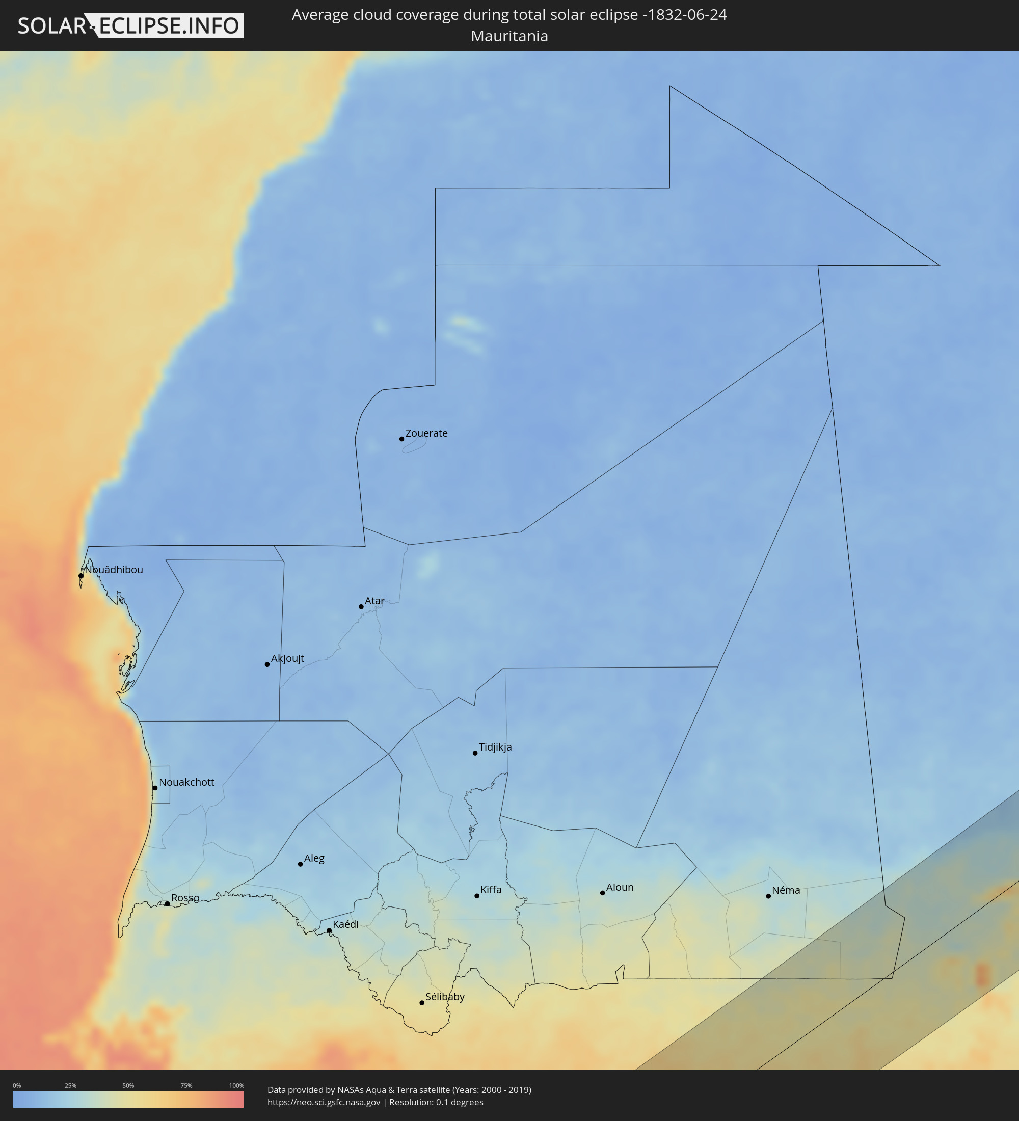 Mauritania
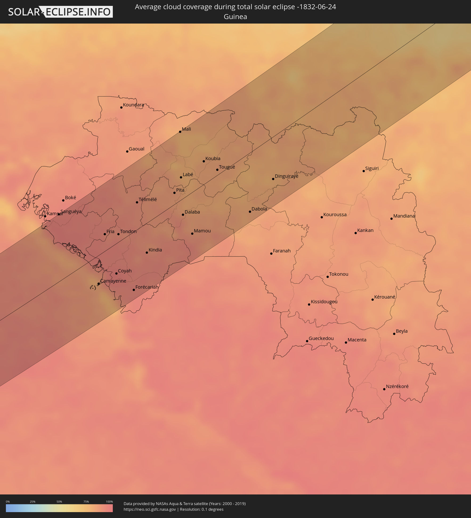 Guinea
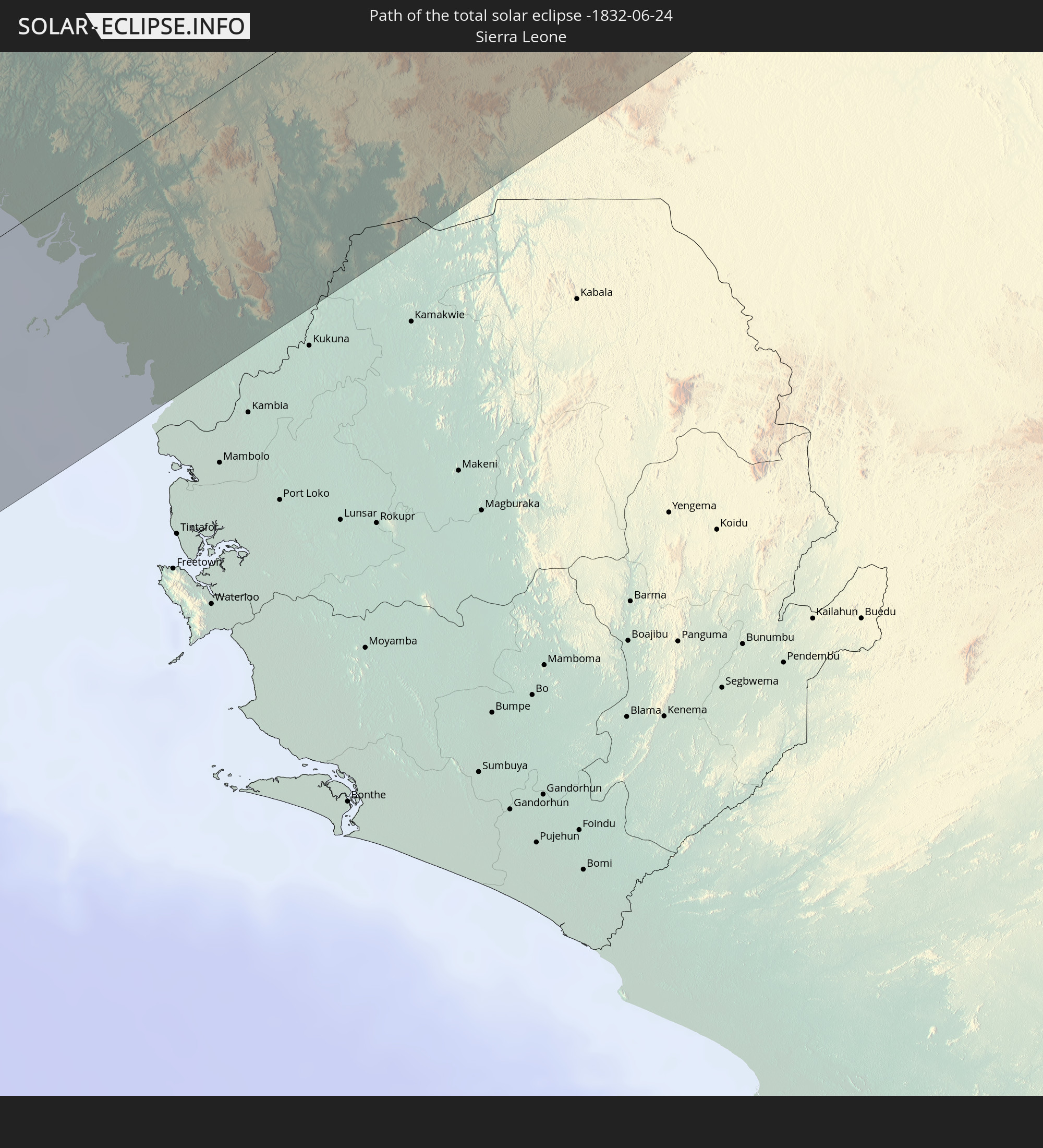
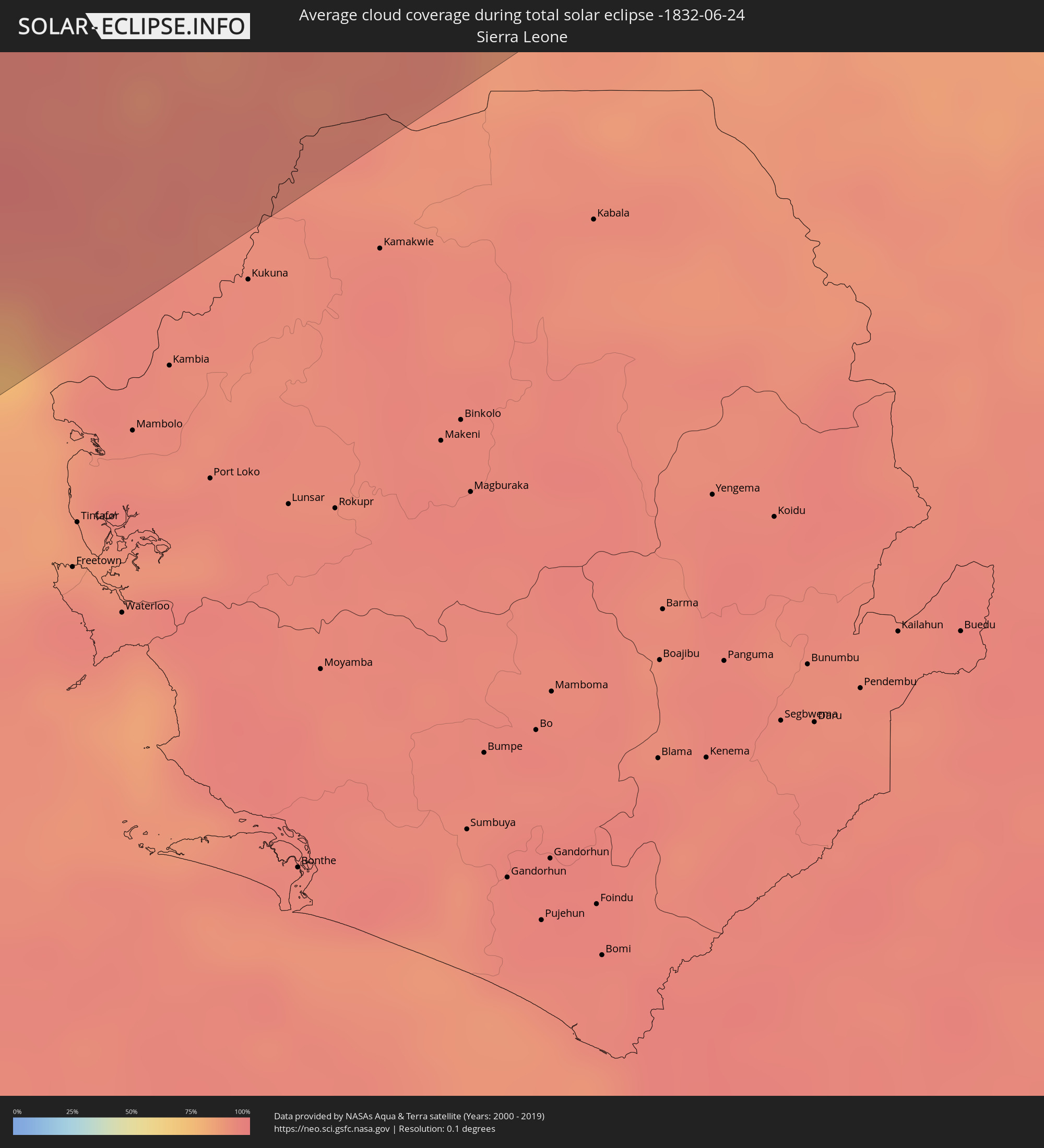 Sierra Leone
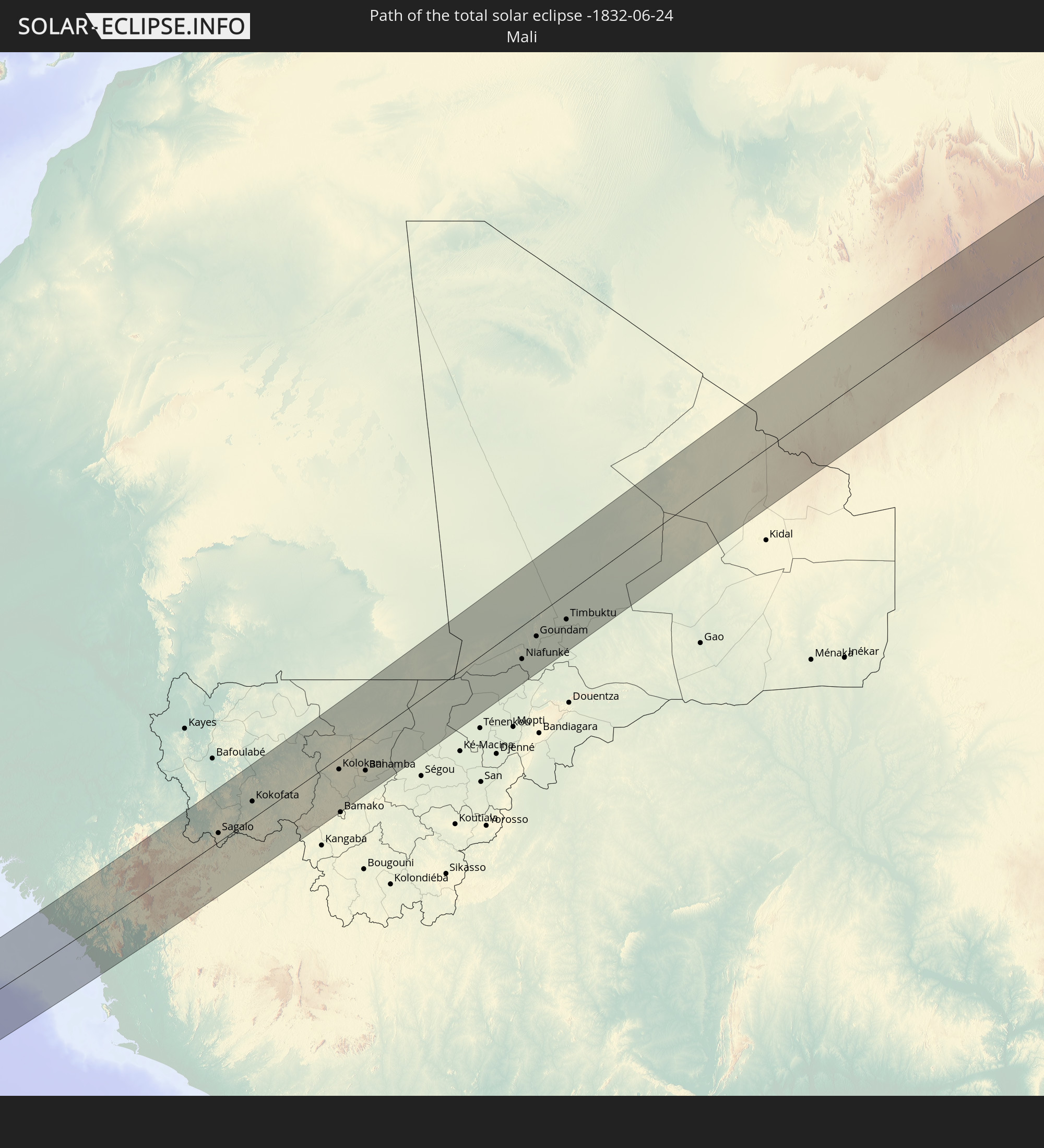
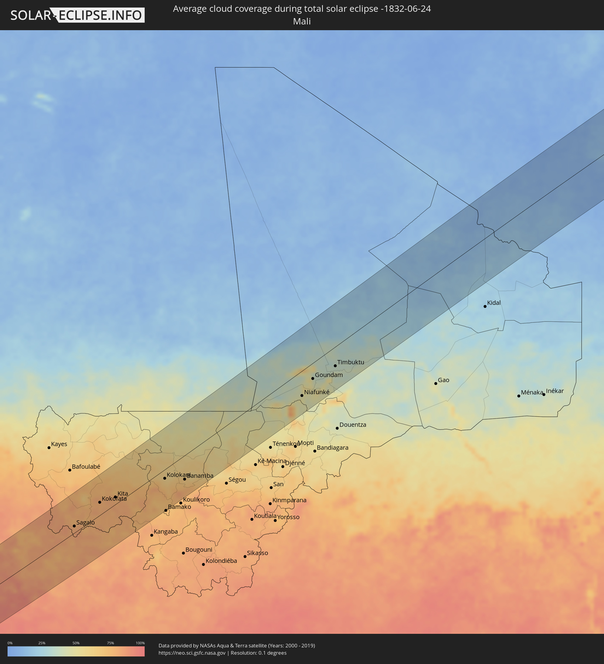 Mali
Mali
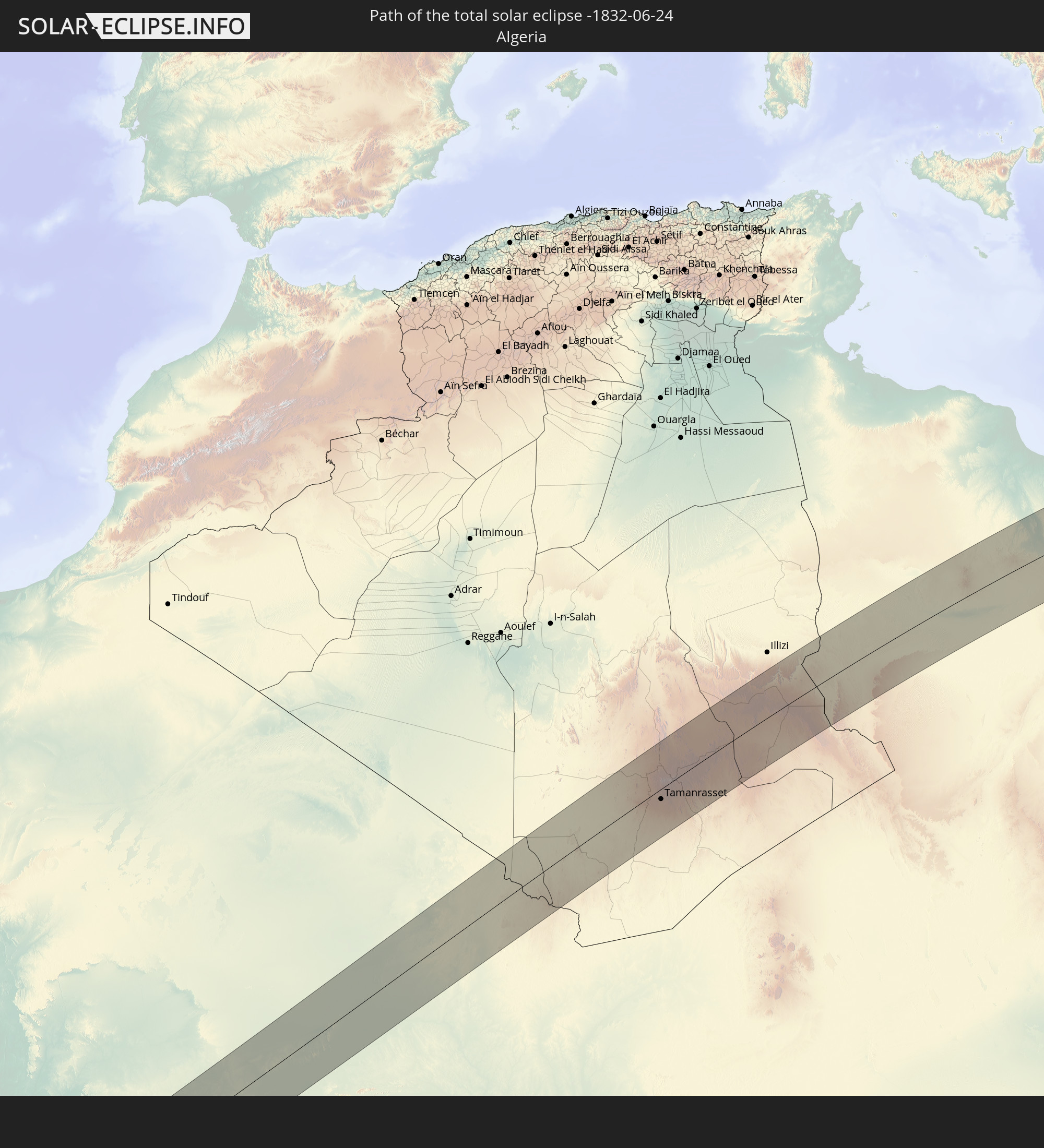
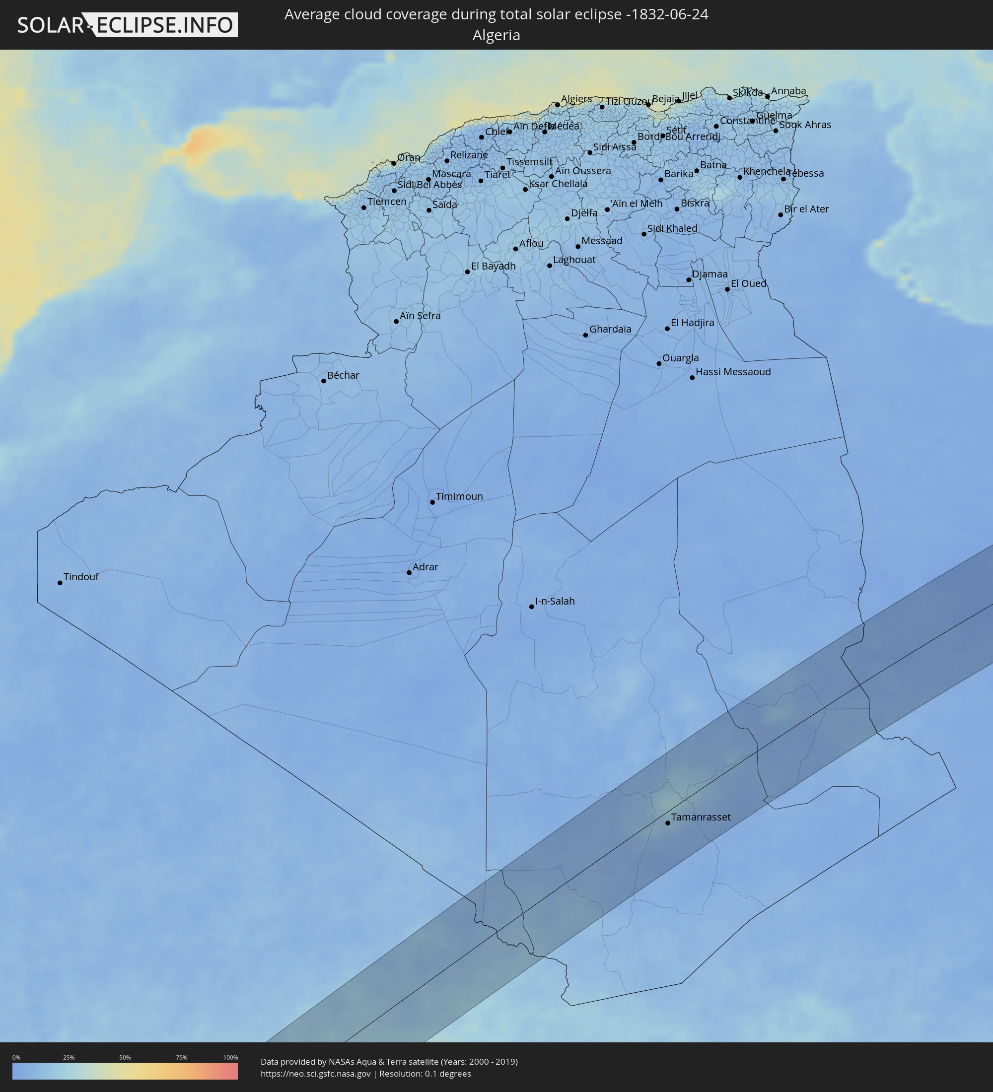 Algeria
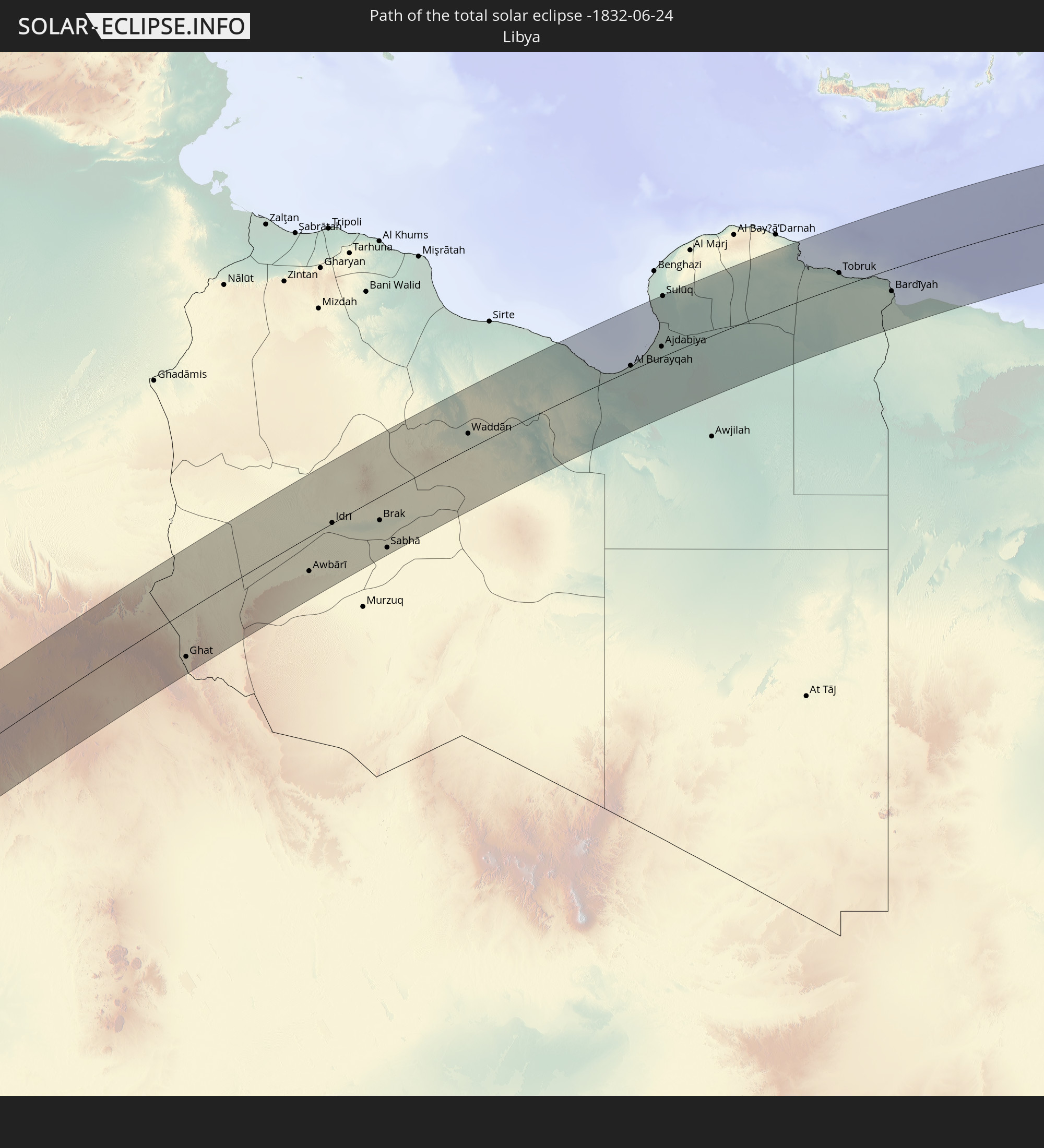
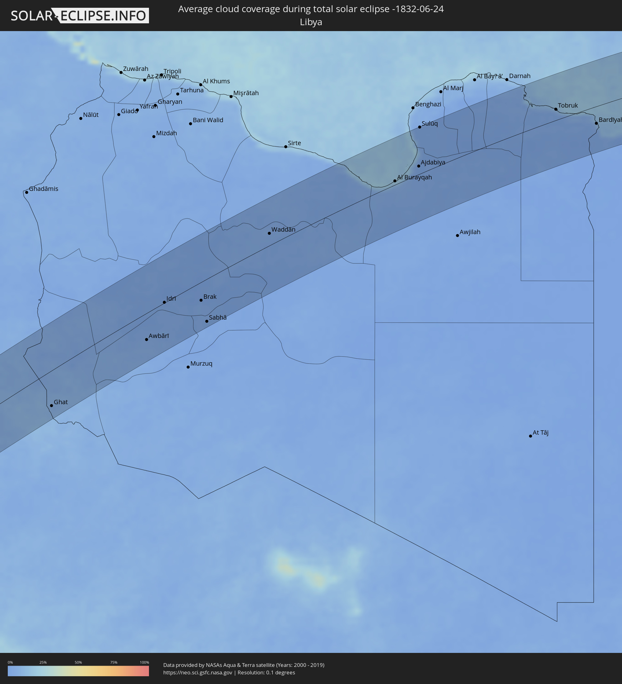 Libya
Libya
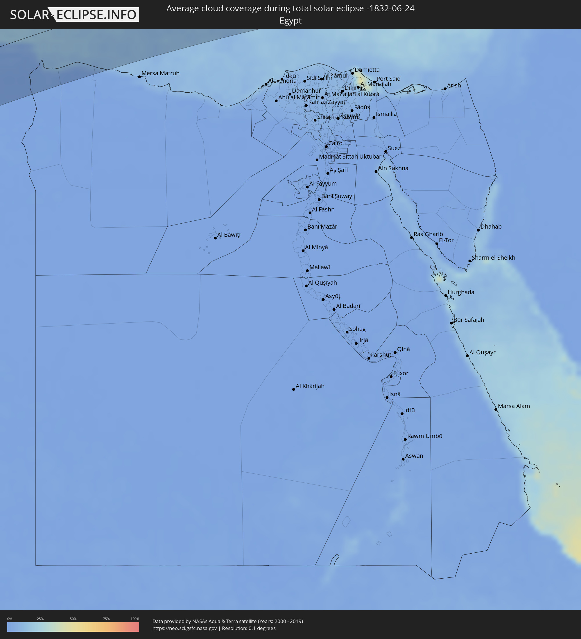 Egypt
Egypt
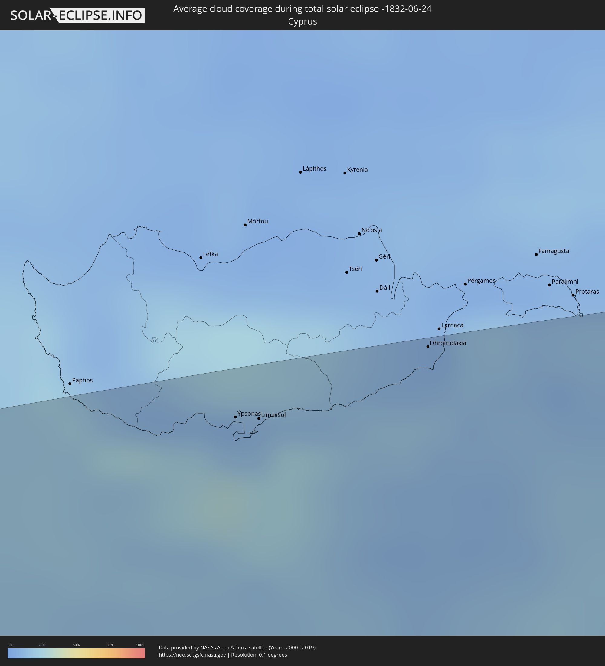 Cyprus
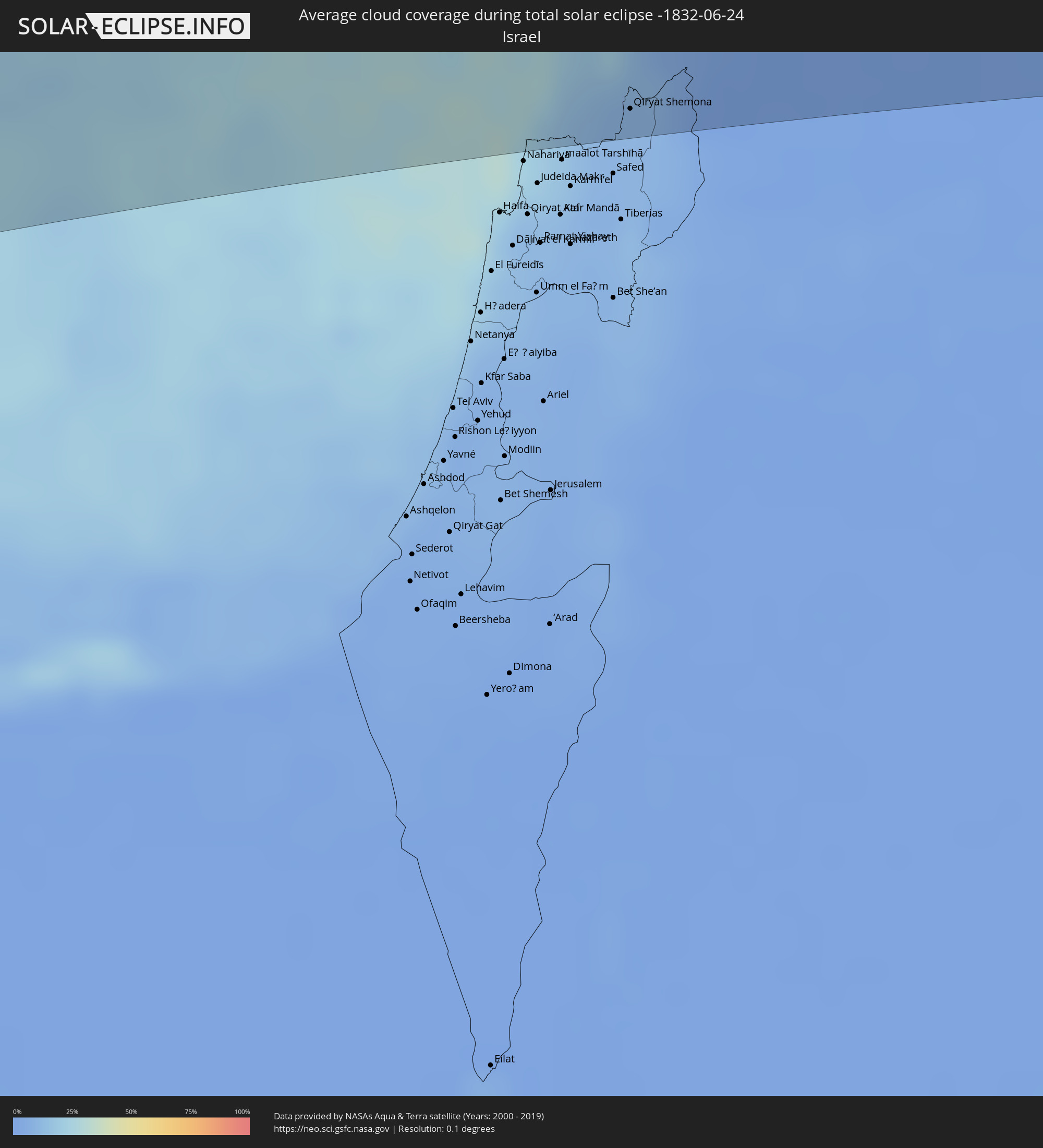 Israel
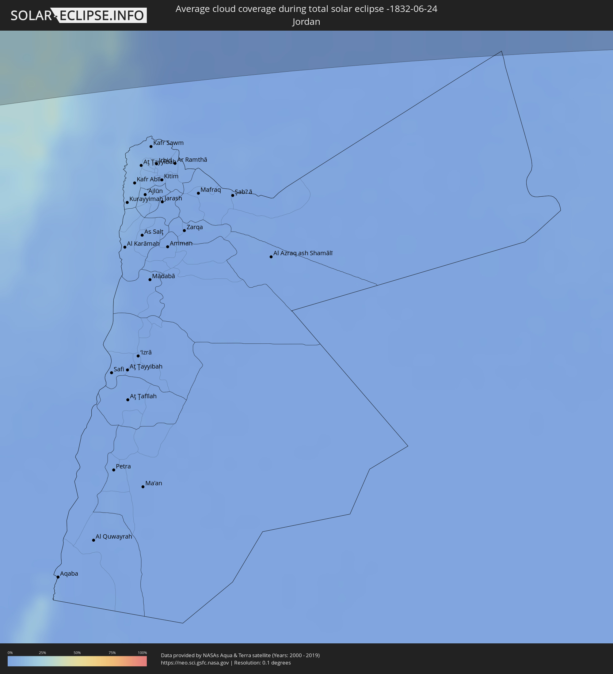 Jordan
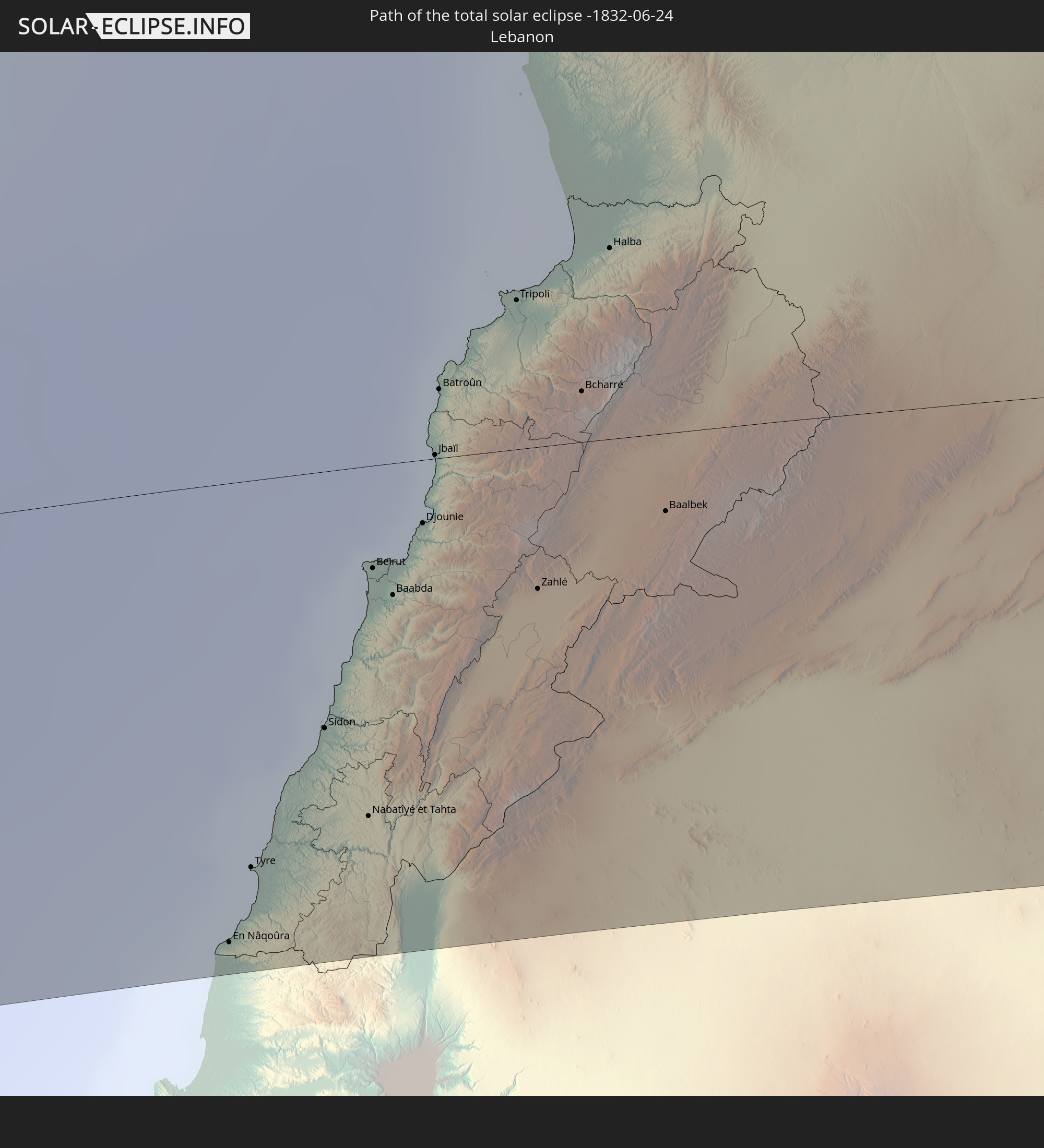
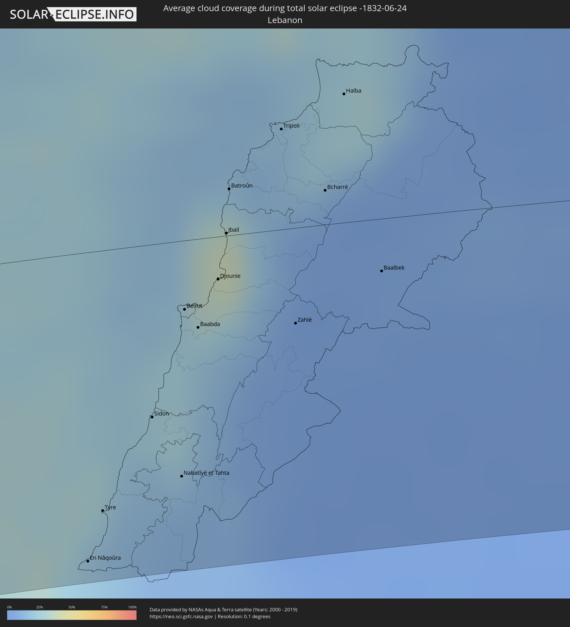 Lebanon
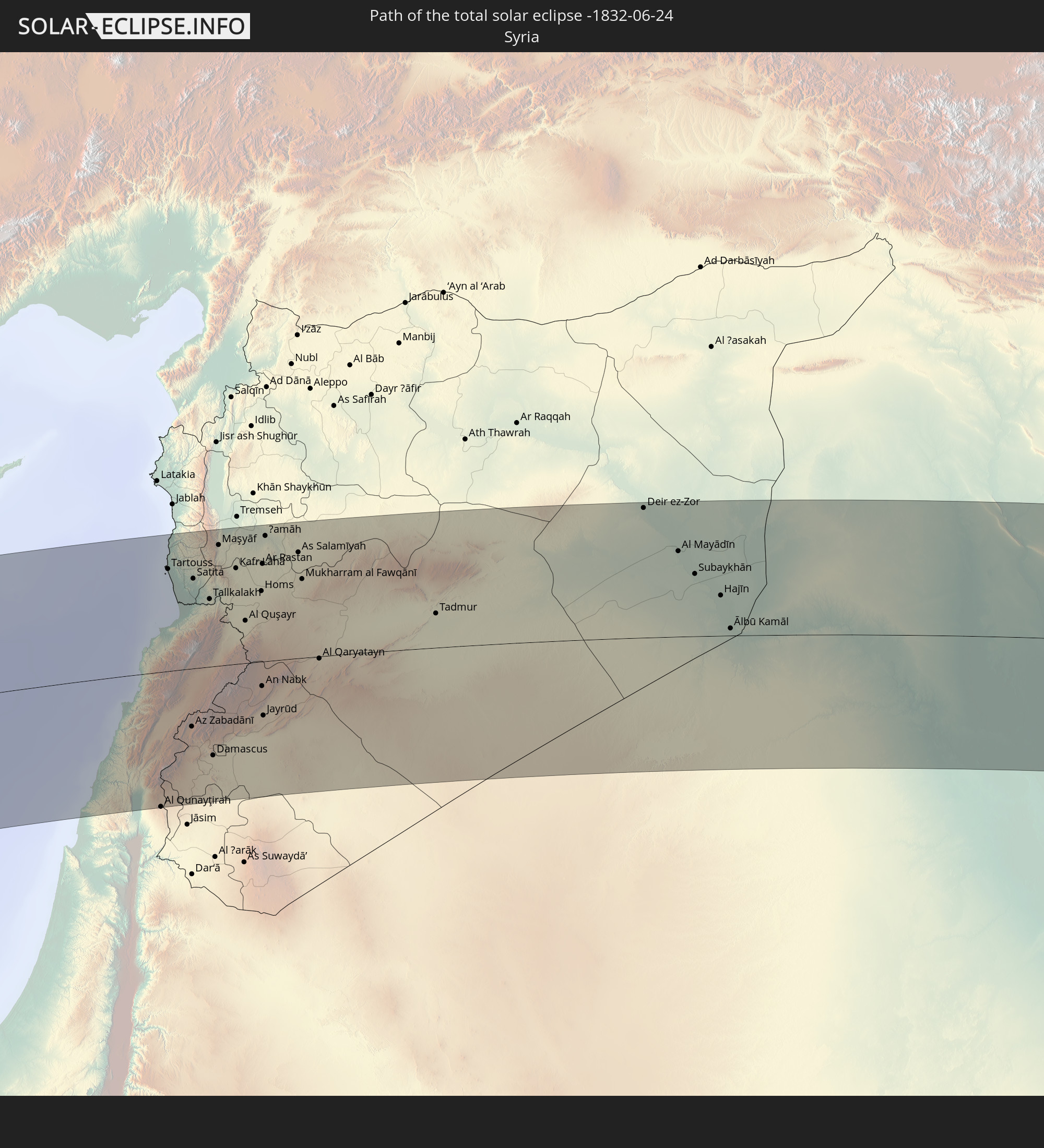
 Syria
Syria
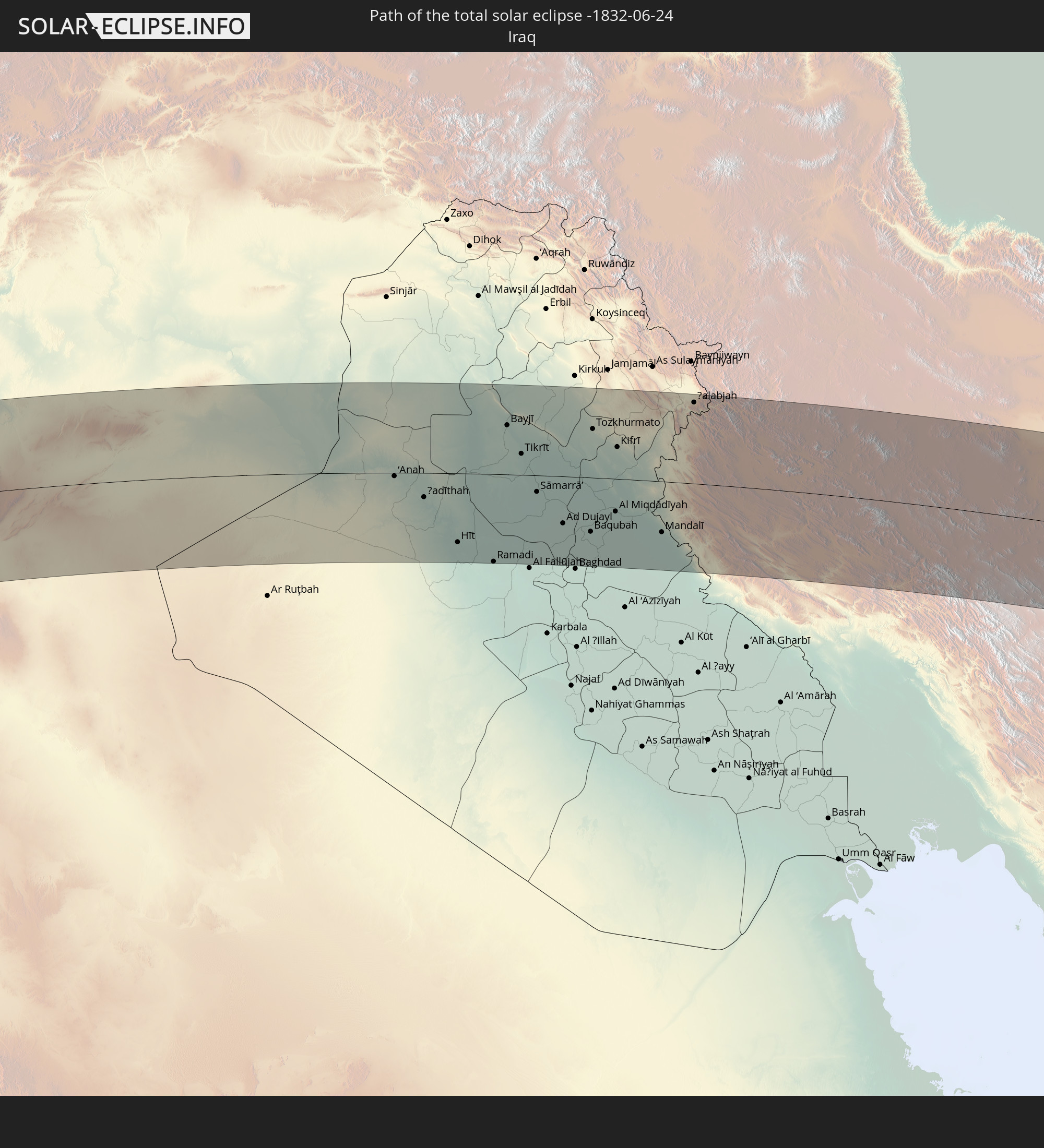
 Iraq
Iraq
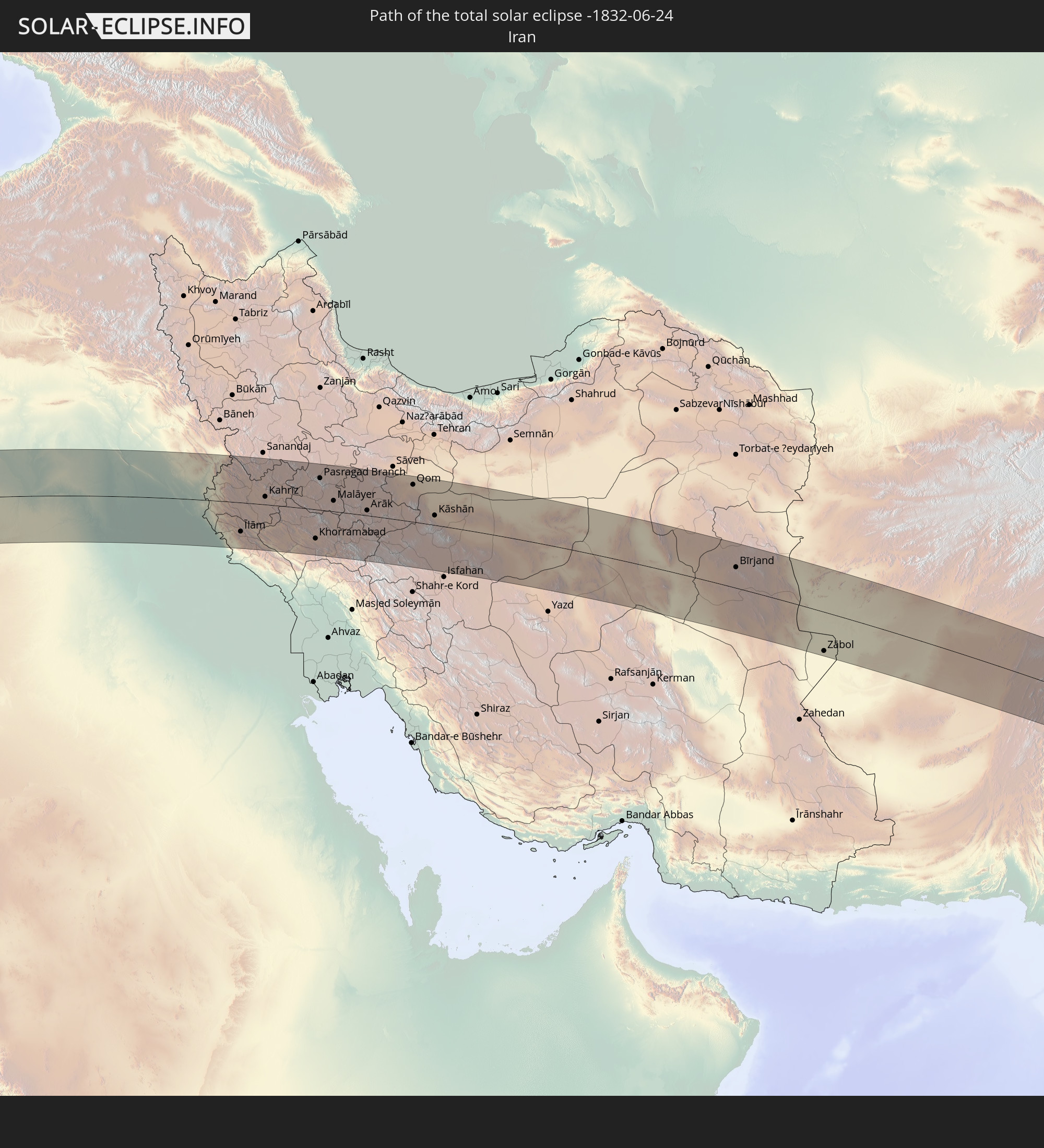
 Iran
Iran
 Afghanistan
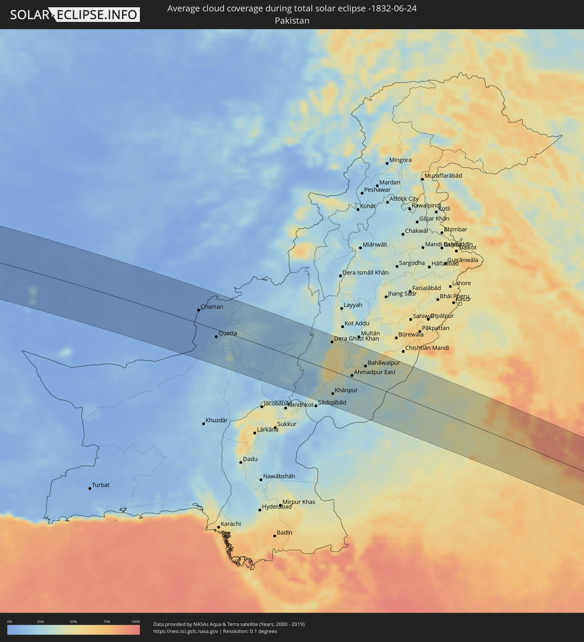 Pakistan
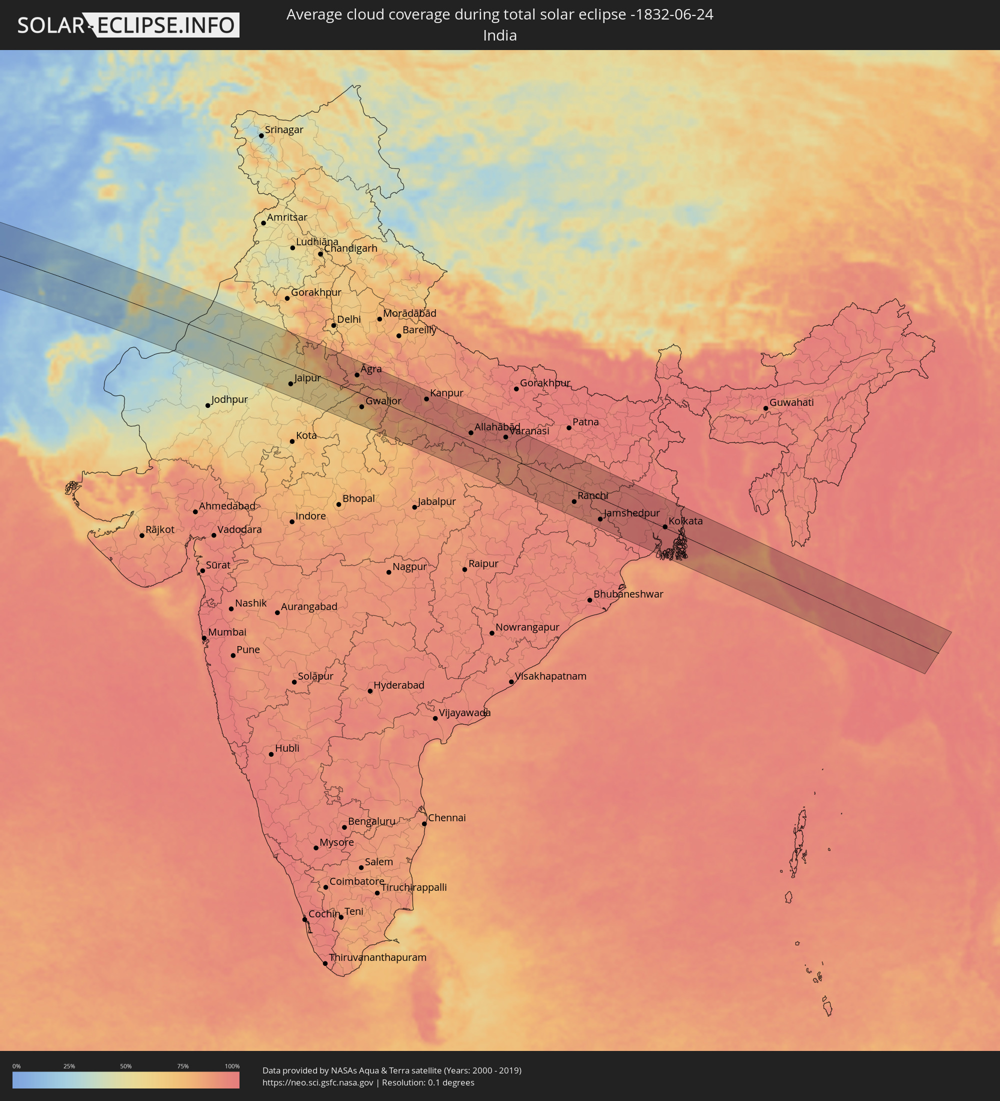 India
India
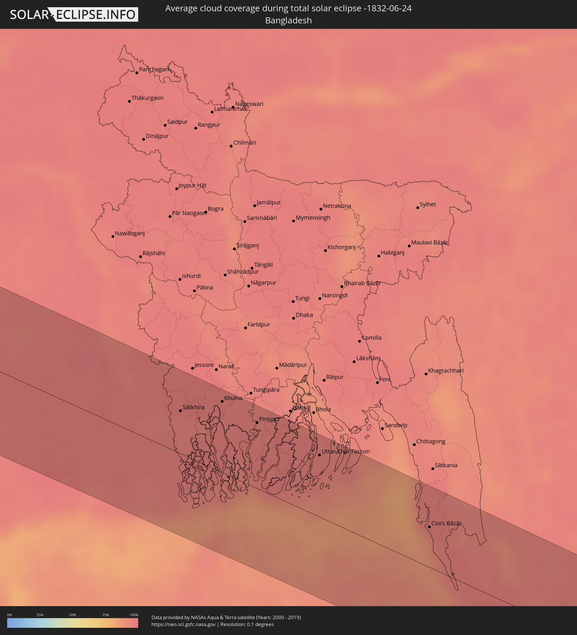 Bangladesh
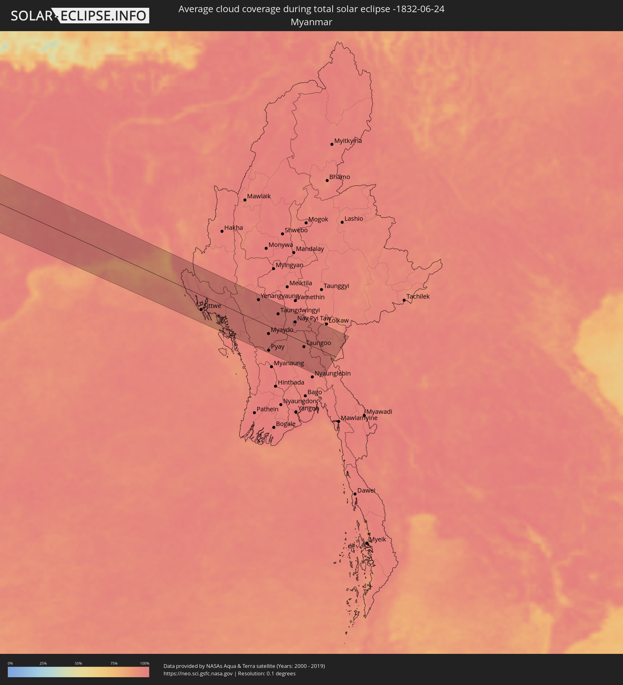 Myanmar
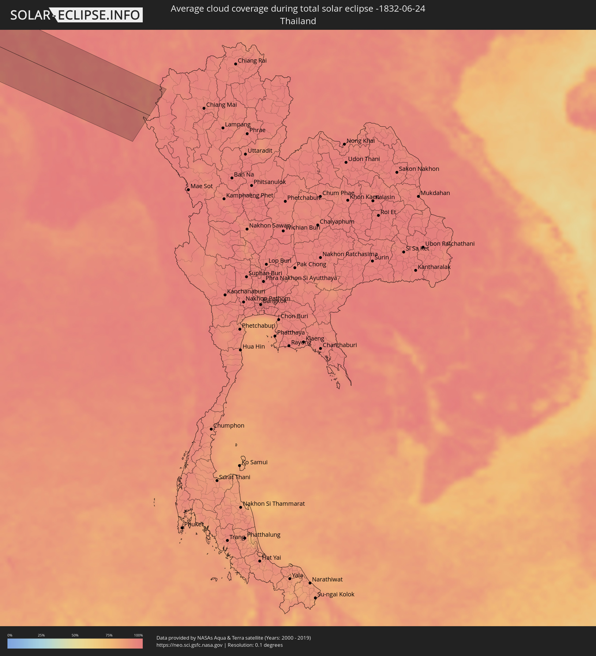 Thailand
Cities inside the path of the eclipse
The following table shows all locations with a population of more than 5,000 inside the eclipse path. Cities which have more than 100,000 inhabitants are marked bold. A click at the locations opens a detailed map.
| City | Type | Eclipse duration | Local time of max. eclipse | Distance to central line | Ø Cloud coverage |
|
Camayenne, Conakry
|
total | - | 08:27:11 UTC-00:16 | 45 km | 84% |
|
Fria, Boke
|
total | - | 08:28:13 UTC-00:16 | 26 km | 94% |
|
Dubréka, Kindia
|
total | - | 08:27:35 UTC-00:16 | 31 km | 95% |
|
Coyah, Kindia
|
total | - | 08:27:35 UTC-00:16 | 47 km | 95% |
|
Tondon, Kindia
|
total | - | 08:28:22 UTC-00:16 | 12 km | 93% |
|
Forécariah, Kindia
|
total | - | 08:27:27 UTC-00:16 | 91 km | 94% |
|
Télimélé, Kindia
|
total | - | 08:29:12 UTC-00:16 | 42 km | 89% |
|
Kindia, Kindia
|
total | - | 08:28:19 UTC-00:16 | 46 km | 92% |
|
Pita, Mamou
|
total | - | 08:29:50 UTC-00:16 | 17 km | 84% |
|
Labé, Labe
|
total | - | 08:30:13 UTC-00:16 | 34 km | 82% |
|
Mamou, Mamou
|
total | - | 08:29:14 UTC-00:16 | 64 km | 90% |
|
Koubia, Labe
|
total | - | 08:30:49 UTC-00:16 | 35 km | 82% |
|
Tougué, Labe
|
total | - | 08:30:49 UTC-00:16 | 8 km | 82% |
|
Dabola, Faranah
|
total | - | 08:30:23 UTC-00:16 | 91 km | 81% |
|
Diré
|
total | - | 08:32:23 UTC-00:16 | 42 km | 83% |
|
Sagalo, Kayes
|
total | - | 08:32:29 UTC-00:16 | 17 km | 81% |
|
Kokofata
|
total | - | 08:33:57 UTC-00:16 | 33 km | 79% |
|
Kita, Kayes
|
total | - | 08:34:32 UTC-00:16 | 18 km | 79% |
|
Kati, Koulikoro
|
total | - | 08:35:23 UTC-00:16 | 96 km | 72% |
|
Kolokani, Koulikoro
|
total | - | 08:36:31 UTC-00:16 | 23 km | 64% |
|
Banamba, Koulikoro
|
total | - | 08:37:01 UTC-00:16 | 62 km | 71% |
|
Niafunké, Tombouctou
|
total | - | 08:43:53 UTC-00:16 | 63 km | 50% |
|
Goundam, Tombouctou
|
total | - | 08:44:56 UTC-00:16 | 40 km | 49% |
|
Timbuktu, Tombouctou
|
total | - | 08:46:13 UTC-00:16 | 49 km | 37% |
|
Tamanrasset, Tamanrasset
|
total | - | 09:33:05 UTC+00:09 | 24 km | 15% |
|
Ghat, Sha‘bīyat Ghāt
|
total | - | 10:28:13 UTC+00:52 | 82 km | 6% |
|
Awbārī, Sha‘bīyat Wādī al Ḩayāt
|
total | - | 10:35:48 UTC+00:52 | 63 km | 4% |
|
Idrī, Ash Shāţiʼ
|
total | - | 10:38:07 UTC+00:52 | 1 km | 2% |
|
Brak, Ash Shāţiʼ
|
total | - | 10:40:16 UTC+00:52 | 43 km | 3% |
|
Al Jadīd, Sabhā
|
total | - | 10:39:50 UTC+00:52 | 98 km | 1% |
|
Sabhā, Sabhā
|
total | - | 10:39:52 UTC+00:52 | 101 km | 2% |
|
Hūn, Al Jufrah
|
total | - | 10:45:59 UTC+00:52 | 33 km | 3% |
|
Waddān, Al Jufrah
|
total | - | 10:46:27 UTC+00:52 | 28 km | 2% |
|
Al Burayqah, Sha‘bīyat al Wāḩāt
|
total | - | 10:55:33 UTC+00:52 | 9 km | 8% |
|
Az Zuwaytīnah, Sha‘bīyat al Wāḩāt
|
total | - | 10:57:24 UTC+00:52 | 43 km | 15% |
|
Ajdabiya, Sha‘bīyat al Wāḩāt
|
total | - | 10:57:25 UTC+00:52 | 19 km | 2% |
|
Sulūq, Banghāzī
|
total | - | 10:58:30 UTC+00:52 | 111 km | 2% |
|
Tobruk, Sha‘bīyat al Buţnān
|
total | - | 11:07:21 UTC+00:52 | 26 km | 7% |
|
Bardīyah, Sha‘bīyat al Buţnān
|
total | - | 11:09:37 UTC+00:52 | 42 km | 10% |
|
Ýpsonas, Limassol
|
total | - | 12:50:15 UTC+02:13 | 98 km | 15% |
|
Limassol, Limassol
|
total | - | 12:50:25 UTC+02:13 | 96 km | 15% |
|
Dhromolaxia, Larnaka
|
total | - | 12:51:42 UTC+02:13 | 109 km | 12% |
|
En Nâqoûra, South Governorate
|
total | - | 12:41:14 UTC+02:00 | 104 km | 23% |
|
Shelomi, Northern District
|
total | - | 13:01:54 UTC+02:20 | 110 km | 23% |
|
Tyre, South Governorate
|
total | - | 12:41:24 UTC+02:00 | 88 km | 23% |
|
Sidon, South Governorate
|
total | - | 12:41:52 UTC+02:00 | 58 km | 23% |
|
Habboûch, Nabatîyé
|
total | - | 12:42:05 UTC+02:00 | 76 km | 14% |
|
Nabatîyé et Tahta, Nabatîyé
|
total | - | 12:42:05 UTC+02:00 | 79 km | 14% |
|
Beirut, Beyrouth
|
total | - | 12:42:13 UTC+02:00 | 23 km | 22% |
|
Baabda, Mont-Liban
|
total | - | 12:42:19 UTC+02:00 | 30 km | 25% |
|
Qiryat Shemona, Northern District
|
total | - | 13:02:55 UTC+02:20 | 99 km | 9% |
|
Djounie, Mont-Liban
|
total | - | 12:42:30 UTC+02:00 | 14 km | 32% |
|
Jbaïl, Mont-Liban
|
total | - | 12:42:36 UTC+02:00 | 1 km | 33% |
|
Batroûn, Liban-Nord
|
total | - | 12:42:39 UTC+02:00 | 16 km | 19% |
|
Al Qunayţirah, Quneitra
|
total | - | 13:08:00 UTC+02:25 | 111 km | 6% |
|
Tripoli, Liban-Nord
|
total | - | 12:43:06 UTC+02:00 | 34 km | 13% |
|
Tartouss, Tartus
|
total | - | 13:08:27 UTC+02:25 | 83 km | 33% |
|
Zahlé, Béqaa
|
total | - | 12:43:07 UTC+02:00 | 32 km | 3% |
|
Bcharré, Liban-Nord
|
total | - | 12:43:25 UTC+02:00 | 11 km | 13% |
|
Baalbek, Baalbek-Hermel
|
total | - | 12:43:50 UTC+02:00 | 18 km | 2% |
|
Damascus, Dimashq
|
total | - | 13:09:07 UTC+02:25 | 73 km | 0% |
|
Al Quşayr, Homs
|
total | - | 13:09:54 UTC+02:25 | 35 km | 2% |
|
Homs, Homs
|
total | - | 13:10:14 UTC+02:25 | 58 km | 2% |
|
An Nabk, Rif-dimashq
|
total | - | 13:10:10 UTC+02:25 | 20 km | 2% |
|
Ar Rastan, Homs
|
total | - | 13:10:17 UTC+02:25 | 80 km | 2% |
|
Jayrūd, Rif-dimashq
|
total | - | 13:10:10 UTC+02:25 | 44 km | 1% |
|
Ḩamāh, Hama
|
total | - | 13:10:21 UTC+02:25 | 102 km | 3% |
|
As Salamīyah, Hama
|
total | - | 13:10:58 UTC+02:25 | 86 km | 2% |
|
Tadmur, Homs
|
total | - | 13:13:35 UTC+02:25 | 28 km | 1% |
|
Deir ez-Zor, Deir ez-Zor
|
total | - | 13:17:25 UTC+02:25 | 106 km | 3% |
|
Al Mayādīn, Deir ez-Zor
|
total | - | 13:18:05 UTC+02:25 | 70 km | 4% |
|
Ālbū Kamāl, Deir ez-Zor
|
total | - | 13:19:07 UTC+02:25 | 6 km | 4% |
|
‘Anah, Anbar
|
total | - | 13:53:42 UTC+02:57 | 4 km | 2% |
|
Ḩadīthah, Anbar
|
total | - | 13:54:33 UTC+02:57 | 30 km | 0% |
|
Hīt, Anbar
|
total | - | 13:55:34 UTC+02:57 | 85 km | 0% |
|
Ramadi, Anbar
|
total | - | 13:56:35 UTC+02:57 | 108 km | 1% |
|
Bayjī, Salah ad Din Governorate
|
total | - | 13:56:34 UTC+02:57 | 60 km | 3% |
|
Tikrīt, Salah ad Din Governorate
|
total | - | 13:57:02 UTC+02:57 | 26 km | 2% |
|
Sāmarrā’, Salah ad Din Governorate
|
total | - | 13:57:33 UTC+02:57 | 20 km | 2% |
|
Balad, Salah ad Din Governorate
|
total | - | 13:58:07 UTC+02:57 | 39 km | 2% |
|
Baqubah, Diyālá
|
total | - | 13:59:05 UTC+02:57 | 67 km | 2% |
|
Tozkhurmato, Salah ad Din Governorate
|
total | - | 13:58:47 UTC+02:57 | 60 km | 1% |
|
Al Miqdādīyah, Diyālá
|
total | - | 13:59:40 UTC+02:57 | 40 km | 1% |
|
Kifrī, Diyālá
|
total | - | 13:59:29 UTC+02:57 | 39 km | 1% |
|
Mandalī, Diyālá
|
total | - | 14:00:56 UTC+02:57 | 62 km | 0% |
|
Ḩalabjah, As Sulaymānīyah
|
total | - | 14:01:13 UTC+02:57 | 99 km | 3% |
|
Īlām, Īlām
|
total | - | 14:30:46 UTC+03:25 | 69 km | 1% |
|
Kahrīz, Kermānshāh
|
total | - | 14:31:38 UTC+03:25 | 18 km | 3% |
|
Kūhdasht, Lorestān
|
total | - | 14:33:01 UTC+03:25 | 71 km | 1% |
|
Khorramabad, Lorestān
|
total | - | 14:34:24 UTC+03:25 | 69 km | 4% |
|
Pasragad Branch, Hamadān
|
total | - | 14:33:59 UTC+03:25 | 75 km | 12% |
|
Borūjerd, Lorestān
|
total | - | 14:34:55 UTC+03:25 | 20 km | 4% |
|
Malāyer, Hamadān
|
total | - | 14:34:50 UTC+03:25 | 25 km | 9% |
|
Arāk, Markazi
|
total | - | 14:36:27 UTC+03:25 | 12 km | 9% |
|
Alīgūdarz, Lorestān
|
total | - | 14:36:49 UTC+03:25 | 64 km | 9% |
|
Khomeyn, Markazi
|
total | - | 14:37:21 UTC+03:25 | 33 km | 11% |
|
Qom, Qom
|
total | - | 14:38:08 UTC+03:25 | 87 km | 4% |
|
Kāshān, Isfahan
|
total | - | 14:39:26 UTC+03:25 | 23 km | 7% |
|
Bīrjand, Khorāsān-e Jonūbī
|
total | - | 14:51:35 UTC+03:25 | 49 km | 5% |
|
Zābol, Sistan and Baluchestan
|
total | - | 14:55:50 UTC+03:25 | 92 km | 2% |
|
Anār Darah, Farah
|
total | - | 15:28:54 UTC+04:00 | 97 km | 2% |
|
Zaranj, Nimroz
|
total | - | 15:30:36 UTC+04:00 | 90 km | 2% |
|
Farah, Farah
|
total | - | 15:29:45 UTC+04:00 | 68 km | 2% |
|
Khāsh, Nimroz
|
total | - | 15:31:12 UTC+04:00 | 4 km | 2% |
|
Markaz-e Ḩukūmat-e Darwēshān, Helmand
|
total | - | 15:33:03 UTC+04:00 | 7 km | 4% |
|
Lashkar Gāh, Helmand
|
total | - | 15:32:51 UTC+04:00 | 47 km | 3% |
|
Gereshk, Helmand
|
total | - | 15:32:52 UTC+04:00 | 77 km | 2% |
|
Kandahār, Kandahar
|
total | - | 15:34:11 UTC+04:00 | 88 km | 2% |
|
Chaman, Balochistān
|
total | - | 16:03:42 UTC+04:28 | 37 km | 5% |
|
Quetta, Balochistān
|
total | - | 16:04:49 UTC+04:28 | 22 km | 13% |
|
Sibi, Balochistān
|
total | - | 16:06:09 UTC+04:28 | 63 km | 14% |
|
Rājanpur, Punjab
|
total | - | 16:08:33 UTC+04:28 | 29 km | 34% |
|
Jāmpur, Punjab
|
total | - | 16:08:19 UTC+04:28 | 37 km | 54% |
|
Dera Ghazi Khan, Punjab
|
total | - | 16:07:59 UTC+04:28 | 81 km | 30% |
|
Khānpur, Punjab
|
total | - | 16:09:12 UTC+04:28 | 65 km | 28% |
|
Jatoi Shimāli, Punjab
|
total | - | 16:08:37 UTC+04:28 | 32 km | 54% |
|
Ahmadpur East, Punjab
|
total | - | 16:09:14 UTC+04:28 | 7 km | 29% |
|
Shujāābād, Punjab
|
total | - | 16:08:38 UTC+04:28 | 85 km | 34% |
|
Lodhrān, Punjab
|
total | - | 16:09:10 UTC+04:28 | 62 km | 39% |
|
Bahāwalpur, Punjab
|
total | - | 16:09:19 UTC+04:28 | 49 km | 36% |
|
Kohror Pakka, Punjab
|
total | - | 16:09:18 UTC+04:28 | 80 km | 39% |
|
Fort Abbās, Punjab
|
total | - | 16:10:18 UTC+04:28 | 68 km | 38% |
|
Bīkaner, Rajasthan
|
total | - | 17:04:33 UTC+05:21 | 37 km | 36% |
|
Jaipur, Rajasthan
|
total | - | 17:06:54 UTC+05:21 | 60 km | 58% |
|
Āgra, Uttar Pradesh
|
total | - | 17:07:47 UTC+05:21 | 52 km | 77% |
|
Gwalior, Madhya Pradesh
|
total | - | 17:08:36 UTC+05:21 | 40 km | 64% |
|
Kanpur, Uttar Pradesh
|
total | - | 17:09:17 UTC+05:21 | 69 km | 83% |
|
Allahābād, Uttar Pradesh
|
total | - | 17:10:34 UTC+05:21 | 25 km | 93% |
|
Varanasi, Uttar Pradesh
|
total | - | 17:10:59 UTC+05:21 | 59 km | 91% |
|
Ranchi, Jharkhand
|
total | - | 17:12:52 UTC+05:21 | 47 km | 91% |
|
Jamshedpur, Jharkhand
|
total | - | 17:13:22 UTC+05:21 | 66 km | 94% |
|
Āsansol, West Bengal
|
total | - | 17:12:53 UTC+05:21 | 57 km | 95% |
|
Durgapur, West Bengal
|
total | - | 17:13:02 UTC+05:21 | 54 km | 97% |
|
Nangi, West Bengal
|
total | - | 17:13:46 UTC+05:21 | 10 km | 97% |
|
Kolkata, West Bengal
|
total | - | 17:13:45 UTC+05:21 | 2 km | 97% |
|
Bhātpāra, West Bengal
|
total | - | 17:13:33 UTC+05:21 | 34 km | 97% |
|
Sātkhira, Khulna
|
total | - | 17:45:52 UTC+05:53 | 47 km | 95% |
|
Jhingergācha, Khulna
|
total | - | 17:45:36 UTC+05:53 | 89 km | 96% |
|
Kesabpur, Khulna
|
total | - | 17:45:44 UTC+05:53 | 73 km | 98% |
|
Phultala, Khulna
|
total | - | 17:45:52 UTC+05:53 | 67 km | 96% |
|
Khulna, Khulna
|
total | - | 17:45:49 UTC+05:53 | 78 km | 96% |
|
Sarankhola, Khulna
|
total | - | 17:46:08 UTC+05:53 | 37 km | 95% |
|
Morrelgonj, Khulna
|
total | - | 17:46:03 UTC+05:53 | 55 km | 96% |
|
Pirojpur, Barisāl
|
total | - | 17:45:58 UTC+05:53 | 73 km | 96% |
|
Bhāndāria, Barisāl
|
total | - | 17:46:02 UTC+05:53 | 67 km | 96% |
|
Nālchiti, Barisāl
|
total | - | 17:45:56 UTC+05:53 | 91 km | 96% |
|
Uttar Char Fasson, Khulna
|
total | - | 17:46:12 UTC+05:53 | 68 km | 96% |
|
Lālmohan, Barisāl
|
total | - | 17:46:08 UTC+05:53 | 81 km | 96% |
|
Cox’s Bāzār, Chittagong
|
total | - | 17:46:39 UTC+05:53 | 45 km | 90% |
|
Teknāf, Chittagong
|
total | - | 17:46:58 UTC+05:53 | 2 km | 94% |
|
Sittwe, Rakhine
|
total | - | 18:18:47 UTC+06:24 | 48 km | 91% |
|
Yenangyaung, Magway
|
total | - | 18:18:23 UTC+06:24 | 71 km | 95% |
|
Minbu, Magway
|
total | - | 18:18:33 UTC+06:24 | 42 km | 94% |
|
Magway, Magway
|
total | - | 18:18:33 UTC+06:24 | 41 km | 95% |
|
Thayetmyo, Magway
|
total | - | 18:18:58 UTC+06:24 | 31 km | 95% |
|
Myaydo, Magway
|
total | - | 18:18:56 UTC+06:24 | 25 km | 95% |
|
Pyay, Bago
|
total | - | 18:19:13 UTC+06:24 | 80 km | 95% |
|
Taungdwingyi, Magway
|
total | - | 18:18:33 UTC+06:24 | 54 km | 96% |
|
Nay Pyi Taw, Nay Pyi Taw
|
total | - | 18:18:35 UTC+06:24 | 53 km | 97% |
|
Pyinmana, Nay Pyi Taw
|
total | - | 18:18:35 UTC+06:24 | 56 km | 97% |
|
Taungoo, Bago
|
total | - | 18:18:57 UTC+06:24 | 15 km | 97% |
|
Pyu, Bago
|
total | - | 18:19:11 UTC+06:24 | 61 km | 97% |