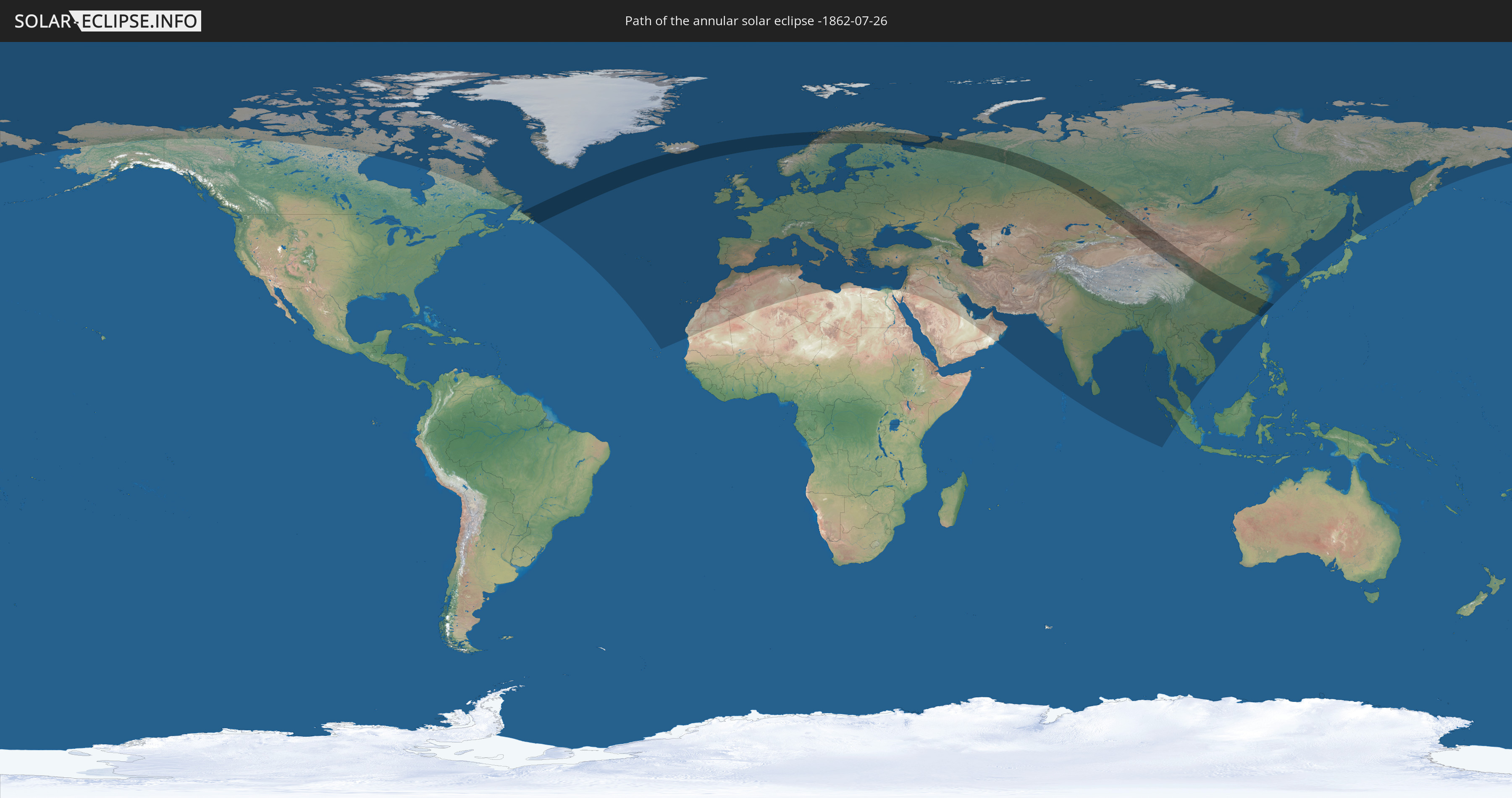
Annular solar eclipse of 07/26/-1862
| Day of week: | Thursday |
| Maximum duration of eclipse: | 05m24s |
| Maximum width of eclipse path: | 304 km |
| Saros cycle: | 6 |
| Coverage: | 93.8% |
| Magnitude: | 0.9383 |
| Gamma: | 0.657 |
Wo kann man die Sonnenfinsternis vom 07/26/-1862 sehen?
Die Sonnenfinsternis am 07/26/-1862 kann man in 107 Ländern als partielle Sonnenfinsternis beobachten.
Der Finsternispfad verläuft durch 10 Länder. Nur in diesen Ländern ist sie als annular Sonnenfinsternis zu sehen.
In den folgenden Ländern ist die Sonnenfinsternis annular zu sehen
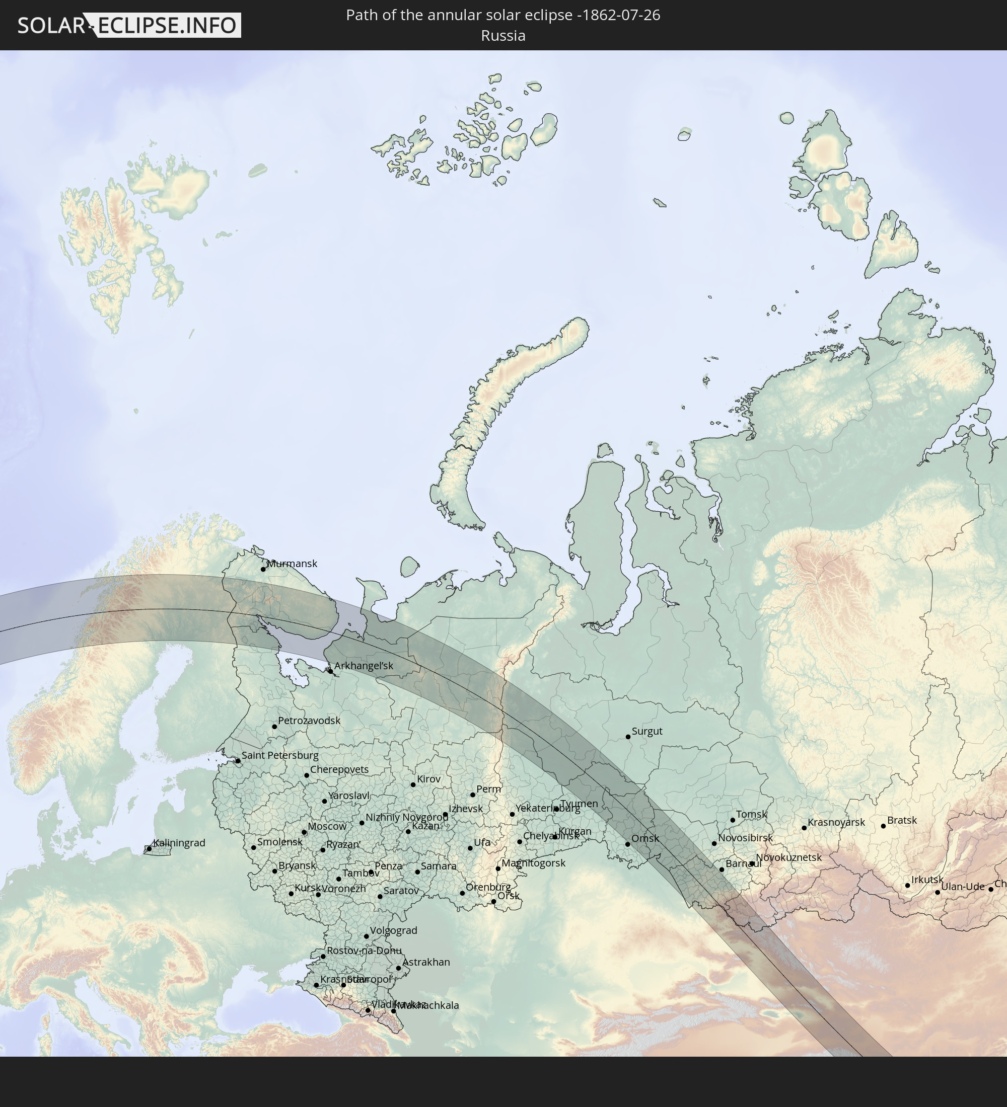 Russia
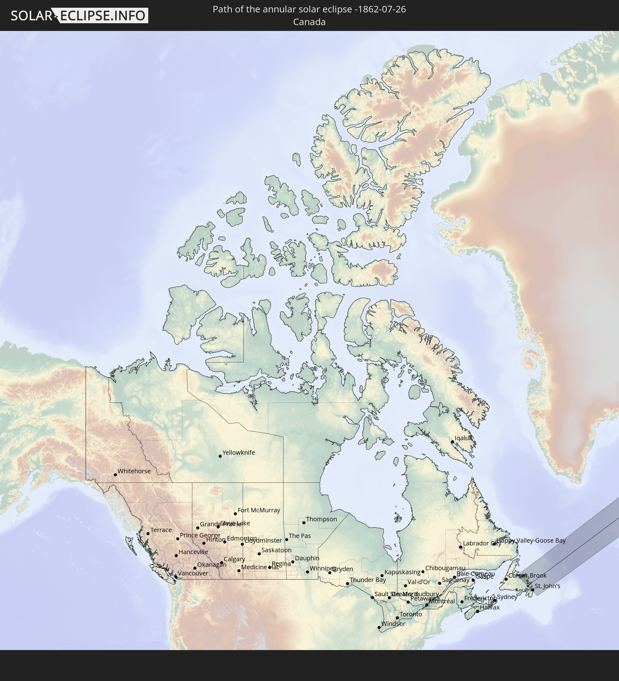 Canada
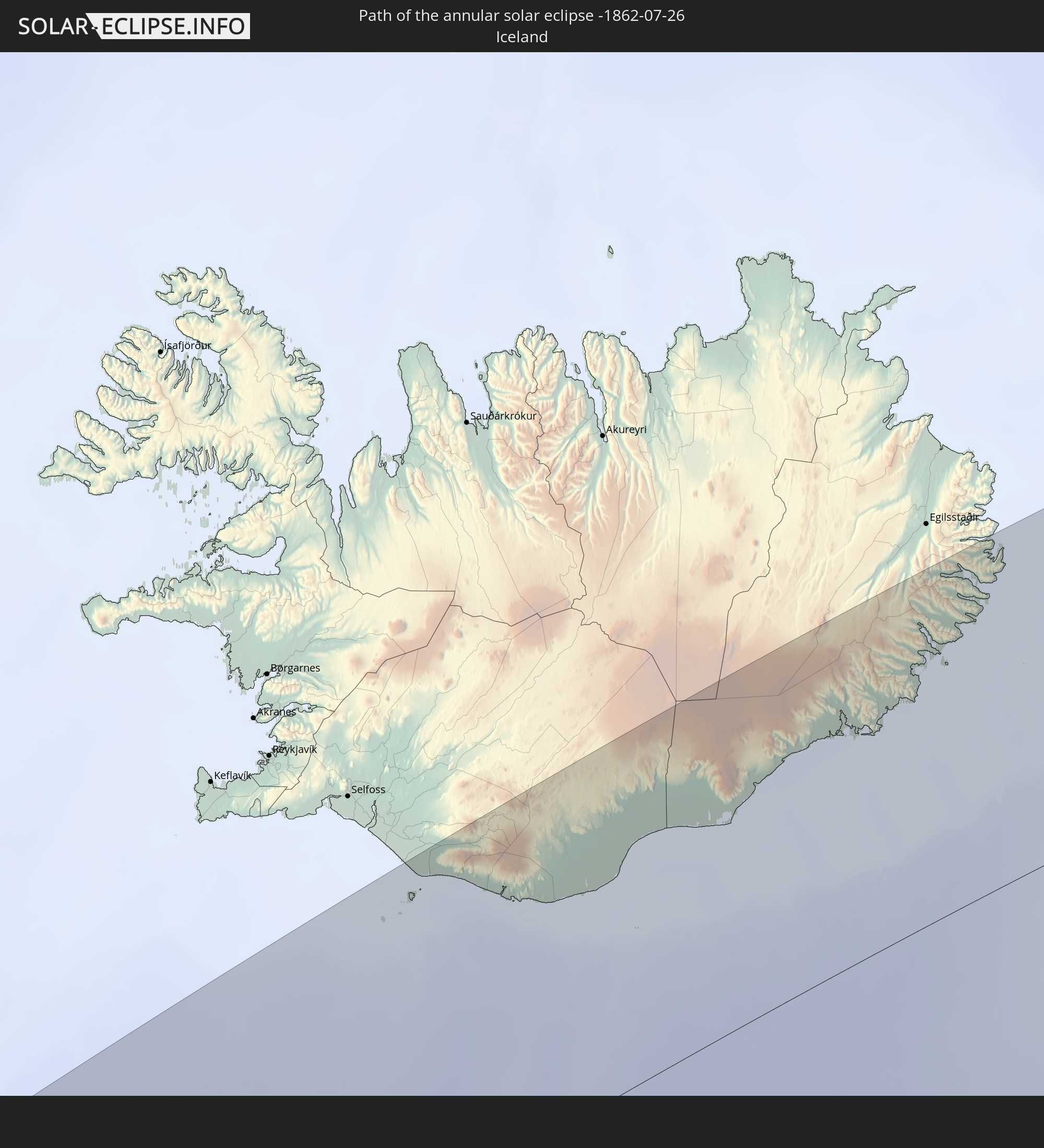 Iceland
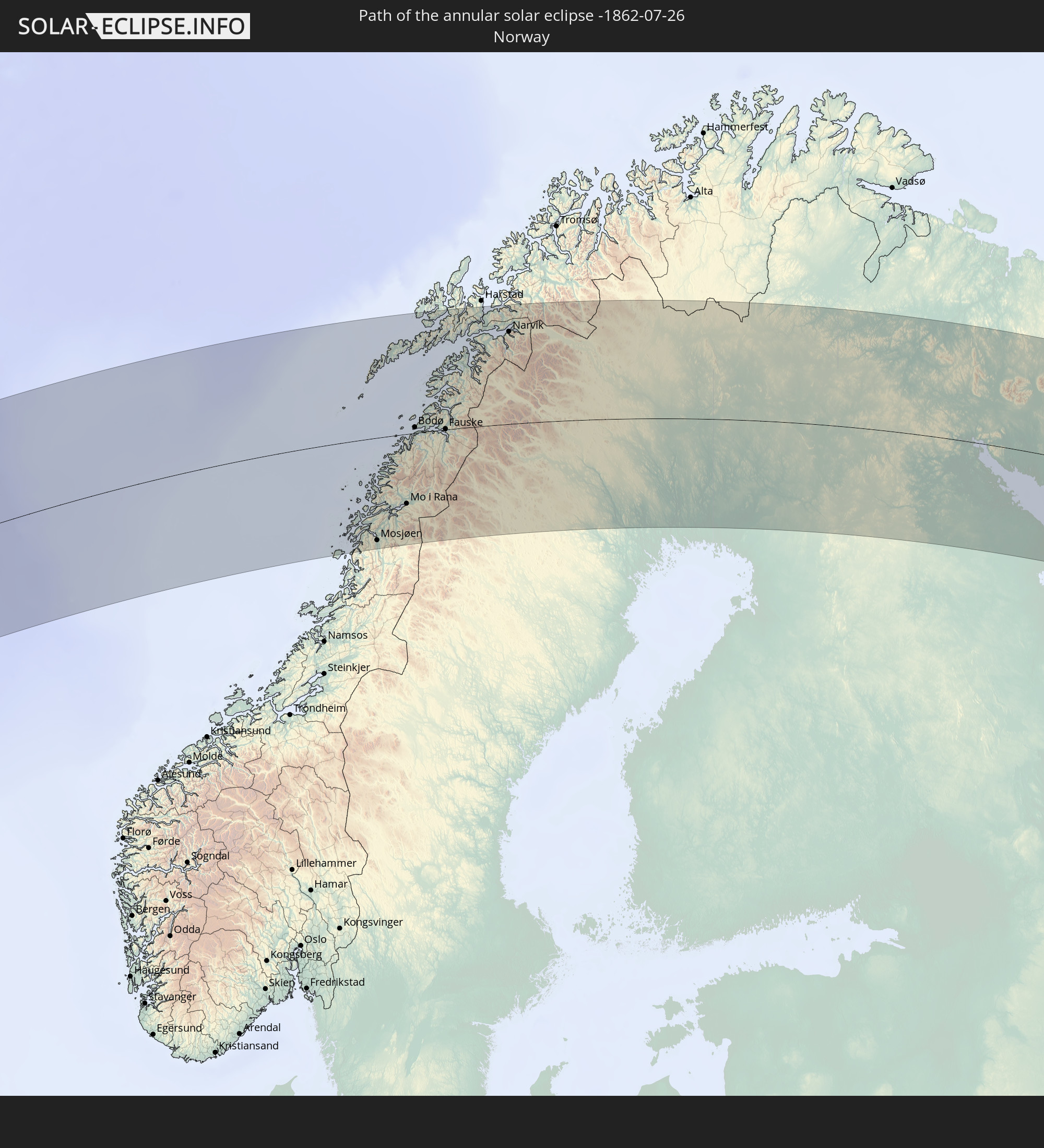 Norway
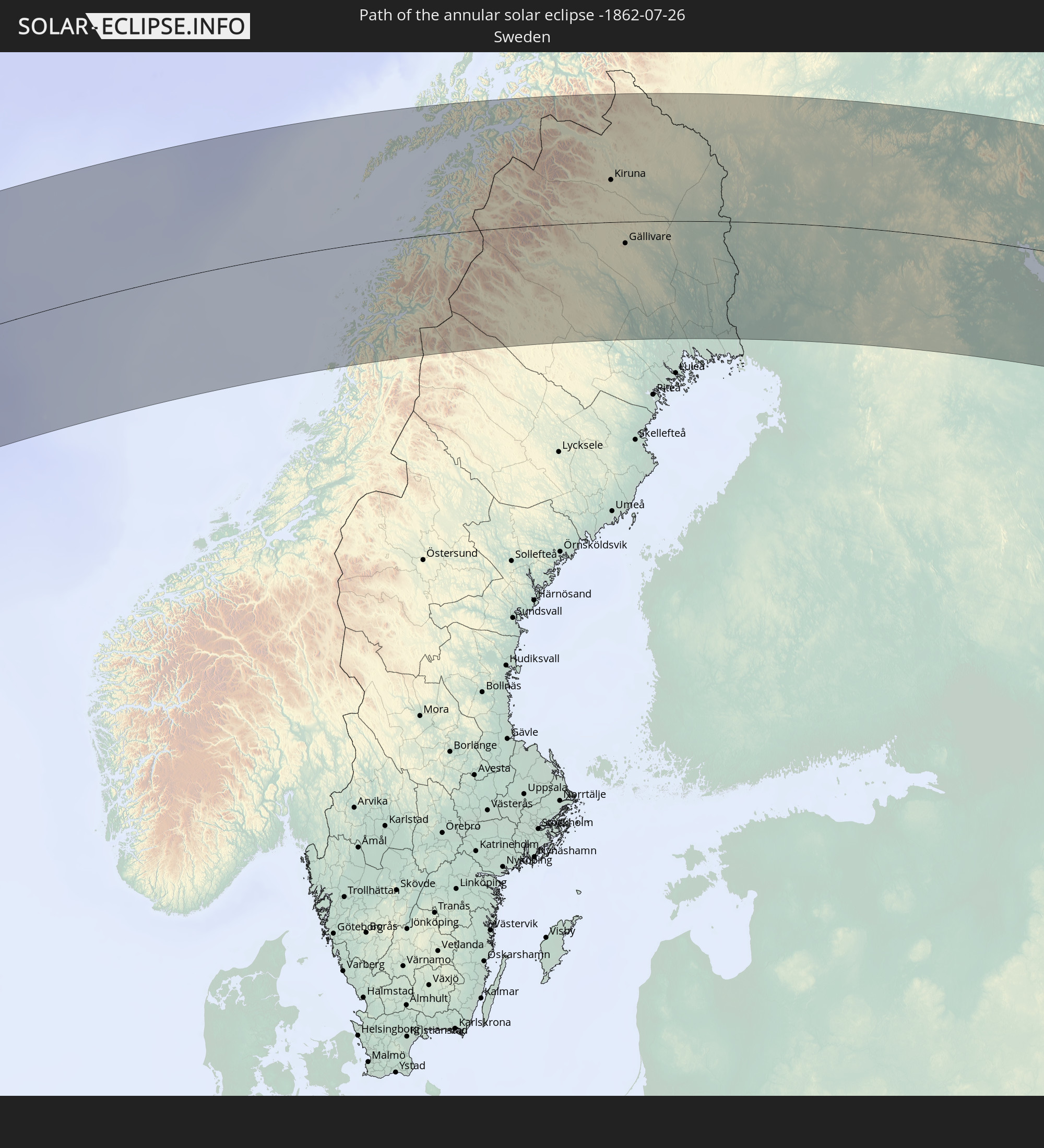 Sweden
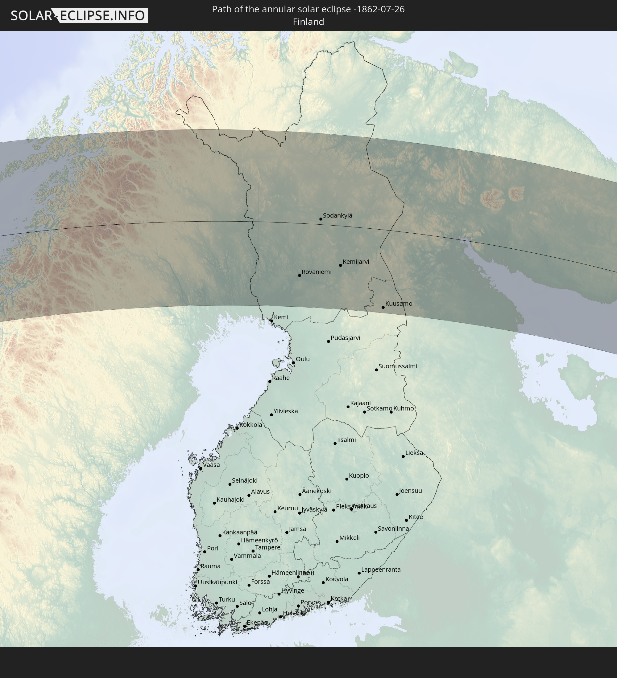 Finland
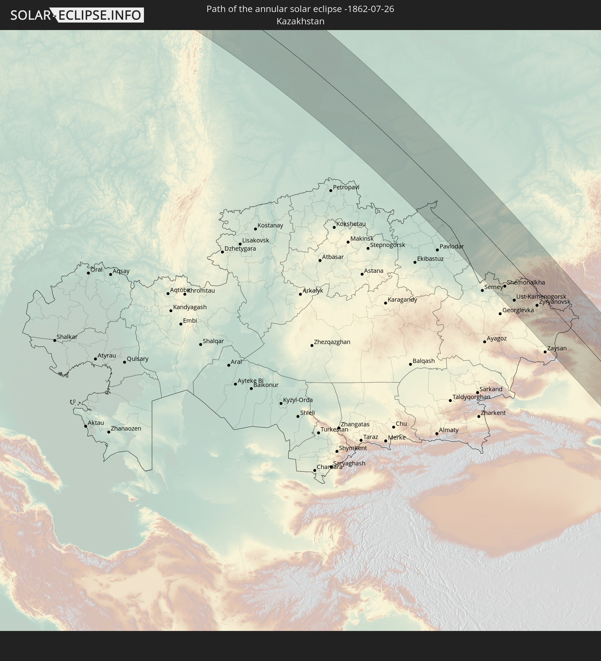 Kazakhstan
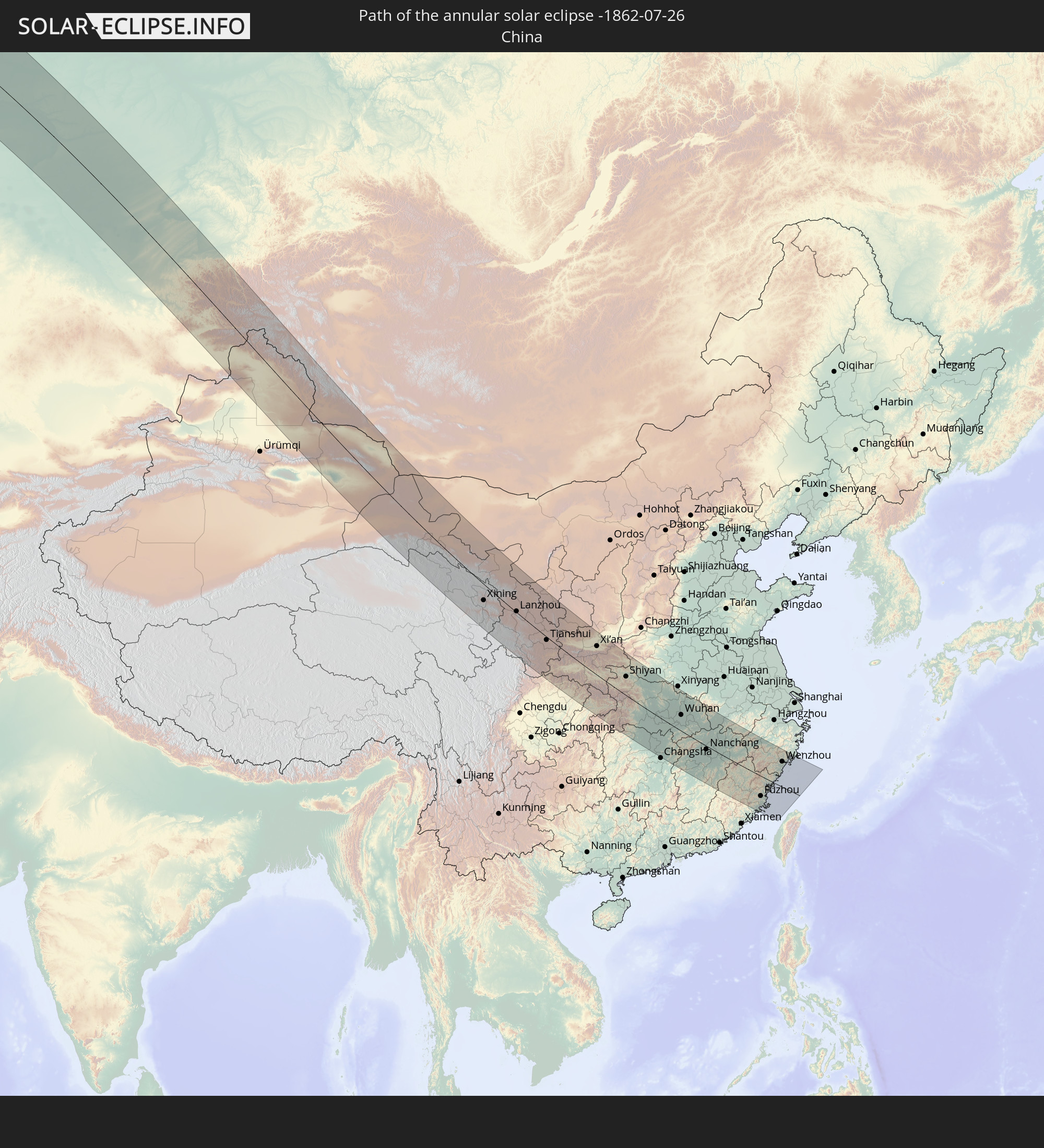 China
China
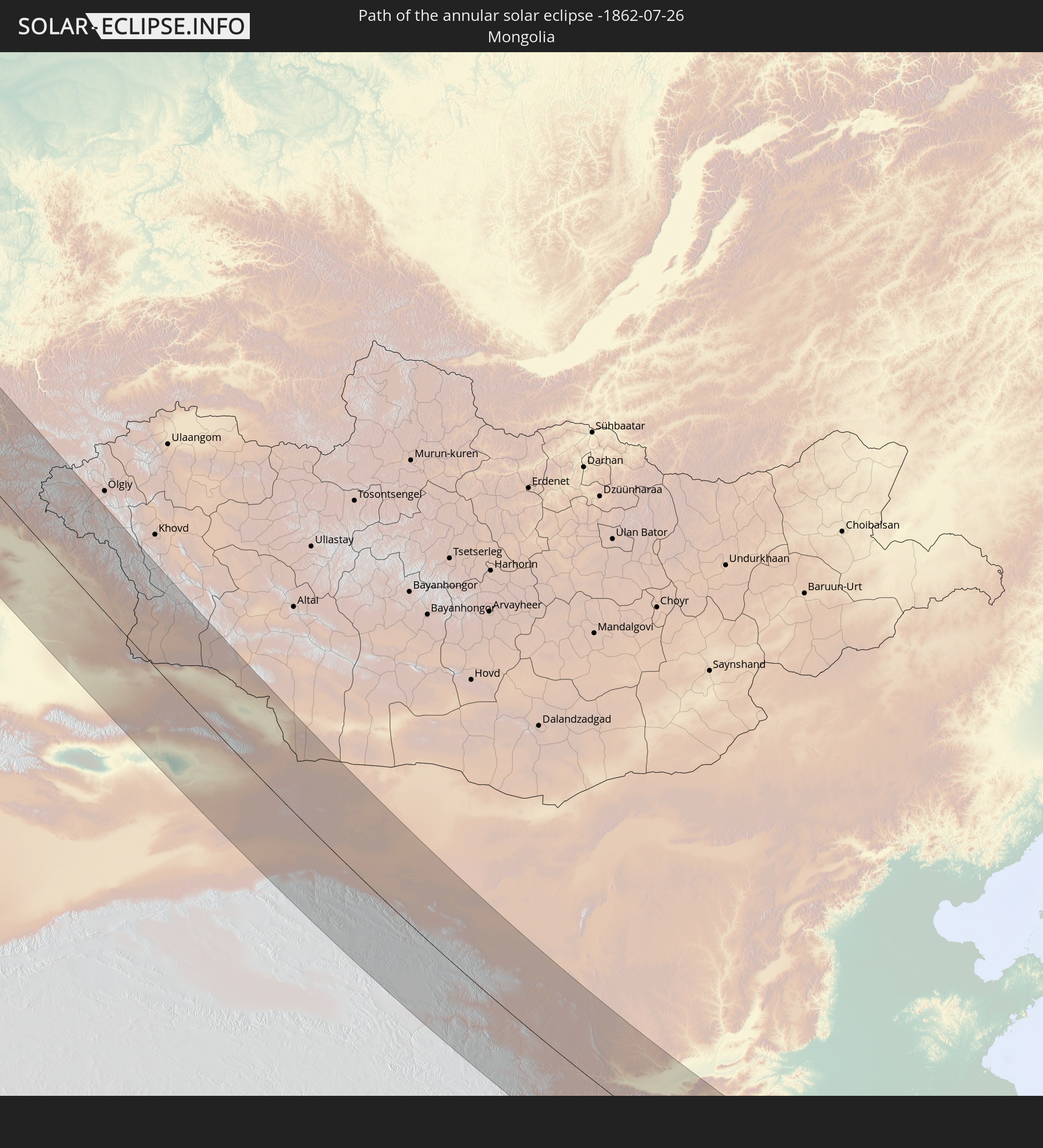 Mongolia
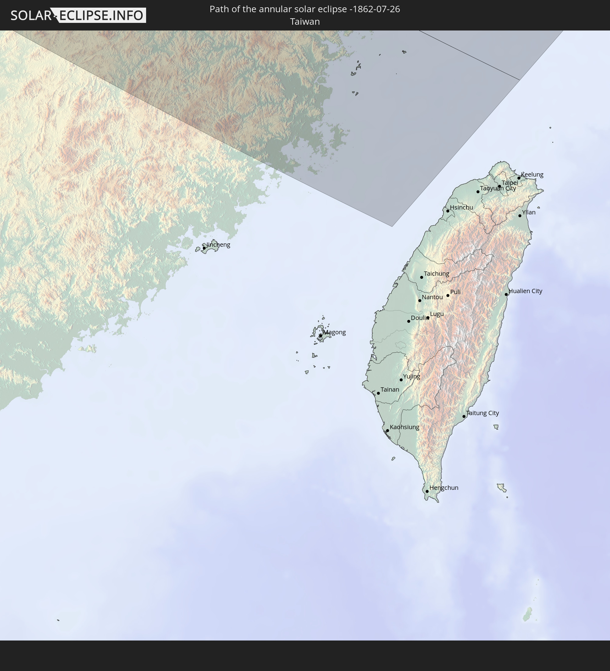 Taiwan
In den folgenden Ländern ist die Sonnenfinsternis partiell zu sehen
 Russia
 United States
 Canada
 Greenland
 Portugal
 Iceland
 Spain
Spain
 Mauritania
 Morocco
 Mali
Mali
 Republic of Ireland
 Svalbard and Jan Mayen
 Algeria
 United Kingdom
 Faroe Islands
 Gibraltar
 France
 Isle of Man
 Guernsey
 Jersey
 Andorra
 Belgium
 Netherlands
 Norway
 Luxembourg
 Germany
 Switzerland
 Italy
Italy
 Monaco
 Tunisia
 Denmark
 Libya
Libya
 Liechtenstein
 Austria
 Sweden
 Czechia
 San Marino
 Vatican City
 Slovenia
 Croatia
 Poland
 Malta
Malta
 Bosnia and Herzegovina
 Hungary
 Slovakia
 Montenegro
 Serbia
 Albania
 Åland Islands
 Greece
 Romania
 Republic of Macedonia
 Finland
 Lithuania
 Latvia
 Estonia
 Ukraine
 Bulgaria
 Belarus
 Egypt
Egypt
 Turkey
 Moldova
 Cyprus
 State of Palestine
 Israel
 Saudi Arabia
 Jordan
 Lebanon
 Syria
Syria
 Iraq
Iraq
 Georgia
 Armenia
 Iran
Iran
 Azerbaijan
 Kazakhstan
 Kuwait
 Bahrain
 Qatar
Qatar
 United Arab Emirates
 Oman
Oman
 Turkmenistan
 Uzbekistan
 Afghanistan
 Pakistan
 Tajikistan
 India
India
 Kyrgyzstan
 Maldives
 China
China
 Sri Lanka
 Nepal
Nepal
 Mongolia
 Bangladesh
 Bhutan
 Myanmar
 Indonesia
 Thailand
 Malaysia
 Laos
Laos
 Vietnam
 Cambodia
 Macau
Macau
 Hong Kong
 Taiwan
 Japan
Japan
 North Korea
 South Korea
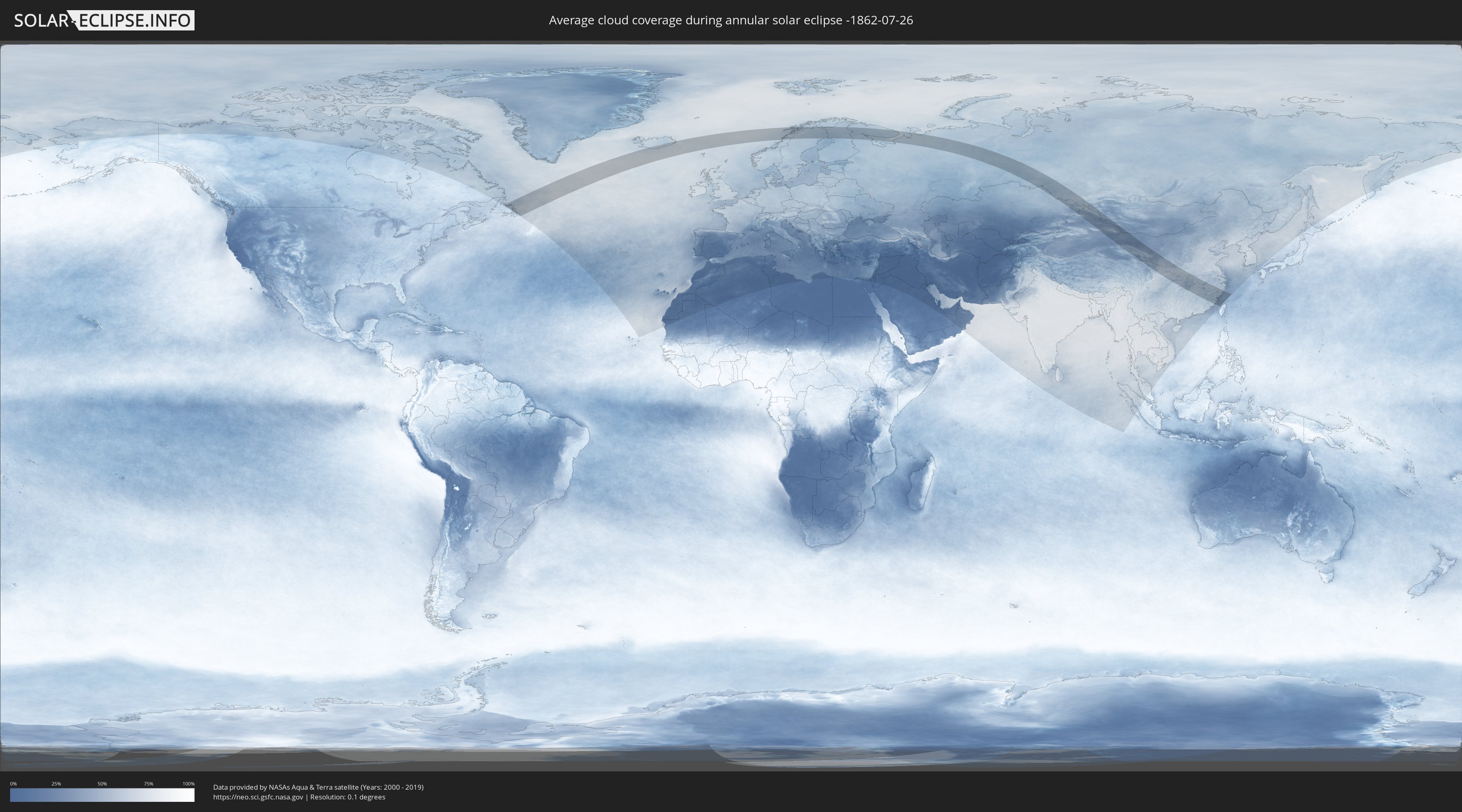
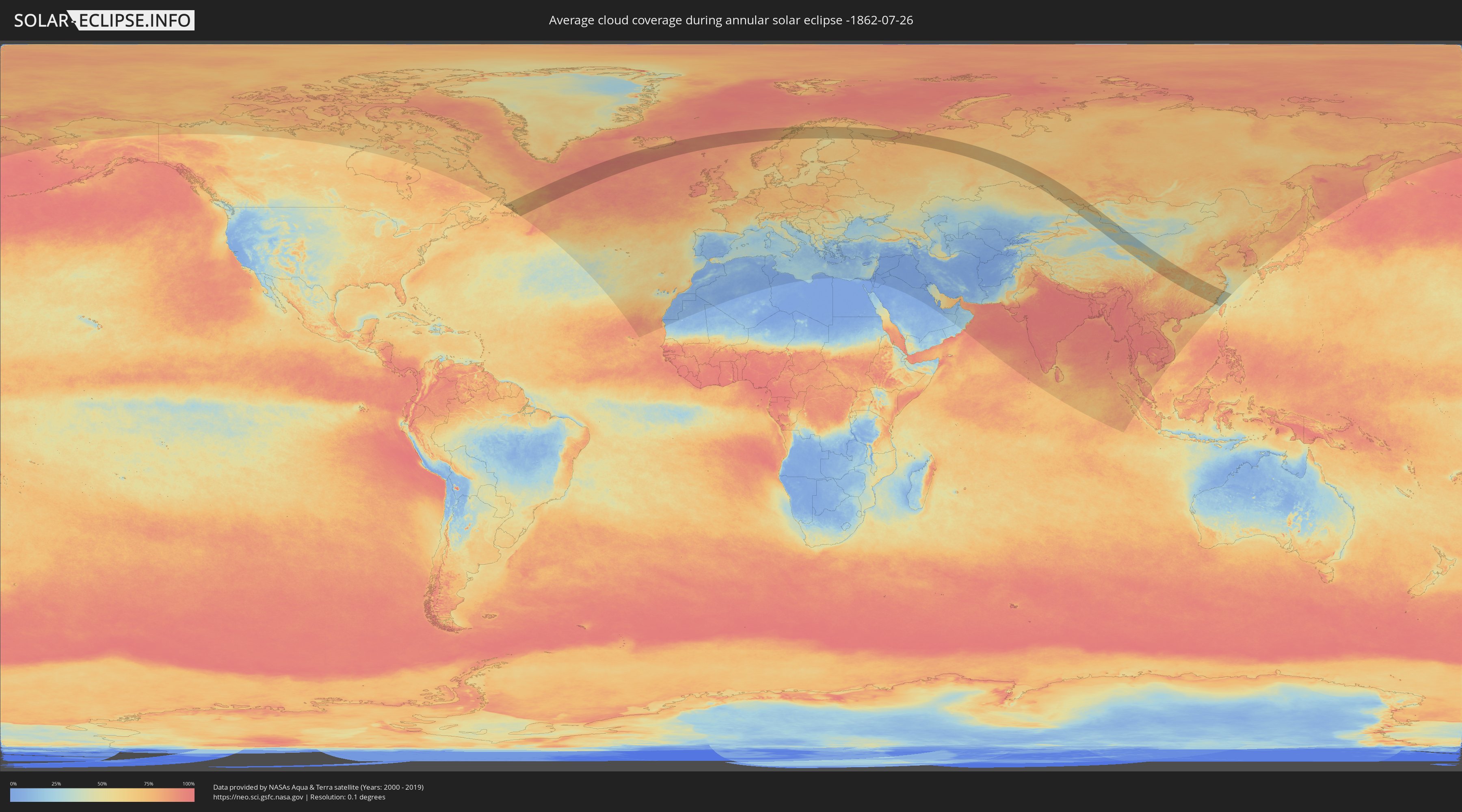
How will be the weather during the annular solar eclipse on 07/26/-1862?
Where is the best place to see the annular solar eclipse of 07/26/-1862?
The following maps show the average cloud coverage for the day of the annular solar eclipse.
With the help of these maps, it is possible to find the place along the eclipse path, which has the best
chance of a cloudless sky.
Nevertheless, you should consider local circumstances and inform about the weather of your chosen
observation site.
The data is provided by NASAs satellites
AQUA and TERRA.
The cloud maps are averaged over a period of 19 years (2000 - 2019).
Detailed country maps
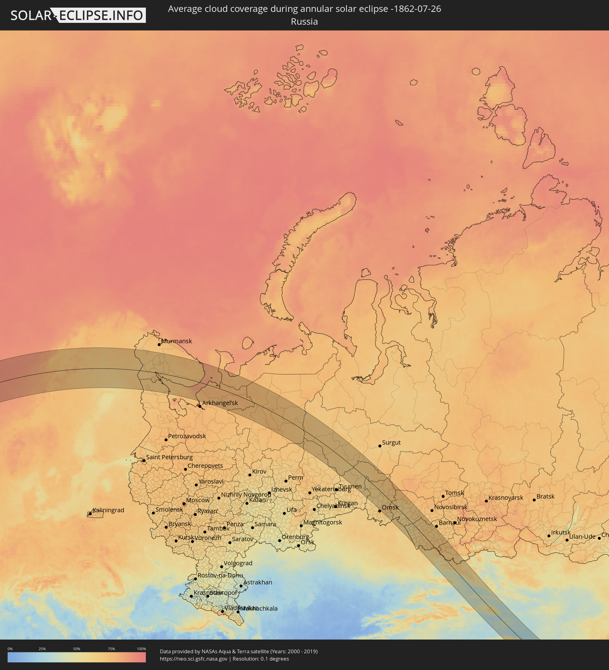 Russia
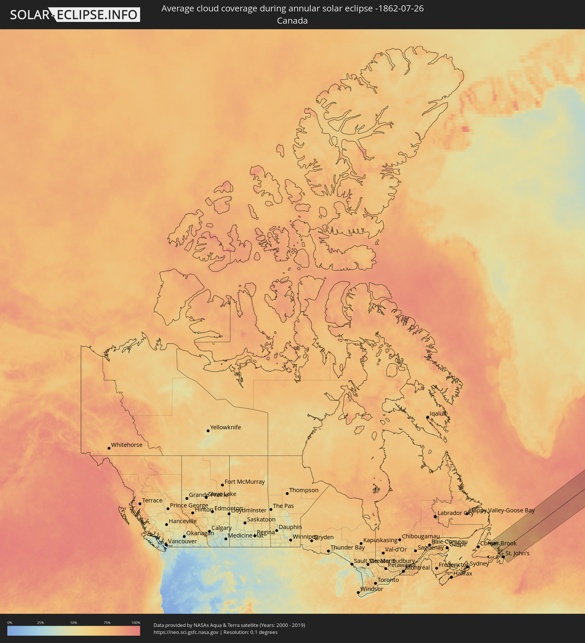 Canada
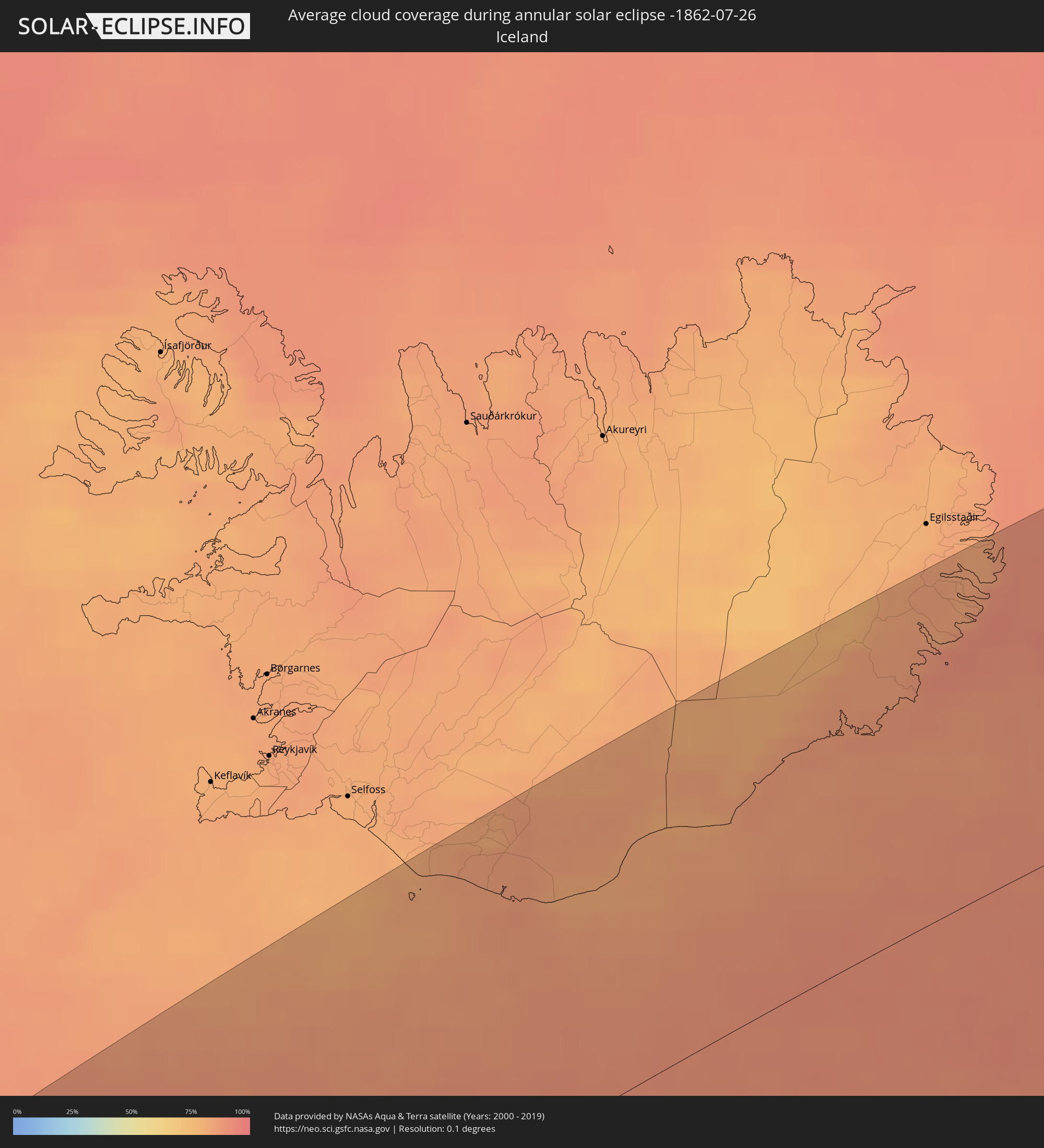 Iceland
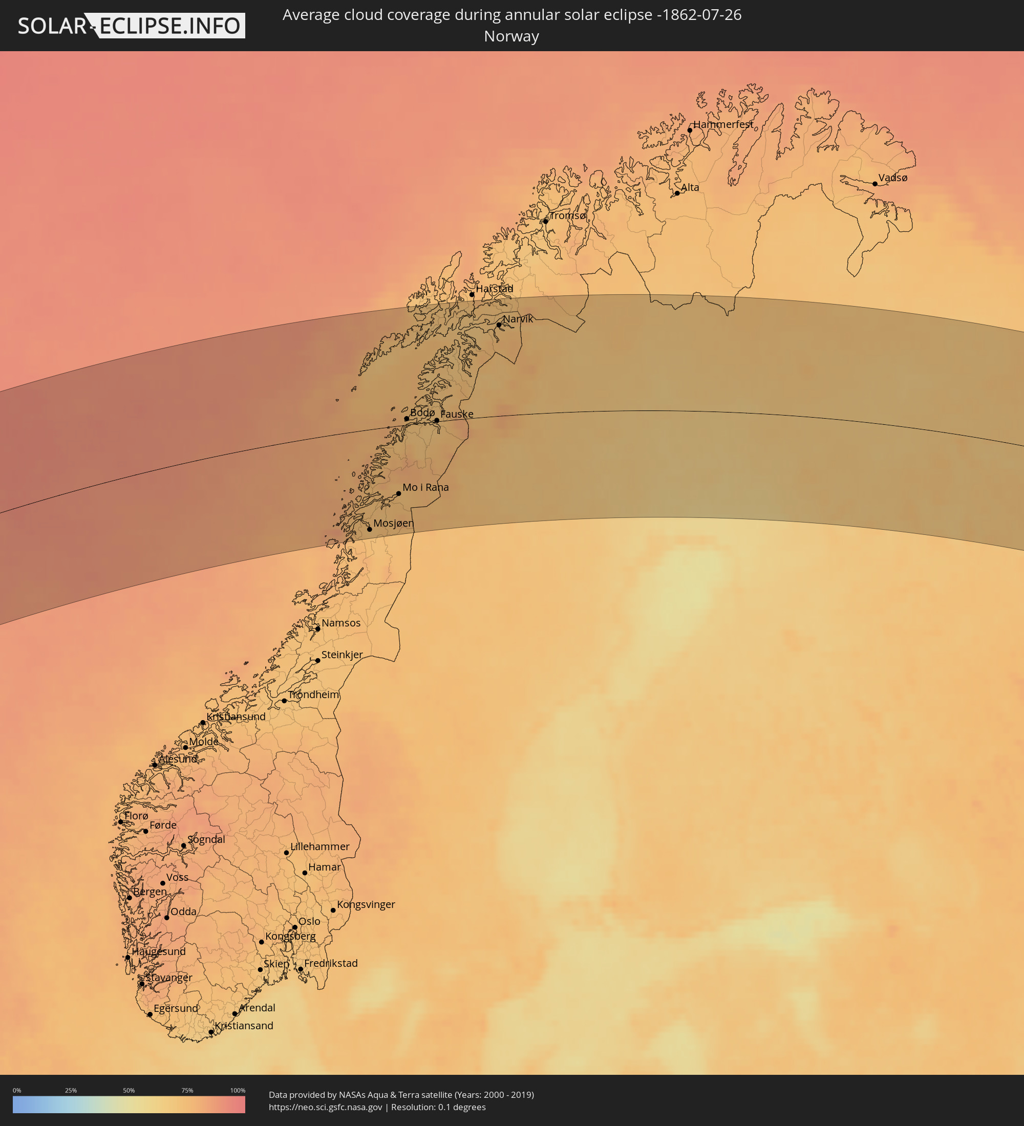 Norway
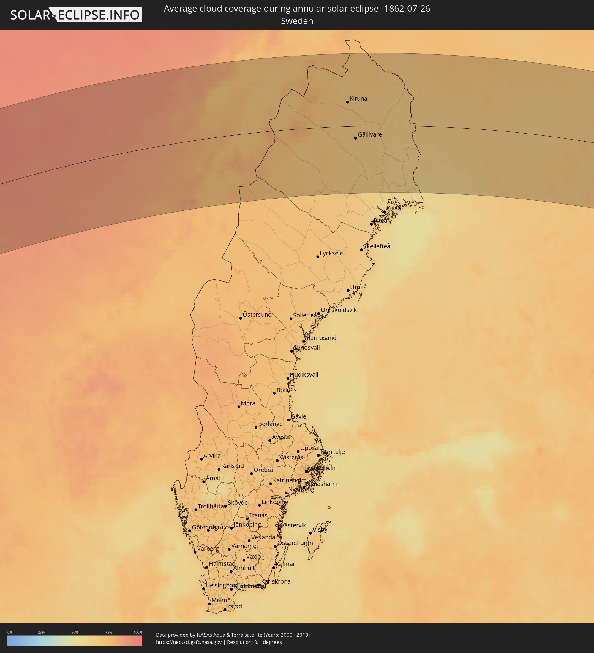 Sweden
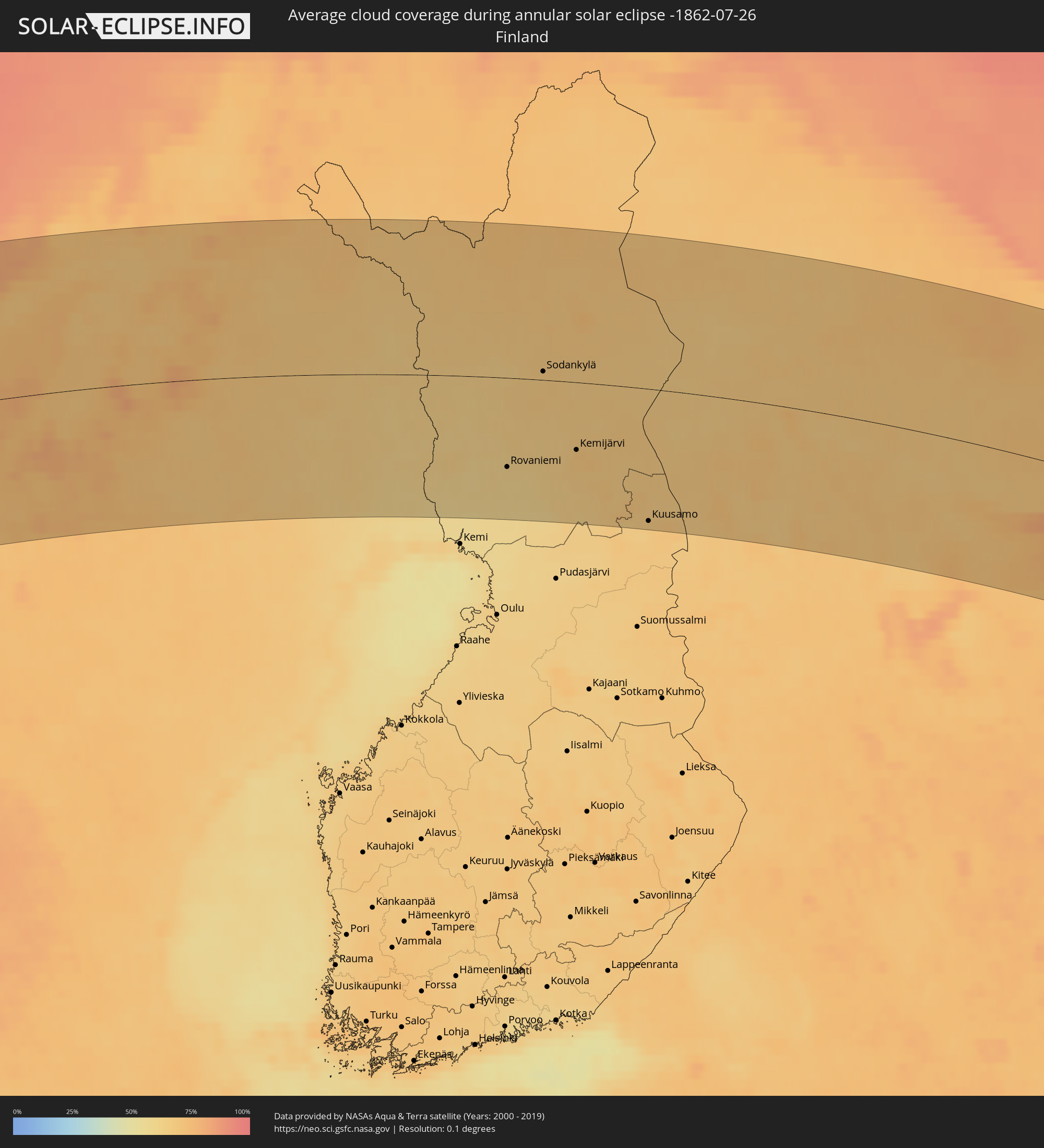 Finland
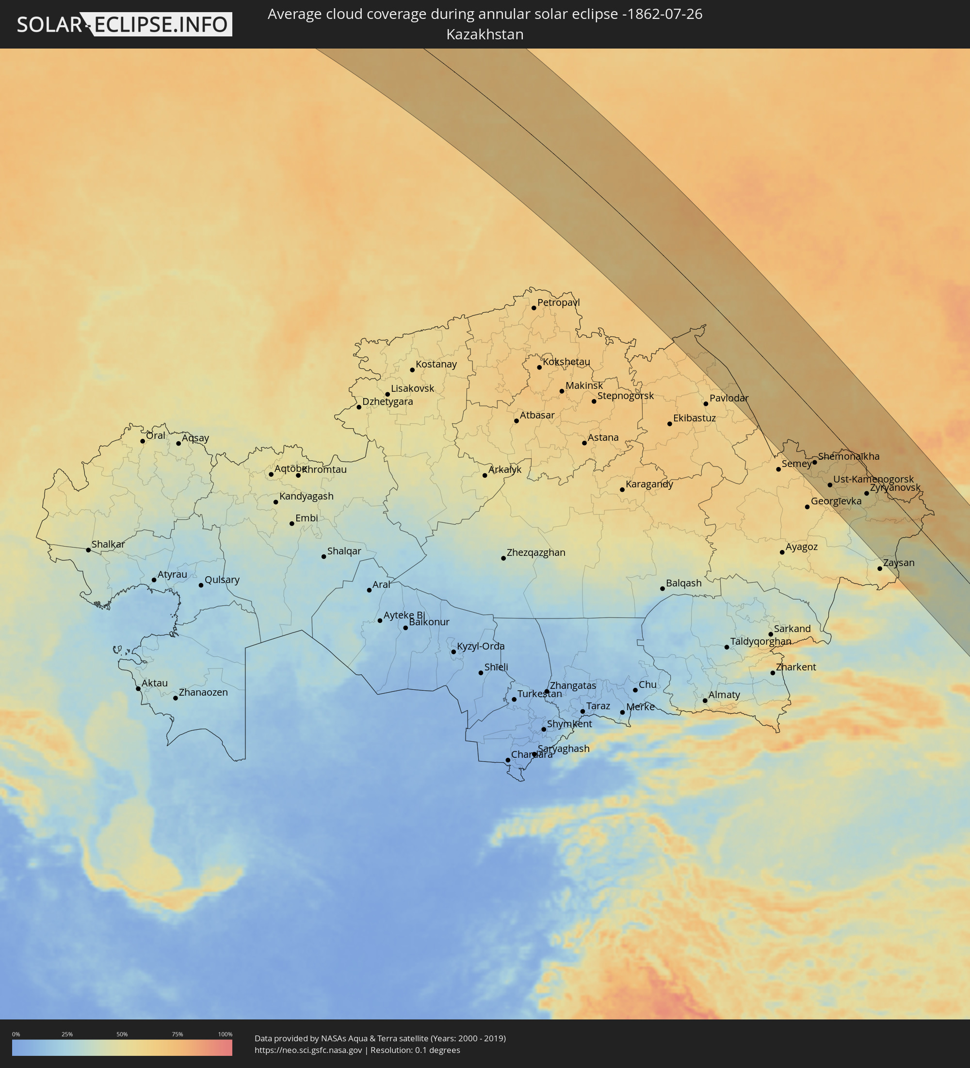 Kazakhstan
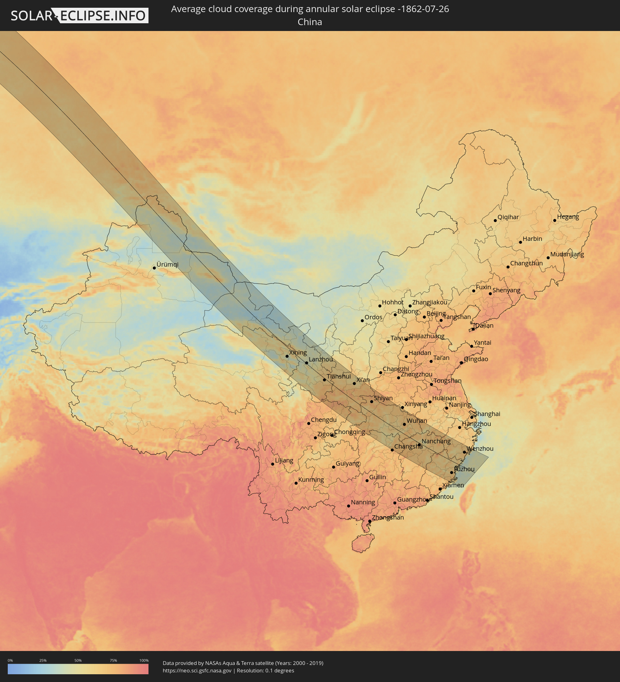 China
China
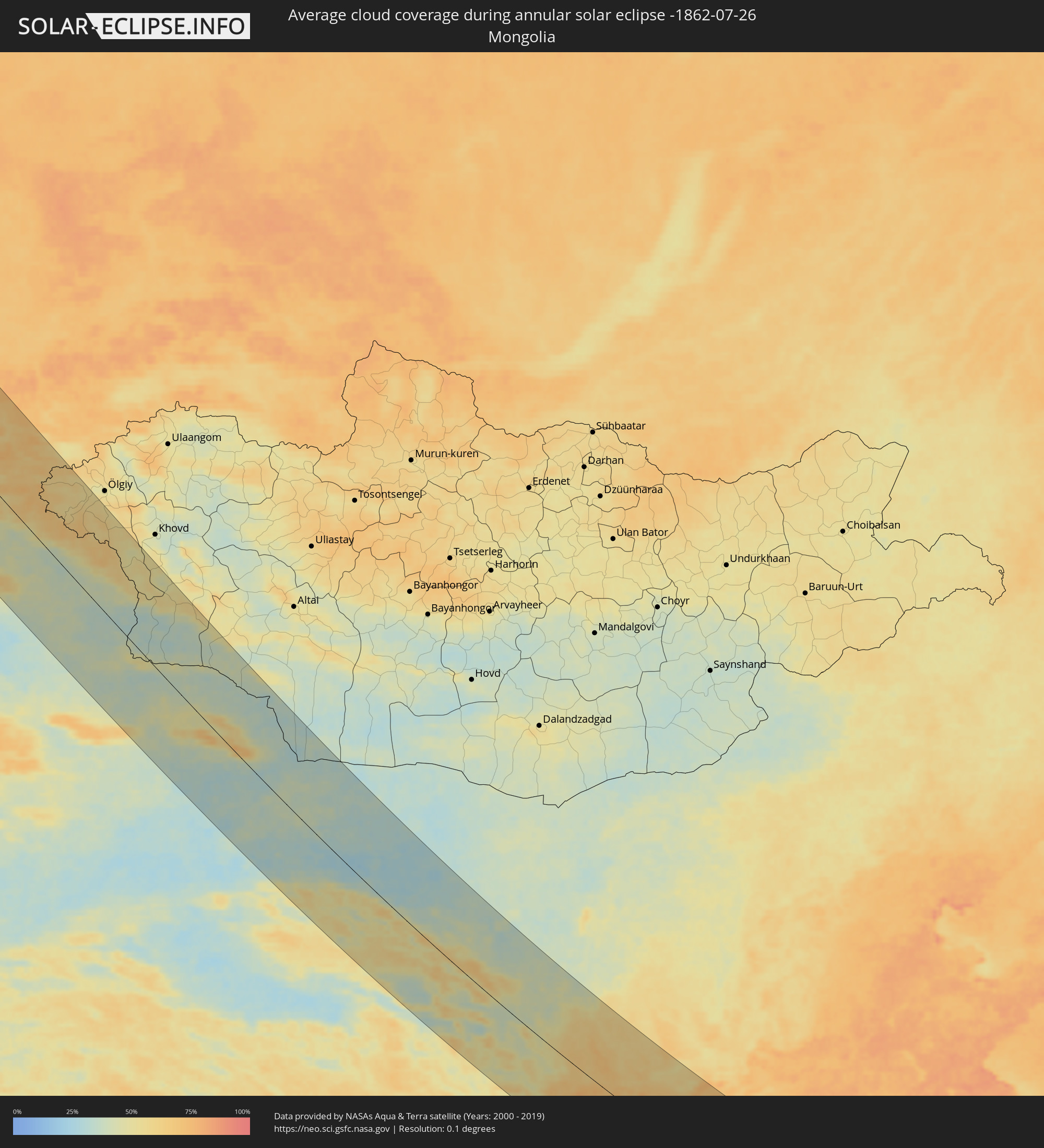 Mongolia
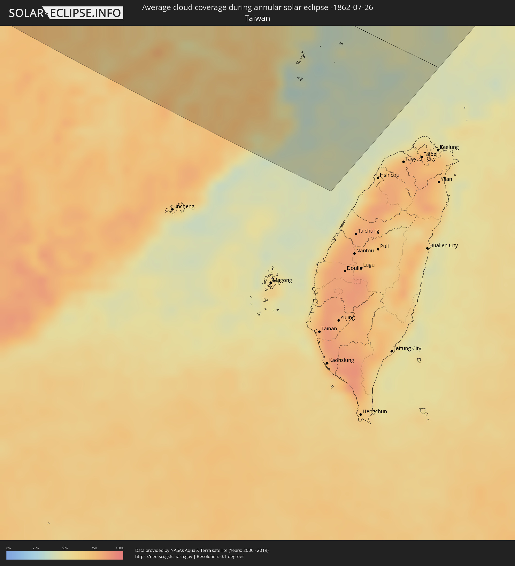 Taiwan
Cities inside the path of the eclipse
The following table shows all locations with a population of more than 5,000 inside the eclipse path. Cities which have more than 100,000 inhabitants are marked bold. A click at the locations opens a detailed map.
| City | Type | Eclipse duration | Local time of max. eclipse | Distance to central line | Ø Cloud coverage |
|
Carbonear, Newfoundland and Labrador
|
annular | - | 04:10:21 UTC-03:30 | 65 km | 72% |
|
Mount Pearl, Newfoundland and Labrador
|
annular | - | 04:09:53 UTC-03:30 | 104 km | 67% |
|
St. John's, Newfoundland and Labrador
|
annular | - | 04:09:54 UTC-03:30 | 102 km | 67% |
|
Sandnessjøen, Nordland
|
annular | - | 09:20:45 UTC+01:00 | 121 km | 74% |
|
Mosjøen, Nordland
|
annular | - | 09:20:59 UTC+01:00 | 145 km | 72% |
|
Mo i Rana, Nordland
|
annular | - | 09:22:18 UTC+01:00 | 98 km | 73% |
|
Bodø, Nordland
|
annular | - | 09:23:34 UTC+01:00 | 9 km | 73% |
|
Fauske, Nordland
|
annular | - | 09:24:19 UTC+01:00 | 5 km | 70% |
|
Narvik, Nordland
|
annular | - | 09:27:05 UTC+01:00 | 124 km | 72% |
|
Kiruna, Norrbotten
|
annular | - | 09:28:45 UTC+01:00 | 54 km | 68% |
|
Gällivare, Norrbotten
|
annular | - | 09:28:30 UTC+01:00 | 28 km | 67% |
|
Malmberget, Norrbotten
|
annular | - | 09:28:32 UTC+01:00 | 24 km | 68% |
|
Ylitornio, Lapland
|
annular | - | 10:10:22 UTC+01:39 | 120 km | 61% |
|
Kittilä, Lapland
|
annular | - | 10:12:23 UTC+01:39 | 33 km | 67% |
|
Rovaniemi, Lapland
|
annular | - | 10:12:23 UTC+01:39 | 95 km | 63% |
|
Sodankylä, Lapland
|
annular | - | 10:13:44 UTC+01:39 | 9 km | 67% |
|
Pyhäjärvi, Lapland
|
annular | - | 10:14:06 UTC+01:39 | 28 km | 67% |
|
Kemijärvi, Lapland
|
annular | - | 10:14:05 UTC+01:39 | 72 km | 69% |
|
Kuusamo, Northern Ostrobothnia
|
annular | - | 10:15:28 UTC+01:39 | 142 km | 68% |
|
Kovdor, Murmansk
|
annular | - | 11:07:47 UTC+02:30 | 41 km | 66% |
|
Kandalaksha, Murmansk
|
annular | - | 11:09:28 UTC+02:30 | 10 km | 69% |
|
Polyarnyye Zori, Murmansk
|
annular | - | 11:09:36 UTC+02:30 | 31 km | 67% |
|
Monchegorsk, Murmansk
|
annular | - | 11:10:05 UTC+02:30 | 97 km | 68% |
|
Olenegorsk, Murmansk
|
annular | - | 11:10:29 UTC+02:30 | 122 km | 68% |
|
Apatity, Murmansk
|
annular | - | 11:10:29 UTC+02:30 | 60 km | 68% |
|
Ukhta, Komi Republic
|
annular | - | 11:33:00 UTC+02:30 | 59 km | 74% |
|
Vuktyl, Komi Republic
|
annular | - | 11:36:32 UTC+02:30 | 59 km | 69% |
|
Yugorsk, Khanty-Mansiyskiy Avtonomnyy Okrug
|
annular | - | 13:18:23 UTC+04:02 | 9 km | 69% |
|
Uray, Khanty-Mansiyskiy Avtonomnyy Okrug
|
annular | - | 13:21:43 UTC+04:02 | 65 km | 65% |
|
Nyagan, Khanty-Mansiyskiy Avtonomnyy Okrug
|
annular | - | 13:19:14 UTC+04:02 | 133 km | 67% |
|
Tobol’sk, Tyumenskaya
|
annular | - | 13:28:34 UTC+04:02 | 110 km | 62% |
|
Khanty-Mansiysk, Khanty-Mansiyskiy Avtonomnyy Okrug
|
annular | - | 13:24:30 UTC+04:02 | 156 km | 67% |
|
Tara, Omsk
|
annular | - | 14:27:53 UTC+04:53 | 27 km | 66% |
|
Kalachinsk, Omsk
|
annular | - | 14:31:41 UTC+04:53 | 114 km | 67% |
|
Tatarsk, Novosibirsk
|
annular | - | 15:50:34 UTC+06:11 | 38 km | 68% |
|
Kupino, Novosibirsk
|
annular | - | 15:53:27 UTC+06:11 | 49 km | 64% |
|
Karasuk, Novosibirsk
|
annular | - | 15:55:22 UTC+06:11 | 62 km | 58% |
|
Kuybyshev, Novosibirsk
|
annular | - | 15:52:07 UTC+06:11 | 87 km | 63% |
|
Slavgorod, Altai Krai
|
annular | - | 15:57:24 UTC+06:11 | 88 km | 62% |
|
Kulunda, Altai Krai
|
annular | - | 15:58:33 UTC+06:11 | 107 km | 61% |
|
Borodūlīkha, East Kazakhstan
|
annular | - | 14:14:27 UTC+04:21 | 151 km | 66% |
|
Rubtsovsk, Altai Krai
|
annular | - | 16:02:33 UTC+06:11 | 76 km | 63% |
|
Kamen’-na-Obi, Altai Krai
|
annular | - | 15:57:54 UTC+06:11 | 105 km | 69% |
|
Zhezkent, East Kazakhstan
|
annular | - | 14:14:20 UTC+04:21 | 112 km | 66% |
|
Gornyak, Altai Krai
|
annular | - | 16:03:51 UTC+06:11 | 102 km | 65% |
|
Ūst’-Talovka, East Kazakhstan
|
annular | - | 14:15:31 UTC+04:21 | 117 km | 61% |
|
Shemonaīkha, East Kazakhstan
|
annular | - | 14:15:24 UTC+04:21 | 107 km | 61% |
|
Suzun, Novosibirsk
|
annular | - | 15:58:38 UTC+06:11 | 151 km | 66% |
|
Glubokoye, East Kazakhstan
|
annular | - | 14:16:44 UTC+04:21 | 124 km | 58% |
|
Belūsovka, East Kazakhstan
|
annular | - | 14:16:54 UTC+04:21 | 113 km | 59% |
|
Ust-Kamenogorsk, East Kazakhstan
|
annular | - | 14:17:18 UTC+04:21 | 122 km | 58% |
|
Aleysk, Altai Krai
|
annular | - | 16:01:40 UTC+06:11 | 78 km | 66% |
|
Pavlovsk, Altai Krai
|
annular | - | 16:00:05 UTC+06:11 | 149 km | 70% |
|
Asūbulaq, East Kazakhstan
|
annular | - | 14:18:30 UTC+04:21 | 130 km | 58% |
|
Ridder, East Kazakhstan
|
annular | - | 14:17:09 UTC+04:21 | 46 km | 68% |
|
Zhanga Buqtyrma, East Kazakhstan
|
annular | - | 14:18:41 UTC+04:21 | 99 km | 48% |
|
Aksuat
|
annular | - | 14:20:44 UTC+04:21 | 161 km | 44% |
|
Zyryanovsk, East Kazakhstan
|
annular | - | 14:18:59 UTC+04:21 | 56 km | 52% |
|
Belokurikha, Altai Krai
|
annular | - | 16:04:14 UTC+06:11 | 154 km | 72% |
|
Altayskoye, Altai Krai
|
annular | - | 16:04:33 UTC+06:11 | 168 km | 72% |
|
Xining, Qinghai
|
annular | - | 18:29:37 UTC+08:00 | 74 km | 39% |
|
Wuwei, Gansu
|
annular | - | 18:27:19 UTC+08:00 | 92 km | 41% |
|
Lanzhou, Gansu
|
annular | - | 18:30:38 UTC+08:00 | 23 km | 41% |
|
Tianshui, Gansu
|
annular | - | 18:33:03 UTC+08:00 | 24 km | 64% |
|
Xianyang, Shaanxi
|
annular | - | 18:33:04 UTC+08:00 | 132 km | 64% |
|
Xi’an, Shaanxi
|
annular | - | 18:33:09 UTC+08:00 | 137 km | 60% |
|
Shiyan, Hubei
|
annular | - | 18:35:20 UTC+08:00 | 96 km | 77% |
|
Yichang, Hubei
|
annular | - | 18:38:09 UTC+08:00 | 60 km | 70% |
|
Laohekou, Hubei
|
annular | - | 18:35:31 UTC+08:00 | 116 km | 70% |
|
Changde, Hunan
|
annular | - | 18:40:28 UTC+08:00 | 196 km | 64% |
|
Xiangyang, Hubei
|
annular | - | 18:35:55 UTC+08:00 | 110 km | 67% |
|
Shashi, Hubei
|
annular | - | 18:38:28 UTC+08:00 | 46 km | 59% |
|
Yueyang, Hunan
|
annular | - | 18:39:33 UTC+08:00 | 91 km | 60% |
|
Jingling, Hubei
|
annular | - | 18:37:43 UTC+08:00 | 31 km | 65% |
|
Suizhou, Hubei
|
annular | - | 18:36:04 UTC+08:00 | 143 km | 69% |
|
Xiantao, Hubei
|
annular | - | 18:38:01 UTC+08:00 | 29 km | 63% |
|
Chengzhong, Hubei
|
annular | - | 18:37:08 UTC+08:00 | 82 km | 59% |
|
Guankou, Hunan
|
annular | - | 18:41:05 UTC+08:00 | 179 km | 75% |
|
Wuhan, Hubei
|
annular | - | 18:37:26 UTC+08:00 | 86 km | 74% |
|
Huangshi, Hubei
|
annular | - | 18:37:39 UTC+08:00 | 91 km | 71% |
|
Wuxue, Hubei
|
annular | - | 18:38:01 UTC+08:00 | 80 km | 67% |
|
Nanchang, Jiangxi
|
annular | - | 18:39:32 UTC+08:00 | 18 km | 72% |
|
Jiujiang, Jiangxi
|
annular | - | 18:38:04 UTC+08:00 | 87 km | 73% |
|
Jingdezhen, Jiangxi
|
annular | - | 18:38:09 UTC+08:00 | 108 km | 75% |
|
Shangrao, Jiangxi
|
annular | - | 18:38:59 UTC+08:00 | 60 km | 65% |
|
Putian, Fujian
|
annular | - | 18:42:22 UTC+08:00 | 188 km | 72% |
|
Fuzhou, Fujian
|
annular | - | 18:41:27 UTC+08:00 | 114 km | 68% |
|
Guli, Zhejiang
|
annular | - | 18:37:28 UTC+08:00 | 200 km | 63% |
|
Wenzhou, Zhejiang
|
annular | - | 18:38:19 UTC+08:00 | 142 km | 68% |