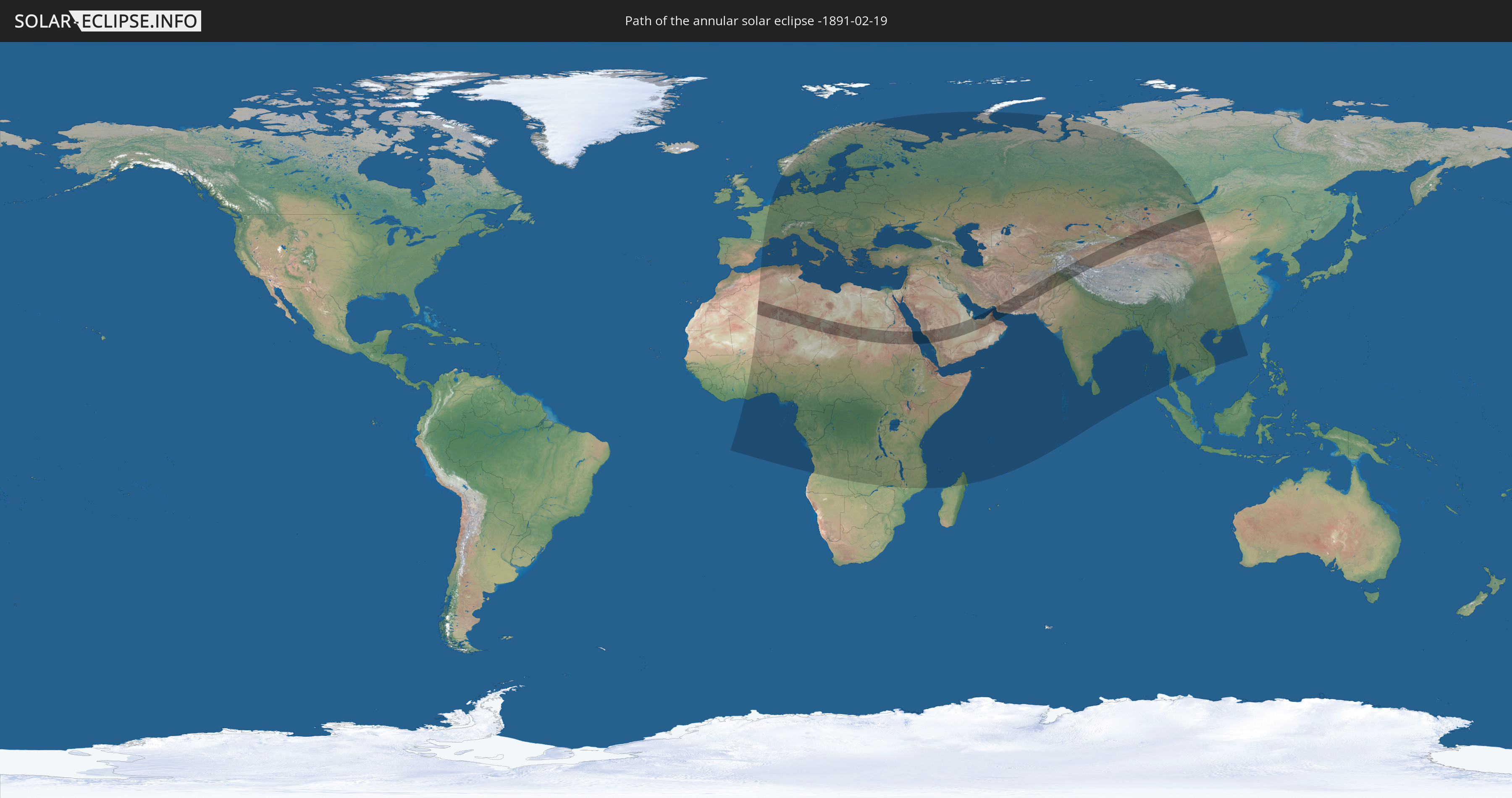
Annular solar eclipse of 02/19/-1891
| Day of week: | Sunday |
| Maximum duration of eclipse: | 08m31s |
| Maximum width of eclipse path: | 318 km |
| Saros cycle: | 0 |
| Coverage: | 93.4% |
| Magnitude: | 0.934 |
| Gamma: | 0.6381 |
Wo kann man die Sonnenfinsternis vom 02/19/-1891 sehen?
Die Sonnenfinsternis am 02/19/-1891 kann man in 123 Ländern als partielle Sonnenfinsternis beobachten.
Der Finsternispfad verläuft durch 15 Länder. Nur in diesen Ländern ist sie als annular Sonnenfinsternis zu sehen.
In den folgenden Ländern ist die Sonnenfinsternis annular zu sehen
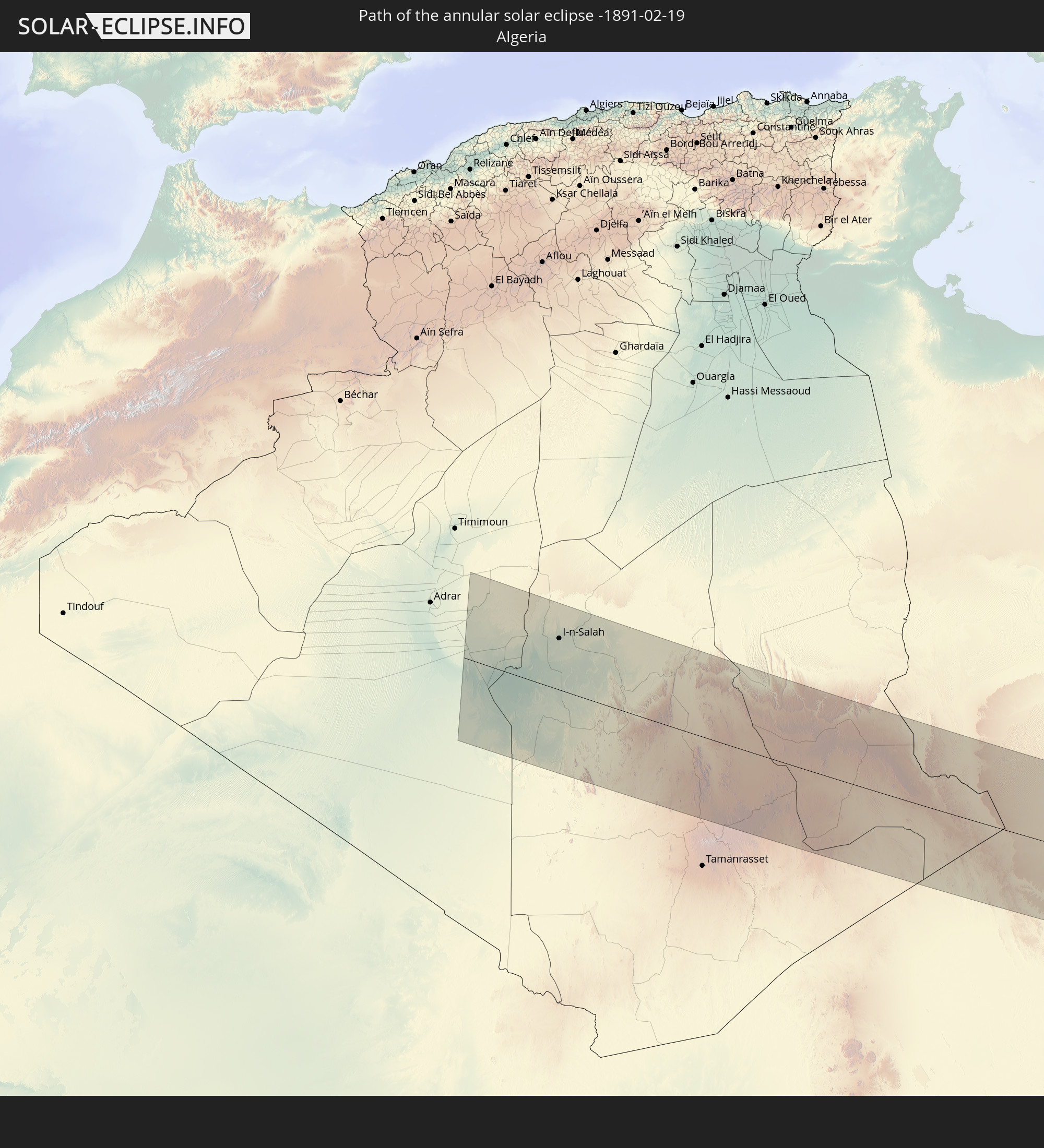 Algeria
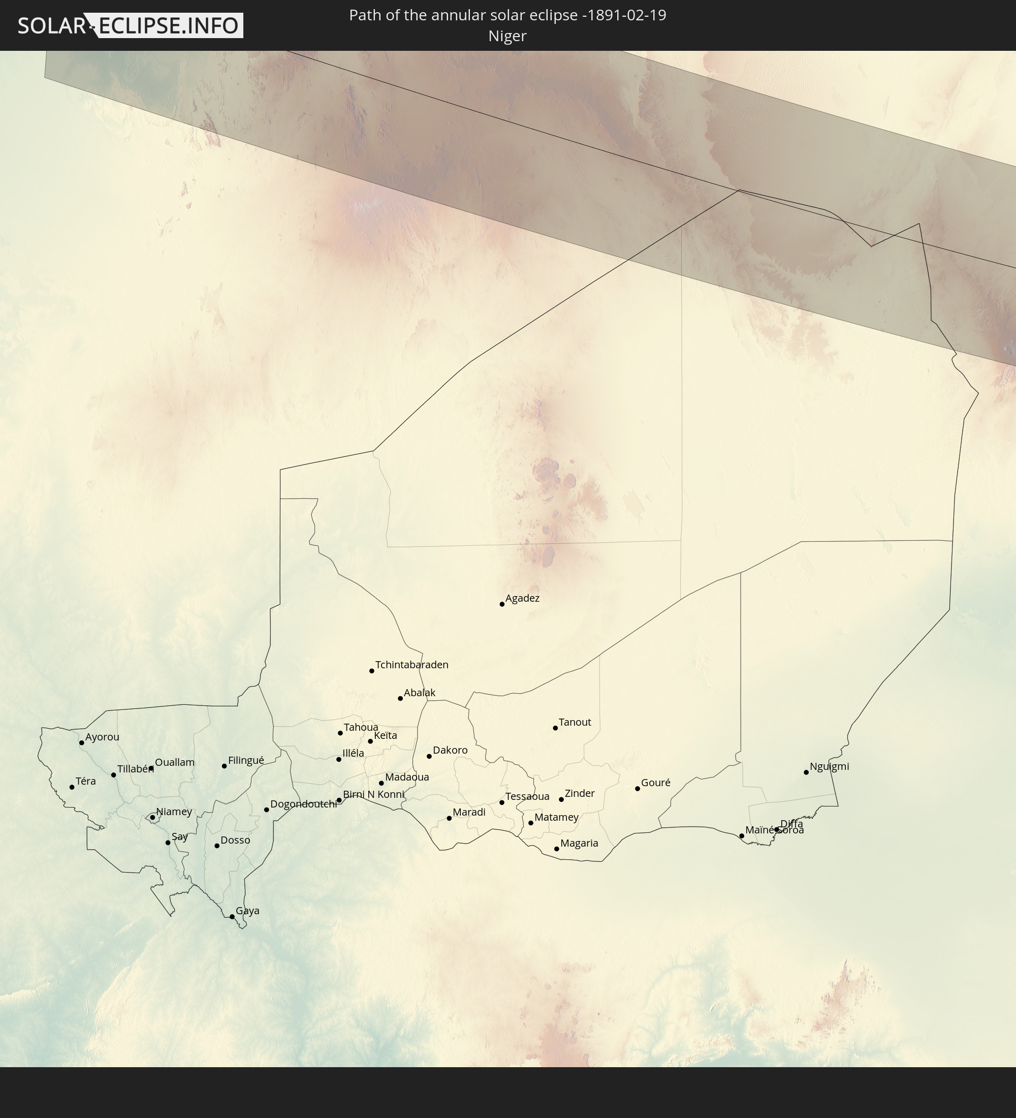 Niger
Niger
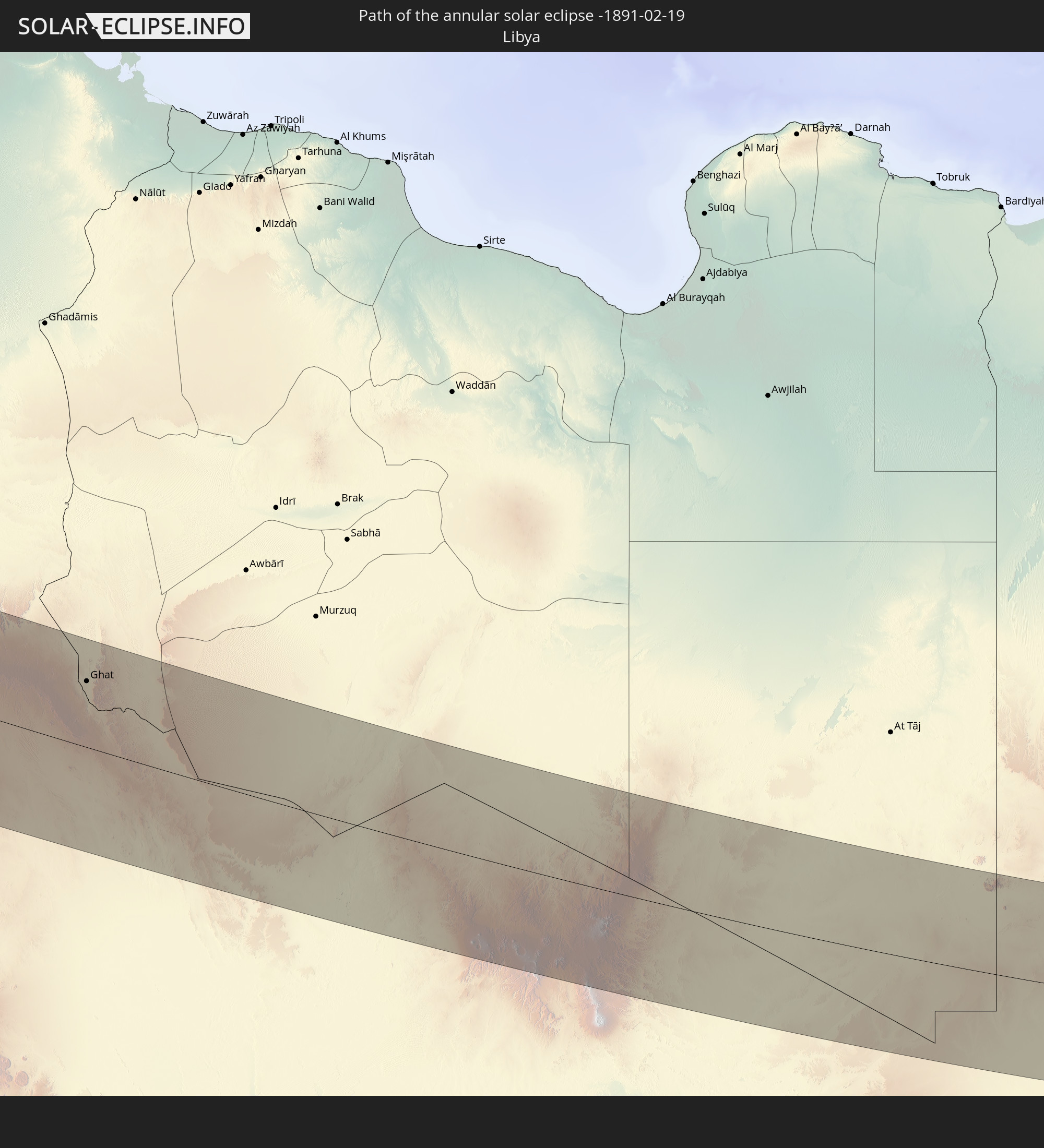 Libya
Libya
 Chad
Chad
 Sudan
Sudan
 Egypt
Egypt
 Saudi Arabia
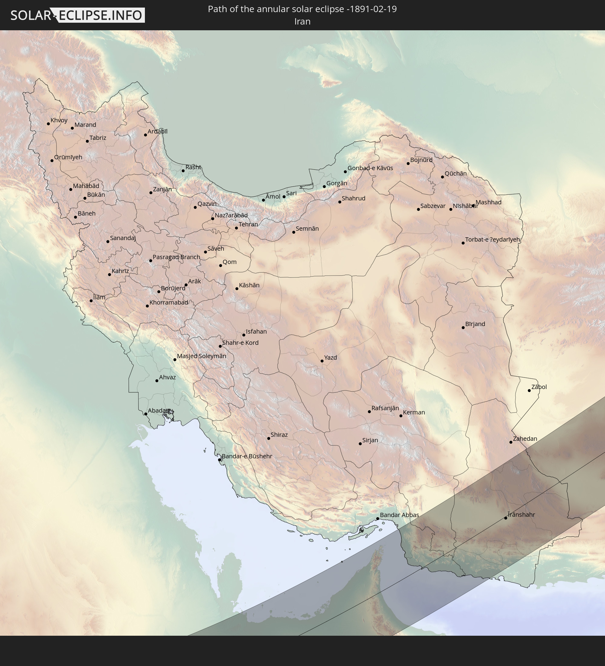 Iran
Iran
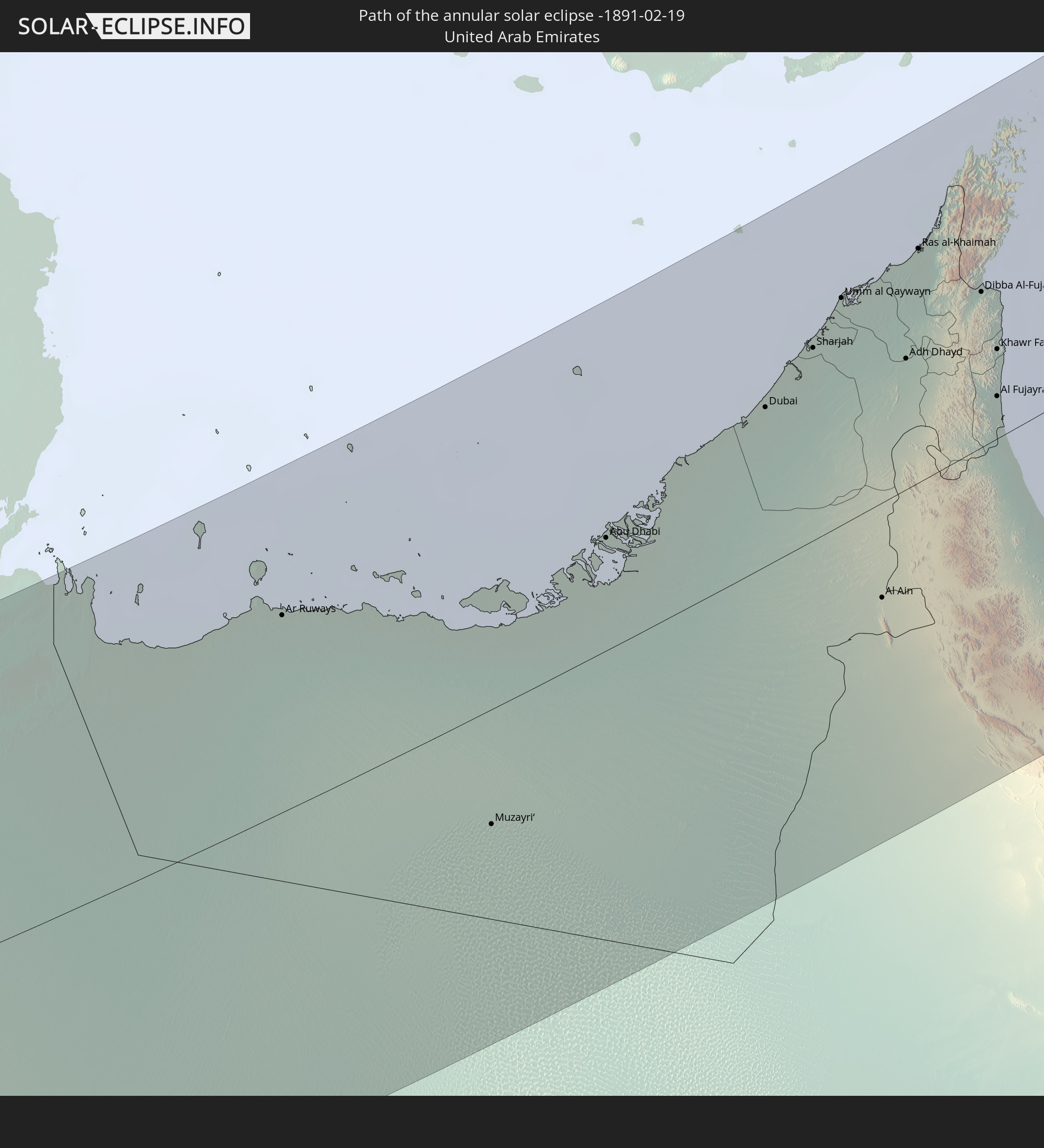 United Arab Emirates
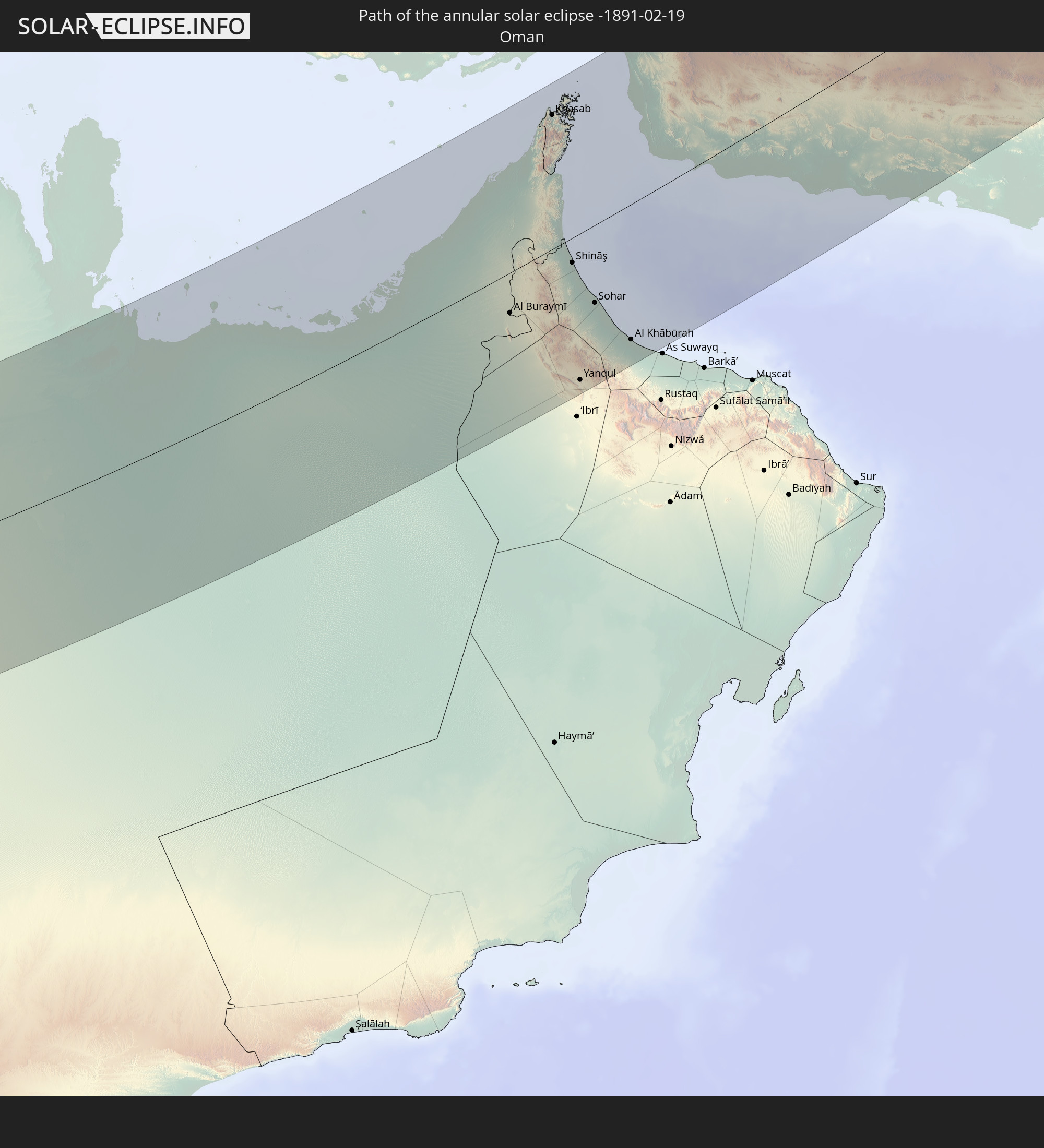 Oman
Oman
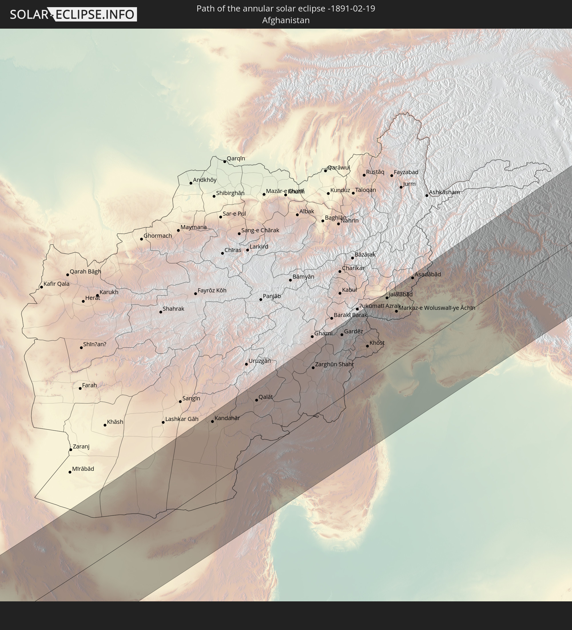 Afghanistan
 Pakistan
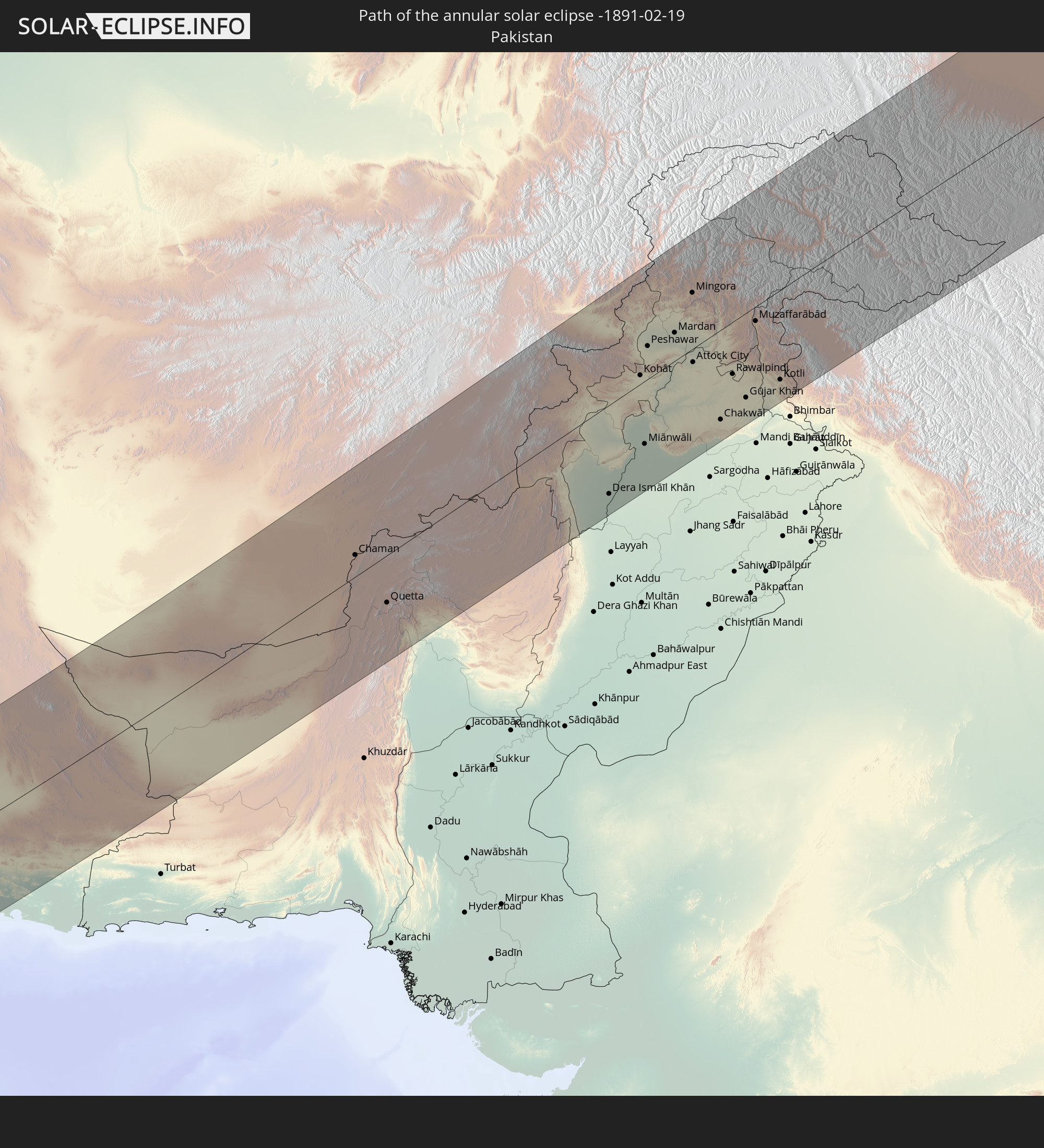
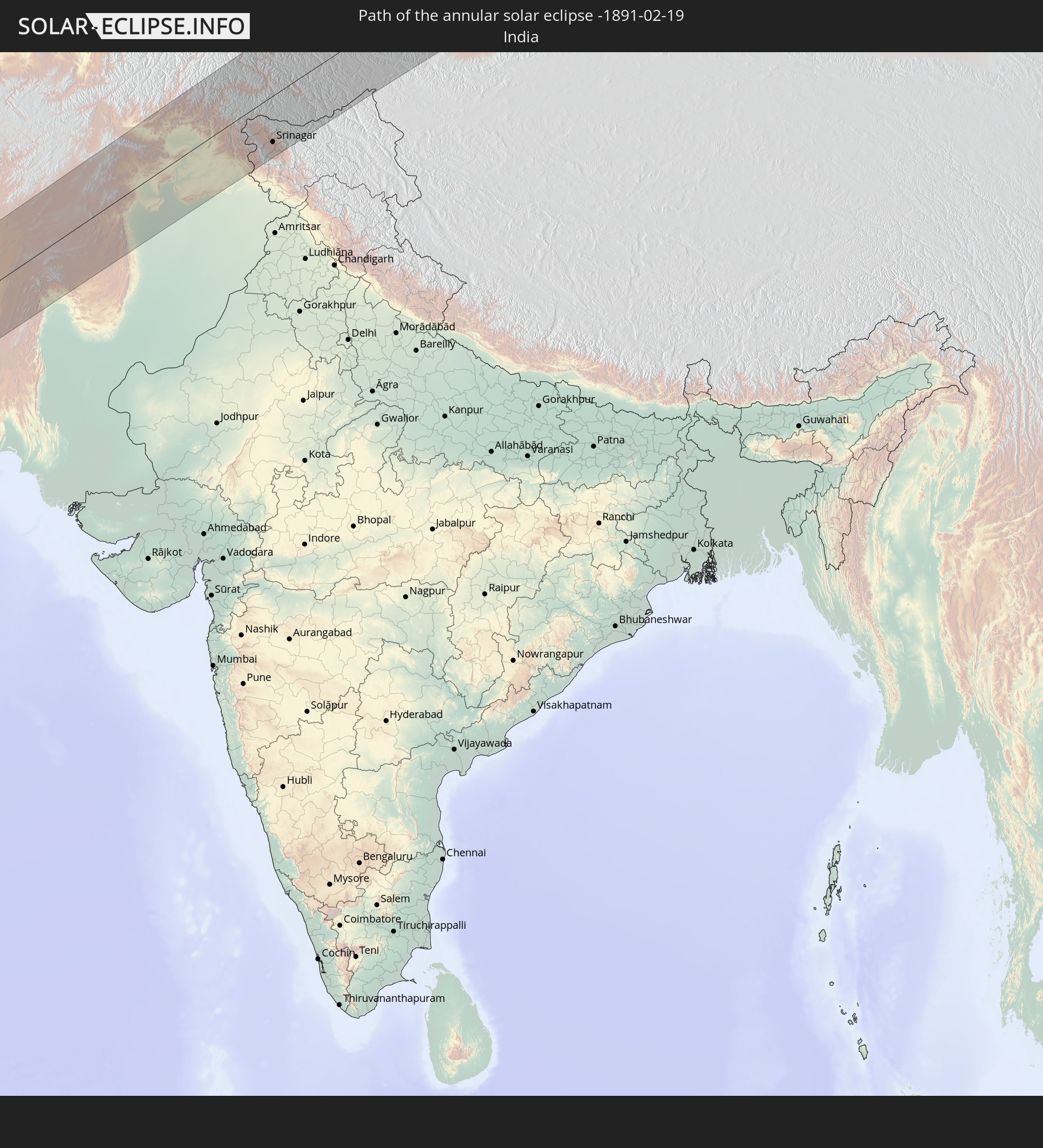 India
India
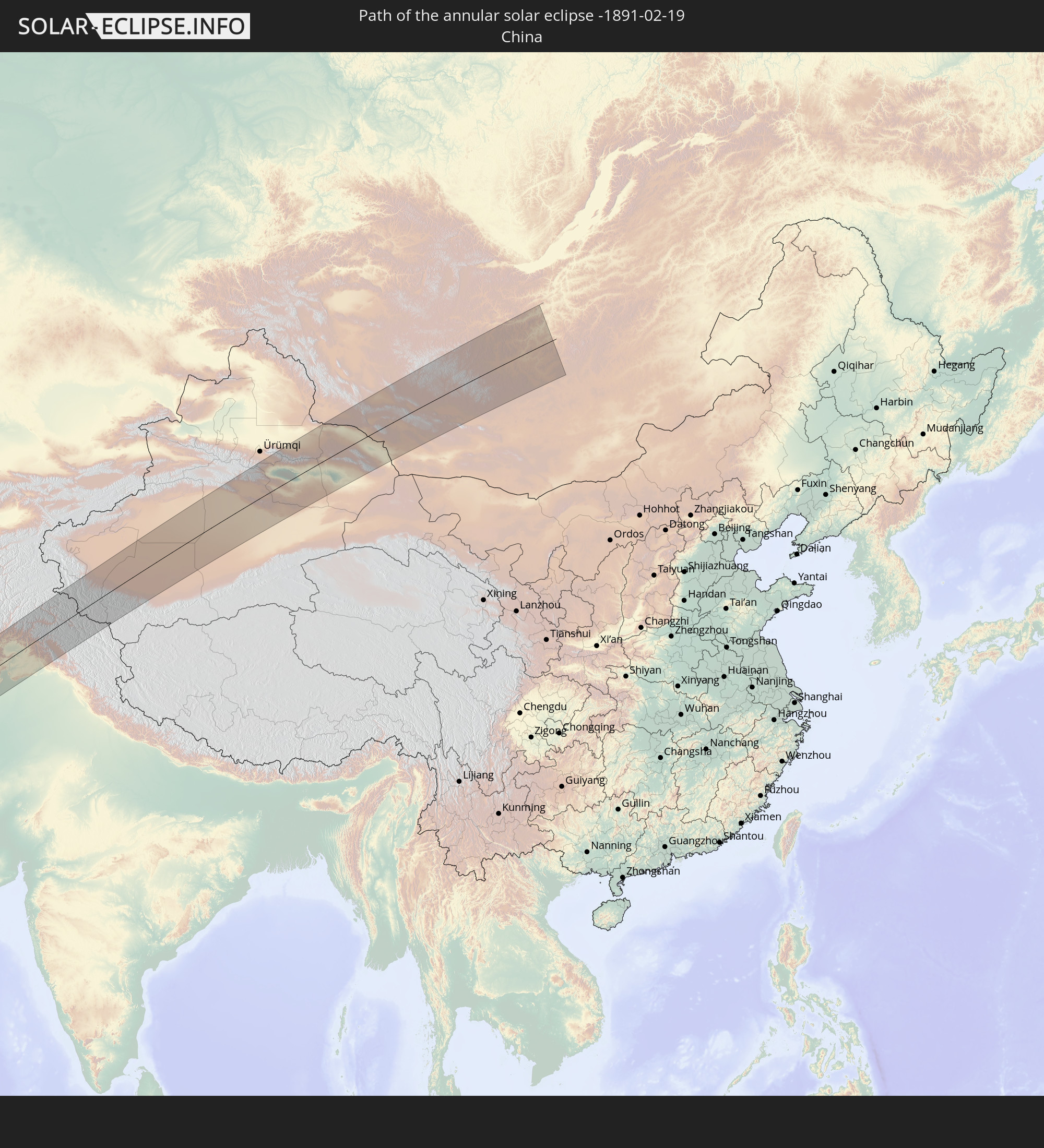 China
China
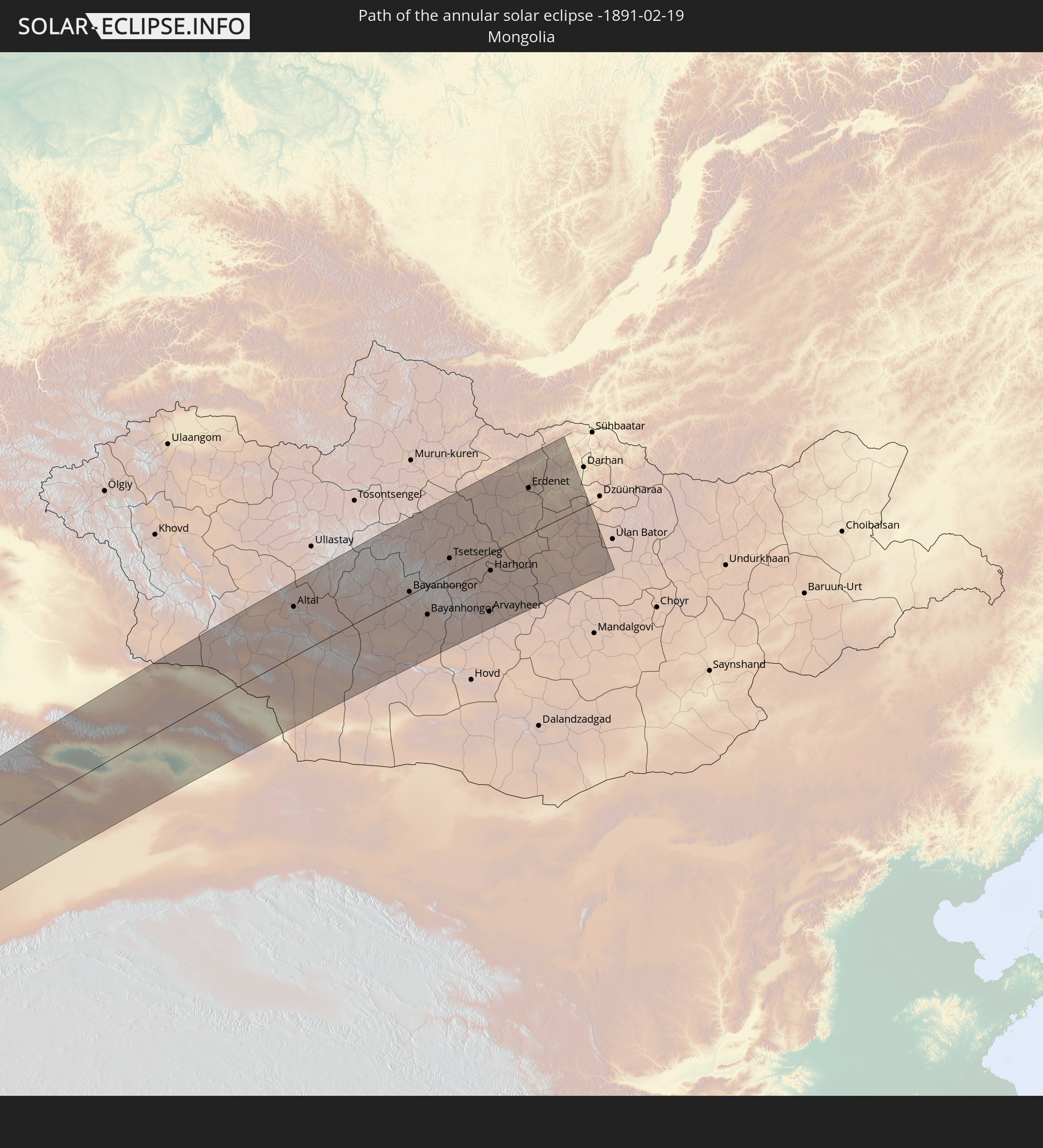 Mongolia
In den folgenden Ländern ist die Sonnenfinsternis partiell zu sehen
 Russia
 Spain
Spain
 Mali
Mali
 Algeria
 Burkina Faso
 France
 Ghana
Ghana
 Togo
Togo
 Niger
Niger
 Benin
Benin
 Andorra
 Belgium
 Nigeria
 Netherlands
 Norway
 Equatorial Guinea
 Luxembourg
 Germany
 Switzerland
 São Tomé and Príncipe
 Italy
Italy
 Monaco
 Tunisia
 Denmark
 Cameroon
 Gabon
Gabon
 Libya
Libya
 Liechtenstein
 Austria
 Sweden
 Republic of the Congo
 Angola
 Czechia
 Democratic Republic of the Congo
 San Marino
 Vatican City
 Slovenia
 Chad
Chad
 Croatia
 Poland
 Malta
Malta
 Central African Republic
 Bosnia and Herzegovina
 Hungary
 Slovakia
 Montenegro
 Serbia
 Albania
 Åland Islands
 Greece
 Romania
 Republic of Macedonia
 Finland
 Lithuania
 Latvia
 Estonia
 Sudan
Sudan
 Zambia
 Ukraine
 Bulgaria
 Belarus
 Egypt
Egypt
 Zimbabwe
 Turkey
 Moldova
 Rwanda
 Burundi
 Tanzania
 Uganda
 Mozambique
 Cyprus
 Malawi
 Ethiopia
 Kenya
Kenya
 State of Palestine
 Israel
 Saudi Arabia
 Jordan
 Lebanon
 Syria
Syria
 Eritrea
 Iraq
Iraq
 Georgia
 French Southern and Antarctic Lands
 Somalia
 Djibouti
 Yemen
Yemen
 Madagascar
 Comoros
 Armenia
 Iran
Iran
 Azerbaijan
 Mayotte
 Seychelles
 Kazakhstan
 Kuwait
 Bahrain
 Qatar
Qatar
 United Arab Emirates
 Oman
Oman
 Turkmenistan
 Uzbekistan
 Mauritius
 Afghanistan
 Pakistan
 Tajikistan
 India
India
 Kyrgyzstan
 British Indian Ocean Territory
 Maldives
 China
China
 Sri Lanka
 Nepal
Nepal
 Mongolia
 Bangladesh
 Bhutan
 Myanmar
 Thailand
 Laos
Laos
 Vietnam
 Cambodia
 Macau
Macau
 Hong Kong
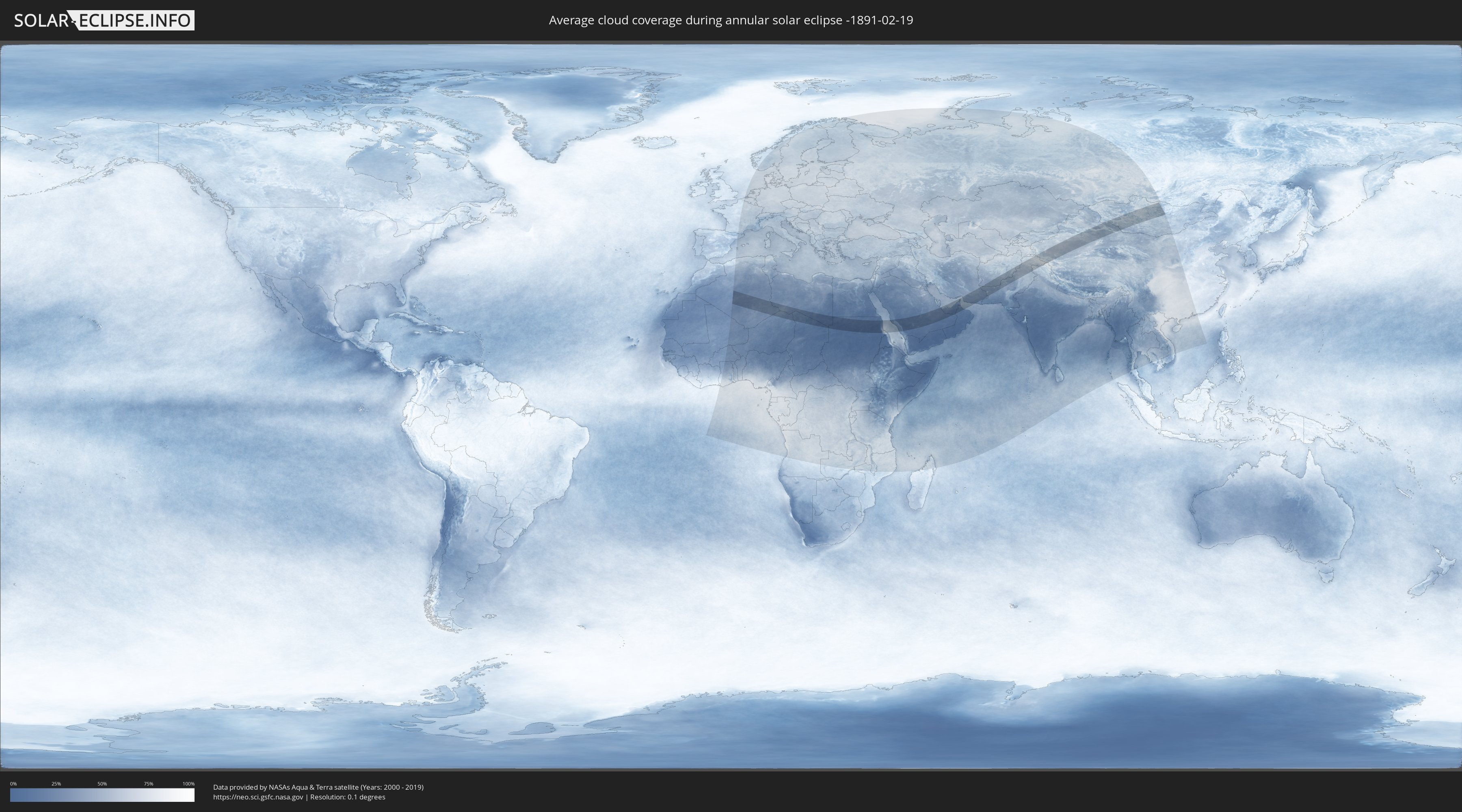
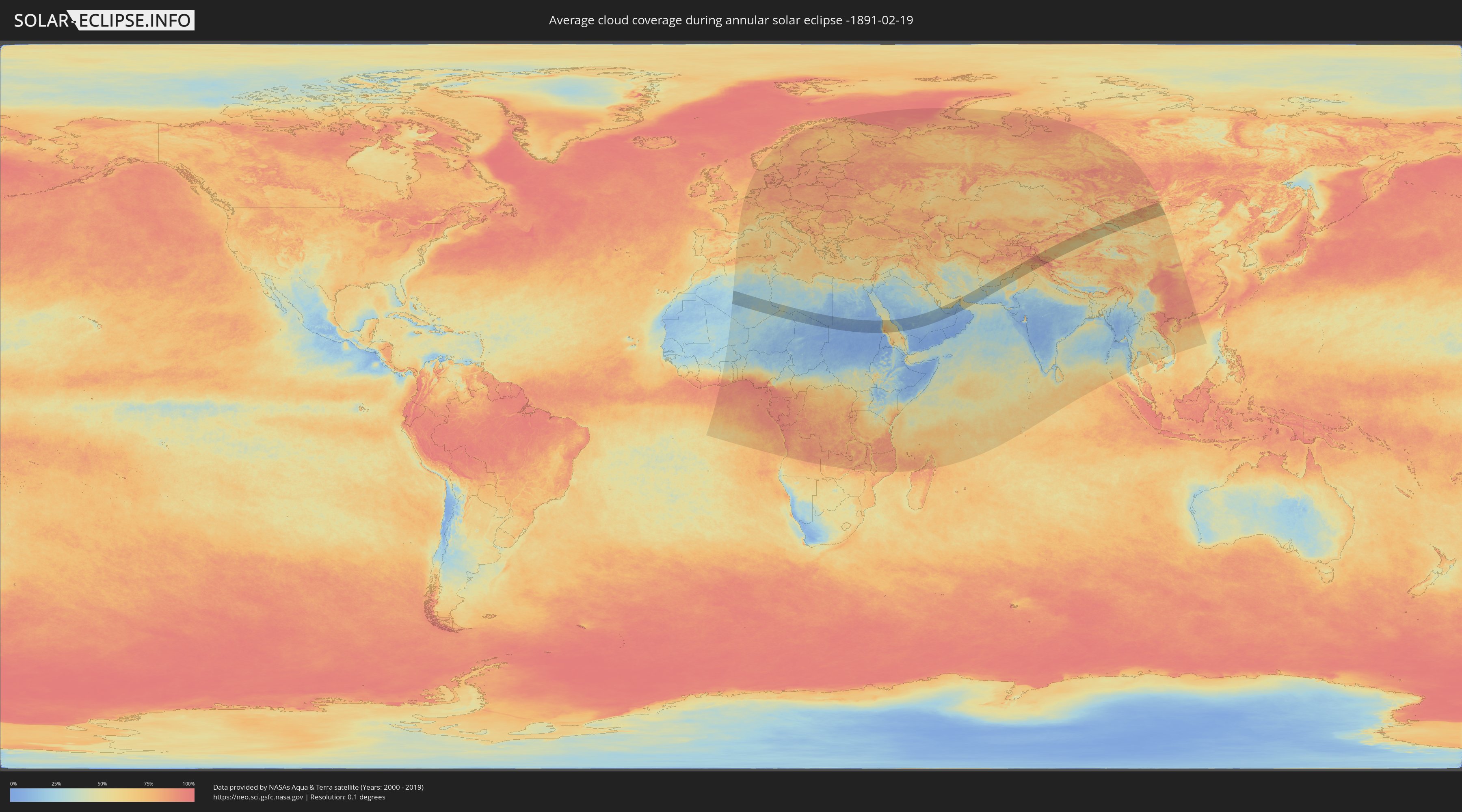
How will be the weather during the annular solar eclipse on 02/19/-1891?
Where is the best place to see the annular solar eclipse of 02/19/-1891?
The following maps show the average cloud coverage for the day of the annular solar eclipse.
With the help of these maps, it is possible to find the place along the eclipse path, which has the best
chance of a cloudless sky.
Nevertheless, you should consider local circumstances and inform about the weather of your chosen
observation site.
The data is provided by NASAs satellites
AQUA and TERRA.
The cloud maps are averaged over a period of 19 years (2000 - 2019).
Detailed country maps
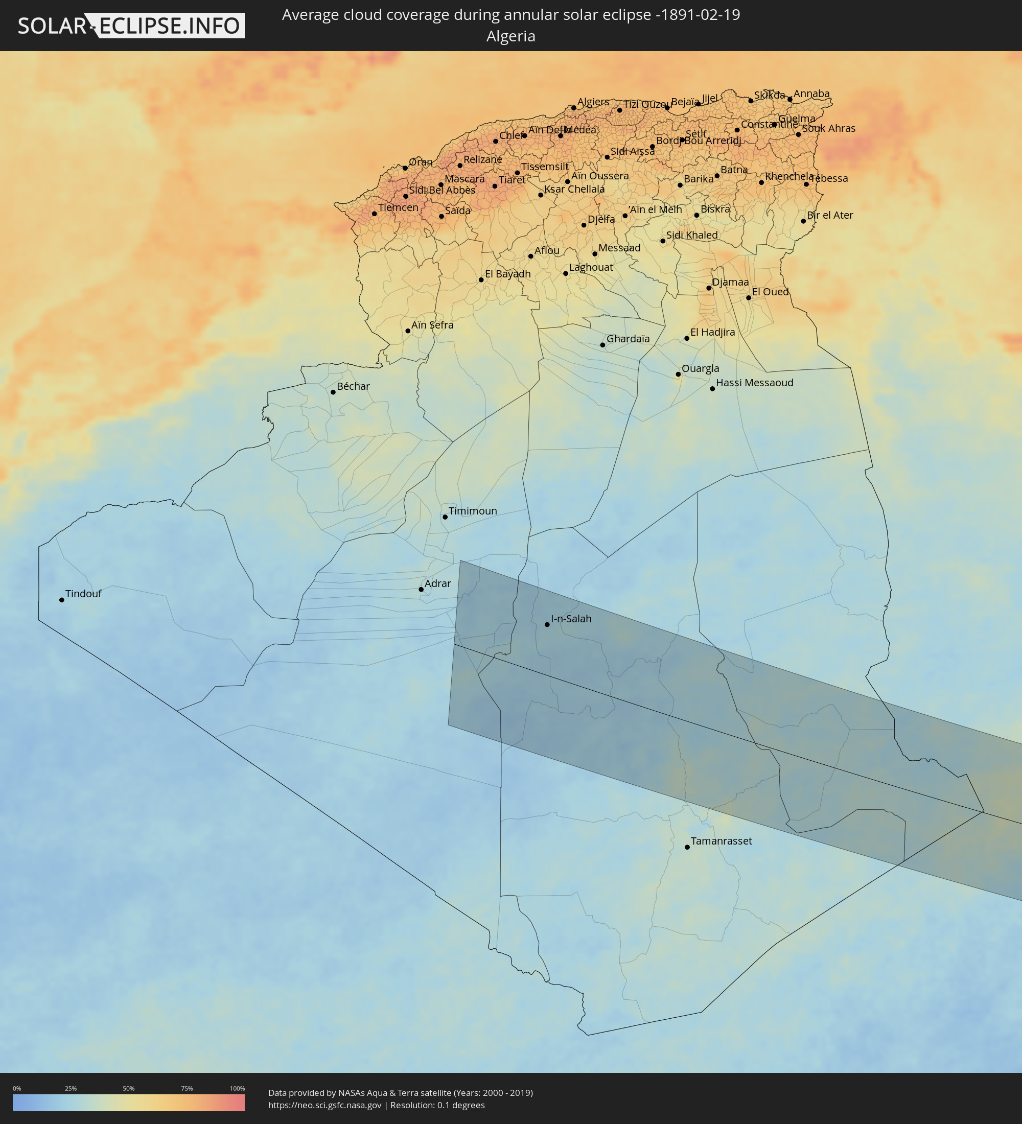 Algeria
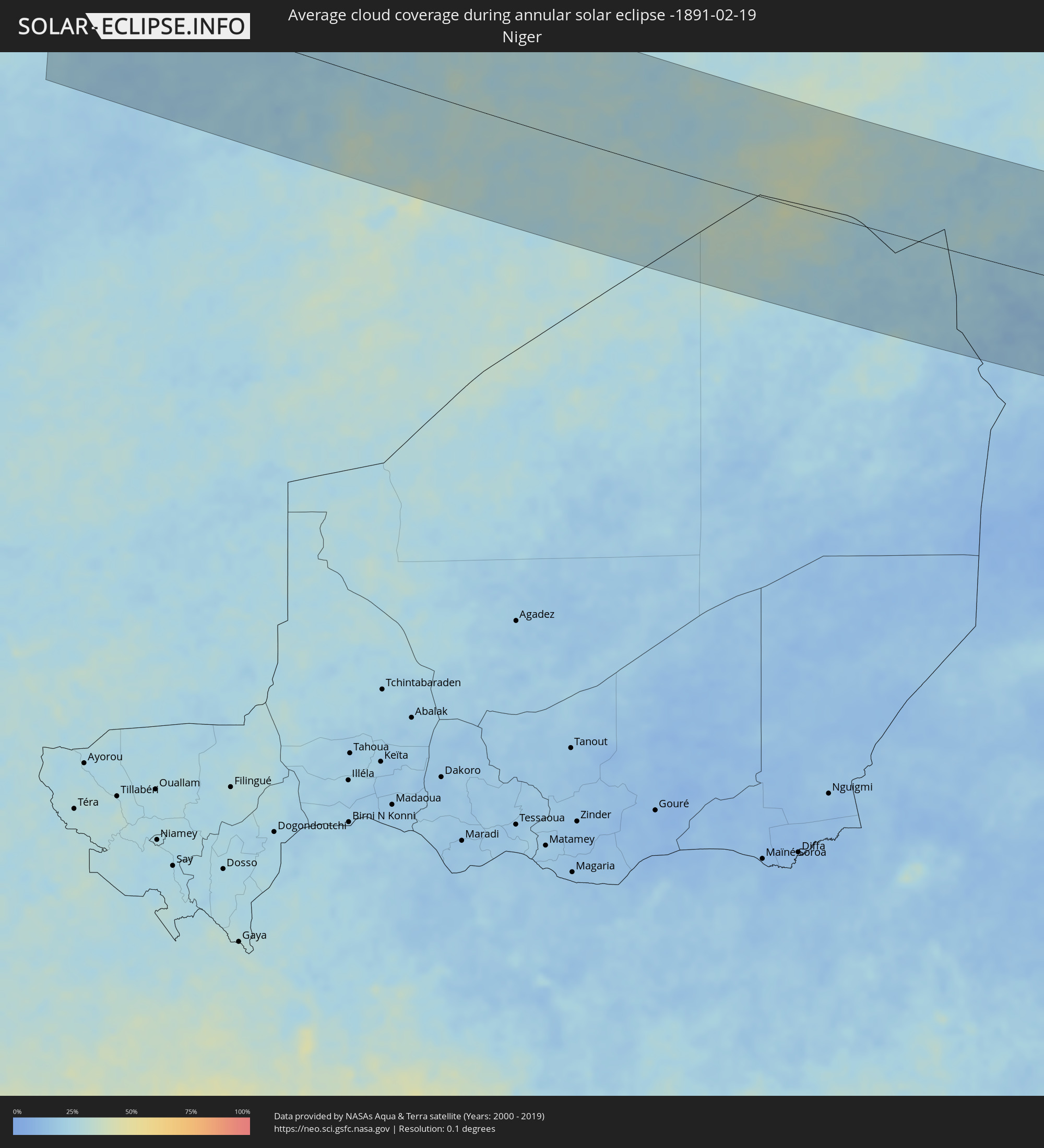 Niger
Niger
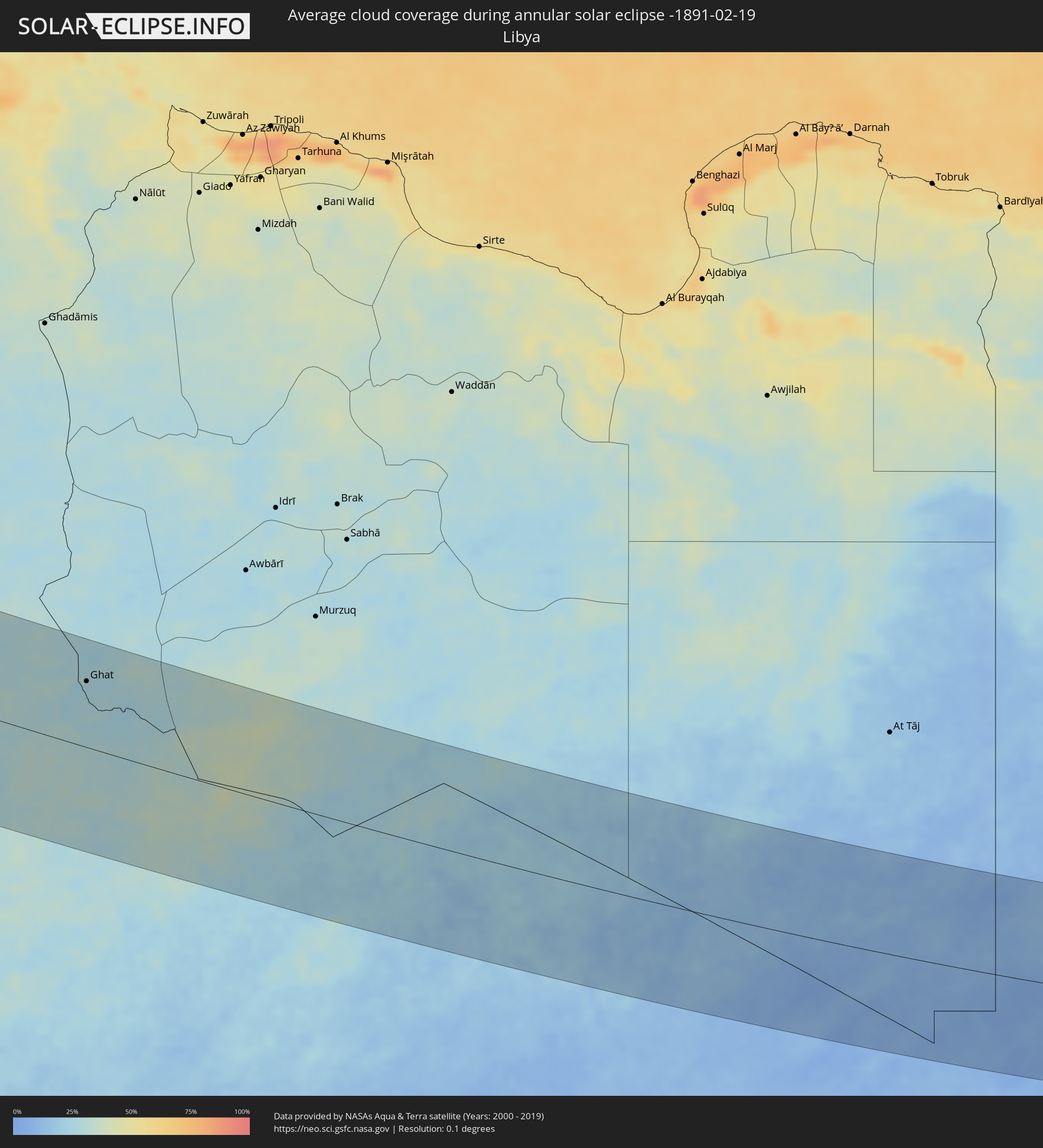 Libya
Libya
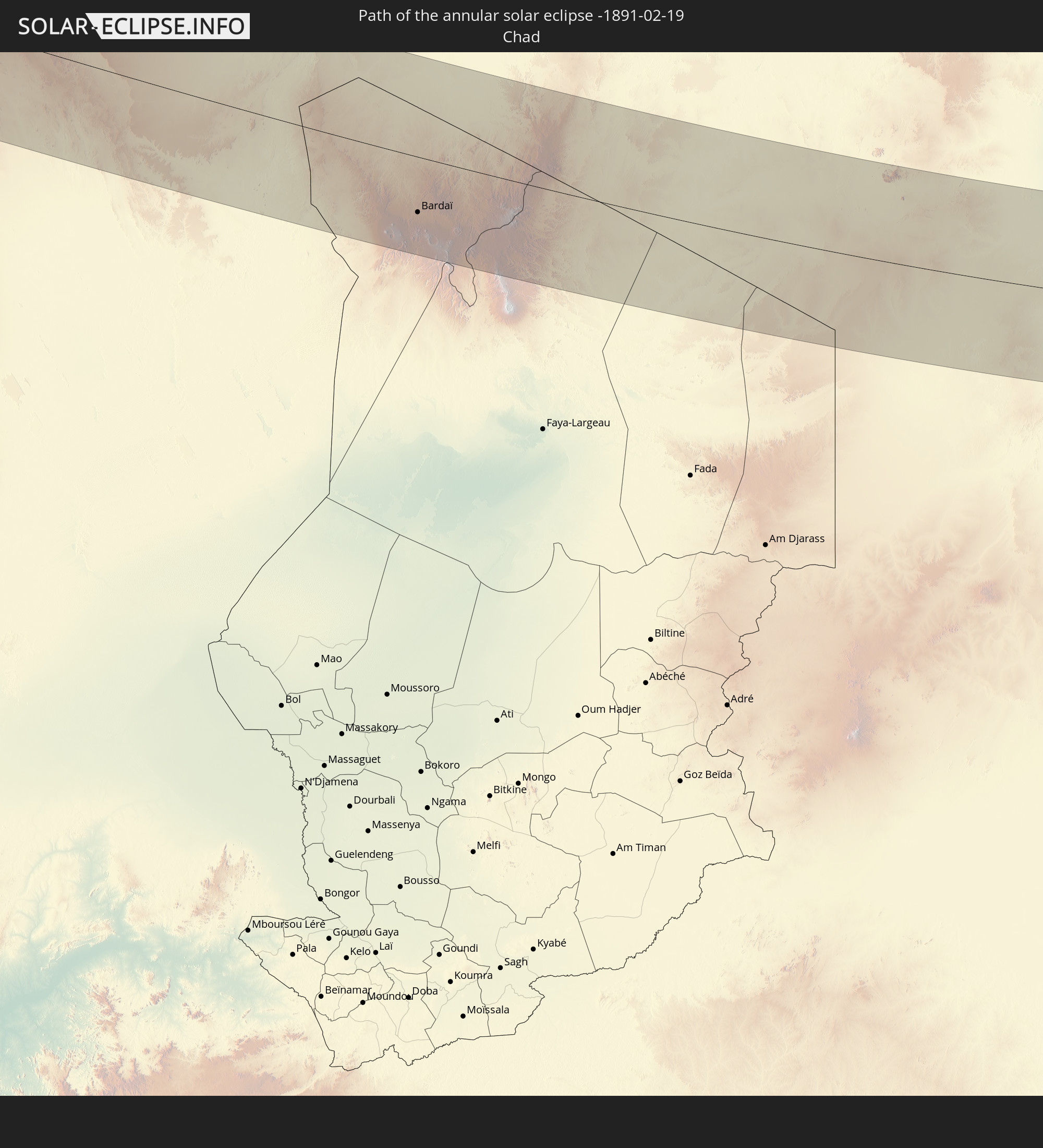
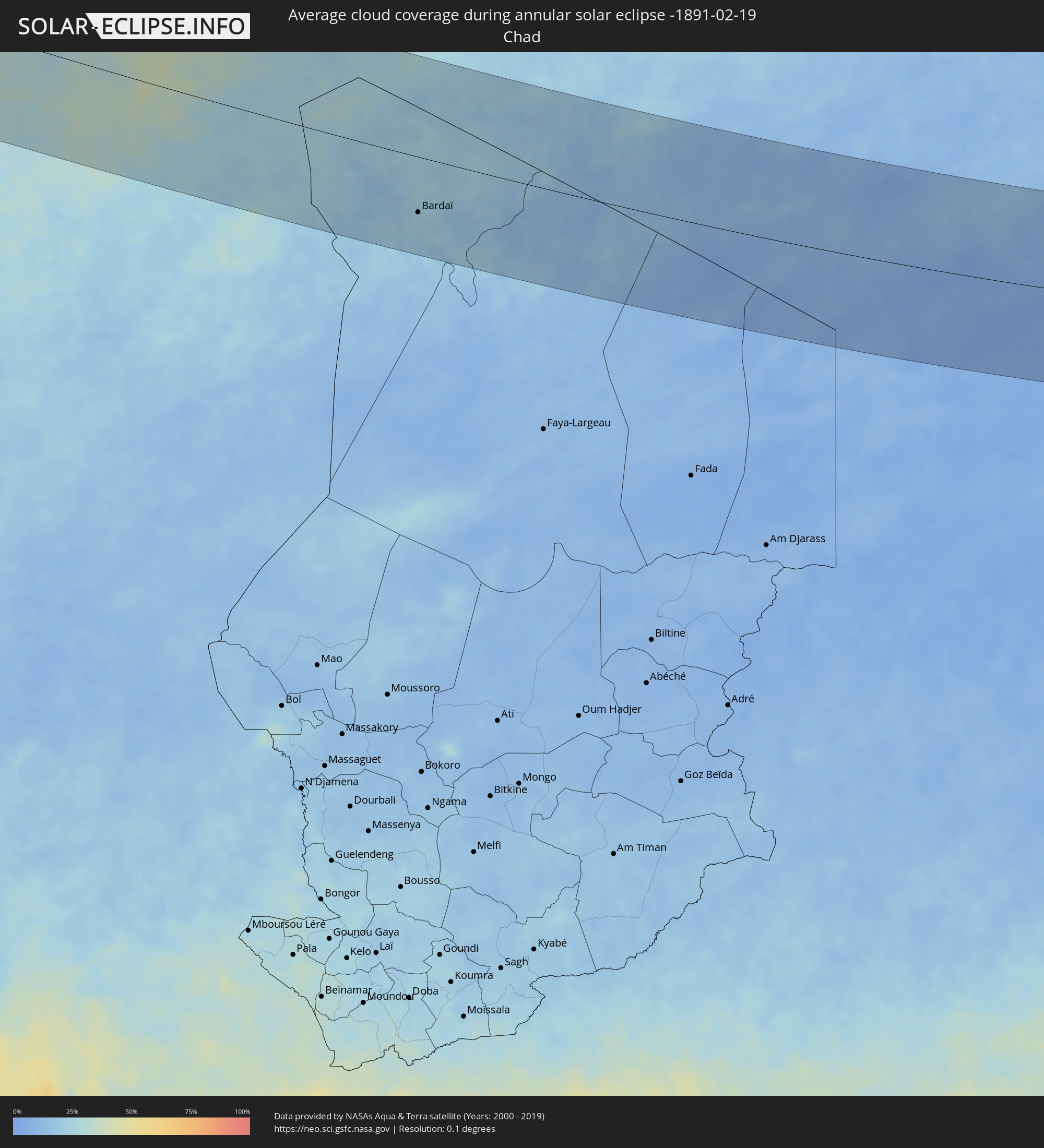 Chad
Chad
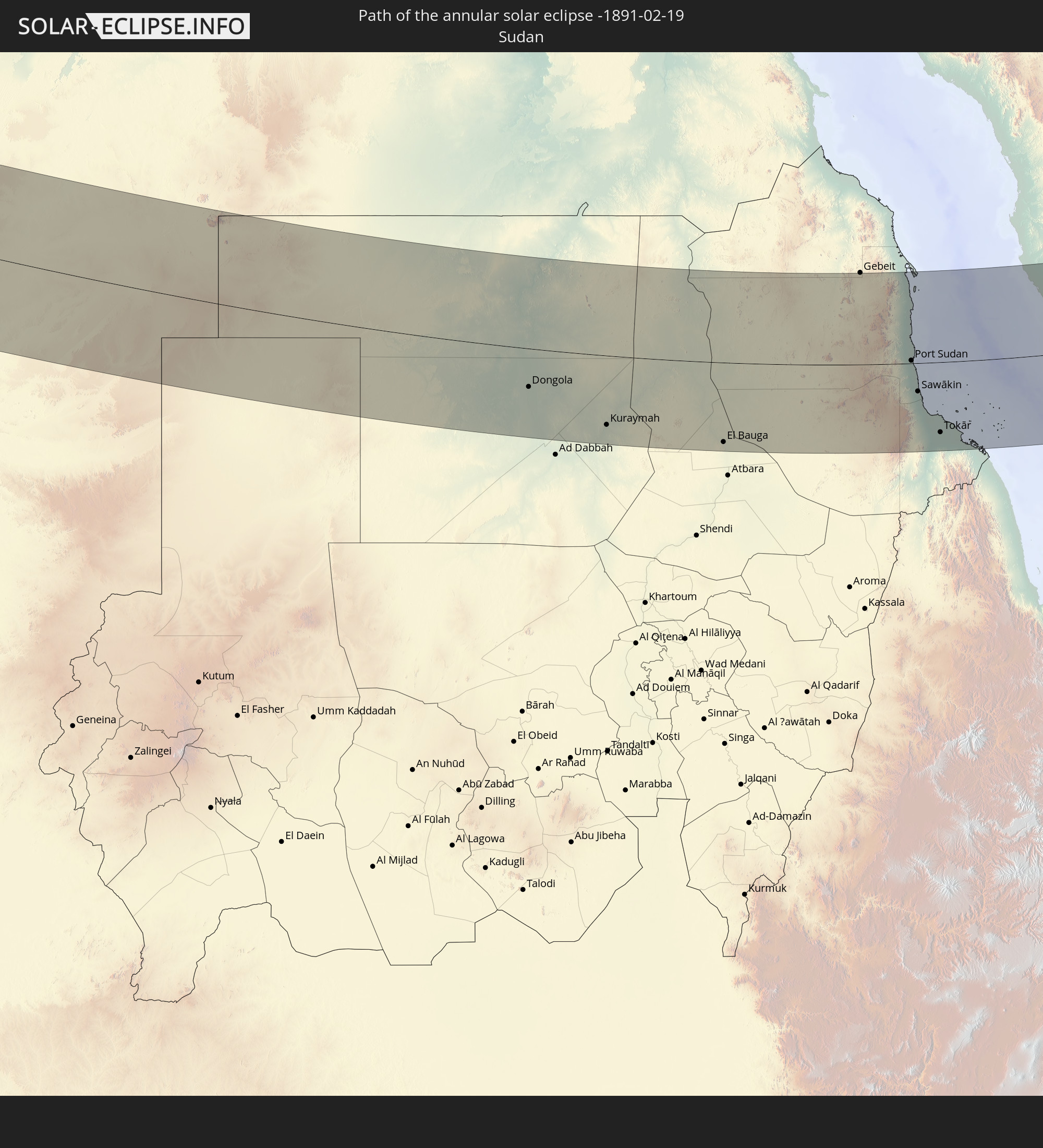
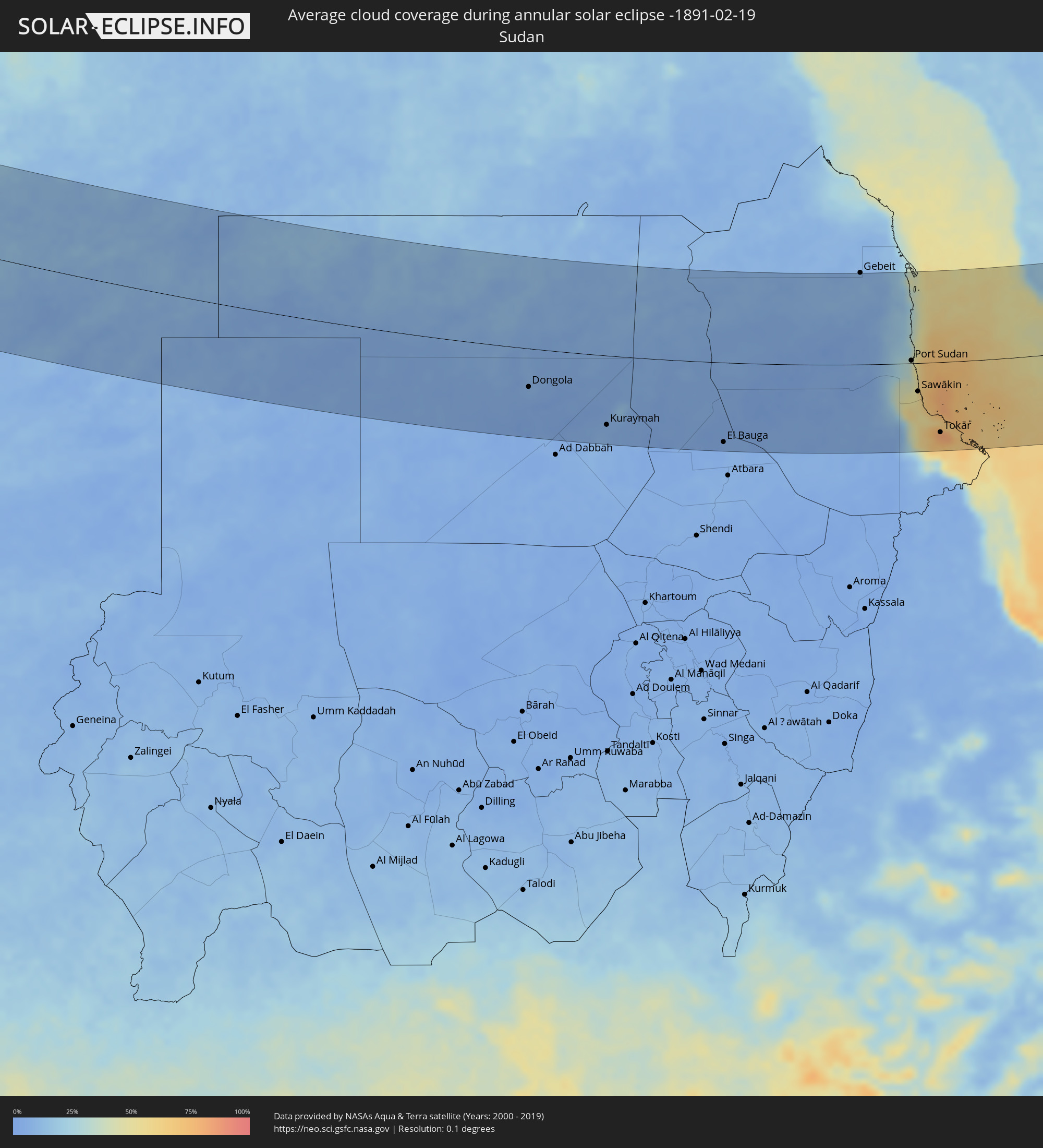 Sudan
Sudan
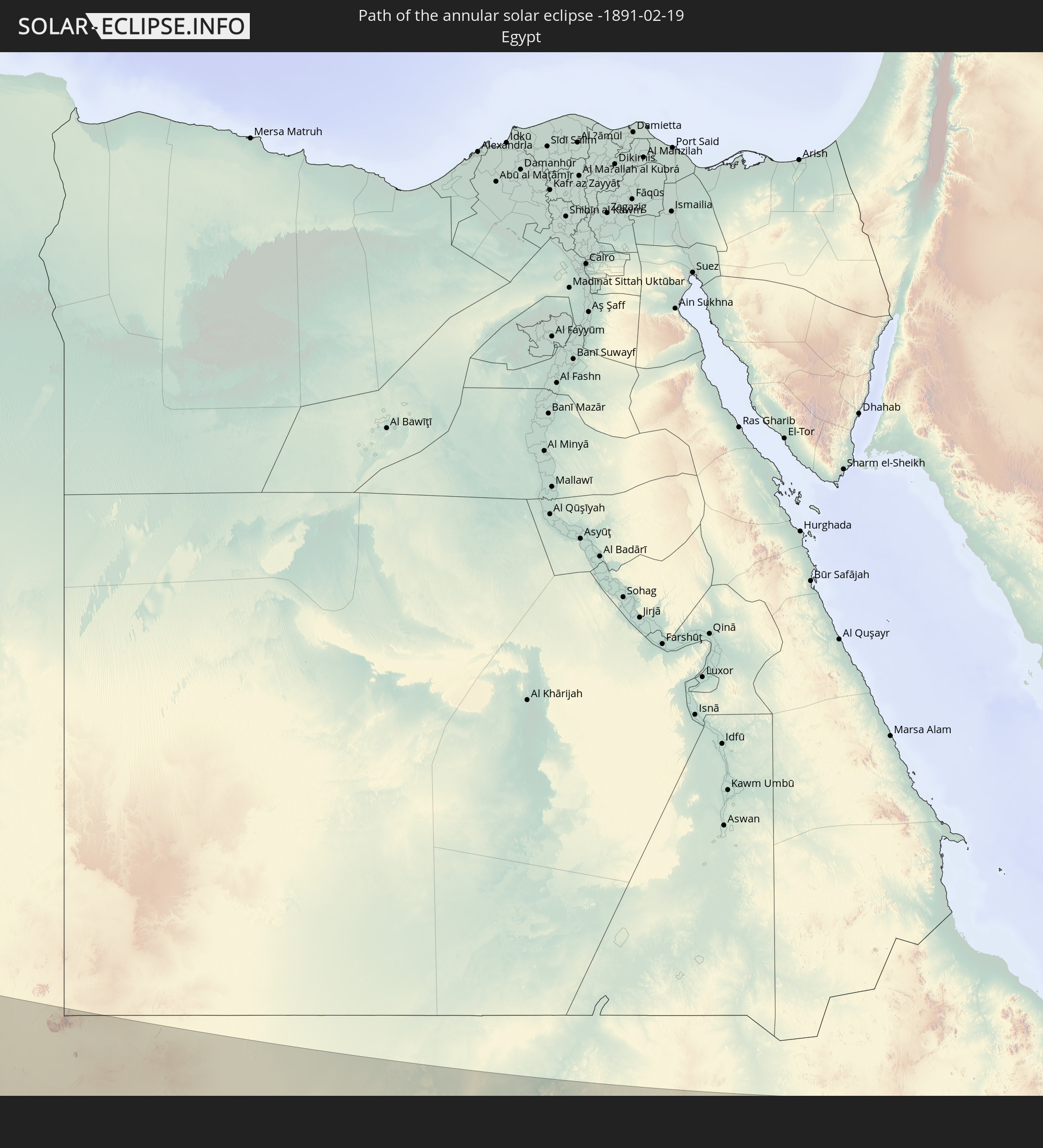
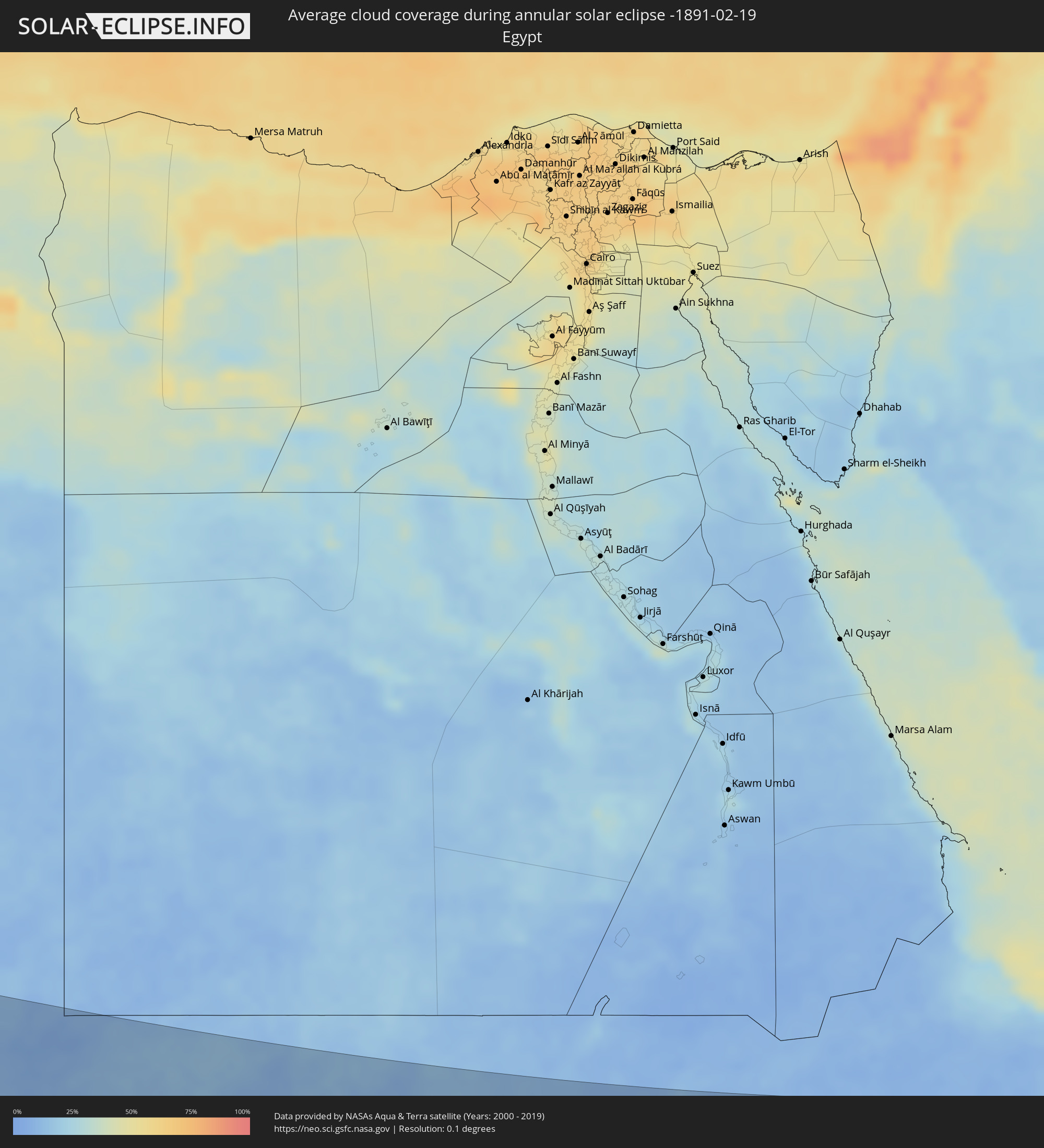 Egypt
Egypt
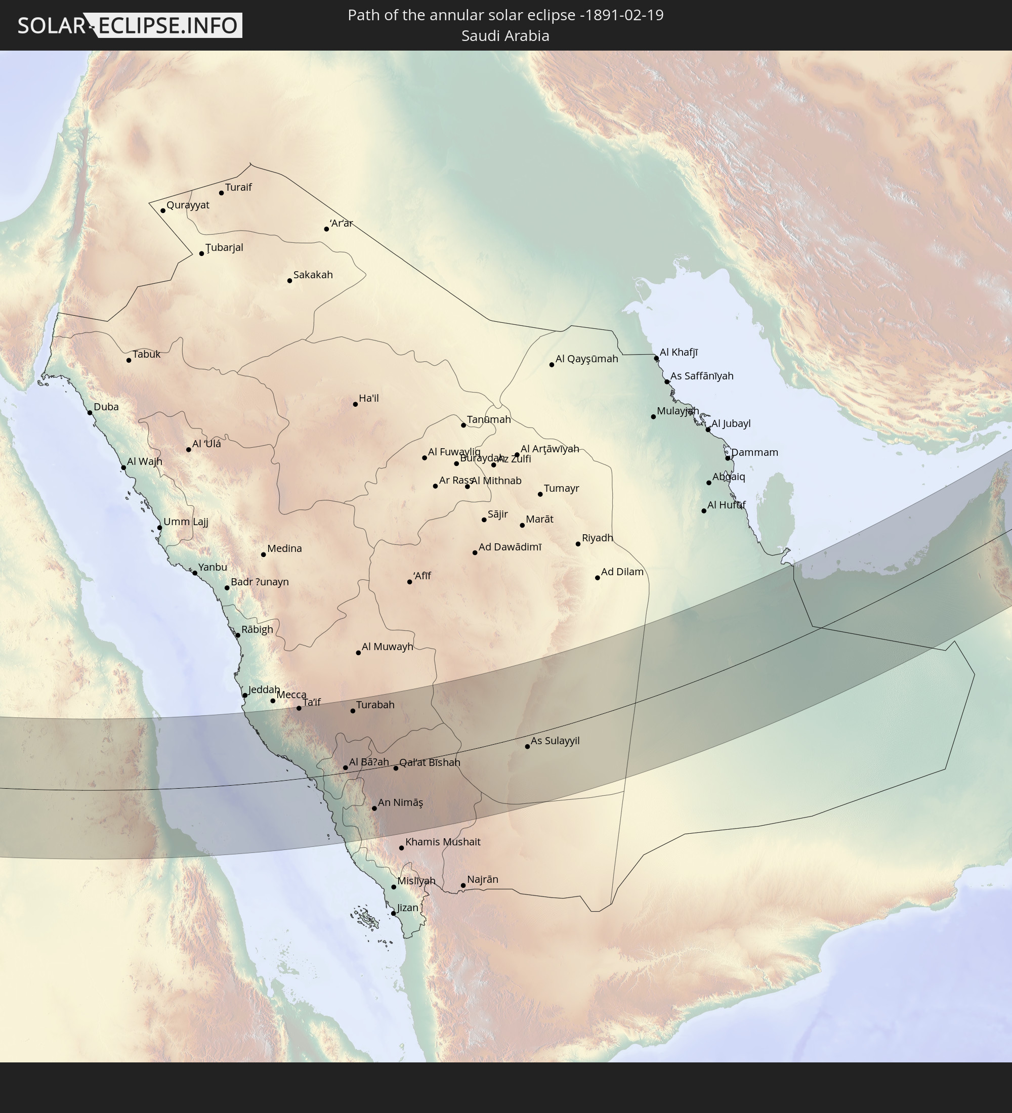
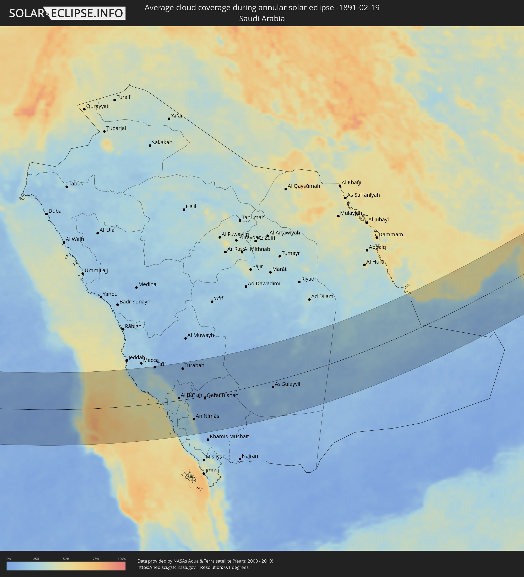 Saudi Arabia
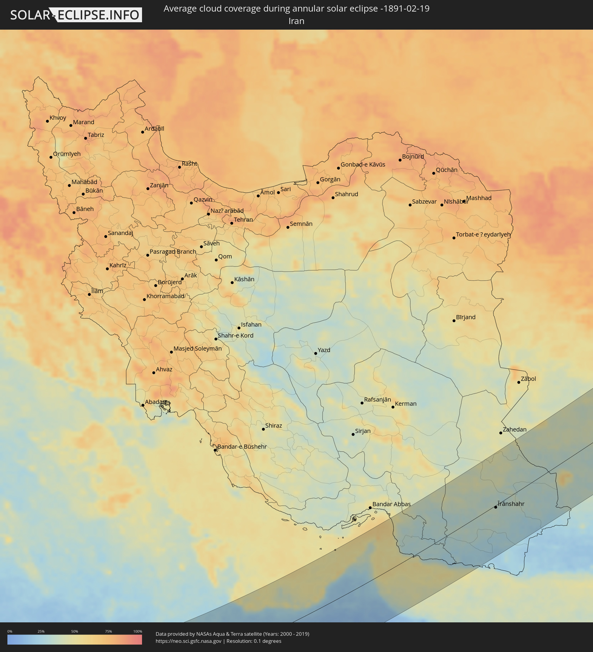 Iran
Iran
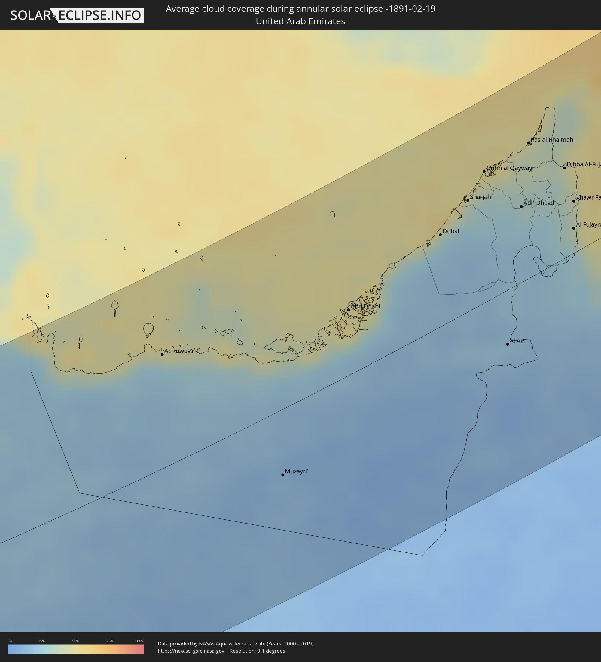 United Arab Emirates
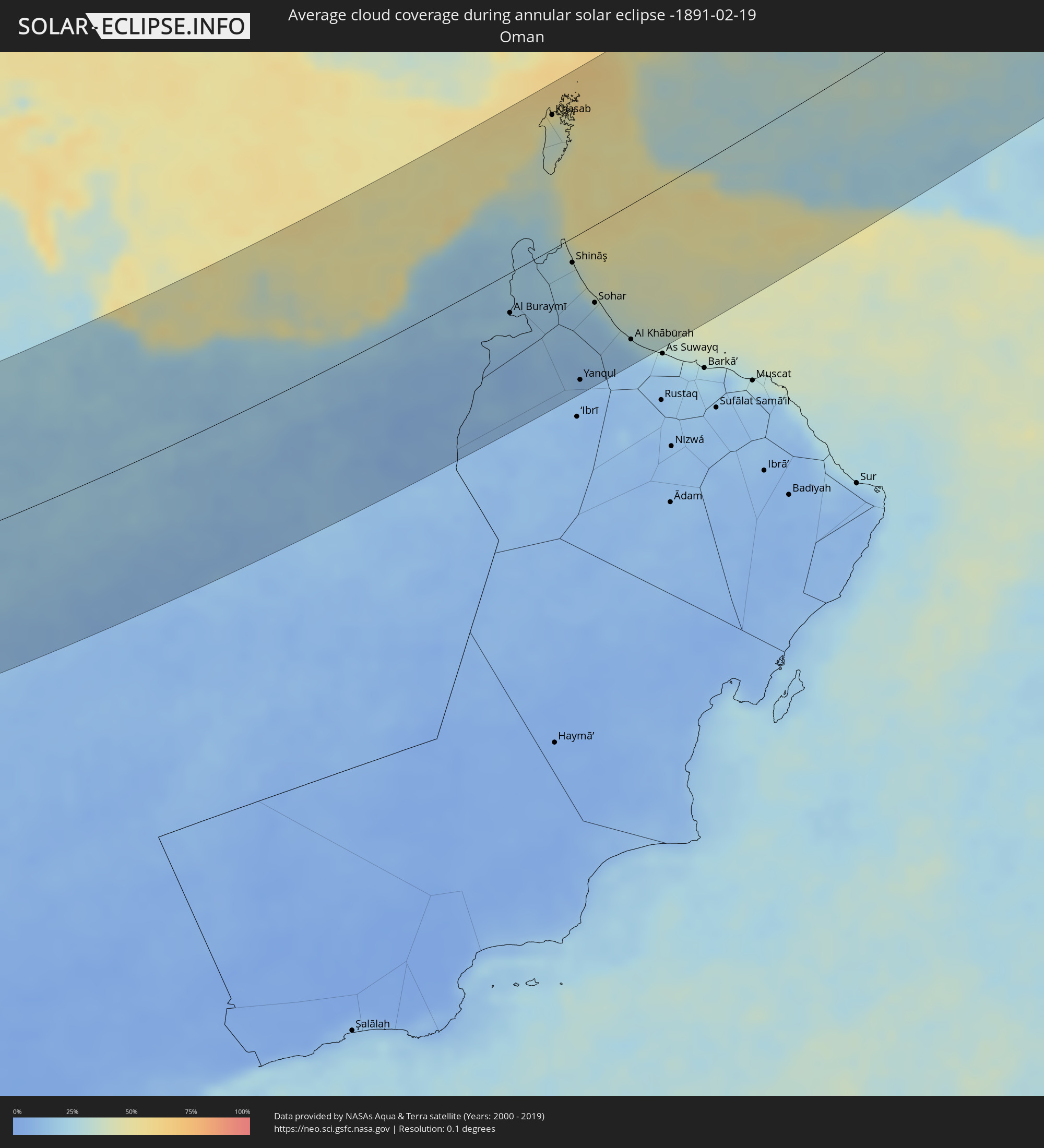 Oman
Oman
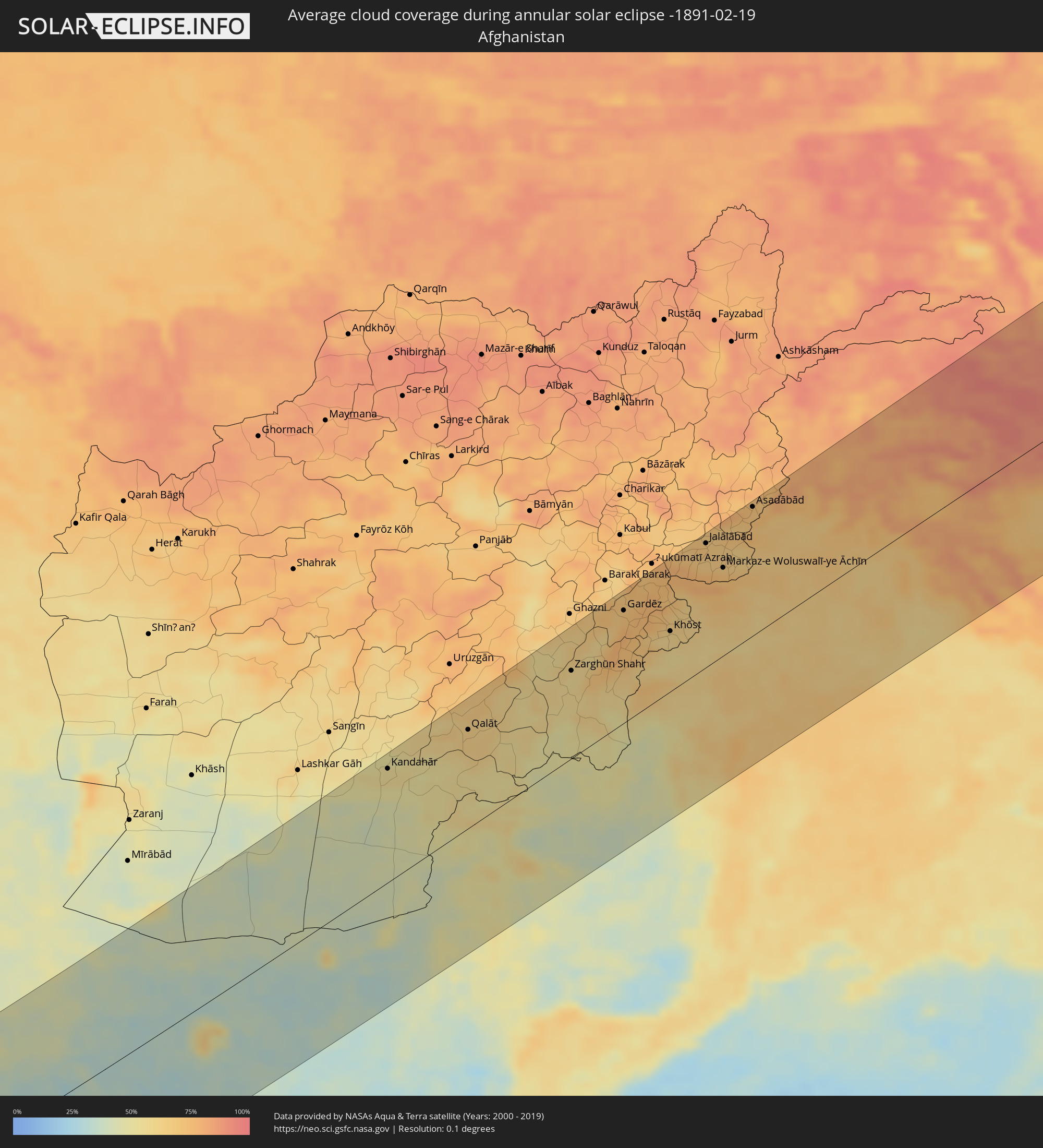 Afghanistan
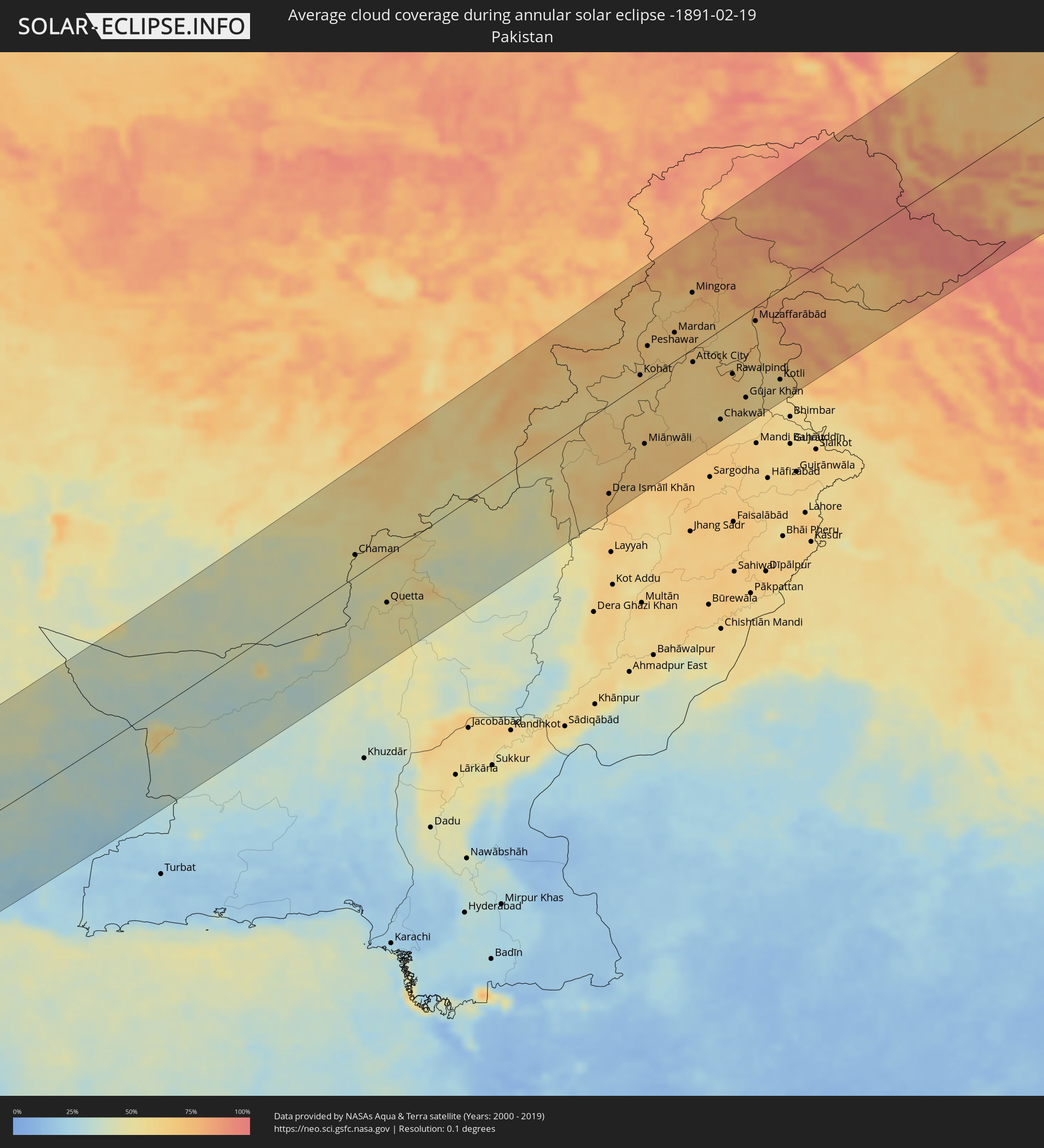 Pakistan
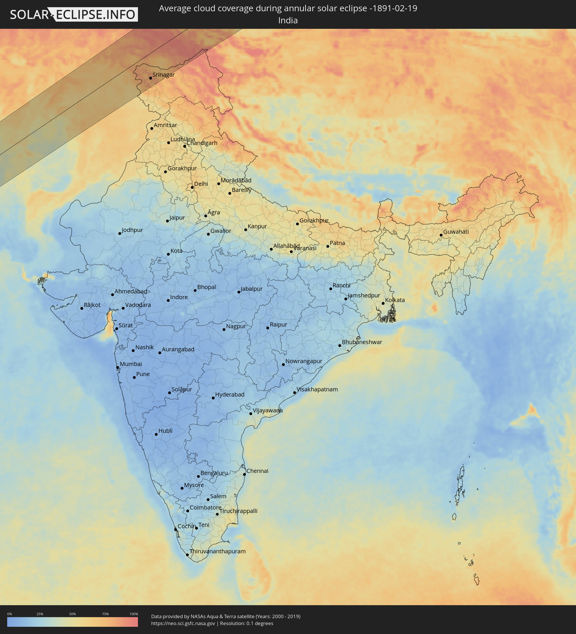 India
India
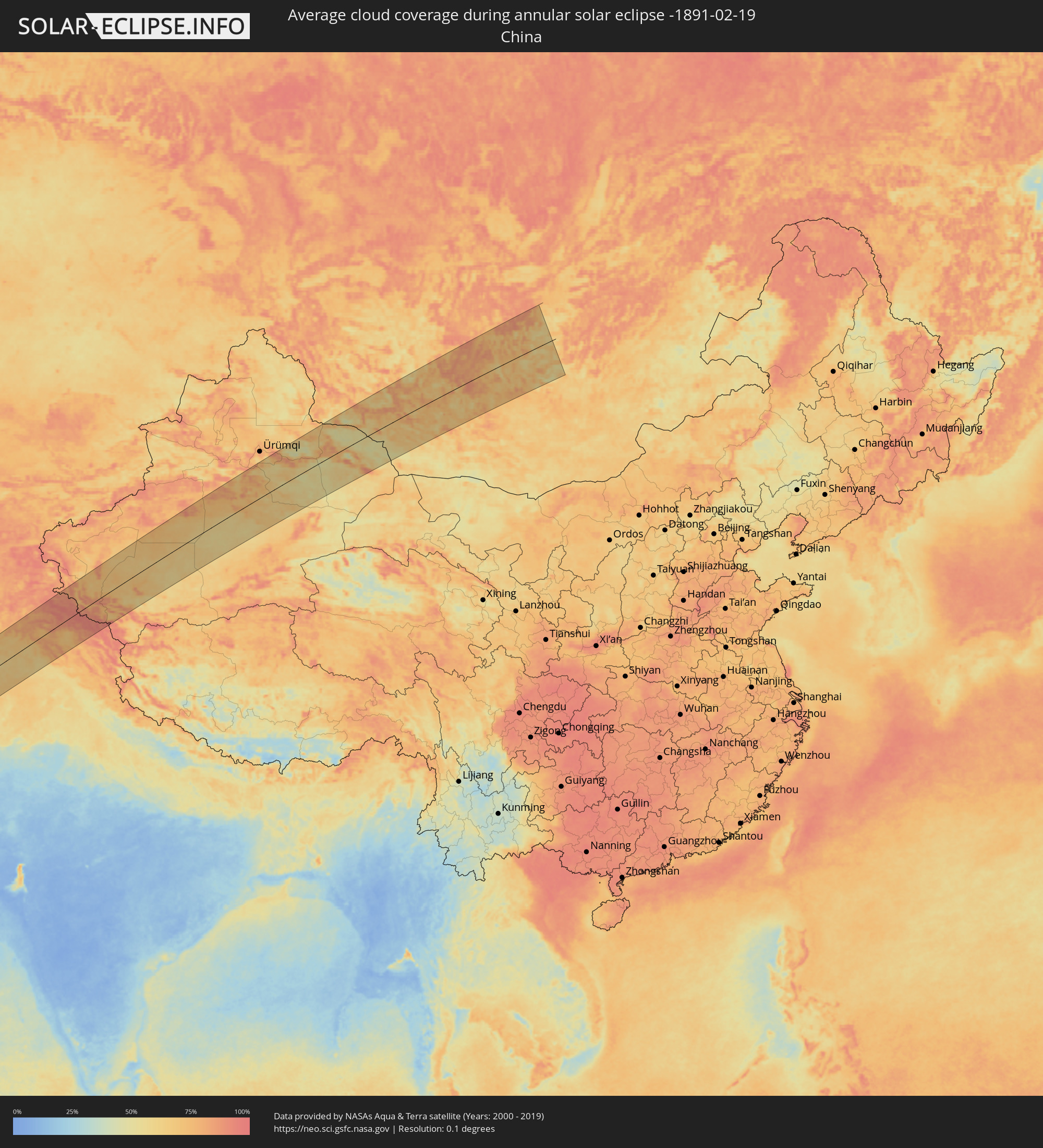 China
China
 Mongolia
Cities inside the path of the eclipse
The following table shows all locations with a population of more than 5,000 inside the eclipse path. Cities which have more than 100,000 inhabitants are marked bold. A click at the locations opens a detailed map.
| City | Type | Eclipse duration | Local time of max. eclipse | Distance to central line | Ø Cloud coverage |
|
Aoulef, Adrar
|
annular | - | 07:02:47 UTC+00:09 | 36 km | 24% |
|
I-n-Salah, Tamanrasset
|
annular | - | 07:03:37 UTC+00:09 | 104 km | 26% |
|
Ghat, Sha‘bīyat Ghāt
|
annular | - | 07:49:07 UTC+00:52 | 104 km | 25% |
|
Bardaï, Tibesti
|
annular | - | 07:59:14 UTC+01:00 | 93 km | 22% |
|
Argo, Northern State
|
annular | - | 09:29:42 UTC+02:10 | 34 km | 6% |
|
Dongola, Northern State
|
annular | - | 09:29:26 UTC+02:10 | 70 km | 7% |
|
Marawī, Northern State
|
annular | - | 09:31:41 UTC+02:10 | 135 km | 7% |
|
Kuraymah, Northern State
|
annular | - | 09:31:50 UTC+02:10 | 128 km | 7% |
|
El Bauga, River Nile
|
annular | - | 09:36:31 UTC+02:10 | 147 km | 4% |
|
Port Sudan, Red Sea
|
annular | - | 09:47:02 UTC+02:10 | 5 km | 34% |
|
Sawākin, Red Sea
|
annular | - | 09:46:43 UTC+02:10 | 52 km | 49% |
|
Tokār, Red Sea
|
annular | - | 09:47:00 UTC+02:10 | 130 km | 78% |
|
Ash Shafā, Makkah
|
annular | - | 10:54:45 UTC+03:06 | 143 km | 34% |
|
Ta’if, Makkah
|
annular | - | 10:55:20 UTC+03:06 | 163 km | 14% |
|
Al Mindak, Al Bahah
|
annular | - | 10:56:34 UTC+03:06 | 29 km | 35% |
|
Al Bāḩah, Al Bahah
|
annular | - | 10:56:57 UTC+03:06 | 10 km | 34% |
|
Turabah, Makkah
|
annular | - | 10:59:02 UTC+03:06 | 140 km | 10% |
|
Al Majāridah, 'Asir
|
annular | - | 10:57:12 UTC+03:06 | 95 km | 21% |
|
An Nimāş, 'Asir
|
annular | - | 10:57:54 UTC+03:06 | 96 km | 35% |
|
Tabālah, 'Asir
|
annular | - | 10:59:49 UTC+03:06 | 12 km | 9% |
|
Qal‘at Bīshah, 'Asir
|
annular | - | 11:00:33 UTC+03:06 | 10 km | 9% |
|
As Sulayyil, Ar Riyāḑ
|
annular | - | 11:10:52 UTC+03:06 | 27 km | 14% |
|
Ar Ruways, Abu Dhabi
|
annular | - | 12:13:40 UTC+03:41 | 91 km | 24% |
|
Muzayri‘, Abu Dhabi
|
annular | - | 12:16:03 UTC+03:41 | 53 km | 13% |
|
Abu Dhabi, Abu Dhabi
|
annular | - | 12:19:24 UTC+03:41 | 51 km | 50% |
|
Dubai, Dubai
|
annular | - | 12:22:36 UTC+03:41 | 71 km | 27% |
|
Sharjah, Ash Shāriqah
|
annular | - | 12:23:39 UTC+03:41 | 86 km | 32% |
|
Ajman, Ajman
|
annular | - | 12:23:47 UTC+03:41 | 92 km | 36% |
|
Umm al Qaywayn, Umm al Qaywayn
|
annular | - | 12:24:19 UTC+03:41 | 101 km | 41% |
|
Al Ain, Abu Dhabi
|
annular | - | 12:23:34 UTC+03:41 | 43 km | 17% |
|
Al Buraymī, Al Buraimi
|
annular | - | 12:23:44 UTC+03:41 | 38 km | 20% |
|
Adh Dhayd, Ash Shāriqah
|
annular | - | 12:25:04 UTC+03:41 | 58 km | 30% |
|
Ras al-Khaimah, Raʼs al Khaymah
|
annular | - | 12:25:46 UTC+03:41 | 104 km | 44% |
|
Khasab, Musandam
|
annular | - | 12:27:05 UTC+03:41 | 126 km | 39% |
|
Dibba Al-Fujairah, Al Fujayrah
|
annular | - | 12:26:34 UTC+03:41 | 69 km | 43% |
|
Dibba Al-Hisn, Al Fujayrah
|
annular | - | 12:26:37 UTC+03:41 | 71 km | 43% |
|
Al Fujayrah, Al Fujayrah
|
annular | - | 12:26:21 UTC+03:41 | 19 km | 33% |
|
Khawr Fakkān, Ash Shāriqah
|
annular | - | 12:26:33 UTC+03:41 | 40 km | 37% |
|
Shināş, Al Batinah North Governorate
|
annular | - | 12:26:22 UTC+03:41 | 24 km | 30% |
|
Yanqul, Az̧ Z̧āhirah
|
annular | - | 12:25:26 UTC+03:41 | 140 km | 11% |
|
Al Liwā’, Al Batinah North Governorate
|
annular | - | 12:26:28 UTC+03:41 | 49 km | 21% |
|
Sohar, Al Batinah North Governorate
|
annular | - | 12:26:43 UTC+03:41 | 74 km | 22% |
|
Şaḩam, Al Batinah North Governorate
|
annular | - | 12:27:06 UTC+03:41 | 100 km | 24% |
|
Al Khābūrah, Al Batinah North Governorate
|
annular | - | 12:27:34 UTC+03:41 | 128 km | 19% |
|
Īrānshahr, Sistan and Baluchestan
|
annular | - | 12:25:39 UTC+03:25 | 6 km | 36% |
|
Qaşr-e Qand, Sistan and Baluchestan
|
annular | - | 12:25:06 UTC+03:25 | 100 km | 28% |
|
Khāsh, Sistan and Baluchestan
|
annular | - | 12:27:52 UTC+03:25 | 61 km | 36% |
|
Kandahār, Kandahar
|
annular | - | 13:15:27 UTC+04:00 | 134 km | 54% |
|
Chaman, Balochistān
|
annular | - | 13:45:10 UTC+04:28 | 30 km | 50% |
|
Qalāt, Zabul
|
annular | - | 13:18:25 UTC+04:00 | 115 km | 64% |
|
Quetta, Balochistān
|
annular | - | 13:46:12 UTC+04:28 | 66 km | 50% |
|
Zarghūn Shahr, Paktika
|
annular | - | 13:22:01 UTC+04:00 | 102 km | 55% |
|
Sharan, Paktika
|
annular | - | 13:22:42 UTC+04:00 | 117 km | 62% |
|
Zaṟah Sharan, Paktika
|
annular | - | 13:22:49 UTC+04:00 | 111 km | 60% |
|
Gardēz, Paktia
|
annular | - | 13:23:49 UTC+04:00 | 129 km | 71% |
|
Khōst, Khowst
|
annular | - | 13:25:14 UTC+04:00 | 69 km | 59% |
|
Jalālābād, Nangarhar
|
annular | - | 13:26:25 UTC+04:00 | 141 km | 67% |
|
Markaz-e Woluswalī-ye Āchīn, Nangarhar
|
annular | - | 13:26:55 UTC+04:00 | 100 km | 71% |
|
Bāsawul, Nangarhar
|
annular | - | 13:27:15 UTC+04:00 | 103 km | 65% |
|
Dera Ismāīl Khān, Khyber Pakhtunkhwa
|
annular | - | 13:55:14 UTC+04:28 | 121 km | 68% |
|
Asadābād, Kunar
|
annular | - | 13:27:49 UTC+04:00 | 146 km | 70% |
|
Āsmār, Kunar
|
annular | - | 13:28:13 UTC+04:00 | 150 km | 75% |
|
Kohāt, Khyber Pakhtunkhwa
|
annular | - | 13:56:33 UTC+04:28 | 12 km | 63% |
|
Miānwāli, Punjab
|
annular | - | 13:56:36 UTC+04:28 | 85 km | 63% |
|
Peshawar, Khyber Pakhtunkhwa
|
annular | - | 13:56:50 UTC+04:28 | 44 km | 68% |
|
Chārsadda, Khyber Pakhtunkhwa
|
annular | - | 13:57:09 UTC+04:28 | 49 km | 65% |
|
Nowshera Cantonment, Khyber Pakhtunkhwa
|
annular | - | 13:57:39 UTC+04:28 | 22 km | 63% |
|
Mardan, Khyber Pakhtunkhwa
|
annular | - | 13:57:45 UTC+04:28 | 38 km | 68% |
|
Mingora, Khyber Pakhtunkhwa
|
annular | - | 13:58:21 UTC+04:28 | 75 km | 73% |
|
Swābi, Khyber Pakhtunkhwa
|
annular | - | 13:58:33 UTC+04:28 | 9 km | 65% |
|
Chakwāl, Punjab
|
annular | - | 13:59:15 UTC+04:28 | 121 km | 63% |
|
Rawalpindi, Punjab
|
annular | - | 13:59:41 UTC+04:28 | 70 km | 69% |
|
Abbottābād, Khyber Pakhtunkhwa
|
annular | - | 13:59:57 UTC+04:28 | 27 km | 65% |
|
Muzaffarābād, Azad Kashmir
|
annular | - | 14:00:26 UTC+04:28 | 19 km | 66% |
|
Kotli, Azad Kashmir
|
annular | - | 14:01:14 UTC+04:28 | 120 km | 59% |
|
Pūnch, Kashmir
|
annular | - | 14:54:33 UTC+05:21 | 107 km | 66% |
|
Kupwāra, Kashmir
|
annular | - | 14:54:51 UTC+05:21 | 91 km | 80% |
|
Bāramūla, Kashmir
|
annular | - | 14:54:59 UTC+05:21 | 79 km | 83% |
|
Pattan, Kashmir
|
annular | - | 14:55:22 UTC+05:21 | 94 km | 77% |
|
Hājan, Kashmir
|
annular | - | 14:55:28 UTC+05:21 | 84 km | 74% |
|
Bandipura, Kashmir
|
annular | - | 14:55:31 UTC+05:21 | 75 km | 76% |
|
Sumbal, Kashmir
|
annular | - | 14:55:32 UTC+05:21 | 92 km | 77% |
|
Tsrār Sharīf, Kashmir
|
annular | - | 14:55:45 UTC+05:21 | 132 km | 79% |
|
Gāndarbal, Kashmir
|
annular | - | 14:55:45 UTC+05:21 | 99 km | 79% |
|
Srinagar, Kashmir
|
annular | - | 14:55:49 UTC+05:21 | 114 km | 79% |
|
Shupīyan, Kashmir
|
annular | - | 14:55:53 UTC+05:21 | 149 km | 78% |
|
Pulwama, Kashmir
|
annular | - | 14:56:00 UTC+05:21 | 138 km | 75% |
|
Awantipur, Kashmir
|
annular | - | 14:56:12 UTC+05:21 | 140 km | 74% |
|
Trāl, Kashmir
|
annular | - | 14:56:22 UTC+05:21 | 144 km | 75% |
|
Pahlgām, Kashmir
|
annular | - | 14:56:44 UTC+05:21 | 146 km | 83% |
|
Kargil, Kashmir
|
annular | - | 14:58:04 UTC+05:21 | 136 km | 78% |
|
Zangguy, Xinjiang Uyghur Autonomous Region
|
annular | - | 17:40:33 UTC+08:00 | 11 km | 68% |
|
Hotan, Xinjiang Uyghur Autonomous Region
|
annular | - | 17:42:19 UTC+08:00 | 84 km | 83% |
|
Korla, Xinjiang Uyghur Autonomous Region
|
annular | - | 17:47:49 UTC+08:00 | 73 km | 76% |
|
Sishilichengzi, Xinjiang Uyghur Autonomous Region
|
annular | - | 17:48:02 UTC+08:00 | 78 km | 78% |
|
Turpan, Xinjiang Uyghur Autonomous Region
|
annular | - | 17:50:02 UTC+08:00 | 58 km | 67% |
|
Hami, Xinjiang Uyghur Autonomous Region
|
annular | - | 17:53:52 UTC+08:00 | 128 km | 57% |
|
Altai, Govĭ-Altay
|
annular | - | 15:59:20 UTC+06:06 | 112 km | 79% |
|
Bayanhongor, Bayanhongor
|
annular | - | 17:02:13 UTC+07:07 | 6 km | 62% |
|
Bayanhongor, Bayanhongor
|
annular | - | 17:03:04 UTC+07:07 | 66 km | 72% |
|
Tsetserleg, Arhangay
|
annular | - | 17:02:08 UTC+07:07 | 35 km | 80% |
|
Arvayheer, Övörhangay
|
annular | - | 17:04:00 UTC+07:07 | 131 km | 74% |
|
Kharkhorin, Övörhangay
|
annular | - | 17:03:04 UTC+07:07 | 39 km | 83% |
|
Harhorin, Övörhangay
|
annular | - | 17:03:04 UTC+07:07 | 39 km | 83% |
|
Bulgan, Bulgan
|
annular | - | 17:01:39 UTC+07:07 | 98 km | 70% |
|
Erdenet, Orhon
|
annular | - | 17:01:38 UTC+07:07 | 102 km | 71% |