Total solar eclipse of 10/04/-1996
| Day of week: | Saturday |
| Maximum duration of eclipse: | 02m04s |
| Maximum width of eclipse path: | 101 km |
| Saros cycle: | 2 |
| Coverage: | 100% |
| Magnitude: | 1.0257 |
| Gamma: | 0.5166 |
Wo kann man die Sonnenfinsternis vom 10/04/-1996 sehen?
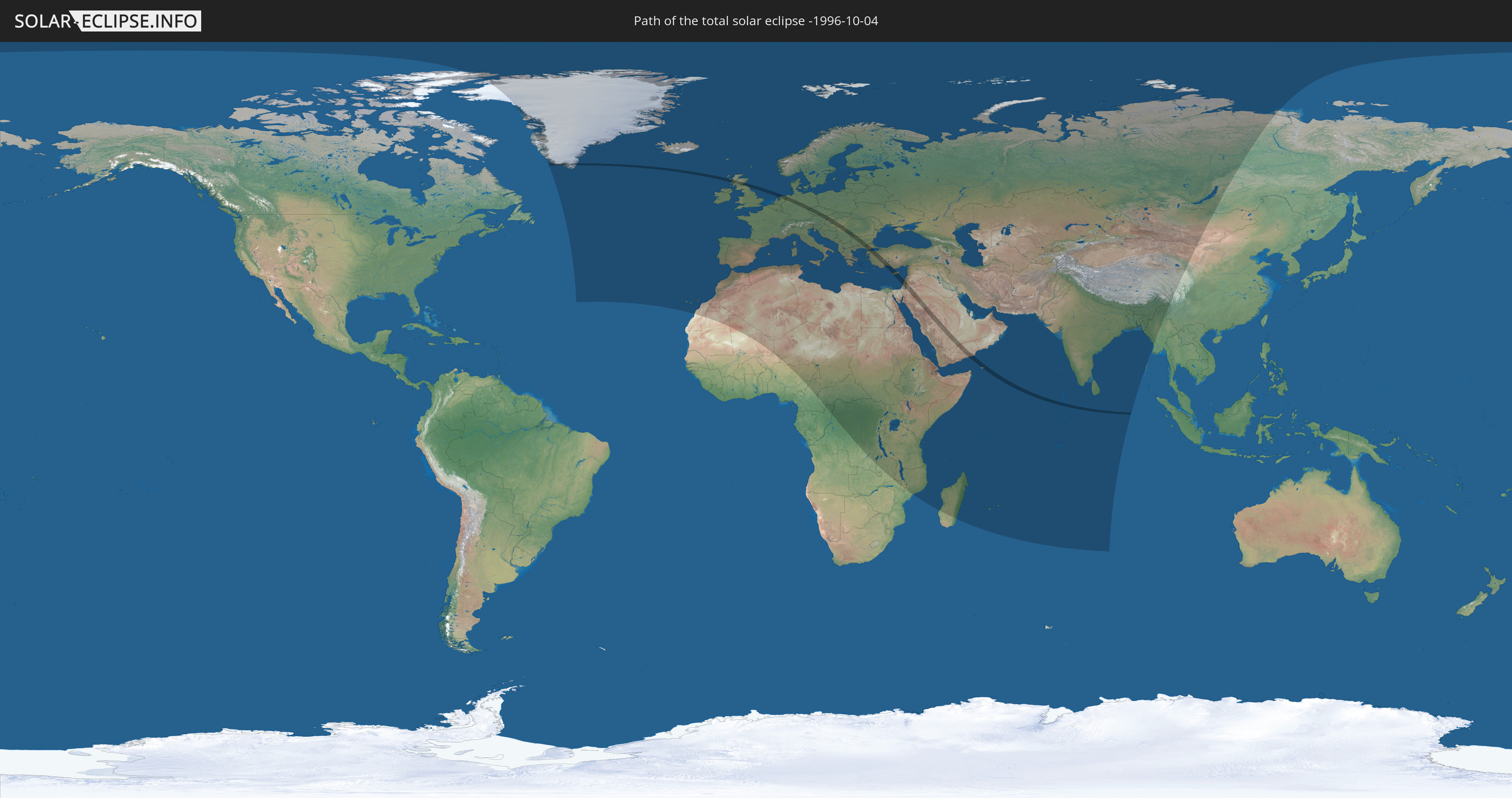
Die Sonnenfinsternis am 10/04/-1996 kann man in 123 Ländern als partielle Sonnenfinsternis beobachten.
Der Finsternispfad verläuft durch 21 Länder. Nur in diesen Ländern ist sie als total Sonnenfinsternis zu sehen.
In den folgenden Ländern ist die Sonnenfinsternis total zu sehen
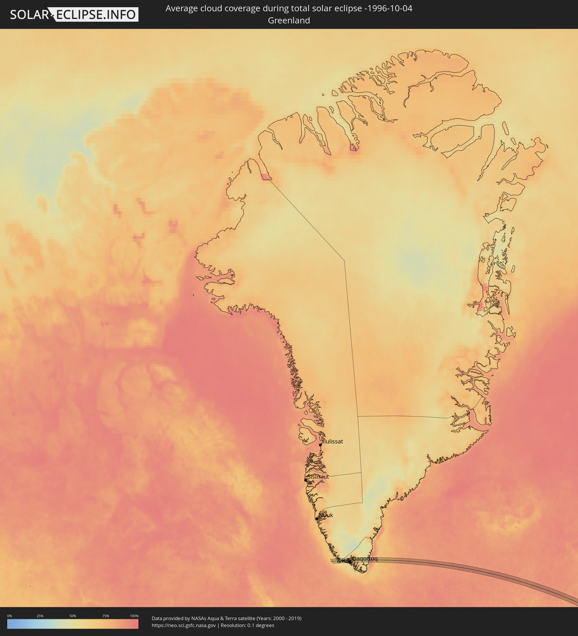
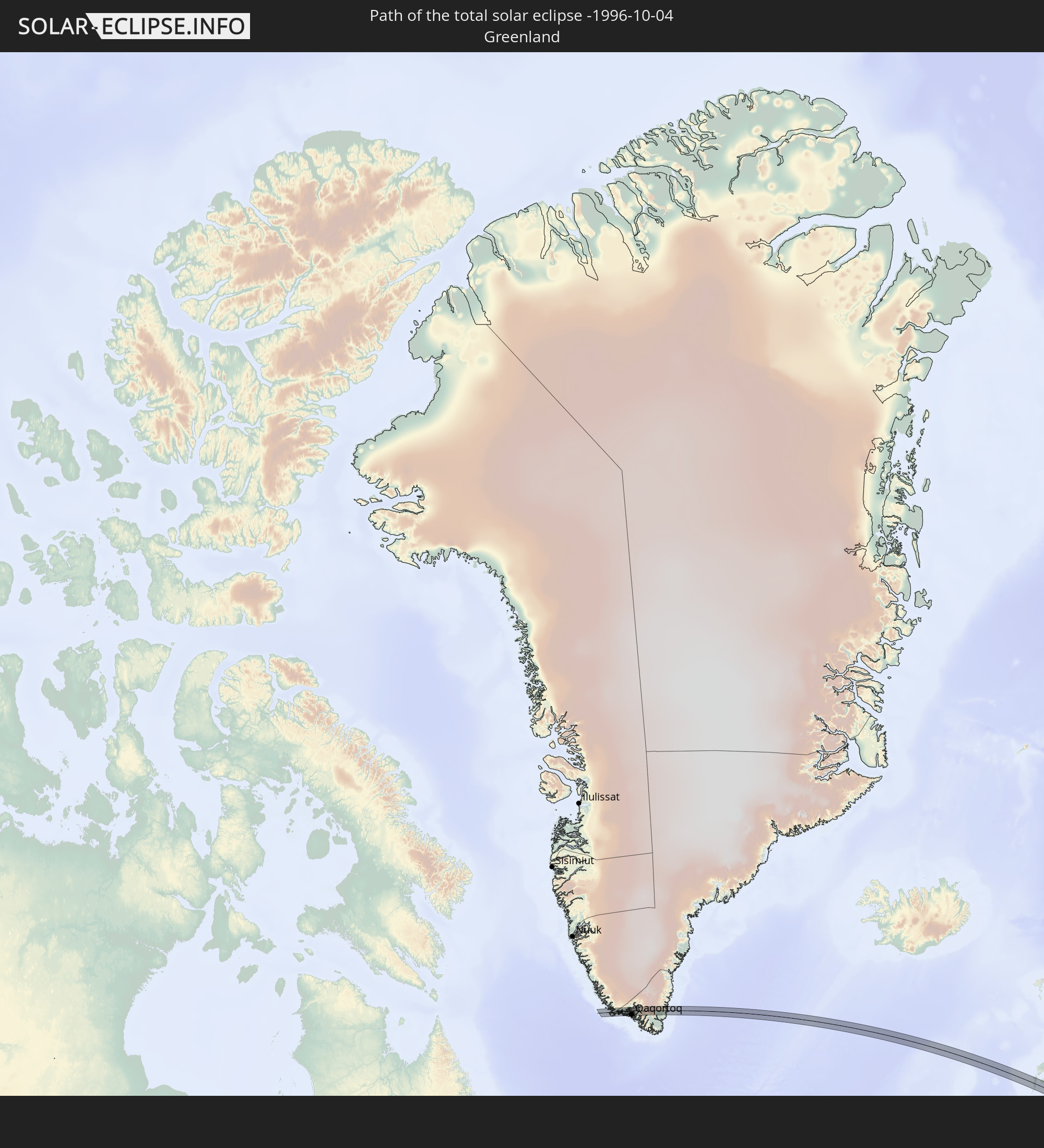 Greenland
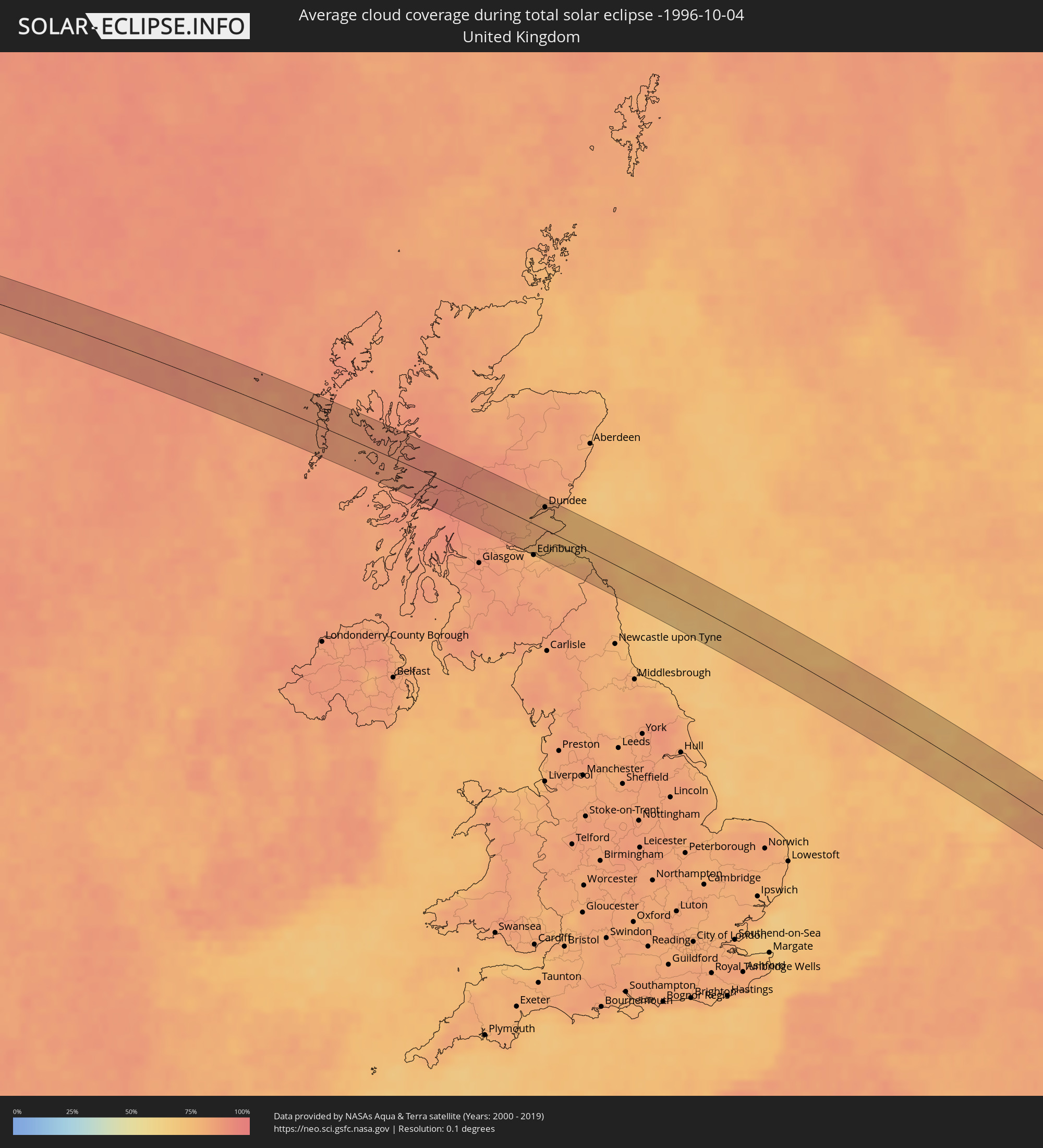
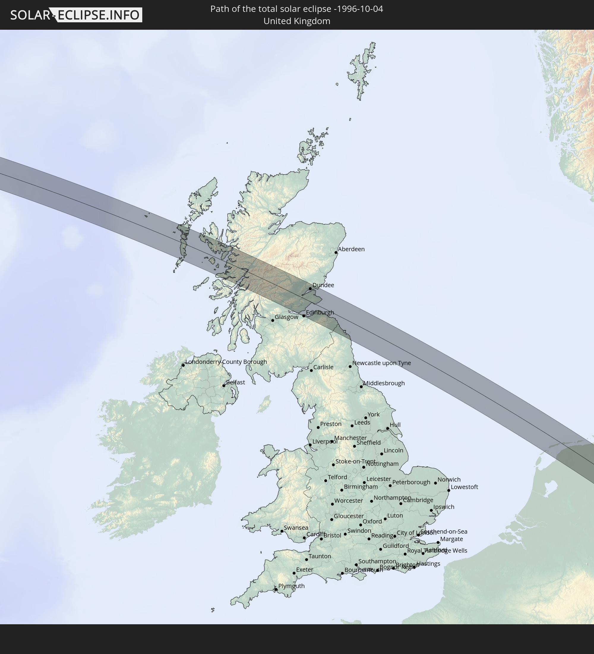 United Kingdom
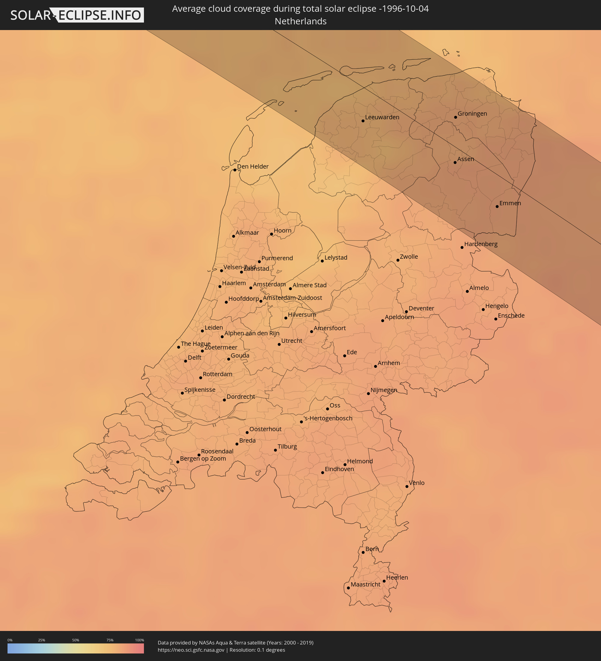
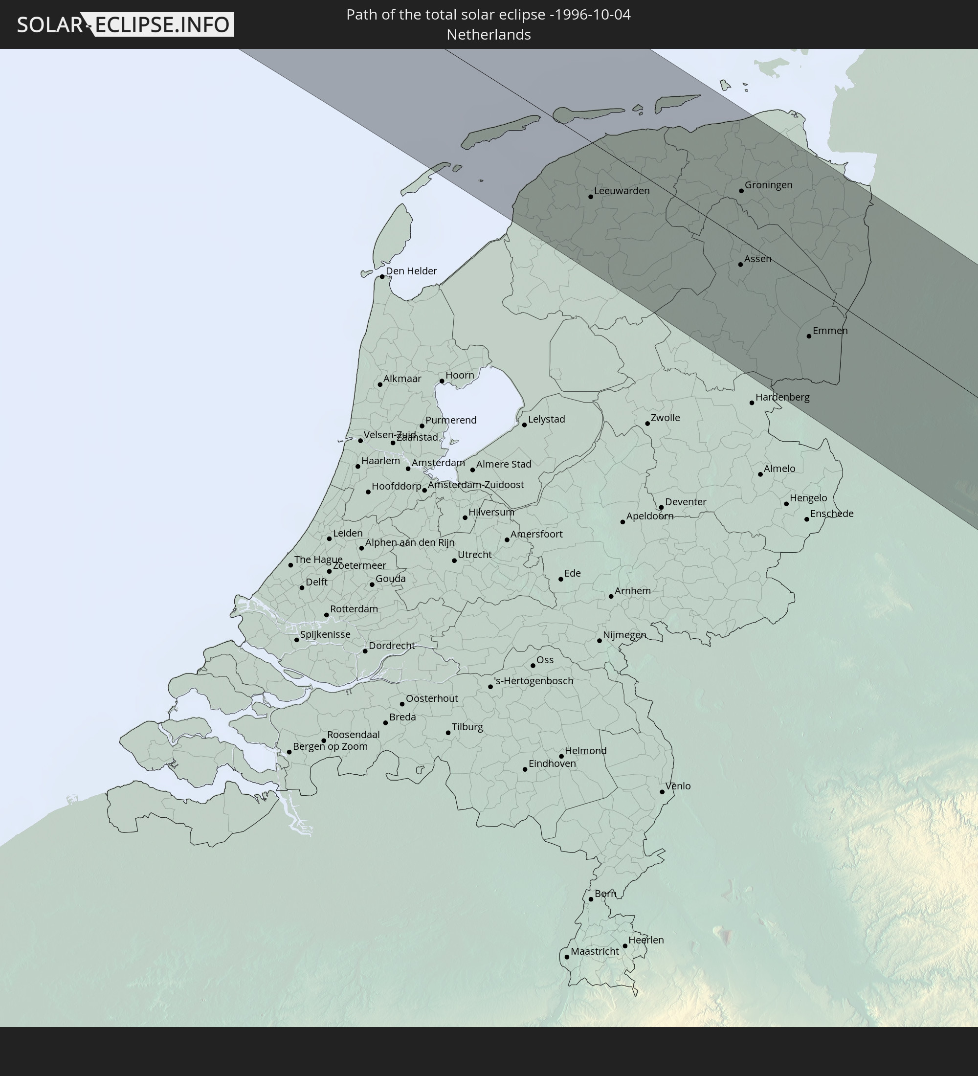 Netherlands
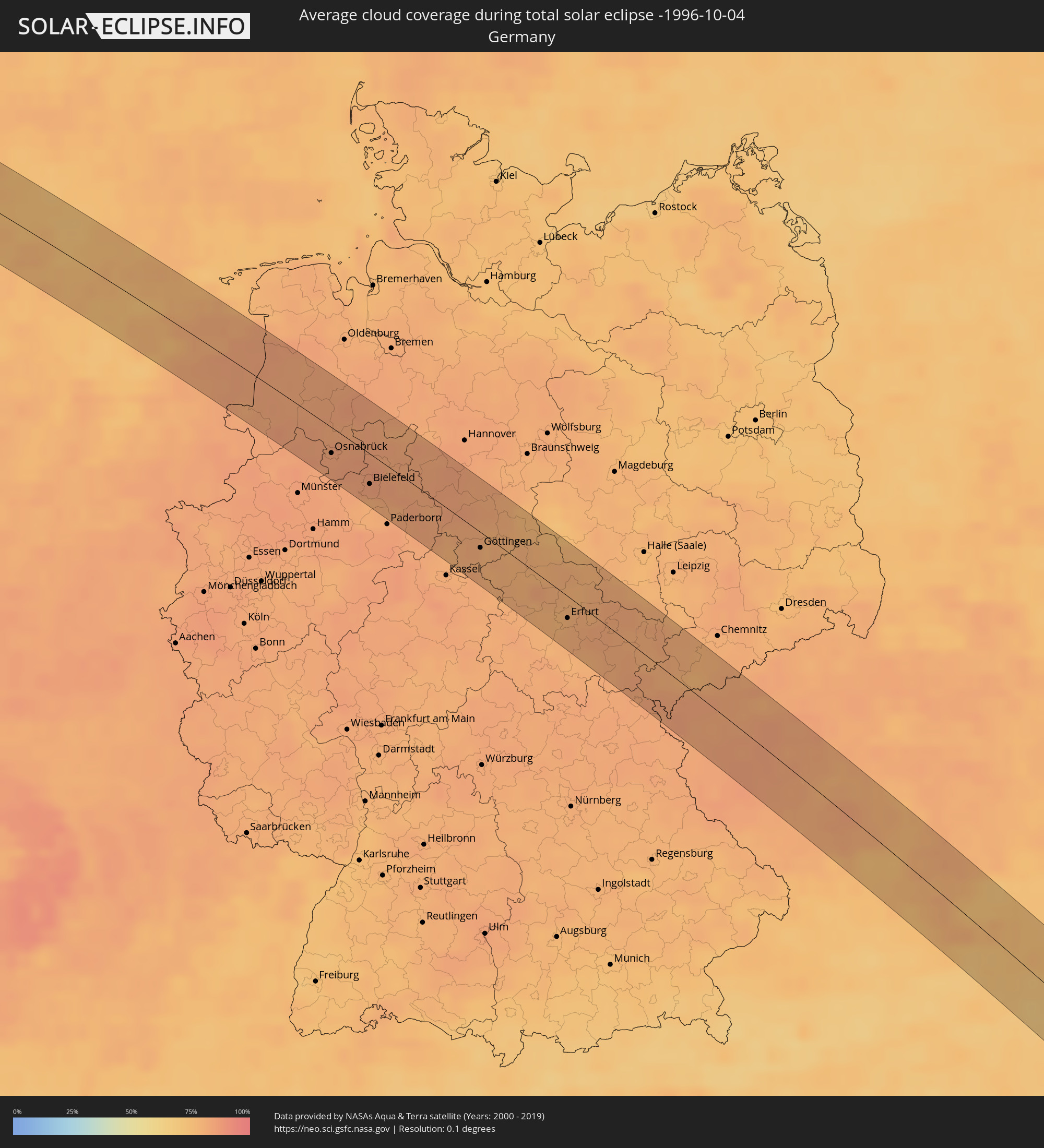
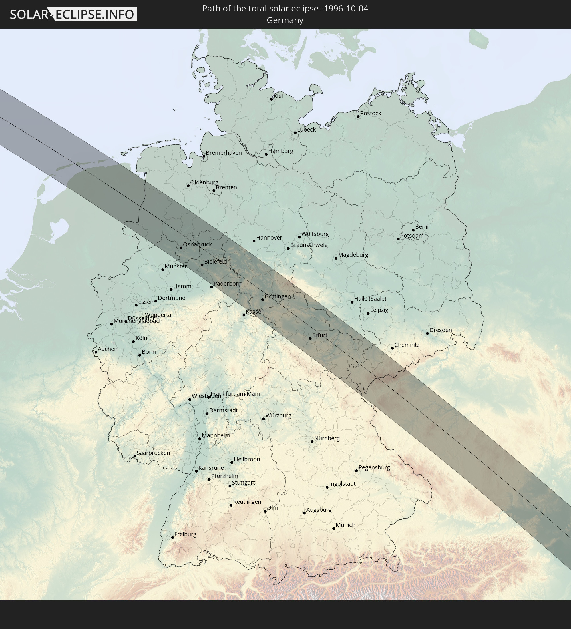 Germany
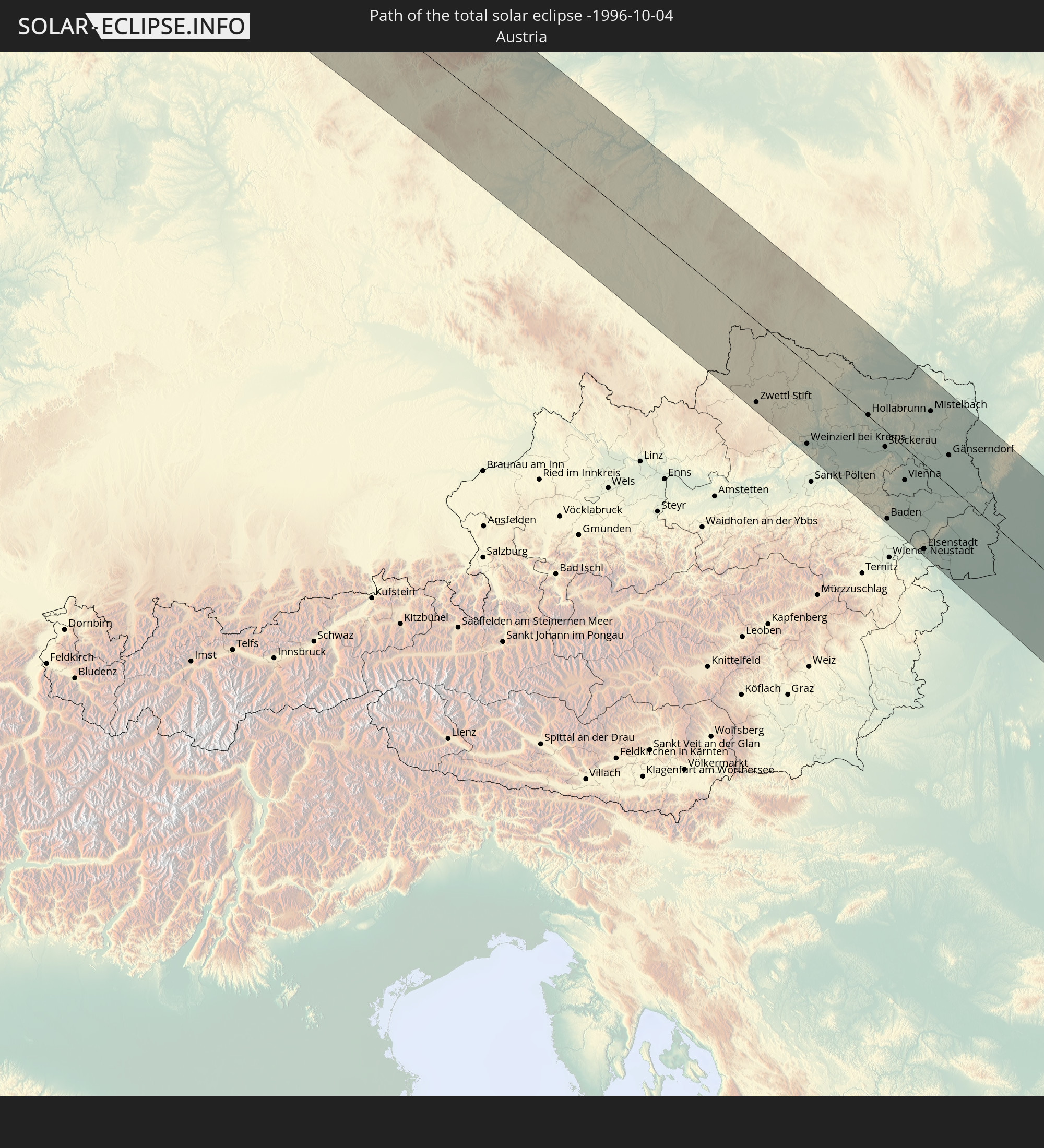 Austria
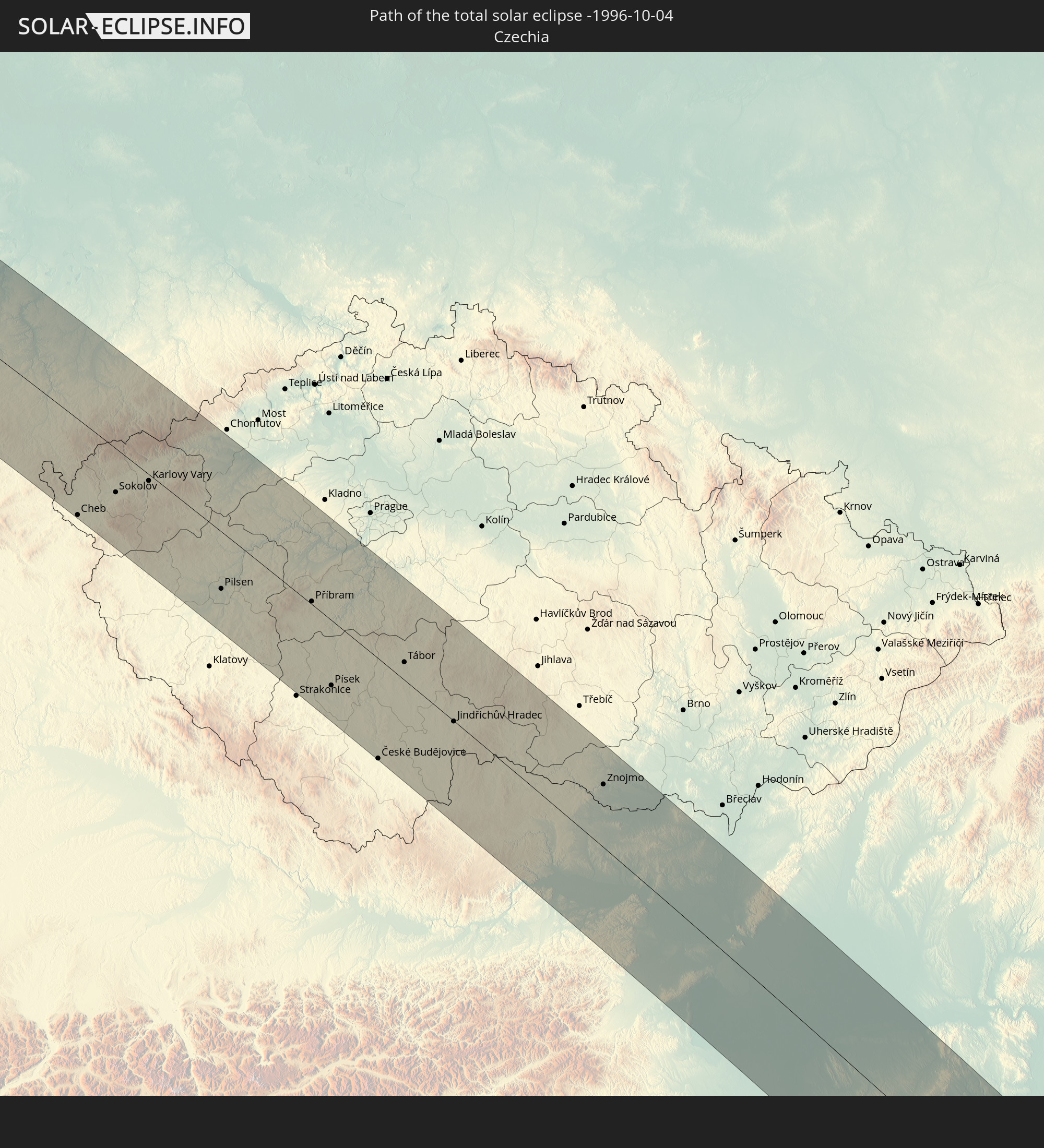 Czechia
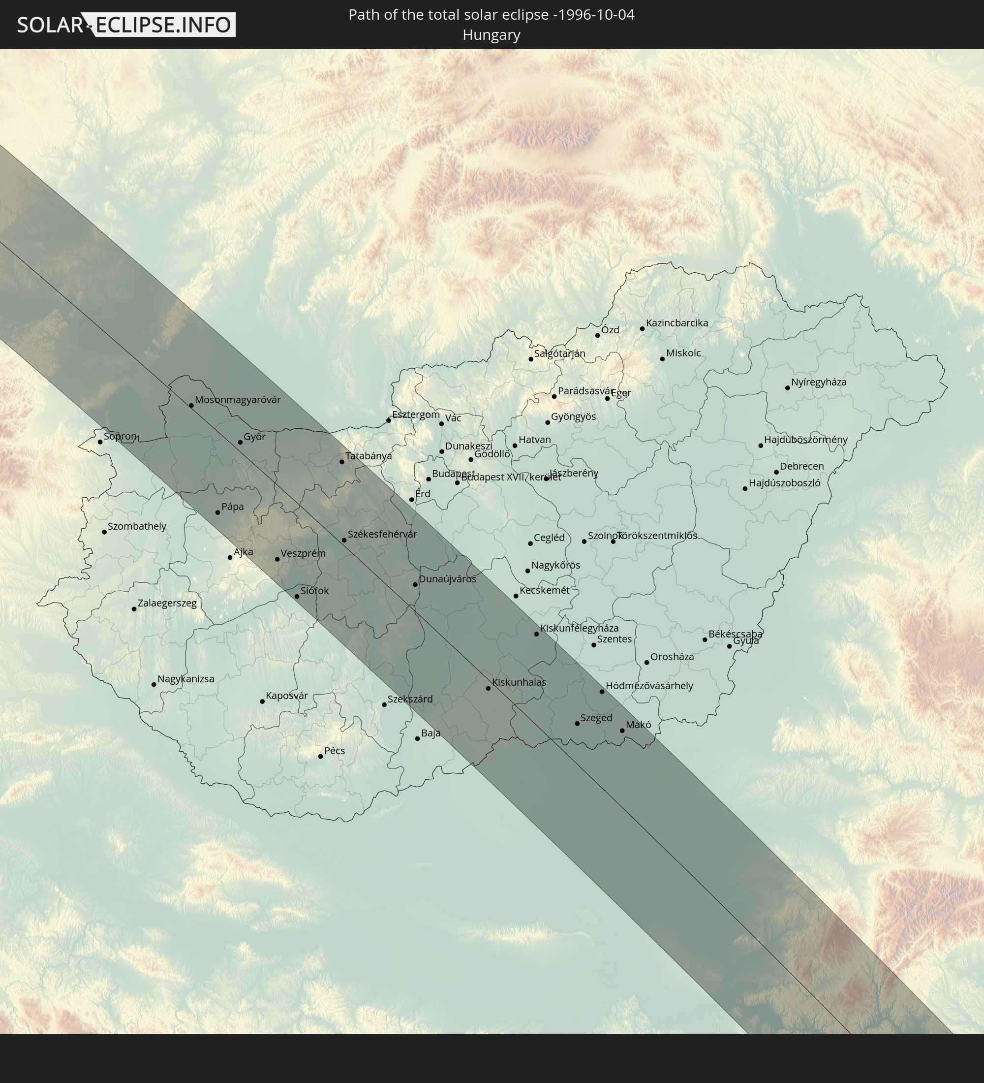 Hungary
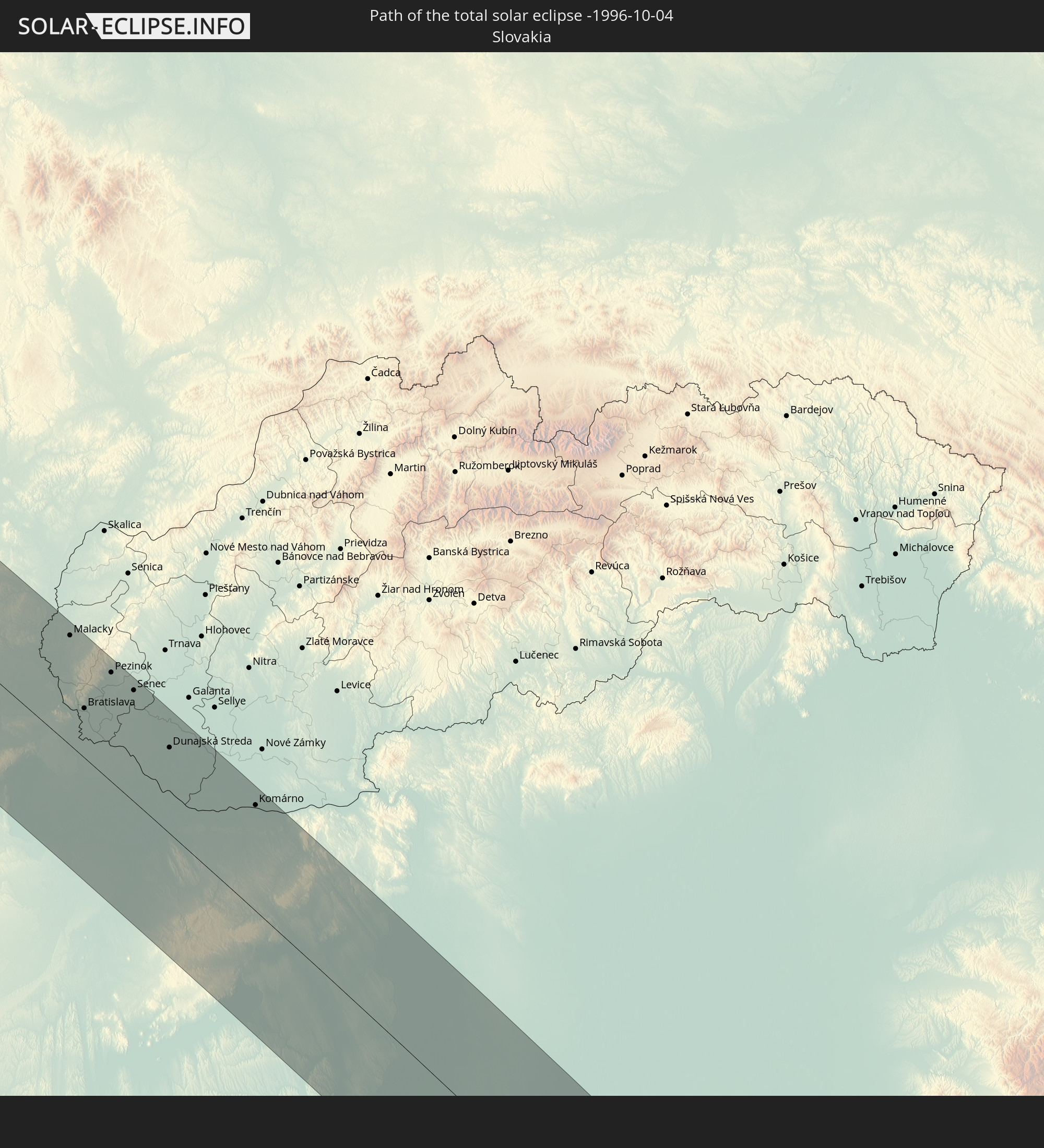 Slovakia
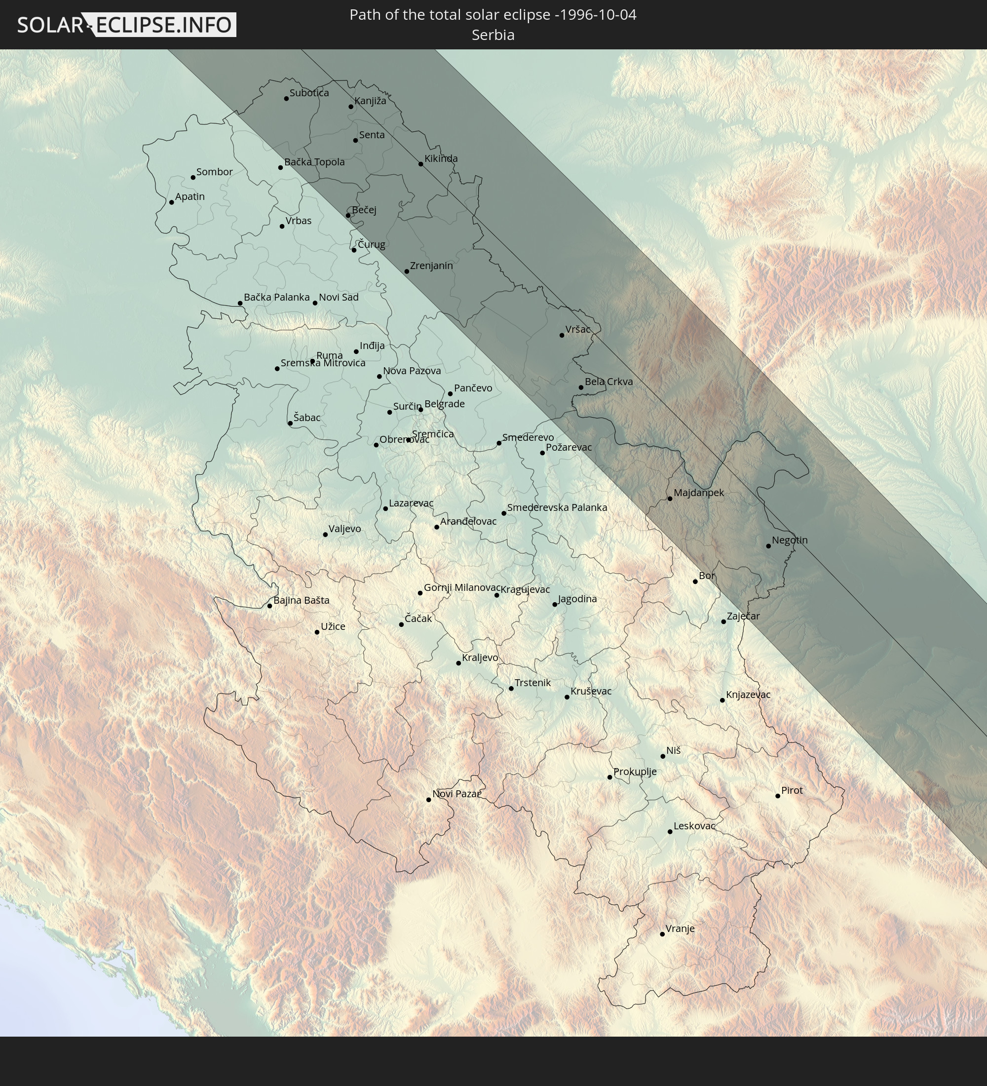 Serbia
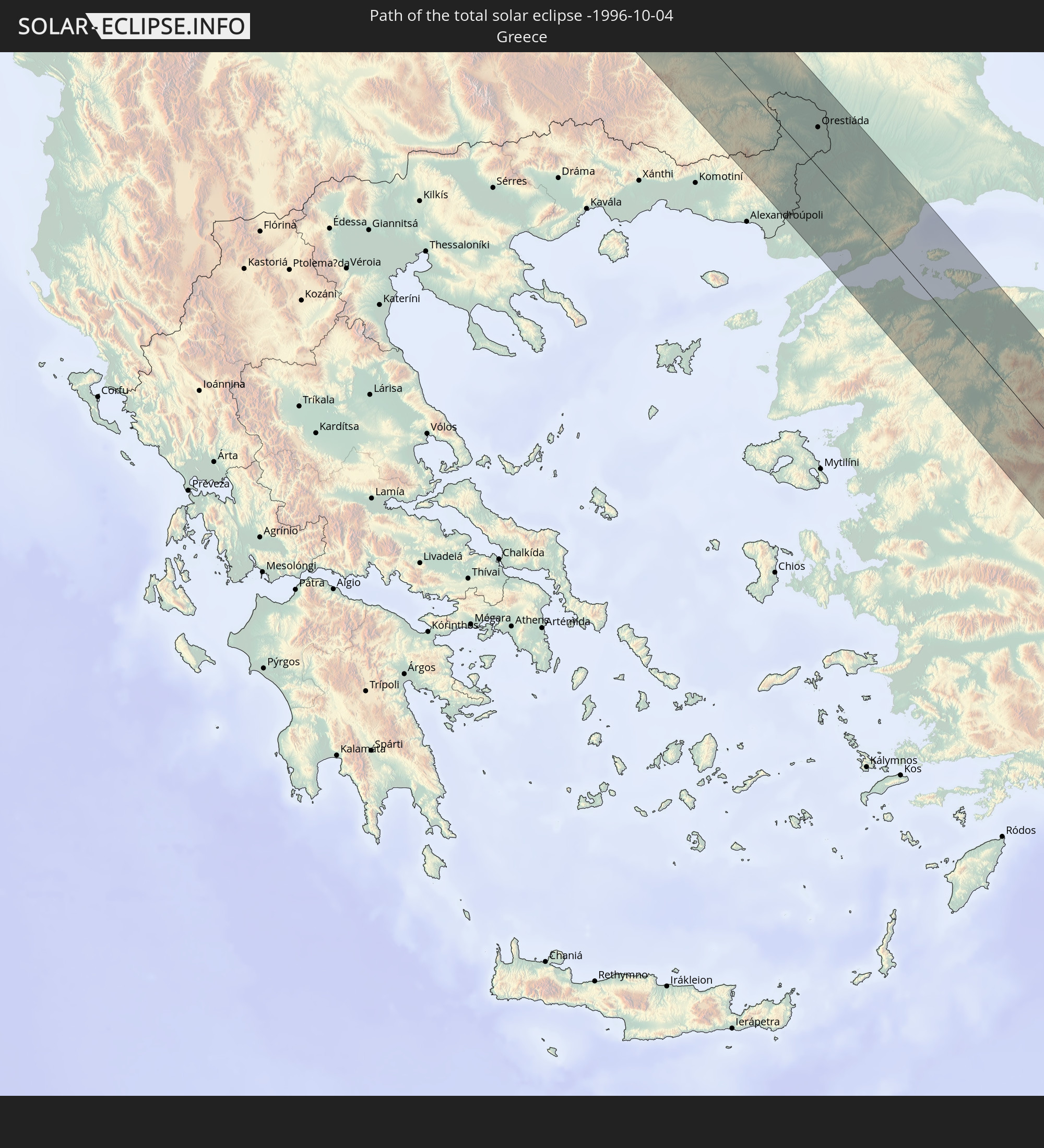 Greece
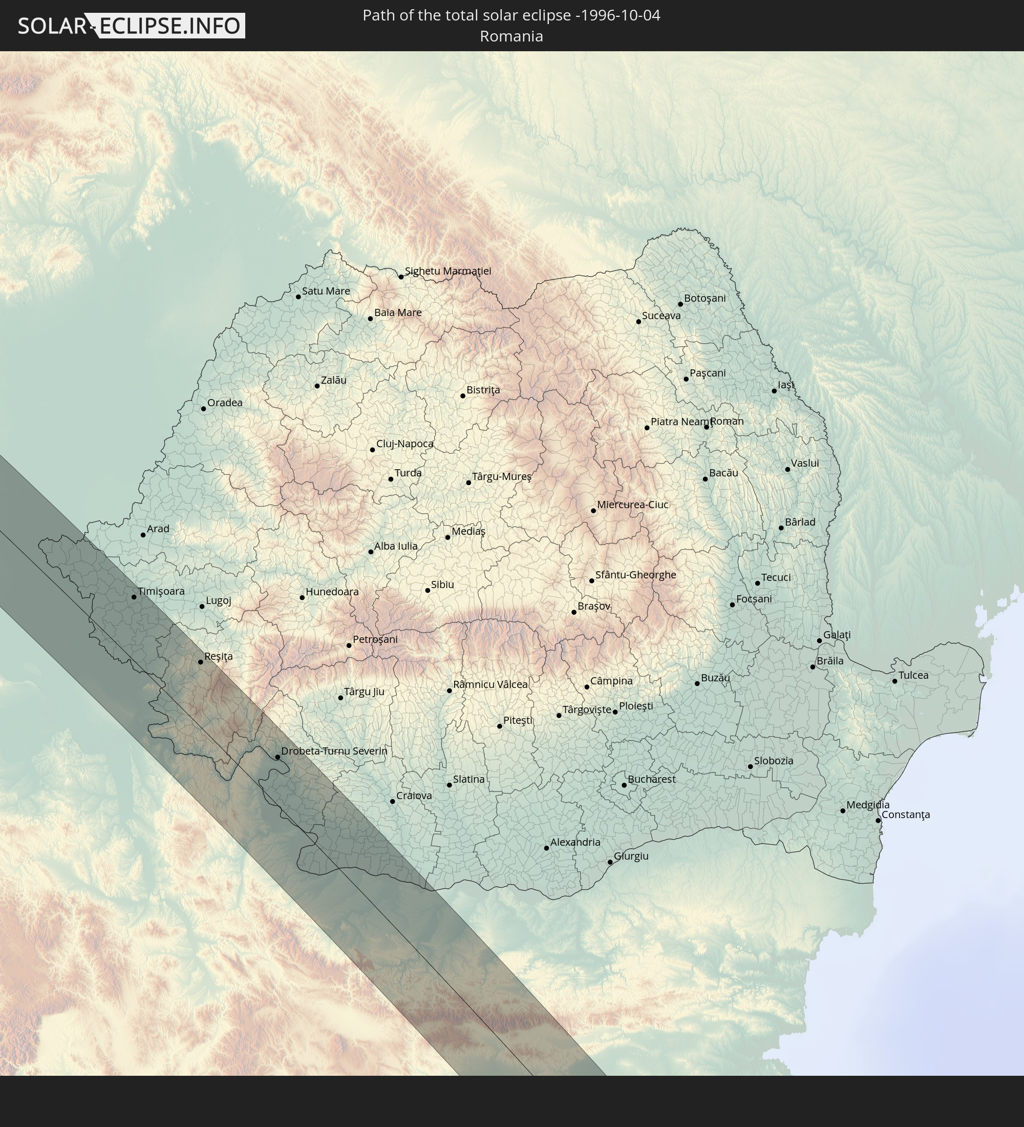 Romania
 Bulgaria
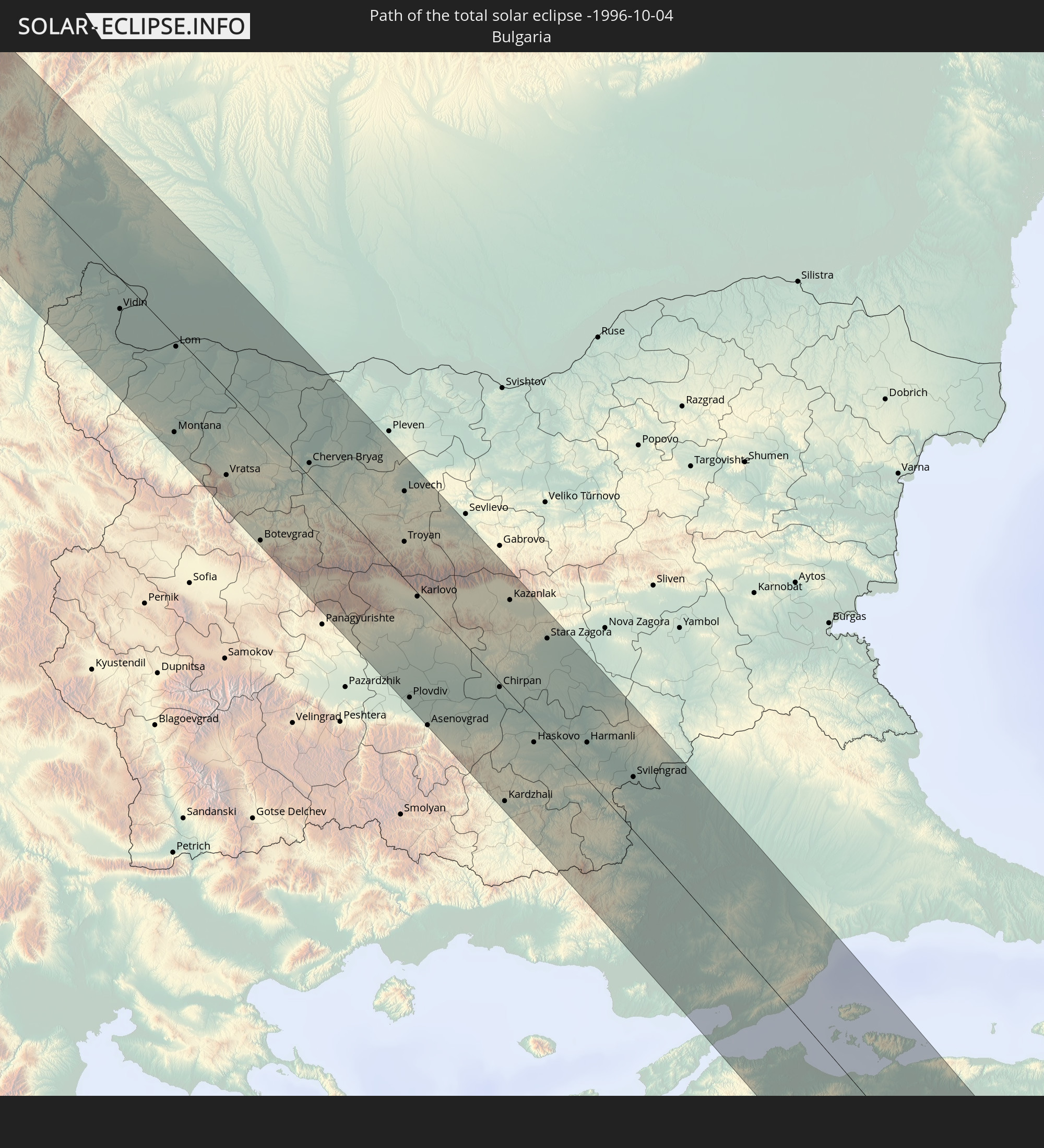
 Turkey
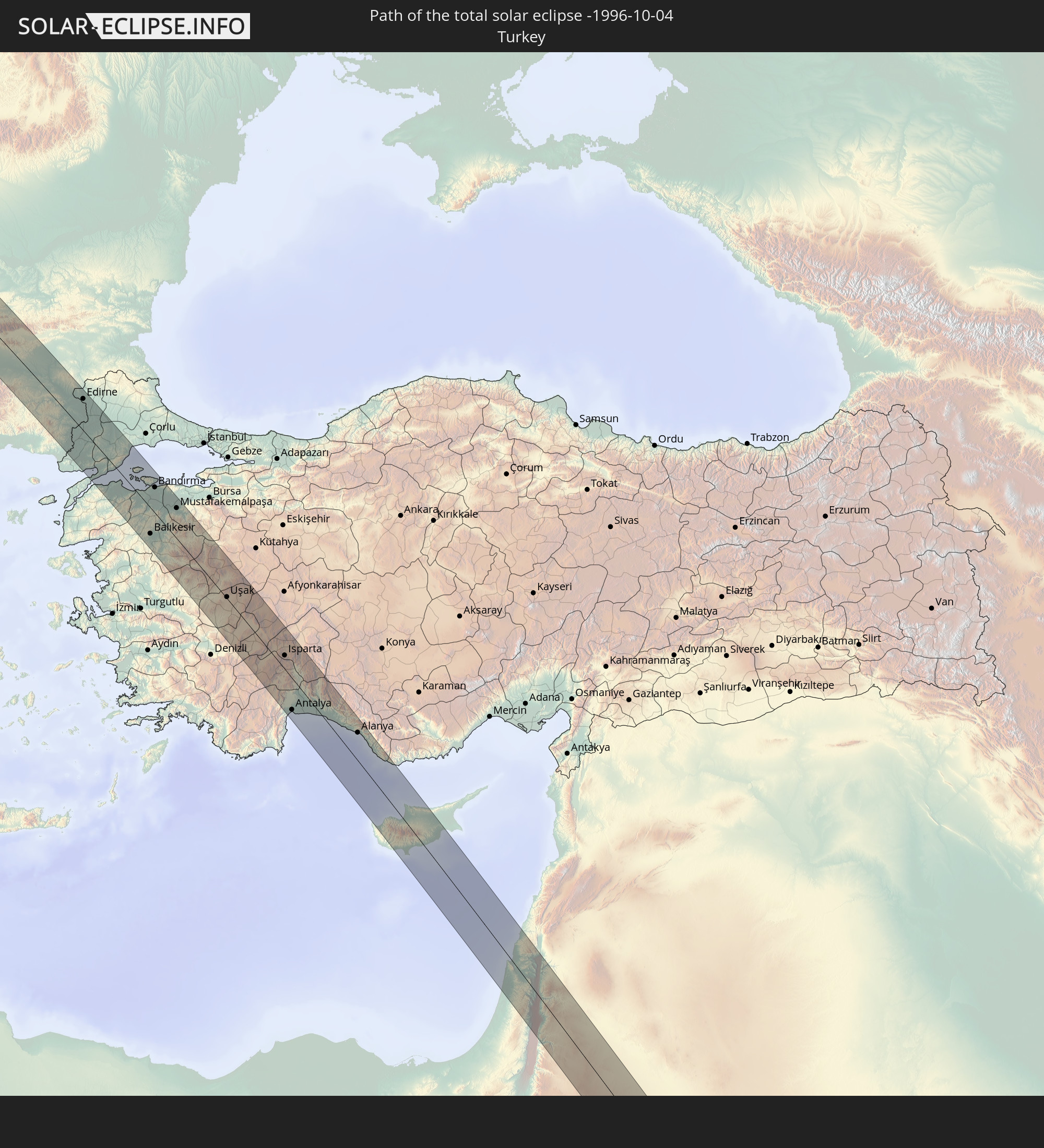
 Cyprus
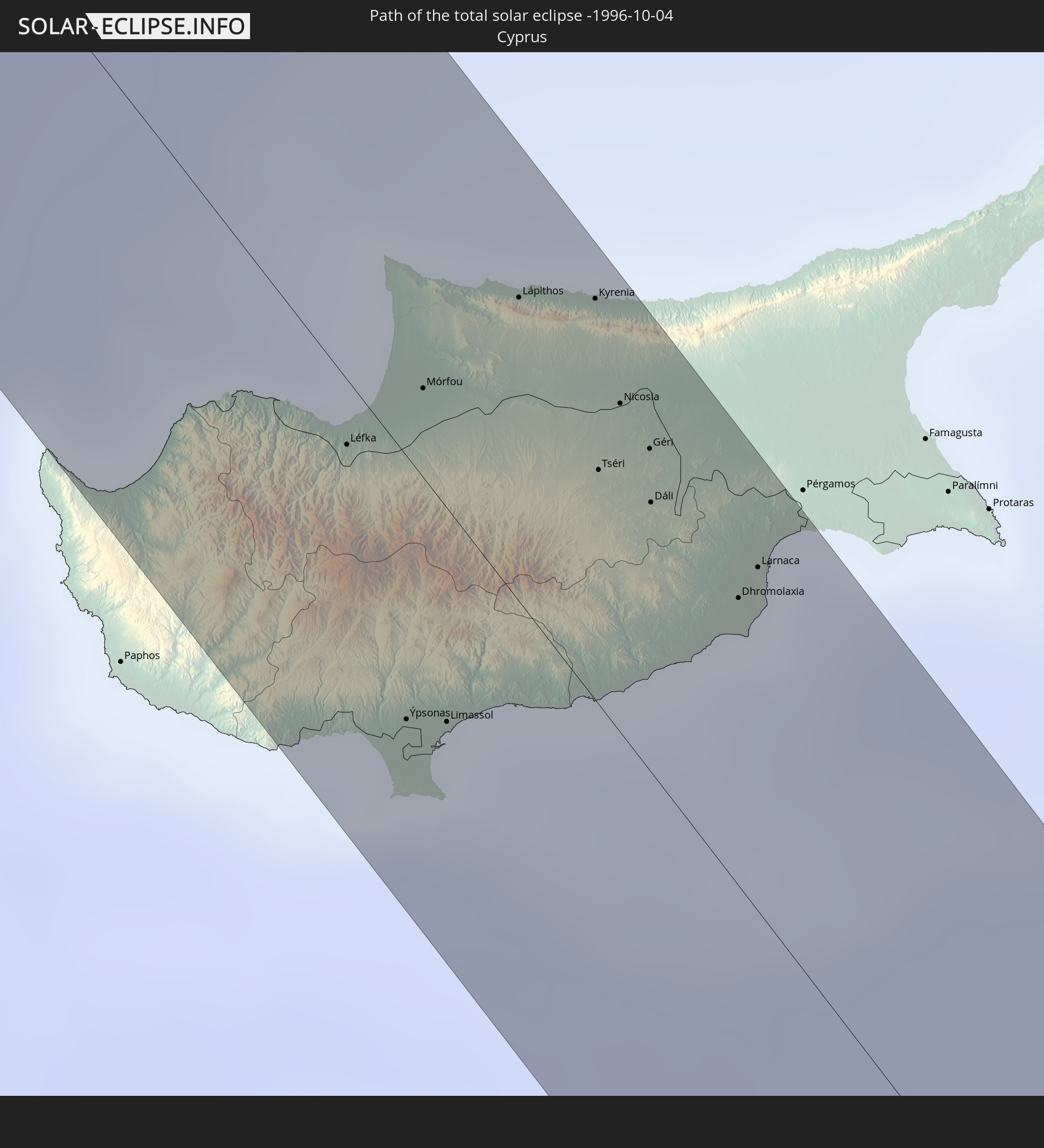
 State of Palestine
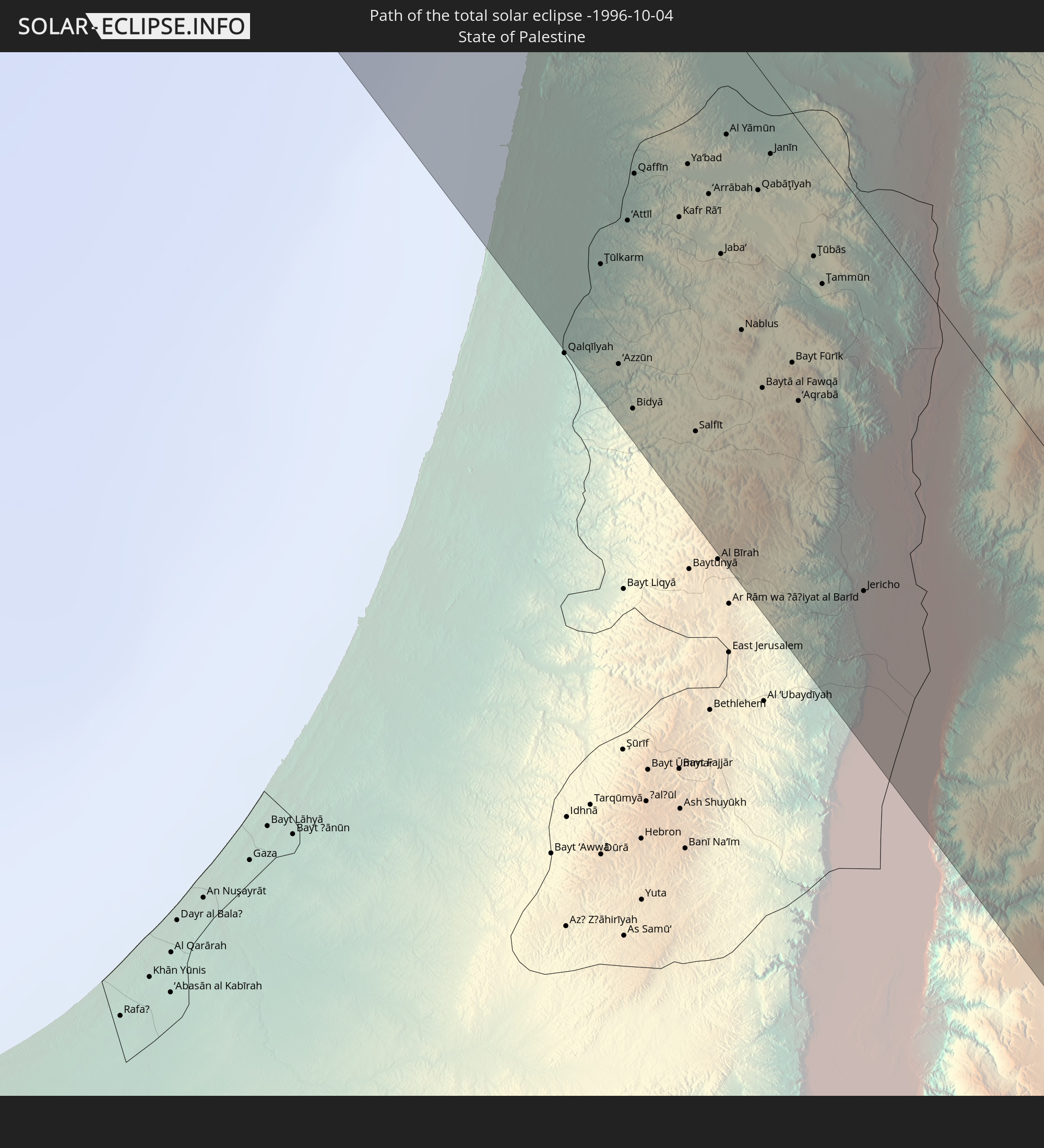
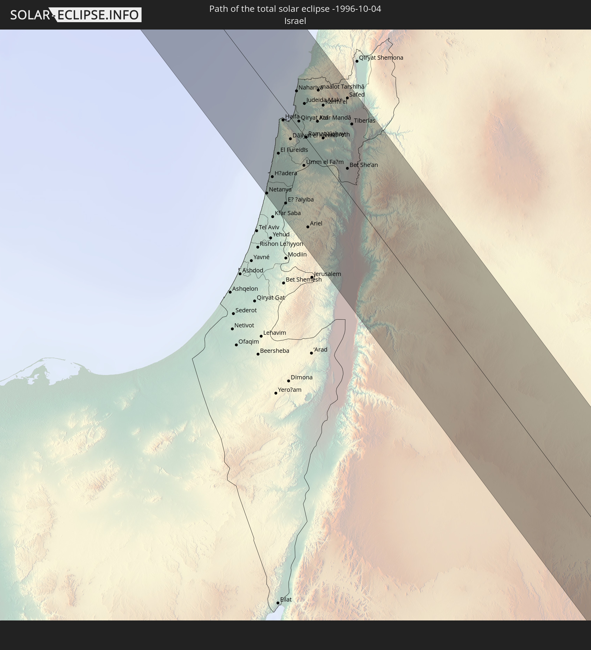 Israel
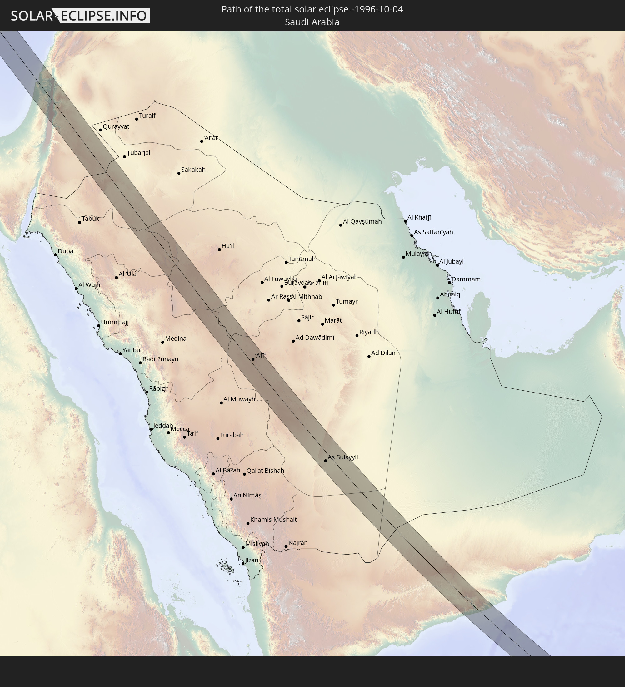 Saudi Arabia
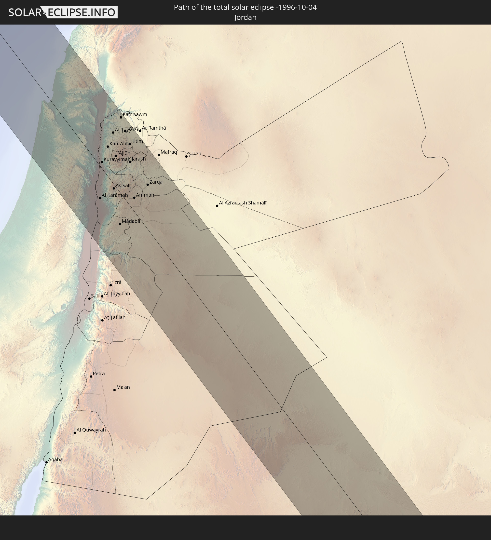 Jordan
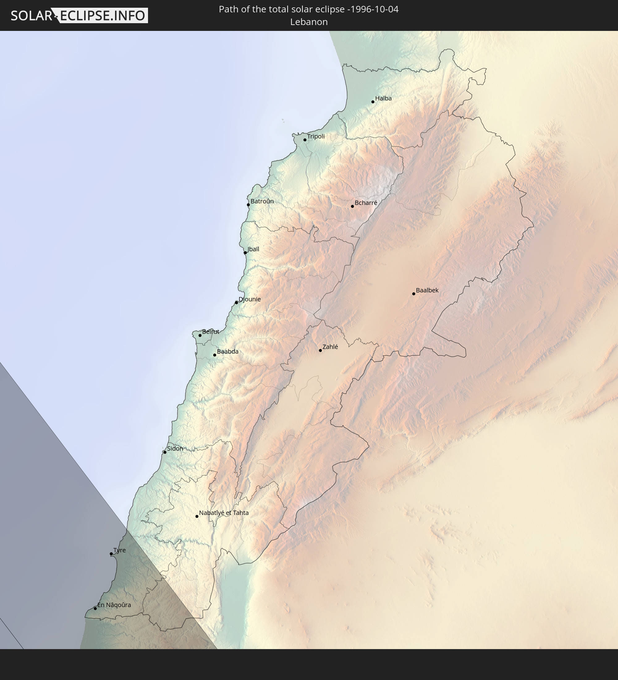 Lebanon
 Yemen
Yemen
 Maldives
In den folgenden Ländern ist die Sonnenfinsternis partiell zu sehen
 Russia
 Canada
 Greenland
 Portugal
 Iceland
 Spain
Spain
 Mauritania
 Morocco
 Mali
Mali
 Republic of Ireland
 Svalbard and Jan Mayen
 Algeria
 United Kingdom
 Faroe Islands
 Gibraltar
 France
 Isle of Man
 Guernsey
 Jersey
 Niger
Niger
 Andorra
 Belgium
 Nigeria
 Netherlands
 Norway
 Luxembourg
 Germany
 Switzerland
 Italy
Italy
 Monaco
 Tunisia
 Denmark
 Cameroon
 Libya
Libya
 Liechtenstein
 Austria
 Sweden
 Republic of the Congo
 Czechia
 Democratic Republic of the Congo
 San Marino
 Vatican City
 Slovenia
 Chad
Chad
 Croatia
 Poland
 Malta
Malta
 Central African Republic
 Bosnia and Herzegovina
 Hungary
 Slovakia
 Montenegro
 Serbia
 Albania
 Åland Islands
 Greece
 Romania
 Republic of Macedonia
 Finland
 Lithuania
 Latvia
 Estonia
 Sudan
Sudan
 Zambia
 Ukraine
 Bulgaria
 Belarus
 Egypt
Egypt
 Turkey
 Moldova
 Rwanda
 Burundi
 Tanzania
 Uganda
 Mozambique
 Cyprus
 Malawi
 Ethiopia
 Kenya
Kenya
 State of Palestine
 Israel
 Saudi Arabia
 Jordan
 Lebanon
 Syria
Syria
 Eritrea
 Iraq
Iraq
 Georgia
 French Southern and Antarctic Lands
 Somalia
 Djibouti
 Yemen
Yemen
 Madagascar
 Comoros
 Armenia
 Iran
Iran
 Azerbaijan
 Mayotte
 Seychelles
 Kazakhstan
 Kuwait
 Bahrain
 Qatar
Qatar
 United Arab Emirates
 Oman
Oman
 Turkmenistan
 Réunion
 Uzbekistan
 Mauritius
 Afghanistan
 Pakistan
 Tajikistan
 India
India
 Kyrgyzstan
 British Indian Ocean Territory
 Maldives
 China
China
 Sri Lanka
 Nepal
Nepal
 Mongolia
 Bangladesh
 Bhutan
 Myanmar
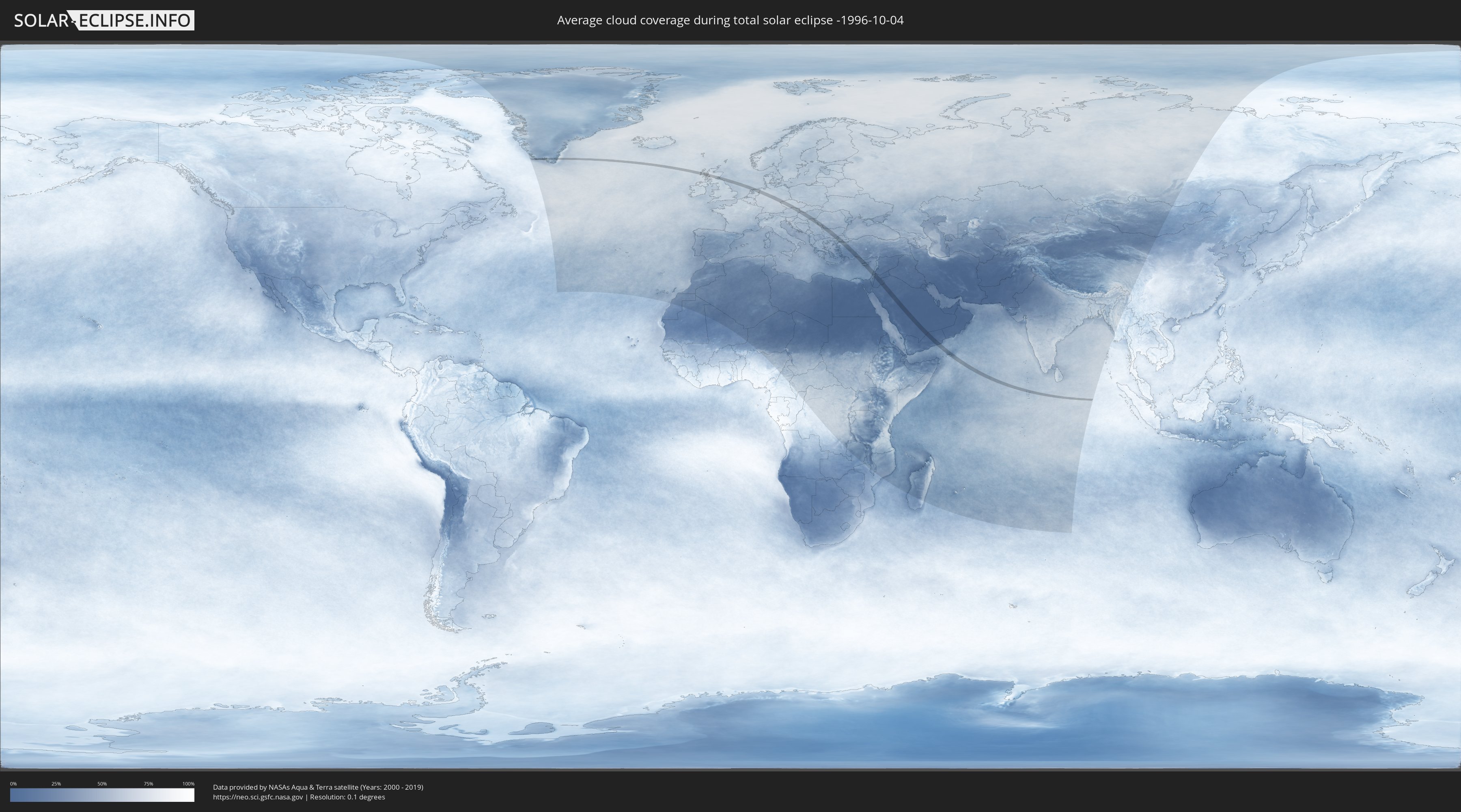
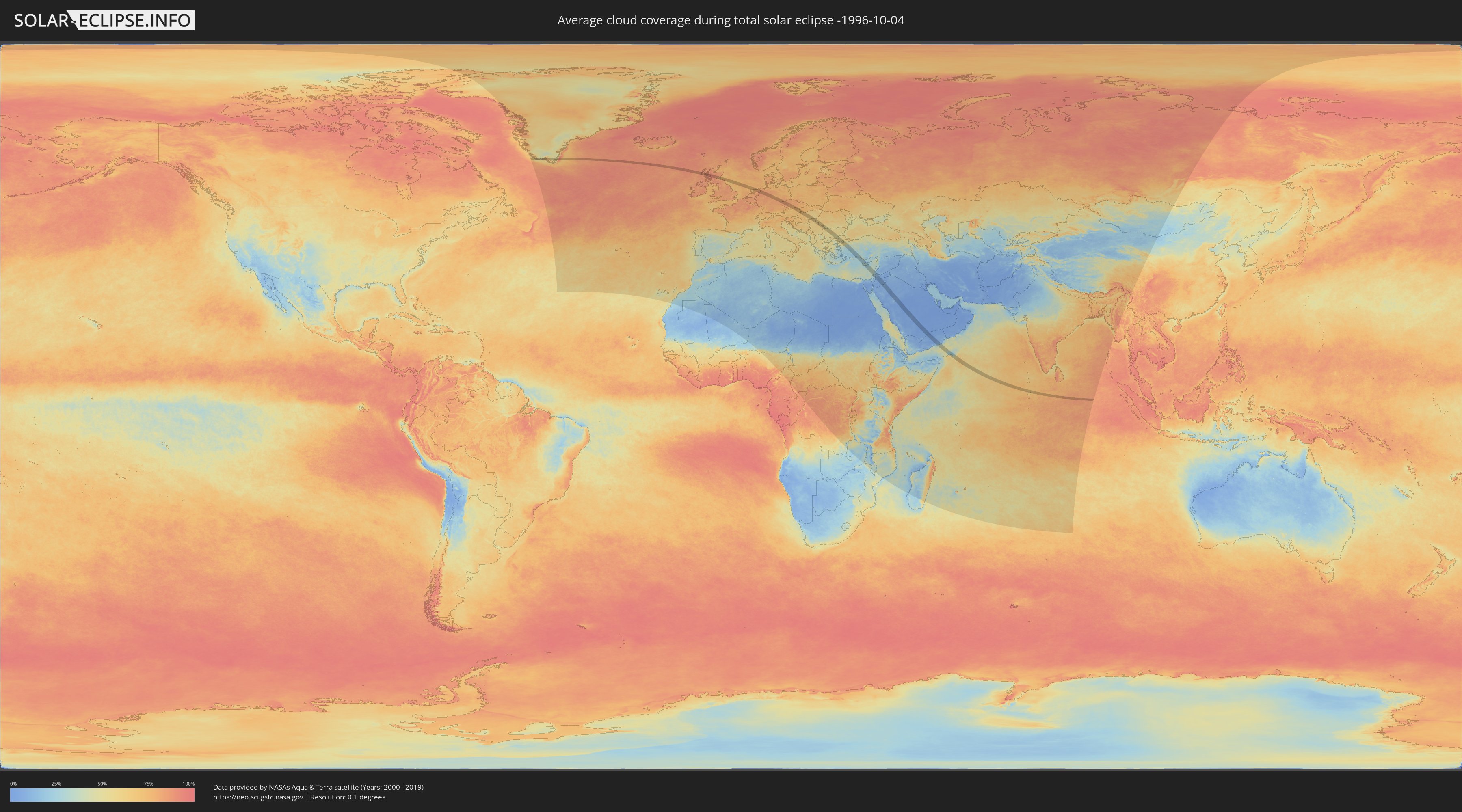
How will be the weather during the total solar eclipse on 10/04/-1996?
Where is the best place to see the total solar eclipse of 10/04/-1996?
The following maps show the average cloud coverage for the day of the total solar eclipse.
With the help of these maps, it is possible to find the place along the eclipse path, which has the best
chance of a cloudless sky.
Nevertheless, you should consider local circumstances and inform about the weather of your chosen
observation site.
The data is provided by NASAs satellites
AQUA and TERRA.
The cloud maps are averaged over a period of 19 years (2000 - 2019).
Detailed country maps
 Greenland
 United Kingdom
 Netherlands
 Germany
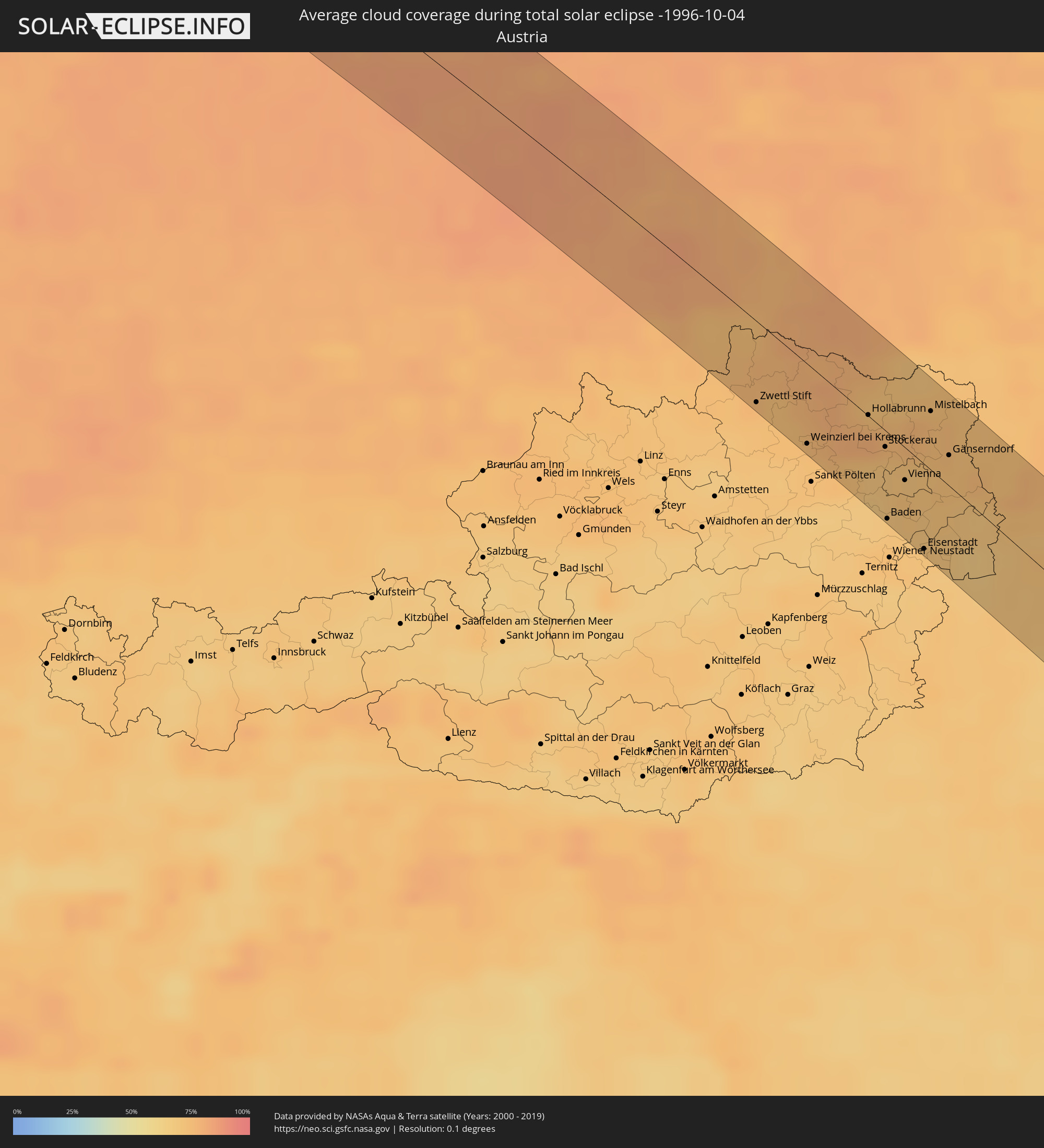 Austria
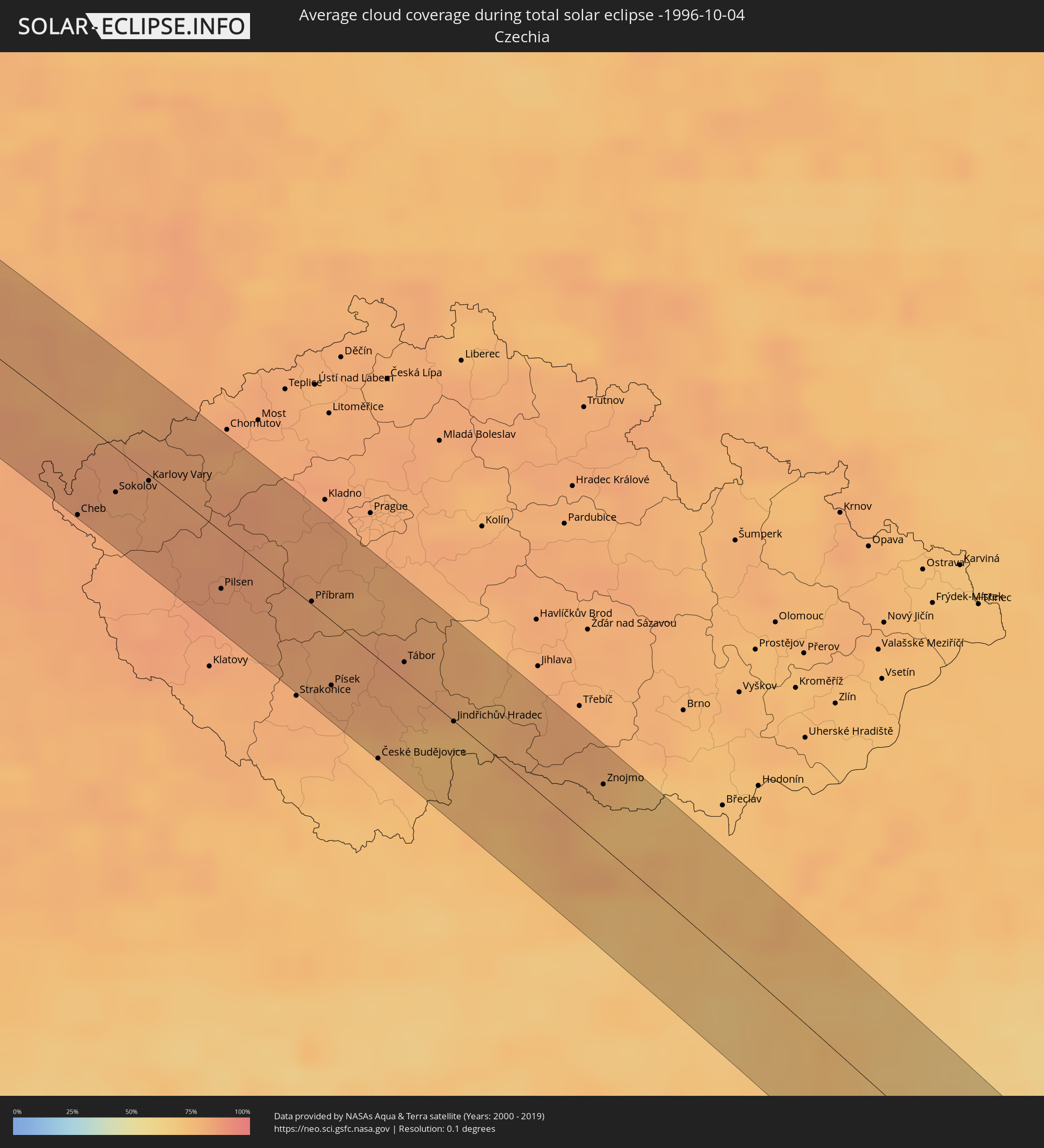 Czechia
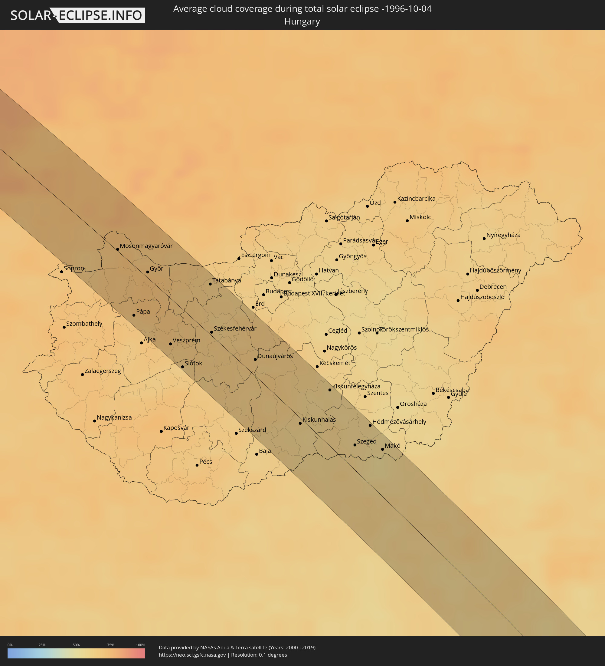 Hungary
 Slovakia
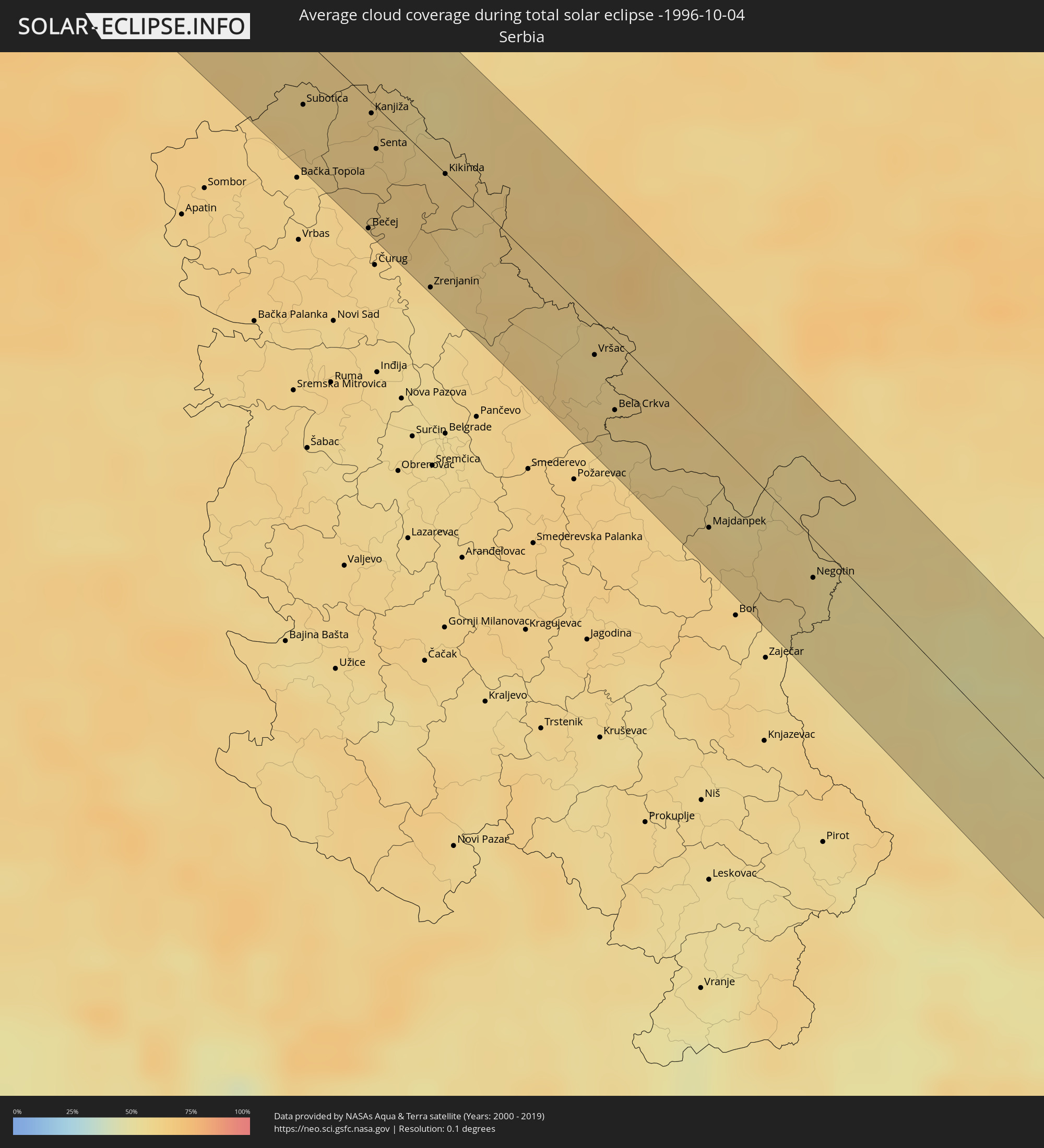 Serbia
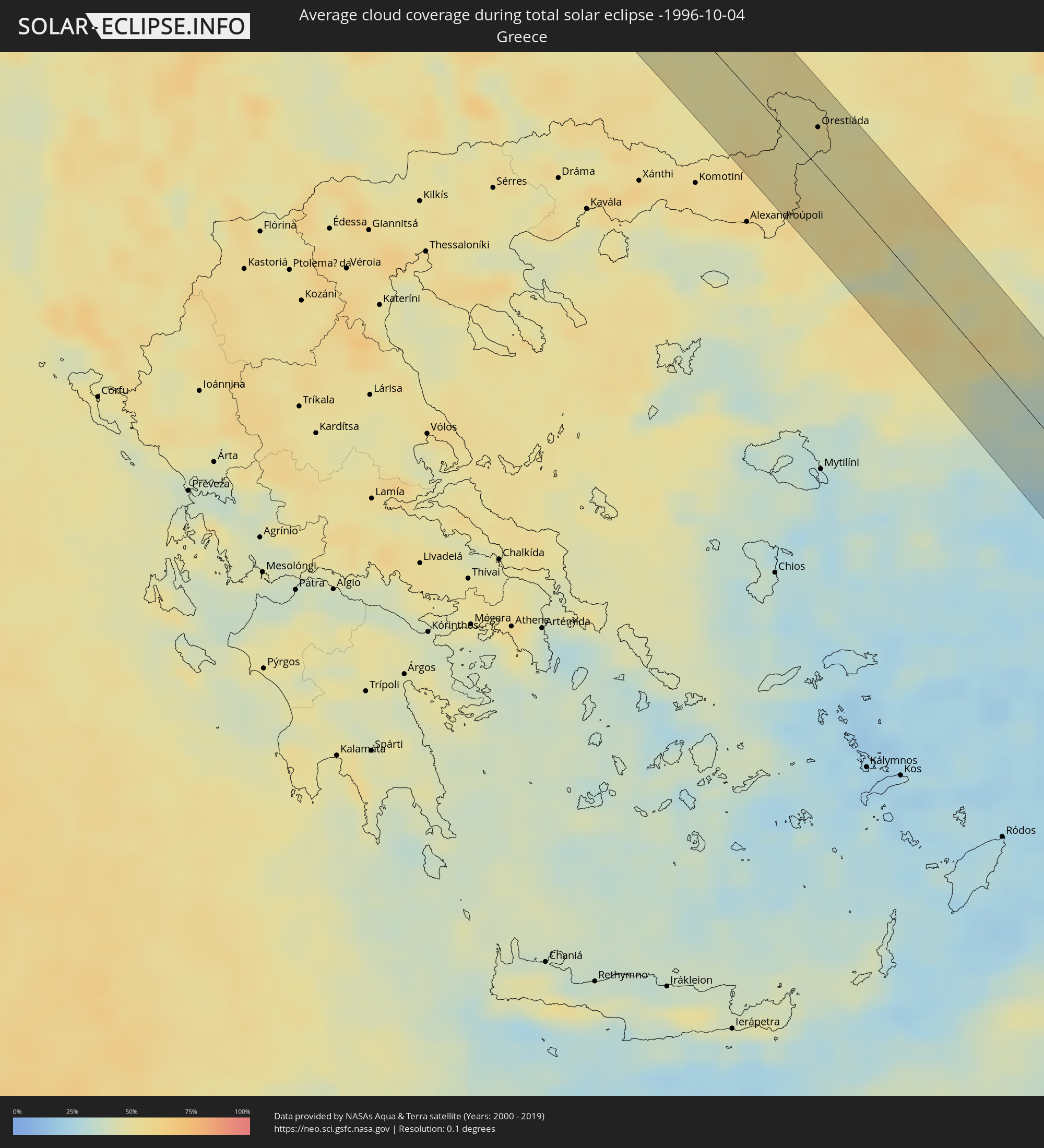 Greece
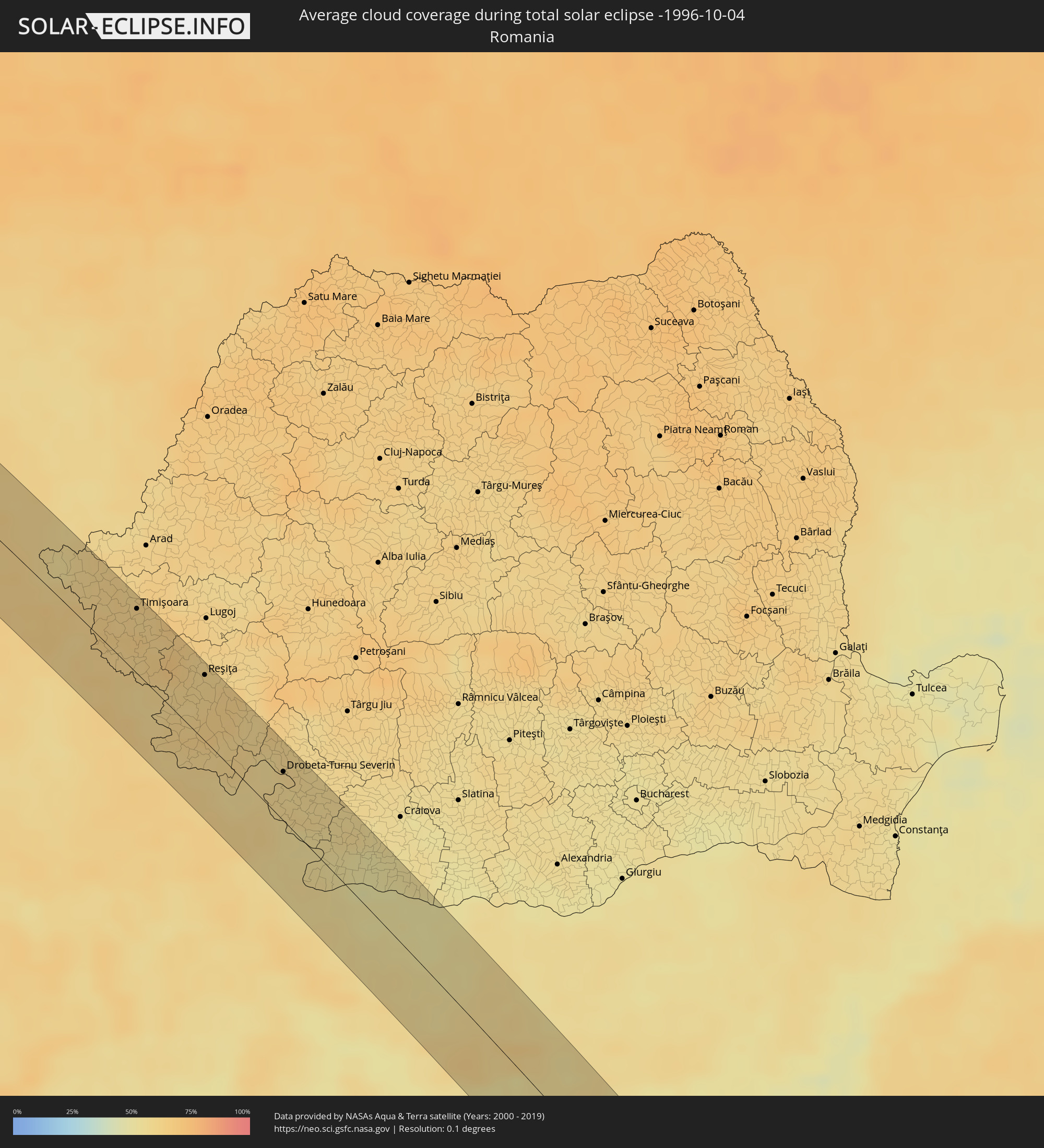 Romania
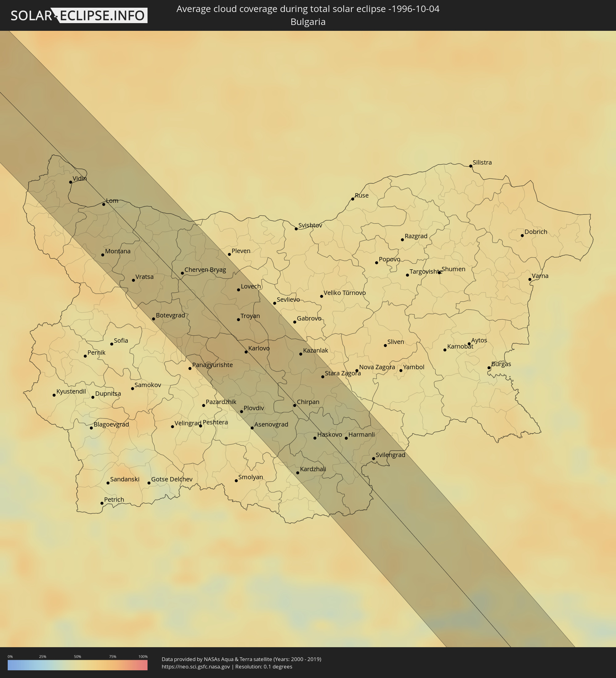 Bulgaria
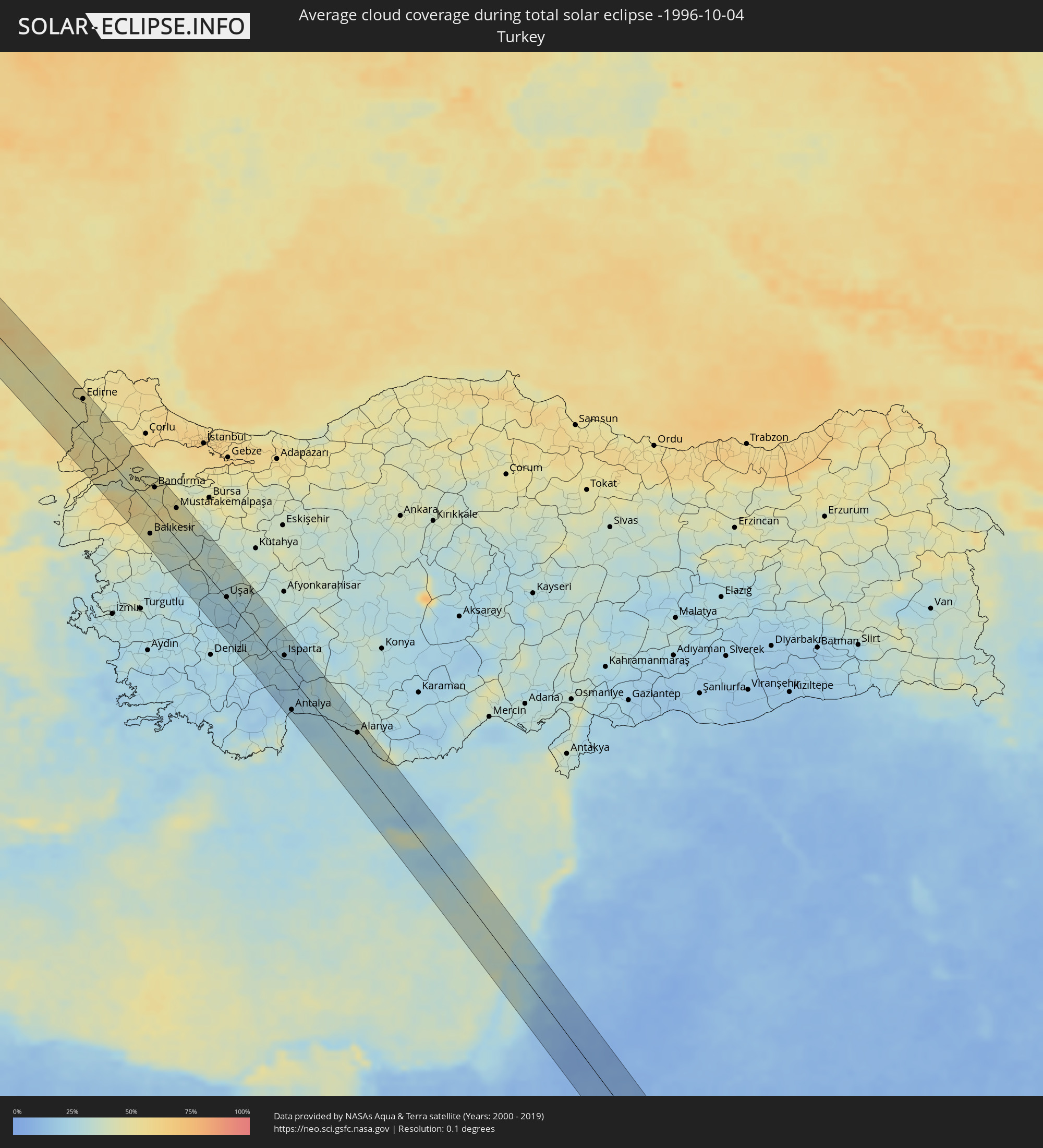 Turkey
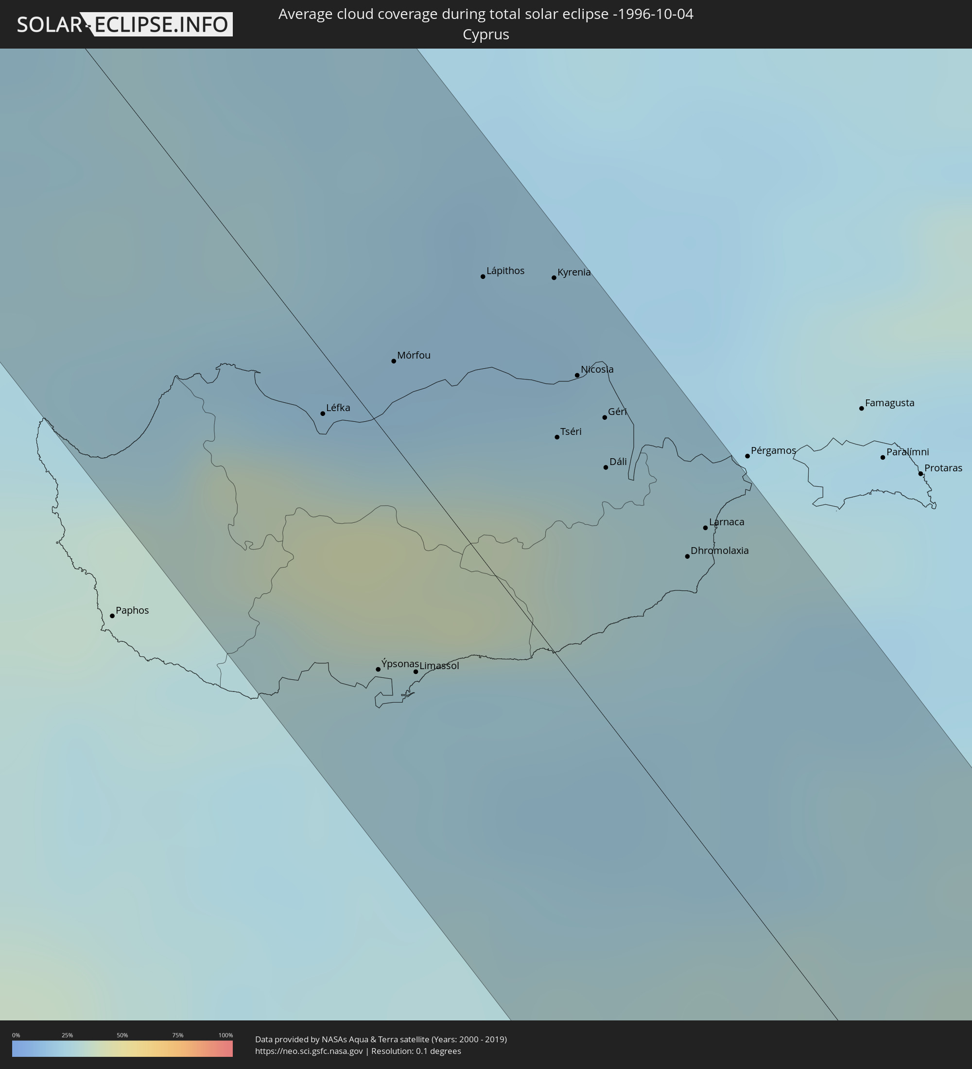 Cyprus
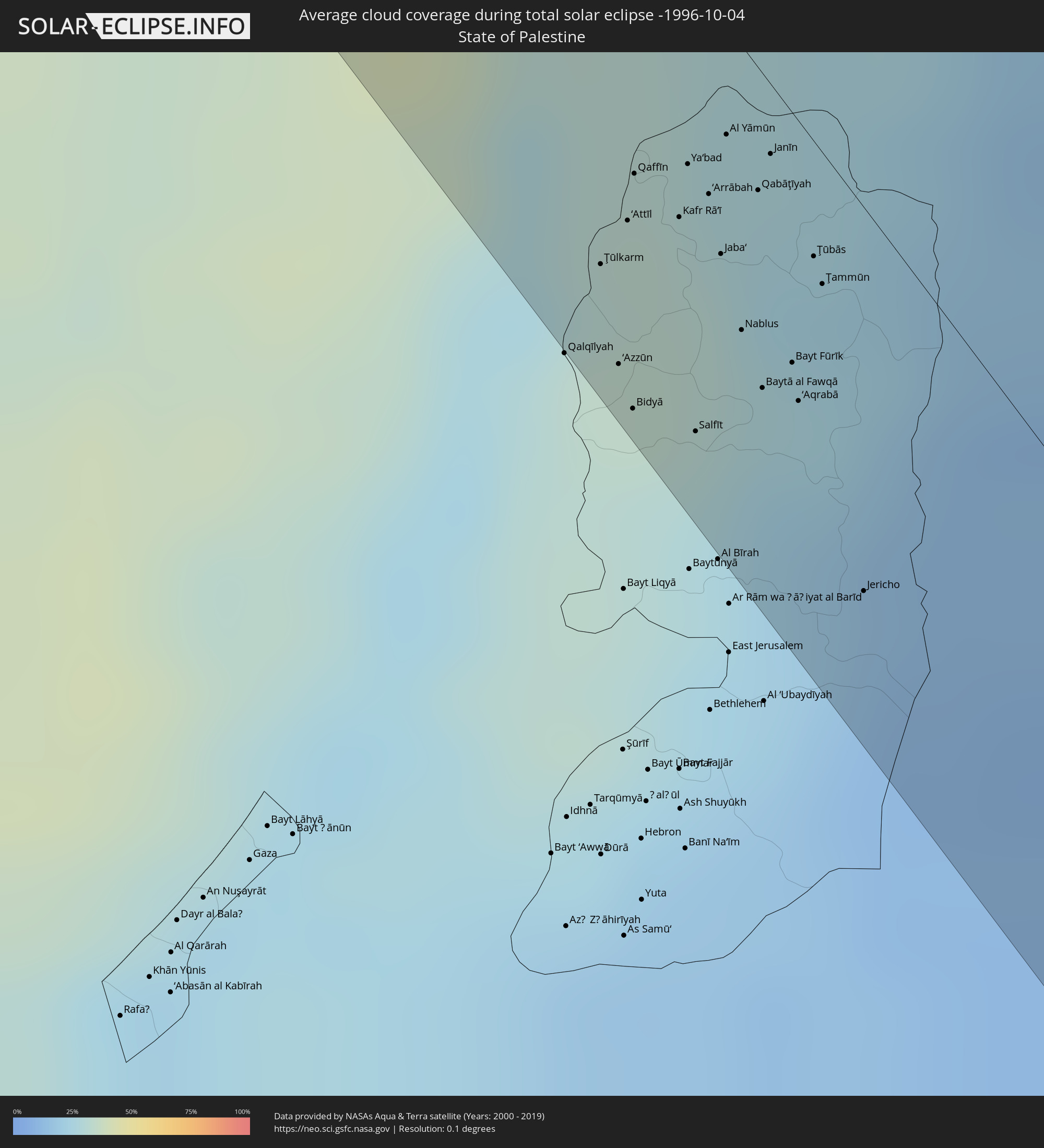 State of Palestine
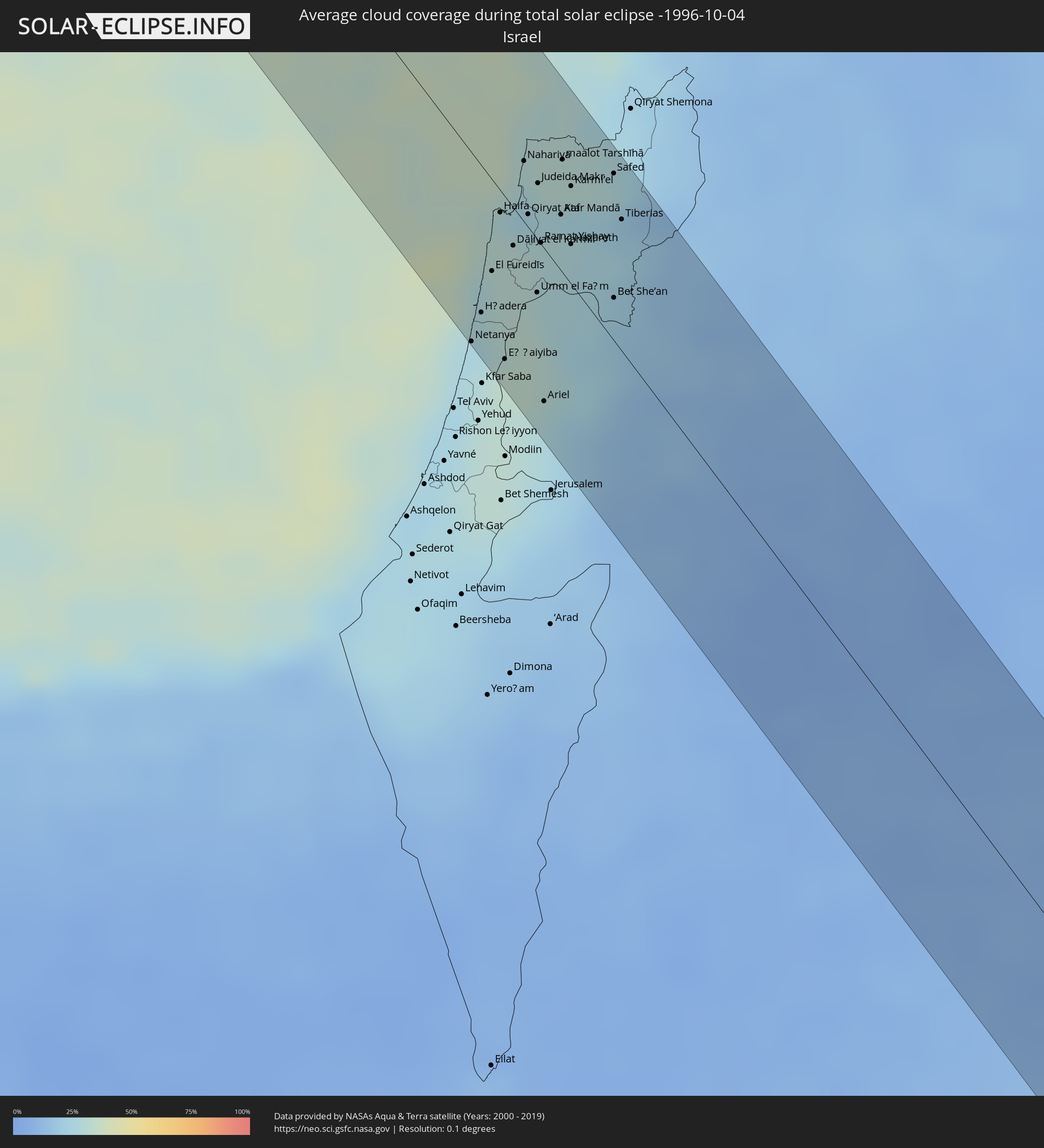 Israel
 Saudi Arabia
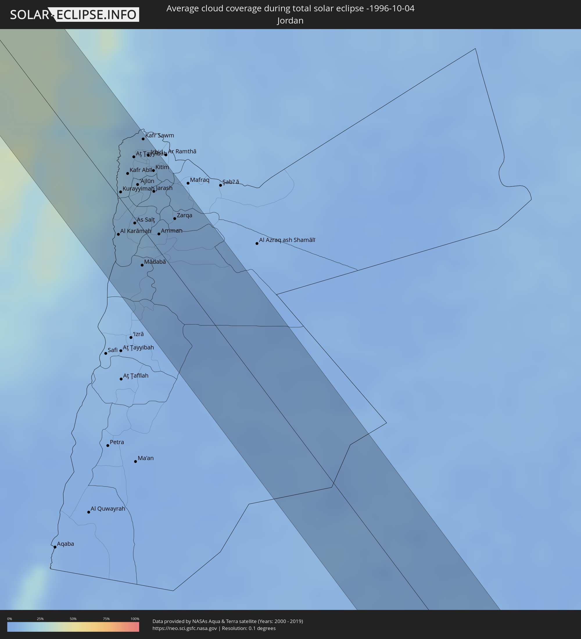 Jordan
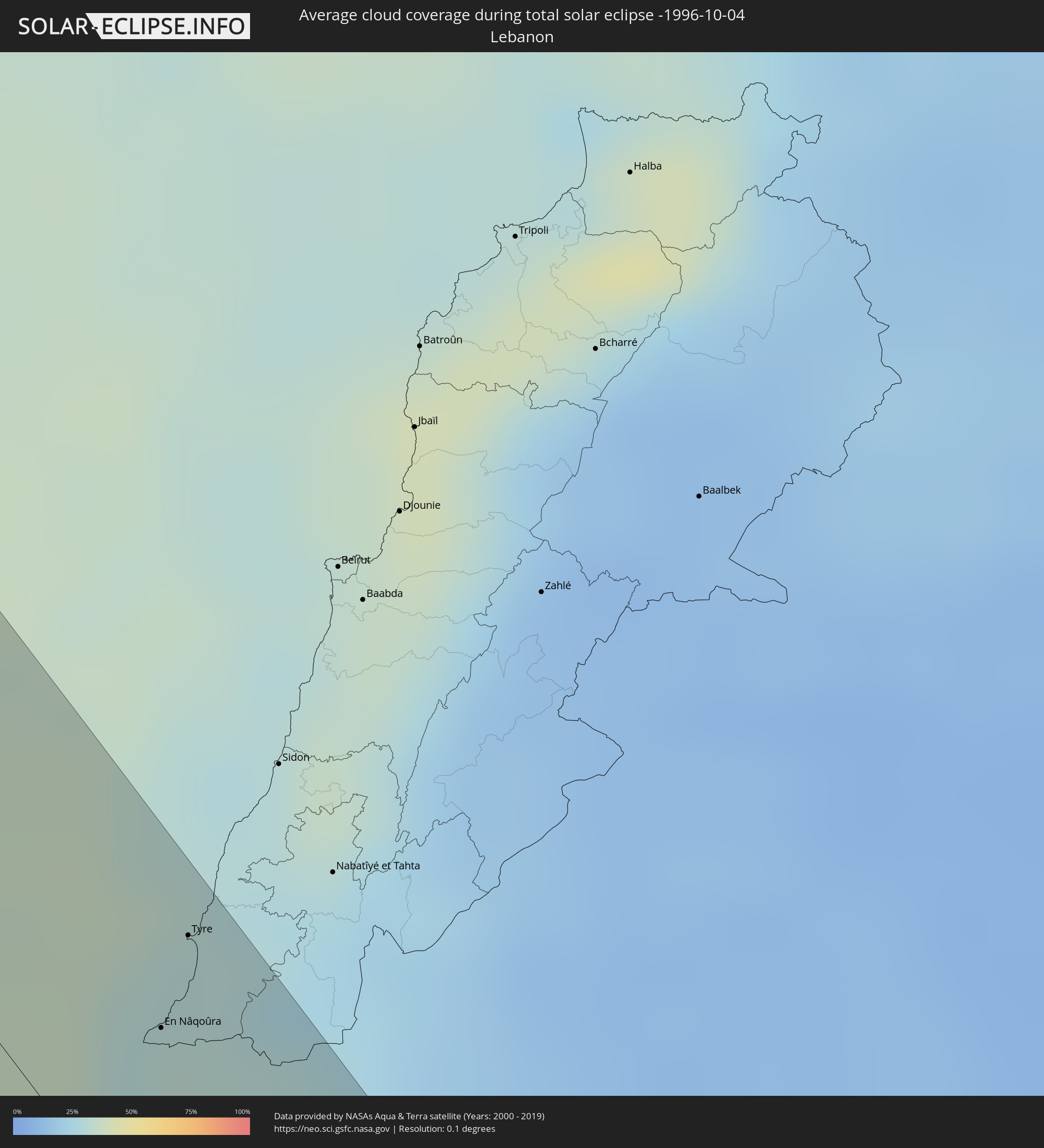 Lebanon
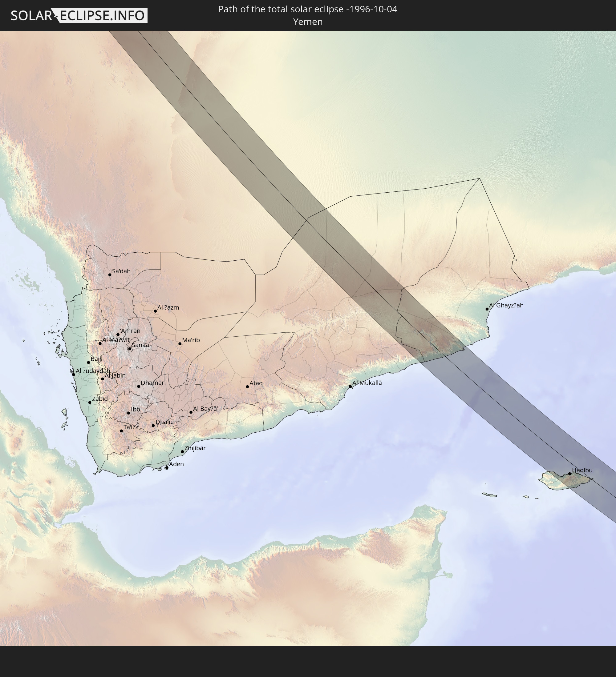
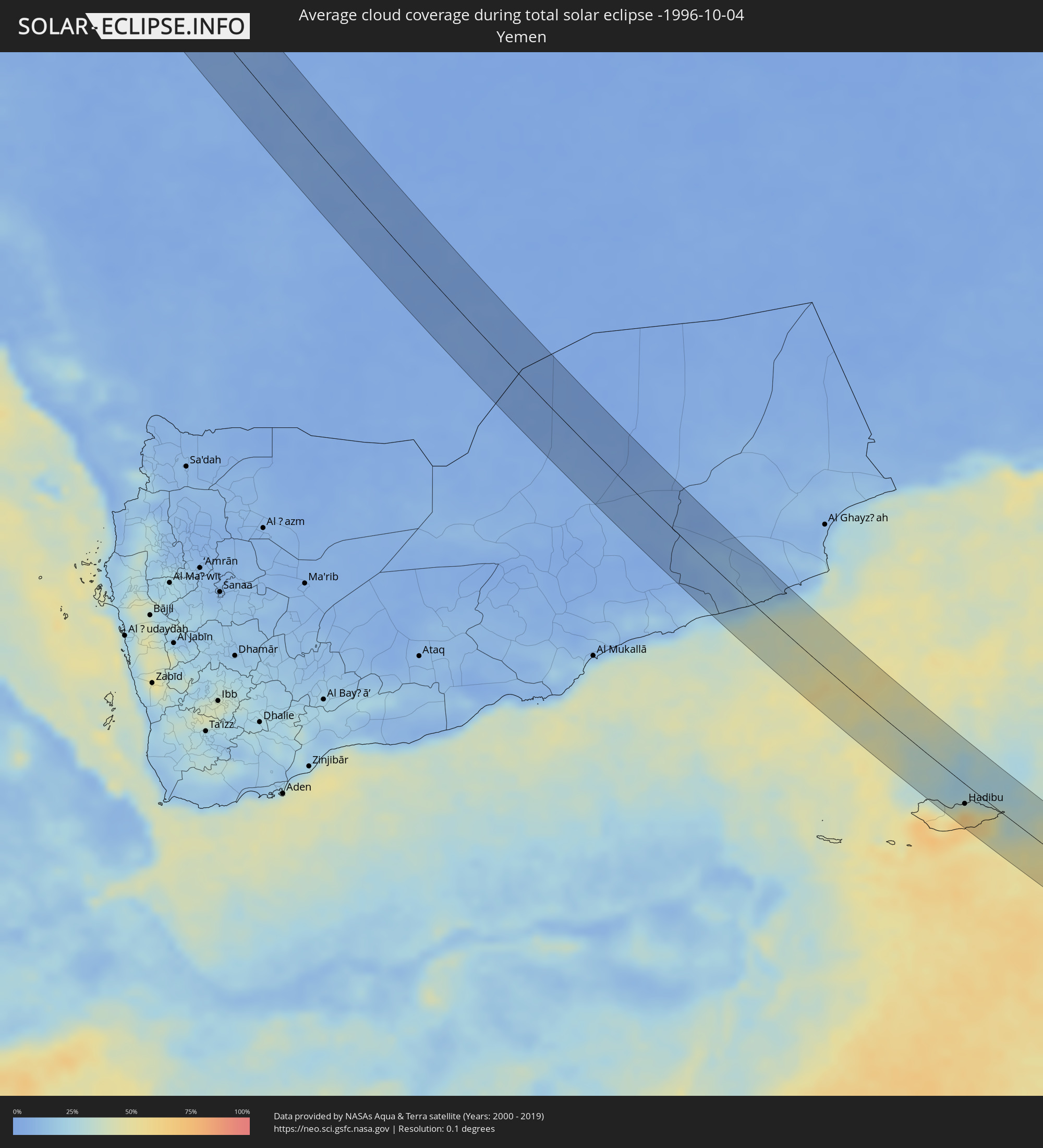 Yemen
Yemen
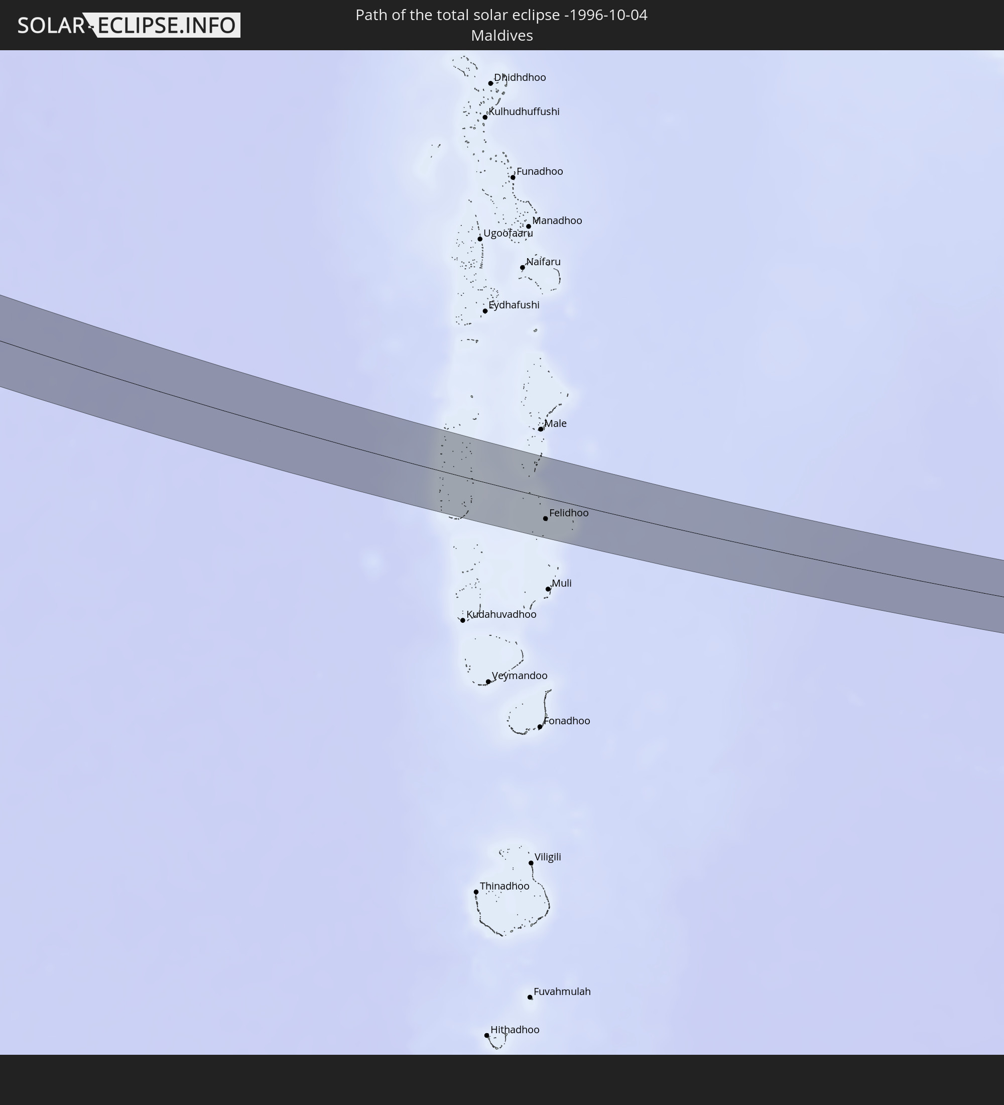
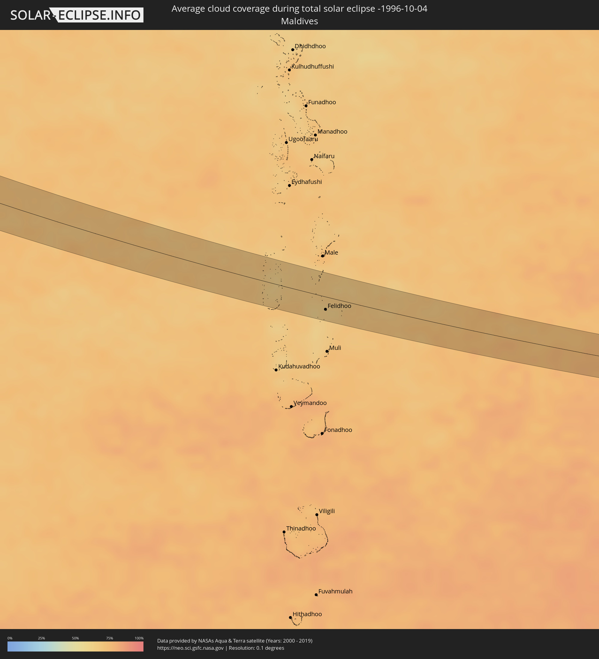 Maldives
Cities inside the path of the eclipse
The following table shows all locations with a population of more than 5,000 inside the eclipse path. Cities which have more than 100,000 inhabitants are marked bold. A click at the locations opens a detailed map.
| City | Type | Eclipse duration | Local time of max. eclipse | Distance to central line | Ø Cloud coverage |
|
Qaqortoq, Kujalleq
|
total | - | 05:34:07 UTC-03:26 | 20 km | 63% |
|
Isle of Skye, Scotland
|
total | - | 09:11:25 UTC+00:00 | 30 km | 86% |
|
Fort William, Scotland
|
total | - | 09:11:58 UTC+00:00 | 3 km | 91% |
|
Alloa, Scotland
|
total | - | 09:12:39 UTC+00:00 | 33 km | 83% |
|
Dunfermline, Scotland
|
total | - | 09:12:53 UTC+00:00 | 29 km | 81% |
|
Perth, Scotland
|
total | - | 09:13:00 UTC+00:00 | 4 km | 82% |
|
Kirkcaldy, Scotland
|
total | - | 09:13:06 UTC+00:00 | 16 km | 76% |
|
Musselburgh, Scotland
|
total | - | 09:13:08 UTC+00:00 | 31 km | 82% |
|
Dundee, Scotland
|
total | - | 09:13:21 UTC+00:00 | 24 km | 78% |
|
Saint Andrews, Scotland
|
total | - | 09:13:26 UTC+00:00 | 16 km | 78% |
|
Berwick-Upon-Tweed, England
|
total | - | 09:13:52 UTC+00:00 | 17 km | 78% |
|
Leeuwarden, Friesland
|
total | - | 09:39:41 UTC+00:19 | 16 km | 77% |
|
Heerenveen, Friesland
|
total | - | 09:39:48 UTC+00:19 | 34 km | 77% |
|
Drachten, Friesland
|
total | - | 09:39:58 UTC+00:19 | 13 km | 79% |
|
Hoogeveen, Drenthe
|
total | - | 09:40:21 UTC+00:19 | 36 km | 82% |
|
Assen, Drenthe
|
total | - | 09:40:24 UTC+00:19 | 7 km | 83% |
|
Groningen, Groningen
|
total | - | 09:40:23 UTC+00:19 | 14 km | 80% |
|
Borger, Drenthe
|
total | - | 09:40:38 UTC+00:19 | 6 km | 83% |
|
Veendam, Groningen
|
total | - | 09:40:41 UTC+00:19 | 15 km | 83% |
|
Emmen, Drenthe
|
total | - | 09:40:45 UTC+00:19 | 15 km | 82% |
|
Delfzijl, Groningen
|
total | - | 09:40:42 UTC+00:19 | 37 km | 81% |
|
Osnabrück, Lower Saxony
|
total | - | 10:22:23 UTC+01:00 | 18 km | 83% |
|
Bielefeld, North Rhine-Westphalia
|
total | - | 10:22:54 UTC+01:00 | 21 km | 80% |
|
Detmold, North Rhine-Westphalia
|
total | - | 10:23:15 UTC+01:00 | 17 km | 81% |
|
Minden, North Rhine-Westphalia
|
total | - | 10:23:14 UTC+01:00 | 17 km | 83% |
|
Göttingen, Lower Saxony
|
total | - | 10:24:25 UTC+01:00 | 11 km | 79% |
|
Erfurt, Thuringia
|
total | - | 10:25:42 UTC+01:00 | 15 km | 79% |
|
Jena, Thuringia
|
total | - | 10:26:18 UTC+01:00 | 4 km | 81% |
|
Gera, Thuringia
|
total | - | 10:26:50 UTC+01:00 | 20 km | 81% |
|
Plauen, Saxony
|
total | - | 10:27:02 UTC+01:00 | 11 km | 81% |
|
Cheb, Karlovarský
|
total | - | 10:27:27 UTC+01:00 | 38 km | 82% |
|
Zwickau, Saxony
|
total | - | 10:27:20 UTC+01:00 | 24 km | 80% |
|
Sokolov, Karlovarský
|
total | - | 10:27:42 UTC+01:00 | 17 km | 82% |
|
Karlovy Vary, Karlovarský
|
total | - | 10:27:56 UTC+01:00 | 2 km | 82% |
|
Pilsen, Plzeňský
|
total | - | 10:28:41 UTC+01:00 | 22 km | 84% |
|
Příbram, Central Bohemia
|
total | - | 10:29:25 UTC+01:00 | 1 km | 82% |
|
Písek, Jihočeský
|
total | - | 10:29:45 UTC+01:00 | 26 km | 81% |
|
České Budějovice, Jihočeský
|
total | - | 10:30:17 UTC+01:00 | 39 km | 76% |
|
Tábor, Jihočeský
|
total | - | 10:30:16 UTC+01:00 | 7 km | 81% |
|
Jindřichův Hradec, Jihočeský
|
total | - | 10:30:48 UTC+01:00 | 0 km | 74% |
|
Zwettl Stift, Lower Austria
|
total | - | 10:31:18 UTC+01:00 | 36 km | 73% |
|
Weinzierl bei Krems, Lower Austria
|
total | - | 10:31:53 UTC+01:00 | 35 km | 73% |
|
Znojmo, South Moravian
|
total | - | 10:32:09 UTC+01:00 | 25 km | 77% |
|
Hollabrunn, Lower Austria
|
total | - | 10:32:22 UTC+01:00 | 0 km | 74% |
|
Stockerau, Lower Austria
|
total | - | 10:32:37 UTC+01:00 | 7 km | 72% |
|
Baden, Lower Austria
|
total | - | 10:32:52 UTC+01:00 | 38 km | 70% |
|
Vienna, Vienna
|
total | - | 10:32:54 UTC+01:00 | 14 km | 72% |
|
Eisenstadt, Burgenland
|
total | - | 10:33:18 UTC+01:00 | 38 km | 69% |
|
Mistelbach, Lower Austria
|
total | - | 10:32:55 UTC+01:00 | 26 km | 74% |
|
Gänserndorf, Lower Austria
|
total | - | 10:33:14 UTC+01:00 | 13 km | 73% |
|
Bruck an der Leitha, Lower Austria
|
total | - | 10:33:29 UTC+01:00 | 11 km | 70% |
|
Malacky, Bratislavský
|
total | - | 10:33:31 UTC+01:00 | 36 km | 73% |
|
Stupava, Bratislavský
|
total | - | 10:33:38 UTC+01:00 | 23 km | 74% |
|
Bratislava, Bratislavský
|
total | - | 10:33:48 UTC+01:00 | 16 km | 72% |
|
Ivanka pri Dunaji, Bratislavský
|
total | - | 10:33:57 UTC+01:00 | 27 km | 77% |
|
Pezinok, Bratislavský
|
total | - | 10:33:54 UTC+01:00 | 36 km | 77% |
|
Mosonmagyaróvár, Győr-Moson-Sopron
|
total | - | 10:34:11 UTC+01:00 | 1 km | 72% |
|
Šamorín, Trnavský
|
total | - | 10:34:07 UTC+01:00 | 17 km | 71% |
|
Senec, Bratislavský
|
total | - | 10:34:06 UTC+01:00 | 37 km | 75% |
|
Pápa, Veszprém
|
total | - | 10:34:46 UTC+01:00 | 34 km | 68% |
|
Dunajská Streda, Trnavský
|
total | - | 10:34:30 UTC+01:00 | 28 km | 70% |
|
Győr, Győr-Moson-Sopron
|
total | - | 10:34:44 UTC+01:00 | 4 km | 73% |
|
Veľký Meder, Trnavský
|
total | - | 10:34:47 UTC+01:00 | 25 km | 69% |
|
Veszprém, Veszprém
|
total | - | 10:35:28 UTC+01:00 | 31 km | 67% |
|
Komárno, Nitriansky
|
total | - | 10:35:16 UTC+01:00 | 35 km | 69% |
|
Tatabánya, Komárom-Esztergom
|
total | - | 10:35:43 UTC+01:00 | 34 km | 65% |
|
Székesfehérvár, Fejér
|
total | - | 10:36:01 UTC+01:00 | 2 km | 67% |
|
Dunaújváros, Fejér
|
total | - | 10:36:49 UTC+01:00 | 11 km | 67% |
|
Subotica, Vojvodina
|
total | - | 10:38:24 UTC+01:00 | 21 km | 61% |
|
Kiskunfélegyháza, Bács-Kiskun
|
total | - | 10:38:08 UTC+01:00 | 38 km | 61% |
|
Bečej, Vojvodina
|
total | - | 10:39:16 UTC+01:00 | 40 km | 62% |
|
Kanjiža, Vojvodina
|
total | - | 10:38:54 UTC+01:00 | 3 km | 62% |
|
Senta, Vojvodina
|
total | - | 10:39:03 UTC+01:00 | 13 km | 63% |
|
Szeged, Csongrád
|
total | - | 10:38:53 UTC+01:00 | 17 km | 60% |
|
Hódmezővásárhely, Csongrád
|
total | - | 10:38:59 UTC+01:00 | 40 km | 58% |
|
Zrenjanin, Vojvodina
|
total | - | 10:39:54 UTC+01:00 | 40 km | 59% |
|
Kikinda, Vojvodina
|
total | - | 10:39:38 UTC+01:00 | 0 km | 63% |
|
Sânnicolau Mare, Timiş
|
total | - | 11:24:02 UTC+01:44 | 29 km | 59% |
|
Timişoara, Timiş
|
total | - | 11:25:04 UTC+01:44 | 35 km | 61% |
|
Vršac, Vojvodina
|
total | - | 10:41:20 UTC+01:00 | 11 km | 59% |
|
Bela Crkva, Vojvodina
|
total | - | 10:41:40 UTC+01:00 | 22 km | 59% |
|
Moldova Nouă, Caraş-Severin
|
total | - | 11:26:33 UTC+01:44 | 21 km | 60% |
|
Oraviţa, Caraş-Severin
|
total | - | 11:26:18 UTC+01:44 | 4 km | 63% |
|
Bocşa, Caraş-Severin
|
total | - | 11:26:01 UTC+01:44 | 32 km | 62% |
|
Reşiţa, Caraş-Severin
|
total | - | 11:26:19 UTC+01:44 | 36 km | 61% |
|
Majdanpek, Central Serbia
|
total | - | 10:42:48 UTC+01:00 | 30 km | 62% |
|
Orşova, Mehedinţi
|
total | - | 11:27:31 UTC+01:44 | 19 km | 57% |
|
Negotin, Central Serbia
|
total | - | 10:43:46 UTC+01:00 | 12 km | 57% |
|
Drobeta-Turnu Severin, Mehedinţi
|
total | - | 11:27:56 UTC+01:44 | 27 km | 57% |
|
Vidin, Vidin
|
total | - | 11:44:28 UTC+02:00 | 11 km | 56% |
|
Calafat, Dolj
|
total | - | 11:28:56 UTC+01:44 | 7 km | 56% |
|
Montana, Montana
|
total | - | 11:45:31 UTC+02:00 | 35 km | 57% |
|
Băileşti, Dolj
|
total | - | 11:29:28 UTC+01:44 | 19 km | 49% |
|
Vratsa, Vratsa
|
total | - | 11:46:12 UTC+02:00 | 31 km | 57% |
|
Lovech, Lovech
|
total | - | 11:47:50 UTC+02:00 | 31 km | 58% |
|
Plovdiv, Plovdiv
|
total | - | 11:48:59 UTC+02:00 | 41 km | 48% |
|
Asenovgrad, Plovdiv
|
total | - | 11:49:18 UTC+02:00 | 44 km | 51% |
|
Kardzhali, Kŭrdzhali
|
total | - | 11:50:26 UTC+02:00 | 41 km | 49% |
|
Kazanlak, Stara Zagora
|
total | - | 11:49:21 UTC+02:00 | 34 km | 52% |
|
Haskovo, Khaskovo
|
total | - | 11:50:21 UTC+02:00 | 8 km | 49% |
|
Stara Zagora, Stara Zagora
|
total | - | 11:49:53 UTC+02:00 | 35 km | 53% |
|
Didymóteicho, East Macedonia and Thrace
|
total | - | 11:27:14 UTC+01:34 | 7 km | 48% |
|
Orestiáda, East Macedonia and Thrace
|
total | - | 11:27:06 UTC+01:34 | 20 km | 47% |
|
Edirne, Edirne
|
total | - | 11:48:59 UTC+01:56 | 35 km | 49% |
|
Tekirdağ, Tekirdağ
|
total | - | 11:51:12 UTC+01:56 | 44 km | 54% |
|
Balıkesir, Balıkesir
|
total | - | 11:53:29 UTC+01:56 | 29 km | 43% |
|
Bandırma, Balıkesir
|
total | - | 11:52:40 UTC+01:56 | 28 km | 49% |
|
Mustafakemalpaşa, Bursa
|
total | - | 11:53:42 UTC+01:56 | 33 km | 51% |
|
Uşak, Uşak
|
total | - | 11:57:02 UTC+01:56 | 2 km | 26% |
|
Isparta, Isparta
|
total | - | 12:00:03 UTC+01:56 | 15 km | 26% |
|
Antalya, Antalya
|
total | - | 12:01:34 UTC+01:56 | 35 km | 24% |
|
Manavgat, Antalya
|
total | - | 12:02:52 UTC+01:56 | 9 km | 24% |
|
Alanya, Antalya
|
total | - | 12:04:04 UTC+01:56 | 31 km | 28% |
|
Léfka, Nicosia
|
total | - | 12:24:12 UTC+02:13 | 7 km | 32% |
|
Ýpsonas, Limassol
|
total | - | 12:25:05 UTC+02:13 | 28 km | 25% |
|
Mórfou, Nicosia
|
total | - | 12:24:16 UTC+02:13 | 9 km | 20% |
|
Limassol, Limassol
|
total | - | 12:25:12 UTC+02:13 | 22 km | 25% |
|
Kyrenia, Keryneia
|
total | - | 12:24:32 UTC+02:13 | 42 km | 19% |
|
Nicosia, Nicosia
|
total | - | 12:24:52 UTC+02:13 | 35 km | 23% |
|
Géri, Nicosia
|
total | - | 12:25:04 UTC+02:13 | 34 km | 26% |
|
Dáli, Nicosia
|
total | - | 12:25:13 UTC+02:13 | 28 km | 29% |
|
Aradíppou, Larnaka
|
total | - | 12:25:35 UTC+02:13 | 36 km | 27% |
|
Larnaca, Larnaka
|
total | - | 12:25:41 UTC+02:13 | 36 km | 26% |
|
Netanya, Central District
|
total | - | 12:39:15 UTC+02:20 | 48 km | 28% |
|
Haifa, Haifa
|
total | - | 12:38:35 UTC+02:20 | 6 km | 31% |
|
Eṭ Ṭaiyiba, Central District
|
total | - | 12:39:36 UTC+02:20 | 41 km | 33% |
|
Ţūlkarm, West Bank
|
total | - | 12:18:53 UTC+02:00 | 37 km | 33% |
|
‘Azzūn, West Bank
|
total | - | 12:19:11 UTC+02:00 | 44 km | 33% |
|
Nahariya, Northern District
|
total | - | 12:38:24 UTC+02:20 | 15 km | 27% |
|
En Nâqoûra, South Governorate
|
total | - | 12:17:37 UTC+02:00 | 26 km | 30% |
|
Umm el Faḥm, Haifa
|
total | - | 12:39:23 UTC+02:20 | 13 km | 29% |
|
Salfīt, West Bank
|
total | - | 12:19:32 UTC+02:00 | 41 km | 28% |
|
Sīlat az̧ Z̧ahr, West Bank
|
total | - | 12:19:07 UTC+02:00 | 24 km | 31% |
|
Ariel, Jerusalem
|
total | - | 12:19:30 UTC+02:00 | 39 km | 28% |
|
Tyre, South Governorate
|
total | - | 12:17:26 UTC+02:00 | 40 km | 30% |
|
Jammā‘īn, West Bank
|
total | - | 12:19:29 UTC+02:00 | 36 km | 28% |
|
Nablus, West Bank
|
total | - | 12:19:24 UTC+02:00 | 26 km | 27% |
|
Dayr Dibwān, West Bank
|
total | - | 12:19:59 UTC+02:00 | 46 km | 22% |
|
Janīn, West Bank
|
total | - | 12:19:02 UTC+02:00 | 6 km | 26% |
|
Nazareth, Northern District
|
total | - | 12:39:17 UTC+02:20 | 10 km | 28% |
|
Karmi’el, Northern District
|
total | - | 12:38:54 UTC+02:20 | 25 km | 25% |
|
Ţūbās, West Bank
|
total | - | 12:19:24 UTC+02:00 | 10 km | 24% |
|
Jericho, West Bank
|
total | - | 12:20:20 UTC+02:00 | 35 km | 13% |
|
Safed, Northern District
|
total | - | 12:39:06 UTC+02:20 | 42 km | 29% |
|
Tiberias, Northern District
|
total | - | 12:39:28 UTC+02:20 | 33 km | 23% |
|
Al Karāmah, Balqa
|
total | - | 12:44:07 UTC+02:23 | 19 km | 13% |
|
Kurayyimah, Irbid
|
total | - | 12:43:33 UTC+02:23 | 4 km | 17% |
|
Şammā, Irbid
|
total | - | 12:43:10 UTC+02:23 | 30 km | 16% |
|
As Salţ, Balqa
|
total | - | 12:44:11 UTC+02:23 | 2 km | 13% |
|
‘Ajlūn, Ajlun
|
total | - | 12:43:41 UTC+02:23 | 19 km | 15% |
|
Saḩam al Kaffārāt, Irbid
|
total | - | 12:43:04 UTC+02:23 | 45 km | 15% |
|
Mādabā, Madaba
|
total | - | 12:44:52 UTC+02:23 | 19 km | 10% |
|
Irbid, Irbid
|
total | - | 12:43:26 UTC+02:23 | 41 km | 13% |
|
Amman, Amman
|
total | - | 12:44:40 UTC+02:23 | 8 km | 12% |
|
Zarqa, Zarqa
|
total | - | 12:44:40 UTC+02:23 | 27 km | 9% |
|
‘Afīf, Ar Riyāḑ
|
total | - | 13:54:09 UTC+03:06 | 11 km | 1% |
|
As Sulayyil, Ar Riyāḑ
|
total | - | 14:05:09 UTC+03:06 | 23 km | 2% |
|
Hadibu, Soqatra Governorate
|
total | - | 14:31:55 UTC+03:06 | 22 km | 64% |
|
Felidhoo, Vaavu Atholhu
|
total | - | 16:49:50 UTC+04:54 | 18 km | 64% |