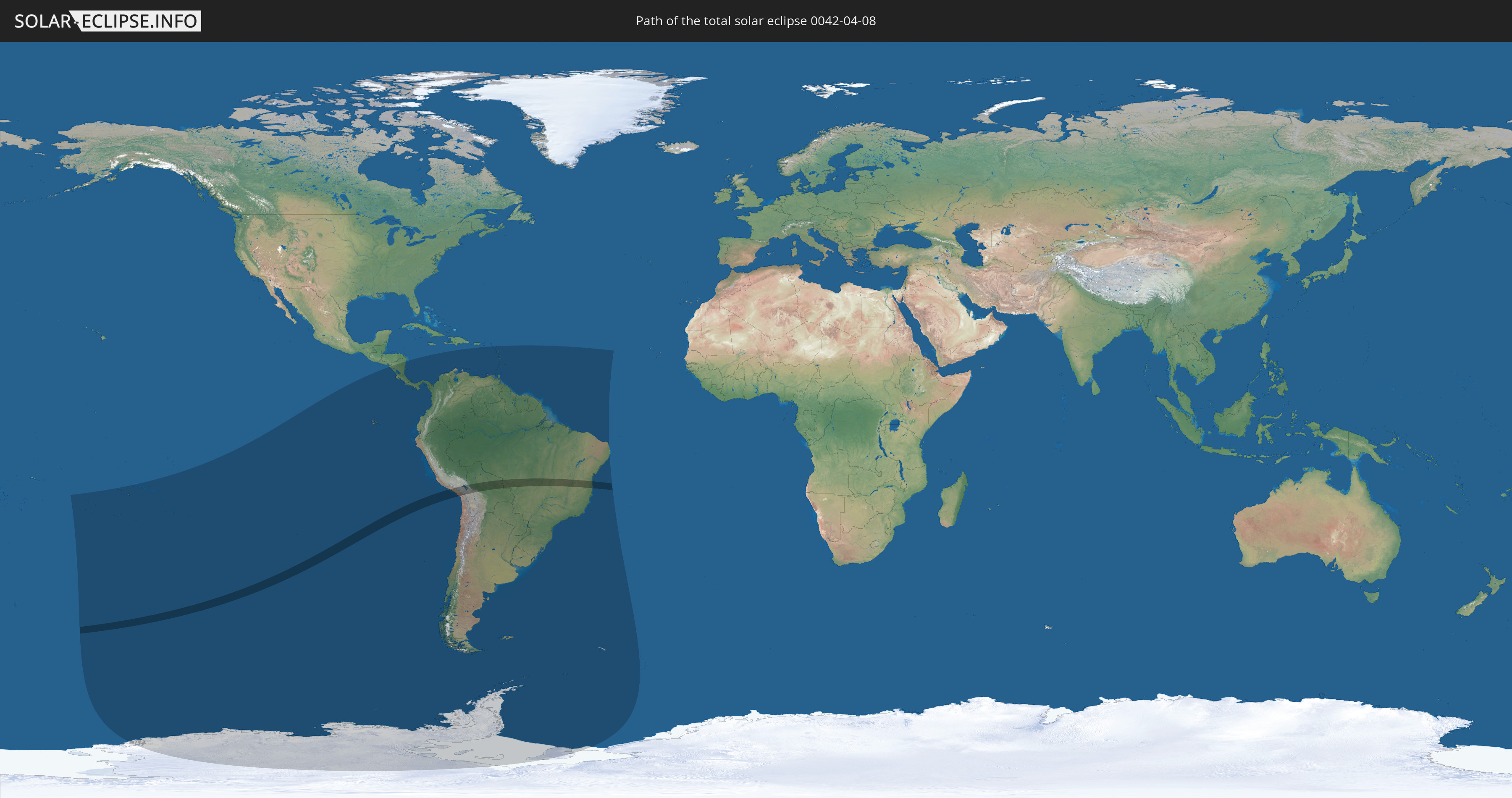
Total solar eclipse of 04/08/0042
| Day of week: | Tuesday |
| Maximum duration of eclipse: | 05m05s |
| Maximum width of eclipse path: | 229 km |
| Saros cycle: | 78 |
| Coverage: | 100% |
| Magnitude: | 1.0588 |
| Gamma: | -0.5449 |
Wo kann man die Sonnenfinsternis vom 04/08/0042 sehen?
Die Sonnenfinsternis am 04/08/0042 kann man in 35 Ländern als partielle Sonnenfinsternis beobachten.
Der Finsternispfad verläuft durch 4 Länder. Nur in diesen Ländern ist sie als total Sonnenfinsternis zu sehen.
In den folgenden Ländern ist die Sonnenfinsternis total zu sehen
 Chile
Chile
 Peru
Peru
 Brazil
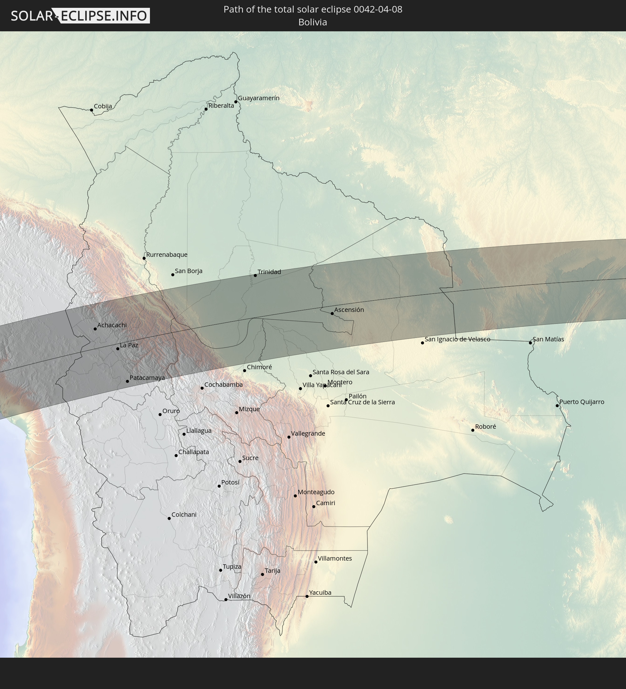 Bolivia
In den folgenden Ländern ist die Sonnenfinsternis partiell zu sehen
 Antarctica
 Kiribati
 Cook Islands
 French Polynesia
 Pitcairn Islands
 Chile
Chile
 Ecuador
 Nicaragua
 Costa Rica
 Panama
 Colombia
 Peru
Peru
 Brazil
 Argentina
 Venezuela
 Aruba
Aruba
 Bolivia
 Saint Kitts and Nevis
 Paraguay
 Antigua and Barbuda
 Montserrat
 Trinidad and Tobago
 Guadeloupe
 Grenada
 Dominica
 Saint Vincent and the Grenadines
 Falkland Islands
 Guyana
 Martinique
 Saint Lucia
 Barbados
 Uruguay
 Suriname
 French Guiana
 South Georgia and the South Sandwich Islands
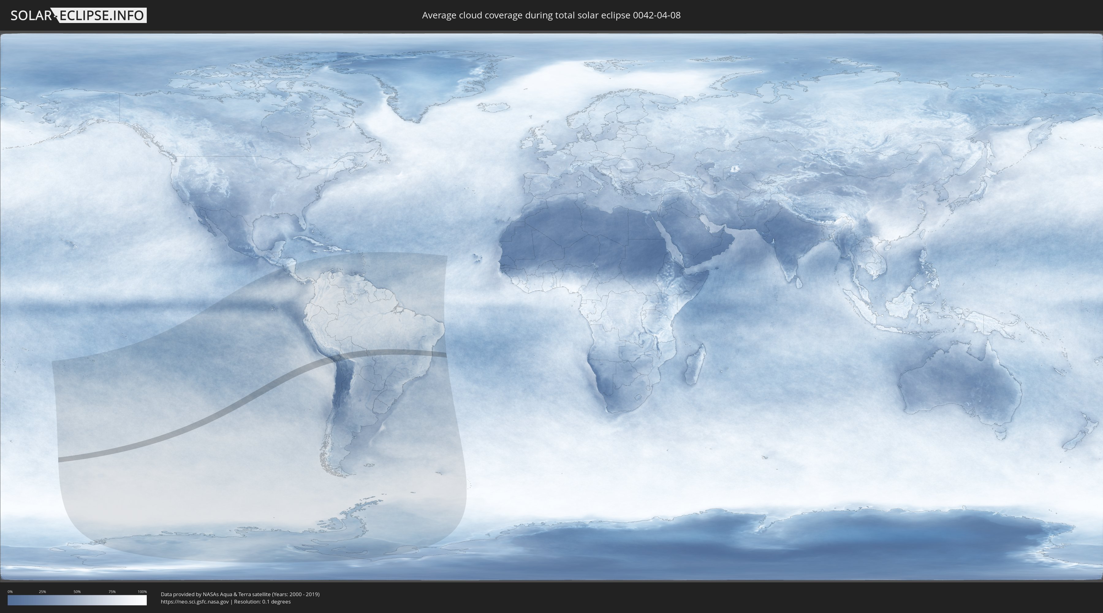
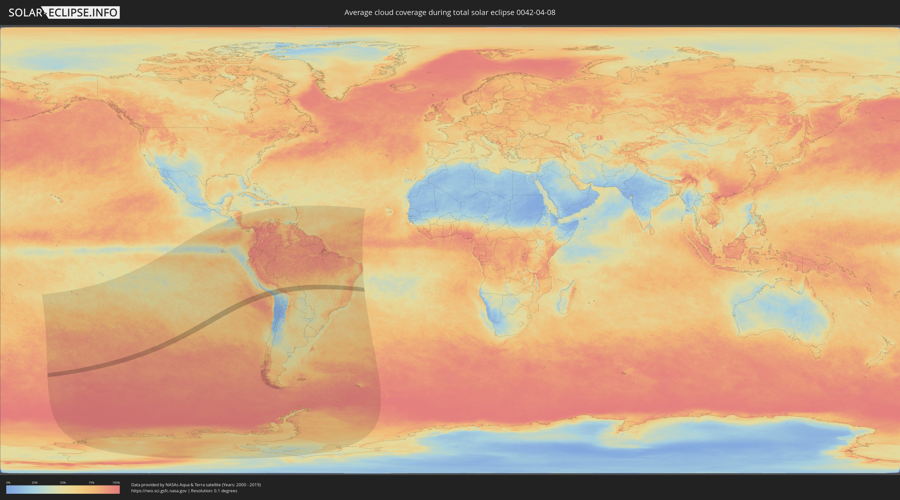
How will be the weather during the total solar eclipse on 04/08/0042?
Where is the best place to see the total solar eclipse of 04/08/0042?
The following maps show the average cloud coverage for the day of the total solar eclipse.
With the help of these maps, it is possible to find the place along the eclipse path, which has the best
chance of a cloudless sky.
Nevertheless, you should consider local circumstances and inform about the weather of your chosen
observation site.
The data is provided by NASAs satellites
AQUA and TERRA.
The cloud maps are averaged over a period of 19 years (2000 - 2019).
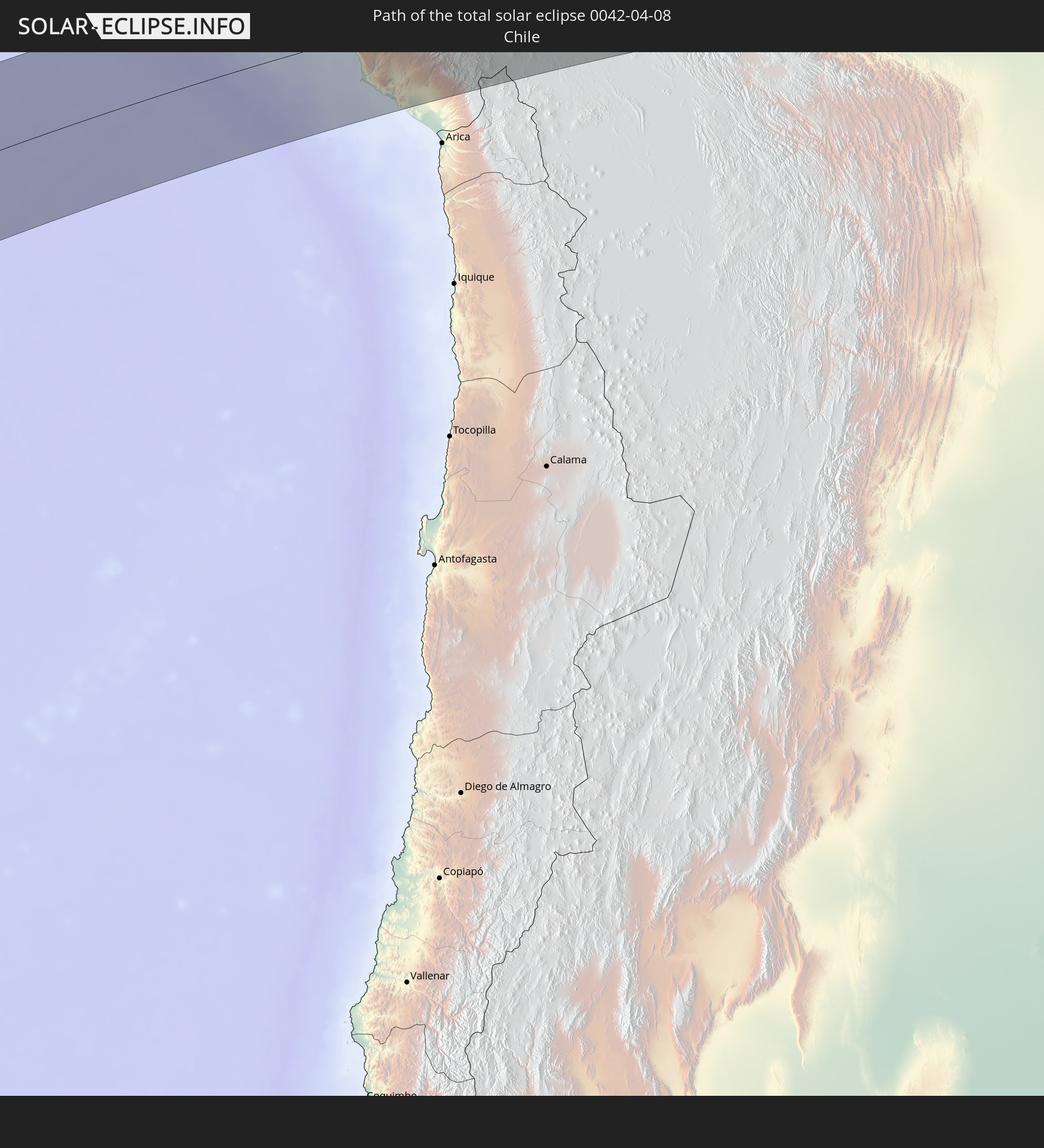
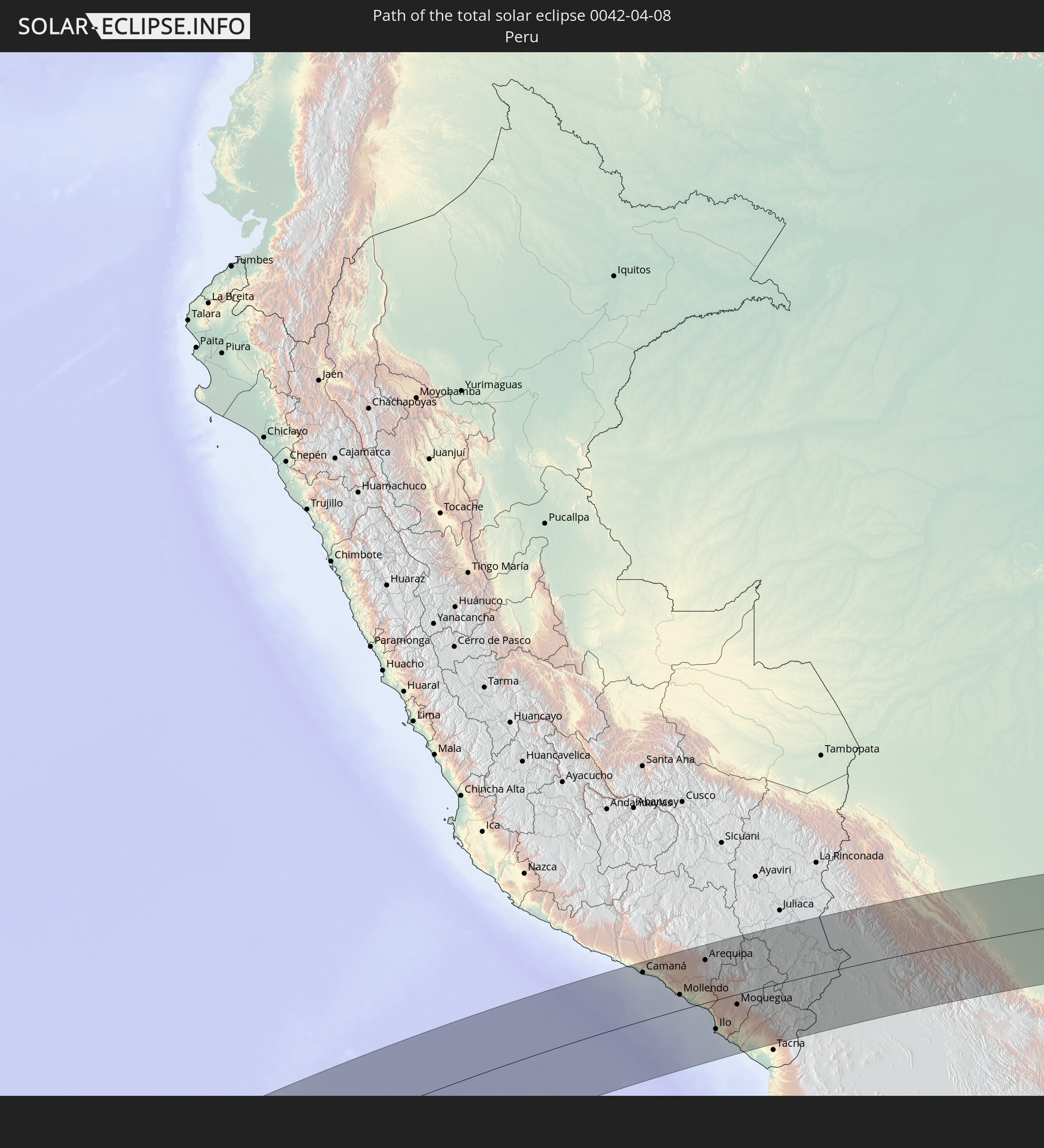
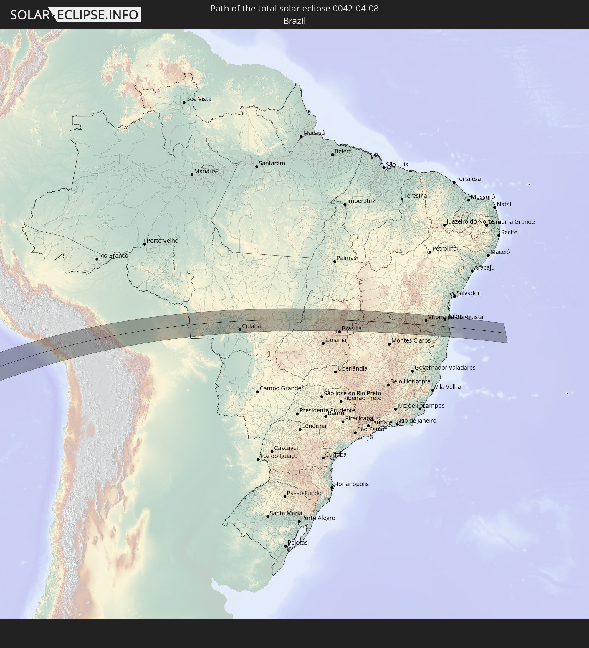
Detailed country maps
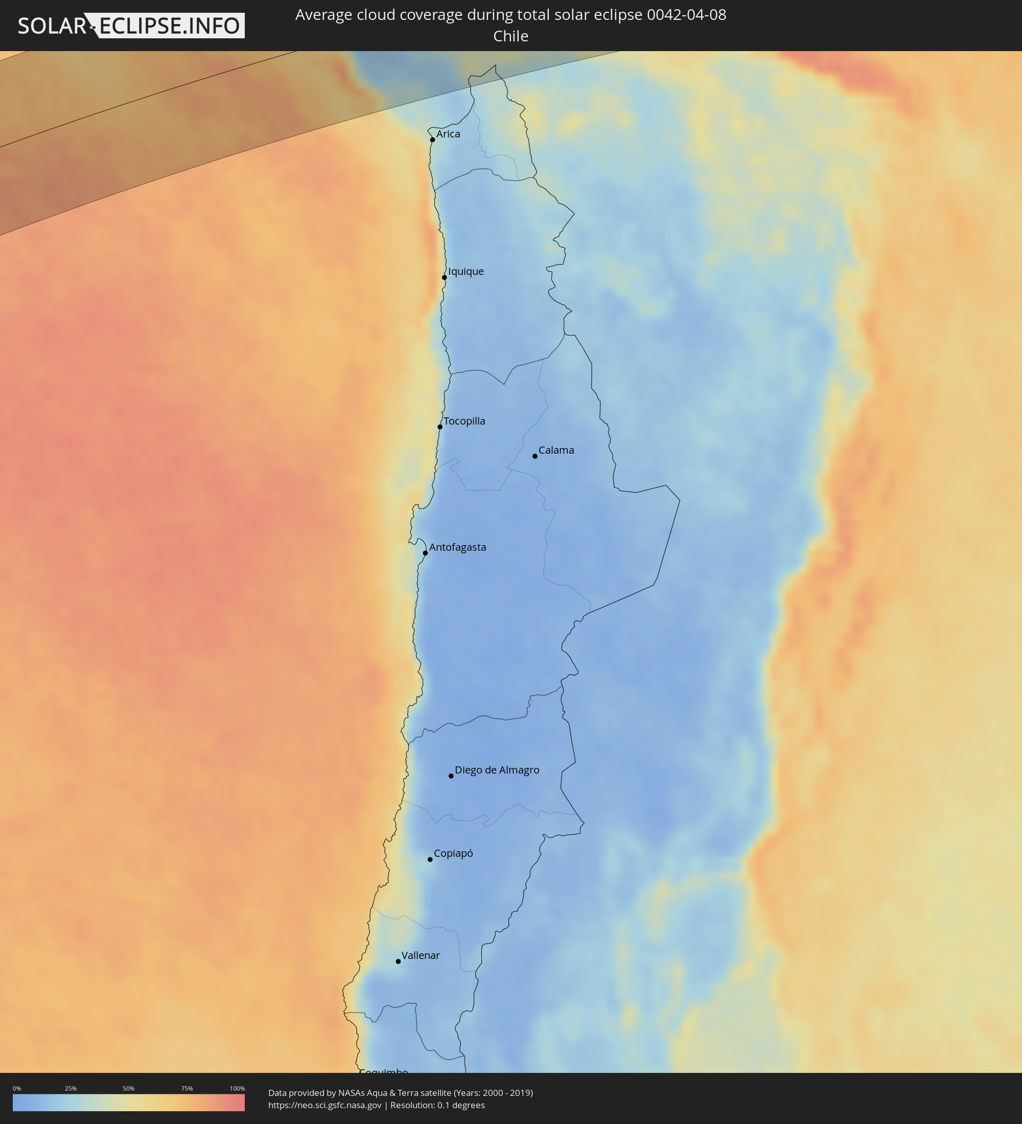 Chile
Chile
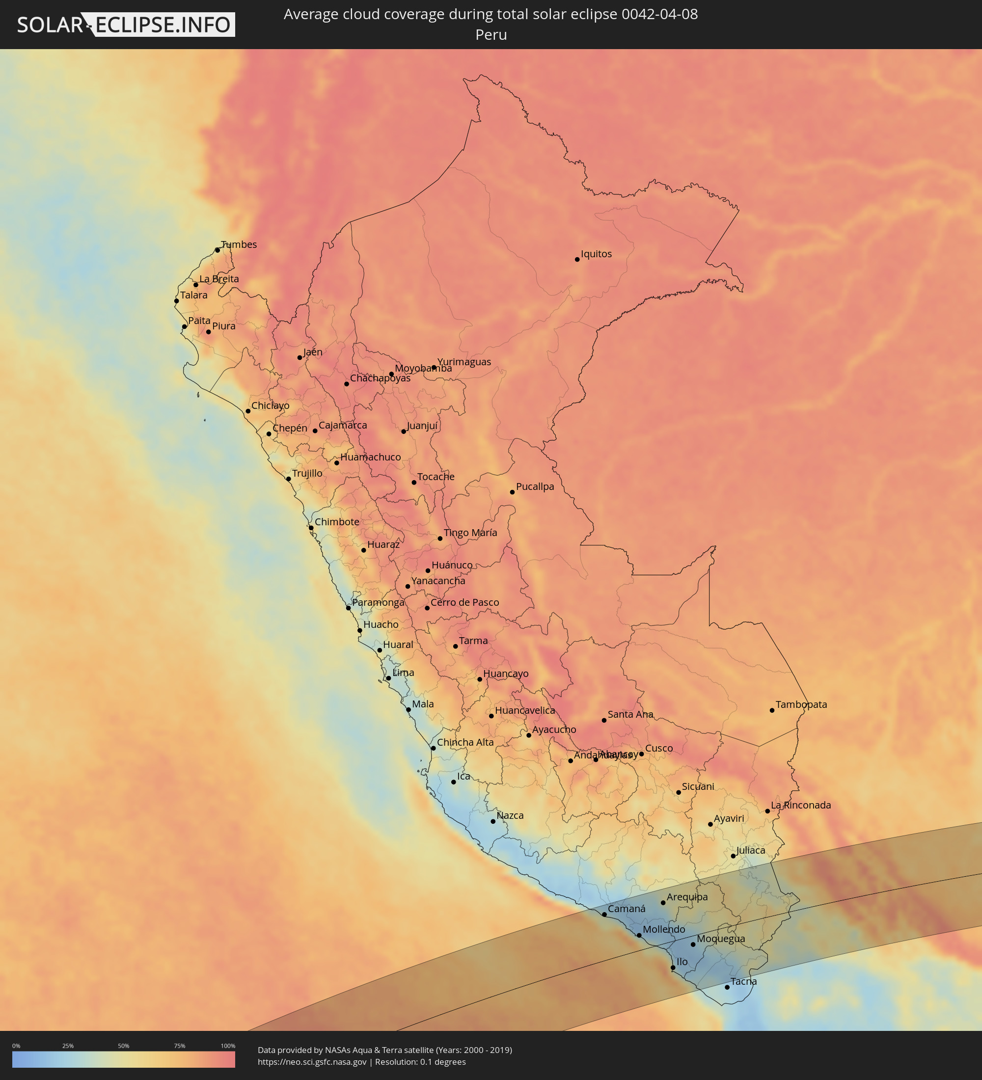 Peru
Peru
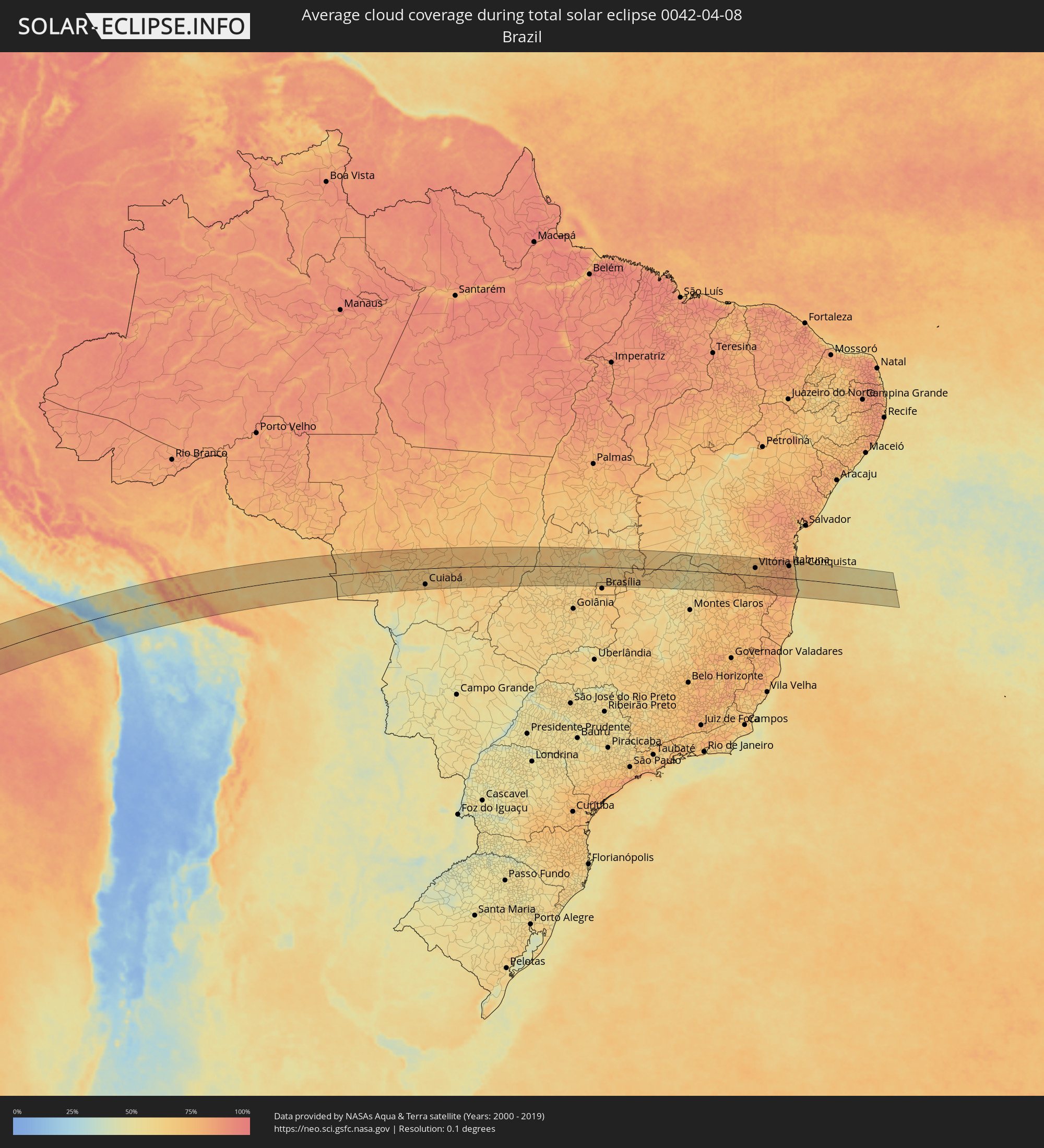 Brazil
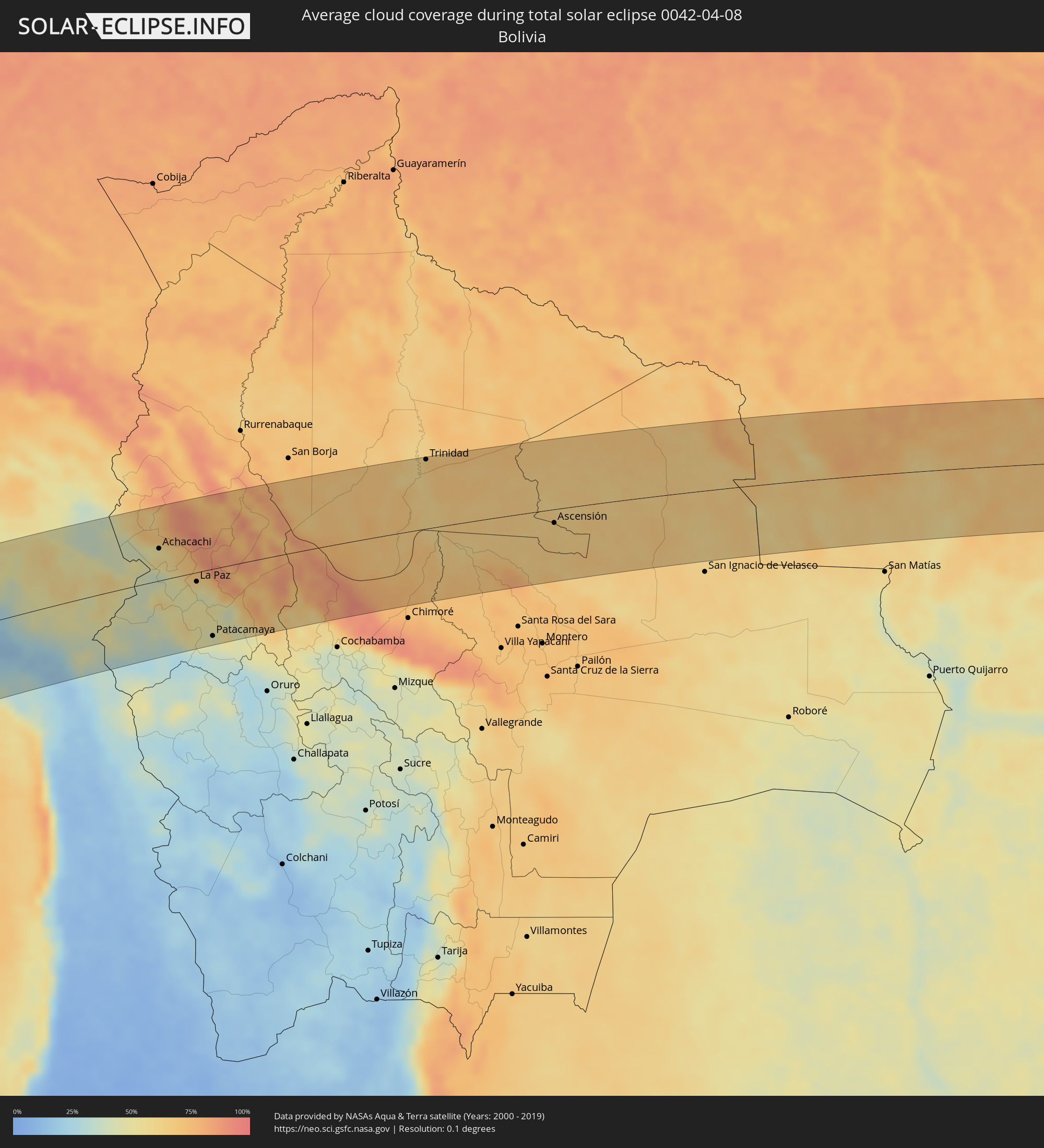 Bolivia
Cities inside the path of the eclipse
The following table shows all locations with a population of more than 5,000 inside the eclipse path. Cities which have more than 100,000 inhabitants are marked bold. A click at the locations opens a detailed map.
| City | Type | Eclipse duration | Local time of max. eclipse | Distance to central line | Ø Cloud coverage |
|
Camaná, Arequipa
|
total | - | 14:26:17 UTC-05:08 | 93 km | 46% |
|
Mollendo, Arequipa
|
total | - | 14:27:00 UTC-05:08 | 29 km | 48% |
|
Punta de Bombón, Arequipa
|
total | - | 14:27:12 UTC-05:08 | 7 km | 49% |
|
Cocachacra, Arequipa
|
total | - | 14:27:23 UTC-05:08 | 15 km | 46% |
|
Yura, Arequipa
|
total | - | 14:28:42 UTC-05:08 | 103 km | 26% |
|
Arequipa, Arequipa
|
total | - | 14:28:45 UTC-05:08 | 83 km | 29% |
|
Ilo, Moquegua
|
total | - | 14:27:22 UTC-05:08 | 56 km | 39% |
|
Pacocha, Moquegua
|
total | - | 14:27:27 UTC-05:08 | 50 km | 39% |
|
Moquegua, Moquegua
|
total | - | 14:28:42 UTC-05:08 | 20 km | 20% |
|
Torata, Moquegua
|
total | - | 14:29:02 UTC-05:08 | 9 km | 26% |
|
Ilabaya, Tacna
|
total | - | 14:29:08 UTC-05:08 | 55 km | 22% |
|
Puno, Puno
|
total | - | 14:32:11 UTC-05:08 | 102 km | 42% |
|
Ilave, Puno
|
total | - | 14:32:28 UTC-05:08 | 67 km | 49% |
|
Juli, Puno
|
total | - | 14:32:39 UTC-05:08 | 48 km | 49% |
|
Yunguyo, Puno
|
total | - | 14:33:13 UTC-05:08 | 35 km | 52% |
|
Desaguadero, Puno
|
total | - | 15:08:51 UTC-04:32 | 0 km | 41% |
|
San Pedro, La Paz
|
total | - | 15:09:37 UTC-04:32 | 31 km | 45% |
|
Achacachi, La Paz
|
total | - | 15:10:09 UTC-04:32 | 47 km | 57% |
|
La Paz, La Paz
|
total | - | 15:10:25 UTC-04:32 | 14 km | 53% |
|
Patacamaya, La Paz
|
total | - | 15:09:47 UTC-04:32 | 99 km | 44% |
|
Trinidad, El Beni
|
total | - | 15:17:37 UTC-04:32 | 104 km | 68% |
|
Ascensión, Santa Cruz
|
total | - | 15:19:03 UTC-04:32 | 20 km | 64% |
|
Pontes e Lacerda, Mato Grosso
|
total | - | 16:18:29 UTC-03:38 | 13 km | 62% |
|
Nova Olímpia, Mato Grosso
|
total | - | 16:21:15 UTC-03:38 | 18 km | 70% |
|
Barra do Bugres, Mato Grosso
|
total | - | 16:21:02 UTC-03:38 | 14 km | 69% |
|
Arenápolis, Mato Grosso
|
total | - | 16:22:06 UTC-03:38 | 53 km | 67% |
|
Nortelândia, Mato Grosso
|
total | - | 16:22:09 UTC-03:38 | 53 km | 67% |
|
Diamantino, Mato Grosso
|
total | - | 16:22:34 UTC-03:38 | 55 km | 70% |
|
Rosário Oeste, Mato Grosso
|
total | - | 16:22:05 UTC-03:38 | 8 km | 69% |
|
Nobres, Mato Grosso
|
total | - | 16:22:19 UTC-03:38 | 20 km | 67% |
|
Cuiabá, Mato Grosso
|
total | - | 16:21:32 UTC-03:38 | 78 km | 71% |
|
Chapada dos Guimarães, Mato Grosso
|
total | - | 16:22:02 UTC-03:38 | 65 km | 68% |
|
Mozarlândia, Goiás
|
total | - | 16:59:15 UTC-03:06 | 3 km | 67% |
|
Crixás, Goiás
|
total | - | 16:59:54 UTC-03:06 | 26 km | 62% |
|
Itapuranga, Goiás
|
total | - | 16:58:49 UTC-03:06 | 87 km | 59% |
|
Rubiataba, Goiás
|
total | - | 16:59:21 UTC-03:06 | 43 km | 61% |
|
Uruana, Goiás
|
total | - | 16:59:04 UTC-03:06 | 80 km | 60% |
|
Ceres, Goiás
|
total | - | 16:59:20 UTC-03:06 | 58 km | 63% |
|
Rialma, Goiás
|
total | - | 16:59:20 UTC-03:06 | 59 km | 63% |
|
Itapaci, Goiás
|
total | - | 16:59:45 UTC-03:06 | 18 km | 61% |
|
Uruaçu, Goiás
|
total | - | 17:00:29 UTC-03:06 | 30 km | 63% |
|
Goianésia, Goiás
|
total | - | 16:59:39 UTC-03:06 | 58 km | 62% |
|
Barro Alto, Goiás
|
total | - | 17:00:10 UTC-03:06 | 19 km | 64% |
|
Niquelândia, Goiás
|
total | - | 17:00:59 UTC-03:06 | 37 km | 63% |
|
Padre Bernardo, Goiás
|
total | - | 17:00:21 UTC-03:06 | 40 km | 64% |
|
Planaltina, Federal District
|
total | - | 17:00:16 UTC-03:06 | 88 km | 70% |
|
Planaltina, Goiás
|
total | - | 17:00:28 UTC-03:06 | 69 km | 68% |
|
Formosa, Goiás
|
total | - | 17:00:33 UTC-03:06 | 78 km | 71% |
|
Iaciara, Goiás
|
total | - | 17:02:27 UTC-03:06 | 85 km | 63% |
|
Buritis, Minas Gerais
|
total | - | 17:00:59 UTC-03:06 | 83 km | 60% |
|
Posse, Goiás
|
total | - | 17:02:36 UTC-03:06 | 87 km | 66% |
|
Januária, Minas Gerais
|
total | - | 17:02:11 UTC-03:06 | 58 km | 48% |
|
Itacarambi, Minas Gerais
|
total | - | 17:02:42 UTC-03:06 | 13 km | 48% |
|
Manga, Minas Gerais
|
total | - | 17:03:07 UTC-03:06 | 26 km | 55% |
|
Carinhanha, Bahia
|
total | - | 17:36:07 UTC-02:34 | 77 km | 54% |
|
Barreiro do Jaíba, Minas Gerais
|
total | - | 17:02:24 UTC-03:06 | 67 km | 58% |
|
Janaúba, Minas Gerais
|
total | - | 17:02:20 UTC-03:06 | 86 km | 60% |
|
Palmas de Monte Alto, Bahia
|
total | - | 17:36:24 UTC-02:34 | 86 km | 63% |
|
Porteirinha, Minas Gerais
|
total | - | 17:02:31 UTC-03:06 | 77 km | 60% |
|
Monte Azul, Minas Gerais
|
total | - | 17:03:10 UTC-03:06 | 11 km | 62% |
|
Mato Verde, Minas Gerais
|
total | - | 17:02:56 UTC-03:06 | 38 km | 58% |
|
Espinosa, Minas Gerais
|
total | - | 17:03:26 UTC-03:06 | 15 km | 64% |
|
Rio Pardo de Minas, Minas Gerais
|
total | - | 17:02:51 UTC-03:06 | 59 km | 69% |
|
Taiobeiras, Minas Gerais
|
total | - | 17:02:46 UTC-03:06 | 79 km | 69% |
|
Caculé, Bahia
|
total | - | 17:36:33 UTC-02:34 | 66 km | 68% |
|
São João do Paraíso, Minas Gerais
|
total | - | 17:03:21 UTC-03:06 | 22 km | 72% |
|
Santana, Bahia
|
total | - | 17:36:44 UTC-02:34 | 74 km | 73% |
|
Águas Vermelhas, Minas Gerais
|
total | - | 17:03:07 UTC-03:06 | 66 km | 74% |
|
São Felipe, Bahia
|
total | - | 17:36:31 UTC-02:34 | 36 km | 67% |
|
Vitória da Conquista, Bahia
|
total | - | 17:36:41 UTC-02:34 | 37 km | 74% |
|
Itambé, Bahia
|
total | - | 17:36:22 UTC-02:34 | 3 km | 76% |
|
Poções, Bahia
|
total | - | 17:37:09 UTC-02:34 | 79 km | 76% |
|
Itapetinga, Bahia
|
total | - | 17:36:29 UTC-02:34 | 0 km | 80% |
|
Iguaí, Bahia
|
total | - | 17:37:01 UTC-02:34 | 56 km | 79% |
|
Itororó, Bahia
|
total | - | 17:36:40 UTC-02:34 | 16 km | 80% |
|
Itarantim, Bahia
|
total | - | 17:36:08 UTC-02:34 | 44 km | 80% |
|
Ibicuí, Bahia
|
total | - | 17:36:58 UTC-02:34 | 48 km | 81% |
|
Pau Brasil, Bahia
|
total | - | 17:36:27 UTC-02:34 | 18 km | 80% |
|
Ibicaraí, Bahia
|
total | - | 17:37:04 UTC-02:34 | 49 km | 81% |
|
Coaraci, Bahia
|
total | - | 17:37:17 UTC-02:34 | 74 km | 84% |
|
Itajuípe, Bahia
|
total | - | 17:37:18 UTC-02:34 | 72 km | 81% |
|
Mascote, Bahia
|
total | - | 17:36:28 UTC-02:34 | 26 km | 82% |
|
Buerarema, Bahia
|
total | - | 17:37:03 UTC-02:34 | 41 km | 82% |
|
Uruçuca, Bahia
|
total | - | 17:37:24 UTC-02:34 | 82 km | 80% |
|
Itabuna, Bahia
|
total | - | 17:37:13 UTC-02:34 | 61 km | 83% |
|
Una, Bahia
|
total | - | 17:36:47 UTC-02:34 | 6 km | 72% |
|
Ilhéus, Bahia
|
total | - | 17:37:17 UTC-02:34 | 62 km | 56% |
|
Canavieiras, Bahia
|
total | - | 17:36:27 UTC-02:34 | 35 km | 58% |
|
Belmonte, Bahia
|
total | - | 17:36:17 UTC-02:34 | 55 km | 62% |