Total solar eclipse of 08/12/0063
| Day of week: | Sunday |
| Maximum duration of eclipse: | 06m22s |
| Maximum width of eclipse path: | 229 km |
| Saros cycle: | 75 |
| Coverage: | 100% |
| Magnitude: | 1.0702 |
| Gamma: | -0.0563 |
Wo kann man die Sonnenfinsternis vom 08/12/0063 sehen?
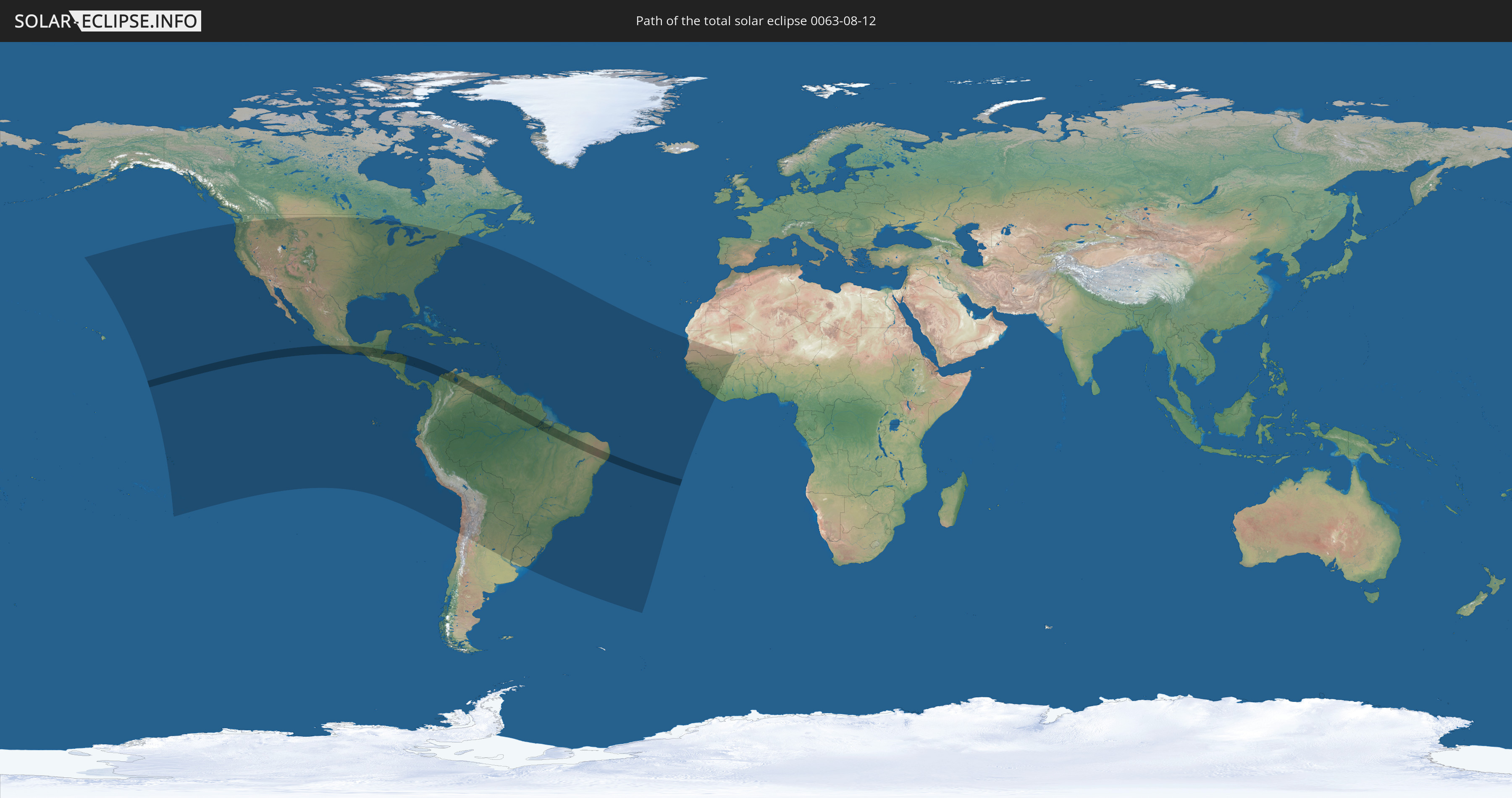
Die Sonnenfinsternis am 08/12/0063 kann man in 61 Ländern als partielle Sonnenfinsternis beobachten.
Der Finsternispfad verläuft durch 10 Länder. Nur in diesen Ländern ist sie als total Sonnenfinsternis zu sehen.
In den folgenden Ländern ist die Sonnenfinsternis total zu sehen
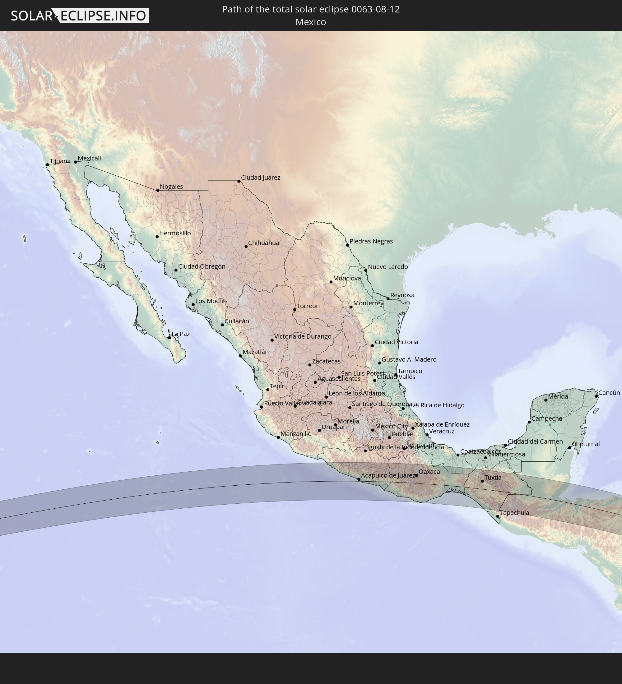 Mexico
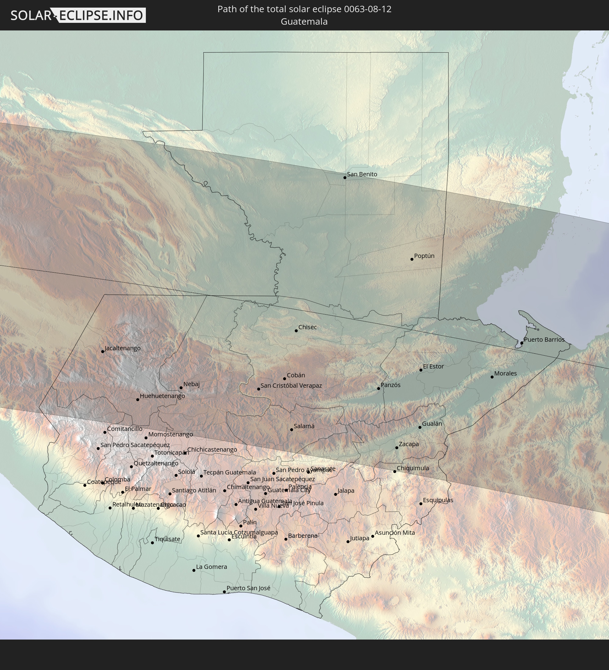 Guatemala
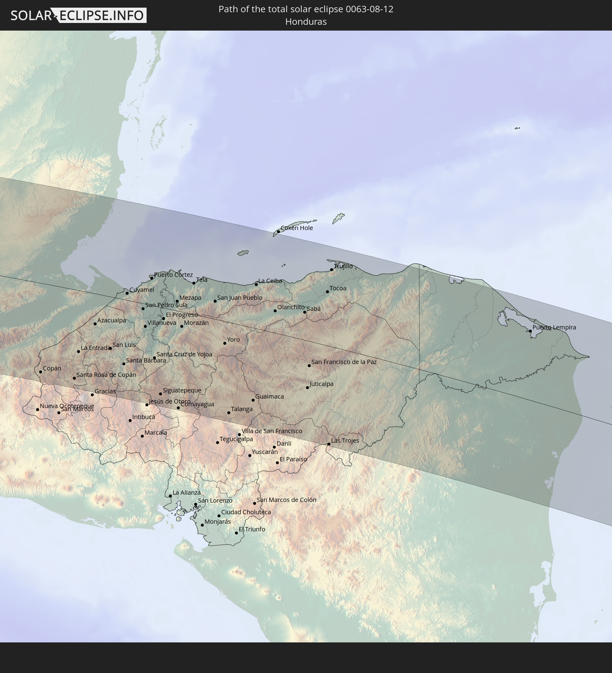 Honduras
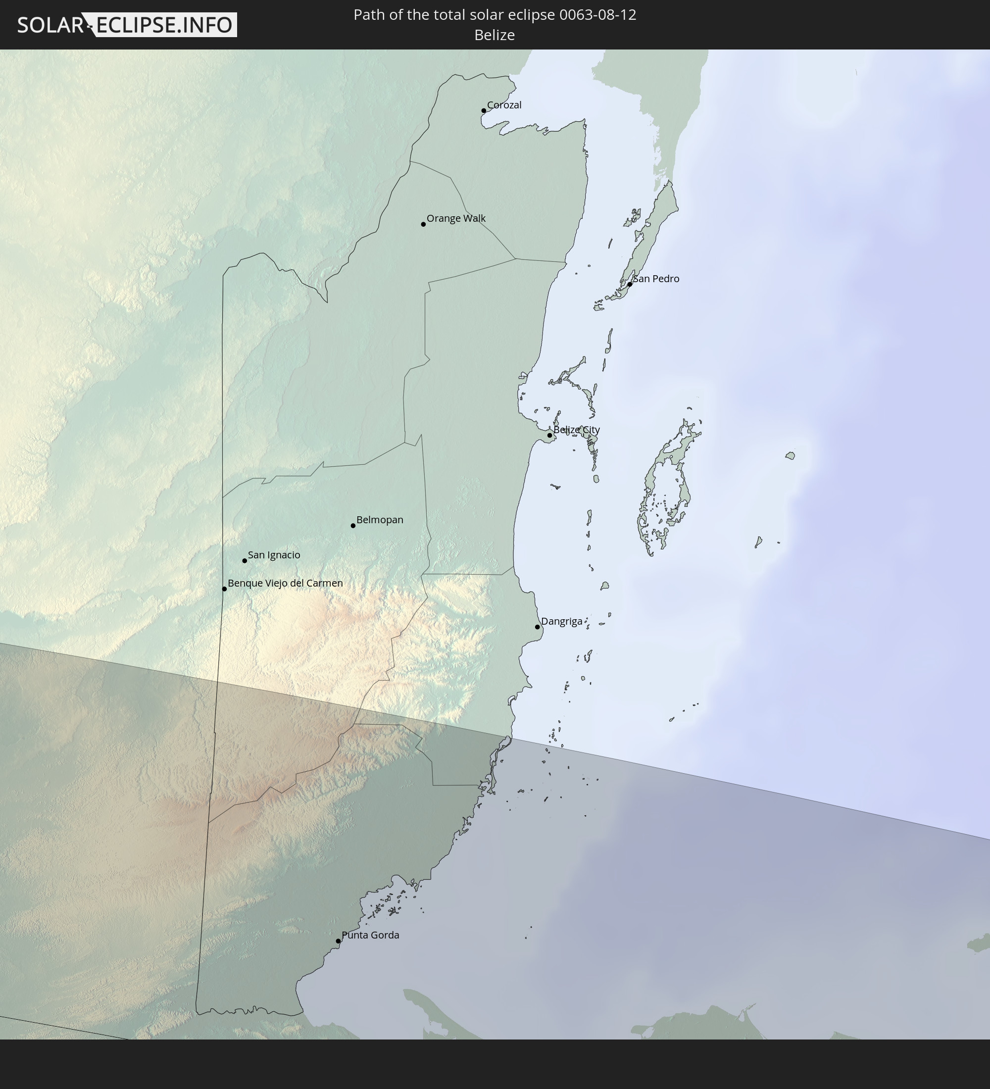 Belize
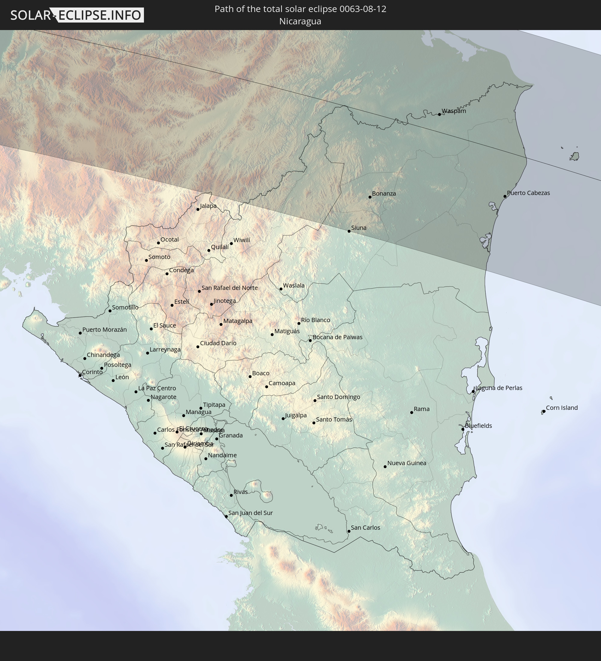 Nicaragua
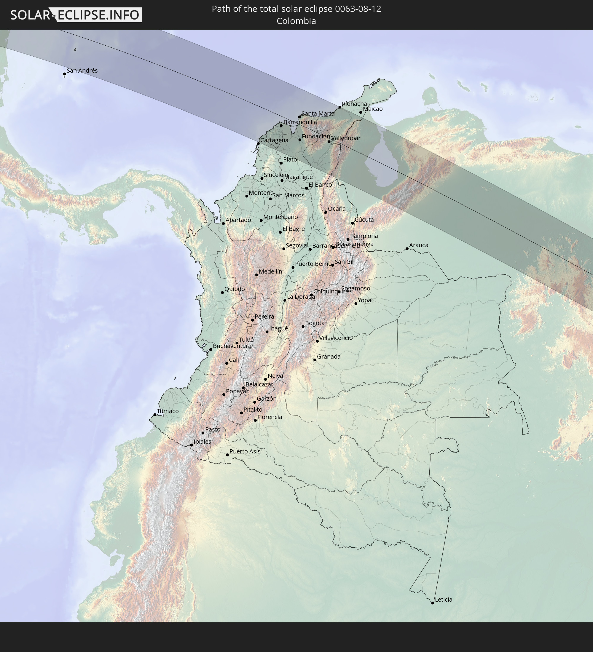 Colombia
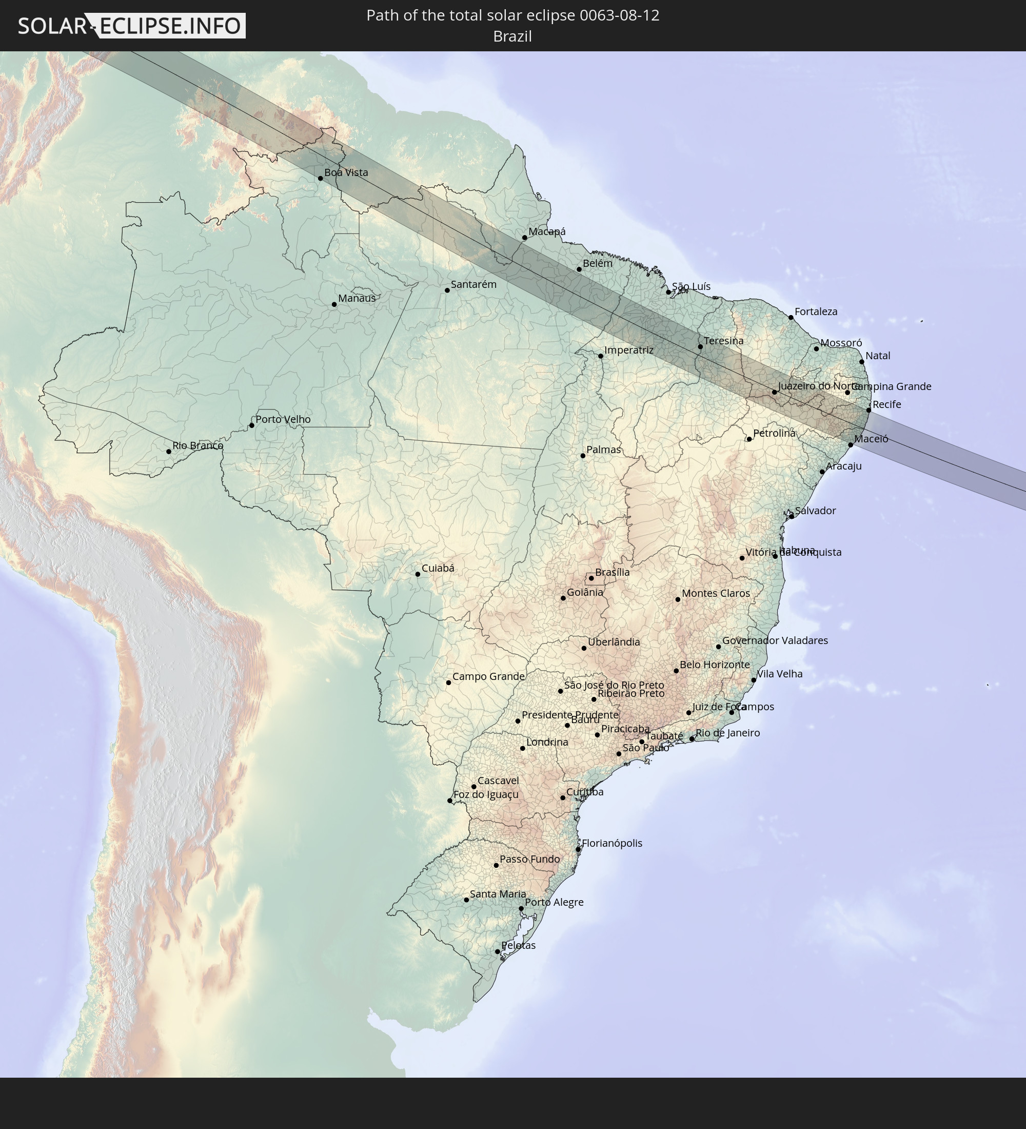 Brazil
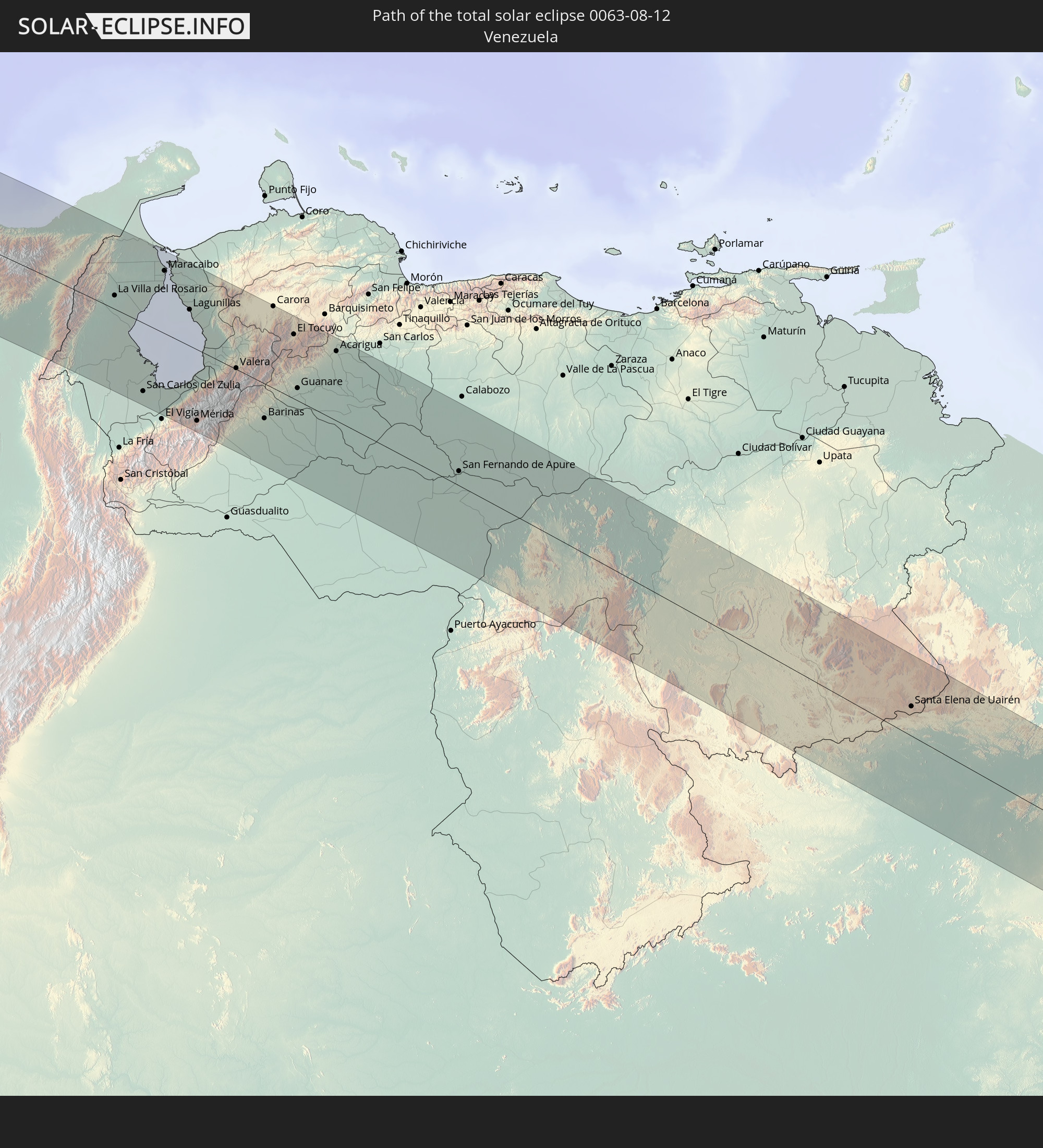 Venezuela
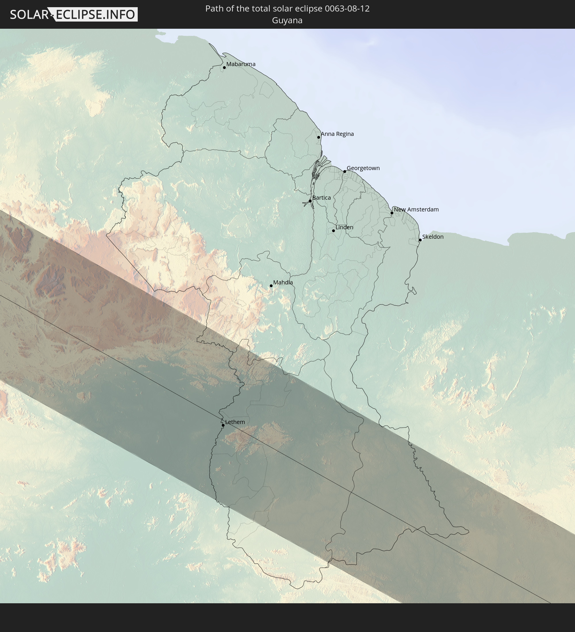 Guyana
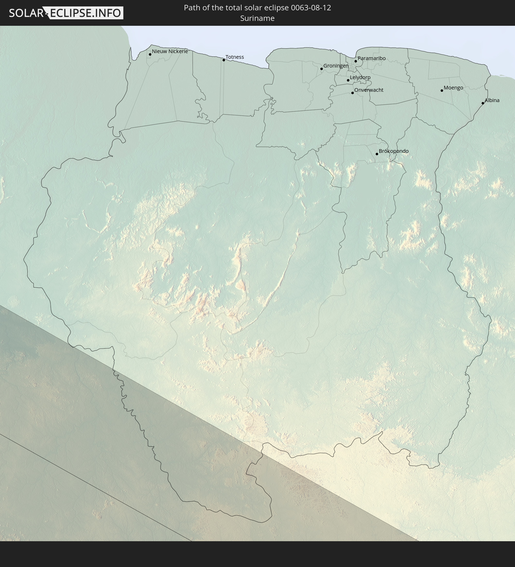 Suriname
In den folgenden Ländern ist die Sonnenfinsternis partiell zu sehen
 United States
 United States Minor Outlying Islands
 French Polynesia
 Canada
 Mexico
 Chile
Chile
 Guatemala
 Ecuador
 El Salvador
 Honduras
 Belize
 Nicaragua
 Costa Rica
 Cuba
Cuba
 Panama
 Colombia
 Cayman Islands
 Peru
Peru
 The Bahamas
 Jamaica
 Haiti
Haiti
 Brazil
 Argentina
 Venezuela
 Turks and Caicos Islands
 Dominican Republic
 Aruba
Aruba
 Bolivia
 Puerto Rico
 United States Virgin Islands
 Bermuda
 British Virgin Islands
 Anguilla
 Collectivity of Saint Martin
 Saint Barthélemy
 Saint Kitts and Nevis
 Paraguay
 Antigua and Barbuda
 Montserrat
 Trinidad and Tobago
 Guadeloupe
 Grenada
 Dominica
 Saint Vincent and the Grenadines
 Guyana
 Martinique
 Saint Lucia
 Barbados
 Uruguay
 Suriname
 French Guiana
 Cabo Verde
 Senegal
 Mauritania
 The Gambia
 Guinea-Bissau
 Guinea
 Sierra Leone
 Mali
Mali
 Liberia
 Ivory Coast
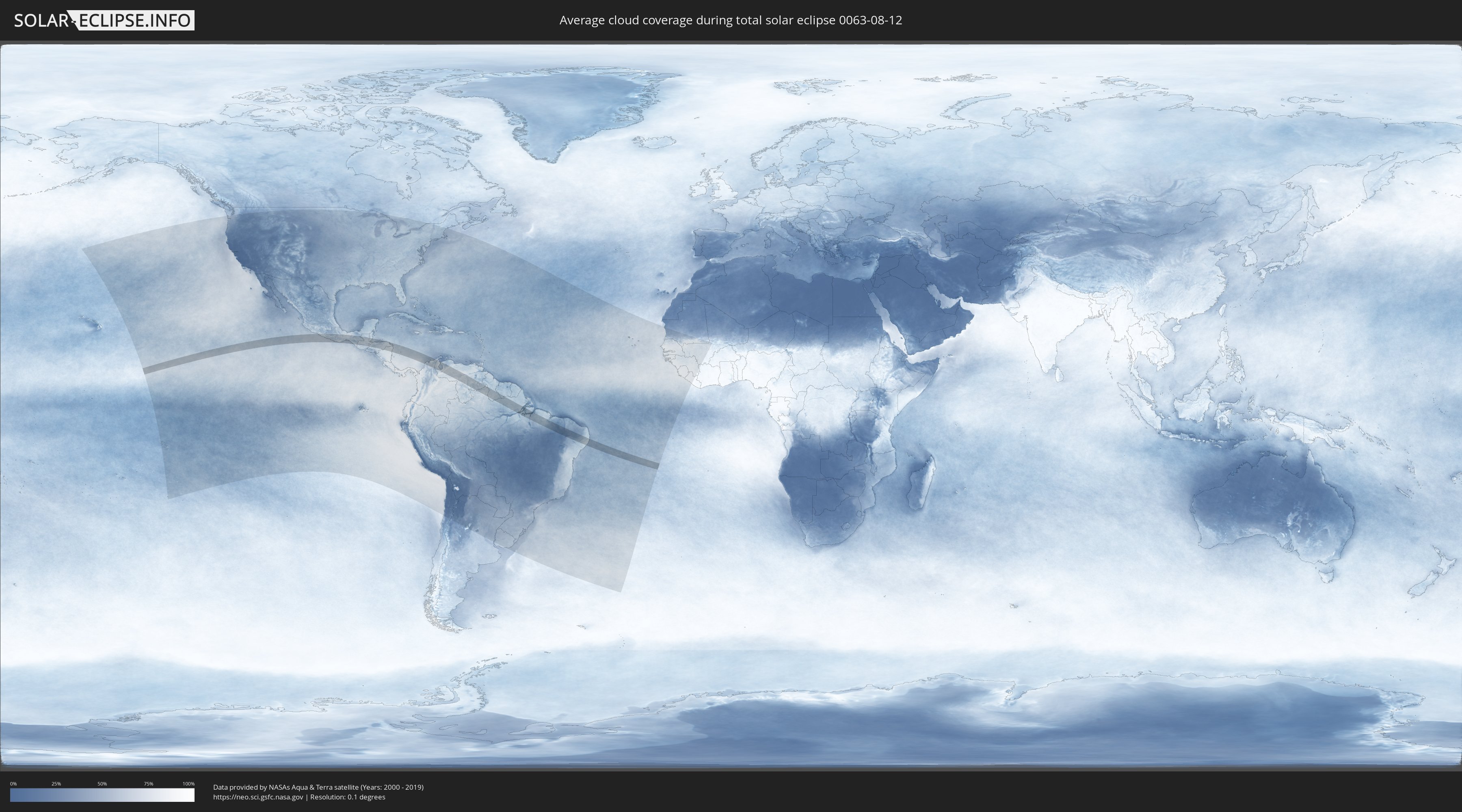
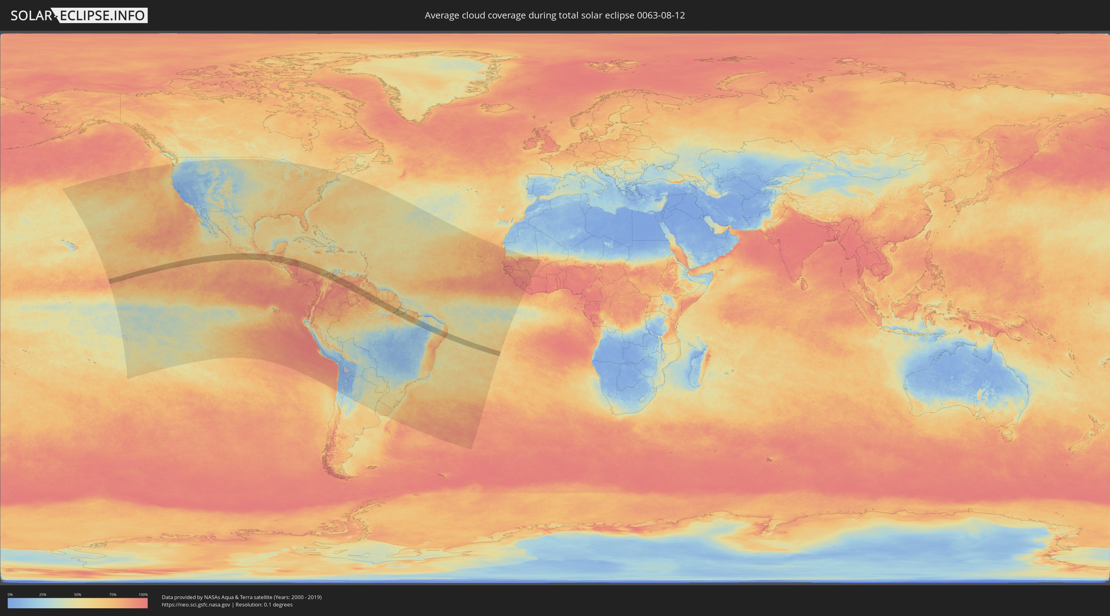
How will be the weather during the total solar eclipse on 08/12/0063?
Where is the best place to see the total solar eclipse of 08/12/0063?
The following maps show the average cloud coverage for the day of the total solar eclipse.
With the help of these maps, it is possible to find the place along the eclipse path, which has the best
chance of a cloudless sky.
Nevertheless, you should consider local circumstances and inform about the weather of your chosen
observation site.
The data is provided by NASAs satellites
AQUA and TERRA.
The cloud maps are averaged over a period of 19 years (2000 - 2019).
Detailed country maps
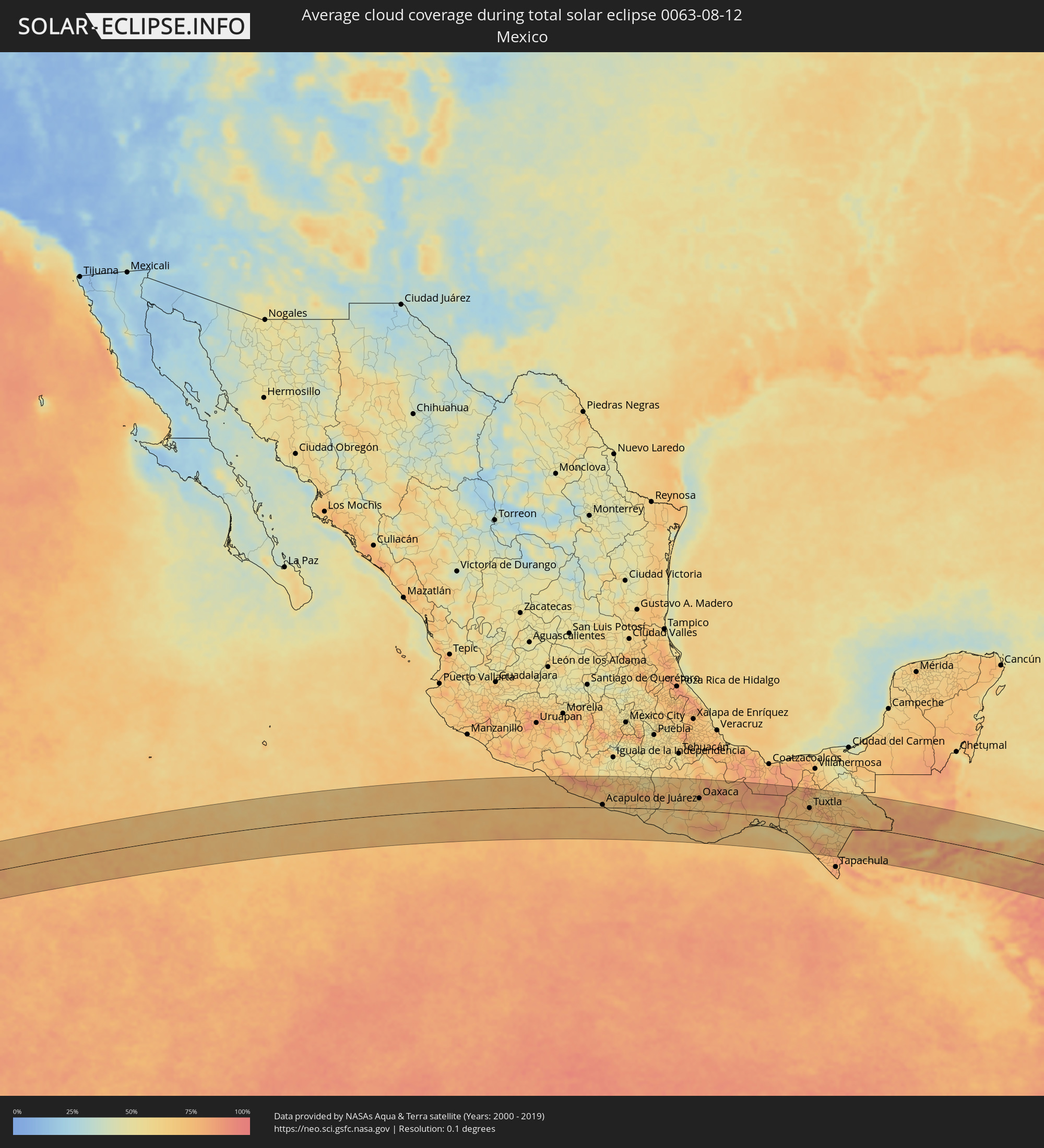 Mexico
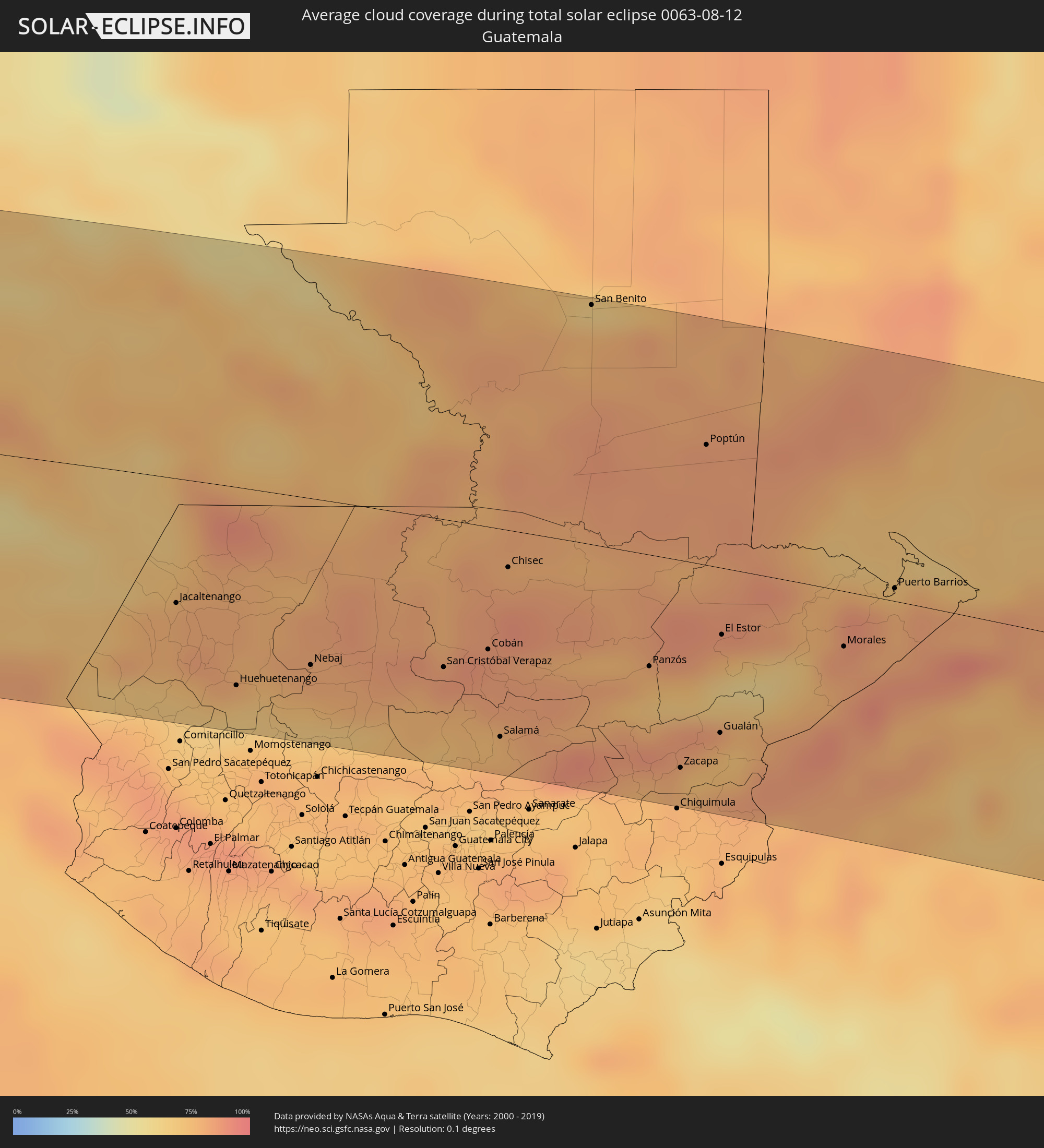 Guatemala
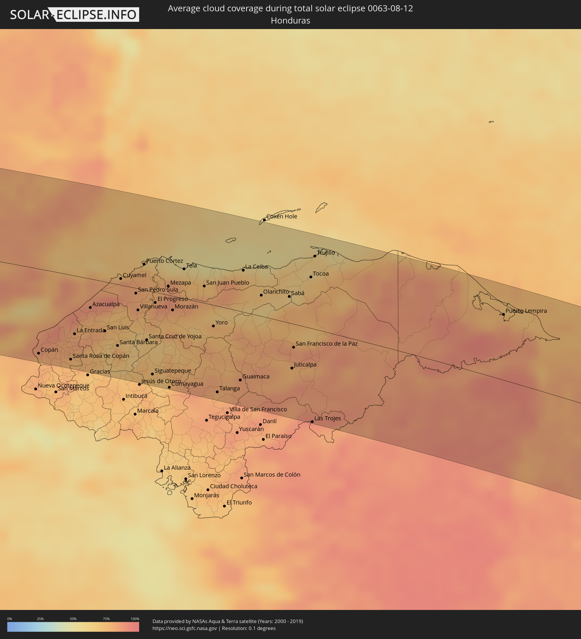 Honduras
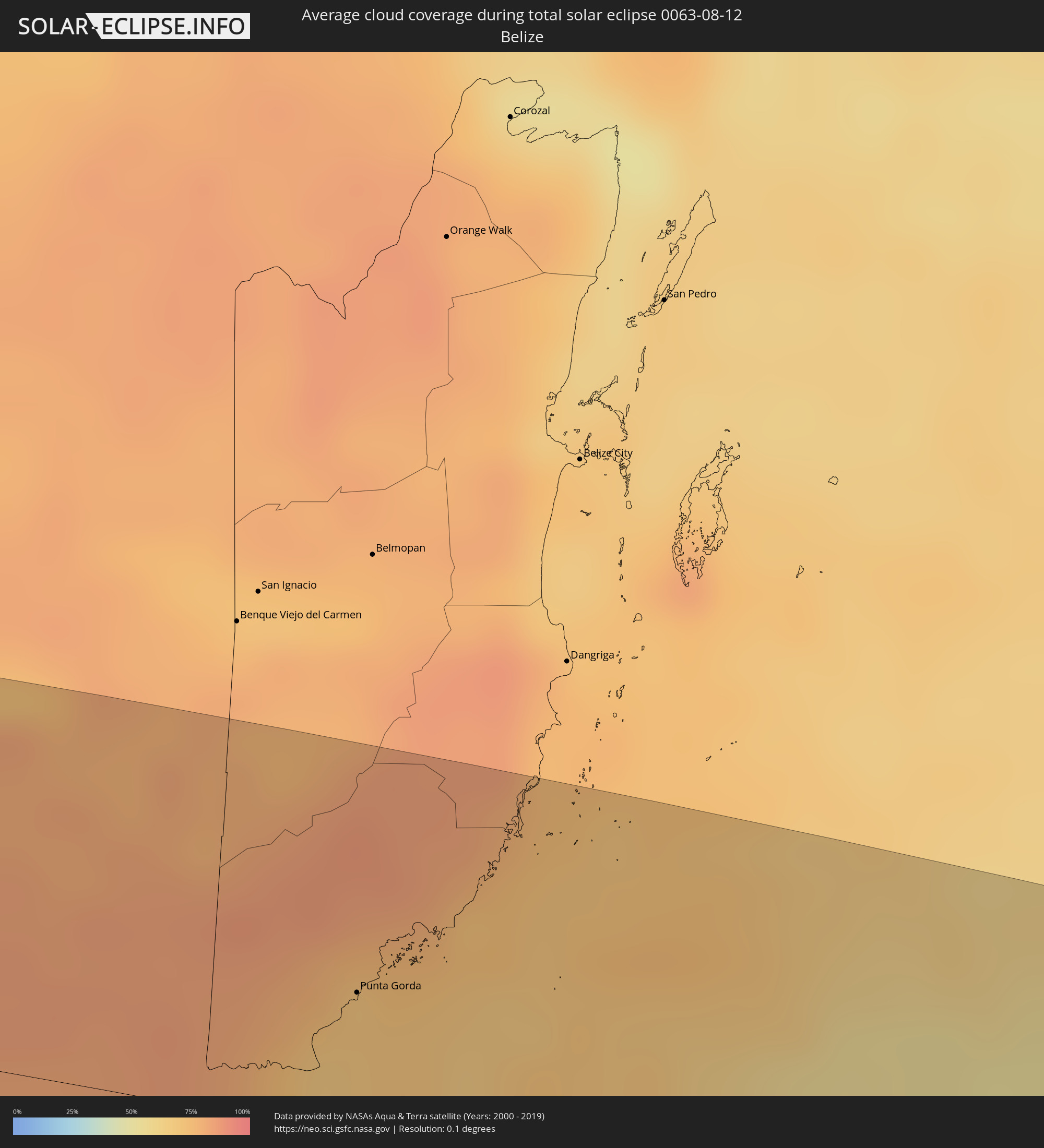 Belize
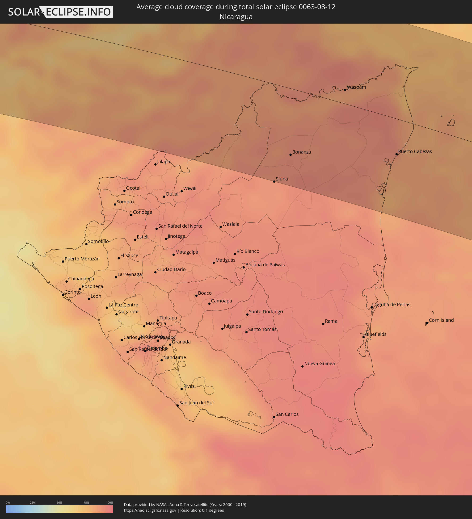 Nicaragua
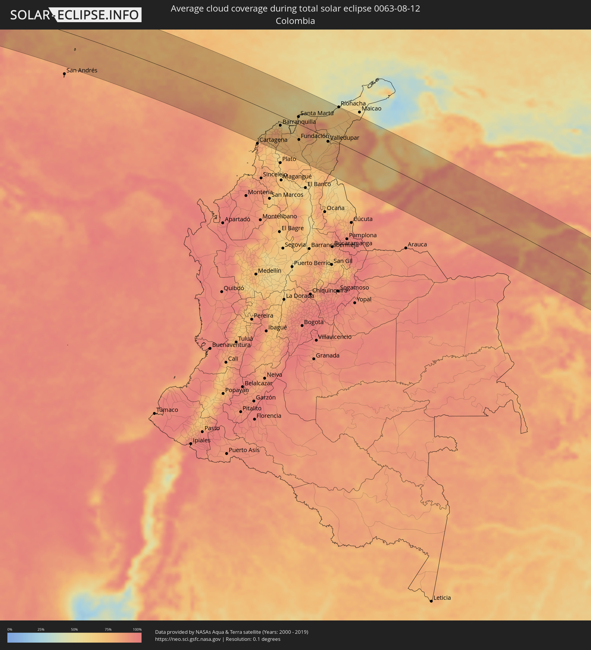 Colombia
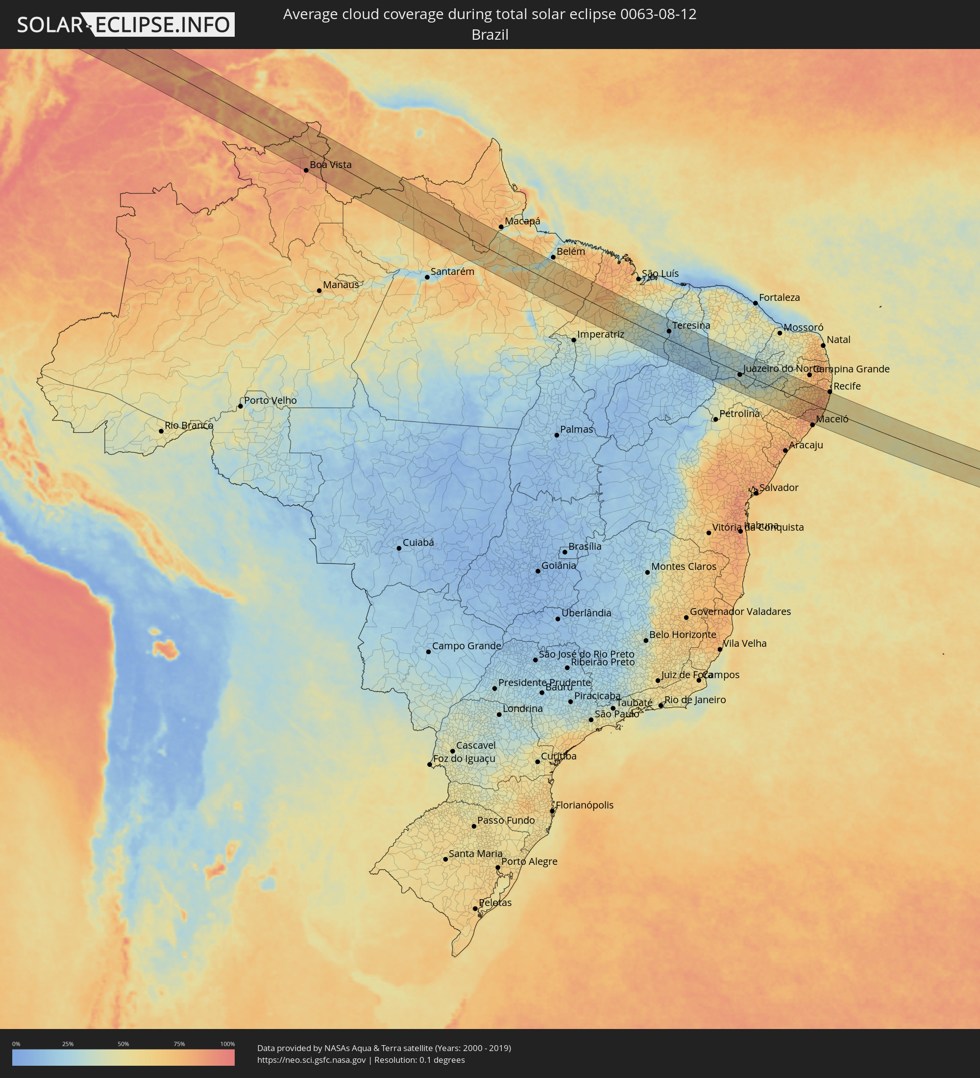 Brazil
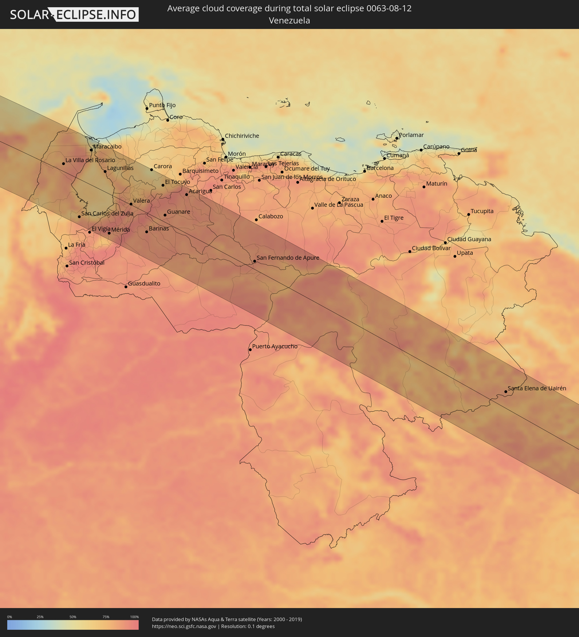 Venezuela
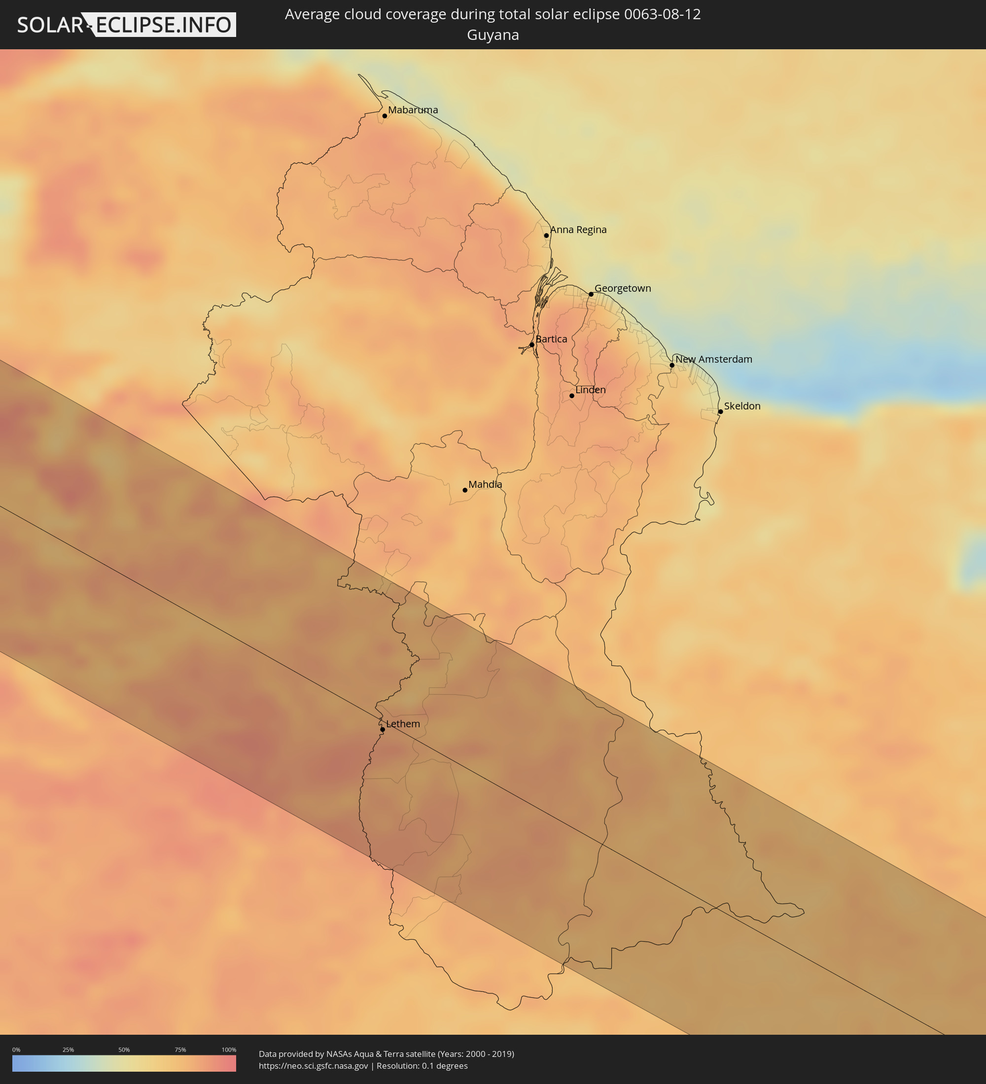 Guyana
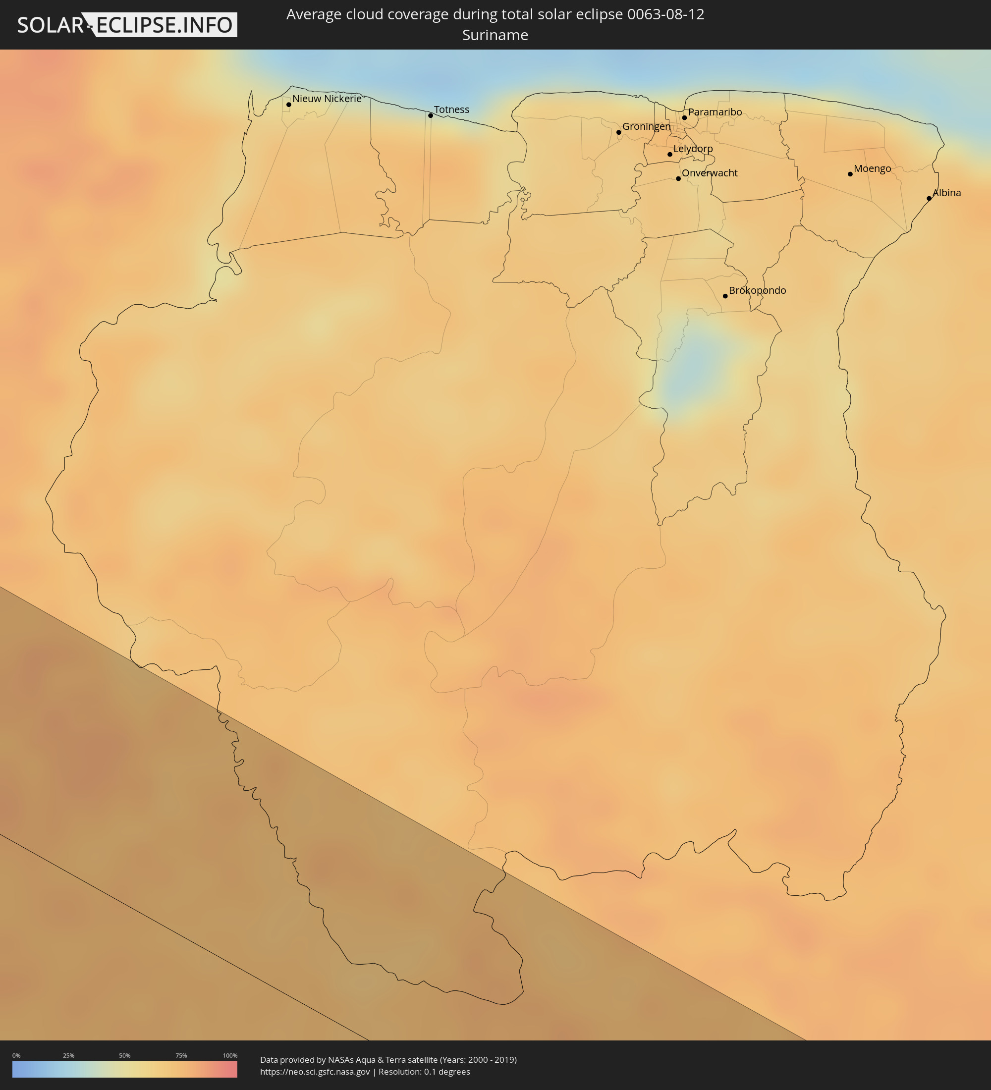 Suriname
Cities inside the path of the eclipse
The following table shows all locations with a population of more than 5,000 inside the eclipse path. Cities which have more than 100,000 inhabitants are marked bold. A click at the locations opens a detailed map.
| City | Type | Eclipse duration | Local time of max. eclipse | Distance to central line | Ø Cloud coverage |
|
Ixtapa-Zihuatanejo, Guerrero
|
total | - | 09:35:18 UTC-06:36 | 96 km | 70% |
|
Atoyac de Álvarez, Guerrero
|
total | - | 09:37:39 UTC-06:36 | 47 km | 73% |
|
Acapulco de Juárez, Guerrero
|
total | - | 09:38:51 UTC-06:36 | 9 km | 69% |
|
Chilpancingo, Guerrero
|
total | - | 09:39:36 UTC-06:36 | 86 km | 70% |
|
Chilapa de Alvarez, Guerrero
|
total | - | 09:40:19 UTC-06:36 | 92 km | 74% |
|
Malinaltepec, Guerrero
|
total | - | 09:41:28 UTC-06:36 | 55 km | 76% |
|
Tlapa de Comonfort, Guerrero
|
total | - | 09:41:38 UTC-06:36 | 88 km | 61% |
|
Pinotepa, Oaxaca
|
total | - | 09:43:01 UTC-06:36 | 44 km | 61% |
|
Oaxaca, Oaxaca
|
total | - | 09:45:56 UTC-06:36 | 44 km | 70% |
|
Santo Domingo Tehuantepec, Oaxaca
|
total | - | 09:49:41 UTC-06:36 | 27 km | 75% |
|
Salina Cruz, Oaxaca
|
total | - | 09:49:49 UTC-06:36 | 42 km | 69% |
|
San Jerónimo Ixtepec, Oaxaca
|
total | - | 09:49:56 UTC-06:36 | 2 km | 76% |
|
Matías Romero, Oaxaca
|
total | - | 09:50:00 UTC-06:36 | 36 km | 82% |
|
Juchitán de Zaragoza, Oaxaca
|
total | - | 09:50:11 UTC-06:36 | 13 km | 65% |
|
Arriaga, Chiapas
|
total | - | 09:53:01 UTC-06:36 | 23 km | 65% |
|
Tonalá, Chiapas
|
total | - | 09:53:26 UTC-06:36 | 38 km | 65% |
|
Cintalapa de Figueroa, Chiapas
|
total | - | 09:53:19 UTC-06:36 | 28 km | 74% |
|
Ocozocoautla de Espinosa, Chiapas
|
total | - | 09:54:08 UTC-06:36 | 41 km | 72% |
|
Tuxtla, Chiapas
|
total | - | 09:54:48 UTC-06:36 | 44 km | 78% |
|
San Cristóbal de las Casas, Chiapas
|
total | - | 09:56:00 UTC-06:36 | 47 km | 79% |
|
Comitán, Chiapas
|
total | - | 09:57:30 UTC-06:36 | 0 km | 67% |
|
Ocosingo, Chiapas
|
total | - | 09:57:19 UTC-06:36 | 74 km | 69% |
|
Las Margaritas, Chiapas
|
total | - | 09:57:52 UTC-06:36 | 10 km | 66% |
|
Jacaltenango, Huehuetenango
|
total | - | 10:33:21 UTC-06:02 | 58 km | 81% |
|
San Mateo Ixtatán, Huehuetenango
|
total | - | 10:33:57 UTC-06:02 | 36 km | 79% |
|
Huehuetenango, Huehuetenango
|
total | - | 10:34:13 UTC-06:02 | 92 km | 65% |
|
Barillas, Huehuetenango
|
total | - | 10:34:23 UTC-06:02 | 36 km | 75% |
|
Nebaj, Quiché
|
total | - | 10:35:02 UTC-06:02 | 77 km | 76% |
|
Zacualpa, Quiché
|
total | - | 10:36:02 UTC-06:02 | 107 km | 77% |
|
Cubulco, Baja Verapaz
|
total | - | 10:36:41 UTC-06:02 | 98 km | 76% |
|
San Cristóbal Verapaz, Alta Verapaz
|
total | - | 10:36:35 UTC-06:02 | 68 km | 79% |
|
Cobán, Alta Verapaz
|
total | - | 10:37:04 UTC-06:02 | 57 km | 84% |
|
Salamá, Baja Verapaz
|
total | - | 10:37:25 UTC-06:02 | 96 km | 78% |
|
Chisec, Alta Verapaz
|
total | - | 10:37:07 UTC-06:02 | 17 km | 82% |
|
San Agustín Acasaguastlán, El Progreso
|
total | - | 10:38:27 UTC-06:02 | 106 km | 72% |
|
San Benito, Petén
|
total | - | 10:37:29 UTC-06:02 | 110 km | 77% |
|
Santa Ana, Petén
|
total | - | 10:37:46 UTC-06:02 | 99 km | 79% |
|
Panzós, Alta Verapaz
|
total | - | 10:39:00 UTC-06:02 | 51 km | 70% |
|
Zacapa, Zacapa
|
total | - | 10:39:37 UTC-06:02 | 96 km | 77% |
|
Poptún, Petén
|
total | - | 10:39:08 UTC-06:02 | 55 km | 84% |
|
Dolores, Petén
|
total | - | 10:39:02 UTC-06:02 | 75 km | 83% |
|
Gualán, Zacapa
|
total | - | 10:40:00 UTC-06:02 | 76 km | 74% |
|
El Estor, Izabal
|
total | - | 10:39:47 UTC-06:02 | 31 km | 64% |
|
Morales, Izabal
|
total | - | 10:41:15 UTC-06:02 | 25 km | 82% |
|
Punta Gorda, Toledo
|
total | - | 10:50:10 UTC-05:52 | 42 km | 69% |
|
Santa Rosa de Copán, Copán
|
total | - | 10:55:01 UTC-05:48 | 103 km | 77% |
|
Lívingston, Izabal
|
total | - | 10:41:13 UTC-06:02 | 14 km | 78% |
|
La Entrada, Copán
|
total | - | 10:54:57 UTC-05:48 | 71 km | 83% |
|
Puerto Barrios, Izabal
|
total | - | 10:41:42 UTC-06:02 | 6 km | 79% |
|
Santa Bárbara, Santa Bárbara
|
total | - | 10:56:24 UTC-05:48 | 75 km | 74% |
|
Cofradía, Cortés
|
total | - | 10:56:20 UTC-05:48 | 20 km | 72% |
|
San Pedro Sula, Cortés
|
total | - | 10:56:36 UTC-05:48 | 6 km | 83% |
|
Villanueva, Cortés
|
total | - | 10:56:48 UTC-05:48 | 26 km | 72% |
|
Puerto Cortez, Cortés
|
total | - | 10:56:39 UTC-05:48 | 31 km | 79% |
|
Santa Cruz de Yojoa, Cortés
|
total | - | 10:57:18 UTC-05:48 | 60 km | 69% |
|
Siguatepeque, Comayagua
|
total | - | 10:57:44 UTC-05:48 | 100 km | 71% |
|
El Progreso, Yoro
|
total | - | 10:57:17 UTC-05:48 | 13 km | 79% |
|
Comayagua, Comayagua
|
total | - | 10:58:23 UTC-05:48 | 112 km | 76% |
|
Morazán, Yoro
|
total | - | 10:57:54 UTC-05:48 | 17 km | 75% |
|
Tela, Atlántida
|
total | - | 10:57:57 UTC-05:48 | 36 km | 65% |
|
Santa Rita, Yoro
|
total | - | 10:58:52 UTC-05:48 | 26 km | 68% |
|
Yoro, Yoro
|
total | - | 10:59:19 UTC-05:48 | 26 km | 75% |
|
Talanga, Francisco Morazán
|
total | - | 10:59:59 UTC-05:48 | 105 km | 81% |
|
Guaimaca, Francisco Morazán
|
total | - | 11:00:38 UTC-05:48 | 84 km | 83% |
|
La Ceiba, Atlántida
|
total | - | 10:59:50 UTC-05:48 | 50 km | 69% |
|
Olanchito, Yoro
|
total | - | 11:00:37 UTC-05:48 | 25 km | 63% |
|
Sabá, Colón
|
total | - | 11:01:31 UTC-05:48 | 32 km | 72% |
|
Juticalpa, Olancho
|
total | - | 11:02:12 UTC-05:48 | 54 km | 77% |
|
Tocoa, Colón
|
total | - | 11:02:03 UTC-05:48 | 61 km | 69% |
|
Trujillo, Colón
|
total | - | 11:02:00 UTC-05:48 | 88 km | 63% |
|
Bonanza, Atlántico Norte (RAAN)
|
total | - | 11:11:00 UTC-05:45 | 78 km | 90% |
|
Waspam, Atlántico Norte (RAAN)
|
total | - | 11:12:08 UTC-05:45 | 16 km | 91% |
|
Puerto Cabezas, Atlántico Norte (RAAN)
|
total | - | 11:14:25 UTC-05:45 | 42 km | 83% |
|
Santa Rosa, Bolívar
|
total | - | 12:30:01 UTC-04:56 | 110 km | 82% |
|
Villanueva, Bolívar
|
total | - | 12:30:17 UTC-04:56 | 106 km | 77% |
|
Repelón, Atlántico
|
total | - | 12:30:38 UTC-04:56 | 95 km | 68% |
|
Puerto Colombia, Atlántico
|
total | - | 12:30:30 UTC-04:56 | 37 km | 74% |
|
Sabanalarga, Atlántico
|
total | - | 12:31:02 UTC-04:56 | 71 km | 76% |
|
Baranoa, Atlántico
|
total | - | 12:30:51 UTC-04:56 | 55 km | 81% |
|
Campo de la Cruz, Atlántico
|
total | - | 12:31:27 UTC-04:56 | 95 km | 70% |
|
Candelaria, Atlántico
|
total | - | 12:31:21 UTC-04:56 | 87 km | 77% |
|
Barranquilla, Atlántico
|
total | - | 12:31:00 UTC-04:56 | 31 km | 75% |
|
Palmar de Varela, Atlántico
|
total | - | 12:31:21 UTC-04:56 | 53 km | 76% |
|
Ponedera, Atlántico
|
total | - | 12:31:29 UTC-04:56 | 63 km | 73% |
|
Pivijay, Magdalena
|
total | - | 12:32:05 UTC-04:56 | 75 km | 77% |
|
Ciénaga, Magdalena
|
total | - | 12:32:25 UTC-04:56 | 3 km | 72% |
|
Santa Marta, Magdalena
|
total | - | 12:32:15 UTC-04:56 | 23 km | 73% |
|
Fundación, Magdalena
|
total | - | 12:33:11 UTC-04:56 | 49 km | 74% |
|
Ariguaní, Cesar
|
total | - | 12:34:01 UTC-04:56 | 68 km | 71% |
|
La Jagua de Ibirico, Cesar
|
total | - | 12:36:41 UTC-04:56 | 106 km | 78% |
|
Valledupar, Cesar
|
total | - | 12:35:46 UTC-04:56 | 12 km | 71% |
|
Agustín Codazzi, Cesar
|
total | - | 12:36:21 UTC-04:56 | 54 km | 73% |
|
San Juan del Cesar, La Guajira
|
total | - | 12:36:03 UTC-04:56 | 31 km | 68% |
|
Villanueva, La Guajira
|
total | - | 12:36:19 UTC-04:56 | 15 km | 74% |
|
Ríohacha, La Guajira
|
total | - | 12:35:20 UTC-04:56 | 113 km | 75% |
|
Fonseca, La Guajira
|
total | - | 12:36:19 UTC-04:56 | 50 km | 69% |
|
Machiques, Zulia
|
total | - | 13:06:45 UTC-04:27 | 19 km | 76% |
|
La Villa del Rosario, Zulia
|
total | - | 13:07:02 UTC-04:27 | 19 km | 85% |
|
San Carlos del Zulia, Zulia
|
total | - | 13:09:47 UTC-04:27 | 95 km | 88% |
|
Maracaibo, Zulia
|
total | - | 13:08:26 UTC-04:27 | 87 km | 73% |
|
Santa Rita, Zulia
|
total | - | 13:08:52 UTC-04:27 | 78 km | 67% |
|
Cabimas, Zulia
|
total | - | 13:09:15 UTC-04:27 | 67 km | 73% |
|
Lagunillas, Zulia
|
total | - | 13:10:03 UTC-04:27 | 50 km | 63% |
|
Ejido, Mérida
|
total | - | 13:12:07 UTC-04:27 | 107 km | 74% |
|
Mérida, Mérida
|
total | - | 13:12:17 UTC-04:27 | 98 km | 78% |
|
Valera, Trujillo
|
total | - | 13:12:47 UTC-04:27 | 1 km | 86% |
|
Trujillo, Trujillo
|
total | - | 13:13:08 UTC-04:27 | 14 km | 82% |
|
Barinitas, Barinas
|
total | - | 13:13:59 UTC-04:27 | 44 km | 85% |
|
Alto Barinas, Barinas
|
total | - | 13:14:41 UTC-04:27 | 52 km | 90% |
|
Barinas, Barinas
|
total | - | 13:14:41 UTC-04:27 | 48 km | 90% |
|
Carora, Lara
|
total | - | 13:12:59 UTC-04:27 | 112 km | 55% |
|
El Tocuyo, Lara
|
total | - | 13:14:13 UTC-04:27 | 88 km | 78% |
|
Guanare, Portuguesa
|
total | - | 13:15:19 UTC-04:27 | 17 km | 87% |
|
Quíbor, Lara
|
total | - | 13:14:28 UTC-04:27 | 111 km | 76% |
|
Araure, Portuguesa
|
total | - | 13:15:58 UTC-04:27 | 95 km | 89% |
|
Acarigua, Portuguesa
|
total | - | 13:16:01 UTC-04:27 | 95 km | 89% |
|
Villa Bruzual, Portuguesa
|
total | - | 13:16:30 UTC-04:27 | 77 km | 88% |
|
San Fernando de Apure, Apure
|
total | - | 13:22:24 UTC-04:27 | 20 km | 88% |
|
Santa Elena de Uairén, Bolívar
|
total | - | 13:40:33 UTC-04:27 | 40 km | 83% |
|
Boa Vista, Roraima
|
total | - | 14:08:33 UTC-04:02 | 109 km | 83% |
|
Lethem, Upper Takutu-Upper Essequibo
|
total | - | 14:19:35 UTC-03:52 | 7 km | 81% |
|
Abaetetuba, Pará
|
total | - | 15:20:41 UTC-03:13 | 77 km | 52% |
|
Paragominas, Pará
|
total | - | 15:23:25 UTC-03:13 | 25 km | 74% |
|
Santa Inês, Maranhão
|
total | - | 16:06:12 UTC-02:34 | 60 km | 64% |
|
Bacabal, Maranhão
|
total | - | 16:07:16 UTC-02:34 | 26 km | 48% |
|
Codó, Maranhão
|
total | - | 16:08:17 UTC-02:34 | 54 km | 35% |
|
Caxias, Maranhão
|
total | - | 16:09:04 UTC-02:34 | 38 km | 30% |
|
Teresina, Piauí
|
total | - | 16:09:44 UTC-02:34 | 42 km | 23% |
|
Picos, Piauí
|
total | - | 16:12:08 UTC-02:34 | 96 km | 19% |
|
Juazeiro do Norte, Ceará
|
total | - | 16:13:53 UTC-02:34 | 12 km | 34% |
|
Iguatu, Ceará
|
total | - | 16:13:25 UTC-02:34 | 76 km | 30% |
|
Serra Talhada, Pernambuco
|
total | - | 16:29:25 UTC-02:19 | 46 km | 44% |
|
Arcoverde, Pernambuco
|
total | - | 16:30:27 UTC-02:19 | 35 km | 54% |
|
Garanhuns, Pernambuco
|
total | - | 16:31:00 UTC-02:19 | 58 km | 78% |
|
Santa Cruz do Capibaribe, Pernambuco
|
total | - | 16:30:45 UTC-02:19 | 49 km | 73% |
|
Caruaru, Pernambuco
|
total | - | 16:31:02 UTC-02:19 | 26 km | 76% |
|
Rio Largo, Alagoas
|
total | - | 16:17:15 UTC-02:34 | 92 km | 79% |
|
Bezerros, Pernambuco
|
total | - | 16:31:07 UTC-02:19 | 39 km | 71% |
|
Gravatá, Pernambuco
|
total | - | 16:31:14 UTC-02:19 | 52 km | 74% |
|
Vitória de Santo Antão, Pernambuco
|
total | - | 16:31:21 UTC-02:19 | 72 km | 81% |
|
Ipojuca, Pernambuco
|
total | - | 16:31:37 UTC-02:19 | 53 km | 76% |
|
São Lourenço da Mata, Pernambuco
|
total | - | 16:31:27 UTC-02:19 | 95 km | 76% |
|
Jaboatão, Pernambuco
|
total | - | 16:31:33 UTC-02:19 | 78 km | 66% |