Total solar eclipse of 03/11/0183
| Day of week: | Tuesday |
| Maximum duration of eclipse: | 04m14s |
| Maximum width of eclipse path: | 195 km |
| Saros cycle: | 81 |
| Coverage: | 100% |
| Magnitude: | 1.0523 |
| Gamma: | 0.4771 |
Wo kann man die Sonnenfinsternis vom 03/11/0183 sehen?
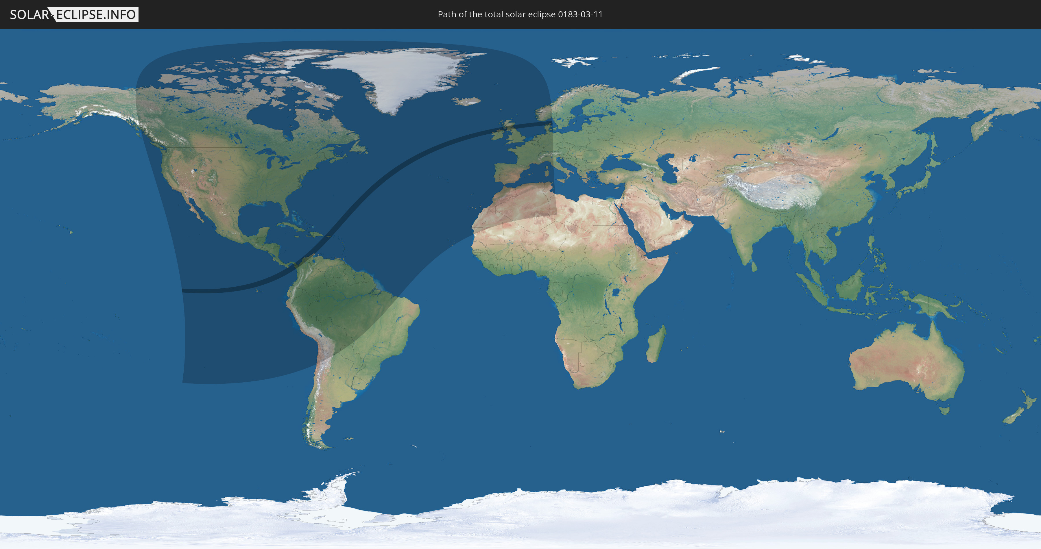
Die Sonnenfinsternis am 03/11/0183 kann man in 82 Ländern als partielle Sonnenfinsternis beobachten.
Der Finsternispfad verläuft durch 8 Länder. Nur in diesen Ländern ist sie als total Sonnenfinsternis zu sehen.
In den folgenden Ländern ist die Sonnenfinsternis total zu sehen
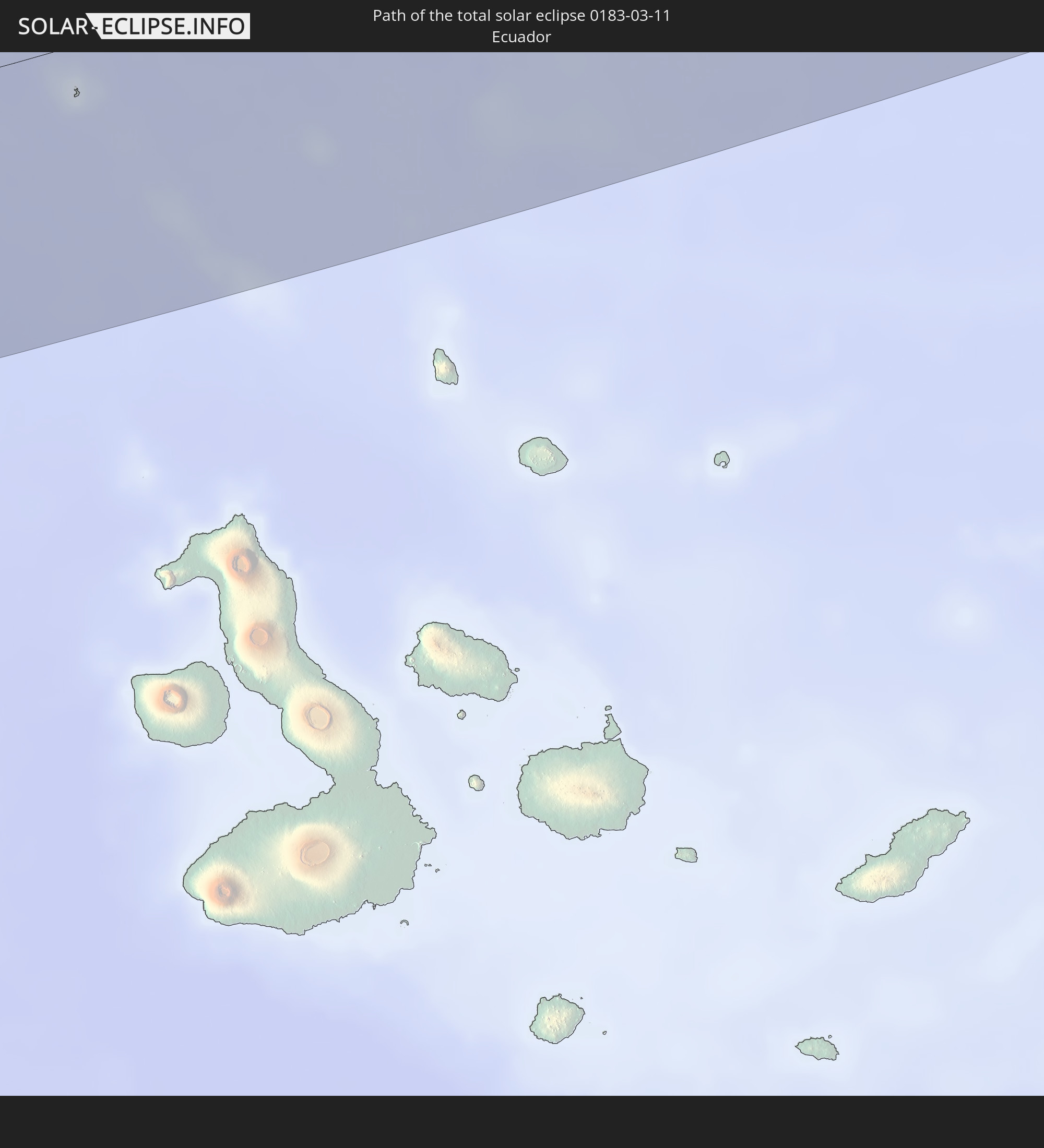 Ecuador
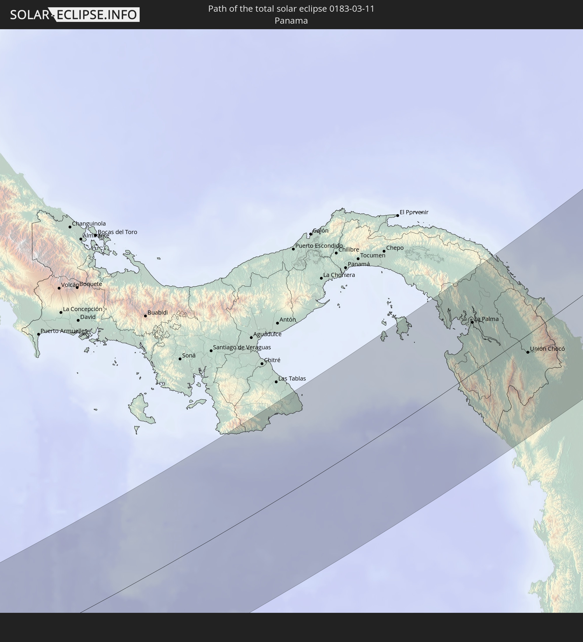 Panama
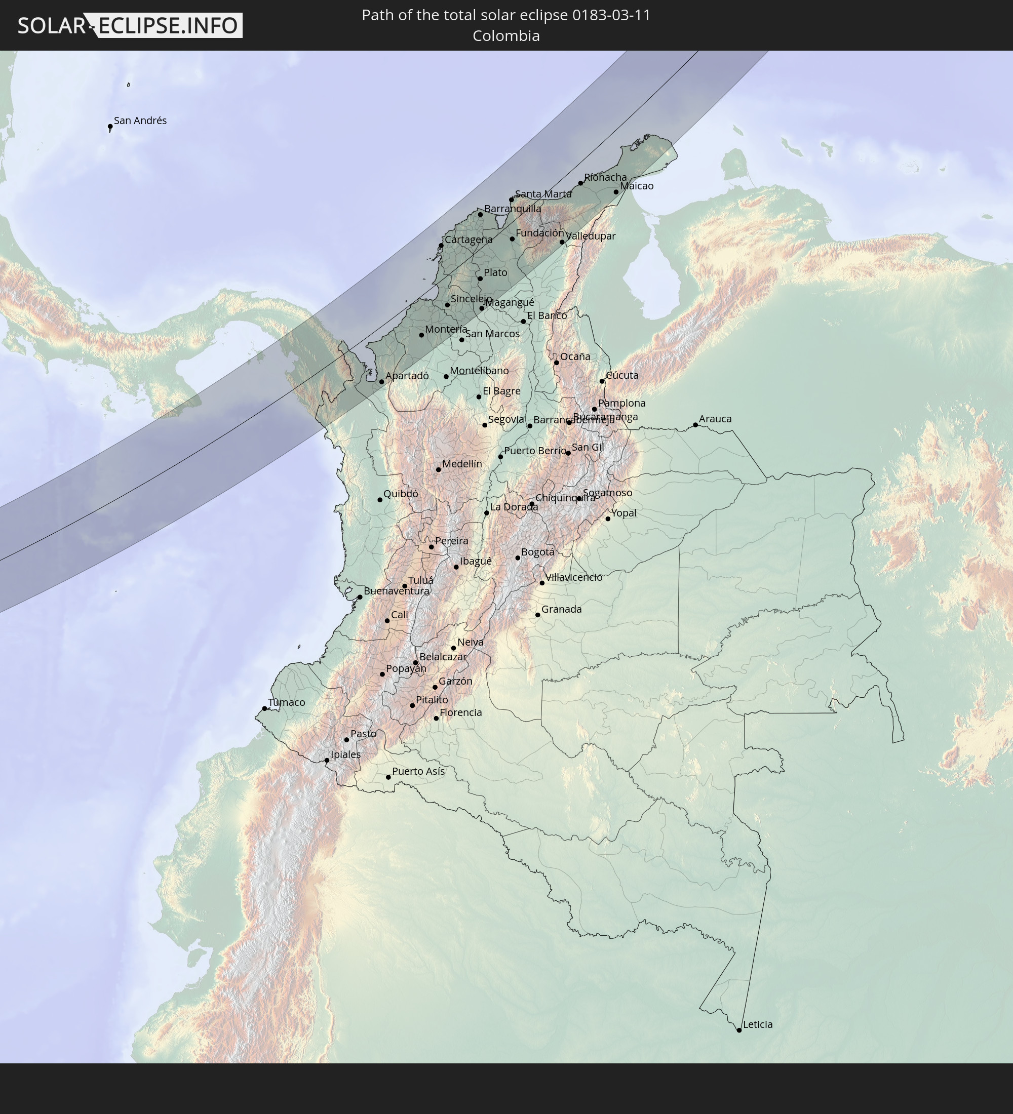 Colombia
 Venezuela
 Puerto Rico
 Republic of Ireland
 United Kingdom
 Denmark
In den folgenden Ländern ist die Sonnenfinsternis partiell zu sehen
 United States
 United States Minor Outlying Islands
 Canada
 Mexico
 Chile
Chile
 Greenland
 Guatemala
 Ecuador
 El Salvador
 Honduras
 Belize
 Nicaragua
 Costa Rica
 Cuba
Cuba
 Panama
 Colombia
 Cayman Islands
 Peru
Peru
 The Bahamas
 Jamaica
 Haiti
Haiti
 Brazil
 Argentina
 Venezuela
 Turks and Caicos Islands
 Dominican Republic
 Aruba
Aruba
 Bolivia
 Puerto Rico
 United States Virgin Islands
 Bermuda
 British Virgin Islands
 Anguilla
 Collectivity of Saint Martin
 Saint Barthélemy
 Saint Kitts and Nevis
 Paraguay
 Antigua and Barbuda
 Montserrat
 Trinidad and Tobago
 Guadeloupe
 Grenada
 Dominica
 Saint Vincent and the Grenadines
 Guyana
 Martinique
 Saint Lucia
 Barbados
 Suriname
 Saint Pierre and Miquelon
 French Guiana
 Portugal
 Cabo Verde
 Iceland
 Spain
Spain
 Mauritania
 Morocco
 Mali
Mali
 Republic of Ireland
 Svalbard and Jan Mayen
 Algeria
 United Kingdom
 Faroe Islands
 Gibraltar
 France
 Isle of Man
 Guernsey
 Jersey
 Andorra
 Belgium
 Netherlands
 Norway
 Luxembourg
 Germany
 Switzerland
 Italy
Italy
 Monaco
 Tunisia
 Denmark
 Libya
Libya
 Liechtenstein
 Austria
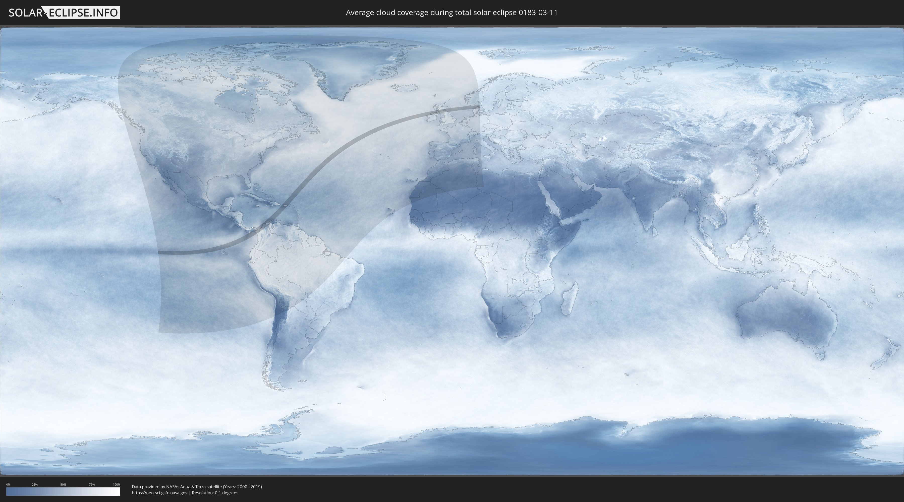
How will be the weather during the total solar eclipse on 03/11/0183?
Where is the best place to see the total solar eclipse of 03/11/0183?
The following maps show the average cloud coverage for the day of the total solar eclipse.
With the help of these maps, it is possible to find the place along the eclipse path, which has the best
chance of a cloudless sky.
Nevertheless, you should consider local circumstances and inform about the weather of your chosen
observation site.
The data is provided by NASAs satellites
AQUA and TERRA.
The cloud maps are averaged over a period of 19 years (2000 - 2019).

Detailed country maps
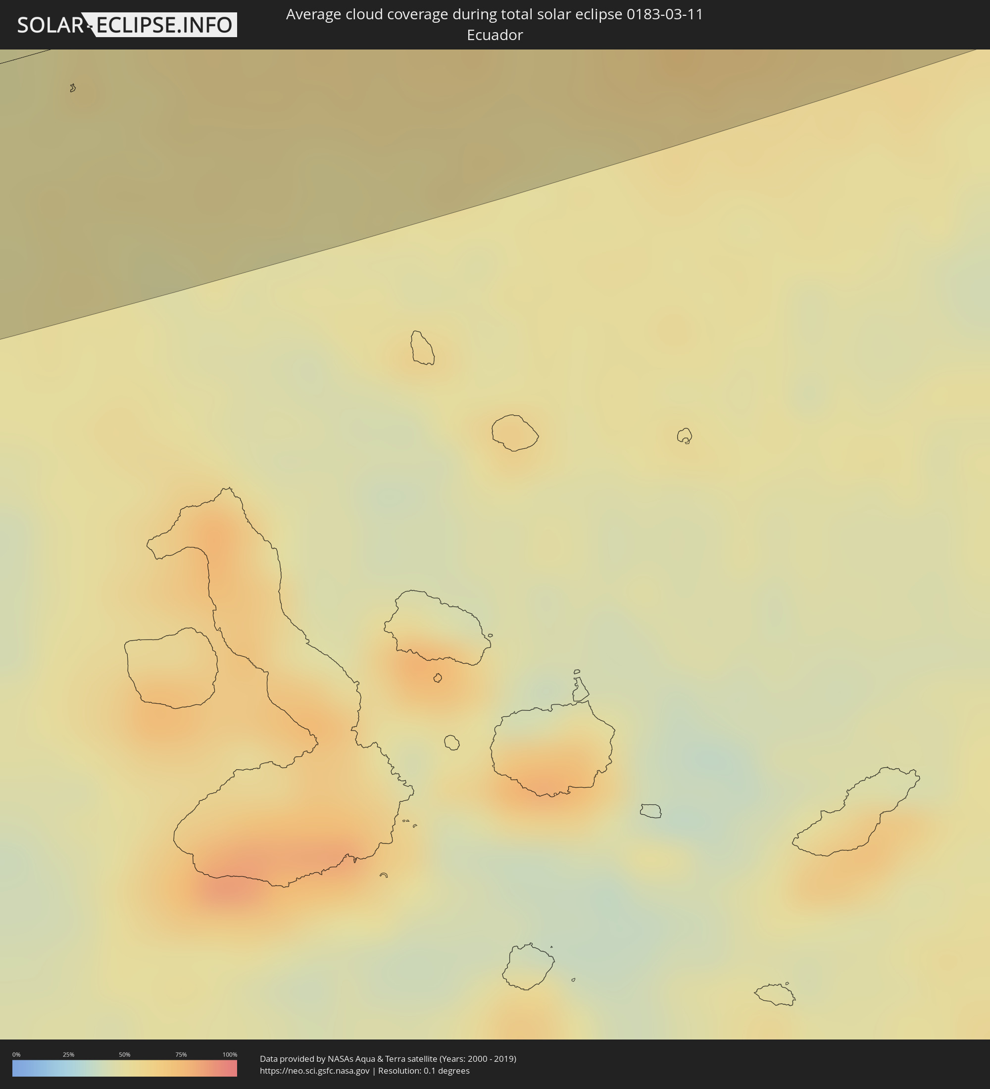 Ecuador
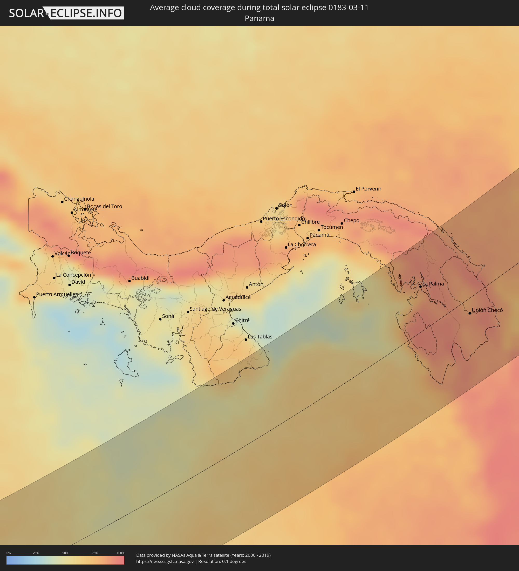 Panama
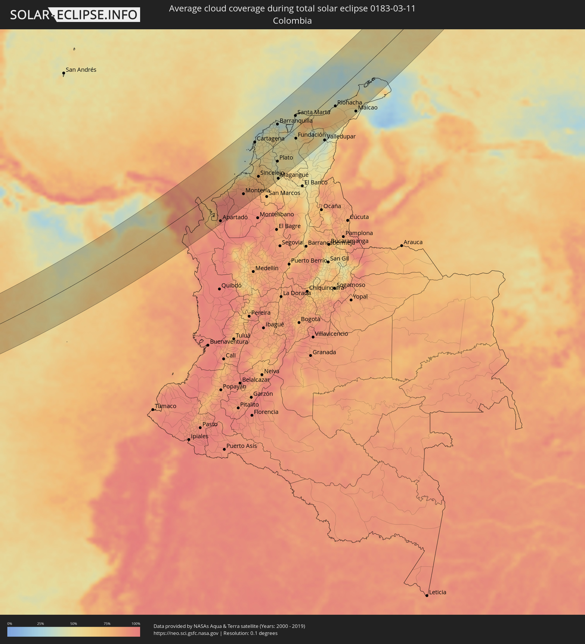 Colombia
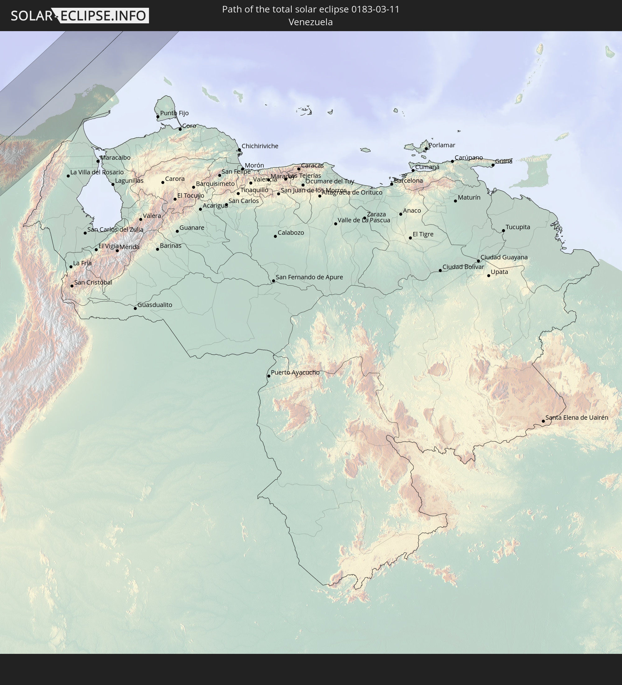
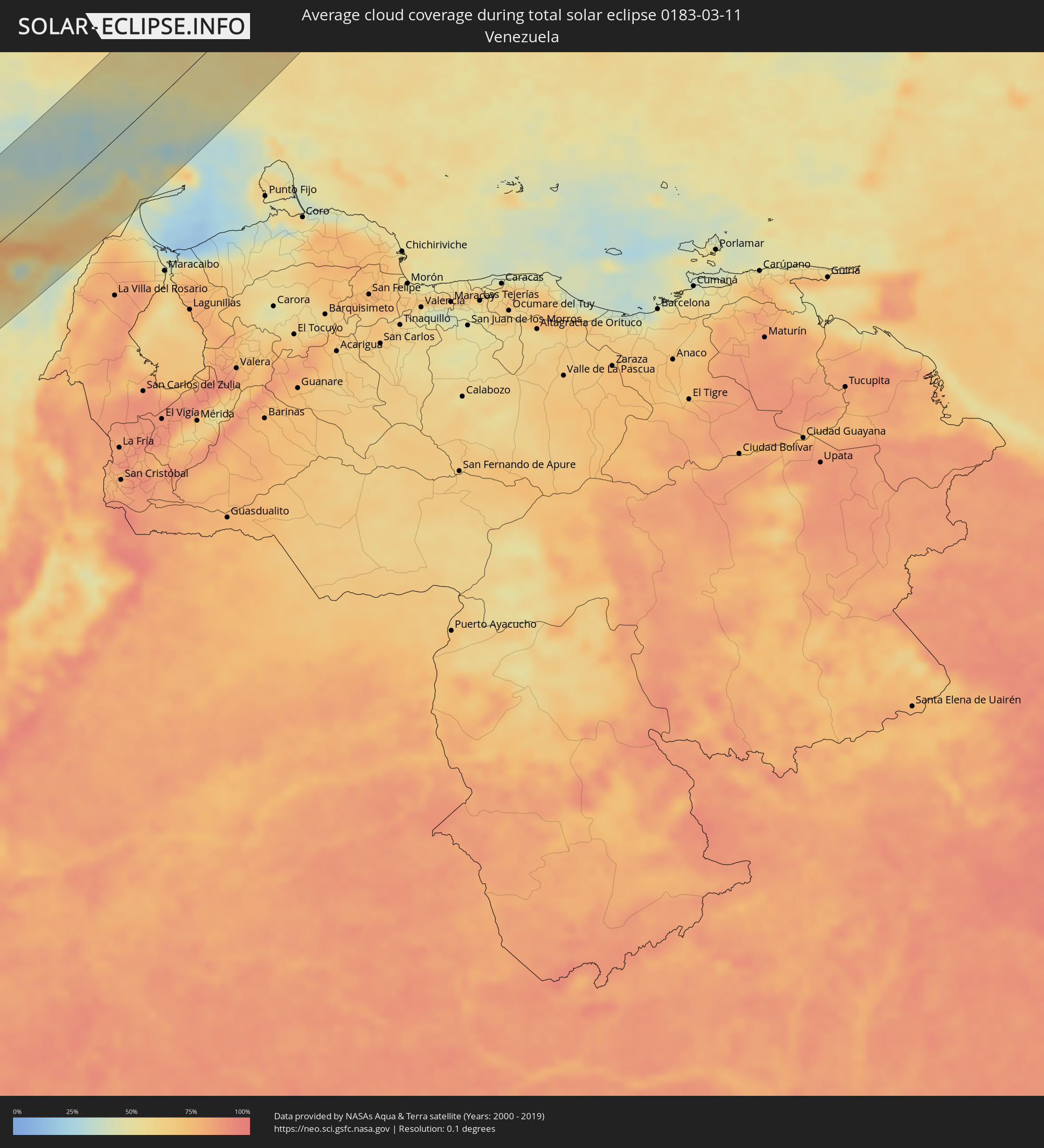 Venezuela
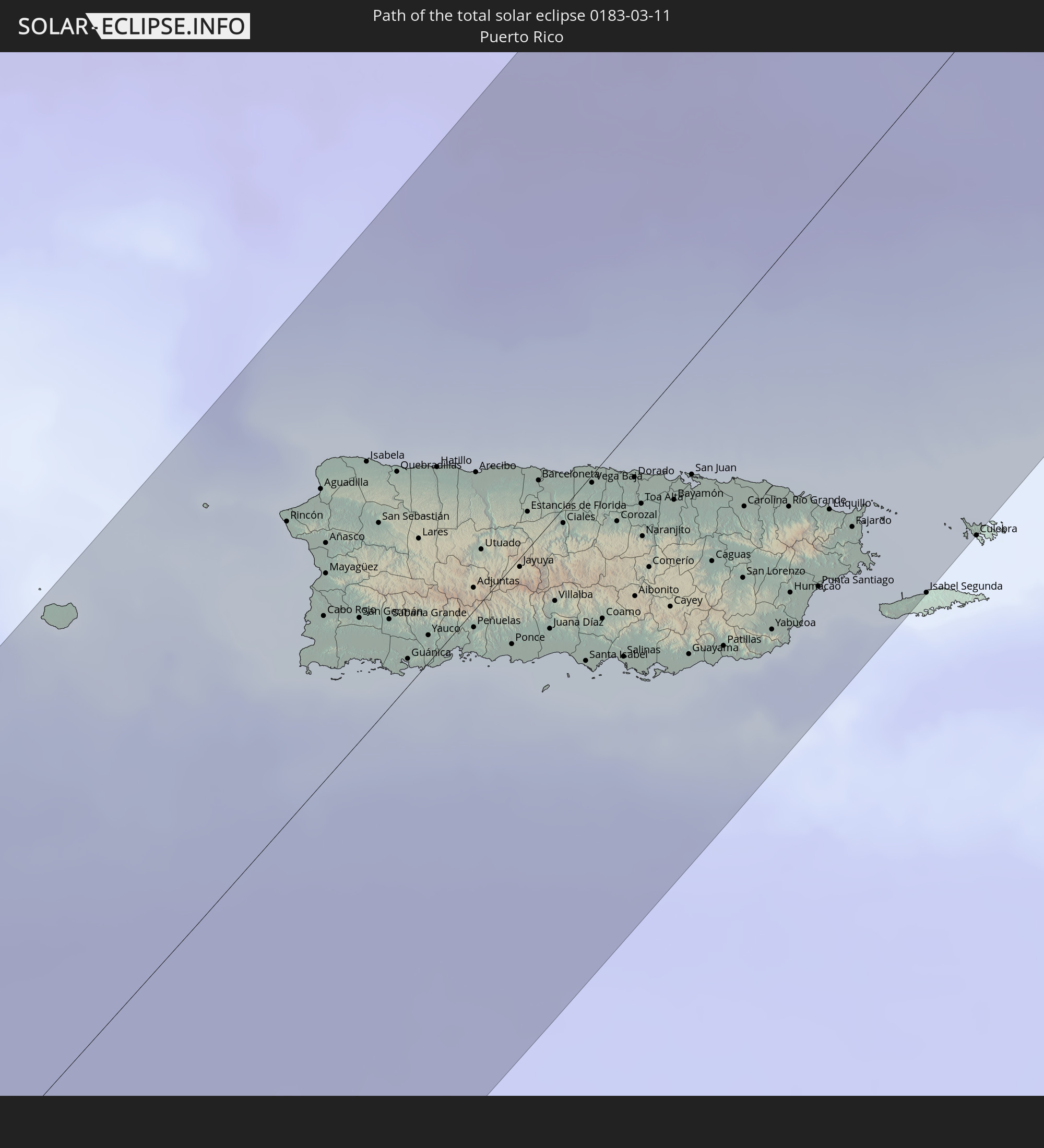
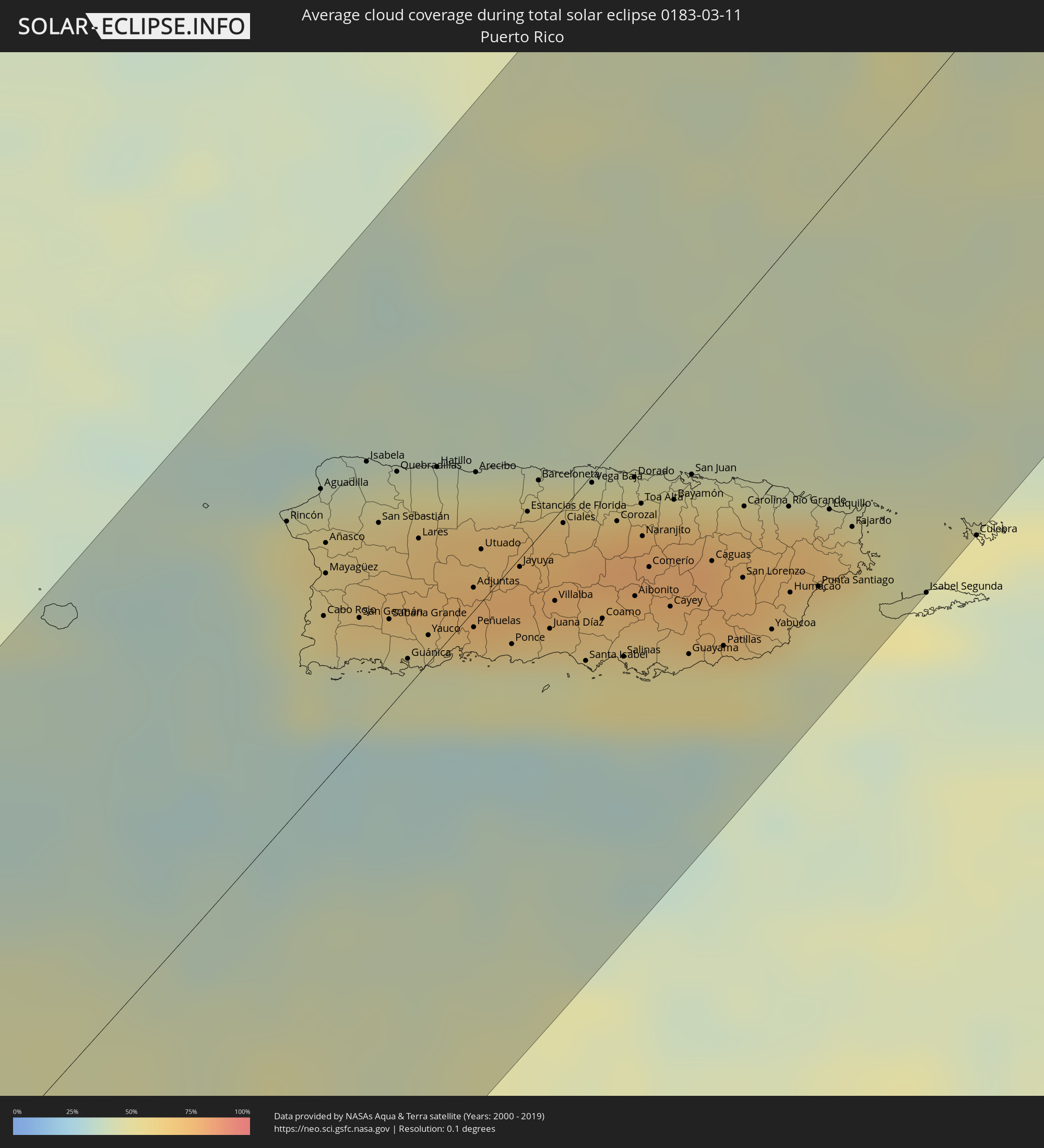 Puerto Rico
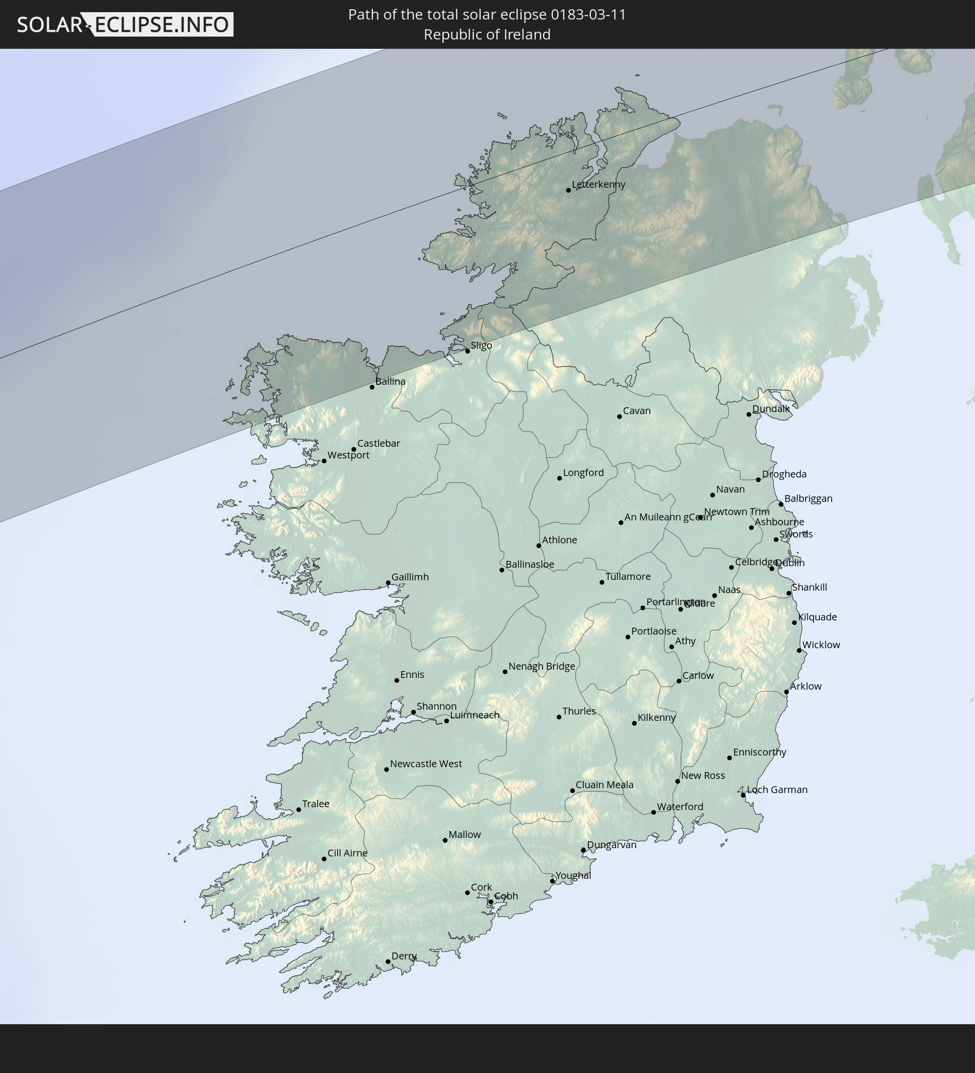
 Republic of Ireland
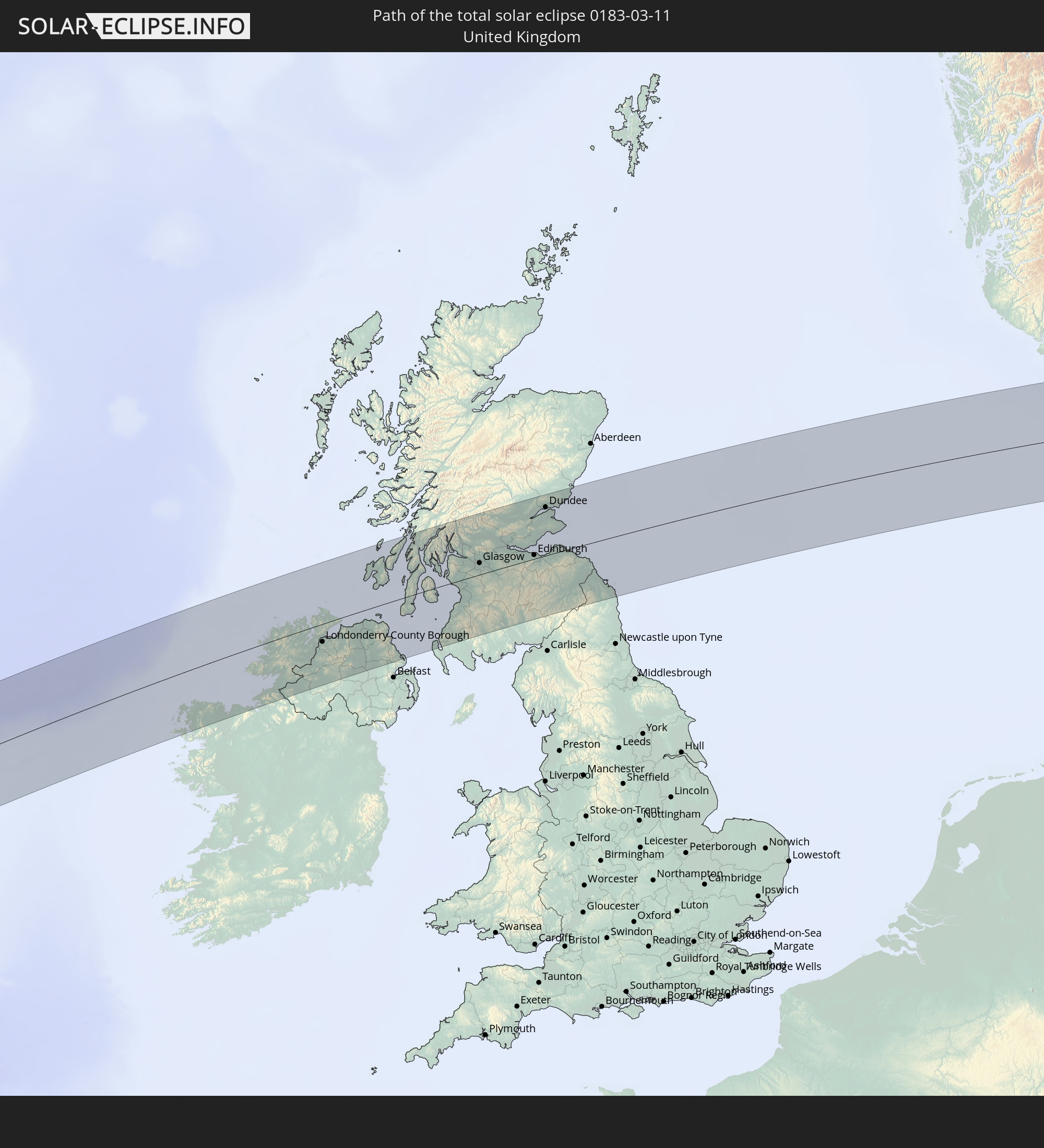
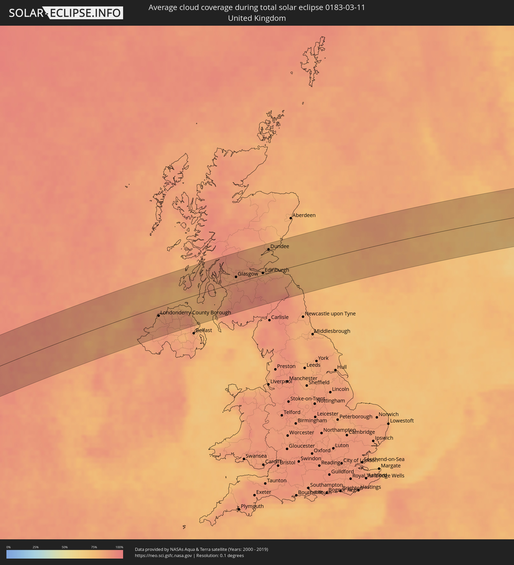 United Kingdom
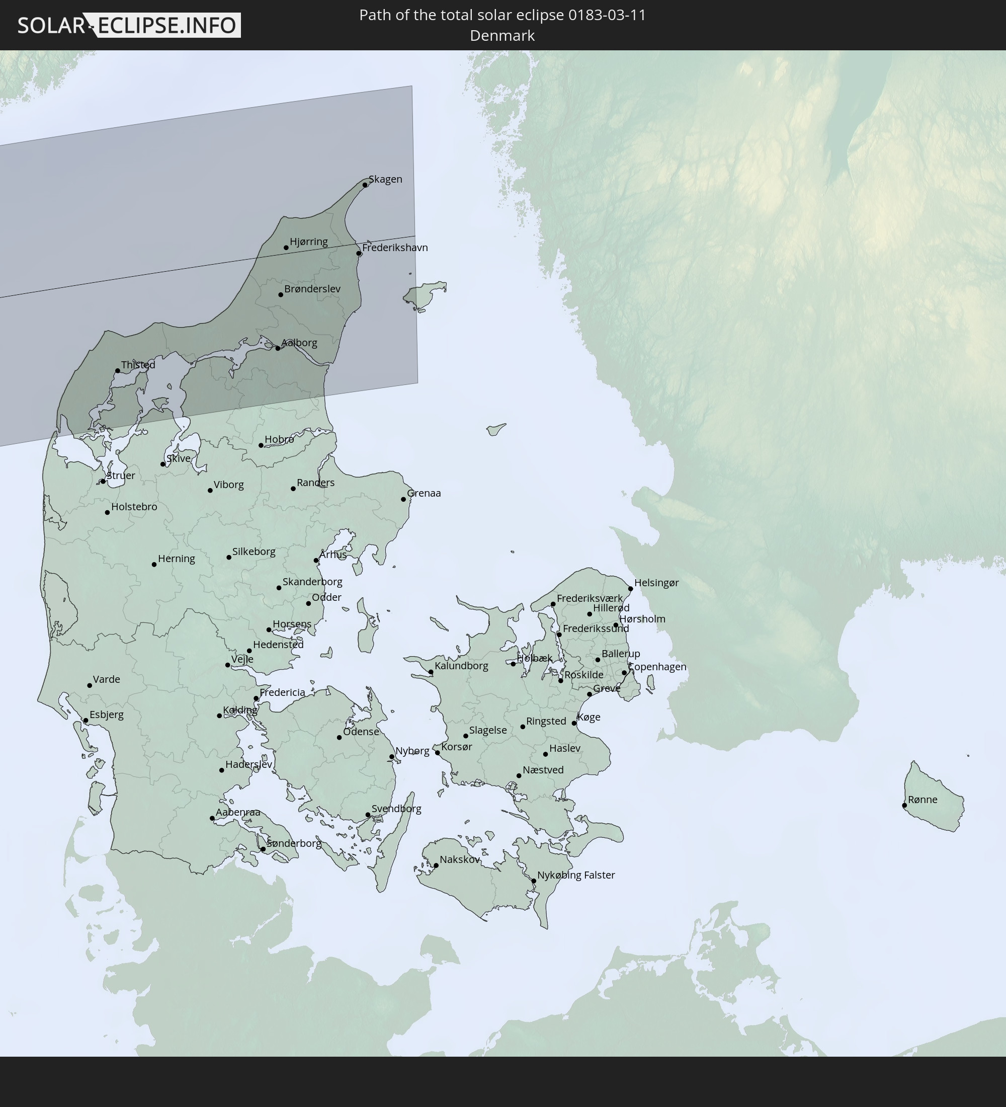
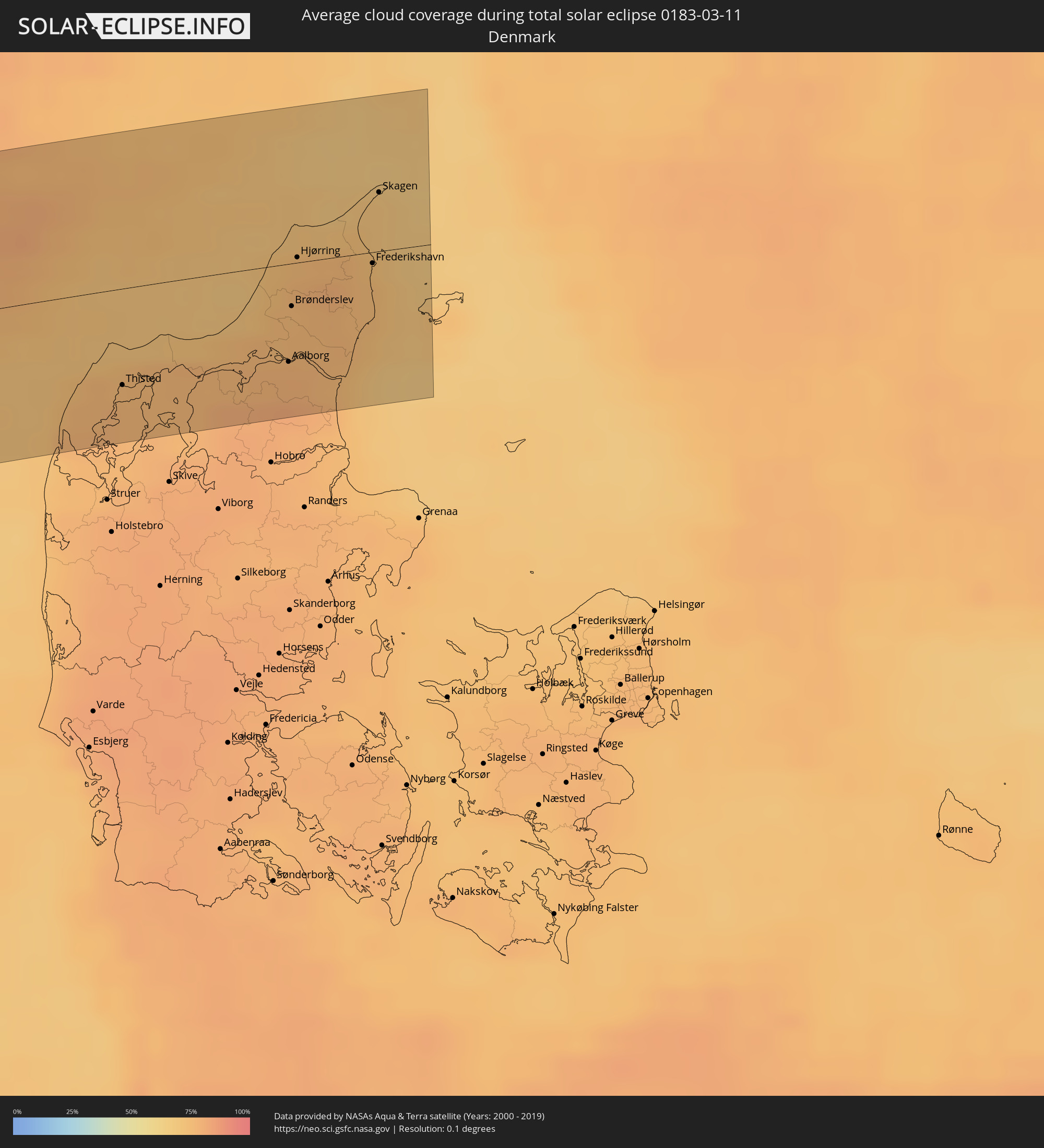 Denmark
Cities inside the path of the eclipse
The following table shows all locations with a population of more than 5,000 inside the eclipse path. Cities which have more than 100,000 inhabitants are marked bold. A click at the locations opens a detailed map.
| City | Type | Eclipse duration | Local time of max. eclipse | Distance to central line | Ø Cloud coverage |
|
La Palma, Darién
|
total | - | 09:23:32 UTC-05:19 | 50 km | 81% |
|
Unión Chocó, Emberá
|
total | - | 09:23:52 UTC-05:19 | 18 km | 87% |
|
Turbo, Antioquia
|
total | - | 09:48:29 UTC-04:56 | 69 km | 85% |
|
Apartadó, Antioquia
|
total | - | 09:48:15 UTC-04:56 | 94 km | 93% |
|
Montería, Córdoba
|
total | - | 09:51:02 UTC-04:56 | 66 km | 91% |
|
Lorica, Córdoba
|
total | - | 09:52:04 UTC-04:56 | 27 km | 76% |
|
Cereté, Córdoba
|
total | - | 09:51:27 UTC-04:56 | 60 km | 83% |
|
Tolú, Sucre
|
total | - | 09:52:59 UTC-04:56 | 18 km | 60% |
|
San Onofre, Sucre
|
total | - | 09:53:28 UTC-04:56 | 3 km | 62% |
|
Cartagena, Bolívar
|
total | - | 09:54:45 UTC-04:56 | 54 km | 47% |
|
Sahagún, Córdoba
|
total | - | 09:52:07 UTC-04:56 | 78 km | 80% |
|
Chinú, Córdoba
|
total | - | 09:52:29 UTC-04:56 | 67 km | 79% |
|
Sincelejo, Sucre
|
total | - | 09:52:52 UTC-04:56 | 49 km | 77% |
|
Arjona, Bolívar
|
total | - | 09:54:45 UTC-04:56 | 30 km | 54% |
|
María la Baja, Bolívar
|
total | - | 09:54:18 UTC-04:56 | 3 km | 53% |
|
Sincé, Sucre
|
total | - | 09:53:09 UTC-04:56 | 72 km | 69% |
|
El Carmen de Bolívar, Bolívar
|
total | - | 09:54:06 UTC-04:56 | 32 km | 59% |
|
San Juan Nepomuceno, Bolívar
|
total | - | 09:54:36 UTC-04:56 | 15 km | 57% |
|
Puerto Colombia, Atlántico
|
total | - | 09:56:48 UTC-04:56 | 66 km | 43% |
|
Sabanalarga, Atlántico
|
total | - | 09:56:10 UTC-04:56 | 33 km | 60% |
|
Baranoa, Atlántico
|
total | - | 09:56:29 UTC-04:56 | 46 km | 47% |
|
Campo de la Cruz, Atlántico
|
total | - | 09:55:45 UTC-04:56 | 9 km | 47% |
|
Plato, Magdalena
|
total | - | 09:54:47 UTC-04:56 | 49 km | 44% |
|
Barranquilla, Atlántico
|
total | - | 09:57:03 UTC-04:56 | 52 km | 43% |
|
Magangué, Bolívar
|
total | - | 09:53:47 UTC-04:56 | 99 km | 58% |
|
Palmar de Varela, Atlántico
|
total | - | 09:56:39 UTC-04:56 | 31 km | 50% |
|
Pivijay, Magdalena
|
total | - | 09:56:21 UTC-04:56 | 3 km | 48% |
|
Ciénaga, Magdalena
|
total | - | 09:58:00 UTC-04:56 | 18 km | 45% |
|
Santa Marta, Magdalena
|
total | - | 09:58:32 UTC-04:56 | 34 km | 43% |
|
Fundación, Magdalena
|
total | - | 09:57:10 UTC-04:56 | 28 km | 54% |
|
Ariguaní, Cesar
|
total | - | 09:56:57 UTC-04:56 | 64 km | 50% |
|
Valledupar, Cesar
|
total | - | 09:58:36 UTC-04:56 | 99 km | 35% |
|
San Juan del Cesar, La Guajira
|
total | - | 09:59:37 UTC-04:56 | 91 km | 39% |
|
Ríohacha, La Guajira
|
total | - | 10:01:17 UTC-04:56 | 34 km | 67% |
|
Fonseca, La Guajira
|
total | - | 10:00:06 UTC-04:56 | 93 km | 48% |
|
Maicao, La Guajira
|
total | - | 10:02:05 UTC-04:56 | 95 km | 59% |
|
Aguadilla, Aguadilla
|
total | - | 11:21:11 UTC-04:00 | 58 km | 52% |
|
Mayagüez, Mayaguez
|
total | - | 11:20:46 UTC-04:00 | 41 km | 60% |
|
Moca, Moca
|
total | - | 11:21:11 UTC-04:00 | 53 km | 56% |
|
Lajas, Lajas
|
total | - | 11:20:36 UTC-04:00 | 23 km | 41% |
|
San Germán, San German
|
total | - | 11:20:41 UTC-04:00 | 24 km | 58% |
|
Isabela, Isabela
|
total | - | 11:21:33 UTC-04:00 | 53 km | 47% |
|
San Sebastián, San Sebastian
|
total | - | 11:21:17 UTC-04:00 | 39 km | 63% |
|
Quebradillas, Quebradillas
|
total | - | 11:21:39 UTC-04:00 | 45 km | 50% |
|
Yauco, Yauco
|
total | - | 11:20:56 UTC-04:00 | 5 km | 44% |
|
Hatillo, Hatillo
|
total | - | 11:21:53 UTC-04:00 | 36 km | 49% |
|
Guayanilla, Guayanilla
|
total | - | 11:21:01 UTC-04:00 | 1 km | 44% |
|
Adjuntas, Adjuntas
|
total | - | 11:21:25 UTC-04:00 | 5 km | 75% |
|
Arecibo, Arecibo
|
total | - | 11:22:03 UTC-04:00 | 27 km | 50% |
|
Utuado, Utuado
|
total | - | 11:21:40 UTC-04:00 | 10 km | 68% |
|
Ponce, Ponce
|
total | - | 11:21:18 UTC-04:00 | 15 km | 46% |
|
Florida, Florida
|
total | - | 11:22:06 UTC-04:00 | 6 km | 68% |
|
Barceloneta, Barceloneta
|
total | - | 11:22:19 UTC-04:00 | 11 km | 53% |
|
Vega Baja, Vega Baja
|
total | - | 11:22:34 UTC-04:00 | 2 km | 68% |
|
Coamo, Coamo
|
total | - | 11:21:54 UTC-04:00 | 31 km | 64% |
|
Coco, Salinas
|
total | - | 11:21:55 UTC-04:00 | 44 km | 52% |
|
Ingenio, Toa Baja
|
total | - | 11:22:51 UTC-04:00 | 15 km | 72% |
|
Candelaria Arenas, Toa Baja
|
total | - | 11:22:49 UTC-04:00 | 17 km | 72% |
|
Pájaros, Toa Alta
|
total | - | 11:22:43 UTC-04:00 | 21 km | 72% |
|
Cayey, Cayey
|
total | - | 11:22:18 UTC-04:00 | 43 km | 64% |
|
Cidra, Cidra
|
total | - | 11:22:26 UTC-04:00 | 39 km | 75% |
|
Guayama, Guayama
|
total | - | 11:22:08 UTC-04:00 | 57 km | 52% |
|
San Juan, San Juan
|
total | - | 11:23:06 UTC-04:00 | 22 km | 51% |
|
Caguas, Caguas
|
total | - | 11:22:45 UTC-04:00 | 44 km | 75% |
|
Carolina, Carolina
|
total | - | 11:23:12 UTC-04:00 | 41 km | 68% |
|
Santa Barbara, Canovanas
|
total | - | 11:23:17 UTC-04:00 | 43 km | 66% |
|
Humacao, Humacao
|
total | - | 11:22:58 UTC-04:00 | 68 km | 50% |
|
Punta Santiago, Humacao
|
total | - | 11:23:08 UTC-04:00 | 73 km | 52% |
|
Fajardo, Fajardo
|
total | - | 11:23:37 UTC-04:00 | 69 km | 63% |
|
Isabel Segunda, Vieques Municipality
|
total | - | 11:23:38 UTC-04:00 | 99 km | 46% |
|
Letterkenny, Ulster
|
total | - | 16:34:54 UTC-00:25 | 17 km | 84% |
|
Strabane, Northern Ireland
|
total | - | 17:00:26 UTC+00:00 | 36 km | 83% |
|
Buncrana, Ulster
|
total | - | 16:34:54 UTC-00:25 | 4 km | 82% |
|
Londonderry County Borough, Northern Ireland
|
total | - | 17:00:23 UTC+00:00 | 21 km | 84% |
|
Omagh, Northern Ireland
|
total | - | 17:00:38 UTC+00:00 | 63 km | 85% |
|
Limavady, Northern Ireland
|
total | - | 17:00:29 UTC+00:00 | 22 km | 83% |
|
Cookstown, Northern Ireland
|
total | - | 17:00:49 UTC+00:00 | 70 km | 83% |
|
Coleraine, Northern Ireland
|
total | - | 17:00:32 UTC+00:00 | 19 km | 82% |
|
Magherafelt, Northern Ireland
|
total | - | 17:00:48 UTC+00:00 | 61 km | 83% |
|
Ballymena, Northern Ireland
|
total | - | 17:00:50 UTC+00:00 | 56 km | 87% |
|
Ballyclare, Northern Ireland
|
total | - | 17:01:00 UTC+00:00 | 71 km | 84% |
|
Larne, Northern Ireland
|
total | - | 17:01:00 UTC+00:00 | 66 km | 77% |
|
Largs, Scotland
|
total | - | 17:00:42 UTC+00:00 | 17 km | 83% |
|
Saltcoats, Scotland
|
total | - | 17:00:50 UTC+00:00 | 1 km | 79% |
|
Greenock, Scotland
|
total | - | 17:00:37 UTC+00:00 | 31 km | 86% |
|
Ayr, Scotland
|
total | - | 17:01:00 UTC+00:00 | 23 km | 82% |
|
Johnstone, Scotland
|
total | - | 17:00:47 UTC+00:00 | 14 km | 86% |
|
Kilmarnock, Scotland
|
total | - | 17:00:56 UTC+00:00 | 9 km | 84% |
|
Cumnock, Scotland
|
total | - | 17:01:07 UTC+00:00 | 30 km | 89% |
|
Glasgow, Scotland
|
total | - | 17:00:50 UTC+00:00 | 14 km | 83% |
|
Hamilton, Scotland
|
total | - | 17:00:58 UTC+00:00 | 1 km | 86% |
|
Cumbernauld, Scotland
|
total | - | 17:00:51 UTC+00:00 | 18 km | 86% |
|
Stirling, Scotland
|
total | - | 17:00:45 UTC+00:00 | 35 km | 84% |
|
Polmont, Scotland
|
total | - | 17:00:55 UTC+00:00 | 17 km | 84% |
|
Livingston, Scotland
|
total | - | 17:01:02 UTC+00:00 | 5 km | 87% |
|
Dunfermline, Scotland
|
total | - | 17:00:56 UTC+00:00 | 22 km | 84% |
|
Perth, Scotland
|
total | - | 17:00:42 UTC+00:00 | 56 km | 80% |
|
Edinburgh, Scotland
|
total | - | 17:01:05 UTC+00:00 | 4 km | 80% |
|
Kirkcaldy, Scotland
|
total | - | 17:00:59 UTC+00:00 | 21 km | 80% |
|
Dundee, Scotland
|
total | - | 17:00:47 UTC+00:00 | 56 km | 77% |
|
Tranent, Scotland
|
total | - | 17:01:10 UTC+00:00 | 1 km | 85% |
|
Galashiels, Scotland
|
total | - | 17:01:26 UTC+00:00 | 38 km | 87% |
|
Saint Andrews, Scotland
|
total | - | 17:00:55 UTC+00:00 | 39 km | 77% |
|
Hawick, Scotland
|
total | - | 17:01:35 UTC+00:00 | 59 km | 90% |
|
Arbroath, Scotland
|
total | - | 17:00:49 UTC+00:00 | 60 km | 75% |
|
Berwick-Upon-Tweed, England
|
total | - | 17:01:33 UTC+00:00 | 34 km | 76% |
|
Thisted, North Denmark
|
total | - | 18:02:35 UTC+01:00 | 42 km | 75% |
|
Nykøbing Mors, North Denmark
|
total | - | 18:02:44 UTC+01:00 | 62 km | 77% |
|
Aars, North Denmark
|
total | - | 18:02:47 UTC+01:00 | 66 km | 81% |
|
Støvring, North Denmark
|
total | - | 18:02:44 UTC+01:00 | 60 km | 81% |
|
Aalborg, North Denmark
|
total | - | 18:02:37 UTC+01:00 | 43 km | 78% |
|
Nørresundby, North Denmark
|
total | - | 18:02:37 UTC+01:00 | 43 km | 78% |
|
Brønderslev, North Denmark
|
total | - | 18:02:26 UTC+01:00 | 19 km | 75% |
|
Hirtshals, North Denmark
|
total | - | 18:02:10 UTC+01:00 | 16 km | 72% |
|
Hjørring, North Denmark
|
total | - | 18:02:16 UTC+01:00 | 2 km | 75% |
|
Sæby, North Denmark
|
total | - | 18:02:25 UTC+01:00 | 17 km | 75% |
|
Frederikshavn, North Denmark
|
total | - | 18:02:20 UTC+01:00 | 5 km | 75% |
|
Skagen, North Denmark
|
total | - | 18:02:06 UTC+01:00 | 26 km | 69% |