Total solar eclipse of 07/15/0223
| Day of week: | Tuesday |
| Maximum duration of eclipse: | 05m05s |
| Maximum width of eclipse path: | 216 km |
| Saros cycle: | 88 |
| Coverage: | 100% |
| Magnitude: | 1.0536 |
| Gamma: | -0.58 |
Wo kann man die Sonnenfinsternis vom 07/15/0223 sehen?
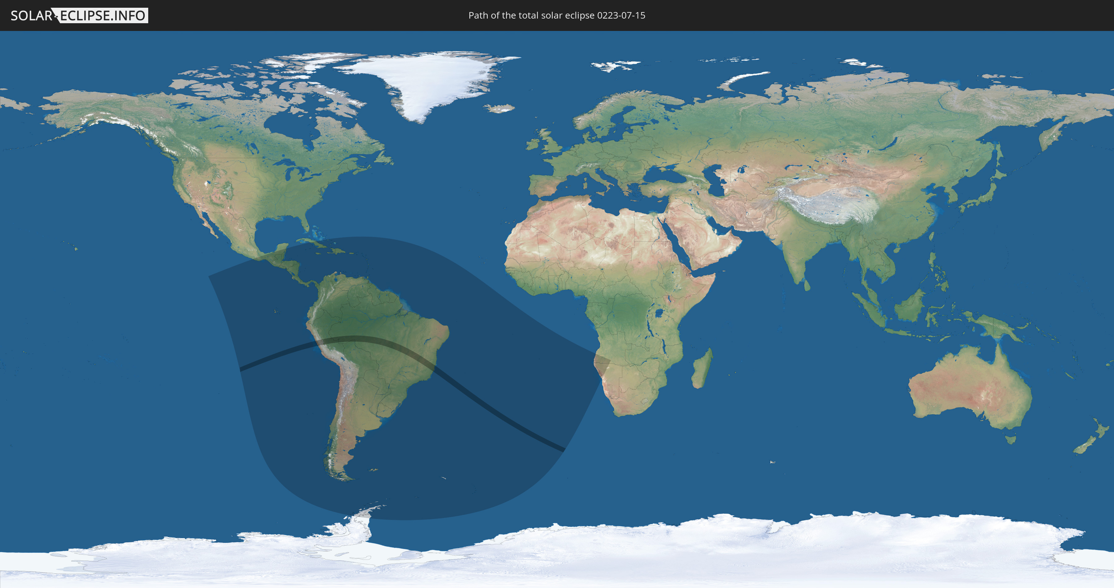
Die Sonnenfinsternis am 07/15/0223 kann man in 53 Ländern als partielle Sonnenfinsternis beobachten.
Der Finsternispfad verläuft durch 4 Länder. Nur in diesen Ländern ist sie als total Sonnenfinsternis zu sehen.
In den folgenden Ländern ist die Sonnenfinsternis total zu sehen
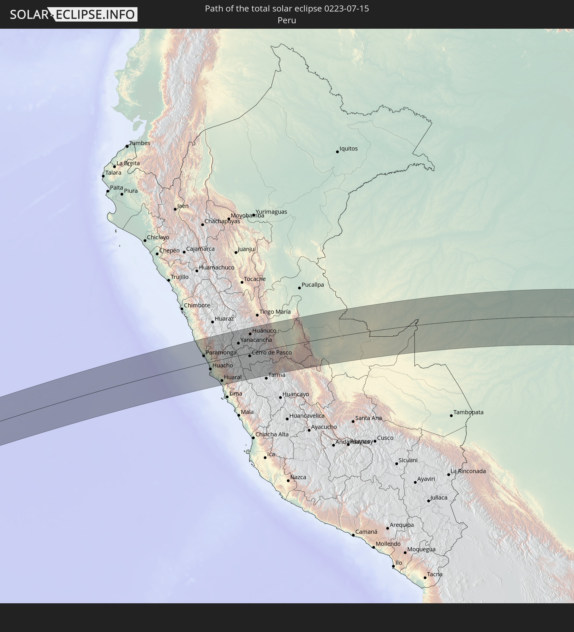 Peru
Peru
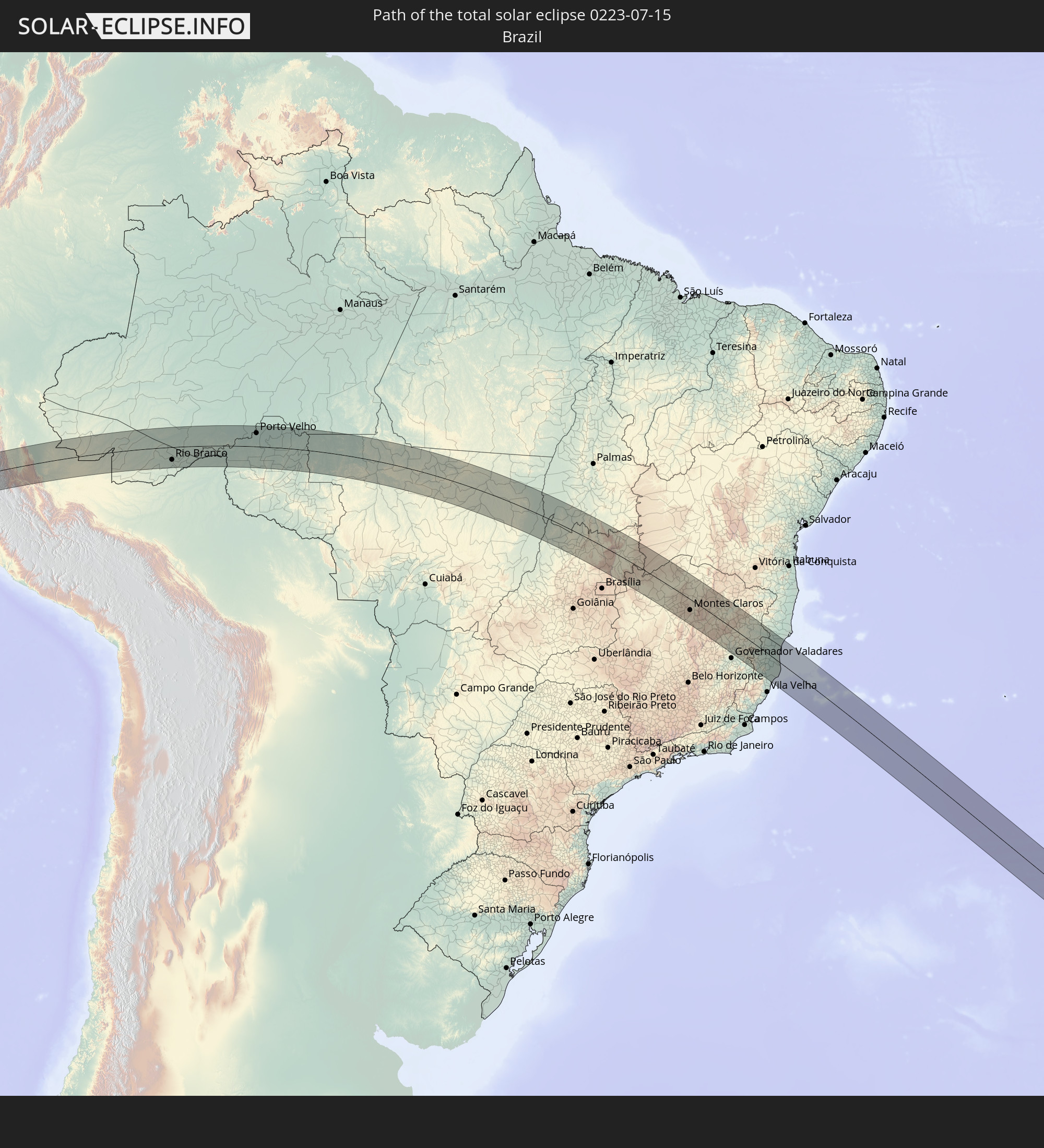 Brazil
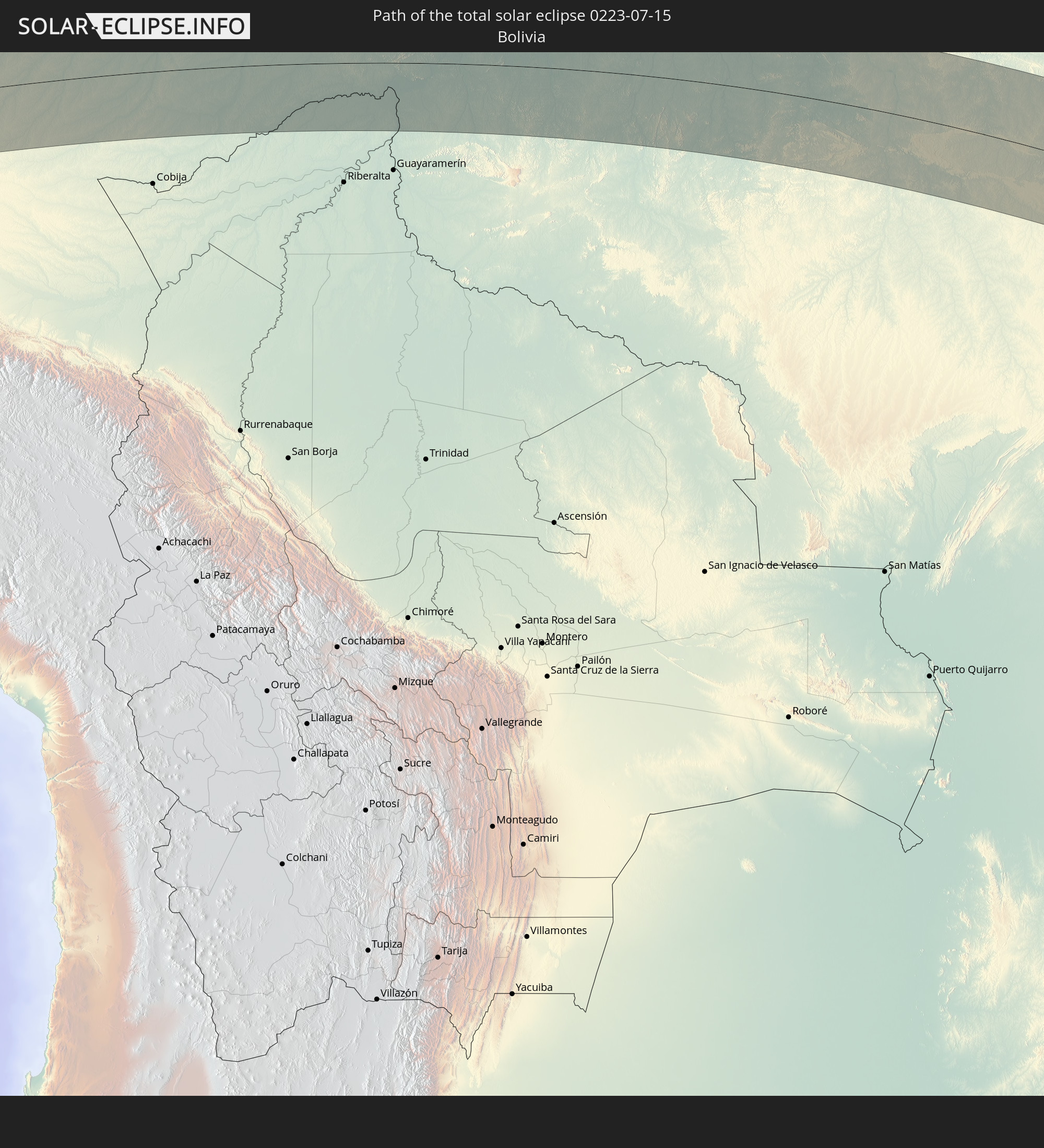 Bolivia
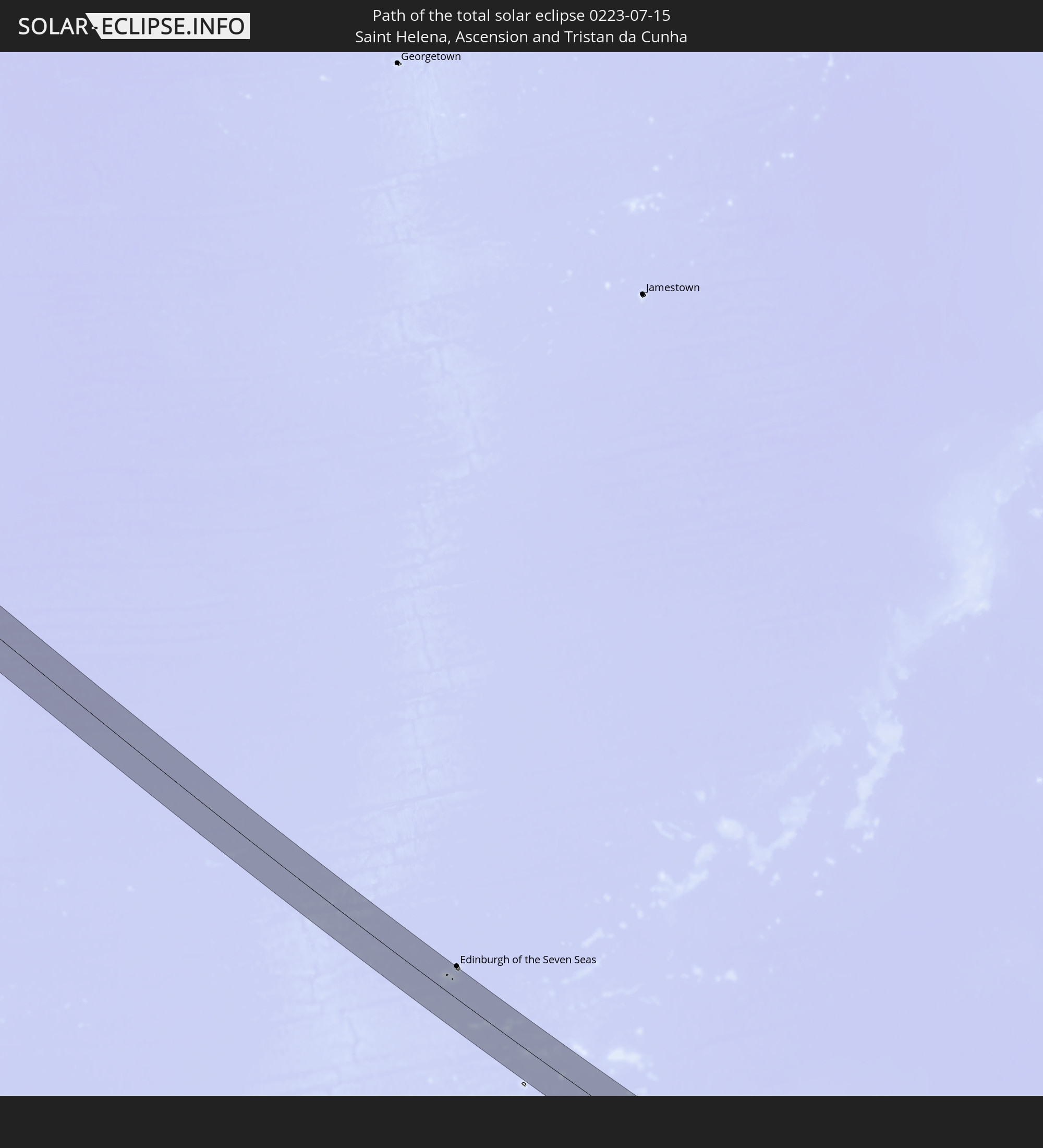 Saint Helena, Ascension and Tristan da Cunha
In den folgenden Ländern ist die Sonnenfinsternis partiell zu sehen
 Antarctica
 United States Minor Outlying Islands
 Mexico
 Chile
Chile
 Guatemala
 Ecuador
 El Salvador
 Honduras
 Belize
 Nicaragua
 Costa Rica
 Cuba
Cuba
 Panama
 Colombia
 Cayman Islands
 Peru
Peru
 The Bahamas
 Jamaica
 Haiti
Haiti
 Brazil
 Argentina
 Venezuela
 Turks and Caicos Islands
 Dominican Republic
 Aruba
Aruba
 Bolivia
 Puerto Rico
 United States Virgin Islands
 British Virgin Islands
 Anguilla
 Collectivity of Saint Martin
 Saint Barthélemy
 Saint Kitts and Nevis
 Paraguay
 Antigua and Barbuda
 Montserrat
 Trinidad and Tobago
 Guadeloupe
 Grenada
 Dominica
 Saint Vincent and the Grenadines
 Falkland Islands
 Guyana
 Martinique
 Saint Lucia
 Barbados
 Uruguay
 Suriname
 French Guiana
 South Georgia and the South Sandwich Islands
 Saint Helena, Ascension and Tristan da Cunha
 Angola
 Namibia
How will be the weather during the total solar eclipse on 07/15/0223?
Where is the best place to see the total solar eclipse of 07/15/0223?
The following maps show the average cloud coverage for the day of the total solar eclipse.
With the help of these maps, it is possible to find the place along the eclipse path, which has the best
chance of a cloudless sky.
Nevertheless, you should consider local circumstances and inform about the weather of your chosen
observation site.
The data is provided by NASAs satellites
AQUA and TERRA.
The cloud maps are averaged over a period of 19 years (2000 - 2019).
Detailed country maps
 Peru
Peru
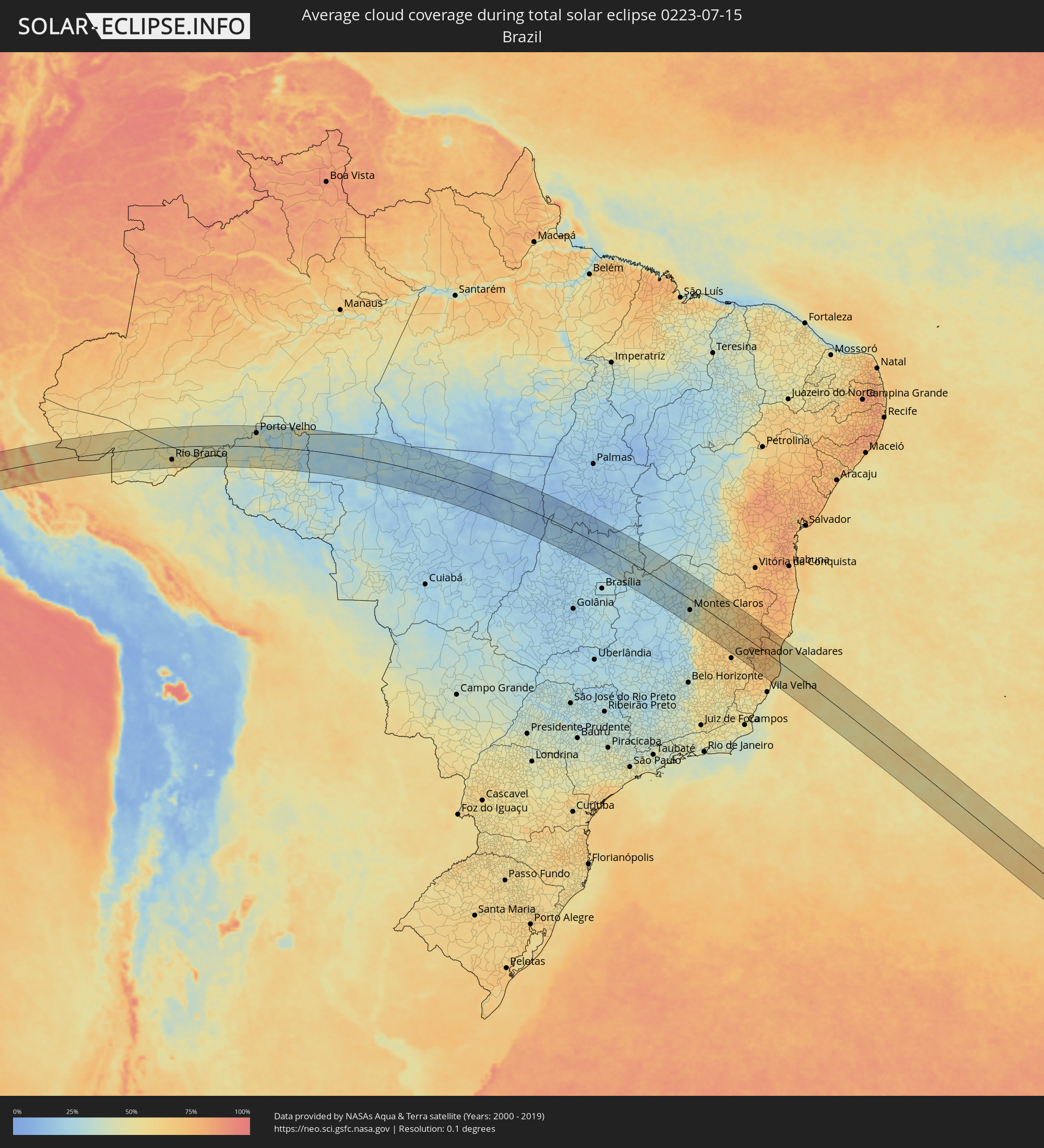 Brazil
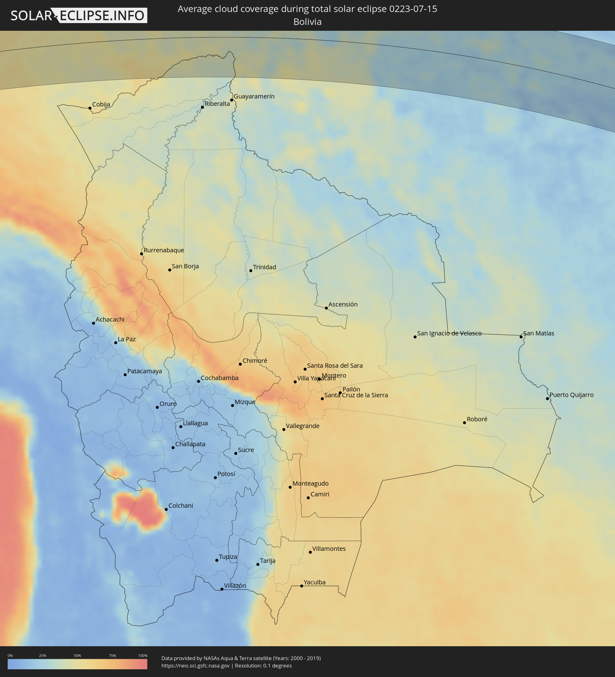 Bolivia
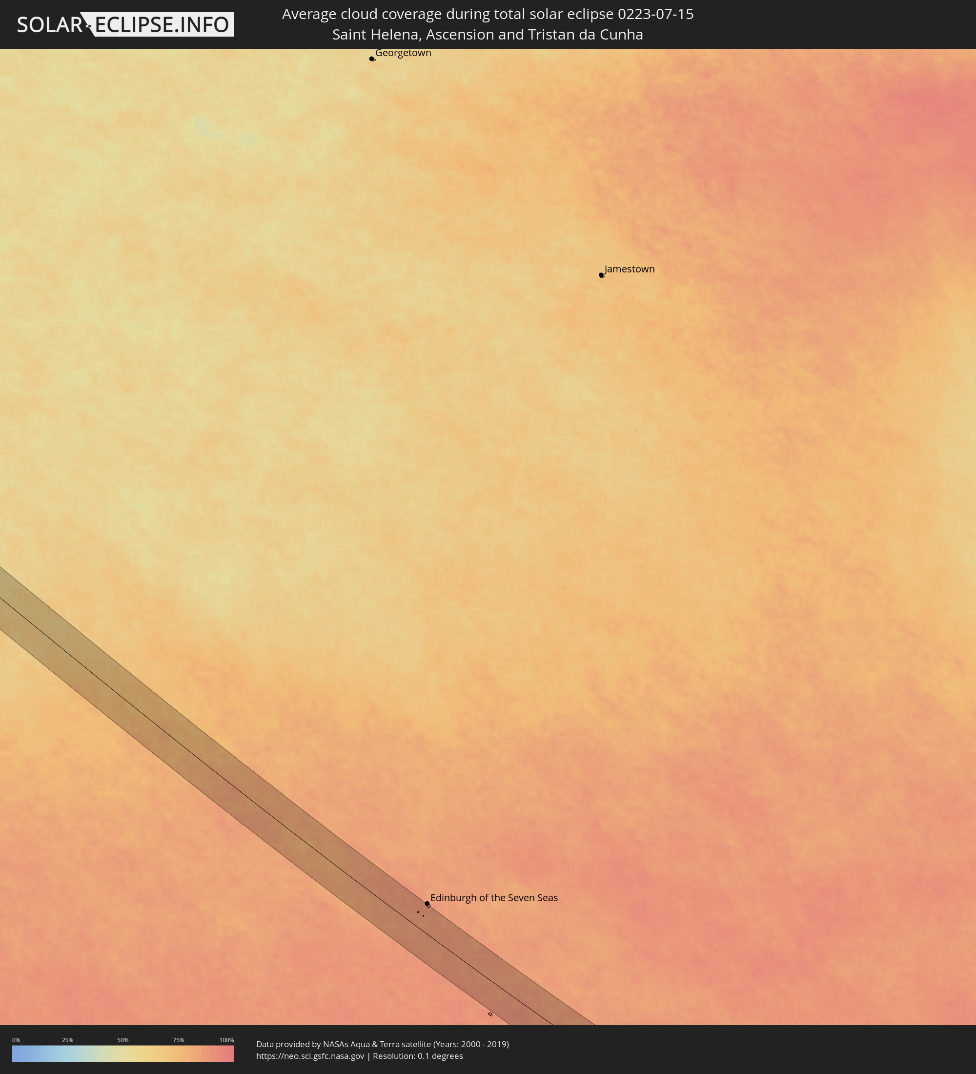 Saint Helena, Ascension and Tristan da Cunha
Cities inside the path of the eclipse
The following table shows all locations with a population of more than 5,000 inside the eclipse path. Cities which have more than 100,000 inhabitants are marked bold. A click at the locations opens a detailed map.
| City | Type | Eclipse duration | Local time of max. eclipse | Distance to central line | Ø Cloud coverage |
|
Paramonga, Lima region
|
total | - | 08:32:33 UTC-05:08 | 27 km | 90% |
|
Pativilca, Lima region
|
total | - | 08:32:39 UTC-05:08 | 22 km | 90% |
|
Barranca, Lima region
|
total | - | 08:32:43 UTC-05:08 | 16 km | 90% |
|
Puerto Supe, Lima region
|
total | - | 08:32:48 UTC-05:08 | 10 km | 87% |
|
Supe, Lima region
|
total | - | 08:32:51 UTC-05:08 | 10 km | 87% |
|
Végueta, Lima region
|
total | - | 08:33:08 UTC-05:08 | 16 km | 83% |
|
Caleta de Carquín, Lima region
|
total | - | 08:33:13 UTC-05:08 | 24 km | 82% |
|
Hualmay, Lima region
|
total | - | 08:33:14 UTC-05:08 | 25 km | 82% |
|
Huacho, Lima region
|
total | - | 08:33:15 UTC-05:08 | 26 km | 82% |
|
Huaura, Lima region
|
total | - | 08:33:14 UTC-05:08 | 23 km | 82% |
|
Chancay, Lima region
|
total | - | 08:34:11 UTC-05:08 | 85 km | 92% |
|
Huaral, Lima region
|
total | - | 08:34:13 UTC-05:08 | 78 km | 83% |
|
Sayán, Lima region
|
total | - | 08:33:58 UTC-05:08 | 40 km | 10% |
|
Oyón, Lima region
|
total | - | 08:34:19 UTC-05:08 | 1 km | 18% |
|
Yanacancha, Huanuco
|
total | - | 08:34:13 UTC-05:08 | 44 km | 48% |
|
San Miguel de Cauri, Huanuco
|
total | - | 08:34:11 UTC-05:08 | 55 km | 45% |
|
Yanahuanca, Pasco Region
|
total | - | 08:34:40 UTC-05:08 | 11 km | 37% |
|
Chaupimarca, Pasco Region
|
total | - | 08:34:39 UTC-05:08 | 22 km | 38% |
|
Tinyahuarco, Pasco Region
|
total | - | 08:35:15 UTC-05:08 | 22 km | 44% |
|
Cerro de Pasco, Pasco Region
|
total | - | 08:35:13 UTC-05:08 | 11 km | 43% |
|
Huánuco, Huanuco
|
total | - | 08:34:41 UTC-05:08 | 69 km | 48% |
|
Ambo, Huanuco
|
total | - | 08:34:54 UTC-05:08 | 46 km | 42% |
|
Carhuamayo, Junín Region
|
total | - | 08:35:48 UTC-05:08 | 43 km | 42% |
|
Junín, Junín Region
|
total | - | 08:36:03 UTC-05:08 | 71 km | 39% |
|
San Pedro de Cajas, Junín Region
|
total | - | 08:36:22 UTC-05:08 | 84 km | 39% |
|
Huasahuasi, Junín Region
|
total | - | 08:36:45 UTC-05:08 | 90 km | 39% |
|
Oxapampa, Pasco Region
|
total | - | 08:36:39 UTC-05:08 | 21 km | 72% |
|
San Ramón, Junín Region
|
total | - | 08:37:10 UTC-05:08 | 81 km | 58% |
|
Villa Rica, Pasco Region
|
total | - | 08:37:01 UTC-05:08 | 41 km | 75% |
|
Perené, Junín Region
|
total | - | 08:37:16 UTC-05:08 | 64 km | 61% |
|
Sena Madureira, Acre
|
total | - | 09:26:34 UTC-04:31 | 44 km | 51% |
|
Rio Branco, Acre
|
total | - | 09:29:20 UTC-04:31 | 64 km | 56% |
|
Senador Guiomard, Acre
|
total | - | 09:29:40 UTC-04:31 | 84 km | 56% |
|
Boca do Acre, Amazonas
|
total | - | 09:57:47 UTC-04:02 | 70 km | 46% |
|
Porto Velho, Rondônia
|
total | - | 10:06:25 UTC-04:02 | 68 km | 46% |
|
Ariquemes, Rondônia
|
total | - | 10:09:46 UTC-04:02 | 55 km | 42% |
|
Aripuanã, Mato Grosso
|
total | - | 10:39:44 UTC-03:38 | 54 km | 30% |
|
São Miguel do Araguaia, Goiás
|
total | - | 11:46:28 UTC-03:06 | 51 km | 21% |
|
Porangatu, Goiás
|
total | - | 11:49:34 UTC-03:06 | 19 km | 16% |
|
Alvorada, Tocantins
|
total | - | 12:21:01 UTC-02:34 | 78 km | 12% |
|
Niquelândia, Goiás
|
total | - | 11:52:41 UTC-03:06 | 86 km | 18% |
|
Iaciara, Goiás
|
total | - | 11:57:24 UTC-03:06 | 47 km | 30% |
|
Buritis, Minas Gerais
|
total | - | 11:59:37 UTC-03:06 | 87 km | 25% |
|
Posse, Goiás
|
total | - | 11:58:07 UTC-03:06 | 62 km | 30% |
|
Arinos, Minas Gerais
|
total | - | 12:00:49 UTC-03:06 | 98 km | 25% |
|
São Francisco, Minas Gerais
|
total | - | 12:04:12 UTC-03:06 | 30 km | 28% |
|
Brasília de Minas, Minas Gerais
|
total | - | 12:05:37 UTC-03:06 | 29 km | 26% |
|
Coração de Jesus, Minas Gerais
|
total | - | 12:06:17 UTC-03:06 | 70 km | 27% |
|
Januária, Minas Gerais
|
total | - | 12:05:04 UTC-03:06 | 42 km | 26% |
|
Mirabela, Minas Gerais
|
total | - | 12:06:23 UTC-03:06 | 18 km | 29% |
|
Itacarambi, Minas Gerais
|
total | - | 12:05:22 UTC-03:06 | 94 km | 32% |
|
Varzelândia, Minas Gerais
|
total | - | 12:06:10 UTC-03:06 | 42 km | 32% |
|
São João da Ponte, Minas Gerais
|
total | - | 12:06:27 UTC-03:06 | 22 km | 36% |
|
Montes Claros, Minas Gerais
|
total | - | 12:07:40 UTC-03:06 | 44 km | 38% |
|
Bocaiúva, Minas Gerais
|
total | - | 12:08:09 UTC-03:06 | 76 km | 41% |
|
Barreiro do Jaíba, Minas Gerais
|
total | - | 12:07:13 UTC-03:06 | 75 km | 35% |
|
Francisco Sá, Minas Gerais
|
total | - | 12:08:22 UTC-03:06 | 2 km | 36% |
|
Janaúba, Minas Gerais
|
total | - | 12:08:09 UTC-03:06 | 75 km | 39% |
|
Porteirinha, Minas Gerais
|
total | - | 12:08:49 UTC-03:06 | 97 km | 37% |
|
Itamarandiba, Minas Gerais
|
total | - | 12:11:21 UTC-03:06 | 88 km | 61% |
|
Turmalina, Minas Gerais
|
total | - | 12:11:08 UTC-03:06 | 27 km | 61% |
|
Minas Novas, Minas Gerais
|
total | - | 12:11:25 UTC-03:06 | 13 km | 61% |
|
Capelinha, Minas Gerais
|
total | - | 12:12:04 UTC-03:06 | 52 km | 63% |
|
Santa Maria do Suaçuí, Minas Gerais
|
total | - | 12:12:48 UTC-03:06 | 91 km | 65% |
|
Salinas, Minas Gerais
|
total | - | 12:11:09 UTC-03:06 | 101 km | 61% |
|
Malacacheta, Minas Gerais
|
total | - | 12:13:19 UTC-03:06 | 38 km | 63% |
|
Araçuaí, Minas Gerais
|
total | - | 12:12:22 UTC-03:06 | 52 km | 56% |
|
Novo Cruzeiro, Minas Gerais
|
total | - | 12:13:28 UTC-03:06 | 8 km | 67% |
|
Caraí, Minas Gerais
|
total | - | 12:13:39 UTC-03:06 | 44 km | 67% |
|
Itambacuri, Minas Gerais
|
total | - | 12:14:28 UTC-03:06 | 32 km | 66% |
|
Teófilo Otoni, Minas Gerais
|
total | - | 12:14:45 UTC-03:06 | 5 km | 68% |
|
Padre Paraíso, Minas Gerais
|
total | - | 12:14:04 UTC-03:06 | 68 km | 70% |
|
Divino das Laranjeiras, Minas Gerais
|
total | - | 12:15:40 UTC-03:06 | 86 km | 63% |
|
Mantenópolis, Espírito Santo
|
total | - | 12:16:37 UTC-03:06 | 72 km | 70% |
|
Águas Formosas, Minas Gerais
|
total | - | 12:15:25 UTC-03:06 | 101 km | 72% |
|
Barra de São Francisco, Espírito Santo
|
total | - | 12:17:05 UTC-03:06 | 48 km | 71% |
|
Pancas, Espírito Santo
|
total | - | 12:17:36 UTC-03:06 | 87 km | 68% |
|
Ecoporanga, Espírito Santo
|
total | - | 12:16:53 UTC-03:06 | 10 km | 75% |
|
Carlos Chagas, Minas Gerais
|
total | - | 12:16:26 UTC-03:06 | 55 km | 76% |
|
Mucurici, Espírito Santo
|
total | - | 12:17:24 UTC-03:06 | 35 km | 77% |
|
Nova Venécia, Espírito Santo
|
total | - | 12:18:14 UTC-03:06 | 13 km | 75% |
|
Montanha, Espírito Santo
|
total | - | 12:17:48 UTC-03:06 | 42 km | 77% |
|
Nanuque, Minas Gerais
|
total | - | 12:17:33 UTC-03:06 | 68 km | 74% |
|
Boa Esperança, Espírito Santo
|
total | - | 12:18:20 UTC-03:06 | 9 km | 73% |
|
Linhares, Espírito Santo
|
total | - | 12:19:37 UTC-03:06 | 53 km | 68% |
|
São Mateus, Espírito Santo
|
total | - | 12:19:32 UTC-03:06 | 20 km | 69% |
|
Conceição da Barra, Espírito Santo
|
total | - | 12:19:43 UTC-03:06 | 39 km | 51% |
|
Mucuri, Bahia
|
total | - | 12:52:10 UTC-02:34 | 96 km | 56% |