Total solar eclipse of 09/07/0294
| Day of week: | Friday |
| Maximum duration of eclipse: | 04m48s |
| Maximum width of eclipse path: | 218 km |
| Saros cycle: | 78 |
| Coverage: | 100% |
| Magnitude: | 1.0621 |
| Gamma: | 0.3671 |
Wo kann man die Sonnenfinsternis vom 09/07/0294 sehen?
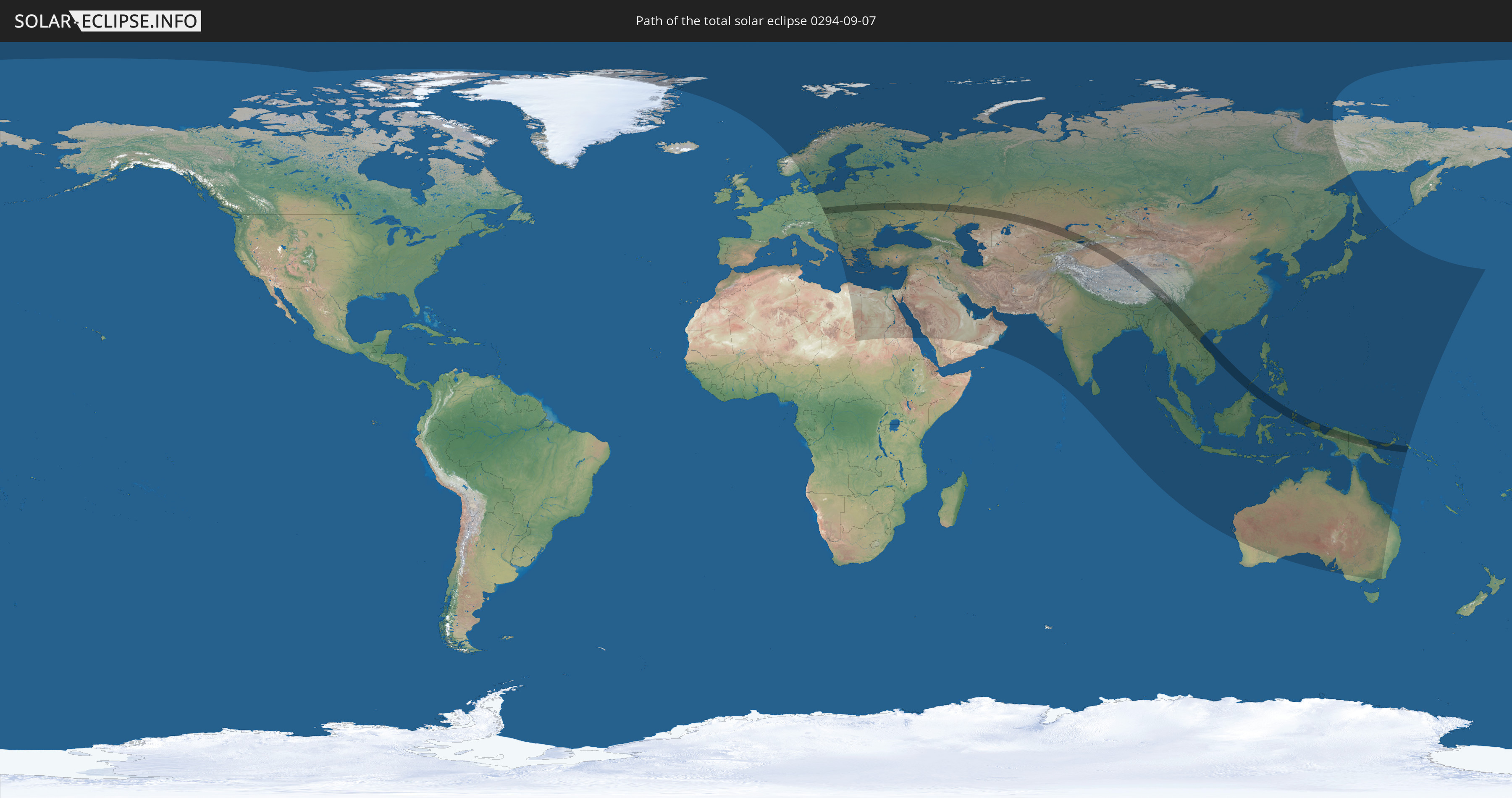
Die Sonnenfinsternis am 09/07/0294 kann man in 92 Ländern als partielle Sonnenfinsternis beobachten.
Der Finsternispfad verläuft durch 17 Länder. Nur in diesen Ländern ist sie als total Sonnenfinsternis zu sehen.
In den folgenden Ländern ist die Sonnenfinsternis total zu sehen
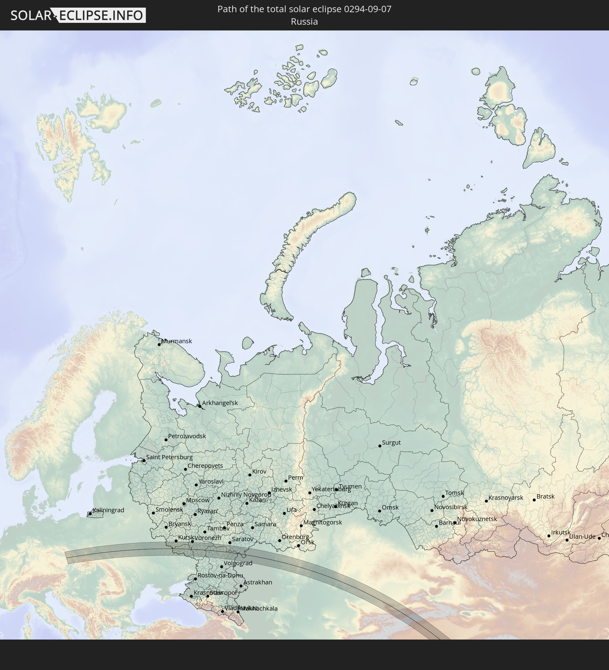 Russia
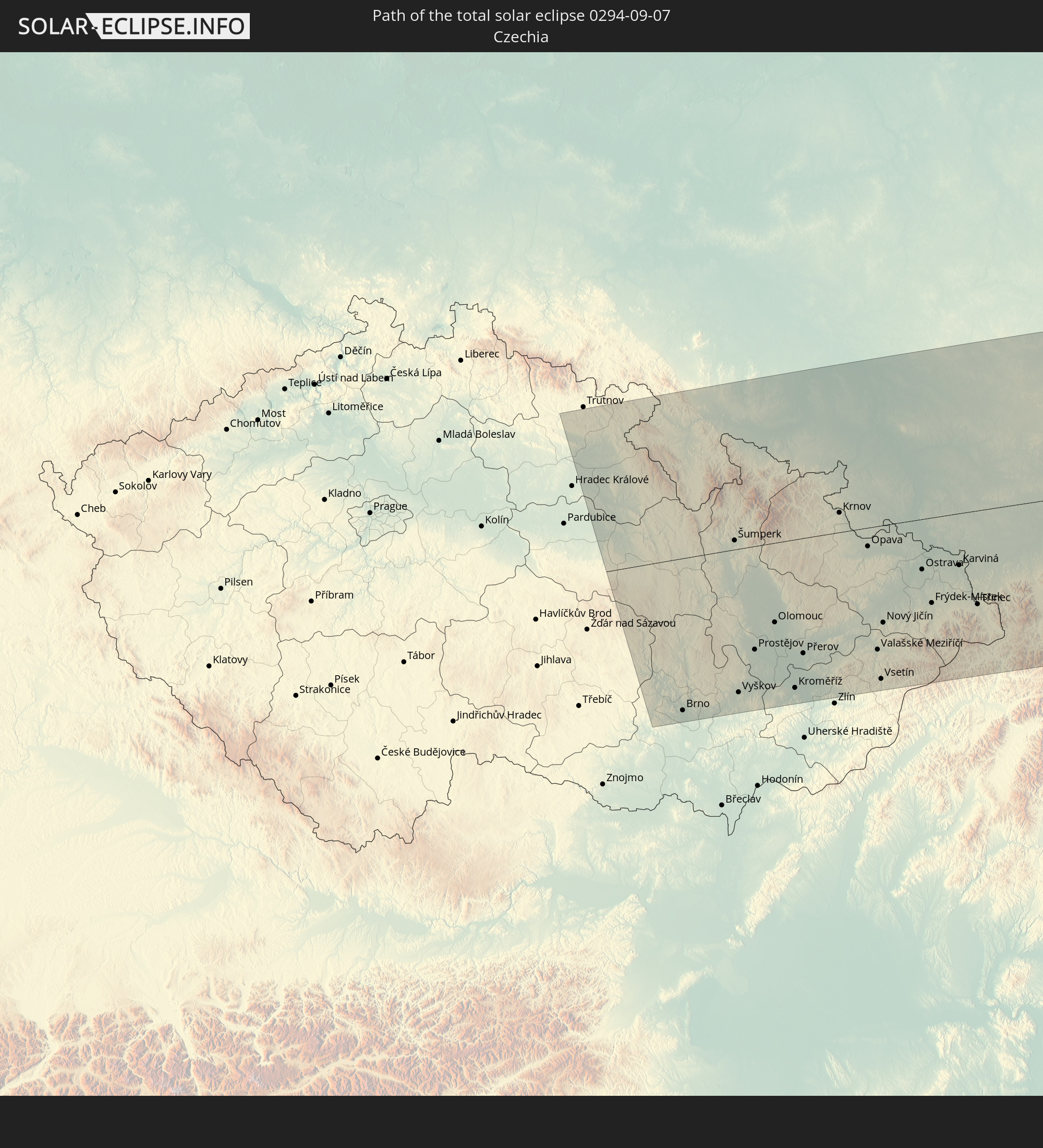 Czechia
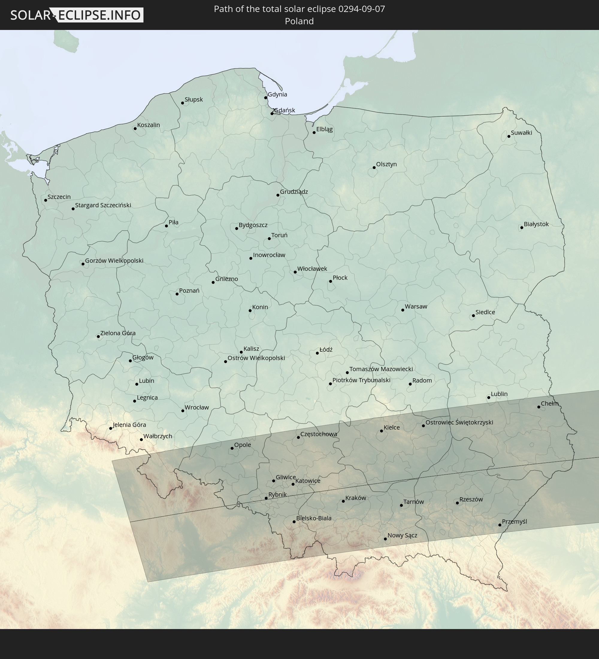 Poland
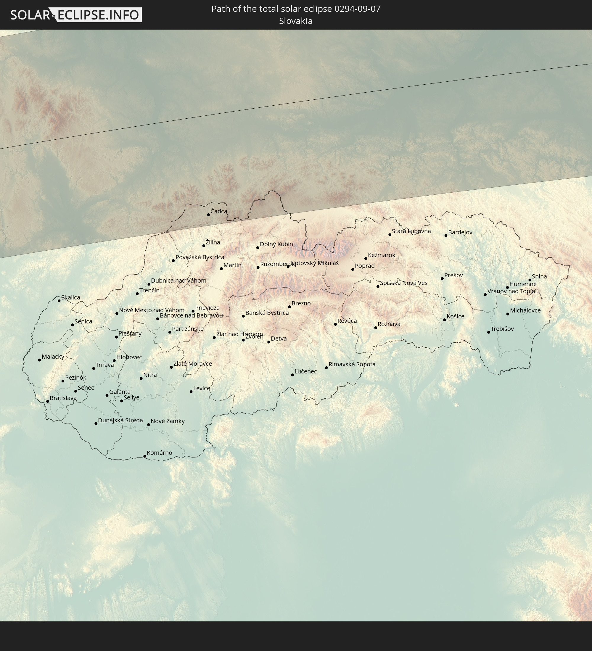 Slovakia
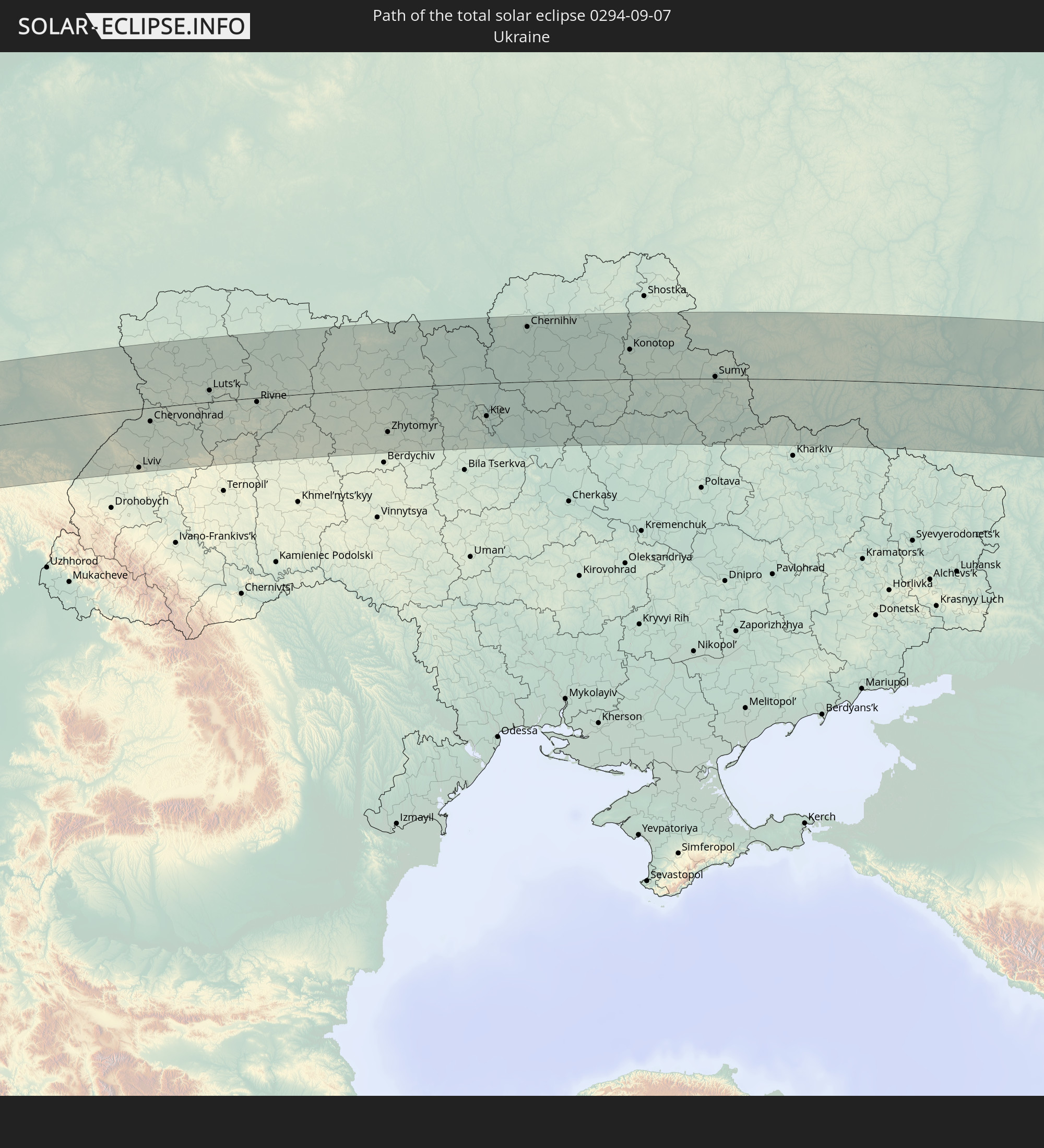 Ukraine
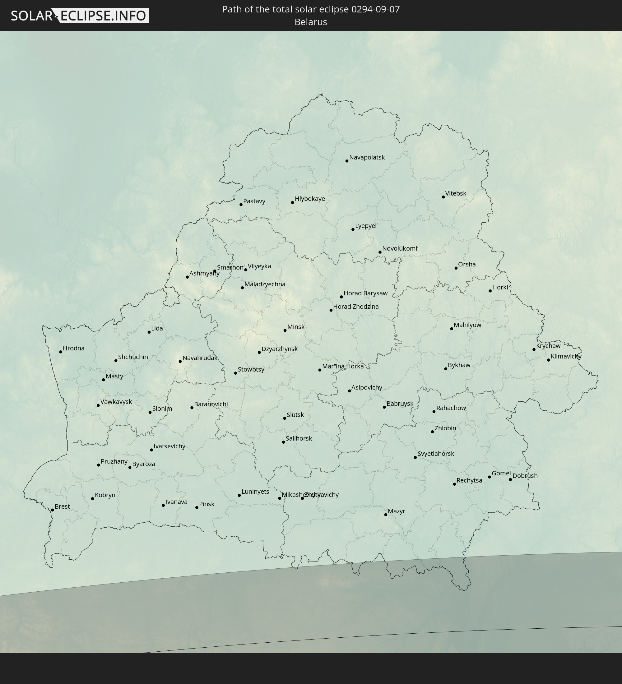 Belarus
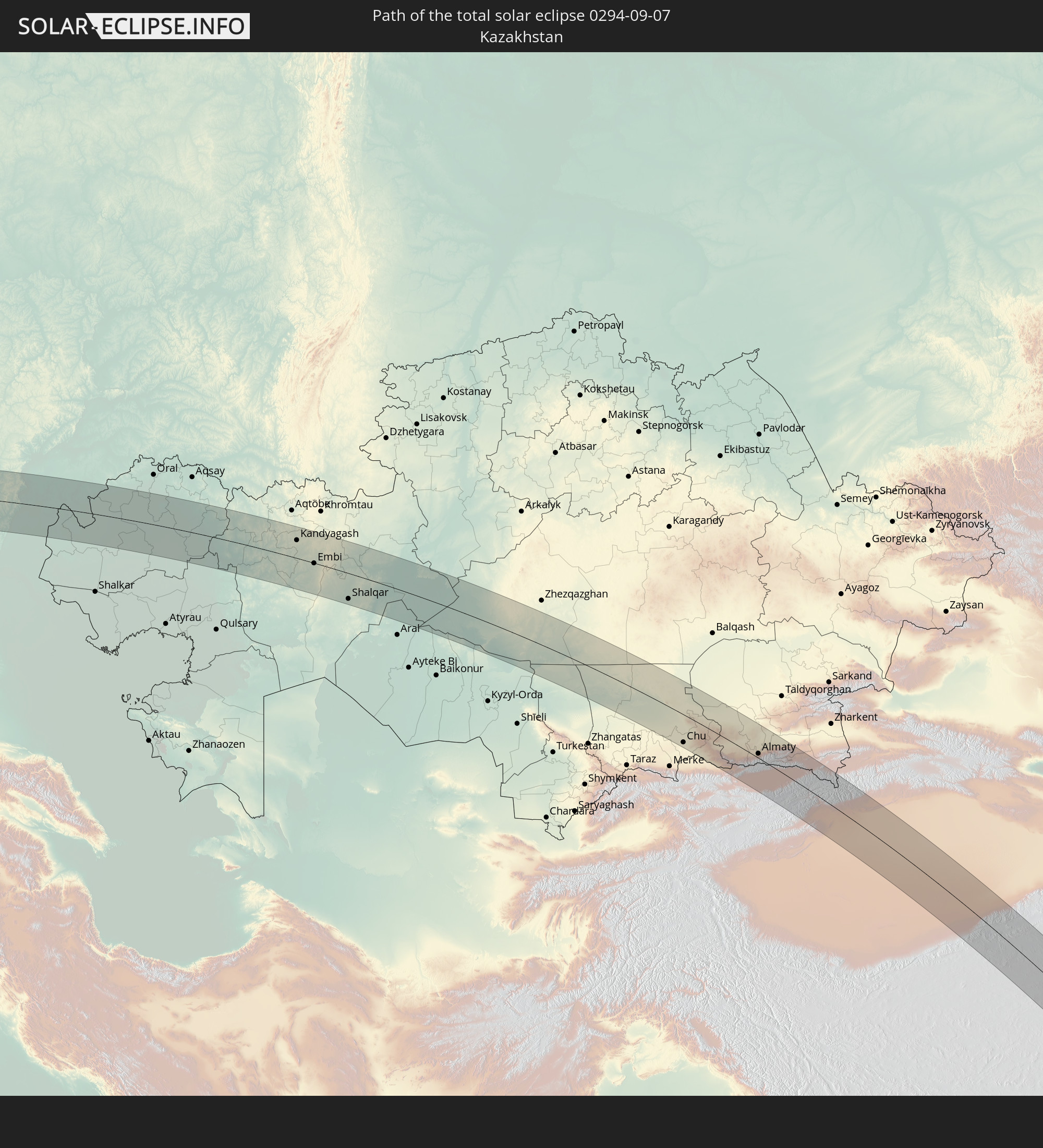 Kazakhstan
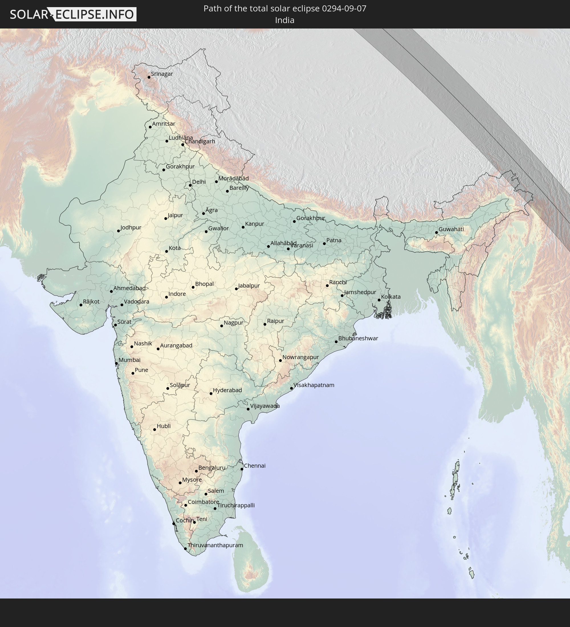 India
India
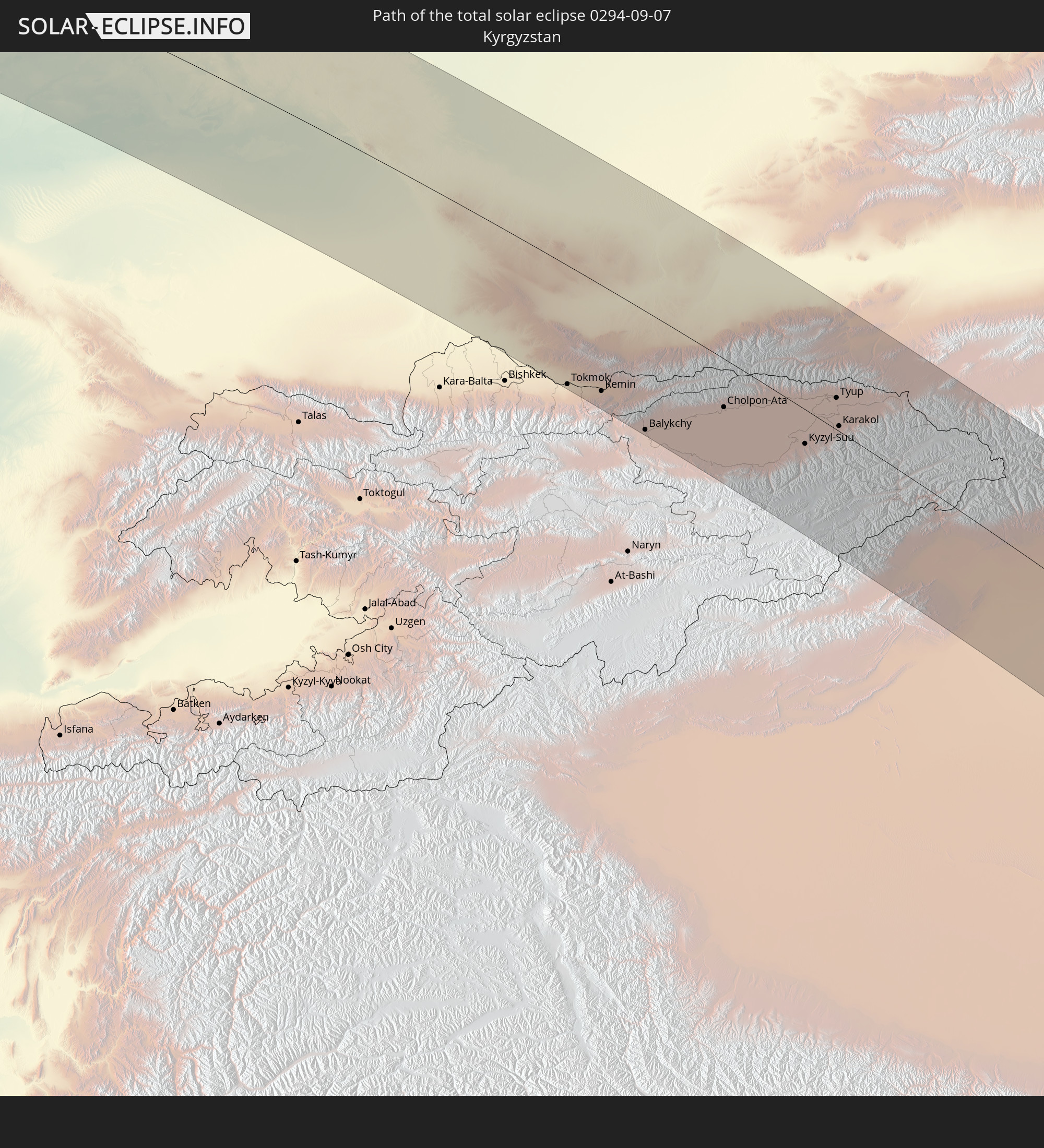 Kyrgyzstan
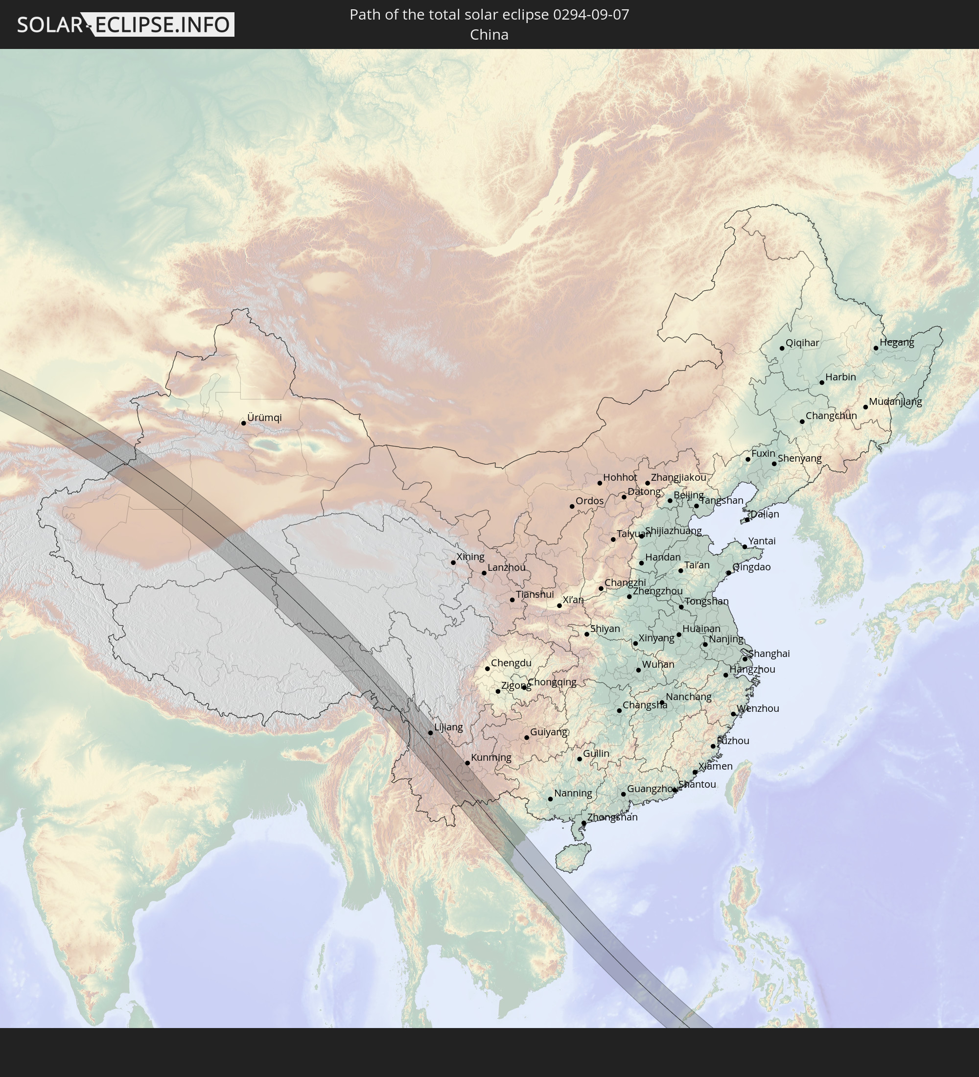 China
China
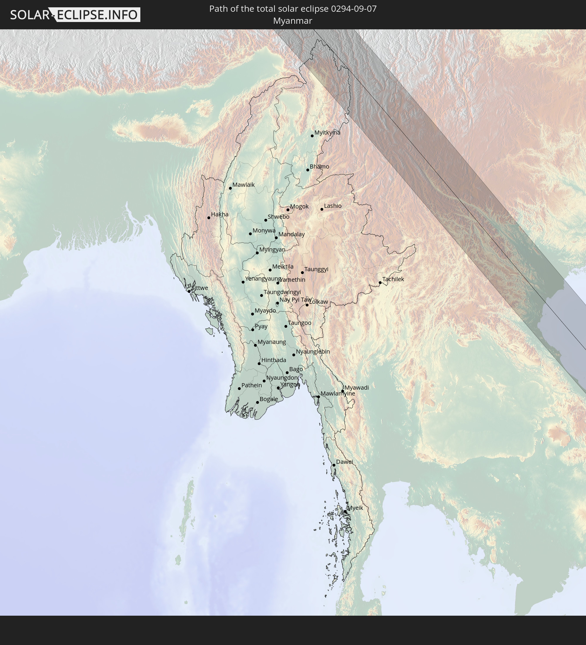 Myanmar
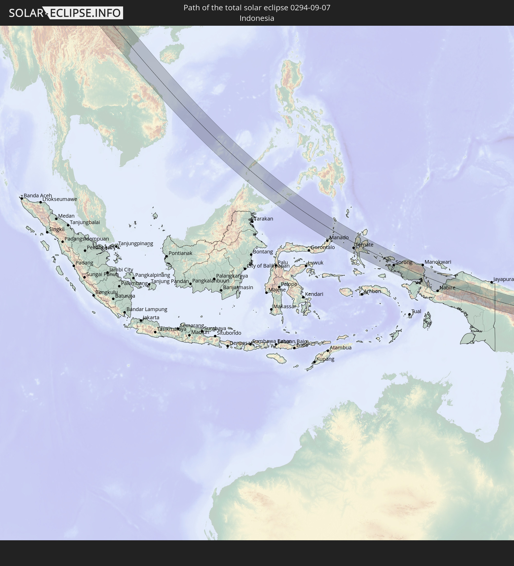 Indonesia
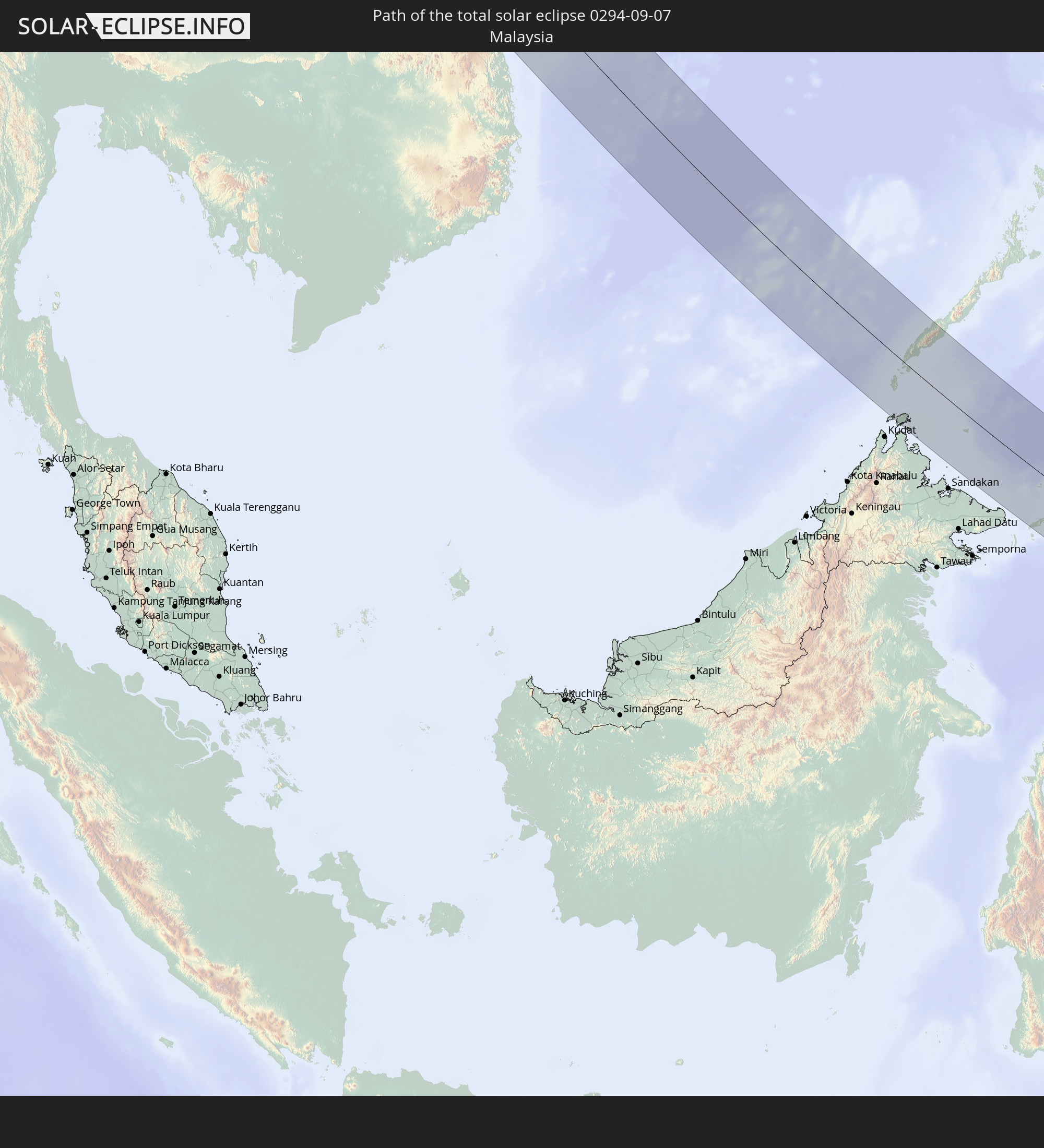 Malaysia
 Laos
Laos
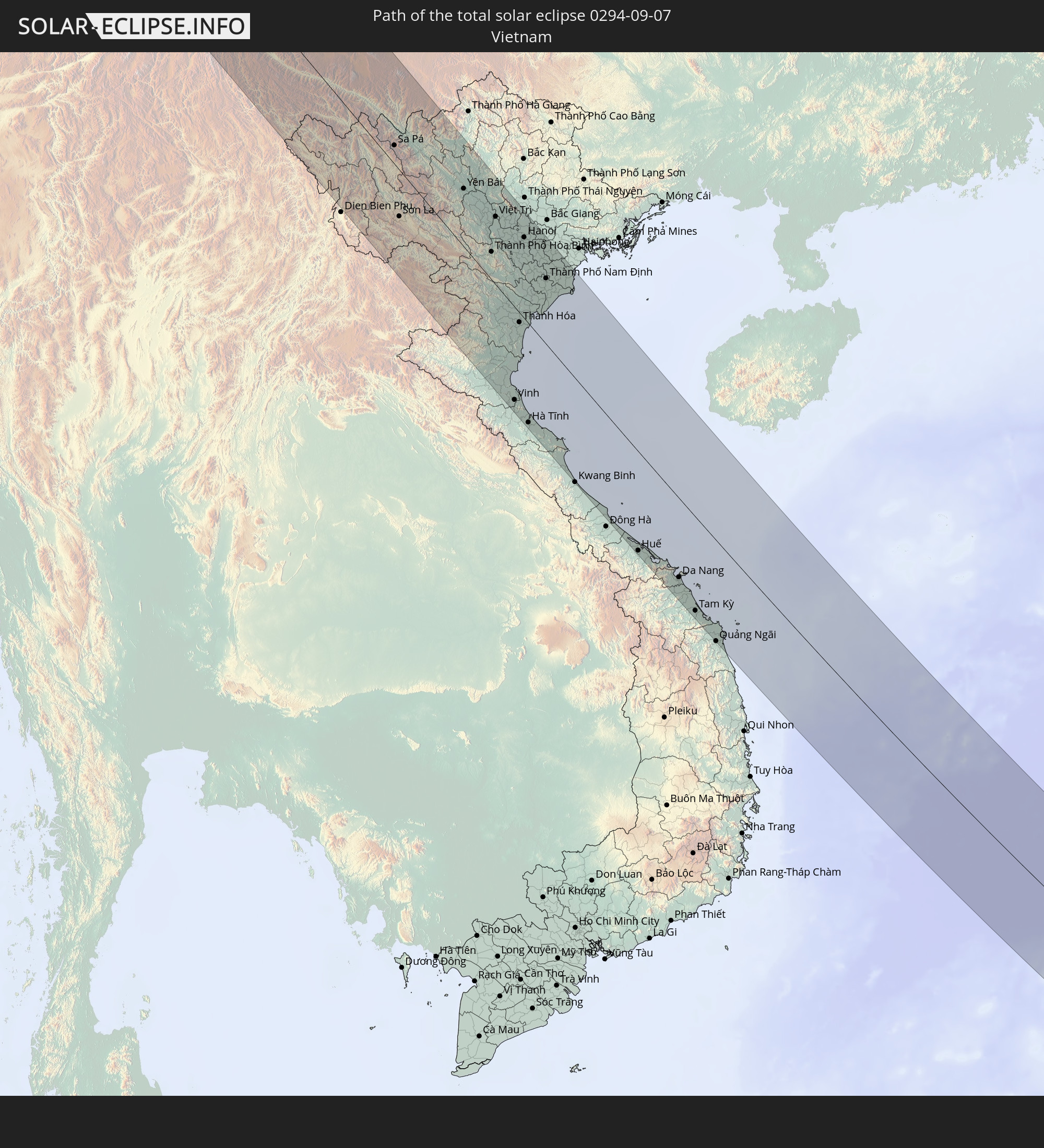 Vietnam
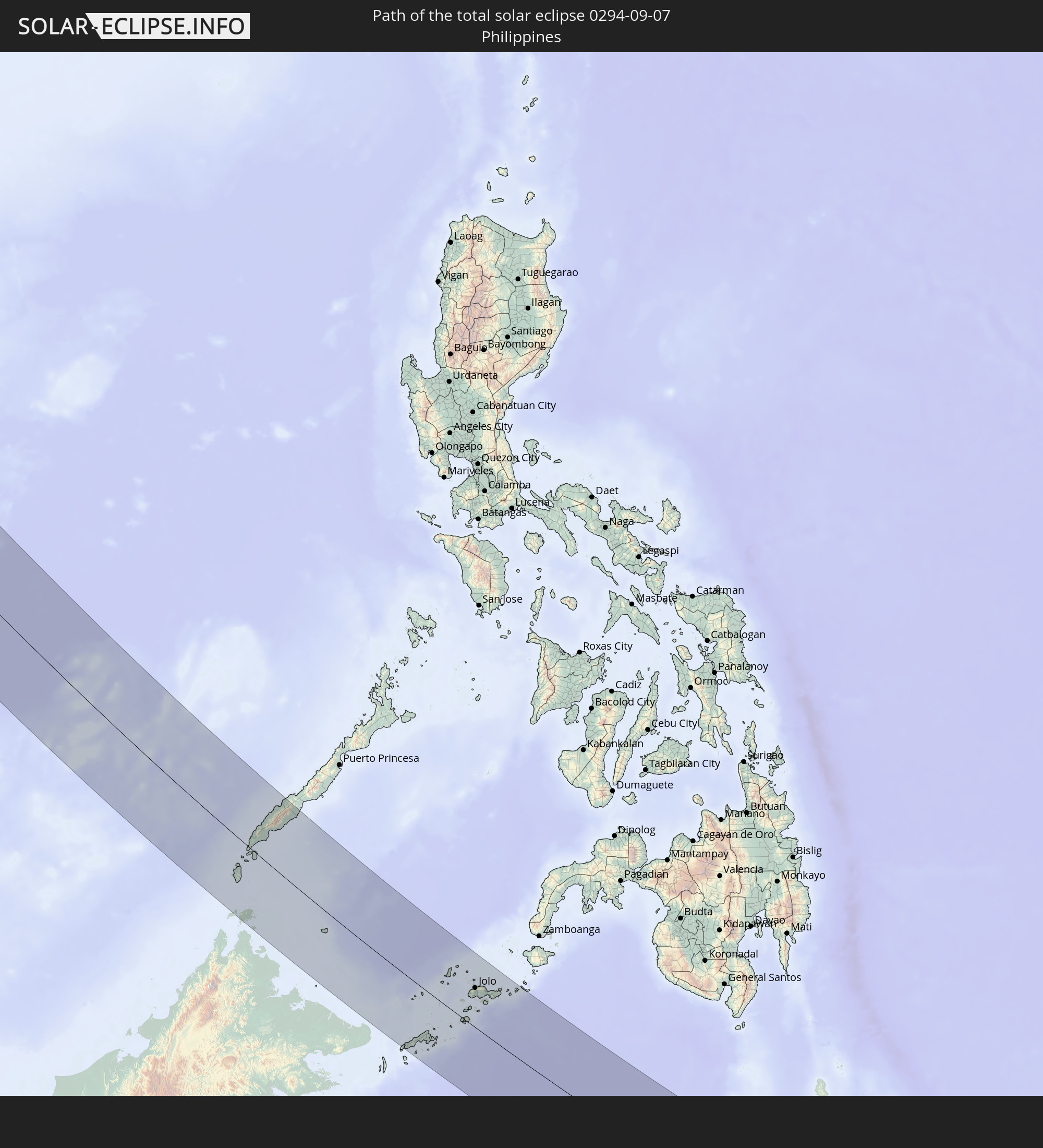 Philippines
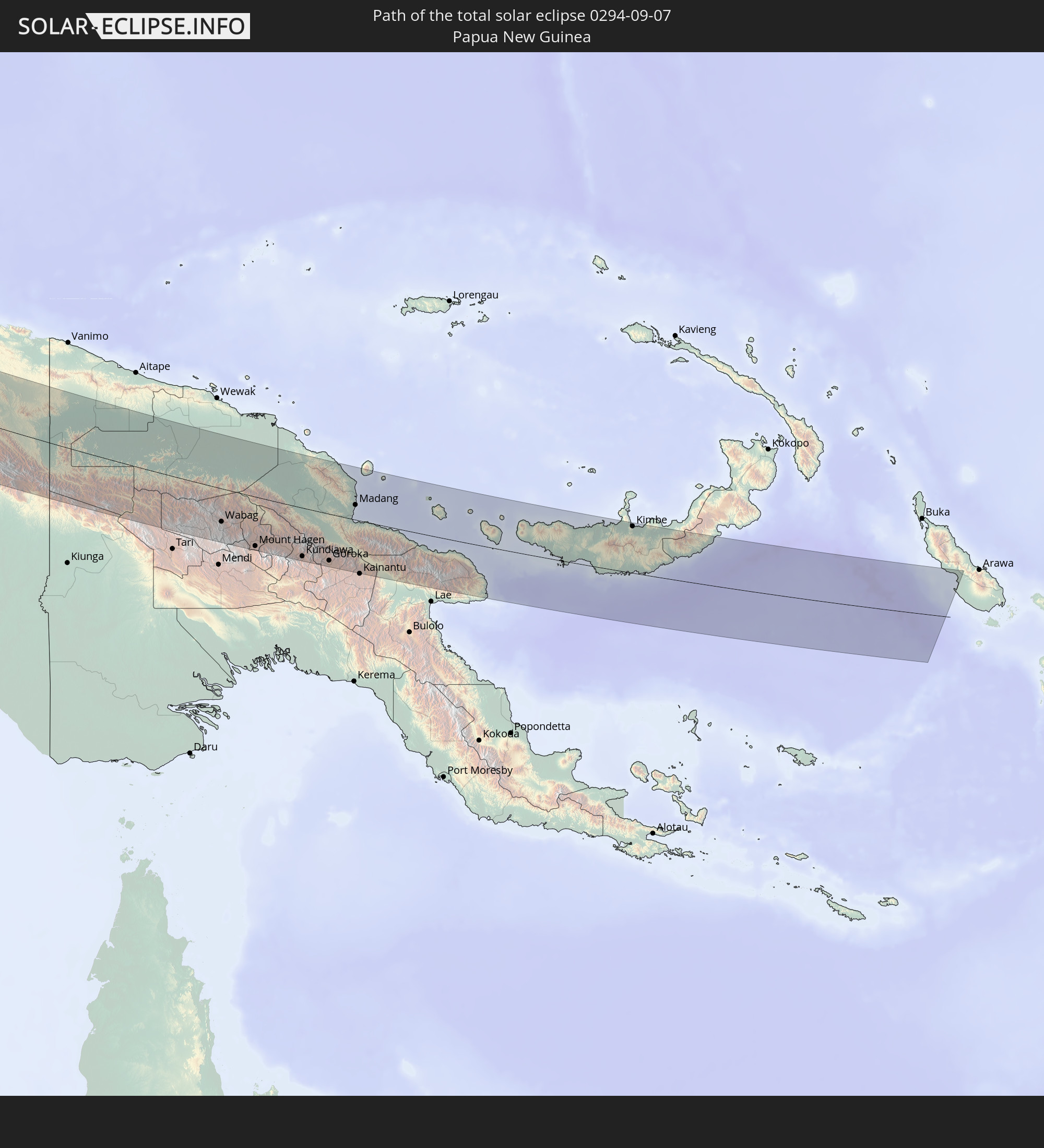 Papua New Guinea
In den folgenden Ländern ist die Sonnenfinsternis partiell zu sehen
 Russia
 Greenland
 Svalbard and Jan Mayen
 Norway
 Germany
 Denmark
 Libya
Libya
 Austria
 Sweden
 Czechia
 Chad
Chad
 Croatia
 Poland
 Bosnia and Herzegovina
 Hungary
 Slovakia
 Montenegro
 Serbia
 Albania
 Åland Islands
 Greece
 Romania
 Republic of Macedonia
 Finland
 Lithuania
 Latvia
 Estonia
 Sudan
Sudan
 Ukraine
 Bulgaria
 Belarus
 Egypt
Egypt
 Turkey
 Moldova
 Cyprus
 State of Palestine
 Israel
 Saudi Arabia
 Jordan
 Lebanon
 Syria
Syria
 Iraq
Iraq
 Georgia
 Yemen
Yemen
 Armenia
 Iran
Iran
 Azerbaijan
 Kazakhstan
 Kuwait
 Bahrain
 Qatar
Qatar
 United Arab Emirates
 Oman
Oman
 Turkmenistan
 Uzbekistan
 Afghanistan
 Pakistan
 Tajikistan
 India
India
 Kyrgyzstan
 China
China
 Sri Lanka
 Nepal
Nepal
 Mongolia
 Bangladesh
 Bhutan
 Myanmar
 Indonesia
 Cocos Islands
 Thailand
 Malaysia
 Laos
Laos
 Vietnam
 Cambodia
 Singapore
 Christmas Island
 Australia
 Macau
Macau
 Hong Kong
 Brunei
 Taiwan
 Philippines
 Japan
Japan
 East Timor
 North Korea
 South Korea
 Palau
Palau
 Federated States of Micronesia
 Papua New Guinea
 Guam
Guam
 Northern Mariana Islands
 Marshall Islands
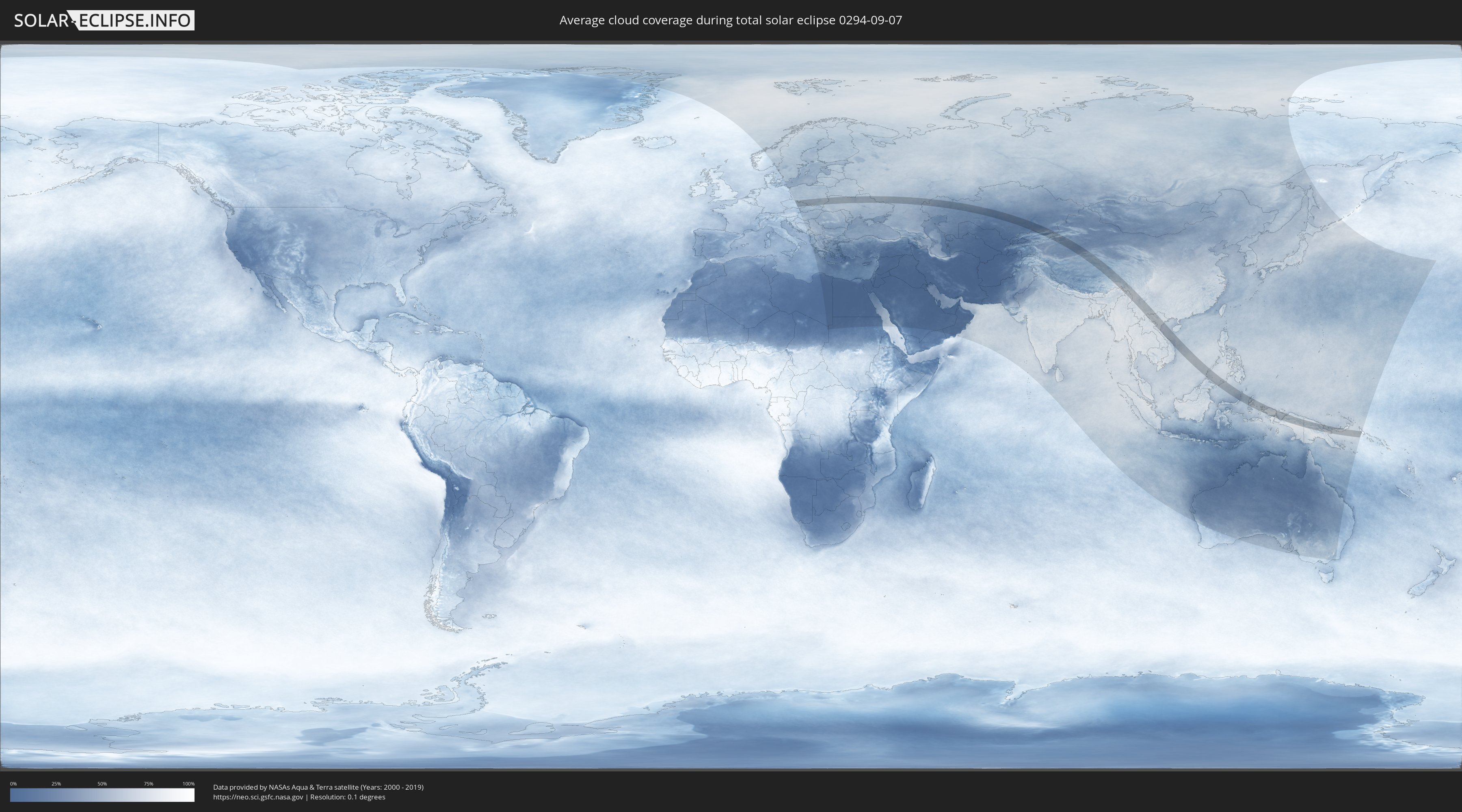
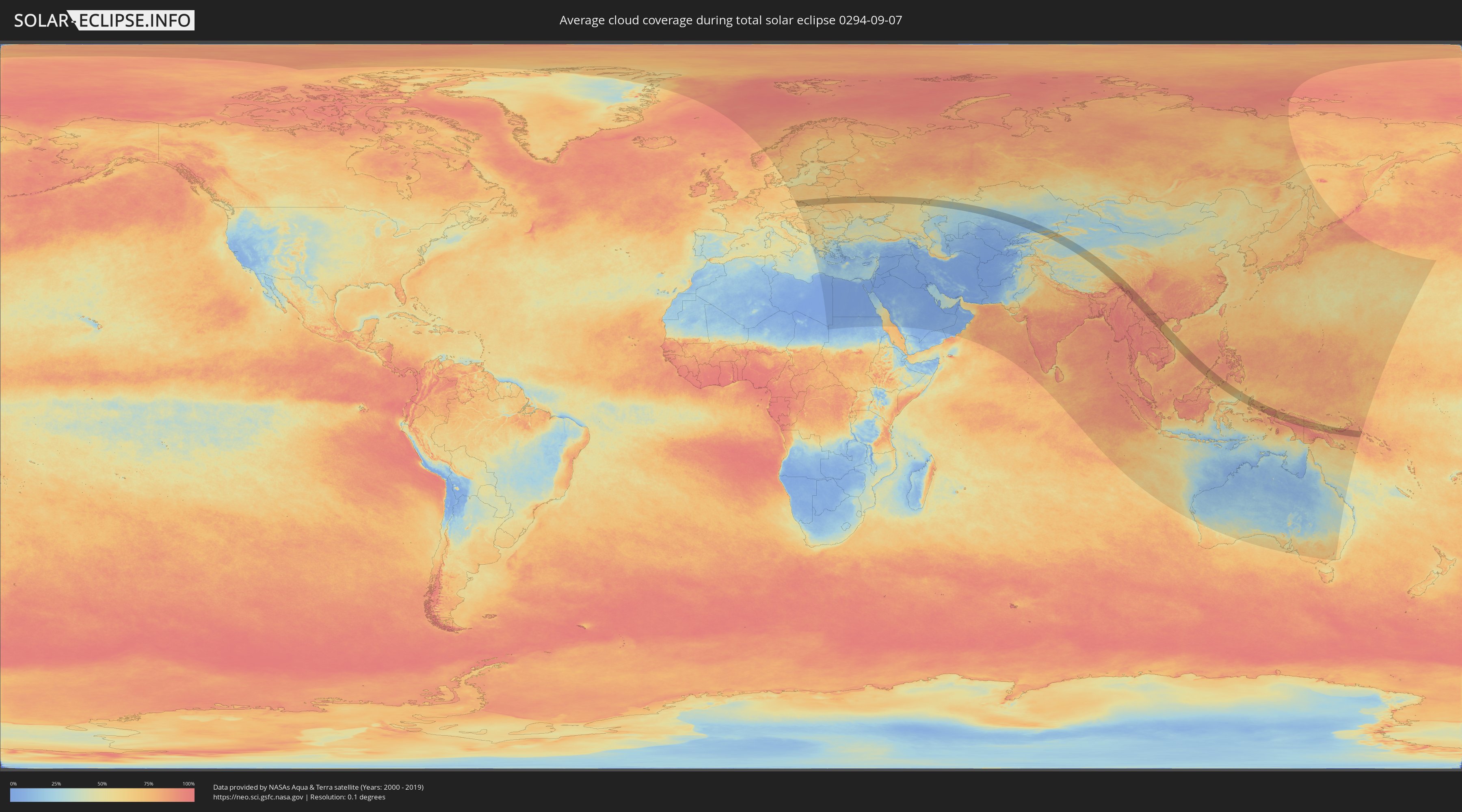
How will be the weather during the total solar eclipse on 09/07/0294?
Where is the best place to see the total solar eclipse of 09/07/0294?
The following maps show the average cloud coverage for the day of the total solar eclipse.
With the help of these maps, it is possible to find the place along the eclipse path, which has the best
chance of a cloudless sky.
Nevertheless, you should consider local circumstances and inform about the weather of your chosen
observation site.
The data is provided by NASAs satellites
AQUA and TERRA.
The cloud maps are averaged over a period of 19 years (2000 - 2019).
Detailed country maps
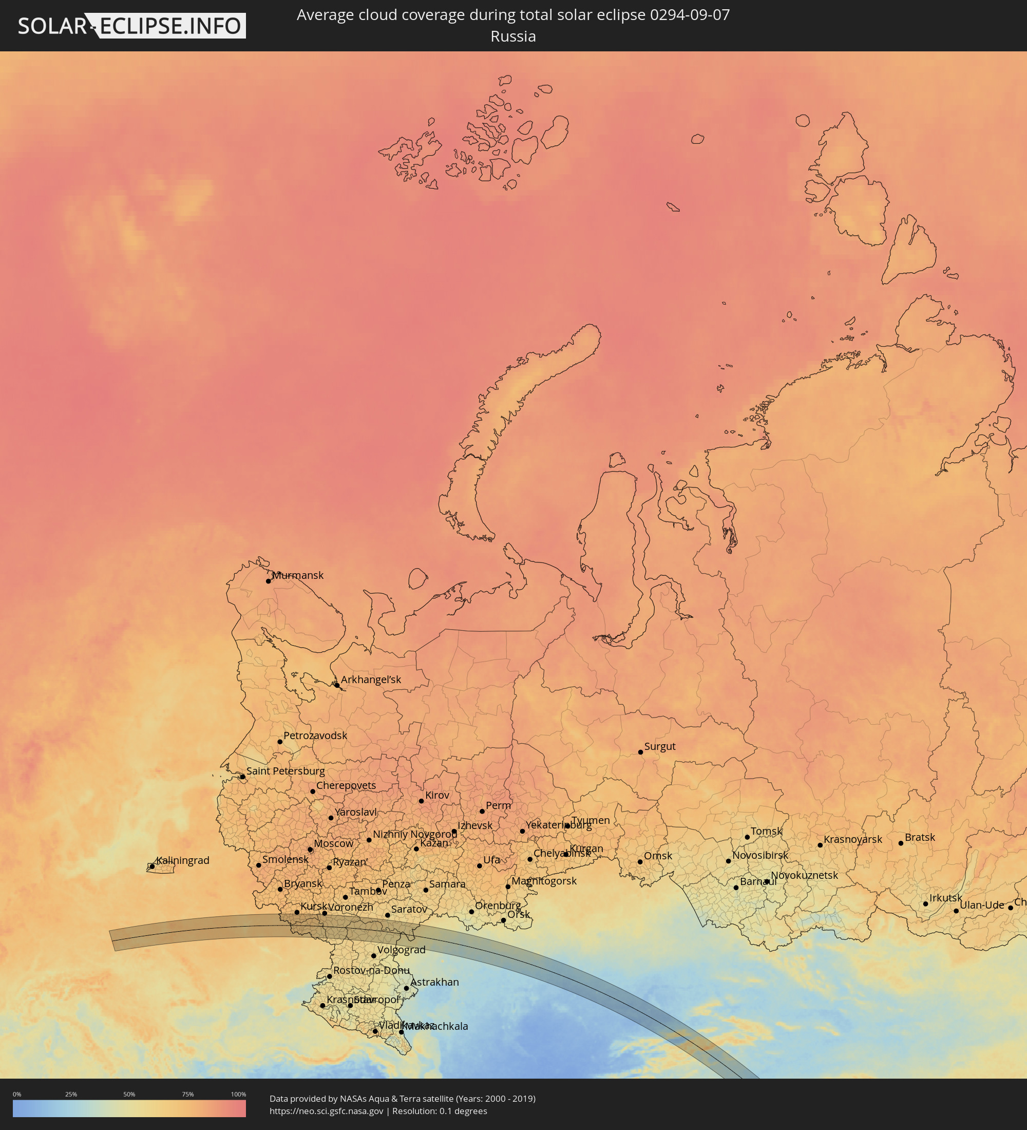 Russia
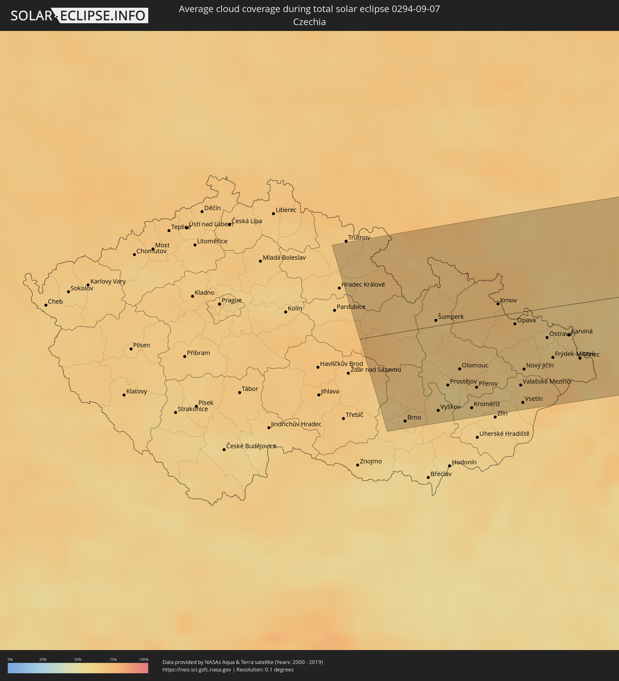 Czechia
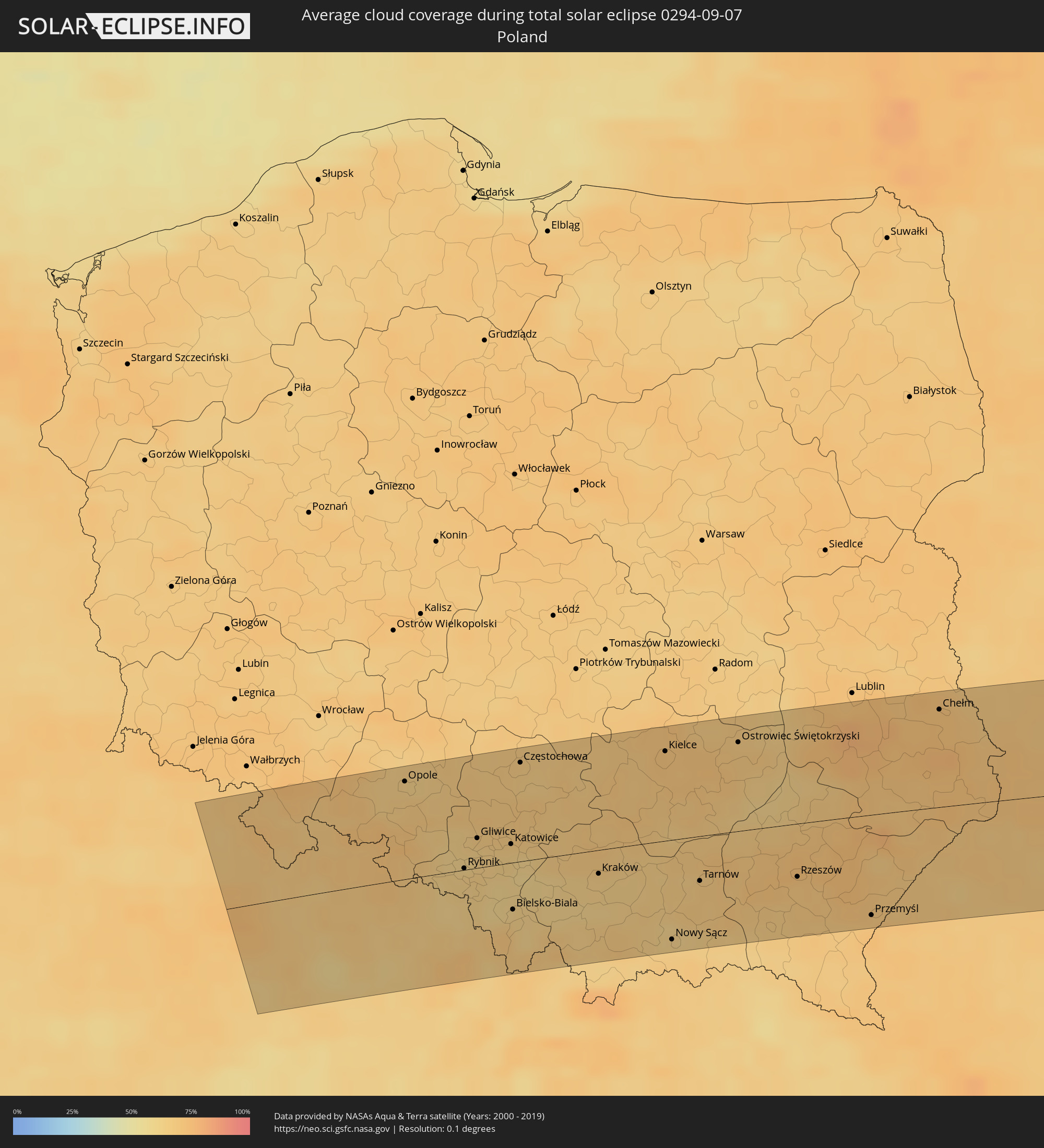 Poland
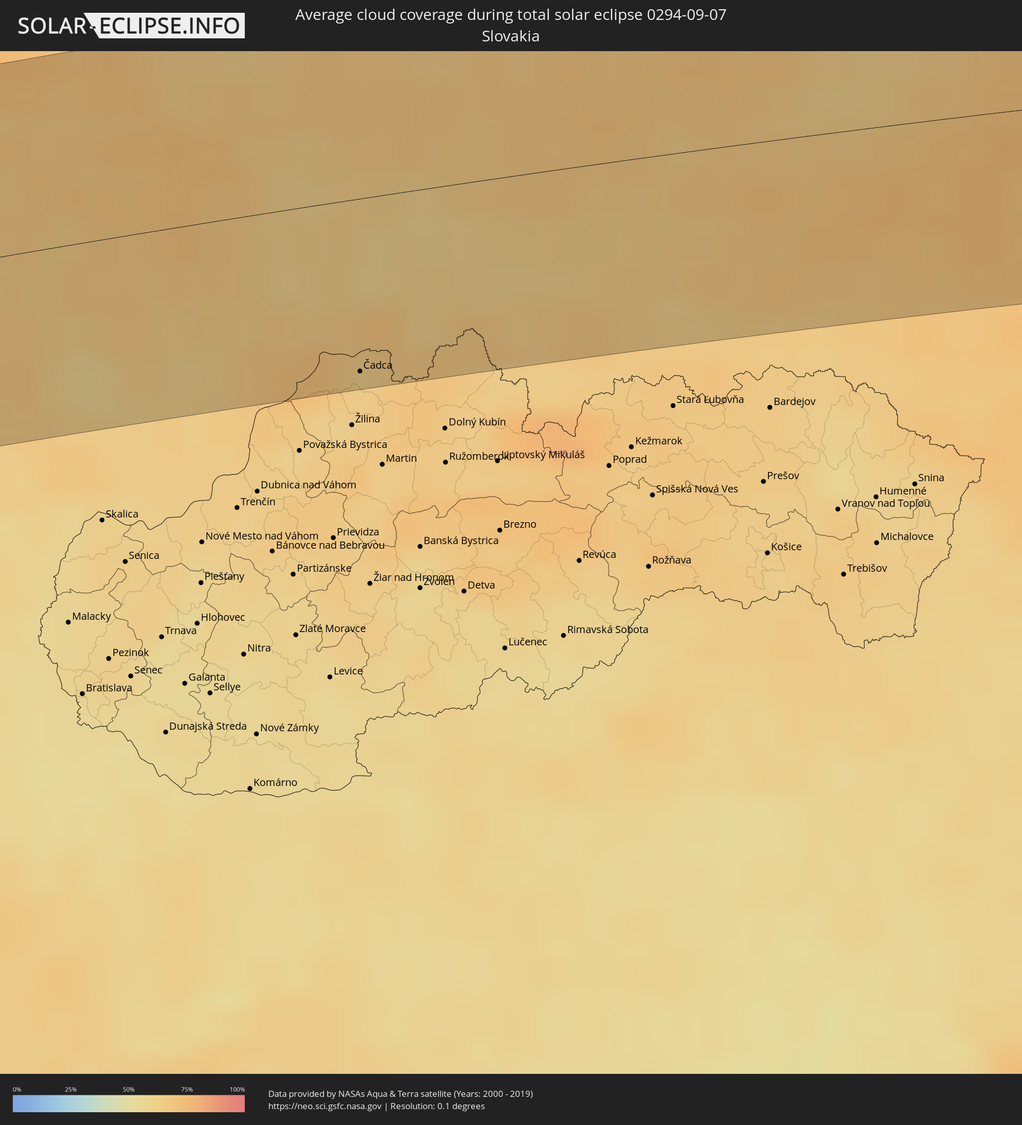 Slovakia
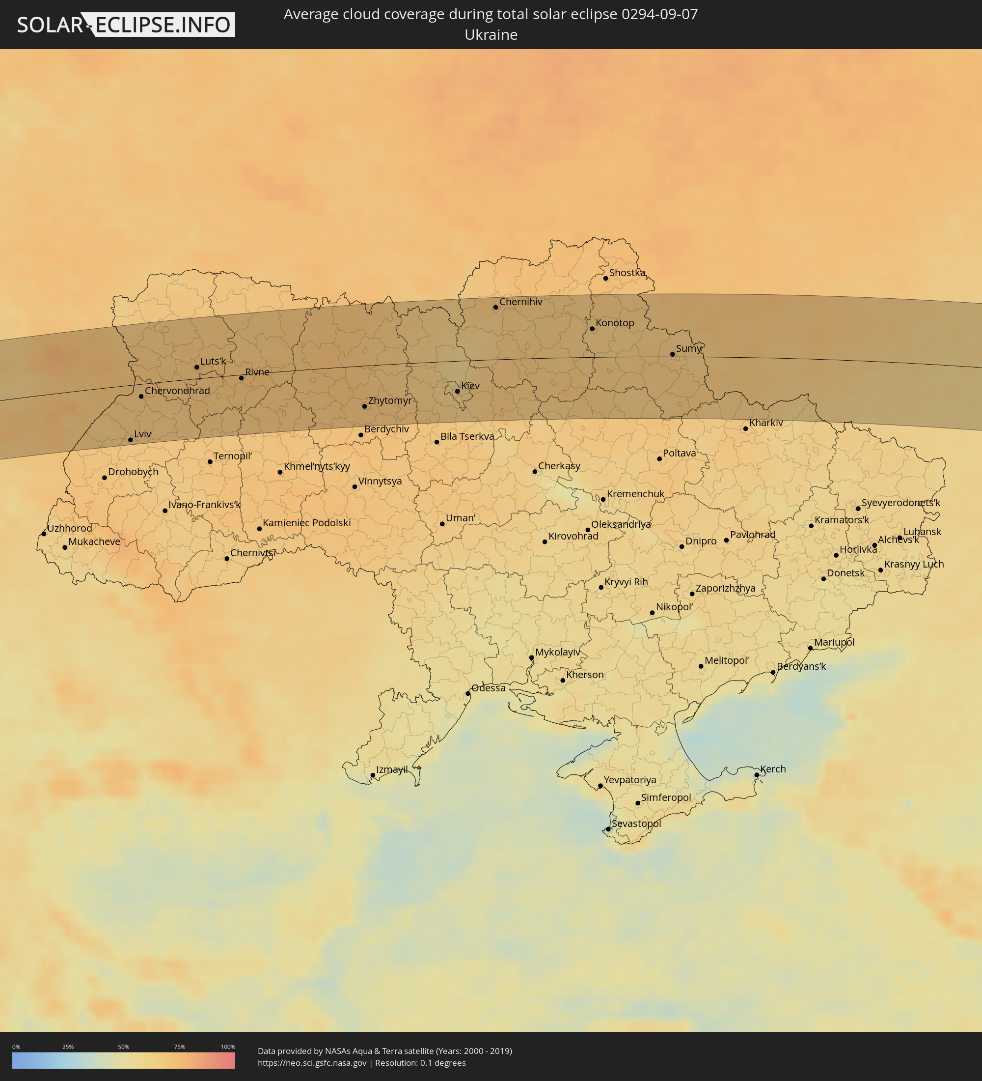 Ukraine
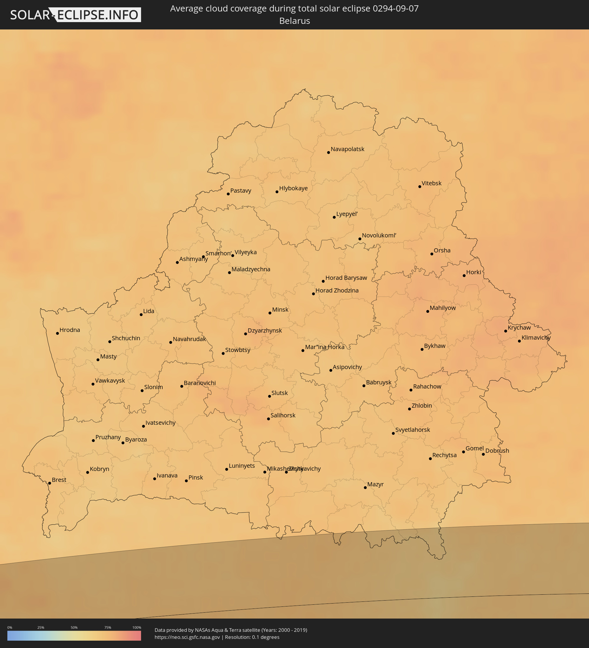 Belarus
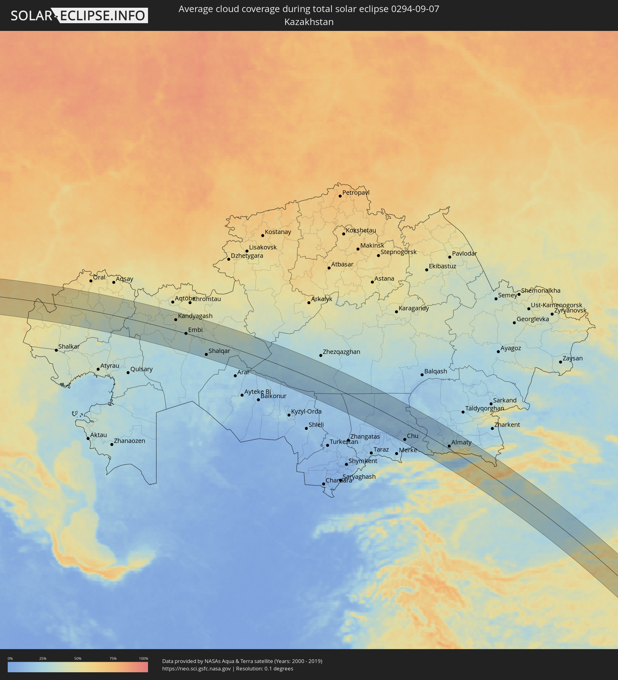 Kazakhstan
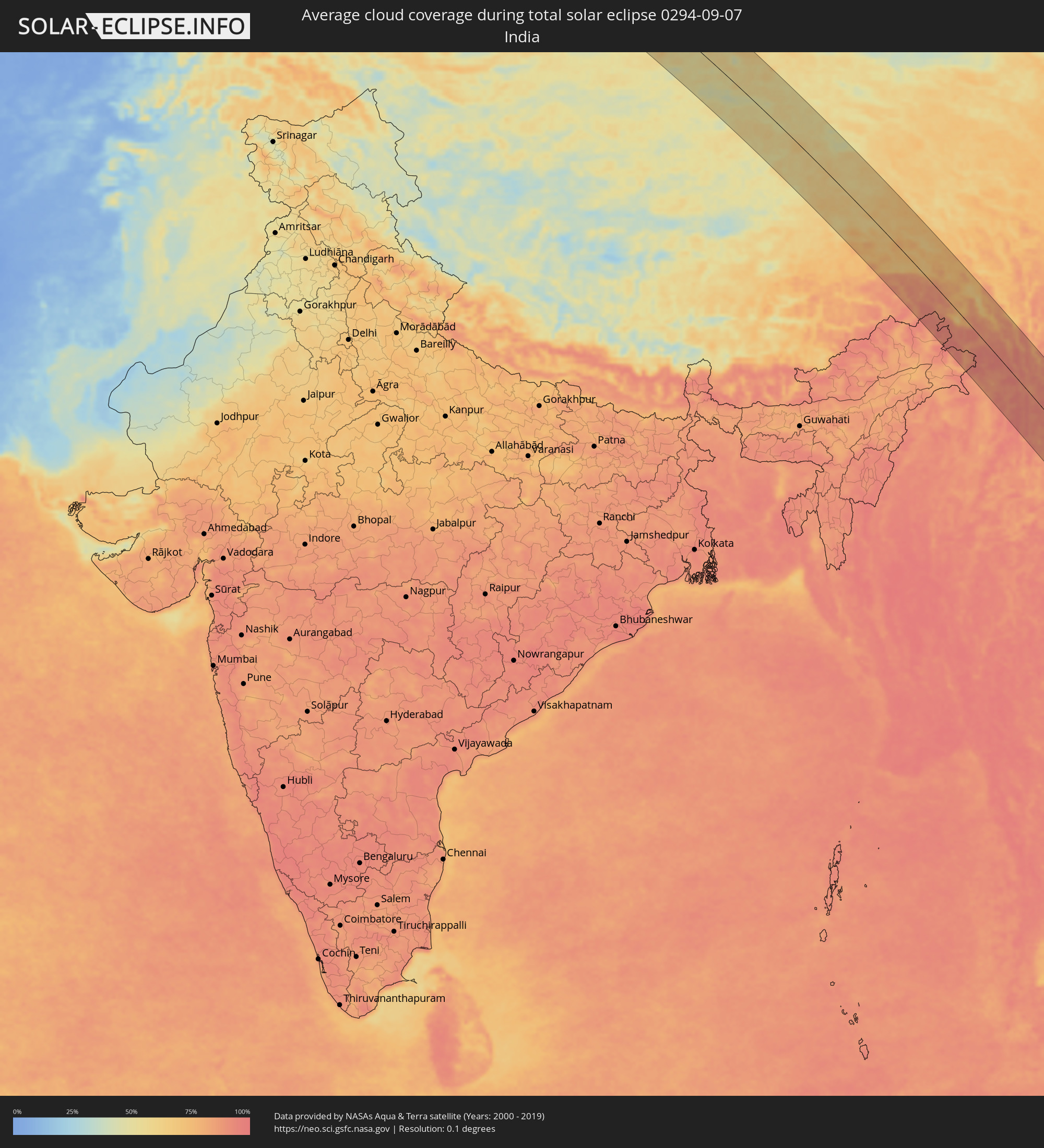 India
India
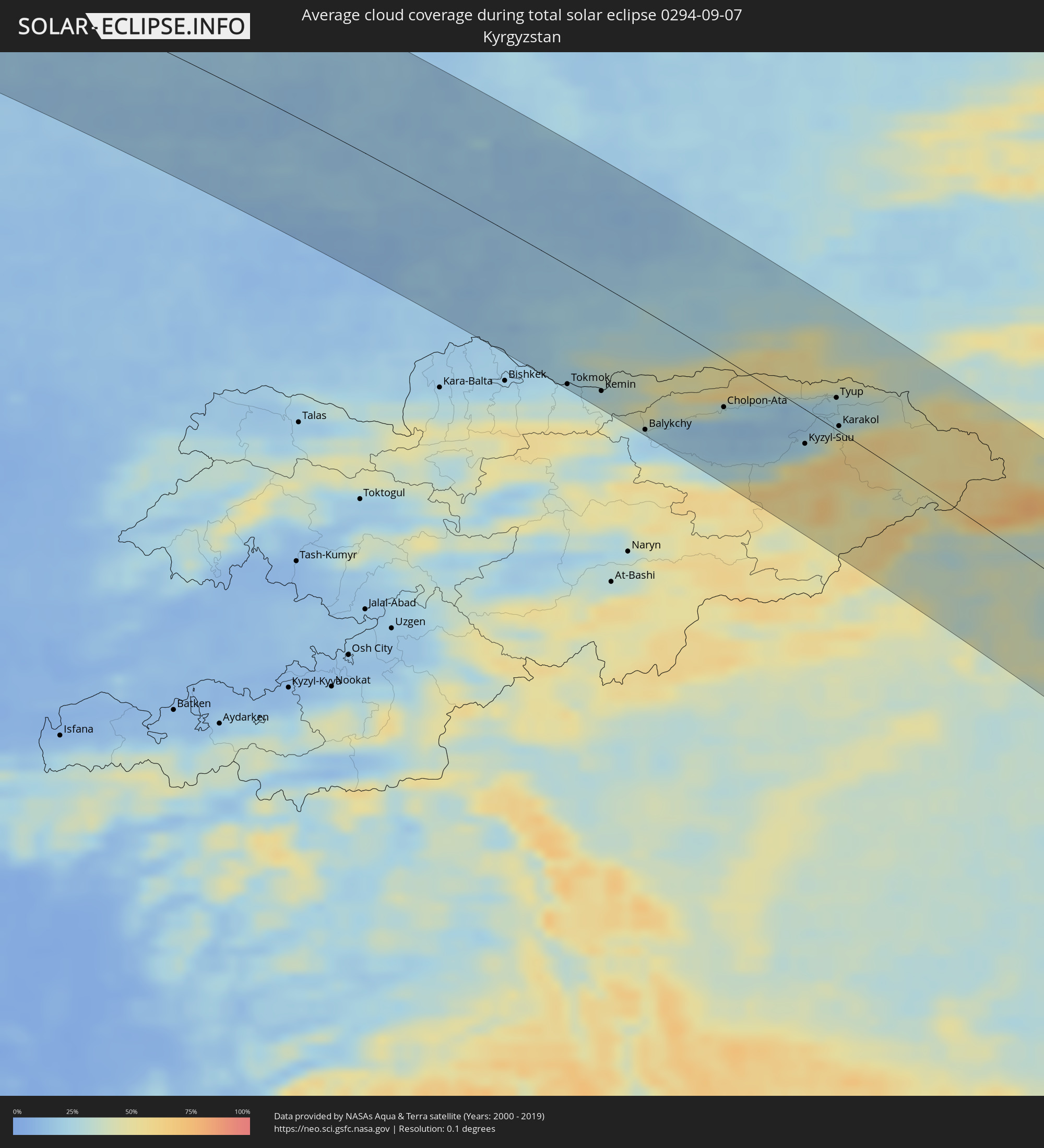 Kyrgyzstan
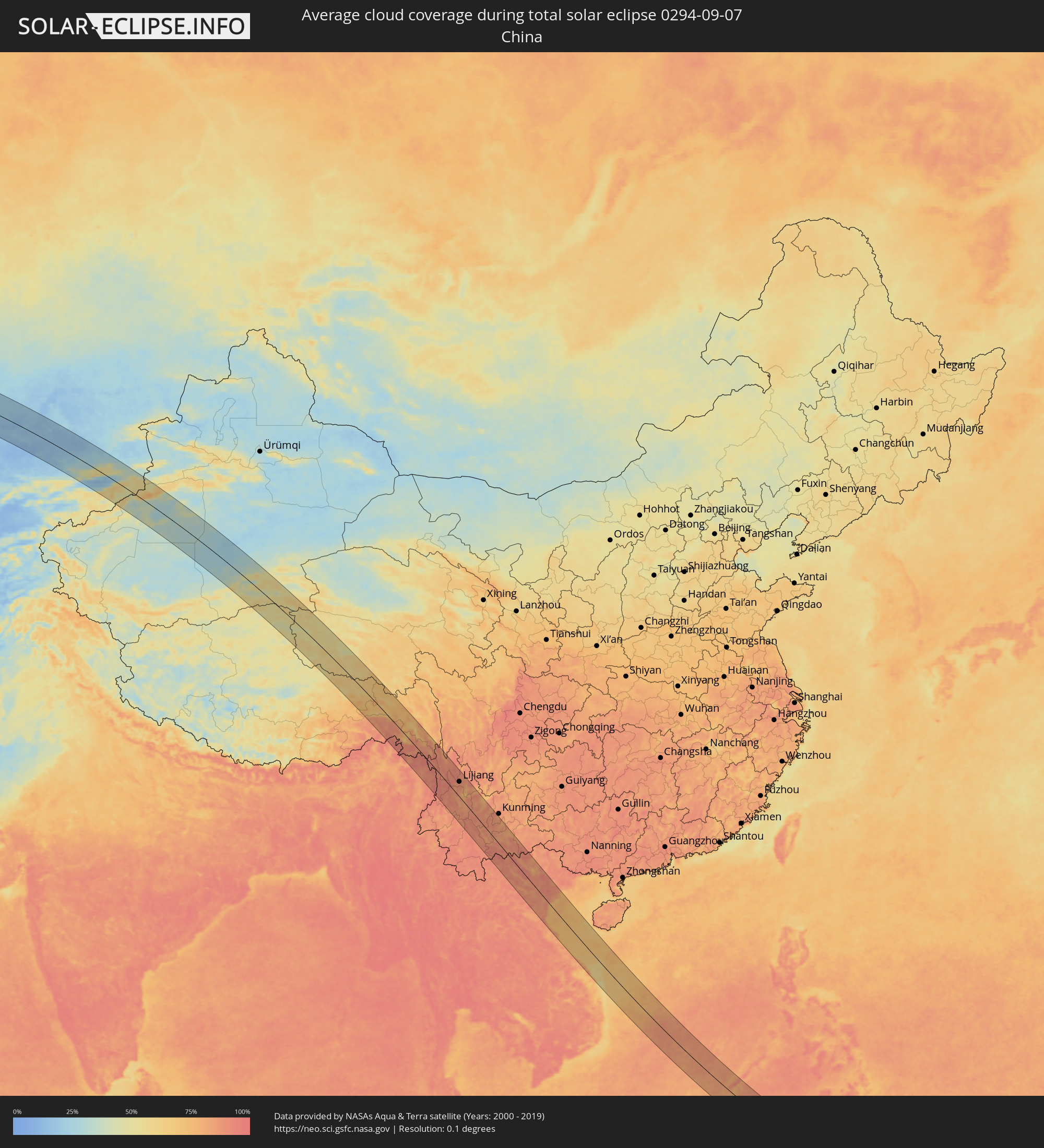 China
China
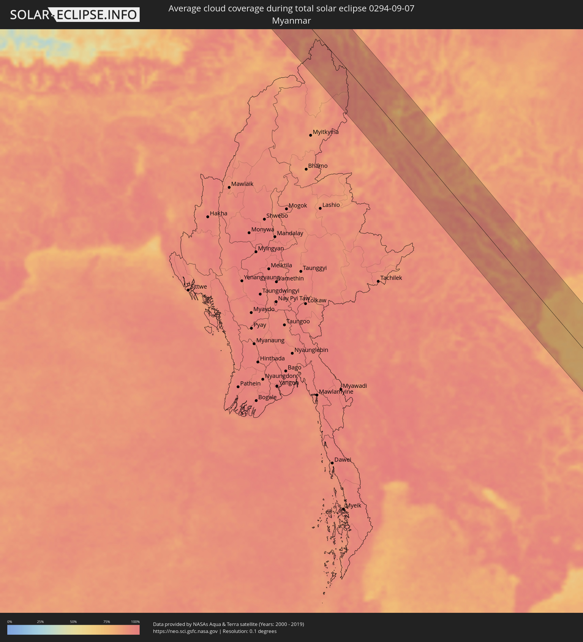 Myanmar
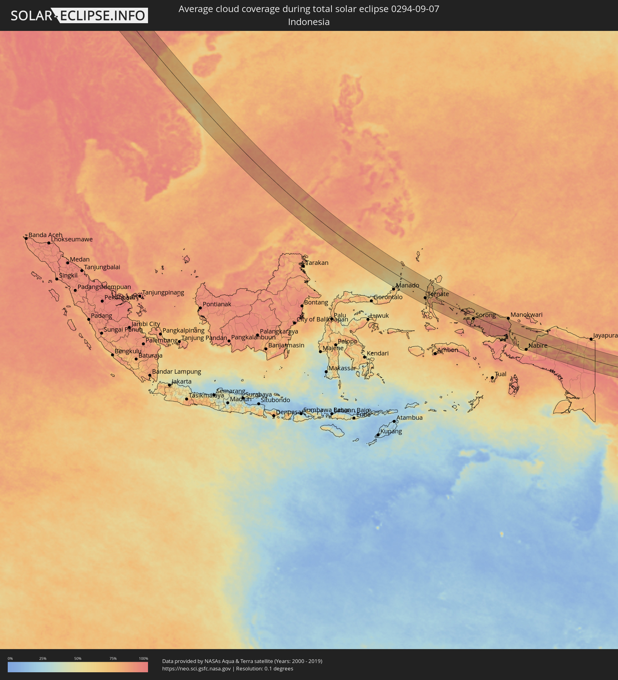 Indonesia
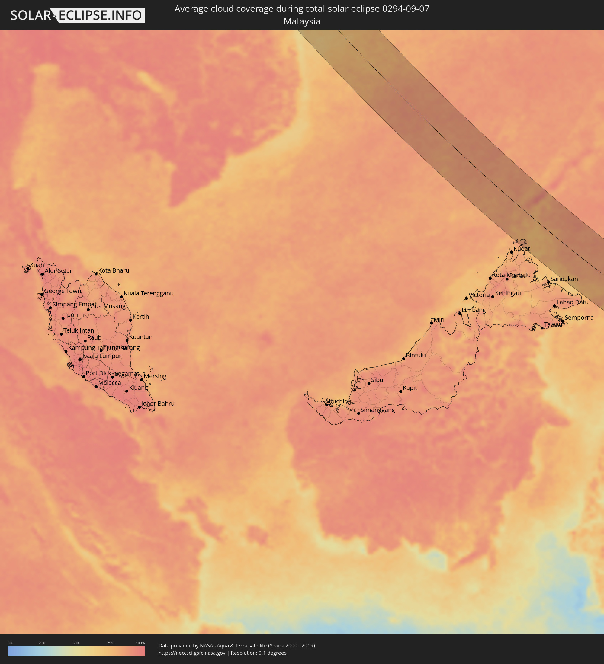 Malaysia
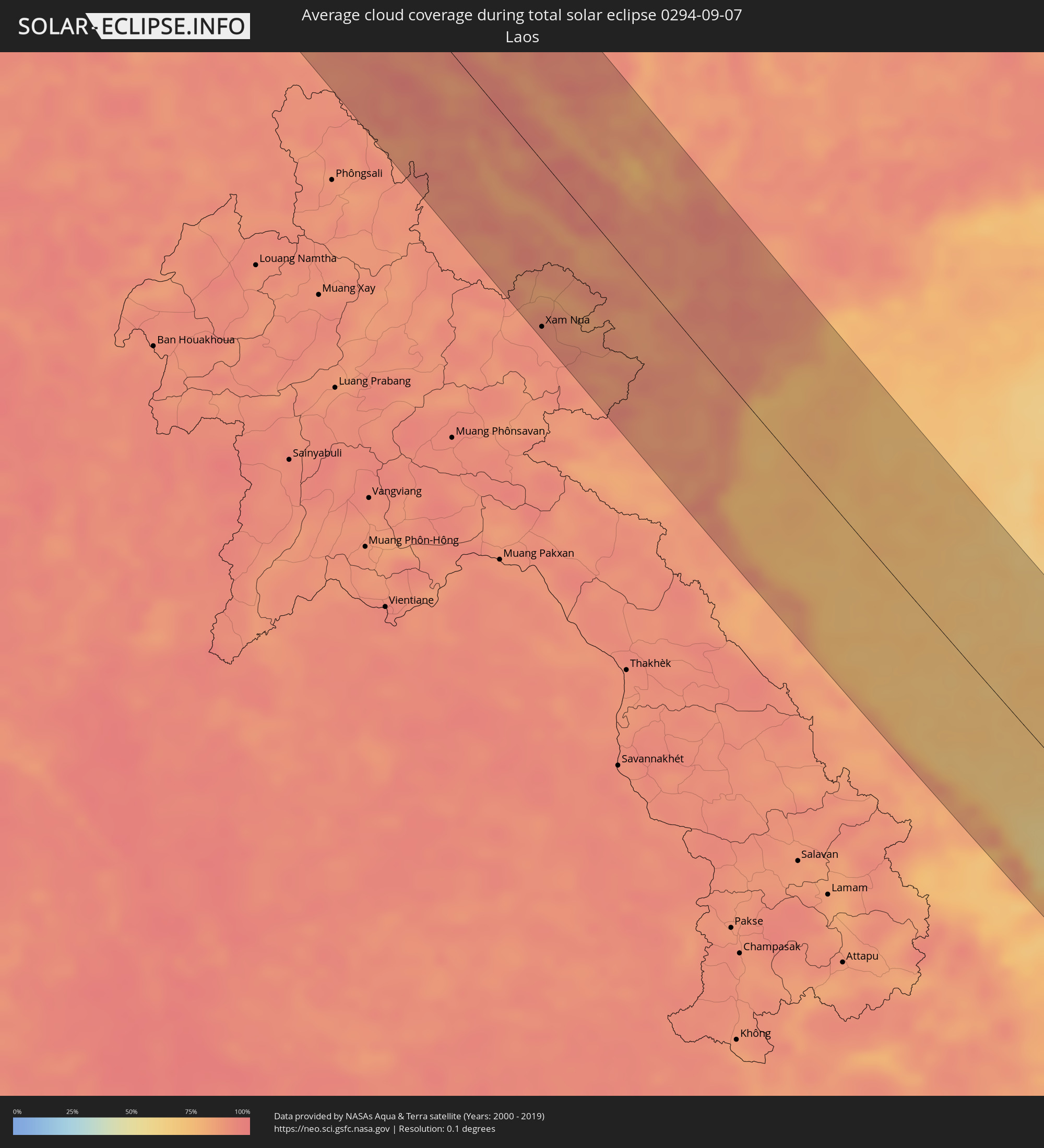 Laos
Laos
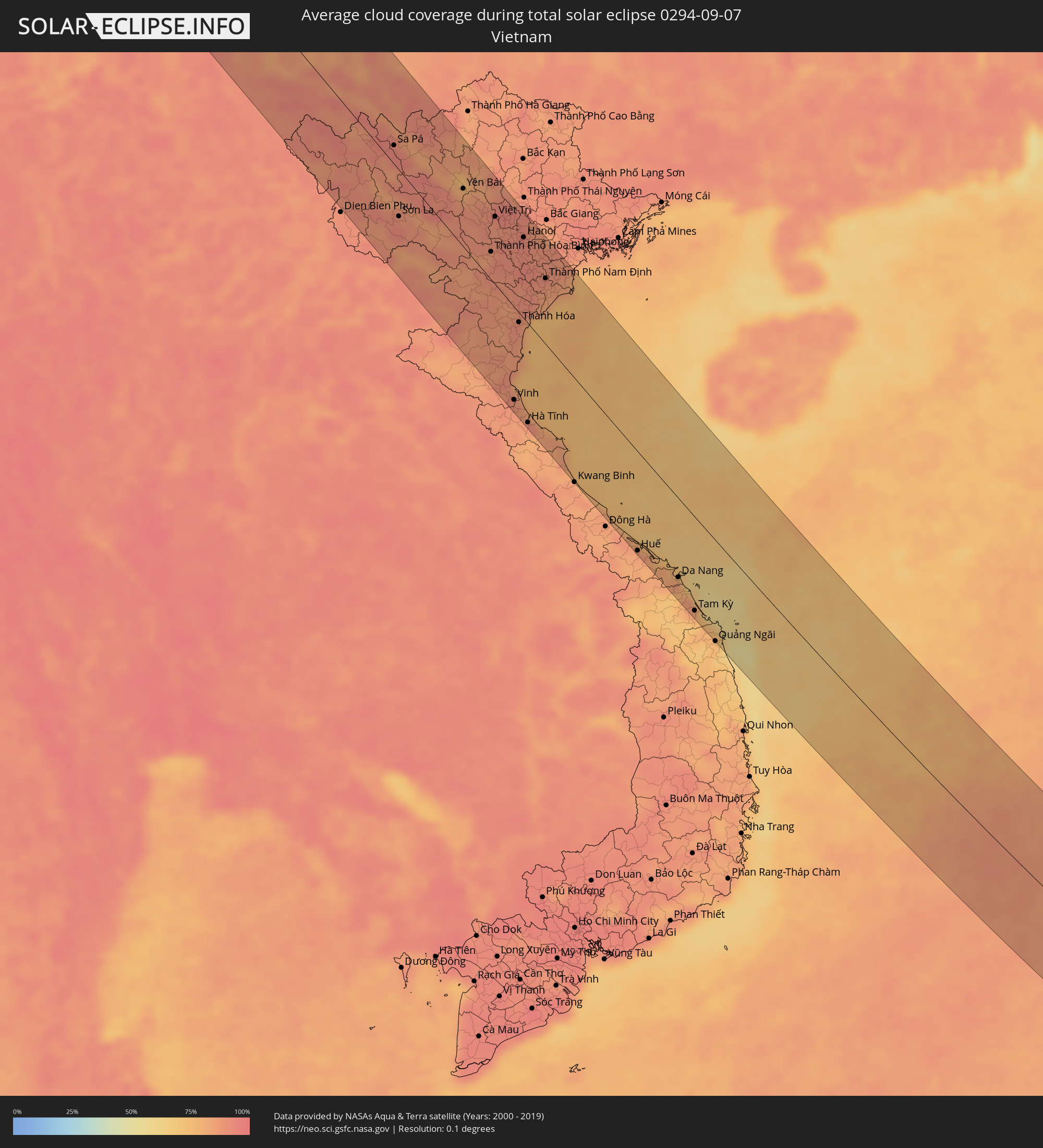 Vietnam
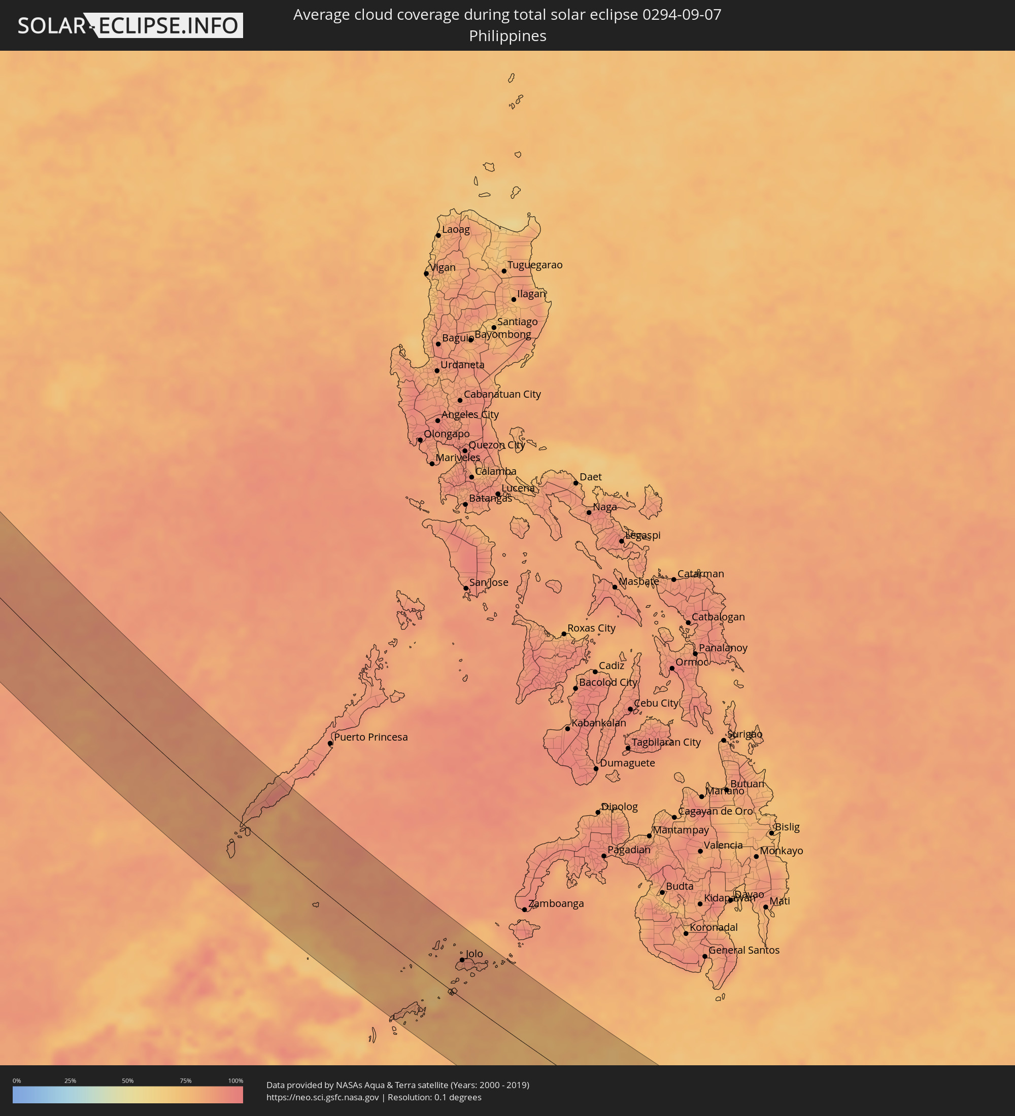 Philippines
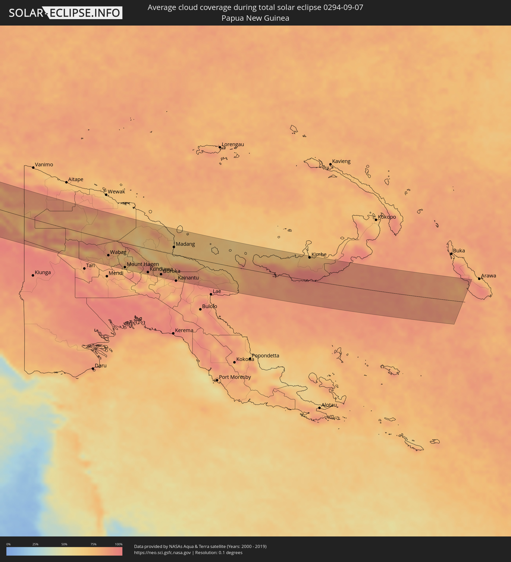 Papua New Guinea
Cities inside the path of the eclipse
The following table shows all locations with a population of more than 5,000 inside the eclipse path. Cities which have more than 100,000 inhabitants are marked bold. A click at the locations opens a detailed map.
| City | Type | Eclipse duration | Local time of max. eclipse | Distance to central line | Ø Cloud coverage |
|
Náchod, Královéhradecký
|
total | - | 05:23:09 UTC+01:00 | 64 km | 69% |
|
Brno, South Moravian
|
total | - | 05:22:15 UTC+01:00 | 76 km | 62% |
|
Šumperk, Olomoucký
|
total | - | 05:22:46 UTC+01:00 | 4 km | 65% |
|
Vyškov, South Moravian
|
total | - | 05:22:17 UTC+01:00 | 71 km | 65% |
|
Prostějov, Olomoucký
|
total | - | 05:22:24 UTC+01:00 | 51 km | 59% |
|
Olomouc, Olomoucký
|
total | - | 05:22:29 UTC+01:00 | 39 km | 65% |
|
Kroměříž, Zlín
|
total | - | 05:22:16 UTC+01:00 | 74 km | 62% |
|
Přerov, Olomoucký
|
total | - | 05:22:22 UTC+01:00 | 57 km | 65% |
|
Krnov, Moravskoslezský
|
total | - | 05:22:49 UTC+01:00 | 10 km | 71% |
|
Opava, Moravskoslezský
|
total | - | 05:22:42 UTC+01:00 | 9 km | 67% |
|
Opole, Opole Voivodeship
|
total | - | 05:47:14 UTC+01:24 | 71 km | 65% |
|
Vsetín, Zlín
|
total | - | 05:22:16 UTC+01:00 | 76 km | 64% |
|
Nový Jičín, Moravskoslezský
|
total | - | 05:22:27 UTC+01:00 | 48 km | 64% |
|
Ostrava, Moravskoslezský
|
total | - | 05:22:36 UTC+01:00 | 25 km | 64% |
|
Frýdek-Místek, Moravskoslezský
|
total | - | 05:22:30 UTC+01:00 | 42 km | 66% |
|
Karviná, Moravskoslezský
|
total | - | 05:22:37 UTC+01:00 | 26 km | 62% |
|
Rybnik, Silesian Voivodeship
|
total | - | 05:46:47 UTC+01:24 | 1 km | 63% |
|
Jastrzębie Zdrój, Silesian Voivodeship
|
total | - | 05:46:41 UTC+01:24 | 15 km | 63% |
|
Turzovka, Žilinský
|
total | - | 05:22:17 UTC+01:00 | 76 km | 66% |
|
Třinec, Moravskoslezský
|
total | - | 05:22:29 UTC+01:00 | 46 km | 66% |
|
Gliwice, Silesian Voivodeship
|
total | - | 05:46:56 UTC+01:24 | 22 km | 64% |
|
Čadca, Žilinský
|
total | - | 05:22:18 UTC+01:00 | 74 km | 63% |
|
Katowice, Silesian Voivodeship
|
total | - | 05:46:53 UTC+01:24 | 14 km | 66% |
|
Bielsko-Biala, Silesian Voivodeship
|
total | - | 05:46:34 UTC+01:24 | 35 km | 66% |
|
Częstochowa, Silesian Voivodeship
|
total | - | 05:47:17 UTC+01:24 | 72 km | 66% |
|
Dąbrowa Górnicza, Silesian Voivodeship
|
total | - | 05:46:56 UTC+01:24 | 18 km | 65% |
|
Kraków, Lesser Poland Voivodeship
|
total | - | 05:46:44 UTC+01:24 | 17 km | 65% |
|
Kielce, Świętokrzyskie
|
total | - | 05:47:19 UTC+01:24 | 65 km | 70% |
|
Nowy Sącz, Lesser Poland Voivodeship
|
total | - | 05:46:24 UTC+01:24 | 73 km | 65% |
|
Tarnów, Lesser Poland Voivodeship
|
total | - | 05:46:41 UTC+01:24 | 33 km | 67% |
|
Ostrowiec Świętokrzyski, Świętokrzyskie
|
total | - | 05:47:22 UTC+01:24 | 65 km | 68% |
|
Rzeszów, Subcarpathian Voivodeship
|
total | - | 05:46:44 UTC+01:24 | 39 km | 68% |
|
Przemyśl, Subcarpathian Voivodeship
|
total | - | 05:46:34 UTC+01:24 | 74 km | 70% |
|
Chełm, Lublin Voivodeship
|
total | - | 05:47:36 UTC+01:24 | 71 km | 72% |
|
Lviv, Lviv
|
total | - | 06:24:45 UTC+02:02 | 78 km | 67% |
|
Novovolyns’k, Volyn
|
total | - | 06:25:24 UTC+02:02 | 19 km | 71% |
|
Chervonohrad, Lviv
|
total | - | 06:25:10 UTC+02:02 | 18 km | 68% |
|
Kovel’, Volyn
|
total | - | 06:25:49 UTC+02:02 | 70 km | 67% |
|
Luts’k, Volyn
|
total | - | 06:25:31 UTC+02:02 | 15 km | 70% |
|
Rivne, Rivne
|
total | - | 06:25:31 UTC+02:02 | 6 km | 71% |
|
Novohrad-Volyns’kyy, Zhytomyr
|
total | - | 06:25:40 UTC+02:02 | 16 km | 71% |
|
Korosten’, Zhytomyr
|
total | - | 06:26:05 UTC+02:02 | 20 km | 71% |
|
Zhytomyr, Zhytomyr
|
total | - | 06:25:35 UTC+02:02 | 58 km | 71% |
|
Kiev, Kyiv City
|
total | - | 06:26:03 UTC+02:02 | 43 km | 61% |
|
Brovary, Kiev
|
total | - | 06:26:09 UTC+02:02 | 37 km | 68% |
|
Chernihiv, Chernihiv
|
total | - | 06:26:57 UTC+02:02 | 72 km | 67% |
|
Nizhyn, Chernihiv
|
total | - | 06:26:45 UTC+02:02 | 19 km | 70% |
|
Pryluky, Chernihiv
|
total | - | 06:26:33 UTC+02:02 | 32 km | 68% |
|
Konotop, Sumy
|
total | - | 06:27:12 UTC+02:02 | 39 km | 67% |
|
Sumy, Sumy
|
total | - | 06:27:23 UTC+02:02 | 3 km | 68% |
|
Kurchatov, Kursk
|
total | - | 06:56:22 UTC+02:30 | 85 km | 70% |
|
Belgorod, Belgorod
|
total | - | 06:55:56 UTC+02:30 | 31 km | 67% |
|
Shebekino, Belgorod
|
total | - | 06:55:54 UTC+02:30 | 53 km | 65% |
|
Gubkin, Belgorod
|
total | - | 06:56:42 UTC+02:30 | 46 km | 70% |
|
Staryy Oskol, Belgorod
|
total | - | 06:56:48 UTC+02:30 | 48 km | 69% |
|
Valuyki, Belgorod
|
total | - | 06:56:11 UTC+02:30 | 73 km | 63% |
|
Rossosh’, Voronezj
|
total | - | 06:56:55 UTC+02:30 | 30 km | 64% |
|
Alekseyevka, Belgorod
|
total | - | 06:56:40 UTC+02:30 | 24 km | 61% |
|
Ostrogozhsk, Voronezj
|
total | - | 06:56:58 UTC+02:30 | 4 km | 63% |
|
Novovoronezh, Voronezj
|
total | - | 06:57:18 UTC+02:30 | 53 km | 66% |
|
Liski, Voronezj
|
total | - | 06:57:12 UTC+02:30 | 18 km | 64% |
|
Rossosh’, Voronezj
|
total | - | 06:56:43 UTC+02:30 | 69 km | 60% |
|
Uryupinsk, Volgograd
|
total | - | 06:58:06 UTC+02:30 | 10 km | 59% |
|
Borisoglebsk, Voronezj
|
total | - | 06:58:29 UTC+02:30 | 73 km | 62% |
|
Mikhaylovka, Volgograd
|
total | - | 06:58:12 UTC+02:30 | 65 km | 59% |
|
Kamyshin, Volgograd
|
total | - | 06:59:18 UTC+02:30 | 44 km | 54% |
|
Shubarkuduk, Aqtöbe
|
total | - | 08:01:05 UTC+03:25 | 0 km | 33% |
|
Shubarshi, Aqtöbe
|
total | - | 08:01:29 UTC+03:25 | 47 km | 33% |
|
Kandyagash, Aqtöbe
|
total | - | 08:01:54 UTC+03:25 | 53 km | 41% |
|
Embi, Aqtöbe
|
total | - | 08:02:19 UTC+03:25 | 1 km | 34% |
|
Shalqar, Aqtöbe
|
total | - | 08:03:19 UTC+03:25 | 77 km | 27% |
|
Moyynkum, Zhambyl
|
total | - | 09:13:51 UTC+04:21 | 47 km | 16% |
|
Chu, Zhambyl
|
total | - | 09:15:07 UTC+04:21 | 82 km | 17% |
|
Tokmok, Chüy
|
total | - | 09:53:56 UTC+04:58 | 95 km | 28% |
|
Kemin, Chüy
|
total | - | 09:54:28 UTC+04:58 | 84 km | 28% |
|
Balykchy, Issyk-Kul Region
|
total | - | 09:55:17 UTC+04:58 | 94 km | 27% |
|
Burunday, Almaty Oblysy
|
total | - | 09:19:06 UTC+04:21 | 20 km | 25% |
|
Almaty, Almaty Qalasy
|
total | - | 09:19:15 UTC+04:21 | 13 km | 28% |
|
Pervomayskiy, Almaty Oblysy
|
total | - | 09:19:12 UTC+04:21 | 24 km | 25% |
|
Otegen Batyra, Almaty Oblysy
|
total | - | 09:19:17 UTC+04:21 | 32 km | 25% |
|
Kapshagay, Almaty Oblysy
|
total | - | 09:19:05 UTC+04:21 | 76 km | 24% |
|
Cholpon-Ata, Issyk-Kul Region
|
total | - | 09:56:20 UTC+04:58 | 38 km | 17% |
|
Talghar, Almaty Oblysy
|
total | - | 09:19:37 UTC+04:21 | 30 km | 33% |
|
Esik, Almaty Oblysy
|
total | - | 09:19:52 UTC+04:21 | 44 km | 31% |
|
Turgen, Almaty Oblysy
|
total | - | 09:20:01 UTC+04:21 | 55 km | 32% |
|
Kyzyl-Suu, Issyk-Kul Region
|
total | - | 09:57:43 UTC+04:58 | 27 km | 36% |
|
Tyup, Issyk-Kul Region
|
total | - | 09:57:57 UTC+04:58 | 25 km | 27% |
|
Karakol, Issyk-Kul Region
|
total | - | 09:58:08 UTC+04:58 | 4 km | 33% |
|
Ak-Suu, Issyk-Kul Region
|
total | - | 09:58:18 UTC+04:58 | 11 km | 37% |
|
Kegen, Almaty Oblysy
|
total | - | 09:22:21 UTC+04:21 | 90 km | 35% |
|
Aykol, Xinjiang Uyghur Autonomous Region
|
total | - | 13:03:10 UTC+08:00 | 58 km | 38% |
|
Aksu, Xinjiang Uyghur Autonomous Region
|
total | - | 13:03:11 UTC+08:00 | 30 km | 39% |
|
Aral, Xinjiang Uyghur Autonomous Region
|
total | - | 13:05:04 UTC+08:00 | 41 km | 37% |
|
Shangri-La, Yunnan
|
total | - | 13:51:20 UTC+08:00 | 92 km | 89% |
|
Dali, Yunnan
|
total | - | 13:56:19 UTC+08:00 | 31 km | 87% |
|
Lijiang, Yunnan
|
total | - | 13:53:55 UTC+08:00 | 62 km | 87% |
|
Longquan, Yunnan
|
total | - | 14:01:11 UTC+08:00 | 53 km | 85% |
|
Lianran, Yunnan
|
total | - | 14:01:12 UTC+08:00 | 96 km | 86% |
|
Yuxi, Yunnan
|
total | - | 14:02:24 UTC+08:00 | 60 km | 86% |
|
Haikou, Yunnan
|
total | - | 14:01:38 UTC+08:00 | 93 km | 85% |
|
Gejiu, Yunnan
|
total | - | 14:05:18 UTC+08:00 | 37 km | 89% |
|
Kaiyuan, Yunnan
|
total | - | 14:04:53 UTC+08:00 | 73 km | 83% |
|
Sa Pá, Lào Cai
|
total | - | 13:15:04 UTC+07:06 | 19 km | 93% |
|
Xam Nua, Houaphan
|
total | - | 12:54:37 UTC+06:42 | 103 km | 92% |
|
Yên Bái, Yên Bái
|
total | - | 13:17:57 UTC+07:06 | 60 km | 80% |
|
Thành Phố Hòa Bình, Hòa Bình
|
total | - | 13:20:25 UTC+07:06 | 29 km | 86% |
|
Việt Trì, Phú Thọ
|
total | - | 13:19:30 UTC+07:06 | 70 km | 89% |
|
Sơn Tây, Ha Nội
|
total | - | 13:20:02 UTC+07:06 | 65 km | 89% |
|
Vinh, Nghệ An
|
total | - | 13:25:16 UTC+07:06 | 97 km | 88% |
|
Thanh Hóa, Thanh Hóa
|
total | - | 13:23:07 UTC+07:06 | 10 km | 88% |
|
Hà Đông, Ha Nội
|
total | - | 13:20:47 UTC+07:06 | 75 km | 92% |
|
Hanoi, Ha Nội
|
total | - | 13:20:47 UTC+07:06 | 84 km | 92% |
|
Bỉm Sơn, Thanh Hóa
|
total | - | 13:22:42 UTC+07:06 | 18 km | 90% |
|
Hưng Yên, Hưng Yên
|
total | - | 13:21:51 UTC+07:06 | 74 km | 90% |
|
Thành Phố Nam Định, Nam Định
|
total | - | 13:22:28 UTC+07:06 | 68 km | 85% |
|
Thành Phố Thái Bình, Thái Bình
|
total | - | 13:22:41 UTC+07:06 | 83 km | 88% |
|
Huế, Thừa Thiên-Huế
|
total | - | 13:32:35 UTC+07:06 | 107 km | 85% |
|
Da Nang, Đà Nẵng
|
total | - | 13:34:18 UTC+07:06 | 86 km | 83% |
|
Tam Kỳ, Quảng Nam
|
total | - | 13:35:40 UTC+07:06 | 103 km | 78% |
|
Balabac, Mimaropa
|
total | - | 14:54:53 UTC+08:00 | 46 km | 81% |
|
Rio Tuba, Mimaropa
|
total | - | 14:54:25 UTC+08:00 | 25 km | 82% |
|
Batarasa, Mimaropa
|
total | - | 14:54:20 UTC+08:00 | 53 km | 84% |
|
Pañgobilian, Mimaropa
|
total | - | 14:54:23 UTC+08:00 | 81 km | 78% |
|
New Batu Batu, Autonomous Region in Muslim Mindanao
|
total | - | 15:03:06 UTC+08:00 | 103 km | 76% |
|
Balimbing, Autonomous Region in Muslim Mindanao
|
total | - | 15:03:10 UTC+08:00 | 97 km | 75% |
|
Languyan, Autonomous Region in Muslim Mindanao
|
total | - | 15:02:59 UTC+08:00 | 73 km | 83% |
|
Tongouson, Autonomous Region in Muslim Mindanao
|
total | - | 15:03:26 UTC+08:00 | 91 km | 77% |
|
Siasi, Autonomous Region in Muslim Mindanao
|
total | - | 15:03:17 UTC+08:00 | 1 km | 83% |
|
Lugus, Autonomous Region in Muslim Mindanao
|
total | - | 15:03:02 UTC+08:00 | 15 km | 81% |
|
Parang, Autonomous Region in Muslim Mindanao
|
total | - | 15:02:46 UTC+08:00 | 40 km | 82% |
|
Laminusa, Autonomous Region in Muslim Mindanao
|
total | - | 15:03:22 UTC+08:00 | 8 km | 85% |
|
Kulase, Autonomous Region in Muslim Mindanao
|
total | - | 15:02:50 UTC+08:00 | 42 km | 81% |
|
Jolo, Autonomous Region in Muslim Mindanao
|
total | - | 15:02:38 UTC+08:00 | 59 km | 89% |
|
Kansipati, Autonomous Region in Muslim Mindanao
|
total | - | 15:02:58 UTC+08:00 | 69 km | 84% |
|
Karungdong, Autonomous Region in Muslim Mindanao
|
total | - | 15:03:12 UTC+08:00 | 61 km | 83% |
|
Ternate, North Maluku
|
total | - | 16:39:22 UTC+09:22 | 51 km | 73% |
|
Sofifi, North Maluku
|
total | - | 16:39:34 UTC+09:22 | 47 km | 83% |
|
Tobelo, North Maluku
|
total | - | 16:38:32 UTC+09:22 | 74 km | 67% |
|
Sorong, West Papua
|
total | - | 16:44:21 UTC+09:22 | 23 km | 90% |
|
Nabire, Papua
|
total | - | 16:49:40 UTC+09:22 | 97 km | 78% |
|
Wabag, Enga
|
total | - | 17:31:53 UTC+10:00 | 56 km | 81% |
|
Mount Hagen, Western Highlands
|
total | - | 17:32:20 UTC+10:00 | 83 km | 77% |
|
Minj, Jiwaka
|
total | - | 17:32:28 UTC+10:00 | 77 km | 77% |
|
Kundiawa, Chimbu
|
total | - | 17:32:37 UTC+10:00 | 82 km | 75% |
|
Goroka, Eastern Highlands
|
total | - | 17:32:45 UTC+10:00 | 79 km | 71% |
|
Madang, Madang
|
total | - | 17:32:04 UTC+10:00 | 25 km | 65% |
|
Kimbe, West New Britain
|
total | - | 17:32:52 UTC+10:00 | 80 km | 78% |