Total solar eclipse of 07/19/0418
| Day of week: | Thursday |
| Maximum duration of eclipse: | 03m52s |
| Maximum width of eclipse path: | 163 km |
| Saros cycle: | 91 |
| Coverage: | 100% |
| Magnitude: | 1.0459 |
| Gamma: | 0.3481 |
Wo kann man die Sonnenfinsternis vom 07/19/0418 sehen?
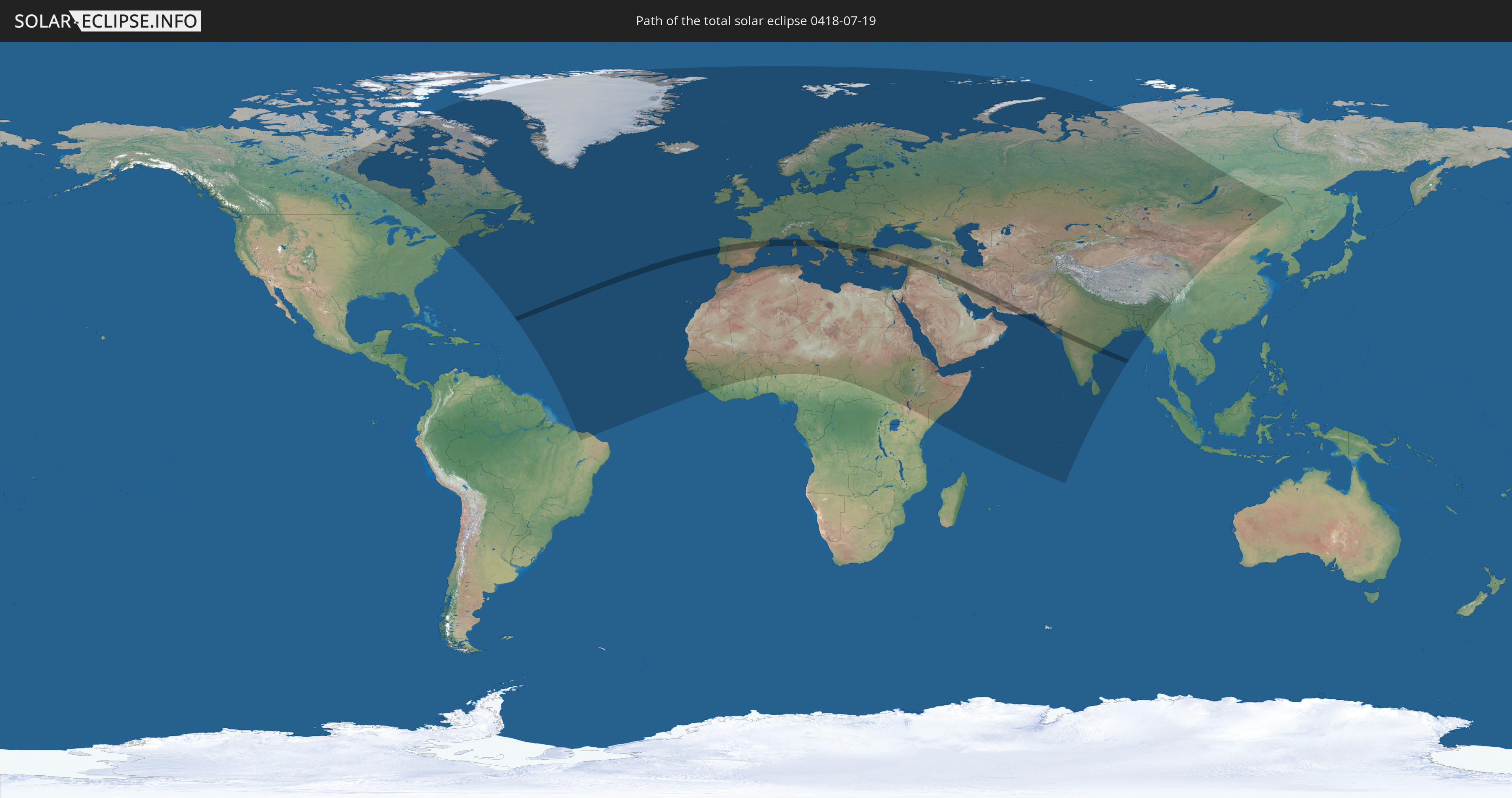
Die Sonnenfinsternis am 07/19/0418 kann man in 124 Ländern als partielle Sonnenfinsternis beobachten.
Der Finsternispfad verläuft durch 18 Länder. Nur in diesen Ländern ist sie als total Sonnenfinsternis zu sehen.
In den folgenden Ländern ist die Sonnenfinsternis total zu sehen
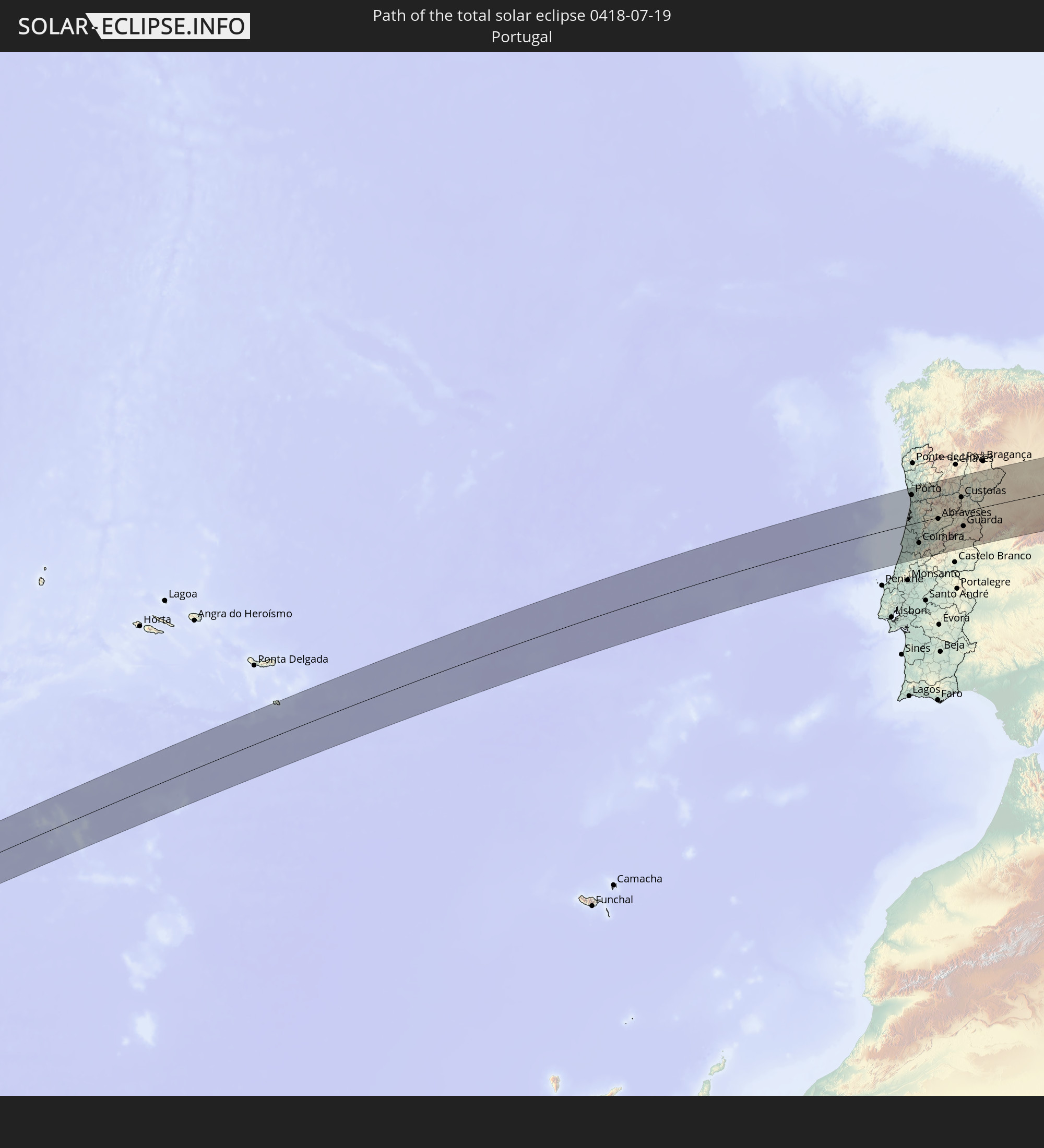 Portugal
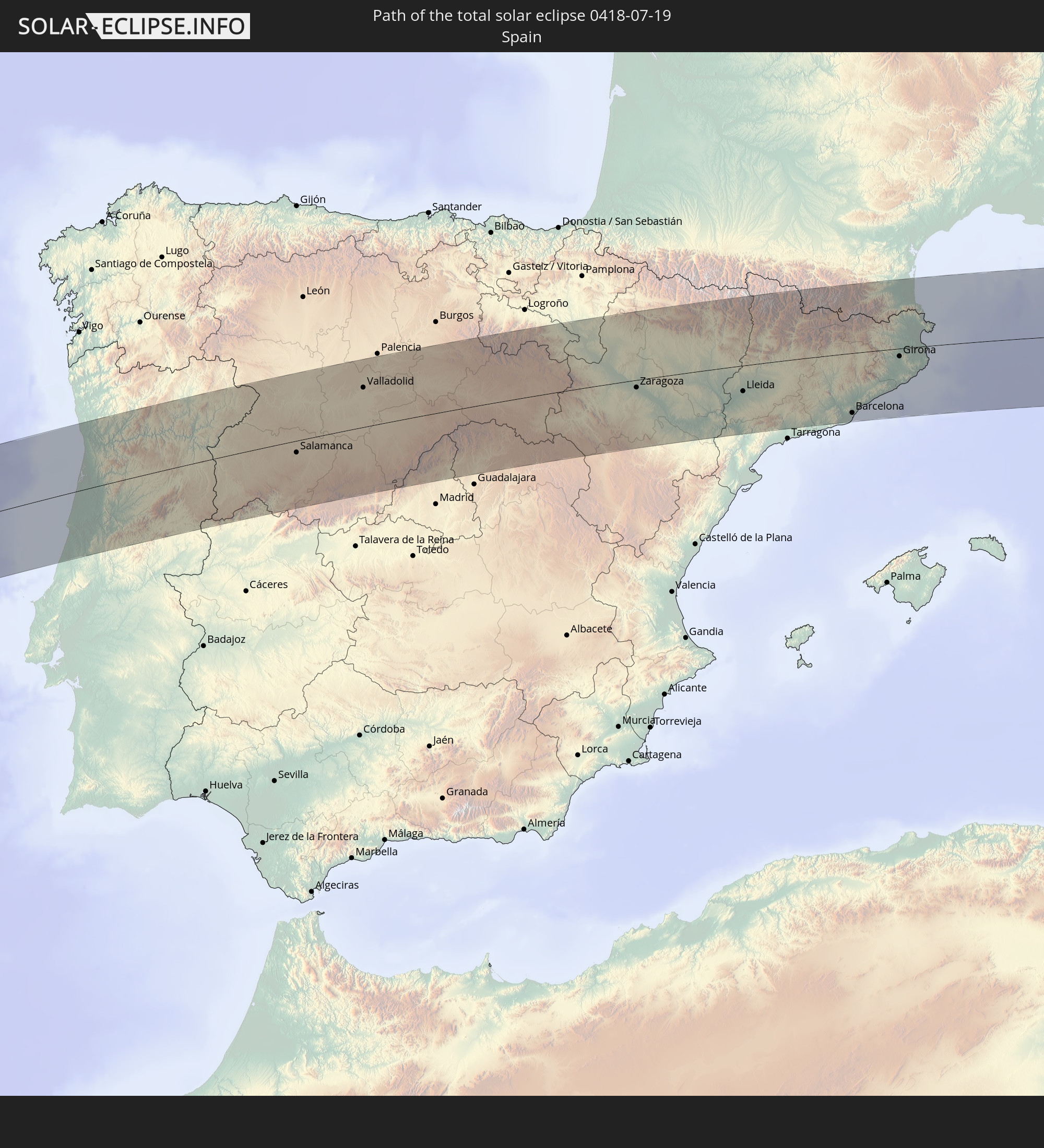 Spain
Spain
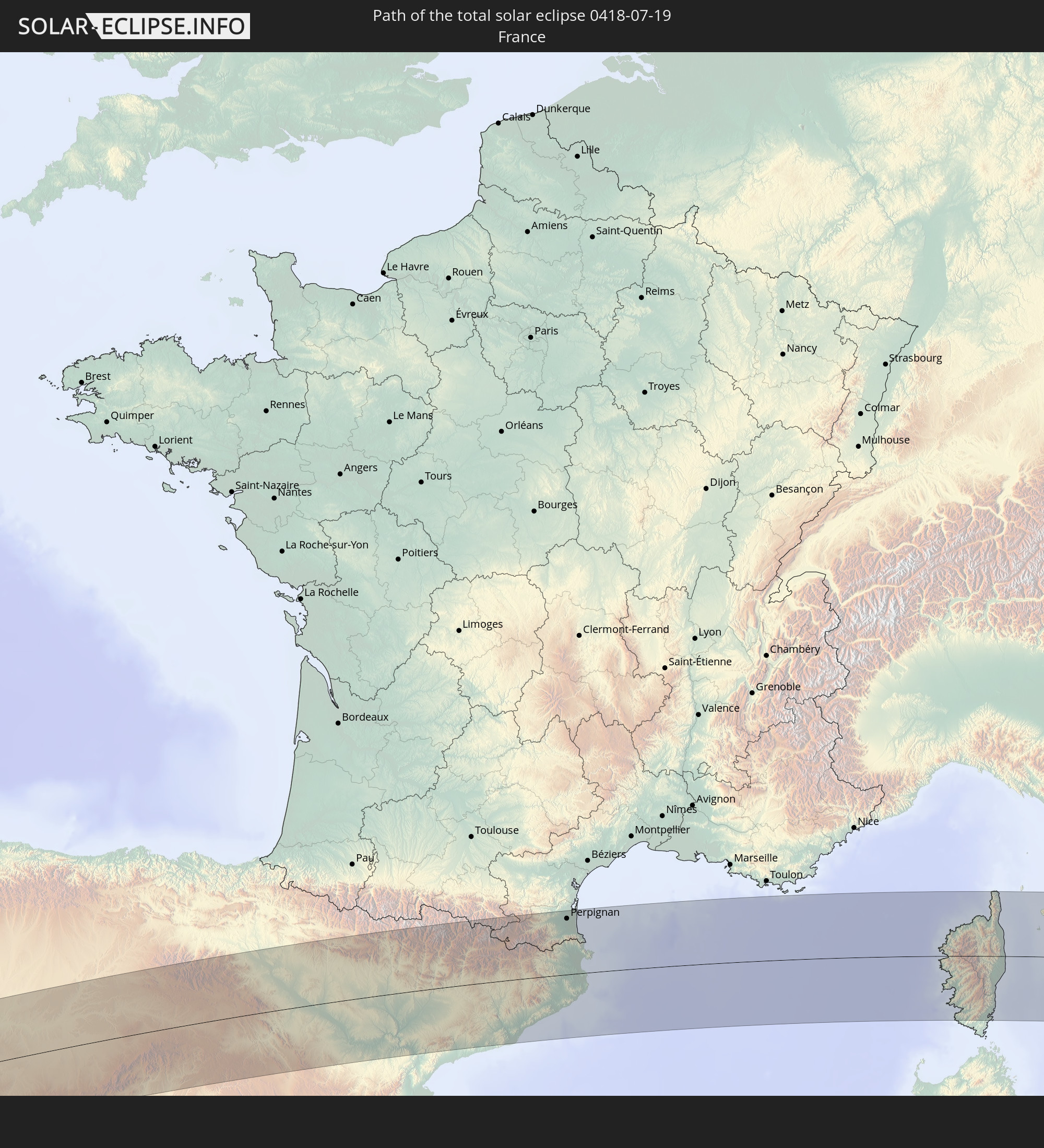 France
 Andorra
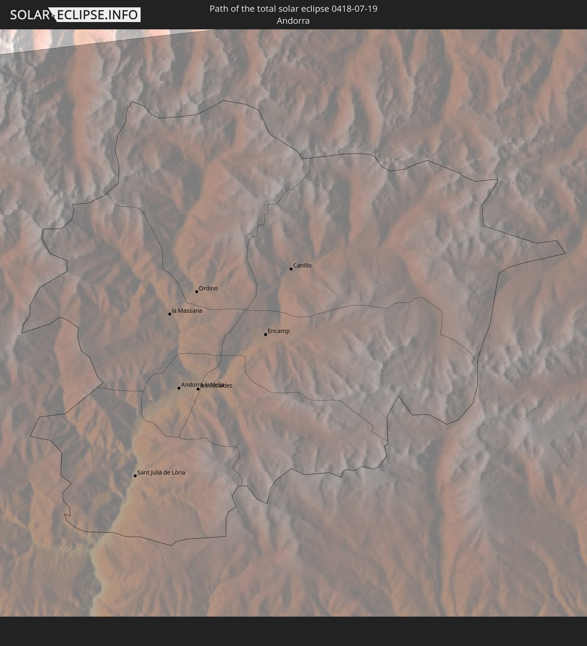
 Italy
Italy
 Vatican City
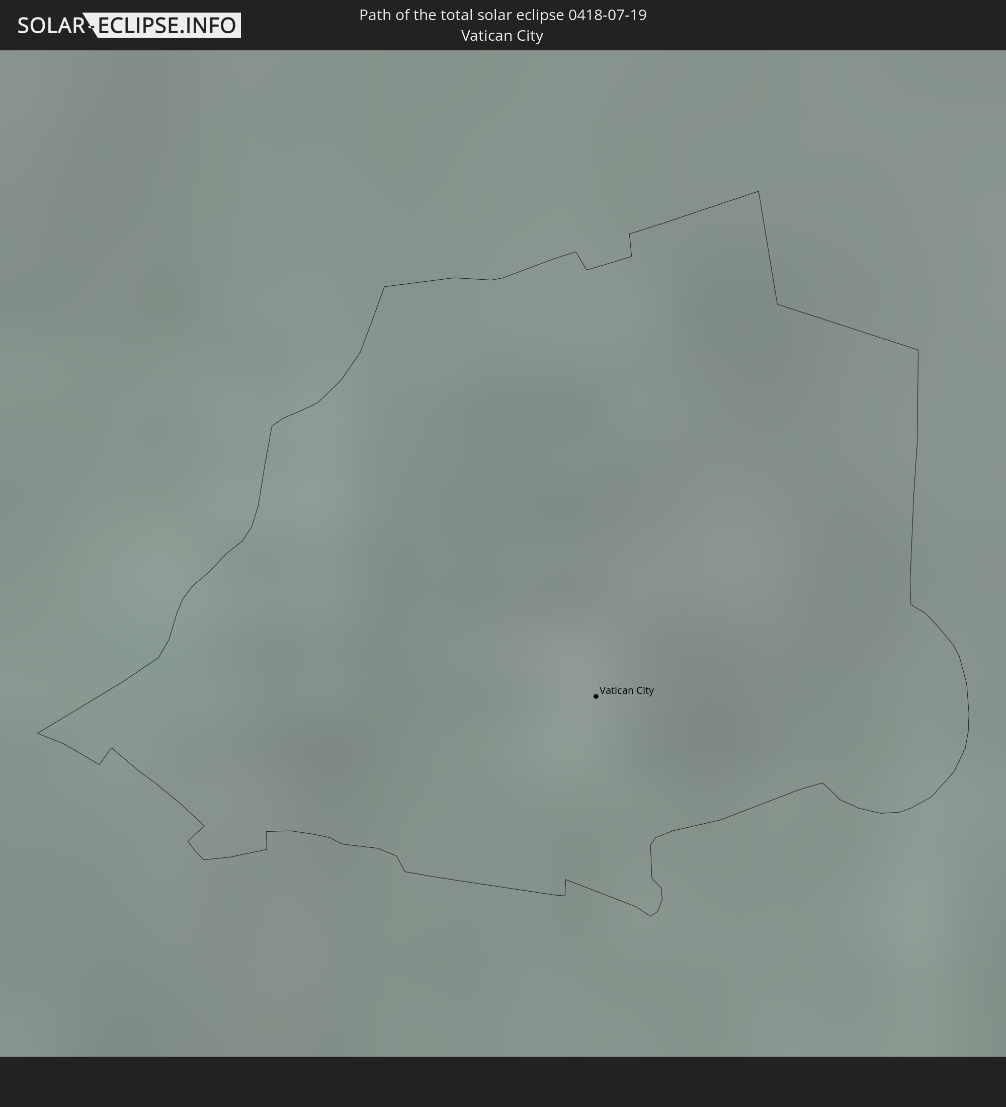
 Croatia
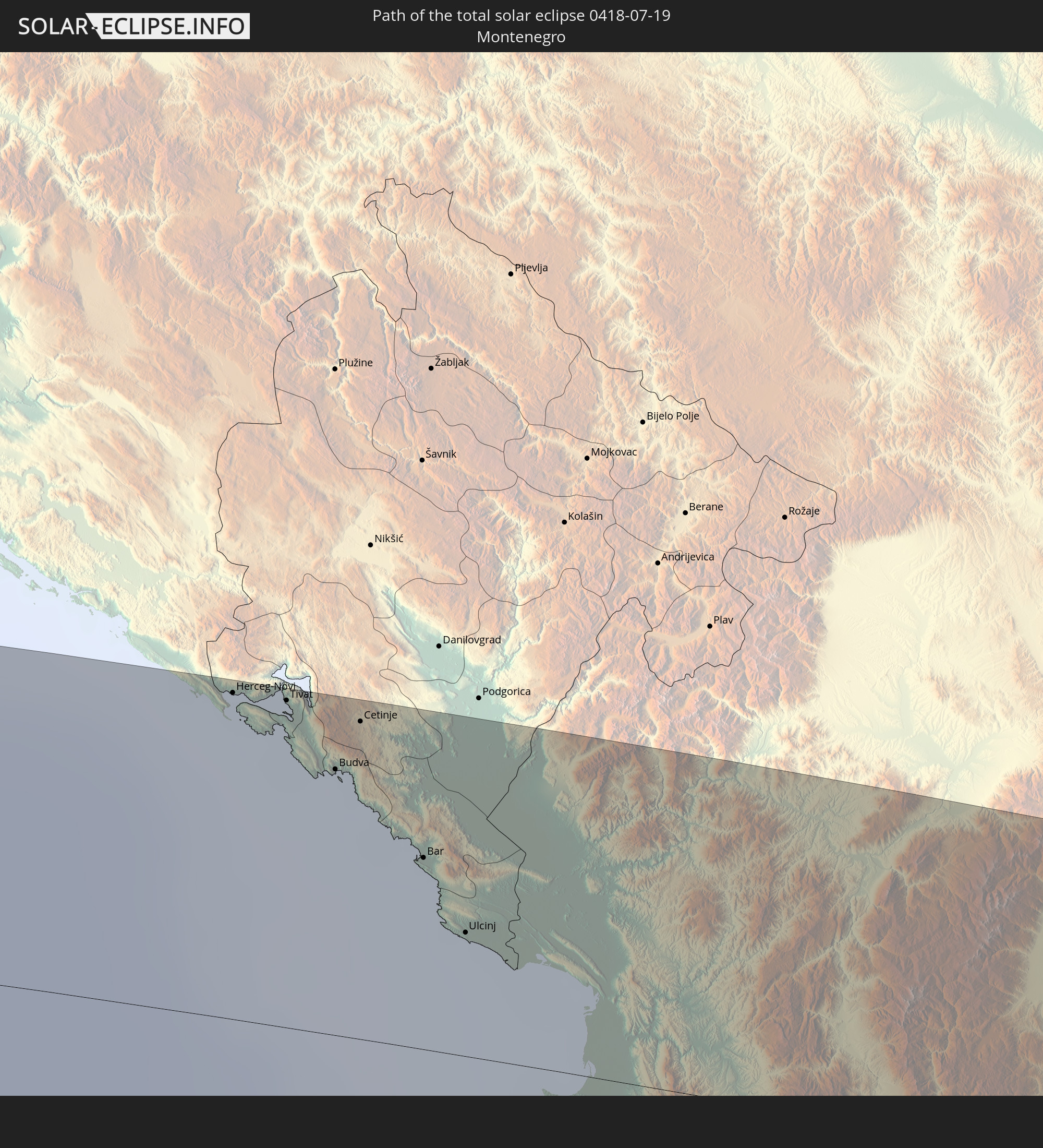 Montenegro
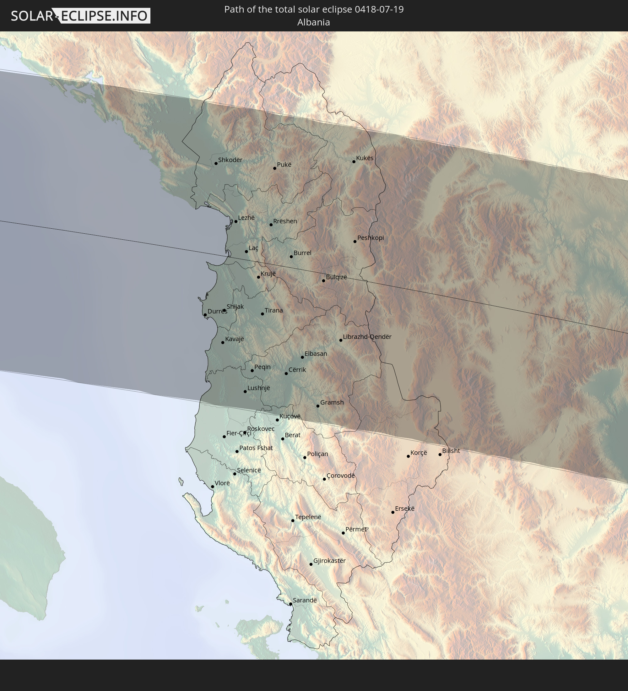 Albania
 Greece
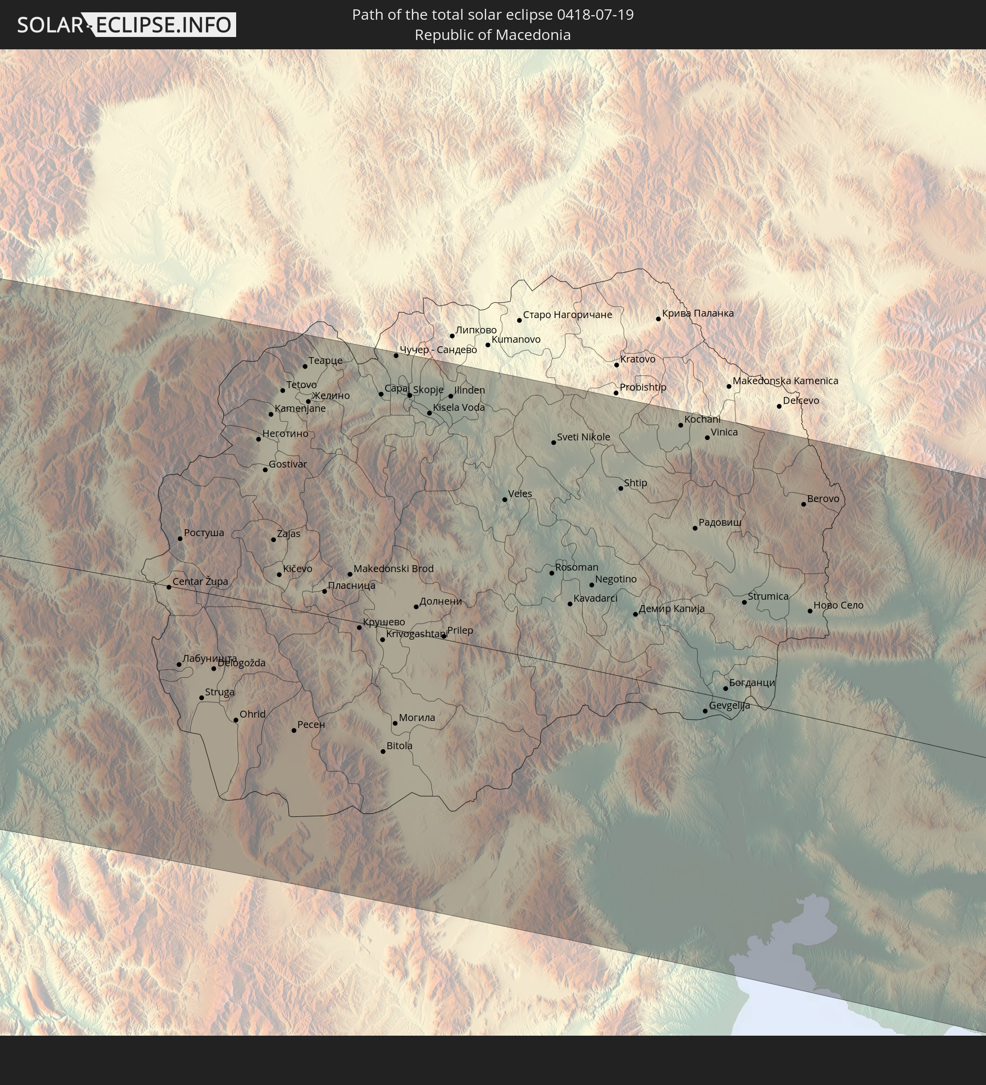 Republic of Macedonia
 Bulgaria
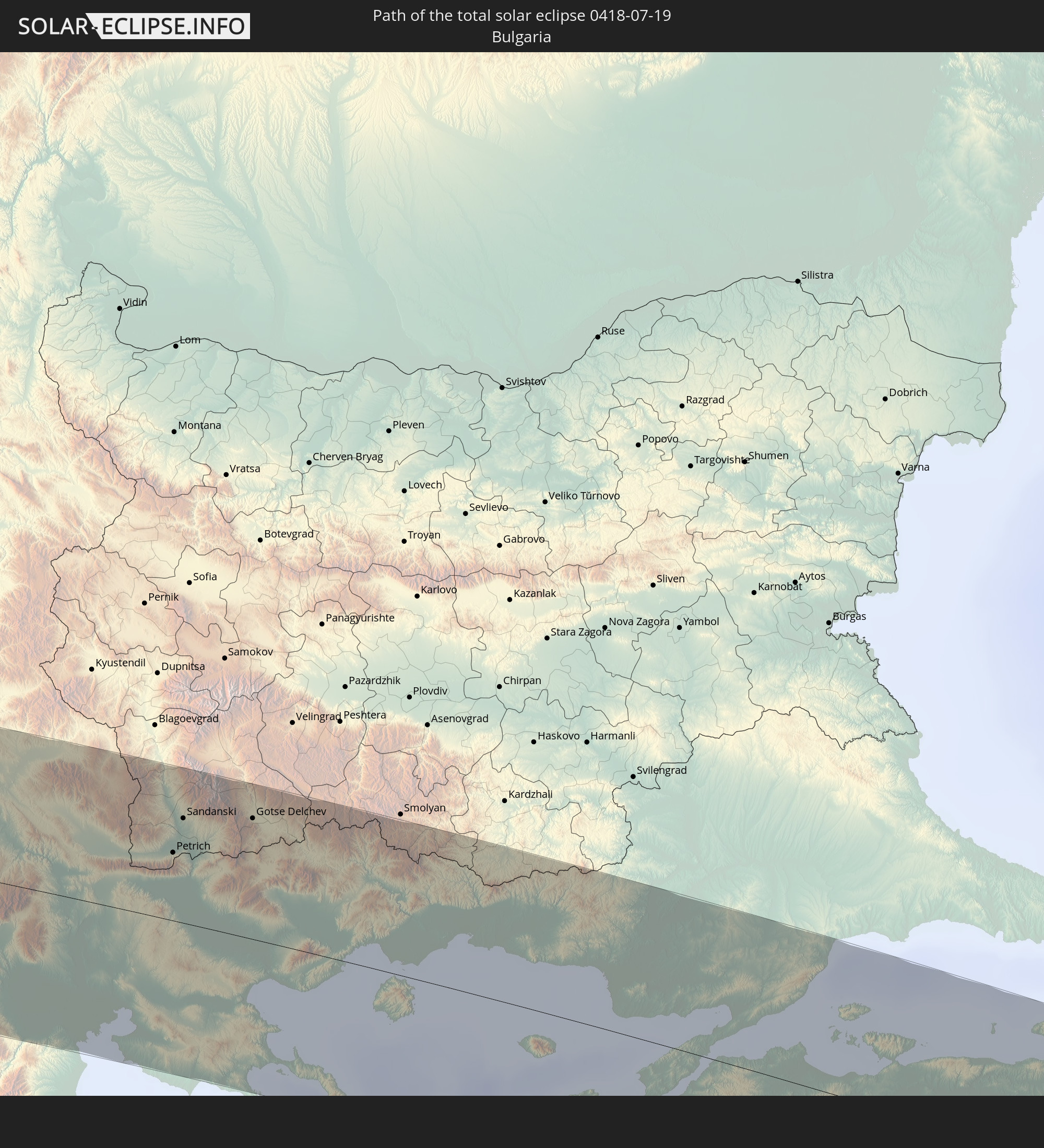
 Turkey
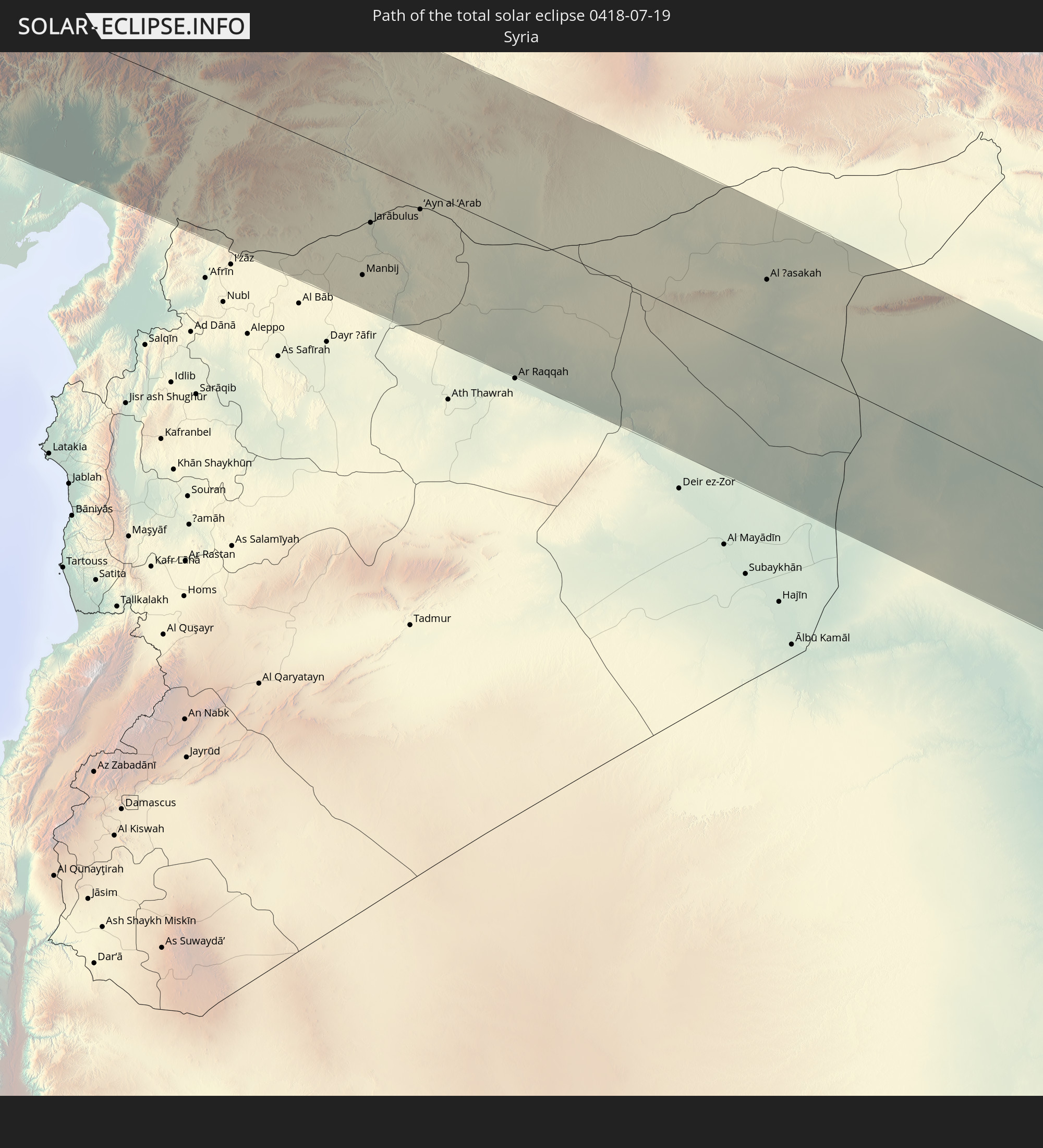 Syria
Syria
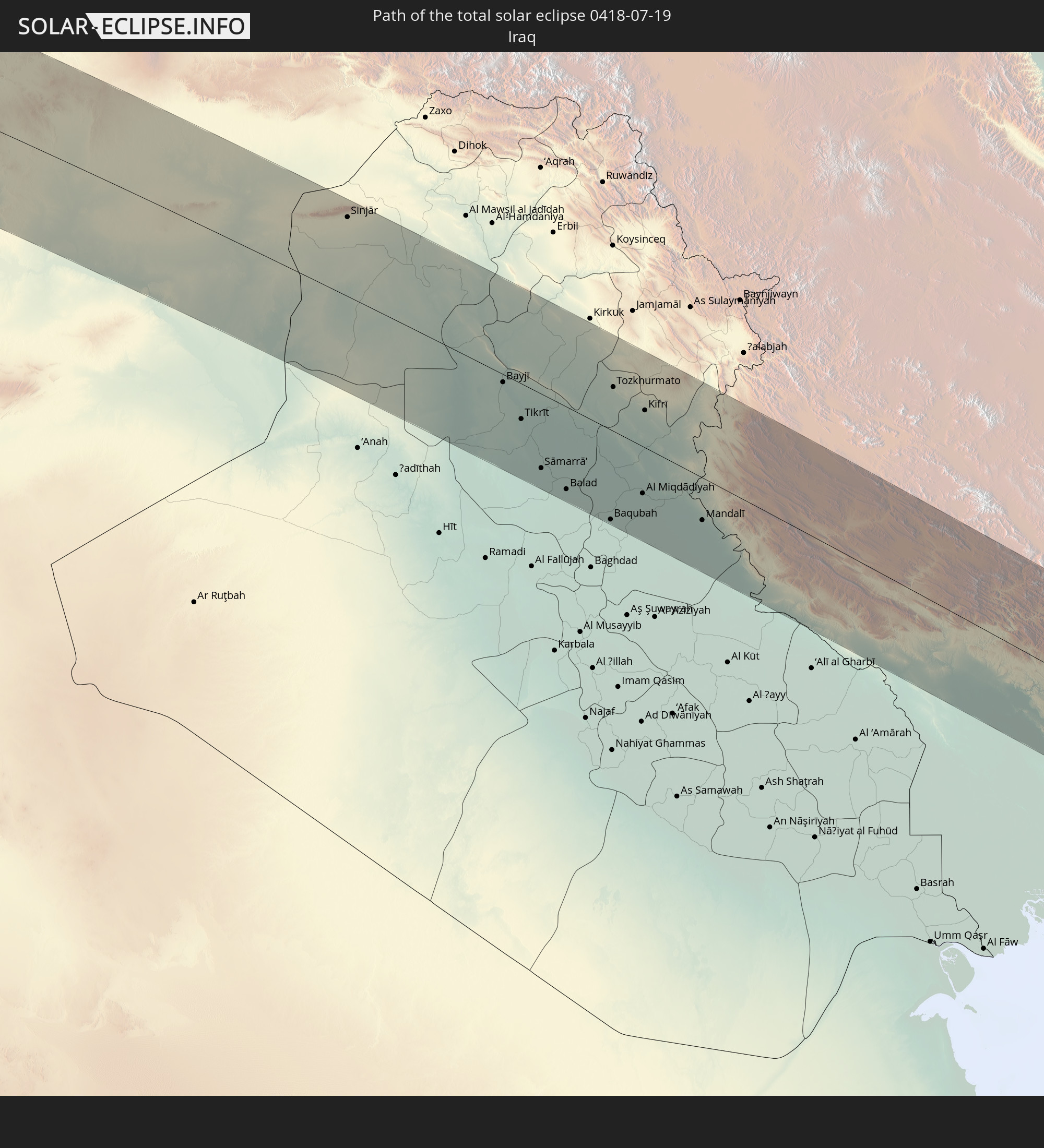 Iraq
Iraq
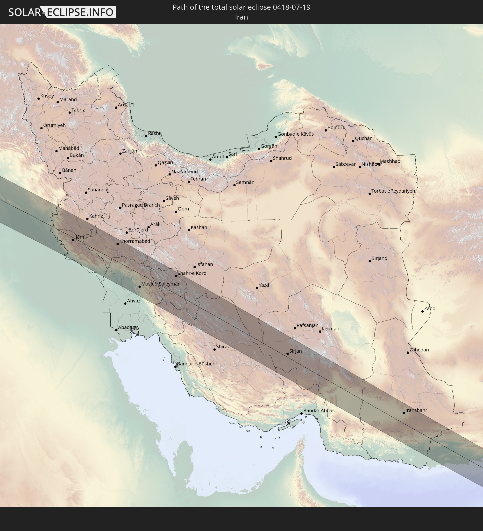 Iran
Iran
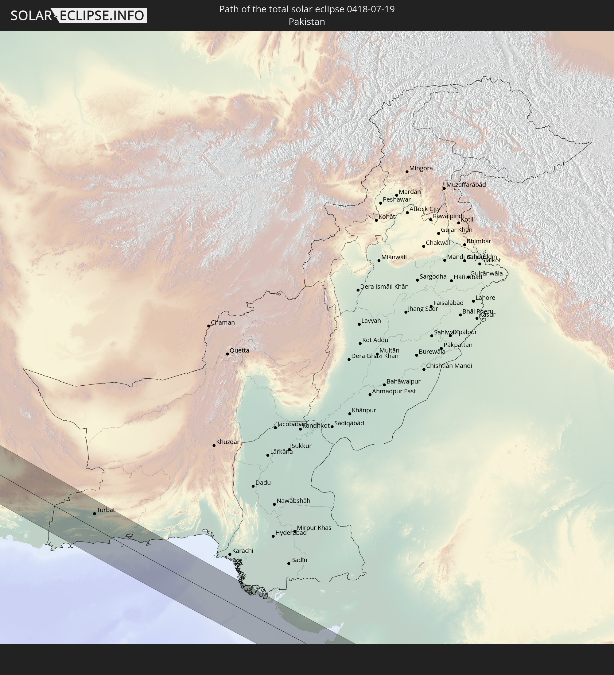 Pakistan
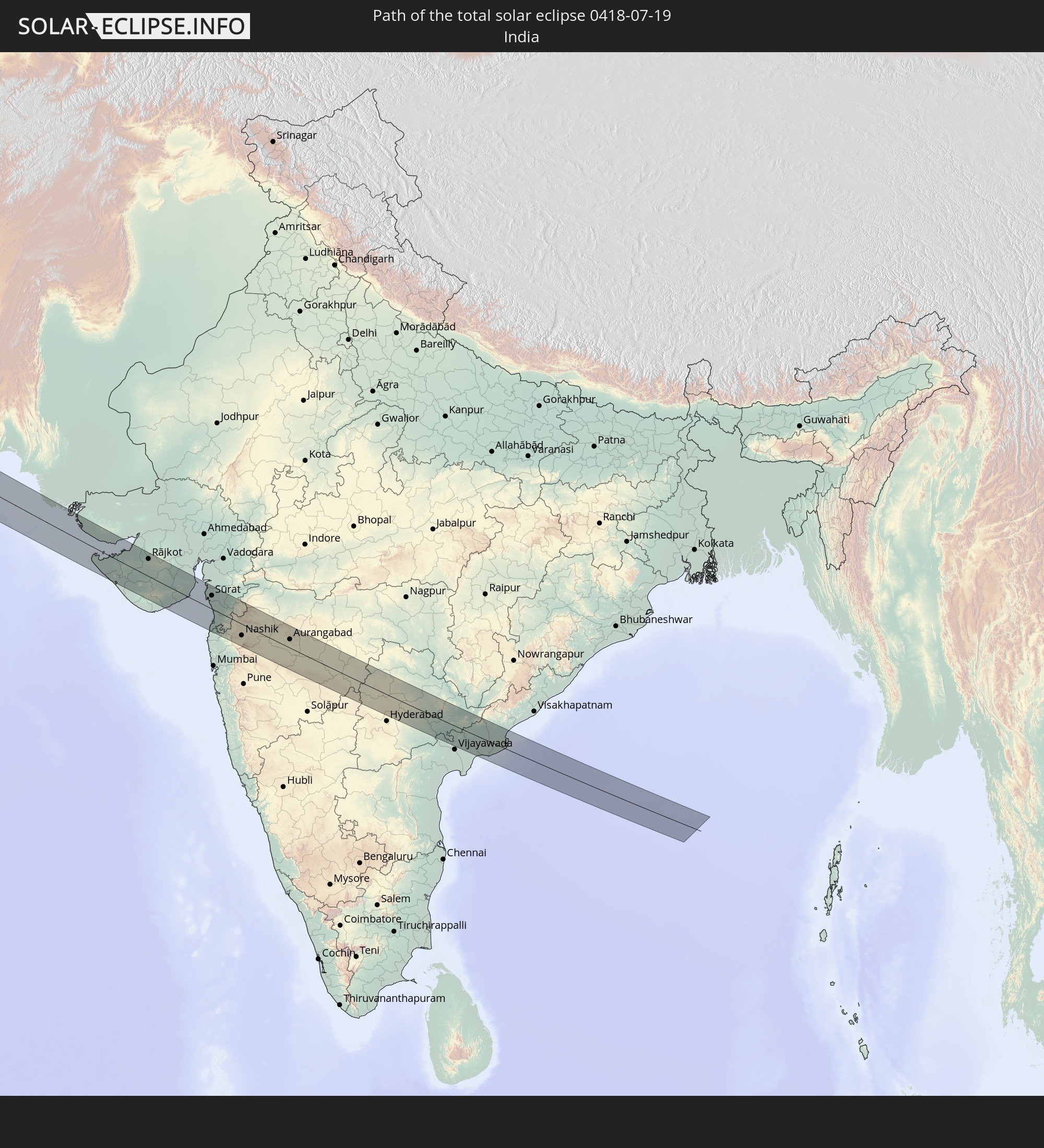 India
India
In den folgenden Ländern ist die Sonnenfinsternis partiell zu sehen
 Russia
 United States
 Canada
 Greenland
 Brazil
 Saint Pierre and Miquelon
 Portugal
 Cabo Verde
 Iceland
 Spain
Spain
 Senegal
 Mauritania
 The Gambia
 Guinea-Bissau
 Guinea
 Sierra Leone
 Morocco
 Mali
Mali
 Liberia
 Republic of Ireland
 Svalbard and Jan Mayen
 Algeria
 United Kingdom
 Ivory Coast
 Faroe Islands
 Burkina Faso
 Gibraltar
 France
 Isle of Man
 Ghana
Ghana
 Guernsey
 Jersey
 Togo
Togo
 Niger
Niger
 Benin
Benin
 Andorra
 Belgium
 Nigeria
 Netherlands
 Norway
 Luxembourg
 Germany
 Switzerland
 Italy
Italy
 Monaco
 Tunisia
 Denmark
 Cameroon
 Libya
Libya
 Liechtenstein
 Austria
 Sweden
 Czechia
 San Marino
 Vatican City
 Slovenia
 Chad
Chad
 Croatia
 Poland
 Malta
Malta
 Central African Republic
 Bosnia and Herzegovina
 Hungary
 Slovakia
 Montenegro
 Serbia
 Albania
 Åland Islands
 Greece
 Romania
 Republic of Macedonia
 Finland
 Lithuania
 Latvia
 Estonia
 Sudan
Sudan
 Ukraine
 Bulgaria
 Belarus
 Egypt
Egypt
 Turkey
 Moldova
 Uganda
 Cyprus
 Ethiopia
 Kenya
Kenya
 State of Palestine
 Israel
 Saudi Arabia
 Jordan
 Lebanon
 Syria
Syria
 Eritrea
 Iraq
Iraq
 Georgia
 Somalia
 Djibouti
 Yemen
Yemen
 Armenia
 Iran
Iran
 Azerbaijan
 Seychelles
 Kazakhstan
 Kuwait
 Bahrain
 Qatar
Qatar
 United Arab Emirates
 Oman
Oman
 Turkmenistan
 Uzbekistan
 Afghanistan
 Pakistan
 Tajikistan
 India
India
 Kyrgyzstan
 British Indian Ocean Territory
 Maldives
 China
China
 Sri Lanka
 Nepal
Nepal
 Mongolia
 Bangladesh
 Bhutan
 Myanmar
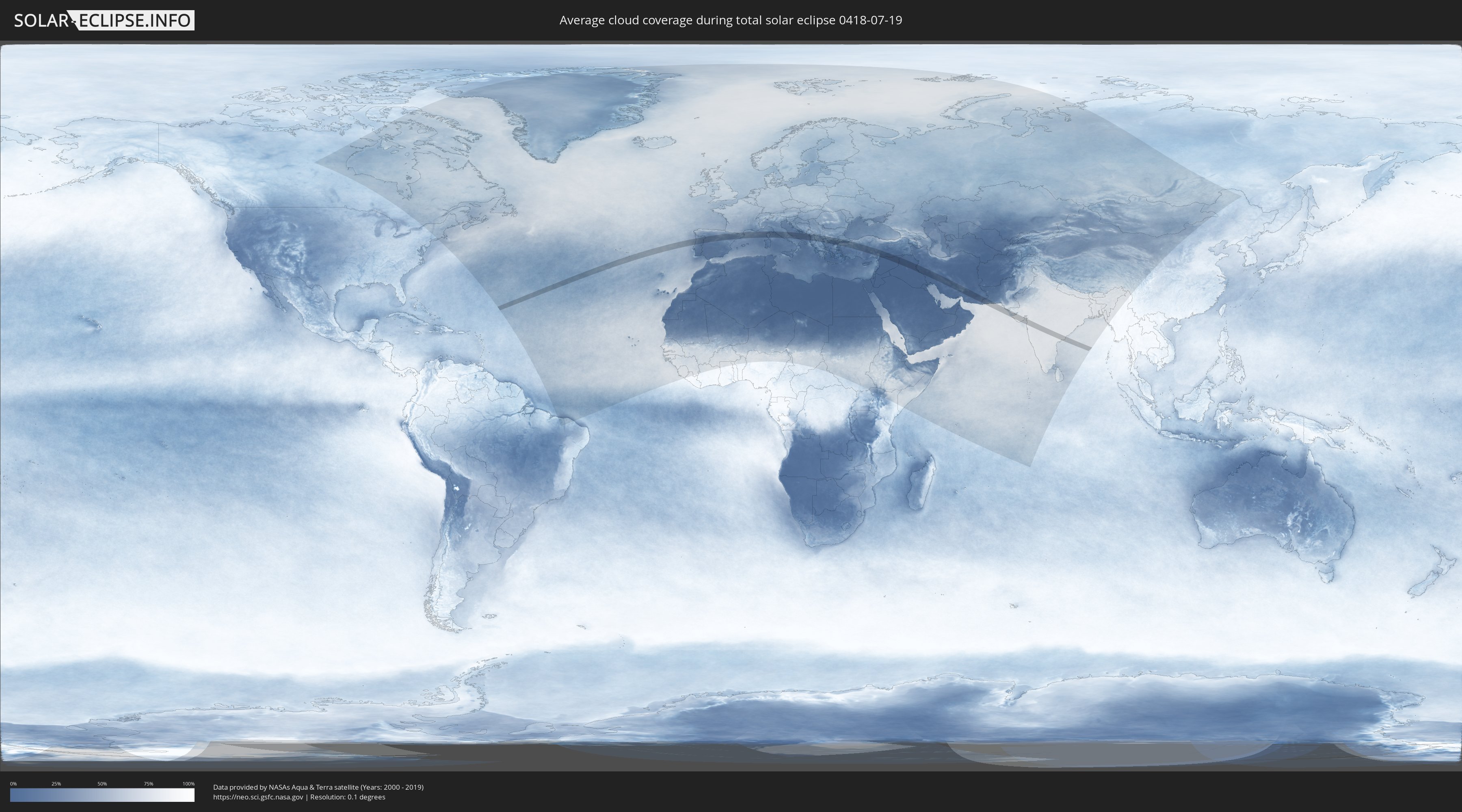
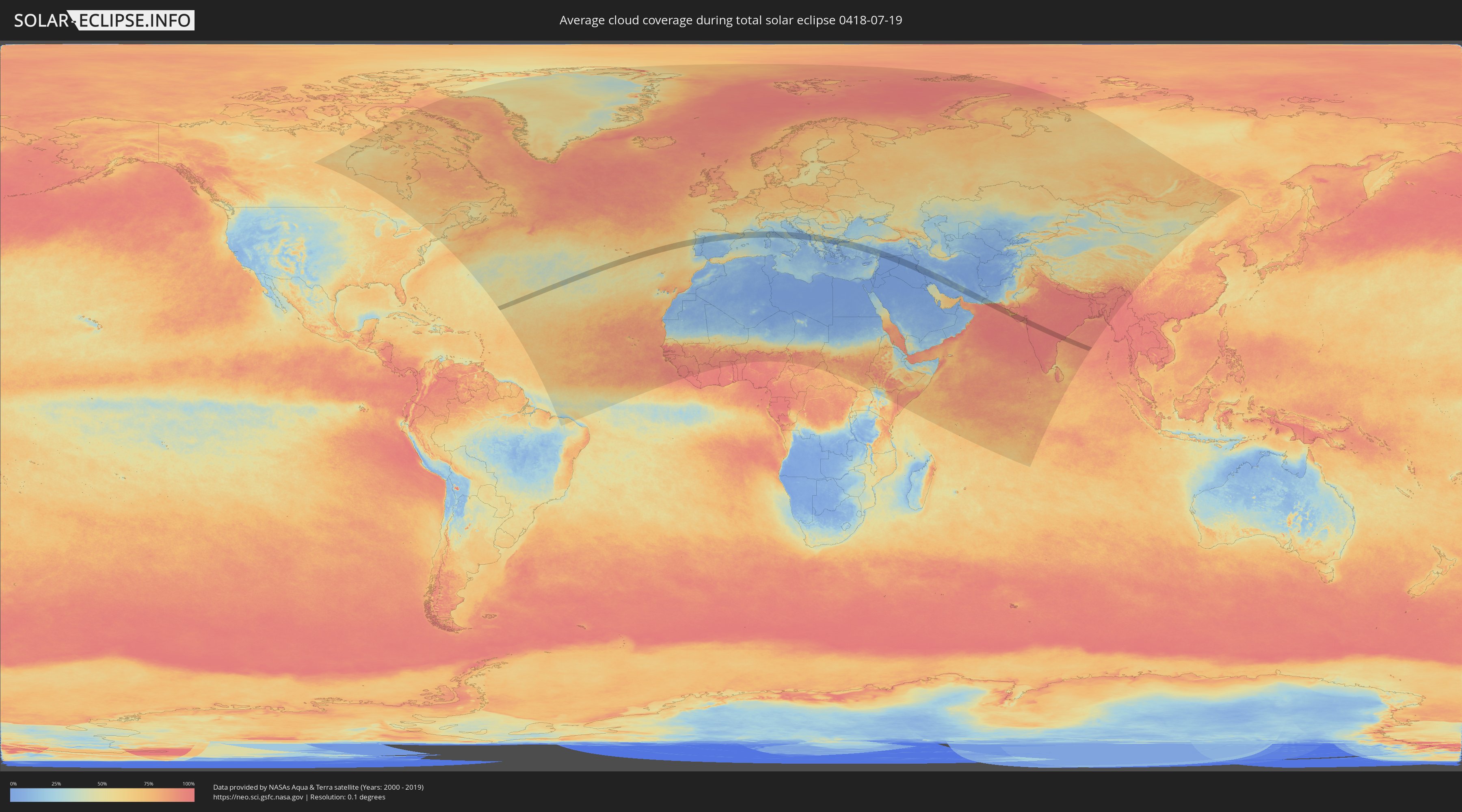
How will be the weather during the total solar eclipse on 07/19/0418?
Where is the best place to see the total solar eclipse of 07/19/0418?
The following maps show the average cloud coverage for the day of the total solar eclipse.
With the help of these maps, it is possible to find the place along the eclipse path, which has the best
chance of a cloudless sky.
Nevertheless, you should consider local circumstances and inform about the weather of your chosen
observation site.
The data is provided by NASAs satellites
AQUA and TERRA.
The cloud maps are averaged over a period of 19 years (2000 - 2019).
Detailed country maps
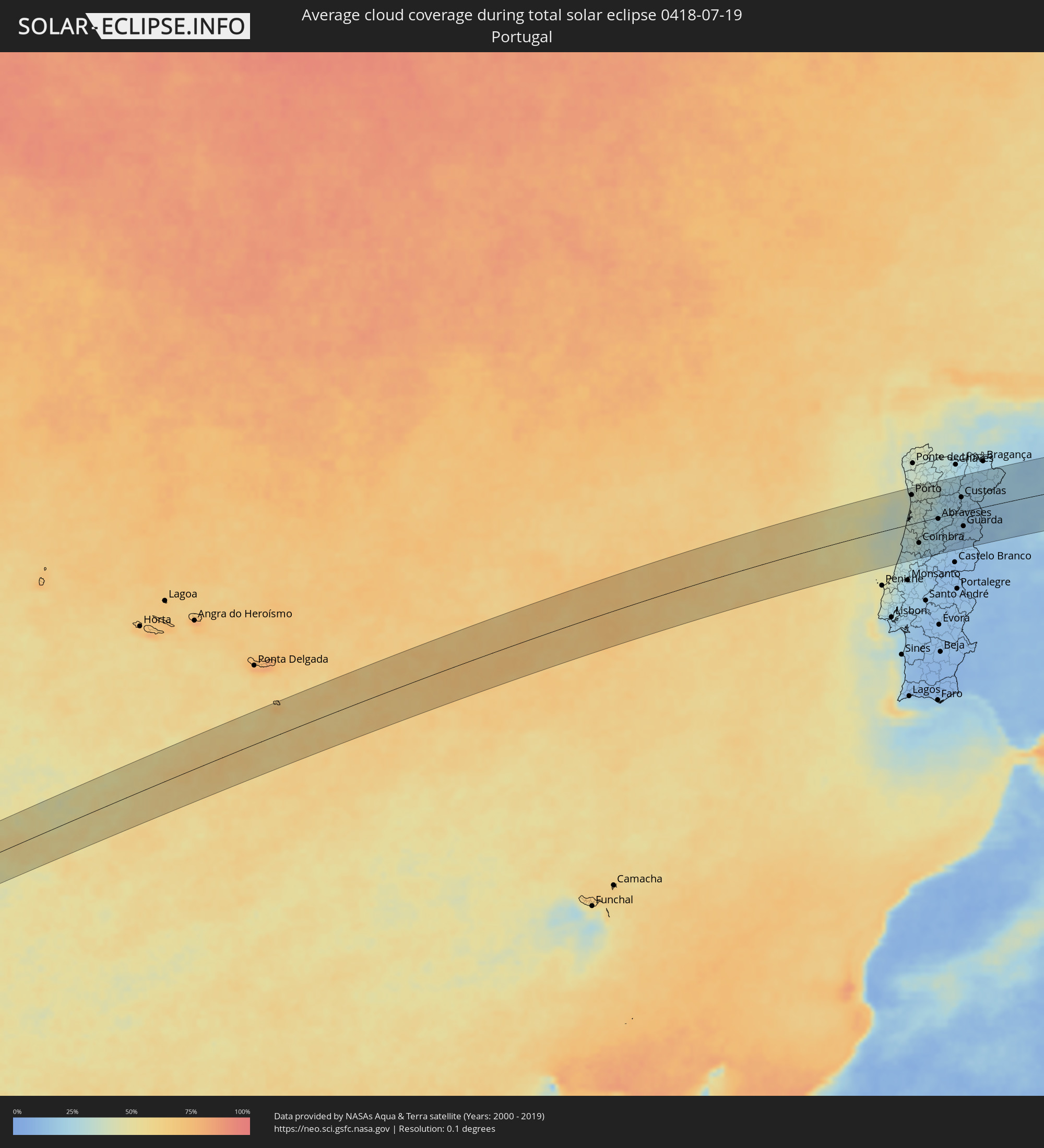 Portugal
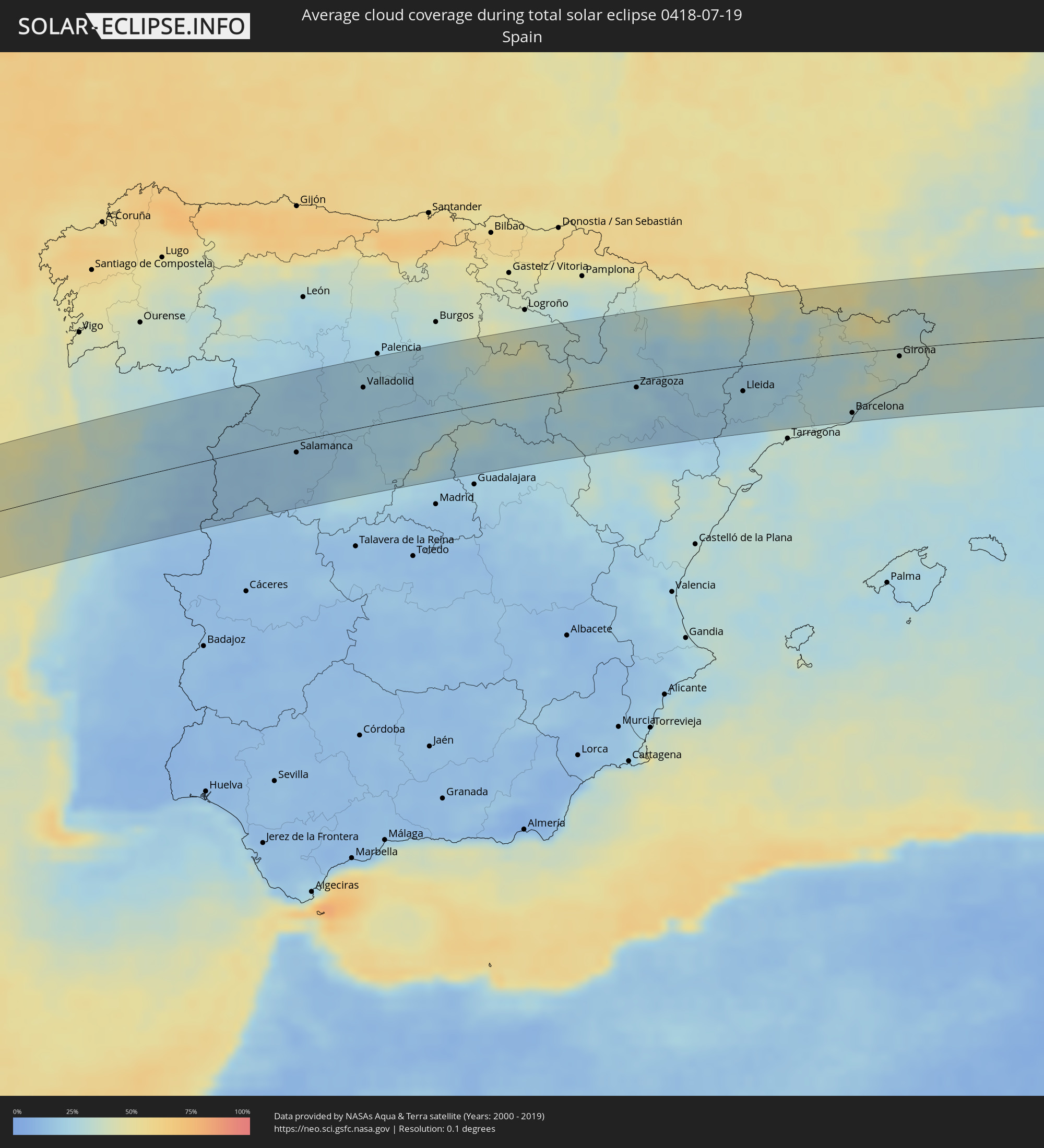 Spain
Spain
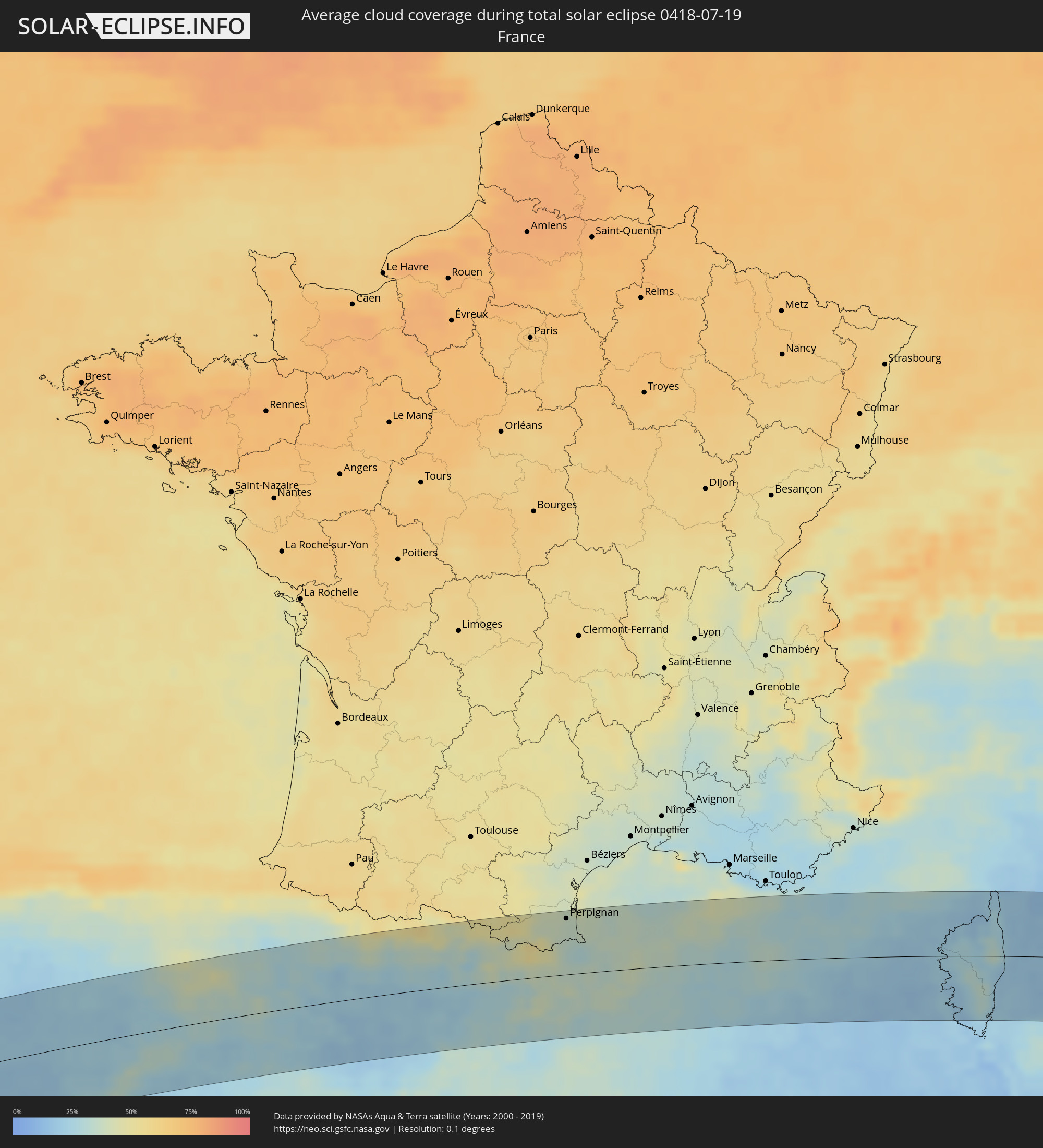 France
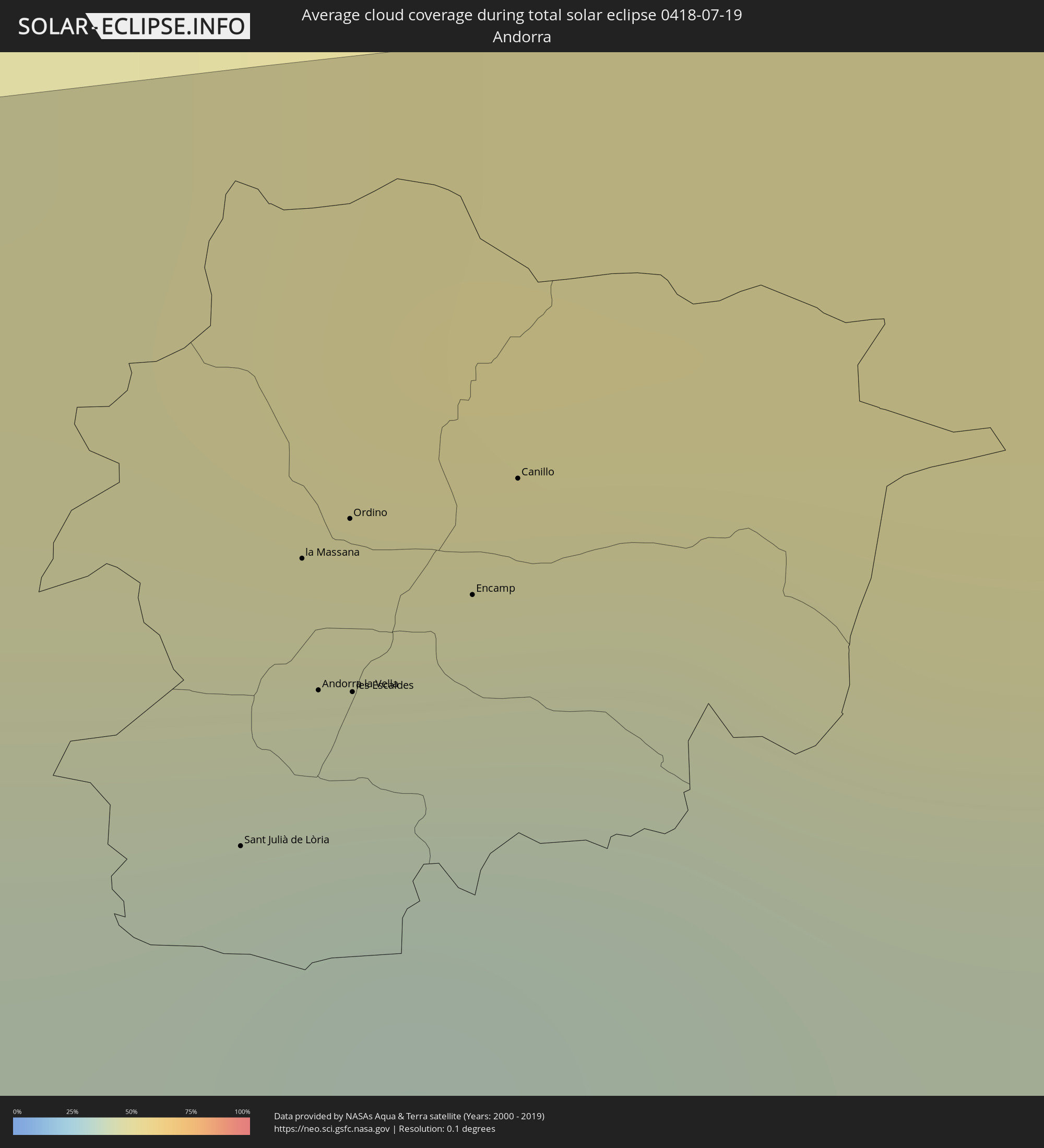 Andorra
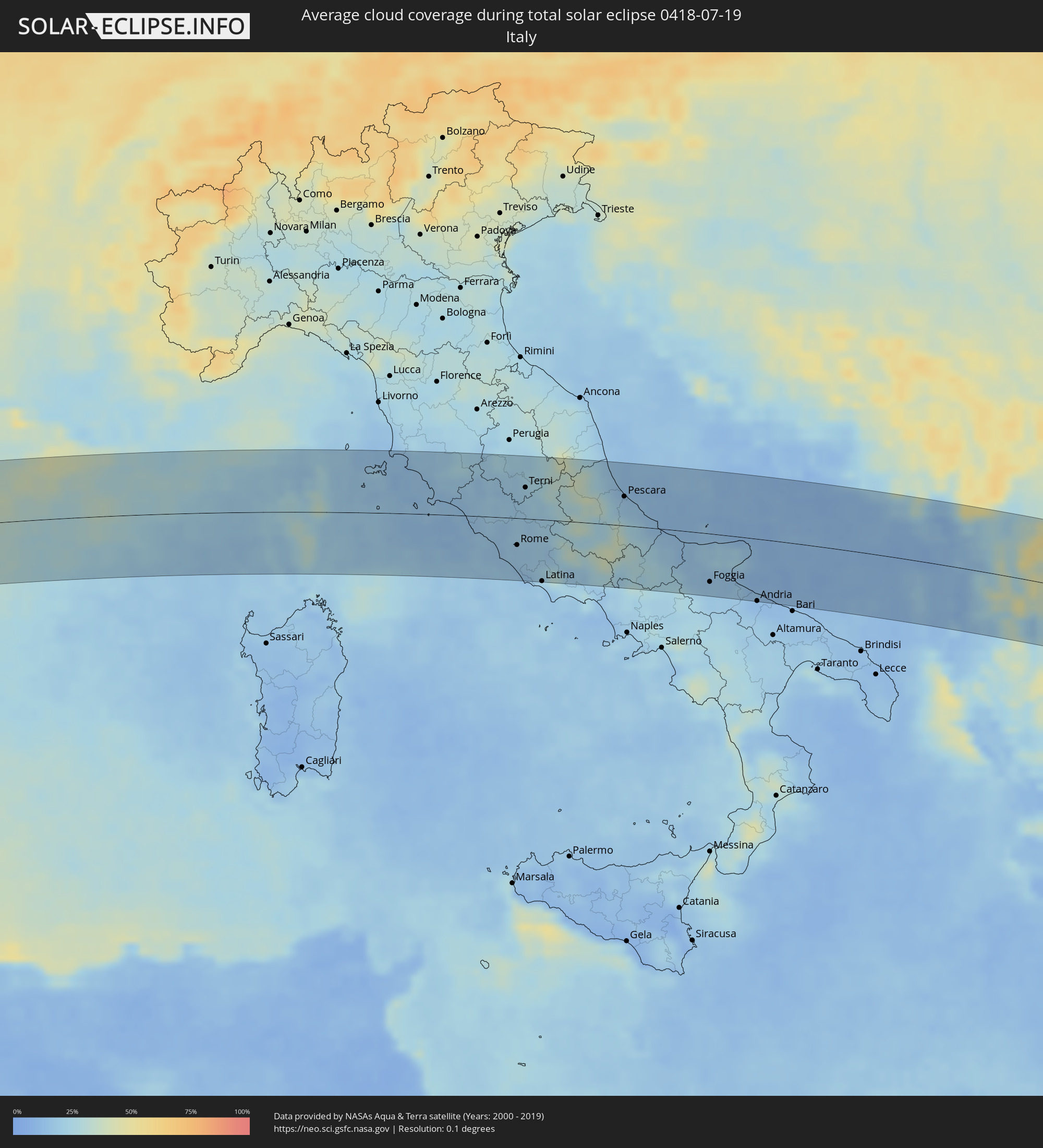 Italy
Italy
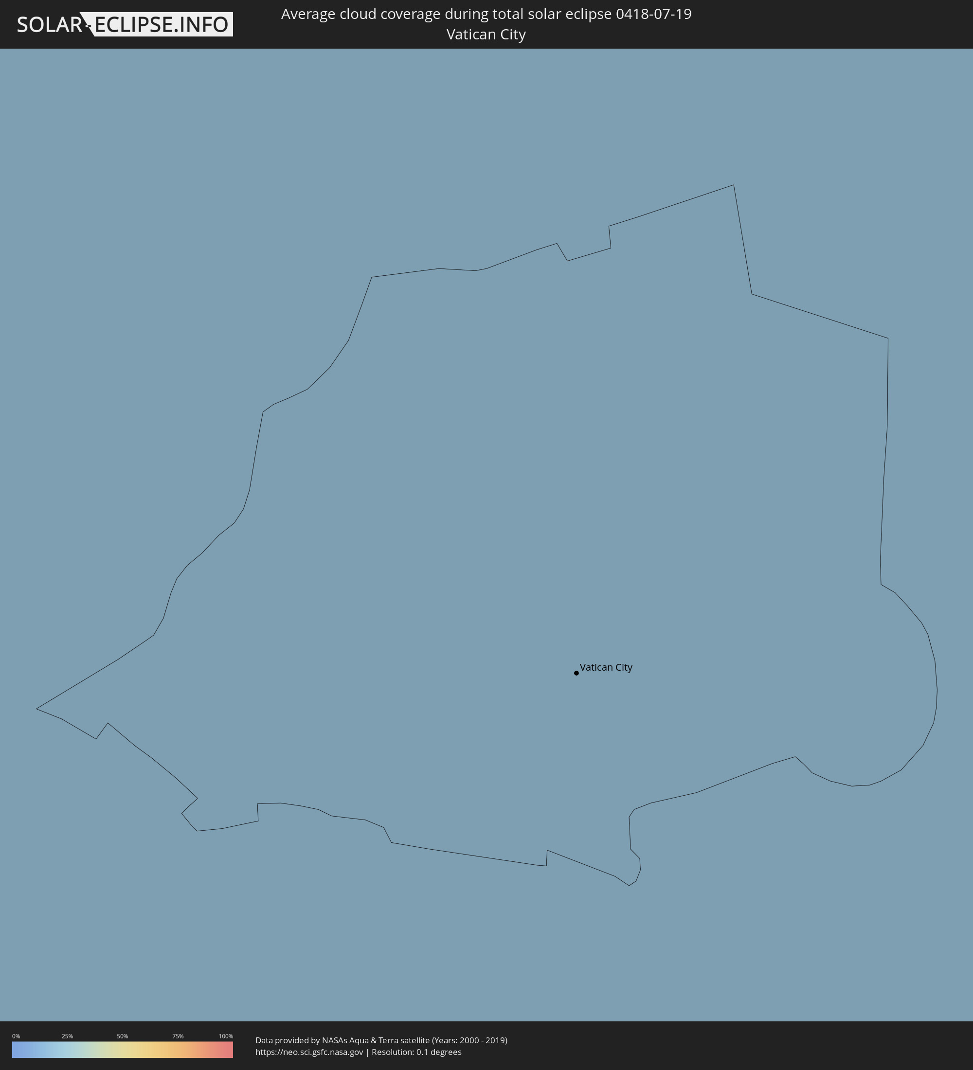 Vatican City
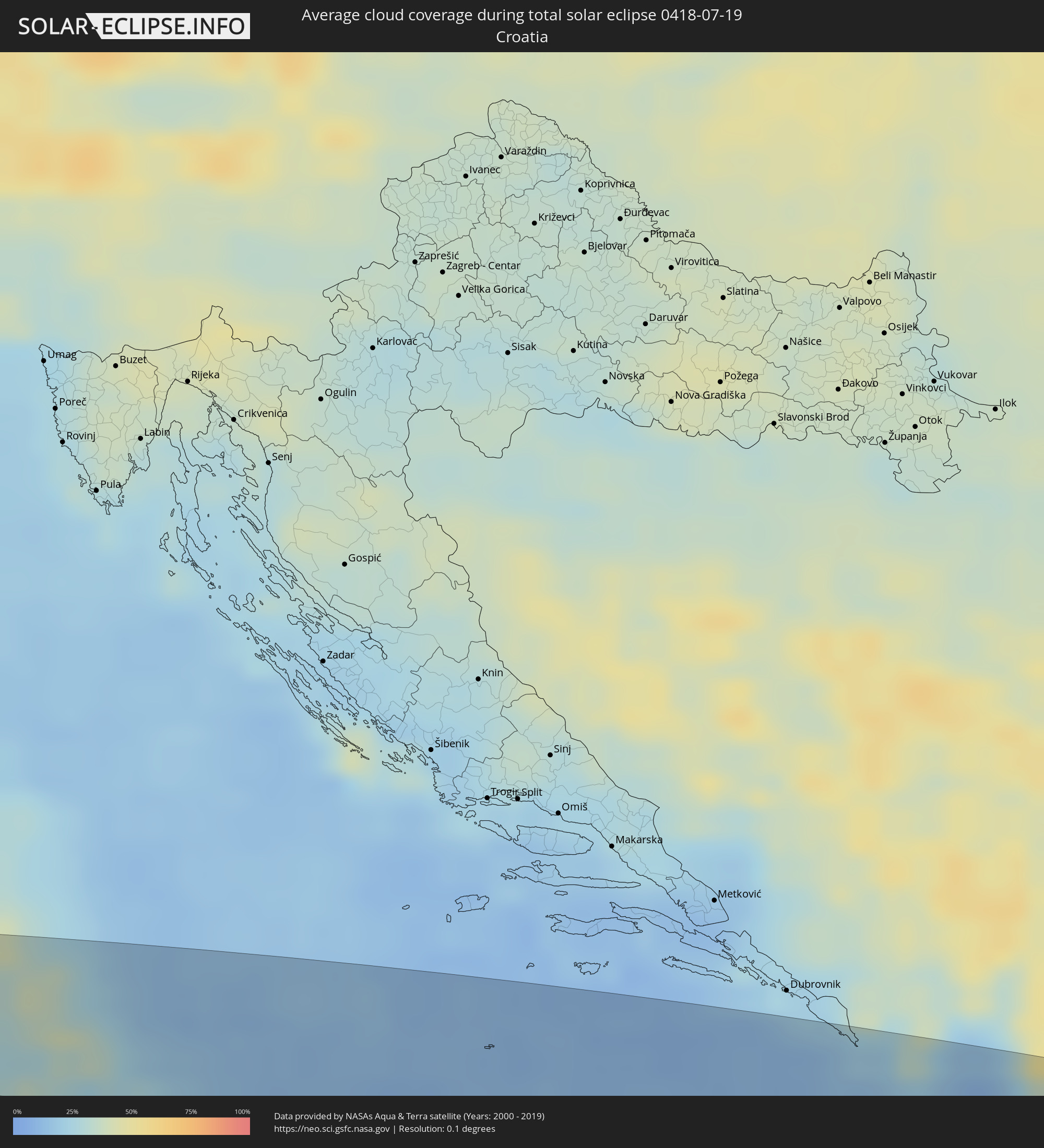 Croatia
 Montenegro
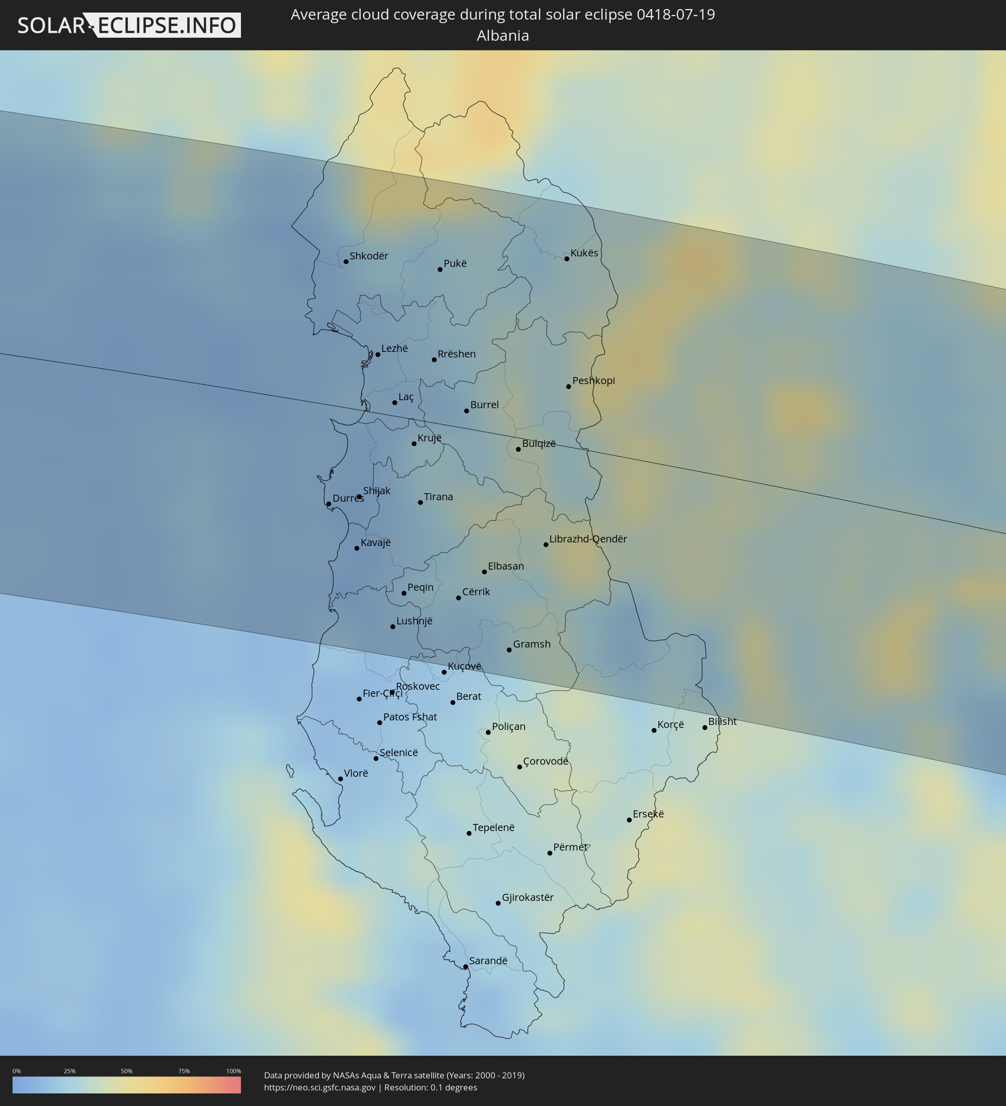 Albania
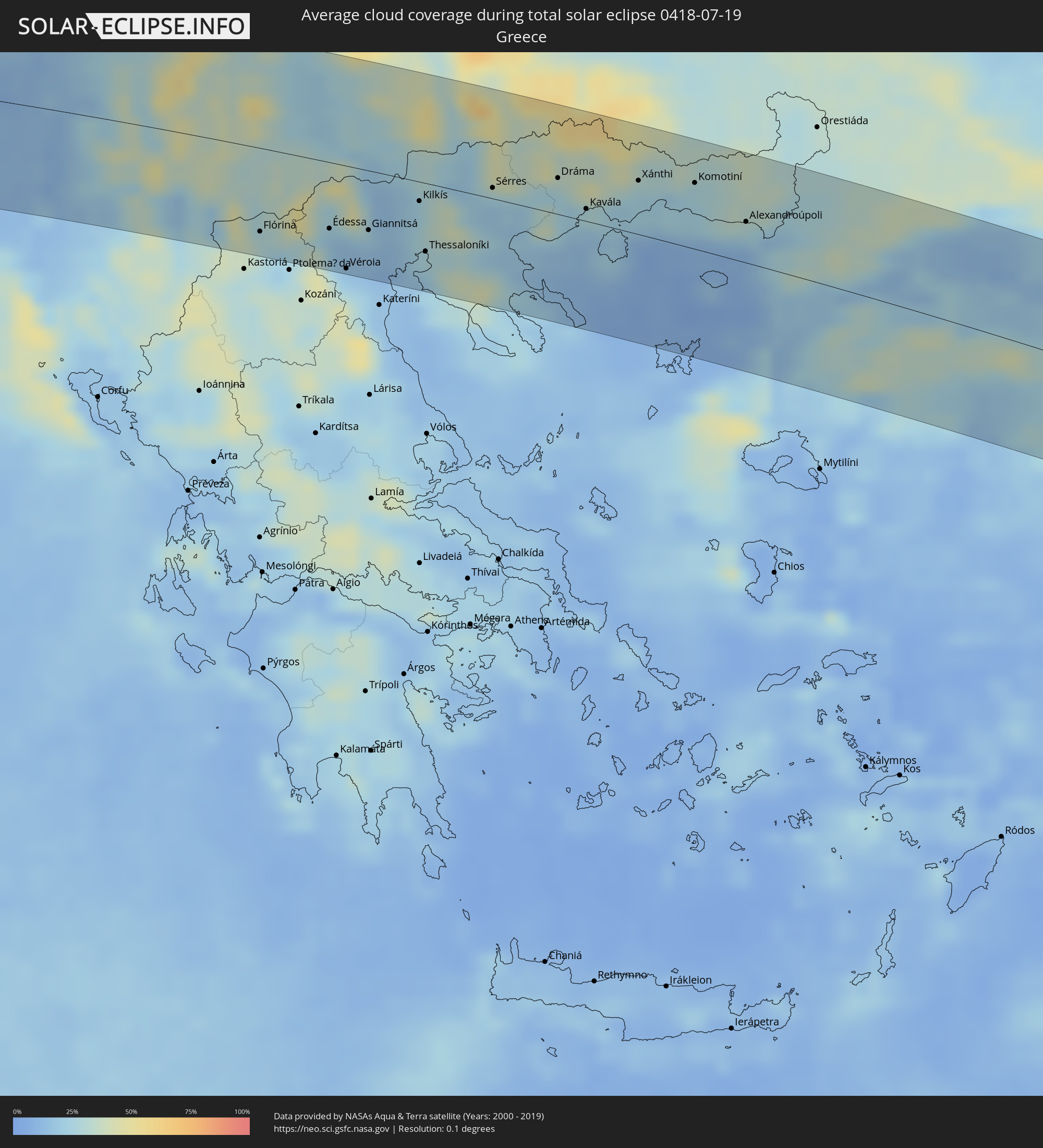 Greece
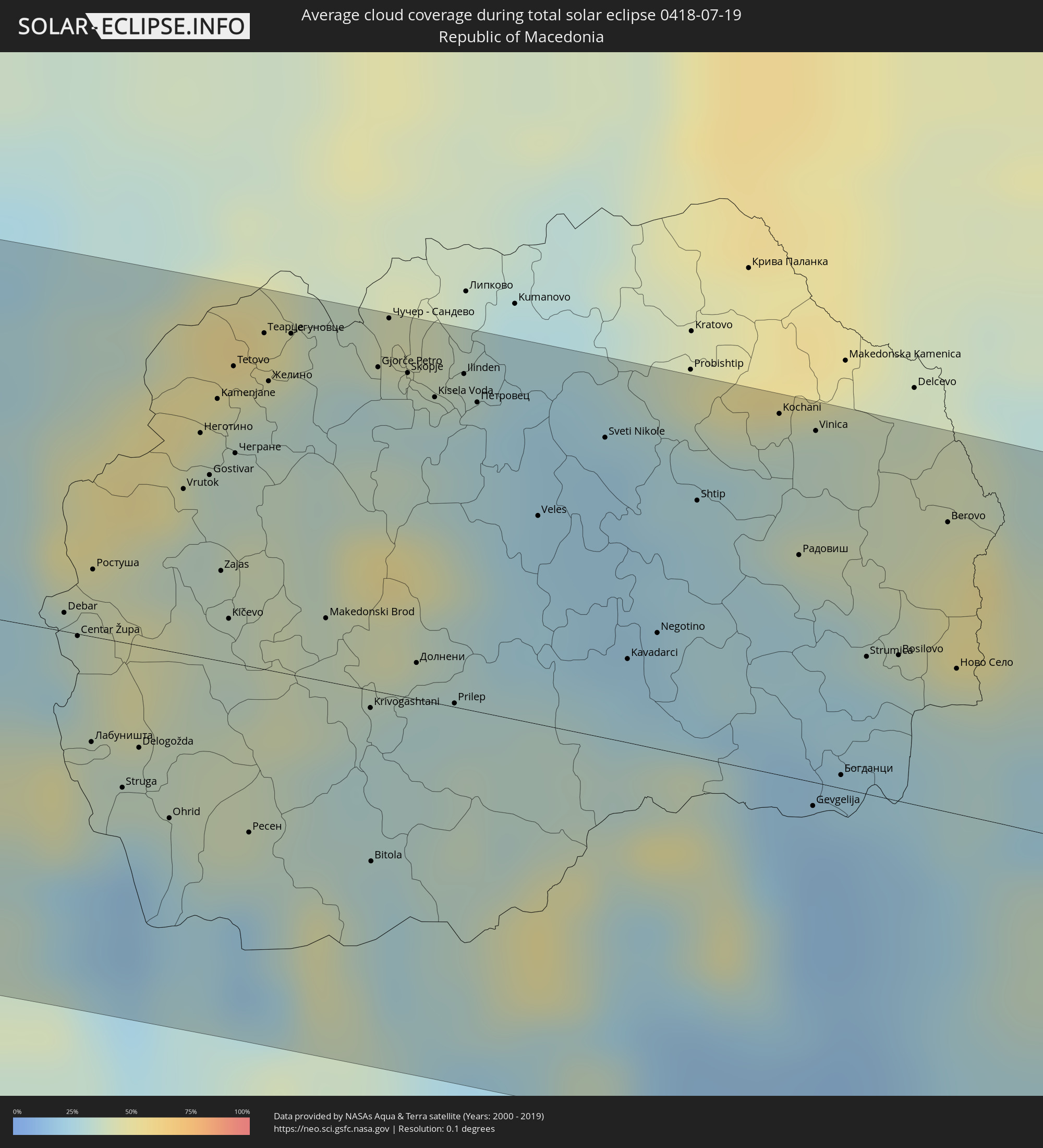 Republic of Macedonia
 Bulgaria
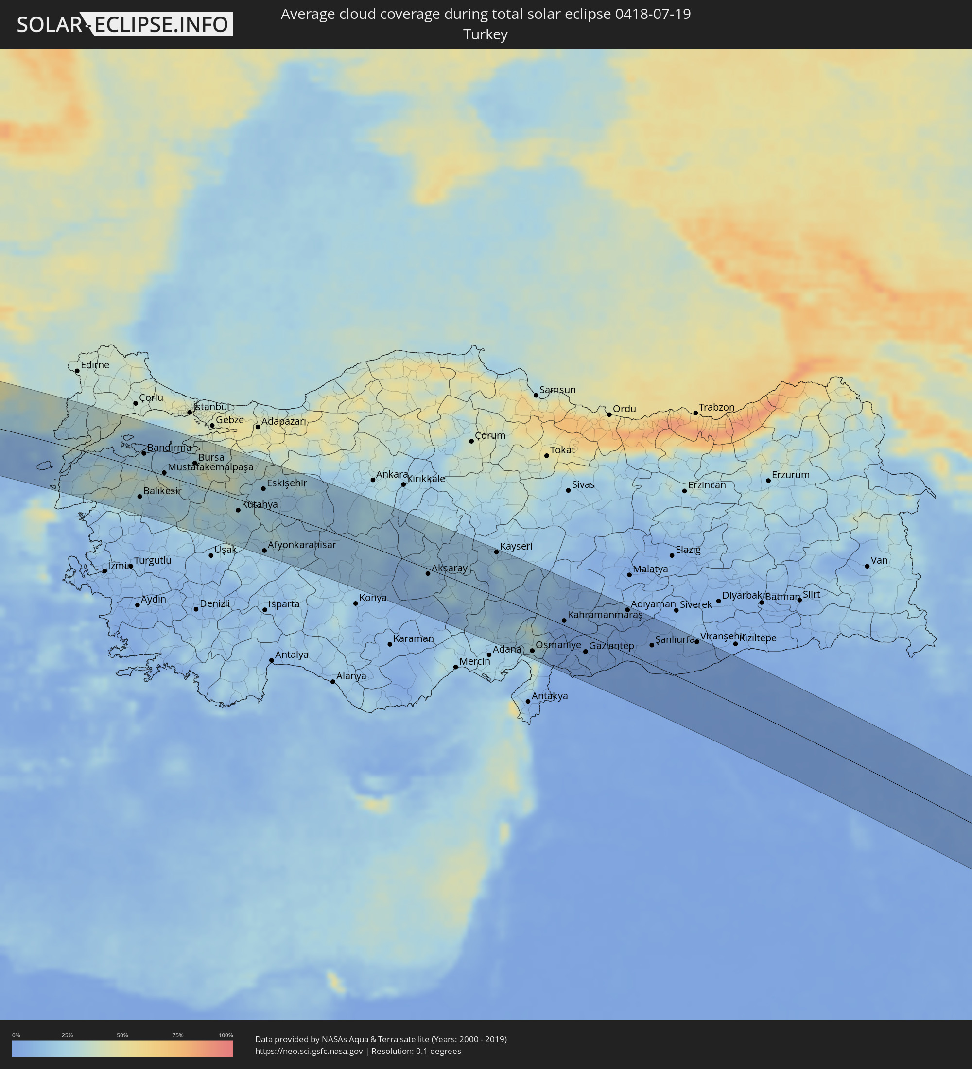 Turkey
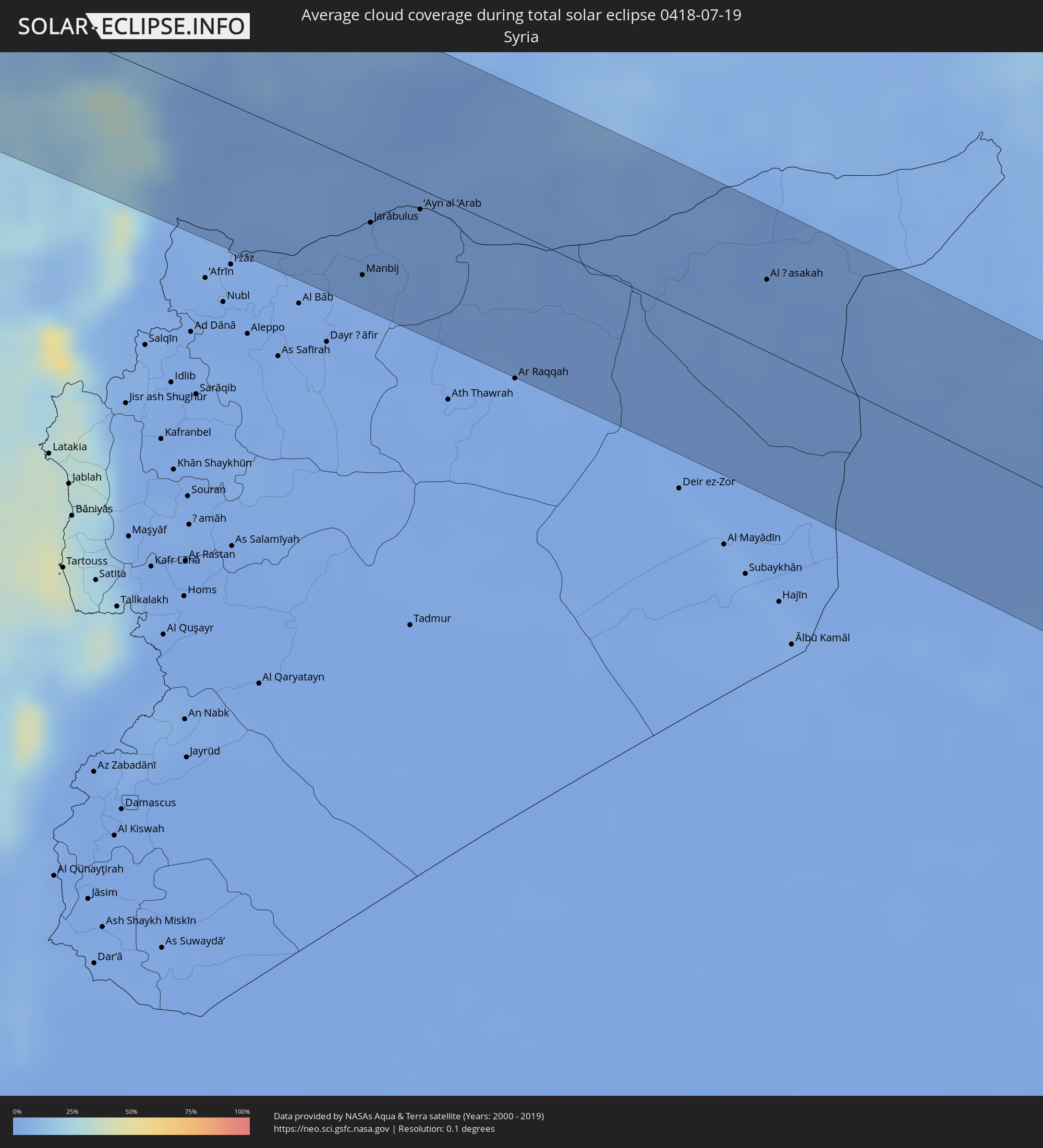 Syria
Syria
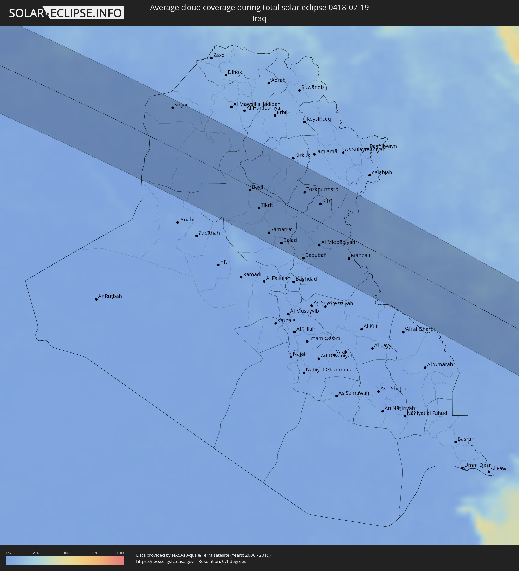 Iraq
Iraq
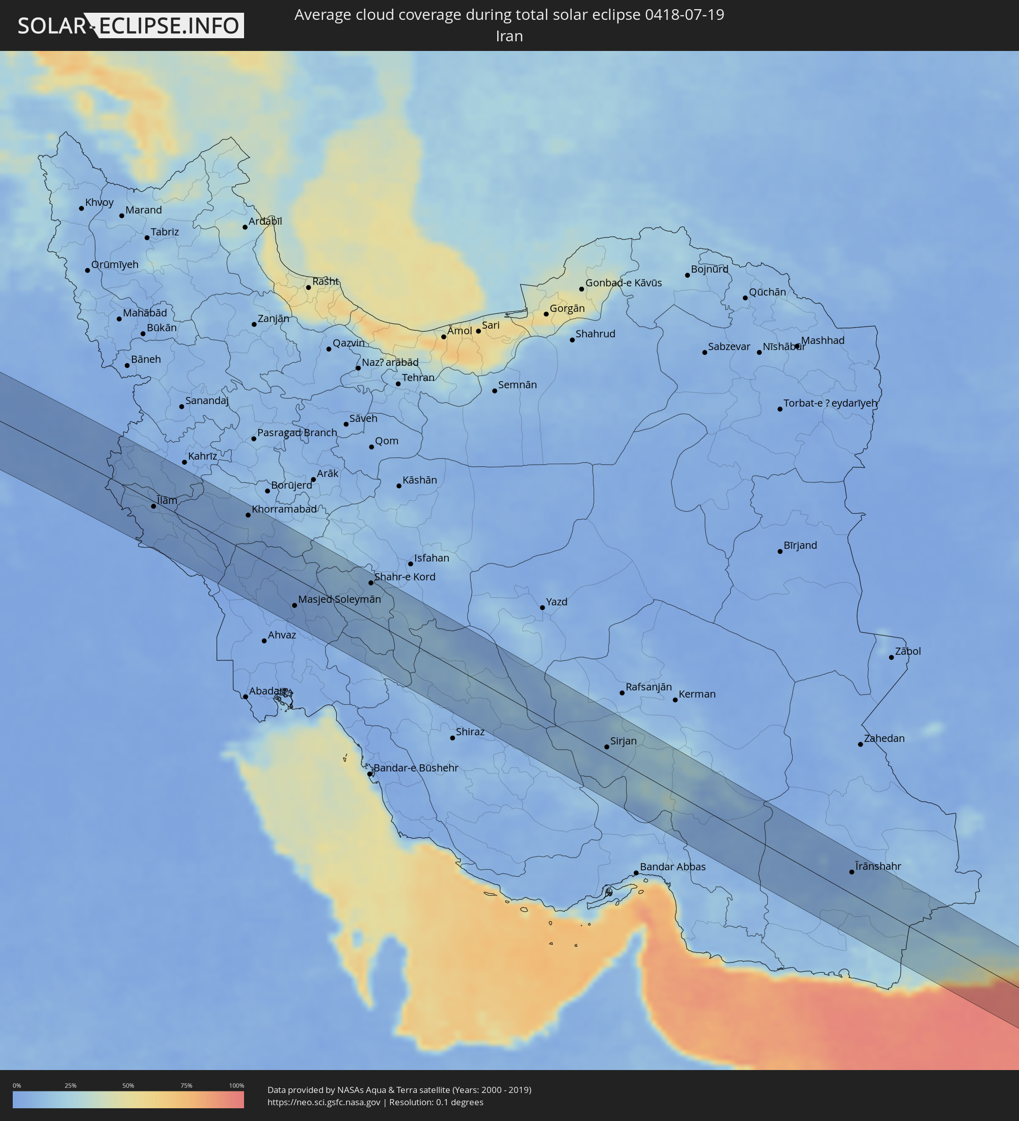 Iran
Iran
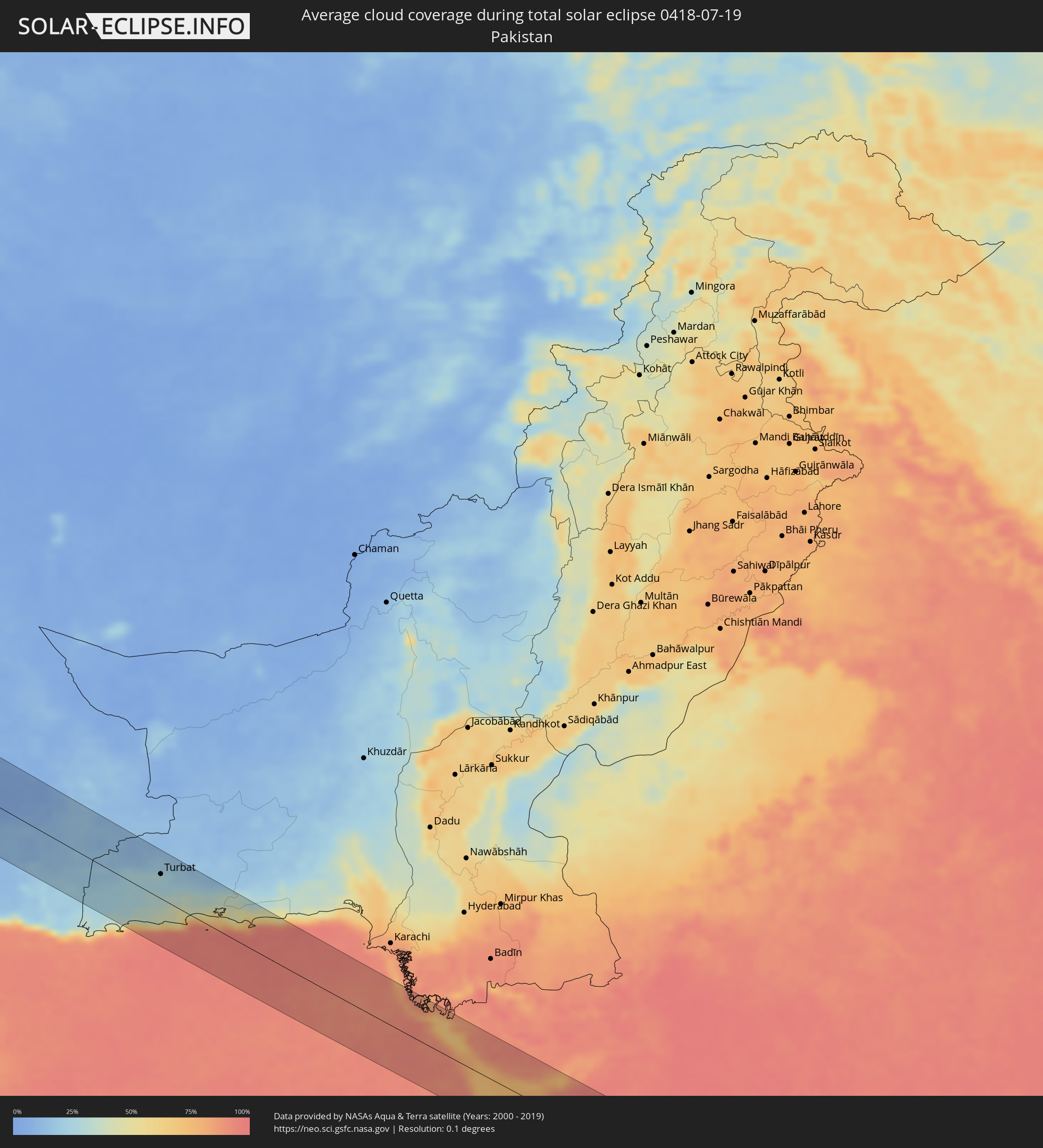 Pakistan
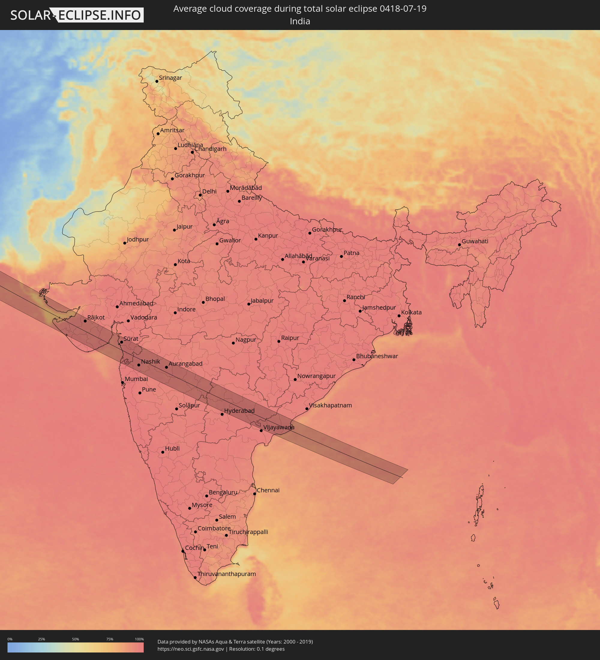 India
India
Cities inside the path of the eclipse
The following table shows all locations with a population of more than 5,000 inside the eclipse path. Cities which have more than 100,000 inhabitants are marked bold. A click at the locations opens a detailed map.
| City | Type | Eclipse duration | Local time of max. eclipse | Distance to central line | Ø Cloud coverage |
|
Aveiro, Aveiro
|
total | - | 09:18:57 UTC-00:36 | 7 km | 35% |
|
Pombal, Leiria
|
total | - | 09:18:13 UTC-00:36 | 72 km | 28% |
|
Porto, Porto
|
total | - | 09:19:31 UTC-00:36 | 61 km | 36% |
|
São João da Madeira, Aveiro
|
total | - | 09:19:26 UTC-00:36 | 32 km | 36% |
|
Coimbra, Coimbra
|
total | - | 09:18:50 UTC-00:36 | 45 km | 28% |
|
Perafita, Porto
|
total | - | 09:20:04 UTC-00:36 | 58 km | 35% |
|
Viseu, Viseu
|
total | - | 09:20:03 UTC-00:36 | 6 km | 24% |
|
Vila Real, Vila Real
|
total | - | 09:20:57 UTC-00:36 | 61 km | 24% |
|
Covilhã, Castelo Branco
|
total | - | 09:20:18 UTC-00:36 | 54 km | 17% |
|
Custoias, Guarda
|
total | - | 09:21:23 UTC-00:36 | 31 km | 20% |
|
Guarda, Guarda
|
total | - | 09:20:55 UTC-00:36 | 31 km | 17% |
|
Mirandela, Bragança
|
total | - | 09:21:58 UTC-00:36 | 70 km | 20% |
|
Zamora, Castille and León
|
total | - | 10:00:57 UTC+00:00 | 46 km | 21% |
|
Salamanca, Castille and León
|
total | - | 10:00:35 UTC+00:00 | 14 km | 18% |
|
Valladolid, Castille and León
|
total | - | 10:02:43 UTC+00:00 | 46 km | 22% |
|
Ávila, Castille and León
|
total | - | 10:01:51 UTC+00:00 | 64 km | 25% |
|
Segovia, Castille and León
|
total | - | 10:03:04 UTC+00:00 | 41 km | 30% |
|
Zaragoza, Aragon
|
total | - | 10:09:10 UTC+00:00 | 9 km | 25% |
|
Lleida, Catalonia
|
total | - | 10:11:48 UTC+00:00 | 30 km | 22% |
|
Sant Julià de Lòria, Sant Julià de Loria
|
total | - | 10:13:55 UTC+00:00 | 55 km | 36% |
|
la Massana, La Massana
|
total | - | 10:14:01 UTC+00:00 | 64 km | 36% |
|
Andorra la Vella, Andorra la Vella
|
total | - | 10:14:00 UTC+00:00 | 60 km | 36% |
|
Ordino, Ordino
|
total | - | 10:14:03 UTC+00:00 | 65 km | 44% |
|
les Escaldes, Escaldes-Engordany
|
total | - | 10:14:01 UTC+00:00 | 60 km | 36% |
|
Encamp, Encamp
|
total | - | 10:14:07 UTC+00:00 | 62 km | 37% |
|
Canillo, Canillo
|
total | - | 10:14:11 UTC+00:00 | 66 km | 43% |
|
Manresa, Catalonia
|
total | - | 10:14:04 UTC+00:00 | 29 km | 28% |
|
Terrassa, Catalonia
|
total | - | 10:14:19 UTC+00:00 | 49 km | 31% |
|
Barcelona, Catalonia
|
total | - | 10:14:28 UTC+00:00 | 70 km | 31% |
|
Prades, Occitania
|
total | - | 10:25:04 UTC+00:09 | 64 km | 44% |
|
Mataró, Catalonia
|
total | - | 10:15:06 UTC+00:00 | 55 km | 29% |
|
Ceret, Occitania
|
total | - | 10:25:33 UTC+00:09 | 47 km | 40% |
|
Le Soler, Occitania
|
total | - | 10:25:45 UTC+00:09 | 69 km | 37% |
|
Girona, Catalonia
|
total | - | 10:16:04 UTC+00:00 | 9 km | 36% |
|
Toulouges, Occitania
|
total | - | 10:25:49 UTC+00:09 | 67 km | 37% |
|
Perpignan, Occitania
|
total | - | 10:25:57 UTC+00:09 | 70 km | 36% |
|
Pia, Occitania
|
total | - | 10:26:01 UTC+00:09 | 75 km | 36% |
|
Elne, Occitania
|
total | - | 10:26:02 UTC+00:09 | 58 km | 34% |
|
Argelers, Occitania
|
total | - | 10:26:06 UTC+00:09 | 52 km | 32% |
|
Ajaccio, Corsica
|
total | - | 10:36:51 UTC+00:09 | 39 km | 21% |
|
Corte, Corsica
|
total | - | 10:37:46 UTC+00:09 | 3 km | 28% |
|
Porto-Vecchio, Corsica
|
total | - | 10:37:52 UTC+00:09 | 76 km | 21% |
|
Bastia, Corsica
|
total | - | 10:38:27 UTC+00:09 | 47 km | 24% |
|
Grosseto, Tuscany
|
total | - | 11:32:24 UTC+01:00 | 57 km | 16% |
|
Acilia-Castel Fusano-Ostia Antica, Latium
|
total | - | 11:34:49 UTC+01:00 | 50 km | 15% |
|
Vatican City
|
total | - | 11:35:04 UTC+01:00 | 34 km | 17% |
|
Rome, Latium
|
total | - | 11:35:12 UTC+01:00 | 35 km | 17% |
|
Terni, Umbria
|
total | - | 11:35:28 UTC+01:00 | 40 km | 20% |
|
Guidonia Montecelio, Latium
|
total | - | 11:35:38 UTC+01:00 | 23 km | 18% |
|
Latina, Latium
|
total | - | 11:36:01 UTC+01:00 | 80 km | 17% |
|
Pescara, Abruzzo
|
total | - | 11:38:39 UTC+01:00 | 38 km | 16% |
|
San Severo, Apulia
|
total | - | 11:41:11 UTC+01:00 | 39 km | 16% |
|
Foggia, Apulia
|
total | - | 11:41:35 UTC+01:00 | 63 km | 16% |
|
Cerignola, Apulia
|
total | - | 11:42:20 UTC+01:00 | 81 km | 17% |
|
Andria, Apulia
|
total | - | 11:43:12 UTC+01:00 | 81 km | 14% |
|
Molfetta, Apulia
|
total | - | 11:43:51 UTC+01:00 | 81 km | 12% |
|
Herceg-Novi, Herceg Novi
|
total | - | 11:47:30 UTC+01:00 | 79 km | 24% |
|
Tivat, Tivat
|
total | - | 11:47:50 UTC+01:00 | 79 km | 22% |
|
Kotor, Kotor
|
total | - | 11:47:59 UTC+01:00 | 78 km | 31% |
|
Dobrota
|
total | - | 11:47:58 UTC+01:00 | 82 km | 31% |
|
Budva, Budva
|
total | - | 11:48:11 UTC+01:00 | 64 km | 22% |
|
Cetinje, Cetinje
|
total | - | 11:48:17 UTC+01:00 | 76 km | 31% |
|
Bar, Bar
|
total | - | 11:48:47 UTC+01:00 | 46 km | 15% |
|
Ulcinj, Ulcinj
|
total | - | 11:49:06 UTC+01:00 | 30 km | 12% |
|
Durrës, Durrës
|
total | - | 12:09:09 UTC+01:19 | 34 km | 14% |
|
Shkodër, Shkodër
|
total | - | 12:08:59 UTC+01:19 | 49 km | 14% |
|
Kavajë, Tiranë
|
total | - | 12:09:27 UTC+01:19 | 47 km | 13% |
|
Lezhë, Lezhë
|
total | - | 12:09:22 UTC+01:19 | 20 km | 16% |
|
Lushnjë, Fier
|
total | - | 12:09:52 UTC+01:19 | 72 km | 15% |
|
Laç, Lezhë
|
total | - | 12:09:35 UTC+01:19 | 4 km | 17% |
|
Krujë, Durrës
|
total | - | 12:09:48 UTC+01:19 | 8 km | 23% |
|
Tirana, Tiranë
|
total | - | 12:09:56 UTC+01:19 | 28 km | 20% |
|
Burrel, Dibër
|
total | - | 12:10:12 UTC+01:19 | 6 km | 24% |
|
Elbasan, Elbasan
|
total | - | 12:10:35 UTC+01:19 | 48 km | 23% |
|
Kukës, Kukës
|
total | - | 12:10:50 UTC+01:19 | 63 km | 28% |
|
Peshkopi, Dibër
|
total | - | 12:11:02 UTC+01:19 | 20 km | 28% |
|
Centar Župa, Centar Župa
|
total | - | 11:52:04 UTC+01:00 | 0 km | 38% |
|
Ohrid, Ohrid
|
total | - | 11:52:46 UTC+01:00 | 36 km | 26% |
|
Gostivar, Gostivar
|
total | - | 11:52:38 UTC+01:00 | 40 km | 34% |
|
Tetovo, Tetovo
|
total | - | 11:52:39 UTC+01:00 | 64 km | 35% |
|
Bitola, Bitola
|
total | - | 11:53:55 UTC+01:00 | 37 km | 35% |
|
Skopje, Karpoš
|
total | - | 11:53:36 UTC+01:00 | 70 km | 31% |
|
Prilep, Prilep
|
total | - | 11:54:13 UTC+01:00 | 1 km | 35% |
|
Veles, Veles
|
total | - | 11:54:27 UTC+01:00 | 45 km | 23% |
|
Kavadarci, Kavadarci
|
total | - | 11:55:06 UTC+01:00 | 18 km | 27% |
|
Édessa, Central Macedonia
|
total | - | 12:30:25 UTC+01:34 | 50 km | 24% |
|
Náousa, Central Macedonia
|
total | - | 12:30:34 UTC+01:34 | 69 km | 28% |
|
Shtip, Štip
|
total | - | 11:55:18 UTC+01:00 | 55 km | 25% |
|
Véroia, Central Macedonia
|
total | - | 12:30:54 UTC+01:34 | 78 km | 23% |
|
Giannitsá, Central Macedonia
|
total | - | 12:31:10 UTC+01:34 | 45 km | 21% |
|
Kochani, Kočani
|
total | - | 11:55:38 UTC+01:00 | 78 km | 32% |
|
Strumica, Strumica
|
total | - | 11:56:24 UTC+01:00 | 30 km | 26% |
|
Kilkís, Central Macedonia
|
total | - | 12:32:01 UTC+01:34 | 15 km | 24% |
|
Thessaloníki, Central Macedonia
|
total | - | 12:32:22 UTC+01:34 | 51 km | 20% |
|
Petrich, Blagoevgrad
|
total | - | 12:57:36 UTC+02:00 | 36 km | 26% |
|
Sandanski, Blagoevgrad
|
total | - | 12:57:37 UTC+02:00 | 55 km | 31% |
|
Sérres, Central Macedonia
|
total | - | 12:33:21 UTC+01:34 | 8 km | 24% |
|
Gotse Delchev, Blagoevgrad
|
total | - | 12:58:32 UTC+02:00 | 64 km | 42% |
|
Dráma, East Macedonia and Thrace
|
total | - | 12:34:32 UTC+01:34 | 27 km | 29% |
|
Kavála, East Macedonia and Thrace
|
total | - | 12:35:12 UTC+01:34 | 9 km | 20% |
|
Xánthi, East Macedonia and Thrace
|
total | - | 12:36:02 UTC+01:34 | 40 km | 25% |
|
Madan, Smolyan
|
total | - | 13:01:02 UTC+02:00 | 81 km | 44% |
|
Nedelino, Smolyan
|
total | - | 13:01:20 UTC+02:00 | 78 km | 39% |
|
Zlatograd, Smolyan
|
total | - | 13:01:25 UTC+02:00 | 71 km | 36% |
|
Komotiní, East Macedonia and Thrace
|
total | - | 12:37:06 UTC+01:34 | 49 km | 25% |
|
Alexandroúpoli, East Macedonia and Thrace
|
total | - | 12:38:15 UTC+01:34 | 31 km | 19% |
|
Balıkesir, Balıkesir
|
total | - | 13:05:25 UTC+01:56 | 51 km | 22% |
|
Bursa, Bursa
|
total | - | 13:07:13 UTC+01:56 | 37 km | 37% |
|
Kütahya, Kütahya
|
total | - | 13:09:48 UTC+01:56 | 20 km | 22% |
|
Eskişehir, Eskişehir
|
total | - | 13:10:29 UTC+01:56 | 32 km | 22% |
|
Aksaray, Aksaray
|
total | - | 13:18:41 UTC+01:56 | 9 km | 15% |
|
Kayseri, Kayseri
|
total | - | 13:20:52 UTC+01:56 | 76 km | 21% |
|
Osmaniye, Osmaniye
|
total | - | 13:24:21 UTC+01:56 | 68 km | 24% |
|
Kahramanmaraş, Kahramanmaraş
|
total | - | 13:24:53 UTC+01:56 | 8 km | 2% |
|
Gaziantep, Gaziantep
|
total | - | 13:26:22 UTC+01:56 | 30 km | 5% |
|
Manbij, Aleppo
|
total | - | 13:56:20 UTC+02:25 | 63 km | 1% |
|
Jarābulus, Aleppo
|
total | - | 13:56:02 UTC+02:25 | 31 km | 3% |
|
Adıyaman, Adıyaman
|
total | - | 13:26:57 UTC+01:56 | 74 km | 3% |
|
‘Ayn al ‘Arab, Aleppo
|
total | - | 13:56:31 UTC+02:25 | 11 km | 2% |
|
Şanlıurfa, Şanlıurfa
|
total | - | 13:28:37 UTC+01:56 | 33 km | 3% |
|
Viranşehir, Şanlıurfa
|
total | - | 13:30:07 UTC+01:56 | 74 km | 2% |
|
Al Ḩasakah, Al-Hasakah
|
total | - | 14:01:00 UTC+02:25 | 40 km | 1% |
|
Sinjār, Nīnawá
|
total | - | 14:35:25 UTC+02:57 | 66 km | 2% |
|
Bayjī, Salah ad Din Governorate
|
total | - | 14:39:53 UTC+02:57 | 7 km | 2% |
|
Tikrīt, Salah ad Din Governorate
|
total | - | 14:40:38 UTC+02:57 | 30 km | 2% |
|
Sāmarrā’, Salah ad Din Governorate
|
total | - | 14:41:33 UTC+02:57 | 63 km | 2% |
|
Balad, Salah ad Din Governorate
|
total | - | 14:42:12 UTC+02:57 | 70 km | 2% |
|
Khāliş, Diyālá
|
total | - | 14:43:04 UTC+02:57 | 74 km | 2% |
|
Baqubah, Diyālá
|
total | - | 14:43:15 UTC+02:57 | 76 km | 2% |
|
Tozkhurmato, Salah ad Din Governorate
|
total | - | 14:41:37 UTC+02:57 | 37 km | 1% |
|
Al Miqdādīyah, Diyālá
|
total | - | 14:43:24 UTC+02:57 | 40 km | 1% |
|
Kifrī, Diyālá
|
total | - | 14:42:23 UTC+02:57 | 31 km | 3% |
|
Mandalī, Diyālá
|
total | - | 14:44:37 UTC+02:57 | 36 km | 2% |
|
Īlām, Īlām
|
total | - | 15:14:06 UTC+03:25 | 9 km | 6% |
|
Kūhdasht, Lorestān
|
total | - | 15:15:50 UTC+03:25 | 33 km | 4% |
|
Khorramabad, Lorestān
|
total | - | 15:16:51 UTC+03:25 | 62 km | 9% |
|
Shūshtar, Khuzestan
|
total | - | 15:19:39 UTC+03:25 | 57 km | 2% |
|
Masjed Soleymān, Khuzestan
|
total | - | 15:20:22 UTC+03:25 | 47 km | 2% |
|
Shahr-e Kord, Chahār Maḩāll va Bakhtīārī
|
total | - | 15:21:38 UTC+03:25 | 63 km | 13% |
|
Borūjen, Chahār Maḩāll va Bakhtīārī
|
total | - | 15:22:39 UTC+03:25 | 47 km | 16% |
|
Yasuj, Kohgīlūyeh va Būyer Aḩmad
|
total | - | 15:24:56 UTC+03:25 | 65 km | 13% |
|
Ābādeh, Fars
|
total | - | 15:25:21 UTC+03:25 | 33 km | 10% |
|
Shahr-e Bābak, Kerman
|
total | - | 15:29:23 UTC+03:25 | 49 km | 12% |
|
Sirjan, Kerman
|
total | - | 15:30:53 UTC+03:25 | 12 km | 13% |
|
Īrānshahr, Sistan and Baluchestan
|
total | - | 15:38:07 UTC+03:25 | 38 km | 7% |
|
Turbat, Balochistān
|
total | - | 16:43:44 UTC+04:28 | 37 km | 27% |
|
Pasni, Balochistān
|
total | - | 16:44:58 UTC+04:28 | 14 km | 78% |
|
Ormāra, Balochistān
|
total | - | 16:45:40 UTC+04:28 | 38 km | 87% |
|
Jāmnagar, Gujarat
|
total | - | 17:44:14 UTC+05:21 | 34 km | 96% |
|
Rājkot, Gujarat
|
total | - | 17:44:40 UTC+05:21 | 51 km | 95% |
|
Bhāvnagar, Gujarat
|
total | - | 17:45:35 UTC+05:21 | 65 km | 96% |
|
Sūrat, Gujarat
|
total | - | 17:46:23 UTC+05:21 | 40 km | 95% |
|
Bilimora, Gujarat
|
total | - | 17:46:53 UTC+05:21 | 3 km | 97% |
|
Nashik, Maharashtra
|
total | - | 17:47:52 UTC+05:21 | 34 km | 97% |
|
Mālegaon, Maharashtra
|
total | - | 17:47:22 UTC+05:21 | 55 km | 96% |
|
Aurangabad, Maharashtra
|
total | - | 17:48:11 UTC+05:21 | 26 km | 97% |
|
Nanded, Maharashtra
|
total | - | 17:49:04 UTC+05:21 | 45 km | 95% |
|
Nizāmābād, Telangana
|
total | - | 17:49:35 UTC+05:21 | 31 km | 95% |
|
Warangal, Telangana
|
total | - | 17:50:13 UTC+05:21 | 30 km | 97% |
|
Rājahmundry, Andhra Pradesh
|
total | - | 17:50:59 UTC+05:21 | 26 km | 97% |