Annular solar eclipse of 07/20/0464
| Day of week: | Sunday |
| Maximum duration of eclipse: | 02m57s |
| Maximum width of eclipse path: | 120 km |
| Saros cycle: | 82 |
| Coverage: | 96.9% |
| Magnitude: | 0.9693 |
| Gamma: | 0.4042 |
Wo kann man die Sonnenfinsternis vom 07/20/0464 sehen?
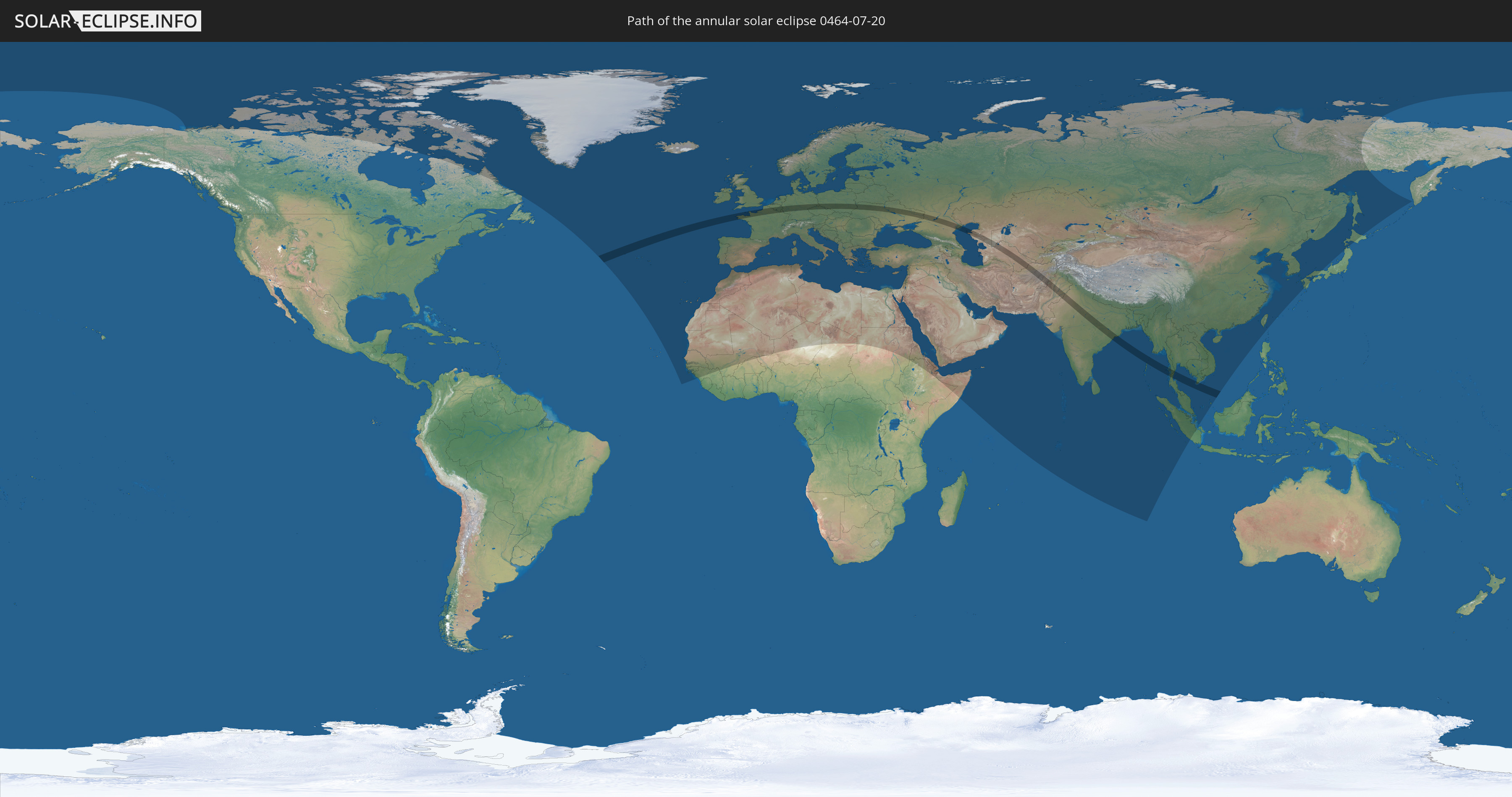
Die Sonnenfinsternis am 07/20/0464 kann man in 122 Ländern als partielle Sonnenfinsternis beobachten.
Der Finsternispfad verläuft durch 22 Länder. Nur in diesen Ländern ist sie als annular Sonnenfinsternis zu sehen.
In den folgenden Ländern ist die Sonnenfinsternis annular zu sehen
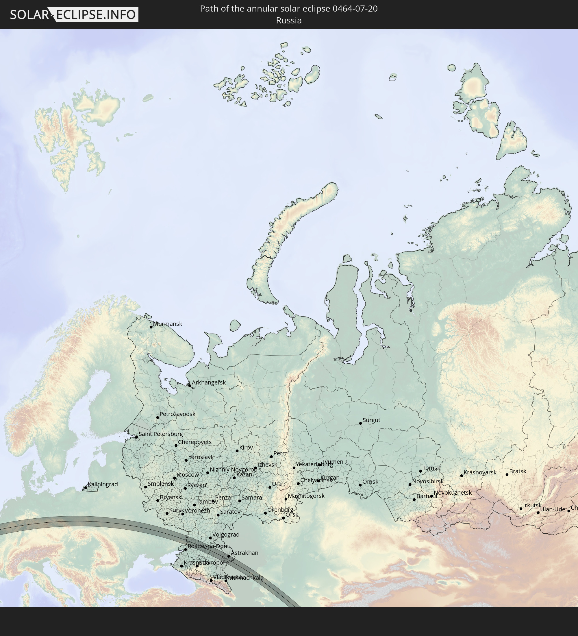 Russia
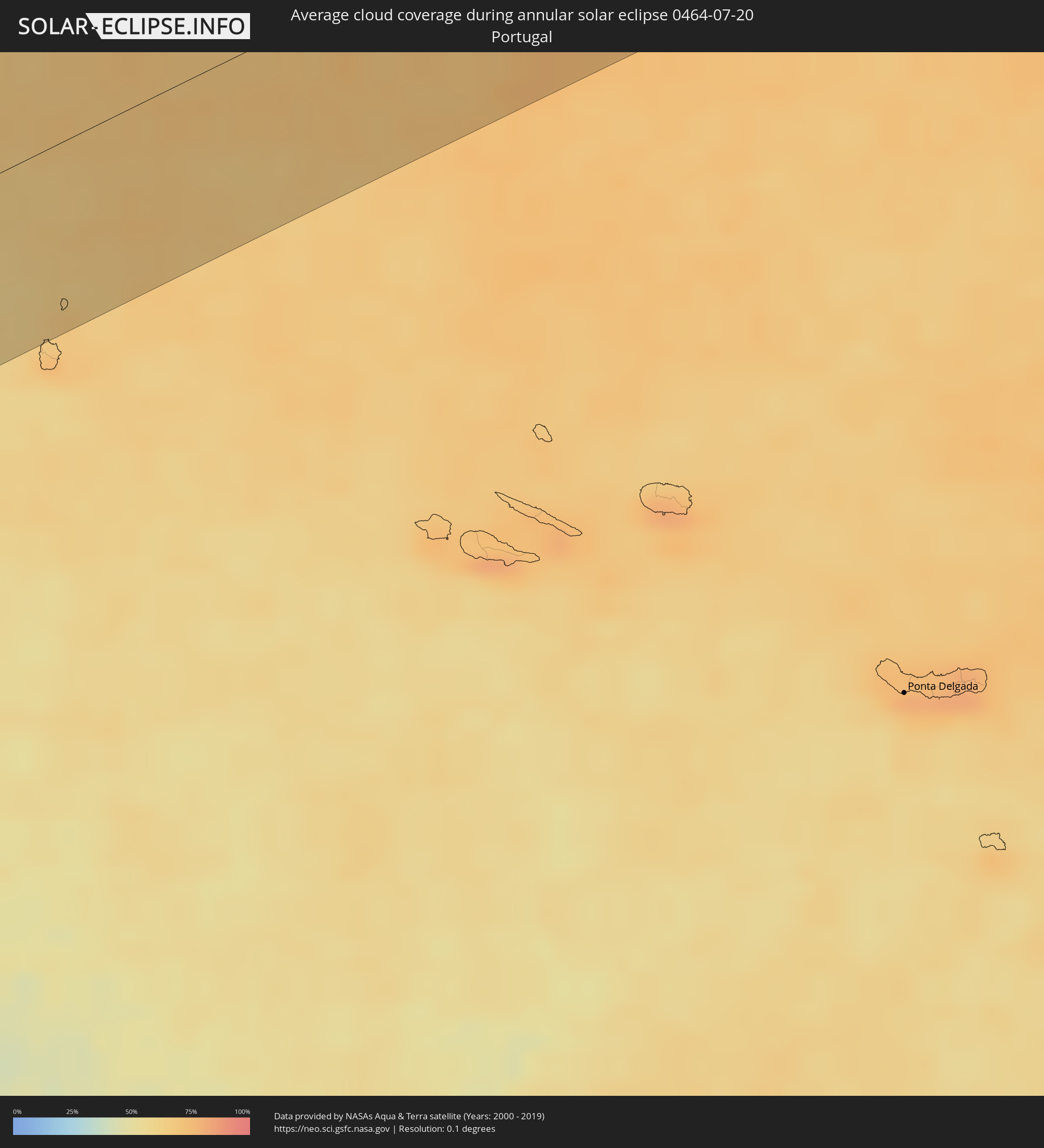
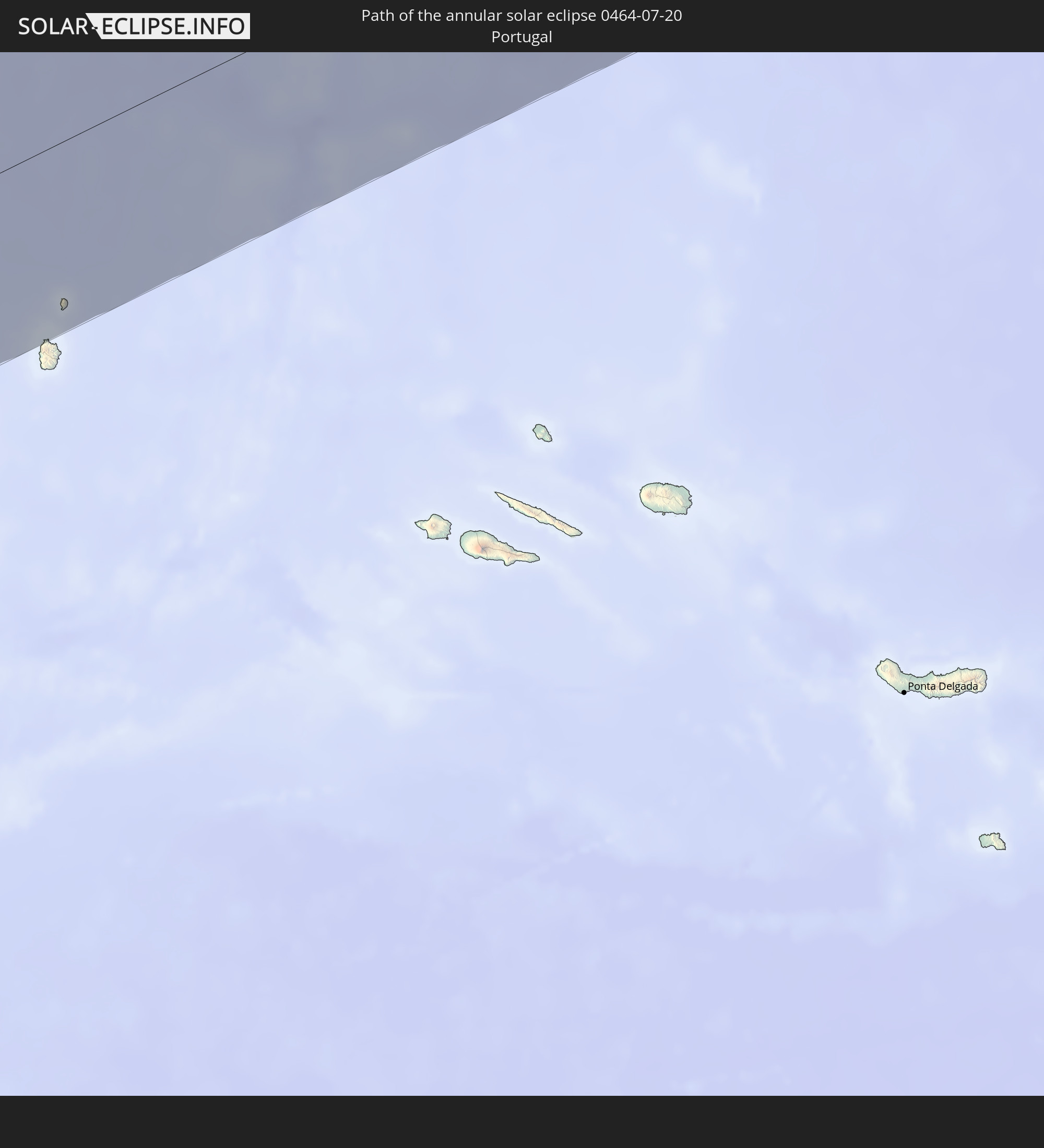 Portugal
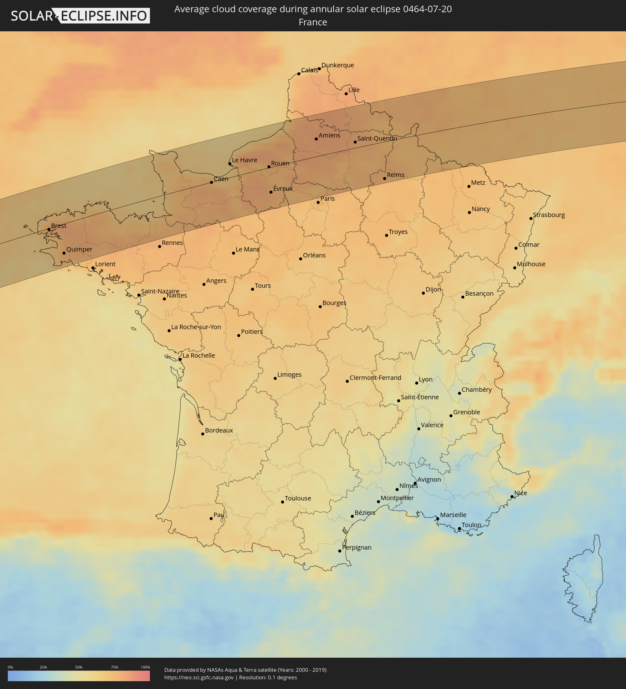
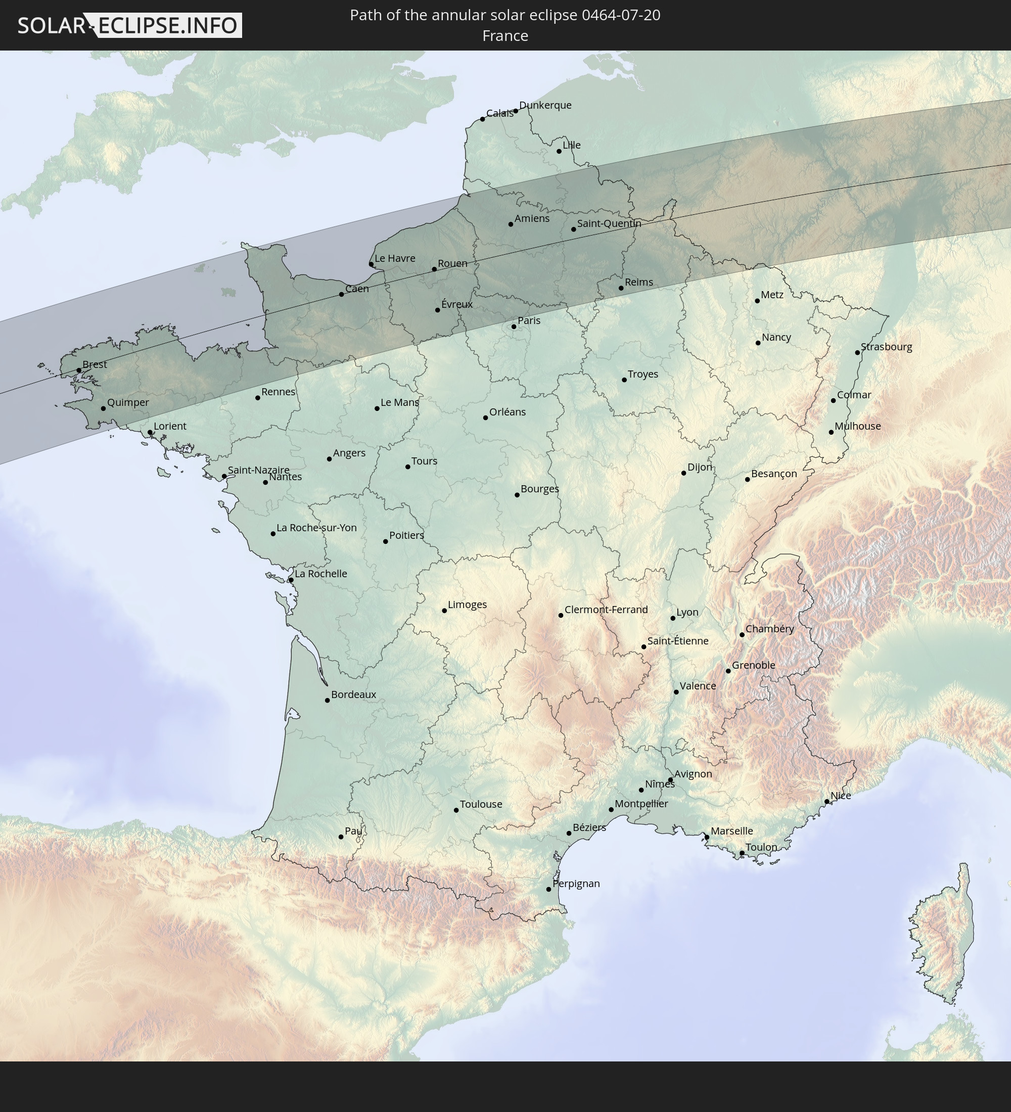 France
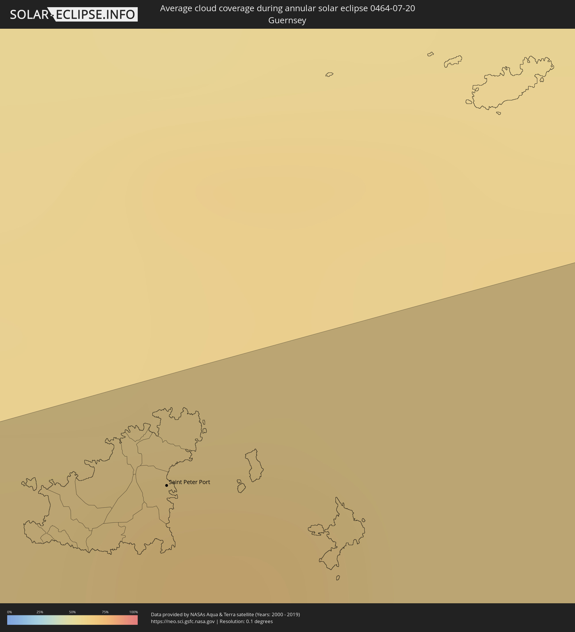
 Guernsey
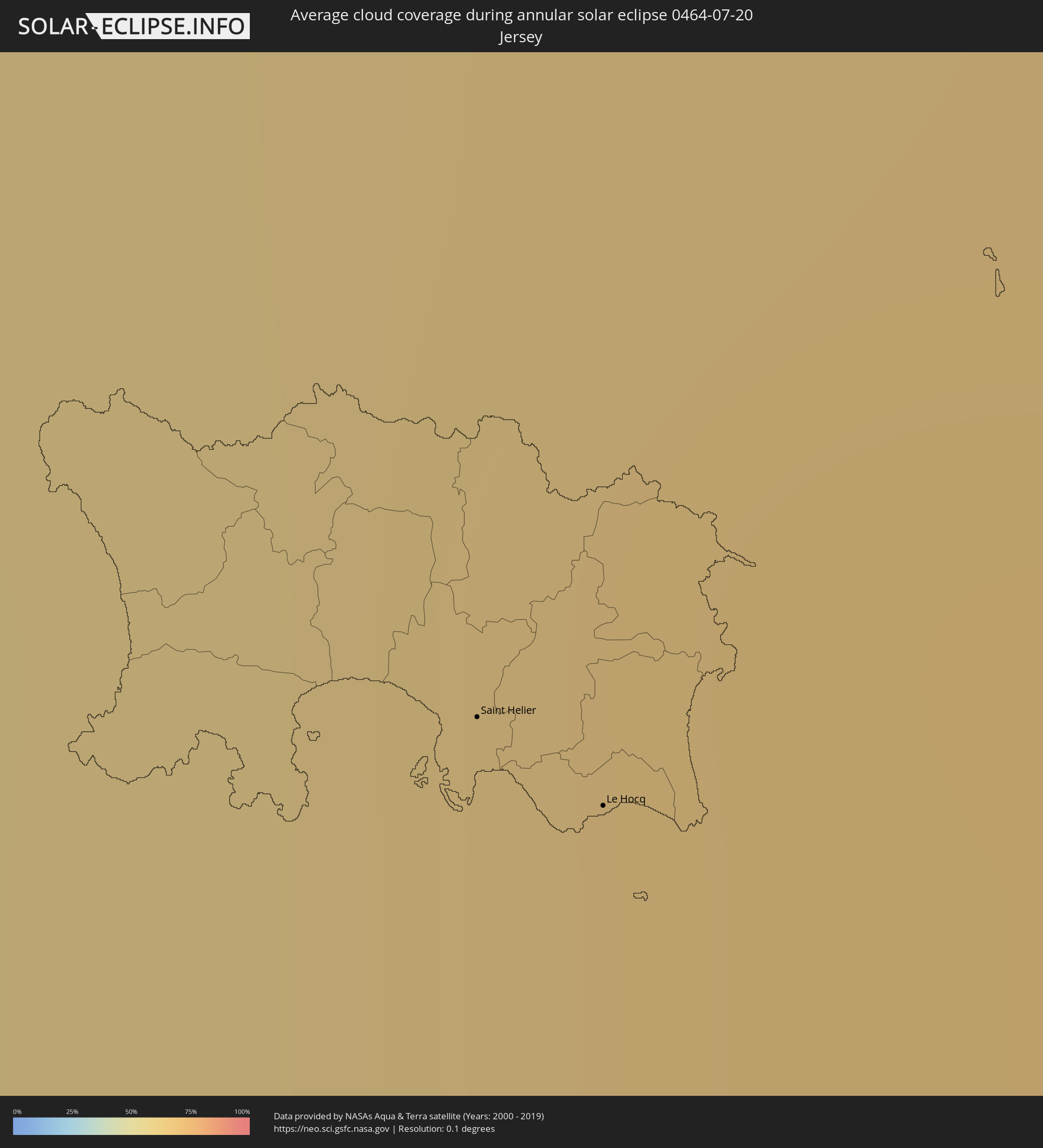
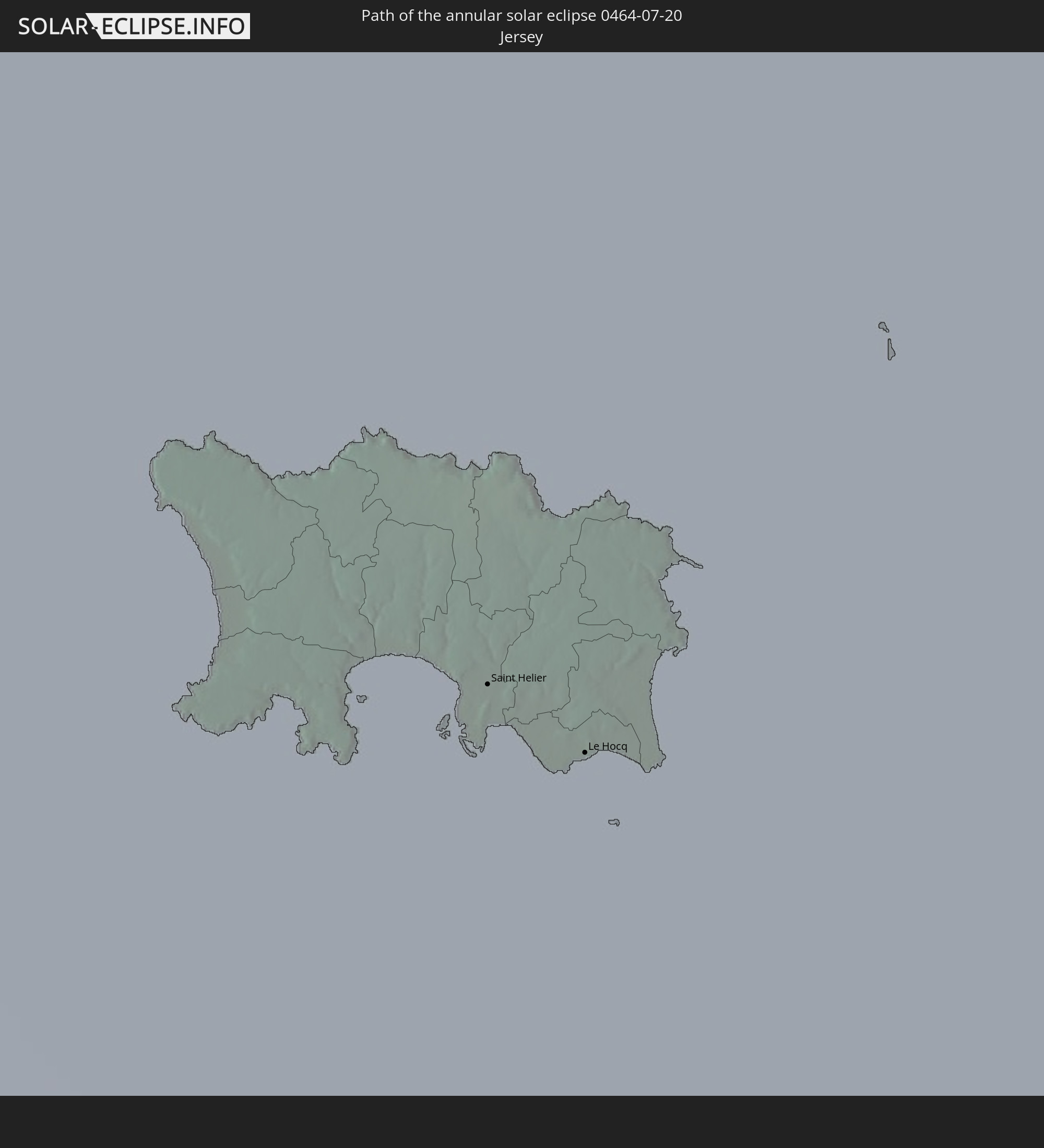 Jersey
 Belgium
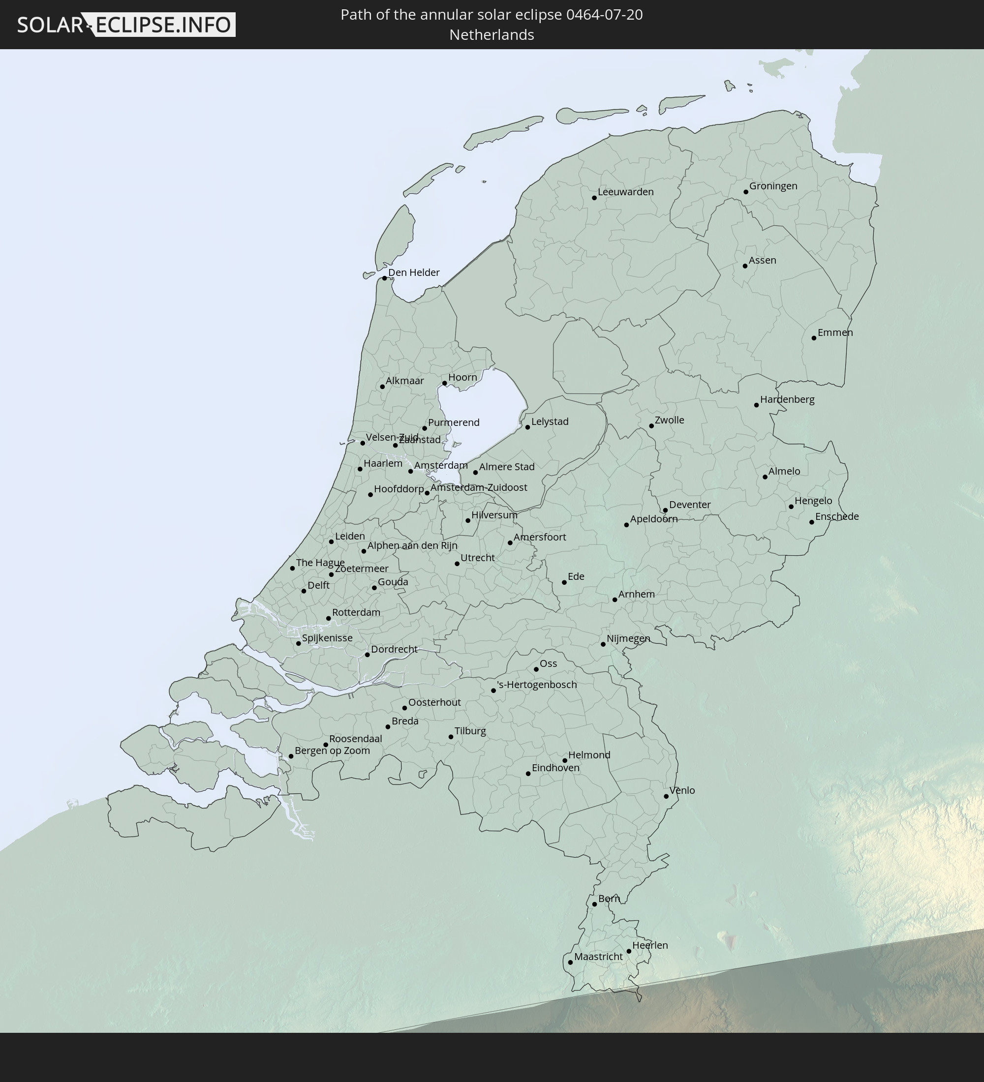 Netherlands
 Luxembourg
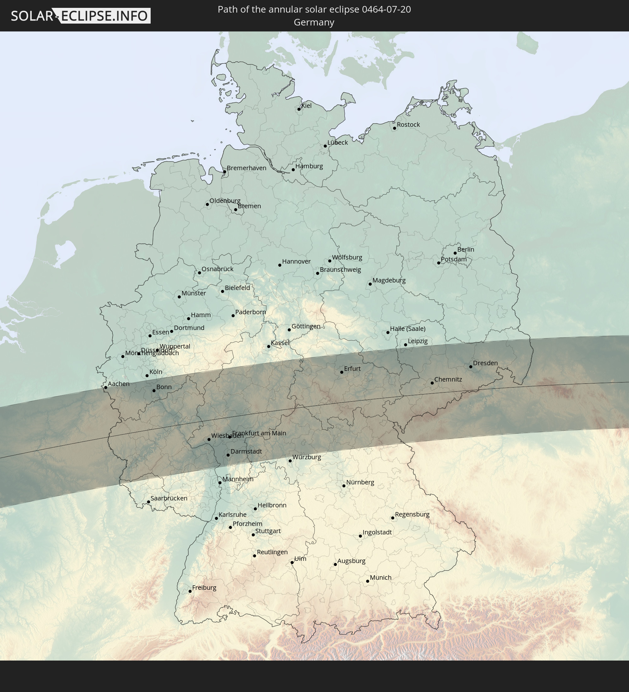 Germany
 Czechia
 Poland
 Ukraine
 Kazakhstan
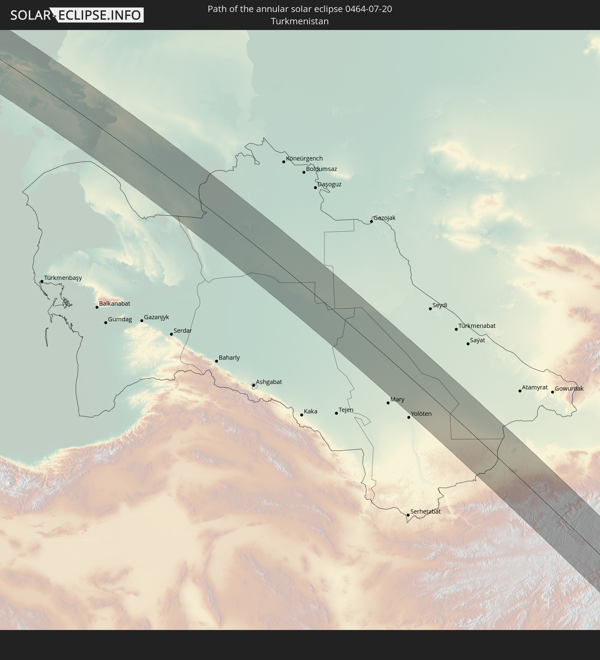 Turkmenistan
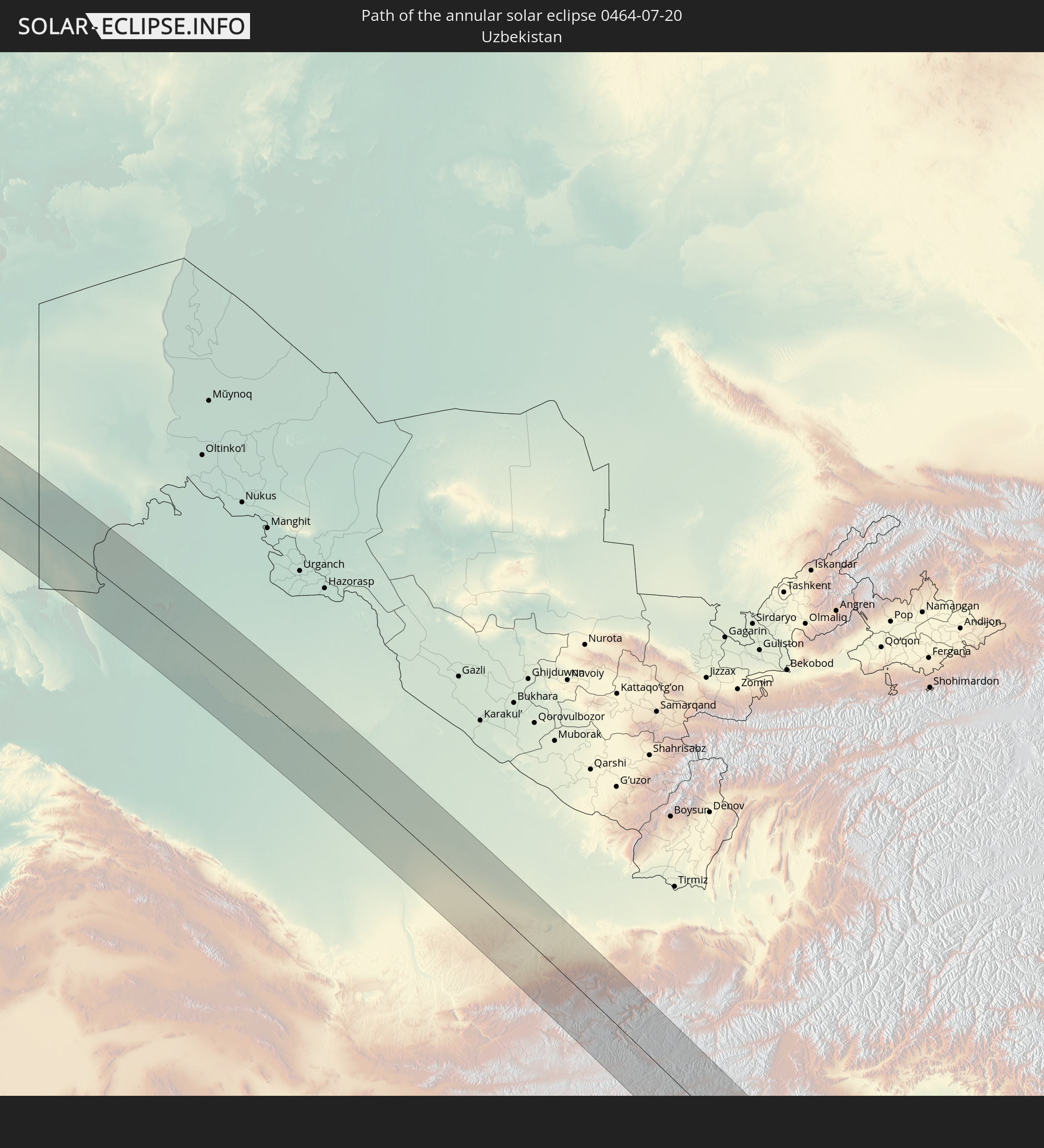 Uzbekistan
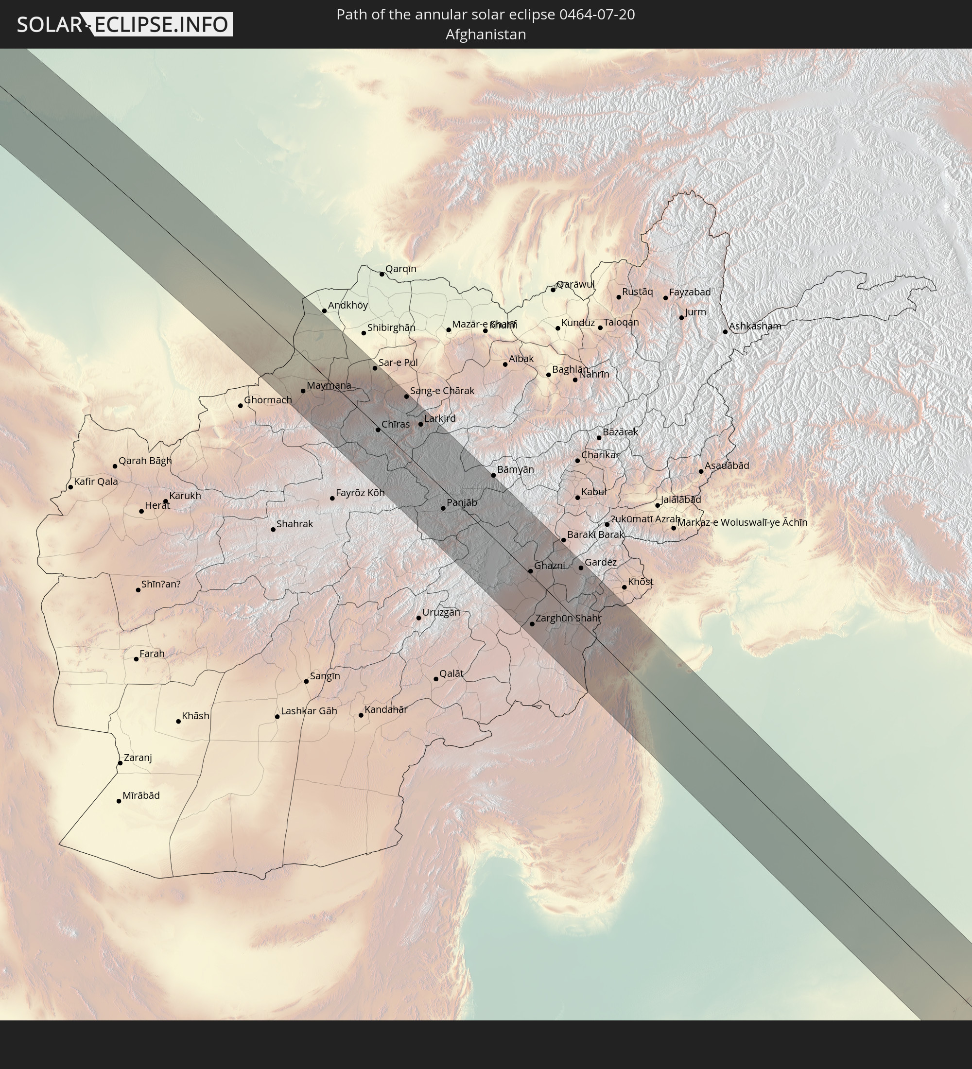 Afghanistan
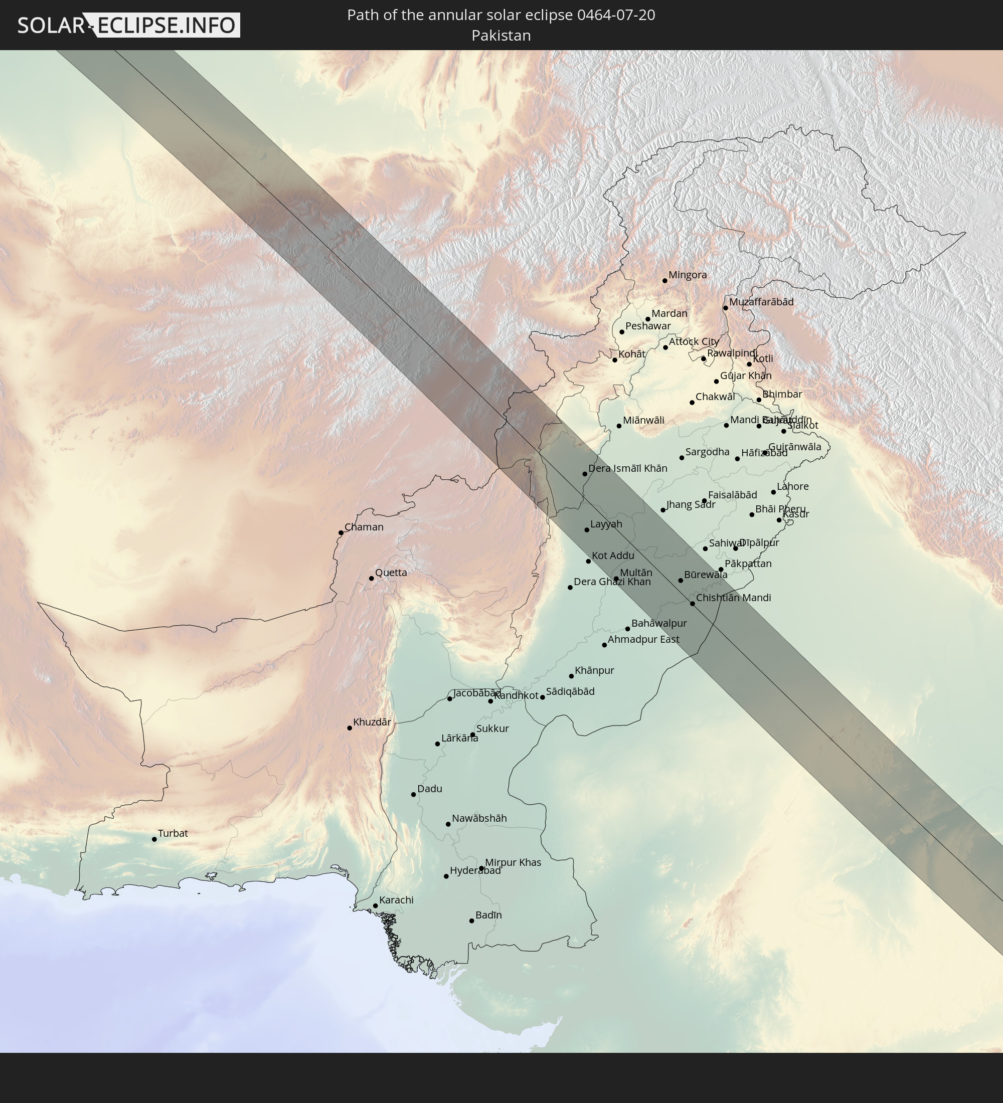 Pakistan
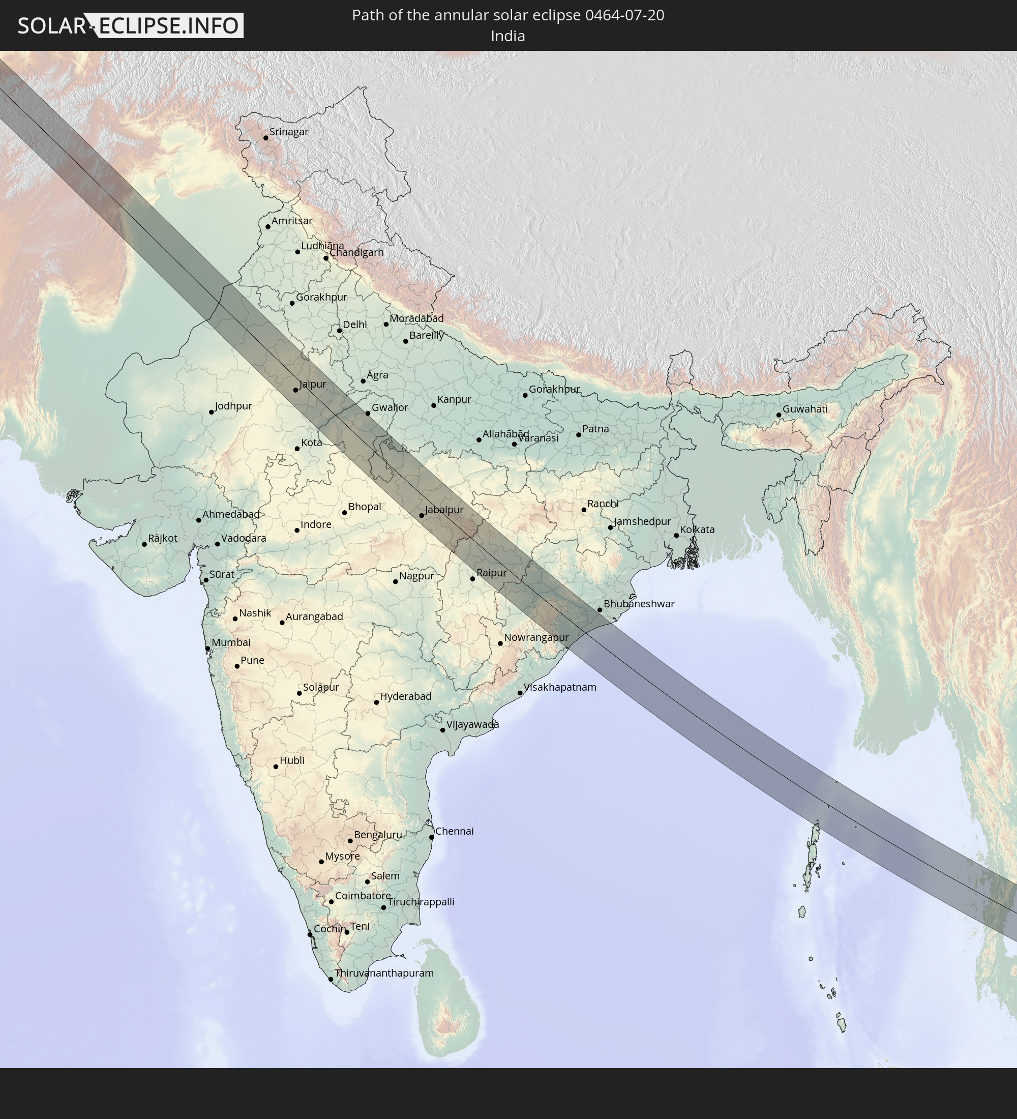 India
India
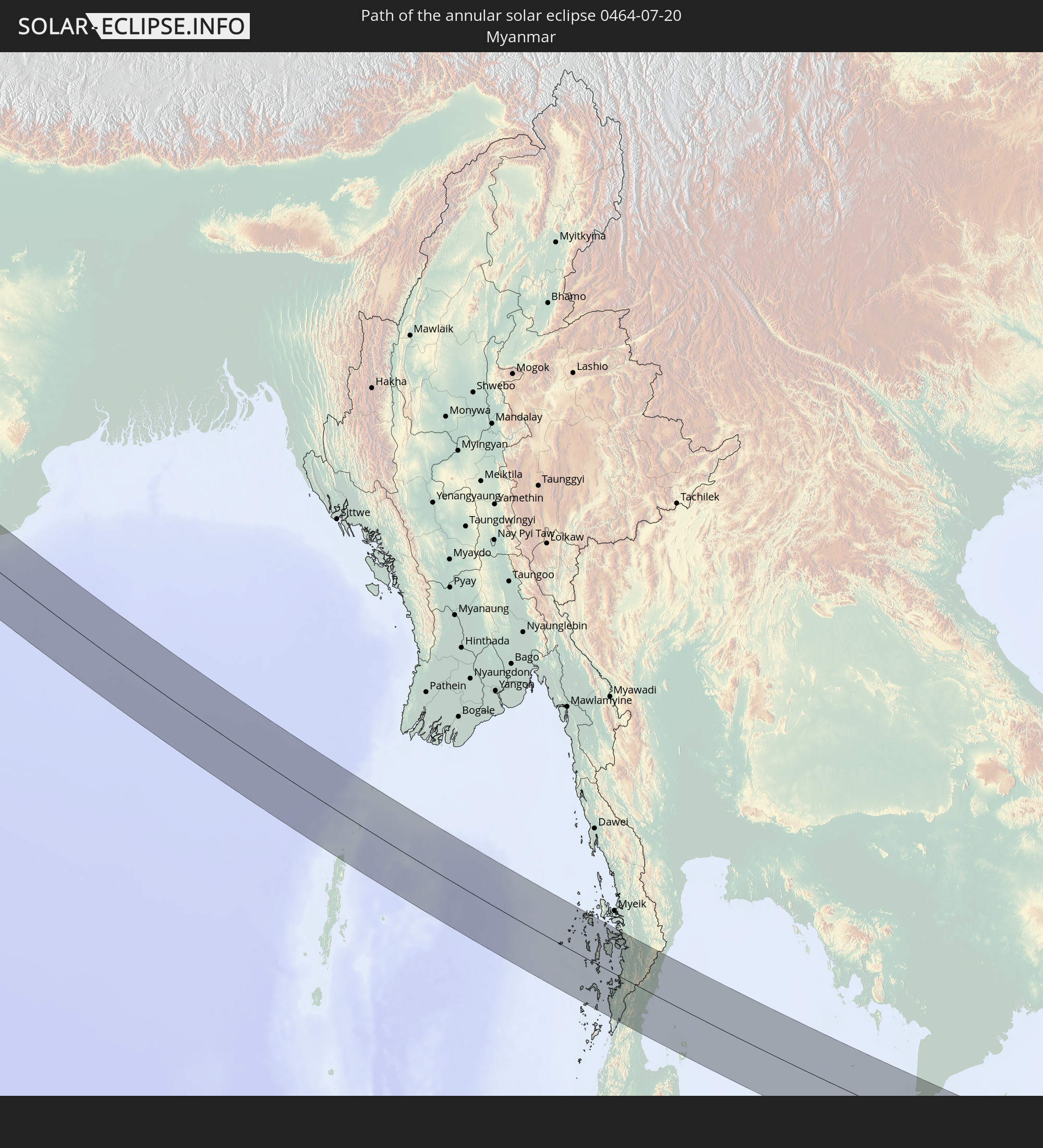 Myanmar
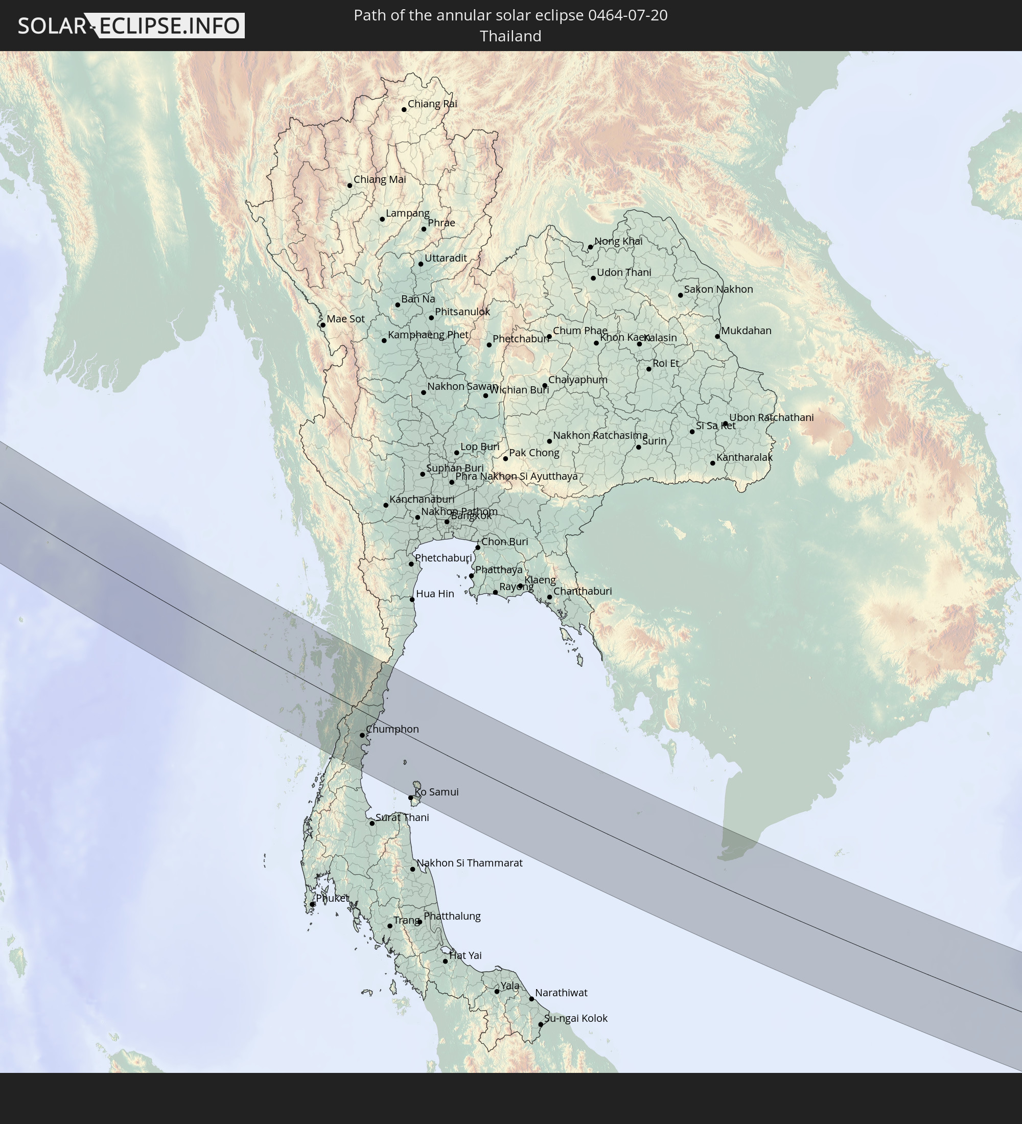 Thailand
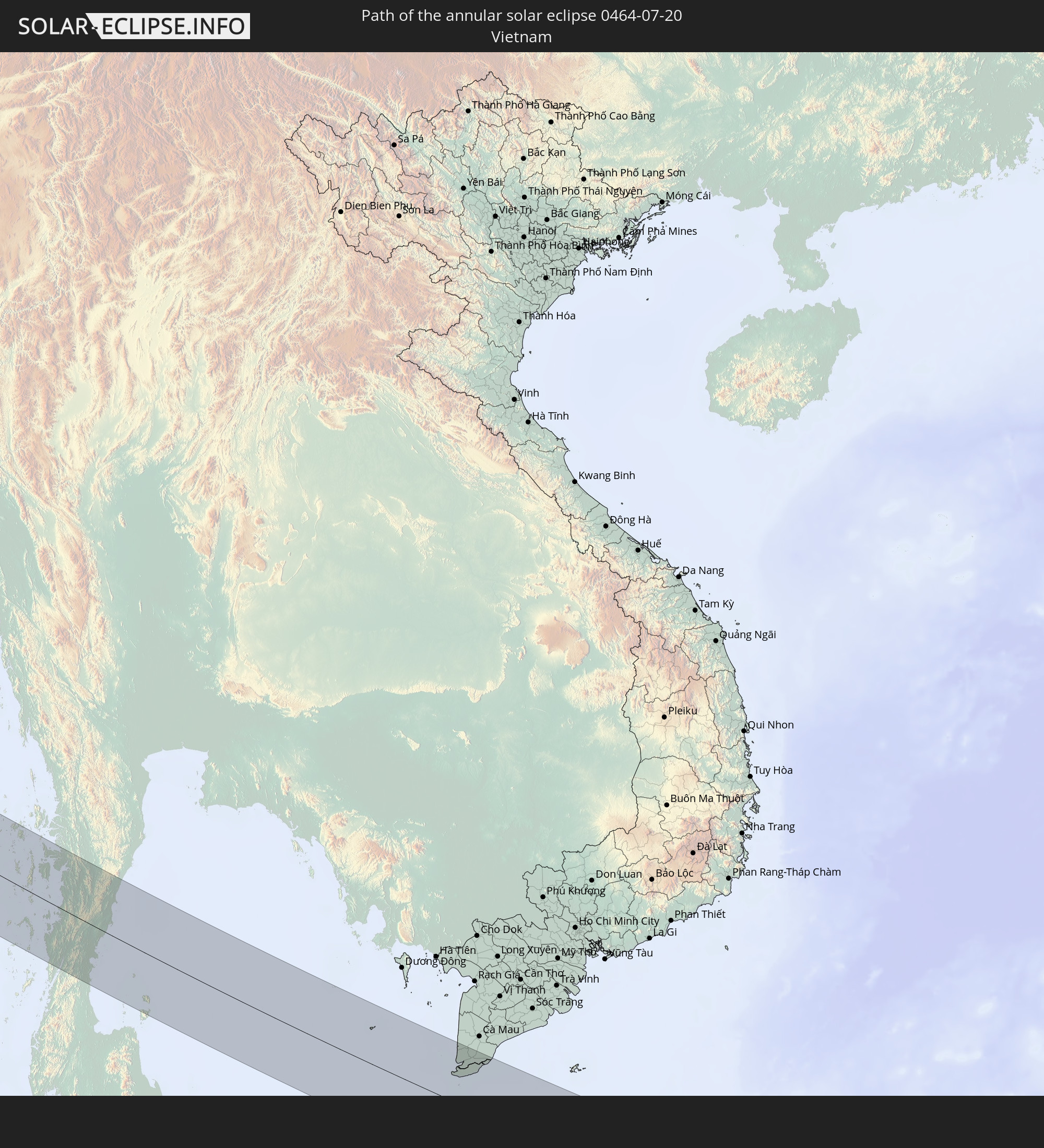 Vietnam
 Cambodia
In den folgenden Ländern ist die Sonnenfinsternis partiell zu sehen
 Russia
 Canada
 Greenland
 Portugal
 Iceland
 Spain
Spain
 Senegal
 Mauritania
 The Gambia
 Guinea-Bissau
 Guinea
 Morocco
 Mali
Mali
 Republic of Ireland
 Svalbard and Jan Mayen
 Algeria
 United Kingdom
 Faroe Islands
 Burkina Faso
 Gibraltar
 France
 Isle of Man
 Guernsey
 Jersey
 Niger
Niger
 Andorra
 Belgium
 Netherlands
 Norway
 Luxembourg
 Germany
 Switzerland
 Italy
Italy
 Monaco
 Tunisia
 Denmark
 Libya
Libya
 Liechtenstein
 Austria
 Sweden
 Czechia
 San Marino
 Vatican City
 Slovenia
 Chad
Chad
 Croatia
 Poland
 Malta
Malta
 Bosnia and Herzegovina
 Hungary
 Slovakia
 Montenegro
 Serbia
 Albania
 Åland Islands
 Greece
 Romania
 Republic of Macedonia
 Finland
 Lithuania
 Latvia
 Estonia
 Sudan
Sudan
 Ukraine
 Bulgaria
 Belarus
 Egypt
Egypt
 Turkey
 Moldova
 Cyprus
 Ethiopia
 State of Palestine
 Israel
 Saudi Arabia
 Jordan
 Lebanon
 Syria
Syria
 Eritrea
 Iraq
Iraq
 Georgia
 Somalia
 Djibouti
 Yemen
Yemen
 Armenia
 Iran
Iran
 Azerbaijan
 Kazakhstan
 Kuwait
 Bahrain
 Qatar
Qatar
 United Arab Emirates
 Oman
Oman
 Turkmenistan
 Uzbekistan
 Afghanistan
 Pakistan
 Tajikistan
 India
India
 Kyrgyzstan
 British Indian Ocean Territory
 Maldives
 China
China
 Sri Lanka
 Nepal
Nepal
 Mongolia
 Bangladesh
 Bhutan
 Myanmar
 Indonesia
 Cocos Islands
 Thailand
 Malaysia
 Laos
Laos
 Vietnam
 Cambodia
 Singapore
 Macau
Macau
 Hong Kong
 Taiwan
 Japan
Japan
 North Korea
 South Korea
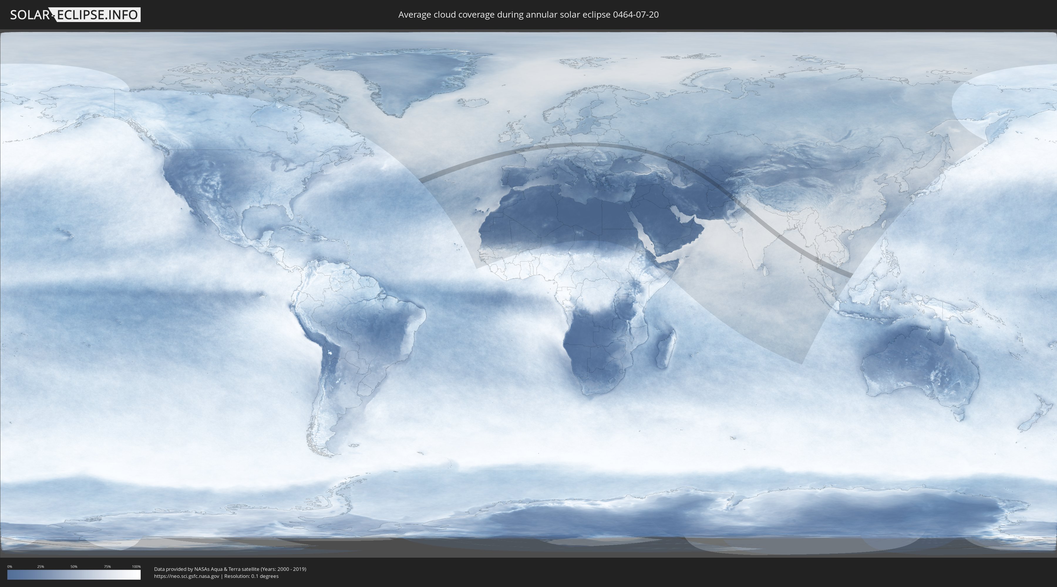
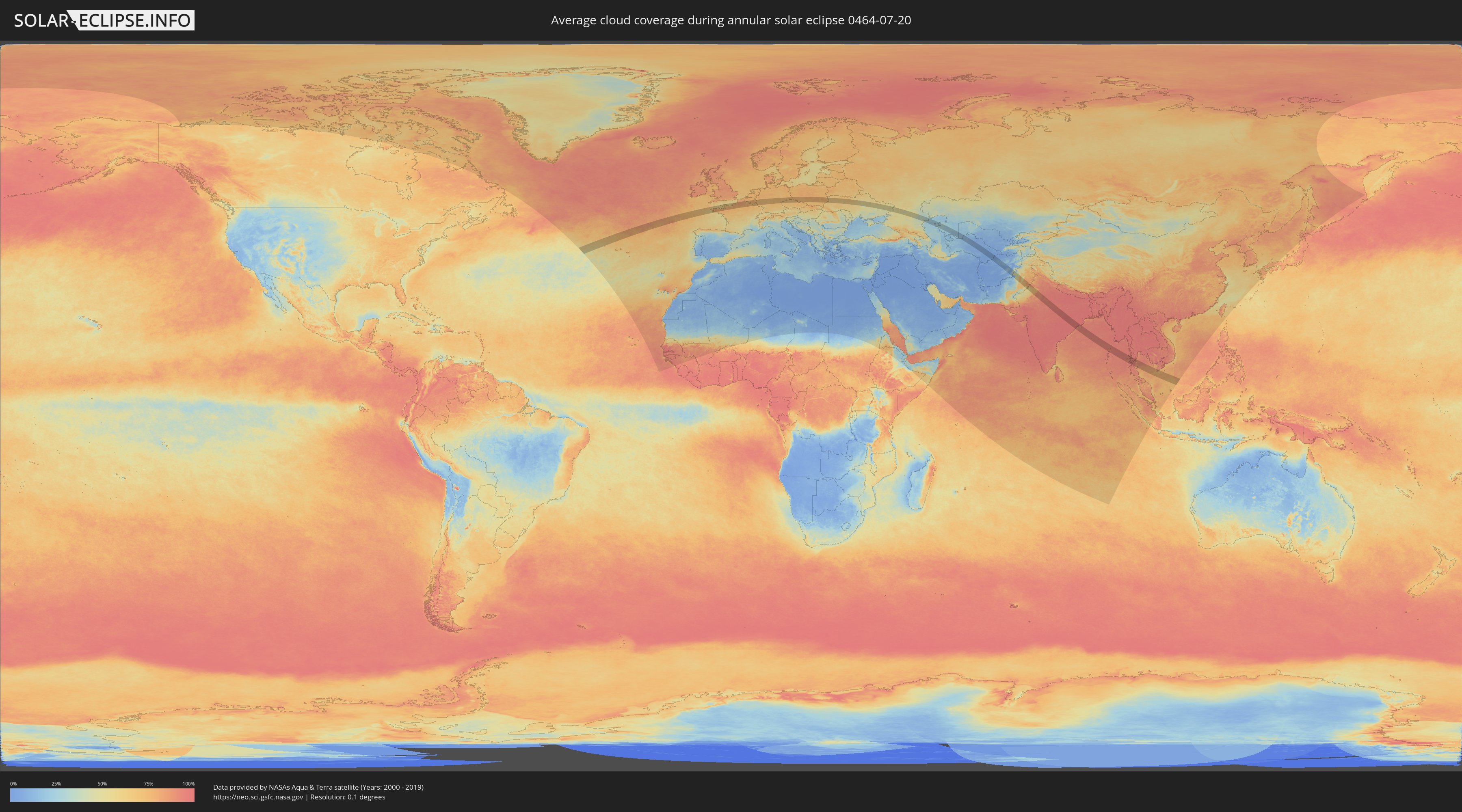
How will be the weather during the annular solar eclipse on 07/20/0464?
Where is the best place to see the annular solar eclipse of 07/20/0464?
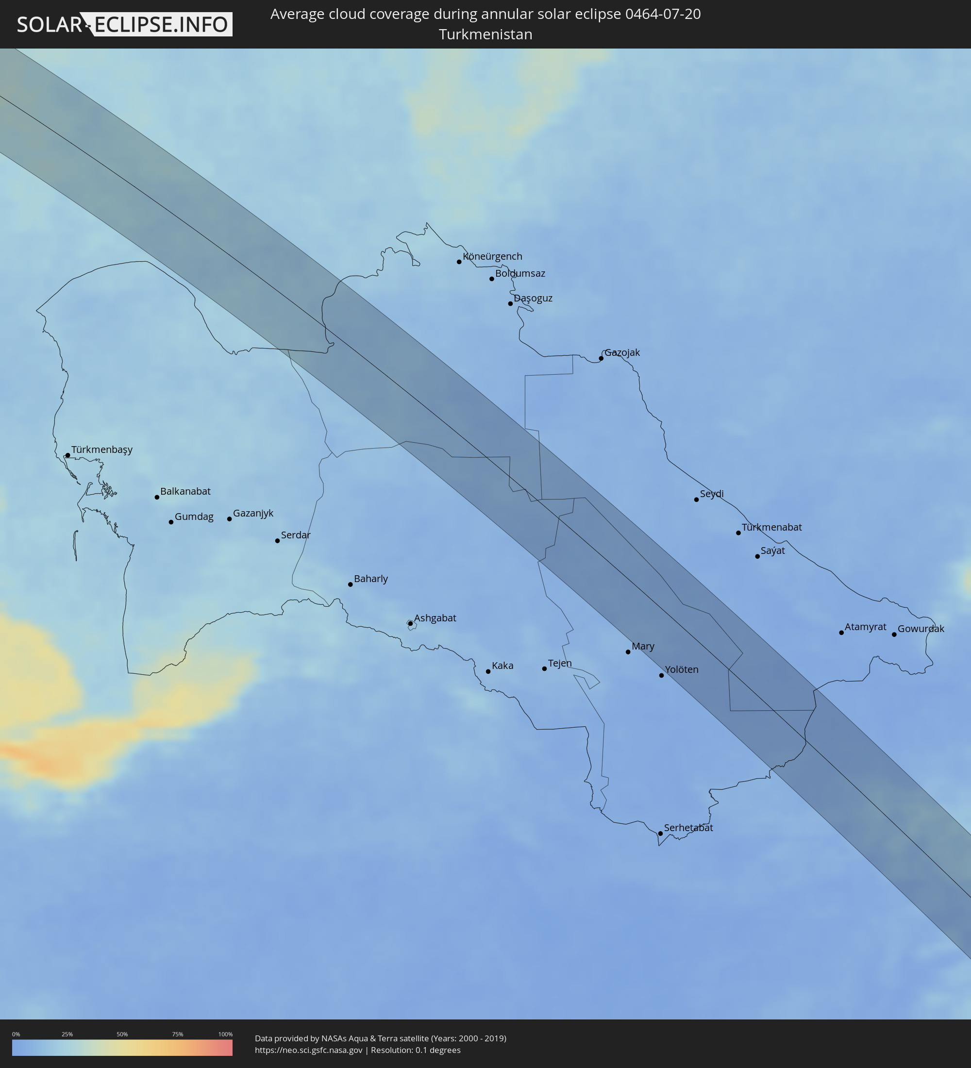
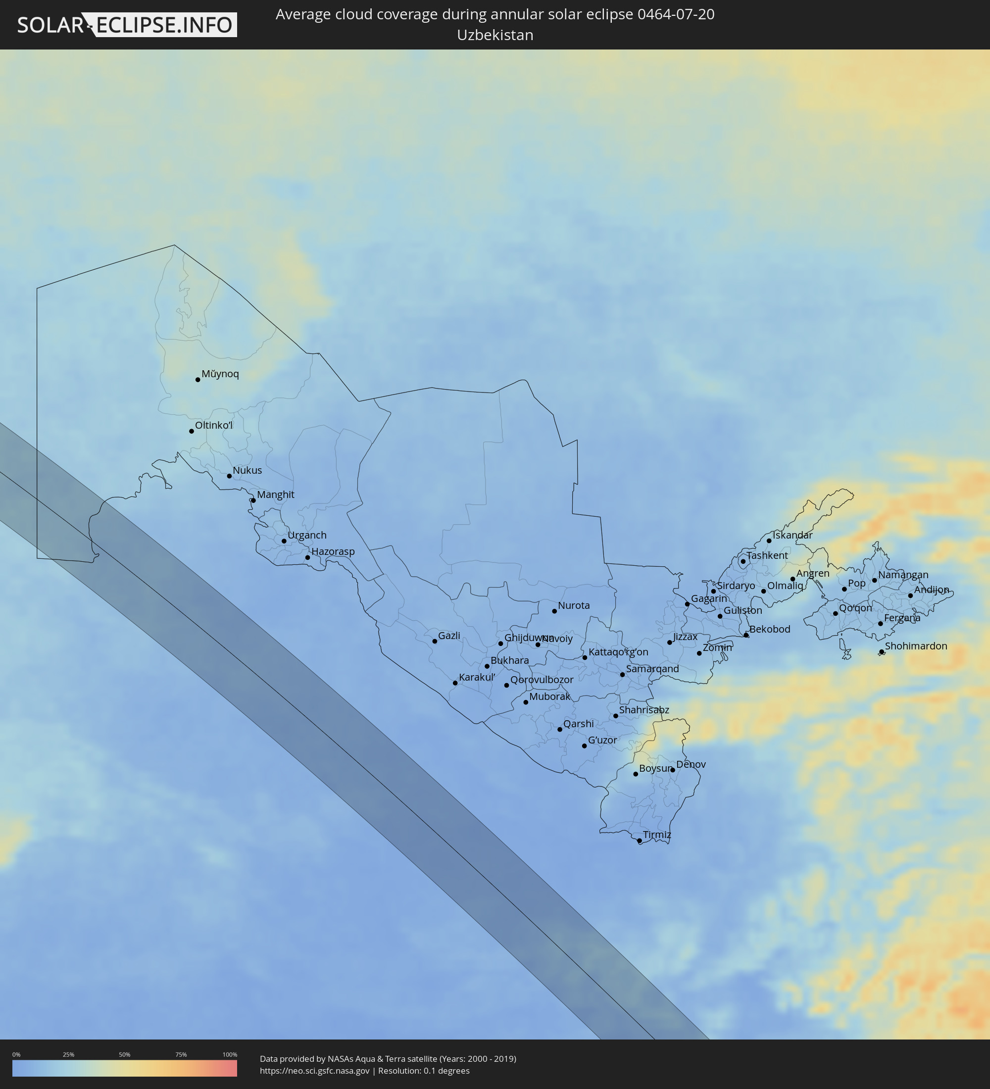
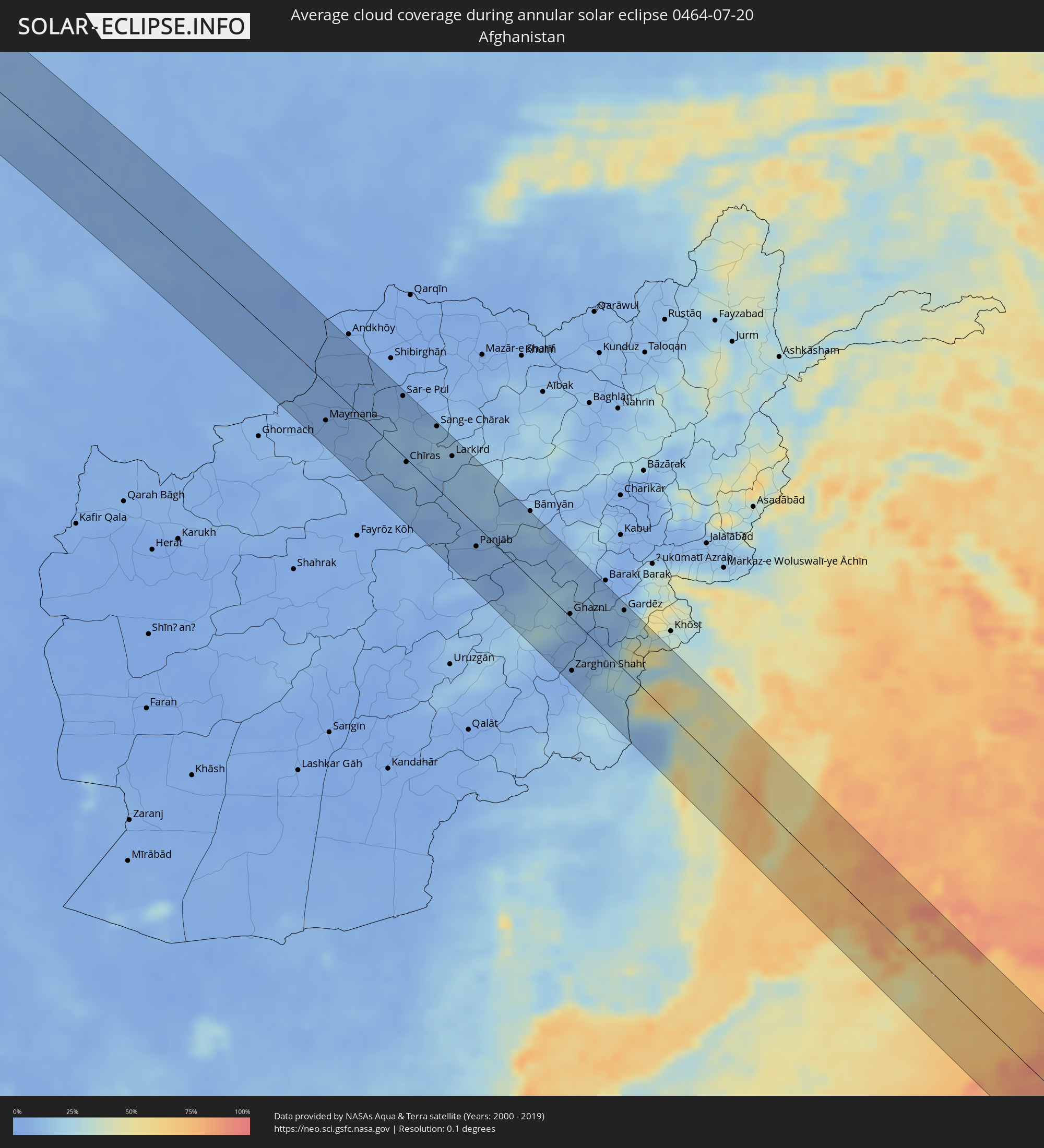
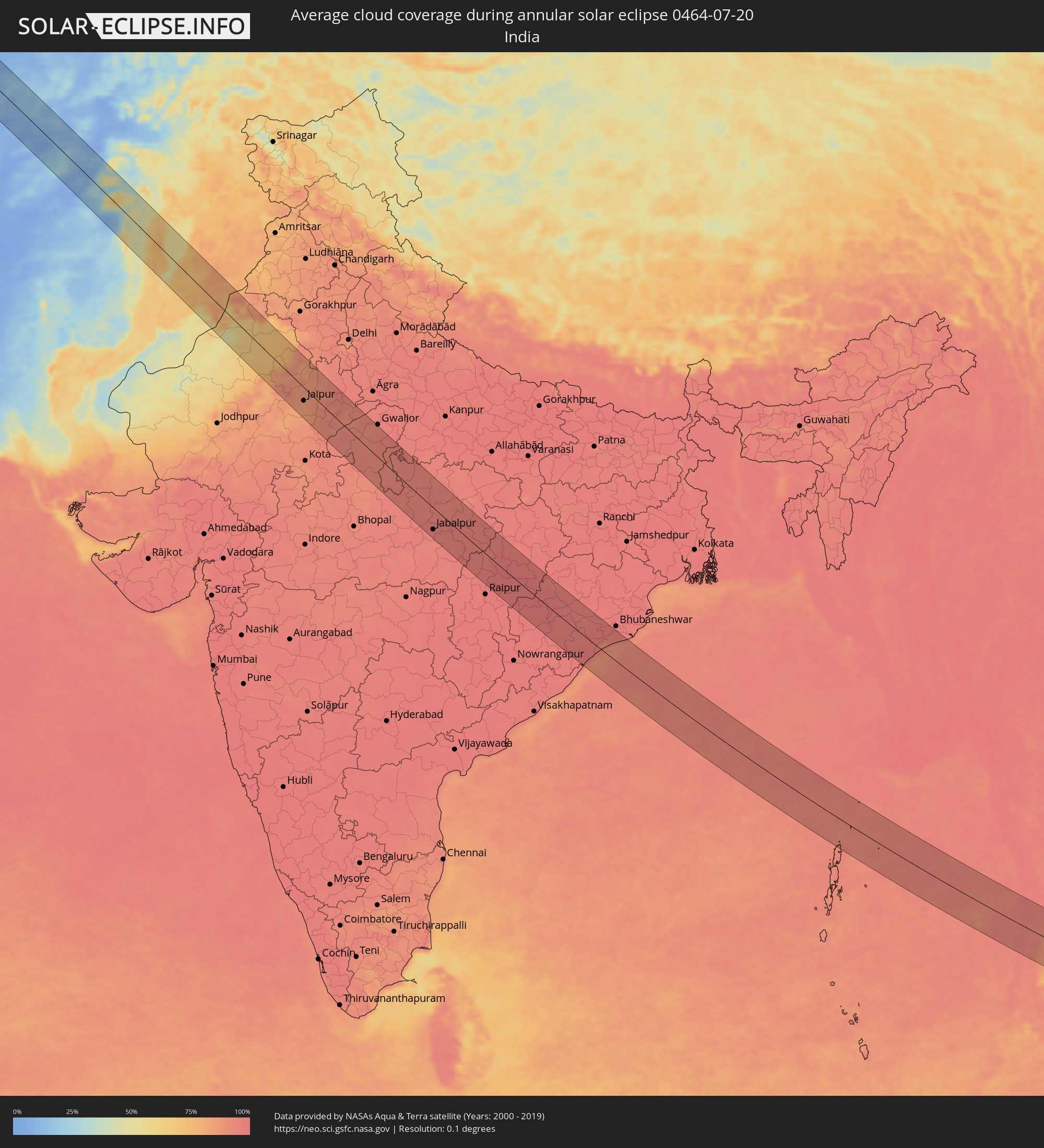
The following maps show the average cloud coverage for the day of the annular solar eclipse.
With the help of these maps, it is possible to find the place along the eclipse path, which has the best
chance of a cloudless sky.
Nevertheless, you should consider local circumstances and inform about the weather of your chosen
observation site.
The data is provided by NASAs satellites
AQUA and TERRA.
The cloud maps are averaged over a period of 19 years (2000 - 2019).
Detailed country maps
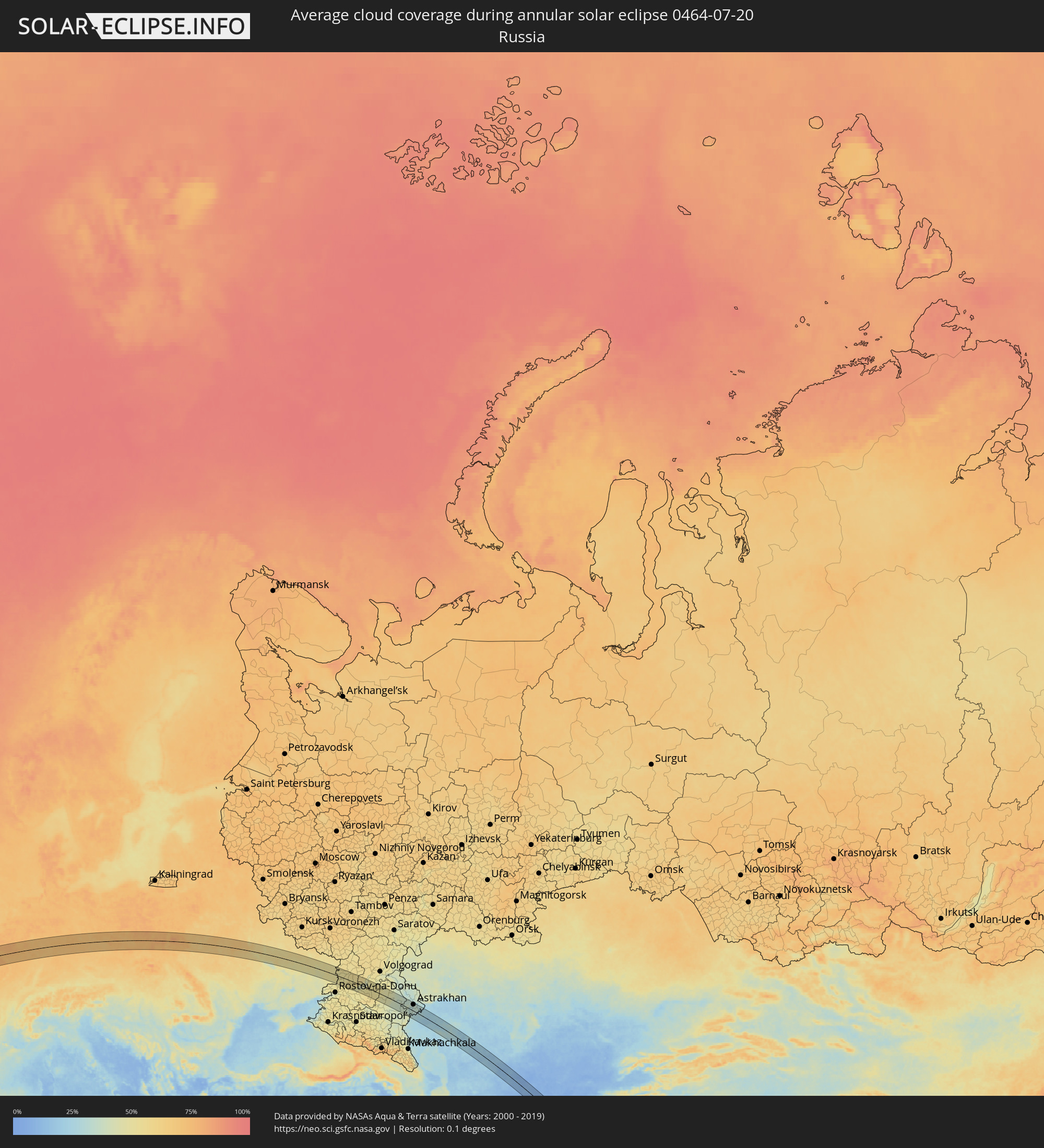 Russia
 Portugal
 France
 Guernsey
 Jersey
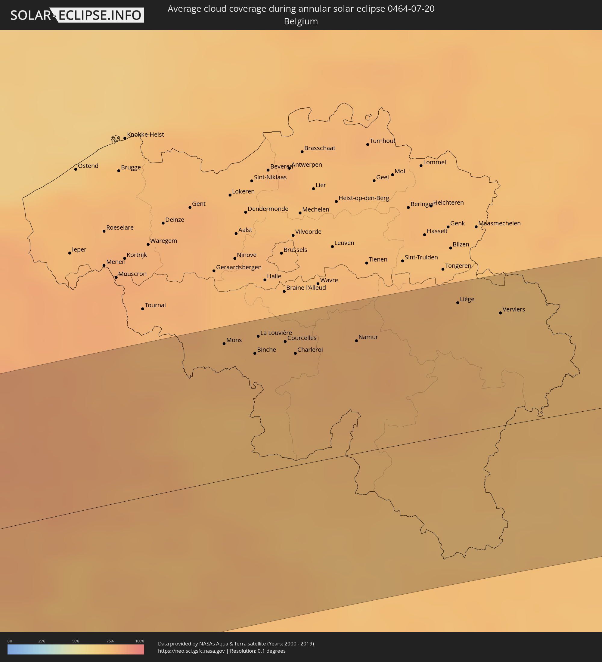 Belgium
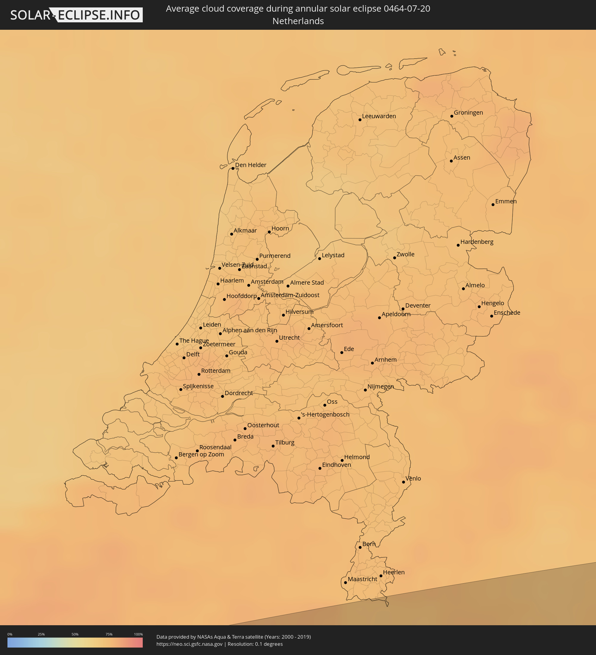 Netherlands
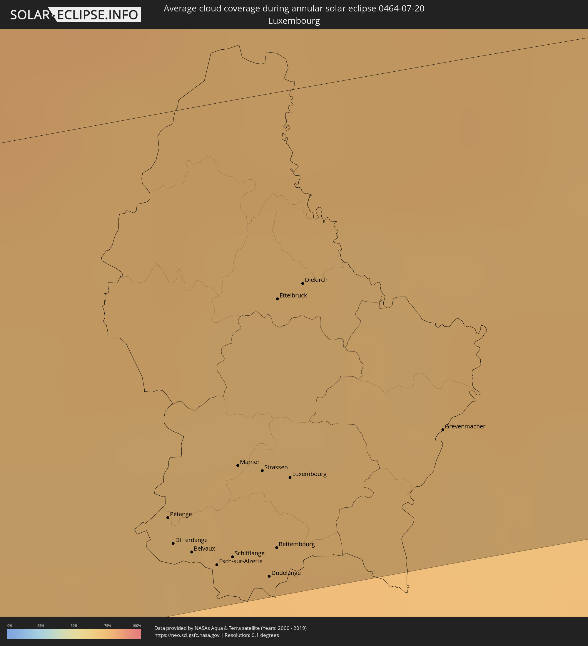 Luxembourg
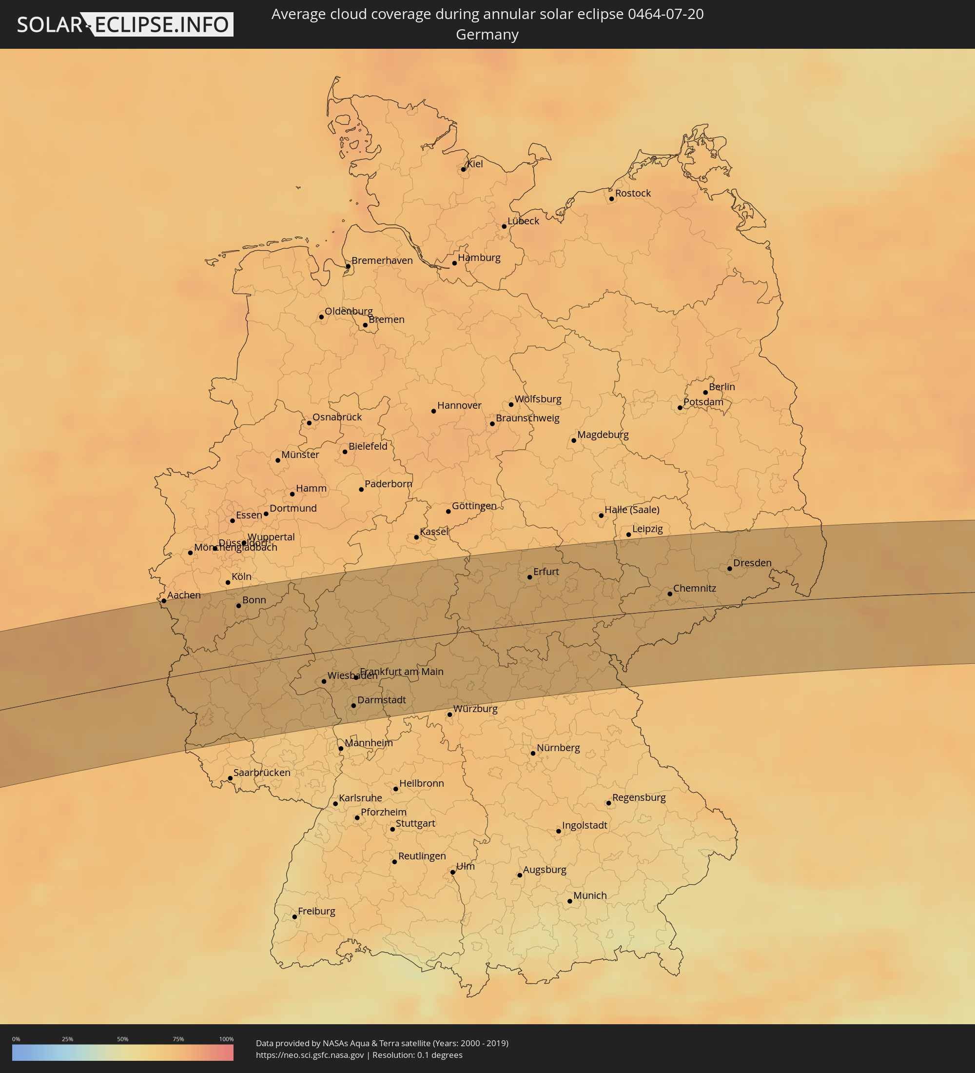 Germany
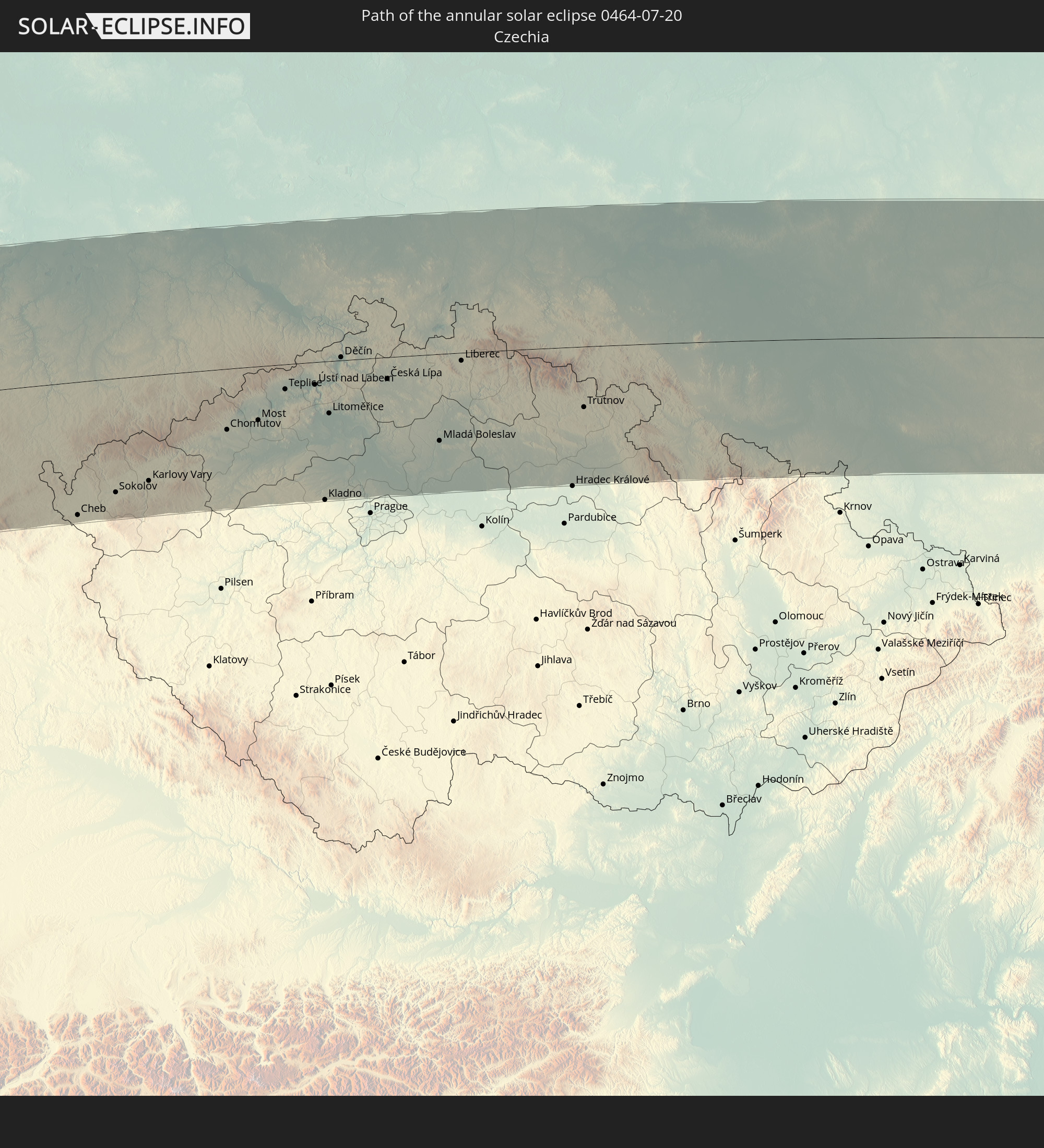
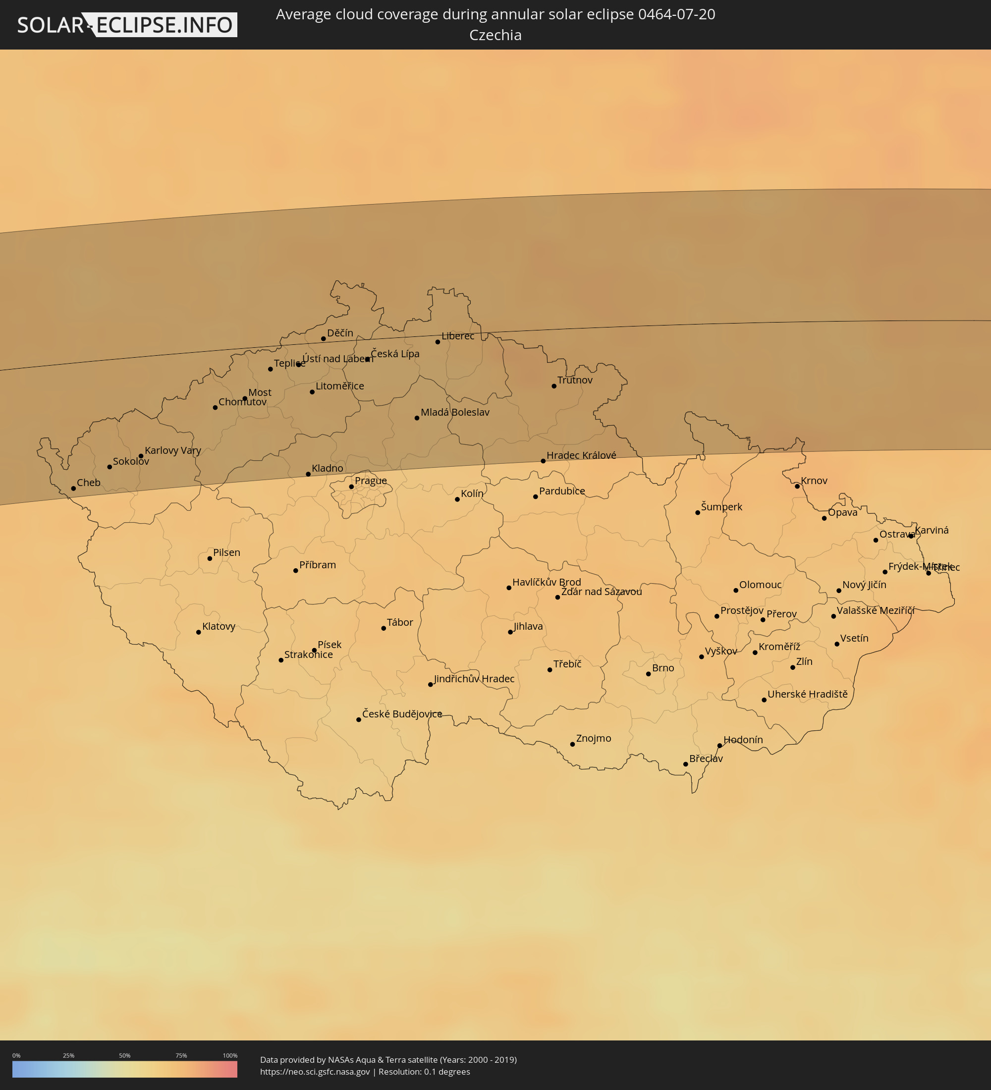 Czechia
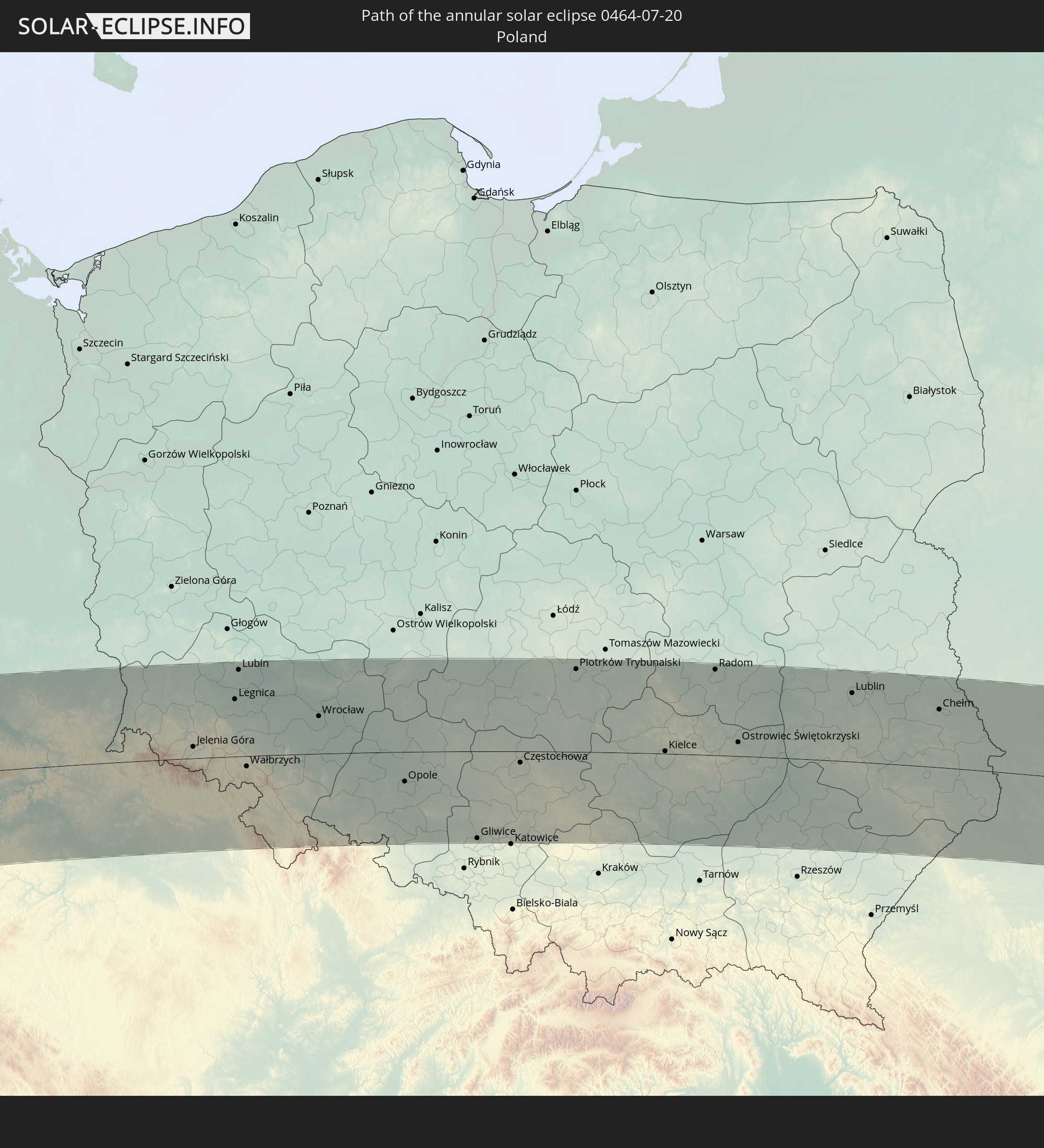
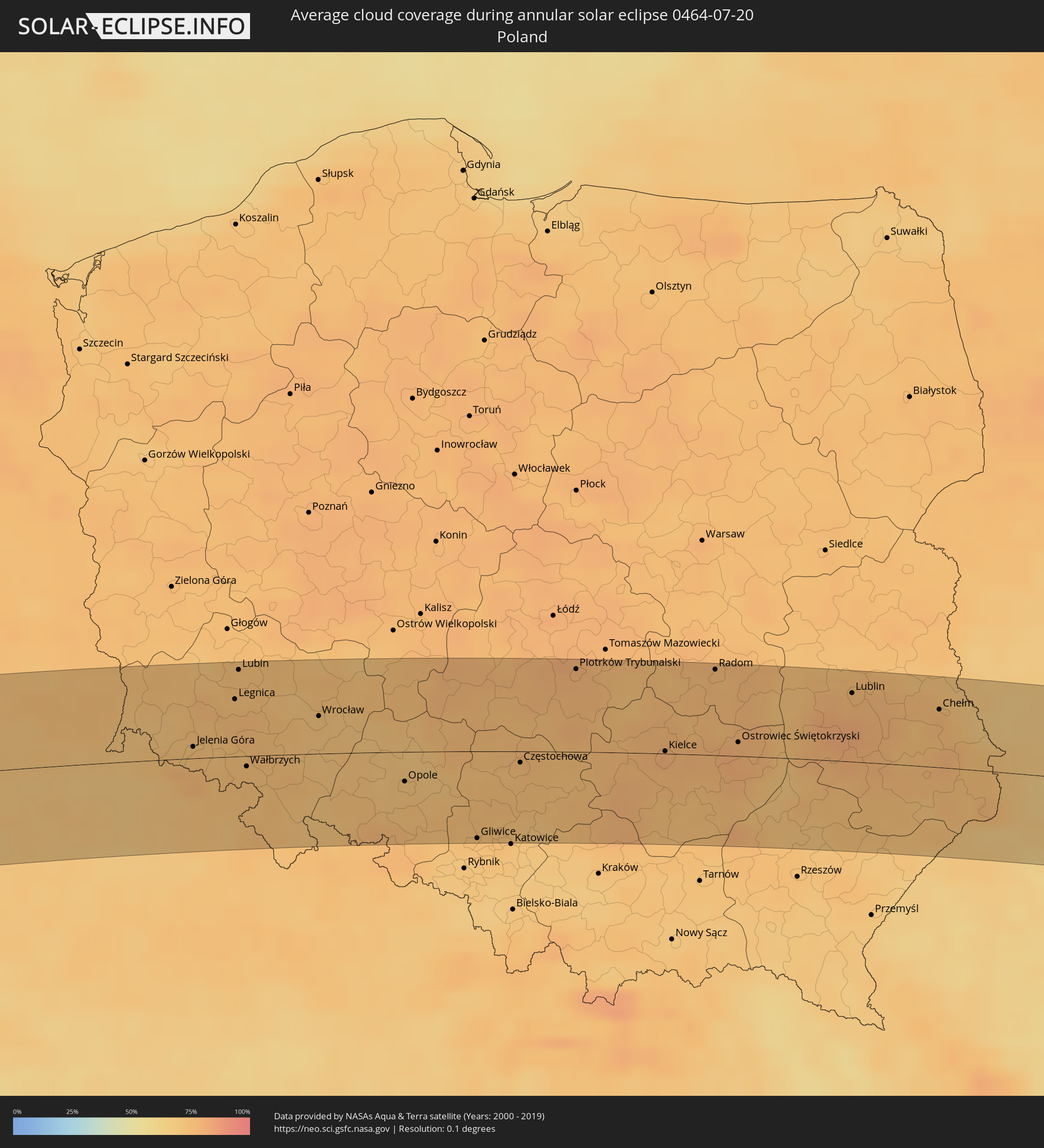 Poland
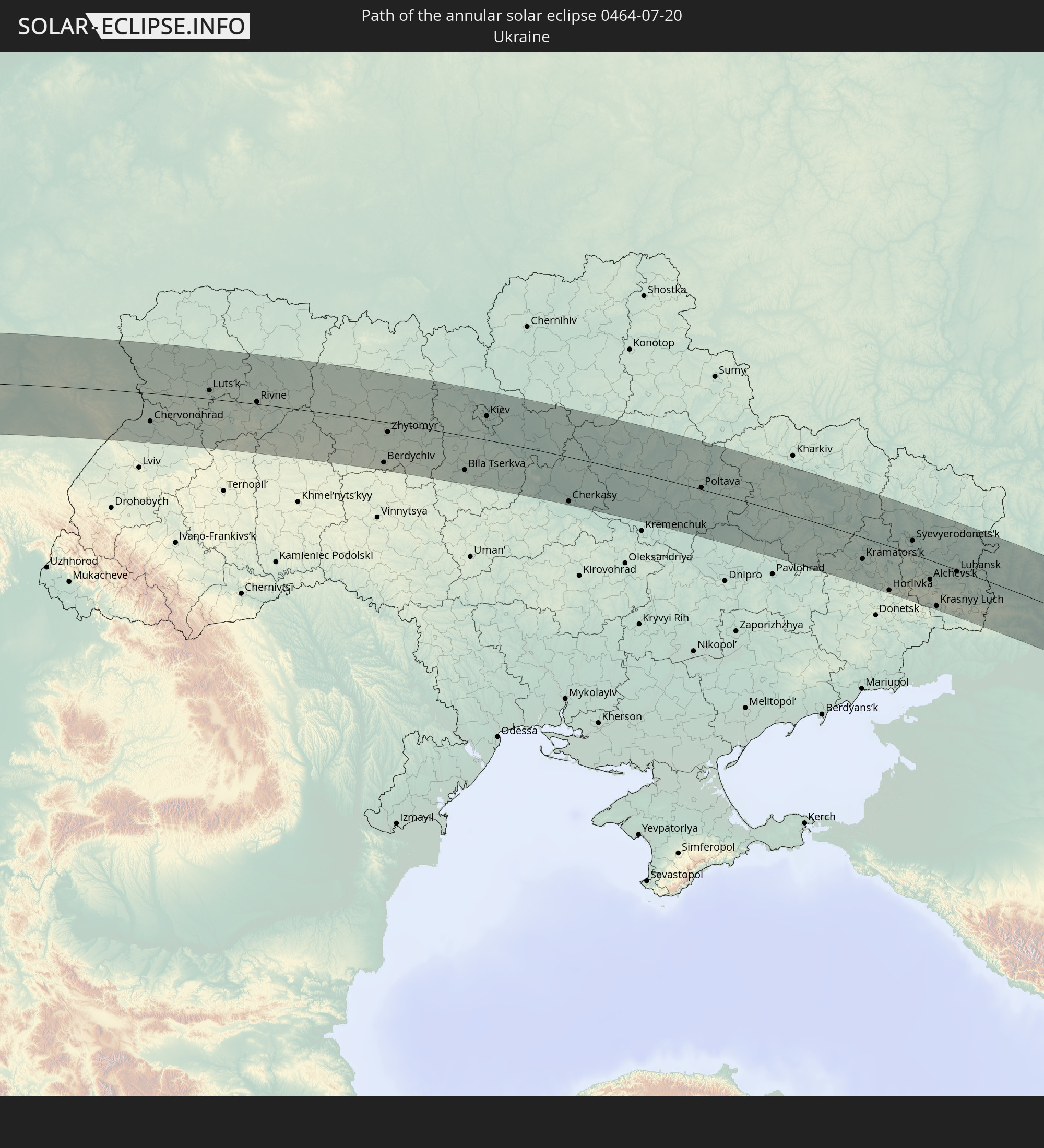
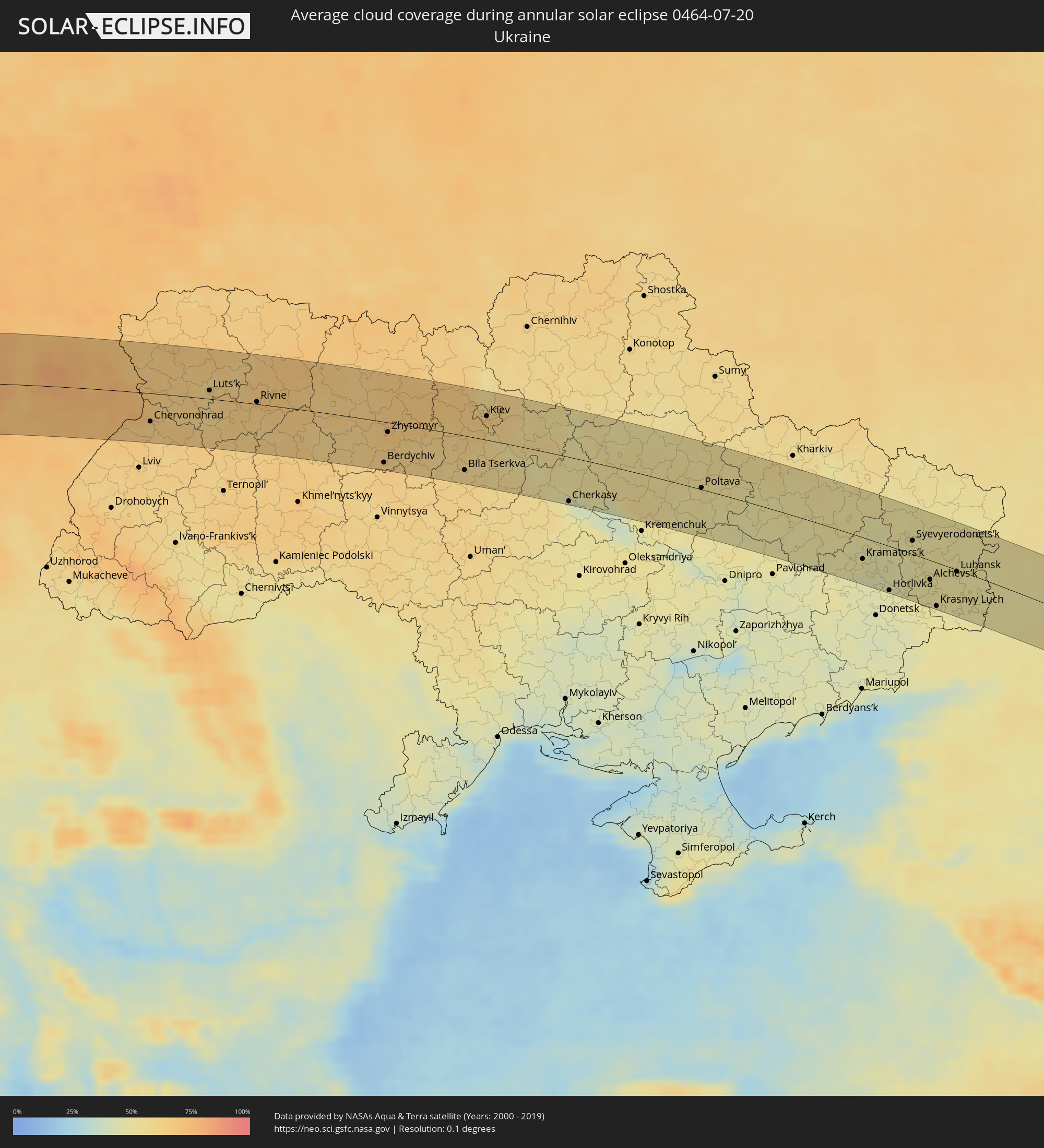 Ukraine
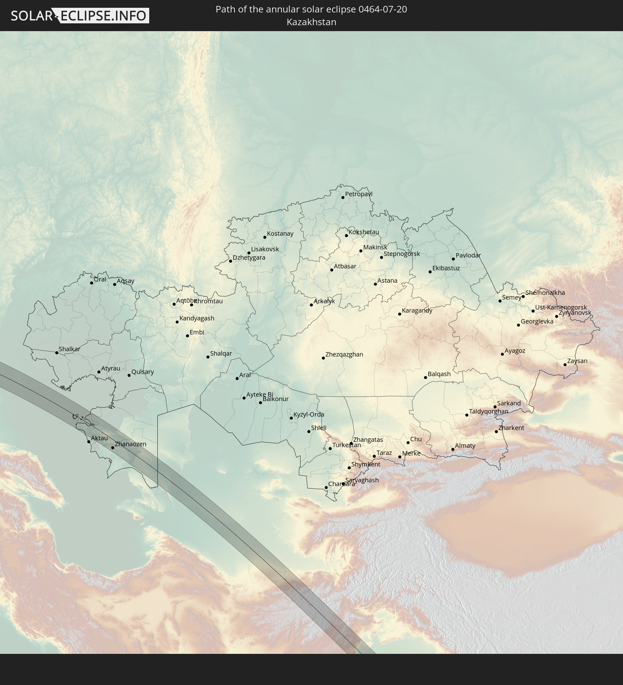
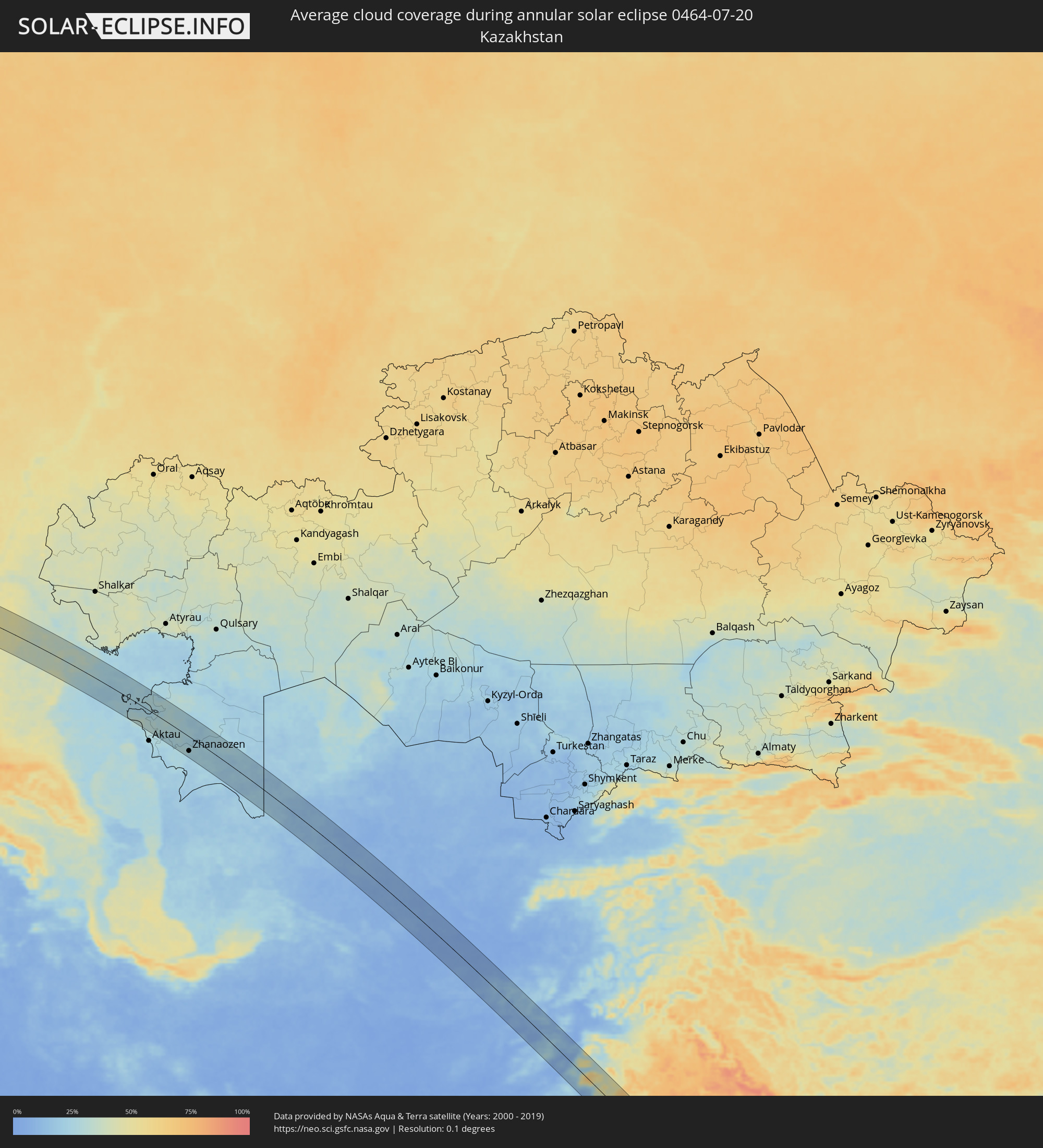 Kazakhstan
 Turkmenistan
 Uzbekistan
 Afghanistan
 Pakistan
 India
India
 Myanmar
 Thailand
 Vietnam
 Cambodia
Cities inside the path of the eclipse
The following table shows all locations with a population of more than 5,000 inside the eclipse path. Cities which have more than 100,000 inhabitants are marked bold. A click at the locations opens a detailed map.
| City | Type | Eclipse duration | Local time of max. eclipse | Distance to central line | Ø Cloud coverage |
|
Brest, Brittany
|
annular | - | 07:45:45 UTC+00:09 | 3 km | 73% |
|
Quimper, Brittany
|
annular | - | 07:45:29 UTC+00:09 | 54 km | 75% |
|
Saint Peter Port, St Peter Port
|
annular | - | 07:38:56 UTC+00:00 | 70 km | 64% |
|
Saint Helier, St Helier
|
annular | - | 07:38:53 UTC+00:00 | 32 km | 64% |
|
Le Hocq, St Clement
|
annular | - | 07:38:53 UTC+00:00 | 29 km | 64% |
|
Caen, Normandy
|
annular | - | 07:49:27 UTC+00:09 | 1 km | 77% |
|
Le Havre, Normandy
|
annular | - | 07:50:10 UTC+00:09 | 24 km | 63% |
|
Rouen, Normandy
|
annular | - | 07:50:51 UTC+00:09 | 1 km | 75% |
|
Évreux, Normandy
|
annular | - | 07:50:24 UTC+00:09 | 45 km | 78% |
|
Cergy-Pontoise, Île-de-France
|
annular | - | 07:51:09 UTC+00:09 | 59 km | 74% |
|
Beauvais, Hauts-de-France
|
annular | - | 07:51:37 UTC+00:09 | 17 km | 78% |
|
Argenteuil, Île-de-France
|
annular | - | 07:51:11 UTC+00:09 | 72 km | 72% |
|
Amiens, Hauts-de-France
|
annular | - | 07:52:21 UTC+00:09 | 31 km | 81% |
|
Saint-Quentin, Hauts-de-France
|
annular | - | 07:53:06 UTC+00:09 | 10 km | 79% |
|
Mons, Wallonia
|
annular | - | 07:45:01 UTC+00:00 | 66 km | 76% |
|
Reims, Grand-Est
|
annular | - | 07:53:03 UTC+00:09 | 67 km | 75% |
|
La Louvière, Wallonia
|
annular | - | 07:45:15 UTC+00:00 | 66 km | 77% |
|
Walcourt, Wallonia
|
annular | - | 07:45:12 UTC+00:00 | 37 km | 76% |
|
Charleroi, Wallonia
|
annular | - | 07:45:24 UTC+00:00 | 54 km | 77% |
|
Gembloux, Wallonia
|
annular | - | 07:45:47 UTC+00:00 | 67 km | 76% |
|
Namur, Wallonia
|
annular | - | 07:45:50 UTC+00:00 | 54 km | 77% |
|
Andenne, Wallonia
|
annular | - | 07:46:03 UTC+00:00 | 54 km | 77% |
|
Ciney, Wallonia
|
annular | - | 07:45:50 UTC+00:00 | 32 km | 77% |
|
Marche-en-Famenne, Wallonia
|
annular | - | 07:45:59 UTC+00:00 | 22 km | 76% |
|
Liège, Wallonia
|
annular | - | 07:46:39 UTC+00:00 | 63 km | 75% |
|
Arlon, Wallonia
|
annular | - | 07:45:49 UTC+00:00 | 44 km | 71% |
|
Verviers, Wallonia
|
annular | - | 07:46:52 UTC+00:00 | 54 km | 72% |
|
Pétange, Luxembourg
|
annular | - | 08:10:20 UTC+00:24 | 59 km | 70% |
|
Differdange, Luxembourg
|
annular | - | 08:10:18 UTC+00:24 | 62 km | 73% |
|
Belvaux, Luxembourg
|
annular | - | 08:10:20 UTC+00:24 | 64 km | 73% |
|
Esch-sur-Alzette, Luxembourg
|
annular | - | 08:10:22 UTC+00:24 | 67 km | 73% |
|
Schifflange, Luxembourg
|
annular | - | 08:10:24 UTC+00:24 | 66 km | 73% |
|
Vaals, Limburg
|
annular | - | 08:06:44 UTC+00:19 | 72 km | 71% |
|
Mamer, Luxembourg
|
annular | - | 08:10:33 UTC+00:24 | 53 km | 72% |
|
Bertrange, Luxembourg
|
annular | - | 08:10:33 UTC+00:24 | 55 km | 73% |
|
Strassen, Luxembourg
|
annular | - | 08:10:35 UTC+00:24 | 54 km | 73% |
|
Aachen, North Rhine-Westphalia
|
annular | - | 08:47:16 UTC+01:00 | 72 km | 72% |
|
Bettembourg, Luxembourg
|
annular | - | 08:10:30 UTC+00:24 | 66 km | 72% |
|
Ettelbruck, Diekirch
|
annular | - | 08:10:52 UTC+00:24 | 30 km | 70% |
|
Luxembourg, Luxembourg
|
annular | - | 08:10:38 UTC+00:24 | 56 km | 73% |
|
Diekirch, Diekirch
|
annular | - | 08:10:56 UTC+00:24 | 28 km | 71% |
|
Bonn, North Rhine-Westphalia
|
annular | - | 08:48:10 UTC+01:00 | 55 km | 73% |
|
Koblenz, Rheinland-Pfalz
|
annular | - | 08:48:14 UTC+01:00 | 8 km | 70% |
|
Siegen, North Rhine-Westphalia
|
annular | - | 08:49:13 UTC+01:00 | 60 km | 71% |
|
Wiesbaden, Hesse
|
annular | - | 08:48:37 UTC+01:00 | 29 km | 70% |
|
Darmstadt, Hesse
|
annular | - | 08:48:48 UTC+01:00 | 57 km | 68% |
|
Frankfurt am Main, Hesse
|
annular | - | 08:49:05 UTC+01:00 | 30 km | 69% |
|
Erfurt, Thuringia
|
annular | - | 08:52:26 UTC+01:00 | 44 km | 72% |
|
Jena, Thuringia
|
annular | - | 08:52:59 UTC+01:00 | 34 km | 74% |
|
Gera, Thuringia
|
annular | - | 08:53:29 UTC+01:00 | 25 km | 73% |
|
Cheb, Karlovarský
|
annular | - | 08:53:04 UTC+01:00 | 66 km | 70% |
|
Sokolov, Karlovarský
|
annular | - | 08:53:28 UTC+01:00 | 56 km | 68% |
|
Karlovy Vary, Karlovarský
|
annular | - | 08:53:47 UTC+01:00 | 52 km | 71% |
|
Chemnitz, Saxony
|
annular | - | 08:54:24 UTC+01:00 | 14 km | 71% |
|
Chomutov, Ústecký
|
annular | - | 08:54:38 UTC+01:00 | 30 km | 69% |
|
Most, Ústecký
|
annular | - | 08:54:55 UTC+01:00 | 26 km | 69% |
|
Dresden, Saxony
|
annular | - | 08:55:32 UTC+01:00 | 34 km | 70% |
|
Ústí nad Labem, Ústecký
|
annular | - | 08:55:32 UTC+01:00 | 11 km | 68% |
|
Kladno, Central Bohemia
|
annular | - | 08:55:10 UTC+01:00 | 68 km | 70% |
|
Děčín, Ústecký
|
annular | - | 08:55:51 UTC+01:00 | 2 km | 70% |
|
Česká Lípa, Liberecký
|
annular | - | 08:56:09 UTC+01:00 | 11 km | 67% |
|
Mladá Boleslav, Central Bohemia
|
annular | - | 08:56:22 UTC+01:00 | 43 km | 69% |
|
Liberec, Liberecký
|
annular | - | 08:56:51 UTC+01:00 | 4 km | 69% |
|
Jelenia Góra, Lower Silesian Voivodeship
|
annular | - | 09:21:47 UTC+01:24 | 8 km | 72% |
|
Trutnov, Královéhradecký
|
annular | - | 08:57:44 UTC+01:00 | 30 km | 73% |
|
Legnica, Lower Silesian Voivodeship
|
annular | - | 09:22:34 UTC+01:24 | 42 km | 74% |
|
Wałbrzych, Lower Silesian Voivodeship
|
annular | - | 09:22:22 UTC+01:24 | 8 km | 73% |
|
Wrocław, Lower Silesian Voivodeship
|
annular | - | 09:23:34 UTC+01:24 | 27 km | 71% |
|
Opole, Opole Voivodeship
|
annular | - | 09:24:24 UTC+01:24 | 22 km | 71% |
|
Gliwice, Silesian Voivodeship
|
annular | - | 09:25:08 UTC+01:24 | 64 km | 71% |
|
Sosnowiec, Silesian Voivodeship
|
annular | - | 09:25:42 UTC+01:24 | 65 km | 70% |
|
Częstochowa, Silesian Voivodeship
|
annular | - | 09:26:04 UTC+01:24 | 8 km | 72% |
|
Piotrków Trybunalski, Łódź Voivodeship
|
annular | - | 09:27:14 UTC+01:24 | 60 km | 77% |
|
Kielce, Świętokrzyskie
|
annular | - | 09:28:09 UTC+01:24 | 2 km | 78% |
|
Radom, Masovian Voivodeship
|
annular | - | 09:29:11 UTC+01:24 | 62 km | 76% |
|
Lublin, Lublin Voivodeship
|
annular | - | 09:31:04 UTC+01:24 | 50 km | 76% |
|
Luts’k, Volyn
|
annular | - | 10:12:58 UTC+02:02 | 11 km | 63% |
|
Rivne, Rivne
|
annular | - | 10:14:15 UTC+02:02 | 3 km | 65% |
|
Zhytomyr, Zhytomyr
|
annular | - | 10:18:00 UTC+02:02 | 13 km | 70% |
|
Bila Tserkva, Kiev
|
annular | - | 10:20:17 UTC+02:02 | 45 km | 61% |
|
Kiev, Kyiv City
|
annular | - | 10:20:59 UTC+02:02 | 31 km | 65% |
|
Cherkasy, Cherkasy
|
annular | - | 10:23:33 UTC+02:02 | 58 km | 46% |
|
Poltava, Poltava
|
annular | - | 10:27:46 UTC+02:02 | 2 km | 56% |
|
Kramators’k, Donetsk
|
annular | - | 10:33:20 UTC+02:02 | 28 km | 48% |
|
Sloviansk, Donetsk
|
annular | - | 10:33:23 UTC+02:02 | 11 km | 48% |
|
Horlivka, Donetsk
|
annular | - | 10:34:25 UTC+02:02 | 57 km | 46% |
|
Syevyerodonets’k, Luhansk
|
annular | - | 10:34:54 UTC+02:02 | 18 km | 50% |
|
Luhansk, Luhansk
|
annular | - | 10:36:35 UTC+02:02 | 2 km | 50% |
|
Gukovo, Rostov Oblast
|
annular | - | 11:06:13 UTC+02:30 | 39 km | 49% |
|
Donetsk, Rostov Oblast
|
annular | - | 11:06:04 UTC+02:30 | 10 km | 49% |
|
Krasnyy Sulin, Rostov Oblast
|
annular | - | 11:06:34 UTC+02:30 | 53 km | 49% |
|
Kamensk-Shakhtinskiy, Rostov Oblast
|
annular | - | 11:06:39 UTC+02:30 | 4 km | 51% |
|
Belaya Kalitva, Rostov Oblast
|
annular | - | 11:07:40 UTC+02:30 | 4 km | 49% |
|
Konstantinovsk, Rostov Oblast
|
annular | - | 11:08:40 UTC+02:30 | 57 km | 51% |
|
Morozovsk, Rostov Oblast
|
annular | - | 11:09:27 UTC+02:30 | 43 km | 55% |
|
Tsimlyansk, Rostov Oblast
|
annular | - | 11:10:29 UTC+02:30 | 22 km | 44% |
|
Volgodonsk, Rostov Oblast
|
annular | - | 11:10:41 UTC+02:30 | 34 km | 49% |
|
Kotel’nikovo, Volgograd
|
annular | - | 11:12:25 UTC+02:30 | 7 km | 51% |
|
Astrakhan, Astrakhan
|
annular | - | 12:12:46 UTC+03:20 | 46 km | 33% |
|
Kamyzyak, Astrakhan
|
annular | - | 12:13:07 UTC+03:20 | 24 km | 34% |
|
Fort-Shevchenko, Mangghystaū
|
annular | - | 12:24:21 UTC+03:25 | 44 km | 29% |
|
Zhetibay, Mangghystaū
|
annular | - | 12:29:04 UTC+03:25 | 52 km | 25% |
|
Shetpe, Mangghystaū
|
annular | - | 12:28:16 UTC+03:25 | 3 km | 27% |
|
Zhanaozen, Mangghystaū
|
annular | - | 12:30:55 UTC+03:25 | 40 km | 23% |
|
Bayramaly, Mary
|
annular | - | 13:25:55 UTC+03:53 | 54 km | 5% |
|
Maymana, Faryab
|
annular | - | 13:40:00 UTC+04:00 | 37 km | 5% |
|
Darzāb, Jowzjan
|
annular | - | 13:40:47 UTC+04:00 | 5 km | 8% |
|
Qal‘ah-ye Shahr, Sar-e Pol
|
annular | - | 13:41:58 UTC+04:00 | 18 km | 10% |
|
Sar-e Pul, Sar-e Pol
|
annular | - | 13:41:06 UTC+04:00 | 58 km | 6% |
|
Chīras, Sar-e Pol
|
annular | - | 13:42:51 UTC+04:00 | 3 km | 13% |
|
Tagāw-Bāy, Sar-e Pol
|
annular | - | 13:42:22 UTC+04:00 | 25 km | 10% |
|
Sang-e Chārak, Sar-e Pol
|
annular | - | 13:42:36 UTC+04:00 | 60 km | 17% |
|
Larkird, Sar-e Pol
|
annular | - | 13:43:41 UTC+04:00 | 45 km | 14% |
|
Panjāb, Bamyan
|
annular | - | 13:46:32 UTC+04:00 | 20 km | 5% |
|
Ghazni, Ghazni
|
annular | - | 13:50:15 UTC+04:00 | 3 km | 13% |
|
Zarghūn Shahr, Paktika
|
annular | - | 13:51:48 UTC+04:00 | 52 km | 3% |
|
Gardēz, Paktia
|
annular | - | 13:51:14 UTC+04:00 | 59 km | 11% |
|
Dera Ismāīl Khān, Khyber Pakhtunkhwa
|
annular | - | 14:25:20 UTC+04:28 | 30 km | 67% |
|
Layyah, Punjab
|
annular | - | 14:27:14 UTC+04:28 | 37 km | 68% |
|
Bhakkar, Punjab
|
annular | - | 14:25:58 UTC+04:28 | 24 km | 72% |
|
Multān, Punjab
|
annular | - | 14:29:30 UTC+04:28 | 62 km | 67% |
|
Vihāri, Punjab
|
annular | - | 14:30:52 UTC+04:28 | 16 km | 74% |
|
Hāsilpur, Punjab
|
annular | - | 14:31:47 UTC+04:28 | 27 km | 72% |
|
Kamālia, Punjab
|
annular | - | 14:29:45 UTC+04:28 | 60 km | 77% |
|
Būrewāla, Punjab
|
annular | - | 14:30:56 UTC+04:28 | 15 km | 81% |
|
Chīchāwatni, Punjab
|
annular | - | 14:30:13 UTC+04:28 | 47 km | 79% |
|
Chishtiān Mandi, Punjab
|
annular | - | 14:31:57 UTC+04:28 | 1 km | 78% |
|
Ārifwāla, Punjab
|
annular | - | 14:31:09 UTC+04:28 | 54 km | 81% |
|
Bahāwalnagar, Punjab
|
annular | - | 14:31:58 UTC+04:28 | 43 km | 77% |
|
Sūjāngarh, Rajasthan
|
annular | - | 15:31:02 UTC+05:21 | 58 km | 77% |
|
Sīkar, Rajasthan
|
annular | - | 15:31:54 UTC+05:21 | 19 km | 85% |
|
Jaipur, Rajasthan
|
annular | - | 15:33:57 UTC+05:21 | 30 km | 84% |
|
Shivpuri, Madhya Pradesh
|
annular | - | 15:38:41 UTC+05:21 | 23 km | 94% |
|
Jhānsi, Uttar Pradesh
|
annular | - | 15:39:24 UTC+05:21 | 42 km | 94% |
|
Jabalpur, Madhya Pradesh
|
annular | - | 15:44:56 UTC+05:21 | 53 km | 96% |
|
Murwāra, Madhya Pradesh
|
annular | - | 15:43:59 UTC+05:21 | 33 km | 93% |
|
Bilāspur, Chhattisgarh
|
annular | - | 15:48:30 UTC+05:21 | 4 km | 98% |
|
Korba, Chhattisgarh
|
annular | - | 15:48:21 UTC+05:21 | 63 km | 98% |
|
Sambalpur, Odisha
|
annular | - | 15:50:43 UTC+05:21 | 73 km | 97% |
|
Brahmapur, Odisha
|
annular | - | 15:54:56 UTC+05:21 | 59 km | 95% |
|
Puri, Odisha
|
annular | - | 15:54:37 UTC+05:21 | 50 km | 92% |
|
Chumphon, Chumphon
|
annular | - | 17:31:49 UTC+06:42 | 37 km | 94% |
|
Bang Saphan, Prachuap Khiri Khan
|
annular | - | 17:30:56 UTC+06:42 | 51 km | 94% |
|
Ko Pha Ngan, Nakhon Si Thammarat
|
annular | - | 17:32:38 UTC+06:42 | 67 km | 82% |