Annular solar eclipse of 09/01/0536
| Day of week: | Saturday |
| Maximum duration of eclipse: | 04m54s |
| Maximum width of eclipse path: | 258 km |
| Saros cycle: | 82 |
| Coverage: | 94.7% |
| Magnitude: | 0.9466 |
| Gamma: | 0.664 |
Wo kann man die Sonnenfinsternis vom 09/01/0536 sehen?
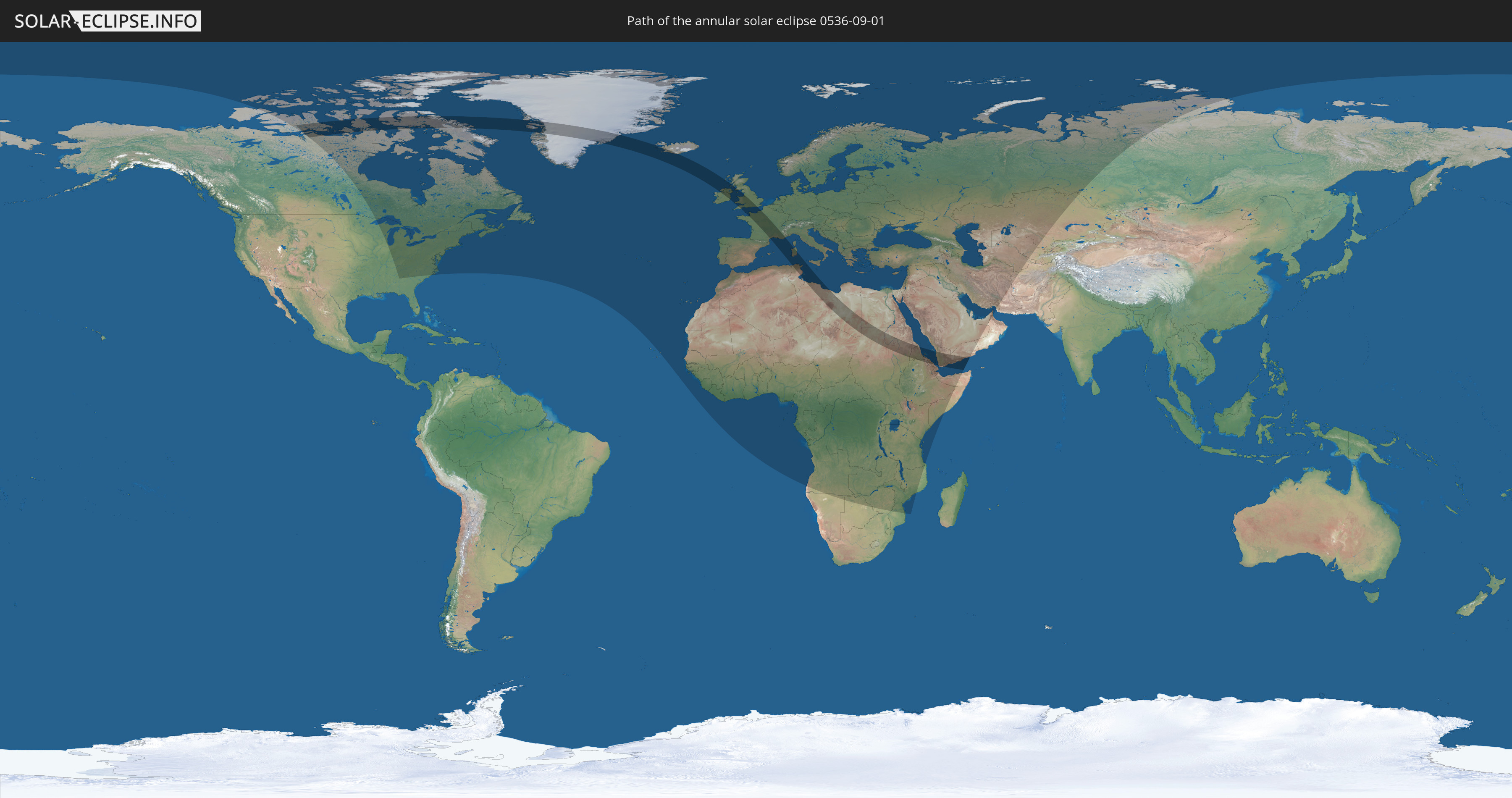
Die Sonnenfinsternis am 09/01/0536 kann man in 124 Ländern als partielle Sonnenfinsternis beobachten.
Der Finsternispfad verläuft durch 19 Länder. Nur in diesen Ländern ist sie als annular Sonnenfinsternis zu sehen.
In den folgenden Ländern ist die Sonnenfinsternis annular zu sehen
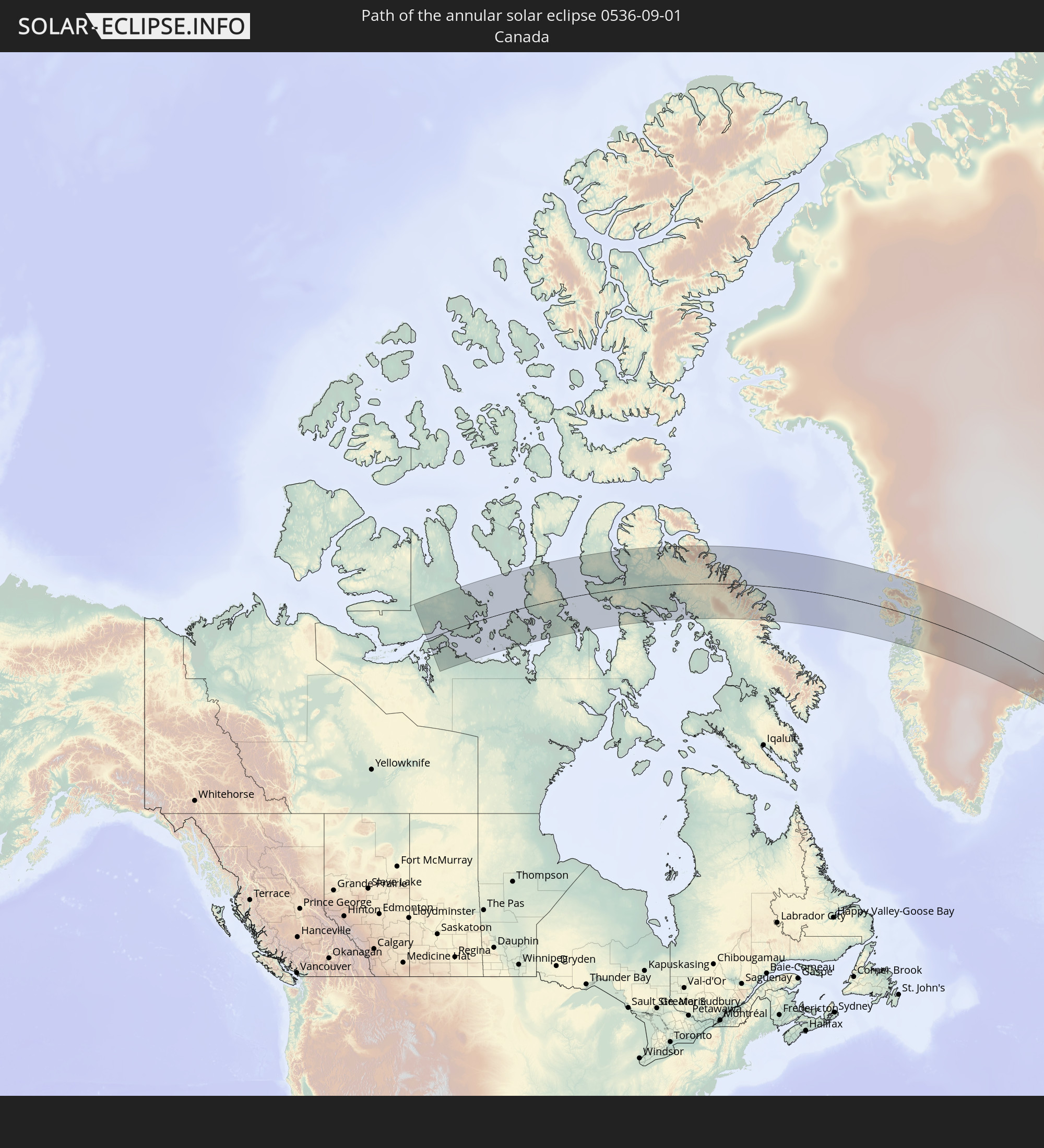 Canada
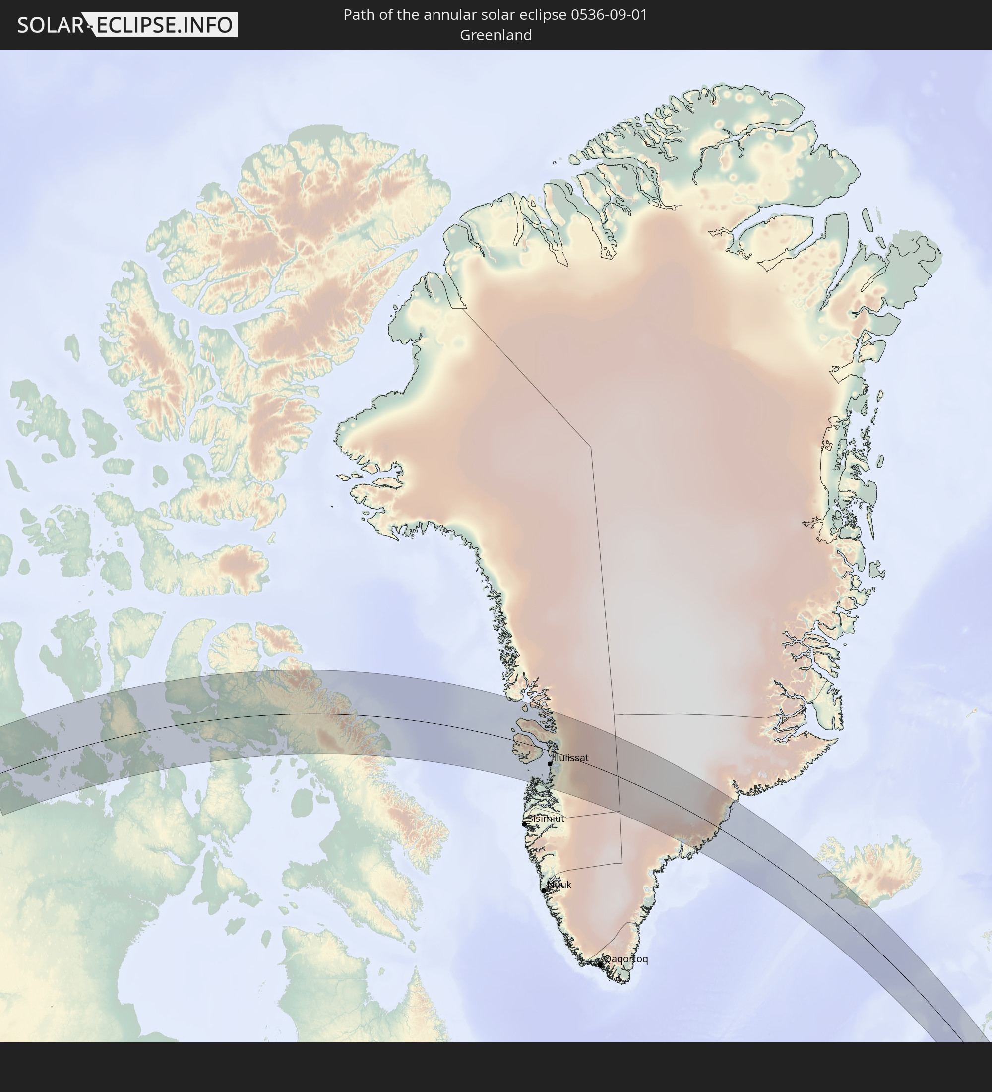 Greenland
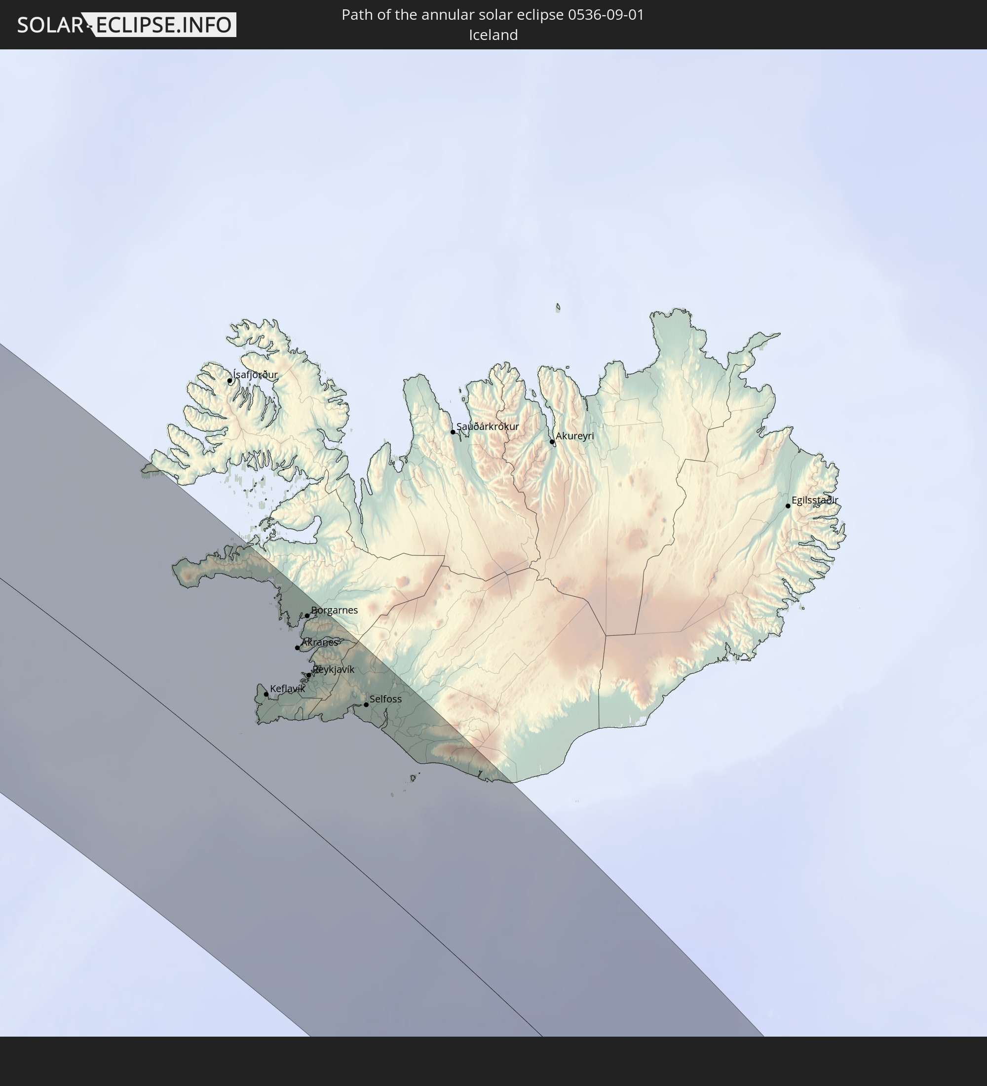 Iceland
 Republic of Ireland
 Algeria
 United Kingdom
 France
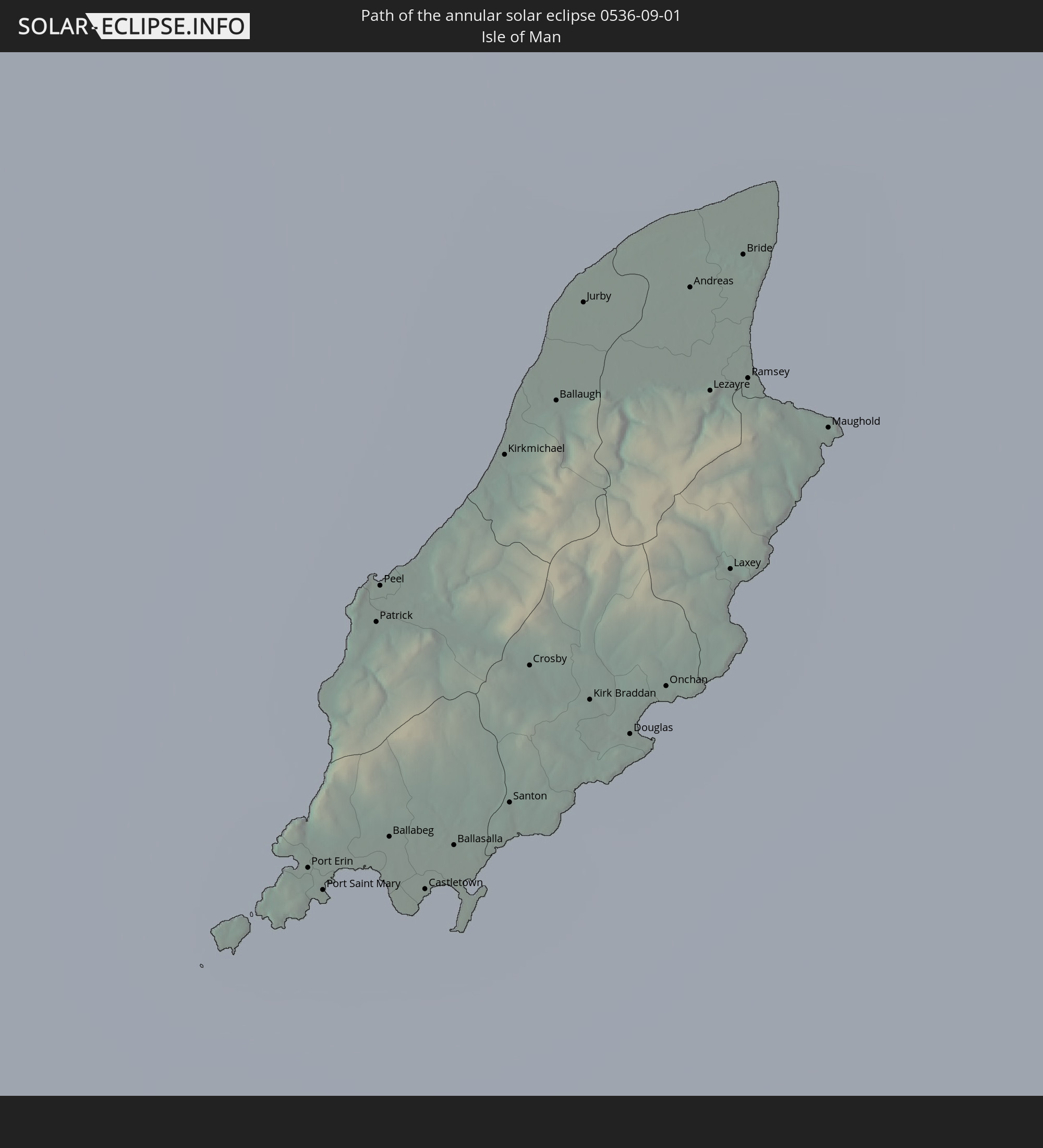 Isle of Man
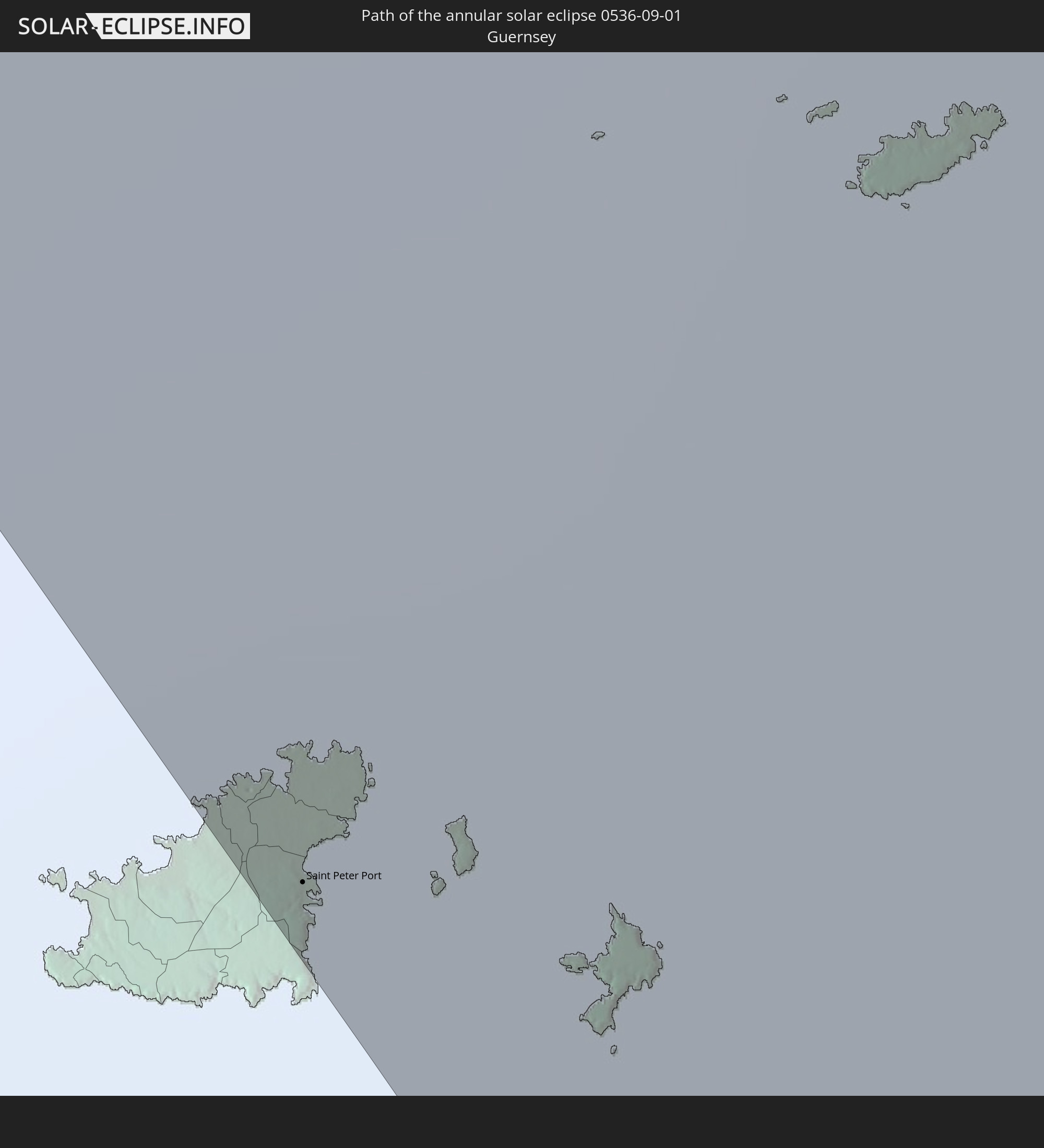 Guernsey
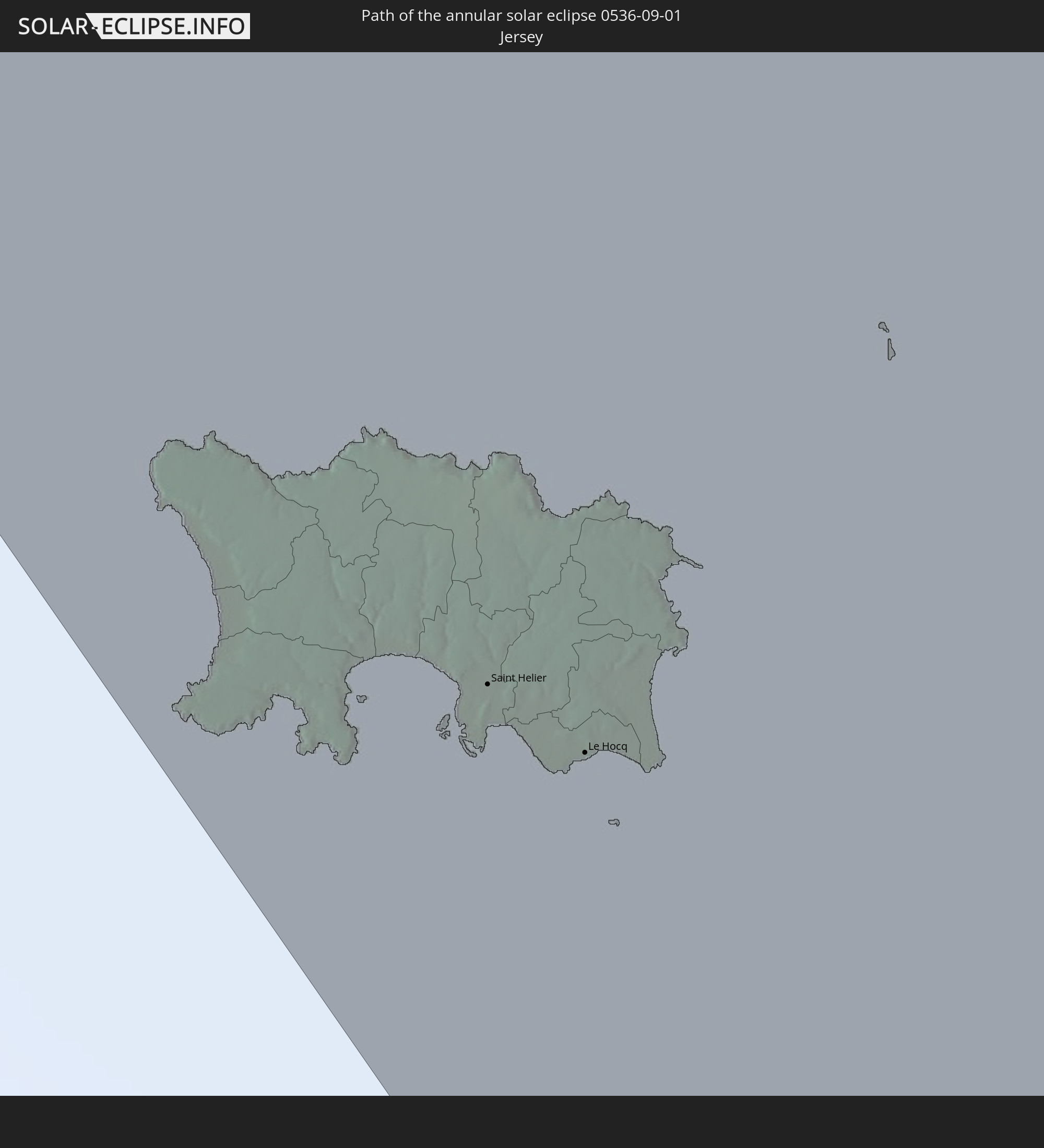 Jersey
 Italy
Italy
 Tunisia
 Libya
Libya
 Sudan
Sudan
 Egypt
Egypt
 Ethiopia
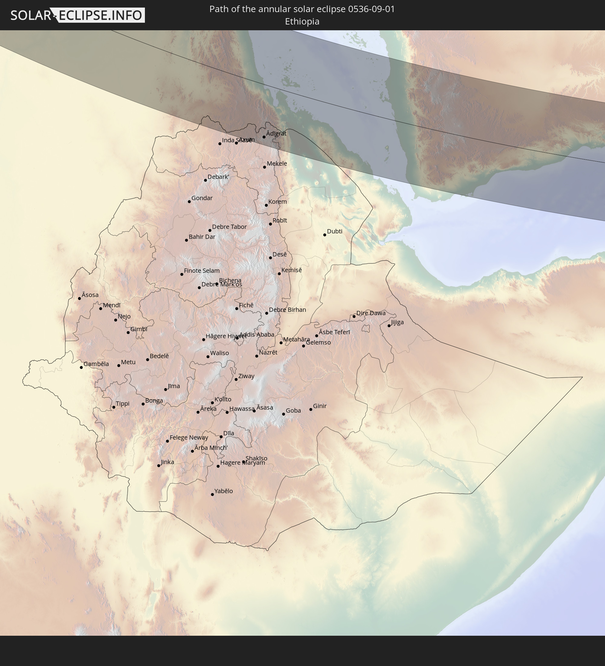
 Saudi Arabia
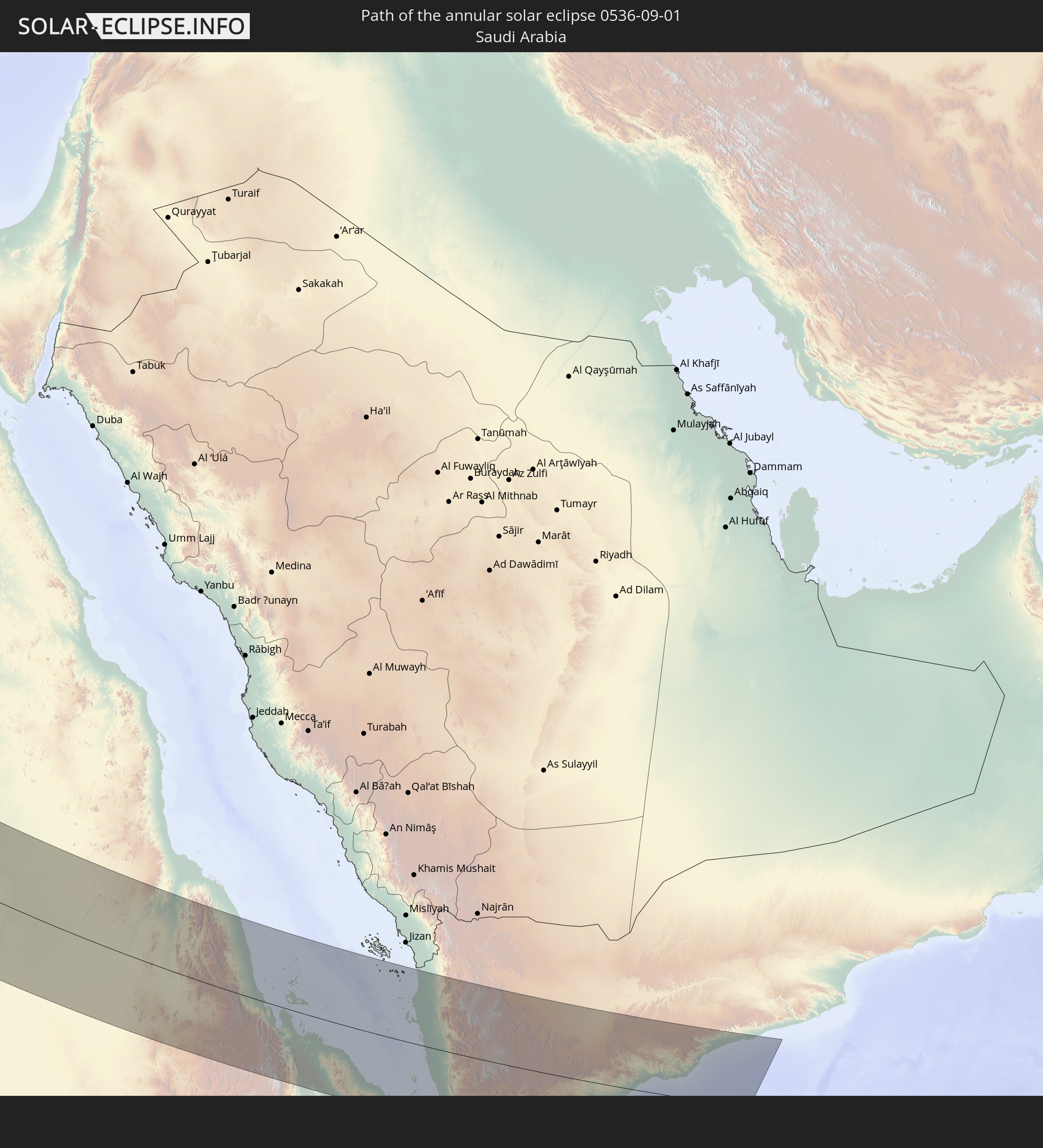
 Eritrea
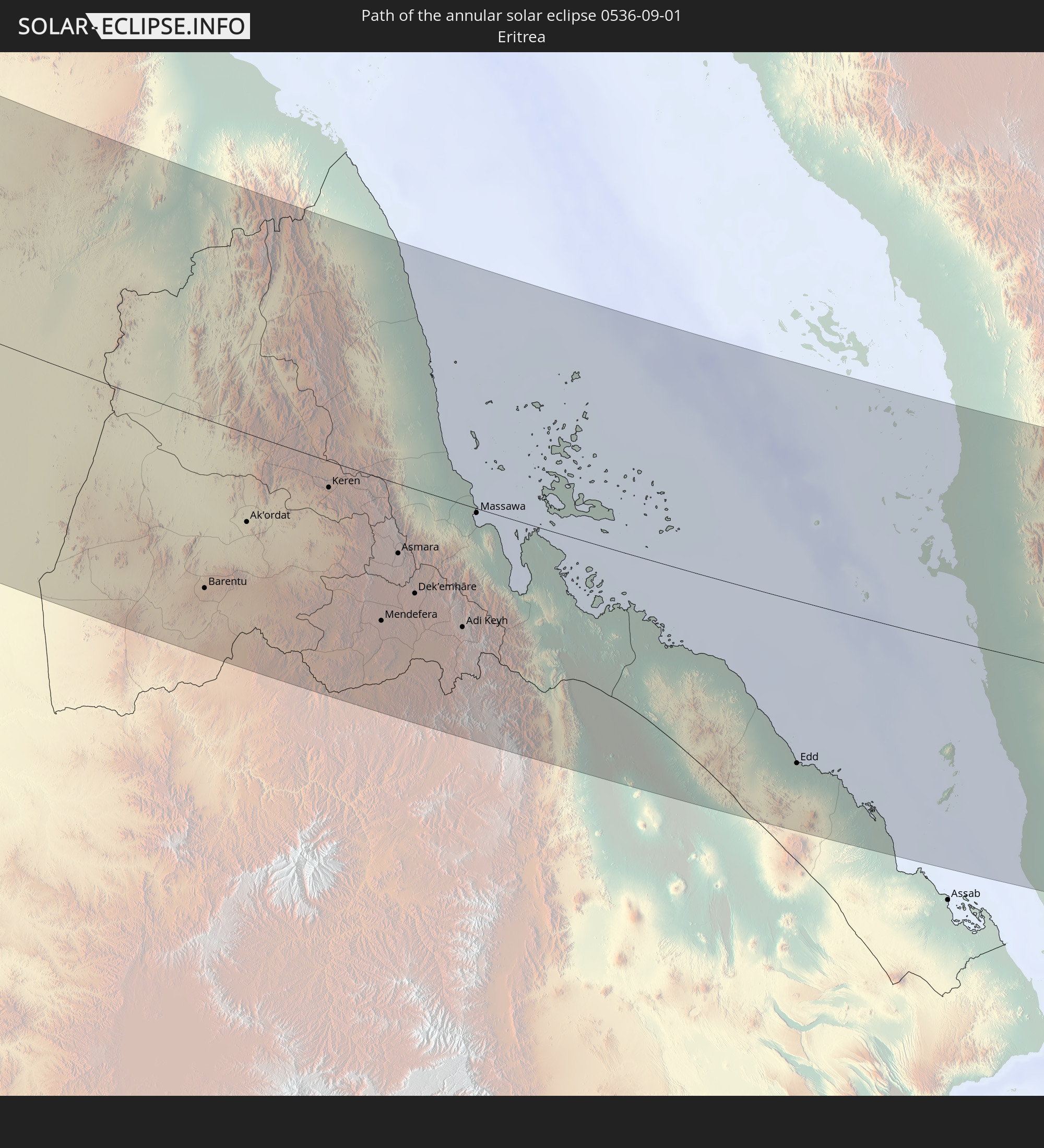
 Yemen
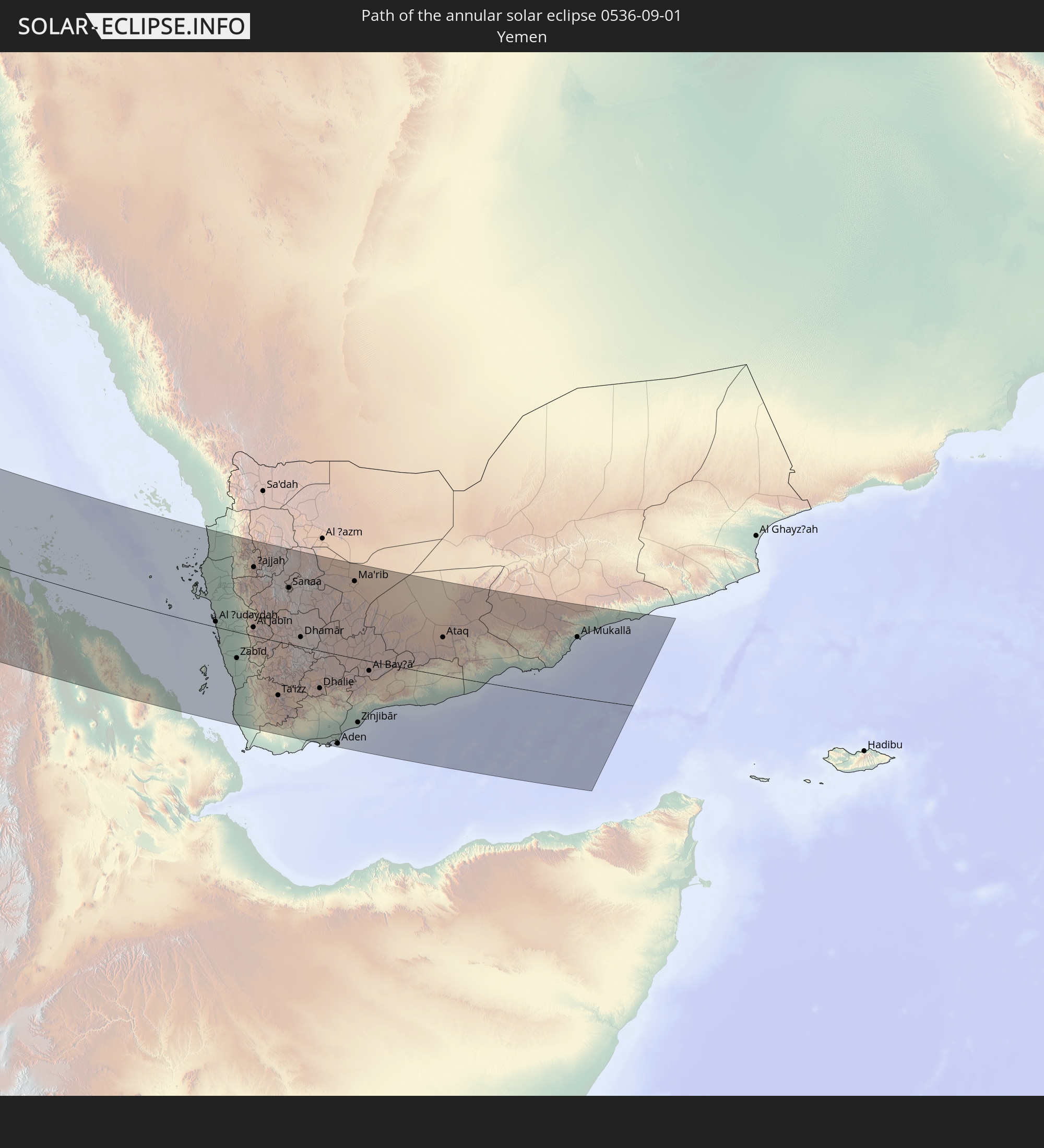
Yemen
In den folgenden Ländern ist die Sonnenfinsternis partiell zu sehen
 Russia
 United States
 Canada
 Greenland
 Saint Pierre and Miquelon
 Portugal
 Cabo Verde
 Iceland
 Spain
Spain
 Senegal
 Mauritania
 The Gambia
 Guinea-Bissau
 Guinea
 Sierra Leone
 Morocco
 Mali
Mali
 Liberia
 Republic of Ireland
 Svalbard and Jan Mayen
 Algeria
 United Kingdom
 Ivory Coast
 Faroe Islands
 Burkina Faso
 Gibraltar
 France
 Isle of Man
 Ghana
Ghana
 Guernsey
 Jersey
 Togo
Togo
 Niger
Niger
 Benin
Benin
 Andorra
 Belgium
 Nigeria
 Netherlands
 Norway
 Equatorial Guinea
 Luxembourg
 Germany
 Switzerland
 São Tomé and Príncipe
 Italy
Italy
 Monaco
 Tunisia
 Denmark
 Cameroon
 Gabon
Gabon
 Libya
Libya
 Liechtenstein
 Austria
 Sweden
 Republic of the Congo
 Angola
 Namibia
 Czechia
 Democratic Republic of the Congo
 San Marino
 Vatican City
 Slovenia
 Chad
Chad
 Croatia
 Poland
 Malta
Malta
 Central African Republic
 Bosnia and Herzegovina
 Hungary
 Slovakia
 Montenegro
 Serbia
 Albania
 Åland Islands
 Greece
 Botswana
 Romania
 Republic of Macedonia
 Finland
 Lithuania
 Latvia
 Estonia
 Sudan
Sudan
 Zambia
 Ukraine
 Bulgaria
 Belarus
 Egypt
Egypt
 Zimbabwe
 Turkey
 Moldova
 Rwanda
 Burundi
 Tanzania
 Uganda
 Mozambique
 Cyprus
 Malawi
 Ethiopia
 Kenya
Kenya
 State of Palestine
 Israel
 Saudi Arabia
 Jordan
 Lebanon
 Syria
Syria
 Eritrea
 Iraq
Iraq
 Georgia
 Somalia
 Djibouti
 Yemen
Yemen
 Armenia
 Iran
Iran
 Azerbaijan
 Kazakhstan
 Kuwait
 Bahrain
 Qatar
Qatar
 United Arab Emirates
 Oman
Oman
 Turkmenistan
 Uzbekistan
 Afghanistan
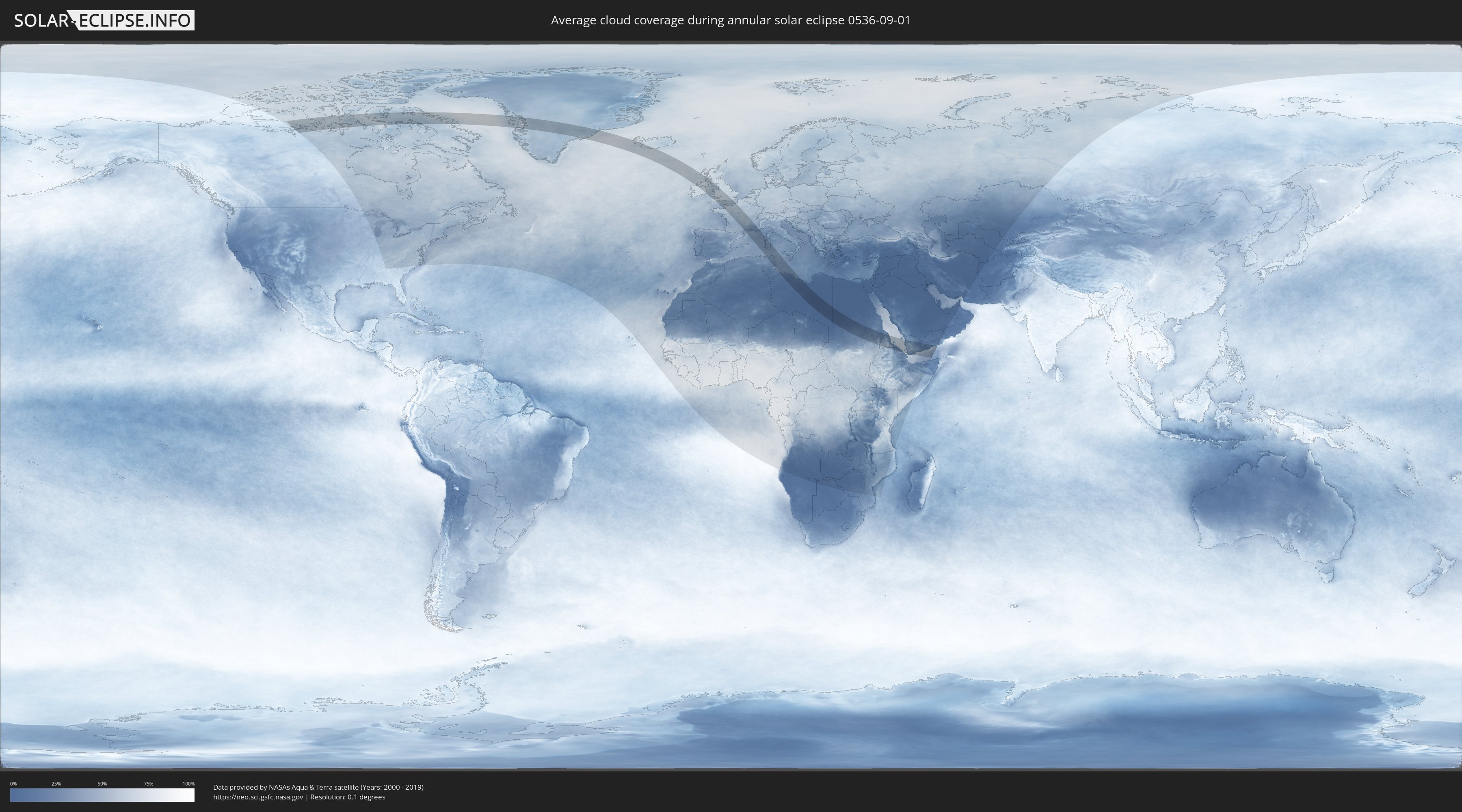
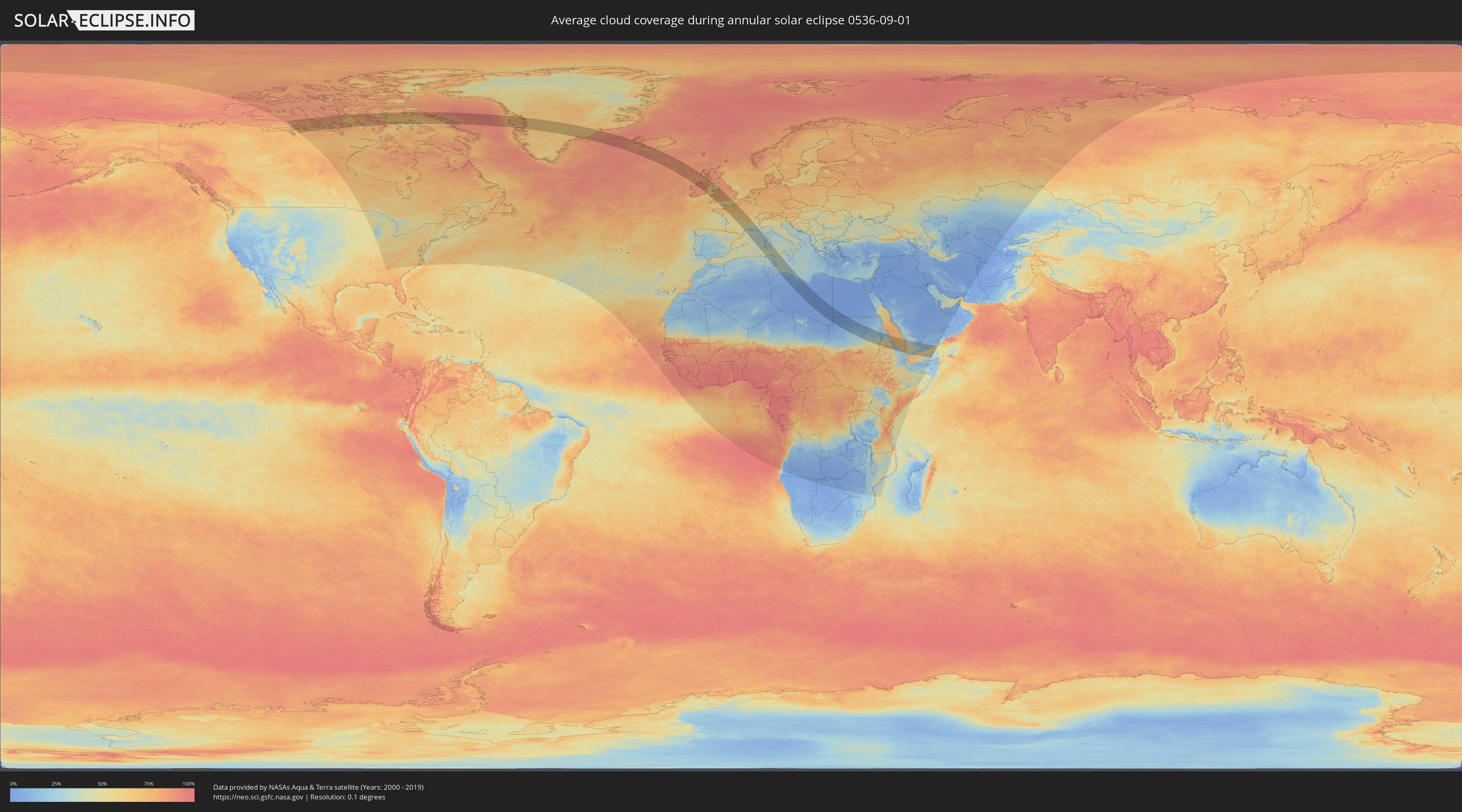
How will be the weather during the annular solar eclipse on 09/01/0536?
Where is the best place to see the annular solar eclipse of 09/01/0536?
The following maps show the average cloud coverage for the day of the annular solar eclipse.
With the help of these maps, it is possible to find the place along the eclipse path, which has the best
chance of a cloudless sky.
Nevertheless, you should consider local circumstances and inform about the weather of your chosen
observation site.
The data is provided by NASAs satellites
AQUA and TERRA.
The cloud maps are averaged over a period of 19 years (2000 - 2019).
Detailed country maps
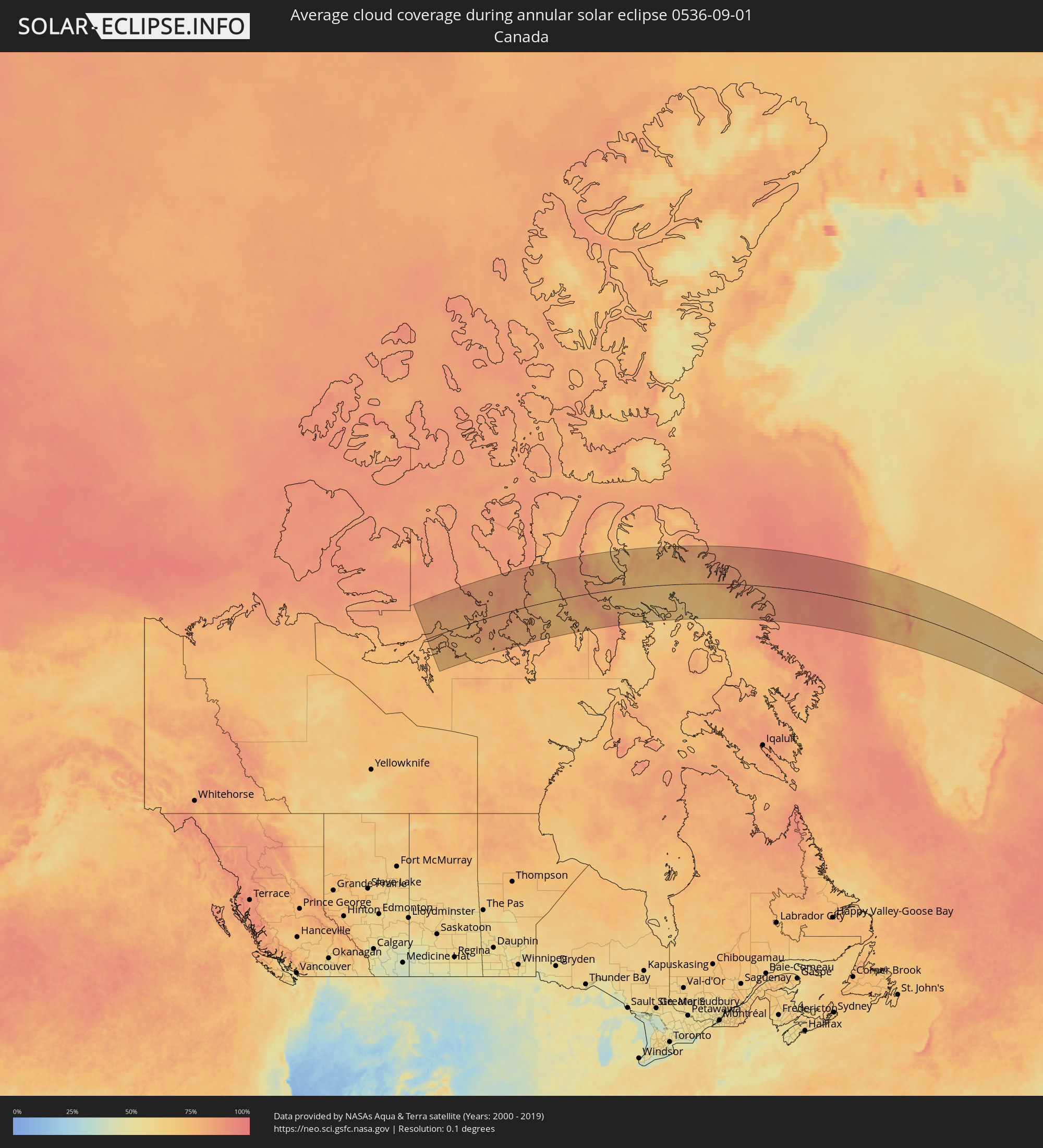 Canada
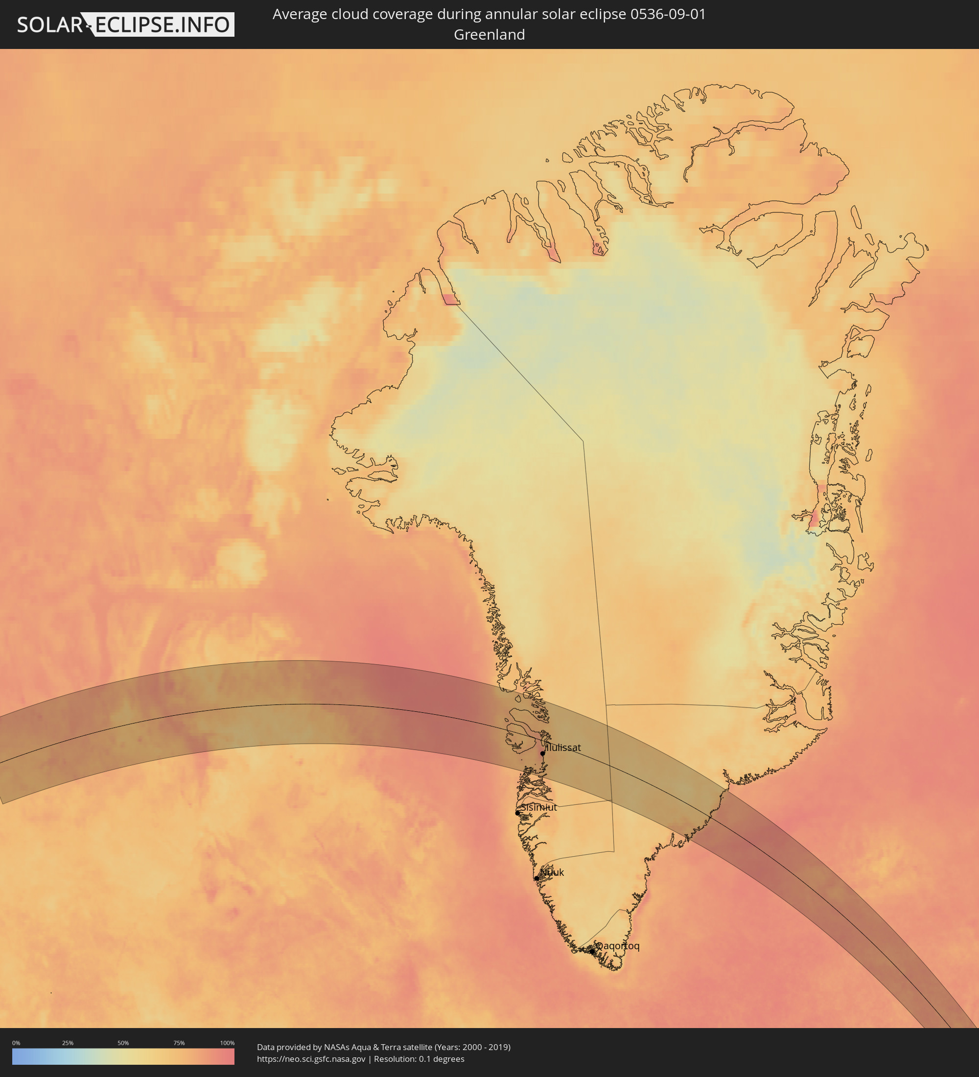 Greenland
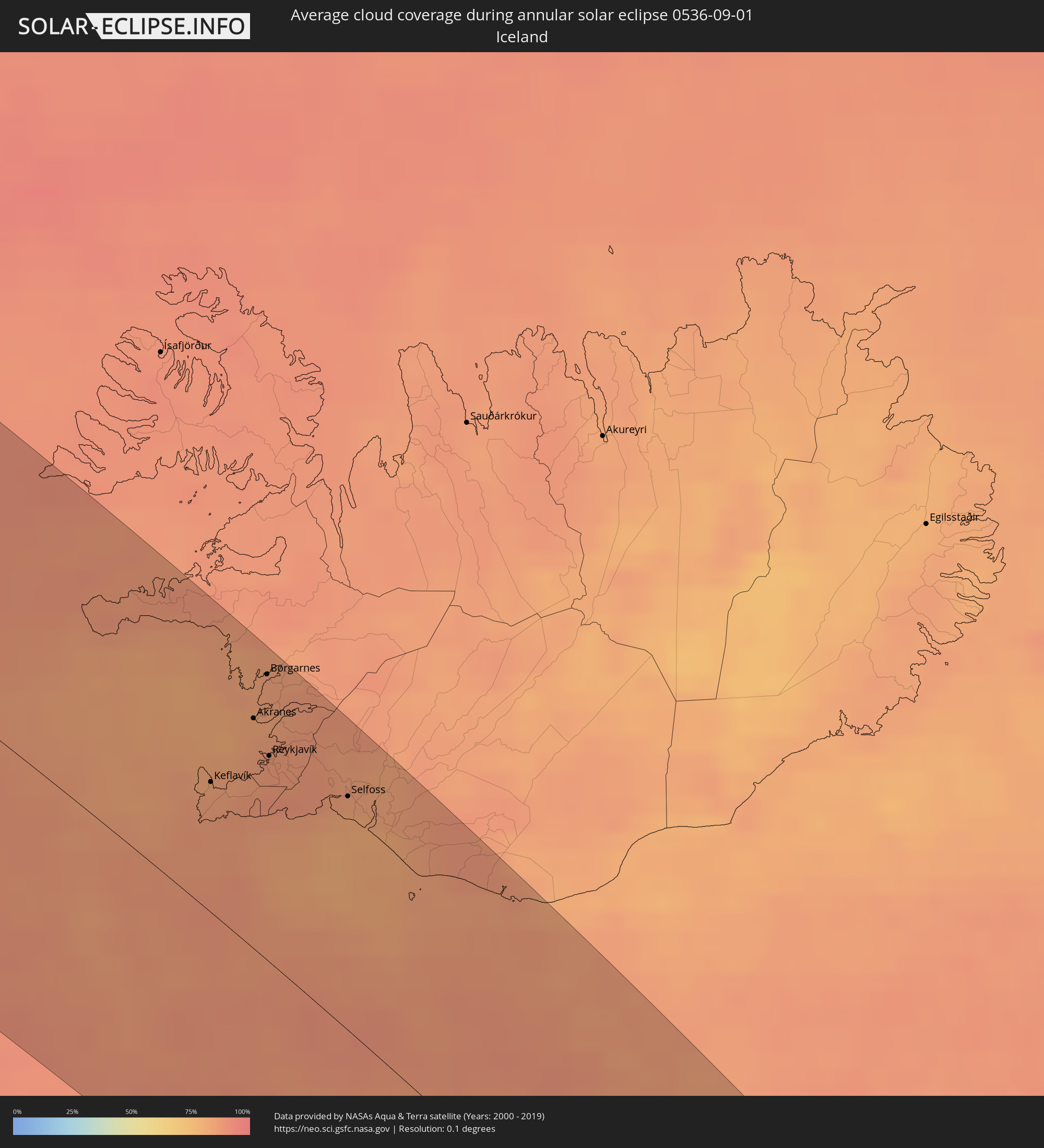 Iceland
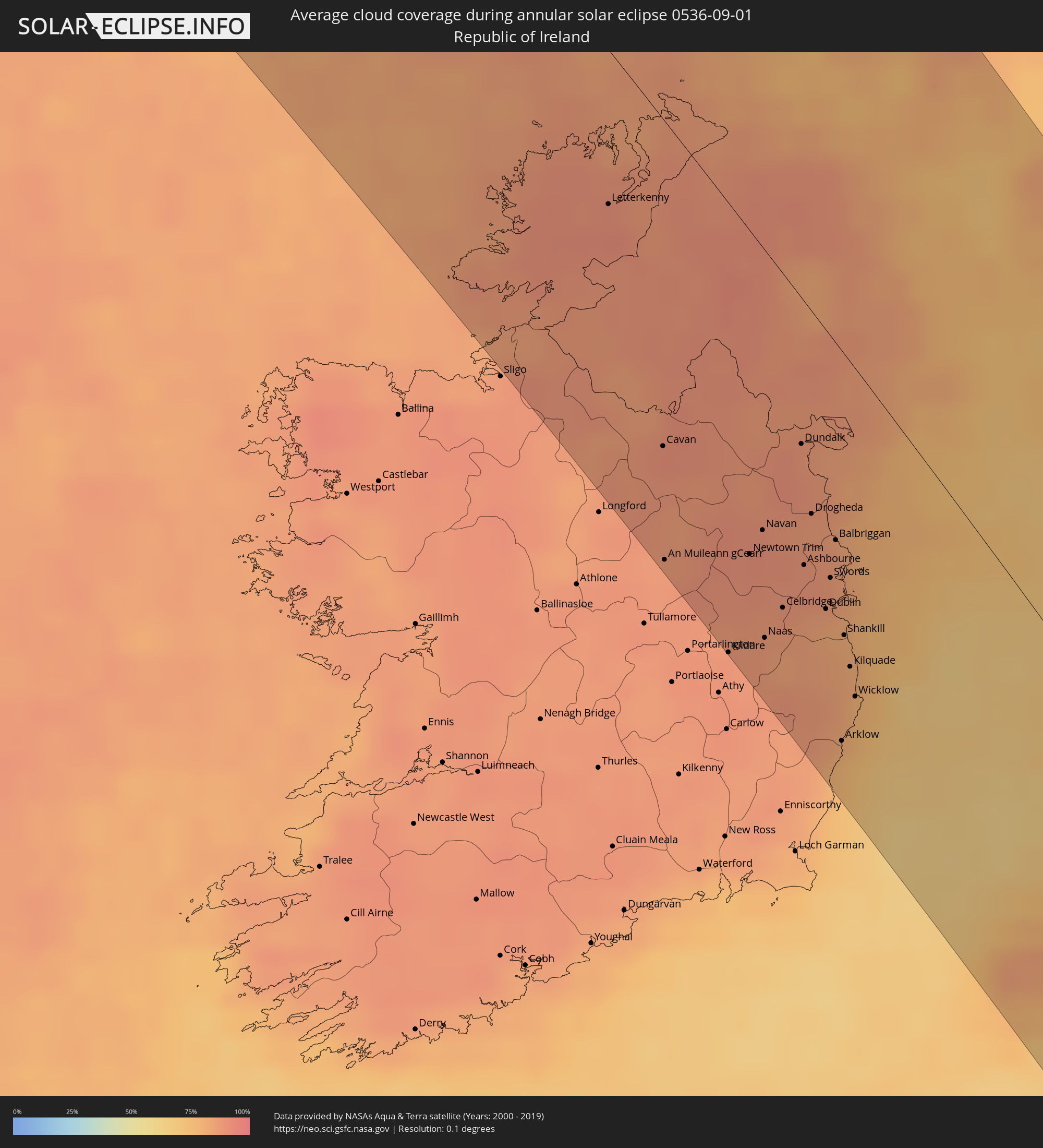 Republic of Ireland
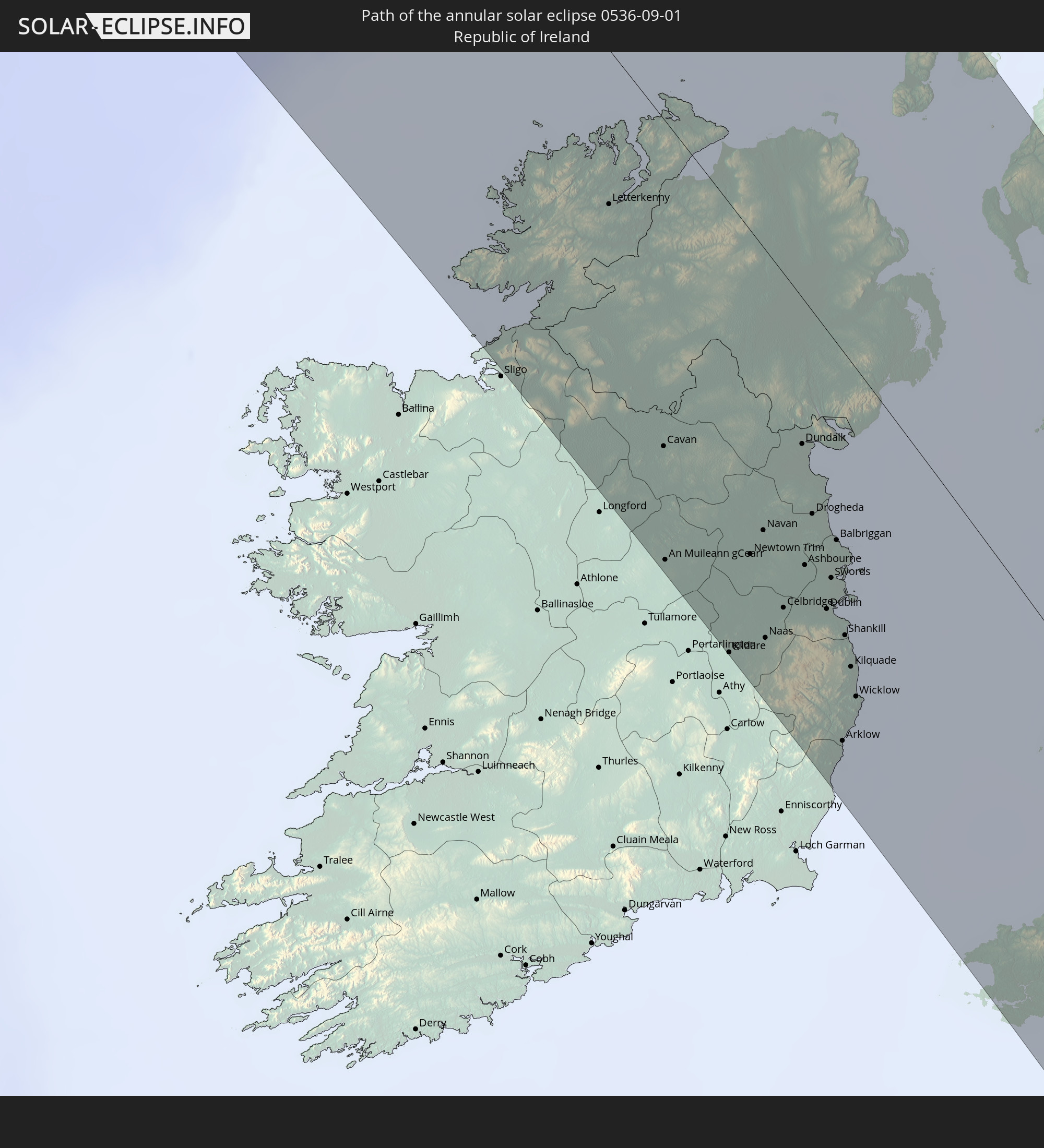
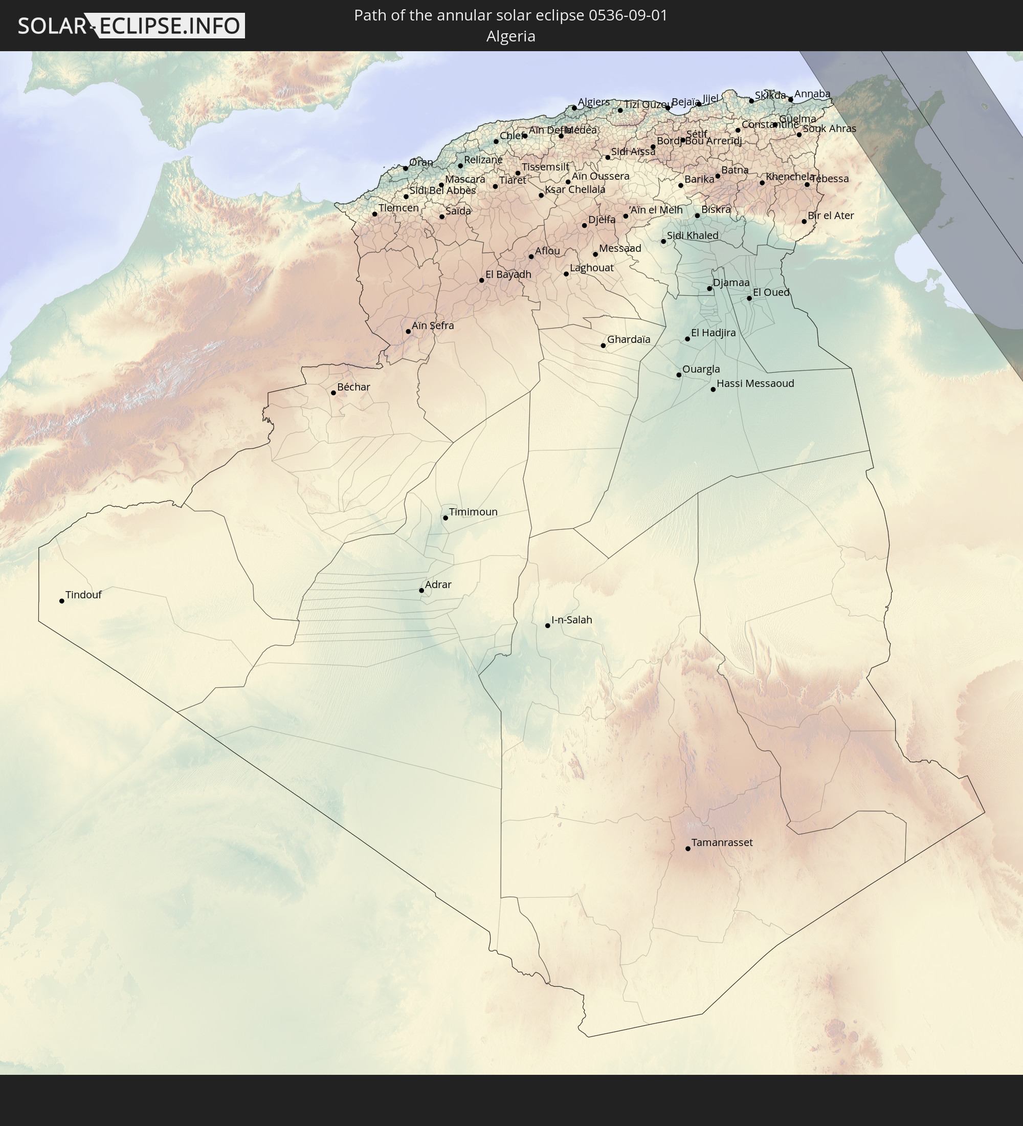
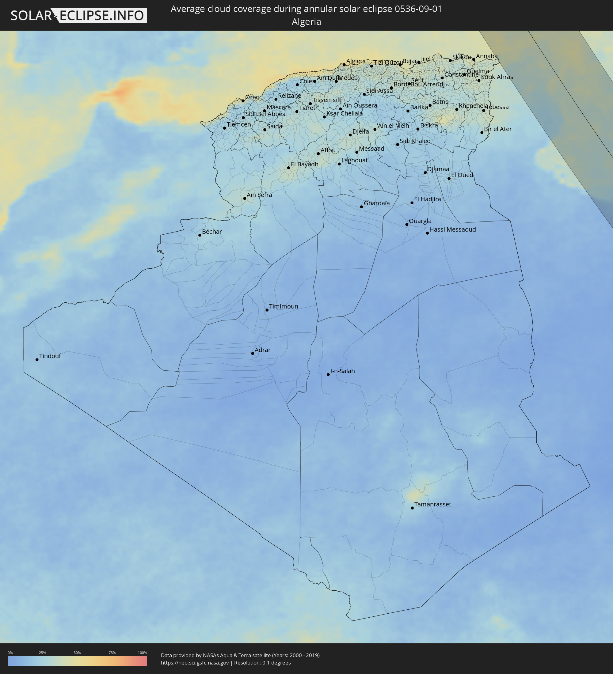 Algeria
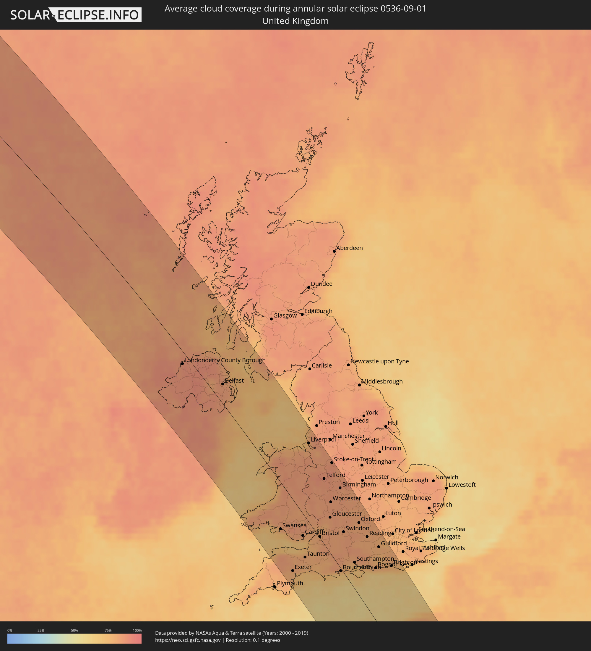 United Kingdom
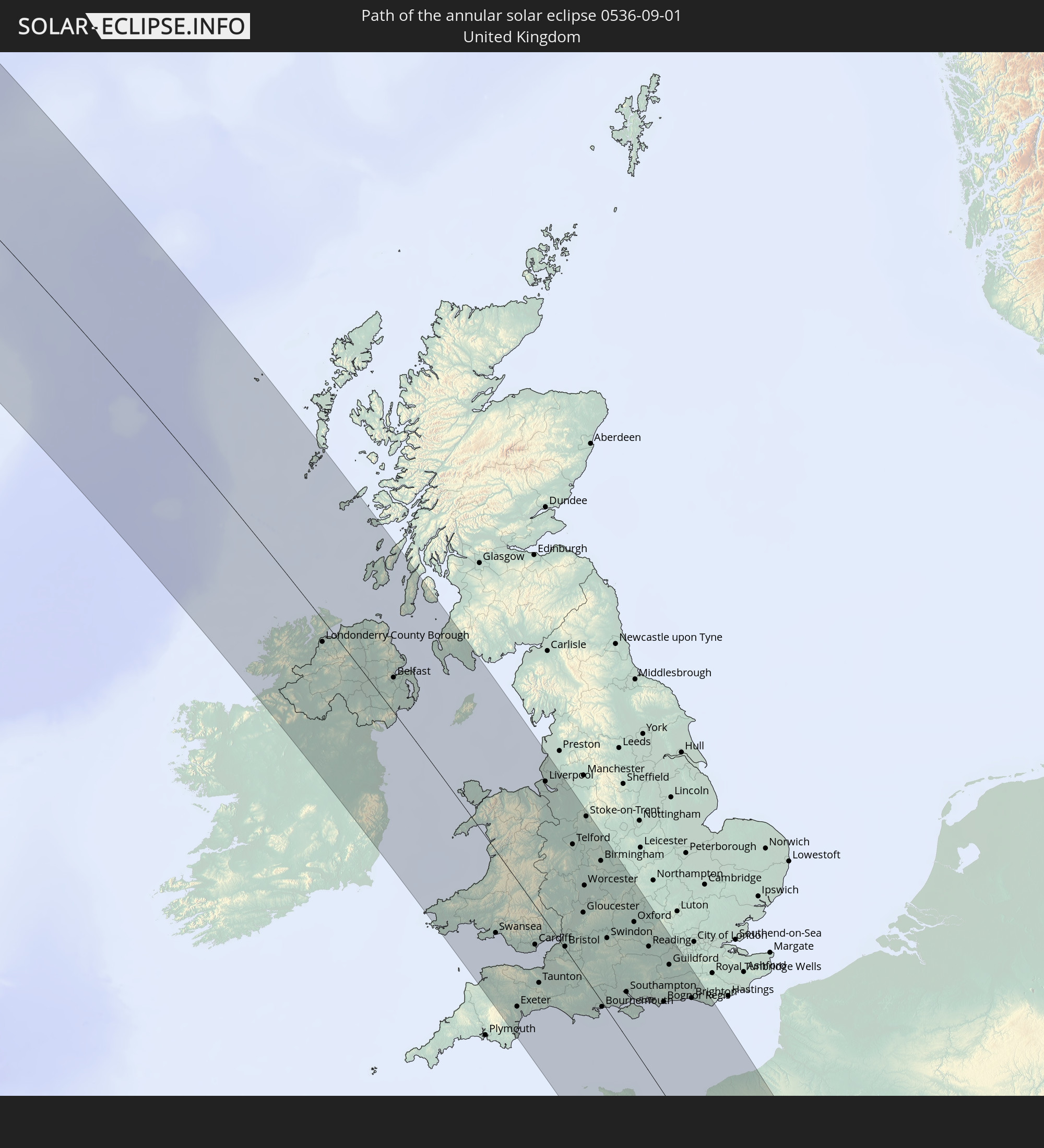
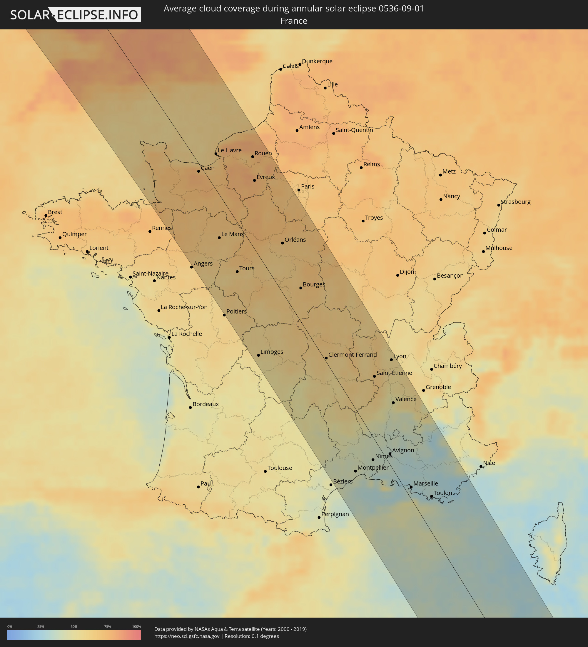 France
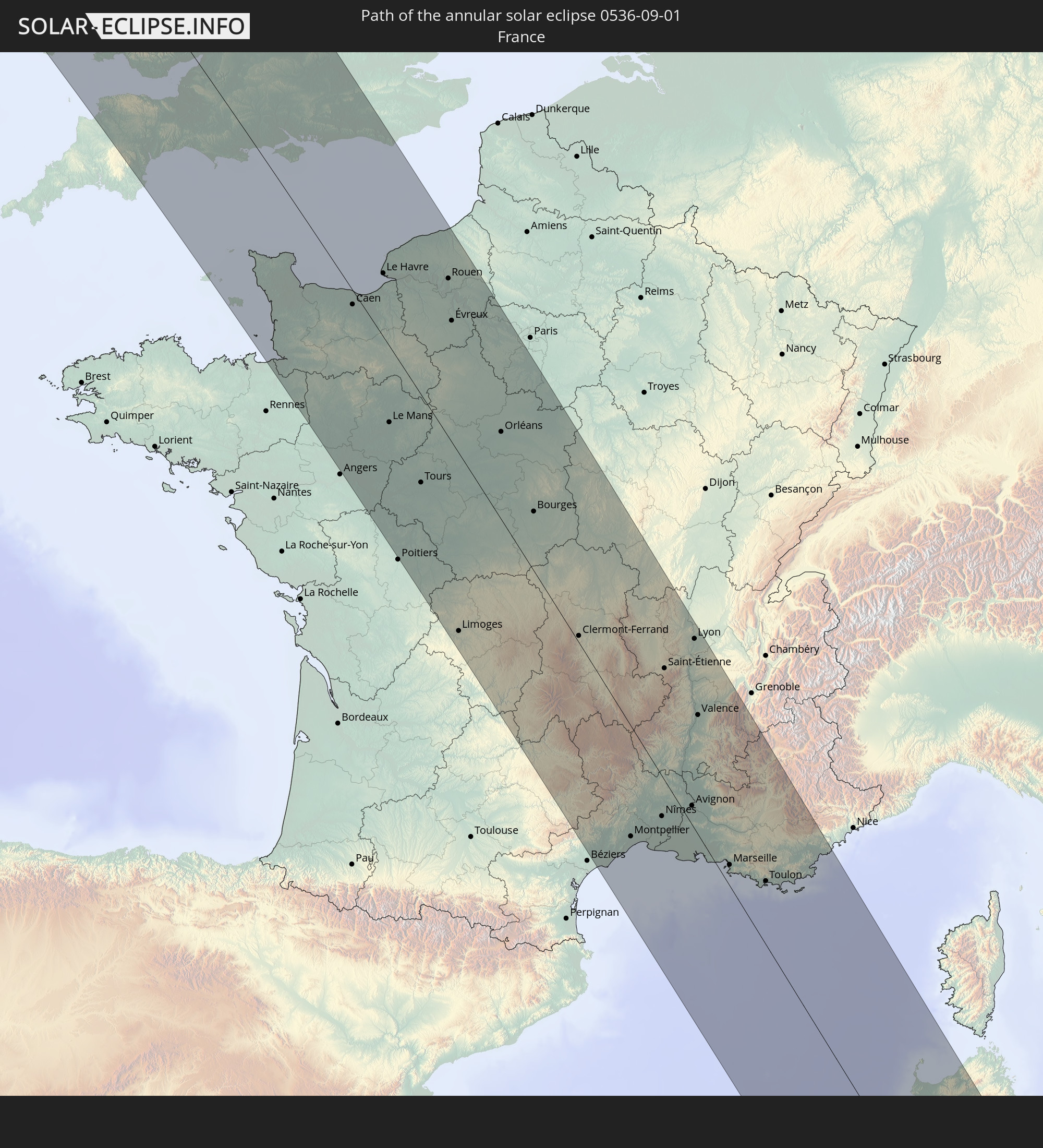
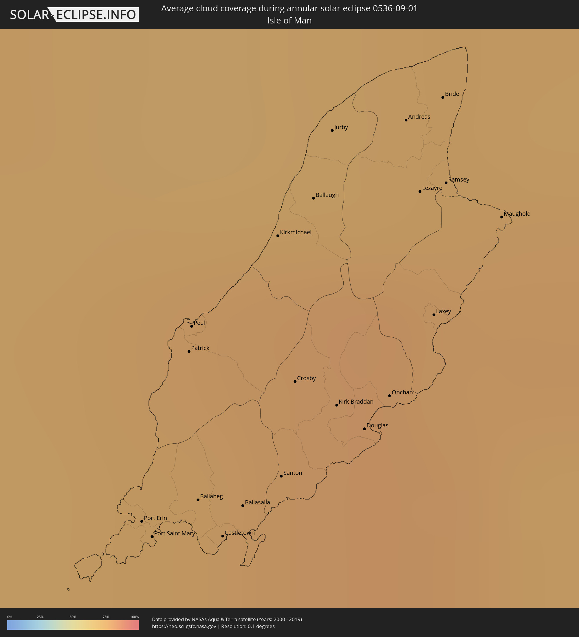 Isle of Man
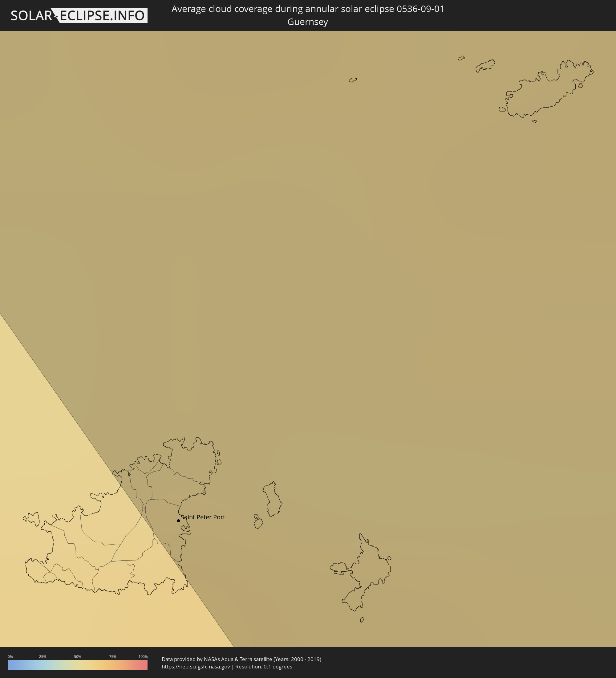 Guernsey
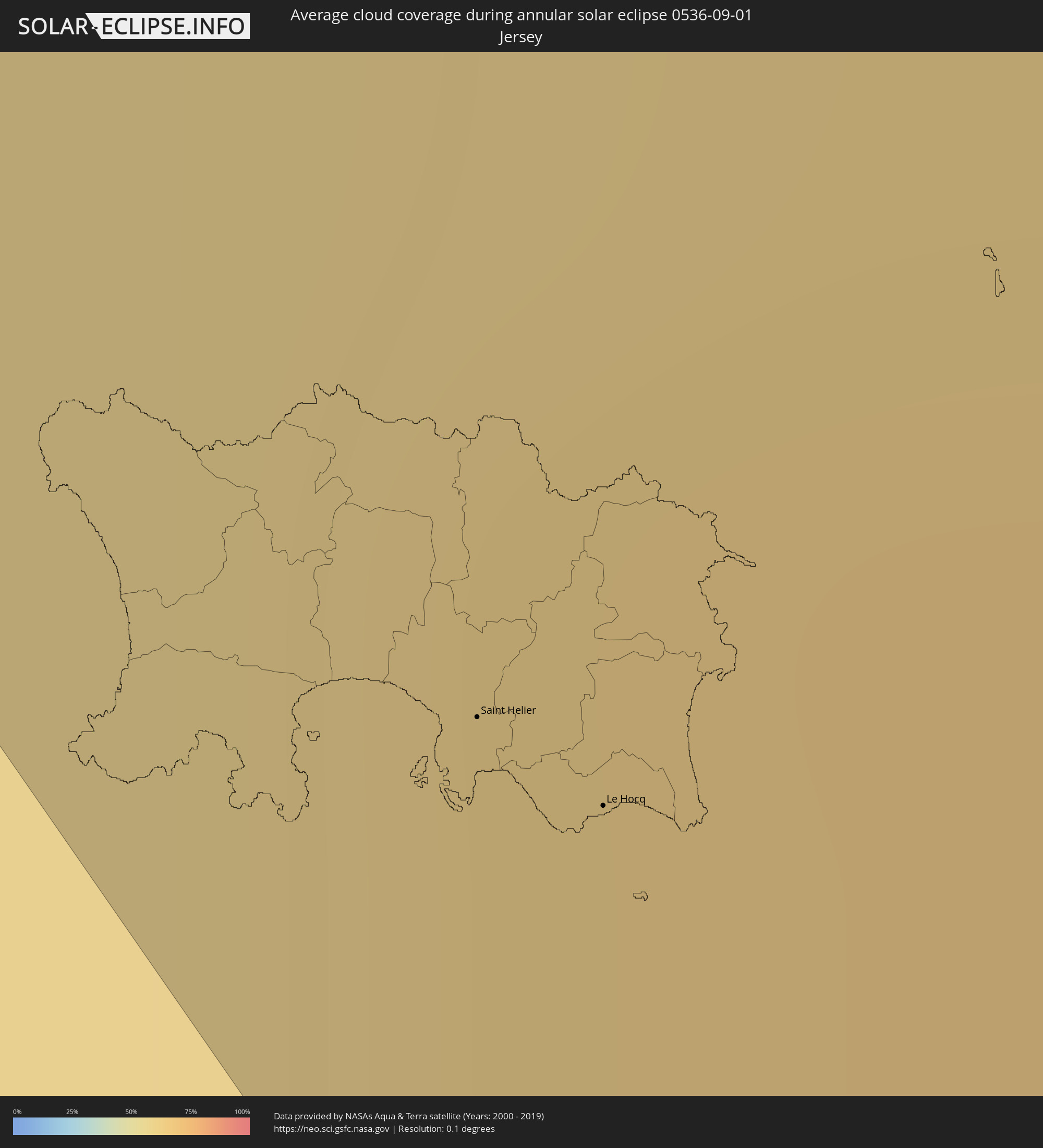 Jersey
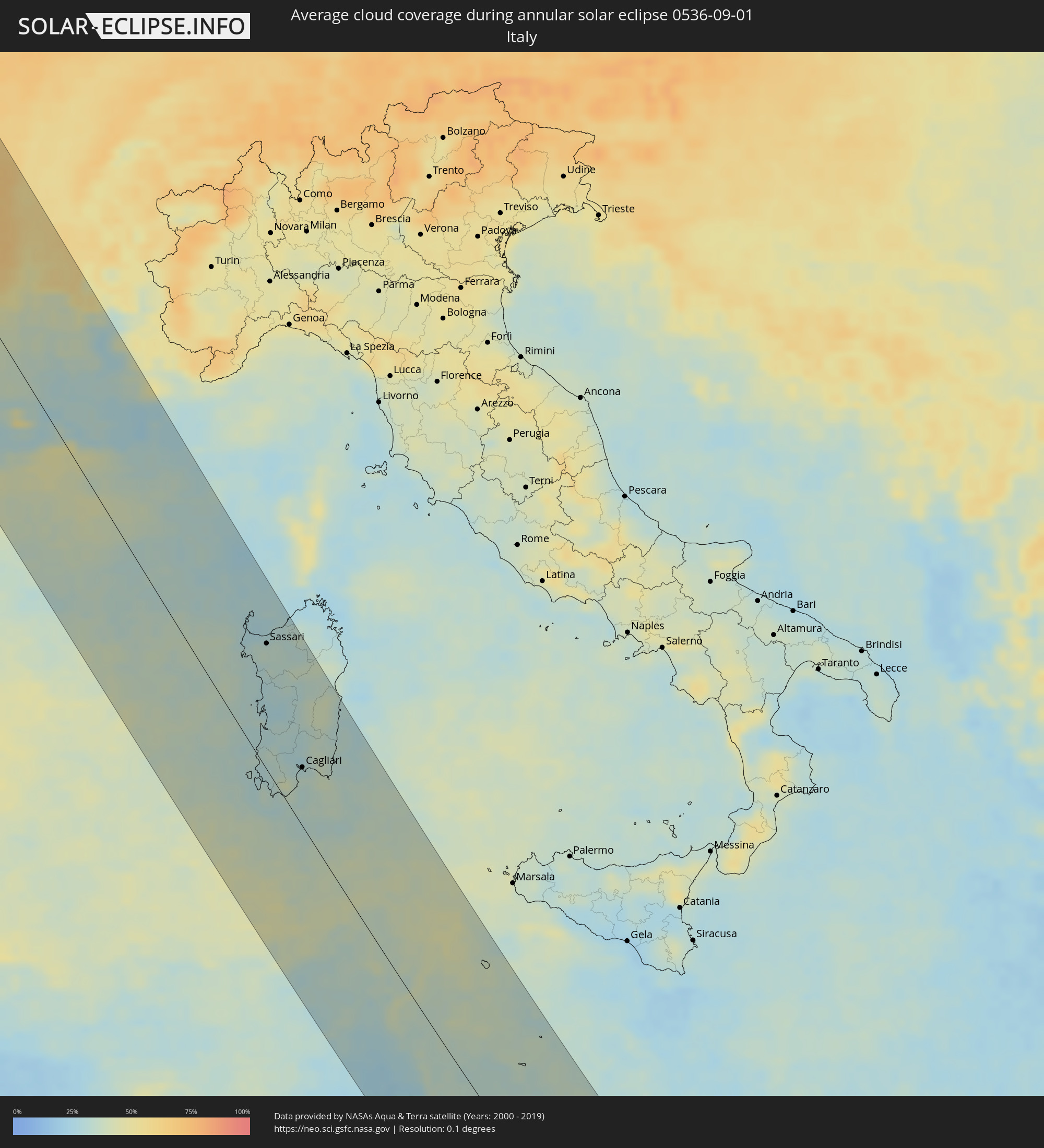 Italy
Italy
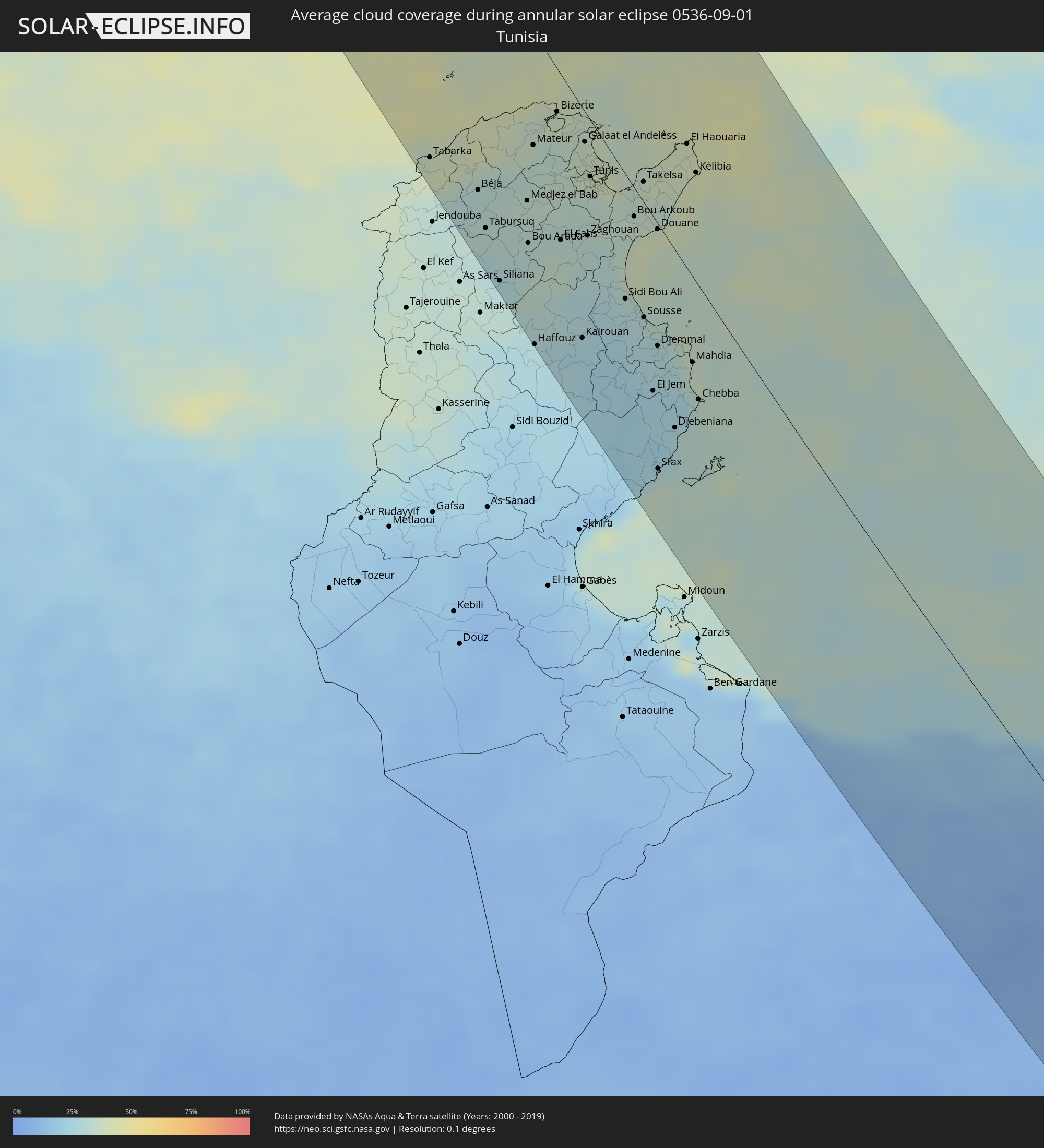 Tunisia
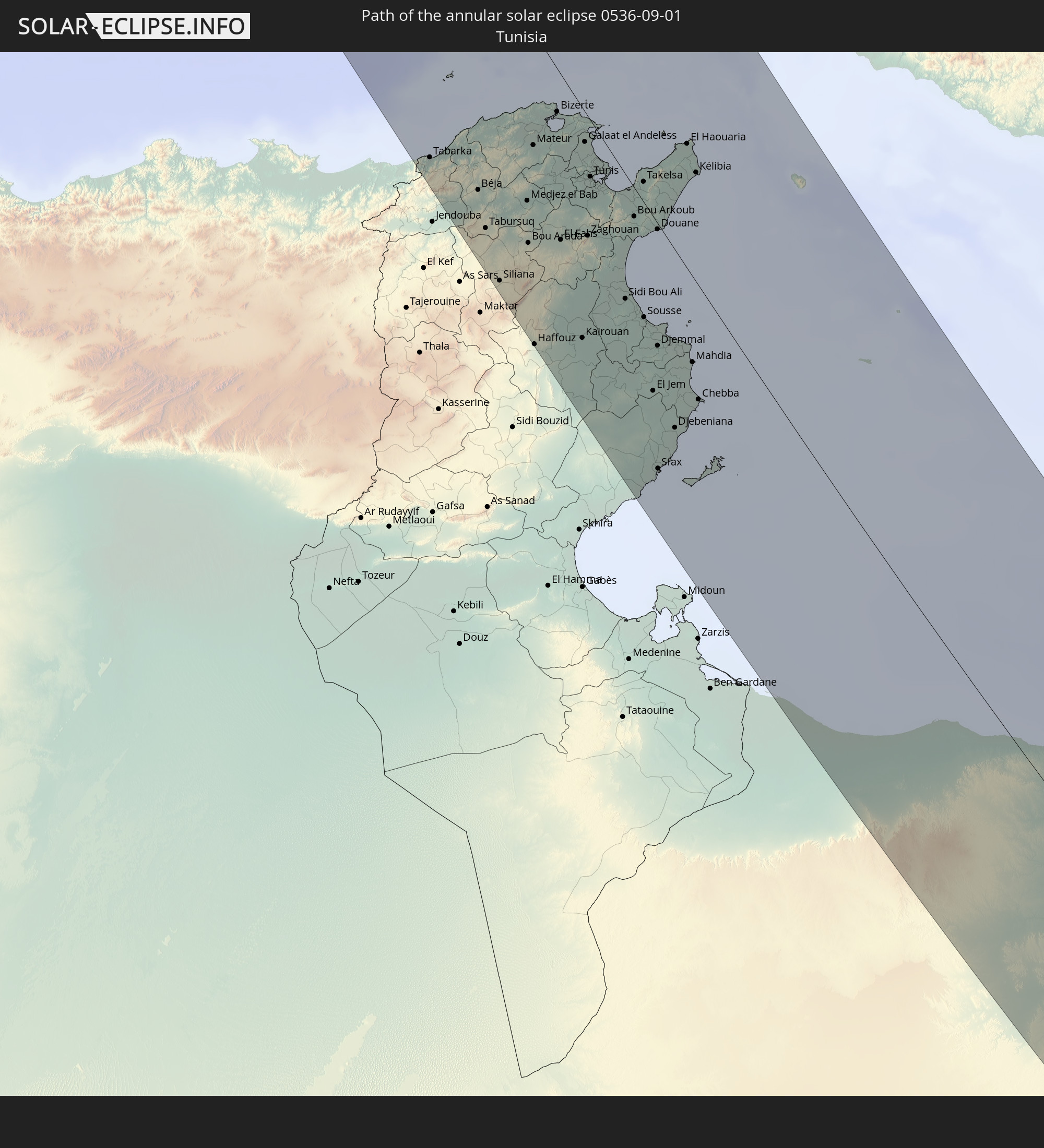
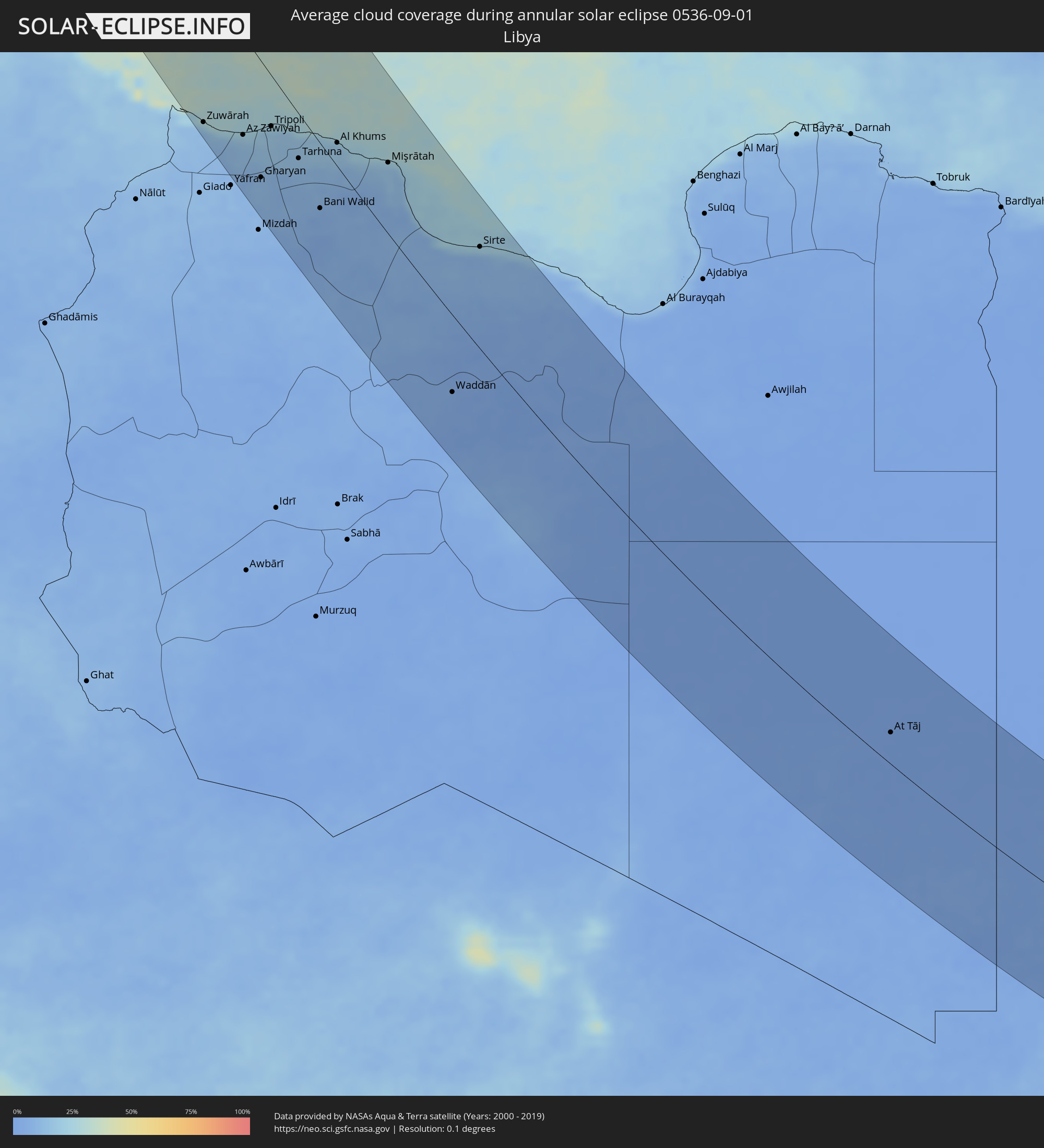 Libya
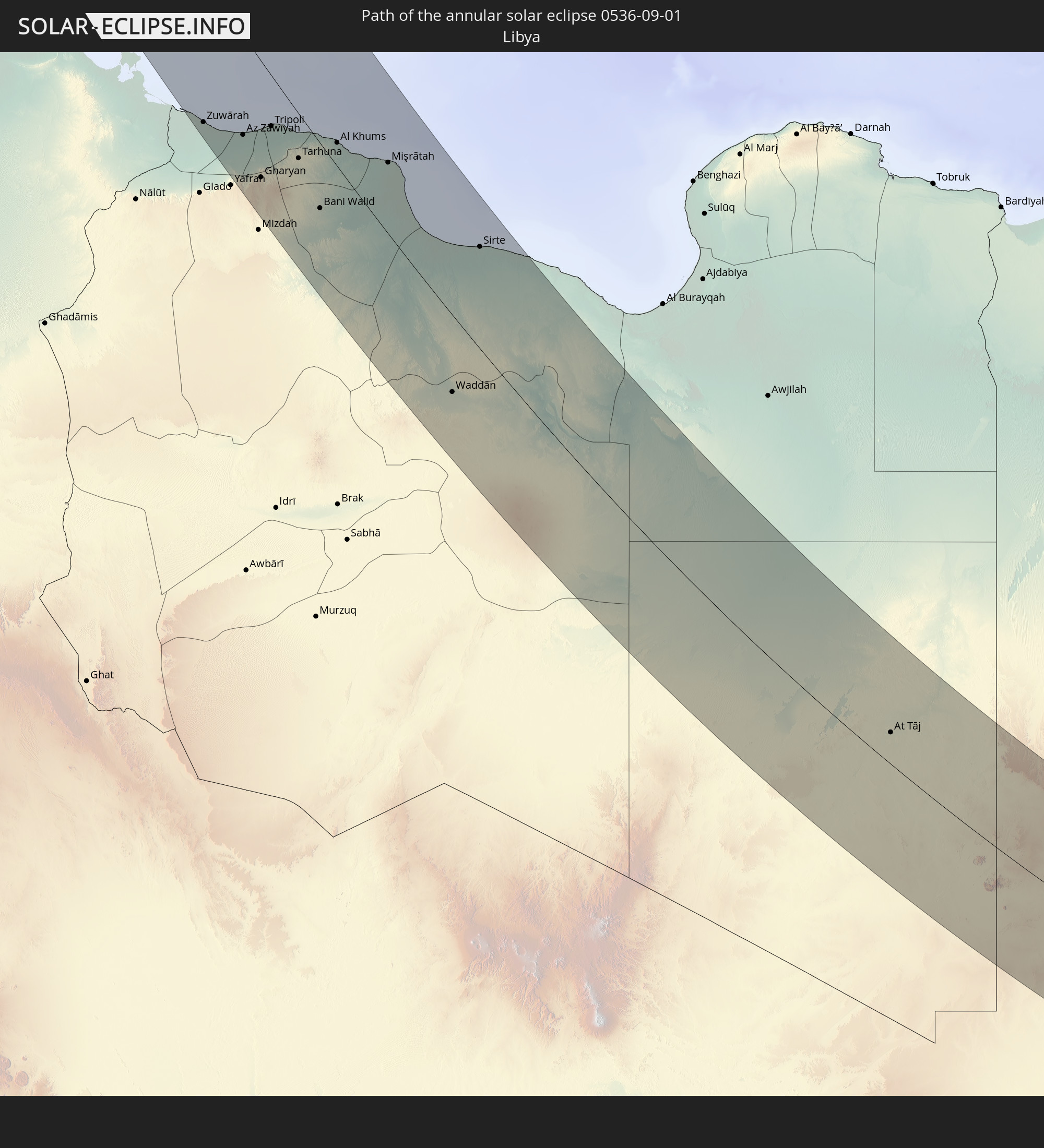
Libya
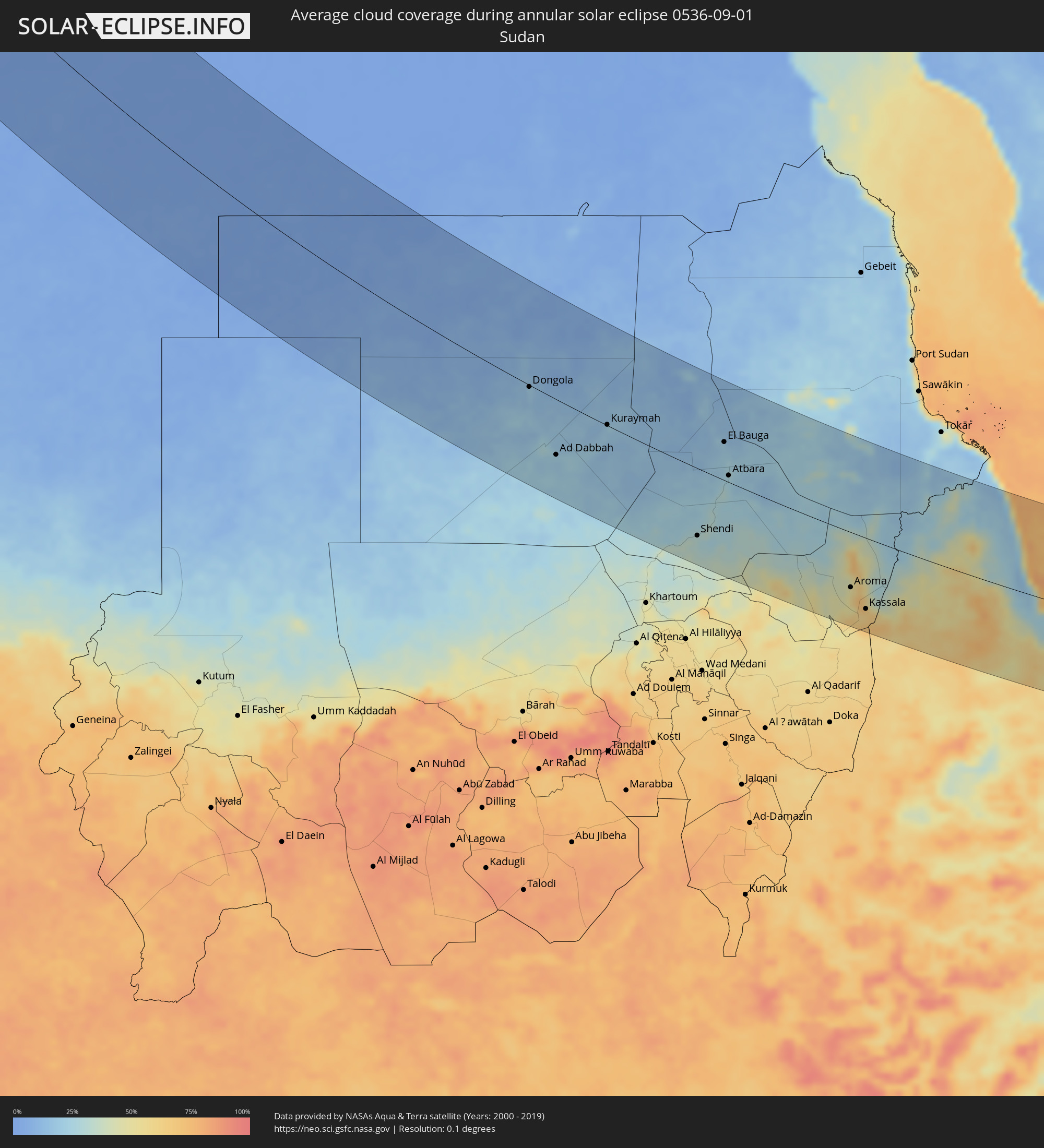 Sudan
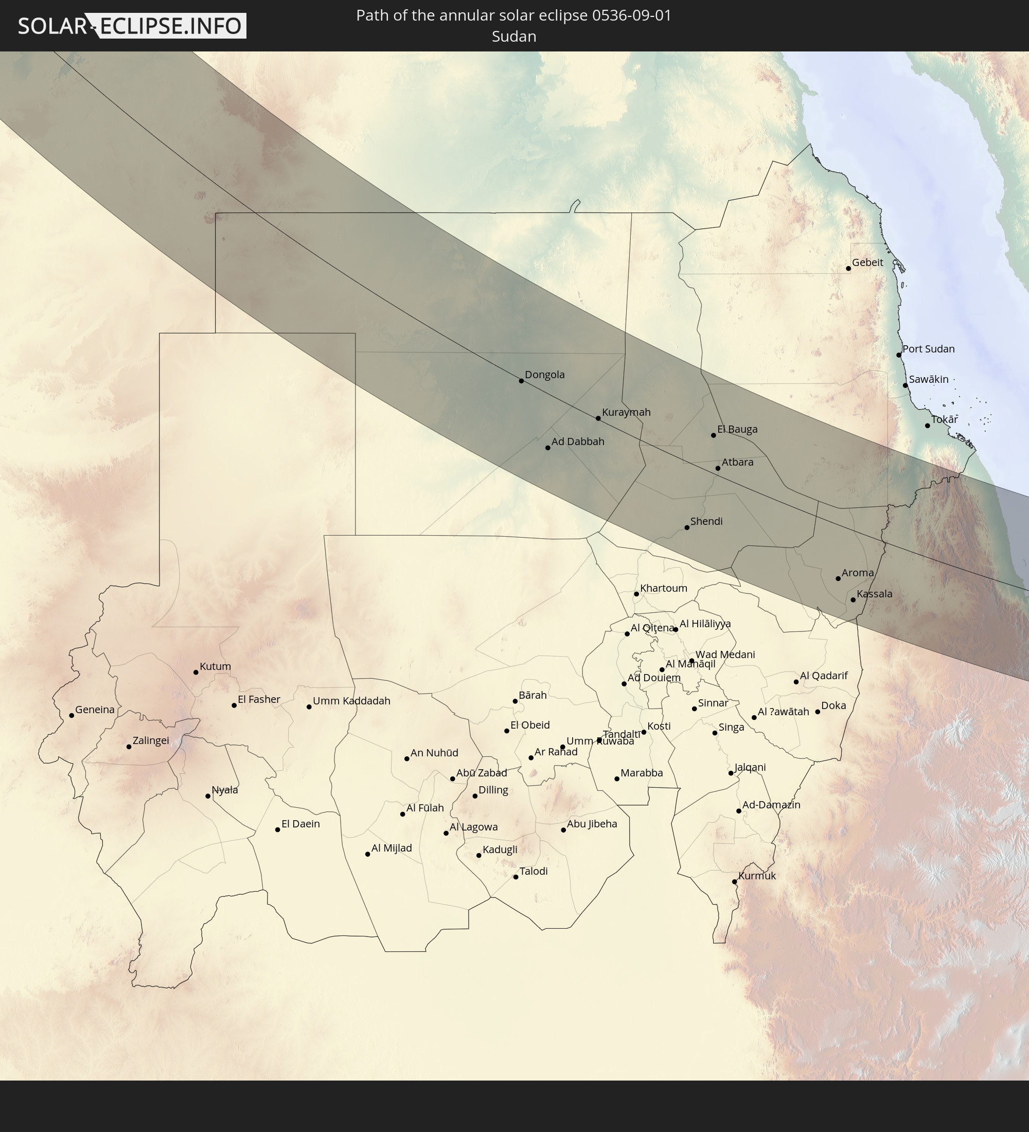
Sudan
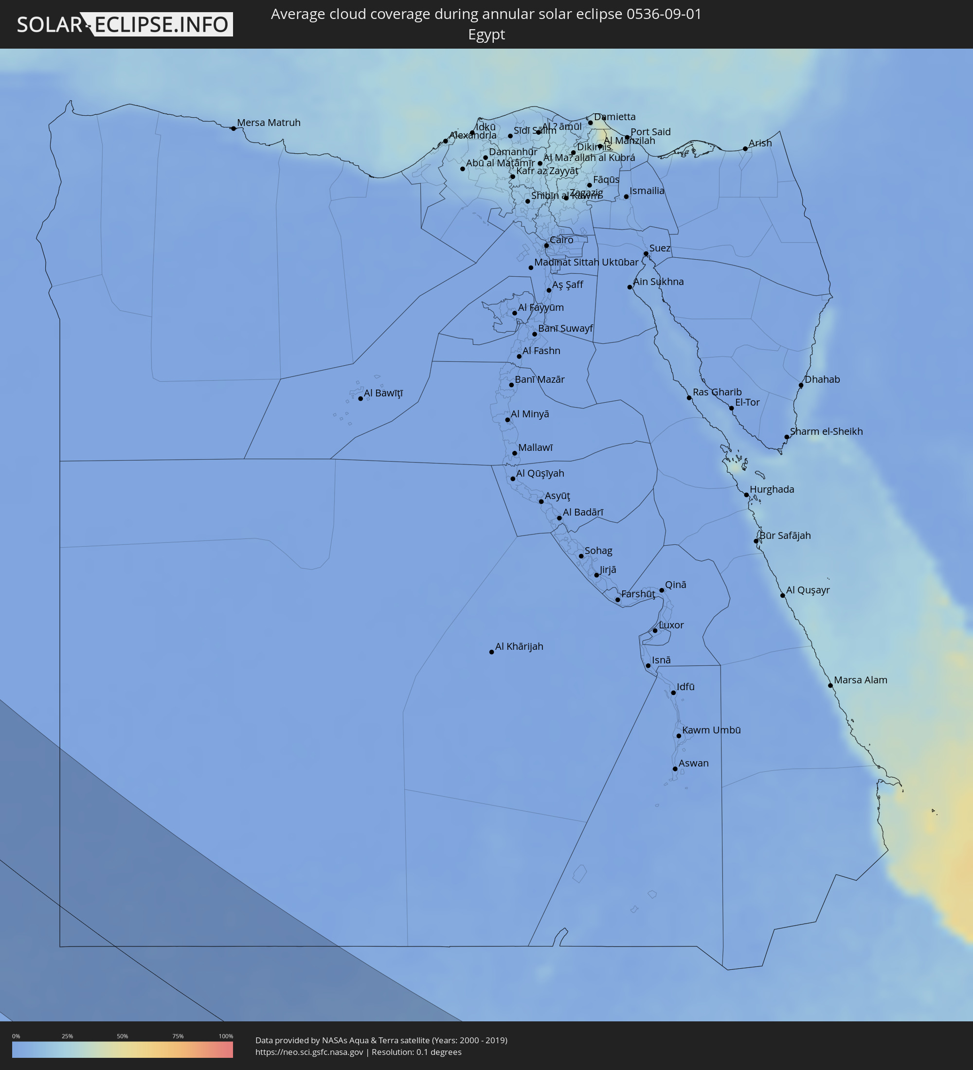 Egypt
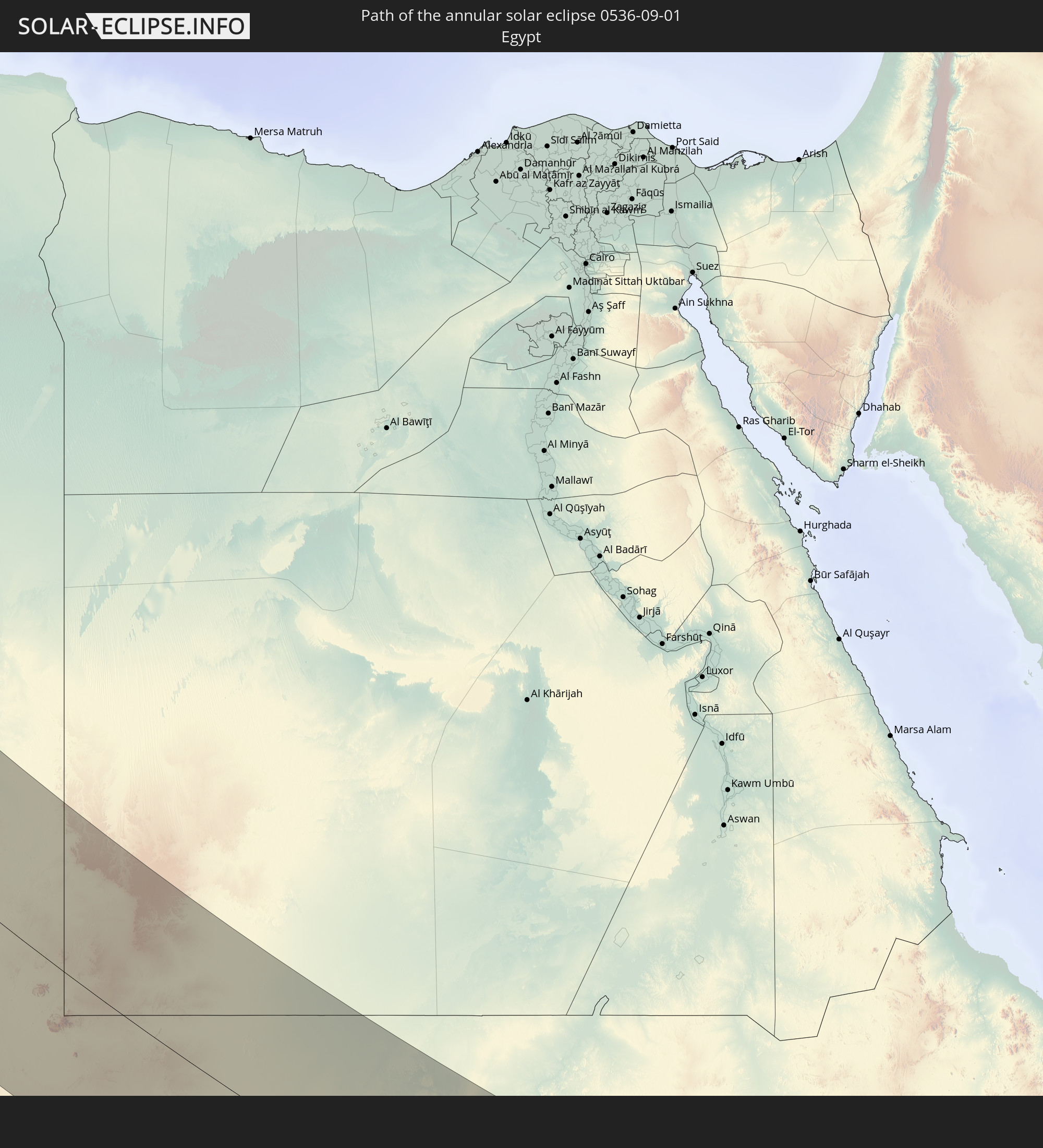
Egypt
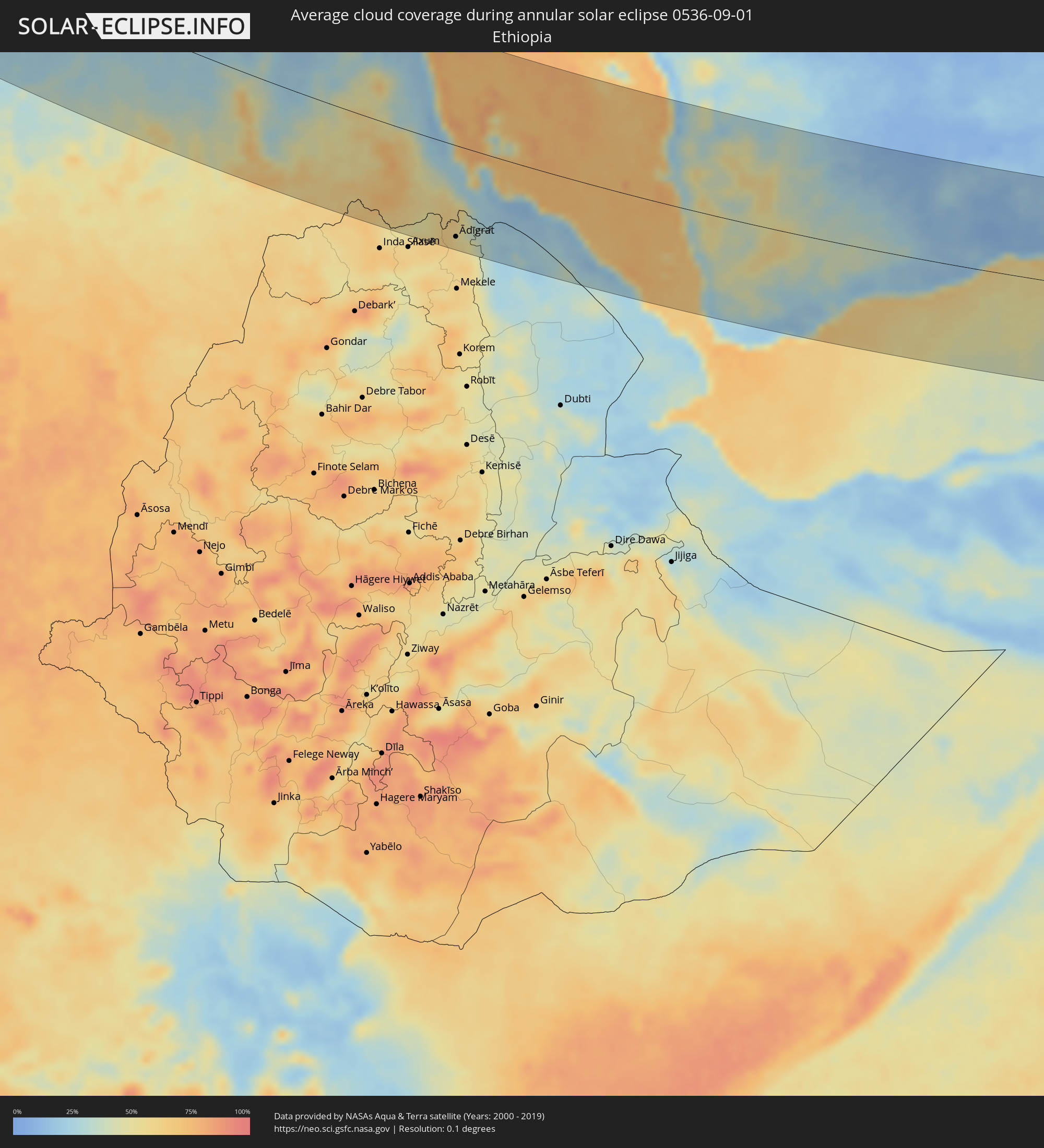 Ethiopia
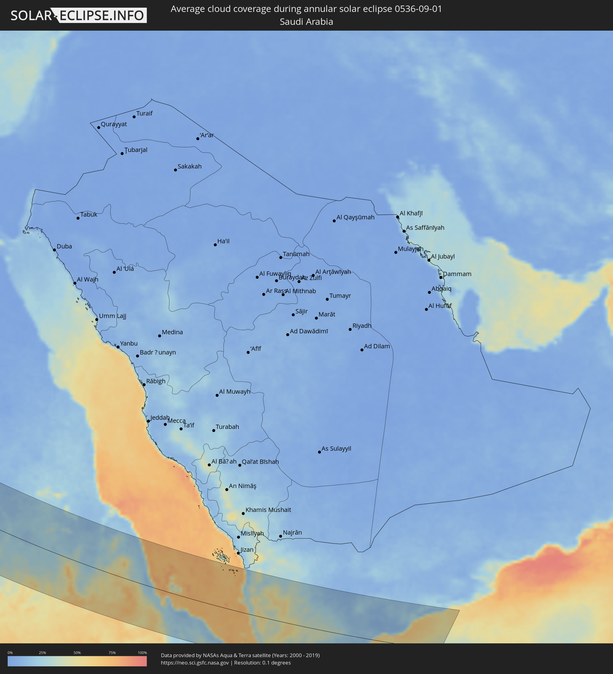 Saudi Arabia
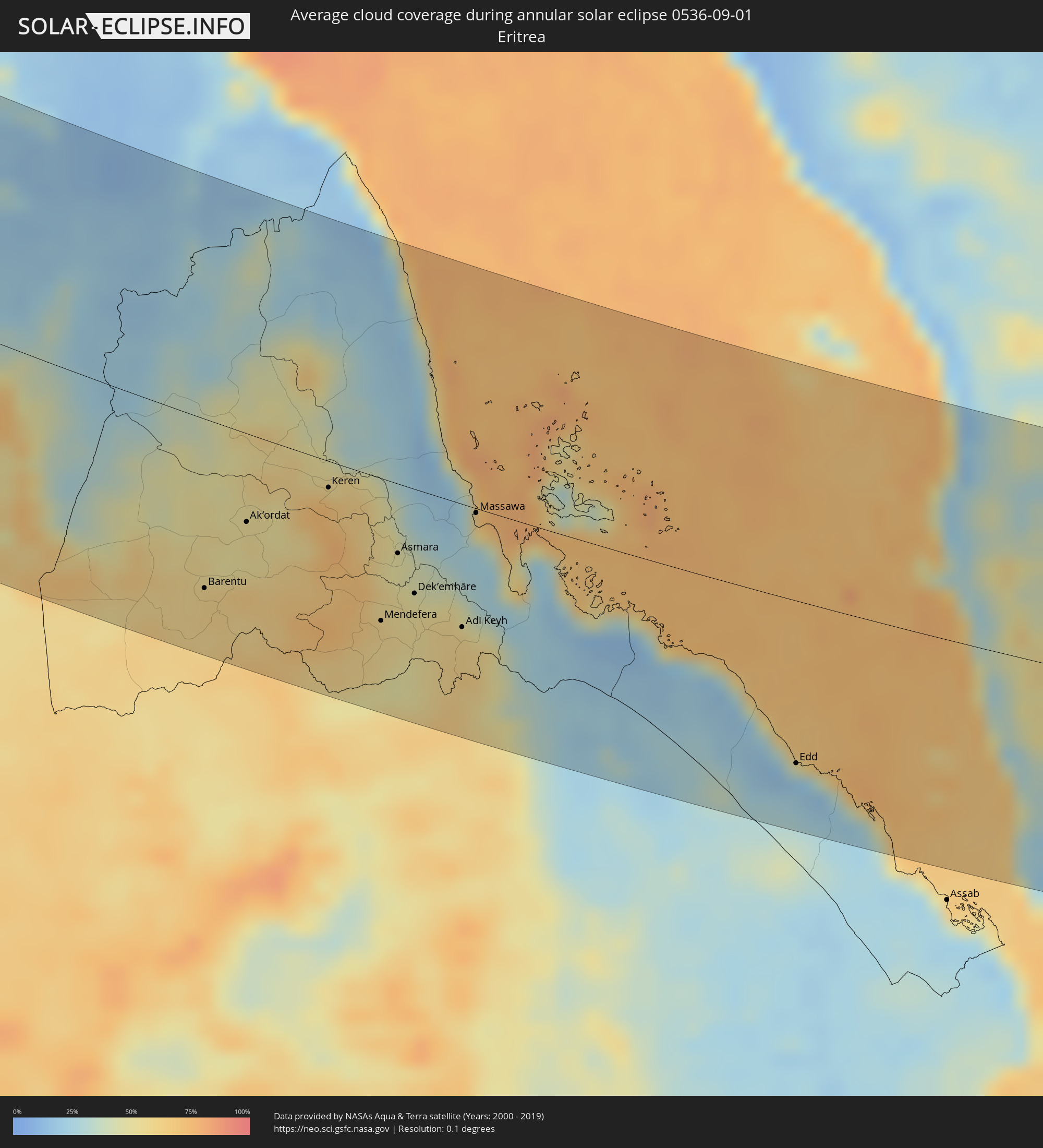 Eritrea
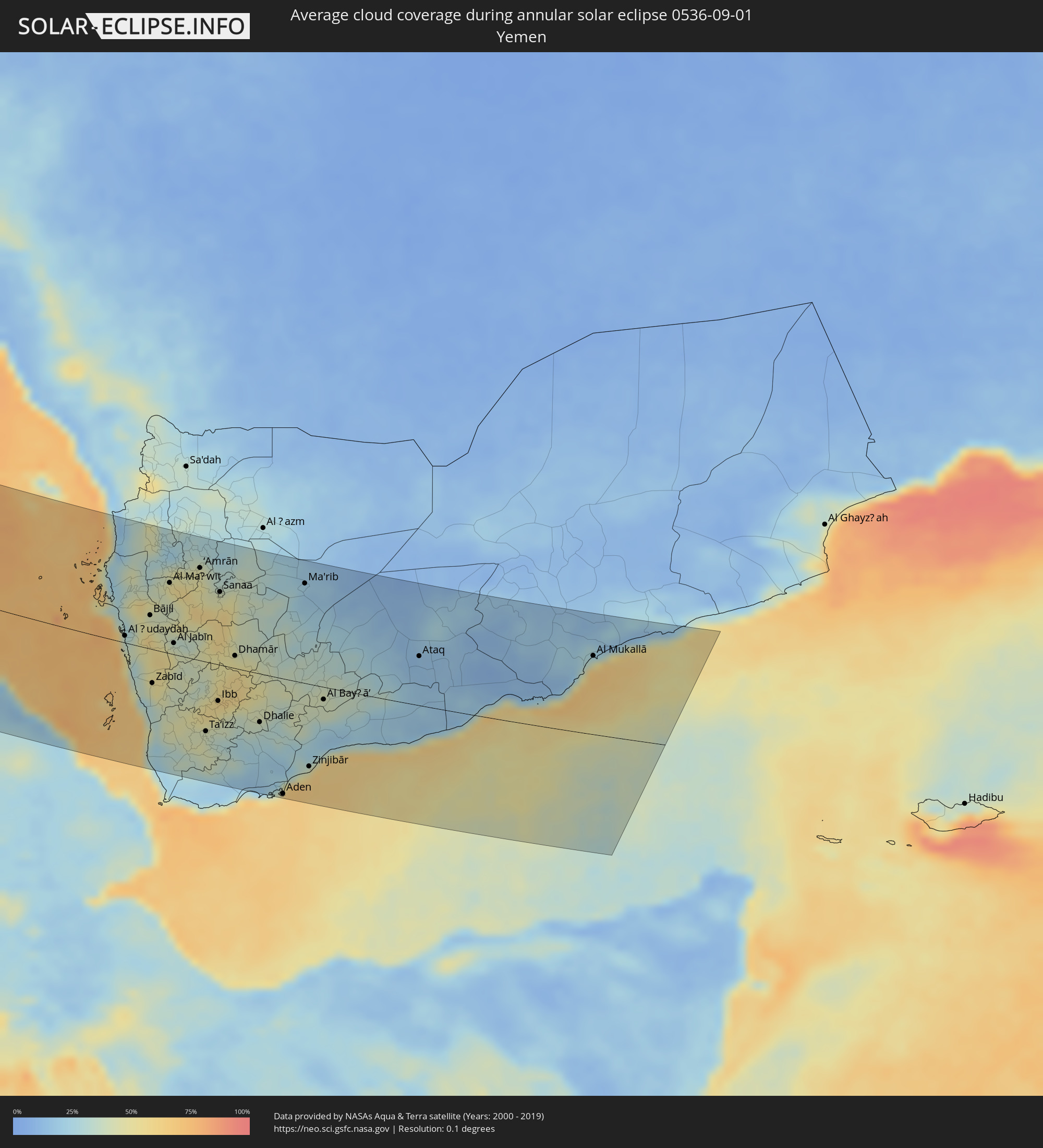 Yemen
Yemen
Cities inside the path of the eclipse
The following table shows all locations with a population of more than 5,000 inside the eclipse path. Cities which have more than 100,000 inhabitants are marked bold. A click at the locations opens a detailed map.
| City | Type | Eclipse duration | Local time of max. eclipse | Distance to central line | Ø Cloud coverage |
|
Ilulissat, Qaasuitsup
|
annular | - | 08:33:48 UTC-03:26 | 51 km | 78% |
|
Keflavík, Southern Peninsula
|
annular | - | 10:50:39 UTC-01:28 | 56 km | 84% |
|
Akranes, West
|
annular | - | 10:51:01 UTC-01:28 | 98 km | 84% |
|
Hafnarfjörður, Capital Region
|
annular | - | 10:51:12 UTC-01:28 | 81 km | 86% |
|
Garðabær, Capital Region
|
annular | - | 10:51:12 UTC-01:28 | 83 km | 86% |
|
Borgarnes, West
|
annular | - | 10:51:06 UTC-01:28 | 121 km | 84% |
|
Kópavogur, Capital Region
|
annular | - | 10:51:12 UTC-01:28 | 86 km | 86% |
|
Reykjavík, Capital Region
|
annular | - | 10:51:13 UTC-01:28 | 88 km | 86% |
|
Mosfellsbær, Capital Region
|
annular | - | 10:51:23 UTC-01:28 | 97 km | 86% |
|
Selfoss, South
|
annular | - | 10:52:04 UTC-01:28 | 100 km | 82% |
|
Letterkenny, Ulster
|
annular | - | 12:15:38 UTC-00:25 | 41 km | 90% |
|
Cavan, Ulster
|
annular | - | 12:17:18 UTC-00:25 | 89 km | 89% |
|
An Muileann gCearr, Leinster
|
annular | - | 12:17:55 UTC-00:25 | 120 km | 87% |
|
Kildare, Leinster
|
annular | - | 12:18:58 UTC-00:25 | 123 km | 88% |
|
Navan, Leinster
|
annular | - | 12:18:35 UTC-00:25 | 77 km | 89% |
|
Naas, Leinster
|
annular | - | 12:19:11 UTC-00:25 | 106 km | 87% |
|
Celbridge, Leinster
|
annular | - | 12:19:11 UTC-00:25 | 91 km | 85% |
|
Dundalk, Leinster
|
annular | - | 12:18:26 UTC-00:25 | 39 km | 87% |
|
Ashbourne, Leinster
|
annular | - | 12:19:07 UTC-00:25 | 71 km | 88% |
|
Drogheda, Leinster
|
annular | - | 12:18:54 UTC-00:25 | 55 km | 86% |
|
Dublin, Leinster
|
annular | - | 12:19:33 UTC-00:25 | 76 km | 81% |
|
Balbriggan, Leinster
|
annular | - | 12:19:15 UTC-00:25 | 53 km | 86% |
|
Arklow, Leinster
|
annular | - | 12:20:26 UTC-00:25 | 106 km | 76% |
|
Kilquade
|
annular | - | 12:20:05 UTC-00:25 | 83 km | 82% |
|
Belfast, Northern Ireland
|
annular | - | 12:43:36 UTC+00:00 | 26 km | 84% |
|
Port Erin, Port Erin
|
annular | - | 12:45:42 UTC+00:00 | 54 km | 72% |
|
Port Saint Mary, Port St Mary
|
annular | - | 12:45:43 UTC+00:00 | 53 km | 72% |
|
Peel, Peel
|
annular | - | 12:45:35 UTC+00:00 | 66 km | 75% |
|
Ballasalla, Malew
|
annular | - | 12:45:49 UTC+00:00 | 61 km | 74% |
|
Kirkmichael, Michael
|
annular | - | 12:45:37 UTC+00:00 | 75 km | 77% |
|
Santon, Santon
|
annular | - | 12:45:51 UTC+00:00 | 64 km | 74% |
|
Crosby, Marown
|
annular | - | 12:45:47 UTC+00:00 | 70 km | 77% |
|
Ballaugh, Ballaugh
|
annular | - | 12:45:38 UTC+00:00 | 79 km | 78% |
|
Jurby, Jurby
|
annular | - | 12:45:36 UTC+00:00 | 84 km | 73% |
|
Douglas, Douglas
|
annular | - | 12:45:56 UTC+00:00 | 72 km | 78% |
|
Onchan, Onchan
|
annular | - | 12:45:56 UTC+00:00 | 75 km | 78% |
|
Andreas, Andreas
|
annular | - | 12:45:41 UTC+00:00 | 89 km | 74% |
|
Lezayre, Lezayre
|
annular | - | 12:45:47 UTC+00:00 | 86 km | 76% |
|
Ramsey, Ramsey
|
annular | - | 12:45:48 UTC+00:00 | 88 km | 76% |
|
Swansea, Wales
|
annular | - | 12:50:16 UTC+00:00 | 64 km | 74% |
|
Cardiff, Wales
|
annular | - | 12:51:27 UTC+00:00 | 30 km | 77% |
|
Liverpool, England
|
annular | - | 12:48:47 UTC+00:00 | 105 km | 80% |
|
Bristol, England
|
annular | - | 12:52:14 UTC+00:00 | 2 km | 82% |
|
Saint Peter Port, St Peter Port
|
annular | - | 12:55:33 UTC+00:00 | 122 km | 60% |
|
Stoke-on-Trent, England
|
annular | - | 12:50:21 UTC+00:00 | 123 km | 87% |
|
Wolverhampton, England
|
annular | - | 12:51:03 UTC+00:00 | 100 km | 85% |
|
Saint Helier, St Helier
|
annular | - | 12:56:34 UTC+00:00 | 113 km | 63% |
|
Le Hocq, St Clement
|
annular | - | 12:56:40 UTC+00:00 | 112 km | 63% |
|
Birmingham, England
|
annular | - | 12:51:29 UTC+00:00 | 106 km | 84% |
|
Bournemouth, England
|
annular | - | 12:54:18 UTC+00:00 | 3 km | 69% |
|
Swindon, England
|
annular | - | 12:53:05 UTC+00:00 | 55 km | 82% |
|
Coventry, England
|
annular | - | 12:52:05 UTC+00:00 | 123 km | 82% |
|
Southampton, England
|
annular | - | 12:54:36 UTC+00:00 | 36 km | 74% |
|
Portsmouth, England
|
annular | - | 12:55:10 UTC+00:00 | 47 km | 70% |
|
Reading, England
|
annular | - | 12:54:15 UTC+00:00 | 95 km | 81% |
|
Le Havre, Normandy
|
annular | - | 13:08:14 UTC+00:09 | 39 km | 64% |
|
Le Mans, Pays de la Loire
|
annular | - | 13:11:00 UTC+00:09 | 47 km | 67% |
|
Tours, Centre
|
annular | - | 13:12:46 UTC+00:09 | 54 km | 61% |
|
Limoges, Nouvelle-Aquitaine
|
annular | - | 13:16:27 UTC+00:09 | 112 km | 53% |
|
Orléans, Centre
|
annular | - | 13:13:22 UTC+00:09 | 54 km | 66% |
|
Saint-Quentin-en-Yvelines, Île-de-France
|
annular | - | 13:11:56 UTC+00:09 | 113 km | 70% |
|
Clermont-Ferrand, Auvergne-Rhône-Alpes
|
annular | - | 13:18:56 UTC+00:09 | 4 km | 62% |
|
Montpellier, Occitania
|
annular | - | 13:24:19 UTC+00:09 | 71 km | 42% |
|
Nîmes, Occitania
|
annular | - | 13:24:29 UTC+00:09 | 26 km | 37% |
|
Saint-Étienne, Auvergne-Rhône-Alpes
|
annular | - | 13:21:17 UTC+00:09 | 71 km | 66% |
|
Lyon, Auvergne-Rhône-Alpes
|
annular | - | 13:21:14 UTC+00:09 | 119 km | 57% |
|
Marseille, Provence-Alpes-Côte d'Azur
|
annular | - | 13:26:55 UTC+00:09 | 14 km | 32% |
|
Aix-en-Provence, Provence-Alpes-Côte d'Azur
|
annular | - | 13:26:31 UTC+00:09 | 32 km | 31% |
|
Toulon, Provence-Alpes-Côte d'Azur
|
annular | - | 13:28:00 UTC+00:09 | 41 km | 35% |
|
Alghero, Sardinia
|
annular | - | 14:27:08 UTC+01:00 | 62 km | 31% |
|
Porto Torres, Sardinia
|
annular | - | 14:26:38 UTC+01:00 | 84 km | 33% |
|
Carbonia, Sardinia
|
annular | - | 14:30:28 UTC+01:00 | 5 km | 29% |
|
Iglesias, Sardinia
|
annular | - | 14:30:10 UTC+01:00 | 5 km | 29% |
|
Sassari, Sardinia
|
annular | - | 14:27:04 UTC+01:00 | 89 km | 34% |
|
Ittiri, Sardinia
|
annular | - | 14:27:22 UTC+01:00 | 82 km | 32% |
|
Oristano, Sardinia
|
annular | - | 14:28:55 UTC+01:00 | 44 km | 28% |
|
Terralba, Sardinia
|
annular | - | 14:29:22 UTC+01:00 | 36 km | 29% |
|
Villacidro, Sardinia
|
annular | - | 14:30:05 UTC+01:00 | 29 km | 34% |
|
Macomer, Sardinia
|
annular | - | 14:28:20 UTC+01:00 | 78 km | 32% |
|
Serramanna, Sardinia
|
annular | - | 14:30:23 UTC+01:00 | 40 km | 29% |
|
Cagliari, Sardinia
|
annular | - | 14:31:03 UTC+01:00 | 43 km | 35% |
|
Dolianova, Sardinia
|
annular | - | 14:30:48 UTC+01:00 | 56 km | 29% |
|
Béja, Bājah
|
annular | - | 13:46:08 UTC+00:09 | 103 km | 30% |
|
Nuoro, Sardinia
|
annular | - | 14:28:54 UTC+01:00 | 121 km | 33% |
|
Menzel Bourguiba, Banzart
|
annular | - | 13:45:54 UTC+00:09 | 32 km | 37% |
|
Bizerte, Banzart
|
annular | - | 13:45:44 UTC+00:09 | 18 km | 38% |
|
Kairouan, Al Qayrawān
|
annular | - | 13:49:39 UTC+00:09 | 99 km | 26% |
|
La Mohammedia, Tūnis
|
annular | - | 13:47:26 UTC+00:09 | 33 km | 33% |
|
Tunis, Tūnis
|
annular | - | 13:47:07 UTC+00:09 | 24 km | 36% |
|
Al Marsá, Tūnis
|
annular | - | 13:47:11 UTC+00:09 | 9 km | 41% |
|
Hammam-Lif, Tūnis
|
annular | - | 13:47:32 UTC+00:09 | 16 km | 35% |
|
Sousse, Sūsah
|
annular | - | 13:49:58 UTC+00:09 | 50 km | 29% |
|
Douane, Nābul
|
annular | - | 13:48:41 UTC+00:09 | 3 km | 37% |
|
Sfax, Şafāqis
|
annular | - | 13:52:36 UTC+00:09 | 108 km | 35% |
|
Monastir, Al Munastīr
|
annular | - | 13:50:18 UTC+00:09 | 38 km | 30% |
|
Mahdia, Al Mahdīyah
|
annular | - | 13:51:12 UTC+00:09 | 38 km | 37% |
|
Kélibia, Nābul
|
annular | - | 13:48:10 UTC+00:09 | 47 km | 42% |
|
Zuwārah, An Nuqāţ al Khams
|
annular | - | 14:41:43 UTC+00:52 | 125 km | 12% |
|
Şabrātah, Az Zāwiyah
|
annular | - | 14:42:30 UTC+00:52 | 103 km | 16% |
|
Az Zāwīyah, Az Zāwiyah
|
annular | - | 14:42:51 UTC+00:52 | 87 km | 18% |
|
Gharyan, Jabal al Gharbi District
|
annular | - | 14:44:32 UTC+00:52 | 104 km | 11% |
|
Tripoli, Tripoli
|
annular | - | 14:43:06 UTC+00:52 | 45 km | 17% |
|
Tagiura, Tripoli
|
annular | - | 14:43:16 UTC+00:52 | 32 km | 16% |
|
Tarhuna, Al Marqab
|
annular | - | 14:44:37 UTC+00:52 | 40 km | 12% |
|
Bani Walid, Mişrātah
|
annular | - | 14:46:35 UTC+00:52 | 60 km | 7% |
|
Al Khums, Al Marqab
|
annular | - | 14:44:49 UTC+00:52 | 22 km | 16% |
|
Zliten, Mişrātah
|
annular | - | 14:45:34 UTC+00:52 | 33 km | 17% |
|
Mişrātah, Mişrātah
|
annular | - | 14:46:20 UTC+00:52 | 66 km | 14% |
|
Waddān, Al Jufrah
|
annular | - | 14:54:48 UTC+00:52 | 77 km | 4% |
|
Sirte, Surt
|
annular | - | 14:50:35 UTC+00:52 | 100 km | 10% |
|
At Tāj, Al Kufrah
|
annular | - | 15:12:03 UTC+00:52 | 40 km | 1% |
|
Argo, Northern State
|
annular | - | 16:43:07 UTC+02:10 | 27 km | 16% |
|
Dongola, Northern State
|
annular | - | 16:43:47 UTC+02:10 | 3 km | 19% |
|
Ad Dabbah, Northern State
|
annular | - | 16:46:04 UTC+02:10 | 91 km | 22% |
|
Marawī, Northern State
|
annular | - | 16:45:38 UTC+02:10 | 7 km | 19% |
|
Kuraymah, Northern State
|
annular | - | 16:45:31 UTC+02:10 | 1 km | 22% |
|
El Matama, River Nile
|
annular | - | 16:49:20 UTC+02:10 | 117 km | 32% |
|
Shendi, River Nile
|
annular | - | 16:49:23 UTC+02:10 | 115 km | 32% |
|
El Bauga, River Nile
|
annular | - | 16:46:48 UTC+02:10 | 65 km | 21% |
|
Ed Damer, River Nile
|
annular | - | 16:47:59 UTC+02:10 | 0 km | 25% |
|
Berber, River Nile
|
annular | - | 16:47:15 UTC+02:10 | 44 km | 25% |
|
Atbara, River Nile
|
annular | - | 16:47:49 UTC+02:10 | 12 km | 25% |
|
Aroma, Kassala
|
annular | - | 16:51:37 UTC+02:10 | 97 km | 47% |
|
Wagar, Kassala
|
annular | - | 16:51:04 UTC+02:10 | 59 km | 70% |
|
Kassala, Kassala
|
annular | - | 16:52:16 UTC+02:10 | 125 km | 62% |
|
Barentu, Gash-Barka
|
annular | - | 17:10:12 UTC+02:27 | 119 km | 61% |
|
Ak’ordat, Gash-Barka
|
annular | - | 17:09:32 UTC+02:27 | 62 km | 55% |
|
Keren, Anseba
|
annular | - | 17:09:16 UTC+02:27 | 19 km | 57% |
|
Mendefera, Debub
|
annular | - | 17:10:44 UTC+02:27 | 101 km | 60% |
|
Asmara, Maekel
|
annular | - | 17:10:02 UTC+02:27 | 49 km | 50% |
|
Dek’emhāre, Debub
|
annular | - | 17:10:28 UTC+02:27 | 74 km | 53% |
|
Adi Keyh, Debub
|
annular | - | 17:10:52 UTC+02:27 | 88 km | 60% |
|
Ādīgrat, Tigray
|
annular | - | 17:11:46 UTC+02:27 | 145 km | 54% |
|
Massawa, Northern Red Sea
|
annular | - | 17:09:41 UTC+02:27 | 3 km | 54% |
|
Edd, Southern Red Sea
|
annular | - | 17:12:27 UTC+02:27 | 117 km | 20% |
|
Al Ḩudaydah, Muḩāfaz̧at al Ḩudaydah
|
annular | - | 17:50:48 UTC+03:06 | 10 km | 38% |
|
Bājil, Muḩāfaz̧at al Ḩudaydah
|
annular | - | 17:50:25 UTC+03:06 | 46 km | 48% |
|
Zabīd, Muḩāfaz̧at al Ḩudaydah
|
annular | - | 17:51:42 UTC+03:06 | 47 km | 41% |
|
Ḩajjah, Ḩajjah
|
annular | - | 17:49:28 UTC+03:06 | 123 km | 45% |
|
‘Amrān, Omran
|
annular | - | 17:49:31 UTC+03:06 | 128 km | 47% |
|
Ta‘izz, Ta‘izz
|
annular | - | 17:52:35 UTC+03:06 | 96 km | 43% |
|
Dhī as Sufāl, Ibb
|
annular | - | 17:52:13 UTC+03:06 | 66 km | 46% |
|
Ibb, Ibb
|
annular | - | 17:52:02 UTC+03:06 | 50 km | 55% |
|
Sanaa, Sanaa
|
annular | - | 17:49:59 UTC+03:06 | 101 km | 45% |
|
Sayyān, Sanaa
|
annular | - | 17:50:15 UTC+03:06 | 84 km | 59% |
|
Dhamār, Dhamār
|
annular | - | 17:51:11 UTC+03:06 | 17 km | 53% |
|
Aden, Aden
|
annular | - | 17:53:41 UTC+03:06 | 160 km | 60% |
|
Al Bayḑā’, Al Bayḑāʼ
|
annular | - | 17:51:57 UTC+03:06 | 17 km | 39% |
|
Al Mukallā, Muḩāfaz̧at Ḩaḑramawt
|
annular | - | 17:50:48 UTC+03:06 | 110 km | 62% |