Total solar eclipse of 07/01/0558
| Day of week: | Saturday |
| Maximum duration of eclipse: | 05m45s |
| Maximum width of eclipse path: | 278 km |
| Saros cycle: | 84 |
| Coverage: | 100% |
| Magnitude: | 1.0783 |
| Gamma: | 0.4153 |
Wo kann man die Sonnenfinsternis vom 07/01/0558 sehen?
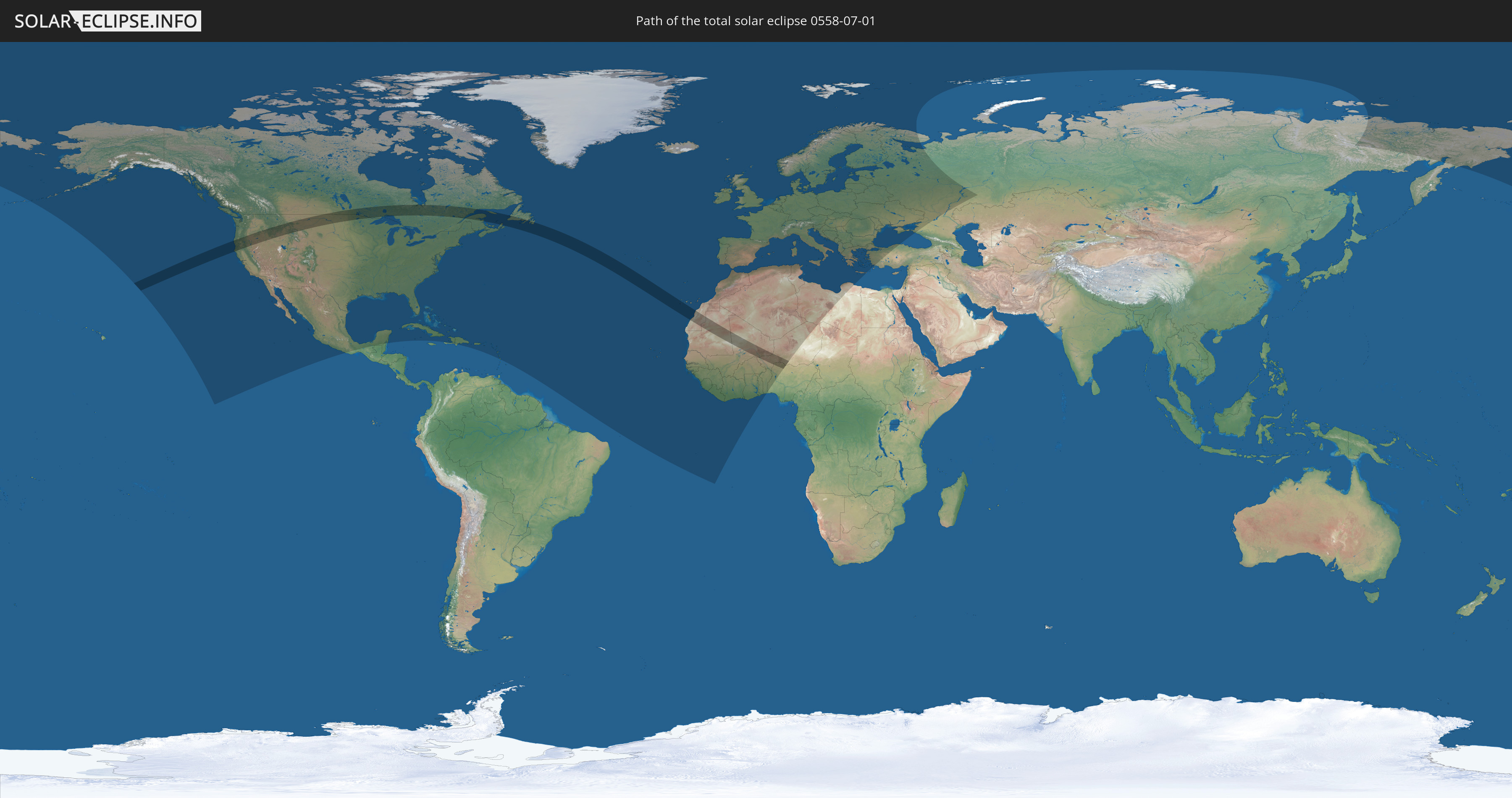
Die Sonnenfinsternis am 07/01/0558 kann man in 99 Ländern als partielle Sonnenfinsternis beobachten.
Der Finsternispfad verläuft durch 8 Länder. Nur in diesen Ländern ist sie als total Sonnenfinsternis zu sehen.
In den folgenden Ländern ist die Sonnenfinsternis total zu sehen
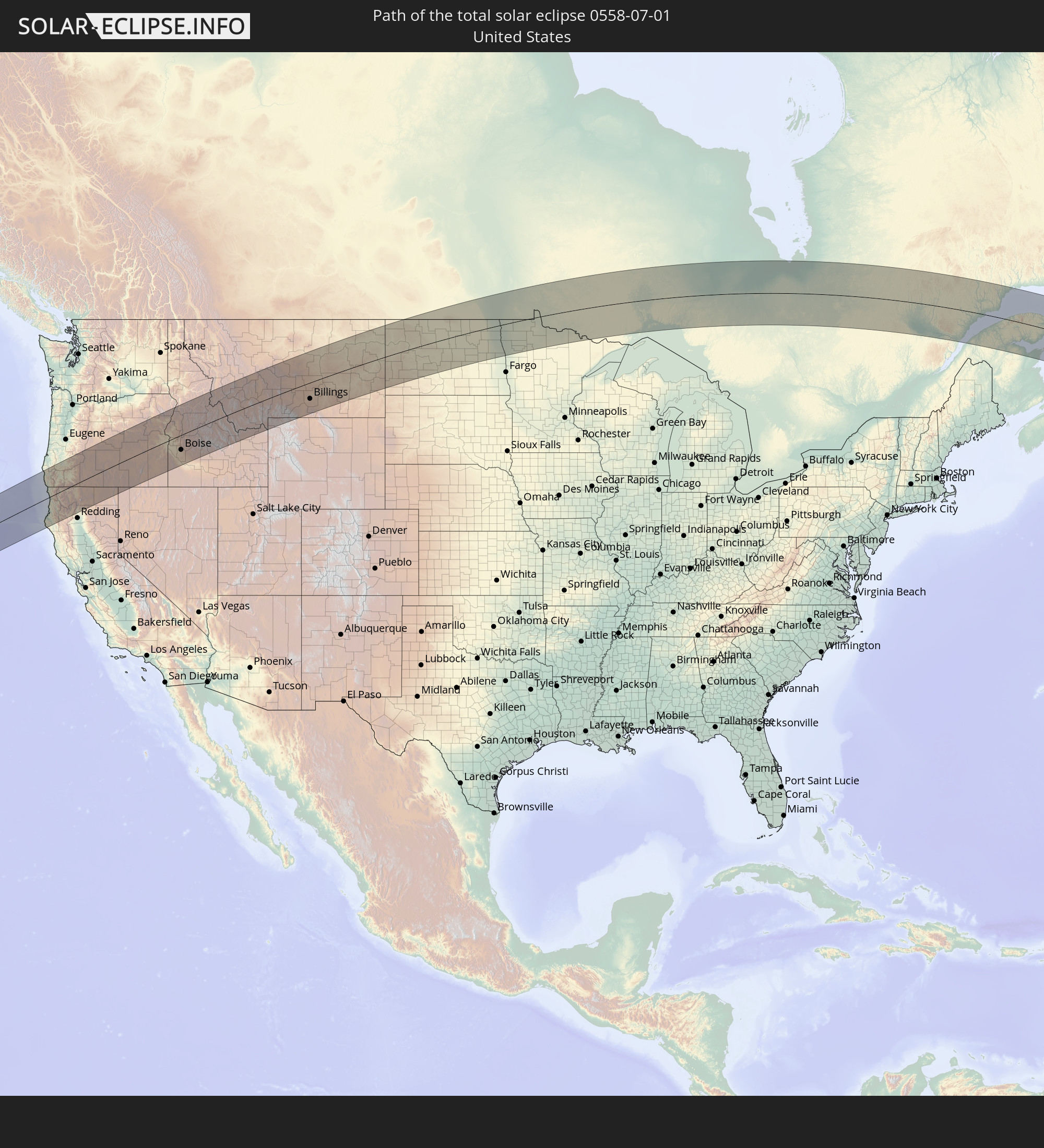 United States
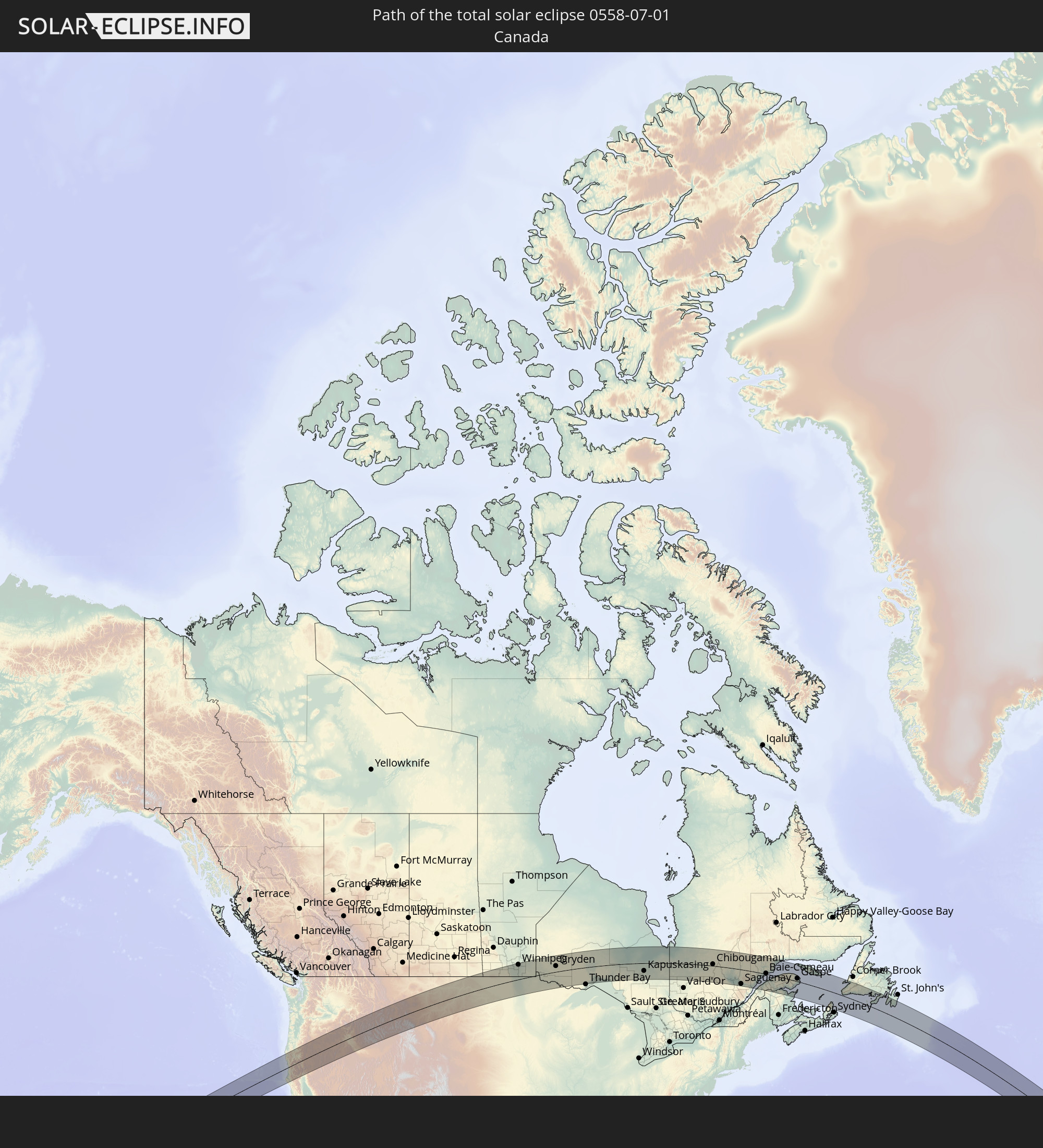 Canada
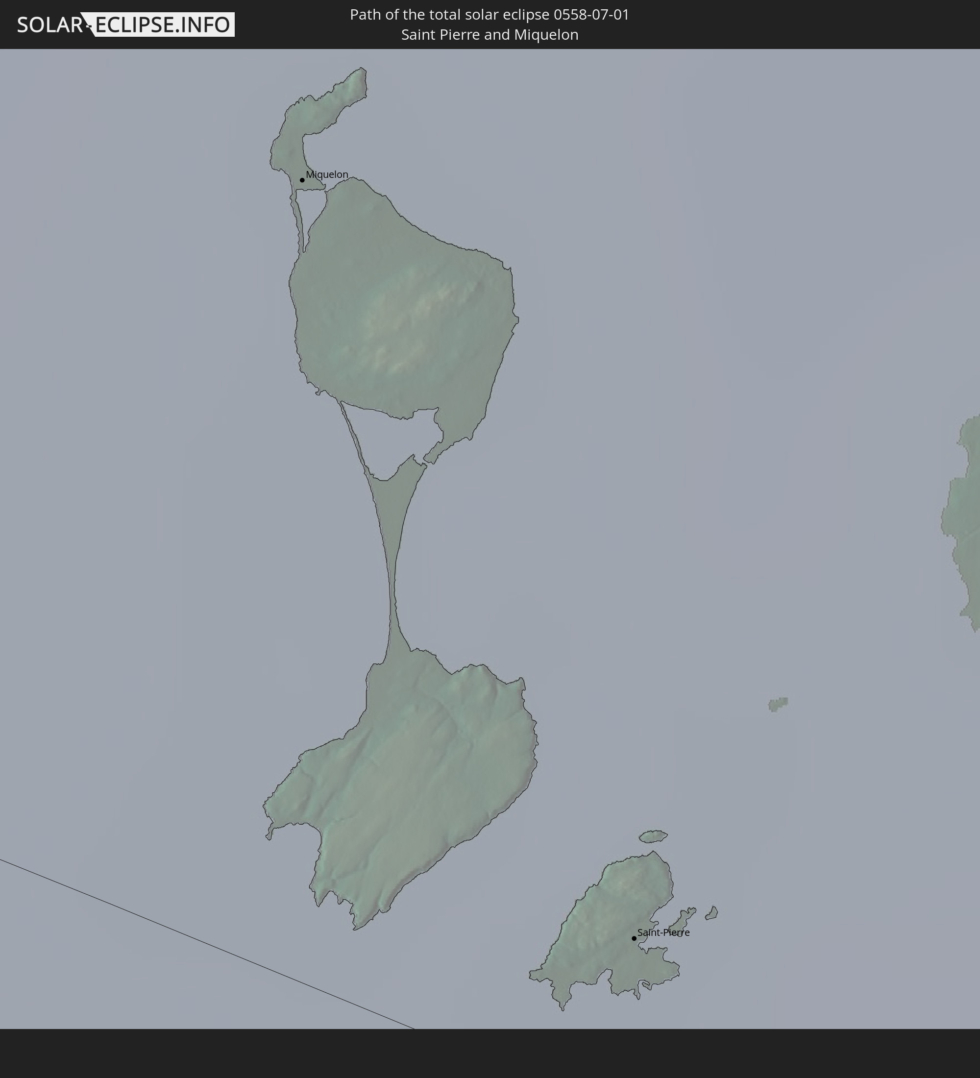 Saint Pierre and Miquelon
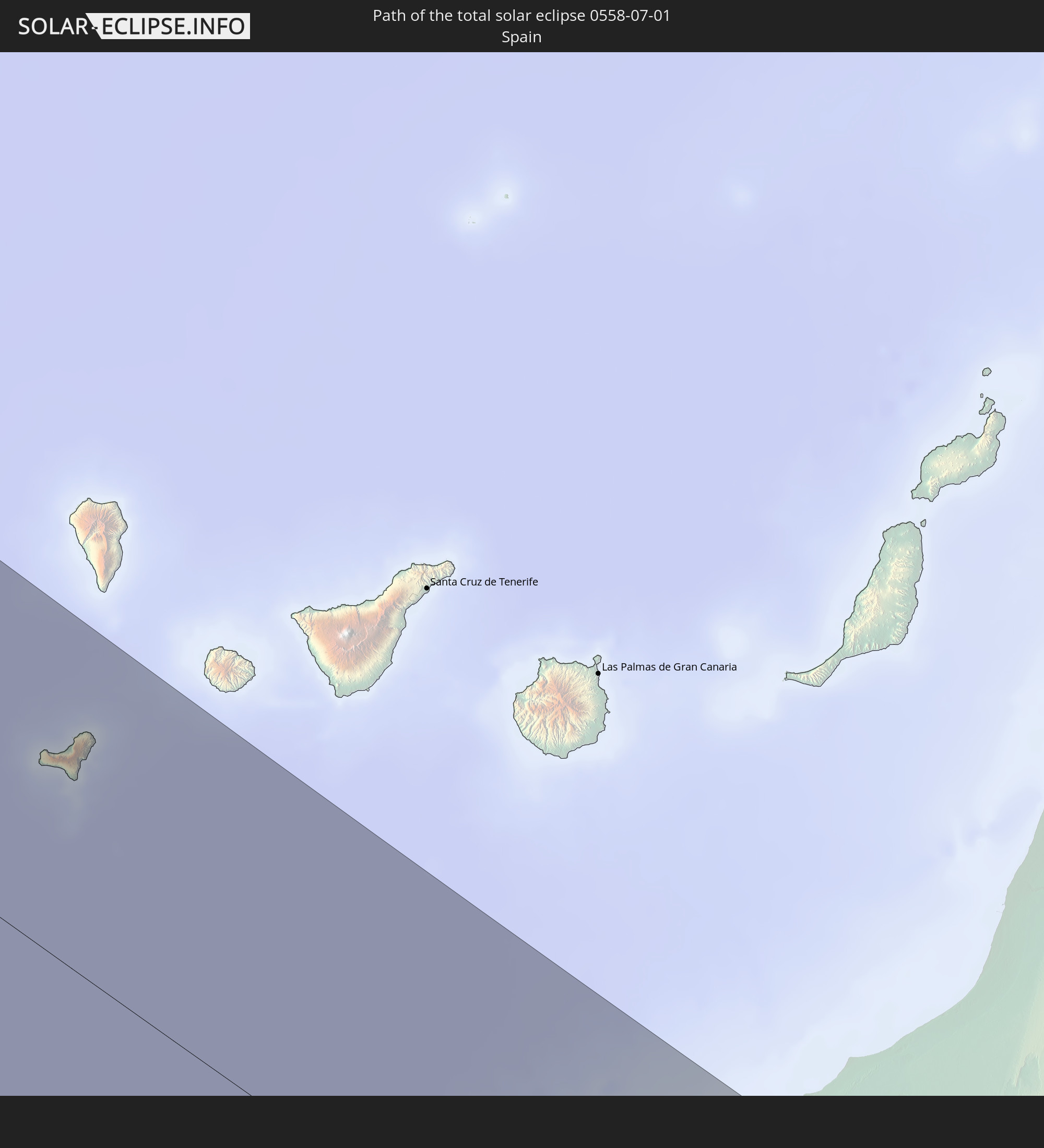 Spain
Spain
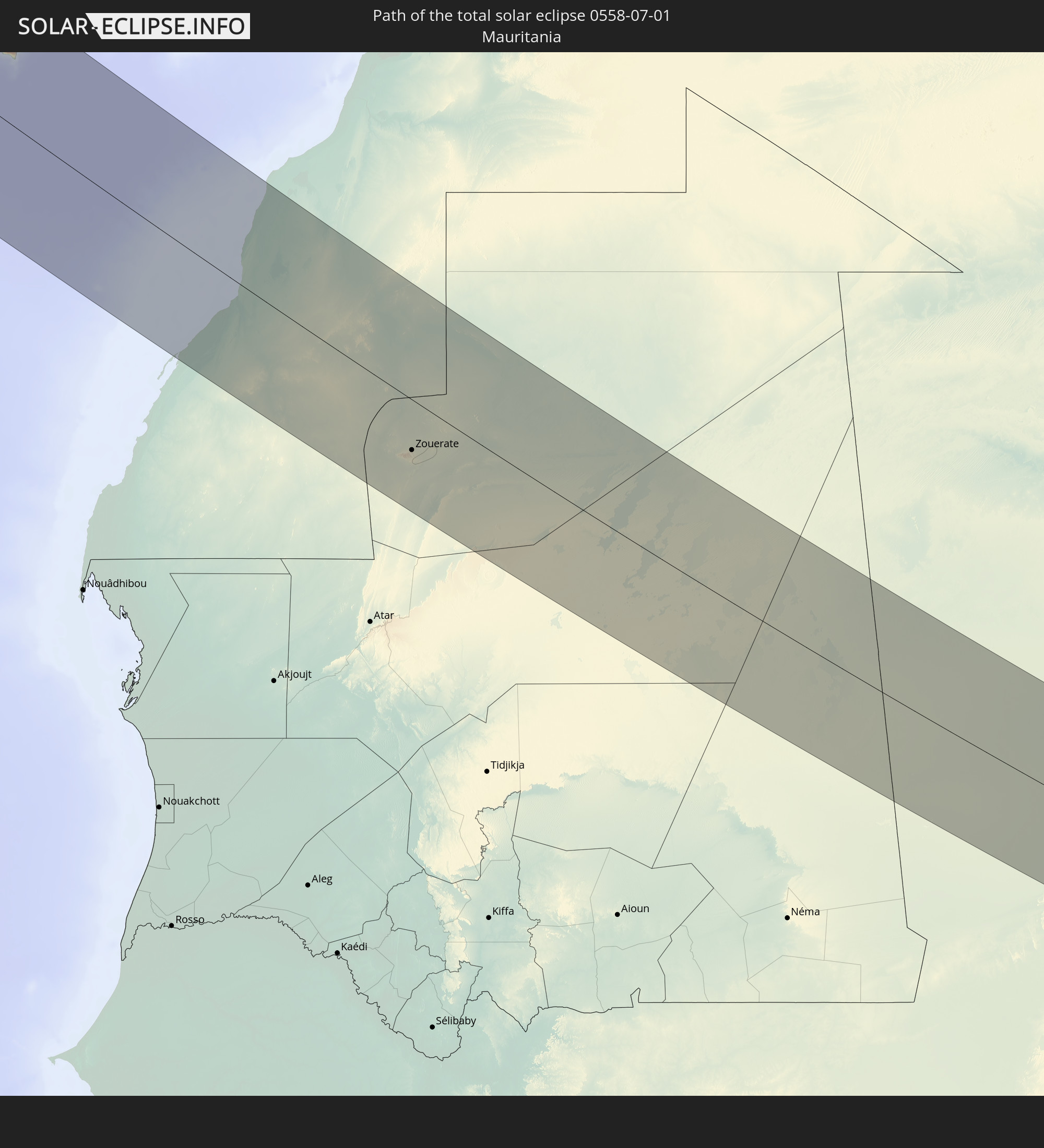 Mauritania
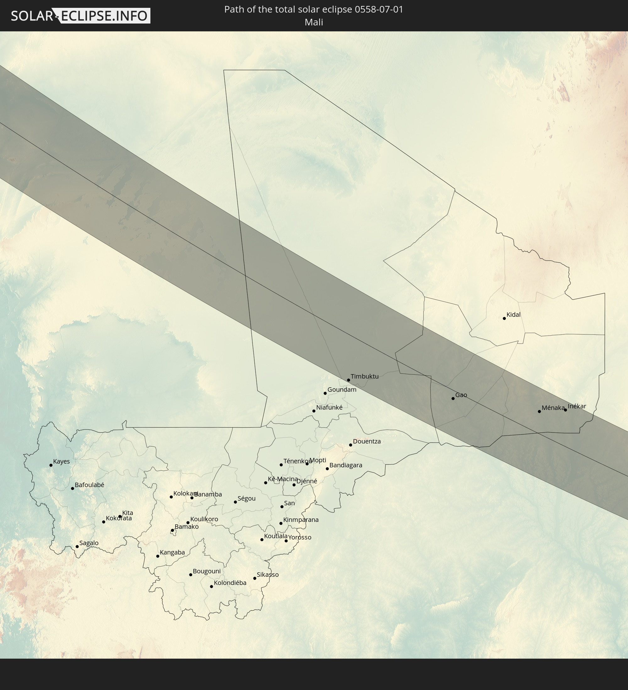 Mali
Mali
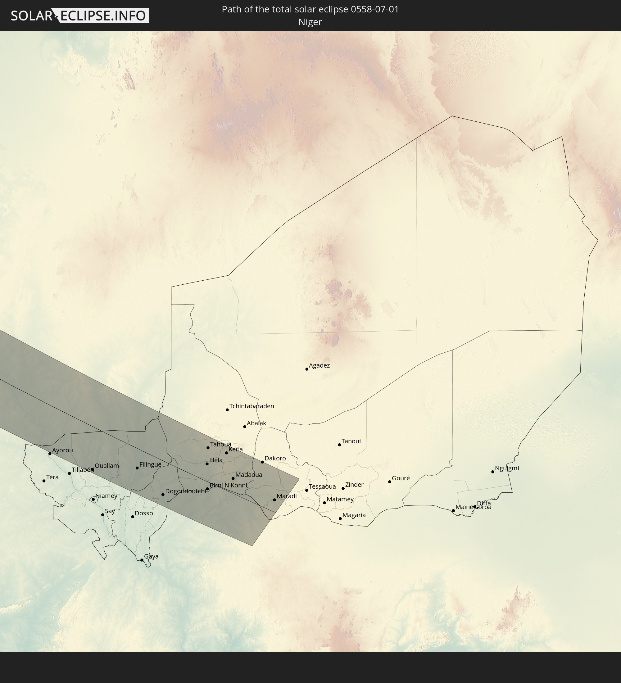 Niger
Niger
 Nigeria
In den folgenden Ländern ist die Sonnenfinsternis partiell zu sehen
 Russia
 United States
 Canada
 Mexico
 Greenland
 Guatemala
 Belize
 Cuba
Cuba
 Cayman Islands
 The Bahamas
 Haiti
Haiti
 Turks and Caicos Islands
 Dominican Republic
 Puerto Rico
 United States Virgin Islands
 Bermuda
 British Virgin Islands
 Anguilla
 Collectivity of Saint Martin
 Saint Barthélemy
 Saint Kitts and Nevis
 Antigua and Barbuda
 Montserrat
 Guadeloupe
 Dominica
 Martinique
 Saint Pierre and Miquelon
 Portugal
 Cabo Verde
 Iceland
 Spain
Spain
 Senegal
 Mauritania
 The Gambia
 Guinea-Bissau
 Guinea
 Saint Helena, Ascension and Tristan da Cunha
 Sierra Leone
 Morocco
 Mali
Mali
 Liberia
 Republic of Ireland
 Svalbard and Jan Mayen
 Algeria
 United Kingdom
 Ivory Coast
 Faroe Islands
 Burkina Faso
 Gibraltar
 France
 Isle of Man
 Ghana
Ghana
 Guernsey
 Jersey
 Togo
Togo
 Niger
Niger
 Benin
Benin
 Andorra
 Belgium
 Nigeria
 Netherlands
 Norway
 Luxembourg
 Germany
 Switzerland
 Italy
Italy
 Monaco
 Tunisia
 Denmark
 Libya
Libya
 Liechtenstein
 Austria
 Sweden
 Czechia
 San Marino
 Vatican City
 Slovenia
 Croatia
 Poland
 Malta
Malta
 Bosnia and Herzegovina
 Hungary
 Slovakia
 Montenegro
 Serbia
 Albania
 Åland Islands
 Greece
 Romania
 Republic of Macedonia
 Finland
 Lithuania
 Latvia
 Estonia
 Ukraine
 Bulgaria
 Belarus
 Turkey
 Moldova
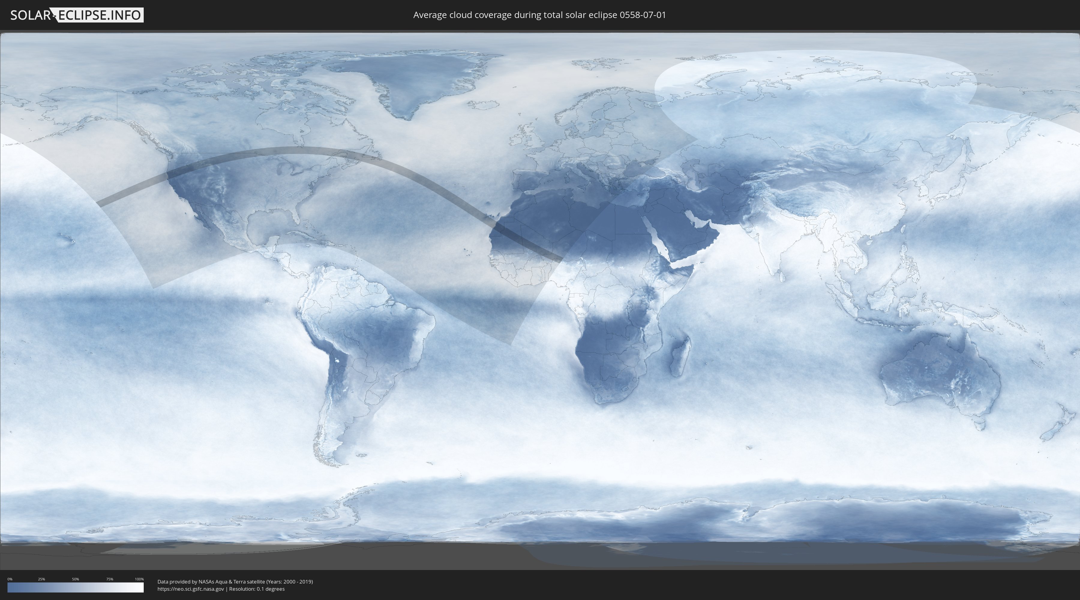
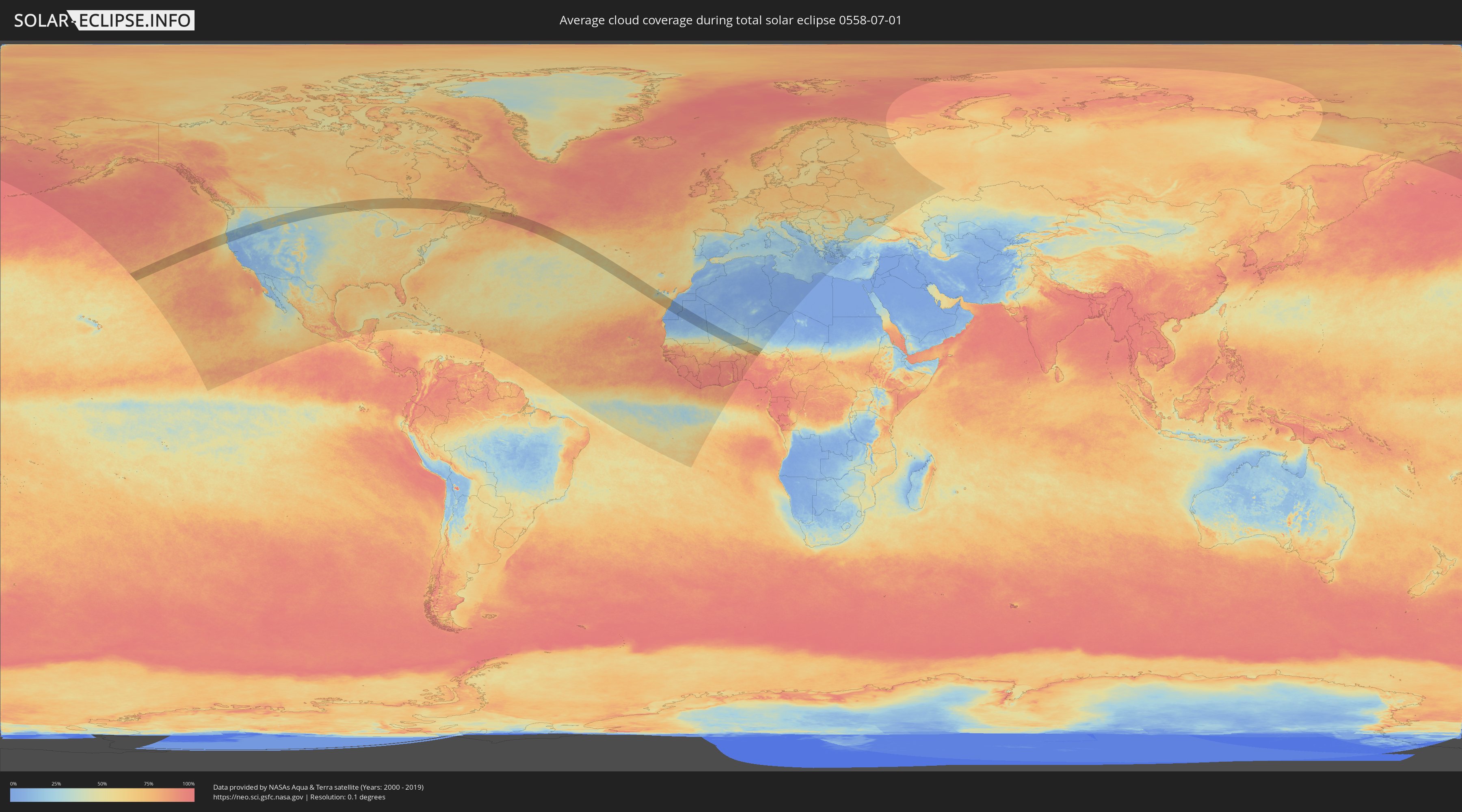
How will be the weather during the total solar eclipse on 07/01/0558?
Where is the best place to see the total solar eclipse of 07/01/0558?
The following maps show the average cloud coverage for the day of the total solar eclipse.
With the help of these maps, it is possible to find the place along the eclipse path, which has the best
chance of a cloudless sky.
Nevertheless, you should consider local circumstances and inform about the weather of your chosen
observation site.
The data is provided by NASAs satellites
AQUA and TERRA.
The cloud maps are averaged over a period of 19 years (2000 - 2019).
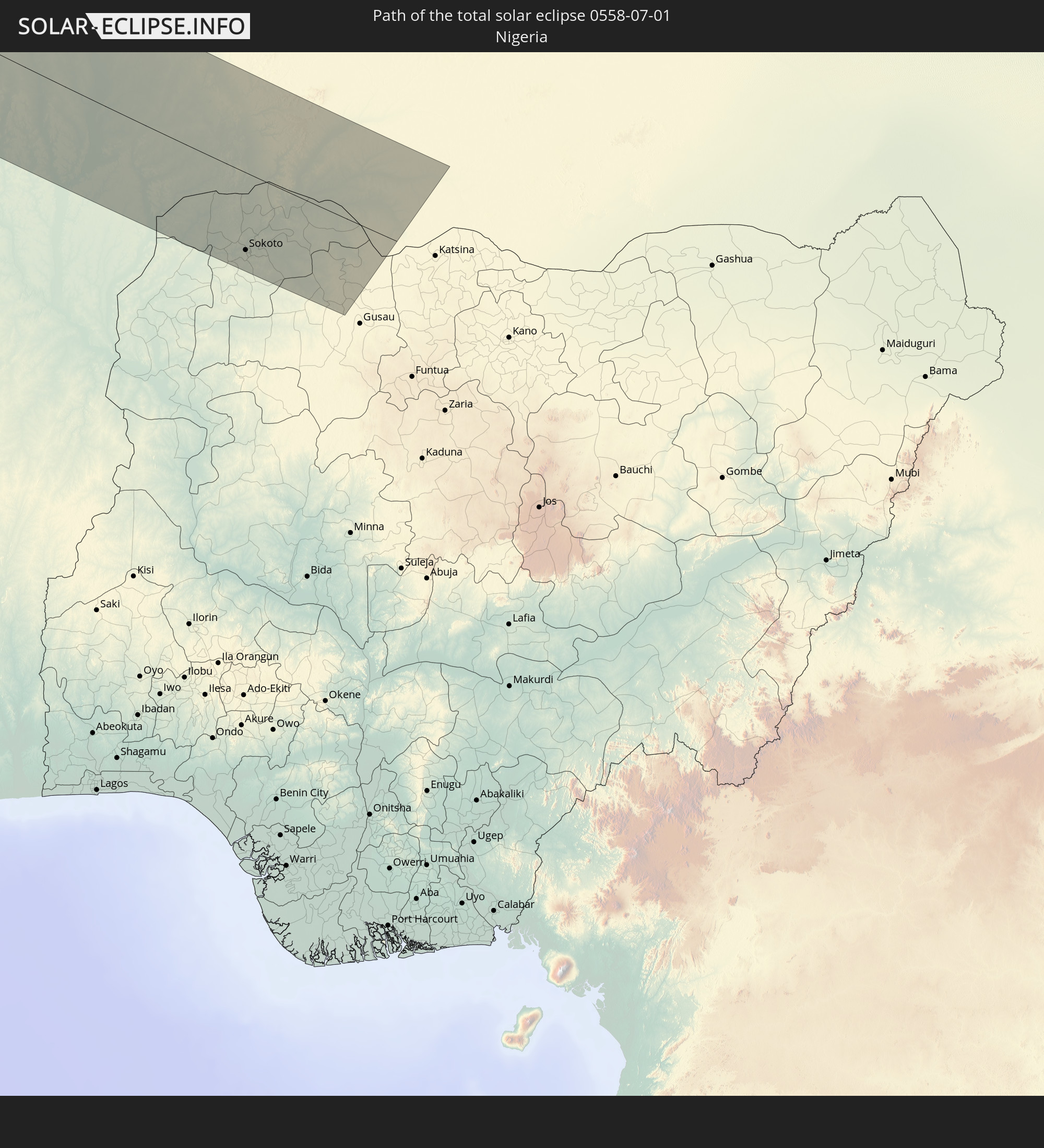
Detailed country maps
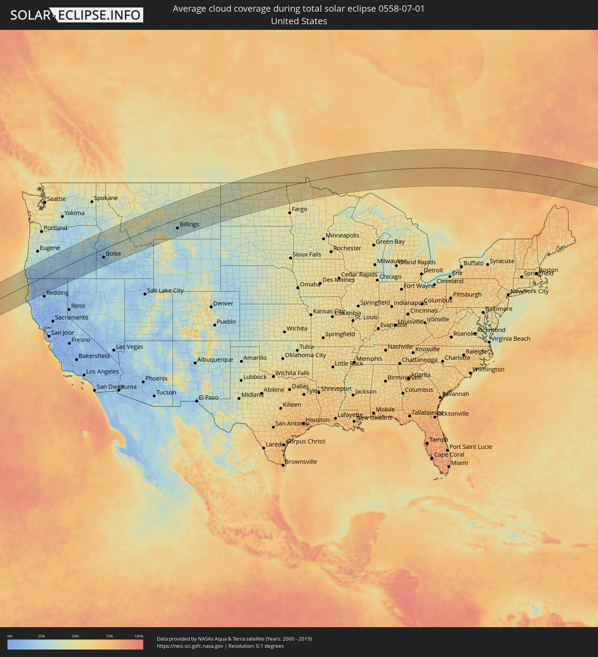 United States
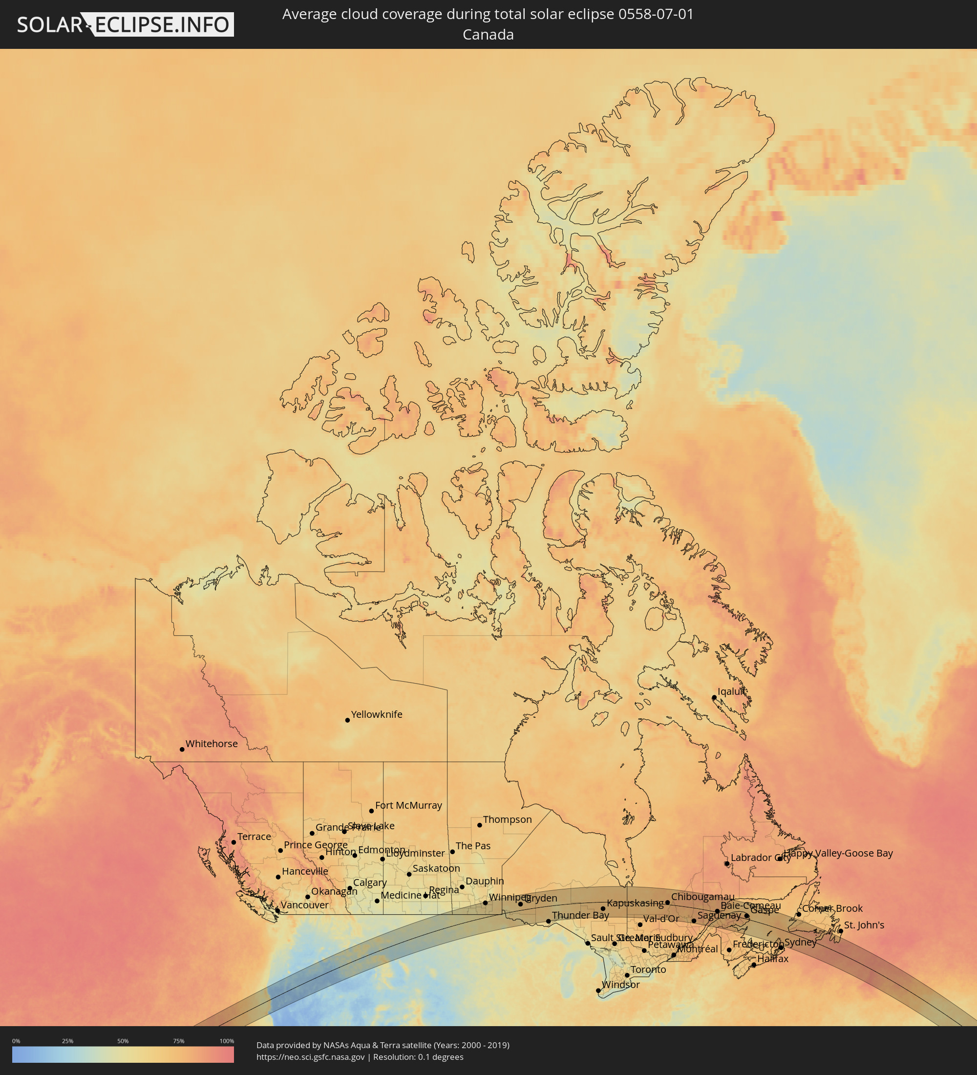 Canada
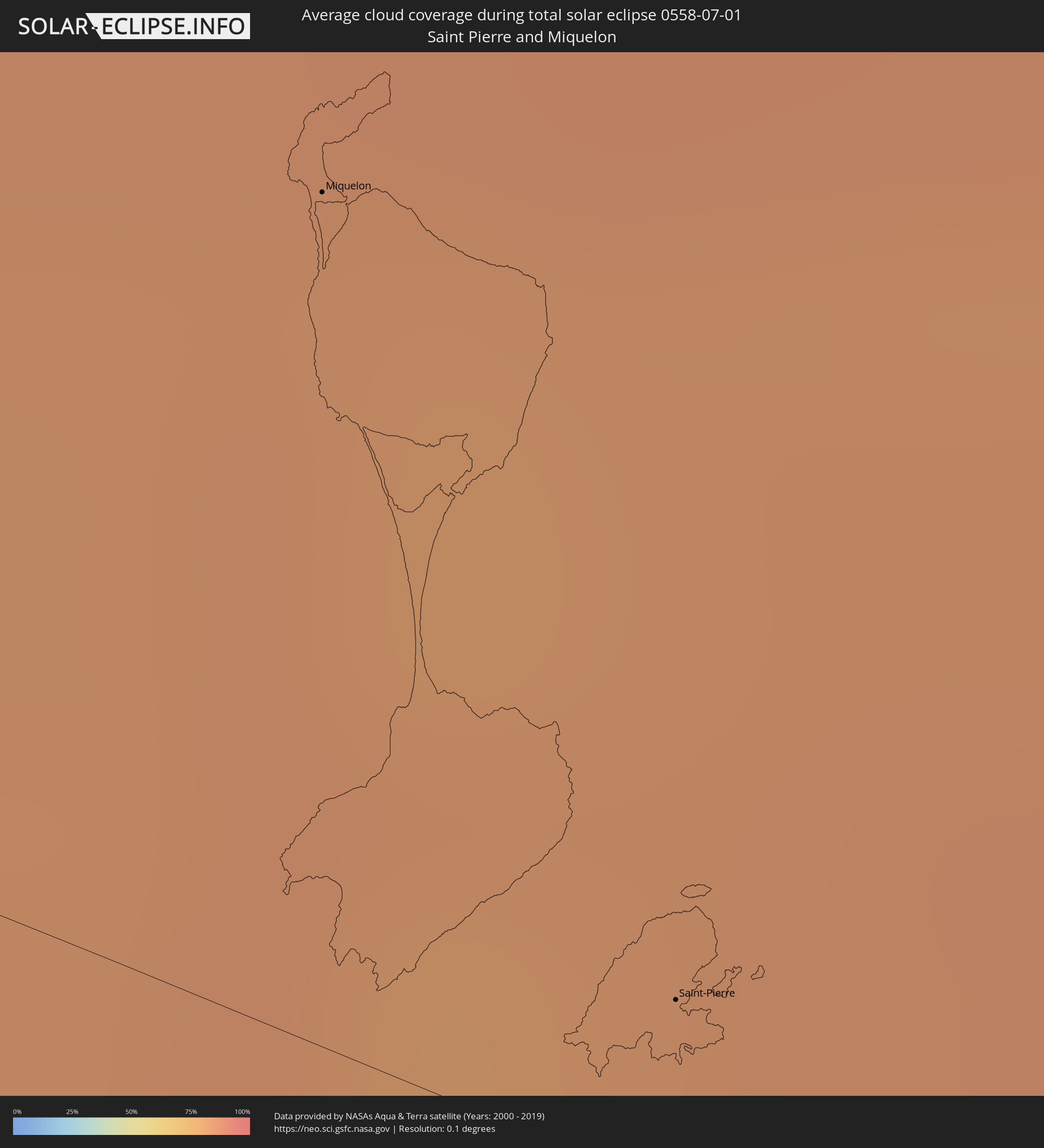 Saint Pierre and Miquelon
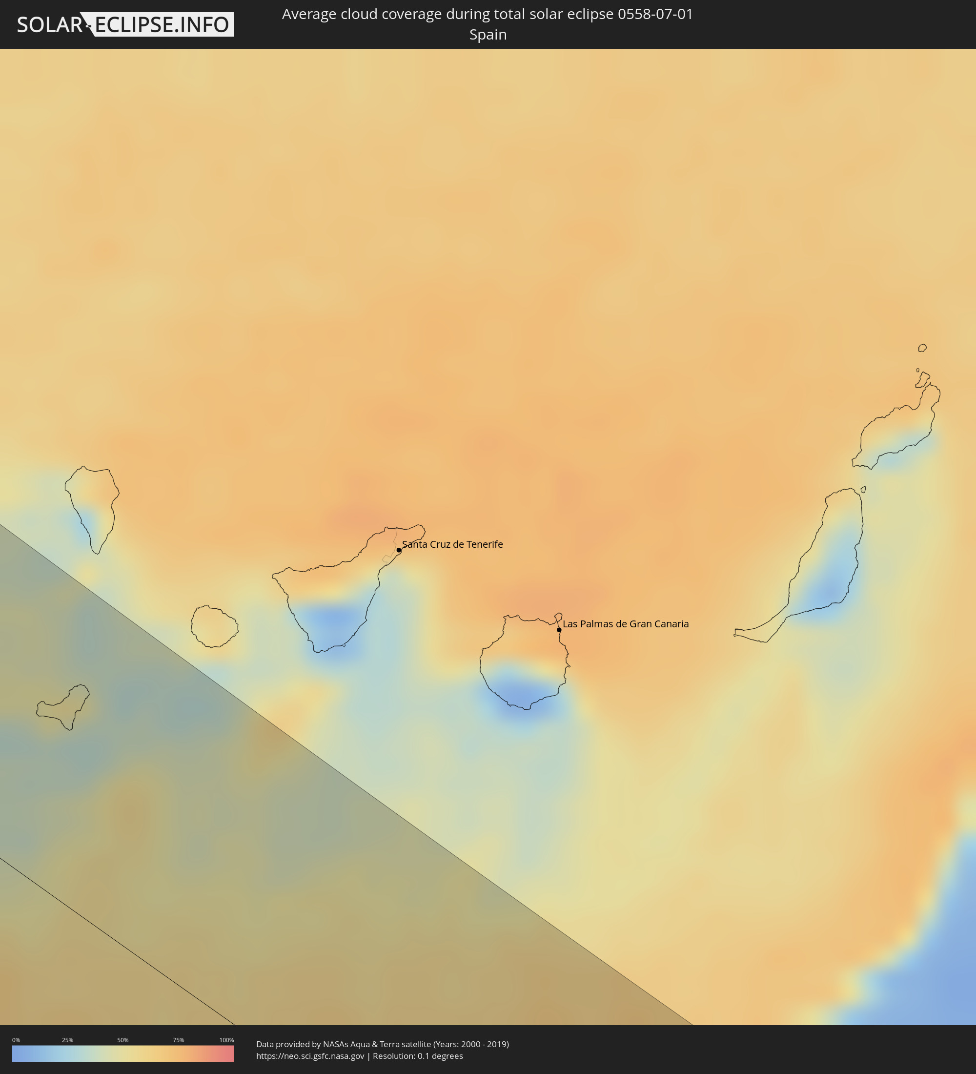 Spain
Spain
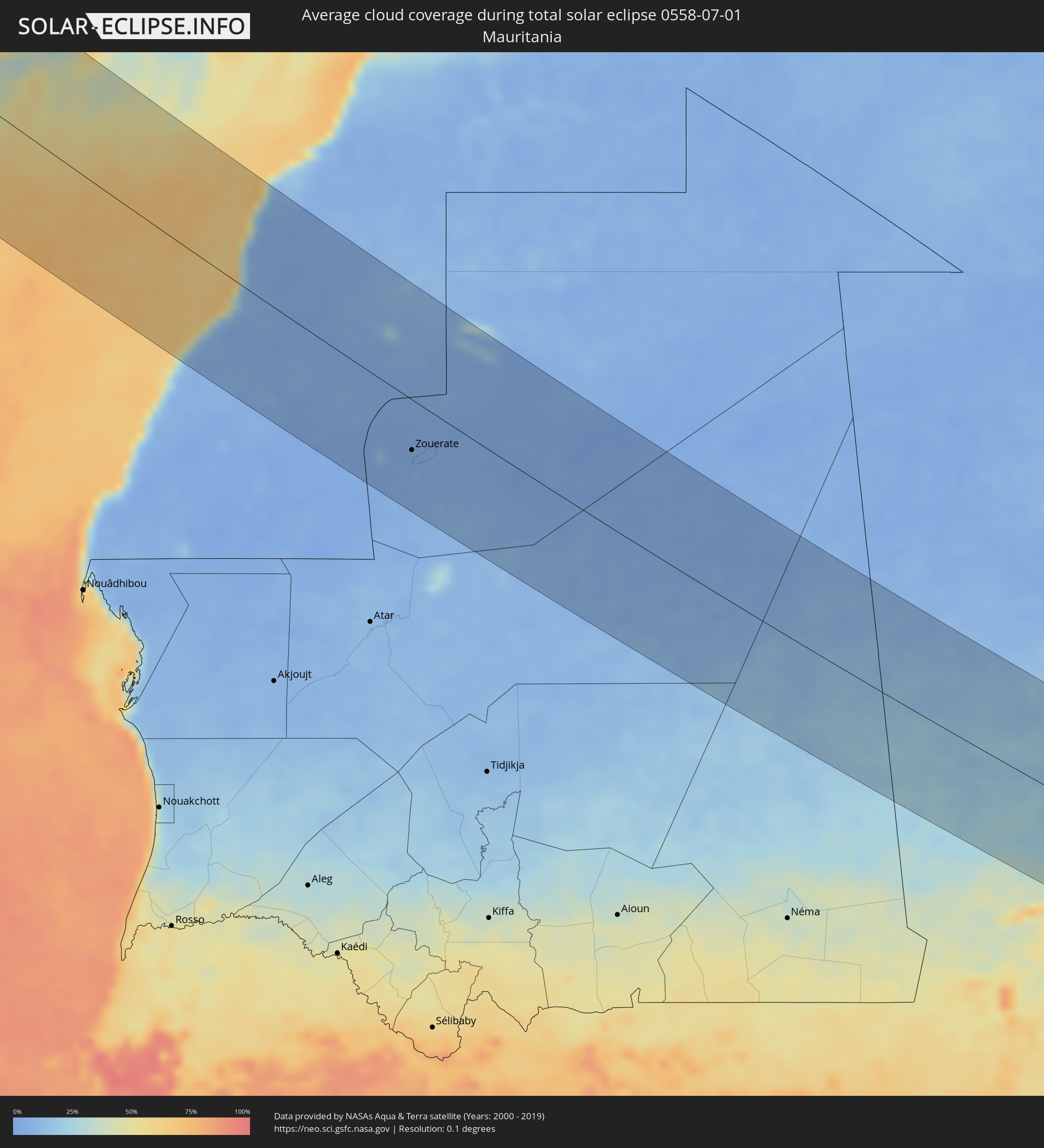 Mauritania
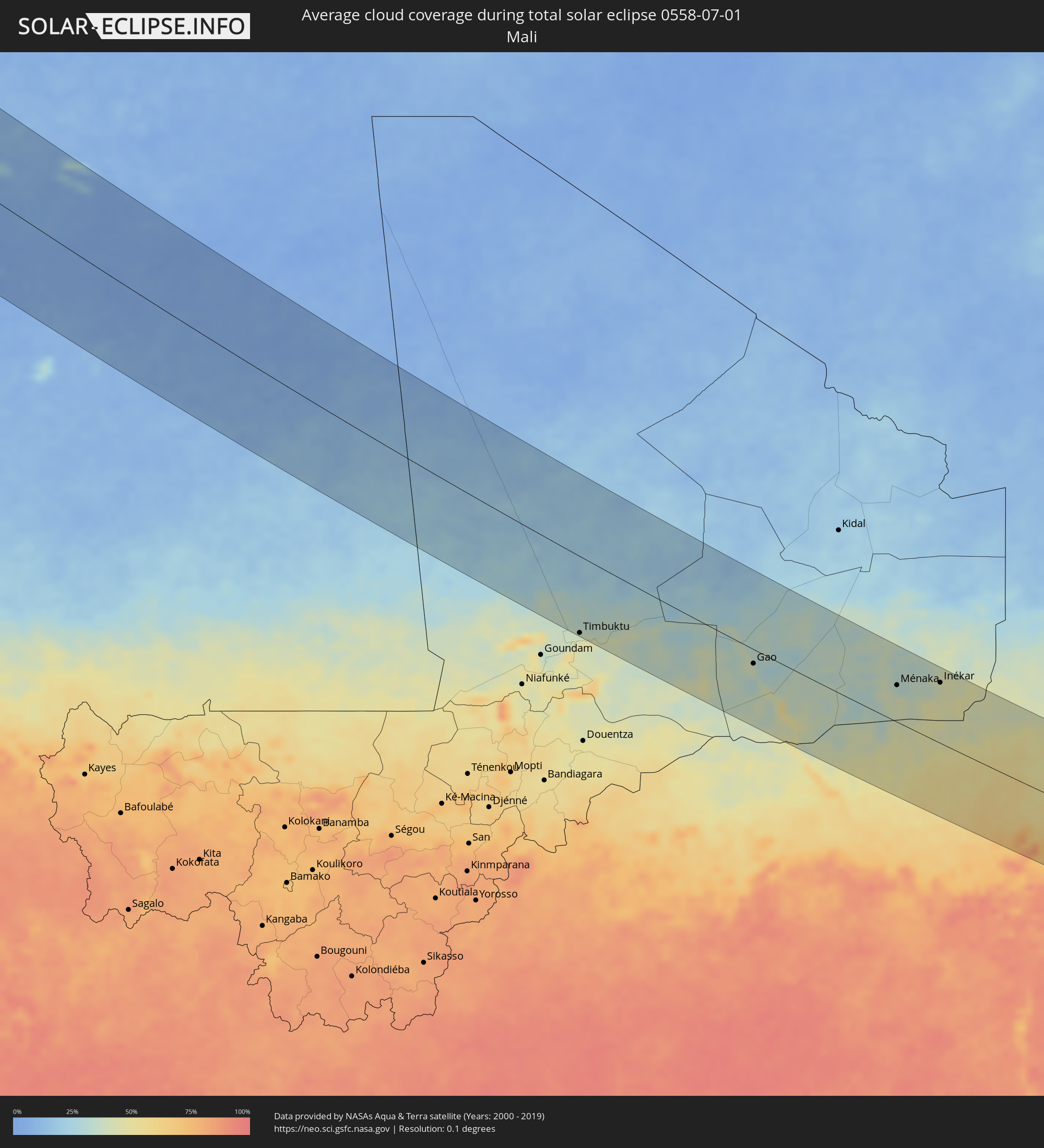 Mali
Mali
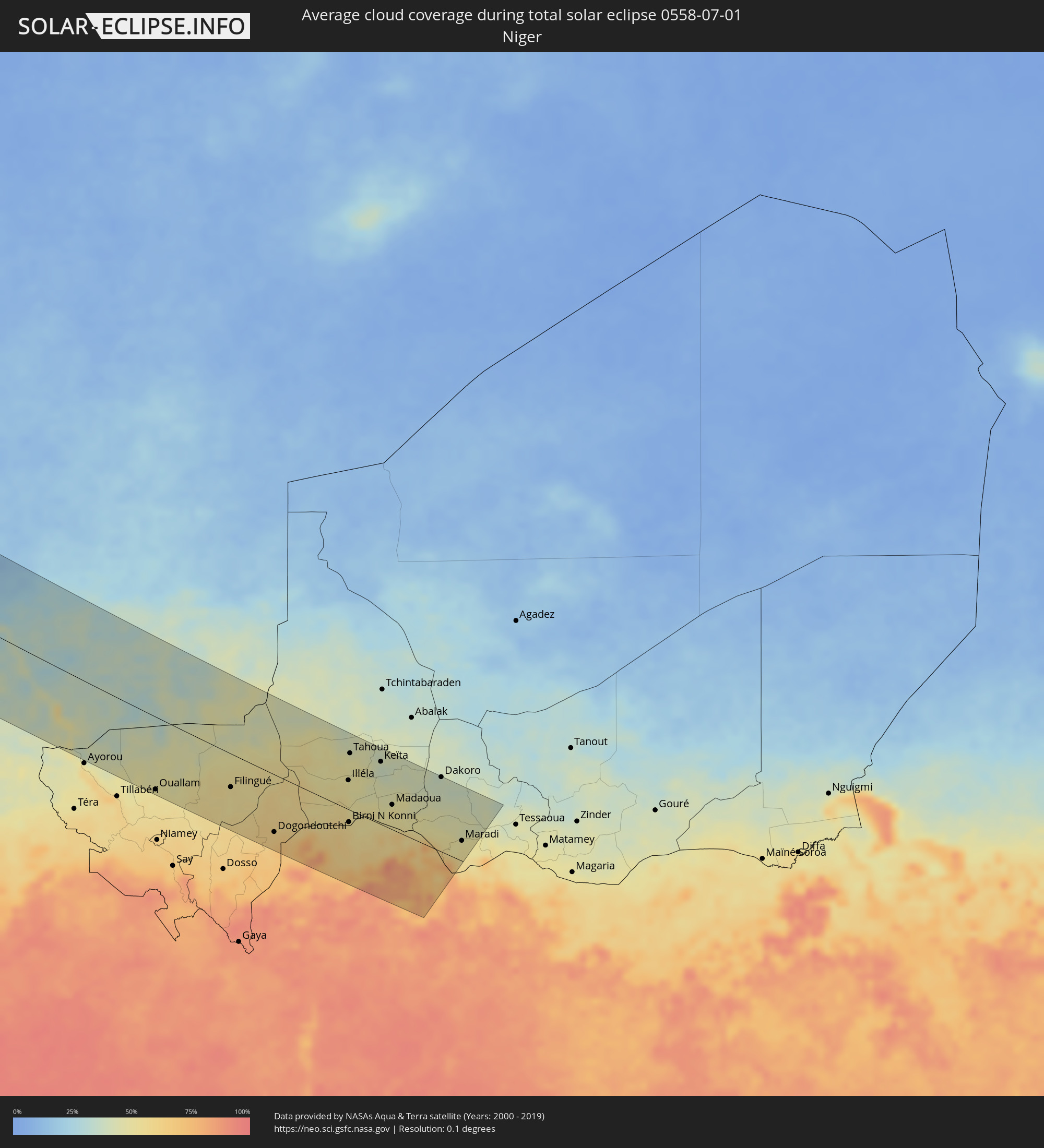 Niger
Niger
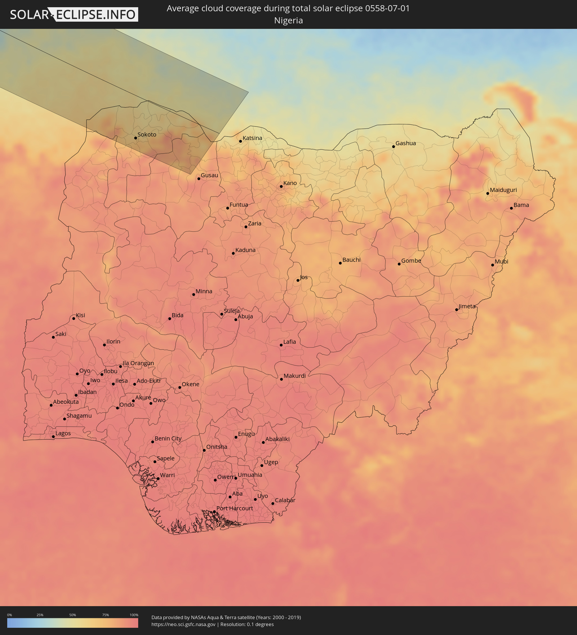 Nigeria
Cities inside the path of the eclipse
The following table shows all locations with a population of more than 5,000 inside the eclipse path. Cities which have more than 100,000 inhabitants are marked bold. A click at the locations opens a detailed map.
| City | Type | Eclipse duration | Local time of max. eclipse | Distance to central line | Ø Cloud coverage |
|
Eureka, California
|
total | - | 06:56:22 UTC-08:00 | 70 km | 57% |
|
Fortuna, California
|
total | - | 06:56:08 UTC-08:00 | 90 km | 42% |
|
McKinleyville, California
|
total | - | 06:56:33 UTC-08:00 | 58 km | 57% |
|
Grants Pass, Oregon
|
total | - | 06:58:33 UTC-08:00 | 63 km | 14% |
|
Medford, Oregon
|
total | - | 06:58:34 UTC-08:00 | 35 km | 15% |
|
White City, Oregon
|
total | - | 06:58:42 UTC-08:00 | 46 km | 13% |
|
Eagle Point, Oregon
|
total | - | 06:58:46 UTC-08:00 | 47 km | 12% |
|
Ashland, Oregon
|
total | - | 06:58:27 UTC-08:00 | 16 km | 17% |
|
Klamath Falls, Oregon
|
total | - | 06:58:48 UTC-08:00 | 15 km | 12% |
|
Baker City, Oregon
|
total | - | 07:03:34 UTC-08:00 | 106 km | 25% |
|
Ontario, Oregon
|
total | - | 08:03:03 UTC-07:00 | 2 km | 15% |
|
Caldwell, Idaho
|
total | - | 08:02:45 UTC-07:00 | 44 km | 14% |
|
Nampa, Idaho
|
total | - | 08:02:39 UTC-07:00 | 61 km | 15% |
|
Meridian, Idaho
|
total | - | 08:02:50 UTC-07:00 | 59 km | 14% |
|
Boise, Idaho
|
total | - | 08:02:56 UTC-07:00 | 65 km | 14% |
|
Mountain Home, Idaho
|
total | - | 08:02:37 UTC-07:00 | 131 km | 17% |
|
Anaconda, Montana
|
total | - | 08:07:55 UTC-07:00 | 91 km | 50% |
|
Butte, Montana
|
total | - | 08:08:01 UTC-07:00 | 66 km | 43% |
|
Helena, Montana
|
total | - | 08:09:04 UTC-07:00 | 112 km | 42% |
|
Helena Valley Southeast, Montana
|
total | - | 08:09:10 UTC-07:00 | 111 km | 43% |
|
Bozeman, Montana
|
total | - | 08:08:36 UTC-07:00 | 11 km | 27% |
|
Billings, Montana
|
total | - | 08:10:34 UTC-07:00 | 70 km | 31% |
|
Miles City, Montana
|
total | - | 08:13:28 UTC-07:00 | 73 km | 34% |
|
Williston, North Dakota
|
total | - | 09:17:26 UTC-06:00 | 60 km | 41% |
|
Dickinson, North Dakota
|
total | - | 08:16:45 UTC-07:00 | 94 km | 38% |
|
Minot, North Dakota
|
total | - | 09:19:42 UTC-06:00 | 19 km | 49% |
|
Morden, Manitoba
|
total | - | 09:23:57 UTC-06:00 | 63 km | 53% |
|
Winkler, Manitoba
|
total | - | 09:24:06 UTC-06:00 | 59 km | 54% |
|
Winnipeg, Manitoba
|
total | - | 09:25:39 UTC-06:00 | 122 km | 63% |
|
Grand Forks, North Dakota
|
total | - | 09:23:48 UTC-06:00 | 93 km | 53% |
|
East Grand Forks, Minnesota
|
total | - | 09:23:49 UTC-06:00 | 92 km | 53% |
|
Steinbach, Manitoba
|
total | - | 09:25:47 UTC-06:00 | 75 km | 57% |
|
Thief River Falls, Minnesota
|
total | - | 09:24:57 UTC-06:00 | 86 km | 53% |
|
Fort Frances, Ontario
|
total | - | 09:28:40 UTC-06:00 | 74 km | 57% |
|
Dryden, Ontario
|
total | - | 09:30:30 UTC-06:00 | 48 km | 64% |
|
Kapuskasing, Ontario
|
total | - | 10:43:56 UTC-05:00 | 65 km | 69% |
|
La Sarre, Quebec
|
total | - | 10:48:33 UTC-05:00 | 133 km | 71% |
|
Chibougamau, Quebec
|
total | - | 10:56:14 UTC-05:00 | 13 km | 73% |
|
Saint-Félicien, Quebec
|
total | - | 10:59:18 UTC-05:00 | 110 km | 71% |
|
Roberval, Quebec
|
total | - | 10:59:39 UTC-05:00 | 123 km | 73% |
|
Dolbeau-Mistassini, Quebec
|
total | - | 10:59:38 UTC-05:00 | 83 km | 72% |
|
Pont Rouge, Quebec
|
total | - | 10:59:52 UTC-05:00 | 81 km | 73% |
|
Alma, Quebec
|
total | - | 11:00:37 UTC-05:00 | 113 km | 72% |
|
Jonquière, Quebec
|
total | - | 11:01:17 UTC-05:00 | 123 km | 71% |
|
Saguenay, Quebec
|
total | - | 11:01:35 UTC-05:00 | 121 km | 72% |
|
Rimouski, Quebec
|
total | - | 11:05:47 UTC-05:00 | 85 km | 70% |
|
Mont-Joli, Quebec
|
total | - | 11:06:17 UTC-05:00 | 65 km | 68% |
|
Baie-Comeau, Quebec
|
total | - | 11:06:10 UTC-05:00 | 5 km | 76% |
|
Matane, Quebec
|
total | - | 11:07:18 UTC-05:00 | 28 km | 69% |
|
Amqui, Quebec
|
total | - | 11:07:35 UTC-05:00 | 66 km | 73% |
|
Port-Cartier, Quebec
|
total | - | 11:07:56 UTC-05:00 | 113 km | 79% |
|
Campbellton, New Brunswick
|
total | - | 11:54:37 UTC-04:14 | 104 km | 74% |
|
Sainte-Anne-des-Monts, Quebec
|
total | - | 11:08:52 UTC-05:00 | 20 km | 69% |
|
Bathurst, New Brunswick
|
total | - | 11:56:30 UTC-04:14 | 128 km | 73% |
|
Chandler, Quebec
|
total | - | 11:12:10 UTC-05:00 | 31 km | 73% |
|
Gaspé, Quebec
|
total | - | 11:12:14 UTC-05:00 | 25 km | 72% |
|
Stephenville, Newfoundland and Labrador
|
total | - | 12:50:57 UTC-03:30 | 126 km | 67% |
|
Miquelon, Miquelon-Langlade
|
total | - | 12:41:54 UTC-03:44 | 35 km | 83% |
|
Saint-Pierre, Saint-Pierre
|
total | - | 12:42:32 UTC-03:44 | 8 km | 84% |
|
Zouerate, Tiris Zemmour
|
total | - | 17:31:06 UTC-00:16 | 60 km | 4% |
|
Timbuktu, Tombouctou
|
total | - | 17:38:23 UTC-00:16 | 122 km | 41% |
|
Gao, Gao
|
total | - | 17:38:28 UTC-00:16 | 23 km | 40% |
|
Ouallam, Tillabéri
|
total | - | 18:09:33 UTC+00:13 | 115 km | 53% |
|
Ménaka, Gao
|
total | - | 17:38:17 UTC-00:16 | 60 km | 37% |
|
Inékar, Gao
|
total | - | 17:38:04 UTC-00:16 | 99 km | 40% |
|
Filingué, Tillabéri
|
total | - | 18:09:12 UTC+00:13 | 53 km | 54% |
|
Dogondoutchi, Dosso
|
total | - | 18:09:38 UTC+00:13 | 92 km | 62% |
|
Binji, Sokoto
|
total | - | 18:09:43 UTC+00:13 | 94 km | 68% |
|
Gwadabawa, Sokoto
|
total | - | 18:09:30 UTC+00:13 | 65 km | 63% |
|
Sokoto, Sokoto
|
total | - | 18:09:45 UTC+00:13 | 95 km | 70% |
|
Illéla, Tahoua
|
total | - | 18:08:33 UTC+00:13 | 47 km | 51% |
|
Birni N Konni, Tahoua
|
total | - | 18:09:08 UTC+00:13 | 20 km | 55% |
|
Tahoua, Tahoua
|
total | - | 18:08:10 UTC+00:13 | 91 km | 49% |
|
Illela, Sokoto
|
total | - | 18:09:10 UTC+00:13 | 25 km | 57% |
|
Dange, Sokoto
|
total | - | 18:09:53 UTC+00:13 | 111 km | 72% |
|
Wurno, Sokoto
|
total | - | 18:09:30 UTC+00:13 | 63 km | 60% |
|
Rabah, Sokoto
|
total | - | 18:09:37 UTC+00:13 | 77 km | 73% |
|
Goronyo, Sokoto
|
total | - | 18:09:17 UTC+00:13 | 37 km | 60% |
|
Gandi, Sokoto
|
total | - | 18:09:40 UTC+00:13 | 82 km | 75% |
|
Keïta, Tahoua
|
total | - | 18:08:08 UTC+00:13 | 100 km | 38% |
|
Madaoua, Tahoua
|
total | - | 18:08:40 UTC+00:13 | 40 km | 52% |
|
Bouza, Tahoua
|
total | - | 18:08:20 UTC+00:13 | 79 km | 46% |
|
Talata Mafara, Zamfara
|
total | - | 18:09:53 UTC+00:13 | 108 km | 71% |
|
Maru, Zamfara
|
total | - | 18:09:57 UTC+00:13 | 118 km | 85% |
|
Moriki, Zamfara
|
total | - | 18:09:29 UTC+00:13 | 58 km | 71% |
|
Shinkafi, Zamfara
|
total | - | 18:09:19 UTC+00:13 | 37 km | 72% |
|
Kaura Namoda, Zamfara
|
total | - | 18:09:41 UTC+00:13 | 83 km | 80% |
|
Dakoro, Maradi
|
total | - | 18:08:01 UTC+00:13 | 120 km | 39% |
|
Tibiri, Maradi
|
total | - | 18:08:44 UTC+00:13 | 38 km | 50% |
|
Maradi, Maradi
|
total | - | 18:08:46 UTC+00:13 | 33 km | 50% |
|
Madarounfa, Maradi
|
total | - | 18:08:54 UTC+00:13 | 16 km | 54% |
|
Mayahi, Maradi
|
total | - | 18:08:11 UTC+00:13 | 106 km | 40% |