Total solar eclipse of 08/12/0603
| Day of week: | Friday |
| Maximum duration of eclipse: | 04m33s |
| Maximum width of eclipse path: | 301 km |
| Saros cycle: | 103 |
| Coverage: | 100% |
| Magnitude: | 1.0671 |
| Gamma: | 0.686 |
Wo kann man die Sonnenfinsternis vom 08/12/0603 sehen?
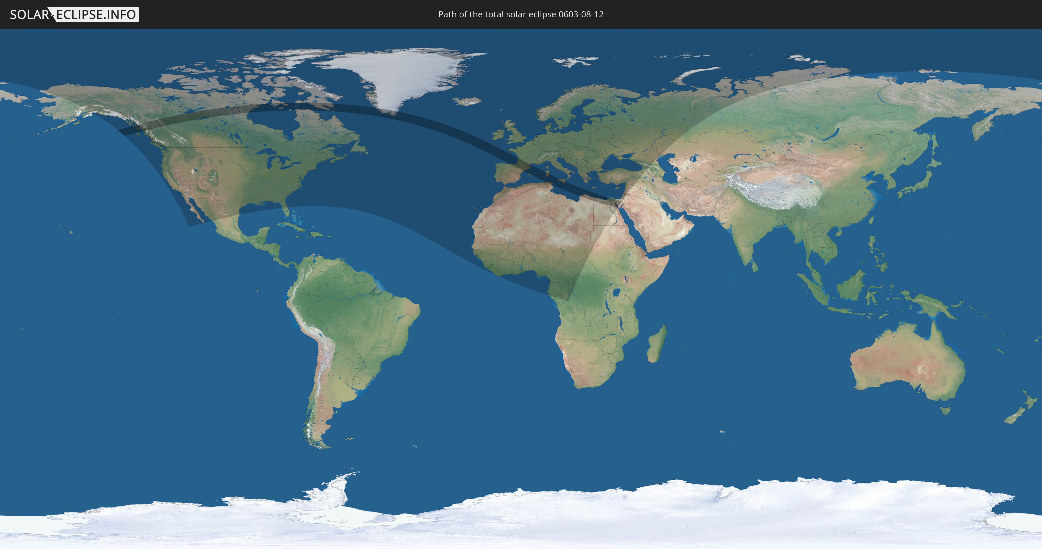
Die Sonnenfinsternis am 08/12/0603 kann man in 96 Ländern als partielle Sonnenfinsternis beobachten.
Der Finsternispfad verläuft durch 12 Länder. Nur in diesen Ländern ist sie als total Sonnenfinsternis zu sehen.
In den folgenden Ländern ist die Sonnenfinsternis total zu sehen
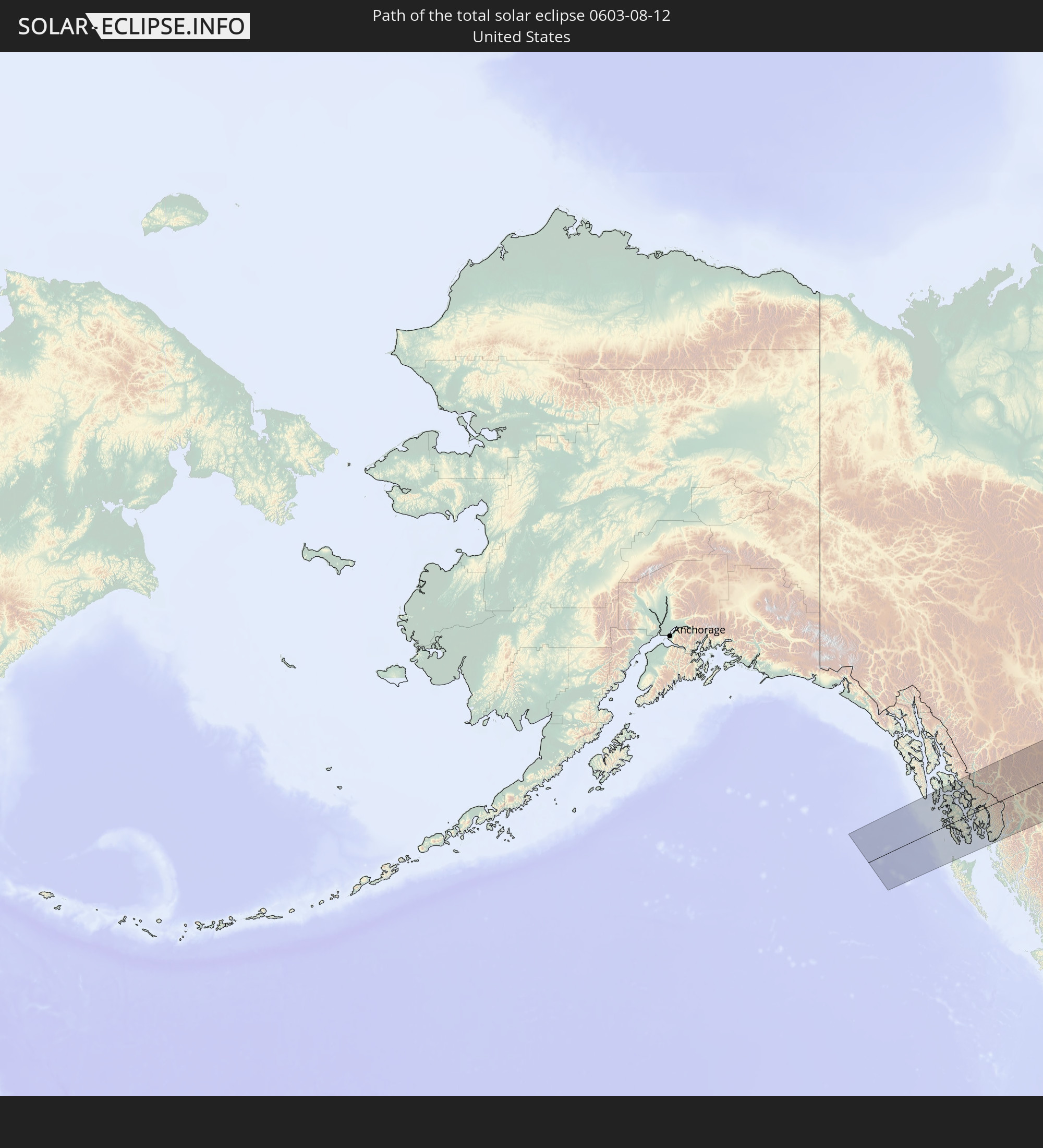 United States
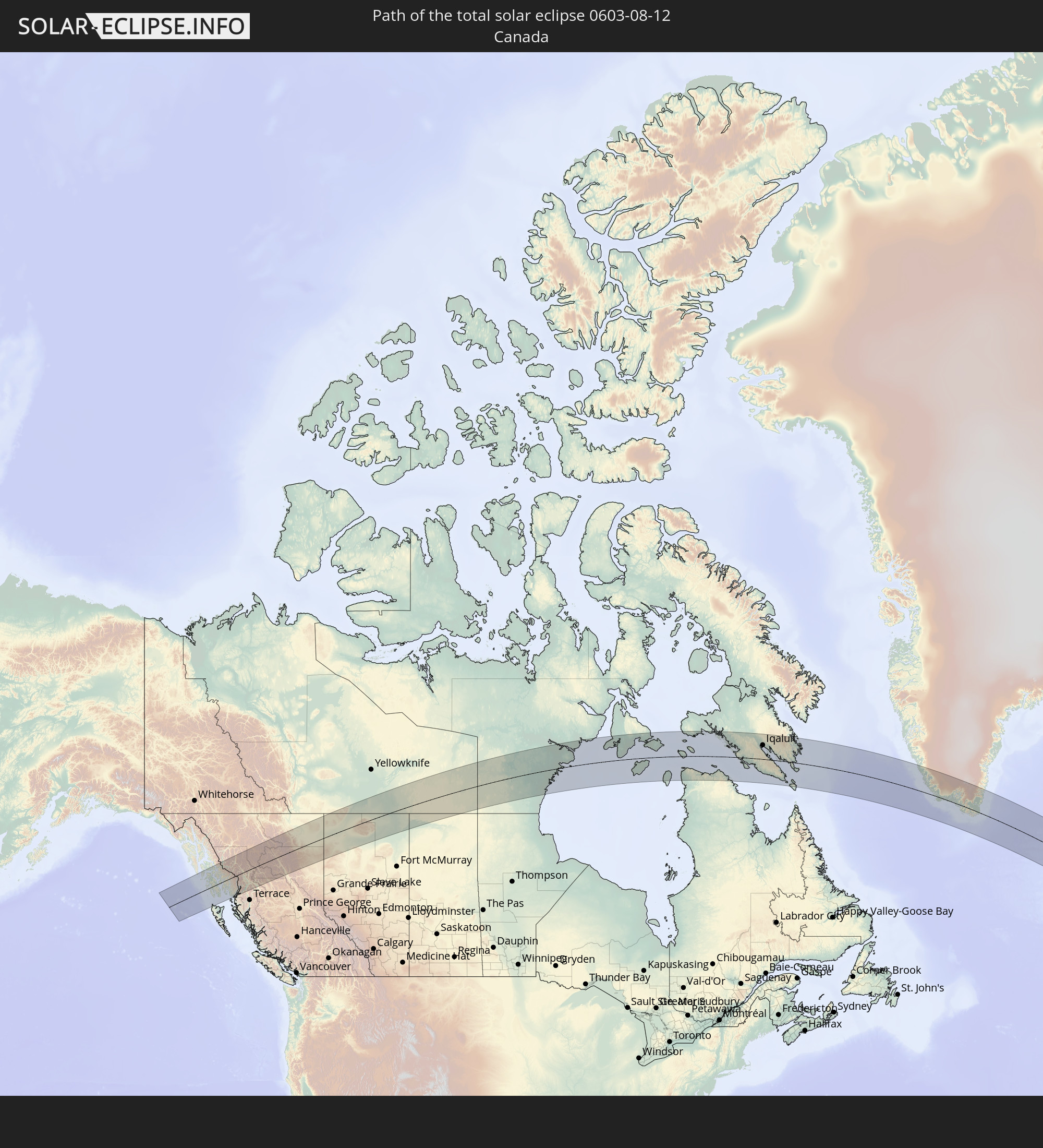 Canada
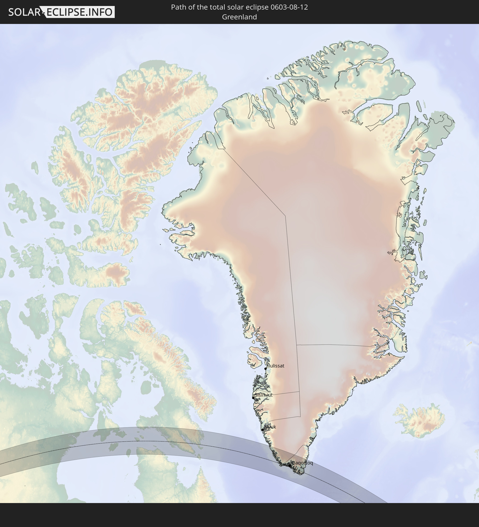 Greenland
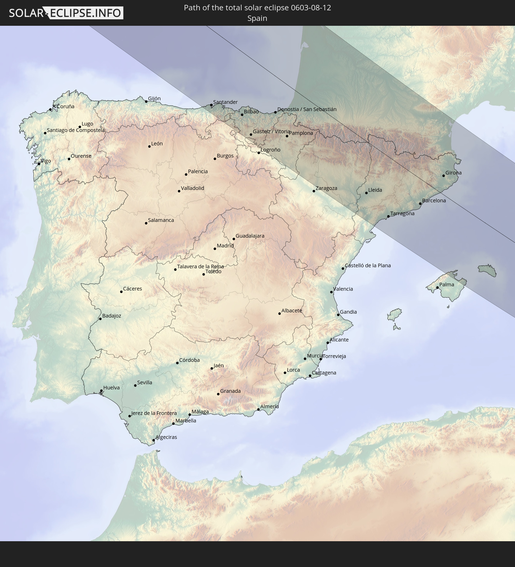 Spain
Spain
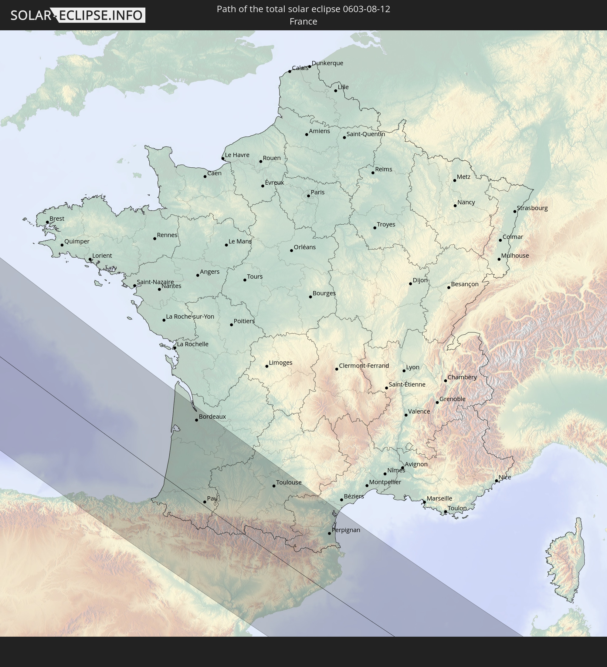 France
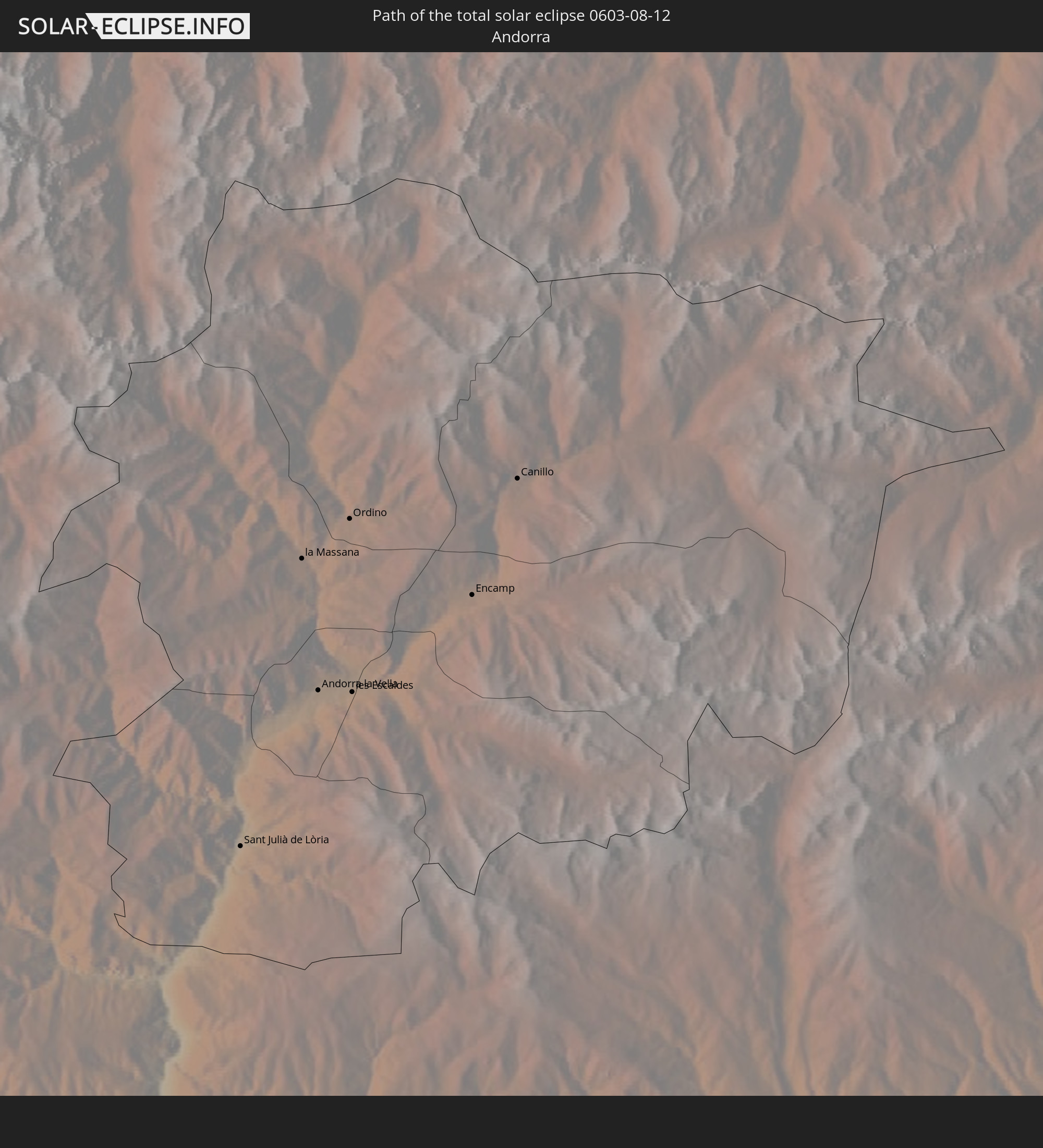 Andorra
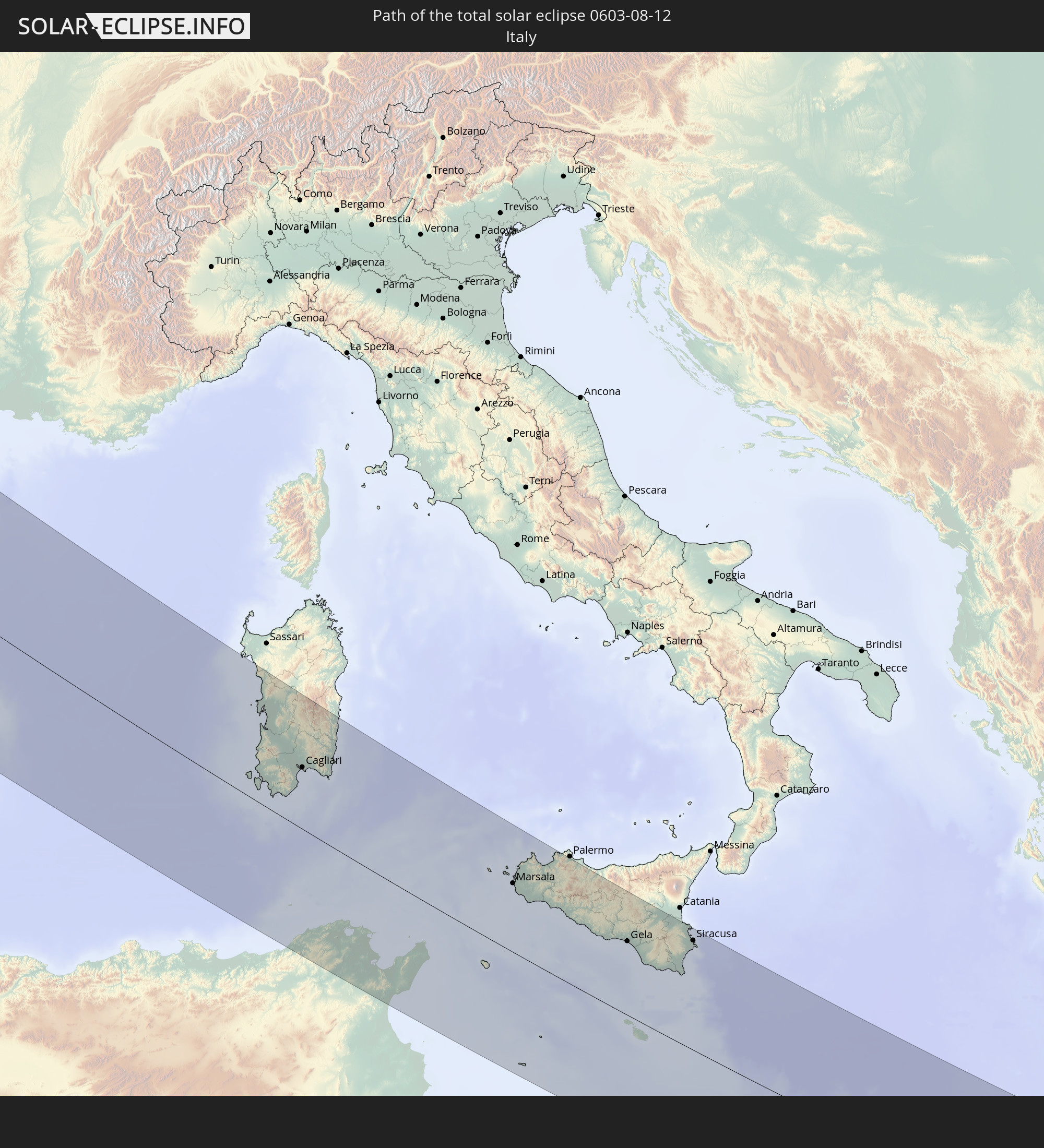 Italy
Italy
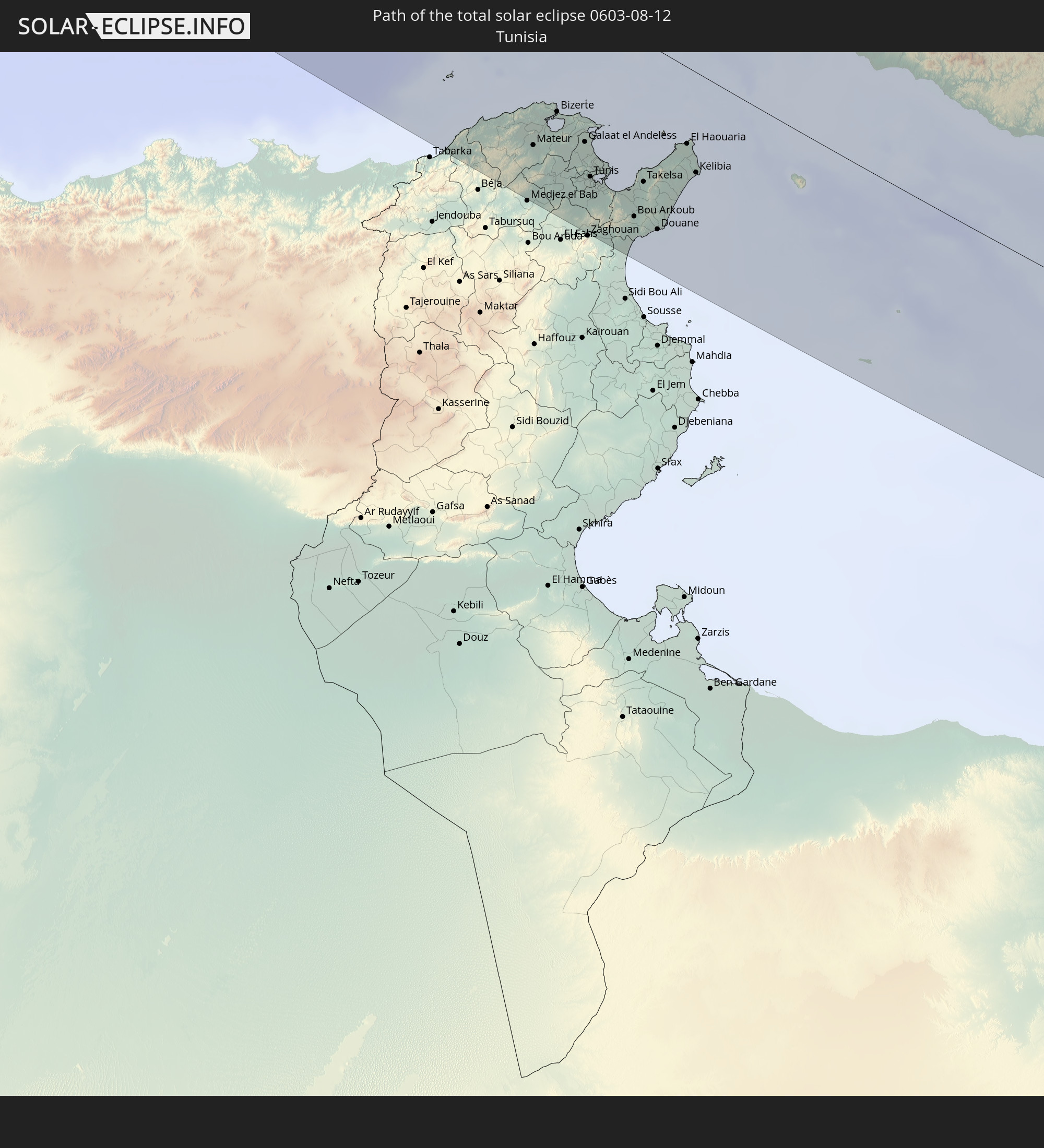 Tunisia
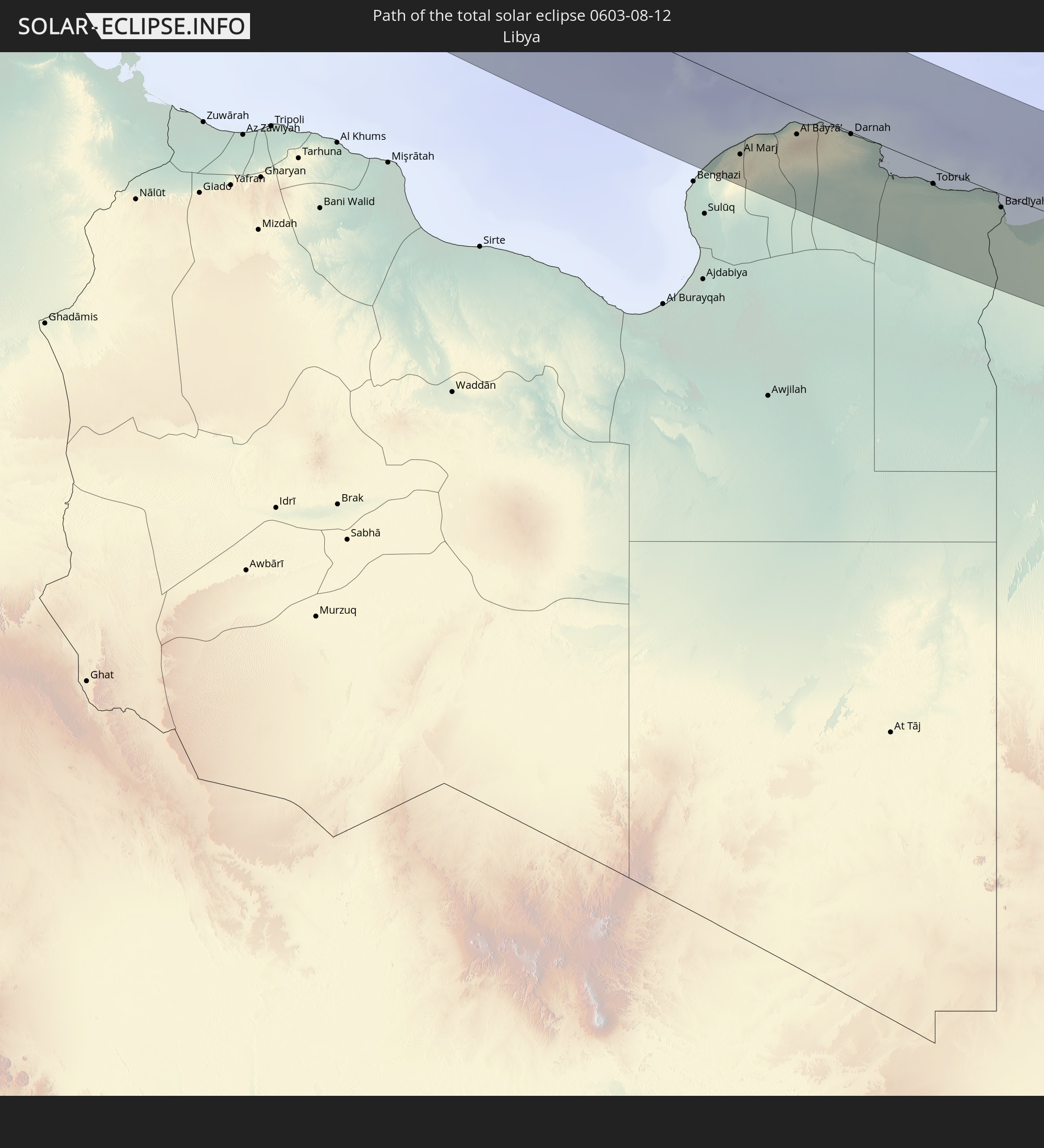 Libya
Libya
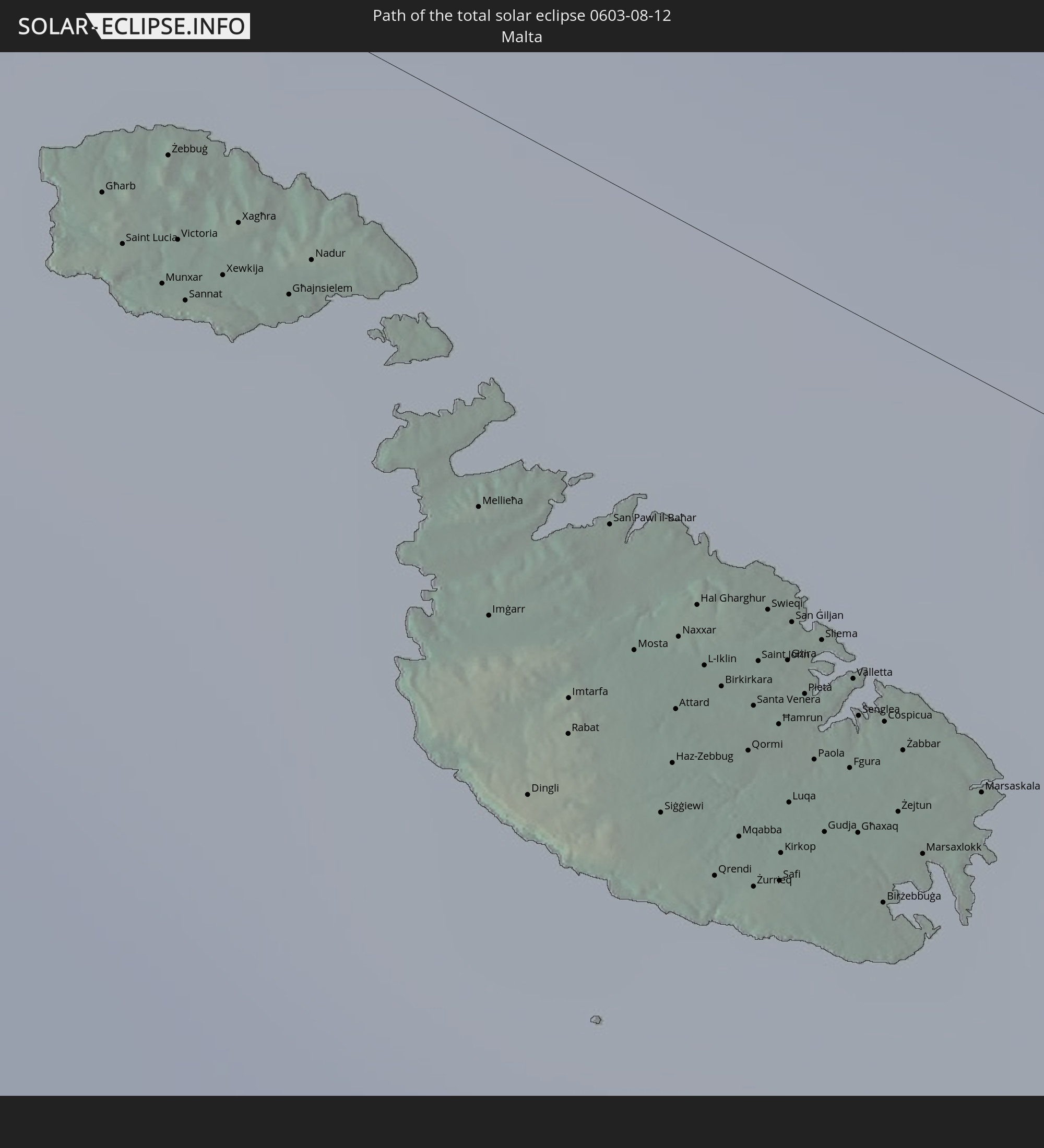 Malta
Malta
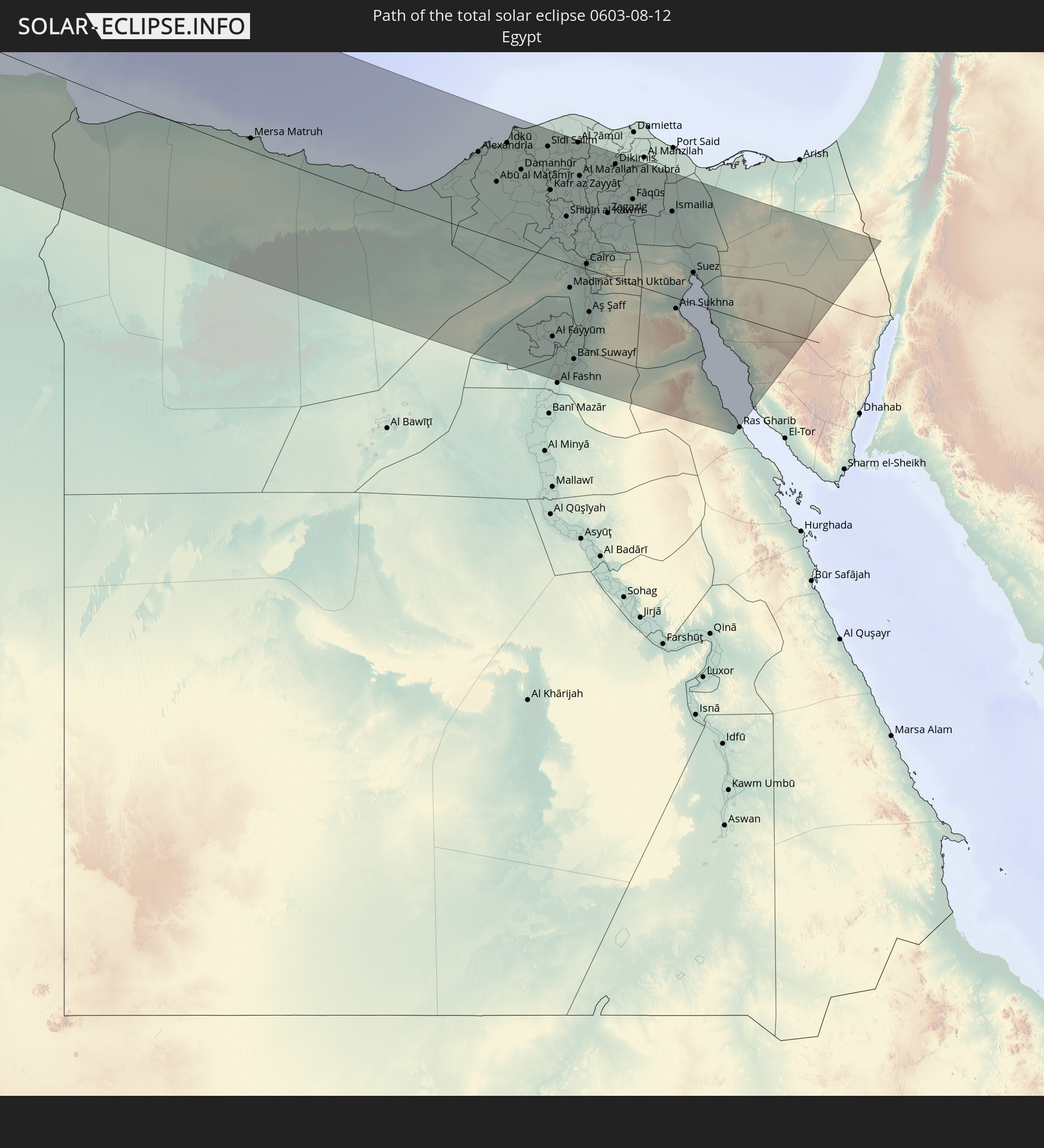 Egypt
Egypt
 Israel
In den folgenden Ländern ist die Sonnenfinsternis partiell zu sehen
 Russia
 United States
 Canada
 Mexico
 Greenland
 Bermuda
 Saint Pierre and Miquelon
 Portugal
 Cabo Verde
 Iceland
 Spain
Spain
 Senegal
 Mauritania
 The Gambia
 Guinea-Bissau
 Guinea
 Sierra Leone
 Morocco
 Mali
Mali
 Liberia
 Republic of Ireland
 Svalbard and Jan Mayen
 Algeria
 United Kingdom
 Ivory Coast
 Faroe Islands
 Burkina Faso
 Gibraltar
 France
 Isle of Man
 Ghana
Ghana
 Guernsey
 Jersey
 Togo
Togo
 Niger
Niger
 Benin
Benin
 Andorra
 Belgium
 Nigeria
 Netherlands
 Norway
 Equatorial Guinea
 Luxembourg
 Germany
 Switzerland
 São Tomé and Príncipe
 Italy
Italy
 Monaco
 Tunisia
 Denmark
 Cameroon
 Gabon
Gabon
 Libya
Libya
 Liechtenstein
 Austria
 Sweden
 Republic of the Congo
 Czechia
 Democratic Republic of the Congo
 San Marino
 Vatican City
 Slovenia
 Chad
Chad
 Croatia
 Poland
 Malta
Malta
 Central African Republic
 Bosnia and Herzegovina
 Hungary
 Slovakia
 Montenegro
 Serbia
 Albania
 Åland Islands
 Greece
 Romania
 Republic of Macedonia
 Finland
 Lithuania
 Latvia
 Estonia
 Sudan
Sudan
 Ukraine
 Bulgaria
 Belarus
 Egypt
Egypt
 Turkey
 Moldova
 Cyprus
 State of Palestine
 Israel
 Jordan
 Lebanon
 Syria
Syria
 Georgia
 Kazakhstan
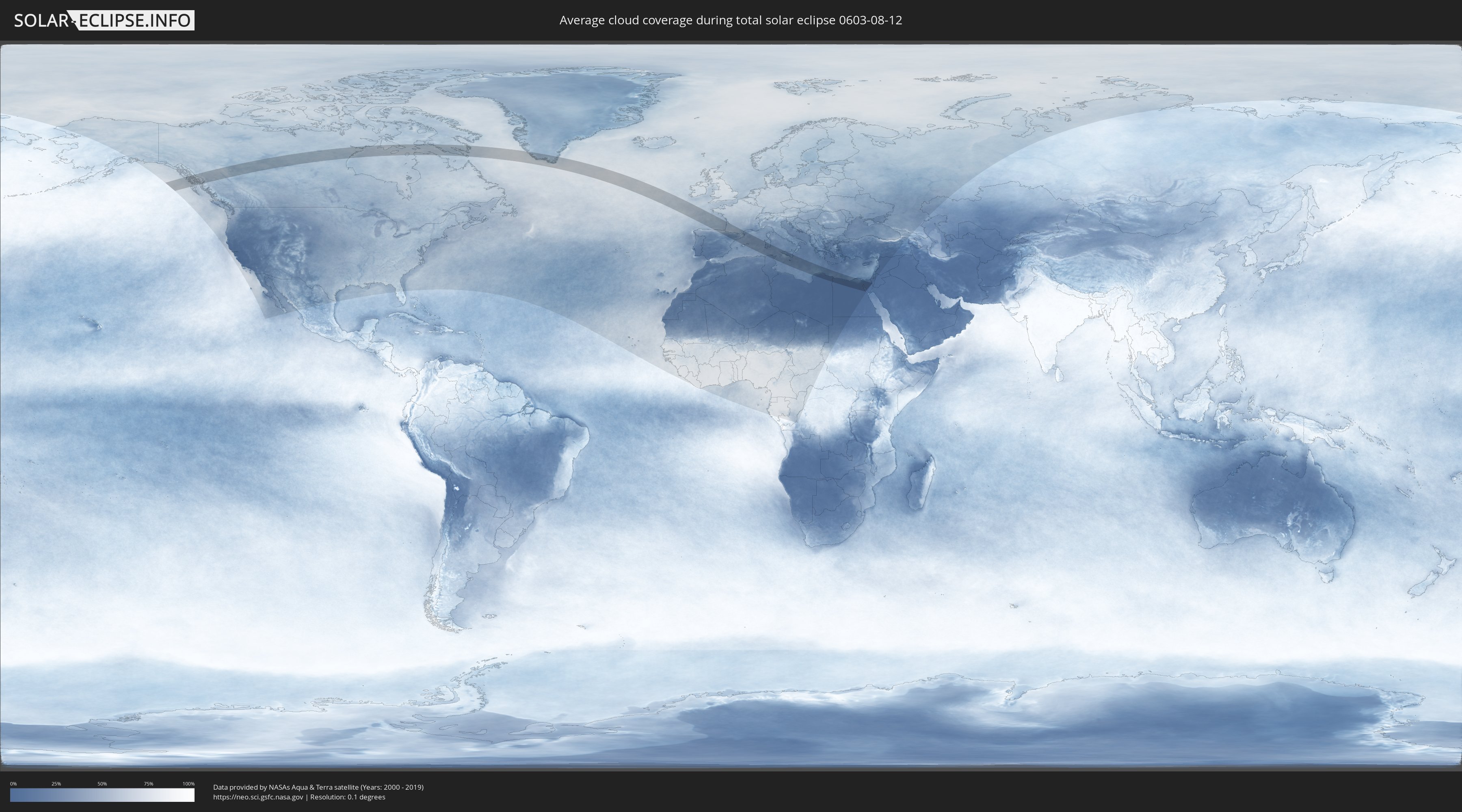
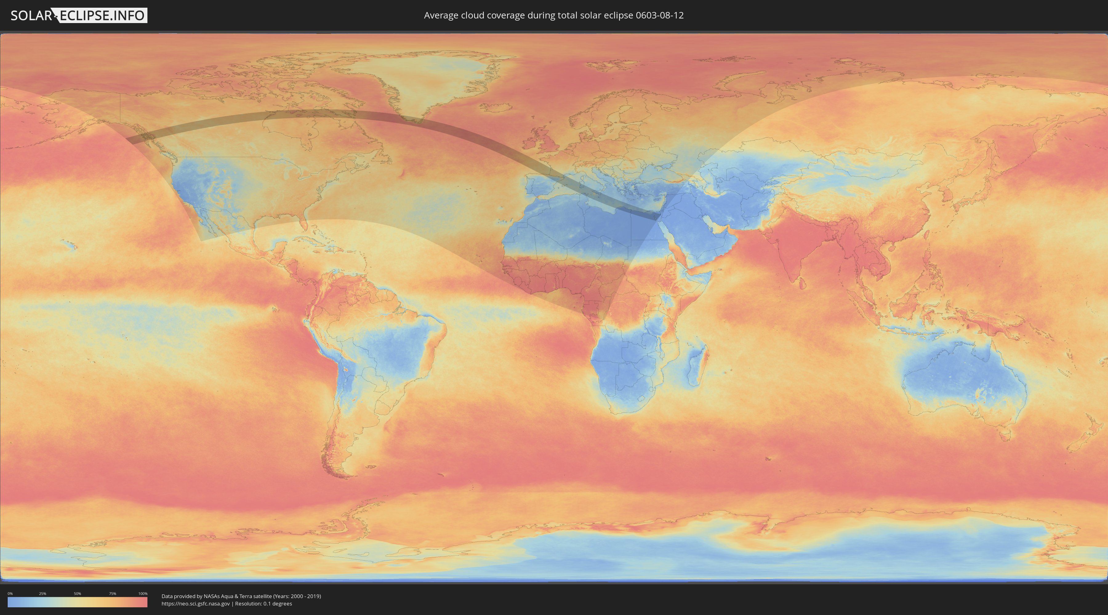
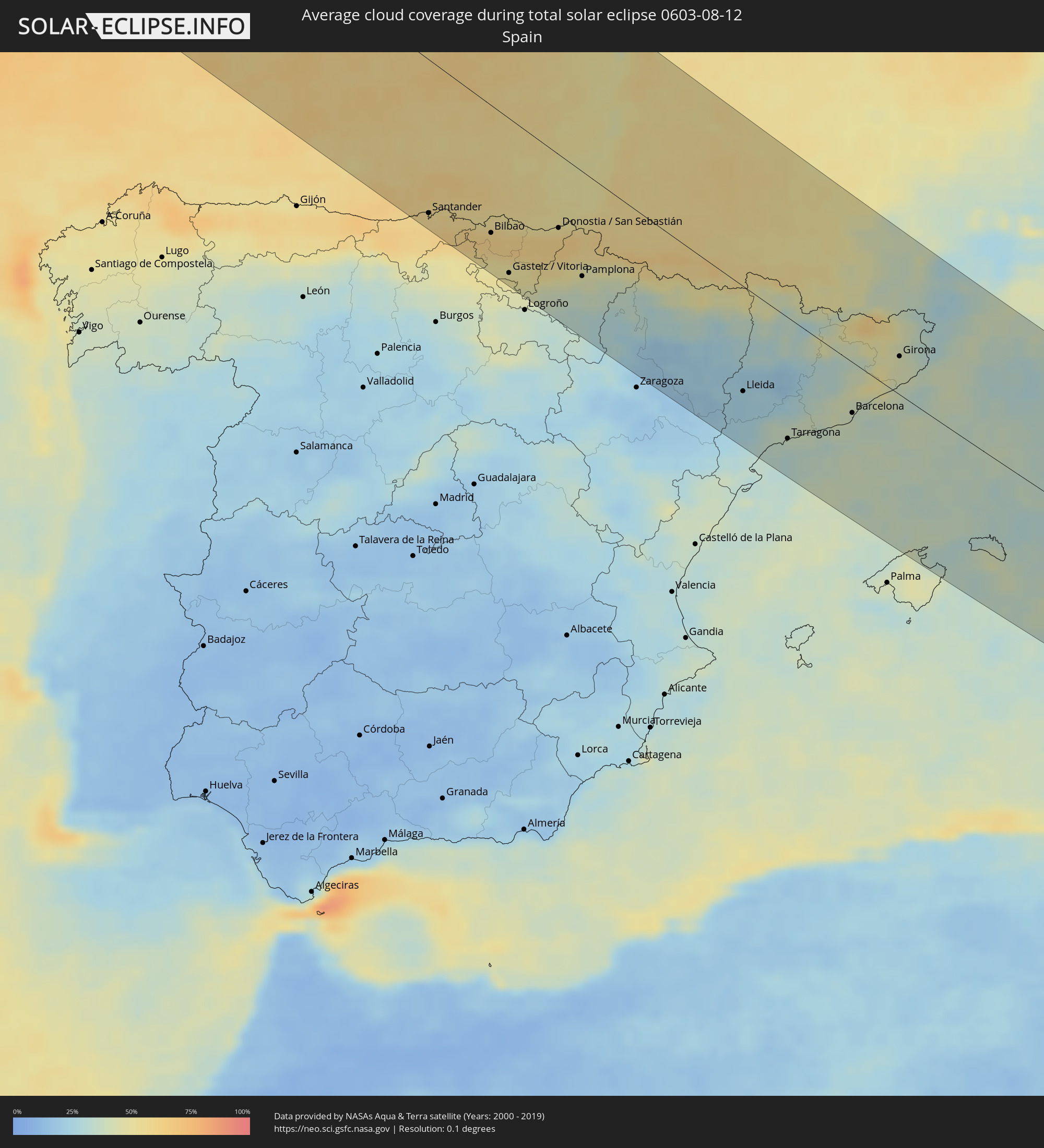
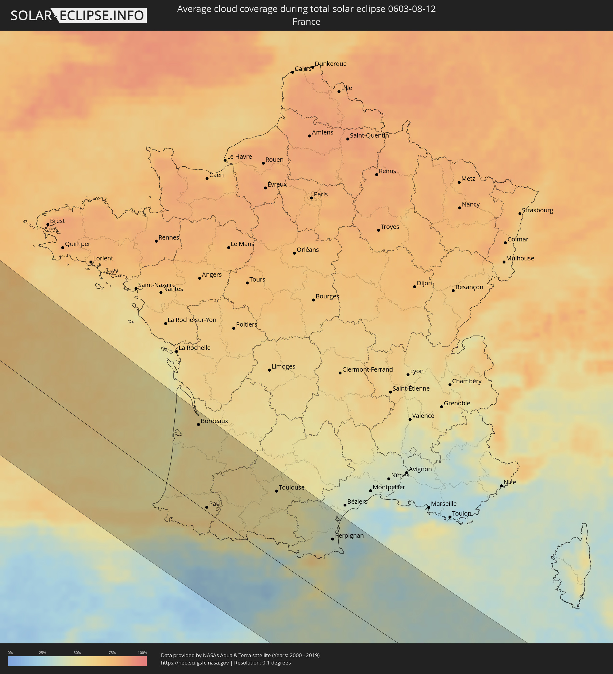
How will be the weather during the total solar eclipse on 08/12/0603?
Where is the best place to see the total solar eclipse of 08/12/0603?
The following maps show the average cloud coverage for the day of the total solar eclipse.
With the help of these maps, it is possible to find the place along the eclipse path, which has the best
chance of a cloudless sky.
Nevertheless, you should consider local circumstances and inform about the weather of your chosen
observation site.
The data is provided by NASAs satellites
AQUA and TERRA.
The cloud maps are averaged over a period of 19 years (2000 - 2019).
Detailed country maps
 United States
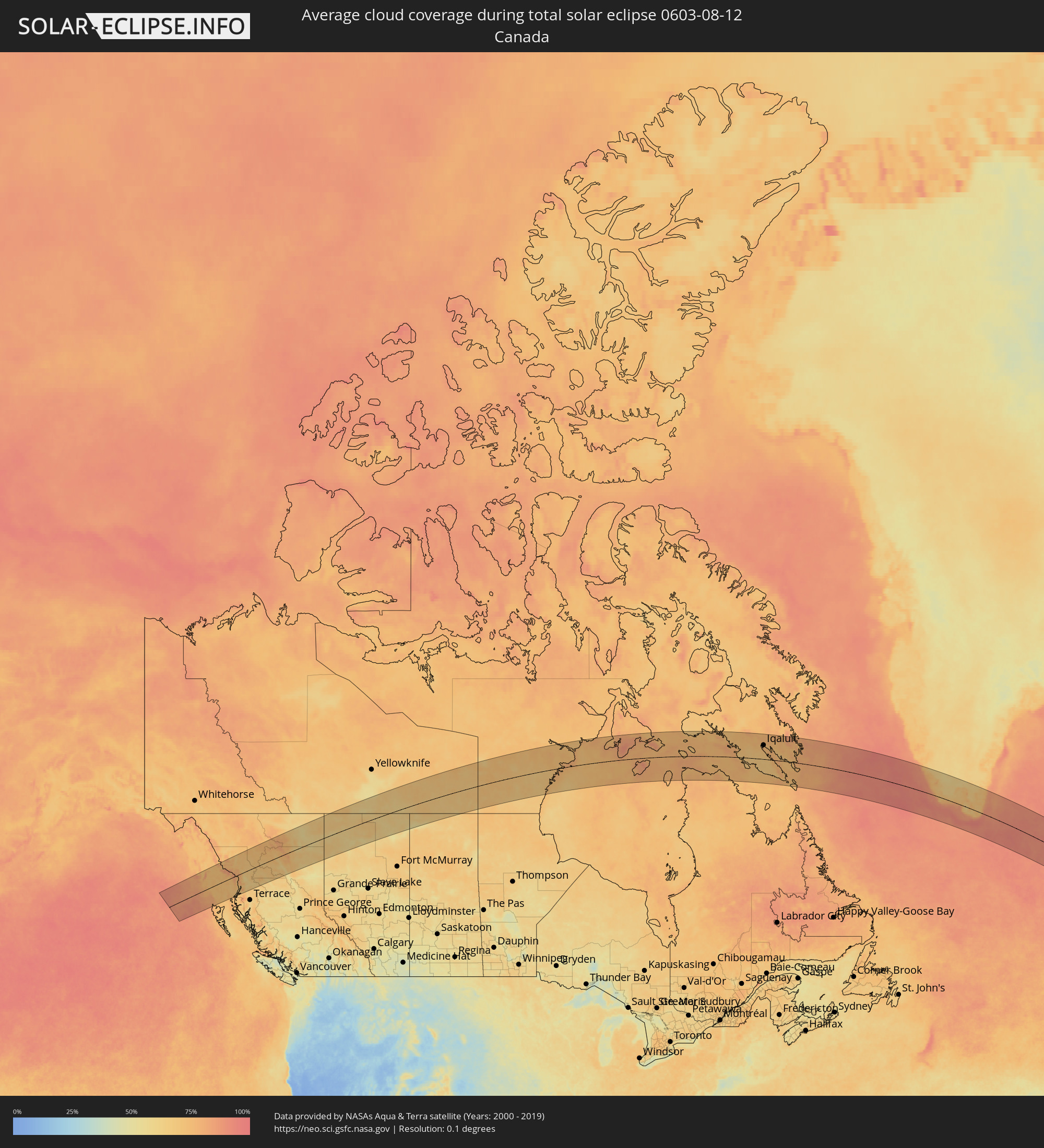 Canada
 Greenland
 Spain
Spain
 France
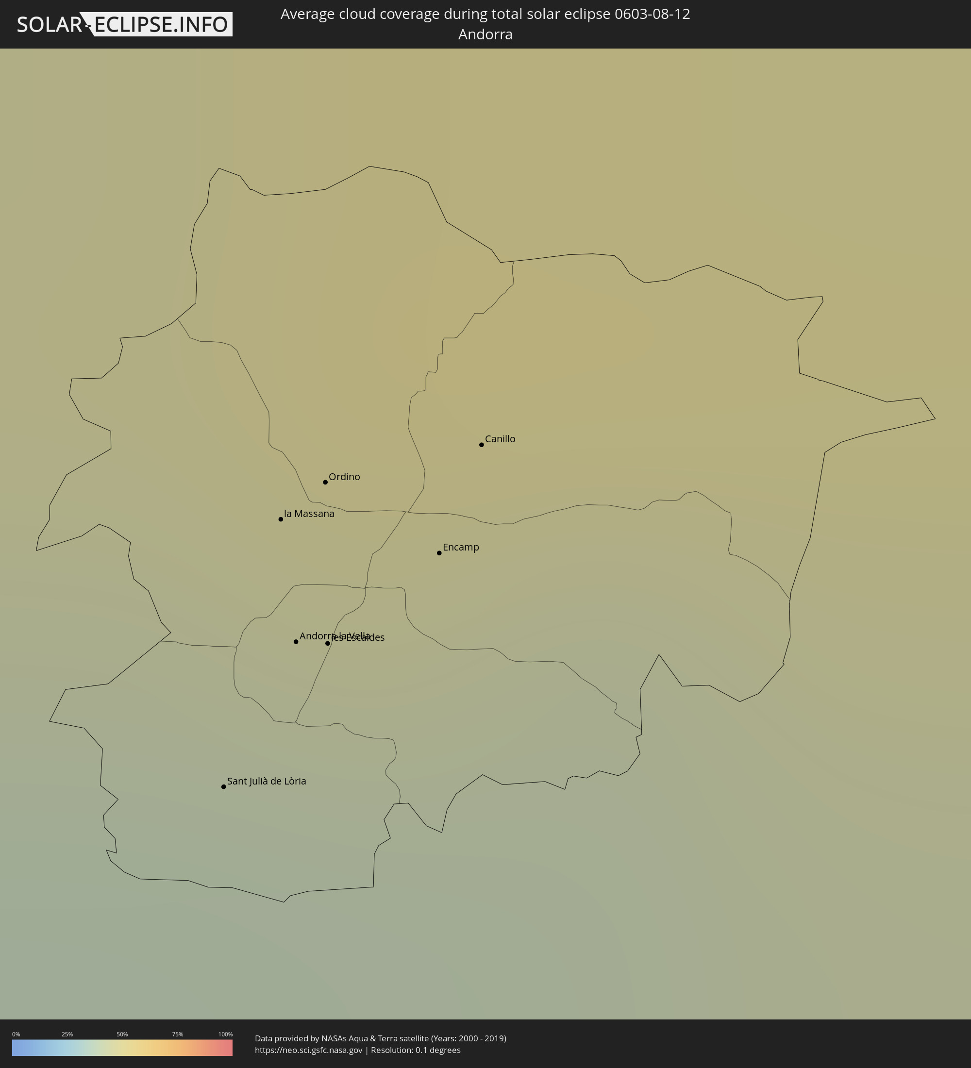 Andorra
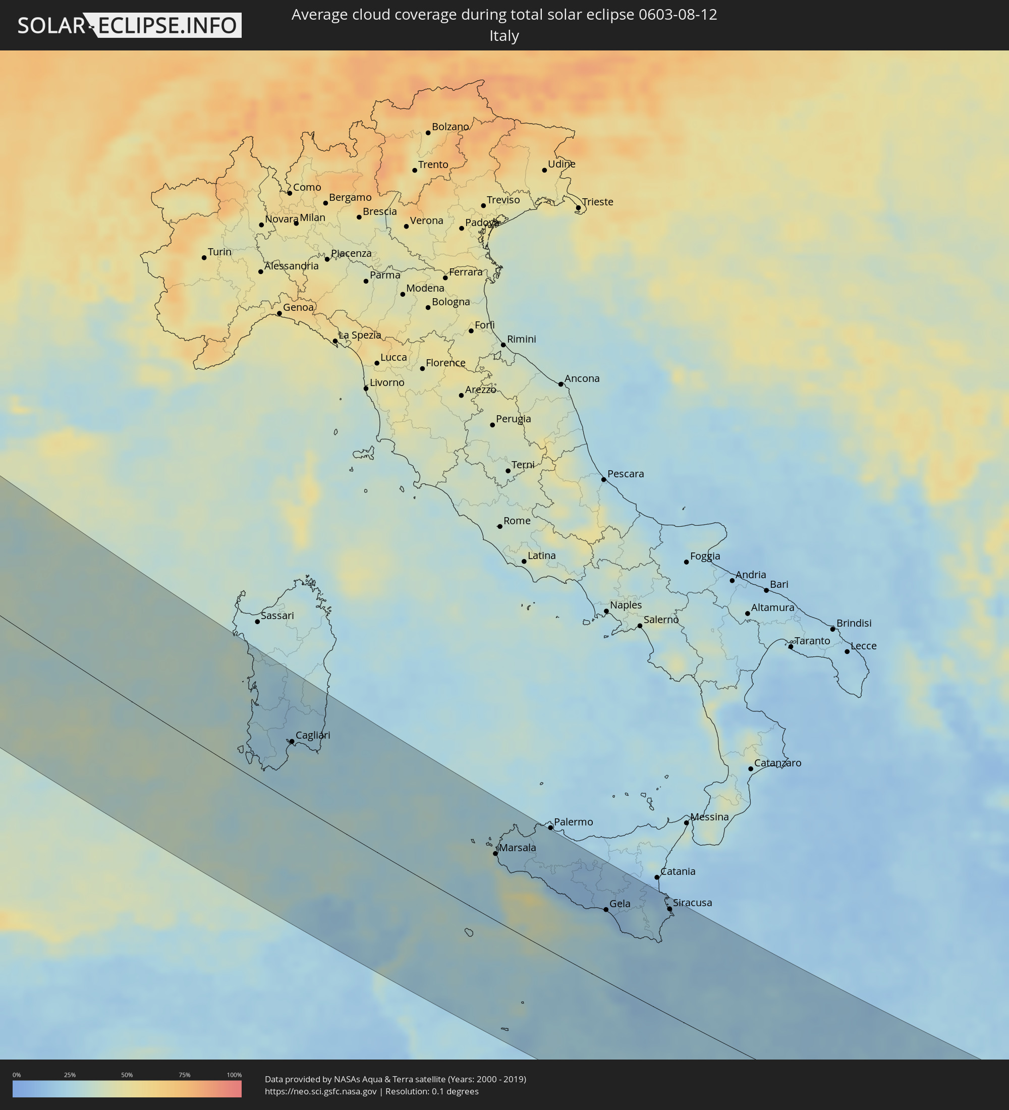 Italy
Italy
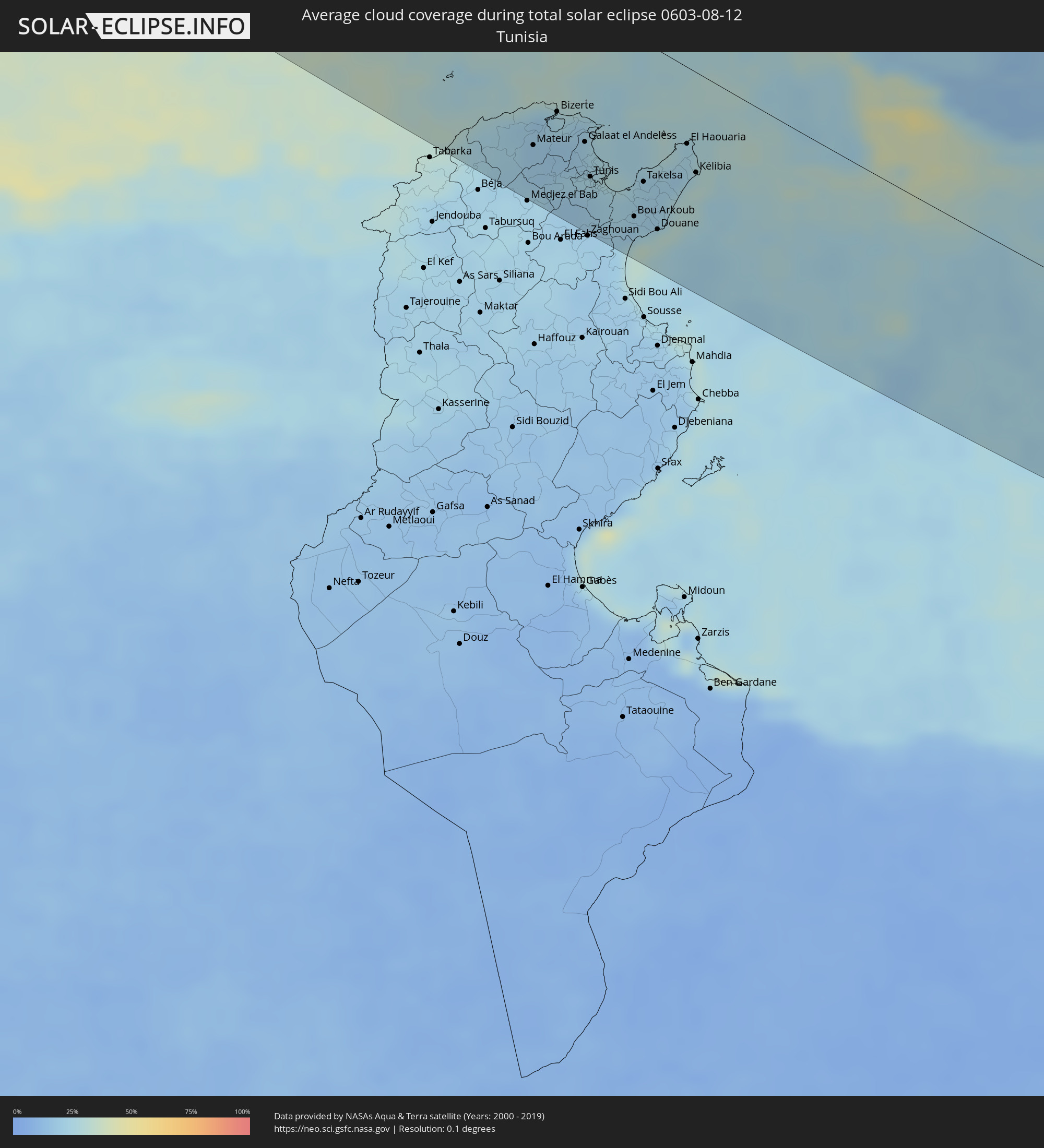 Tunisia
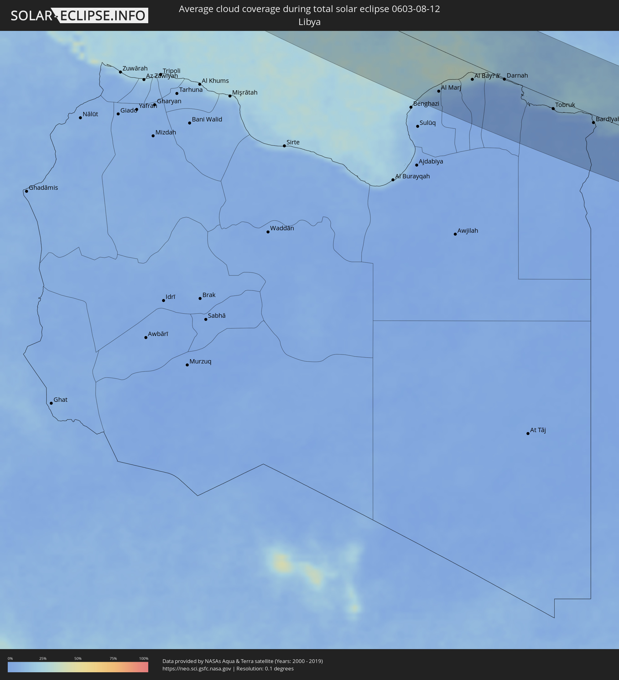 Libya
Libya
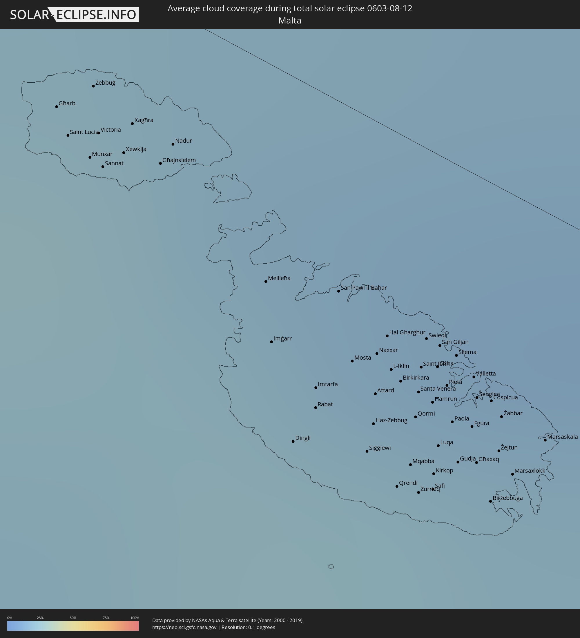 Malta
Malta
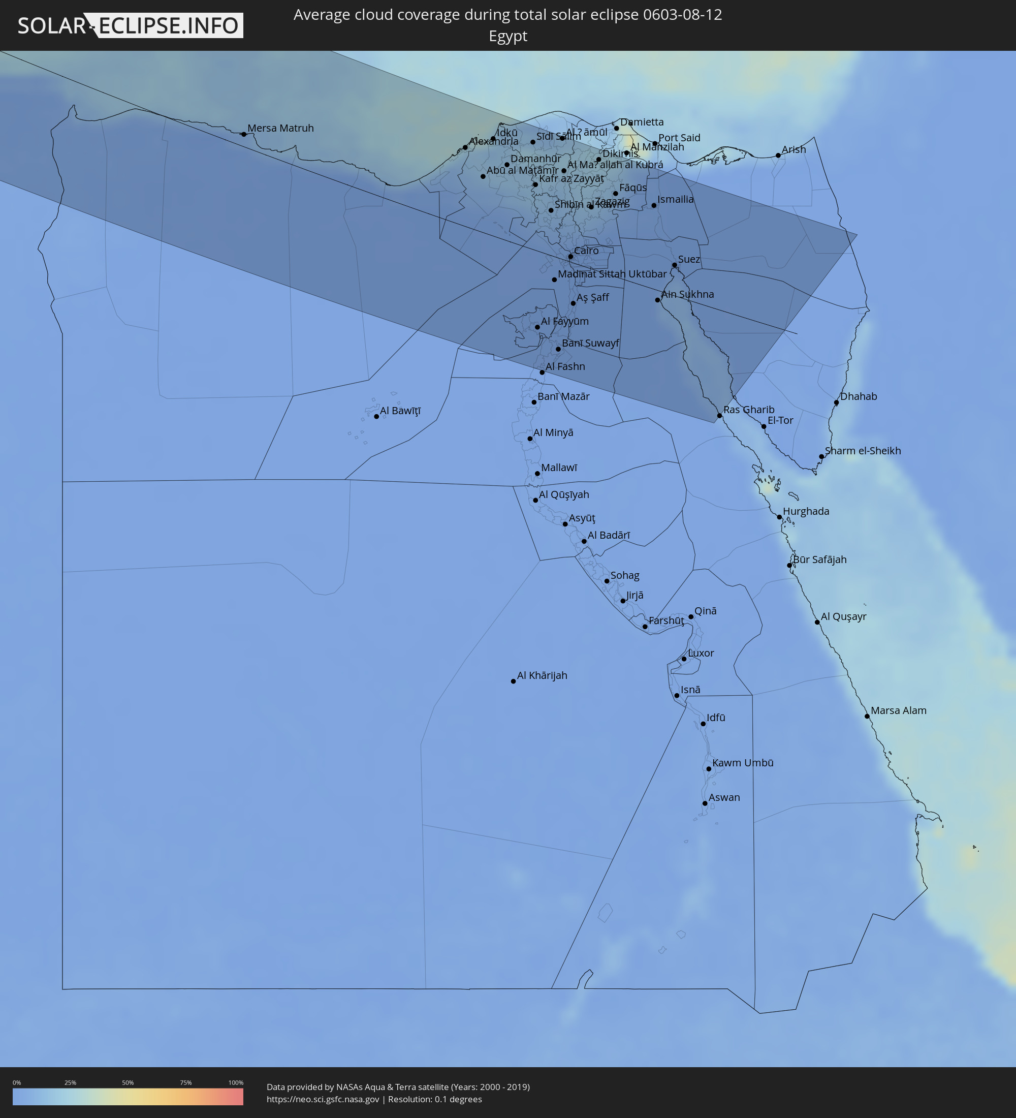 Egypt
Egypt
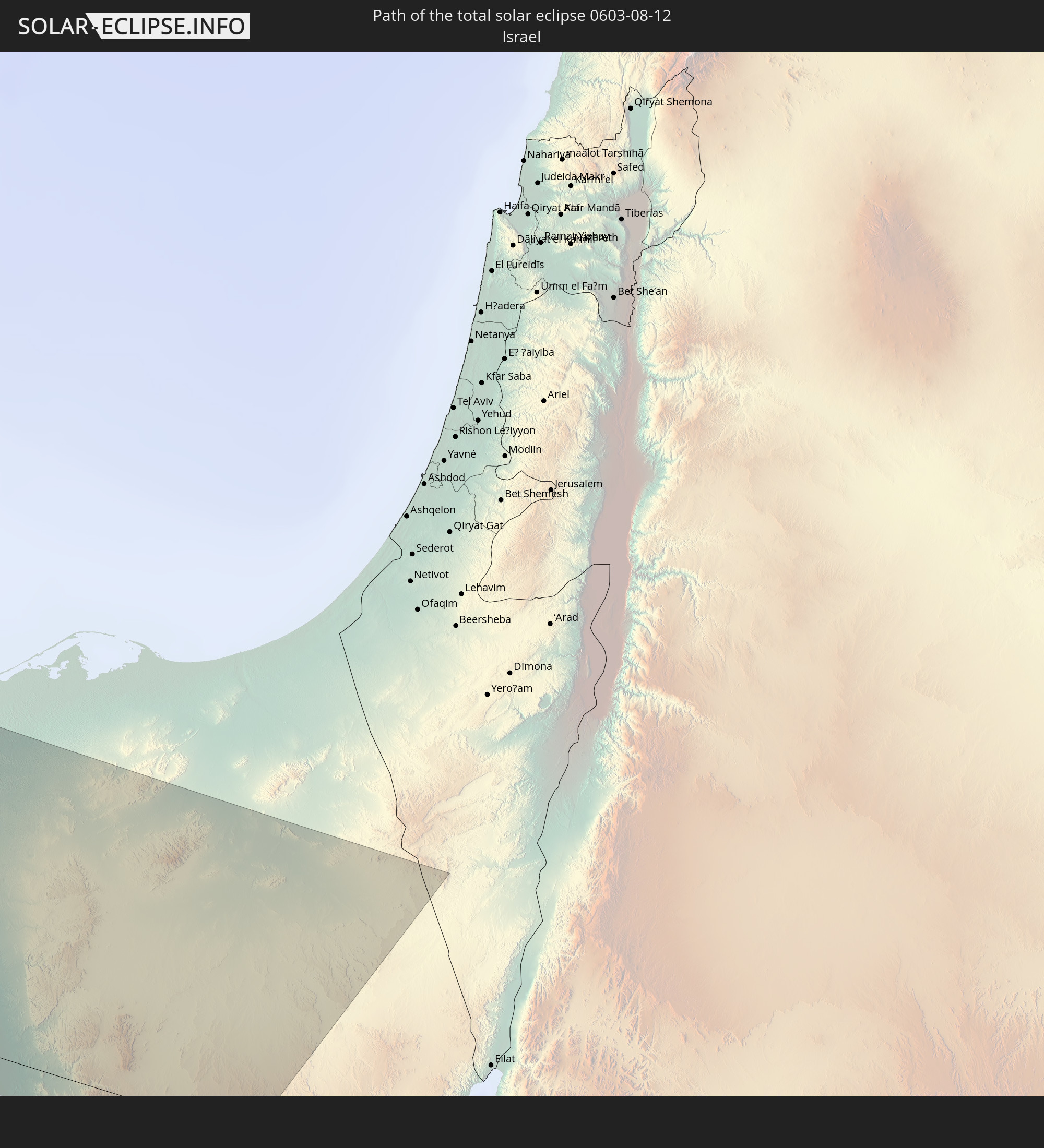
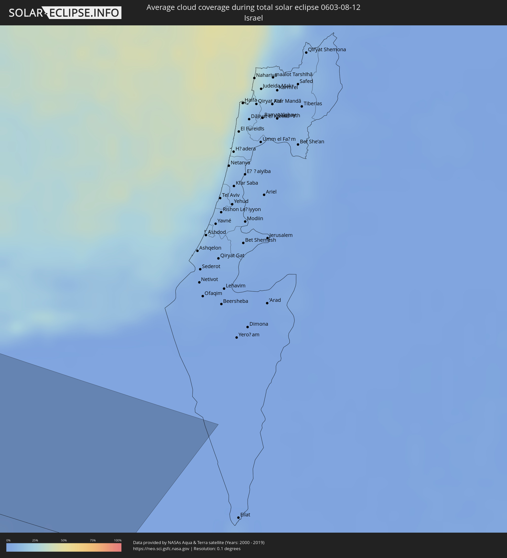 Israel
Cities inside the path of the eclipse
The following table shows all locations with a population of more than 5,000 inside the eclipse path. Cities which have more than 100,000 inhabitants are marked bold. A click at the locations opens a detailed map.
| City | Type | Eclipse duration | Local time of max. eclipse | Distance to central line | Ø Cloud coverage |
|
Ketchikan, Alaska
|
total | - | 03:50:56 UTC-10:00 | 44 km | 74% |
|
Iqaluit, Nunavut
|
total | - | 09:23:00 UTC-05:00 | 81 km | 77% |
|
Qaqortoq, Kujalleq
|
total | - | 11:16:50 UTC-03:26 | 15 km | 74% |
|
Santander, Cantabria
|
total | - | 15:51:03 UTC+00:00 | 141 km | 57% |
|
Bilbao, Basque Country
|
total | - | 15:52:04 UTC+00:00 | 117 km | 61% |
|
Gasteiz / Vitoria, Basque Country
|
total | - | 15:52:57 UTC+00:00 | 142 km | 47% |
|
Donostia / San Sebastián, Basque Country
|
total | - | 15:52:40 UTC+00:00 | 68 km | 61% |
|
Irun, Basque Country
|
total | - | 15:52:45 UTC+00:00 | 57 km | 63% |
|
Pamplona, Navarre
|
total | - | 15:53:45 UTC+00:00 | 97 km | 42% |
|
Bayonne, Nouvelle-Aquitaine
|
total | - | 16:02:04 UTC+00:09 | 29 km | 54% |
|
La Teste-de-Buch, Nouvelle-Aquitaine
|
total | - | 16:00:19 UTC+00:09 | 92 km | 48% |
|
Dax, Nouvelle-Aquitaine
|
total | - | 16:01:58 UTC+00:09 | 12 km | 56% |
|
Bordeaux, Nouvelle-Aquitaine
|
total | - | 16:00:20 UTC+00:09 | 135 km | 54% |
|
Mont-de-Marsan, Nouvelle-Aquitaine
|
total | - | 16:02:02 UTC+00:09 | 54 km | 56% |
|
Huesca, Aragon
|
total | - | 15:55:45 UTC+00:00 | 103 km | 20% |
|
Pau, Nouvelle-Aquitaine
|
total | - | 16:03:08 UTC+00:09 | 11 km | 56% |
|
Tarbes, Occitania
|
total | - | 16:03:33 UTC+00:09 | 23 km | 54% |
|
Marmande, Nouvelle-Aquitaine
|
total | - | 16:01:25 UTC+00:09 | 140 km | 52% |
|
Auch, Occitania
|
total | - | 16:03:09 UTC+00:09 | 83 km | 56% |
|
Lleida, Catalonia
|
total | - | 15:57:19 UTC+00:00 | 102 km | 23% |
|
Agen, Nouvelle-Aquitaine
|
total | - | 16:02:14 UTC+00:09 | 136 km | 56% |
|
Villeneuve-sur-Lot, Nouvelle-Aquitaine
|
total | - | 16:01:55 UTC+00:09 | 157 km | 55% |
|
Tarragona, Catalonia
|
total | - | 15:58:33 UTC+00:00 | 117 km | 33% |
|
Montauban, Occitania
|
total | - | 16:02:59 UTC+00:09 | 154 km | 53% |
|
Muret, Occitania
|
total | - | 16:03:56 UTC+00:09 | 103 km | 52% |
|
Toulouse, Occitania
|
total | - | 16:03:46 UTC+00:09 | 120 km | 51% |
|
Sant Julià de Lòria, Sant Julià de Loria
|
total | - | 15:56:24 UTC+00:00 | 23 km | 39% |
|
la Massana, La Massana
|
total | - | 15:56:16 UTC+00:00 | 32 km | 39% |
|
Andorra la Vella, Andorra la Vella
|
total | - | 15:56:20 UTC+00:00 | 28 km | 39% |
|
Ordino, Ordino
|
total | - | 15:56:16 UTC+00:00 | 33 km | 45% |
|
les Escaldes, Escaldes-Engordany
|
total | - | 15:56:21 UTC+00:00 | 28 km | 39% |
|
Encamp, Encamp
|
total | - | 15:56:20 UTC+00:00 | 31 km | 40% |
|
Canillo, Canillo
|
total | - | 15:56:17 UTC+00:00 | 35 km | 43% |
|
Pamiers, Occitania
|
total | - | 16:04:42 UTC+00:09 | 83 km | 50% |
|
Vilanova i la Geltrú, Catalonia
|
total | - | 15:58:40 UTC+00:00 | 87 km | 34% |
|
Manresa, Catalonia
|
total | - | 15:57:51 UTC+00:00 | 34 km | 34% |
|
Castelldefels, Catalonia
|
total | - | 15:58:43 UTC+00:00 | 68 km | 38% |
|
Terrassa, Catalonia
|
total | - | 15:58:15 UTC+00:00 | 45 km | 42% |
|
Barcelona, Catalonia
|
total | - | 15:58:38 UTC+00:00 | 49 km | 38% |
|
Mollet del Vallès, Catalonia
|
total | - | 15:58:24 UTC+00:00 | 33 km | 36% |
|
Castres, Occitania
|
total | - | 16:04:15 UTC+00:09 | 157 km | 50% |
|
Carcassonne, Occitania
|
total | - | 16:04:58 UTC+00:09 | 127 km | 45% |
|
Mataró, Catalonia
|
total | - | 15:58:32 UTC+00:00 | 23 km | 36% |
|
Blanes, Catalonia
|
total | - | 15:58:31 UTC+00:00 | 25 km | 40% |
|
Girona, Catalonia
|
total | - | 15:58:00 UTC+00:00 | 38 km | 43% |
|
Perpignan, Occitania
|
total | - | 16:06:10 UTC+00:09 | 107 km | 37% |
|
Figueres, Catalonia
|
total | - | 15:57:36 UTC+00:00 | 69 km | 38% |
|
Narbonne, Occitania
|
total | - | 16:05:24 UTC+00:09 | 155 km | 40% |
|
Cagliari, Sardinia
|
total | - | 17:05:35 UTC+01:00 | 74 km | 31% |
|
Mateur, Banzart
|
total | - | 16:18:40 UTC+00:09 | 114 km | 19% |
|
Douar Tindja, Banzart
|
total | - | 16:18:30 UTC+00:09 | 99 km | 22% |
|
Menzel Bourguiba, Banzart
|
total | - | 16:18:32 UTC+00:09 | 98 km | 22% |
|
Menzel Abderhaman, Banzart
|
total | - | 16:18:25 UTC+00:09 | 86 km | 22% |
|
Bizerte, Banzart
|
total | - | 16:18:22 UTC+00:09 | 82 km | 25% |
|
El Alia, Banzart
|
total | - | 16:18:35 UTC+00:09 | 84 km | 21% |
|
Galaat el Andeless, Ariana
|
total | - | 16:18:47 UTC+00:09 | 91 km | 21% |
|
La Mohammedia, Tūnis
|
total | - | 16:19:25 UTC+00:09 | 127 km | 21% |
|
Tunis, Tūnis
|
total | - | 16:19:12 UTC+00:09 | 113 km | 23% |
|
Al Marsá, Tūnis
|
total | - | 16:19:09 UTC+00:09 | 99 km | 29% |
|
Carthage, Tūnis
|
total | - | 16:19:11 UTC+00:09 | 101 km | 29% |
|
Hammam-Lif, Tūnis
|
total | - | 16:19:24 UTC+00:09 | 112 km | 23% |
|
Mennzel Bou Zelfa, Nābul
|
total | - | 16:19:33 UTC+00:09 | 108 km | 21% |
|
Beni Khalled, Nābul
|
total | - | 16:19:36 UTC+00:09 | 111 km | 21% |
|
Takelsa, Nābul
|
total | - | 16:19:24 UTC+00:09 | 96 km | 22% |
|
Douane, Nābul
|
total | - | 16:19:58 UTC+00:09 | 121 km | 29% |
|
Beni Khiar, Nābul
|
total | - | 16:19:57 UTC+00:09 | 118 km | 31% |
|
Korba, Nābul
|
total | - | 16:19:48 UTC+00:09 | 104 km | 31% |
|
Kélibia, Nābul
|
total | - | 16:19:26 UTC+00:09 | 68 km | 31% |
|
Marsala, Sicily
|
total | - | 17:08:58 UTC+01:00 | 83 km | 34% |
|
Trapani, Sicily
|
total | - | 17:08:39 UTC+01:00 | 109 km | 26% |
|
Mazara del Vallo, Sicily
|
total | - | 17:09:14 UTC+01:00 | 78 km | 30% |
|
Castelvetrano, Sicily
|
total | - | 17:09:15 UTC+01:00 | 90 km | 23% |
|
Alcamo, Sicily
|
total | - | 17:08:49 UTC+01:00 | 126 km | 21% |
|
Sciacca, Sicily
|
total | - | 17:09:36 UTC+01:00 | 84 km | 35% |
|
Carini, Sicily
|
total | - | 17:08:38 UTC+01:00 | 149 km | 24% |
|
Agrigento, Sicily
|
total | - | 17:10:02 UTC+01:00 | 86 km | 21% |
|
Canicattì, Sicily
|
total | - | 17:10:01 UTC+01:00 | 104 km | 14% |
|
Licata, Sicily
|
total | - | 17:10:26 UTC+01:00 | 81 km | 26% |
|
Caltanissetta, Sicily
|
total | - | 17:09:51 UTC+01:00 | 125 km | 14% |
|
San Lawrenz, Saint Lawrence
|
total | - | 17:12:07 UTC+01:00 | 10 km | 26% |
|
Għarb, L-Għarb
|
total | - | 17:12:07 UTC+01:00 | 9 km | 26% |
|
Kerċem, Ta’ Kerċem
|
total | - | 17:12:09 UTC+01:00 | 10 km | 25% |
|
Munxar, Il-Munxar
|
total | - | 17:12:10 UTC+01:00 | 11 km | 25% |
|
Żebbuġ, Iż-Żebbuġ
|
total | - | 17:12:06 UTC+01:00 | 7 km | 26% |
|
Fontana, Il-Fontana
|
total | - | 17:12:09 UTC+01:00 | 10 km | 25% |
|
Victoria, Victoria
|
total | - | 17:12:09 UTC+01:00 | 9 km | 25% |
|
Gela, Sicily
|
total | - | 17:10:33 UTC+01:00 | 95 km | 23% |
|
Sannat, Sannat
|
total | - | 17:12:11 UTC+01:00 | 11 km | 25% |
|
Imtarfa, L-Imtarfa
|
total | - | 17:12:25 UTC+01:00 | 17 km | 25% |
|
Lija, Lija
|
total | - | 17:12:24 UTC+01:00 | 15 km | 25% |
|
Hal Gharghur, Ħal Għargħur
|
total | - | 17:12:22 UTC+01:00 | 12 km | 22% |
|
Qrendi, Il-Qrendi
|
total | - | 17:12:31 UTC+01:00 | 21 km | 22% |
|
Birkirkara, Birkirkara
|
total | - | 17:12:25 UTC+01:00 | 14 km | 22% |
|
Mqabba, L-Imqabba
|
total | - | 17:12:30 UTC+01:00 | 19 km | 22% |
|
Safi, Safi
|
total | - | 17:12:31 UTC+01:00 | 20 km | 22% |
|
Kirkop, Kirkop
|
total | - | 17:12:30 UTC+01:00 | 19 km | 22% |
|
Ta’ Xbiex, Ta’ Xbiex
|
total | - | 17:12:25 UTC+01:00 | 13 km | 22% |
|
Floriana, Il-Furjana
|
total | - | 17:12:26 UTC+01:00 | 13 km | 22% |
|
Caltagirone, Sicily
|
total | - | 17:10:21 UTC+01:00 | 120 km | 17% |
|
Vittoria, Sicily
|
total | - | 17:10:48 UTC+01:00 | 92 km | 13% |
|
Xgħajra, Ix-Xgħajra
|
total | - | 17:12:27 UTC+01:00 | 12 km | 22% |
|
Ragusa, Sicily
|
total | - | 17:10:53 UTC+01:00 | 100 km | 18% |
|
Avola, Sicily
|
total | - | 17:11:00 UTC+01:00 | 114 km | 23% |
|
Augusta, Sicily
|
total | - | 17:10:30 UTC+01:00 | 149 km | 19% |
|
Siracusa, Sicily
|
total | - | 17:10:45 UTC+01:00 | 137 km | 20% |
|
Tūkrah, Al Marj
|
total | - | 17:10:45 UTC+00:52 | 104 km | 12% |
|
Al Abyār, Al Marj
|
total | - | 17:11:14 UTC+00:52 | 138 km | 8% |
|
Al Marj, Al Marj
|
total | - | 17:10:49 UTC+00:52 | 99 km | 8% |
|
Al Bayḑā’, Al Jabal al Akhḑar
|
total | - | 17:10:26 UTC+00:52 | 37 km | 14% |
|
Al Qubbah, Darnah
|
total | - | 17:10:25 UTC+00:52 | 26 km | 8% |
|
Darnah, Darnah
|
total | - | 17:10:24 UTC+00:52 | 15 km | 13% |
|
Tobruk, Sha‘bīyat al Buţnān
|
total | - | 17:11:16 UTC+00:52 | 25 km | 8% |
|
Bardīyah, Sha‘bīyat al Buţnān
|
total | - | 17:11:37 UTC+00:52 | 25 km | 7% |
|
Alexandria, Alexandria
|
total | - | 18:18:50 UTC+02:00 | 88 km | 13% |
|
Kafr ad Dawwār, Beheira
|
total | - | 18:18:54 UTC+02:00 | 85 km | 14% |
|
Idkū, Beheira
|
total | - | 18:18:39 UTC+02:00 | 108 km | 12% |
|
Damanhūr, Beheira
|
total | - | 18:18:58 UTC+02:00 | 86 km | 15% |
|
Al Fayyūm, Faiyum
|
total | - | 18:21:00 UTC+02:00 | 87 km | 1% |
|
Kafr ash Shaykh, Kafr el-Sheikh
|
total | - | 18:18:45 UTC+02:00 | 107 km | 18% |
|
Tanda, Gharbia
|
total | - | 18:19:09 UTC+02:00 | 79 km | 13% |
|
Shibīn al Kawm, Monufia
|
total | - | 18:19:26 UTC+02:00 | 52 km | 10% |
|
Banī Suwayf, Beni Suweif
|
total | - | 18:21:13 UTC+02:00 | 104 km | 0% |
|
Al Maḩallah al Kubrá, Gharbia
|
total | - | 18:18:53 UTC+02:00 | 100 km | 17% |
|
Banhā, Qalyubia
|
total | - | 18:19:31 UTC+02:00 | 45 km | 8% |
|
Cairo, Cairo
|
total | - | 18:19:59 UTC+02:00 | 24 km | 0% |
|
Ḩalwān, Cairo
|
total | - | 18:20:14 UTC+02:00 | 22 km | 0% |
|
Al Manşūrah, Dakahlia
|
total | - | 18:18:45 UTC+02:00 | 112 km | 17% |
|
Zagazig, Sharqia
|
total | - | 18:19:16 UTC+02:00 | 72 km | 11% |
|
Bilbays, Sharqia
|
total | - | 18:19:28 UTC+02:00 | 54 km | 3% |
|
Dikirnis, Dakahlia
|
total | - | 18:18:38 UTC+02:00 | 126 km | 21% |
|
Ismailia, Ismailia
|
total | - | 18:19:03 UTC+02:00 | 94 km | 2% |
|
Suez, Suez
|
total | - | 18:19:45 UTC+02:00 | 35 km | 2% |