Annular solar eclipse of 12/07/0671
| Day of week: | Thursday |
| Maximum duration of eclipse: | 10m18s |
| Maximum width of eclipse path: | 389 km |
| Saros cycle: | 101 |
| Coverage: | 92.4% |
| Magnitude: | 0.9238 |
| Gamma: | 0.6733 |
Wo kann man die Sonnenfinsternis vom 12/07/0671 sehen?
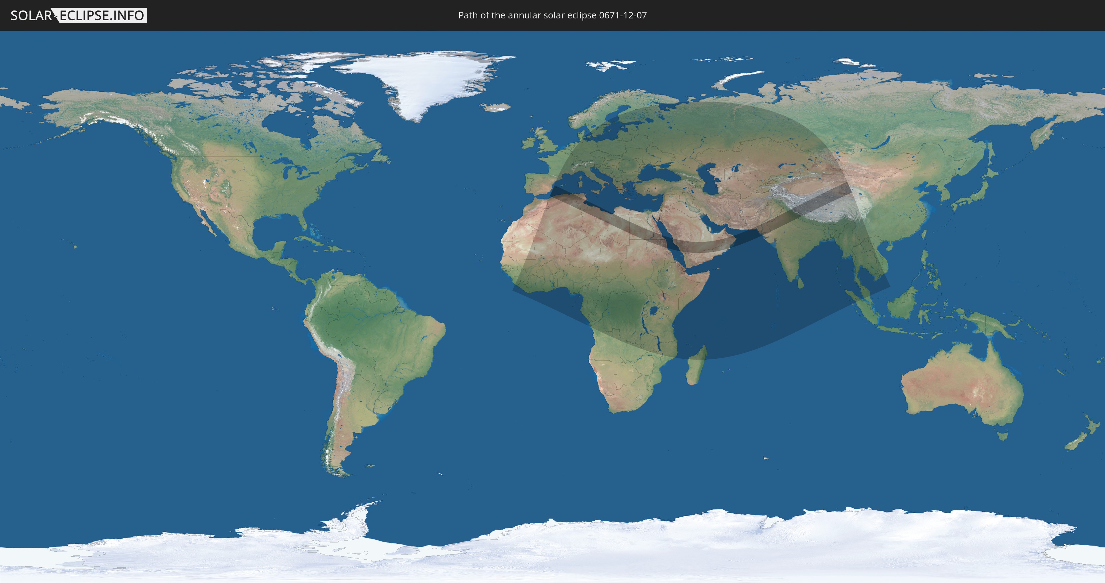
Die Sonnenfinsternis am 12/07/0671 kann man in 125 Ländern als partielle Sonnenfinsternis beobachten.
Der Finsternispfad verläuft durch 13 Länder. Nur in diesen Ländern ist sie als annular Sonnenfinsternis zu sehen.
In den folgenden Ländern ist die Sonnenfinsternis annular zu sehen
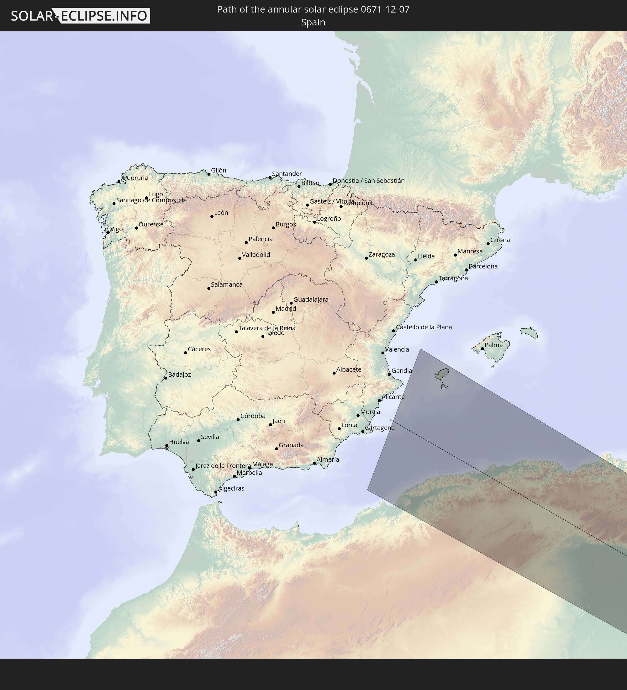 Spain
Spain
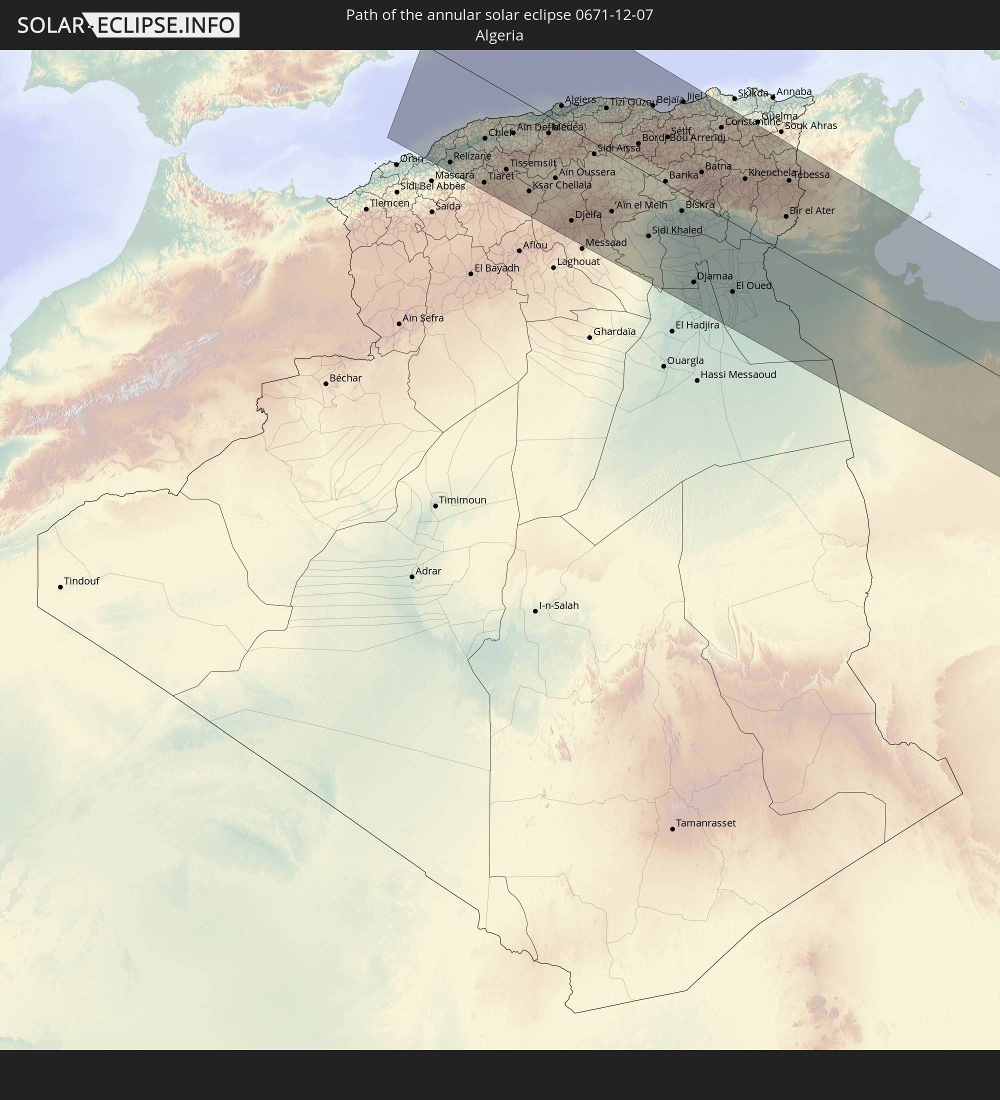 Algeria
 Tunisia
 Libya
Libya
 Sudan
Sudan
 Egypt
Egypt
 Saudi Arabia
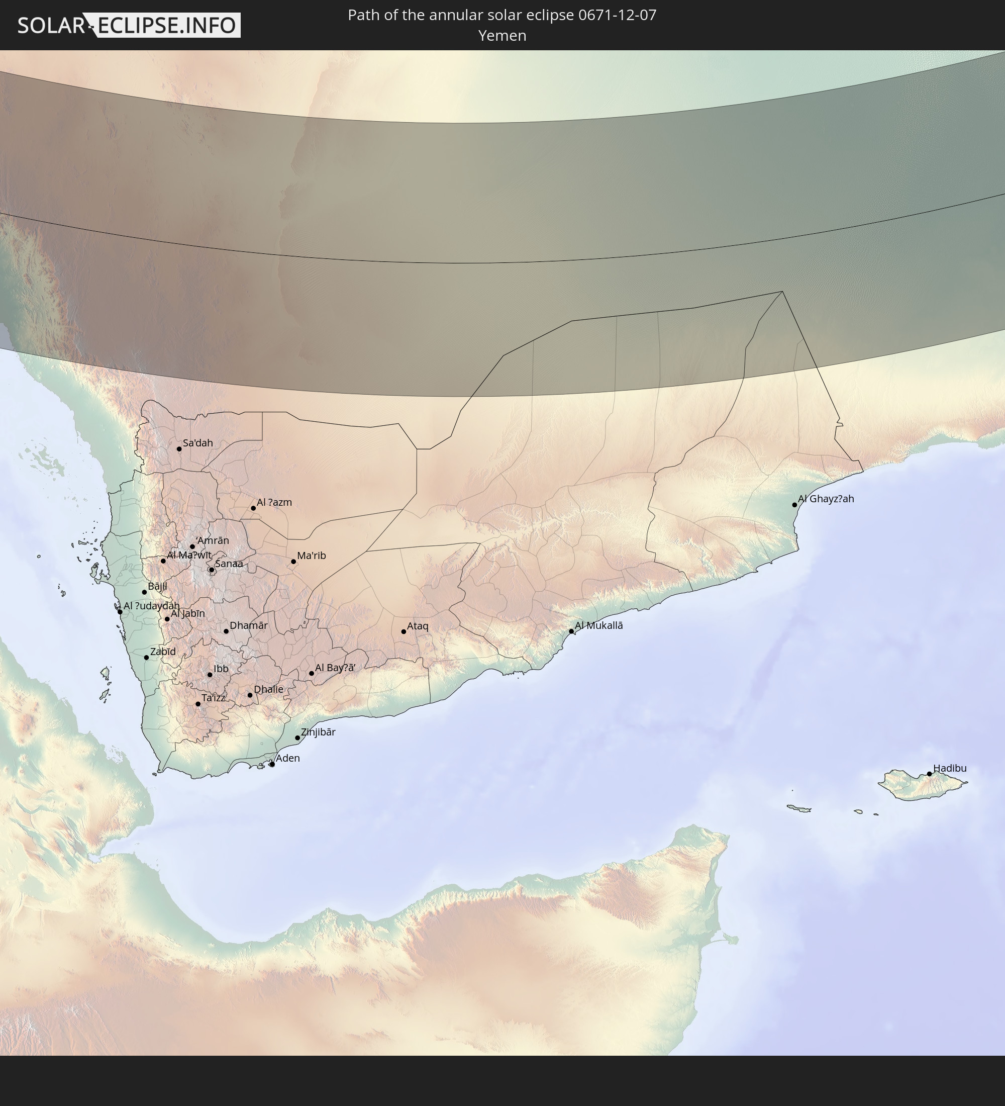 Yemen
Yemen
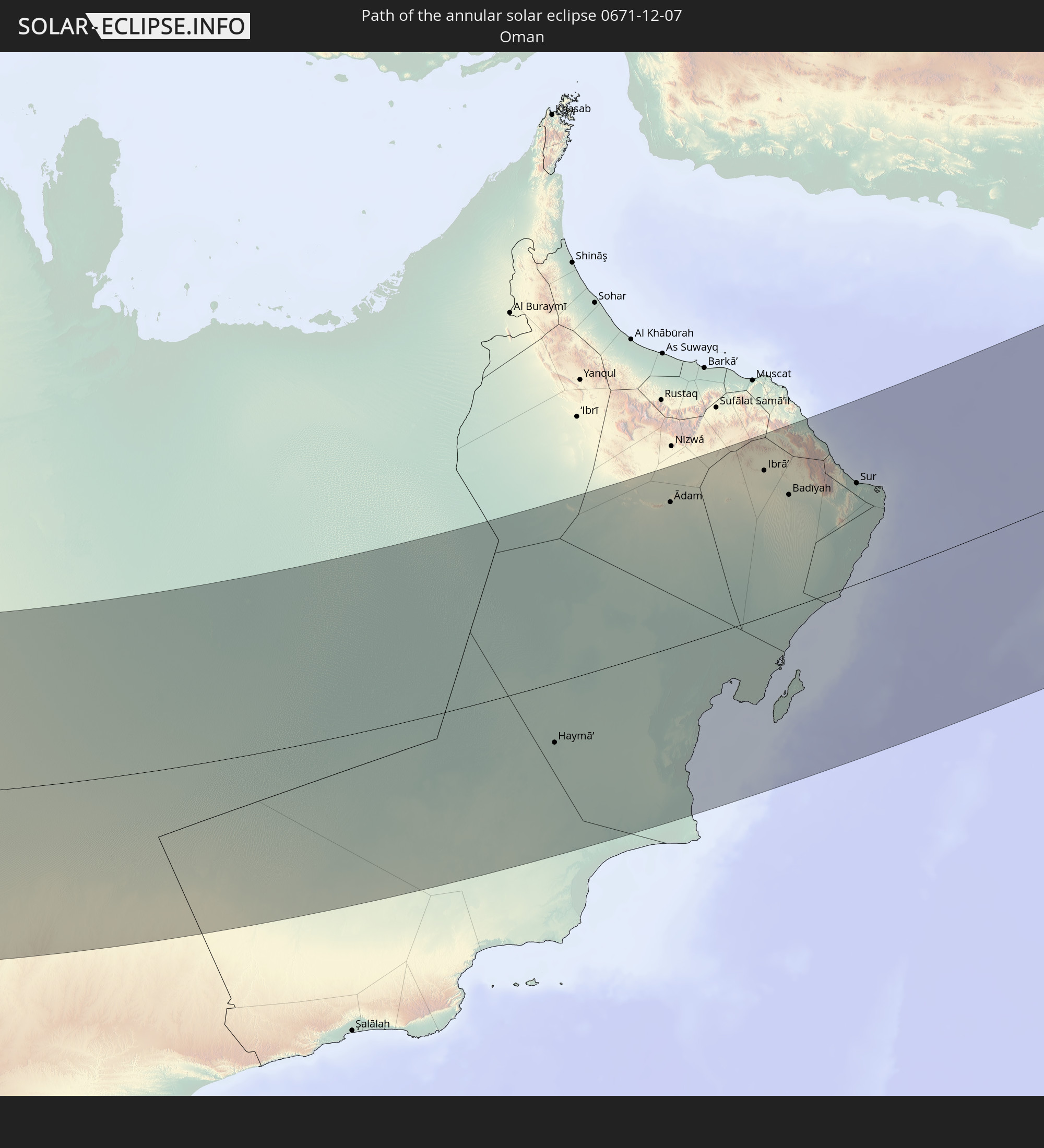 Oman
Oman
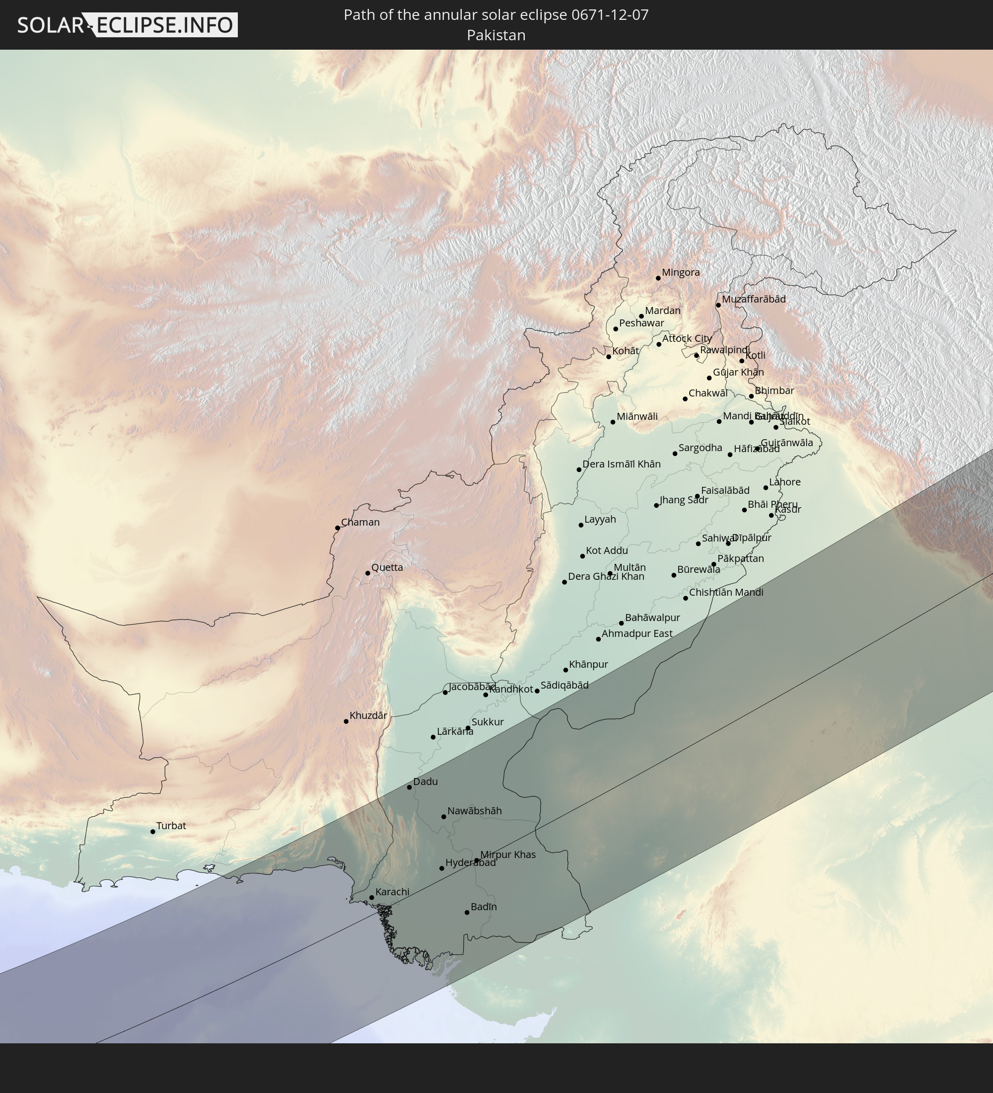 Pakistan
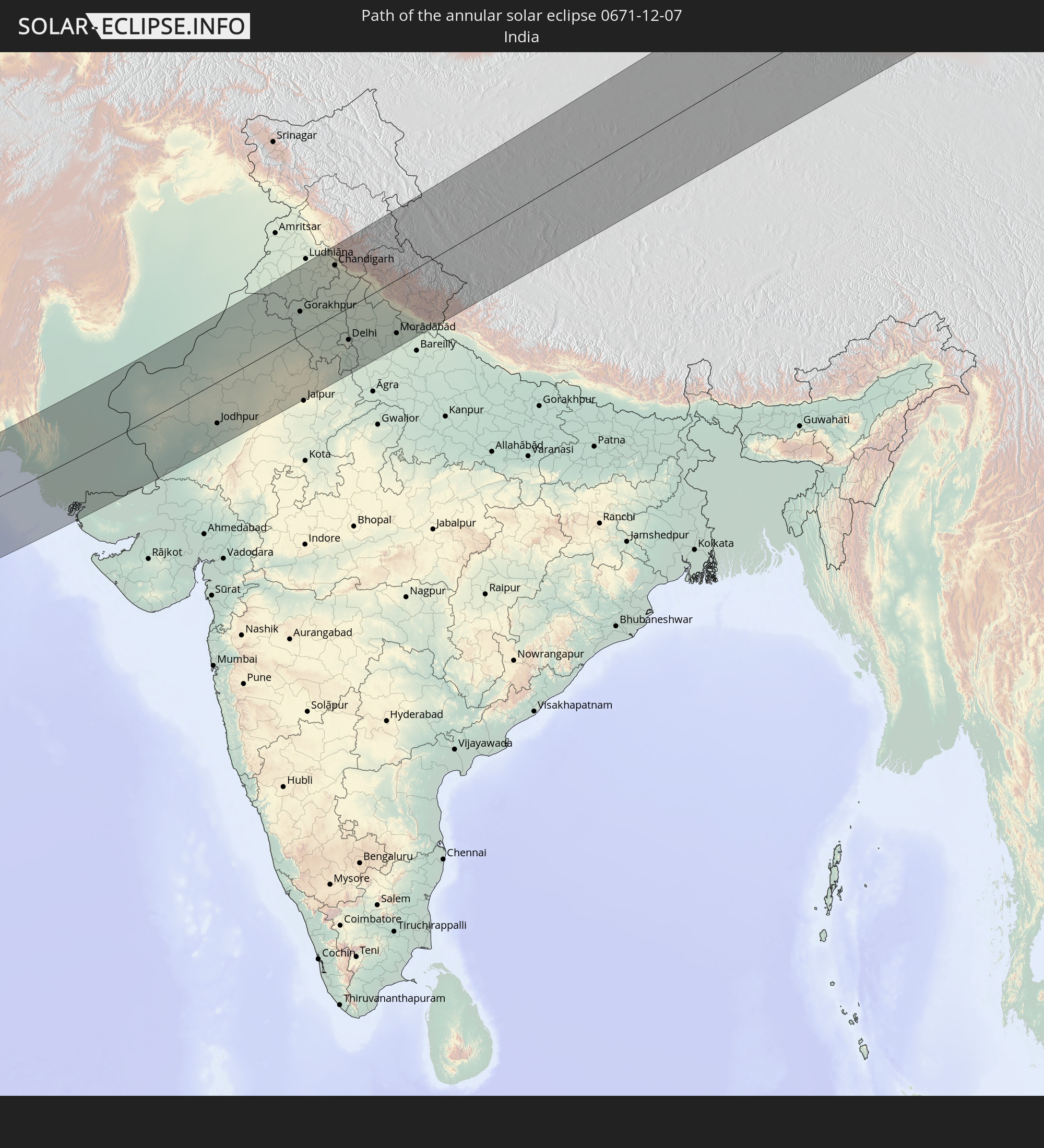 India
India
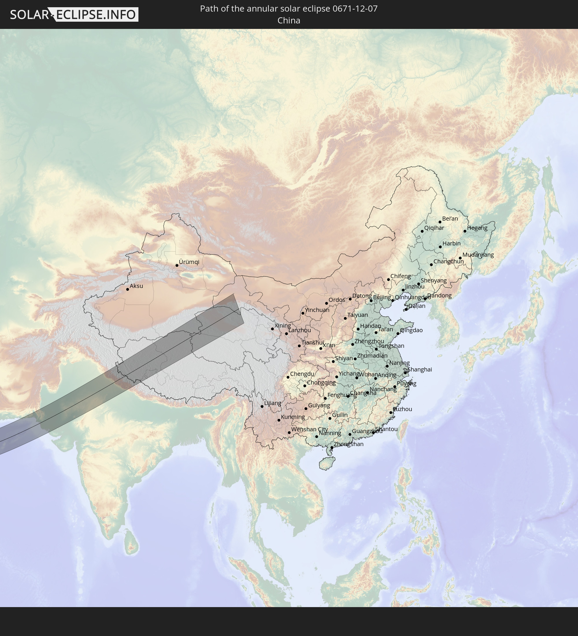 China
China
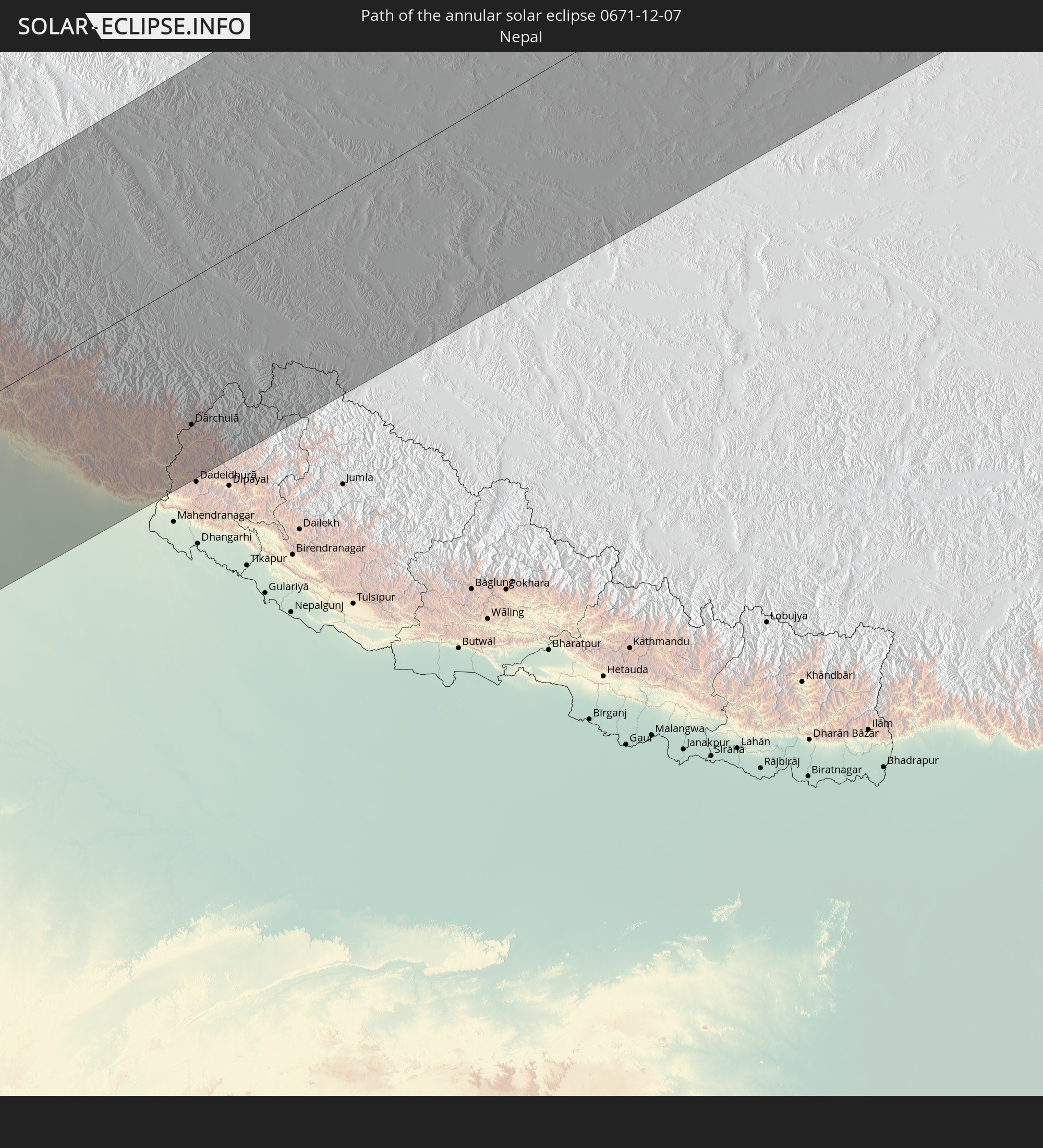 Nepal
Nepal
In den folgenden Ländern ist die Sonnenfinsternis partiell zu sehen
 Russia
 Spain
Spain
 Mauritania
 Guinea
 Sierra Leone
 Morocco
 Mali
Mali
 Liberia
 Algeria
 Ivory Coast
 Burkina Faso
 France
 Ghana
Ghana
 Togo
Togo
 Niger
Niger
 Benin
Benin
 Belgium
 Nigeria
 Equatorial Guinea
 Luxembourg
 Germany
 Switzerland
 São Tomé and Príncipe
 Italy
Italy
 Monaco
 Tunisia
 Denmark
 Cameroon
 Gabon
Gabon
 Libya
Libya
 Liechtenstein
 Austria
 Sweden
 Republic of the Congo
 Angola
 Czechia
 Democratic Republic of the Congo
 San Marino
 Vatican City
 Slovenia
 Chad
Chad
 Croatia
 Poland
 Malta
Malta
 Central African Republic
 Bosnia and Herzegovina
 Hungary
 Slovakia
 Montenegro
 Serbia
 Albania
 Åland Islands
 Greece
 Romania
 Republic of Macedonia
 Finland
 Lithuania
 Latvia
 Estonia
 Sudan
Sudan
 Zambia
 Ukraine
 Bulgaria
 Belarus
 Egypt
Egypt
 Turkey
 Moldova
 Rwanda
 Burundi
 Tanzania
 Uganda
 Mozambique
 Cyprus
 Malawi
 Ethiopia
 Kenya
Kenya
 State of Palestine
 Israel
 Saudi Arabia
 Jordan
 Lebanon
 Syria
Syria
 Eritrea
 Iraq
Iraq
 Georgia
 French Southern and Antarctic Lands
 Somalia
 Djibouti
 Yemen
Yemen
 Madagascar
 Comoros
 Armenia
 Iran
Iran
 Azerbaijan
 Mayotte
 Seychelles
 Kazakhstan
 Kuwait
 Bahrain
 Qatar
Qatar
 United Arab Emirates
 Oman
Oman
 Turkmenistan
 Uzbekistan
 Mauritius
 Afghanistan
 Pakistan
 Tajikistan
 India
India
 Kyrgyzstan
 British Indian Ocean Territory
 Maldives
 China
China
 Sri Lanka
 Nepal
Nepal
 Mongolia
 Bangladesh
 Bhutan
 Myanmar
 Indonesia
 Thailand
 Malaysia
 Laos
Laos
 Vietnam
 Cambodia
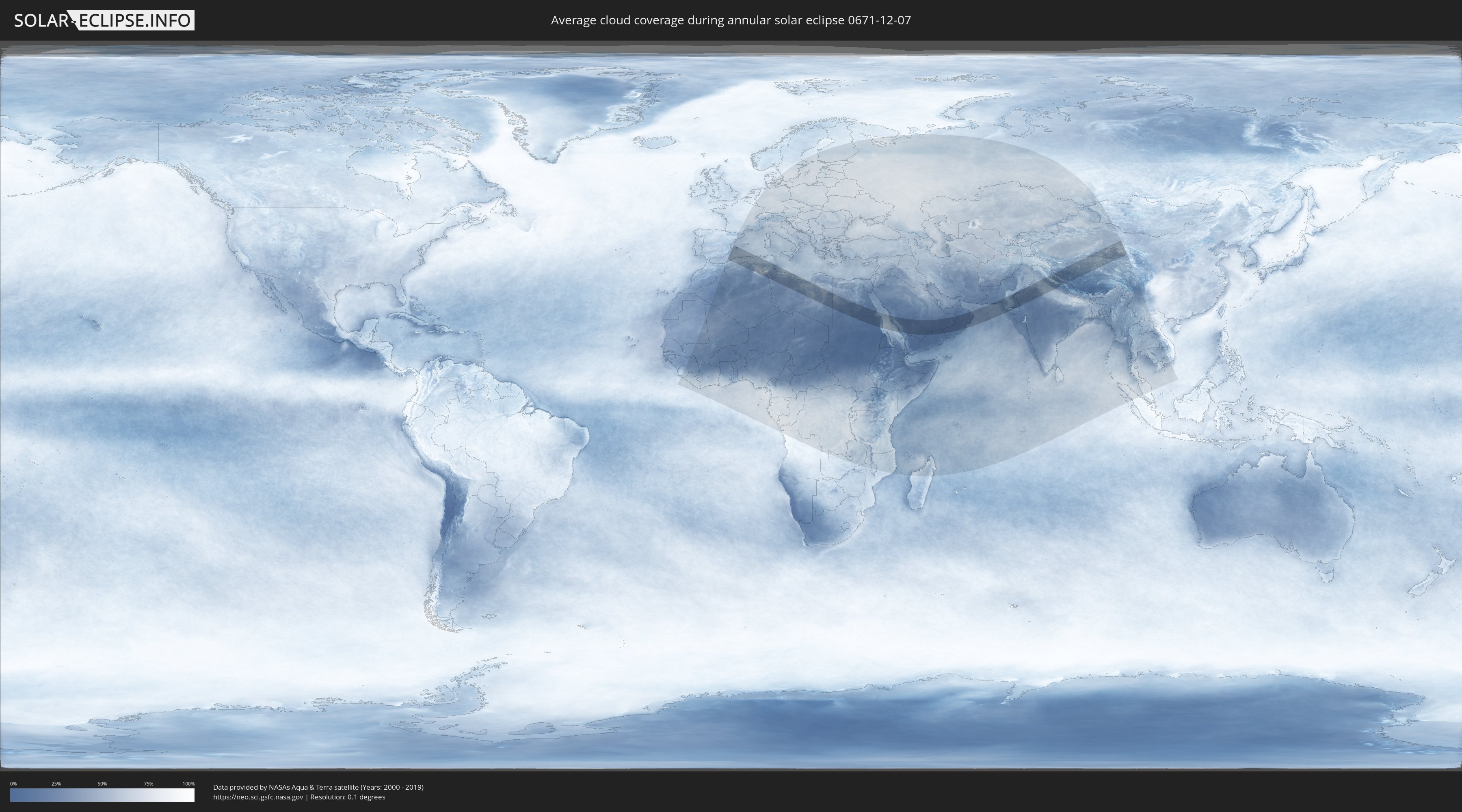
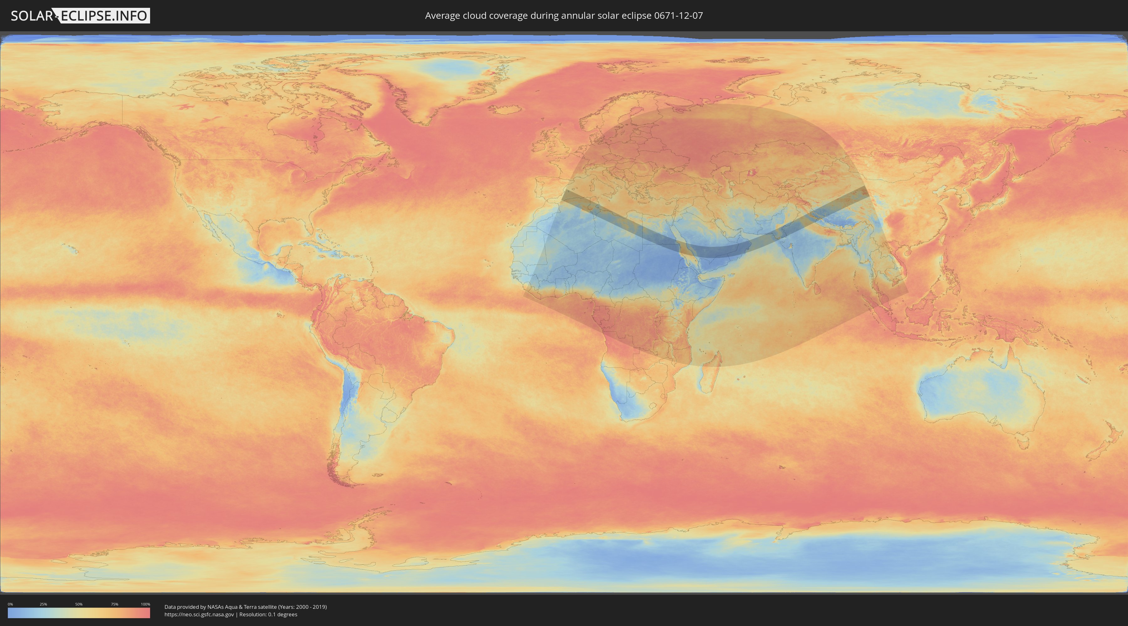
How will be the weather during the annular solar eclipse on 12/07/0671?
Where is the best place to see the annular solar eclipse of 12/07/0671?
The following maps show the average cloud coverage for the day of the annular solar eclipse.
With the help of these maps, it is possible to find the place along the eclipse path, which has the best
chance of a cloudless sky.
Nevertheless, you should consider local circumstances and inform about the weather of your chosen
observation site.
The data is provided by NASAs satellites
AQUA and TERRA.
The cloud maps are averaged over a period of 19 years (2000 - 2019).
Detailed country maps
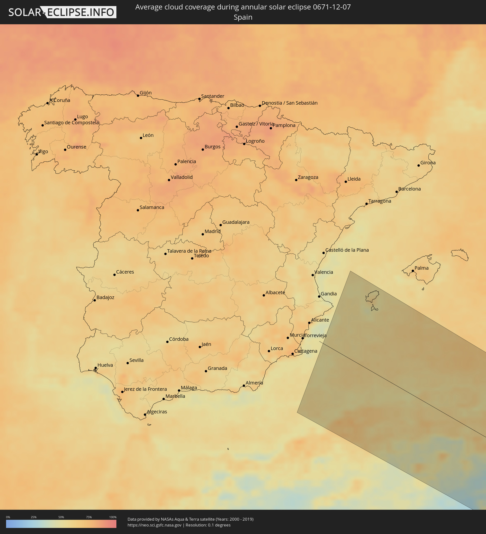 Spain
Spain
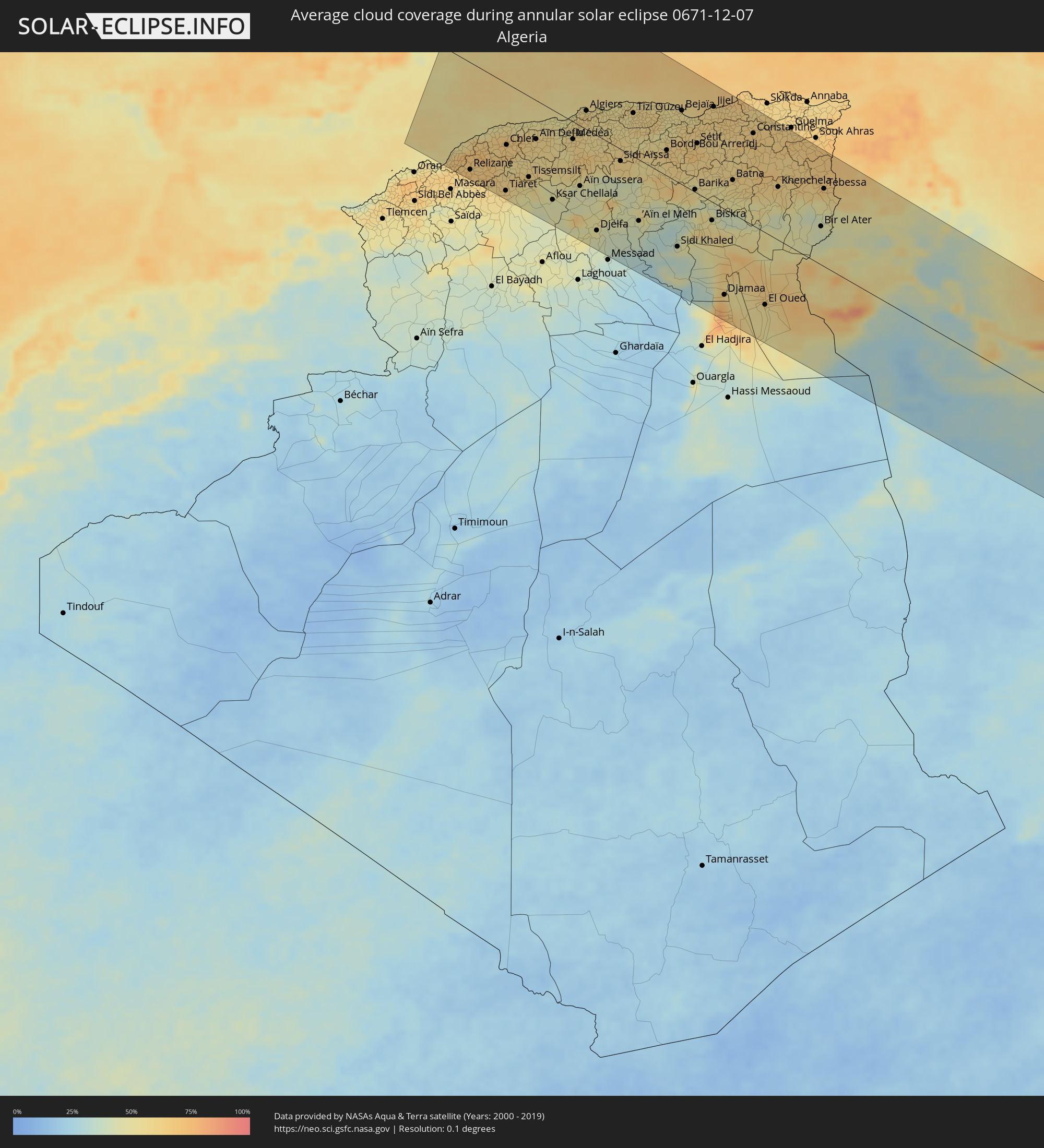 Algeria
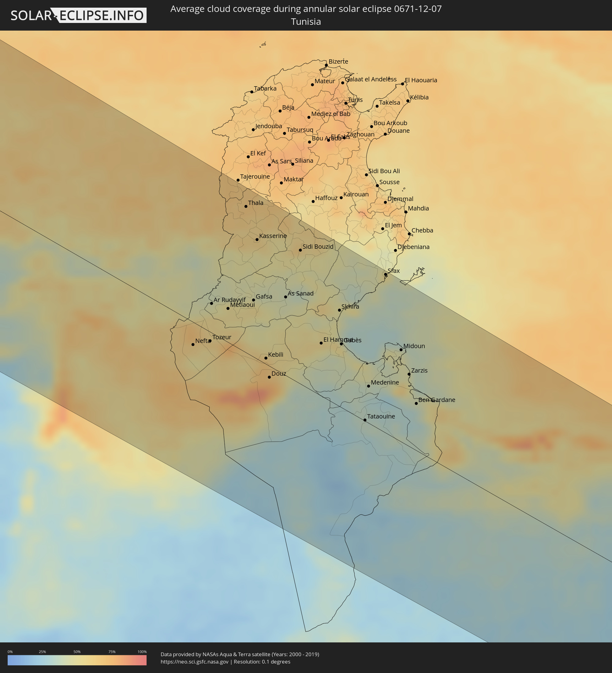 Tunisia
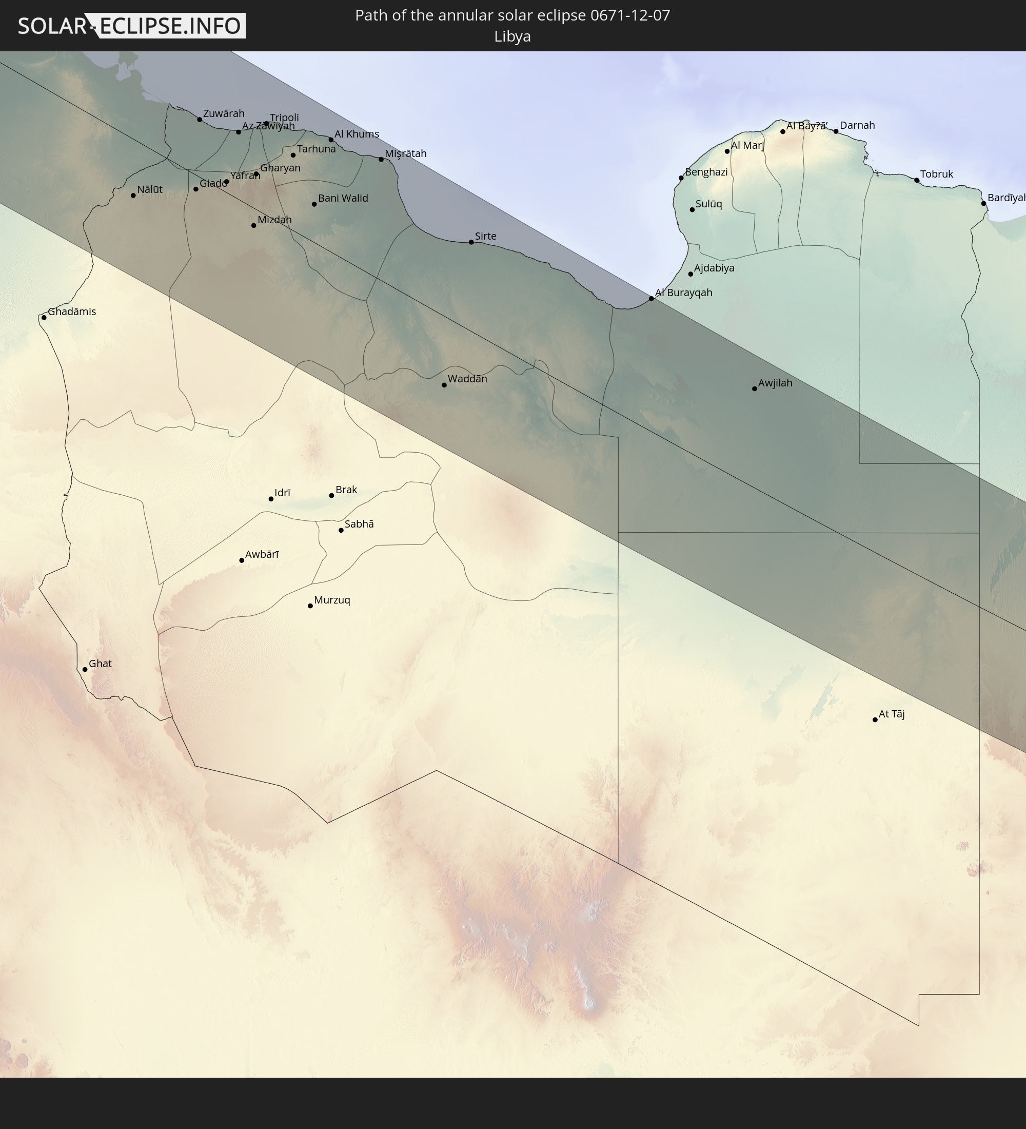
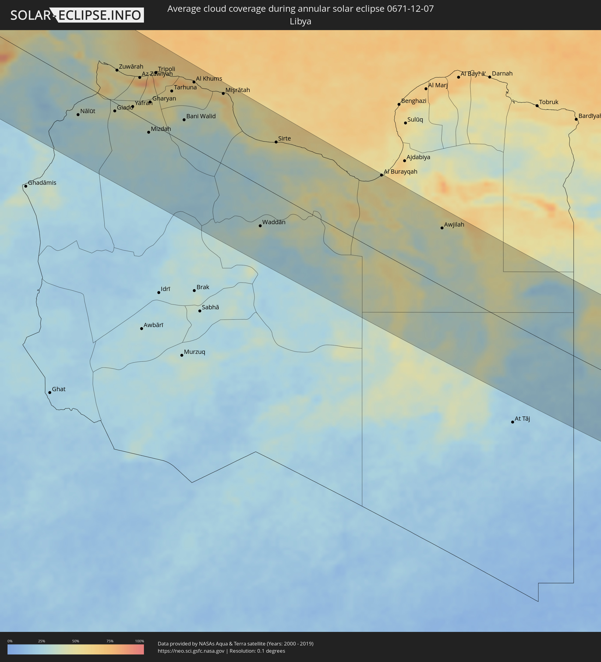 Libya
Libya
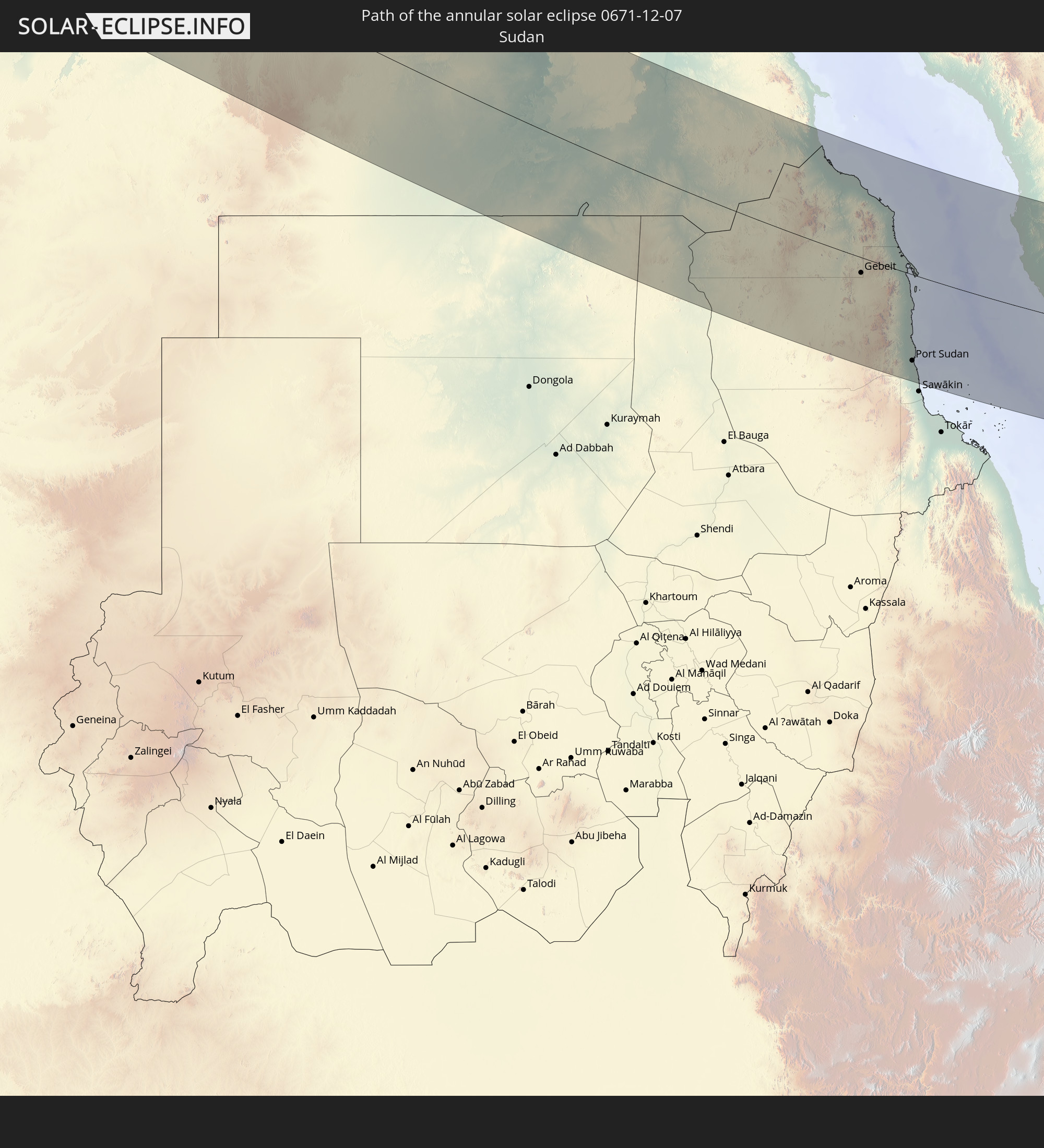
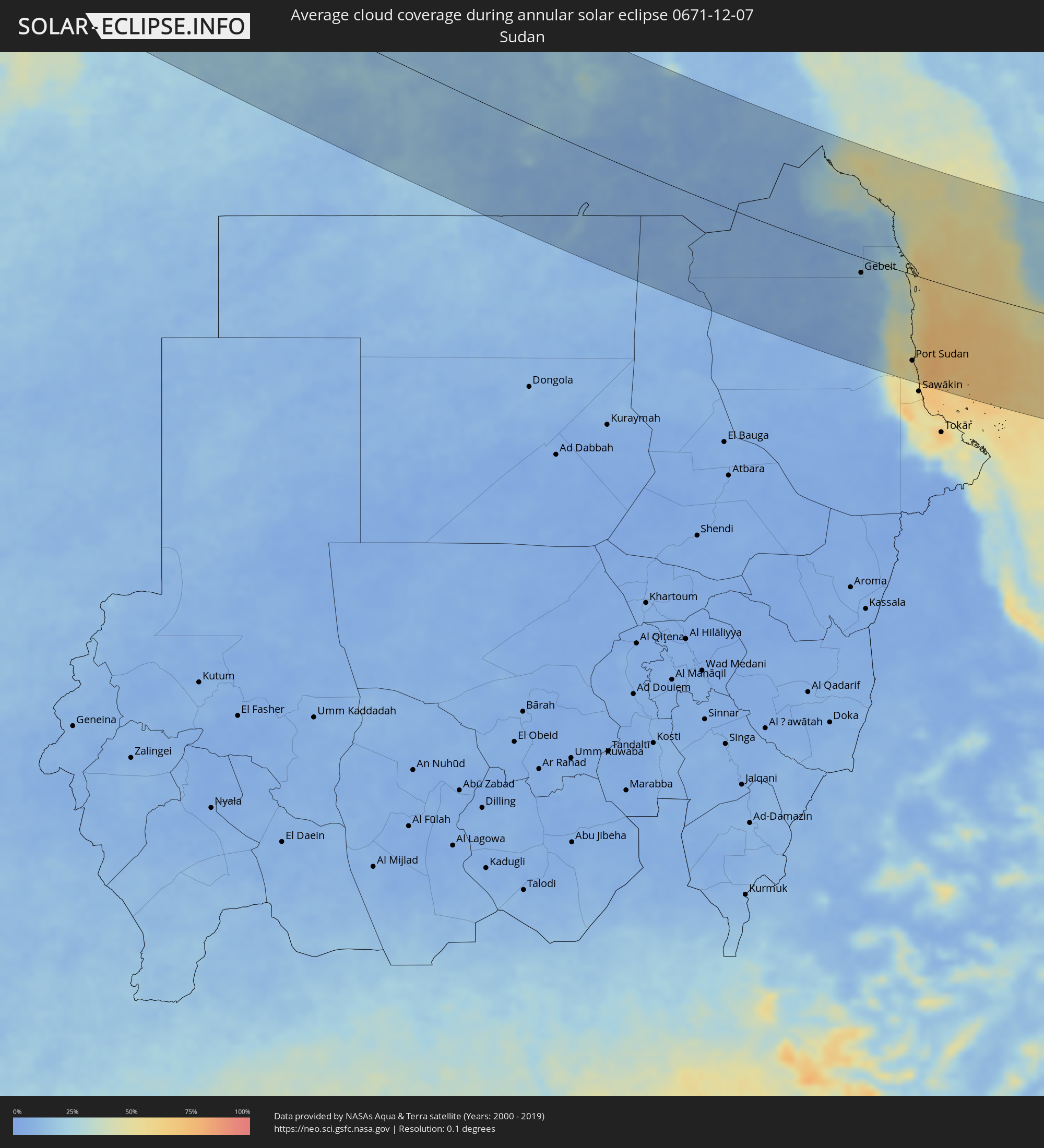 Sudan
Sudan
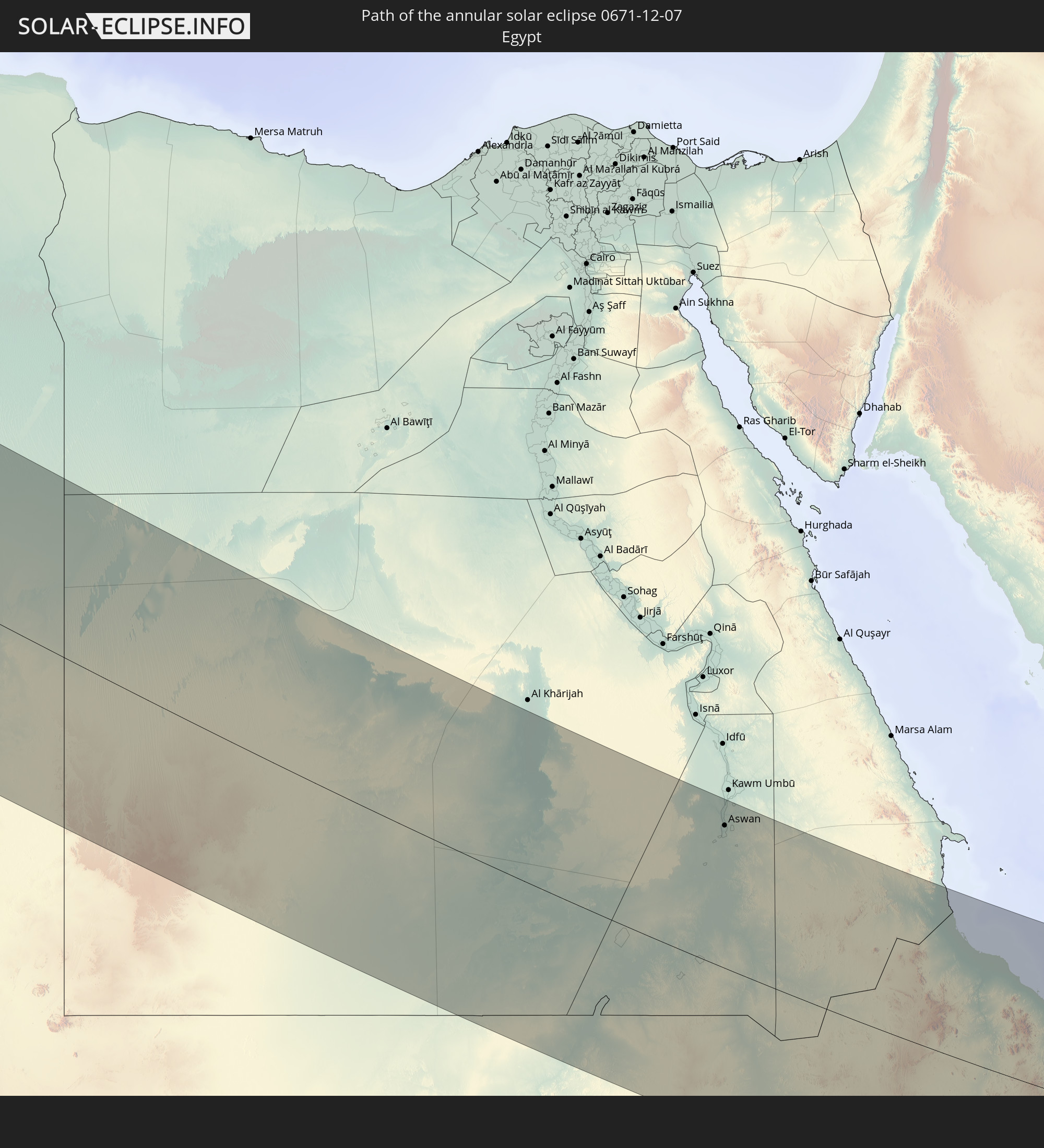
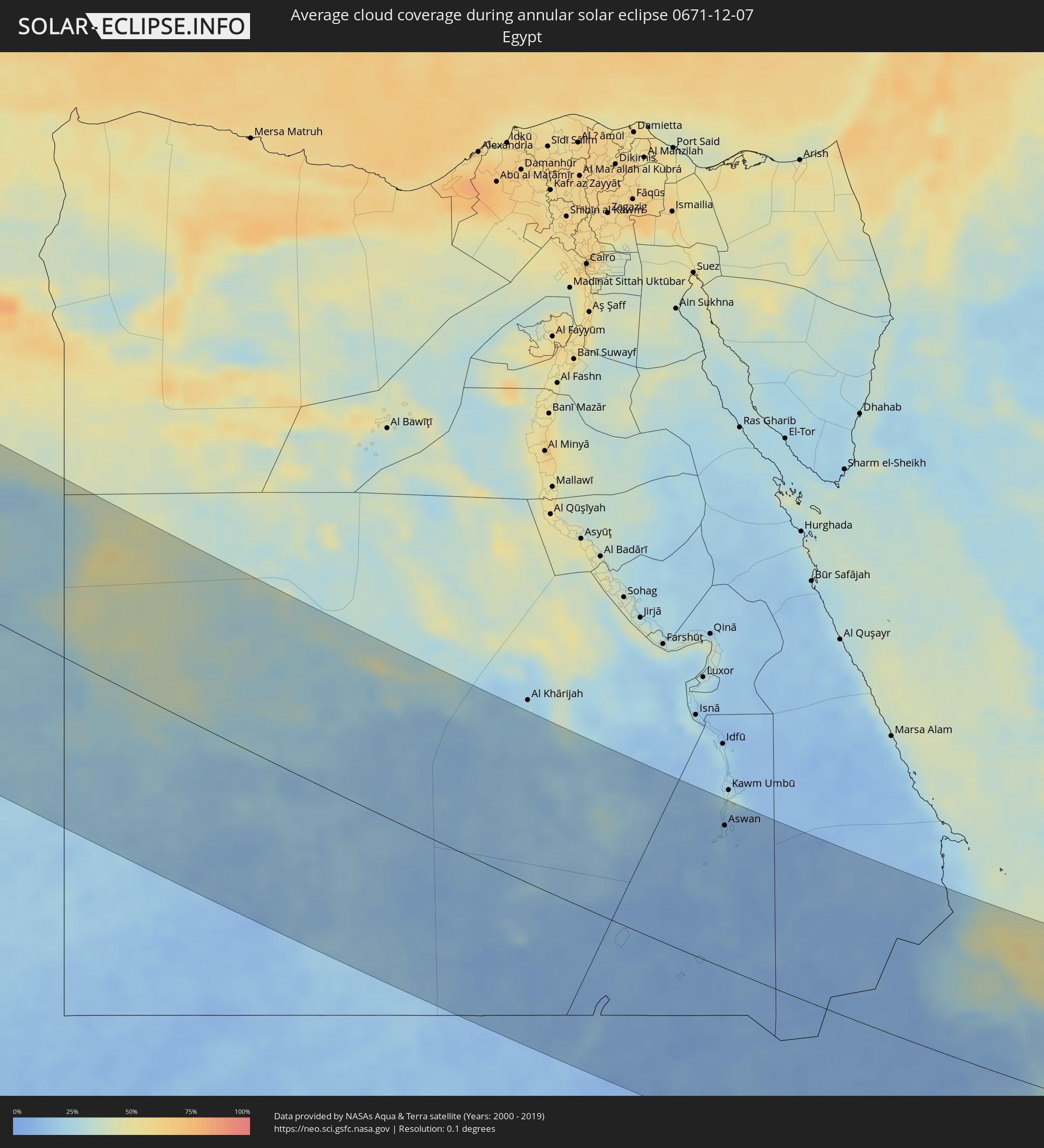 Egypt
Egypt
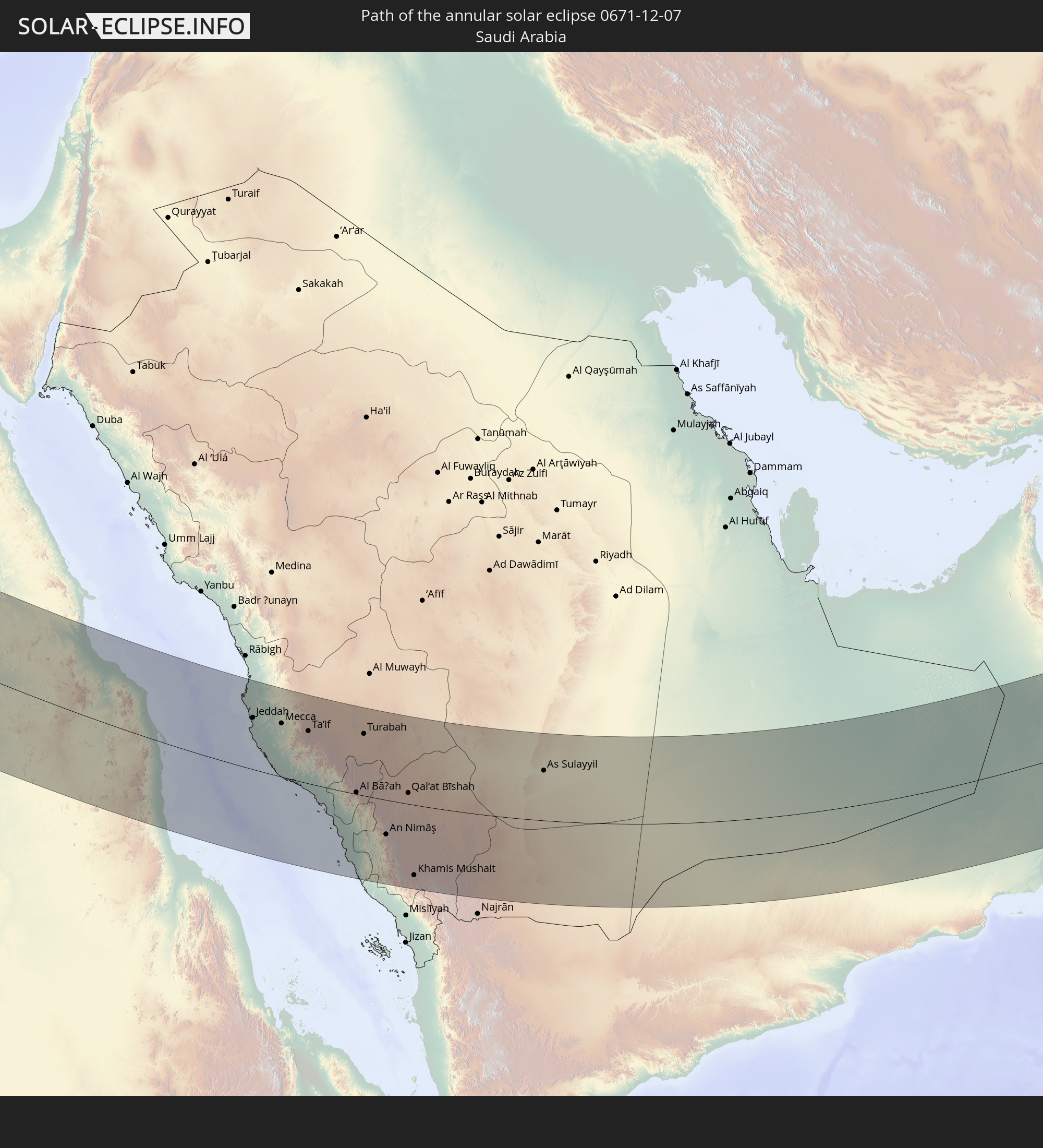
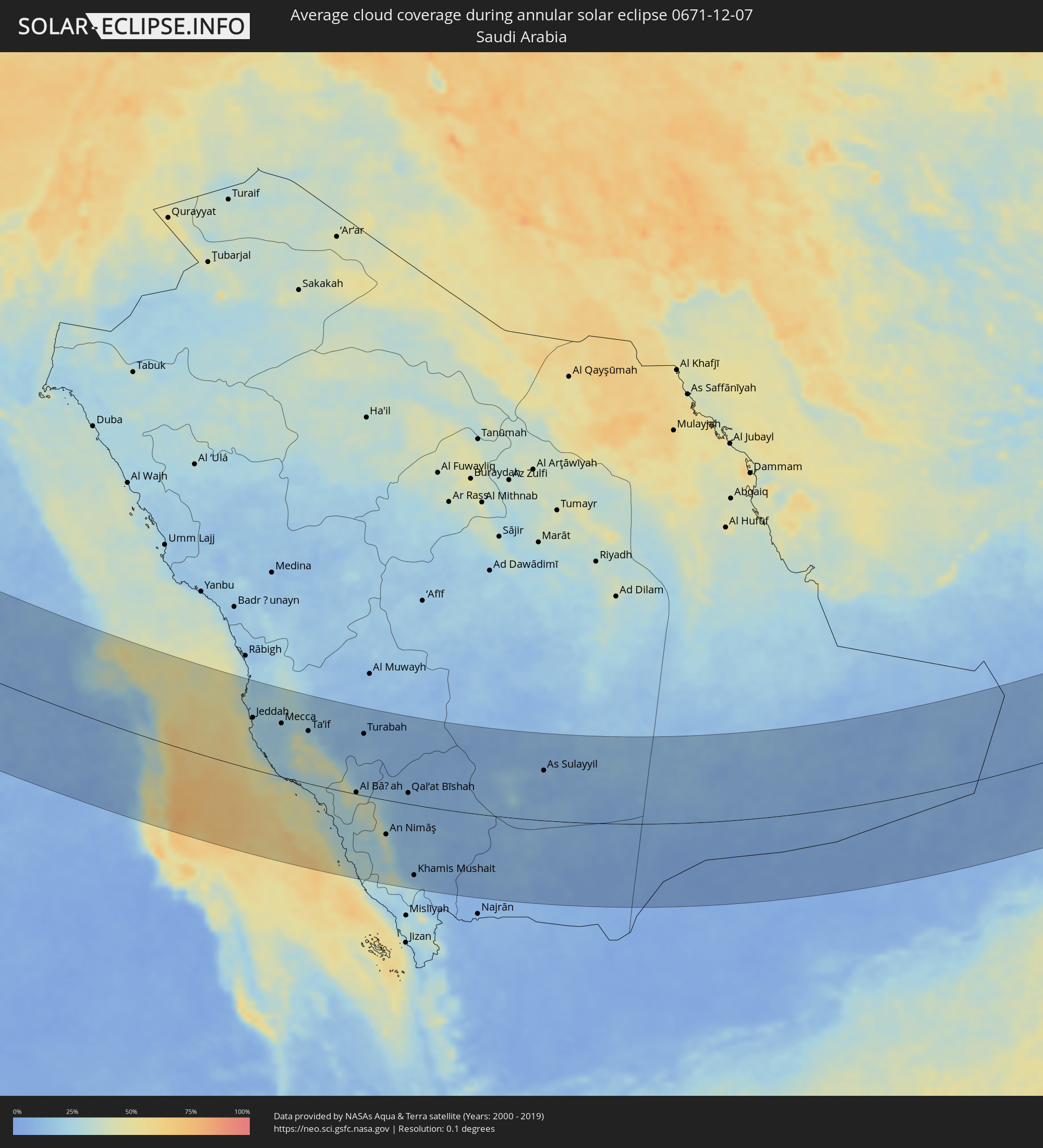 Saudi Arabia
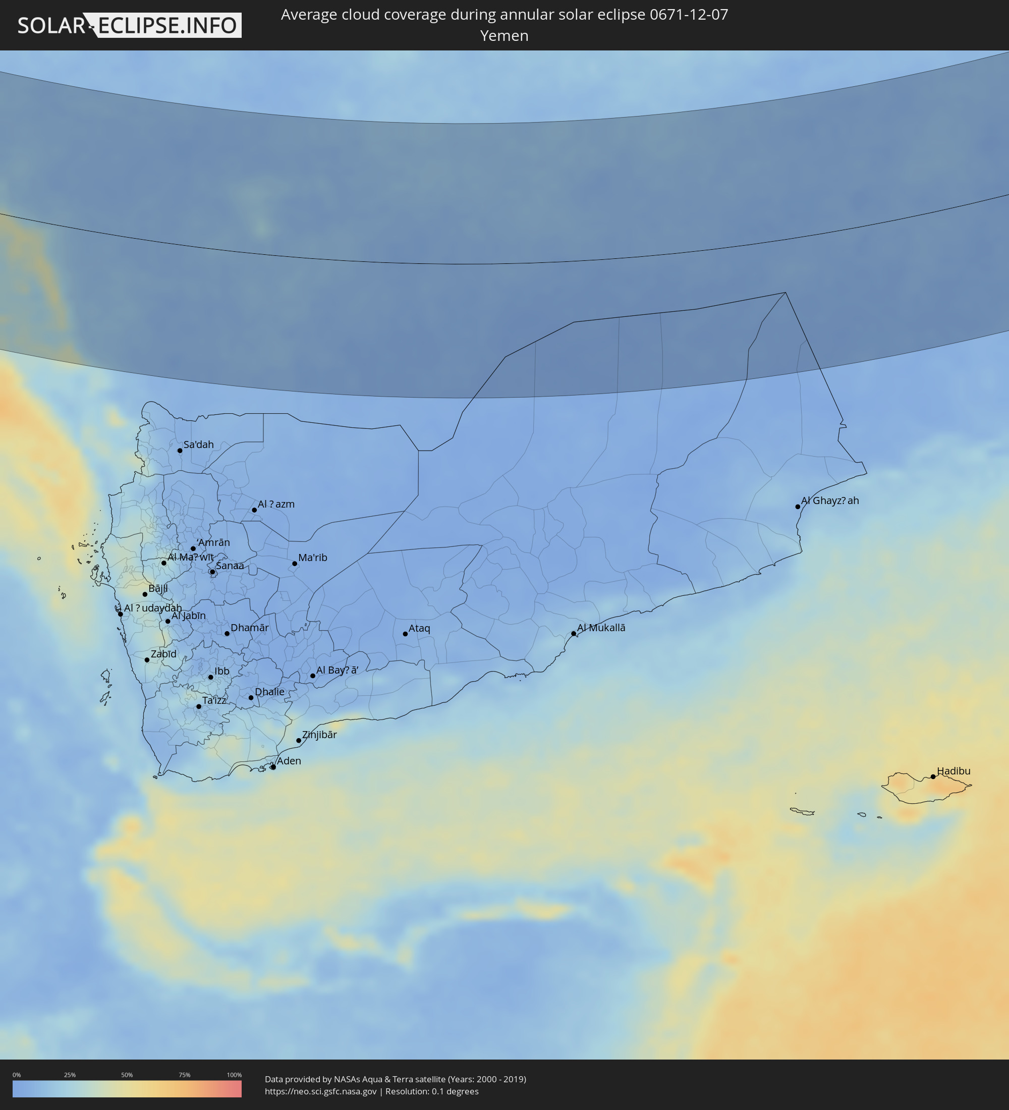 Yemen
Yemen
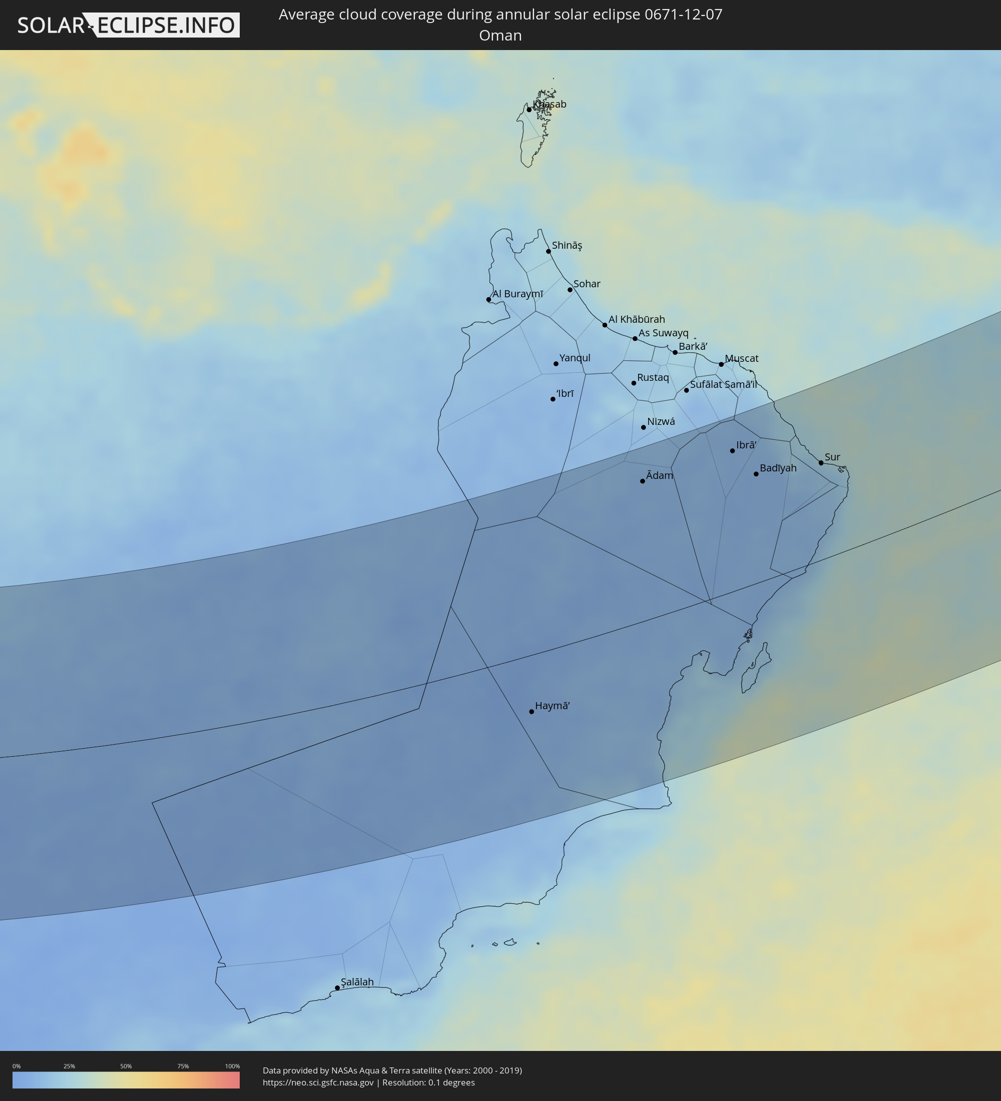 Oman
Oman
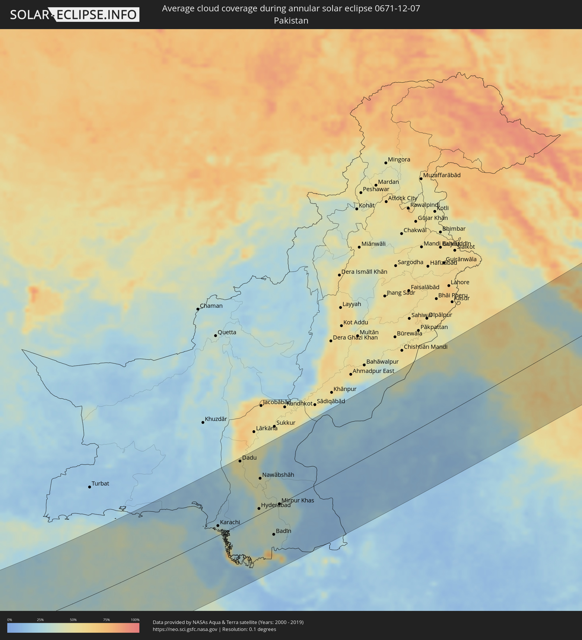 Pakistan
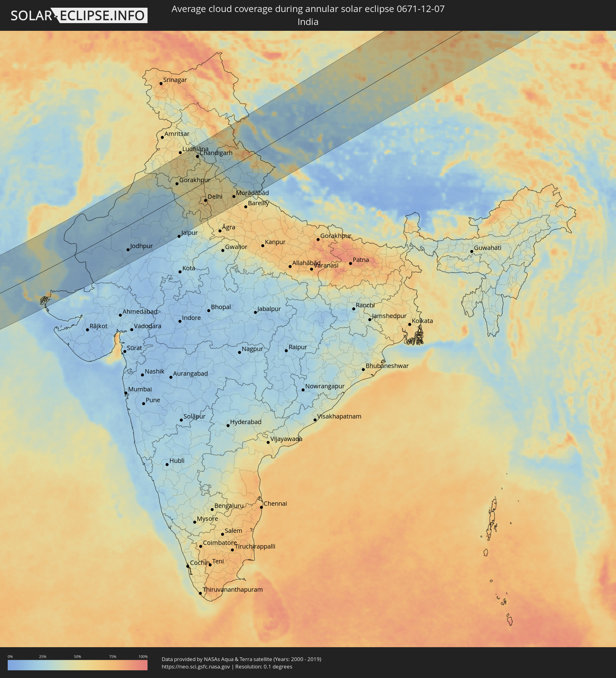 India
India
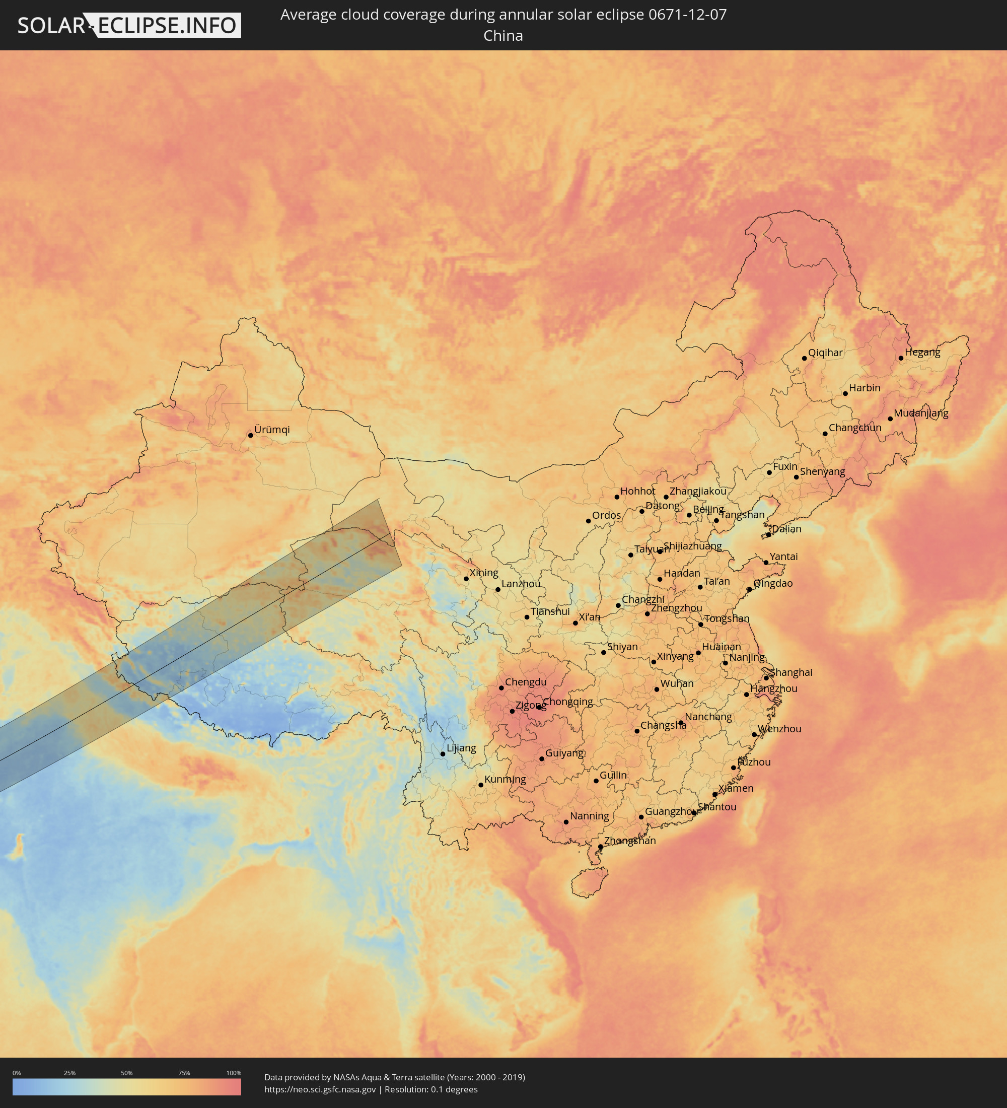 China
China
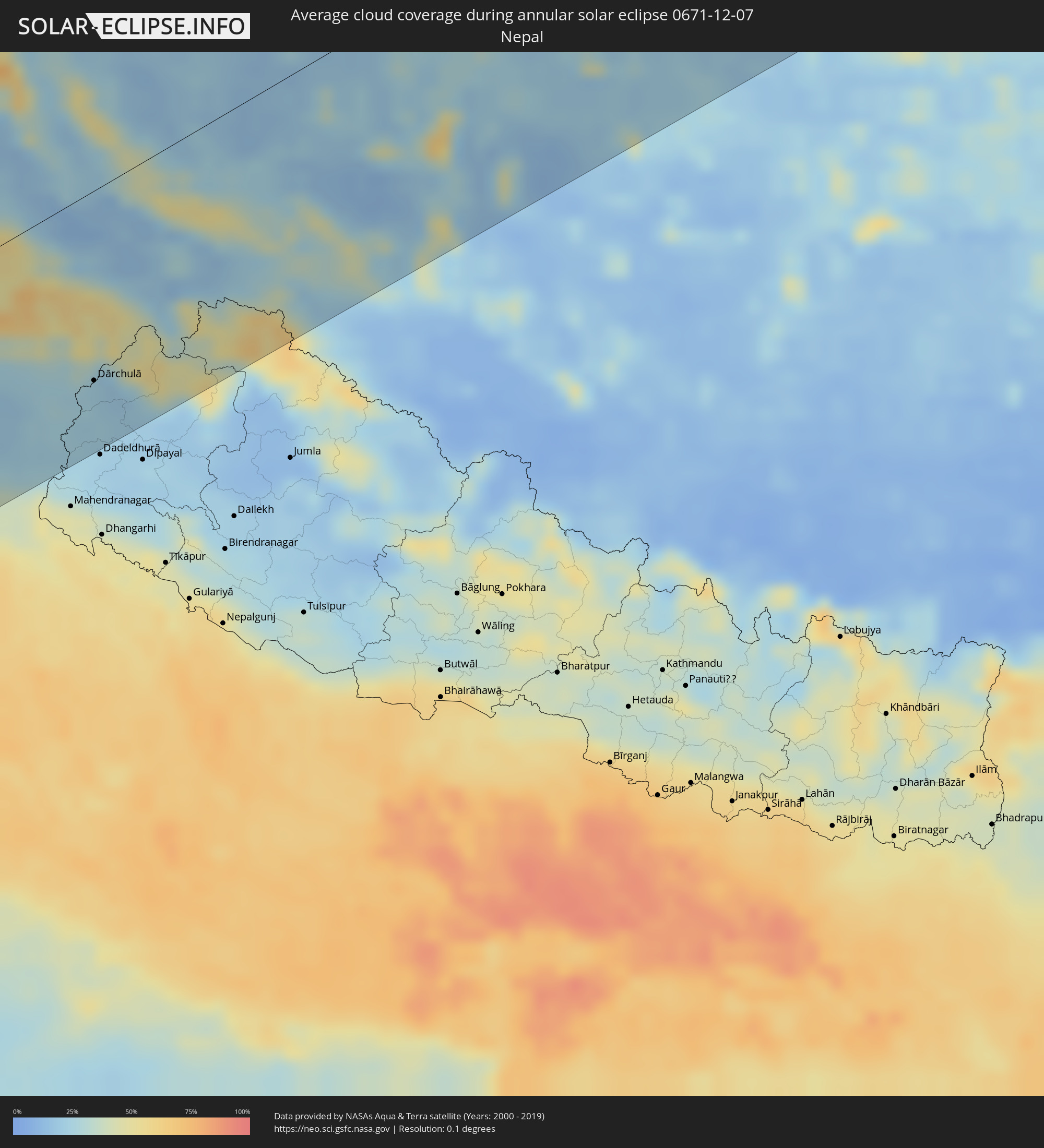 Nepal
Nepal
Cities inside the path of the eclipse
The following table shows all locations with a population of more than 5,000 inside the eclipse path. Cities which have more than 100,000 inhabitants are marked bold. A click at the locations opens a detailed map.
| City | Type | Eclipse duration | Local time of max. eclipse | Distance to central line | Ø Cloud coverage |
|
Sant Antoni de Portmany, Balearic Islands
|
annular | - | 07:16:01 UTC+00:00 | 168 km | 58% |
|
Tiaret, Tiaret
|
annular | - | 07:21:30 UTC+00:09 | 180 km | 60% |
|
Chlef, Chlef
|
annular | - | 07:22:19 UTC+00:09 | 102 km | 65% |
|
Ibiza, Balearic Islands
|
annular | - | 07:16:00 UTC+00:00 | 167 km | 54% |
|
Santa Eulària des Riu, Balearic Islands
|
annular | - | 07:16:09 UTC+00:00 | 179 km | 57% |
|
Médéa, Medea
|
annular | - | 07:23:14 UTC+00:09 | 29 km | 62% |
|
Blida, Blida
|
annular | - | 07:23:30 UTC+00:09 | 6 km | 58% |
|
Algiers, Algiers
|
annular | - | 07:23:56 UTC+00:09 | 31 km | 60% |
|
Djelfa, Djelfa
|
annular | - | 07:21:57 UTC+00:09 | 160 km | 48% |
|
Boumerdas, Boumerdes
|
annular | - | 07:24:13 UTC+00:09 | 52 km | 55% |
|
Tizi Ouzou, Tizi Ouzou
|
annular | - | 07:24:32 UTC+00:09 | 72 km | 55% |
|
Bordj Bou Arreridj, Bordj Bou Arréridj
|
annular | - | 07:24:21 UTC+00:09 | 43 km | 63% |
|
Bejaïa, Béjaïa
|
annular | - | 07:25:18 UTC+00:09 | 123 km | 55% |
|
Sétif, Sétif
|
annular | - | 07:24:57 UTC+00:09 | 84 km | 65% |
|
Biskra, Biskra
|
annular | - | 07:23:49 UTC+00:09 | 31 km | 53% |
|
Jijel, Jijel
|
annular | - | 07:25:52 UTC+00:09 | 160 km | 63% |
|
Batna, Batna
|
annular | - | 07:24:51 UTC+00:09 | 57 km | 60% |
|
Constantine, Constantine
|
annular | - | 07:26:02 UTC+00:09 | 155 km | 65% |
|
El Oued, El Oued
|
annular | - | 07:23:16 UTC+00:09 | 124 km | 55% |
|
Nefta, Tawzar
|
annular | - | 07:24:35 UTC+00:09 | 27 km | 58% |
|
Tébessa, Tébessa
|
annular | - | 07:26:17 UTC+00:09 | 132 km | 62% |
|
Tozeur, Tawzar
|
annular | - | 07:24:50 UTC+00:09 | 11 km | 54% |
|
Ar Rudayyif, Gafsa
|
annular | - | 07:25:18 UTC+00:09 | 35 km | 48% |
|
Metlaoui, Gafsa
|
annular | - | 07:25:27 UTC+00:09 | 40 km | 53% |
|
Thala, Al Qaşrayn
|
annular | - | 07:26:55 UTC+00:09 | 173 km | 66% |
|
Gafsa, Gafsa
|
annular | - | 07:25:53 UTC+00:09 | 68 km | 56% |
|
Kasserine, Al Qaşrayn
|
annular | - | 07:26:40 UTC+00:09 | 142 km | 61% |
|
Kebili, Qibilī
|
annular | - | 07:25:22 UTC+00:09 | 7 km | 64% |
|
Douz, Qibilī
|
annular | - | 07:25:11 UTC+00:09 | 14 km | 76% |
|
Sidi Bouzid, Sīdī Bū Zayd
|
annular | - | 07:27:07 UTC+00:09 | 159 km | 49% |
|
El Hamma, Qābis
|
annular | - | 07:26:18 UTC+00:09 | 63 km | 49% |
|
Gabès, Qābis
|
annular | - | 07:26:35 UTC+00:09 | 76 km | 53% |
|
Tataouine, Tataouine
|
annular | - | 07:26:02 UTC+00:09 | 1 km | 35% |
|
Medenine, Madanīn
|
annular | - | 07:26:29 UTC+00:09 | 44 km | 37% |
|
Sfax, Şafāqis
|
annular | - | 07:28:03 UTC+00:09 | 190 km | 40% |
|
Nālūt, Sha‘bīyat Nālūt
|
annular | - | 08:09:01 UTC+00:52 | 77 km | 30% |
|
Midoun, Madanīn
|
annular | - | 07:27:23 UTC+00:09 | 111 km | 46% |
|
Zarzis, Madanīn
|
annular | - | 07:27:13 UTC+00:09 | 87 km | 48% |
|
Zuwārah, An Nuqāţ al Khams
|
annular | - | 08:11:05 UTC+00:52 | 77 km | 56% |
|
Zintan, Jabal al Gharbi District
|
annular | - | 08:10:23 UTC+00:52 | 11 km | 39% |
|
Şabrātah, Az Zāwiyah
|
annular | - | 08:11:24 UTC+00:52 | 83 km | 70% |
|
Yafran, Jabal al Gharbi District
|
annular | - | 08:10:48 UTC+00:52 | 14 km | 48% |
|
Az Zāwīyah, Az Zāwiyah
|
annular | - | 08:11:37 UTC+00:52 | 91 km | 74% |
|
Mizdah, Jabal al Gharbi District
|
annular | - | 08:10:46 UTC+00:52 | 24 km | 30% |
|
Gharyan, Jabal al Gharbi District
|
annular | - | 08:11:26 UTC+00:52 | 48 km | 53% |
|
Tripoli, Tripoli
|
annular | - | 08:12:14 UTC+00:52 | 124 km | 71% |
|
Tagiura, Tripoli
|
annular | - | 08:12:26 UTC+00:52 | 132 km | 66% |
|
Tarhuna, Al Marqab
|
annular | - | 08:12:21 UTC+00:52 | 102 km | 51% |
|
Bani Walid, Mişrātah
|
annular | - | 08:12:10 UTC+00:52 | 52 km | 33% |
|
Al Khums, Al Marqab
|
annular | - | 08:13:17 UTC+00:52 | 152 km | 59% |
|
Zliten, Mişrātah
|
annular | - | 08:13:29 UTC+00:52 | 149 km | 61% |
|
Mişrātah, Mişrātah
|
annular | - | 08:14:03 UTC+00:52 | 165 km | 65% |
|
Waddān, Al Jufrah
|
annular | - | 08:12:50 UTC+00:52 | 97 km | 40% |
|
Sirte, Surt
|
annular | - | 08:14:59 UTC+00:52 | 123 km | 51% |
|
Aswan, Aswan
|
annular | - | 09:50:10 UTC+02:00 | 161 km | 14% |
|
Gebeit, Red Sea
|
annular | - | 10:09:19 UTC+02:10 | 27 km | 15% |
|
Port Sudan, Red Sea
|
annular | - | 10:11:51 UTC+02:10 | 151 km | 48% |
|
Jeddah, Makkah
|
annular | - | 11:15:21 UTC+03:06 | 113 km | 30% |
|
Al Jumūm, Makkah
|
annular | - | 11:17:02 UTC+03:06 | 135 km | 23% |
|
Mecca, Makkah
|
annular | - | 11:17:26 UTC+03:06 | 118 km | 22% |
|
Al Hadā, Makkah
|
annular | - | 11:18:59 UTC+03:06 | 124 km | 27% |
|
Ash Shafā, Makkah
|
annular | - | 11:19:01 UTC+03:06 | 92 km | 46% |
|
Ta’if, Makkah
|
annular | - | 11:19:24 UTC+03:06 | 116 km | 24% |
|
Al Mindak, Al Bahah
|
annular | - | 11:22:14 UTC+03:06 | 16 km | 42% |
|
Al Bāḩah, Al Bahah
|
annular | - | 11:22:52 UTC+03:06 | 4 km | 40% |
|
Turabah, Makkah
|
annular | - | 11:23:37 UTC+03:06 | 138 km | 12% |
|
Al Majāridah, 'Asir
|
annular | - | 11:24:19 UTC+03:06 | 84 km | 23% |
|
An Nimāş, 'Asir
|
annular | - | 11:25:04 UTC+03:06 | 78 km | 43% |
|
Tabālah, 'Asir
|
annular | - | 11:26:09 UTC+03:06 | 16 km | 12% |
|
Abha, 'Asir
|
annular | - | 11:26:21 UTC+03:06 | 173 km | 31% |
|
Qal‘at Bīshah, 'Asir
|
annular | - | 11:26:54 UTC+03:06 | 25 km | 9% |
|
Khamis Mushait, 'Asir
|
annular | - | 11:27:10 UTC+03:06 | 160 km | 15% |
|
As Sulayyil, Ar Riyāḑ
|
annular | - | 11:37:49 UTC+03:06 | 114 km | 11% |
|
Haymā’, Al Wusţá
|
annular | - | 12:51:16 UTC+03:41 | 65 km | 7% |
|
Ādam, Muḩāfaz̧at ad Dākhilīyah
|
annular | - | 12:55:17 UTC+03:41 | 154 km | 9% |
|
Ibrā’, Ash Sharqiyah North Governorate
|
annular | - | 12:58:30 UTC+03:41 | 153 km | 10% |
|
Al Qābil, Ash Sharqiyah North Governorate
|
annular | - | 12:59:02 UTC+03:41 | 135 km | 9% |
|
Badīyah, Ash Sharqiyah North Governorate
|
annular | - | 12:59:23 UTC+03:41 | 119 km | 9% |
|
Sur, Ash Sharqiyah South Governorate
|
annular | - | 13:01:39 UTC+03:41 | 105 km | 17% |
|
Karachi, Sindh
|
annular | - | 14:08:40 UTC+04:28 | 27 km | 36% |
|
Dadu, Sindh
|
annular | - | 14:09:34 UTC+04:28 | 176 km | 51% |
|
Sehwān, Sindh
|
annular | - | 14:09:54 UTC+04:28 | 142 km | 44% |
|
Thatta, Sindh
|
annular | - | 14:10:40 UTC+04:28 | 27 km | 35% |
|
Moro, Sindh
|
annular | - | 14:10:07 UTC+04:28 | 159 km | 47% |
|
Hyderabad, Sindh
|
annular | - | 14:11:27 UTC+04:28 | 16 km | 43% |
|
Nawābshāh, Sindh
|
annular | - | 14:11:12 UTC+04:28 | 99 km | 44% |
|
Hāla, Sindh
|
annular | - | 14:11:24 UTC+04:28 | 56 km | 44% |
|
Tando Muhammad Khān, Sindh
|
annular | - | 14:11:55 UTC+04:28 | 18 km | 39% |
|
Shāhdādpur, Sindh
|
annular | - | 14:11:48 UTC+04:28 | 57 km | 42% |
|
Mātli, Sindh
|
annular | - | 14:12:13 UTC+04:28 | 31 km | 36% |
|
Tando Ādam, Sindh
|
annular | - | 14:11:57 UTC+04:28 | 40 km | 38% |
|
Tando Allāhyār, Sindh
|
annular | - | 14:12:12 UTC+04:28 | 7 km | 41% |
|
Badīn, Sindh
|
annular | - | 14:12:45 UTC+04:28 | 78 km | 36% |
|
Sānghar, Sindh
|
annular | - | 14:12:28 UTC+04:28 | 54 km | 37% |
|
Mirpur Khas, Sindh
|
annular | - | 14:12:50 UTC+04:28 | 1 km | 36% |
|
Umarkot, Sindh
|
annular | - | 14:14:26 UTC+04:28 | 50 km | 27% |
|
Jodhpur, Rajasthan
|
annular | - | 15:13:30 UTC+05:21 | 116 km | 18% |
|
Bīkaner, Rajasthan
|
annular | - | 15:13:11 UTC+05:21 | 40 km | 19% |
|
Ajmer, Rajasthan
|
annular | - | 15:16:19 UTC+05:21 | 176 km | 16% |
|
Gorakhpur, Haryana
|
annular | - | 15:16:23 UTC+05:21 | 64 km | 52% |
|
Hisar, Haryana
|
annular | - | 15:16:39 UTC+05:21 | 33 km | 53% |
|
Patiāla, Punjab
|
annular | - | 15:16:57 UTC+05:21 | 115 km | 53% |
|
Rohtak, Haryana
|
annular | - | 15:18:11 UTC+05:21 | 34 km | 54% |
|
Chandigarh, Chandigarh
|
annular | - | 15:17:17 UTC+05:21 | 134 km | 49% |
|
Delhi, NCT
|
annular | - | 15:19:19 UTC+05:21 | 88 km | 63% |
|
Farīdābād, Haryana
|
annular | - | 15:19:35 UTC+05:21 | 115 km | 62% |
|
Ghāziābād, Uttar Pradesh
|
annular | - | 15:19:37 UTC+05:21 | 97 km | 67% |
|
Sahāranpur, Uttar Pradesh
|
annular | - | 15:18:57 UTC+05:21 | 24 km | 50% |
|
Muzaffarnagar, Uttar Pradesh
|
annular | - | 15:19:31 UTC+05:21 | 32 km | 52% |
|
Meerut, Uttar Pradesh
|
annular | - | 15:19:50 UTC+05:21 | 79 km | 60% |
|
Dehra Dūn, Uttarakhand
|
annular | - | 15:19:26 UTC+05:21 | 34 km | 40% |
|
Morādābād, Uttar Pradesh
|
annular | - | 15:21:28 UTC+05:21 | 145 km | 58% |
|
Rāmpur, Uttar Pradesh
|
annular | - | 15:21:50 UTC+05:21 | 160 km | 57% |
|
Dārchulā, Western Region
|
annular | - | 15:23:11 UTC+05:21 | 133 km | 23% |
|
Burang, Tibet Autonomous Region
|
annular | - | 18:02:32 UTC+08:00 | 120 km | 25% |