Total solar eclipse of 07/16/0790
| Day of week: | Monday |
| Maximum duration of eclipse: | 03m03s |
| Maximum width of eclipse path: | 100 km |
| Saros cycle: | 97 |
| Coverage: | 100% |
| Magnitude: | 1.0296 |
| Gamma: | -0.0525 |
Wo kann man die Sonnenfinsternis vom 07/16/0790 sehen?
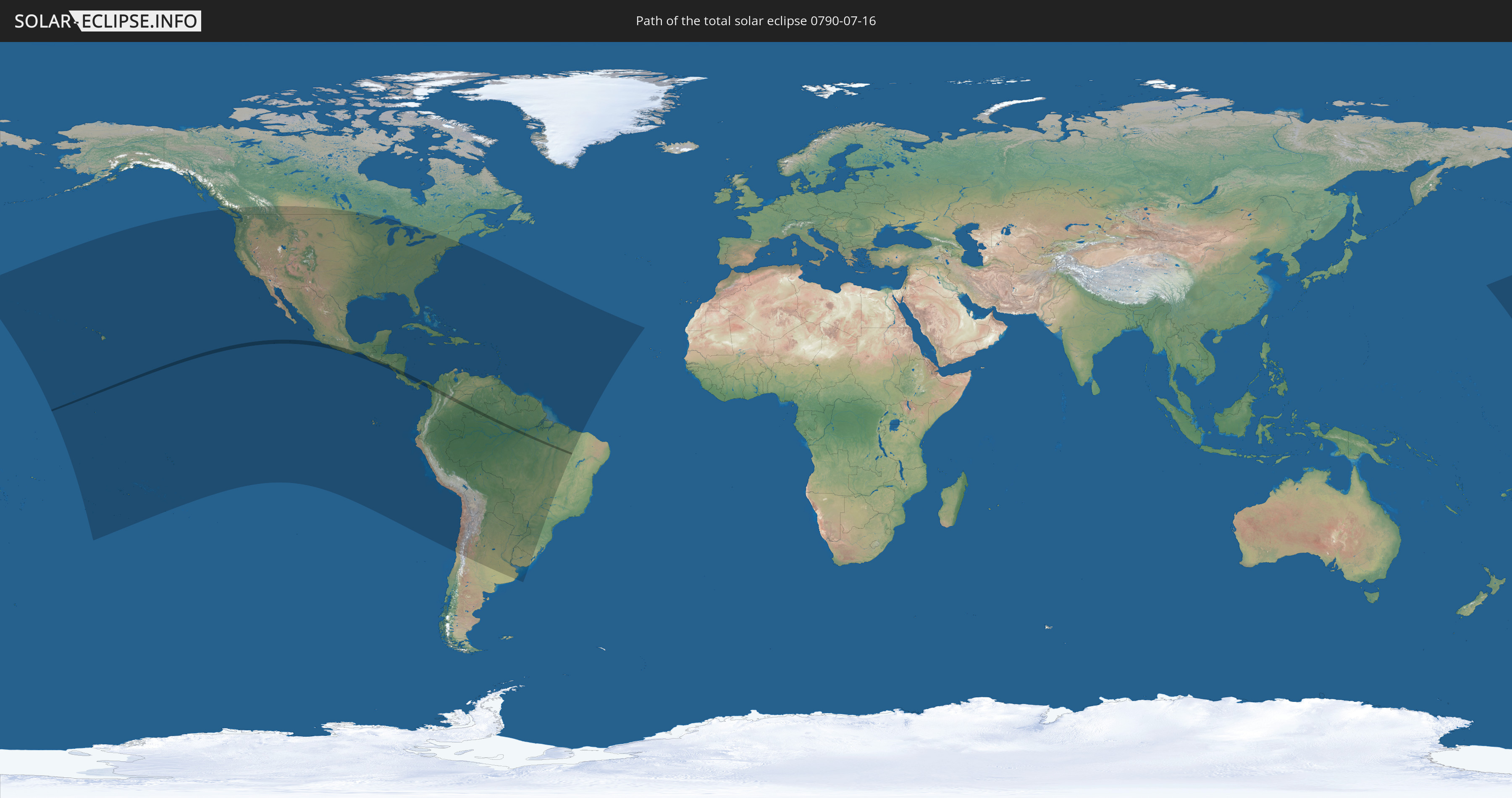
Die Sonnenfinsternis am 07/16/0790 kann man in 53 Ländern als partielle Sonnenfinsternis beobachten.
Der Finsternispfad verläuft durch 10 Länder. Nur in diesen Ländern ist sie als total Sonnenfinsternis zu sehen.
In den folgenden Ländern ist die Sonnenfinsternis total zu sehen
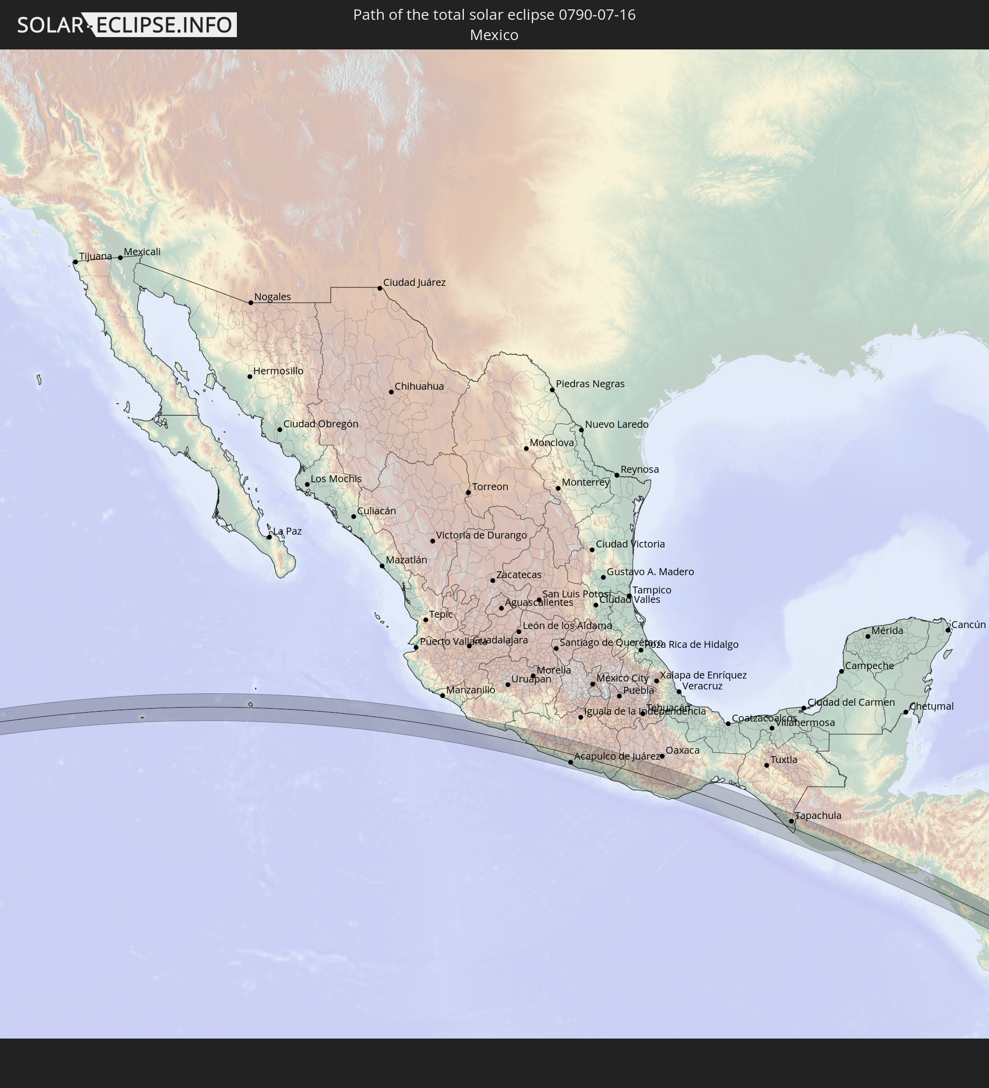 Mexico
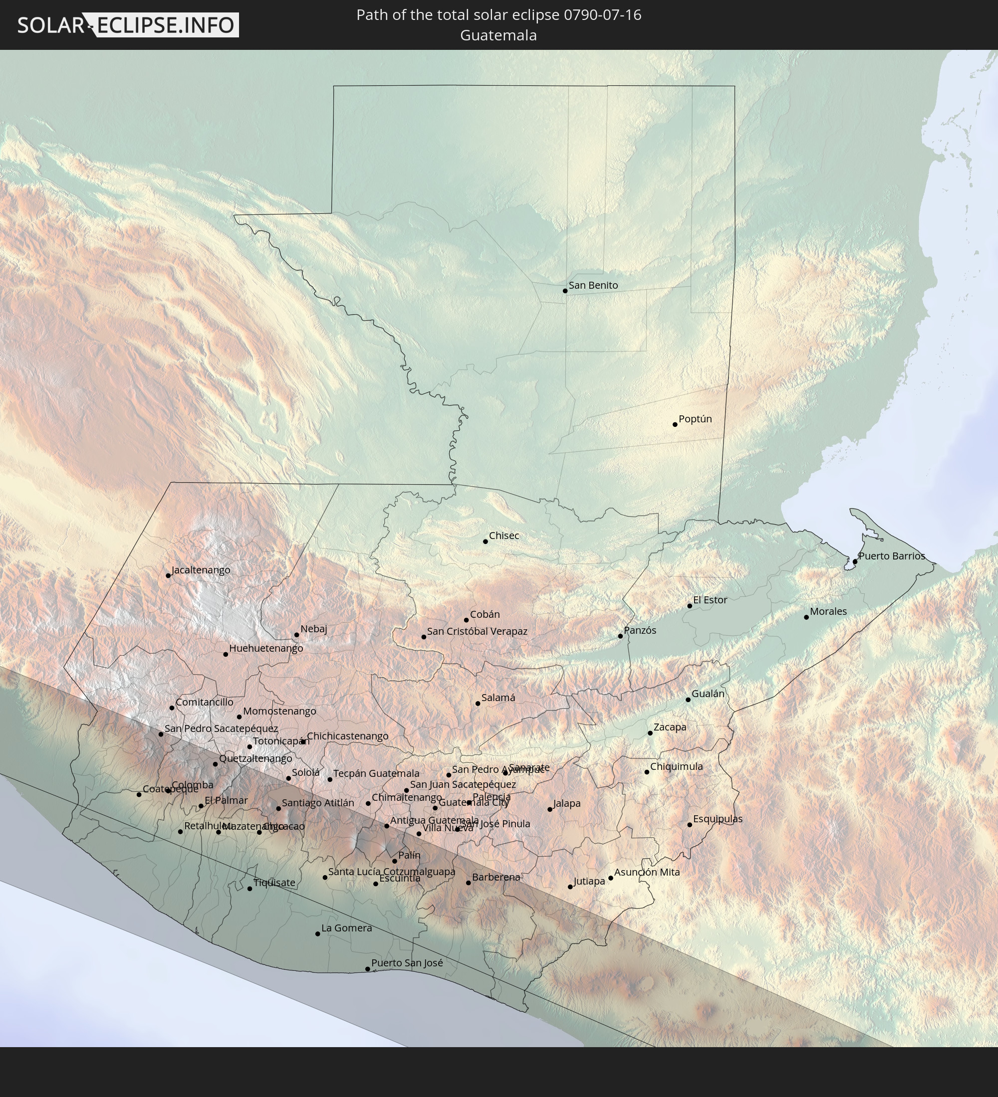 Guatemala
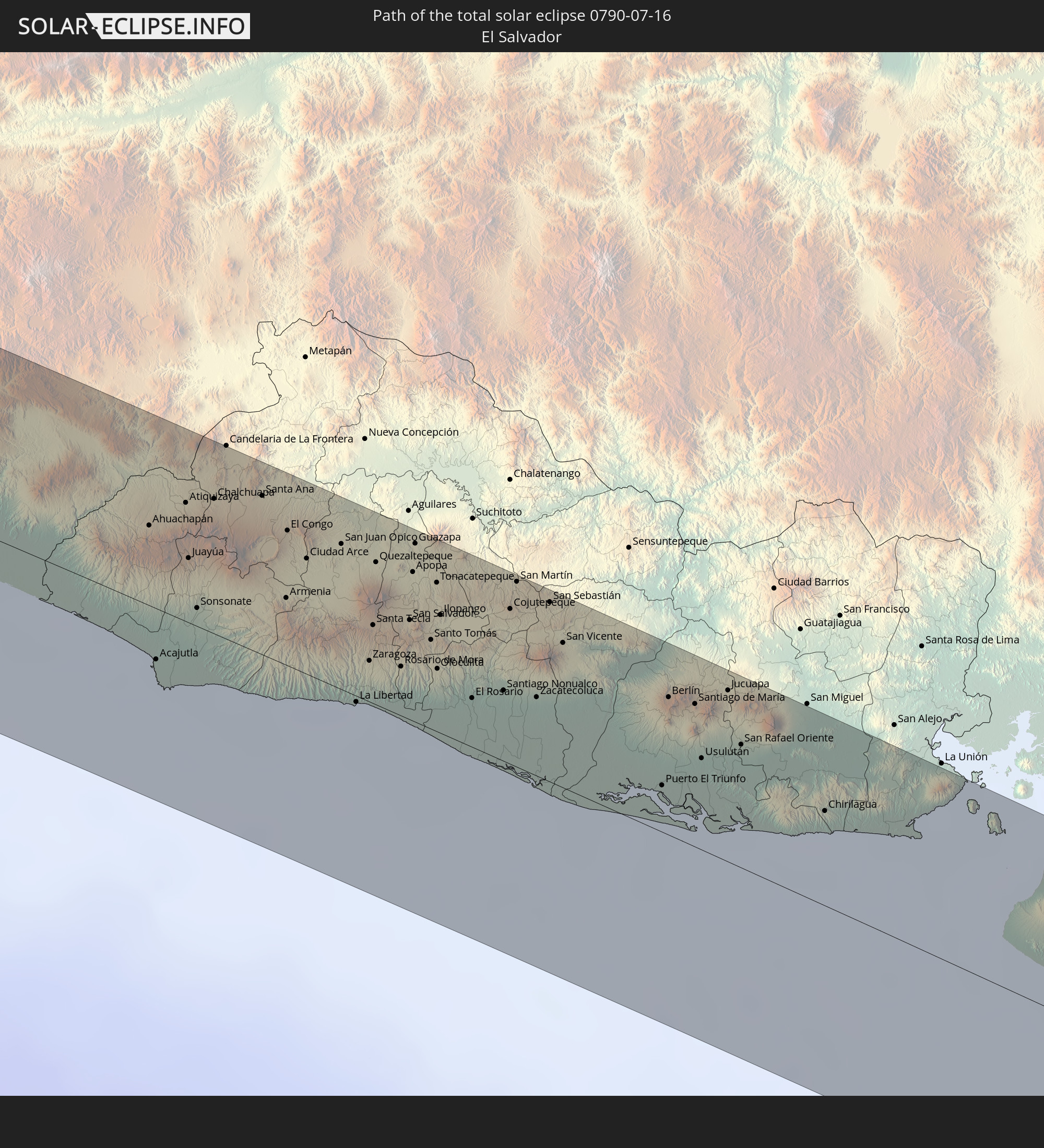 El Salvador
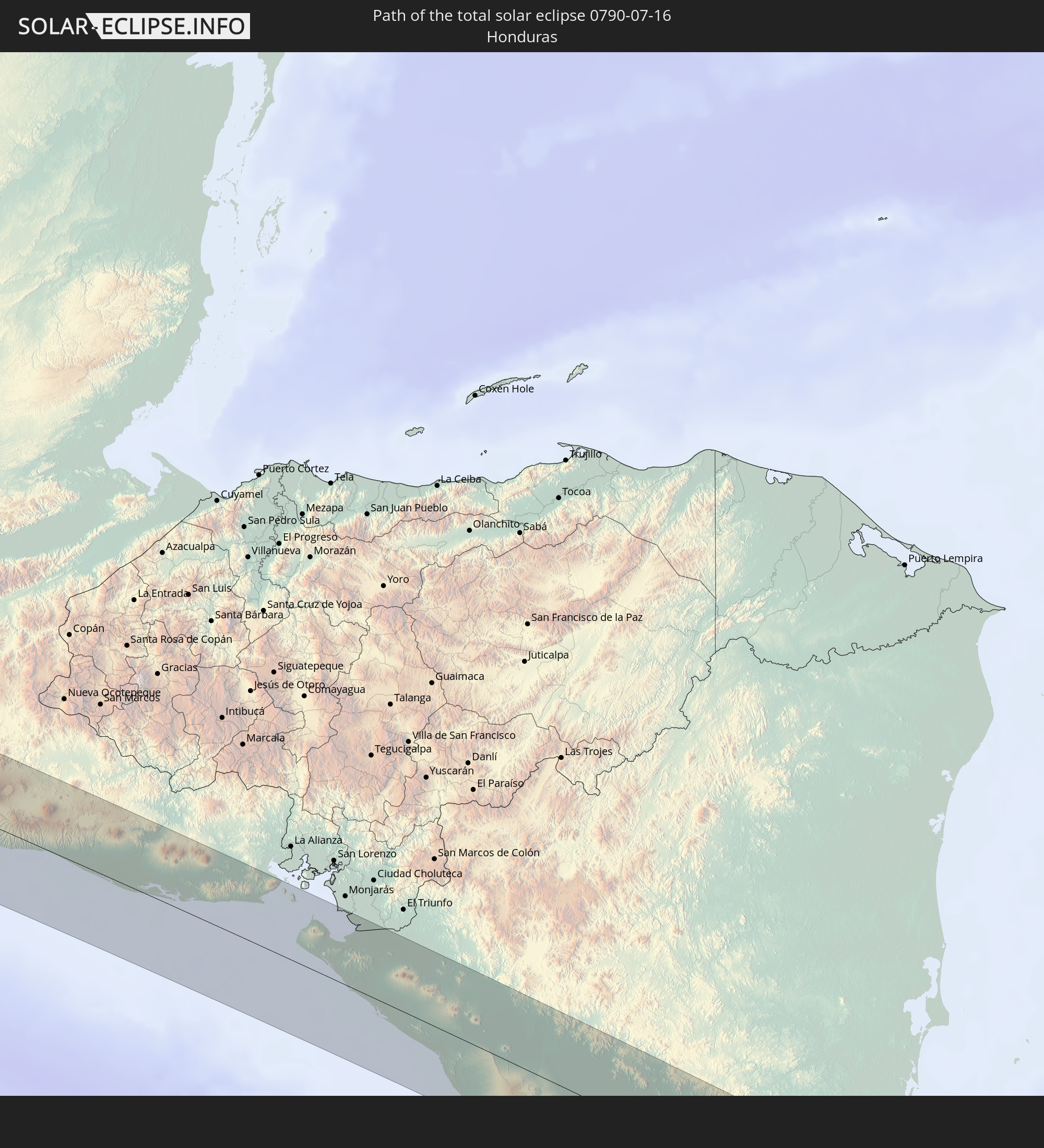 Honduras
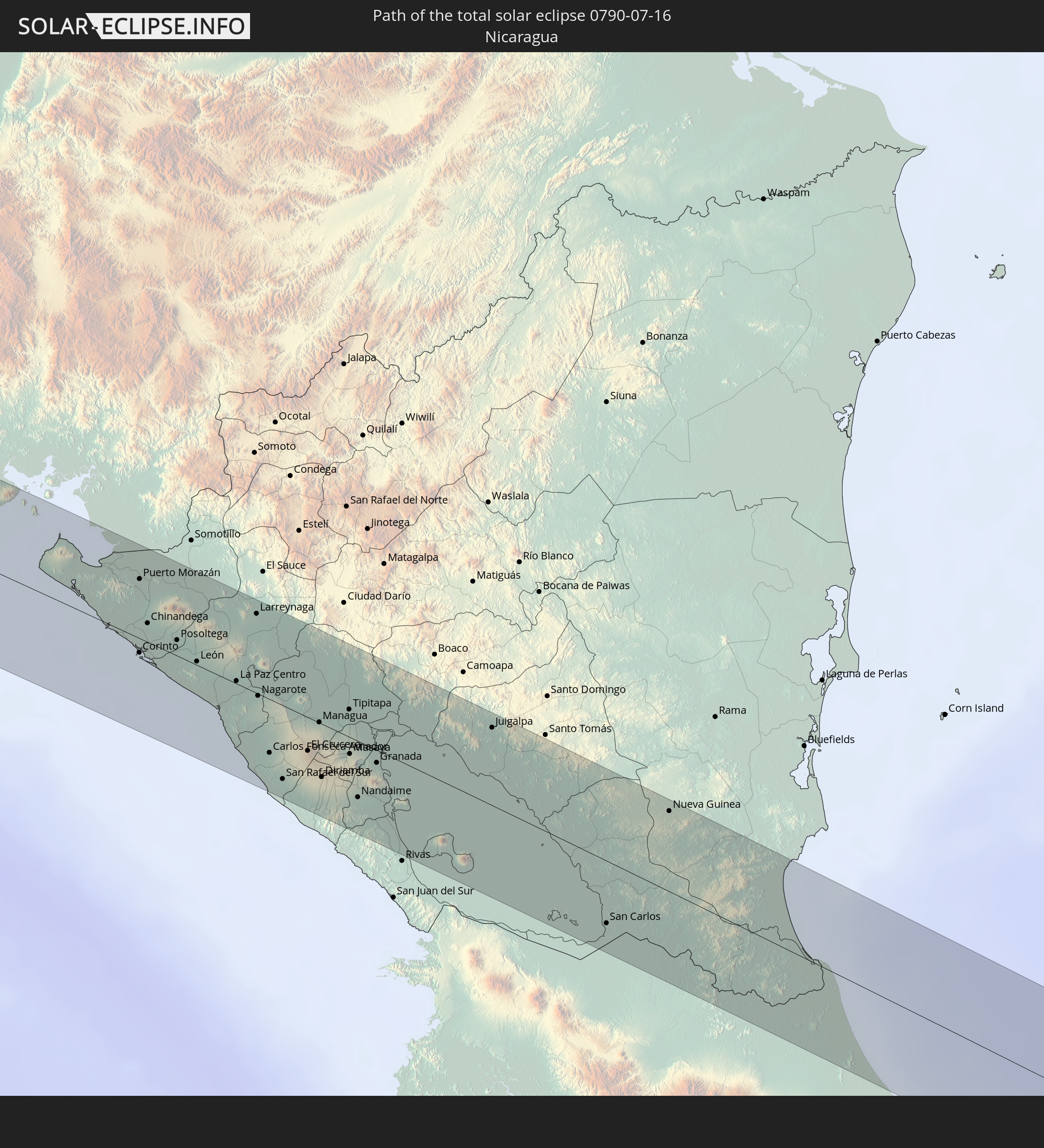 Nicaragua
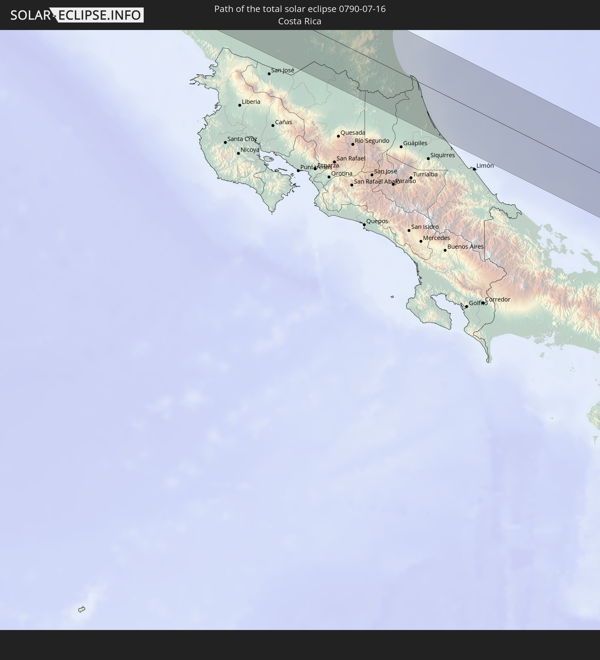 Costa Rica
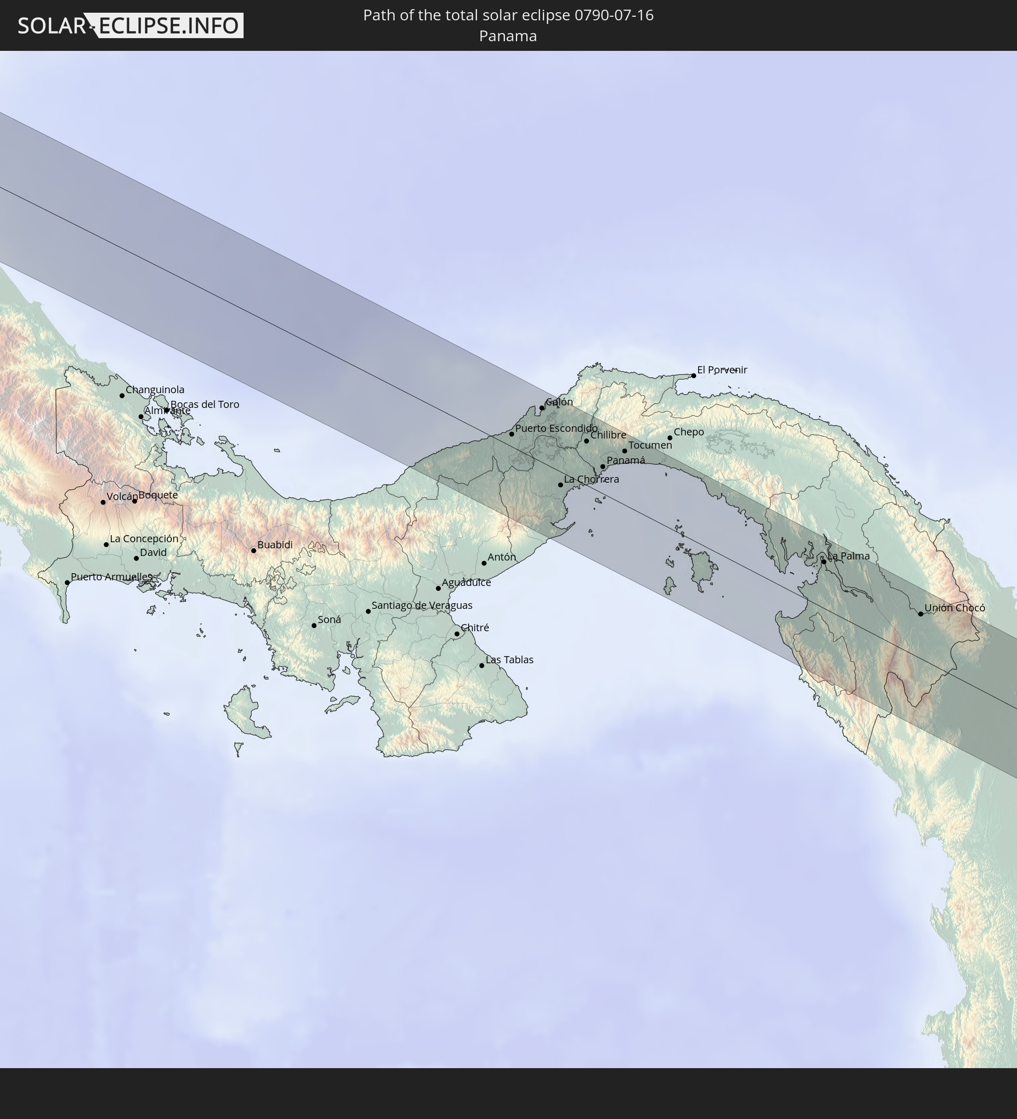 Panama
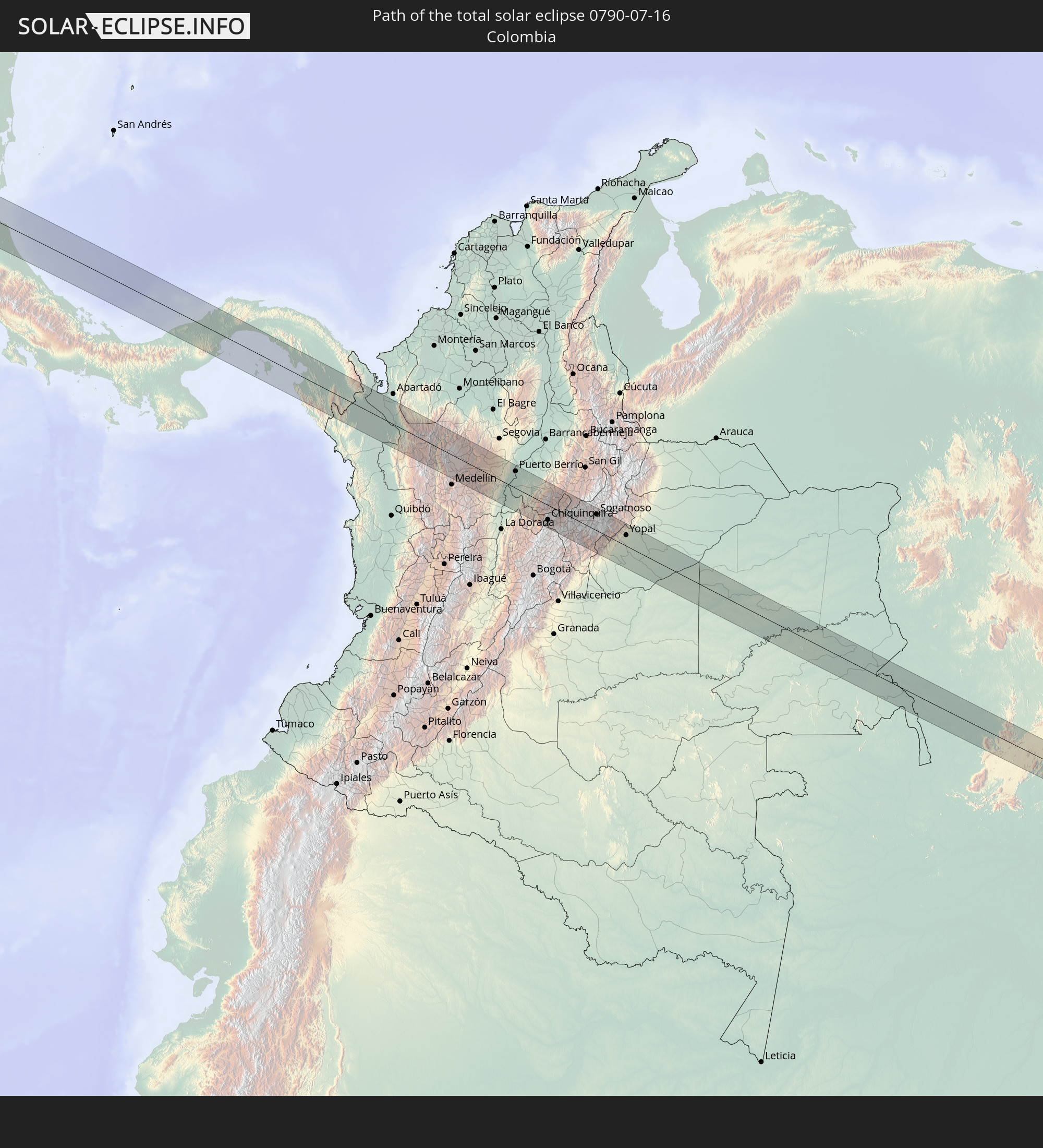 Colombia
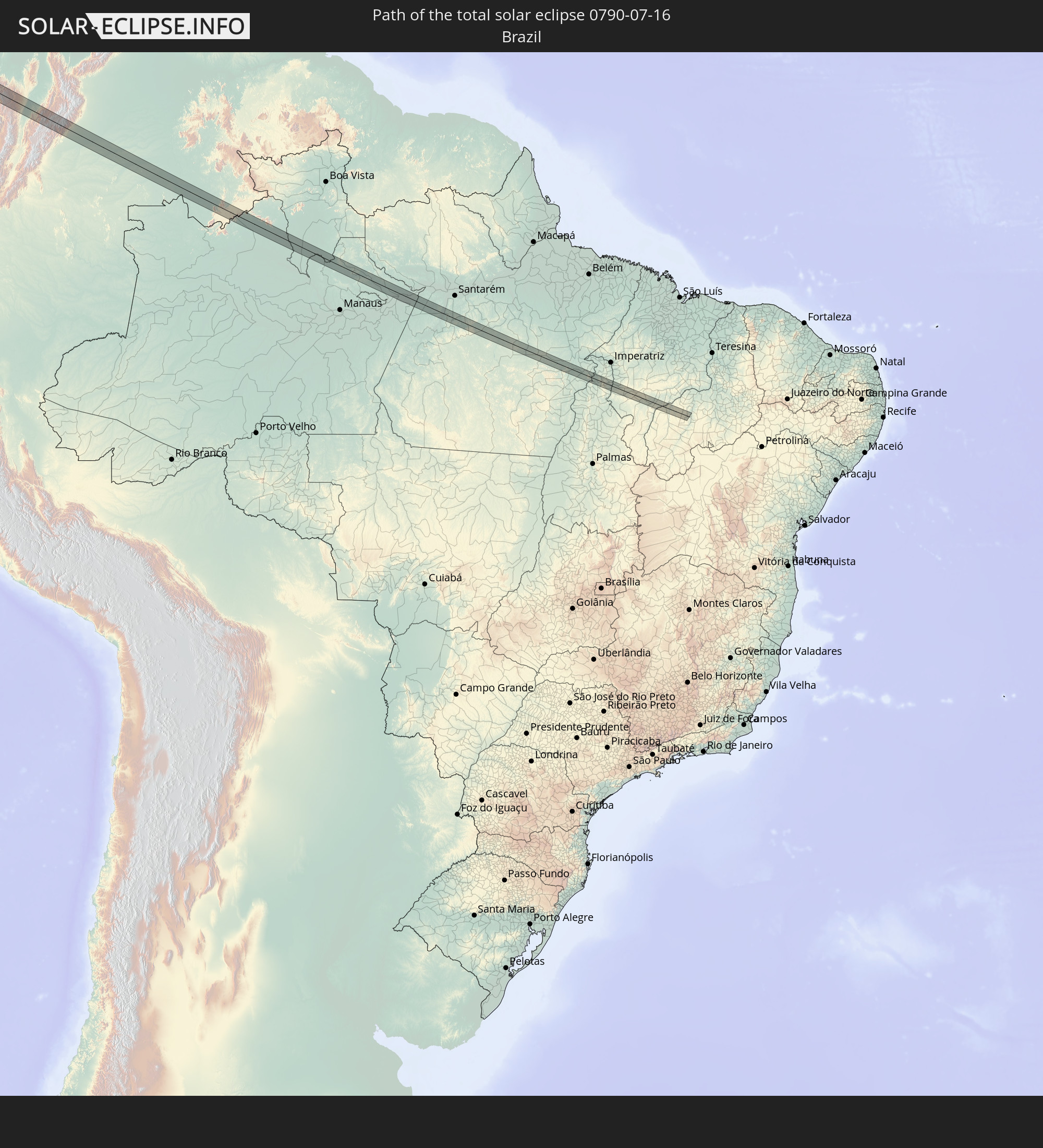 Brazil
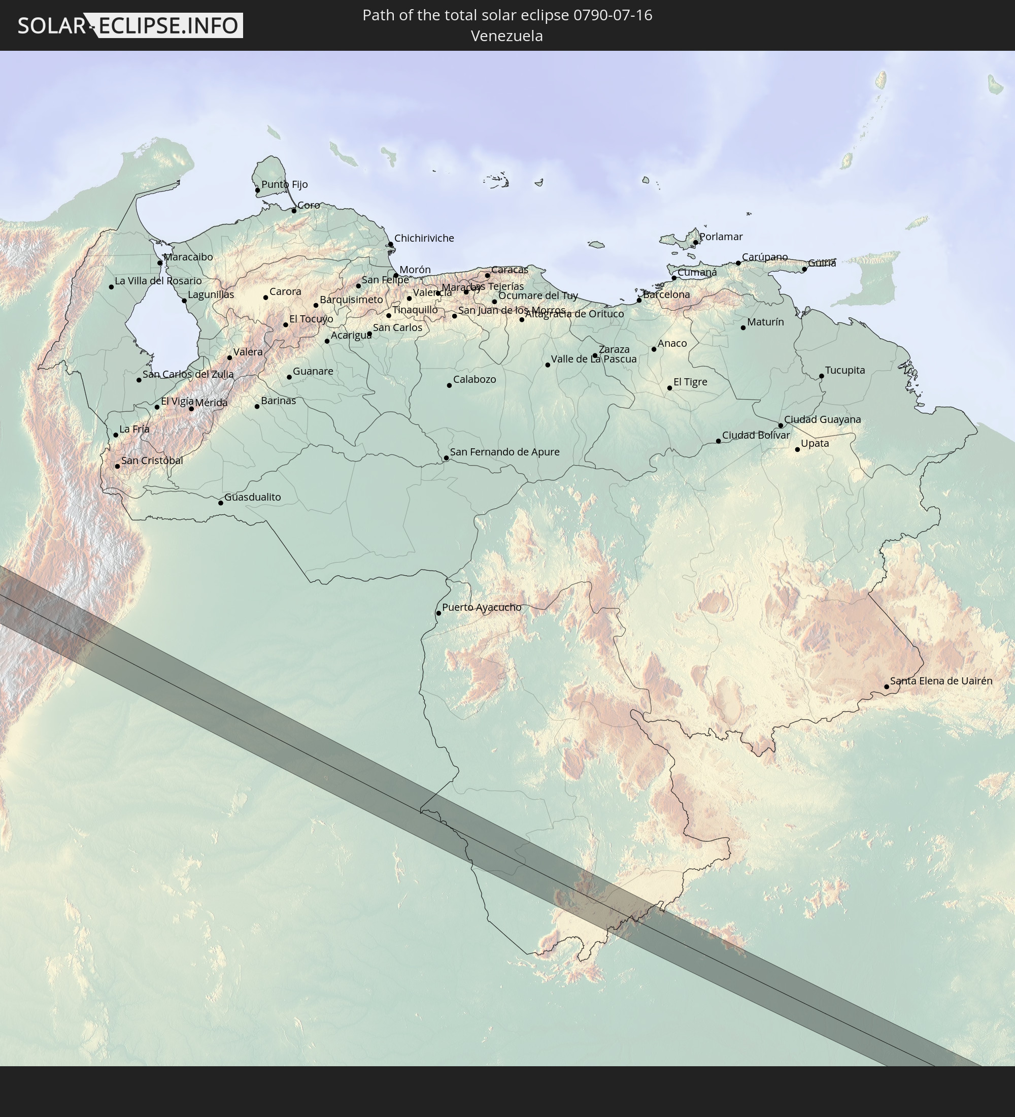 Venezuela
In den folgenden Ländern ist die Sonnenfinsternis partiell zu sehen
 United States
 United States Minor Outlying Islands
 Kiribati
 Cook Islands
 French Polynesia
 Canada
 Mexico
 Chile
Chile
 Guatemala
 Ecuador
 El Salvador
 Honduras
 Belize
 Nicaragua
 Costa Rica
 Cuba
Cuba
 Panama
 Colombia
 Cayman Islands
 Peru
Peru
 The Bahamas
 Jamaica
 Haiti
Haiti
 Brazil
 Argentina
 Venezuela
 Turks and Caicos Islands
 Dominican Republic
 Aruba
Aruba
 Bolivia
 Puerto Rico
 United States Virgin Islands
 Bermuda
 British Virgin Islands
 Anguilla
 Collectivity of Saint Martin
 Saint Barthélemy
 Saint Kitts and Nevis
 Paraguay
 Antigua and Barbuda
 Montserrat
 Trinidad and Tobago
 Guadeloupe
 Grenada
 Dominica
 Saint Vincent and the Grenadines
 Guyana
 Martinique
 Saint Lucia
 Barbados
 Uruguay
 Suriname
 French Guiana
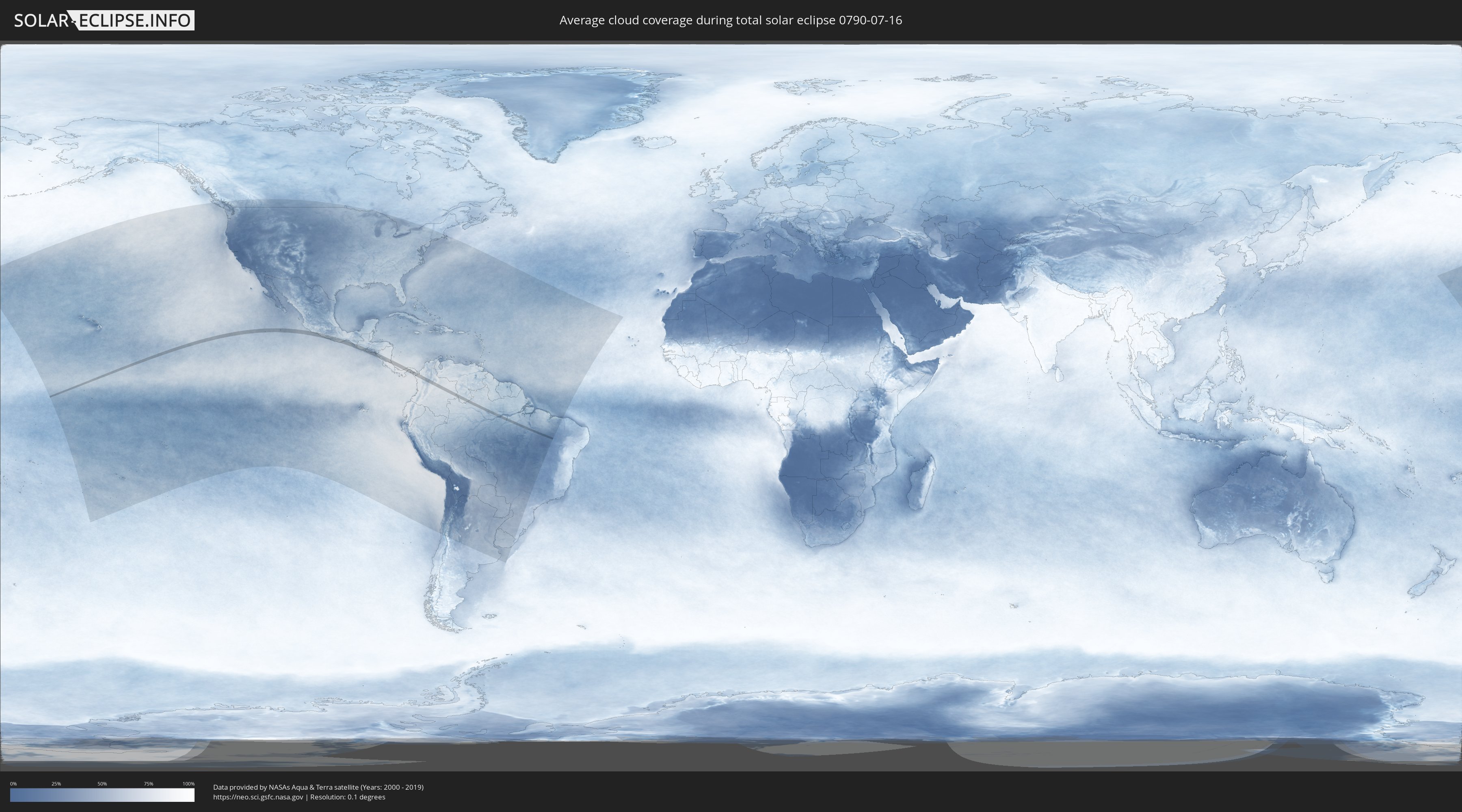
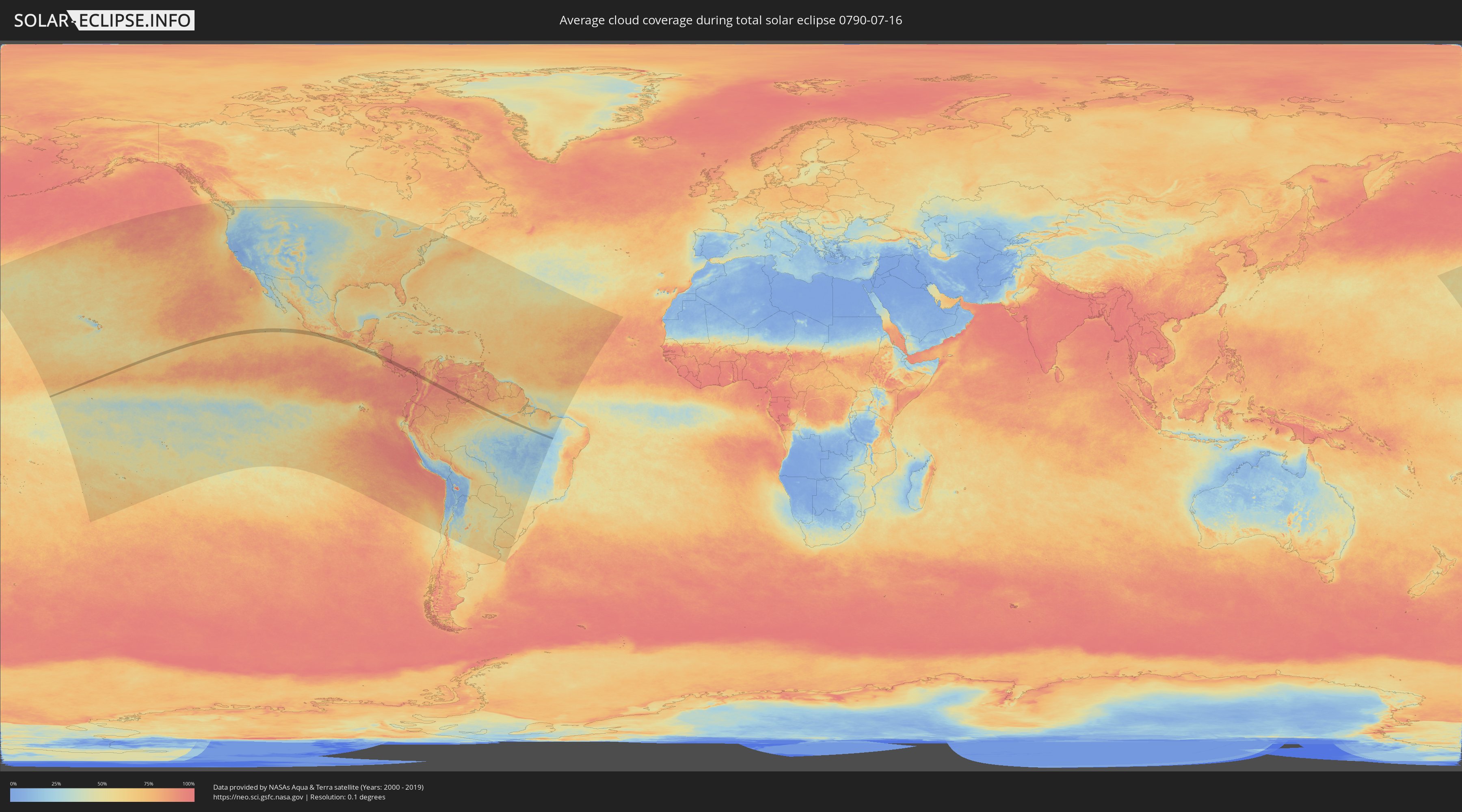
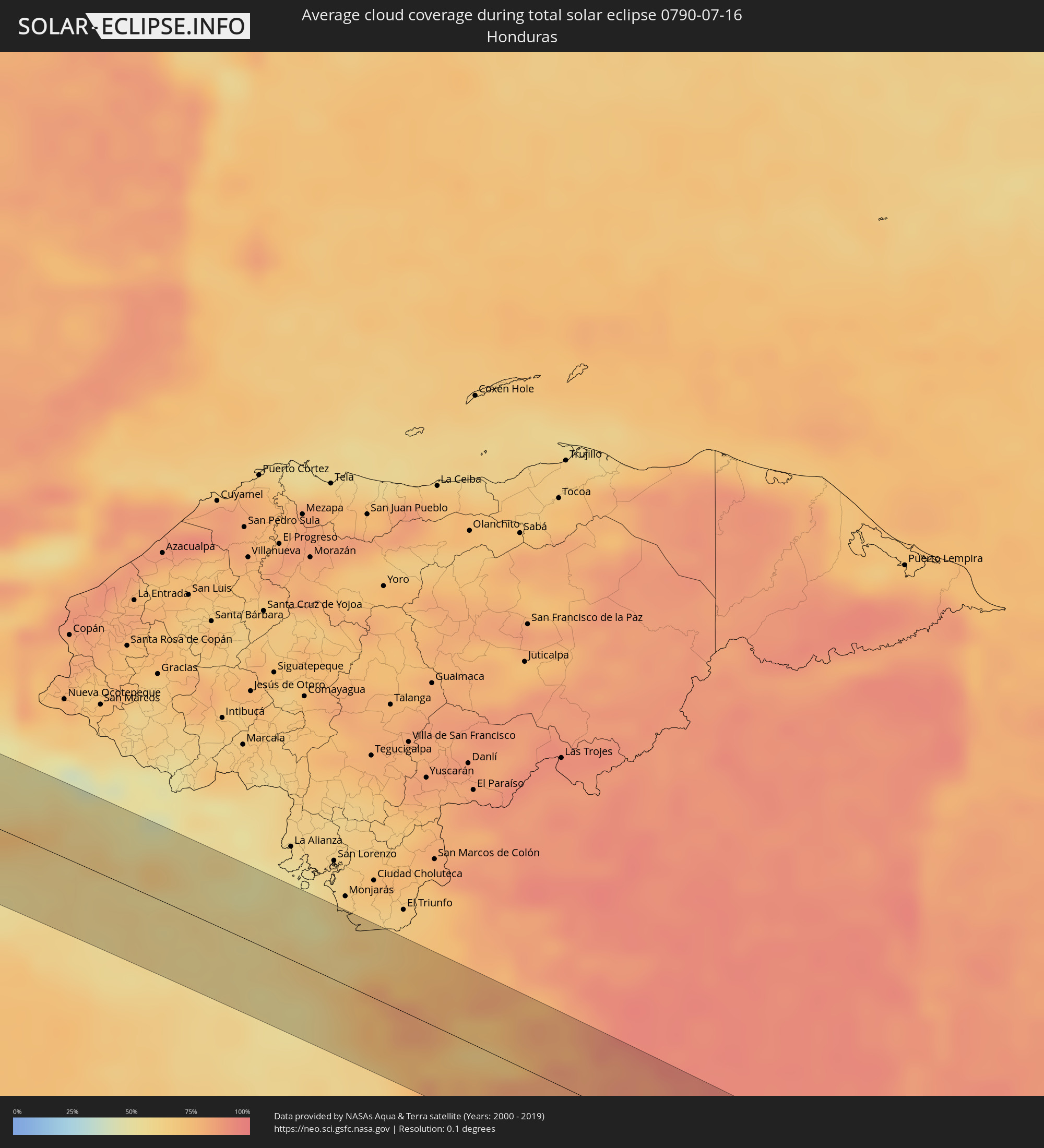
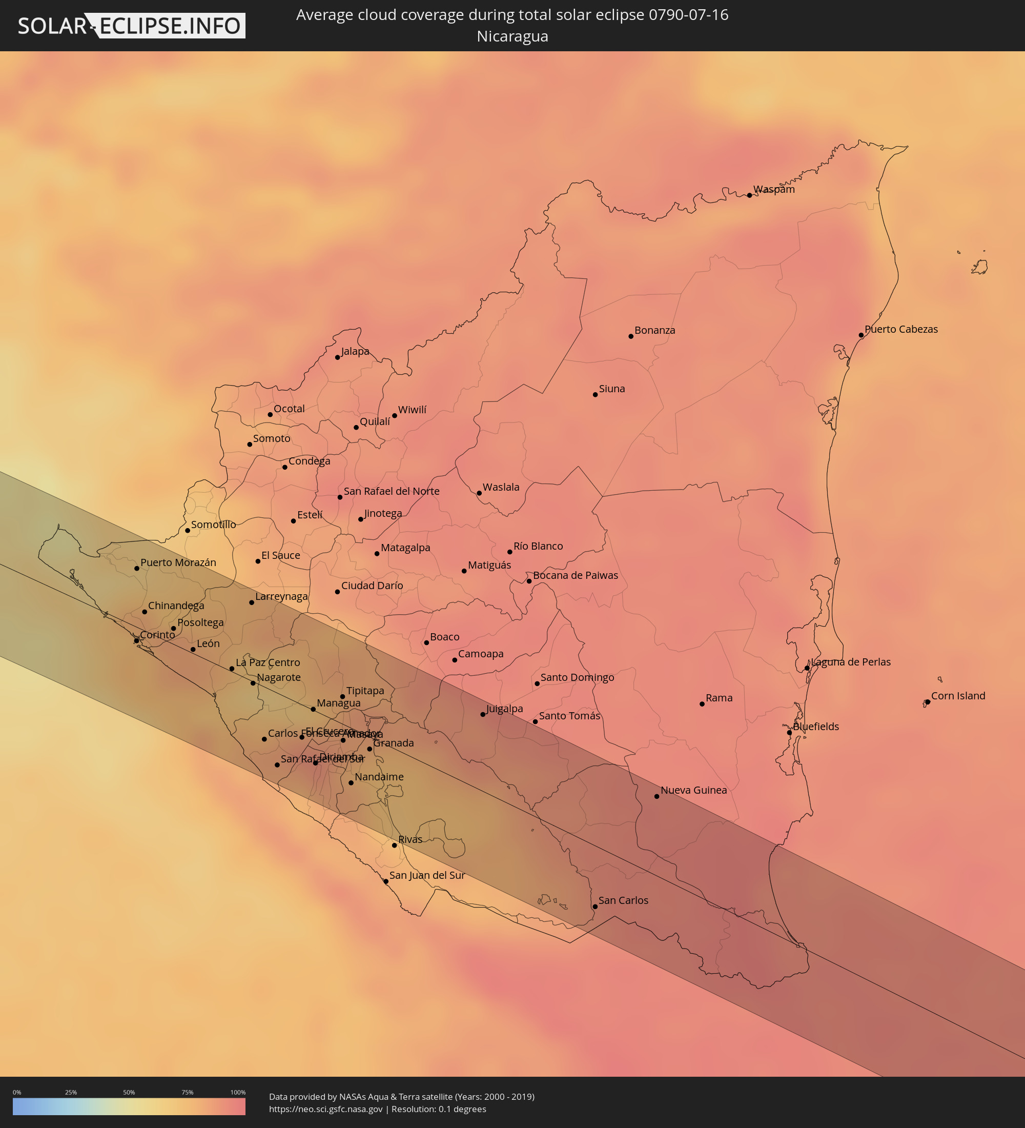
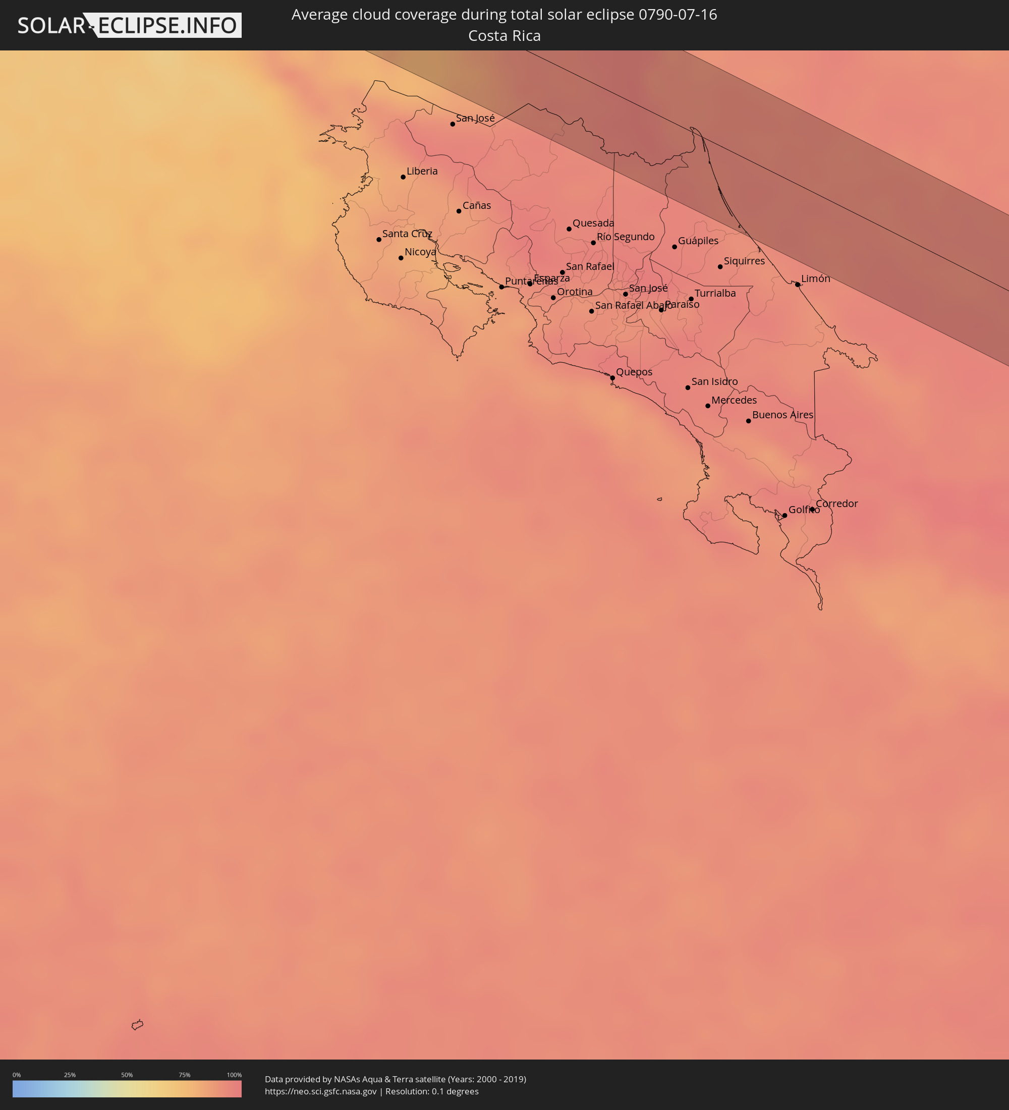
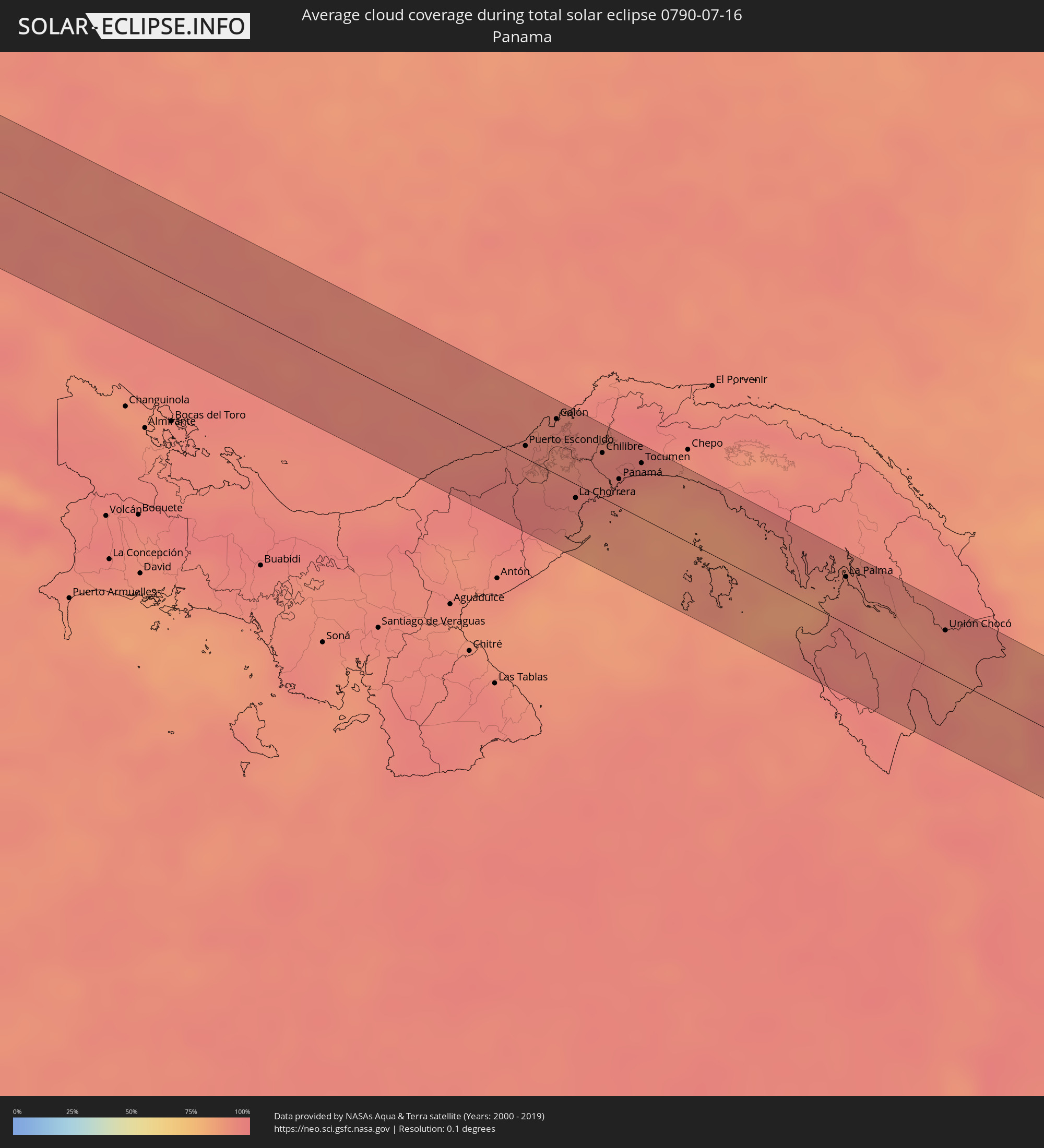
How will be the weather during the total solar eclipse on 07/16/0790?
Where is the best place to see the total solar eclipse of 07/16/0790?
The following maps show the average cloud coverage for the day of the total solar eclipse.
With the help of these maps, it is possible to find the place along the eclipse path, which has the best
chance of a cloudless sky.
Nevertheless, you should consider local circumstances and inform about the weather of your chosen
observation site.
The data is provided by NASAs satellites
AQUA and TERRA.
The cloud maps are averaged over a period of 19 years (2000 - 2019).
Detailed country maps
 Mexico
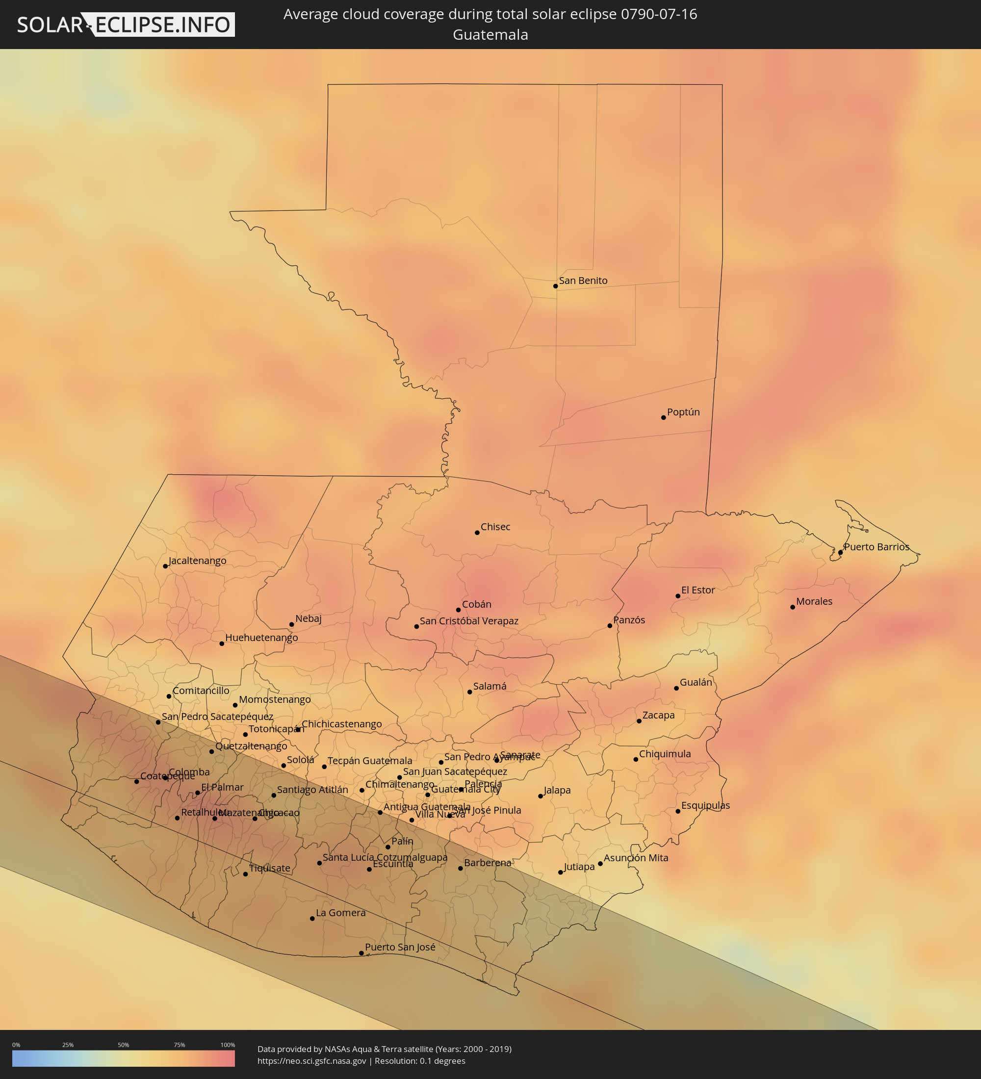 Guatemala
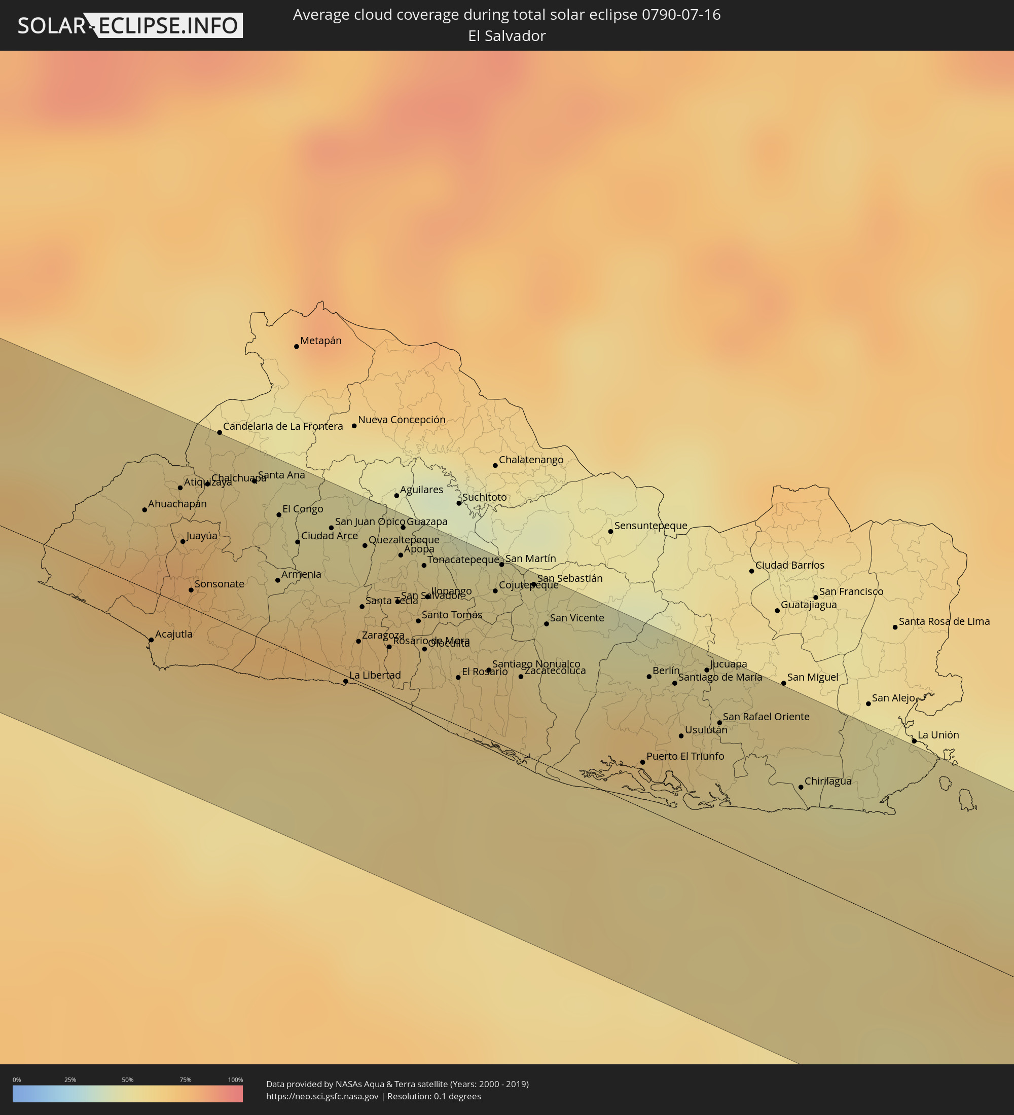 El Salvador
 Honduras
 Nicaragua
 Costa Rica
 Panama
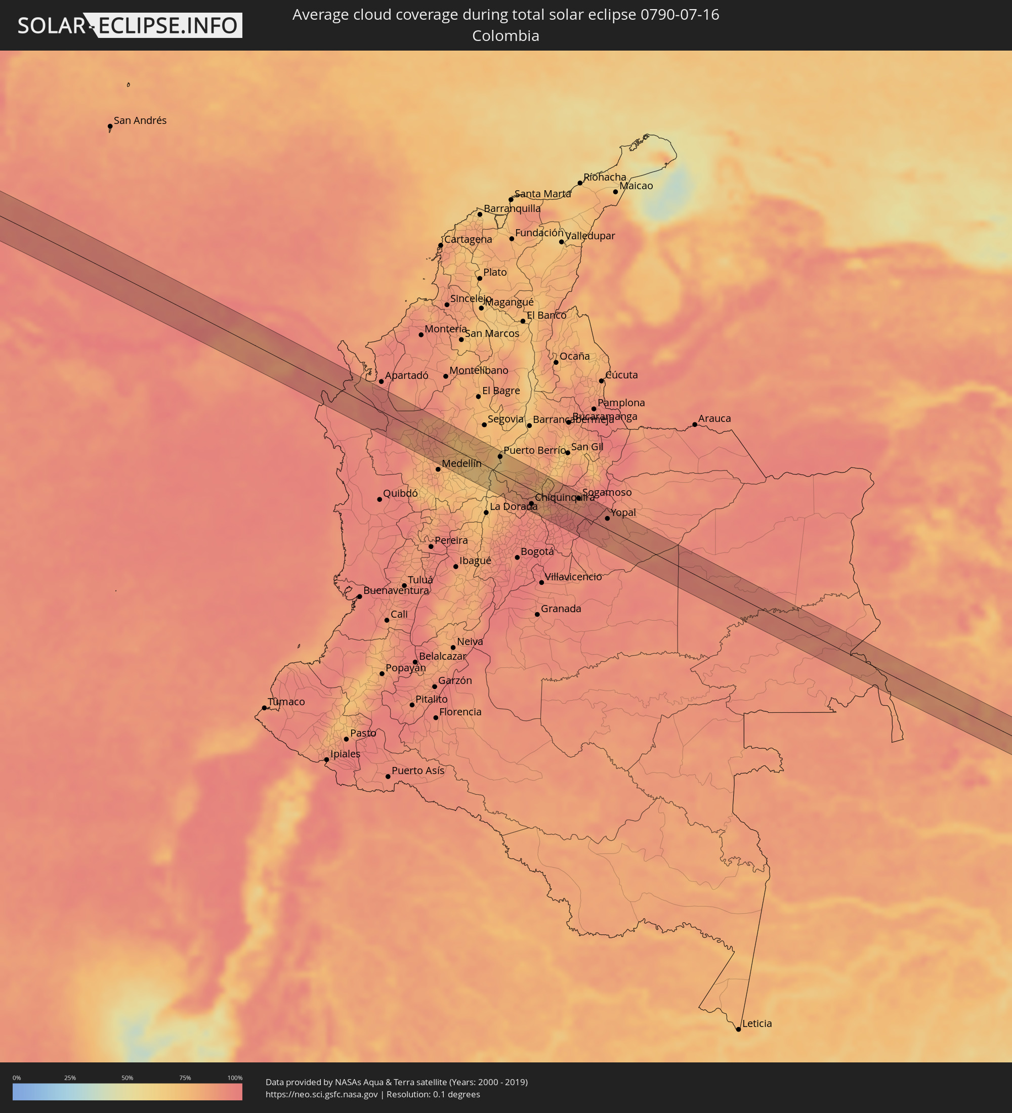 Colombia
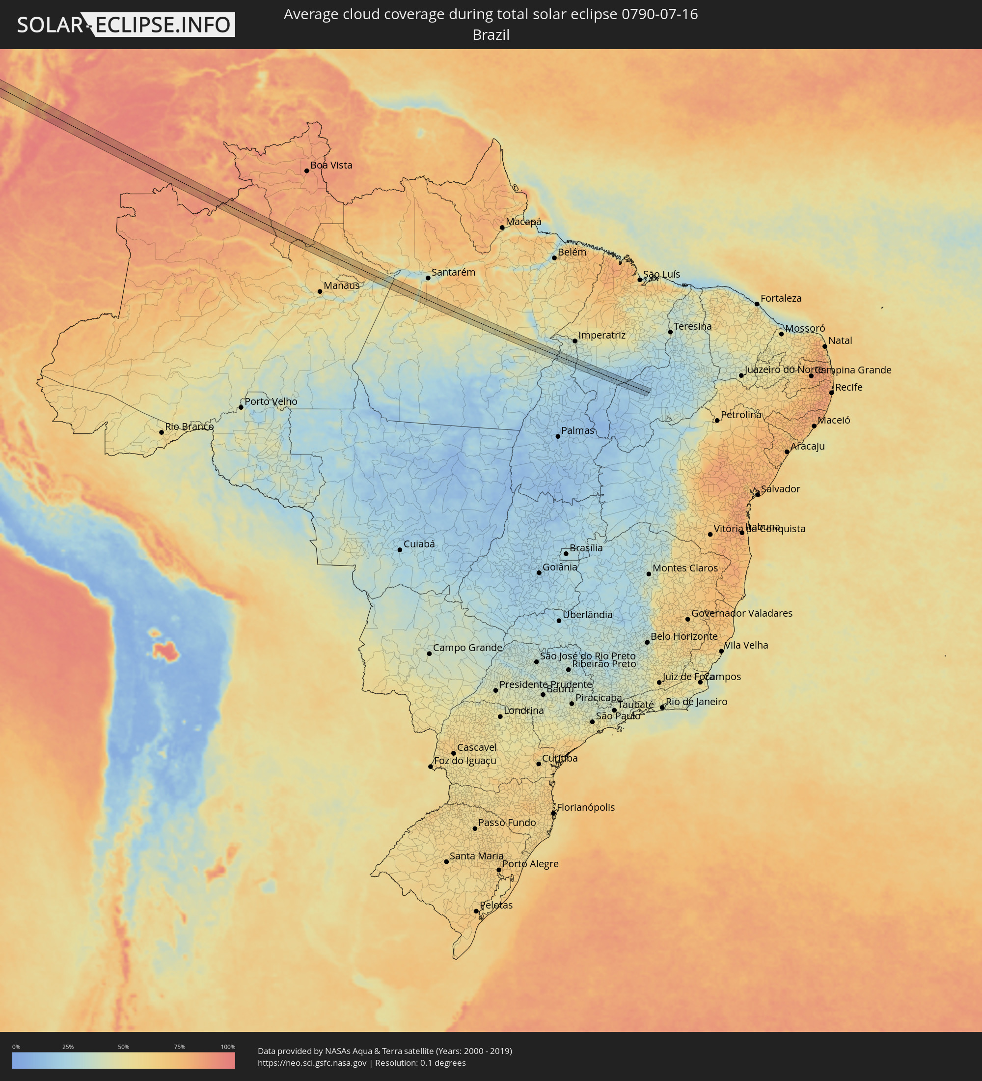 Brazil
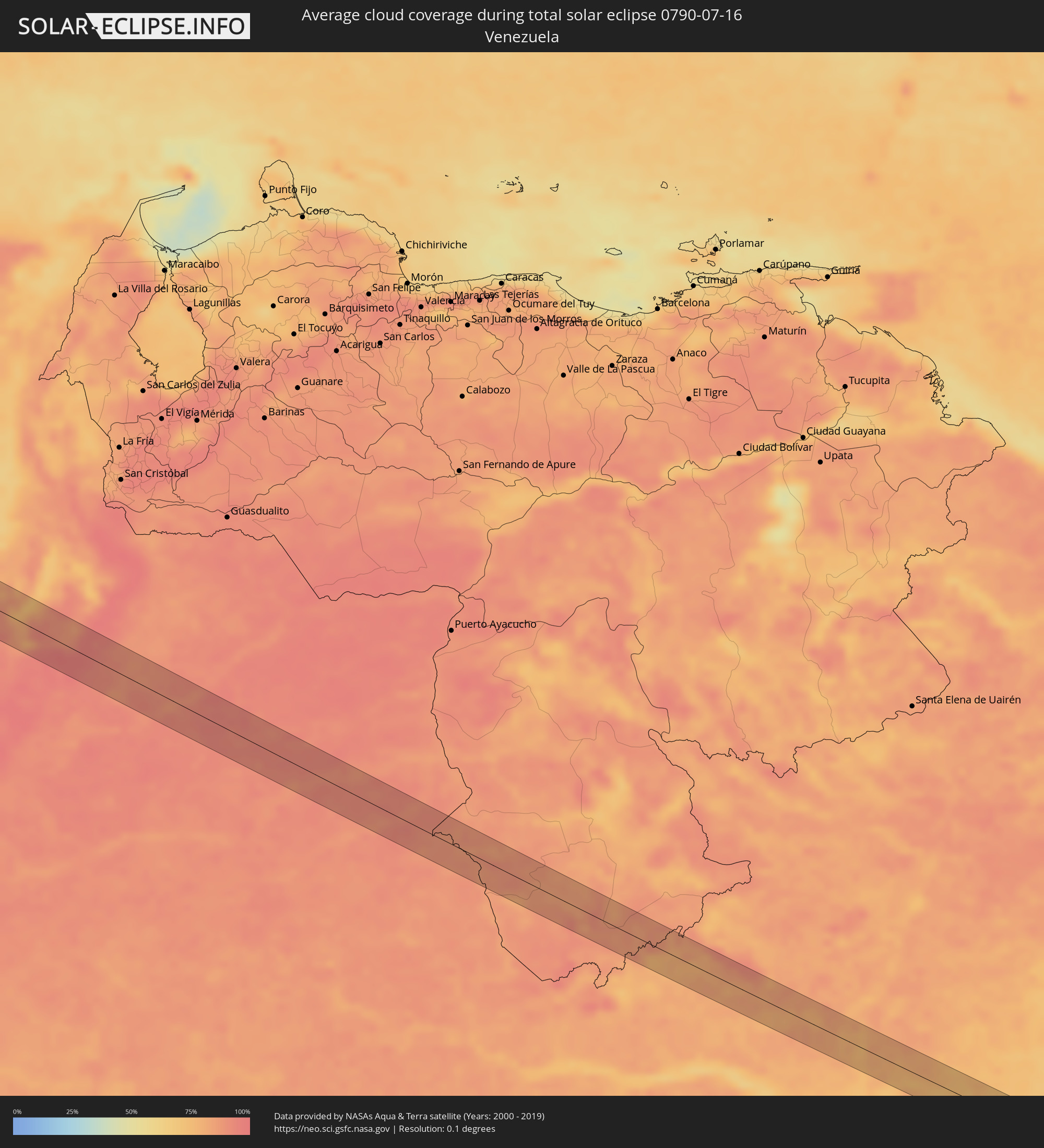 Venezuela
Cities inside the path of the eclipse
The following table shows all locations with a population of more than 5,000 inside the eclipse path. Cities which have more than 100,000 inhabitants are marked bold. A click at the locations opens a detailed map.
| City | Type | Eclipse duration | Local time of max. eclipse | Distance to central line | Ø Cloud coverage |
|
Ciudad Lázaro Cárdenas, Michoacán
|
total | - | 12:28:39 UTC-06:36 | 32 km | 68% |
|
San José Ixtapa (Barrio Viejo), Guerrero
|
total | - | 12:30:43 UTC-06:36 | 16 km | 68% |
|
Ixtapa-Zihuatanejo, Guerrero
|
total | - | 12:30:58 UTC-06:36 | 11 km | 68% |
|
Petatlán, Guerrero
|
total | - | 12:31:56 UTC-06:36 | 7 km | 69% |
|
Técpan de Galeana, Guerrero
|
total | - | 12:34:10 UTC-06:36 | 12 km | 68% |
|
Atoyac de Álvarez, Guerrero
|
total | - | 12:34:47 UTC-06:36 | 8 km | 67% |
|
Coyuca de Benítez, Guerrero
|
total | - | 12:36:01 UTC-06:36 | 21 km | 65% |
|
Acapulco de Juárez, Guerrero
|
total | - | 12:36:45 UTC-06:36 | 31 km | 68% |
|
Tierra Colorada, Guerrero
|
total | - | 12:37:36 UTC-06:36 | 11 km | 62% |
|
San Marcos, Guerrero
|
total | - | 12:38:20 UTC-06:36 | 24 km | 60% |
|
Cruz Grande, Guerrero
|
total | - | 12:39:13 UTC-06:36 | 25 km | 58% |
|
Ayutla de los Libres, Guerrero
|
total | - | 12:39:06 UTC-06:36 | 2 km | 64% |
|
San Luis Acatlán, Guerrero
|
total | - | 12:40:20 UTC-06:36 | 4 km | 59% |
|
Malinaltepec, Guerrero
|
total | - | 12:40:09 UTC-06:36 | 44 km | 77% |
|
Cuajinicuilapa de Santa Maria, Guerrero
|
total | - | 12:41:36 UTC-06:36 | 31 km | 65% |
|
Ometepec, Guerrero
|
total | - | 12:41:26 UTC-06:36 | 7 km | 55% |
|
Pinotepa, Oaxaca
|
total | - | 12:42:49 UTC-06:36 | 34 km | 59% |
|
Putla Villa de Guerrero, Oaxaca
|
total | - | 12:42:34 UTC-06:36 | 43 km | 67% |
|
Jamiltepec, Oaxaca
|
total | - | 12:43:33 UTC-06:36 | 33 km | 65% |
|
Ejutla de Crespo, Oaxaca
|
total | - | 12:46:32 UTC-06:36 | 32 km | 73% |
|
Miahuatlán de Porfirio Díaz, Oaxaca
|
total | - | 12:47:09 UTC-06:36 | 12 km | 81% |
|
San Pedro Pochutla, Oaxaca
|
total | - | 12:48:06 UTC-06:36 | 46 km | 71% |
|
Crucecita, Oaxaca
|
total | - | 12:49:03 UTC-06:36 | 33 km | 68% |
|
Salina Cruz, Oaxaca
|
total | - | 12:51:20 UTC-06:36 | 44 km | 67% |
|
Escuintla, Chiapas
|
total | - | 12:59:17 UTC-06:36 | 48 km | 72% |
|
Huixtla, Chiapas
|
total | - | 12:59:59 UTC-06:36 | 37 km | 72% |
|
Puerto Madero, Chiapas
|
total | - | 13:00:34 UTC-06:36 | 5 km | 65% |
|
Tapachula, Chiapas
|
total | - | 13:00:48 UTC-06:36 | 21 km | 79% |
|
Brisas Barra de Suchiate, Chiapas
|
total | - | 13:35:50 UTC-06:02 | 16 km | 58% |
|
Ocós, San Marcos
|
total | - | 13:35:57 UTC-06:02 | 17 km | 58% |
|
Ayutla, San Marcos
|
total | - | 13:35:54 UTC-06:02 | 2 km | 72% |
|
Malacatán, San Marcos
|
total | - | 13:35:52 UTC-06:02 | 30 km | 71% |
|
Coatepeque, Quetzaltenango
|
total | - | 13:36:36 UTC-06:02 | 16 km | 72% |
|
San Pedro Sacatepéquez, San Marcos
|
total | - | 13:36:34 UTC-06:02 | 47 km | 82% |
|
Retalhuleu, Retalhuleu
|
total | - | 13:37:17 UTC-06:02 | 6 km | 76% |
|
San Felipe, Retalhuleu
|
total | - | 13:37:24 UTC-06:02 | 18 km | 78% |
|
El Palmar, Quetzaltenango
|
total | - | 13:37:24 UTC-06:02 | 22 km | 84% |
|
Quetzaltenango, Quetzaltenango
|
total | - | 13:37:22 UTC-06:02 | 44 km | 84% |
|
Mazatenango, Suchitepeque
|
total | - | 13:37:44 UTC-06:02 | 13 km | 74% |
|
Samayac, Quetzaltenango
|
total | - | 13:37:48 UTC-06:02 | 20 km | 81% |
|
Santa Catarina Ixtahuacán, Sololá
|
total | - | 13:37:48 UTC-06:02 | 46 km | 78% |
|
Tiquisate, Escuintla
|
total | - | 13:38:24 UTC-06:02 | 7 km | 77% |
|
Chicacao, Suchitepeque
|
total | - | 13:38:14 UTC-06:02 | 21 km | 75% |
|
Santiago Atitlán, Sololá
|
total | - | 13:38:20 UTC-06:02 | 35 km | 81% |
|
Patulul, Suchitepeque
|
total | - | 13:38:45 UTC-06:02 | 15 km | 74% |
|
La Gomera, Escuintla
|
total | - | 13:39:26 UTC-06:02 | 14 km | 74% |
|
Patzún, Chimaltenango
|
total | - | 13:38:50 UTC-06:02 | 49 km | 74% |
|
Santa Lucía Cotzumalguapa, Escuintla
|
total | - | 13:39:14 UTC-06:02 | 13 km | 75% |
|
Yepocapa, Chimaltenango
|
total | - | 13:39:12 UTC-06:02 | 33 km | 81% |
|
Puerto San José, Escuintla
|
total | - | 13:40:11 UTC-06:02 | 21 km | 62% |
|
San Miguel Dueñas, Sacatepéquez
|
total | - | 13:39:35 UTC-06:02 | 41 km | 78% |
|
Escuintla, Escuintla
|
total | - | 13:39:51 UTC-06:02 | 19 km | 74% |
|
Antigua Guatemala, Sacatepéquez
|
total | - | 13:39:42 UTC-06:02 | 48 km | 73% |
|
Villa Canales, Guatemala
|
total | - | 13:40:18 UTC-06:02 | 48 km | 72% |
|
Chiquimulilla, Santa Rosa
|
total | - | 13:41:08 UTC-06:02 | 14 km | 69% |
|
Barberena, Santa Rosa
|
total | - | 13:40:56 UTC-06:02 | 38 km | 62% |
|
Oratorio, Santa Rosa
|
total | - | 13:41:30 UTC-06:02 | 37 km | 59% |
|
Jalpatagua, Jutiapa
|
total | - | 13:42:01 UTC-06:02 | 36 km | 58% |
|
Concepción de Ataco, Ahuachapán
|
total | - | 13:47:59 UTC-05:56 | 15 km | 77% |
|
Ahuachapán, Ahuachapán
|
total | - | 13:47:56 UTC-05:56 | 20 km | 77% |
|
Acajutla, Sonsonate
|
total | - | 13:48:21 UTC-05:56 | 13 km | 61% |
|
Atiquizaya, Ahuachapán
|
total | - | 13:48:06 UTC-05:56 | 30 km | 67% |
|
Juayúa, Sonsonate
|
total | - | 13:48:17 UTC-05:56 | 16 km | 73% |
|
San Antonio del Monte, Sonsonate
|
total | - | 13:48:26 UTC-05:56 | 4 km | 69% |
|
Nahuizalco, Sonsonate
|
total | - | 13:48:22 UTC-05:56 | 10 km | 73% |
|
Sonsonate, Sonsonate
|
total | - | 13:48:28 UTC-05:56 | 5 km | 69% |
|
Santa Ana, Santa Ana
|
total | - | 13:48:34 UTC-05:56 | 40 km | 62% |
|
Armenia, Sonsonate
|
total | - | 13:49:00 UTC-05:56 | 17 km | 73% |
|
El Congo, Santa Ana
|
total | - | 13:48:49 UTC-05:56 | 34 km | 54% |
|
Ciudad Arce, La Libertad
|
total | - | 13:49:01 UTC-05:56 | 29 km | 62% |
|
San Juan Opico, La Libertad
|
total | - | 13:49:11 UTC-05:56 | 36 km | 54% |
|
La Libertad, La Libertad
|
total | - | 13:49:44 UTC-05:56 | 2 km | 61% |
|
Quezaltepeque, La Libertad
|
total | - | 13:49:27 UTC-05:56 | 36 km | 62% |
|
San Salvador, San Salvador
|
total | - | 13:49:50 UTC-05:56 | 25 km | 67% |
|
Panchimalco, San Salvador
|
total | - | 13:49:56 UTC-05:56 | 17 km | 62% |
|
Guazapa, San Salvador
|
total | - | 13:49:39 UTC-05:56 | 45 km | 57% |
|
Santiago Nonualco, La Paz
|
total | - | 13:50:36 UTC-05:56 | 18 km | 62% |
|
Cojutepeque, Cuscatlán
|
total | - | 13:50:25 UTC-05:56 | 39 km | 57% |
|
Zacatecoluca, La Paz
|
total | - | 13:50:50 UTC-05:56 | 20 km | 64% |
|
San Sebastián, San Vicente
|
total | - | 13:50:38 UTC-05:56 | 45 km | 54% |
|
San Vicente, San Vicente
|
total | - | 13:50:50 UTC-05:56 | 36 km | 55% |
|
Jiquilisco, Usulután
|
total | - | 13:51:43 UTC-05:56 | 14 km | 55% |
|
Berlín, Usulután
|
total | - | 13:51:38 UTC-05:56 | 34 km | 64% |
|
Usulután, Usulután
|
total | - | 13:52:00 UTC-05:56 | 23 km | 64% |
|
Jucuapa, Usulután
|
total | - | 13:51:58 UTC-05:56 | 43 km | 58% |
|
El Tránsito, San Miguel
|
total | - | 13:52:14 UTC-05:56 | 27 km | 60% |
|
Chinameca, San Miguel
|
total | - | 13:52:04 UTC-05:56 | 43 km | 58% |
|
Corinto, Chinandega
|
total | - | 14:07:36 UTC-05:45 | 7 km | 75% |
|
Puerto Morazán, Chinandega
|
total | - | 14:07:10 UTC-05:45 | 30 km | 62% |
|
Chinandega, Chinandega
|
total | - | 14:07:31 UTC-05:45 | 10 km | 78% |
|
León, León
|
total | - | 14:08:19 UTC-05:45 | 2 km | 75% |
|
Telica, León
|
total | - | 14:08:16 UTC-05:45 | 11 km | 82% |
|
La Paz Centro, León
|
total | - | 14:08:54 UTC-05:45 | 1 km | 72% |
|
Larreynaga, León
|
total | - | 14:08:44 UTC-05:45 | 40 km | 77% |
|
Nagarote, León
|
total | - | 14:09:14 UTC-05:45 | 1 km | 72% |
|
San Rafael del Sur, Managua
|
total | - | 14:09:59 UTC-05:45 | 37 km | 79% |
|
El Crucero, Managua
|
total | - | 14:10:07 UTC-05:45 | 17 km | 83% |
|
Managua, Managua
|
total | - | 14:10:05 UTC-05:45 | 0 km | 89% |
|
Diriamba, Carazo
|
total | - | 14:10:26 UTC-05:45 | 27 km | 82% |
|
Dolores, Carazo
|
total | - | 14:10:29 UTC-05:45 | 26 km | 82% |
|
Ticuantepe, Managua
|
total | - | 14:10:19 UTC-05:45 | 9 km | 89% |
|
San Marcos, Carazo
|
total | - | 14:10:27 UTC-05:45 | 20 km | 82% |
|
Jinotepe, Carazo
|
total | - | 14:10:31 UTC-05:45 | 26 km | 79% |
|
La Concepción, Masaya
|
total | - | 14:10:27 UTC-05:45 | 17 km | 82% |
|
Masatepe, Masaya
|
total | - | 14:10:34 UTC-05:45 | 16 km | 83% |
|
Nindirí, Masaya
|
total | - | 14:10:31 UTC-05:45 | 7 km | 81% |
|
Tipitapa, Managua
|
total | - | 14:10:21 UTC-05:45 | 14 km | 82% |
|
Niquinohomo, Masaya
|
total | - | 14:10:42 UTC-05:45 | 15 km | 83% |
|
Masaya, Masaya
|
total | - | 14:10:37 UTC-05:45 | 8 km | 81% |
|
Nandaime, Granada
|
total | - | 14:10:57 UTC-05:45 | 28 km | 82% |
|
Diriomo, Granada
|
total | - | 14:10:49 UTC-05:45 | 16 km | 83% |
|
Granada, Granada
|
total | - | 14:10:58 UTC-05:45 | 6 km | 80% |
|
Juigalpa, Chontales
|
total | - | 14:12:03 UTC-05:45 | 39 km | 90% |
|
Acoyapa, Chontales
|
total | - | 14:12:38 UTC-05:45 | 35 km | 85% |
|
San Carlos, Río San Juan
|
total | - | 14:14:26 UTC-05:45 | 31 km | 92% |
|
Nueva Guinea, Atlántico Sur
|
total | - | 14:14:28 UTC-05:45 | 40 km | 93% |
|
Puerto Escondido, Colón
|
total | - | 14:51:14 UTC-05:19 | 7 km | 94% |
|
Colón, Colón
|
total | - | 14:51:23 UTC-05:19 | 33 km | 93% |
|
Cativá, Colón
|
total | - | 14:51:29 UTC-05:19 | 37 km | 94% |
|
El Coco, Panamá
|
total | - | 14:52:03 UTC-05:19 | 11 km | 94% |
|
Guadalupe, Panamá
|
total | - | 14:52:04 UTC-05:19 | 12 km | 94% |
|
Sabanitas, Colón
|
total | - | 14:51:33 UTC-05:19 | 36 km | 93% |
|
Puerto Pilón, Colón
|
total | - | 14:51:33 UTC-05:19 | 39 km | 94% |
|
La Chorrera, Panamá
|
total | - | 14:52:06 UTC-05:19 | 8 km | 94% |
|
Nuevo Arraiján, Panamá
|
total | - | 14:52:10 UTC-05:19 | 1 km | 92% |
|
Vista Alegre, Panamá
|
total | - | 14:52:11 UTC-05:19 | 1 km | 92% |
|
Arraiján, Panamá
|
total | - | 14:52:15 UTC-05:19 | 5 km | 95% |
|
Veracruz, Panamá
|
total | - | 14:52:21 UTC-05:19 | 0 km | 91% |
|
Chilibre, Panamá
|
total | - | 14:52:05 UTC-05:19 | 27 km | 94% |
|
Alcalde Díaz, Panamá
|
total | - | 14:52:14 UTC-05:19 | 27 km | 92% |
|
Ancón, Panamá
|
total | - | 14:52:25 UTC-05:19 | 11 km | 93% |
|
La Cabima, Panamá
|
total | - | 14:52:16 UTC-05:19 | 28 km | 95% |
|
Las Cumbres, Panamá
|
total | - | 14:52:19 UTC-05:19 | 25 km | 95% |
|
Panamá, Panamá
|
total | - | 14:52:26 UTC-05:19 | 16 km | 91% |
|
San Miguelito, Panamá
|
total | - | 14:52:27 UTC-05:19 | 24 km | 95% |
|
Tocumen, Panamá
|
total | - | 14:52:33 UTC-05:19 | 33 km | 93% |
|
Pacora, Panamá
|
total | - | 14:52:44 UTC-05:19 | 36 km | 92% |
|
La Palma, Darién
|
total | - | 14:55:20 UTC-05:19 | 28 km | 91% |
|
Unión Chocó, Emberá
|
total | - | 14:56:38 UTC-05:19 | 27 km | 93% |
|
Chigorodó, Antioquia
|
total | - | 15:21:42 UTC-04:56 | 29 km | 96% |
|
Dabeiba, Antioquia
|
total | - | 15:22:59 UTC-04:56 | 15 km | 89% |
|
Frontino, Antioquia
|
total | - | 15:23:25 UTC-04:56 | 31 km | 85% |
|
Antioquia, Antioquia
|
total | - | 15:24:04 UTC-04:56 | 36 km | 78% |
|
Ituango, Antioquia
|
total | - | 15:23:33 UTC-04:56 | 27 km | 84% |
|
San Pedro, Antioquia
|
total | - | 15:24:32 UTC-04:56 | 32 km | 83% |
|
Municipio de Copacabana, Antioquia
|
total | - | 15:24:43 UTC-04:56 | 41 km | 79% |
|
Santa Rosa de Osos, Antioquia
|
total | - | 15:24:30 UTC-04:56 | 9 km | 81% |
|
Yarumal, Antioquia
|
total | - | 15:24:15 UTC-04:56 | 25 km | 81% |
|
Don Matías, Antioquia
|
total | - | 15:24:45 UTC-04:56 | 21 km | 78% |
|
Barbosa, Antioquia
|
total | - | 15:24:53 UTC-04:56 | 23 km | 77% |
|
Cisneros, Antioquia
|
total | - | 15:25:07 UTC-04:56 | 1 km | 73% |
|
Amalfi, Antioquia
|
total | - | 15:24:46 UTC-04:56 | 37 km | 76% |
|
San Carlos, Antioquia
|
total | - | 15:25:35 UTC-04:56 | 30 km | 69% |
|
Vegachí, Antioquia
|
total | - | 15:25:19 UTC-04:56 | 37 km | 80% |
|
Puerto Boyacá, Boyacá
|
total | - | 15:26:21 UTC-04:56 | 30 km | 66% |
|
Puerto Berrío, Antioquia
|
total | - | 15:26:06 UTC-04:56 | 30 km | 64% |
|
Cimitarra, Santander
|
total | - | 15:26:52 UTC-04:56 | 36 km | 81% |
|
Chiquinquirá, Boyacá
|
total | - | 15:27:42 UTC-04:56 | 26 km | 87% |
|
Vélez, Santander
|
total | - | 15:27:31 UTC-04:56 | 20 km | 75% |
|
Barbosa, Santander
|
total | - | 15:27:40 UTC-04:56 | 15 km | 82% |
|
Moniquirá, Boyacá
|
total | - | 15:27:46 UTC-04:56 | 12 km | 82% |
|
Tunja, Boyacá
|
total | - | 15:28:21 UTC-04:56 | 11 km | 94% |
|
Paipa, Boyacá
|
total | - | 15:28:27 UTC-04:56 | 26 km | 89% |
|
Duitama, Boyacá
|
total | - | 15:28:30 UTC-04:56 | 35 km | 87% |
|
Sogamoso, Boyacá
|
total | - | 15:28:44 UTC-04:56 | 29 km | 88% |
|
Aguazul, Casanare
|
total | - | 15:29:42 UTC-04:56 | 5 km | 92% |
|
Yopal, Casanare
|
total | - | 15:29:44 UTC-04:56 | 19 km | 91% |
|
Villanueva, Casanare
|
total | - | 15:30:18 UTC-04:56 | 36 km | 87% |
|
Parintins, Amazonas
|
total | - | 16:40:44 UTC-04:02 | 4 km | 52% |
|
Bom Jardim, Maranhão
|
total | - | 18:12:49 UTC-02:34 | 4 km | 20% |